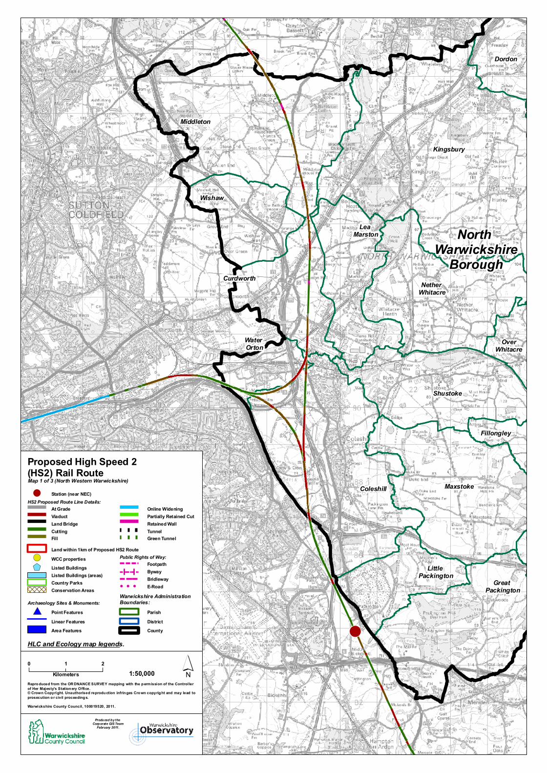
! Kingsbury Coleshill Middleton Dordon Maxstoke Shustoke Fillongley Nether Whitacre Great Packington Wishaw Curdworth Over Whitacre Lea Marston Little Packington Water Orton North Warwickshire Borough 0 2 1 Kilometers ´ Reproduced from the ORDNANCE SURVEY mapping with the permission of the Controller of Her Majesty's Stationery Office. © Crown Copyright. Unauthorised reproduction infringes Crown copyright and may lead to prosecution or civil proceedings. Warwickshire County Council, 100019520, 2011. 1:50,000 Map 1 of 3 (North Western Warwickshire) Land within 1km of Proposed HS2 Route At Grade Viaduct Cutting Fill Tunnel Retained Wall Online Widening WCC properties HS2 Proposed Route Line Details: District County Proposed High Speed 2 (HS2) Rail Route HLC and Ecology map legends. Station (near NEC) ! Warwickshire Administration Boundaries: Produced by the Corporate GIS Team February 2011. ! ( Listed Buildings Conservation Areas Country Parks Parish Bridleway Byway !!! E-Road Footpath Public Rights of Way: Green Tunnel Land Bridge Partially Retained Cut Archaeology Sites & Monuments: Point Features Linear Features Area Features # * Listed Buildings (areas) $ +

Welcome message from author
This document is posted to help you gain knowledge. Please leave a comment to let me know what you think about it! Share it to your friends and learn new things together.
Transcript
! ! !
! ! !
! ! ! ! !
! ! ! ! !
! ! ! ! !
! ! ! ! !
! ! ! ! !
! ! ! ! ! !
! ! ! ! ! !
! ! ! ! ! !
! ! ! ! ! !
! !
! !
! !
! !
! ! ! !
! ! ! !
! ! ! !
! ! ! !
! ! ! ! ! ! ! ! ! ! ! !
! ! ! ! ! ! ! ! ! ! ! !
! ! ! ! ! ! ! ! ! ! ! !
! ! ! ! ! ! ! ! ! ! ! !
! ! ! ! ! ! ! ! ! ! ! !
! ! ! ! ! ! ! ! ! ! ! !
! ! ! ! ! ! ! ! ! ! ! !
! ! ! ! ! ! ! ! ! ! ! !
#*#*#*#*#*
#*
#*#*
#*
#*#*#*#*
#*
#*
#*#*
#*
#*
#*
#*#*
#*
#*
#*#*#*
#*
#*
#*
#*
#*
#*
#*
#*
#*#*#*
#*#* #*
#*
#*#*#*
#*
#*
#*#*#* #*
#*
#*
#*
#*
#*
#*
#*#*#*
#*
#*
#*#*#*
#*
#*
#*
#*
#*
#*
#*
#*
#*
#*
#*
#*
#*
#*
#*
#*#*#*
#*
#*
#*
#*
#*#*
#*
#*
#*
#*#*
#*
#*
#*#*
#*#*#*#*#*#*#*
#*#* #*
#*
#*
#*
#*
#*
#*
#*
#*
#*
#*
#* #*
#*#*
#*
#*
#*
#*
#*
#*#*#*#*#*#*
#*
#*
#*
#*
#*
#*
#*#*
#*
#*
#*
#*
#*
#*
#*
#*
#*
#*
#*
#*
#*
#*
#*
#*
#*
#*#*
#*
#*#*
#*
#*#*
#*
#*
#*
#*
#*
!
!
!
!
! !
!
!
!
!
$+
$+
$+
$+
$+
$+ $+
$+
$+
$+$+
$+
$+
$+
$+
$+
$+
$+
$+
$+
$+
$+
$+
$+
$+
$+
$+
$+
$+
$+
$+
$+
$+
$+
$+
$+$+$+$+$+
$+
$+
$+!(
!(
!(
!(!(
!( !(
!(
!(
!(
!(
!(
!
Kingsbury
Fillongley
Coleshill
Middleton
Dordon
Polesworth
Arley
Maxstoke
Dordon
Baxterley
Bentley
Shustoke
Fillongley
Nether Whitacre
Great Packington
Wishaw
Curdworth
OverWhitacre
Lea Marston
Merevale
Baxterley
Little Packington
Baddesley Ensor
Caldecote
Water Orton
North Warwickshire
Borough
0 21Kilometers ´
Repro duced from the OR DNANCE SURVEY mapping with the p ermission of the Controllerof Her Majesty's Station ery Office.© Crown Copyright. Unauthorised reprodu ction infrin ges Cro wn copyrig ht and may lead to prosecution o r civil proceeding s.Warwickshire County Council , 100019520, 2011.
1:50,000
Map 1 of 3 (North Western Warwickshire)
Land within 1km of Proposed HS2 Route
At GradeViaduct
CuttingFill
TunnelRetained Wall
Online Widening
WCC properties
HS2 Proposed Route Line Details:
DistrictCounty
Proposed High Speed 2 (HS2) Rail Route
HLC and Ecology map legends.
Station (near NEC)!
Warwickshire Administration Boundaries:
Produced by the Corporate GIS Team
February 2011.
!(Listed Buildings
Conservation AreasCountry Parks
Parish
BridlewayByway
! ! ! E-Road
FootpathPublic Rights of Way:
Green Tunnel
Land BridgePartially Retained Cut
Archaeology Sites & Monuments:Point FeaturesLinear FeaturesArea Features
#*
Listed Buildings (areas)$+
Related Documents