Warning Improvements Second Workshop on Severe Weather Technology for NWS Warning Decision Making Tuesday, July 10, 2007 May 8, 2003 John Ferree NWS Severe Storms Services Leader

Warning Improvements Warning Improvements Second Workshop on Severe Weather Technology for NWS Warning Decision Making Tuesday, July 10, 2007 Second Workshop.
Dec 27, 2015
Welcome message from author
This document is posted to help you gain knowledge. Please leave a comment to let me know what you think about it! Share it to your friends and learn new things together.
Transcript

Warning ImprovementsWarning Improvements
Second Workshop on Severe Weather Technology for NWS Warning Decision Making
Tuesday, July 10, 2007
Second Workshop on Severe Weather Technology for NWS Warning Decision Making
Tuesday, July 10, 2007
May 8, 2003
John FerreeNWS Severe Storms Services Leader
John FerreeNWS Severe Storms Services Leader

Some Things to Think AboutSome Things to Think About
• How does the technology discussed assist in other high impact events?
– Hurricanes, Volcanoes, Accidents, Terrorism
• What are the roles of partners in defining requirements?
• What are the impacts of changes in dissemination technology?
• How do we improve on our best performances?
• How does the technology discussed assist in other high impact events?
– Hurricanes, Volcanoes, Accidents, Terrorism
• What are the roles of partners in defining requirements?
• What are the impacts of changes in dissemination technology?
• How do we improve on our best performances?
Can We Do Better?Can We Do Better?
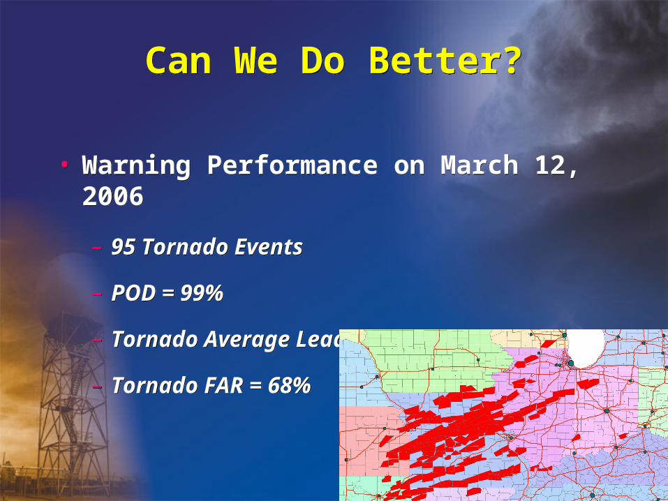
• Warning Performance on March 12, 2006
– 95 Tornado Events
– POD = 99%
– Tornado Average Lead Time = 23.1 min
– Tornado FAR = 68%
• Warning Performance on March 12, 2006
– 95 Tornado Events
– POD = 99%
– Tornado Average Lead Time = 23.1 min
– Tornado FAR = 68%

Quote from anEmergency Manager
Quote from anEmergency Manager
“For my purposes, (severe thunderstorm and tornado) watches aren’t that useful. Usually,
they are too early. I don’t want to deploy spotters and have them wait four hours for the weather. Warnings are always too late. Give us about an hour lead time before the
severe storms get here.”
“For my purposes, (severe thunderstorm and tornado) watches aren’t that useful. Usually,
they are too early. I don’t want to deploy spotters and have them wait four hours for the weather. Warnings are always too late. Give us about an hour lead time before the
severe storms get here.”

Science, Technology, Societal Impacts Collide
Science, Technology, Societal Impacts Collide


OSIP Projects in this Presentation OSIP Projects in this Presentation
• 05-080 | Storm-Based Warnings
• 06-056 | Synchronization of preliminary LSR and Storm Data Event Types
• 04-008 | Next Generation Warning Tool
• 05-080 | Storm-Based Warnings
• 06-056 | Synchronization of preliminary LSR and Storm Data Event Types
• 04-008 | Next Generation Warning Tool
A Few Other Projects of InterestA Few Other Projects of Interest

County-Based Tornado Warnings8 Counties under warning
Almost 1 million people warned
County-Based Tornado Warnings8 Counties under warning
Almost 1 million people warned
• More specific• Increased clarity• Supports newdissemination technology
05-080 | Storm-Based Warnings 05-080 | Storm-Based Warnings
Three simultaneous tornadoes within
line of severe thunderstorms
Storm-Based Tornado Warnings
70% less area covered~600,000 fewer people warned
Storm-Based Tornado Warnings
70% less area covered~600,000 fewer people warned

Private Sector Use of Storm-Based Warnings Increases
Private Sector Use of Storm-Based Warnings Increases

Storm-Based = GIS BasedStorm-Based = GIS Based
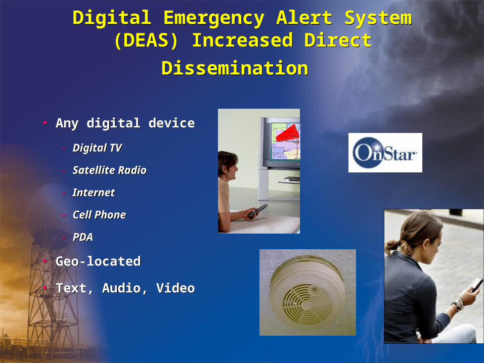
Digital Emergency Alert System (DEAS)
Increased Direct Dissemination Digital Emergency Alert System (DEAS)
Increased Direct Dissemination
• Any digital device
– Digital TV
– Satellite Radio
– Internet
– Cell Phone
– PDA
• Geo-located
• Text, Audio, Video
• Any digital device
– Digital TV
– Satellite Radio
– Internet
– Cell Phone
– PDA
• Geo-located
• Text, Audio, Video

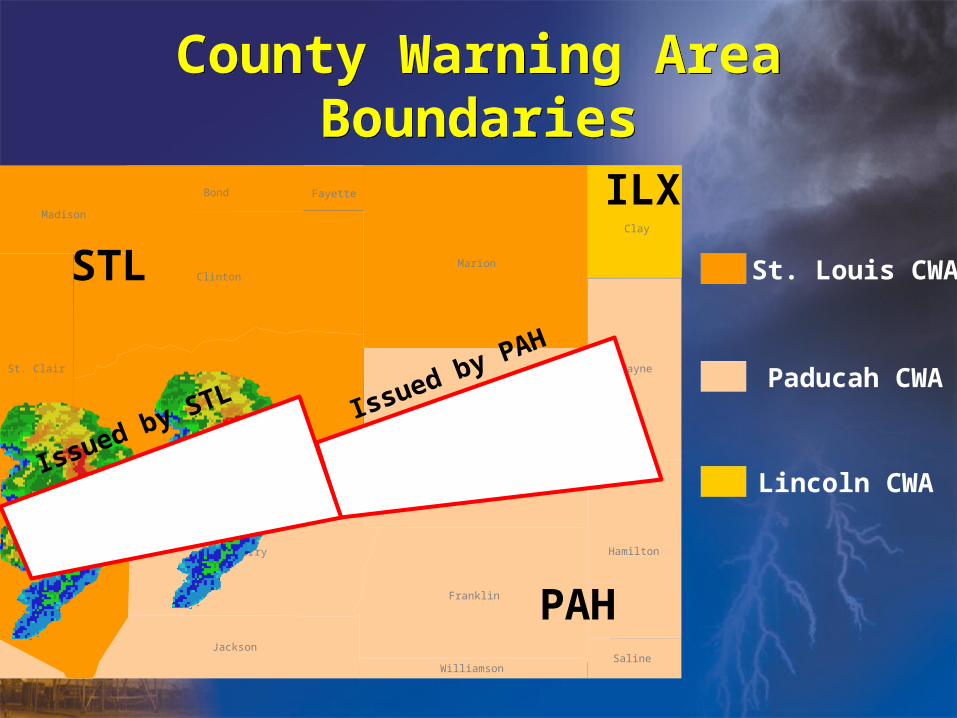
Outstanding Issues for Storm-Based WarningsOutstanding Issues for Storm-Based Warnings
1. County Warning Area (CWA) boundaries
2. Multiple warnings in a county
3. CAP format
4. Local Storm Report (LSR) improvements
1. County Warning Area (CWA) boundaries
2. Multiple warnings in a county
3. CAP format
4. Local Storm Report (LSR) improvements

County Warning Area BoundariesCounty Warning Area Boundaries
St. Louis CWA
Paducah CWA
Lincoln CWA
Madison
Bond
Clinton
Fayette
Marion
St. Clair
Washington
Randolph
Perry
Jackson
Franklin
Jefferson
Hamilton
WilliamsonSaline
Wayne
Clay
STL
PAH
ILX
Madison
Bond
Clinton
Fayette
Marion
St. Clair
Washington
Randolph
Perry
Jackson
Franklin
Jefferson
Hamilton
WilliamsonSaline
Wayne
Clay
STL
PAH
ILX
County Warning Area BoundariesCounty Warning Area Boundaries
St. Louis CWA
Paducah CWA
Lincoln CWA
Issued by PAH
Issued by STL

Multiple Warnings in One County/Parish
Multiple Warnings in One County/Parish
• Issue for text, radio, TV crawls
• Add reference to other valid warnings
• Include counties with directional delimiters?
• Summary severe weather statements?
• Issue for text, radio, TV crawls
• Add reference to other valid warnings
• Include counties with directional delimiters?
• Summary severe weather statements?
Madison
Bond
Clinton
Fayette
Marion
St. Clair
Washington
Randolph
Perry
Jackson
Franklin
Jefferson
Williamson
TOR until 3:30PM
SVR until 3:45PM

CAP FormatCAP Format
“The Order requires EAS participants to accept messages using Common Alerting Protocol (CAP)…to ensure the efficient and rapid transmission of EAS alerts to the American public in a variety of formats (including text, audio and video) and via different means (broadcast, cable, satellite, and other networks) and to promote the development of Next Generation EAS.”
Federal Communications Commission AnnouncementMay 31, 2007
http://www.eic.org/docs/FCCCAPEASnotice.pdf

Local Storm Report ImprovementsLocal Storm Report Improvements
• NWSI 10-512 page 12
• Why so many other LSR programs?
– SevereClear
– WHIRL
– WarnSpot
– More…
• NWSI 10-512 page 12
• Why so many other LSR programs?
– SevereClear
– WHIRL
– WarnSpot
– More…
Section 5.2.1 Creation Software. WFOs should use the AWIPS LSR generation software for reports.Section 5.2.1 Creation Software. WFOs should use the AWIPS LSR generation software for reports.

06-056 | Local Storm Reports06-056 | Local Storm Reports
• Individual report output with VTEC ETN
– Accurate corrections
• Cumulative report output
– One line per report (15 reports in 15 lines)
– Flexible time range (severe reports 18Z – 21Z)
– Flexible report type (snowfall accumulation)
• CAP/XML Format
• Integrates with StormData
• Individual report output with VTEC ETN
– Accurate corrections
• Cumulative report output
– One line per report (15 reports in 15 lines)
– Flexible time range (severe reports 18Z – 21Z)
– Flexible report type (snowfall accumulation)
• CAP/XML Format
• Integrates with StormData

06-056 | Local Storm Reports06-056 | Local Storm Reports
• Run from AWIPS or PC
• Point and Click Map
– Google Earth Type
– GIS
• Lat/Lon is report location
• Direction from town/landmark is only an estimate
• Support Street Addresses
• Overlays with warnings, reports, mesoscale data, radar data, etc.
• Integrates with
• Run from AWIPS or PC
• Point and Click Map
– Google Earth Type
– GIS
• Lat/Lon is report location
• Direction from town/landmark is only an estimate
• Support Street Addresses
• Overlays with warnings, reports, mesoscale data, radar data, etc.
• Integrates with

Current EffortsCurrent Efforts
• SevereClear – Jason Burks (Huntville ITO)
• ? - Alaska SIB (WFO Friendly)
• IEM COW – Daryl Herzmann (Iowa State)
• WarnSpot – Greg Garrett (Jackson SOO)
• WHIRL – Matthew Sardi and Steven Fano (FTW)
• National Performance Management Committee
• SevereClear – Jason Burks (Huntville ITO)
• ? - Alaska SIB (WFO Friendly)
• IEM COW – Daryl Herzmann (Iowa State)
• WarnSpot – Greg Garrett (Jackson SOO)
• WHIRL – Matthew Sardi and Steven Fano (FTW)
• National Performance Management Committee

Proposal for Short TermProposal for Short Term
• National support for a local PC based application
– Similar to GHG development
• Chose the best
– Developer input
– Work Team
• Implement with training by Jan. 1, 2008
• National support for a local PC based application
– Similar to GHG development
• Chose the best
– Developer input
– Work Team
• Implement with training by Jan. 1, 2008

Proposal for Long TermProposal for Long Term
• Begin OSIP project for Next Generation LSR system
• Link with Next Generation Warning Tool development
• Target first opportunity in AWIPS 2 Architecture
• Begin OSIP project for Next Generation LSR system
• Link with Next Generation Warning Tool development
• Target first opportunity in AWIPS 2 Architecture

04-008 Next Generation Warning Tool04-008 Next Generation Warning Tool
• Need for a consistent user interface
– WarnGen
– GHG
– River Pro
• Allow forecasters to focus on what, where and when of warnings
• Formatting tools deliver content that is consistent and meets needs of users
• Need for a consistent user interface
– WarnGen
– GHG
– River Pro
• Allow forecasters to focus on what, where and when of warnings
• Formatting tools deliver content that is consistent and meets needs of users
Hazard Grid in GHG

Additional Benefits of NGWTAdditional Benefits of NGWT
• Minimize training, support resources
• Foundation for future requirements
– Allow long fuse warnings to leverage the digital forecast process
– Anticipate changes in formats and allow greater geographical specificity
• Minimize training, support resources
• Foundation for future requirements
– Allow long fuse warnings to leverage the digital forecast process
– Anticipate changes in formats and allow greater geographical specificity
Summary and DiscussionSummary and Discussion
• Storm-Based Warnings
• Local Storm Reports
• Next Generation Warning Tool
• Others?
• Contact Information
– Email: [email protected]
– Phone: 405-325-2209
• Storm-Based Warnings
• Local Storm Reports
• Next Generation Warning Tool
• Others?
• Contact Information
– Email: [email protected]
– Phone: 405-325-2209

More Discussion TopicsMore Discussion Topics
• How does the technology discussed assist in other high impact events?
– Hurricanes, Volcanoes, Accidents, Terrorism
• What are the roles of partners in defining requirements?
• What are the impacts of changes in dissemination technology?
• How do we improve on our best performances?
• How does the technology discussed assist in other high impact events?
– Hurricanes, Volcanoes, Accidents, Terrorism
• What are the roles of partners in defining requirements?
• What are the impacts of changes in dissemination technology?
• How do we improve on our best performances?

Backup SlidesBackup Slides
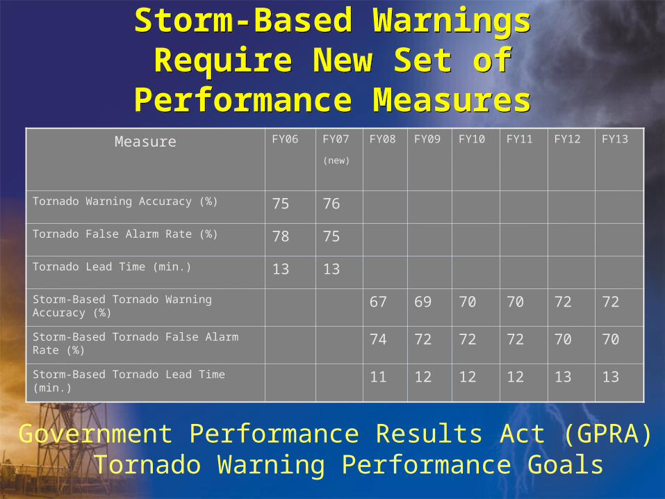
Storm-Based Warnings Require New Set of Performance Measures
Storm-Based Warnings Require New Set of Performance Measures
Measure FY06 FY07
(new)
FY08 FY09 FY10 FY11 FY12 FY13
Tornado Warning Accuracy (%) 75 76
Tornado False Alarm Rate (%) 78 75
Tornado Lead Time (min.) 13 13
Storm-Based Tornado Warning Accuracy (%) 67 69 70 70 72 72
Storm-Based Tornado False Alarm Rate (%) 74 72 72 72 70 70
Storm-Based Tornado Lead Time (min.) 11 12 12 12 13 13
Government Performance Results Act (GPRA)Tornado Warning Performance Goals

Feature Tracking AddedFeature Tracking Added
• Location and motion of feature
– Estimated location of tornado, leading edge of gust front, leading edge of hail core, or other.
• Location and motion of feature
– Estimated location of tornado, leading edge of gust front, leading edge of hail core, or other.
* AT 425 PM MST...NATIONAL WEATHER SERVICE DOPPLER RADAR INDICATED A SEVERE THUNDERSTORM. THIS STORM WAS LOCATED 12 MILES SOUTHWEST OF AKRON...AND MOVING NORTHEAST AT 20 MPH.
• THE SEVERE THUNDERSTORM WILL BE NEAR... AKRON AND 8 MILES WEST OF LATNER BY 500 PM MST
LAT...LON 4031 10316 4011 10303 3998 10346 4014 10356 TIME...MOT...LOC 2325Z 248DEG 18KT 4010 10340

OB8.1 Enhancements Support Storm-Based Warnings
OB8.1 Enhancements Support Storm-Based Warnings
Better Matching along CWA BoundaryBetter Matching along CWA BoundaryBetter Matching along CWA BoundaryBetter Matching along CWA Boundary

OB8.1 Enhancements Support Storm-Based Warnings
OB8.1 Enhancements Support Storm-Based Warnings
New Multi-Colored Warning Displays with Frequent UpdatingNew Multi-Colored Warning Displays with Frequent UpdatingNew Multi-Colored Warning Displays with Frequent UpdatingNew Multi-Colored Warning Displays with Frequent Updating

OB8.1 Enhancements Support Storm-Based Warnings
OB8.1 Enhancements Support Storm-Based Warnings
Can’t expand an existing warningCan’t expand an existing warningCan’t expand an existing warningCan’t expand an existing warning

OB8.1 Enhancements Support Storm-Based Warnings
OB8.1 Enhancements Support Storm-Based Warnings
What you hatch is what you get!What you hatch is what you get!What you hatch is what you get!What you hatch is what you get!
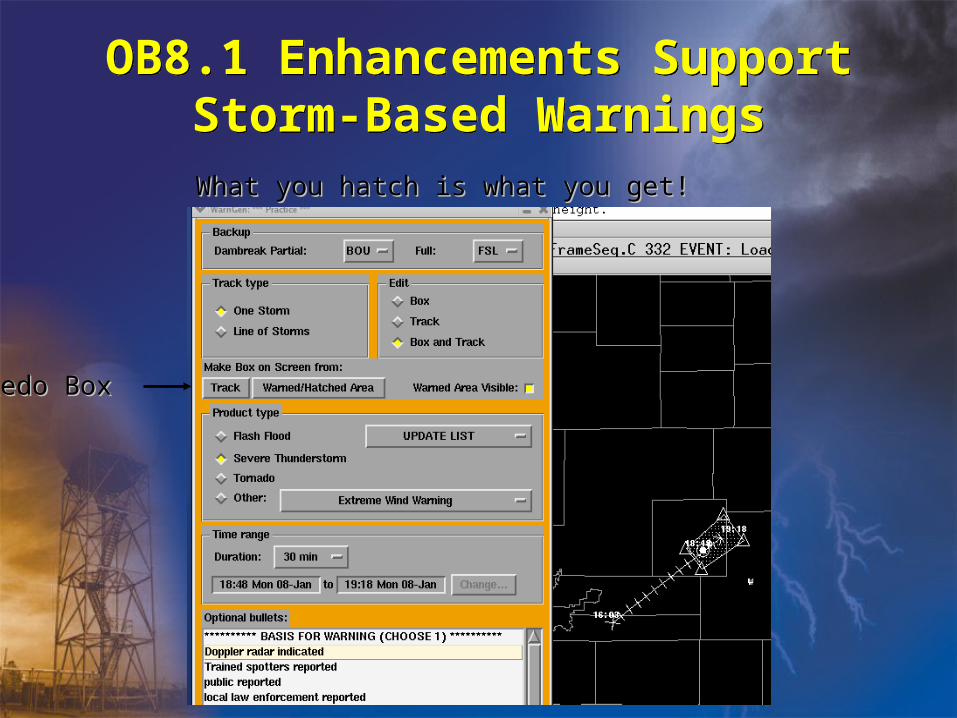
OB8.1 Enhancements Support Storm-Based Warnings
OB8.1 Enhancements Support Storm-Based Warnings
What you hatch is what you get!What you hatch is what you get!What you hatch is what you get!What you hatch is what you get!
Redo BoxRedo BoxRedo BoxRedo Box

OB8.2 Proposed Changes for Storm-Based Warnings
OB8.2 Proposed Changes for Storm-Based Warnings
• Collaboration polygons
• Separate land/marine warnings - one polygon
• FFMP basin map available with WarnGen
• Add section in text listing other existing warnings in same counties
• Depiction of archived warnings – pick list
• Collaboration polygons
• Separate land/marine warnings - one polygon
• FFMP basin map available with WarnGen
• Add section in text listing other existing warnings in same counties
• Depiction of archived warnings – pick list

TDWR Data Access ExpandingTDWR Data Access Expanding

TDWR Central Data CollectionTDWR Central Data Collection
KGSP WSR-88DKGSP WSR-88D TCLT TDWRTCLT TDWR

RDA/RPG Build 9.0Deployed April-November
RDA/RPG Build 9.0Deployed April-November
• Sachidananda-Zrnic (SZ) 2 Algorithm
– Applied only to Split Cut elevations (“2” for two rotations)
– Implemented on lowest 2 or 3 elevations of specific VCPs
• 211, 212, 221
– Significantly greater velocity data recovery
– Can often recover velocity from two overlaid trips
• Sachidananda-Zrnic (SZ) 2 Algorithm
– Applied only to Split Cut elevations (“2” for two rotations)
– Implemented on lowest 2 or 3 elevations of specific VCPs
• 211, 212, 221
– Significantly greater velocity data recovery
– Can often recover velocity from two overlaid trips

Legacy VCPsLegacy VCPs

SZ-2 VCPsSZ-2 VCPs
VCP 212
VCP 221
VCP 211

SZ-2 PerformanceSame Antenna
SZ-2 PerformanceSame Antenna
Legacy Range Unfolding
SZ-2
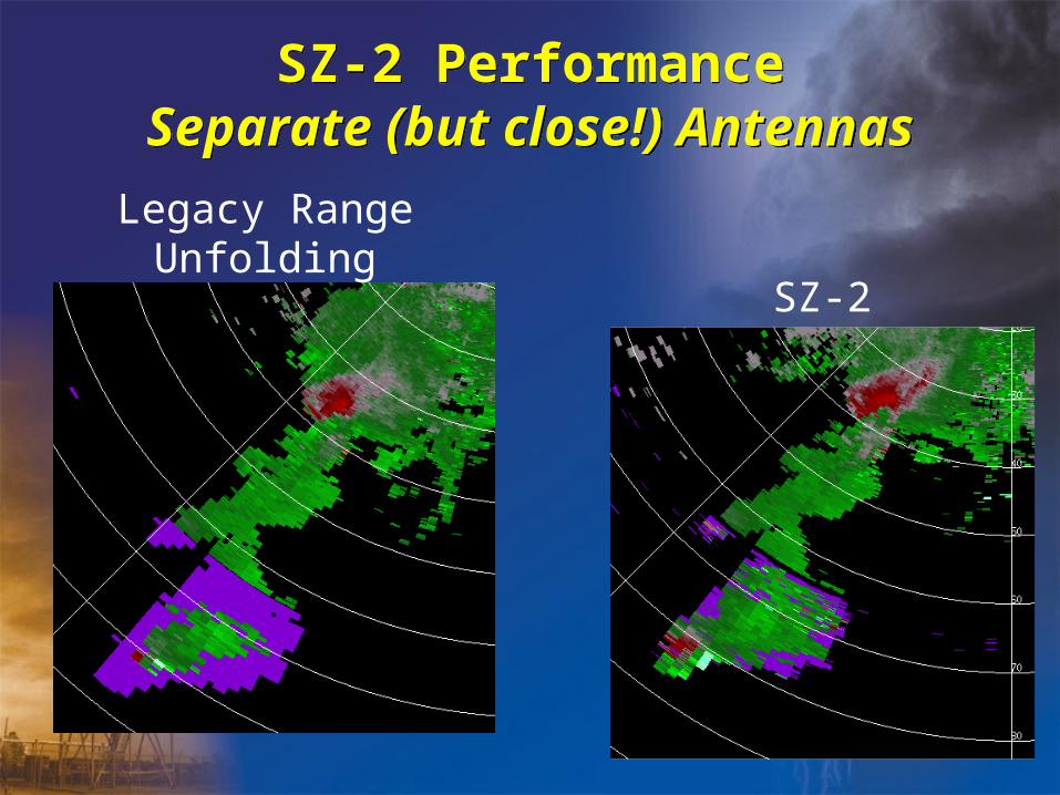
SZ-2 PerformanceSeparate (but close!) Antennas
SZ-2 PerformanceSeparate (but close!) Antennas
Legacy Range Unfolding
SZ-2

Four-DimensionalStormcell Investigator (FSI)
Four-DimensionalStormcell Investigator (FSI)
• Can update X-Section line by dragging reference points
• 2D and 3D pictures are linked
• Other representations update on-the-fly
• Can update X-Section line by dragging reference points
• 2D and 3D pictures are linked
• Other representations update on-the-fly
The Lemon TechniqueThe Lemon Technique

FSI ConfigurationFSI Configuration
PPI
Plan
Position
Indicator
VDX
Vertical
Dynamic
X-Section
PPI
Plan
Position
Indicator
VDX
Vertical
Dynamic
X-Section
CAPPI
Constant
Altitude
PPI
3D Flier
Three-
Dimensional
Flier
CAPPI
Constant
Altitude
PPI
3D Flier
Three-
Dimensional
Flier
• FSIalpha will have a linked 4-panel design:• FSIalpha will have a linked 4-panel design:
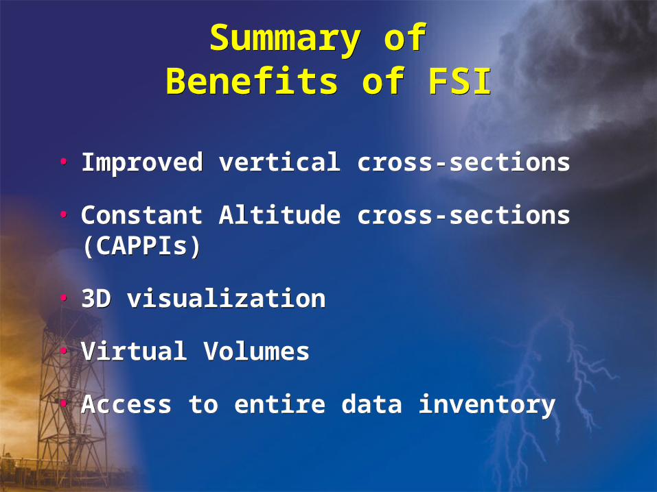
Summary of Benefits of FSISummary of
Benefits of FSI
• Improved vertical cross-sections
• Constant Altitude cross-sections (CAPPIs)
• 3D visualization
• Virtual Volumes
• Access to entire data inventory
• Improved vertical cross-sections
• Constant Altitude cross-sections (CAPPIs)
• 3D visualization
• Virtual Volumes
• Access to entire data inventory

Radar Improvements in 2008Radar Improvements in 2008
• Three new Super Resolution Digital Base Products (SDR, SDV, SDW)
– 0.5 degree azimuths
– 0.25 kilometer reflectivity to 460 km
– 0.25 velocity & spectrum width to 300 km
– All elevation cuts at and below 1.8 deg
– Both Precipitation Mode and Clear Air Mode
• VCP 122
– Improved version of VCP 121
– For the Split Cut tilts, there is one SZ-2 Doppler rotation along with a second CD rotation

Super Resolution ReflectivitySuper Resolution Reflectivity
0.5 deg Super Resolution Z0.5 deg Super Resolution Z 0.5 deg Normal Z0.5 deg Normal Z

Super Resolution VelocitySuper Resolution Velocity
0.5 deg Normal V0.5 deg Normal V0.5 deg Super Resolution V0.5 deg Super Resolution V

www.weather.gov/sbwarningswww.weather.gov/sbwarnings
Related Documents