Warm Up 2/6/09 Warm Up 2/6/09 1. What technology do scientists use to measure ocean depth? a. sonar c. rope b. submersible d. laser 2. Differences in ocean-surface height can be measured by ____. a. satellites c. submersibles b. sonar d. none of the above 3. Approximately how much of Earth’s surface is covered by land? a. 60 percent c. 30 percent b. 70 percent d. 50 percent Answers: 1) a. 2) a. 3) c.

Warm Up 2/6/09 1. 1. What technology do scientists use to measure ocean depth? a. sonarc. rope b. submersibled. laser 2. 2. Differences in ocean-surface.
Dec 18, 2015
Welcome message from author
This document is posted to help you gain knowledge. Please leave a comment to let me know what you think about it! Share it to your friends and learn new things together.
Transcript

Warm Up 2/6/09Warm Up 2/6/09
1. What technology do scientists use to measure ocean depth?a. sonar c. ropeb. submersible d. laser
2. Differences in ocean-surface height can be measured by ____.a. satellites c. submersiblesb. sonar d. none of the above
3. Approximately how much of Earth’s surface is covered by land?a. 60 percent c. 30 percentb. 70 percent d. 50 percent
Answers: 1) a. 2) a. 3) c.
Ocean Floor Ocean Floor FeaturesFeatures
Chapter 14, Section 2Chapter 14, Section 2
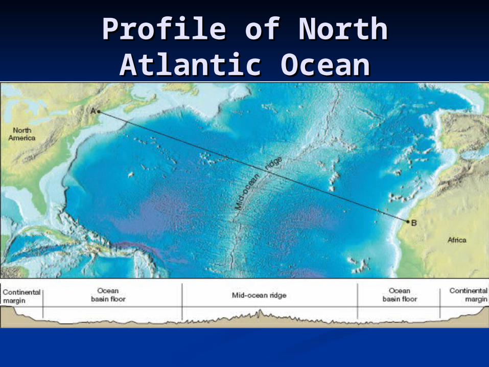
Profile of North Atlantic Profile of North Atlantic OceanOcean
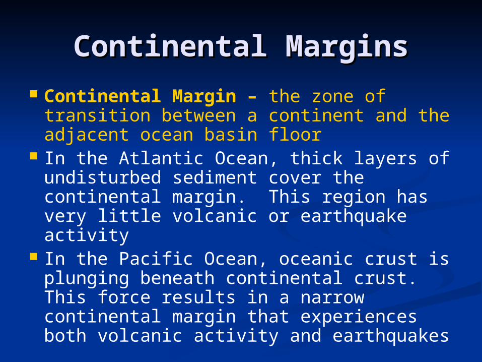
Continental MarginsContinental Margins Continental Margin – the zone of
transition between a continent and the adjacent ocean basin floor
In the Atlantic Ocean, thick layers of undisturbed sediment cover the continental margin. This region has very little volcanic or earthquake activity
In the Pacific Ocean, oceanic crust is plunging beneath continental crust. This force results in a narrow continental margin that experiences both volcanic activity and earthquakes

Passive Continental Passive Continental MarginMargin
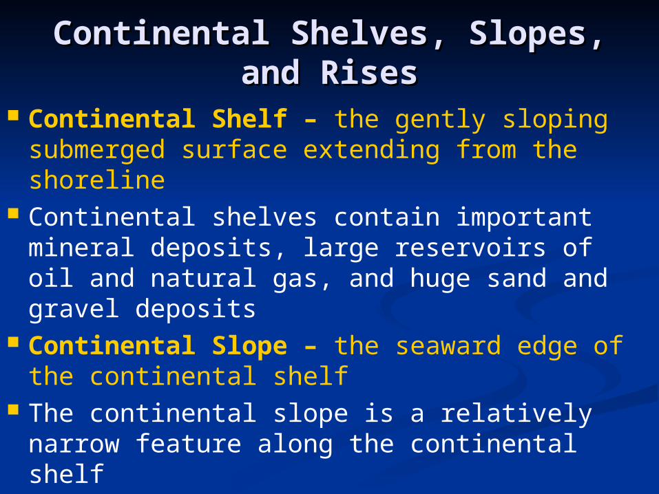
Continental Shelves, Slopes, Continental Shelves, Slopes, and Risesand Rises
Continental Shelf – the gently sloping submerged surface extending from the shoreline
Continental shelves contain important mineral deposits, large reservoirs of oil and natural gas, and huge sand and gravel deposits
Continental Slope – the seaward edge of the continental shelf
The continental slope is a relatively narrow feature along the continental shelf
Submarine Canyon – deep, steep-sided valleys cut into the continental slope
Turbidity Currents – occasional movements of dense, sediment-rich water down the continental slope
Turbidity currents are known to be an important factor in sediment transfer in the ocean
Continental Rise – a gradual incline which merges with the steep continental margin, occurs in regions where trenches do not exist
Continental Shelves, Slopes, Continental Shelves, Slopes, and Rises Continuedand Rises Continued

Submarine CanyonsSubmarine Canyons

Concept CheckConcept Check
Compare and contrast the continental slope and continental rise.
Continental slope marks the steep boundary between continental crust and oceanic crust. The continental rise occurs at the end of the continental slope and has a more gradual incline.

Ocean Basin FloorOcean Basin Floor Ocean Basin Floor – area between the
continental margin and the mid-ocean ridge Deep-ocean trenches are long, narrow creases
in the ocean floor that form the deepest parts of the ocean
Trenches form at sites of plate convergence where one moving plate descends beneath another and plunges back into the mantle
Abyssal Plains – deep, extremely flat features and are the most level places on Earth
The sediments that make up abyssal plains are carried there by turbidity currents or deposited as a result of suspended sediments settling

Ocean Basin Floor Ocean Basin Floor ContinuedContinued
Seamounts – the submerged volcanic peaks which dot the ocean floor
Once underwater volcanoes reach the surface, they form islands
After millions of years, the tops are eroded away and the once active islands sink back into the ocean, forming guyots
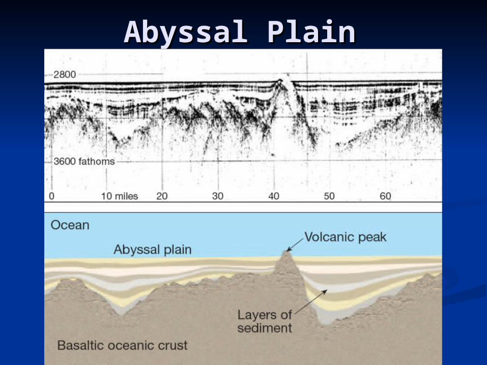
Abyssal PlainAbyssal Plain

Concept CheckConcept Check
What are abyssal plains? Deep, extremely flat regions of the
ocean floor.

Mid-Ocean RidgesMid-Ocean Ridges Mid-Ocean Ridge – found near the center
of most ocean basins; an interconnected system of underwater mountains that have developed on newly formed ocean crust
Seafloor Spreading – occurs at divergent plate boundaries where two lithospheric plates are moving apart
New ocean floor is formed at mid-ocean ridges as magma rises between the diverging plates and cools
Hydrothermal vents form along mid-ocean ridges and are zones where mineral-rich water escapes through cracks in oceanic crust into the surrounding cooler water

Profile of North Atlantic Profile of North Atlantic OceanOcean

Assignment (Due 2/13)Assignment (Due 2/13)
Read Chapter 14 (pg. 394-413) Do Chapter 14 Assessment #1-33 (pg. 417-418)
Cool DownCool Down What is formed at mid-ocean ridges? New ocean floor Compare and contrast seamounts and
guyots. A seamount is an underwater volcano that
has not reached the surface yet. A guyot is a volcanic island that has been eroded and sunk back under the water’s surface.
What is one thing new that you learned today? Explain what it is.
Related Documents