Warden Woods: A Case Study of Building Affordable Market Family Housing on Former Industrial Lands April 27, 2015 Research Report No. 3

Welcome message from author
This document is posted to help you gain knowledge. Please leave a comment to let me know what you think about it! Share it to your friends and learn new things together.
Transcript

Warden Woods: A Case Study of
Building Affordable Market Family
Housing on Former Industrial Lands
Apr i l 27 , 2015
DRAFT Research Report No. 3
Warden Woods: A Case Study of Building
Affordable Market Family Housing on
Former Industrial Lands
Campus Location
111 Gerrard Street East,
3rd floor, GER-204D
Toronto, Ontario
www.ryerson.ca/cur
The opinions expressed in this research report are those of the author only and do not represent
opinions and views of either CUR or Ryerson University.
TABLE OF CONTENTS
EXECUTIVE SUMMARY ............................................................................................................................................ i
1. OVERVIEW AND METHODS ................................................................................................................................... 1
1.1 Research Approach ...................................................................................................................................... 1
1.2 Report Structure ........................................................................................................................................... 2
2. HISTORICAL DEVELOPMENT OF THE WARDEN AVENUE CORRIDOR WITHIN A
LARGER INDUSTRIAL AREA .................................................................................................................................. 3
2.1 Industrial Area Context ............................................................................................................................... 3
2.2 Conditions of Warden Avenue Corridor at the Turn of the Millennium ........................................... 4
2.3 Chapter Summary ......................................................................................................................................... 4
3. PLANNING PROCESS AND MILESTONES LEADING TO OFFICIAL PLAN AND
ZONING REDESIGNATION .................................................................................................................................... 5
3.1 Timeline ......................................................................................................................................................... 5
3.2 Chapter Summary ....................................................................................................................................... 15
4. CHARACTERISTICS OF THE HOUSING BUILT AND CHARACTERISTICS OF THE RESIDENTS IN THE
WARDEN WOODS COMMUNITY ......................................................................................................................... 16
4.1 Housing Characteristics – Development Applications ........................................................................ 16
4.2 Developers and Developments ................................................................................................................ 17
4.3 Housing Sales by Type of Unit ................................................................................................................ 18
4.4 Characteristics of Residents ..................................................................................................................... 20
4.5 Chapter Summary ....................................................................................................................................... 22
LIST OF FIGURES
Figure 1: Detail from Map “Opportunities to Concentrate Projected Growth” ................................................. 7
Figure 2: Warden Woods Corridor Recommended Land Use Framework ........................................................... 11
Figure 3: Development Applications for Warden Woods and Nearby Areas, 2005-2007 .................................. 17
Figure 4: New Housing Units Sold in Warden Woods by Type, 2006 - 2014 (Jan.-Sept.) .................................. 19
Figure 5: Home Sales per Year in Warden Woods, 2006-2014 ............................................................................... 19
Figure 6: Warden Woods Population Characteristics, 2011 ..................................................................................... 21
Figure 7: Warden Woods Household Characteristics, 2011 ..................................................................................... 22

P a g e | i A p r i l 2 7 , 2 0 1 5
EXECUTIVE SUMMARY1
This report traces the transformation of 68 hectares (168 acres) of land in the former city of
Scarborough from an under-performing industrial area to the family-oriented residential community
now known as the Warden Woods Community. The research undertaken for this report was used as
input into CUR’s Policy Commentary No. 2 Reusing Older Industrial Areas: An Effective Tool for Providing
Affordable Market Housing for Families in the City of Toronto released in December 2014.
It briefly describes conditions in the larger industrial area of which the Warden Woods lands were a
part around the year 2000, and provides insights into the numbers and types of housing built and
the characteristics of residents occupying the new homes. The bulk of the report provides a
chronology of the planning process that led to the conversion of the Warden Woods lands from
industrial or commercial uses to a sizable lower-density residential community.
The City’s promotion of the creation of a new community with a large component of affordable
market ground-oriented housing for families has been a success in Warden Woods, and its intentions
were realized. The keys to this success include:
Relatively low land prices which were linked to a mature industrial area which was in decline
as an employment area;
The commitment of city planners and politicians to the redevelopment of an older industrial
area to create a new residential community of affordable market ground-oriented housing;
A subway station in or near the redevelopment area and access to nearby employment nodes
via car or bus;
No permissions for higher density apartments on any of the land parcels owned by private
interests;
Developers who foresaw the redevelopment potential of then industrial or commercial lands
for the housing units that have been built in Warden Woods; and
Proximity to an existing residential community where both communities can jointly use
existing community amenities which resulted in infrastructure efficiencies.
1 This report was authored by Dr. Frank A. Clayton, Senior Research Fellow, CUR with research assistance provided by Colin Wolfe and Zach Youngerman. The opinions expressed in this research report are those of the author only and do not represent opinions and views of either CUR or Ryerson University.

P a g e | 1 A p r i l 2 7 , 2 0 1 5
1. OVERVIEW AND METHODS
Historical Development of the Warden Avenue Corridor within a Larger Industrial Area
The Warden Woods area was the southern end of a large industrial area that was home to many
prominent corporations. It suffered from a number of global stresses and, as macroeconomic
conditions shifted, had become less economically productive as an industrial area. Retail ventures in
the area met mixed success and eventually proved to be unviable in the transitional industrial context
in which they were located.
Planning Process and Milestones leading to Re-designation (Official Plan and Zoning)
Background studies and city policy documents culminating in the 2002 Toronto Official Plan
favoured the conversion of poorly-performing industrial areas to residential development.
Development pressure along the Warden Avenue corridor along with the potential value of
under-used parking at the Warden Station prompted the city to hire a team led by the
planningAlliance to study the area comprehensively. The consultants, and later city staff,
supported managing, rather than resisting, residential development. However, issues of the scale
and type of housing – ground-oriented versus mixed-use and high-density – created ongoing
tension between planners’ visions and developers’ market imperatives.
Characteristics of the Housing Built and the Residents in the Warden Woods Community
Overall, the character of the housing that was built in the newly redeveloped Warden Woods area
has taken the form of ground-oriented housing typologies which are affordable from a market
perspective. The rapid sellout indicates the existence of a sizable untapped demand for this type of
housing.
The new housing which was built in Warden Woods has attracted a preponderance of home-owning
families with children at home — many neither English nor French as their mother tongue.
1.1 Research Approach
The approach used for this report includes reviewing City of Toronto and Toronto Transit
Commission (TTC) planning documents including official and secondary plans, staff and consultant
reports, and zoning by-laws. This information is supplemented with news sources to provide
context.
An assessment of the characteristics of the housing built and residents of Warden Woods was
obtained from Statistics Canada, Environics Analytics, and RealNet Canada Inc.

P a g e | 2 A p r i l 2 7 , 2 0 1 5
1.2 Report Structure
The report is divided into four chapters in addition to the introduction.
Chapter 2 describes the history of industry along the Warden Avenue corridor and the economic
conditions at the turn of the millennium.
Chapter 3 describes the milestones, including the Official Plan and TTC planning efforts, which
culminated in the Phase 3 Planning Study and the Warden Woods Community Secondary Plan,
which ultimately recommended the creation of a new residential housing community.
Chapter 4 investigates the Census of Canada, Environics and RealNet data on the typology of the
housing which was built and looks at the population and household characteristics of the new
Warden Woods community.

P a g e | 3 A p r i l 2 7 , 2 0 1 5
2. HISTORICAL DEVELOPMENT OF THE WARDEN AVENUE
CORRIDOR WITHIN A LARGER INDUSTRIAL AREA
2.1 Industrial Area Context
The area that is now Warden Woods was part of an extensive employment district. Planning policy
for Employment Districts (often through secondary plans) was intended to preserve stable
employment lands for future job security, growth and regional economic prosperity. According to
the Scarborough Official Plan, which remained in force after amalgamation, the future Warden
Woods lands fell under two secondary plans.2 These were the Golden Mile Employment District
Secondary Plan and the Oakridge Employment District Secondary Plan. The Golden Mile was
named after an industrial concentration in England and had been the site of a munitions plant
during WWII. Companies in the Golden Mile and Oakridge districts included auto manufacturers,
Canadian General Electric, Pilkington Glass, Becker's Milk and Bell Canada.
Despite some heterogeneity in uses and relative resilience after the 1992-1994 recession, larger
trends began to undermine the viability of the area.3 An increasingly globalized economy, and free
trade agreements, shifted manufacturing south and overseas. Computerized production displaced
labour with investment in capital. Locally, the expansion of the 400 series highways neutralized the
facilities’ locational advantages of being adjacent to the CN rail lines, and it increased competition
from suburban companies on lower-cost land.4
A survey of employment districts across Toronto, which was conducted as part of the Official Plan
update in 2002, describes and quantifies trends which drove the changes in areas like the Warden
Woods lands. Historical Profiles of Employment Districts, 1991-2000 divides the geography of
employment in the city into 18 districts. The Golden Mile and Oakridge Employment Districts were
combined with employment areas as far North as Highway 401 in a district which was referred to as
“Scarborough South West.”5
During the ten-year period, employment declined 7.6% and the number of businesses declined
12.8% in the larger Scarborough South West. Of the group of 18 districts in the city of Toronto, six
had declines, but only the gentrifying Weston Road/Junction district had a greater drop in
employment than did Scarborough South West. Given the loss of 4,000 manufacturing jobs in
2 According to the Toronto Official Plan “Every official plan of the City that was in force on January 1, 1998 by virtue of Section
45 of the City of Toronto Act, 1997 (No. 2) and that remains in force on the day on which this section comes into force, (a)
deemed to be an official plan of the City; and (b) remains in force, in respect of the part of the City to which it applied on
December 31, 1997, until city council repeals it or amends it to provide otherwise.”2006, c. 11, Sched. A, s. 421. The New
Official Plan was adopted by City Council in December 2002, and came into force in June 2006 through an OMB decision. 3 Urban Development Services, City Planning Division, Employment Areas: New Futures for Industrial Land (City of Toronto,
2000), 9. 4 Ibid, p.10. Generally characterizes underperforming employment areas as having a “rail orientation and relatively poor access to
the highway system.” 5 Urban Development Services, City Planning Division. Historical Profile of Employment Districts 1991-2000 (City of Toronto,
2002).

P a g e | 4 A p r i l 2 7 , 2 0 1 5
Scarborough South West, it is not surprising that parts of the Golden Mile and Oakridge
Employment Districts became the objects of study as potential transition areas.
2.2 Conditions of Warden Avenue Corridor at the Turn of the
Millennium
Prior to the redevelopment, the Warden Avenue Corridor was lined with manufacturers and the
Warden Woods area included local landmark like the Lily Cup Company, which featured a two-storey
painted “cup” intersecting the otherwise plain brick building. Other prominent facilities were the
Becker’s Milk Plant, which processed and distributed milk and other products for their chain of
convenience stores, and the Pilkington – later Ford – Glass factory at 350 Danforth Road.
Beyond manufacturing and warehousing, Centennial College (a career-oriented institution) offered
courses in healthcare, nutrition and administration. It occupied a decommissioned government
facility starting in 1966. North of St. Clair Avenue, the Warden Woods mall, built in 1970, was
revamped in the mid-1990s as a so-called Power Centre with four anchor tenants: The Sports
Authority, Future Shop, Michaels, and Petstuff. A media article about the redevelopment lists a
“generous [advertising] launch budget of $1 million.”6 However, financial success of the Power
Centre was not there for the mall, eventually leading to its demolition in 2005.
The conditions along Warden Avenue before redevelopment tell a story of an area in transition. A
patchwork of historical manufacturing and industrial uses were beginning to diversify, as adaptive re-
use of industrial buildings and new retail development gradually changed the makeup of the area.
2.3 Chapter Summary
The Warden Woods area was the southern end of a large industrial area that was home to many
prominent corporations. It suffered from a number of global stresses and, as macroeconomic
conditions shifted, it became less economically productive as an industrial area. Retail ventures in the
area met mixed success and eventually proved to be unviable in the transitional industrial context in
which they were located.
6“Mall morphs into Power Centre,” Strategy, April 17, 1995, accessed July 30, 2014, http://strategyonline.ca/1995/04/17/10444-19950417/.

P a g e | 5 A p r i l 2 7 , 2 0 1 5
3. PLANNING PROCESS AND MILESTONES LEADING TO OFFICIAL
PLAN AND ZONING REDESIGNATION
This chapter provides a chronology of the planning process which led to the conversion of the
Warden Woods lands from an underused Employment Area to a lower density residential
community. The objective of this section is to trace the evolution of planning thought about how to
proceed with these lands. As will be illustrated, planning policy struggled to keep pace with
development pressure and stakeholder eagerness to redevelop the area. The complexity of the
redevelopment effort was increased due to the need to balance the priorities of the TTC, the City of
Toronto and a variety of local industry, landowner and resident interests.
3.1 Timeline
1994 – In October, Scarborough Council requested the Golden Mile Land Use Review Study to
consider the introduction of retail and commercial uses into this established industrial area.
1996 – City of Scarborough passed Employment District Zoning By-law No 24982 on December
10, 1996. It was a consolidation of all of the Employment District zoning by-laws in Scarborough.
The original by-laws for Golden Mile and Oakridge were first adopted well before that – probably in
the early to mid-1960s.
1997 – The Ontario Government of Premier Mike Harris cut provincial funding to TTC.
1998 – The municipalities of Scarborough, North York, Etobicoke, East York and York
amalgamated with the City of Toronto, a process initiated by Premier Mike Harris’s government.
1999 – Scarborough Community Council submitted a report on amending the zoning of properties
in the Birchmount Park Employment District, very near the south-eastern boundary of the future
Warden Woods. The report described the outcome of a public meeting with eight property-owners
and Councillor Ashton. It stated that a number of industries had closed or relocated, alternatively
leasing their properties or leaving them vacant. As the council report makes clear, “The consensus
was that a broader mix of land uses in addition to the existing industrial uses would be beneficial in
improving the current situation.”7
2000 – TTC convened a joint working group with the city of Toronto to investigate the potential of
more ambitious sale or redevelopment of TTC assets. They considered spinning off a subsidiary to
become a true property developer. This task force was established to “review properties used for
transit purposes and to identify and prioritize those properties that have the highest development
7 Scarborough Community Council, City of Toronto, Official Plan Amendment Application SP1999004, Zoning By-law Amendment Application SZ1999007, December 8, 1999.

P a g e | 6 A p r i l 2 7 , 2 0 1 5
potential and marketability.”8 Specifically, the group evaluated potential properties according to the
planning context, operational issues for the TTC, and real estate issues.
2000 – City of Toronto released Employment Areas: New Futures for Industrial Land as part of the
background for the Official Plan. The report focused on 14 large Industrial Employment Areas in
the city, but did not discuss these areas individually. Warden Woods was included within a larger area
called the South West Scarborough Industrial Area.
The Employment Areas report recommended that strategic Employment Areas be protected, while
others faring poorly be managed explicitly as “transitional areas” to be redeveloped for residential,
retail and other “higher order uses”.
The recommendation that not all Employment Areas be preserved was based on the assessment that
some older industrial sites would be “very expensive and risky” to reconfigure for future
employment uses. At the same time, “strong demand” for residential uses, specifically ground-related
housing, was putting pressure on older sites and would continue well into the future.9
The Warden Woods area has all of the characteristics which were described as being in the poorly
performing areas: “older central area or inner suburban industrial districts, often linear in shape,
typically with a rail orientation and relatively poor access to the highway system.”10
Those characteristics, and others which differentiate strong from weak employment areas, were
formalized into seven criteria which were recommended as the basis for determining whether or not
employment areas should be retained for employment uses or rezoned for other uses. The seven
criteria which were outlined in the report are:
Health of an Area (taking into consideration prediction of future employment trends)
Presence of Appropriate Transportation
Presence of Existing Uses
Critical Mass (a diversity of building stocks able to accommodate and adapt to economic
shifts)
Composition of the Employment Mix
Infrastructure Needs
Future Potential (an open-ended vision as to whether another use better serves city-wide
needs)
8 Commissioner of Corporate Services and Chief General Manager, TTC to Administration Committee and Toronto Transit Commission, “Review of TTC Properties,” March 12, 2002, City of Toronto, p. 2. 9 Urban Development Services, City Planning Division, Employment Areas: New Futures for Industrial Land. (City of Toronto, 2000), 15. 10 Ibid, p.12

P a g e | 7 A p r i l 2 7 , 2 0 1 5
2002, May – Toronto Urban Development Services released Flashforward: Projecting Population and
Employment to 2031 In a Mature Urban Area.” Map 2 of that report, titled “Opportunities to
Concentrate Projected Growth” identified Victoria Park and Warden Avenue Stations as having
“redevelopment potential” (See Figure 1). These areas, which included much of what would become
the Warden Woods community, were seen as opportunities partly because of their proximity to
subway stations, as increasing the number of residents would make better use of existing transit
infrastructure.11
Figure 1:
Detail from Map “Opportunities to Concentrate Projected Growth”
Source: Map 2, “Opportunities to Concentrate Projected Growth” in Flashforward: Projecting Population and
Employment to 2031 In A Mature Urban Area. (Toronto: City of Toronto, 2002), 13.
2002 – Most pre-amalgamation employment areas were included in the Employment Districts on
Map 2 of the new Official Plan which meant that conversion to residential use was not permitted.
Some employment areas were not including the Warden Woods area. The Official Plan was “silent”
about conversion of these areas which were still designated as Employment Areas in the Official
Plan but were not designated as Employment Districts on the Land Use Plan. Once conversion had
been agreed on, the Official Plan provided direction for redevelopment.
The direction was that Secondary Plans should be prepared for areas with “large tracts of vacant or
underused land which would benefit from comprehensive planning” and “areas where development
is occurring, or proposed, at a scale, intensity or character which necessitates reconsideration or
11 Urban Development Services, City Planning Division Flashforward: Projecting Population and Employment to 2031 In A Mature Urban Area. (City of Toronto, 2002), 13.

P a g e | 8 A p r i l 2 7 , 2 0 1 5
reconfiguration of local streets, block plans, public works, open space or other public services or
facilities.” Secondary plans also set out guidelines for density and parking.
One new designation category was “Regeneration Area”, which was inspired by the success of
rezoning aging industrial uses in the King-Spadina and King-Parliament areas of downtown
Toronto. The rationale behind Regeneration Areas was explained in the following passage:
Regeneration Areas open up unique areas of the City to a wide array of uses to help attract
investment, re-use buildings, encourage new construction and bring life to the streets. These areas
are key to the Plan’s growth strategy, reintegrating areas of the City that are no longer in productive
urban use due to shifts in the local or global economies. In Regeneration Areas, commercial,
residential, live/work, institutional and light industrial uses can be mixed within the same block or
even the same building12 [italics in original]
The new Regeneration Area classification reflected official thinking about the changing economy,
vacancy rates, and lifestyles, particularly in the Downtown. The language suggested a more flexible
and fluid approach to industrial lands that needed to adapt to the shifting economies and a broader
suite of land uses.
2002 – A joint TTC/City of Toronto task force reported on 10 “Schedule A” properties that had a
high probability of redevelopment within 5 years. Within that group, the North Commuter Parking
Lot of Warden Station was described as having a medium probability of success. The group
reported that the site was attractive for redevelopment and that the replacement of the commuter
parking was a “marginal operational difficulty”. When Warden Station served as the easternmost
terminus of the Bloor-Danforth line from 1968 to 1980, commuter parking was an important
component of intermodal transfer.13 A report by TTC that same year said that Warden Station had
some of the lowest passenger volumes in the system and was ranked 28 of 31 for population and
employment density.14 A more significant obstacle, the group wrote, was that “it would not be
prudent to attempt to redevelop this site” before completion “of a planning framework study which
would enable the City to maximize on the development potential.”15
Warden Station was one of many properties which the task force felt, “despite their potential, are
difficult to develop and require a concentrated staff effort over a period of time to ensure that
redevelopment occurs consistent with City and TTC goals and objectives.” Overall, the report
suggested that policy needed to take the lead to realize the development potential of lands like
12 City Planning Division, Toronto Official Plan (City of Toronto, November 2002), 31. 13 Chief Planner and Executive Director, City Planning Division to Planning and Transportation Committee, Toronto
Staff Report “Phase 3 Warden Corridor Land Use Planning Study,” September 21, 2005, http://www.toronto.ca/legdocs/2005/agendas/committees/plt/plt051006/it001.pdf, accessed April 20, 2015. This report states that the North Lot contained 1,341 spaces and was never more than half-full, p.14. 14 “TTC Rapid Transit Expansion Study,” cited in planningAlliance TTC Subway Lands - Warden Corridor and Victoria Park Station, Phase 1 Warden Corridor Planning Study (2004), 54. 15 “Review of TTC Properties” (2000), 8.

P a g e | 9 A p r i l 2 7 , 2 0 1 5
Warden Woods. A planning framework study was seen as a prerequisite to a redevelopment effort, as
it would help to guide the redevelopment process with a long-term scope.
2003 – City of Toronto hired a consultant team of planningAlliance, McCormick Rankin, and
Metropolitan Knowledge International to perform a two-phase land use and planning study for
redeveloping the Warden Corridor. The City wanted to assess the economic viability of the then-
current uses, whether there was adequate physical and social infrastructure for new residential
development, and how it should respond to development proposals. The team took a broad view of
the work, stating that “Warden Station parking lots should not be studied in isolation from other
lands in the Warden Corridor that have been the subject of developer interest.”16
2004, April – planningAlliance released a Phase 1 report, Land Use Planning Study TTC Subway Lands
Warden Corridor and Victoria Park Station. A map delineating the study area boundary was broadly
consistent with the locations of approved and potential private development north and south of
Warden Station. In total, fifteen properties were categorized as having recently approved
applications, current applications, or pre-application interest in a several square kilometre area
extending from Eglinton Avenue to Danforth and from Birchmount Road to a non-linear border to
the west. Surprisingly, several properties in various stages of development west of Warden Avenue
were excluded from the smaller area of “Potential Land Use Change.” How the boundary of the
smaller area was defined was not described. However, the report stated that Becker’s Milk and
Centennial College which were in the smaller area were considering relocating and that the
remaining businesses “are viable uses but are relatively low-value properties.”17
This mixed but generally negative assessment continued in the economic overview of the study area.
The authors stated that the area “considerably underperforms other comparable areas in Etobicoke
and North York.” While a City of Toronto staff report which was cited in the report had listed a
number of firms which had grown in the study area, the uptick in employment was concentrated at
Eglinton and Birchmount – outside the boundary of Potential Land Use Change. A map showing
the distribution of employment in the Potential Land Use Change area had a lot of empty space.
The greatest concentration of employment was at Becker’s Milk on Warden Avenue north of
Danforth Road.18
2004, May – planningAlliance held a design charrette which was conducted “in consultation with
those with a direct interest in the future of the two Study Areas, including residents and service
providers, the TTC and other area developers and landowners and the two City Councilors.”19
2004, July – Consultants held a meeting specifically with landowners. This group stressed that any
proposed planning framework needed to create realistic development scenarios that allowed for
16 planningAlliance, “TTC Subway Lands – Warden Corridor and Victoria Park Station, Phase 1 Warden Corridor Planning Study” (2004), 2. 17 planningAlliance, “TTC Subway Land,” (2004), 51. 18 Ibid, p. 52. 19 planningAlliance, McCormick Rankin, and Metropolitan Knowledge International, “Land Use Planning Study - TTC Subway Lands, Warden Corridor and Victoria Park Station, Phase 2 Consultants Report” (2004), 1.
P a g e | 10 A p r i l 2 7 , 2 0 1 5
flexibility in response to market considerations. Namely, the stakeholders wanted to avoid a plan that
would require them “to develop denser and taller buildings than they [were] interested in pursuing,
based on their reading of market demand”.20 In response, the consultants reduced the overall
number of proposed dwelling units from 4,700 to 3,300 in the development scenarios. The
developers also pressed to make sure that parkland requirements were equitable and recognized
where each property owner was in the development and approval stage.
2004, September – Centennial College officially closed its Warden Avenue location and relocated to
an existing campus location at Markham and Highway 401.
2004, November – planningAlliance released its Phase 2 report describing a 10-sector
comprehensive vision for future development balancing economic opportunities, public realm
enhancements, and green space provisions. The consultants recognized shifting conditions in the
area and the need for planning policies to reflect these changes:
Our response to the fundamental land use issue posed by the Study is that there is little to be gained by
refusing to consider a redesignation to permit residential and mixed use development within the
Employment Area south of the Warden station. In fact, in our view, it represents better planning to
develop a comprehensive plan that accommodates currently proposed as well as anticipated future
residential development, rather than to try to maintain the status quo and have individual
residential/mixed use conversions make it through the process on an ad hoc basis.21
At the same time, the report recommended protecting viable Employment Areas, while promoting
residential and non-residential development as much as compatible. The section on land-use
recommended mixed-use development “to encourage economic diversity and live-work
opportunities,” as well as potential community services.22 The new recommended land use
framework can be seen in Figure 2.
20 Ibid, p. 22. 21 Ibid, p. 25. 22 Ibid, p. 11.

P a g e | 11 A p r i l 2 7 , 2 0 1 5
Figure 2:
Warden Woods Corridor Recommended Land Use
Framework
Source: planningAlliance et al., Figure 19: Recommended Land Use Framework:
Warden Corridor, in “Land Use Planning Study, Phase 2 Consultants Report”
(2004), 43.
The consultants removed one small property from the study area west of Warden Avenue on the
basis that it was part of an Employment District outlined in the Official Plan’s Urban Structure Plan.
According to the Official Plan, such areas were part of the long-term employment structure of the
city and were to be protected for employment uses only.23 The team felt that an attempt to
redesignate this parcel for non-employment uses would set a bad precedent for future redesignation
of other Employment Districts.
23 Ibid, p. 25.

P a g e | 12 A p r i l 2 7 , 2 0 1 5
The consultants proposed a hierarchy of road-networks and housing such that “mid-rise densities
are along major streets and higher densities are adjacent to subway stations.”24 Massing and public
realm controls were advocated as methods for making high-rise buildings more pleasant at street
level than existing residential towers and for transitioning to a low-rise residential fabric which was
compatible with adjacent established neighbourhoods. The mix of housing products which was
“encouraged” was intended to accommodate a range of household types and people of varying
income levels. Retail was proposed for ground floor space along Warden Avenue.
2005 or Earlier – TTC strategy was to relocate 850 parking spaces from the TTC-owned North
parking lot to the Hydro corridor south of St. Clair. Relocation and realignment of the bus terminal
in the South parking lot would free 1.2 hectares for development.25
2005, February – In consultation with Ward 35 Councillor Altobello, representatives from
Mattamy Homes and Goldman Group submitted redevelopment applications to the Scarborough
Community Council for a total of nearly 1,500 residential units. The proposals covered the four
largest parcels of land within the Warden Avenue Corridor. These sites included the former Warden
Power Centre, the Centennial College property, the Becker’s Milk property and the Patterson
Engineering property. Redevelopment applications included the Mattamy Homes proposal for 520
townhouses and condominiums and the Goldman Group proposal for 450 plus townhouses on
Warden Avenue; and 477 single-family, semi-detached, and townhouse units on Danforth Road.26
2005, April – City Council adopted a Status Report recommending the redevelopment of the
Warden Corridor provided that community facilities and services would be enhanced.
2005, June – The Committee of Adjustment approved dividing the Becker’s Dairy site into four
parcels (671, 673, 675 and 679 Warden Avenue) and a future road along the southern limit of 673
Warden Avenue.
2005, June – City staff organized a day-long workshop to discuss options around the community
services and facilities component of the redevelopment. The consultation included input from 40
participants, as well as TTC staff. Participants discussed options relating to the location and
configuration of a new community centre and forthcoming greenspace assets. Retail amenities and
built form were also key components which were raised by participants:
The Workshop participants identified the need for new development in the Warden Corridor to
include a variety of commercial uses such as a grocery store, ground floor convenience retail, a
bakery, and restaurants (including a pub) and cafes on the basis that the new community should be
well served by supporting commercial amenities, and the sense that the existing surrounding
communities are lacking in these amenities. The Workshop participants generally supported mid-rise
building heights along Warden Avenue, and felt that it would be essential for building heights to
transition down toward the surrounding residential communities. Higher building heights near the
24 Ibid, p. 12. 25 Toronto Staff Report “Phase 3 Warden Corridor Land Use Planning Study” (September 21, 2005), 14. 26 Stuart Green, “Warden Planning Meeting Slated” The Scarborough Mirror, February, 2005.
P a g e | 13 A p r i l 2 7 , 2 0 1 5
subway station were felt to be acceptable, at a general maximum of 8 storeys, with one group taking
the view that up to 15 storeys should be permitted.27
2005, September – City planning staff released Phase 3 report Warden Corridor Land Use Planning
Study. The final phase of the report (implementation) presented land use suggestions and
recommendations for a secondary plan, a conceptual Master Plan to coordinate private and public
investment, and amendments to the Official Plan and zoning by-laws. Phase 3 culminated in the
creation of the Warden Woods Community Secondary Plan, which was intended to “support private
and public investment in the creation of a new community, integrated with the surrounding
residential communities” as well as ravine systems, and remaining employment uses.28 It included
Neighbourhoods, Apartment Neighbourhoods, and Mixed Use land use designations.
Messaging in the report argued for a balance between existing industrial uses and potential new
residential development. Staff supported the permanent protection of employment lands north of
the new Warden Woods area. They also stated that the new Warden Woods Community Secondary
Plan created a framework which required new developers to study the interface between potentially
conflicting uses and might require “appropriate mitigation measures, such as buffers, screening
source…and warning clauses” for approval.29
However, the report noted that the existing (M) zoning for the southern portion of the Golden Mile
Employment District was the most restrictive industrial land use. Any use deemed “offensive” by
virtue of its physical impact was already “prohibited,” according to the “general zoning provision.”
Staff also recommended that industrial uses which were most likely to impact nearby residences be
removed from the zoning designation. They dismissed the concern expressed by business operators
that new residential development would prove problematic, citing that “separation distances between
existing industry and proposed new residential uses…are comparable to those which exist in many
instances throughout Toronto.”30
The report stated that the City was negotiating with the Goldman Group over subdivision
applications for 350 Danforth Road and other properties. Developers, including the Goldman
Group, Mattamy, and Ranka, agreed to provide a community centre in a new park north of Warden
Station, according to the report. Staff recommended “timely provision of community facilities,” in
response to a strong desire expressed by local residents.
Staff suggested that two new parks on either side of St. Clair be achieved “through application of
the alternative parkland dedication provisions of Section 42 (3) of the Planning Act for residential
development at the rate of 0.4 hectares per 300 dwelling units.”
Staff recommended “pre-zoning” 10 hectares (24 acres) of city-owned land, which was under TTC
title and used for commuter parking. According to the report, this would “provide a strong
27 Toronto Staff Report, “Phase 3 Warden Corridor Land Use Planning Study” (September 21, 2005), 5. 28 Ibid, p. 37. 29 Ibid, p. 16. 30 Ibid, p. 16.

P a g e | 14 A p r i l 2 7 , 2 0 1 5
indication of the City’s objectives” and “establish value” for them.”31 These lands north and south
of Warden Station were to accommodate 950 dwelling units in towers which would be permitted to
heights of 12-15 storeys.
2005, September – As part of the Phase 3 report, Staff included a draft official plan amendment
for the Warden Woods Community Secondary Plan. The plan “establishes a framework to guide the
coordinated development of new mixed use and residential neighbourhoods with all the ingredients
for success including adequate community facilities, excellence in urban design, and a balanced
transportation system.”
The housing policies pursued a mix of housing types and resident incomes; these would be
consistent with the housing policies of the Official Plan.
The Secondary Plan seeks the provision of a broad range of housing types, sizes and affordability
for Warden Woods residents, including ownership and rental housing to ensure the development
of a diverse, mixed income community.
On large sites generally over 5 hectares (12.4 acres) in size, the Plan requires a minimum of 30%
of new housing to be in forms other than single and semi-detached houses, and a minimum of
20% of new housing units to be provided at affordable rents or purchase prices.32
Active development applications, primarily for residential redevelopment of the area totaled 1,788
dwelling units at the time of the Phase 3 report.
Three land use designations were suggested in the draft plan. The Neighbourhood land use
designation prioritized residential uses in ground-oriented houses with “interspersed walk-up
apartments” to “respect and reinforce the physical patterns and character of established
Neighbourhoods.” The Apartment Neighbourhood land use included the uses permitted in
Neighbourhood designation, as well as apartment buildings, retail, and institutional and community
facilities. Mixed Use designated areas “consist of a broad range of commercial, residential, and
institutional uses.” The only stand-alone retail store permitted was a supermarket. The Phase 3
report outlined the intent of the land-use framework as follows:
In general, mid-rise mixed-use buildings (4 to 8 storeys) are encouraged along Warden Avenue and
Danforth Road frontages, except for areas near the Warden Avenue and St. Clair Avenue intersection,
where taller mixed-use buildings (9 storeys and above) are promoted to take advantage of the close
proximity to the TTC Warden Station.
At Warden Station, the plan recommended “landmark” buildings with podiums to “define the
streets and emphasize the significance of the intersection.”
2005, October – City Council adopted new Zoning By-law No. 950-2005 for the lands to be
known as Warden Woods Community. Warden Woods Community Secondary Plan Official Plan
31 Ibid, p. 12. 32 Ibid, p. 20.
P a g e | 15 A p r i l 2 7 , 2 0 1 5
Amendment No. 1145 was also adopted.
3.2 Chapter Summary
Background studies and city policy documents culminating in the 2002 Toronto Official Plan
favoured the conversion of poorly-performing industrial areas to uses like residential
development. Development pressure along the Warden Avenue corridor, together with the
potential value of under-used parking at the Warden Station, prompted the city to hire a team led
by the planningAlliance to study the area comprehensively. The consultants, and later City staff,
supported managing, rather than resisting, residential development.
P a g e | 16 A p r i l 2 7 , 2 0 1 5
4. CHARACTERISTICS OF THE HOUSING BUILT AND
CHARACTERISTICS OF THE RESIDENTS IN THE WARDEN
WOODS COMMUNITY
This chapter considers what the redevelopment of the Warden Woods area looks like and the
characteristics of the residents that live there.
Housing, population and household data for this chapter were obtained through RealNet Canada,
Inc. (the number and type of new units) and Environics Analytics, which is part of the Environics
group of companies. Environics provided information based on the 2006 and 2011 Census of
Canada, and the 2011 National Household Survey (NHS). The attributes of the housing were
ground-truthed during a driving tour in November, 2014.
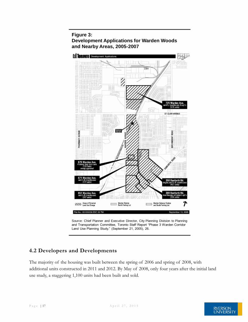
4.1 Housing Characteristics – Development Applications
Figure 3 shows the range and density of development proposals and applications in Warden Woods
in 2006 and 2007. Most parcesl south of St. Clair Avenue were designated for subdivisions of semi-
detached homes and townhouses while parcels north of St. Clair Avenue were designated for
apartments and townhouses.
P a g e | 17 A p r i l 2 7 , 2 0 1 5
Figure 3:
Development Applications for Warden Woods
and Nearby Areas, 2005-2007
Source: Chief Planner and Executive Director, City Planning Division to Planning
and Transportation Committee, Toronto Staff Report “Phase 3 Warden Corridor
Land Use Planning Study.” (September 21, 2005), 26.
4.2 Developers and Developments
The majority of the housing was built between the spring of 2006 and spring of 2008, with
additional units constructed in 2011 and 2012. By May of 2008, only four years after the initial land
use study, a staggering 1,100 units had been built and sold.

P a g e | 18 A p r i l 2 7 , 2 0 1 5
Goldman Centennial Developments built the Regal Crest Homes at 651 Warden Ave, where
Centennial College had been. Semi-detached homes and townhouses were first sold in August, 2006.
Arista Homes built the Lily Factory Towns at 300 Danforth Road, where the Lily Cup Factory had
been. The first townhouses were sold in July 2011.
The Monarch Corporation built the Upper Danforth Village at 350 Danforth Road, where
Pilkington Glass and Patterson Engineering had been. Detached, semi-detached, and townhouse
units were first sold in May, 2006.
Mattamy Homes built the Summerside at 725 Warden Avenue, where the Warden Power Centre had
been. They sold semi-detached homes and townhouses starting in October 2006. They started
selling low-rise apartment units in March, 2007.
First View Homes built Warden Woods at 725 Warden Avenue, where the CN Rail spur had been.
The first townhomes were sold in May, 2012
The Goldman Group built the Ina Grafton Gage Home for seniors at 40 Bell Estate Road, and the
Stafford Homes and Brookfield Homes at 80 Bell Estate Road. These townhouses and stacked
townhouses first started selling in April, 2008. Both properties had been part of the historic
Thornbeck-Bell Estate. The former address was 671 Warden Ave and was the location of the Becker
Milk facility.
In contrast to the vision of the phase 2 and phase 3 reports, and the Secondary Plan, developers did
not build 4-storey to 8-storey residential and mixed use apartments along Warden Avenue. Instead,
new housing along this avenue is predominantly 3-storey walk-up townhouses and a long term care
facility. The greatest divergence from the planning vision is at Warden and St. Clair, city and TTC
lands, where no buildings have yet been built. This Mixed Use area (Map 20 – Land Use in the
Official Plan) was expected to take on the greatest heights and densities in the form of transit-
oriented development given its proximity to Warden Subway Station. Why the Warden and St. Clair
area has not yet developed at the same rapid rate as the surrounding lower-scale townhouses is not
within the scope of this analysis.
4.3 Housing Sales by Type of Unit
According to RealNet, 1,449 units were sold from 2006 to September 2014. As illustrated in Figure
4, over half of the new development consisted of townhouses, followed by low-rise apartments and
semi-detached homes. No high-rises have yet been constructed or sold in the area. This split in unit
types is very similar to the changes in households by type of housing occupied which the Census of
Canada shows from mid-2006 to mid-2011.

P a g e | 19 A p r i l 2 7 , 2 0 1 5
Figure 5 illustrates how rapidly the new housing in Warden Woods was marketed and sold in just
two years. Over 60% of the 1,449 sales took place in the first two years.
According to the National Housing Survey (as adjusted by Environics), median home prices are
about the same as citywide averages, despite newly constructed housing typically costing more than
equivalent existing housing stock. The median value of owner-occupied dwellings in Warden Woods
50
247
833
319
0
200
400
600
800
1000
Detached Semi Detached Townhouse Apartment*
Units
*Apartments include stacked townshouses
Source: RealNet
Figure 4: New Housing Units Sold in Warden Woods by Type, 2006 – 2014 (Jan – Sept)
318
576
212
10640 63 89
414
0
200
400
600
800
2006 2007 2008 2009 2010 2011 2012 2013 2014(Jan -Sept)
Un
its
Source: RealNet
Figure 5:Home Sales Per Year in Warden Woods, 2006-2014

P a g e | 20 A p r i l 2 7 , 2 0 1 5
in mid-2011 was $397,511, compared with the citywide average of $401,400. Over 85% of the
approximately 1,300 occupied units were owner-occupied in mid-2011.33
4.4 Characteristics of Residents34
Figures 6 and 7 highlight the characteristics of the population residing in the two Census of Canada
Dissemination Areas approximating the new Warden Woods community in mid-2011.
The people living in Warden Woods in 2011 (approximately 80% are new since 2006) tended to be
younger, with persons aged 55 years and over accounting for just 16% of the residents. It is likely
that most of the older people were living in the area prior to the development of the new Warden
Woods housing beginning in 2006. A sizeable number of people have neither English nor French as
their mother tongue. The bulk of new residents moved from elsewhere in the city of Toronto
during the 2006-2011 period. A much smaller number of people moved from parts of Canada,
outside the city of Toronto or moved from other countries.
About half of the working residents travelled to and from work by automobile and half by public
transit. Travel by public transit is supported with the Warden subway station located within the
Warden Woods community. The average commute time in one direction was 35.1 minutes.
33 Census of Canada, 2011 adjusted National Household Survey. 34 Statistics on the housing and demographic characteristics of the Warden Woods community are based on information provided by Environics Analytics, which is part of the Environics group of companies, based on the 2006 and 2011 Census of Canada, and the 2011 National Household Survey. It should be noted that Dissemination Areas 20482 and 203503 encompass an area larger than the Warden Woods community. In mid- 2006, prior to housing in Warden Woods being occupied, there were 400 occupied dwellings in these two dissemination areas.

P a g e | 21 A p r i l 2 7 , 2 0 1 5
Warden Woods Population Characteristics, 2011
Age Number Percent
0-14 years 1,090 19
15-24 years 799 14
25-34 years 979 17
35-44 years 1,022 18
45-54 years 875 15
55-64 years 455 8
65+ years 433 8
Total 5,653 100
Language - Mother Tongues
English 2,103 41
French 44 1
Non-Official Languages 2909 58
Total 5,056 100
Mobility Over Past 5 Years
Non-Movers 1,015 21
Moved Elsewhere in the City of Toronto 3,020 61
Moved from Elsewhere in Canada 385 8
Moved from Outside of Canada 505 10
Total 4,925 100
Transportation Mode to Work
Automobile 1,405 51
Public Transit 1,290 47
Walked, Bicycle or Other 35 2
Total 2745 100
Median Commute Time 35.1
Source: Census of Canada and Environics Analytics
minutes
Figure 6:
Figure 7 shows the characteristics of residents by household (or dwelling unit) in Warden Woods.
The heads of households in Warden Woods in mid-2011 spanned the age groups from the 25-34
year olds to the 55 years and over age group. The households headed by an older person were likely
the households living in Warden Woods before 2006. The ages of heads of household, in
combination with the data on family households with children at home, indicate that there is a range
of younger and middle-aged families with children.

P a g e | 22 A p r i l 2 7 , 2 0 1 5
Most households consist of families in contrast with people living alone or living with others but
not in a married or common-law arrangement. The vast majority are homeowners. The median
household income in 2011 was $66,211 and the median value of owned house occupied was
$397,511.
Warden Woods Household Characteristics, 2011
Age of Household Maintainer Number Percent
Under 25 years 40 2
25 to 34 years 405 23
35 to 44 years 455 26
45 to 54 years 420 24
55 years and over 410 24
Total 1,730 100
Households by Type
One-Family 1,277 75
Multiple-Family 101 6
Non-Family 33 19
Total 1,711 100
Census Families in Households
Families with Children 1,108 75
Families without Children 380 25
Total 1,488 100
Presence of Children
Without Children 324 28
With Children 846 72
Total Couple Family Households 1,170 100
*Private Households Only
Tenure
Owner 1,495 86
Renter 240 14
Total Number of Households 1,730 100
Median Household Income $66,221
Median Value of Owned Dwellings $397,511
Source: Census of Canada and Environics Analytics
Figure 7:
4.5 Chapter Summary
Overall, the housing that was built in the newly redeveloped Warden Woods area has been ground-
oriented and affordable from a market perspective. Its rapid sellout indicates that there is a sizable
untapped demand for this type of mainly ownership housing. This housing has also attracted a

P a g e | 23 A p r i l 2 7 , 2 0 1 5
preponderance of families which have neither English nor French as their mother tongue and who
have children at home.
Related Documents