Welcome message from author
This document is posted to help you gain knowledge. Please leave a comment to let me know what you think about it! Share it to your friends and learn new things together.
Transcript


This page was intentionally left blank.

2
CONTENTS
I. Introduction 3 RegionalPlanProcess 4 HomesteadAssociationandBeneficiaries 5-6 PartneringBenefits 7-8
II. Regional Profile HistoryandCulturalAspectsoftheArea 9-10 RegionalLands 11-12 DHHLLands 13-14 RegionalDemographics 15-16 ElectedOfficialsandPoliticalBoundaries 17-18
III. Infrastructure DevelopmentProjects 19-20 Roads 21-22 Water 23-24 Utilities 25-26 PublicFacilities 27-30
IV. Homestead Priorities IssuesandOpportunities 31-32 PotentialProjects 33-34 PriorityProject-WaimeaHawaiianHomestead 35-36 CommunityComplex-Planning PriorityProject-SupportandAssistAgriculturaland 37-38 PastoralLesseesinWaimeaNui PriorityProject-SupportandDevelopAffordable 39-40 HomesteadingAlternativesinWaimeaNui PriorityProject-AssesstheImplicationsofEliminatingRequirements 41-42 toPayPropertyTaxes PriorityProject-AssesstheImplicationsofaNon-Standard 43-44 BuildingCode

3
WhaT arE rEgiONal PlaNS?
Regional Plans are part of DHHL’s three-tiered Planning System. At tier one is the General Plan which articulates long-range goals and objectives for the Department. At the second tier, there are Program Plans that are statewide in focus, covering specific topic areas such as the Native Hawaiian Housing Plan and a Native Hawaiian Development Program Plan. Also at this second tier are the Department’s Island Plans that identify the Department’s land use designations per island which function similar to the counties’ land use zones. The Regional Plans are located at the third tier in the Department’s Planning System which focuses at the community/regional level. The Regional Plans apply the goals, policies, and land use designations to specific geographic regions. The Regional Plans are a means to:
• Identify data - people, lands, and infrastructure of homestead communities and the surrounding region;
• Identify what DHHL and other landowners are planning to do;• Provide the primary mechanism for beneficiary input in the development of their
homestead communities;• Identify issues and potential projects; and • Identify Priority Projects determined by the Department and homestead community.
The Vision of the Department of Hawaiian Home Lands (DHHL) is to build vibrant homestead communities that flourish from the solid foundation of the Hawaiian Home Lands Trust. A trust grounded in commitment to serving and partnering with beneficiaries, implementing sound policies and procedures, following a long-term sustainable financial plan, and practicing an organizational culture that honors the spirit of its founder, Prince Jonah Kühiö Kalanianaÿole. DHHL works in partnership with government agencies, private landowners, non-profit organizations, homestead associations, and other community groups. Regional plans provide the means to solidify visions and partnerships that are essential to effectively manage Hawaiian Home Lands trust lands for the betterment of native Hawaiian beneficiaries.
The Waimea Nui regional plan is one of twenty-one (21) regional plans that DHHL is developing with beneficiaries. In these regional plans, DHHL and its beneficiaries take on a leadership role in the community, working to strengthen the growth of the area, developing partnership to leverage diverse resources and capital investment. The regional plans provide DHHL and the affected homestead community opportunities to determine the future direction of the homestead, assess land use development factors, identify issues and opportunities, and identify the region’s top priority projects slated for implementation within the next three (3) years.
1st Tier
2nd Tier
Regional PlansHomestead Areas, 2-4 year timeframe
3rd Tier
Island PlansGeographic, 10-year timeframe
Strategic Program PlansStatewide, 3-6 year timeframe
General PlanStatewide, 20-year timeframe
DHHL’s Planning System
DHHL’s Planning System
Strategic goals and ObjectivesReaffirm & Assert TRUST Status
Ensuring the Financial Well-being of the TrustProvide Excellent Customer Service
Deliver Diverse Homesteading Opportunities
II.NTRODUCTION

4
hOW arE rEgiONal PlaNS DEvElOPED?
The regional plans are developed in conjunction with lessees of the region as well as regional stakeholders (landowners, agencies, other organizations) in a series of planning meetings as illustrated. During these meetings, issues and opportunities that should be addressed in the regional plan are identified and a list of potential projects is developed to address those issues and opportunities. From this, list lessees determine by consensus their top five (5) priority projects that are written up with project details, budget estimates, and other pertinent project planning information. Draft regional plans are then subject to the approval of the Hawaiian Homes Commission, which means that the Commission and Department officially support the priorities identified in the regional plan.
Upon approval, the homestead community, the Department, and other development partners can seek necessary funding and pursue the implementation of the Priority Projects. The Priority Projects are a key component of aligning support and providing focus to efforts to develop the region. Finally, since
DHHL knows that regional development is a dynamic process with constantly changing opportunities and emerging issues, regular regional plan updates are built into the planning process. In this way, regional plans are updated as needed, which generally have amounted to biennial updates (one update every two years), in order to keep abreast of changing conditions and new opportunities.
hOW arE rEgiONal PlaNS USED?
As a compilation of existing plans and proposed projects for the region, the regional plan helps to coordinate the orderly development of regional infrastructure improvements. With the addition of lessee input in the process, the regional plans become a powerful tool to focus energies and efforts, align interests, and secure funding for the top priorities identified in the regional plan. In this way, regional plans have become a critical tool to unify and support our beneficiary community.
The Regional Plan Deveopment and Update Process
Residential homesteads in Lälämilo The Regional Plan Development and Update Process
• Interview Agencies• Interview Landowners• Demographic Data• Development Trends• Legislation• Funding
• Homestead Leaders• Beneficiaries/Lessees• Surrounding Landowners• Government Agencies• Community Organizations
• Beneficiary• Community
GatherData
ConductPlanningMeetings
IdentifyPotentialProjects
IdentifyPriorityProjects
Updates ImplementProjects
HHCApproval
Regional Plan Process

5
Farming in Pu‘ukapu
Honokäia looking towards Waipio Valley
Entrance to Kühio Hale residential subdivision
Temporary use of lands in Lälämilo for ranching
Cattle drinking water at Ka’alaHomesteads in Lälämilo Keanu‘i‘omanö Stream running through Lälämilo
Cattle changing pastures, Ka’ala
Honokäia to Honoka‘a
I NTRODUCTION

6
he legal basis for the establishment of DHHL is the Hawaiian Homes Commission Act, 1920, as amended (HHCA). It was passed by Congress and signed into law by President Warren Harding on July 9, 1921 (chapter 42, 42 Stat. 108).
A majority of the Waimea nui lands in DHHL inventory today were part of the original lands included in the 1921 HHCA. The first lease in Waimea nui was awarded in 1929 in Waimanu Valley. While there are no longer any leases in the remote valley, over 500 native Hawaiian families have homesteads in the Waimea region.
The Waimea Hawaiian Homesteaders’ Association, Inc. (WHHA) was established in 1952 by lessees that gathered together with the intention of helping each other prosper on their ‘äina. WHHA is a non-profit, community-based socio-economic development organization that seeks to promote, encourage and support the advancement, rehabilitation, self-sufficiency and well-being of its member lessees and families, as well as promoting the integrity and pride of Kanaka Maoli culture, ‘iwi kupuna, and moe pu.
The WHHA meets regularly covering a variety of topics and provides testimony when legislation may impact lessee benefits. WHHA has partnered with and supports the Pu‘ukapu Pastoral Water Group, ‘Oiwi Lökahi O Ka Mokupuni o Keawe, Honokäia Pastoral Acreage ‘Ohana, and Kanu O Ka ‘Äina 21st Century Public Charter School. WHHA is also a founding member of Sovereign Council of the Hawaiian Homelands Assembly.
Kühiö Hale, located on DHHL lands is a facility heavily utilized by the homestead community as well as the general population in Waimea. While undersized for many of its uses, Kühiö Hale provides office space for DHHL and is utilized by the ‘Aha Pünana Leo Hawaiian Immersion School, Kamehameha preschool, the Waimea Homestead Farmer’s Market Corporation, and as a community center by WHHA for meetings and gatherings.
T
Hawaiian Homestead in Waimea Nui
Mike hodsonPresident
M. lili‘uokalani rossVice President
T. Kainoa hodsonSecretary
M. Kanani KapuniaiTreasurer
Nancy hondaAgriculture Director
N. Duke KapuniaiPastoral Director
Corinne WellerResidential Director
Jacy WaiauAt Large Director
Ku‘ulei KeakealaniAt Large Director
haWai‘i iSlaND haWaiiaN hOMESTEaD aSSOCiaTiONS
Waimea Hawaiian Homestead Community AssociationKaumana Hawaiian Home Lands Association Keaukaha Community Association Keaukaha-Pana’ewa Farmers Association Maku’u Farmers Association Pana’ewa Hawaiian Home Lands Community Association Pi’ihonua Homestead Community Association Ka’u Hawaiian Home Lands Association
Homestead Association and Beneficiaries
Homestead Leadership

7
Shared Costs & Multiple Financing Options
DHHL is working in partnership with other government agencies, the private sector and community organizations to develop its lands and improve community life. DHHL believes that partnerships are an effective way to leverage resources and capital investments, mitigate undesirable impacts of development, coordinate area growth, reduce risks in large scale community projects, and create broad community benefits.
These partnerships allow for better prioritization and coordination of infrastructure improvement and the development of regional and public residential facilities. This coordination helps individual organizations achieve their goals while bringing long-term benefits to the community and region.
DHHL brings to these partnerships:Land for development in strategic locations;• Potential use of tax-exempt financing;• Access to legislative appropriations;• Access to federal funding such as HUD, USDA, SBA;• Flexibility in the application of development standards, • zoning, and design; andCultural understanding and resources.•
Külana ‘Öiwi
The consortium partnership includes: DHHL, The Queen Emma Foundation, • Kamehameha Schools, Queen Liliÿuokalani Children’s Center, ALU LIKE, Inc., and the Office of Hawaiian Affairs. The center is designed to house the offices and programs run by these Hawaiian • organizations. The concept of a “one-stop service center” for the Hawaiian people will facilitate • the coordinated delivery of government and private services more efficiently.At Külana ÿÖiwi, each agency provides different services, such as child welfare, • social and educational services for youth, health care services, and vocational training services geared to strengthen Hawaiian families, values and culture.This model is being emulated in development projects proposed around the State.•
Groundbreaking Ceremony
Community Work Project
Public Facilities Partnership
DHHL participated in a number of partnerships involving public facilities and community resources. The most notable partnerships brought together Hawaiian agencies and non-profit organizations into a multi-service complex where a broad range of programs are housed to serve the public. Such multi-service complexes have been built on Hawaiian Home Lands in partnership with Kamehameha Schools, Queen Liliÿuokalani Children’s Center, ALU LIKE, Papa Ola Lökahi, the Office of Hawaiian Affairs, Hawaiian community organizations, and the counties.
These multi-service complexes are housing preschools, offices, meeting facilities, health clinics, and activity centers. Examples of multi-service complexes can be found in Keaukaha and Waimea homestead communities on Hawai‘i Island.
Through a series of management partnerships with DLNR and the Nature Conservancy, unique ecosystems and historic sites are being protected. Examples include the Hakalau Forest Reserve, the ÿÄina Hou Management Area,the Päläÿau and Moÿomomi preserves, the Kalaupapa peninsula, and the Kamäÿoa-Puÿuÿeo National Historic District where koa forests, endangered plants and animals, and native species are being protected for future generations.
I NTRODUCTION

8
DHHL has participated in a number of successful partnerships. A few of these are highlighted here.
Infrastructure Partnership
DHHL has partnered with county governments and utility providers on infrastructure improvements that benefit the entire community. DHHL has participated in water-system development with the counties by providing funding, land easements, and access to federal and state programs. An example of this is the Makuÿu Water System on Hawaiÿi. DHHL has also developed partnerships with Hawaiÿi and Maui counties to better service the homestead communities that are too small for county-only service, or to provide water to homesteads during upset conditions. In Puÿukapu, this partnership paved the way for the development of the Puÿukapu Hybrid Water System that is currently in construction.
DHHL has also provided numerous easements over its lands to electrical, water, telephone, and cable companies to service both homestead areas and the general public.
Residential Partnership
Through partnerships, DHHL has reduced the cost of homes to low-income beneficiaries. DHHL has done this by sharing in the cost of infrastructure, helping to secure tax credits, and using self-help methods of construction. Partnerships in Kapolei resulted in 70 rent-to-own units constructed by Mark Development using low-income tax credits and 45 self-help homes constructed with Menehune Development and Honolulu Habitat for Humanity. In these types of partnerships, DHHL provides the land, secures federal grants, and provides access to, or assistance in, acquiring tax credits, subsidies, or other financing.
Self-help housing partnerships:• - Construction of 41 homes in La‘i ‘Öpua with Kökua Housing Corporation- Construction of 45 homes in Kapolei with Menehune Housing Corporation and Honolulu Habitat for Humanity
Co-location of various Hawaiian agencies and services providers • on O‘ahu, Moloka‘i, and MauiLocation of Kamehameha Preschools on DHHL property on • several islandsPartnership to create a community resource center with • Chaminade University, Association of Hawaiian Civic Clubs, and other Hawaiian organizations
State of Hawaiÿi, Department of AgricultureState of Hawaiÿi, Department of TransportationState of Hawaiÿi, Department of Land and Natural ResourcesState of Hawaiÿi, Department of Education, Honokaÿa ComplexHawaiÿi County, Department of PlanningHawaiÿi County, Department of Public WorksHawaiÿi County, Department of Parks and RecreationHawaiÿi County, Department of Water Supply
Kamehameha preschool on DHHL property.
Waimea Community AssociationMauna Kea Soil & Water Conservation DistrictBig Island Farm BureauKanu o ka ÿÄina Charter SchoolParker RanchKamehameha SchoolsHawai‘i Island Economic Development BoardNorth Hawai‘i Community HospitalNative Hawaiian Health ClinicWaimea Homestead Farmer’s Market Corporation
Stake HolderS and Potential collaboratorS in Waimea
Multi-generational participation in workshops
Beneficiaries moving into their homestead
Partnering Benefits

9
L älämilo and Puÿukapu are located in Waimea, on the plateau between the Kohala Mountains and Mauna Kea, within the judicial district of South Kohala. On one side of the Waimea plains, the Kohala Mountains provide a backdrop of rolling hills, and on the other side, Mauna Kea provides a backdrop of a dramatic snowcapped mountain. The name Waimea literally means “reddish water” (Püku‘i, et al., 1976), named after the discoloration of the stream water from the fertile soil. The literal meaning of Puÿukapu is “sacred hill.” Puÿukapu is known as a place where chiefs and commoners met to discuss important matters (Püku‘i et al. 1974:199). Lälämilo literally means the limb or branch of the milo tree (Püku‘i, et al., 1976). The region of Lälämilo was named for the chief Lälämilo, who gained fame as an expert fisherman (Maly 1999:27).
Dating back to ancient Hawaiian history, Waimea has been associated with royalty and chiefly lineages. Famous for its lush pastures, misty rain, and fog, the area was once known as “Hulilauali‘i,” meaning “Calabash of many chiefs,” due to the multitude of chiefs living in the Waimea area (Haun, et. Al, 2002).
True to its name, “place of destiny,” Kohala was the birthplace of Kamehameha I, who unified all the islands under one ruler (Environmental Communications 1976). During the time of Kamehameha’s rise, Waimea and South Kohala became one of the most important regions in the islands (Townscape 1992:16). Being a favored location, several heiau and agricultural field systems were located in the area. Desired by the chiefs, Kamehameha I kept the farming lands of Pu‘ukapu for royal agricultural sustenance. A large agricultural field system is still evident in Waimea today.
In old stories, legends, and songs of Hawai‘i, Waimea was a land famous for brave warriors admired by the aliÿi (kings) and the site for many battles. In ancient Hawaiian history, the Battle of Höküÿula was fought on the plains of Waimea. This battle is important in Hawaiian history, as one of the first major wars between Maui and the island of Hawai‘i. During Kamehameha’s rise to power, Waimea was famous for its fierce
King Kamehameha trained his fiercest warriors (Kïpu‘upu‘u) in the Waimea area.
Majestic Mauna Kea as seen from Hilo
II.R egional Profile
10
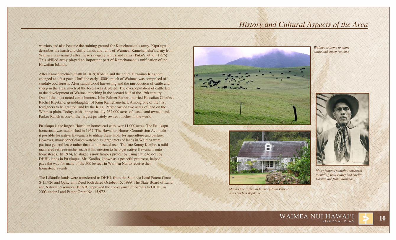
Waimea is home to many cattle and sheep ranches
Many famous paniolo (cowboys) including Ikua Purdy and Archie Ka‘aua are from Waimea.
Mana Hale, original home of John Parker and Chiefess Kipikane
warriors and also became the training ground for Kamehameha’s army. Kïpuÿupuÿu describes the harsh and chilly winds and rains of Waimea. Kamehameha’s army from Waimea was named after these ravaging winds and rains (Püku‘i, et al., 1976). This skilled army played an important part of Kamehameha’s unification of the Hawaiian Islands.
After Kamehameha’s death in 1819, Kohala and the entire Hawaiian Kingdom changed at a fast pace. Until the early 1800s, much of Waimea was comprised of sandalwood forests. After sandalwood harvesting and the introduction of cattle and sheep in the area, much of the forest was depleted. The overpopulation of cattle led to the development of Waimea ranching in the second half of the 19th century. One of the most noted cattle hunters, John Palmer Parker, married Hawaiian Chiefess, Rachel Kipikane, granddaughter of King Kamehameha I. Among one of the first foreigners to be granted land by the King, Parker owned two acres of land on the Waimea plain. Today, with approximately 262,000 acres of leased and owned land, Parker Ranch is one of the largest privately owned ranches in the world.
Puÿukapu is the largest Hawaiian homestead with over 11,000 acres. The Puÿukapu homestead was established in 1952. The Hawaiian Homes Commission Act made it possible for native Hawaiians to utilize these lands for agriculture and pasture.However, many beneficiaries watched as large tracts of lands in Waimea were put into general lease rather than to homestead use. The late Sonny Kaniho, a mild mannered retiree/rancher made it his mission to help get native Hawaiians onto homesteads. In 1974, he staged a now famous protest by using cattle to occupy DHHL lands in Pu‘ukapu. Mr. Kaniho, known as a peaceful protestor, helped pave the way for many of the 500 lessees in Waimea Nui to receive their homestead awards.
The Lälämilo lands were transferred to DHHL from the State via Land Patent Grant S-15,926 and Quitclaim Deed both dated October 15, 1999. The State Board of Land and Natural Resources (BLNR) approved the conveyance of parcels to DHHL in 2003 under Land Patent Grant No. 15,972.
History and Cultural Aspects of the Area

11
Pat
h: Q
:\Haw
aii\D
HH
L H
awai
i Hom
este
ad P
lans
\Lal
amilo
-Puu
kapu
\GIS
\pro
ject
s\20
11 p
lan
revi
sion
\Reg
iona
l Lan
d O
wne
rs.m
xdP
DF
- Q
:\Haw
aii\D
HH
L H
awai
i Hom
este
ad P
lans
\Lal
amilo
-Puu
kapu
\PD
F\2
011
Pla
n R
evis
ion
Source:
Disclaimer: This Graphic has been prepared for general planning purposes only and should not be used for boundary Interpretations or other spatial analysis.DATE: 8/30/2011
Que
en K
aahu
man
u H
wy
WAIMANU
PUÿUKAPU
NIENIE
HONOKÄIA
LÄLÄMILO
PAUAHIKAWAIHAE
WAIKOLOA-WAIÿALEÿALE
KAMOKU-KAPULENA
Hapuna BeachState Park
Mämalahoa Hwy
Old Mämalah oa Hw y
Ko
hala M
ountain R d
Mäm
alah
oa H
wy
PACIFIC OCEAN
PACIFICOCEAN
Honokaa-Wapio Rd
STATE
PARKERRANCH
KAMEHAMEHASCHOOL LANDS
STATE
QUEEN EMMAFOUNDATION
STATE
WAIKOLOALAND & CATTLE
PARKER RANCH
COUNTYGOVT.
KAMEHAMEHASCHOOLS LANDS
PARKERRANCH
PARKERRANCH
KEONIKI
LEGENDDHHL
Lälämilo-PuÿukapuDHHL-Outside of Regional Planning Area
Large Land OwnersParker RanchKamehameha SchoolsQueen Emma FoundationGovt. County of HawaiiGovt. FederalGovt. StateWaikoloa Land & CattleMajor Roads
FEDERALGOVT.
Kawai hae Rd.
3
4
2
1
Pat
h: Q
:\Haw
aii\D
HH
L H
awai
i Hom
este
ad P
lans
\Lal
amilo
-Puu
kapu
\GIS
\pro
ject
s\20
11 p
lan
revi
sion
\Reg
iona
l Lan
d O
wne
rs.m
xdP
DF
- Q
:\Haw
aii\D
HH
L H
awai
i Hom
este
ad P
lans
\Lal
amilo
-Puu
kapu
\PD
F\2
011
Pla
n R
evis
ion
Source:
Disclaimer: This Graphic has been prepared for general planning purposes only and should not be used for boundary Interpretations or other spatial analysis.DATE: 8/30/2011
Que
en K
aahu
man
u H
wy
WAIMANU
PUÿUKAPU
NIENIE
HONOKÄIA
LÄLÄMILO
PAUAHIKAWAIHAE
WAIKOLOA-WAIÿALEÿALE
KAMOKU-KAPULENA
Hapuna BeachState Park
Mämalahoa Hwy
Old Mämalah oa Hw y
Ko
hala M
ountain R d
Mäm
alah
oa H
wy
PACIFIC OCEAN
PACIFICOCEAN
Honokaa-Wapio Rd
STATE
PARKERRANCH
KAMEHAMEHASCHOOL LANDS
STATE
QUEEN EMMAFOUNDATION
STATE
WAIKOLOALAND & CATTLE
PARKER RANCH
COUNTYGOVT.
KAMEHAMEHASCHOOLS LANDS
PARKERRANCH
PARKERRANCH
KEONIKI
LEGENDDHHL
Lälämilo-PuÿukapuDHHL-Outside of Regional Planning Area
Large Land OwnersParker RanchKamehameha SchoolsQueen Emma FoundationGovt. County of HawaiiGovt. FederalGovt. StateWaikoloa Land & CattleMajor Roads
FEDERALGOVT.
Kawai hae Rd.
R egional Profile

12
Major Land OwnersParker ranch Foundation Trust – Parker Ranch, founded in 1847, is one of the largest and oldest ranches in the United States. With a total of 150,000 acres on the Big Island, Parker Ranch owns much of the developable land in the central portion of Waimea. Its projects include the Waimea Town Center project and a new subdivision adjacent to the Parker Ranch Historic Homes. After the passing of Parker Ranch’s last owner, Richard Smart, the assets of the Ranch were left to the Parker Ranch Foundation Trust to benefit the residents of Waimea. The four beneficiaries to the trust are Parker School Trust Corporation, Hawai‘i Preparatory Academy, North Hawai‘i Com-munity Hospital (Lucy Henriques Medical Center has now merged with NHCH), and the Hawai‘i Community Foundation (which distributes its proceeds to non-profit organizations in Waimea). Richard Smart sought to provide for the educational, health, and cultural needs of the town.
Kamehameha Schools – Kamehameha Schools is the largest private landowner in the state of Hawai‘i. Kamehameha Schools is a private, charitable, perpetual trust dedicated to the education of Hawaiian children and youth. Established in her will of 1883, the Kamehameha Schools is a legacy of Princess Bernice Pauahi Bishop, great-granddaughter and last direct royal descendant of King Kamehameha the Great. Income generated from numerous investments, and residential, commercial, and resort leases, fund the schools’ maintenance and educational services.
Queen Emma Foundation - The Queen Emma Foundation is a non-profit subsidiary of The Queen’s Health Systems. The Queen Emma Foundation manages more than 12,000 acres of land. Most noteworthy of the foundation’s lands are located in Waikïkï and Hälawa on O‘ahu and in Kawaihae on Hawai‘i. The lands were handed down in trust by the Queen upon her death in 1885. Income from the foundation’s assets is dedicated to supporting and improving services offered to the community by The Queen’s Health Systems. The Queen’s Health Systems, which includes Queens Medical Center, is the largest comprehensive health care delivery system in Hawai‘i, providing a full range of emergency, inpatient and outpatient services. Foundation support also extends to other health care entities and programs that benefit the community.
Waikoloa land and Cattle - Waikoloa Land and Cattle owns 31,000 acres of land in the South Kohala region. The company owns the 1,350-acre Waikoloa Beach Resort, which houses the 548-room Waikoloa Hotel operated by Marriot and the 1,241-room Hilton Waikoloa Hotel.
1
2
3
4
Princess Bernice Pauahi BishopKamehameha Schools
Queen Emma and King Kamehameha IVQueen Emma Foundation
Richard Smart Parker Ranch Foundation
Regional Lands

13
Dhhl Landslälämilo – Lälämilo is a 230+ acre parcel planned for residential, agricultural, and possibly commercial development. A total of 442 residential homestead lots are planned in the area. Originally 1,722 acres of land were offered for transfer by the State. However, due to the amount of unexploded military ordnances on the larger parcel, DHHL opted to take just a portion of the site. As of June 2011, there are 30 residential lessees in Lälämilo.
Pu‘ukapu – Pu‘ukapu 1, 2, and 3 are located in the southeast section of Waimea with a over 13,000+ acres. The land use for most of the Pu‘ukapu parcels is predominantly pasture. Parcels in Pu‘ukapu 2 and 3 are currently inaccessible for any type of development. The lands being examined for development are located in Pu‘ukapu 1.
Pu‘ukapu 1 is comprised of nearly 11,000 acres. Except for the northern portion of Pu‘ukapu 1, the parcel is primarily in pasture use. Farm lots are located in the area between Kühiö Village and Pu‘u Pülehu. Kühiö Village (residential lots) is located at the fringe of Waimea Village, while Pu‘u Pülehu (residential lots) is closer to the eastern boundary. A portion of the land has been taken out of homestead for the protection of special resourc-es. The eastern boundary of the Pu‘ukapu tract coincides with the boundary between the South Kohala and Hämäkua Districts. There were a total of 454 lessees in Pu‘ukapu as of June 2011.
2
1
1
2
3
4
5
6
7
8
Kailua-Kona
Kawaihae
ÿUpolu
Ka Lae
Hilo
Punaluÿu
Volcano
Waimea
Land Use DesignationsDHHL is not subject to the County of Hawaiÿi land use planning allocation guidelines or zoning regulations. Being exempt from these regulations provides DHHL with the opportunity as well as the responsibility to ensure that the designated land uses are appropriate based on the needs of the Department, its beneficiaries, as well as protective of key environmental and cultural resources. DHHL lands are categorized into ten different land use designations or zones. There are four homesteading designations: Residential, Subsistence Agriculture, Supplemental Agriculture, and Pastoral. The remaining six designations are General Agricul-ture, Special District, Community Use, Conservation, Commercial and Industrial. While lands designated “General Agriculture” may be utilized for agriculture, it is also the designation given to lands that DHHL has not determined the final disposition.
land Summarylälämilo 232 acresPu‘ukapu 1-3 13,053 acresPauahi 557 acresWaimanu 200 acresKeoniki 230 acresKamoku-Kapulena- 4,735 acres Waikoloa-Wai‘ale‘alehonokäia 3,243 acresNi‘eni‘e 7,135 acresTOTal 29,385 acres
Acreages are approximate.
R egional Profile
14
Pauahi - Pauahi is a 550+ -acre parcel designated for pastoral use. The parcel is split by Ko-hala Mountain Road. In the 1976 Hawaiian Home Lands General Plan, recommendations were made to convert from general lease to pastoral use by eligible beneficiaries. The current Hawai‘i Island Plan land use designation for Pauahi recommends consideration for pastoral homesteads.
Waimanu - DHHL has 200 acres within the 3,600 acre pristine Waimanu Valley along the Hämäkua Coastline. The valley is accessible via a 7.5-mile foot trail from Waipi‘o Valley. The area has been proposed for joint State and Federal management in the Natural Area Reserves System. DHHL has designated its Waimanu holdings for conservation.
Keoniki - is a 230-acre parcel along the lower slopes of the Kohala Mountains. The area has been designated for pastoral. However, with temperatures ranging from 55°F-80°F, 75-100 inches of annual rainfall, and predominantly silt-loam soils, other agricultural opportunities are possible where steep slope and site access are not limited.
Kamoku-Kapulena -Waikoloa-Wai‘ale‘ale - consists of approximately 4,700+ acres. A portion of the area within Kamoku is utilized for pastoral homesteading with 12 pastoral homesteads in 2011.
honokäia - Honokäia is a 3,200+ -acre parcel adjacent to Hawaiÿi Belt Road. In 2002, this parcel was evaluated for homesteading opportunities and was recommended agricultural based development. A portion of Honokäia has been opened up for pastoral leases. As of June 2011, 24 pastoral homestead leases were awarded.
Niÿeniÿe - This parcel was part of the original lands provided for the fulfillment of the Hawai-ian Homestead Act. However, over 600 acres were set aside for the Hämäkua Forest Preserve in 1928 by proclamation by then Governor Wallace Farrington. The parcel includes over 7,100+ acres located the cool Hämäkua District. As of June 2011, 11 pastoral homestead leases were located in Nienie. The location of these leases impedes access to undeveloped areas hindering the development of agribusiness on DHHL lands.
Note: Land use designations included in the General and Island Plans are recommendations based on suitabil-ity. Development based on these designations is based on the economic feasibility of development as well as the availability of funds.
5
6
7
8
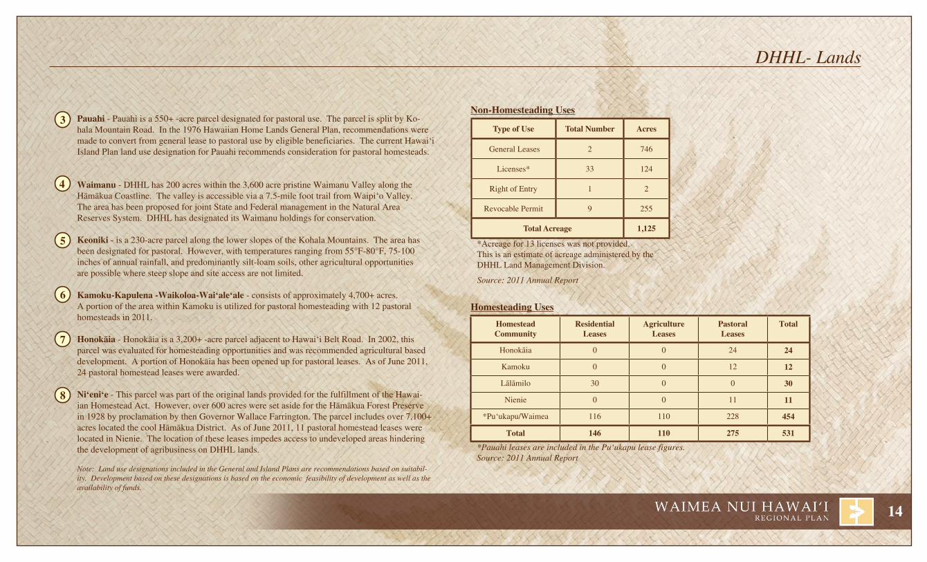
Type of Use Total Number Acres
General Leases 2 746
Licenses* 33 124
Right of Entry 1 2
Revocable Permit 9 255
Total Acreage 1,125
*Acreage for 13 licenses was not provided. This is an estimate of acreage administered by the DHHL Land Management Division.
Source: 2011 Annual Report
Homesteadcommunity
residentialleases
agricultureleases
Pastoralleases
total
Honokäia 0 0 24 24
Kamoku 0 0 12 12
Lälämilo 30 0 0 30
Nienie 0 0 11 11
*Pu‘ukapu/Waimea 116 110 228 454
total 146 110 275 531
*Pauahi leases are included in the Pu‘ukapu lease figures.Source: 2011 Annual Report
3
4
DHHL- Lands
Non-homesteading Uses
homesteading Uses

15
Waimea Nui falls within two Census Designated Places (CDP). Lälämilo and Puÿukapu are located within Waimea as designated by the Federal Government and the South Kohala District as designated by the County of Hawai‘i. Honokäia is located within the County district Hämäkua. Honokäia is part of the Honokaÿa CDP. The U.S. Census Bureau working with DHHL began collecting important demographic data for Hawaiian homesteads. Census data was collected for Lälämilo and Puÿukapu Hawaiian Home Lands in 2010. Honokäia Hawaiian Home Lands were designated in the 2010 Census, but no data was available for collection..
The U.S. Census Bureau has released some of the population data collected during 2010. The remainder of the information provided was collected from the U.S. Census Quickfacts 2005-2009, 2000 Census, South Kohala Community Development Plan and from the Hawaiÿi Island Board of Realtors.
Originally a small rural village with a mild, favorable climate, Waimea is one of the largest communi-ties in South Kohala. Honokaÿa town is the primary settlement within Hämäkua. Both towns have grown over the last 50 years due to their location on a main commuter road between the resorts and the east side of the island. The 2010 Census estimates the resident population of the Waimea CDP at 9,212 persons, a 31% increase over the population recorded ten years earlier. According to the South Kohala Community Development Plan, the population in Waimea is expected to double between 2000 and 2020. The 2010 Census recorded a resident population of 2,258 within the Honokaÿa CDP, a 1% increase from ten years earlier. The 2010 Census recorded 962 residents living within the homestead communities of Puÿukapu and Lälämilo.
The median age in 2010 within Waimea was 37, in Honokaÿa 41, in Lälämilo 46, and in Puÿukapu 37. The median age in 2000 was slightly younger at 36.5 years in Waimea, and 40.2 in Honokaÿa.
Waimea has a large Native Hawaiian/Pacific Islander population at 15.2 percent, compared to the rest of Hawai‘i County’s Native Hawaiian/Pacific Islander population at 11.3 percent. The Native Hawaiian/Pacific Islander population in Honokaÿa was lower than the county average at 3.9%. Within the home-stead communities, the Native Hawaiian/Pacific Islander population is at 40.6% in Lälämilo and 42.9% in Puÿukapu. Those with two or more races made up the largest percentage of the Waimea population at 29.1 percent. According to the 2000 Census, the median household income is higher in Waimea at $51,150, compared to the Hawaiÿi Island median of $39,805. A 2009 estimate prepared by the U.S. Census showed an increase to $76,722 and $55,645 respectively.
Waimea is the most productive vegetable farming area in Hawai‘i County as reported in the County of Hawai‘i General Plan. Ranching is the considered the primary agribusiness in Waimea. However, the primary source of employment (1/3 of Waimea’s workforce) is the tourism industry. Agribusiness (ranching and farming) is the primary source of employment in Hämäkua. However, activities associated with the astronomical facilities atop Mauna Kea also contribute to the Hämäkua economy.
Hawai‘i County has the most diversified economy among the Neighbor Islands. As one of the most innovative Counties in the State, Hawai‘i County leads the way in fields such as astronomy, renewable energy, diversified agriculture, and alternative therapy.
Workforce Breakdown by Trade within Waimea CDP
Other Services4%
Agriculture6%
Public Administration 2%
Leisure33%
Education/Social
Services4%
Manufacturing, Trade, Transportation,
Warehousing & Utilities8%
Construction12%
Professional, Information,Scientific,
Management,Administrative &
Waste Management12%
Retail9%
Finance2%
H omestead Regional Profile
16
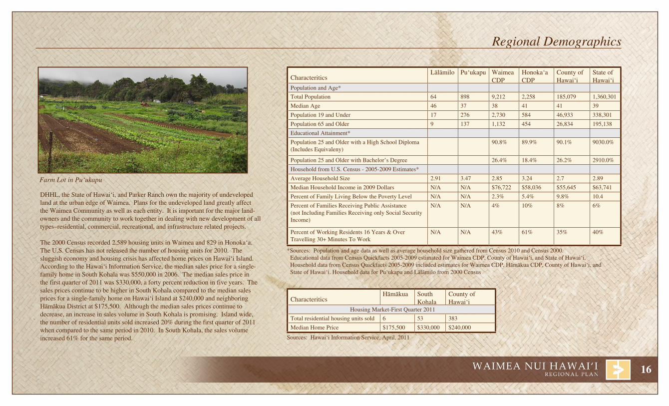
DHHL, the State of Hawai‘i, and Parker Ranch own the majority of undeveloped land at the urban edge of Waimea. Plans for the undeveloped land greatly affect the Waimea Community as well as each entity. It is important for the major land-owners and the community to work together in dealing with new development of all types–residential, commercial, recreational, and infrastructure related projects.
The 2000 Census recorded 2,589 housing units in Waimea and 829 in Honokaÿa. The U.S. Census has not released the number of housing units for 2010. The sluggish economy and housing crisis has affected home prices on Hawaiÿi Island. According to the Hawai‘i Information Service, the median sales price for a single-family home in South Kohala was $550,000 in 2006. The median sales price in the first quarter of 2011 was $330,000, a forty percent reduction in five years. The sales prices continue to be higher in South Kohala compared to the median sales prices for a single-family home on Hawaiÿi Island at $240,000 and neighboring Hämäkua District at $175,500. Although the median sales prices continue to decrease, an increase in sales volume in South Kohala is promising. Island wide, the number of residential units sold increased 20% during the first quarter of 2011 when compared to the same period in 2010. In South Kohala, the sales volume increased 61% for the same period.
CharacteriticsLälämilo Pu‘ukapu Waimea
CDPHonoka‘aCDP
County ofHawai‘i
State of Hawai‘i
Population and Age*
Total Population 64 898 9,212 2,258 185,079 1,360,301
Median Age 46 37 38 41 41 39
Population 19 and Under 17 276 2,730 584 46,933 338,301
Population 65 and Older 9 137 1,132 454 26,834 195,138
Educational Attainment*
Population 25 and Older with a High School Diploma (Includes Equivaleny)
90.8% 89.9% 90.1% 9030.0%
Population 25 and Older with Bachelor’s Degree 26.4% 18.4% 26.2% 2910.0%
Household from U.S. Census - 2005-2009 Estimates*
Average Household Size 2.91 3.47 2.85 3.24 2.7 2.89
Median Household Income in 2009 Dollars N/A N/A $76,722 $58,036 $55,645 $63,741
Percent of Family Living Below the Poverty Level N/A N/A 2.3% 5.4% 9.8% 10.4
Percent of Families Receiving Public Assistance (not Including Families Receiving only Social Security Income)
N/A N/A 4% 10% 8% 6%
Percent of Working Residents 16 Years & Over Travelling 30+ Minutes To Work
N/A N/A 43% 61% 35% 40%
*Sources: Population and age data as well as average household size gathered from Census 2010 and Census 2000. Educational data from Census Quickfacts 2005-2009 estimated for Waimea CDP, County of Hawai‘i, and State of Hawai‘i. Household data from Census Quickfacts 2005-2009 included estimates for Waimea CDP, Hämäkua CDP, County of Hawai‘i, and
State of Hawai‘i. Household data for Pu‘ukapu and Lälämilo from 2000 Census
CharacteriticsHämäkua South
KohalaCounty ofHawai‘i
Housing Market-First Quarter 2011
Total residential housing units sold 6 53 383
Median Home Price $175,500 $330,000 $240,000
Sources: Hawai‘i Information Service, April, 2011
Farm Lot in Pu‘ukapu
Regional Demographics

17
Disclaimer: The information and recommendations expressed in this report are not necessarily endorsed by the people depicted on this page. These same people cannot be held liable for the information presented or the results of the report.
State,Federal,&CountyLeaders Malama Solomon
State Senate District 1
Josh green, M.D.State Senate
District 3
Mark M. NakashimaState House of Representatives
District 1
alapaki Nahale-aHawaiian Homes Commission
Chairman
Neil abercrombieGovernor
Brian SchatzLieutenant Governor
Daniel K. inouyeU.S. Senator
Daniel K. akakaU.S. Senator
Mazie K. hironoCongressional District 2
Billy KenoiHawai‘i Mayor
Pete hoffmannCouncil District 9
robert K. lindsey, Jr.Office of Hawaiian Affairs
Trustee, Hawai‘i
Dominic YagongCouncil District 1
Cindy EvansState House of Representatives
District 7
ian lee loy Hawaiian Homes CommissionEast Hawai‘i Commissioner
Colette Y. MachadoOffice of Hawaiian Affairs
Chairperson
leimana K. DaMateHawaiian Homes CommissionWest Hawai‘i Commissioner
H omestead Regional Profile
18
Disclaimer: The information and recommendations expressed in this report are not necessarily endorsed by the people depicted on this page. These same people cannot be held liable for the information presented or the results of the report. P
ath:
Q:\H
awai
i\DH
HL
Haw
aii H
omes
tead
Pla
ns\L
alam
ilo-P
uuka
pu\G
IS\p
roje
cts\
2011
pla
n re
visi
on\P
oliti
cal_
Bou
ndar
ies-
Sen
ate.
mxd
PD
F -
Q:\H
awai
i\DH
HL
Haw
aii H
omes
tead
Pla
ns\L
alam
ilo-P
uuka
pu\P
DF
\201
1 P
lan
Rev
isio
n
Source:
Disclaimer: This Graphic has been prepared for general planning purposes only and should not be used for boundary Interpretations or other spatial analysis.DATE: 8/30/2011
WAIMANU
PUÿUKAPU
NIENIE
HONOKÄIA
LÄLÄMILO
PAUAHIKAWAIHAE
Mämalahoa Hwy
Old Mämalah oa Hw y
Ko
hala M
ountain R d
Kawaihae R d
Mäm
alah
oa
Hw
y
PACIFIC OCEAN
PACIFICOCEAN
Honokaa-Wapio Rd
KEONIKI
WAIKOLOA-WAIÿALEÿALE
KAMOKU-KAPULENA
Kamam
alu St
Que
en K
aahu
man
u H
wy
Akoni Pule Hwy
Pat
h: Q
:\Haw
aii\D
HH
L H
awai
i Hom
este
ad P
lans
\Lal
amilo
-Puu
kapu
\GIS
\pro
ject
s\20
11 p
lan
revi
sion
\Pol
itica
l_B
ound
arie
s-C
ount
y.m
xdP
DF
- Q
:\Haw
aii\D
HH
L H
awai
i Hom
este
ad P
lans
\Lal
amilo
-Puu
kapu
\PD
F\2
011
Pla
n R
evis
ion
Source:
Disclaimer: This Graphic has been prepared for general planning purposes only and should not be used for boundary Interpretations or other spatial analysis.DATE: 8/30/2011
WAIMANU
PUÿUKAPU
NIENIE
HONOKÄIA
LÄLÄMILO
PAUAHIKAWAIHAE
Mämalahoa Hwy
Old Mämalah oa Hw y
Ko
hala M
ountain R d
Kawaihae R d
Mä
ma
laho
a H
wy
PACIFIC OCEAN
PACIFICOCEAN
Honokaa-Wapio Rd
KEONIKI
WAIKOLOA-WAIÿALEÿALE
KAMOKU-KAPULENA
Que
en K
aahu
man
u H
wy
Akoni Pule Hwy
Pat
h: Q
:\Haw
aii\D
HH
L H
awai
i Hom
este
ad P
lans
\Lal
amilo
-Puu
kapu
\GIS
\pro
ject
s\20
11 p
lan
revi
sion
\Pol
itica
l_B
ound
arie
s-H
ouse
.mxd
PD
F -
Q:\H
awai
i\DH
HL
Haw
aii H
omes
tead
Pla
ns\L
alam
ilo-P
uuka
pu\P
DF
\201
1 P
lan
Rev
isio
n
Source:
Disclaimer: This Graphic has been prepared for general planning purposes only and should not be used for boundary Interpretations or other spatial analysis.DATE: 8/30/2011
WAIMANU
PUÿUKAPU
NIENIE
HONOKÄIA
LÄLÄMILO
PAUAHIKAWAIHAE
Mämalahoa Hwy
Old Mämalah oa Hw y
Ko
hala M
ountain R d
Kawaihae R d
Mä
ma
lah
oa H
wy
PACIFIC OCEAN
PACIFICOCEAN
Honokaa-Wapio Rd
KEONIKI
WAIKOLOA-WAIÿALEÿALE
KAMOKU-KAPULENA
Que
en K
aahu
man
u H
wy
Akoni Pule Hwy
Pat
h: Q
:\Haw
aii\D
HH
L H
awai
i Hom
este
ad P
lans
\Lal
amilo
-Puu
kapu
\GIS
\pro
ject
s\20
11 p
lan
revi
sion
\Pol
itica
l_B
ound
arie
s-C
ongr
ess.
mxd
PD
F -
Q:\H
awai
i\DH
HL
Haw
aii H
omes
tead
Pla
ns\L
alam
ilo-P
uuka
pu\P
DF
\201
1 P
lan
Rev
isio
n
Source: Disclaimer: This Graphic has been prepared for general planning purposes only and should not be used for boundary Interpretations or other spatial analysis.
DATE: 8/30/2011
WAIMANU
PUÿUKAPU
NIENIE
HONOKÄIA
LÄLÄMILO
PAUAHIKAWAIHAE
Mämalahoa Hwy
Old Mämalah oa Hw y
Ko
hala M
ountain R d
Kawaihae R d
Mä
ma
laho
a H
wy
PACIFIC OCEAN
PACIFICOCEAN
Honokaa-Wapio Rd
KEONIKI
WAIKOLOA-WAIÿALEÿALE
KAMOKU-KAPULENA
Que
en K
aahu
man
u H
wy
Akoni Pule Hwy
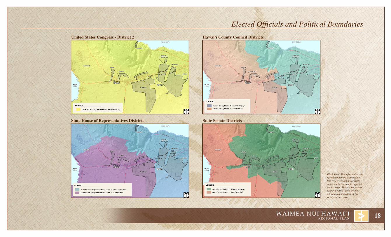
United States Congress - District 2
State house of representatives Districts
hawai‘i County Council Districts
State Senate Districts
Elected Officials and Political Boundaries

19
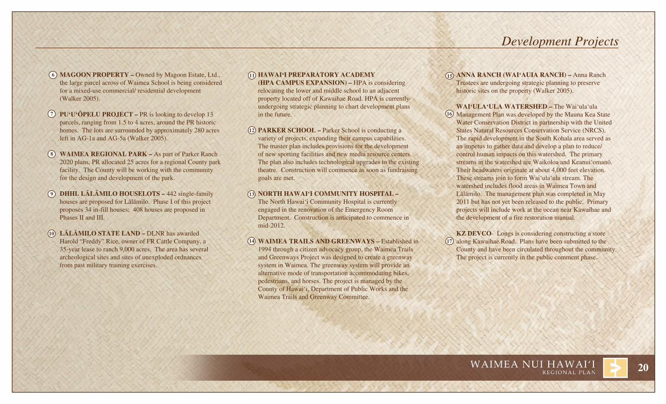
OKaDa FarM – Okada Farm, the largest contiguous farm lots in Waimea, has plans to be subdivided into AG-1a lots (Walker 2005).
KalOKO DEvElOPMENT iNC. – Kaloko Development Inc. has plans to construct a 40-lot subdivision on a 9.18 acre parcel along Lindsey Road (Waimea Community Development Plan Committee 2005).
ParKEr raNCh 2020 (WaiMEa TOWN CENTEr PlaN) – Parker Ranch (PR) began the planning for the Waimea Town Center Plan in the early 1980s. In 1992, the original plans were approved and adopted by the County. In 1994, PR revised the Waimea Town Center Plan in response to community concerns. The revised plan was approved in 1996. PR is currently revising the plan.
hOlOhOlO Kü – Holoholo Kü is a residential development by Kamuela Associates LLC, located within the Waimea Town Center. The first phase of development, completed in 2002, included 44 single-family condominium ranch homes. A total of 132 units are proposed for the entire site.
lUala‘i aT ParKEr raNCh – Developed by Kaomalo LLC, Schuler Homes, Inc., and PR, Luala‘i at Parker Ranch will consist of approximately 322 residential units, parks, and open space areas on 75 acres of land. The project is located within the Waimea Town Center. The first phase of development, completed in 2002, created 55 units.
1
2
3
4
5
Areas of proposed development.
Pat
h: Q
:\Haw
aii\D
HH
L H
awai
i Hom
este
ad P
lans
\Lal
amilo
-Puu
kapu
\GIS
\pro
ject
s\20
11 p
lan
revi
sion
\Reg
iona
l Lan
d O
wne
rs.m
xdP
DF
- Q
:\Haw
aii\D
HH
L H
awai
i Hom
este
ad P
lans
\Lal
amilo
-Puu
kapu
\PD
F\2
011
Pla
n R
evis
ion
Source:
Disclaimer: This Graphic has been prepared for general planning purposes only and should not be used for boundary Interpretations or other spatial analysis.DATE: 8/30/2011
Que
en K
aahu
man
u H
wy
WAIMANU
PUÿUKAPU
NIENIE
HONOKÄIA
LÄLÄMILO
PAUAHIKAWAIHAE
WAIKOLOA-WAIÿALEÿALE
KAMOKU-KAPULENA
Hapuna BeachState Park
Mämalahoa Hwy
Old Mämalah oa Hw y
Ko
hala M
ountain R d
Mäm
alah
oa H
wy
PACIFIC OCEAN
PACIFICOCEAN
Honokaa-Wapio Rd
STATE
PARKERRANCH
KAMEHAMEHASCHOOL LANDS
STATE
QUEEN EMMAFOUNDATION
STATE
WAIKOLOALAND & CATTLE
PARKER RANCH
COUNTYGOVT.
KAMEHAMEHASCHOOLS LANDS
PARKERRANCH
PARKERRANCH
KEONIKI
LEGENDDHHL
Lälämilo-PuÿukapuDHHL-Outside of Regional Planning Area
Large Land OwnersParker RanchKamehameha SchoolsQueen Emma FoundationGovt. County of HawaiiGovt. FederalGovt. StateWaikoloa Land & CattleMajor Roads
FEDERALGOVT.
Kawai hae Rd.
1
16
15
1413
12
11
10
9
8
7 6
5 4
3
217
II.I INFRASTRUTURE
20
haWai‘i PrEParaTOrY aCaDEMY (hPa CaMPUS ExPaNSiON) – HPA is considering relocating the lower and middle school to an adjacent property located off of Kawaihae Road. HPA is currently undergoing strategic planning to chart development plans in the future.
ParKEr SChOOl – Parker School is conducting a variety of projects, expanding their campus capabilities. The master plan includes provisions for the development of new sporting facilities and new media resource centers. The plan also includes technological upgrades to the existing theatre. Construction will commence as soon as fundraising goals are met.
NOrTh haWai‘i COMMUNiTY hOSPiTal – The North Hawai‘i Community Hospital is currently engaged in the renovation of the Emergency Room Department. Construction is anticipated to commence in mid-2012.
WaiMEa TrailS aND grEENWaYS – Established in 1994 through a citizen advocacy group, the Waimea Trails and Greenways Project was designed to create a greenway system in Waimea. The greenway system will provide an alternative mode of transportation accommodating bikes, pedestrians, and horses. The project is managed by the County of Hawai‘i, Department of Public Works and the Waimea Trails and Greenway Committee.
6
7
8
9
10
11
13
14
15
16
MagOON PrOPErTY – Owned by Magoon Estate, Ltd., the large parcel across of Waimea School is being considered for a mixed-use commercial/ residential development (Walker 2005).
PU‘U‘ÖPElU PrOJECT – PR is looking to develop 13 parcels, ranging from 1.5 to 4 acres, around the PR historic homes. The lots are surrounded by approximately 280 acres left in AG-1a and AG-5a (Walker 2005).
WaiMEa rEgiONal ParK – As part of Parker Ranch 2020 plans, PR allocated 25 acres for a regional County park facility. The County will be working with the community for the design and development of the park.
Dhhl lÄlÄMilO hOUSElOTS – 442 single-family houses are proposed for Lälämilo. Phase I of this project proposes 34 in-fill houses; 408 houses are proposed in Phases II and III.
lÄlÄMilO STaTE laND – DLNR has awarded Harold “Freddy” Rice, owner of FR Cattle Company, a 35-year lease to ranch 9,000 acres. The area has several archeological sites and sites of unexploded ordnances from past military training exercises.
aNNa raNCh (Wai‘aUia raNCh) – Anna Ranch Trustees are undergoing strategic planning to preserve historic sites on the property (Walker 2005).
Wai‘Ula‘Ula WaTErShED – The Wai‘ula‘ula Management Plan was developed by the Mauna Kea State Water Conservation District in partnership with the United States Natural Resources Conservation Service (NRCS). The rapid development in the South Kohala area served as an impetus to gather data and develop a plan to reduce/control human impacts on this watershed. The primary streams in the watershed are Waikoloa and Keanui‘omanö. Their headwaters originate at about 4,000 feet elevation. These streams join to form Wai‘ula‘ula stream. The watershed includes flood areas in Waimea Town and Lälämilo. The management plan was completed in May 2011 but has not yet been released to the public. Primary projects will include work at the ocean near Kawaihae and the development of a fire restoration manual.
KZ DEvCO- Longs is considering constructing a store along Kawaihae Road. Plans have been submitted to the County and have been circulated throughout the community. The project is currently in the public comment phase.
12
17
Development Projects

21
Pat
h: Q
:\Haw
aii\D
HH
L H
awai
i Hom
este
ad P
lans
\Lal
amilo
-Puu
kapu
\GIS
\pro
ject
s\20
11 p
lan
revi
sion
\Infra
stru
ctur
e-R
oads
.mxd
PD
F -
Q:\H
awai
i\DH
HL
Haw
aii H
omes
tead
Pla
ns\L
alam
ilo-P
uuka
pu\P
DF
\201
1 P
lan
Rev
isio
n
Disclaimer: This Graphic has been prepared for general planning purposes only and should not be used for boundary Interpretations or other spatial analysis.DATE: 1/13/2012 Source:
LEGENDDHHL
Proposed Transportation Corridors
Alignment Alternatives
Waimea Trails & Greenways & Equestrian Trials
Major Roads
Other Roads
WAIMANU
PUÿUKAPU
NIENIE
HONOKÄIA
LÄLÄMILO
PAUAHIKAWAIHAE
Mämalahoa Hwy
Old Mämalah oa Hw y
Ko
hala M
ountain R d
Kawaihae R d
Mä
ma
l ah
oa H
wy
PACIFIC OCEAN
PACIFICOCEAN
Honokaa-Wapio Rd
KEONIKI
WAIKOLOA-WAIÿALEÿALE
KAMOKU-KAPULENA
Mana Rd
Polihau Alanui
Kalihu RdKamam
alu St
Lalamilo Farm Rd
Kaneh oa St Ouli St
Mealani R
d
Saddle Road
Que
en K
aahu
man
u H
wy
Akoni Pule Hwy
Forest Road
Roadways in Lälämilo, August 2011.
kalöPä Sand GulcH byPaSSCounty CIP funds totalling $3,394,000 were allocated to acquire land, design, and construct a bypass road around Kalöpä sand gulch. Originally planned to extend from Kaÿäpahu Road to Mämalahoa Highway, the final design stopped short of Mämalahoa to address safety/line of sight concerns. Construction of the bypass was completed in July 2011.
WaikaHalulu GulcH bridGe reHabilitationThe existing one-lane Waikahalulu Bridge is limited to use by vehicles weighing 6-tons or less. Federal Highways Agency and Hawaiÿi DOT classify the bridge as structurally deficient and functionally obsolete. County CIP funds of $100,000 have been appropriated for planning; $500,000 is being requested during the 2011-2012 fiscal year to process and secure necessary approvals and permits, conduct engineering design, and various technical studies. The design will include structural upgrades to accomodate HS-20 (40,00 pound) vehicles and trucks on a two-lane bridge. It is anticipated that the construction will require an additional $5,000,000 in CIP funding in fiscal year 2012-2013. Federal funding of up to 80% of the installation and construction costs will be pursued.
lälämilo PHaSe i interSection imProvementSIn support of Lälämilo Phase I, State CIP funding was requested to channelize the Kawaihae Road/West Access Road (“Road A”) Intersection. The project would include constructing storage lanes, pavement widening, grading, and possible utility relocations. The project is currently in the design phase. It is estimated that $787,000 will be required for construction. No CIP funds have been appropriated at this time for construction.
1
2
3
11
6
43
2
1
7810
9
5
NFRASTRUCTURE - ROADS IIII.

22
Waimea traffic circulation imProvementS$7,475,000 has been allocated to plan, design, acquire land, and construct various traffic circulation improvements in Waimea. During fiscal year 2010-2011, an additional $2,030,000 in County CIP funds was approved for construction.
mämalaHoa HiGHWay lindSey road to kamämalu Street This project would replace non-compliant curb ramps, driveways, and sidewalks along Mämalahoa Highway from 300 feet west of Lindsey Road to Kamämalu Street. The construction is anticipated to cost $1,750,000. The project is eligible for federal highway funds that will cover up to 100% of the construction cost. The County appropriated $750,000 in CIP funding during the 2010-2011 fiscal year.
Saddle road imProvementSThe Saddle Road (State Route 200) Improvement Project includes expansion and realignment of the roadway, extension to Queen Ka‘ahumanu Highway, possible extension to Hawai‘i Belt Road (State Route 19), and various improvements to the roadway. The project is a joint effort by the Federal Highways Administration, U.S. Department of the Army, State Department of Transportation, and the County of Hawai‘i. The project is estimated at $220 million. Construction is currently underway for the first phase of the project, which is expected to be completed in 2008. The roadway alignment was re-evaluated in a supplemental EIS due to concerns raised. The supplemental EIS was approved by Governor Lingle in September 2010.
lindSey road bridGe Lindsey Road bridge across Waikoloa Stream adjacent to the Lindsey Road intersection is structurally unsound. Jacks have been placed under the bridge so that it can support heavy truck traffic. The jacks are held in place by friction (they are not bolted to the bridge structure) and would probably wash away during a high-intensity storm event. If the bridge were to collapse or be washed out, traffic moving from Kawaihae or North Kohala east though Waimea would have to detour through Waikoloa to reach Hilo and vice versa.
Construction began in June 2011 and will include the installation of reinforced beams.
Wai‘aka bridGe and interSection rePlacement ProjectThis project is planned to widen and realign the bridge over Wai‘aka Stream and the adjacent intersection at Kohala Mountain Road and Kawaihae Road. In addition, the project would included the installation of various safety related improvements.
Acquisition of a right-of-way is not expected to occur until FY 2013 with construction to begin in 2014. A public hearing associated with an Environmental Assessment was pending as of the March 2011 action list.
4
5
6
7
8
9 Waimea toWn center connector roadSThe Waimea Town Center Connector Roads is planned to extend from Kamämalu Street near the Waimea Civic Center to Mämalahoa Highway near the Parker Ranch Race Track. Developed from the Parker Ranch 2020 Plan, also known as the Waimea Town Center Plan, the connector roads will include a linear park, bikeway and pedestrian pathway. The Lindsey Road Extension is a project within the scope of the Waimea Town Center Connector Roads.
lindSey road PedeStrian Safety imProvementS Pedestrian safety, particularly near schools, is important. Parker School agreed to provide the County with $20,000 to install a pedestrian crosswalk across Lindsey Road in front of the school and a bus shelter.
kaWaiHae road PedeStrian Safety imProvementS In September 2011, the South Kohala Traffic Safety Committee (SKTSC), an independent citizen group requested that Longs Drugs Store include funds to address pedestrian safety as part of its community benefits package. SKTSC recommends donation of funds necessary to cover the cost of a crosswalk with flashing lights and bus shelter. Funds have not been allocated at the time of publication.
10
11
Infrastructure - Roads

23
Pat
h: Q
:\Haw
aii\D
HH
L H
awai
i Hom
este
ad P
lans
\Lal
amilo
-Puu
kapu
\GIS
\pro
ject
s\20
11 p
lan
revi
sion
\Infra
stru
ctur
e-W
ater
.mxd
PD
F -
Q:\H
awai
i\DH
HL
Haw
aii H
omes
tead
Pla
ns\L
alam
ilo-P
uuka
pu\P
DF
\201
1 P
lan
Rev
isio
n
Source: Disclaimer: This Graphic has been prepared for general planning purposes only and should not be used for boundary Interpretations or other spatial analysis.
DATE: 1/13/2012
Que
en K
aahu
man
u H
wy
WAIMANU
PUÿUKAPU
NIENIE
HONOKÄIA
LÄLÄMILO
PAUAHIKAWAIHAE
KEONIKI
WAIKOLOA-WAIÿALEÿALE
KAMOKU-KAPULENA
Mämalahoa Hwy
Ko
hala M
ountain R d
Kawaihae R d
Mäm
alah
oa
Hw
y
PACIFIC OCEAN
PACIFICOCEAN
Honokaa-Wapio Rd
Old Mämalahoa Hwy
Akoni Pule Hwy
Que
en K
aahu
ma n
u H
wy
Water Utilities in Lälämilo, August 2011.
Pat
h: Q
:\Haw
aii\D
HH
L H
awai
i Hom
este
ad P
lans
\Lal
amilo
-Puu
kapu
\GIS
\pro
ject
s\20
11 p
lan
revi
sion
\Infra
stru
ctur
e-W
ater
-lege
nd.m
xdP
DF
- Q
:\Haw
aii\D
HH
L H
awai
i Hom
este
ad P
lans
\Lal
amilo
-Puu
kapu
\PD
F\2
011
Pla
n R
evis
ion
Source: Disclaimer: This Graphic has been prepared for general planning purposes only and should not be used for boundary Interpretations or other spatial analysis.
DATE: 1/3/2012
Que
en K
aahu
man
u H
wy
LEGENDDHHL
Dept. of Ag Service Area
Pump
Tank
Flumes
Valve
'4 Wells, Tunnel, and Springs
' State Irrigation Reservoirs
!. State Irrigation Wells
Ditches
Streams
Tunnels
Pipe
State Irrigation Pipes
Major Roads
DOA Non-Potable Water Reservoir in Puÿukapu
DWS Drinking Water Reservoir in Waimea
NFRASTRUCTURE - WATERI

24
Existing Water SystemThe DHHL lands in this region obtain water from three aquifer sector areas, West Mauna Kea Aquifer Sector Area (ASEA), Kohala ASEA, and East Mauna Kea ASEA. Each of these large sector areas has one to four localized aquifer systems.
Municipal water use accounts for just a small portion of the current water usage. In West Mauna Kea ASEA aquifer system, Waikoloa private water system operated by the West Hawai‘i Water Company is the largest water user, consuming approximately 41% of the water withdrawn. In Kohala and East Mauna Kea ASEAs 64% and 77% of water withdrawn is consumed for agriculture purposes. Based on the calculated sustainable yields, water supply required is adequate to meet current needs and support some growth. However, transmission of water to remote lots far from primary corridors continues to be a problem plaguing homesteaders, and others located outside the more urbanized areas like downtown Waimea and Honokaÿa.
Aquifer Sector
Aquifer Systems
DHHL Lands(ASEA)
Current Water Use (ASEA)
Groundwater(ASEA)
Surface Water(ASEA)
Agriculture(MGD)
All other(MGD)
Wells Sustainable Yield (MGD)
KohalaASEA
HäwïWaimanuMähukona
PauahiKeonikiLälämilo
Puÿukapu 1 and 2Waimanu*
4.16 2.32 63 154 40 perennial streams
West Mauna
Kea ASEA
Waimea Portion of Puÿukapu 3
Kühiö Villages
3.34 7.71 30 24 Keanu‘i‘omanö WaikoloaHopukani
Waihu Liloe
East Mauna
Kea ASEA
Honokaÿa PaÿauiloHakalauOnomea
HonokäiaKamoku-Kapulena
NieniePortion of
Puÿukapu 2 and 3
9.56 2.84 26 388 85 perennial streams
Source: 2006, Hawai‘i County Water Use and Development Plan Update
The Department of Water Services operates two water systems in the Waimea Nui region that service DHHL lands. These systems are the Waimea and Haina systems. The Lälämilo DWS water system services Kawaihae which is part of a separate DHHL regional planning region.
Current Funding ActivityThe Department of Water Services has several planning and construction projects that are being funded in the North Hawaiÿi Region.
Puÿukapu Watershed and Retarding Dam Restoration - Debris and sediment has accumulated since the structure was built. No maintenance has been conducted since its construction. The project would restore facilities to build conditions under maintenance agreement with the State. Future maintenance will be performed through the County Flood Control Program. In 2011, $250,000 was appropriated for construction activities associated with this project.
Earthquake Repairs -The 2006 earthquake caused extensive damage to several DWS reservoirs in Waimea. All but one have been repaired and are back in use. In 2011, a $657,000 contract was awarded to design a new liner and repair the reservoir.
Access Roadway - In 2011, a contract was awarded in the amount of $729,000 to construct the Ähualoa well power line access roadway.
Ongoing Sludge Management - The DWS water system in Waimea requires regular treatment of water to ensure potable water quality standards. The treatment plant generates sludge as a by-product of water treatment. Periodically the sludge is removed from the plant. Approximately $100,000 is allocated annually for the handling and removal of the sludges.
Infrastructure - Water

25
"
"
k
" " ""
"
"
"
" kOuli
Waika
Waimea
Puukapu
Kamuela
LalamiloKawaihae
Mauna Lani
Kahua Ranch
Lalamilo Wind Farm
Path
: Q:\H
awai
i\DH
HL
Haw
aii H
omes
tead
Pla
ns\L
alam
ilo-P
uuka
pu\G
IS\p
roje
cts\
2011
pla
n re
visi
on\In
frast
ruct
ure-
Util
ities
.mxd
- Q:\H
awai
i\DH
HL
Haw
aii H
omes
tead
Pla
ns\L
alam
ilo-P
uuka
pu\P
DF\
2011
Pla
n R
evis
ion
Source: Hawaii County General PlanDisclaimer: This Graphic has been prepared for general planning purposes only and should not be used for boundary Interpretations or other spatial analysis.
DATE: 8/30/2011
WAIMANU
PUÿUKAPU
NIENIE
HONOKÄIA
LÄLÄMILO
PAUAHIKAWAIHAE
KEONIKI
WAIKOLOA-WAIÿALEÿALE
KAMOKU-KAPULENA
Mämalahoa Hwy
Old Mämalah oa Hw y
Ko
hala M
ountain R d
Mäm
alah
oa
Hw
y
PACIFIC OCEAN
PACIFICOCEAN
Honokaa-Wapio Rd
Kawaihae Rd
Saddle Rd
LEGENDDHHL
" Generation Station, Sub Station
k Wind Farm
Power Line
Major Roads
Que
en K
aahu
man
u H
wy
Akoni Pule Hwy
Electrical Utilities in Lälämilo, August 2011.
Kailua-Kona
Kawaihae
ÿUpolu
Ka Lae
Hilo
Punaluÿu
Volcano
Waimea
I NFRASTRUCTURE - UTILITIES

26
Electrical Service The Hawai‘i Electric Light Company, Inc. (HELCO) supplies electricity for the County of Hawai‘i. HELCO purchases power from three privately-owned companies - Hilo Coast Power Company, Hämäkua Energy Partners and Puna Geothermal Venture. The balance of power is produced by HELCO-owned steam units, diesel units, and gas turbines. HELCO also owns and purchases hydroelectric units and windfarm energy providing additional energy to the system. The power plant closest to DHHL Lands in Waimea Nui is located in Waimea. The Lälämilo Wind Farm is located west of Waimea.
There are two levels of transmission voltages to transfer power between areas on the Big Island. The main transmission voltage is 69kV. HELCO has four 69kV cross-island transmis-sion lines. The existing distribution system consists of several different voltage levels: 2.4kV, 4.16kV, 7.2kV, 12.47kV and 13.8kV. The distribution system basically consists of overhead pole lines and underground systems. Because of the vastness of the Big Island, the majority of the distribution system consists of overhead pole lines. Underground systems have been used more extensively in the newer subdivisions and developments. HELCO currently operates major switching stations at critical locations around the island. Distribution substations, which transform voltages to distribution voltages, are also located island-wide in proximity to communities and other developments. DHHL lands in Waimea Nui receive power from the Waimea Substation.
GasPropane gas is widely used in residential and commercial facilities on the island of Hawai‘i. In some rural areas of the County, gas is the only source of power. The Public Utilities Commission (PUC) regulates 67 miles of gas mains and service lines on the Big Island. Most of these lines are located in Hilo. Gas service is also provided by tank or cylinder. This type of service is not regulated by the Public Utilities Commission. One of the main liquid propane gas substations is located in Waimea.
Telephone ServiceSandwich Isles Communications will provide fiber optic telephone service to DHHL’s lands. Hawaiian Telcom will provide telephone service to the non-DHHL lands.
Cable Television Service Waimea Nui is within the Oceanic Time Warner Cable service area.
Existing Sewer SystemMost residences in the area are served by cesspools and septic systems. As the population increases, municipal sewage systems are becoming available. Parker Ranch has constructed a limited collection system and treatment plant to service its development needs. Parker Ranch owns and operates the only wastewater treatment plant in the Waimea area. It is located several miles south of Waimea Town and makai of Mämalahoa Highway. The wastewater system is a PUC-regulated utility. The treated effluent is used for pasture irrigation.
Proposed Sewer System ImprovementsHonokaÿa Large Capacity Cesspool Replacement: In 1999, the U.S. EPA promulgated regulations which mandate large capacity cesspools be upgraded or closed by 2005. Large capacity cesspools served numerous public facilities including the Honokaÿa Public School Complex, State Library, Health Department, Judiciary and Elderly Housing Facilities. The County of Hawaiÿi has been moving forward on the closure of the large capacity cesspool, installation of new sewer mains in Honokaÿa Town, acquisition lands for a new sewer plant, and the construction of the new sewer plant. This project has received $15,640,000 in State and County funding to meet this legal mandate. During fiscal year 2011, an additional $183,000 was requested for land acquisition.
Infrastructure - Utilities

27
òñð
å
î
Æ̀
òñðîÆP!®î
î²̧!®
òñð
î
åòñðòñð å
òñð
Æ̀
ÆP_
ÆcÆPå òñð̈åî
åîîåòñðî
Kawaihae SmallBoat Harbor
KamuelaMuseum
Hokuloa Church
HonokaaAirstrip
Spencer Beach Park
Waimea-KohalaAirport
Kukuihaele County Park
Hapuna Beach State Park
Hawaii Preparatory Academy (Upper Campus)
Puukohola Heiau National Historic Site
Pat
h: Q
:\Haw
aii\D
HH
L H
awai
i Hom
este
ad P
lans
\Lal
amilo
-Puu
kapu
\GIS
\pro
ject
s\20
11 p
lan
revi
sion
\Infra
stru
ctur
e-P
ublic
Fac
ilitie
s.m
xdP
DF
- Q
:\Haw
aii\D
HH
L H
awai
i Hom
este
ad P
lans
\Lal
amilo
-Puu
kapu
\PD
F\2
011
Pla
n R
evis
ion
Disclaimer: This Graphic has been prepared for general planning purposes only and should not be used for boundary Interpretations or other spatial analysis.DATE: 1/13/2012 Source:
WAIMANU
PUÿUKAPU
NIENIE
HONOKÄIA
LÄLÄMILO
PAUAHI
KAWAIHAEMämalahoa Hwy
Old Mämalah oa Hw y
Ko
hala M
ountain R d
Kawaihae R d
Mä
ma
l ah
oa H
wy
PACIFIC OCEAN
PACIFICOCEAN
Honokaa-Wapio Rd
KEONIKI
WAIKOLOA-WAIÿALEÿALE
KAMOKU-KAPULENA
LEGENDDHHL
Major Roads
Æc Library
²³ Civic Centers
¨ Fire station
Æ̀ Airport
î Church
ÆP Hospital
²̧ Museum
_ Police station
òñð Park
!® Post Office
å School
Que
en K
aahu
man
u H
wy
Akoni Pule H
wy
î
!®
å
å
òñðÆP
_
Æc
ÆP
å
òñð¨
åî
åî
î
å
òñð
î
²³
î
²³
î
New Hope
Mäm
alaho
a Hwy
Lindsey Rd
Kawaihae Rd
Waimea Park
Parker School
Imiola Church
Ke Ola Mau LoaChurch
Waimea UrgentCare
Waimea Family YMCA
Waimea FireStation
Kamuela Post Office
First BaptistChurch
Waimea CountrySchool
Waimea Police Station
Waimea Community Center
Waimea CivicCenter Park
St. JamesEpiscopal Church
Hawaii MontessoriSch at KML
AnnunciationCatholic Church
Church of JesusChrist of LDS
Waimea NaturePark (Ula Laÿau)
Thelma ParkerMemorial Library
North HawaiiCommunity Hospital
Hawaii Prepatory Academy (Lower Campus)
Waimea Elementary and Intermediate SchoolWaimea Middle Public Conversion Charter School
Public Facilities in Lälämilo, August 2011.
NFRASTRUCTURE - PUBLIC FACILITIESI
28
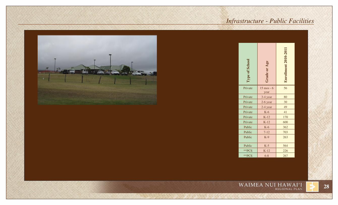
typ
e of
Sch
ool
Gra
de o
r a
ge
enr
ollm
ent
2010
-201
1
Hawai‘iMontessoriSchoolatKamuela
Private 15 mos - 6 year
56
KamehamehaPreschool Private 3-4 year 80
PünanaLeooWaimea Private 2-6 year 30
SmallWorldPreschool Private 2-4 year 49
WaimeaCountrySchool Private K-6 41
Hawai‘iPreparatoryAcademy Private K-12 170
ParkerSchool Private K-12 600
HonokaÿaElementary* Public K-6 362
HonokaÿaHighandIntermediate* Public 7-12 703
Pa‘auiloElementaryandIntermediate
Public K-9 263
WaimeaElementary* Public K-5 564
KanuoKaÿÄina **PCS K-12 226
WaimeaMiddlePublicConversion **PCS 6-8 267* Students are eligible for free tutoring through the federally mandated
No Child Left Behind Act.** PCS - Public Charter School
Schools The State appropriated funding for several improvement projects at Waimea Elementary School totaling $287,000. The project included the planning, design or construction activities related to the replacement of roofs on two buildings, repair and replacement of partitions, expansion of the trash area, and the removal of existing playground equipment.
Kanu o ka ‘Äina Learning ‘Ohana, is located on a DHHL parcel in Pu‘ukapu. It is currently developing a multi-service complex focused on providing womb-to-tomb Hawaiian-focused education in Waimea.
LibrariesThelma Parker Library located in Waimea is the only public library in the region. It is open Tuesday through Saturday with evening hours on Wednesday.
Kanu O Ka ÿÄina’s Kauhale ÿÖiwi o Puÿukapu
Infrastructure - Public Facilities

29
Hospital FacilitiesHealth Care in the Waimea area is provided by the Lucy Henriques Medical Center and the North Hawai‘i Community Hospital. In 1999, the Lucy Henriques Medical Center merged with the North Hawai‘i Community Hospital. In September 2011, North Hawai‘i Community Hospital opened it’s Native Hawaiian Health Clinic designed to provide culturally appropriate, high quality medical and behavior health services. Two state hospitals, Kohala Hospital and Honokaÿa Hospital (also known as Hale Ho‘ola Hämäkua), operate in Kapaÿau and Honokaÿa.
The North Hawai‘i Community Hospital has 24-hour emergency services, acute care, obstetric care, and critical care. The North Hawai‘i Community Hospital is currently engaged in the renovation of the Emergency Room Department. Construction is anticipated to commence in mid-2012. The hospital is also in the midst of a 2-year process to obtain a Trauma Center II designation. Currently, Hilo and Kona are the only trauma centers on island.
Waimea is also world-known for non-traditional healing practices. One of the programs located in Waimea is the Five Mountains Hawai‘i, providing innovative treatments including naturopathic and alternative medicines, incorporation of läÿau lapaÿau herbal treatment, a “wellness” center, cosmetic and spiritual healing, and a spectrum of traditional health care.
In the Hämäkua District, hospital services at Hale Hoÿola Hamakua began providing services in 1951 to the communities of Hämäkua, North Hilo, and South Kohala. Co-located with Hale Hoÿola Hämäkua is the Hämäkua Health Center. The Hämäkua Health Center is a Federally Qualified Health Center that provides a range of health, educational, and preventive social services though the treatment of the whole person that gets its roots from the consolidation of numerous plantation dispensaries.
DHHL Community Services Kühiö Hale serves as the DHHL West Hawai‘i office building and as a community hall. The community hall, located in Puÿukapu, serves the Waimea Hawaiian Homes Association and the overall Waimea community.
Waimea Trails and Greenways The Trails and Greenways project creates a green corridor through Waimea Town along Waikoloa Stream. The project will provide an accessible pathway to connect residences, schools, and businesses in Waimea. The trail extends along Waikoloa Stream from the South Kohala View Estates on the west heading northeast, through the Waimea Nature Park to the state land north of Church Row. The project will include a 17-acre trail head, picnic, and parking area located on state land near the Waimea Transfer Station (Kamuela Bus Center).
This project receives federal funding. The first phase of the project, near the Waimea Nature Park, is completed and open to the public.
NFRASTRUCTURE - PUBLIC FACILITIESI
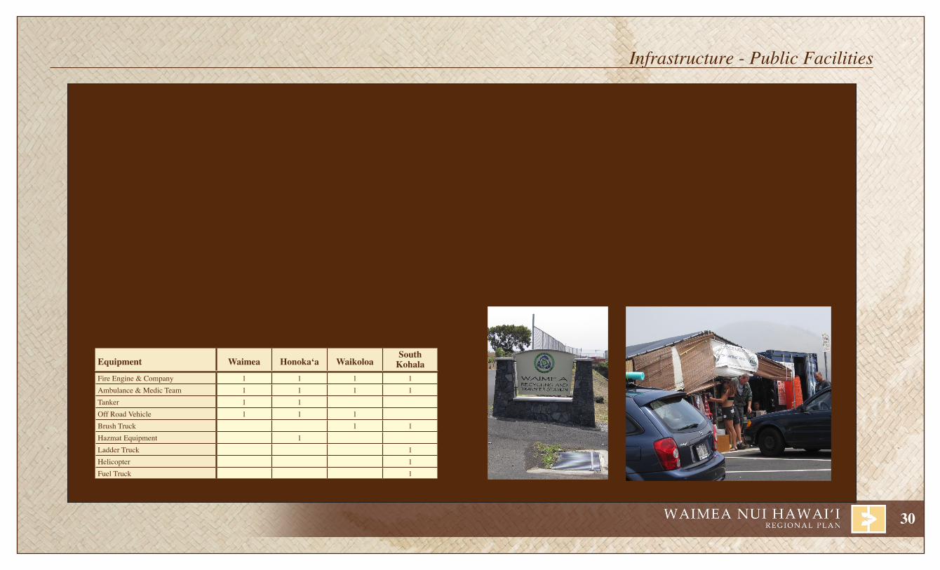
30
Fire / EMT Services There are several fire stations in the Waimea Nui region. The Hawaiian Homestead communities are primarily serviced by the Waimea, Waikoloa, and Honokaÿa stations. The South Kohala Station primarily services Kawaihae, but has specialized equipment including a ladder truck and an emergency medical transport helicopter that are available should an emergency arise. The fire stations in Waimea, South Kohala, North Kohala, Waikoloa and Honokaÿa work together to provide fire and emergency medical services to residences and businesses.
In fiscal year 2011, $570,000 was appropriated by the County for the design of facilities to replace the existing Honokaÿa Fire Station building. The existing building does not have adequate capacity to house vehicles currently assigned to the station. In addition, the existing building, built in 1959 does not comply with high wind and hurricane Standards. It is anticipated that $10,000,000 will be necessary to construct the new facility.
In fiscal year 2011, $500,000 was appropriated to construct a facility to house Volunteer fire-fighting apparatus assigned to the Paÿauilo Volunteer Fire Company. Currently the apparatus is stored at private residences.
fire and medic caPabilitieS of StationS in nortH HaWai‘i ServicinG HaWaiian HomelandS
Equipment Waimea Honoka‘a WaikoloaSouth
KohalaFire Engine & Company 1 1 1 1Ambulance & Medic Team 1 1 1 1Tanker 1 1Off Road Vehicle 1 1 1Brush Truck 1 1Hazmat Equipment 1Ladder Truck 1Helicopter 1Fuel Truck 1Source: County of Hawai‘i, West Hawai‘i Fire Battalion Chief
Police Facilities The Hawaiian Homestead Lands are serviced by two main stations, a sub-station, and a mini-station. Both districts divide officers into shifts providing 24-hour coverage. The South Kohala District Station is located in Waimea at 67-5185 Kamämalu Street, and is generally referred to as the Waimea Police Station. The Waimea Station typically has a minimum of four to five officers on each patrol shift. The South Kohala District also operates a police substation at the Mauna Lani Resort. The Hämäkua District Station is located at 45-3400 Mämane Street in Honokaÿa. The Honokaÿa Police Station typically is staffed by a minimum of two officers per patrol shift. A mini-station is also operated in Waikoloa Village.
Refuse/RecyclingA temporary tent structure currently serves as the beverage container redemption center. The County appropriated $100,000 to design and construct the Waimea Recycling and Transfer Station Garage.
Infrastructure - Public Facilities
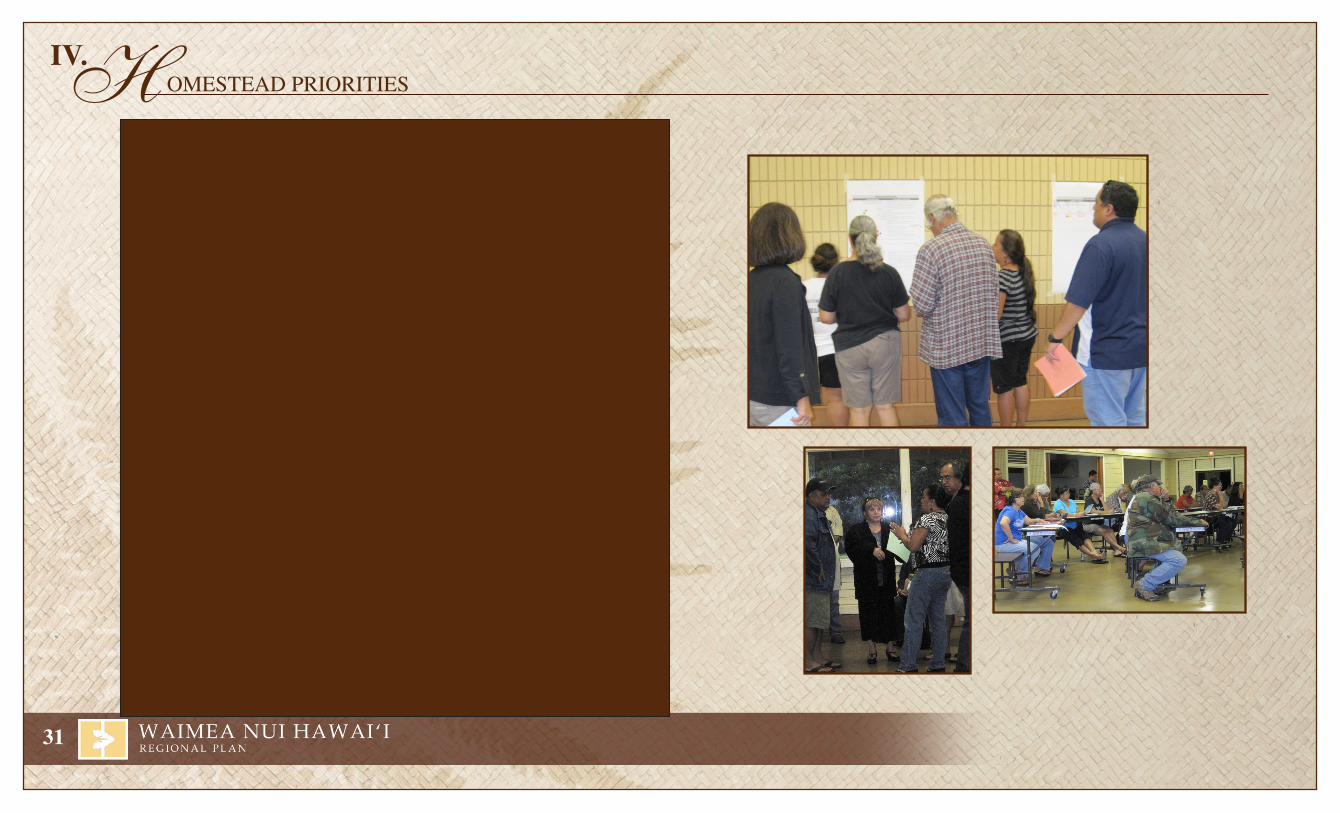
31
Water • Native water rights need to be exercised. • DWS systems in Nienie and Honokäia should be evaluated and assessed. • There are Department of Agriculture reservoirs within DHHL lands? Determine who has access, and if homesteaders can also access this water?
Roads • Completed roads in Lälämilo should be opened. A single access point into and out of
Lälämilo particularly in an emergency is a concern to residents. • Kahilu Road in Puÿukapu floods and is under disrepair.
Community • Community Complex including features such as a park, Küpuna Center, Cemetery, Cultural/Community Center, should be developed on approximately 161 acres of DHHL’s
191-acre lot adjacent to Kanu o ka ‘Äina Learning ‘Ohana location. • Lälämilo should have its own park/community center facilities. • Lälämilo may have different needs than Puÿukapu. • An athletic park is needed in Puÿukapu and should be licensed to the community. • DHHL gas stations would be a great benefit to homesteaders. • Agreements with a gas company to provide gas (natural gas) to homesteads should be considered as a homesteading benefit. • Cinder from DHHL lands was previously available to homesteaders free of charge. Access to DHHL cinder should be evaluated.
Beneficiaries from Waimea Nui that attended the Regional Planning meetings discussed regional issues and opportunities with DHHL. The topics discussed, while varied, focused around the following subjects: Water, Roads, Community, Housing/Homesteading, Agriculture (Farming & Pastoral), and DHHL Protocol.
H OMESTEAD PRIORITIESIV.

32
Housing/Homesteading • DHHL turn-key homes leases should not cost more than comparable fee-simple homes. • More affordable housing opportunities need to be developed. • More self-help homes are needed. • Alternatives to the turn-key option are necessary. The options should be for residential and agriculture, and include a DHHL building code. • Good homes do not need to be green homes. • Many homes are in need of repair and rehabilitation. • Vacant and returned lots should be re-awarded. • Building Code is not flexible enough to allow alternative building types and construction practices.
Agriculture (Farm and Pastoral) • The existing Agriculture and Pastoral programs serving the North Hawaiÿi Homesteads are not producing working farms and ranches. • The moratorium on releasing new agriculture lots should be lifted.
DHHL Protocol
• Beneficiaries should not be subject to property taxes. • Conflicts between DHHL plans and County/State/Federal plans should be addressed. • Programs within DHHL should be coordinated (Külia, Regional Plans, new development, etcetera). • A program for electronic notification should be developed to improve communication.
Issues and Opportunities

33
H OMESTEAD PRIORITIESIV.
Funding / admin Potential Project Community and Dhhl DiscussionFund **Conduct Planning Activities for a Community Complex in Puÿukapu • Conduct Community Visioning exercises. Determine project goals and
how to meet the needs of the Puÿukapu community at large.• Confirm Puÿukapu community support.• Conduct Feasibility Assessment.• Obtain use license to locate approximately 161 acres of DHHL lands,
adjacent to Kanu o ka ‘Äina Learning ‘Ohana.• Develop Site Plan.• Complex should include Park, Küpuna Center, Cemetery,
and Cultural/Community Center.
admin / Fund **Evaluate and revise agriculture/pastoral program • Farms and ranches in Puÿukapu, Nienie and Kamoku requested program support above and beyond what is currently being provided.
• Existing programs need to be evaluated.• Programs should be designed to create productive working farms and ranches.
Fund Conduct planning activities for a community center/park in Lälämilo • Lälämilo should have its own community facilities and should not need to come in to Puÿukapu.
• Determine what Lälämilo needs.
Fund Improve DWS water system to Nienie and Honokäia • Native water rights need to be exercised• There are water needs in Honokäia and Nienie.
Fund Improve Kahilu Road • Kahilu Road is paved on one side only.• Kahilu experiences problems with flooding.• Fee-simple lots utilize the DHHL road to access lots.
Fund Develop agreement with fuel companies to benefit homesteaders • Provide fuel delivery to homesteaders.• Create DHHL community gas stations.
The numerous issues and opportunities identified by beneficiaries were consolidated into a list of potential projects. Based on discussions with meeting participants the potential project list was modified. Projects were added, deleted and revised. During the discussions, participants observed that some of the projects required funding to move forward while others were primarily administrative in nature requiring action by DHHL, the Commission, the State Attorney General or the State Legis-lature to move forward. Based on the participants’ recommendation, each project was segregated into one of two broad categories, administrative or funding. Once the final list of potential projects
was agreed upon, meeting participants were provided with dots to show their support of up to five potential projects. Participants were allowed to vote for each project only once. The table below includes all of the potential projects and identifies those elevated to priority projects by community consensus. The details for the five priority projects described on the following pages were evaluated and expanded upon by DHHL, their consulting team and key stakeholders. These priority projects were then reviewed and approved by the community prior to submission to the Commission for approval.

34
Potential Projects
Funding / admin Potential Project Community and Dhhl DiscussionFund Evaluate cinder mining in Puÿukapu • Cinder on DHHL lands should be made available to homesteaders for
ranching and agricultural needs.• Cinder was previously available.
Fund Create a Lälämilo Homestead Association • Concerns raised that all communities in the region are being forced to merge together.• Lälämilo lessees requested assistance in understanding board roles and responsibilities.
admin **Support/Plan Development of Affordable Homesteading Alternatives • Lower price point of homes.• Provide more self-help opportunities.• Fee-simple homes should cost more.• Creating good new homes doesn’t need to mean building expensive green homes.• Alternative options should address housing type, agriculture opportunities and
Hawaiian building code.
admin **Assess the implications of Eliminating Requirement to Pay Property Taxes • Beneficiaries should not pay property taxes on homestead leases.• Current rules provide lessees a 7-year exemption from property taxes. • Modification of tax liability requires Legislative action to amend HHCA.
admin **Assess the implications of a Non-Standard Building Code • Existing building code is not flexible.• Building code is following the occupying nations rules.• Utilize alternative building materials that are locally produced and/or sustainable
(example- bamboo).• Utilize local community resources (example- does a water heater have to
be installed by a licensed plumber?).• Alternative housing codes need to ensure health and safety, as
well as homeowners ability to insure and finance the home.• The costs associated with enforcing a DHHL code should be evaluated
(i.e. inspections, periodic review, enforcement, etc.).• Creation of a non-standard building code requires Legislative action to amend HHCA.
admin Award Returned and Vacant lots • Returned lots and vacant lots should be awarded.
admin Lift farm lot subdivision moratorium • Allow the subdivision of existing Agriculture lots .
admin Open both Lälämilo Access Roads (east and west) • The road is completed, but not open.• Safety is a concern. There is only one access to the neighborhood,
through an existing neighborhood.
admin Facilitate Coordination Between Lessees Needing Home Repair and the Home Rehabilitation Program
• Many homes are in need of repair and rehabilitation.
** By consensus, the community elevated these potential projects to community priority projects.
35
P RIORITY PROJECT - Waimea Hawaiian Homestead Community Complex - Planning
BackgroundDuring the 2008 DHHL regional planning process, the community identified a need for increasing recreational areas for its expanding community. At that time, the focus was on the needs of the youth facilities, and the development of a neighborhood park was selected as a community priority project. Since then, the community has been holding regular meetings to determine the community needs and to expand the project scope. While a neighborhood park is still important, it is only one element of an approximately 161-acre community complex being proposed by the Waimea Hawaiian Homestead to meet the needs of nä ÿöpio to küpuna, and those that have passed on. While the community visioning process is still in its infancy, the major elements of the complex have been identified: youth recreational facilities, Commu-nity Hale/gathering facility, revenue generation facilities. In addition, honoring and caring for the küpuna of our community is important. For this reason, both küpuna housing, as well as a cemetery ensuring a final resting place are included in the community complex design.
The Waimea Hawaiian Homestead Association identified the need to conduct preliminary planning activities as critical to the success of the project. Raising funds to conduct planning was identified as an important component of moving the project forward. The Association began its fundraising efforts in August 2011, with an extremely successful sold-out benefit luau. Funds that are raised from this and other fundraising efforts, including the pursuit of grants, will be used to further the community’s goals in the development of a community complex. The Waimea Homestead Association is eligible to apply for DHHL grants. It is DHHL’s policy that 15% of revenues generated are used to fund the NHRF grant program.
GoalThe goal of this priority project is to obtain adequate funds through community fundraising efforts, grants/aid from DHHL, or others to complete Phase I planning and assessment of the Waimea Hawaiian Homestead Community Complex.
Processi. PlaNNiNg aND aSSESSMENT
• Funding - Assess funding available for planning activities through Association’s fundraising efforts, DHHL’s Külia Program, and utilizing DHHL’s Priority Project Grants. Conduct/complete relevant community capacity building requirements and applications to the satisfaction of DHHL for award of Külia/Priority Project grant funds.
• Visioning - Conduct community visioning exercises to determine project goals and how these goals will meet the needs of Waimea community at large.
• Confirm Community Support - Many attributes are necessary for grass roots projects to be successful. However, most successful projects have a focused vision, broad support of the concept and vision, and a community willing to promote and work towards identified goals.
• Conceptual Master Plan - Prepare a conceptual Puÿukapu Community Center Complex master plan designed to illustrate the community’s vision of the project.
• Conduct Feasibility and Site Assessments - Once the goals are identified, the project and selected location need to be evaluated to determine if the project is feasible. This may require some fine tuning of the project that should be done working in concert with DHHL. It is critical that this step is done early in the process to avoid allocating time and funds to aspects of the project that are not feasible.
• Market Study -Incorporating an economic development component into the community complex is an excellent way to make the project self-sustainable, provided the market will support the proposed projects. Conducting market studies to determine the appropriate product type, scale, and location can improve the likelihood of success.
36
Priority Project - Puÿukapu Community Complex - Planning
ii. SiTE CONTrOl
• Obtain site control from DHHL
iii. DESigN aND ENTiTlEMENTS
• Consultation - It is important that the envisioned project not only meets the needs of the Puÿukapu community, but also is appropriate in the regional context. Consulting with neighboring landowners like Parker Ranch, and government agencies, such as Department of Planning, South Kohala Traffic Safety Committee, Department of Water Services, and service providers like HELCO, etc. is critical to ensure adequate capacity.
• Complete environmental impacts and land use entitlements. Based on the proposed siting of the community complex on DHHL lands, the project must comply with State Environmental Impact Study rules and regulations, often referred to as Chapter 343. If project proponents intend to pursue federal funding, then the environmental impact assessment will need to also comply with the National Environmental Policy Act (NEPA).
• Capital Campaign • Project Design
iv - vii CONSTrUCTiON
• Infrastructure Construction• Vertical Construction
Phasing I. Planning and Assessment II. Site Control III. Design and Entitlements IV. Construction of Economic Development Component V. Construction of Gathering Hale VI. Construction of Kupuna Housing VII. Construction of Recreational Facilities VIII. Construction of Cemetery
Timeline for Phase I: 9-12 months
3-4 months- Acquisition of Funds6-8 months- Completion of Master Plan, Feasibility and Site Assessment
Estimated Costs Phase I:
Approximately $60,000 - $75,000
Potential Partners• U.S. Department of Agriculture- • Office of Hawaiian Affairs Rural Development • Kanu O Ka ÿÄina• Department of Hawaiian Home Lands • Parker Ranch• Waimea Hawaiian Homestead Association • Hawaiÿi Community Foundation• Hawai‘i Tourism Authority- (Richard Smart Fund-Capacity Building County Product Enrichment Program

37
P RIORITY PROJECT - Evaluate and Revise Agriculture/Pastoral Program Waimea Nui
BackgroundAlthough DHHL has awarded 110 farm and 275 pastoral leases in Waimea Nui, the number of successful, productive working farms is limited. DHHL estimates that only 5% of agricul-ture awards throughout the state are productive farms. Limitations to a successful agriculture (farm) and pastoral (ranch) program in Waimea Nui were identified during community meet-ings, and inquiries, suggestions and recommendations made to DHHL. These include (1) the lack of resources (i.e. water, equipment), (2) limits of lessees’ technical capacity, (3) finances, (4) lack of hands-on training programs and (5) availability of appropriate product type. These issues have contributed to the lack of increase in farming and ranching activities by lessees. The programs that DHHL has in place are not meeting the needs of farmers and ranchers in Waimea Nui. Those farms and ranches that are successful appear to be making it based on their own motivation, research, and hard work, not from the technical or financial support from the Department.
While many native Hawaiian families have traditional ties to farming and ranching, modern era pursuits have resulted in individuals working at jobs away from farms and ranches. As more family members find work in other employment sectors, the traditional educational chain, passing knowledge from küpuna to nä ÿöpio is broken. It is apparent that for many lessees, when an award is received, the family unit may have the desire to farm/ranch, but do not have the technical skills or financial support to be successful. Even successful farmers and ranchers may suffer losses. However, it is much more difficult for a farmer or rancher with no experience to weather such losses, and to move forward and learn from the experience.
Currently, DHHL provides annual technical assistance through a service contract with the UH-CTAHR program. However, it is not meeting the needs of farmers or ranchers in Waimea Nui as currently administered. Farmers and ranchers have indicated that there are obstacles making it difficult to obtain the type of support and assistance expected from this program. In addition, there may be other programs at UH and elsewhere that are better suited to provide support and technical assistances to Waimea Nui farmers and ranchers.
GoalThe primary goal of this priority project is to provide necessary support to increase the number of active farm and ranches in Waimea Nui. Successful homesteaders need to be engaged and called to participate by (1) working with lessees not using their farm or ranch lands, (2) evaluating the issues and pitfalls that are holding farmers and ranchers back from reaching their full potential, (3) revising the agricultural and pastoral programs to improve the success rate of homestead lessees, (4) working with practitioners outside the home-stead community willing to share their expertise, and (5) support community-based programs and grass-roots efforts to improve success of farm and/or ranch homesteads in Waimea Nui. Homestead success duplicated is a victory and a testament to the paniolo spirit of the Waimea Nui lessees.
The following are important components of supporting and assisting agricultural and pastoral lessees in Waimea Nui:
1. Conduct Community ConsultationNew programs or revisions to existing programs need to be vetted by and include assessment and evaluation from the ranchers and farmers of Waimea Nui to discuss and identify obstacles and possible strategies which will enable farming and ranching activity. 2. Separate the agriculture and Pastoral ProgramsWhile some of the issues are the same for ranchers and farmers, there are distinct differences in the type of support, training, and resources needed. The community is recommending that the programs be separated. 3. increase Dhhl Staff to Support the agriculture and Pastoral ProgramThe needs/issues of non-residential lessees are distinctly different from needs/issues associated with lessees on residential homesteads. There are no staff dedicated to the support of pastoral and agriculture lessees.
• Create a distinct office, department, or division within DHHL for the purpose of supporting the success of pastoral and agriculture lessees.
• Work with a liaison that can interface with the farmers and ranchers to identify need, and help direct the lessees to relevant farm and ranch related agencies based on the issue/concern.
4. re-assess Existing Technical assistance Programs that Serve the region • Agriculture

38
Priority Project - Evaluate and revise agriculture/pastoral program
o Develop measurable goals of success with performance based outcomes for technical assistance programs. Recommendations by regional farmers should be incorporated.
o Evaluate CTHAR and other programs to determine the appropriate technical training programs for farmers in Waimea Nui.
o Provide hands on training, a preferred strategy in addition to seminar style training.o Design mentorship programs and mirror projects designed to place “new” farmers in
work study programs with successful farmers in their region.o Support grass-roots efforts, and community initiatives designed to improve the success
rate of Waimea Nui farmers.• Pastoral
o Create a separate technical assistance program designed specifically for ranchers.o Share best practices.o Evaluate other collaborations, such as the UH’s “Mealani’s Taste of the Hawaiian Range”
program.o Develop program to provide marketing assistance.
5. Explore Creation of Community Cooperatives • Agriculture
o Create farm equipment cooperative.o Marketing.
• Pastoralo Create farm equipment cooperative.o Support/Develop community slaughterhouse.o Marketing.
6. Farm/ranch PlansLocal leadership organizations could be incorporated into implementation. These leaders often have knowledge that could improve success of lessees’ farm and ranch plans.
• Assist in developing feasible, implementable farm/ranch plans for existing lessees, and new farmers/ranchers.
• Provide guidance in implementing farm/ranch plans.• Discuss implications of failing to implement farm/ranch plans.• Explore possibilities for and rules regarding requests for supplemental acreage or
competing for general leases.
7. return of Non-productive leasesWhile this is considered a last resort, some beneficiaries with agriculture and pastoral leases may no longer be interested in farming/ranching. With over 17,000 applicants awaiting non-residential awards, return of leases should be enforced once technical assistance programs are successfully implemented.
Phasing I. Community Consultation II. Development of Mentorship Programs and Mirror Projects in Waimea Nui III. Separation of Agriculture and Pastoral Programs IV. DHHL Staff Support and Financial Assistance of Agriculture and Pastoral Program V. Re-assessment of Existing Technical Assistance Programs that Serve Waimea Nui VI. Cooperatives VII. Farm Plan Assistance/EnforcementVIII. Assessment of Non-productive Agriculture and Pastoral Leases (after implementation of
revised technical assistance programs and creation of working cooperatives, mirror/mentorship programs)
Project CostThis is an administrative project that will result in internal cost borne by DHHL and its partners.
CollaborationThere are several organizations that may be able to collaborate and provide opportunities to homestead families to learn about farming. Future Farmers of America- Hawai‘i Waimea Hawaiian Homestead Association4-H Hawaiÿi Local agriculture and pastoral organizationsDepartment of Agriculture Kamehameha Schools University of Hawaiÿi Hawai‘i Community FoundationOffice of Hawaiian Affairs Army GarrisonU.S. Department of Agriculture Federal/State Surplus Programs
39
P RIORITY PROJECT - Support/Plan Development of Affordable Homestead Alternatives in Waimea Nui
BackgroundWhen residential leases were first awarded, homesteaders had a single option for home construction, owner-build. For many years, this was the only option available. The advantage to this option was that the house built was based on what was affordable to the lessee’s household. The disadvantage of owner-build construction is that it limited home-steading to those with the requisite knowledge to build their own home, and/or manage contracted labor. Some communities are still sparsely populated because lessees have not yet built residences years after lease awards. An alternative to the owner-build option was first offered to beneficiaries with the development of Princess Kahanu Estates on Oÿahu. For the first time, waiting list applicants were provided an opportunity to accept a developer built (turn-key) residential homestead. This allowed thousands of applicants with an alternative to constructing their own home and many applicants were removed from the waiting list. Entire communities were built quickly, and utilizing economies of scale, prices were controlled. Recently, residential development of homesteads focused on the turn-key option, and DHHL quickly built several thousand homes on Hawaiÿi, Maui, Länaÿi, Oÿahu, and Kauaÿi. However, for many beneficiaries on the waiting list, neither turn-key nor owner-build met their needs. For these beneficiaries, there were not products nor payment plans that were suitable based on their income.
Self-help projects were created to provide a more affordable option to turn-key homes, with support from a professional developer. Families along with a developer such as Habitat for Humanity would work together in building homes in the community.
Today, regardless of the type of building option utilized in the construction of residential homesteads, DHHL absorbs all costs associated with on-and-off site infrastructure develop-ment. It is a common misconception that the county pays for construction of the roads, or that DWS pays for water lines, etc. While infrastructure costs vary from community to community, DHHL spends an average of $140,000 per lot to provide roads, water, electricity, sewer, etc. DHHL subsidizes the infrastructure costs of the lots, so the cost to lessees for a similarly constructed home, with similar infrastructure improvements is sub-stantially lower than that of a non-DHHL residential home.
The three alternatives currently available, owner-build, turn-key and self-help, while successful in meeting the needs of some do not meet the needs of all of the applicants on the waiting list. There are a number of applicants that have been offered a homestead, but have deferred award due to a lack of financial capacity and/or other barriers. DHHL recognizes that alternatives need to be developed.
GoalWe need to build homes now. Homes should be affordable and accommodate the income of the lessee. Beneficiaries should be provided with, and involved with the planning for more choices, options and products.
ProcessDHHL should consider the following when creating alternative affordable housing options/ models in Waimea Nui while consulting with the community and beneficiaries.
• Provide lower price point for quality homes by utilizing more traditional, less expensive home design and construction.
o Alternative financing optionso Post and pier rather than slab on gradeo Local vendors
• Engage an architect to create alternative designs.o Simple and functional o Easy to add additional space
• Provide green options that don’t increase cost.o Use of local materialso Photovoltaic paid for by installero Orientation of structure to improve air flow

40
Phasing I. Network with Various Housing/Banking programs to Investigate
Alternative Financing Options II. Engage Community in Creating Hands-on OpportunitiesIII. Planning & DesignIV. Construction of Pilot Projects/Options/Models of Alternatives V. Evaluation of Pilot Project/Options/Models
Project CostThis is an administrative project that will result in internal cost borne by DHHL.
CollaborationWaimea Hawaiian Homestead AssociationDHHLUniversity of HawaiÿiUSDA-Rural DevelopmentOffice of Hawaiian AffairsArmy Corps of EngineersCouncil for Native Hawaiian AdvancementKamehemeha SchoolsHome Improvement Companies
Priority Project - Support/Plan Development of Affordable Homesteading Alternatives
Process (continued)
• Options to the traditional single-family home ownership.o Kupuna housingo Multi-familyo ÿOhana housingo Rental with option to purchase homeo Rentalo Kauhale
• Provide more self-help, owner builder, and hands-on opportunities.• Provide more agriculture opportunities within residential communities.
o Landscaping for cultural harvestingo Native street trees or fruit bearing treeso Community gardenso Backyard food security
• Chickens.• Vegetables.• Aquaponics.• Assess the existing building code and draft a handbook for lessee reference.• Evaluate existing DHHL programs to determine appropriateness and “fit”
with other programs.• Contractor Accountability.
o Contractors should be held accountable for the service they provide.o Quality workmanship should be enforced.
• Provide more choices for service providers, i.e. cable, electricity, communication, etc.
• Evaluate and revise programs. Programs designed to assist homesteaders should be regularly evaluated and revised as necessary based on input from both beneficiaries that utilized the program, as well as applicants still on the list.

41
P RIORITY PROJECT - Assess the Implications of Eliminating Requirement to Pay Property Taxes
BackgroundThe Hawaiian Homestead Commission Act (HHCA) in section 208 identifies the conditions of leases. These conditions identify such things as annual rental fee ($1 per year), lease terms, etcetera. Revisions to HHCA §208, modifying the tax liability provision requires legislative action by the State legislature, to amend the HHCA. Section 208 (conditions of leases) also describes the requirements to pay taxes as follows:
Currently, each County determines the tax rate structure paid after the seven-year exemption expires. In Hawaiÿi County, all lots are subject to at least the minimum County tax, currently $100 per year. Taxes for lots with improvements are based on the improvements (not land value), and age of improvements.
DHHL lands are held in trust, and are federally regulated by the U.S. Department of the Interior. Development and construction of infrastructure is paid by DHHL. Maintenance of infrastructure is paid for via sewer, water, electricity user fees. Maintenance of roadways within DHHL landholdings is conducted by DHHL or the County. The maintenance for County maintained roads is paid for via vehicle registration fees. Emergency services are paid in part by revenue generated through property taxes.
DHHL has provided a service to the community at large by allowing the siting of facilities such as fire stations, schools, reservoirs, etcetera on DHHL lands. These public facilities are frequently located on lands ideal for commercial development. DHHL has authorized these requests to locate on DHHL lands and has forgone commercial development to ensure such services are available to its lessees. This should be viewed as financial support of these County and/or State services if market rents are not being charged.
§208 (7): The lessee shall pay all taxes assessed upon the tract and improvements thereon. The department may pay such taxes and have a lien therefor as provided by section 216 of this Act.
(8) The lessee shall perform such other conditions, not in conflict with any provision of this Act, as the department may stipulate in the lease; provided that an original lessee shall be exempt from all taxes for the first seven years after commencement of the term of the lease.

42
Priority Project - Assess the Implications of Eliminating Requirement to Pay Property Taxes
GoalThe primary goal of this priority project is to support an assessment by DHHL to determine jurisdictional standing of the Counties regarding taxation of trust lands and the implications of eliminating property taxes for its beneficiaries.
Program EvaluationDHHL should consider the following during the assessment.
• Obtain Attorney General’s opinion regarding the requirement to pay property tax based on the language in the Hawaiian Homes Commission Act.
• Obtain Attorney General’s opinion regarding the timing of the expiration of exemption (i.e. seven years from signing of lease, or seven years after final subdivision approval).
• Assess the services currently provided by the County of Hawaiÿi that are considered taxable.
• Assess DHHL’s lost income based on community wide services provided on DHHL lands at below market rents.
• Conduct preliminary discussions with the County.
Phasing I. Conduct Internal Evaluation of Implication II. Consultation III. Implementation of Recommendations
Project CostThis is an administrative project that will result in internal cost borne by DHHL.
CollaborationState of Hawai‘i Attorney General’s OfficeDHHLOffice of Hawaiian AffairsU.S. Department of Interior
He ‘auhau kö‘ele na ka Hawai‘i “A taxing of small fields by the Hawai‘i Chiefs” Mary Kawena Pukui explained that after Kamehameha united the islands even the smallest food patch was taxed.

43
P RIORITY PROJECT - Assess the Implications of a Non-Standard Building Code
BackgroundThe beneficiaries in Waimea Nui have expressed their concern that the current building codes are inflexible making building and/or repair of homesteads (both residential and farm structures) difficult, expensive and time consuming. The community expressed a desire to create a non-standard building code.
For over a thousand of years, Native Hawaiians built suitable homes/buildings for Hawaiÿi without the zoning, building ordinances, rules and standards of today. The current build-ing codes adopted by the counties do not integrate traditional Native Hawaiian building practices.
The State Legislature, sought to rectify the omission of Native Hawaiian Architecture in 2006 with the Passage of Act 310. Act 310 sought to allow the use of techniques, styles and customs of Native Hawaiian architecture in present-day construction. The act created a new section in the Hawaiÿi Revised Statutes (HRS§46-1.55) requiring each county to adopt ordinances allowing the exercise of Native Hawaiian architectural practices, styles, customs, techniques and materials. In 2007, the Legislature required implementation of §46-1.55 by each county by 2008. Despite the best intentions of the Act, the State Legislature found that in 2010, the counties had not adopted or amended their ordinances. The counties were urged to apply the Native Hawaiian Architecture in all zoning districts by 2011 in House resolution Number 327 (with Senate concurrence) by the Twenty-fifth Legislature of the State of Hawaiÿi. To date, the County of Hawaiÿi has not adopted or amended its ordinances to create a separate Native Hawaiian building code.
In 1988, the State Legislature found that there was a critical shortage of safe, sanitary and affordable housing in the State. To address this shortage, Act 15 was enacted by the Legislature, instituting a five year window of opportunity exempting affordable housing development from statutes, ordinances, charter provisions, etc. The Housing and Community Development Corporation of Hawai‘i (HCDCH) (the precursor to today’s Hawai‘i Housing Finance and Development Corporation) was able to exempt housing projects from all county requirements. During that time, HCDCH developed several master
planned projects that include some of DHHL’s communities. Examples are the Villages of Laÿi ÿÖpua, and Villages of Kapolei. While Act 15 required HCDCH to build homes, roadways and other infrastructure to code, the review, inspection and approval by the County was waived. This allowed HCDCH to expedite development of these communities and numerous affordable homes were built.
DHHL has not pursued exemption from county building codes in the past for several reasons, including the following:(1) Potential health, safety and welfare concerns; (2) Potential elimination of funds from several sources; (3) Counties may deny long-term maintenance of non-compliant facilities, infrastructure, and roads;(4) Liability/insurance requirements for DHHL and homeowners;
(5) Legislative action by the State Legislature, to amend the HHCA.
In the Villages of Kapolei, the City and County of Honolulu still has not accepted all infrastructure, resulting in long-term maintenance cost being absorbed by the various developers, including DHHL.
Lessons Learned During the HCDCH Exemption: (1) HCDCH was ultimately required to create an internal plan check/permitting
and inspection department, (2) Subsequent to the completion of the projects, the counties have been
reluctant to accept or maintain any of the infrastructure because they were not engaged in permitting or inspecting.

44
Priority Project - Assess the Implications of a Non-Standard Building Code
GoalThe primary goal of this priority project is to support an assessment and evaluation by DHHL and relevant Stakeholders regarding the implications of creating an alternate building code specific to DHHL.
Program EvaluationDHHL should consider the following during the assessment and evaluation • What are the fiscal and administrative ramifications to the trust of developing,
implementing and managing an alternate building code? • Will permitting and code enforcement branches need to be developed within DHHL? • Infrastructure maintenance, (short and long term). • Can flexibility be integrated into a building code that ensures health and safety? • Can an alternate building code incorporate the recommendations of Act 310,
HRS §46-1.55? • Can an alternate building code ensure that lessees have the ability to insure and finance
their home or farm structure? • Will the creation of an alternate building code require Legislative action to amend HHCA? • How will an alternate building code affect the release of funds from various trust fund
contributors (such as HUD, USDA, etc.)?
Phasing I. Follow-up with Hawaiÿi County’s Implementation of §46.1.55 II. Internal Evaluation of ImplicationsIII. Consultation IV. Implementation of Recommendations
Project CostThis is an administrative project that will result in internal cost borne by DHHL to conduct the evaluation.
CollaborationState of Hawaiÿi Attorney General’s OfficeOffice of Hawaiian AffairsU.S Department of Agriculture- Rural DevelopmentU.S. Housing and Urban Development-Native Hawaiian Housing Block GrantOther organizations providing funding to DHHLHawaiÿi Housing Finance and Development Corporation

Related Documents