Rio Caqueta Rio Apaporis Rio Vaupes Rio Guaviare Rio Inirida Rio Vichada Rio Tomo Rio Meta Rio Atrato Rio Magdalena Santa Marta Santa Marta Bucaramanga Bucaramanga Cartagena Cartagena Barranquilla Barranquilla Valledupar Valledupar Sincelejo Sincelejo Monteria Monteria Cucuta Cucuta Medellin Medellin Manizales Manizales Pereira Pereira Armenia Armenia Ibague Ibague Villavicencio Villavicencio Cali Cali Neiva Neiva Pasto Pasto Bogota Bogota ! ( ! ( ! ( ! ( ! ( ! ( ! ( ! ( ! ( ! ( ! ( ! ( ! ( ! ( ! ( ! ( ! ( 0 250 500 125 Kilometers N Capital ! ( City Roads River Lake Elevation Value High : 7088 Low : -416 Terrestrial Biomes Tropical Broadleaf Forest Tropical Savanna Key to Map Symbols CLIMATE ADAPTATION DISASTER RISK REDUCTION COLOMBIA Vulnerability, Risk Reduction, and Adaptation to Climate Change ENV Team Climate Change Climate Risk and Adaptation Country Profile April 2011

Welcome message from author
This document is posted to help you gain knowledge. Please leave a comment to let me know what you think about it! Share it to your friends and learn new things together.
Transcript

Rio Caqueta
Rio Apaporis
Rio Vaupes
Rio Guaviare
Rio Inirida
Rio Vichada
Rio Tomo
Rio M
eta
Rio Atrato
Rio
Mag
dale
na
Santa MartaSanta Marta
BucaramangaBucaramanga
CartagenaCartagena
BarranquillaBarranquilla
ValleduparValledupar
SincelejoSincelejo
MonteriaMonteria
CucutaCucuta
MedellinMedellin
ManizalesManizalesPereiraPereiraArmeniaArmenia IbagueIbague
VillavicencioVillavicencioCaliCali
NeivaNeiva
PastoPasto
BogotaBogota
!(
!(
!(
!(!(!(
!(!(
!(
!(
!(
!(
!(
!( !(
!(!(
0 250 500125 Kilometers
NCapital
!( City
Roads
River
Lake
ElevationValue
High : 7088
Low : -416
Terrestrial BiomesTropical Broadleaf ForestTropical Savanna
Key to Map Symbols
CLIMATE
ADAPTATIONDISASTER
RISKREDUCTION COLOMBIA
Vulnerability, Risk Reduction, and Adaptation to
Climate Change
E N VTeam
Climate Change
Climate Risk and Adaptation Country Profile April 2011

2
Climate Risk and Adaptation Country Profile Colombia
COUNTRY OVERVIEW
Colombia encompasses an area of more than 1.1 million square kilometers and is the only country in South America with both a Caribbean and Pacific coastline. With an estimated population of 44.5 million, Colombia is the third most populous country in Latin America.
1 Even though Colombia is ranked 77
th in the Human Development Index and has an
upper middle-income country status and annual GDP of 234 billion USD2, it has one of the highest levels of inequality
in the world – 52.6 percent of the total population live below the poverty line and this figure reaches 69 percent in rural areas.
3 Colombia has one of the highest rates of internally displaced people (IDP) in the world due to civil
conflicts, leaving as many as 3.7 million especially vulnerable to climate change.4
The majority of the population resides in two areas: the elevated Andes, where water shortages and land degradation already pose a threat, and the coastal and insular areas, where the expected increase in sea level and floods will affect human settlements and economic activities. In addition, the country presents a high incidence of extreme weather and disasters associated with climate conditions and variability.
Colombia is rich in natural resources and is estimated to hold 10-15 % of the world’s
biodiversity. Climate change impacts are expected to pose significant and long-term
effects on fragile and unique ecosystems and to accelerate the pace of land
degradation, impact water quality and agricultural production, contribute to the decline of biodiversity of species such
as high altitude flora and fauna and unique corals in the western Caribbean, and increase the exposure of citizens to
tropical vector diseases, such as malaria and dengue.5
PRIORITY ADAPTATION MEASURES
Colombia’s Integrated National Adaption Program: High Mountain Ecosystems, the Caribbean’s Insular Areas and
Human Health (INAP)6 supports national institutions and stakeholders in defining and implementing prevention and
adaptation measures to reduce the
vulnerability to and risk from climate variability
and projected climate change. Active since
2006, the program’s estimated completion is
December 2011. At least six pilot adaptation
activities have been implemented. The main
priorities of the INAP include:
Making climate, climate variability, and climate change information available for adoption of adaptation
measures and policies;
Designing and implementing an adaptation program that supports maintenance of environmental services (including hydropower potential) in the Las Hermosas Massif in the central range of the Andes;
1 Colombia's First National Communication to the United Nations Framework Convention on Climate Change. 2 World Bank Data 3http://www.ifad.org/evaluation/public_html/eksyst/doc/prj/region/pl/colombia/colombia.htm 4 Christian Aid. The Real Migration Crisis, 2009. 5 Integrated Adaption Program for Colombia, 2006. 6 Both the first and second national communication to the United Nations Framework Convention on Climate Change (UNFCCC) also indicate high vulnerability in Colombia’s high mountain habitats and insular and coastal areas and highlight the threat to human health as areas of primary concern.
Key Sectors
Agriculture and Livestock
Water Resources
Coastal Systems
Human Health
Ecosystems
Priority Adaption Projects Improving availability of climate data for adaption measures
Environmental services in Las Hermosas Massif in central Andes
Adaption to climate vulnerability in Caribbean insular areas
Human health and protection from vector-borne diseases
Source: Colombia’s National Adaptation Program of Action,
2006
3
Climate Risk and Adaptation Country Profile Colombia
Supporting the implementation of physical adaptation measures to reduce the vulnerability of Caribbean insular areas, especially with regard to changes in rainfall and temperature, as well as sea level rise; and
Improving responses to the increased exposure to tropical vector-borne diseases (malaria and dengue), induced by climate change.
Further efforts to improve the management of climate risks and better integrate them into national development
policies were articulated in the project Integrating Climate Change Risks and Opportunities into National Development
Processes and United Nations Country Programming.7 Implemented in 2009 and 2010, the project’s final evaluation
offered the following recommendations for adaptation:
Preserve and strengthen existing biological buffers through the conservation of critical eco-systemic functions and environmental services;
Increase adaptive capacity and resilience in the organization of the State to catalyze its capacity to confront extreme events and the uncertainty from processes of global climate change;
Improve balance between urbanization and rural living conditions;
Reinforce the “safe habitat and territory” concept in urbanization processes to reduce levels of human exposure to extreme events, avoid large economic downturns, produce an effective fight against poverty, and attain the Millennium Development Goals (MDGs);
Develop key institutional functions for adaptation to climate change by incorporating climate change scenarios in all development planning processes.
CLIMATE BASELINE AND CLIMATE FUTURE
CLIMATE BASELINE
Major Climate Processes
Impacts on Climate
El Niño
Warmer and drier than average conditions
La Niña
Wetter than average conditions
Intertropical Convergence Zone (ITCZ)
Drives rainfall
Colombia has a rich and diverse climatic variation resulting from its complex topography and its interaction with the Inter-Tropical Convergence Zone (ITCZ) and inter-annual El Niño/Southern Oscillation (ENSO). Temperatures range from very hot at sea level to relatively cold at higher elevations and vary little with season.
8
Colombia has four climate zones. The hot zone (areas under 900 meters in elevation) displays temperatures varying between 24°C and 38°C and alternating dry and wet inter-annual seasons correspond to summer and winter, respectively. The temperate zone (areas between 900 and 1,980 meters in elevation) exhibits two wet and two dry seasons in January through March and July through September, respectively, and the mean annual temperature varies between 19°C and 24°C. The cold zone (areas from 1,980 meters to about 3,500 meters in elevation) supports about one-fourth of the country’s total population and constitutes about 6 percent of the total land area, including some of the most densely populated plateaus and terraces of the Colombian Andes. With a variety of thermal levels due to the variations of air temperature at higher altitudes, the mean temperature in the cold zone ranges between 10°C and 19°C. The wet seasons are bimodal, occurring from April through May and from September through December. The
7 http://www.adaptationlearning.net/ 8 Poveda, G. et al. 2001. Coupling between Annual and ENSO Timescales in the Malaria-Climate Association in Colombia.

4
Climate Risk and Adaptation Country Profile Colombia
páramos, a treeless region adjacent to the cold zone, extends to approximately 4,500 meters high and delineates the area of permanent snow or nevado.
9
Figure 1: Average annual temperature and total annual precipitation in Colombia
10
The annual rainfall distribution in Colombia is primarily influenced by the position of the Inter-Tropical Convergence Zone (ITCZ), while its spatial variability is governed by the topography of the Andes Mountains, the eastern Pacific and western Atlantic oceans, and the atmospheric circulation over the Amazon basin. Year–to-year variability and extreme precipitation events are related to The El Niño/Southern Oscillation (ENSO). The associated extreme weather events, including floods, droughts and heat waves produce severe socioeconomic and environmental impacts, including crop failure, infrastructure disruption, forest fires, reduced hydropower generation, and epidemics.
11
In most of the Pacific lowlands, precipitation exceeds 7600 mm annually making this one of the wettest regions in the world. Rainfall averages decrease as one moves east along the country, to levels as low as 2540 mm. The eastern slope of the Andes experiences high convective rainfall rates (~ 5,000 mm per year) due to its topographic diversity. Northern areas have a single long rainy season, from May through October, with an annual average rainfall of 1070 mm). Extensive areas of the Caribbean interior are permanently flooded during this time due to poor drainage and land degradation.
12
9 CIA Factbook: Colombia. 10 WorldClim 1960-1990 averages. Robert J. Hijmans, Susan Cameron, and Juan Parra, at the Museum of Vertebrate Zoology, University of California, Berkeley, in collaboration with Peter Jones and Andrew Jarvis (CIAT), and with Karen Richardson (Rainforest CRC). www.worldclim.org/current 11 Ibid note 5. 12 Ibid.
5
Climate Risk and Adaptation Country Profile Colombia
RECENT CLIMATE TRENDS
Temperature has increased on the order of 1°C in the last 20 years.13
Increasing trends of daily mean and minimum temperatures are noted for the past 30–40 years.
14
Hydro-climatic records from 1960 to 1995 show statistically significant positive trends in average monthly minimum and mean temperature, as well as in relative humidity and pan evaporation throughout the country.
15
Positive trends are seen for the occurrence of warm nights16
and negative trends for the occurrence of cold nights
17. There is also a positive tendency for both intense rainfall events and for consecutive dry days.
18
In recent years, rainy seasons have been occurring earlier for central Columbia than 25 years ago.19
For the period of 1961-1990, annual precipitation has varied significantly, between -4 and +6 percent and sea level has risen by 1 to 3 mm per year.
20 For the period of 1995–2005 a relative precipitation increase of 5 percent
from December to February is noted.
Some areas of the páramos have seen a net temperature increase of 0.2-0.3°C per decade during the period 1961-1990 and a decrease in monthly rainfall of between 2 to 3 mm per decade.
21
Between 1990 and 2000, an 82 percent reduction in glaciers has been observed, showing a linear withdrawal of the ice of 10-15 m, yearly. Under current climate trends, glaciers located in Colombia will disappear completely within the next 100 years.
22
Trends in Colombian river stream runoff are mixed, but the main river catchments such as the Cauca and Magdalena Rivers exhibit decreasing trends. Deforestation could account for such decreasing trends in river discharges.
The frequency of extreme rainfall events has increased22
.
CLIMATE FUTURE
The climate science community sources a suite of models to inform decision makers on future climate. Among the most widely used are GCMs (Global Climate Models), RCMs (Regional Climate Models), and downscaling techniques (both empirical and statistical) and several comprehensive reviews are available on the subject. GCMs and RCMs comprise simplified but systematically rigorous interacting mathematical descriptions of important physical and chemical processes governing climate, including the role of the atmosphere, land, oceans, and biological processes. The bullet points below offer insights into a changing climate and are derived for Colombia from a suite of GCMs and RCMs used by the Intergovernmental Panel on Climate Change as well as various scientific organizations studying climate changes across Colombia.
The global climate models (GCM) above project that there may be a warming by mid-century with possibly more frequent heat waves and a more scarce occurrence of days with frost.
The maximum amount of rain that falls in any 5-day period ─ an indicator of extreme weather – is projected to increase and the maximum period between rainy days is expected to decrease.
13 IPCC Fourth Assessment Report (AR4), 2007. 14 Ibid. See note 13 15 Ibid. See note 13 16 The percentage of nights where the 90th percentile of the minimum temperature is exceeded. 17The percentage of nights that fell below the 10th percentile of minimum temperature. 18 Ibid note 5. 19 IPCC 4th Assessment Report. 20 Ibid note 1. 21 Paramos y Ecosistemas Alto Andinos de Colombia. IDEAM, 2002. 22 Colombia’s Second National Communication to the United Nations Framework Convention on Climate Change.
6
Climate Risk and Adaptation Country Profile Colombia
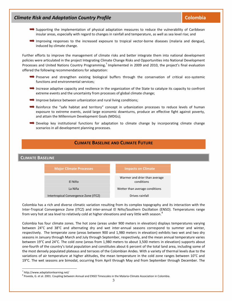
Figure 2: Projected change in rainfall and temperature values for the 2080-2100 compared to historical values for 1980-1999
23
Temperatures across Colombia are projected to increase between 1°C and 2.5°C by 2100 (Figure 2).24
This increase is projected to be more significant in the higher elevations.
25 Recent work reported under the
Integrated National Adaptation Program (INAP) points to a gradual trend in Colombia of exposure to tropical vector diseases (malaria, in particular). The increase has been linked to increases in minimal nocturnal temperatures in the Andes piedmont and to changes in the hydrological cycle induced by the El Niño Southern Oscillation (ENSO) phenomenon.
It is not possible to get a clear picture for precipitation changes due to large model uncertainties (Figure 2). However, recent data suggest that some areas will become wetter while others will become drier. The duration of the rainy season in the San Andrés islands could increase by as much as 15 percent by 2050 and 20 percent by 2080.
26 One study projects that the greatest reduction in rainfall (-30 to -10 percent) would
occur in 20 percent of the country for the period 2011-2040.27
CLIMATE CHANGE IMPACTS ON NATURAL HAZARD VULNERABILITY
AT A GLANCE
Colombia ranks 10th
globally in terms of economic risk posed by three or more hazards. The country has the highest recurrence of extreme events in South America, with 84 percent of the population and 86 percent of its assets in areas exposed to two or more hazards.
23 World Bank’s Climate Change Knowledge Portal: http://sdwebx.worldbank.org/climateportal/ 24 Colombia Second National Communication on Climate Change, 2010. 25 Ibid note 5. 26 World Bank. 2009. Colombia: Country Note on Climate Change Aspects in Agriculture. 27 Colombia Second National Communication on Climate Change, 2010.

7
Climate Risk and Adaptation Country Profile Colombia
Figure 4: Risk of flood mortality in Colombia Source: UNEP Global Risk Identification Programme (GRIP)
www.gripweb.org
Figure 3: Average distribution of disasters each year in Colombia
Source: Prevention Web
Landslides5%
Drought1%
Flood66%
Epidemic2%
Storm 7%
Earthquake19%
Rapid population growth in poorly planned urban areas, informal settlements, and densely populated coastal areas, coupled with the effects of climate change, are already exacerbating flooding and landslides in the country.
28 Sea level
rise also poses a danger to coastal and insular areas.
Floods and Landslides: The lower basins and valleys of Colombia’s principle rivers (the Magdalena, Cauca, Sinnu, Atrato, and Putumayo) are vulnerable to flooding. In recent years, there have been increases in intensity and occurrence of floods:
Floods during the period of 2002–2007 had the highest human and economic impact in Colombia – 2.9 million people affected, with the cost of damages reaching US$ 10 million.
Due to the varied and dramatic topography, deforestation and frequent incidence of heavy rains and landslides have a high occurrence rate. Colombia has the highest landslide rate in South America in terms of fatalities per year per square kilometer.
The number of people killed in flood disasters nearly doubled between 1981 and 2010.
29
Sea Level Rise (SLR): By 2050-2060, the sea level on the Caribbean and Pacific coasts could increase by as much as 40-60cm as compared to the period 1961-1990
.30
More than a million people could be affected, 85 percent living in urban areas. On the Caribbean coast 9 percent of urban housing would be highly vulnerable to flooding, while 46 percent of houses in rural areas would be under threat. On the Pacific coast 48 percent of houses in
28 GFDRR Disaster Risk Management Profile. 2010 29 Prevention Web http://www.preventionweb.net/english/countries/statistics/index.php?cid=37 30 IPCC Fourth Assessment Report (AR4), 2007.

8
Climate Risk and Adaptation Country Profile Colombia
urban areas and 87 percent in rural areas would be highly vulnerable. However, as many houses are traditionally built on wooden piles, adaptation action in these areas is relatively easier.
31
SECTORAL CLIMATE RISK REDUCTION RECOMMENDATIONS
AGRICULTURE
The diverse topography and climate of Colombia allow for the cultivation of a variety of crops, from banana plantations in the Caribbean lowlands to coffee production in the Andean highlands. Cattle ranching is prevalent from the Andean highlands to the eastern plains and constitute 37 percent of land use.
33
Agriculture is the primary driver of economic growth in Colombia generating a fifth of total value added and over a third of foreign exchange. It is responsible for more than 30 percent of total employment in the economy.
34
Agriculture accounts for 37 percent of all water withdrawals and the area equipped for irrigation represents 16.3 percent of the total cultivated area of the country, higher than the overall South American average of 8.9 percent. The efficiency of irrigation systems is fairly low, contributing to increase vulnerability to soil salinization and water erosion.
35An estimated 4.9 percent of the total area covered by cropland and pastures on the Caribbean coast is
threatened by floods to varying degrees (7.2 million hectares in total). 36
Of these, 49.5 percent present high vulnerability to floods and consist of banana and African palm cultivations.
Agriculture in Colombia is vulnerable to soil aridity, erosion, and desertification, all of which already pose serious threats and are expected to increase with climate change. Currently, 4.1 percent of Colombian soil is already affected by desertification. Notably, 15 out of 23 irrigation districts with large-scale irrigation schemes are already affected by land degradation. It is estimated under a future scenario of doubling of CO2 concentrations, 91.3 percentage of the total area will be affected.
37
31 Colombia's First National Communication to the United Nations Framework Convention on Climate Change, 2002. 32INGC Study of Impacts of Climate Change, 2009. 33 Ibid note 7. 34 World Bank Colombia Country Note on Climate Change Aspects in Agriculture, 2009. 35 Poveda et al. Seasonality in ENSO-related precipitation, river discharges, soil moisture, and vegetation index in Colombia, 2001. 36 Referencing a vulnerability study for the coastal area of Colombia carried out in the First National Communication. 37 Ibid note 5.
Implications for Disaster Risk Management32
If there is a true correlation between climate change and increases in the El Niño/Southern Oscillation (ENSO), the associated extreme weather events, including floods, droughts, and heat waves could produce severe socioeconomic and environmental impacts, including crop failure, forest fires, and reduction in energy security due to interruptions in hydropower generation.
Agriculture in Colombia is vulnerable to increases in aridity, soil erosion, and desertification due to increasing climate variability all of which already pose serious problems and could in turn threaten food security.
Runoff levels are expected to rise in coastal regions and could affect areas that already exhibit prevalent floods and landslides, increasing erosion and the occurrence of natural disasters.
Increases in La Nina events might lead to higher incidence of droughts, affecting water supplies and crop production.
9
Climate Risk and Adaptation Country Profile Colombia
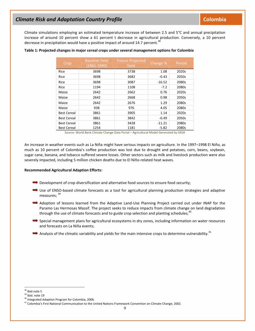
Climate simulations employing an estimated temperature increase of between 2.5 and 5°C and annual precipitation increase of around 10 percent show a 61 percent t decrease in agricultural production. Conversely, a 10 percent decrease in precipitation would have a positive impact of around 14.7 percent.
38
Table 1: Projected changes in major cereal crops under several management options for Colombia
Crop Baseline Yield (1961-1990)
Future Projected Yield
Change % Period
Rice 3698 3738 1.08 2020s
Rice 3698 3682 -0.43 2050s
Rice 3698 3087 -16.52 2080s
Rice 1194 1108 -7.2 2080s
Maize 2642 2662 0.76 2020s
Maize 2642 2668 0.98 2050s
Maize 2642 2676 1.29 2080s
Maize 938 976 4.05 2080s
Best Cereal 3861 3905 1.14 2020s
Best Cereal 3861 3842 -0.49 2050s
Best Cereal 3861 3428 -11.21 2080s Best Cereal 1254 1181 -5.82 2080s
Source: World Bank Climate Change Data Portal – Agricultural Model Generated by IIASA
An increase in weather events such as La Niña might have serious impacts on agriculture. In the 1997–1998 El Niño, as much as 10 percent of Colombia’s coffee production was lost due to drought and potatoes, corn, beans, soybean, sugar cane, banana, and tobacco suffered severe losses. Other sectors such as milk and livestock production were also severely impacted, including 5 million chicken deaths due to El Niño-related heat waves.
Recommended Agricultural Adaption Efforts:
Development of crop diversification and alternative food sources to ensure food security;
Use of ENSO-based climate forecasts as a tool for agricultural planning production strategies and adaptive measures;
39
Adoption of lessons learned from the Adaptive Land-Use Planning Project carried out under INAP for the Paramo Las Hermosas Massif. The project seeks to reduce impacts from climate change on land degradation through the use of climate forecasts and to guide crop selection and planting schedules;
40
Special management plans for agricultural ecosystems in dry zones, including information on water resources and forecasts on La Niña events;
Analysis of the climatic variability and yields for the main intensive crops to determine vulnerability.41
38 Ibid.note 5 39 Ibid. note 19 40 Integrated Adaption Program for Colombia, 2006. 41 Colombia's First National Communication to the United Nations Framework Convention on Climate Change, 2002.

10
Climate Risk and Adaptation Country Profile Colombia
WATER
Local, regional, and global temperature variations have already been shown as negatively affecting runoff rates, river mean flow, and glacial areas in the Northern tropical Andes. Colombia has among the highest levels of runoff offer of water in the world, providing for some 2.000 mm/year and an offer of water in excess of 2.000 cu. km/year, or 57.000 cu. m. per capita. However many areas of the country suffer from excessive deficits at levels of ~70 percent below the national average.
42
More than 95 percent of water used in production and domestic activities is extracted from the Magdalena-Cauca basins and tributaries draining into the Caribbean, which combined represent less than 25 percent of annual water production in the country. The Magdalena river basin also shows high vulnerability with 55 percent losses in mean flow.
43 The Glaciers and Páramo grasslands of the Northern tropical Andes are the primary water sources for hundreds
of settlements and municipal water supplies including the capital of Bogota. These fragile ecosystems are extremely vulnerable to the effects of local, regional and global climate change and are already showing signs of stress. Temperature increase of roughly 1°C in the last 30 years recorded at high-altitude meteorological stations is a primary control on glacier retreat. Eight tropical glaciers disappeared from the Colombian Andes during the 20th century, and the remaining six have experienced alarming retreat rates during the last decade. These significant and intensifying trends in glacier retreat pose numerous threats to human development:
44
With an average glacier linear retreat rate of 10–15 m per year, a total glacial collapse is expected in the next 100 years.
According to the Institute of Hydrology, Meteorology, and Environmental Studies (IDEAM), 25 percent of municipal headwaters show signs of water shortage, and this figure is expected to rise to 55 percent in 2015. This trend poses a great risk to the Colombian Andes where 80 percent of the national population is concentrated.
Between 2015 and 2025, a highly stressed condition is projected in the water availability in Colombia, affecting water supply and ecosystem functioning in the Páramos.
45
A reduction or inoperability of renewable hydropower generation (which provides 80 percent of Colombia’s demand) is expected as a result of a 30 percent reduction in the mean flows of the Colombia Andean region basins (particularly the Cauca river basin) and a maximum of 80 percent loss in some tributaries.
Recommended Water Resources Adaption Efforts:46
Detailed research and monitoring programs to quantify the local surface energy balance and requirements;
Adaptation measures, including integrated water management and watershed protection around the glacial areas of the Andean inter-tropical glaciers;
Identification of current wetland boundaries and distinguishing likely changes in hydrology and vegetative cover.
COASTAL AREAS AND RESOURCES
Colombia’s island zones consist of a series of islands in the Pacific (Malpelo and Gorgona) and in the Caribbean (archipelago of San Andres and Providencia and a large number of keys, islets and shallows). The Caribbean insular area totals 61.8 km
2 of which 90 percent hosts a population of about 70,000. Local economies in these areas rely
primarily on tourism, commerce, industrial and artisan fishing, and traditional agriculture. Coral reefs in these areas
42 Ibid. 43 Ibid. 44 Poveda G, Pineda K. Reassessment of Colombia’s Tropical Glaciers Retreat Rates: Are They Bound to Disappear During the 2010–2020 Decade? 2009. 45 IPCC Fourth Assessment Report (AR4), 2007. 46 See reference 35
11
Climate Risk and Adaptation Country Profile Colombia
produce 12 percent of the country’s fisheries and constitute the nursery of an estimated 65 percent of fish species. Coral beds in the western Caribbean hold endemic species of great global biodiversity value.
47
Stemming from their fragile and interconnected ecosystems, narrow economic bases, small area, geographical dispersion and relatively high population densities these small islands and the low-lying coastal and insular areas along the Pacific and Caribbean are particularly vulnerable to the effects of climate change.
Under a scenario of doubling atmospheric C02 for the period 2050–2080, the following changes could be expected in the Colombian islands:
Caribbean: Mean sea level could rise between 2 and 5 millimeters per year, air temperature could rise between 0.7 and 0.9°C beyond mean values observed for the period 1961-1990, and the annual rainfall for San Andres and Old Providence could have an incremental change between 15 and 20 percent, while in the continental islands of El Rosario and San Bernardo the incremental change would be between 7 and 10 percent.
Sea-level rise and climate change would disrupt fisheries and tourism through the loss of key ecosystems such as coral reefs, beaches due to coastal erosion, coastal inundation, degradation of coastal mangrove ecosystems, saline intrusion to freshwater aquifers, damage to human settlements and infrastructure and important and unique cultural and spiritual sites.
An increase in coastal storms and severe weather events such as tropical hurricanes and related storm surge is also noted due to the change in oceanic oscillation and rainfall patterns.
Recommended Water Resources Adaption Efforts:48
Improve the recovery and resiliency of coastal systems to facilitate natural adaptation to SLR;
Implement a program of “integrated coastal zone management” that emphasizes preservation of wetlands and other species to prevent coastal erosion and flooding and support the production of fisheries;
Perform susceptibility analysis of biophysical aspects in each vulnerable area
HEALTH
Approximately 23 million and 13 million Colombians live in areas of endemic dengue and malaria transmission, respectively, and about 85 percent of Colombia’s territory presents suitable ecological, climate, and epidemiological characteristics for malaria transmission.
49 Just a two-degree temperature change (from 24°C to 26°C) has been shown
to more than double the number of infectious mosquitoes, thus linking temperature and precipitation variations to an increase in vector-borne disease (VBD) incidences of malaria and dengue fever:
50
The incidence of malaria during epidemic years 1964–1983 increased from fewer than 15 cases per 10,000 inhabitants to 58 per 10,000 respectively, and nearly 156 per 10,000 in 1998.
During the 2000–2006 period, 583 municipalities reported malaria cases and 573 reported dengue events, confirming that malaria and dengue are present in more than half of Colombia’s municipalities.
Compared with 2000–2005 incidence rates, an increase of 11 percent and 35 percent in malaria and dengue cases (76,641 and 228,553, respectively) is expected for 50- and 100-year scenarios, due to climate change increase in global temperature and precipitation. These cases will be borne mainly by the low-income and poverty-stricken population.
47 Integrated Adaption Program for Colombia, 2006. 48 Ibid. note 35. 49, 50 Banlco, Jaier T, Hernandez, Diane. The Potential Costs of Climate Change in Tropical Vector-Borne Diseases – A Case Study of Malaria and Dengue Fever. World Bank 2007. LCR Sustainable Development Working Paper No. 32.
12
Climate Risk and Adaptation Country Profile Colombia
El Niño events, which increase precipitation and temperature variations, have been linked to increases in malaria and dengue fever rates.
51 However, there is still a high level of uncertainty as to whether or not
climate change increases the incidence and frequency of El Niño events.
Recommended Health Adaptation Efforts:
Improved response measures, early warning systems, and increased municipality expenditures for fumigation campaigns;
Vector-control implementation and methods adapted to local ecological and social circumstances52
;
Expansion of the Integrated Malaria and Dengue Surveillance and Control System (IMDSCS).
ECOSYSTEMS
Colombia is distinguished as one of the world’s “megadiverse” countries, hosting close to 14 percent of the planet’s biodiversity and some of the world’s richest aquatic resources. The largest source of biological diversity is found in the Andean ecosystem, the Amazon rainforest, and the sub-humid ecosystem in the Chodo area. However, a considerable part of these natural ecosystems has been transformed for agriculture and hydrological and temperature changes linked to climate change further endanger their endemic species:
Some Andean Moorlands have experienced a net increase o f 0.2-0.3°C per decade during the period 1961-1990 and a decrease in monthly rainfall of between 2 to 3 mm per decade. These areas already have low rainfall patterns and largely depend on regulated flows from glaciers and snowcaps.
52 , 53
Due to their endemic nature many of these ecosystems, such as the fragile Highland Andean ecosystems, and those in the Las Hermosas Massif, are vulnerable to hydrological and temperature variances.
Hydrological and temperature variations would result in loss of biodiversity, as there is “no way up” for unique mountain species, and also in loss of much of the environmental goods and services provided by these habitats, especially water supply, basin regulation, and associated hydropower potential.
53
Reduction in storage capacity for water and carbon in the soil, coupled with deforestation in the tropical Andes, would cause more incidences of landslides and floods and thus endanger an already vulnerable population.
54
Recommended Ecosystem Adaptation Efforts:
Deeper analysis and study of ecosystem functions and critical environmental services at all territorial levels to better design conservation and adaption programs.
Integration of payment for ecosystem services into adaption measures to better communicate the environmental goods and services provided by these habitats (for example water supply, basin regulation, and watershed protection).55
51 Poveda G. Climate and ENSO Associations with Malaria Incidence in Colombia, 2002. 52 Integrated Dengue and Malaria Surveillance and Control System, 2006 53 Integrated Adaption Program for Colombia, 2006. 54 IDEAM Paramos y Ecosistemas Alto Andinos de Colombia, en Condicion Hotspot & Global Climate Tensor, 2002. 55 World Bank Convenient Solutions to an Inconvenient Truth, 2010.
13
Climate Risk and Adaptation Country Profile Colombia
EXISTING ADAPTATION FRAMEWORK/STRATEGY/POLICY AND INSTITUTIONS
Beginning in the early 2000s, Colombia successfully decentralized disaster risk management and created a National
System for Disaster Management and Prevention, articulated in its National Disaster Prevention and Attention Plan
(SNPAD). Recommendations made by the GFDRR include improved urban planning, strengthening of local actors,
increased awareness, and the mainstreaming of disaster risk reduction (DRR) and climate change adaptation in
priority sectors. The Territorial Organization Plan (POT) of 2005 is aimed at reform of urban development and
territorial planning to reduce risks of floods and landslides in urban informal settlements. Implementation, however,
has been weak and its interaction with Municipal Development Plans is unclear.
In addition, the following entities are responsible for climate change efforts in Colombia:
The Ministry of Environment, Housing and Territorial Development (MAVDT) is the national authority on the environment, supervising Colombia’s commitments to the UNFCCC, and is the Designated National Authority (DNA) on climate change.
The Institute of Hydrology, Meteorology, and Environmental Studies (IDEAM) is one of five research institutions created within the Ministry of Environment, Housing and Territorial Development with the goal of providing scientific and technical support for the Ministry. It performs scientific studies and research on global change and its effects on Colombia.
The Andean Committee for Disaster Prevention and Response (CAPRADE) predicts seasonal climate and climate extremes.
INS is a governmental agency affiliated with the Colombian Health Ministry and is responsible for public health surveillance and control systems.
The Marine and Coastal Research Institute (INVEMAR) supports policy development, applied research, and conservation in Colombia’s coastal and insular areas and oceanic ecosystems.
Carolina, the Regional Government Corporation established as part of the Colombian National Environment System (SINA), is responsible for environmental planning and management in the archipelago of San Andres, Old Providence, and Santa Catalina.
Other Colombian and Partner Adaptation Initiatives Include:
Integration of ecosystems and adaptation to climate change in the Colombian Massif a program that works to strengthen the coordination of environmental issues within the national development agenda, with an emphasis on reducing vulnerability due to environmental degradation and climate change in the poorest and most affected sectors and groups in the Colombian Massif.
The National Biodiversity Strategy and Action Plan strives to manage biodiversity resources that are considered a key element for the present and future sustainable development of Colombia.
The Climate Change Discussion Table (Mesa Nacional de Cambio Climatico) organized by the Ministry of Environment, IDEAM, and partner organizations serves as a forum for coordinating and integrating the humanitarian consequences of climate change into their institutional agendas.
Safer and Better Prepared Communities, organized by the Red Cross of Colombia and with the support of the Red Cross of Holland and the Disaster Preparedness Program of the Humanitarian Aid Department of the EU (DIPECHO), aims to reduce natural disasters through education and capacity building for populations most vulnerable to disaster.
The Caribbean Planning for Adaptation to Climate Change Project (CPACC), affiliated with the Marine and Coastal Research Institute (INVEMAR) and the Netherlands Climate Change Studies Assistant Programme (NCCSAP), provides capacity building to improve adaptability to sea level rise in two vulnerable points of the Colombian coastal areas (Tumaco-Pacific coast and Cartagena–Caribbean coast), with special emphasis on human populations under poverty conditions.

14
Climate Risk and Adaptation Country Profile Colombia
The government of Colombia has initiated a number of studies and assessments to improve local responses to climate
change. To date, there are 40 adaptation projects under implementation, with the involvement of about 100
institutions: 13 projects are for the Colombian Highlands, three for coastal and insular areas, one on health issues, five
on the relationship of risks and climate change, two on infrastructure and the remaining 13 focus on research of
factors related to climate change in the agricultural sector. Among the most notable projects are the adaptation to
climate change of the San Andrés Island and the pilot project on adaptation to climate change in the “Macizo
Colombiano,” undertaken in cooperation with the United Nations Development Program (UNDP) and the Spanish
government.
INSTITUTIONAL AND POLICY GAPS
Disaster Risk Management (DRM) in Colombia has made great progress in improving monitoring and response to current disasters with the goal of being better prepared for future climate-related events. Colombian DRM, however, still faces obstacles—namely, in spreading knowledge among key decision makers and citizens at local levels, which will be critical for improving urban planning processes for sustainable development and adaptation efforts, while also discouraging informal settlements that worsen climate vulnerability.
Other strategies to improve DRM and climate change adaptation in Colombia include increasing awareness and resilience at local levels, mainstreaming adaptation to climate change in priority sectors, and institutionalizing extreme event risk financing.
RESEARCH, DATA AND INFORMATION GAPS
With nearly 600 natural disasters per year, Colombia is already experiencing climate-related risk. This existing risk,
coupled with projections of climate variance and its implications for loss of biodiversity and ecosystem services, sea
level rise and its effects on coastal and insular areas, as well as the threat to human health and socioeconomic
development, renders Colombia especially vulnerable to future climate variability. Some adaptation measures and
programs have been implemented, but they need to be better articulated and more easily accessible to stakeholders
and all sectors of government.
RESEARCH GAPS
Recommended adaption measures and information for different ecosystems and sectors are insufficient and require further multidisciplinary research.
More emphasis is needed on adaptive measures for internally displaced people and those below the poverty line, as climate change will impact them more than any other groups.
Discrepancies exist regarding the long-term effects of climate change on the El Niño (ENSO) and La Niña events. Since these weather trends have such high impact on people, commerce, and ecosystems, it is crucial to better estimate possible fluctuations in intensity.
Better watershed protection measures need to be researched and developed for the Northern tropical Andean Glacial area as the estimates of their complete disappearance are very alarming.

15
Climate Risk and Adaptation Country Profile Colombia
DATA AND INFORMATION GAPS
There are insufficient or contradictory data on recent and future climate trends for the varying regional and climatic zones.
Very little information was found regarding the threat of drought or adaptive measures to prevent it, even though it is considered a serious threat in some areas and could increase in magnitude.
Studies are needed on the adaptability of the ethno-cultural groups that live in each zone and region, as different groups will require different adaptation measures.
Considering that such a high percentage of the rural population relies on agriculture, more research on alterative livelihoods, food sources, and crop susceptibility is needed.
COLOMBIA
Mozambique
E N VTeam
Climate Change
© 2011 THE WORLD BANK GROUP1818 H Street, NWWashington, DC 20433Internet: www.worldbank.orgContact: Milen Dyoulgerov, [email protected]
All rights reserved.
This volume is a product of the World Bank Group. The World Bank Group does not guarantee the accuracy of the data in-cluded in this work. The boundaries, colors, denominations, and other information shown on any map in this work do not imply any judgement on the part of the World Bank Group concerning the legal status of any territory or the endorsement or acceptance of such boundaries.
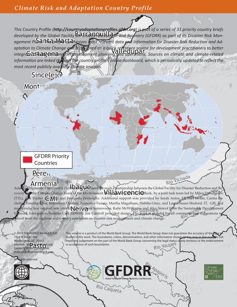
This Country Profile (http://countryadaptationprofiles.gfdrr.org) is part of a series of 31 priority country briefs developed by the Global Facility for Disaster Reduction and Recovery (GFDRR) as part of its Disaster Risk Man-agement Plans. The profile synthesizes most relevant data and information for Disaster Risk Reduction and Ad-aptation to Climate Change and is designed as a quick reference source for development practitioners to better integrate climate resilience in development planning and operations. Sources on climate and climate-related information are linked through the country profile’s online dashboard, which is periodically updated to reflect the most recent publicly available climate analysis.
Climate Risk and Adaptation Country Profile
GFDRR PriorityCountries
Acknowledgments: The Country Profiles were produced through a partnership between the Global Facility for Disaster Reduction and Re-covery and the Climate Change Team of the Environment Department of the World Bank, by a joint task team led by Milen Dyoulgerov (TTL), Ana Bucher (co-TTL), and Fernanda Zermoglio. Additional support was provided by Sarah Antos, Michael Swain, Carina Ba-chofen, Fareeha Iqbal, Iretomiwa Olatunji, Francesca Fusaro, Marilia Magalhaes, Habiba Gitay, and Laura-Susan Shuford. IT, GIS, and map production support was provided by Varuna Somaweera, Katie McWilliams, and Alex Stoicof from the Sustainable Development Network Information Systems Unit (SDNIS). Jim Cantrell provided design. The team is grateful for all comments and suggestions re-ceived from the regional and country specialists on disaster risk management and climate change.
Related Documents