Ž . Journal of Volcanology and Geothermal Research 92 1999 1–29 www.elsevier.comrlocaterjvolgeores Volcanic geology of Furnas Volcano, Sao Miguel, Azores ˜ J.E. Guest a, ) , J.L. Gaspar b , P.D. Cole a,c , G. Queiroz b , A.M. Duncan c , N. Wallenstein b , T. Ferreira b , J.-M. Pacheco b a UniÕersity College London, Planetary Image Centre, 33–35 Daws Lane, Mill Hill, London, NW7 4SD, UK b Departamento de Geociencias, UniÕersidade dos Ac ¸ores, Rua Mae de Deus, 9500 Ponta Delgada, Portugal ˆ ˜ c Centre for Volcanic Studies, Department of EnÕironment, Geography and Geology, UniÕersity of Luton, Park Square, Luton, LU1 3 JU, UK Received 1 November 1998; accepted 20 April 1999 Abstract Furnas is the easternmost of the three active central volcanoes on the island of Sao Miguel in the Azores. Unlike the other ˜ two central volcanoes, Sete Cidades and Fogo, Furnas does not have a well-developed edifice, but consists of a steep-sided caldera complex 8 =5 km across. It is built on the outer flanks of the Povoac ¸aorNordeste lava complex that forms the ˜ eastern end of Sao Miguel. Constructive flanks to the volcano exist on the southern side where they form the coastal cliffs, ˜ and to the west. The caldera margins tend to reflect the regionalrlocal tectonic pattern which has also controlled the distribution of vents within the caldera and areas of thermal springs. Activity at Furnas has been essentially explosive, erupting materials of trachytic composition. Products associated with the volcano include plinian and sub-plinian pumice deposits, ignimbrites and surge deposits, phreatomagmatic ashes, block and ash deposits and dome materials. Most of the activity has occurred from vents within the caldera, or on the caldera margin, although strombolian eruptions with aa flows of ankaramite and hawaiite have occurred outside the caldera. The eruptive history consists of at least two major caldera collapses, followed by caldera infilling. Based on 14 C dates, it appears that the youngest major collapse occurred about 12,000–10,000 years BP. New 14 C dates for a densely welded ignimbrite suggest that a potential caldera-forming eruption Ž . occurred at about 30,000 years BP. Recent eruptions -5000 years old were mainly characterised by alternating episodes of magmatic and phreatomagmatic activity of plinian and sub-plinian magnitude, forming deposits of interbedded ash and lapilli. An historical eruption is documented in 1630 AD; new evidence suggests that another occurred during the early occupation of the area at about 1440 AD. q 1999 Elsevier Science B.V. All rights reserved. Keywords: geology; Furnas Volcano; Azores; trachytic pyroclastics; calderas; 14 C dates 1. Introduction Furnas, near the eastern end of Sao Miguel island ˜ Ž . Fig. 1 , has been, and probably continues to be, one ) Corresponding author. Department of Geological Sciences, University College London, Gower St., London WC1E 6BT, UK of the most active and dangerous volcanoes in the Azores Archipelago. It is a trachytic centre, and the majority of its activity has involved explosive vol- canism. However, throughout its history, it has ex- hibited almost all known eruptive styles ranging from mild effusive activity to caldera-forming explo- sive events. From a hazard perspective, it poses 0377-0273r99r$ - see front matter q 1999 Elsevier Science B.V. All rights reserved. Ž . PII: S0377-0273 99 00064-5

Welcome message from author
This document is posted to help you gain knowledge. Please leave a comment to let me know what you think about it! Share it to your friends and learn new things together.
Transcript
Ž .Journal of Volcanology and Geothermal Research 92 1999 1–29www.elsevier.comrlocaterjvolgeores
Volcanic geology of Furnas Volcano, Sao Miguel, Azores˜J.E. Guest a,), J.L. Gaspar b, P.D. Cole a,c, G. Queiroz b, A.M. Duncan c,
N. Wallenstein b, T. Ferreira b, J.-M. Pacheco b
a UniÕersity College London, Planetary Image Centre, 33–35 Daws Lane, Mill Hill, London, NW7 4SD, UKb Departamento de Geociencias, UniÕersidade dos Acores, Rua Mae de Deus, 9500 Ponta Delgada, Portugalˆ ˜
c Centre for Volcanic Studies, Department of EnÕironment, Geography and Geology, UniÕersity of Luton, Park Square, Luton, LU1 3 JU,UK
Received 1 November 1998; accepted 20 April 1999
Abstract
Furnas is the easternmost of the three active central volcanoes on the island of Sao Miguel in the Azores. Unlike the other˜two central volcanoes, Sete Cidades and Fogo, Furnas does not have a well-developed edifice, but consists of a steep-sidedcaldera complex 8=5 km across. It is built on the outer flanks of the PovoacaorNordeste lava complex that forms the˜eastern end of Sao Miguel. Constructive flanks to the volcano exist on the southern side where they form the coastal cliffs,˜and to the west. The caldera margins tend to reflect the regionalrlocal tectonic pattern which has also controlled thedistribution of vents within the caldera and areas of thermal springs. Activity at Furnas has been essentially explosive,erupting materials of trachytic composition. Products associated with the volcano include plinian and sub-plinian pumicedeposits, ignimbrites and surge deposits, phreatomagmatic ashes, block and ash deposits and dome materials. Most of theactivity has occurred from vents within the caldera, or on the caldera margin, although strombolian eruptions with aa flowsof ankaramite and hawaiite have occurred outside the caldera. The eruptive history consists of at least two major calderacollapses, followed by caldera infilling. Based on 14C dates, it appears that the youngest major collapse occurred about12,000–10,000 years BP. New 14C dates for a densely welded ignimbrite suggest that a potential caldera-forming eruption
Ž .occurred at about 30,000 years BP. Recent eruptions -5000 years old were mainly characterised by alternating episodesof magmatic and phreatomagmatic activity of plinian and sub-plinian magnitude, forming deposits of interbedded ash andlapilli. An historical eruption is documented in 1630 AD; new evidence suggests that another occurred during the earlyoccupation of the area at about 1440 AD. q 1999 Elsevier Science B.V. All rights reserved.
Keywords: geology; Furnas Volcano; Azores; trachytic pyroclastics; calderas; 14C dates
1. Introduction
Furnas, near the eastern end of Sao Miguel island˜Ž .Fig. 1 , has been, and probably continues to be, one
) Corresponding author. Department of Geological Sciences,University College London, Gower St., London WC1E 6BT, UK
of the most active and dangerous volcanoes in theAzores Archipelago. It is a trachytic centre, and themajority of its activity has involved explosive vol-canism. However, throughout its history, it has ex-hibited almost all known eruptive styles rangingfrom mild effusive activity to caldera-forming explo-sive events. From a hazard perspective, it poses
0377-0273r99r$ - see front matter q 1999 Elsevier Science B.V. All rights reserved.Ž .PII: S0377-0273 99 00064-5
( )J.E. Guest et al.rJournal of Volcanology and Geothermal Research 92 1999 1–292
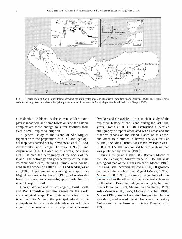
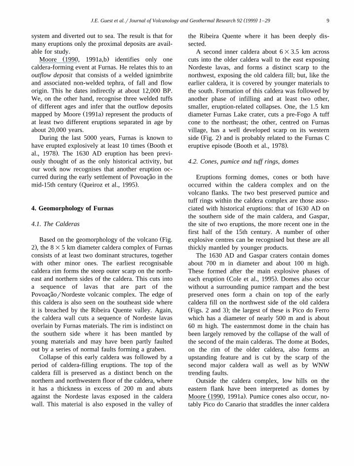
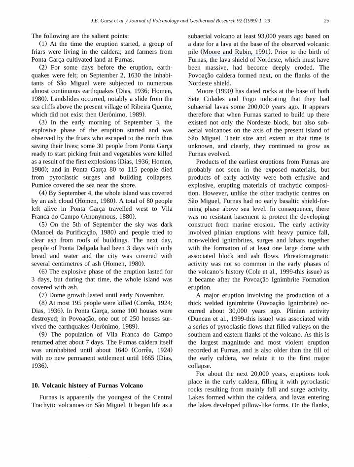
Ž .Fig. 1. General map of Sao Miguel Island showing the main volcanoes and structures modified from Queiroz, 1998 . Inset right shows˜Ž .Atlantic setting; inset left shows the principal structures of the Azores Archipelago area modified from Gaspar, 1996 .
considerable problems as the current caldera com-plex is inhabited, and some towns outside the calderacomplex are close enough to suffer fatalities fromeven a small explosive eruption.
A general study of the island of Sao Miguel,˜together with the preparation of a 1:50,000 geologi-
Ž .cal map, was carried out by Zbyszewski et al. 1958 ,Ž .Zbyszewski and Veiga Ferreira 1959 , and
Ž .Zbyszewski 1961 . Based on this work, Assuncao˜Ž .1961 studied the petrography of the rocks of theisland. The petrology and geochemistry of the mainvolcanic complexes, including Furnas, were consid-
Ž .ered in the works of Fetter 1981 and Rodrigues etŽ .al. 1989 . A preliminary volcanological map of Sao˜
Ž .Miguel was made by Forjaz 1976 , who also de-fined the main volcano-stratigraphic units for this
Ž .island Forjaz, 1984 .George Walker and his colleagues, Basil Booth
and Ron Croasdale, put the Azores on the worldvolcanological map. Their detailed studies of theisland of Sao Miguel, the principal island of the˜archipelago, led to considerable advances in knowl-edge of the mechanisms of explosive volcanism
Ž .Walker and Croasdale, 1971 . In their study of theexplosive history of the island during the last 5000
Ž .years, Booth et al. 1978 established a detailedstratigraphy of tephra associated with Furnas and theother volcanoes on the island. Based on this workand other field studies, a hazard analysis for Sao˜Miguel, including Furnas, was made by Booth et al.Ž .1983 . A 1:50,000 generalised hazard analysis map
Ž .was published by Forjaz 1985 .During the years 1980r1983, Richard Moore of
the US Geological Survey made a 1:15,000 scaleŽ .geological map of the Furnas Volcano Moore, 1983 .
This was later incorporated into a 1:50,000 geologi-Ž .cal map of the whole of Sao Miguel Moore, 1991a .˜
Ž .Moore 1990, 1991b discussed the geology of Fur-nas as well as the other two major central volcanoeson the island. Based on radiogenic dating by him and
Žothers Shotton, 1969; Shotton and Williams, 1971;.Adel-Monem et al., 1975; Moore and Rubin, 1991 ,
Ž .Moore 1990 studied eruption frequencies. Furnaswas designated one of the six European LaboratoryVolcanoes by the European Science Foundation in1990.
( )J.E. Guest et al.rJournal of Volcanology and Geothermal Research 92 1999 1–29 3
2. Atlantic setting
The Azores Archipelago, which consists of nineinhabited islands, sits astride the Mid-Atlantic Ridge.The islands are associated with a region of positivegravity and residual depth anomaly which is inter-preted as the surface expression of a mantle plumeŽ .White et al., 1976; McKenzie and O’Nions, 1995 .
The archipelago is located where the American,Eurasian and African lithospheric plates meet at a
Ž .triple junction Fig. 1 . Within this framework, theNorth Atlantic in the area of the Azores is charac-
Ž .terised by three main tectonic features. These are: 1Ž .The Mid-Atlantic Ridge MAR which crosses the
archipelago between the islands of Flores and FaialŽ .Kurase and Watkins, 1970; Steinmetz et al., 1976 .The ridge trends 108 to the north of latitude 38850X N
Ž .and between 108 and 208 to the south Searle, 1980 ;Ž .2 The East Azores Fracture Zone which extendsbroadly east–west from the MAR to GibraltarŽ . Ž .Kurase and Watkins, 1970 ; and 3 the TerceiraRift which extends from the island of Santa Maria
Ž .northwest to the MAR Machado, 1959 . In addition,the fracture systems of Sao Jorge and FaialrPico˜
Ž .have a general WNW–ESE trend Agostinho, 1932 .ŽFor the Azores Platform Needham and
.Francheteau, 1974; Lourenceau et al., 1968 , theboundary between the American and Eurasian platesis well-established. However, the location and natureof the eastern branch of the Azores triple junction isstill controversial, and is the subject of several geo-
Ž .dynamic models Madeira and Ribeiro, 1990 .
3. Furnas and its geological setting
Ž .The active centres of Sao Miguel Fig. 1 consist˜of three major trachytic central volcanoes, linked byrift zones. At the trachytic centres, explosive volcan-ism has dominated, while in the rift zones, althoughoccasional trachytic eruptions have occurred, activityis characterised by basaltic effusive eruptions accom-panied by strombolian cone building.
At the western end of the island is Sete CidadesVolcano which has been built up from several phasesof activity including the production of a lava shield
Ž .and numerous explosive eruptions. Queiroz 1998
identifies at least 17 explosive eruptions that oc-curred here during the last 5000 years. In addition,there have been three offshore eruptions recorded inthe last 400 years. The edifice is truncated by acomplex caldera which contains two lakes. Withinthe caldera are cones and domes representing thepresent phase of caldera infilling, the most recent of
Žwhich is dated at about 600 years ago Booth et al.,.1978 just before the island was inhabited by Por-
tuguese settlers. The only known historical eruptionsŽ .on land post about 1440 AD in this part of the
Ž .island occurred in 1652 AD Weston, 1994 on theso called ‘waist’ region, the rift between Sete Cidadesand Fogo Volcano to the east. The 18 km long waistconsists of hundreds of cinder cones, fissure ventsystems and associated lava flows.
Ž .Fogo Volcano also known as Agua de Pau , islargely made up of pyroclastic deposits and is alsotruncated by a caldera complex. There have been atleast four eruptions from this centre during the past
Ž .5000 years Booth et al., 1978 , the most recentŽ .being in 1563 AD Weston, 1994 . The deposits
from a major eruption that occurred about 5000years ago were first recognised by Walker and
Ž .Croasdale 1971 and termed Fogo A. This eruptionproduced one of the best documented of all pliniandeposits; it is also distinctive in the field and servesas a widespread marker horizon in the stratigraphy of
ŽSao Miguel Booth et al., 1978; Cole et al., 1999-this˜.issue .
Another, mainly basaltic, rift links Fogo to thenext trachytic centre, Furnas. This rift is known asthe Achada das Furnas complex and is 5 km long; itconsists of cinder cones and lavas, and includes a
Žsmall, young trachytic centre known as Congro Fig..1 .
Furnas Volcano is, from a topographic point-of-view, the least impressive of all the volcanoes onSao Miguel. It has no well-developed positive edi-˜fice: to the west, its products interdigitate with lavasfrom the Achada das Furnas rift; to the east, it banksup against the deeply eroded Nordeste complex oflavas that once formed a basaltic shield, much ofwhich has been destroyed by marine and fluvial
Ž .erosion Moore, 1991a,b . It also cuts into thePovoacao caldera, which, in turn, cuts the Nordeste˜complex. This old caldera is about 6 km across andpartly open to the sea at the mouth of the main
( )J.E. Guest et al.rJournal of Volcanology and Geothermal Research 92 1999 1–294
drainage system. Only a few outcrops of pyroclasticmaterials have been associated with the Povoacao˜
Ž .caldera centre Moore, 1990 . Although the calderais presently open to the sea, and thus could be theresult of sector collapse, the opening is narrow and itis more likely that faulting and marine erosion havecut back into the seaward side, breaching the calderawalls.
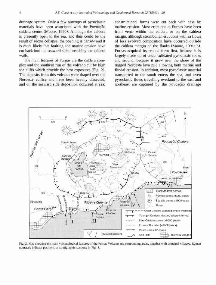
The main features of Furnas are the caldera com-plex and the southern rim of the volcano cut by high
Ž .sea cliffs which provide the best exposures Fig. 2 .The deposits from this volcano were draped over theNordeste edifice and have been heavily dissected,and on the seaward side deposition occurred at sea;
constructional forms were cut back with ease bymarine erosion. Most eruptions at Furnas have beenfrom vents within the caldera or on the calderamargin, although strombolian eruptions with aa flowsof less evolved composition have occurred outside
Ž .the caldera margin on the flanks Moore, 1991a,b .Furnas acquired its eroded form first, because it islargely made up of unconsolidated pyroclastic rocksand second, because it grew near the shore of therugged Nordeste lava pile allowing both marine andfluvial erosion. In addition, most pyroclastic materialtransported to the south enters the sea, and evenpyroclastic flows travelling overland to the east andnortheast are captured by the Povoacao drainage˜
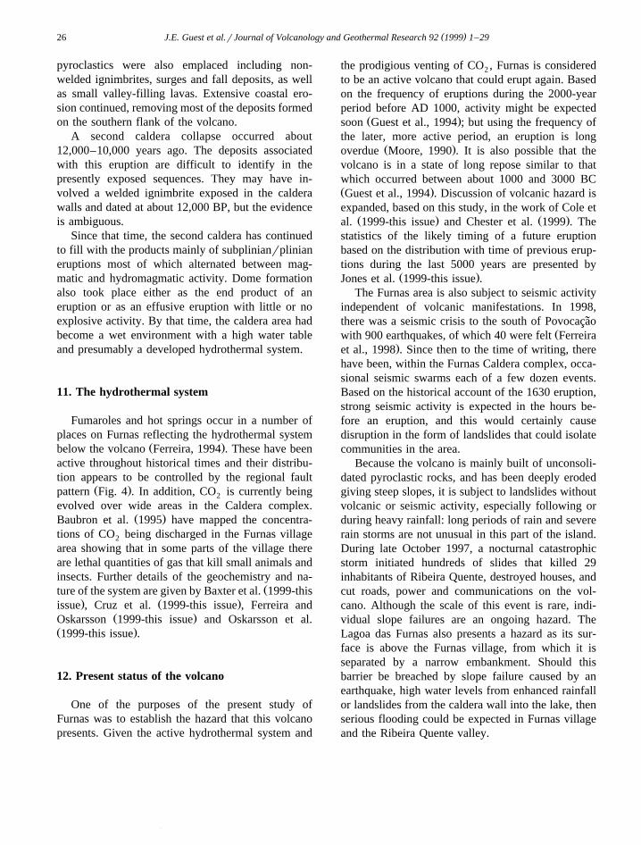
Fig. 2. Map showing the main volcanological features of the Furnas Volcano and surrounding areas, together with principal villages. Romannumerals indicate positions of stratigraphic sections in Fig. 8.

( )J.E. Guest et al.rJournal of Volcanology and Geothermal Research 92 1999 1–29 5
Ž . Ž .Fig. 3. a Sketch of the Furnas Caldera looking northeast from approximately 2 km west of Lagoa das Furnas. b Photograph facingŽ Ž . .northeast from the Pico do Ferro overlook identified in a and Fig. 2 showing the outer earlier caldera wall cut into lavas of the Nordeste
Ž . Ž . Ž .complex A , top of early caldera infill made up of pyroclastics, lacustrine deposits and lavas B ; and the inner caldera scarp C .


( )J.E. Guest et al.rJournal of Volcanology and Geothermal Research 92 1999 1–29 9
system and diverted out to sea. The result is that formany eruptions only the proximal deposits are avail-able for study.
Ž .Moore 1990, 1991a,b identifies only onecaldera-forming event at Furnas. He relates this to anoutflow deposit that consists of a welded ignimbriteand associated non-welded tephra, of fall and floworigin. This he dates indirectly at about 12,000 BP.We, on the other hand, recognise three welded tuffsof different ages and infer that the outflow deposits
Ž .mapped by Moore 1991a represent the products ofat least two different eruptions separated in age byabout 20,000 years.
During the last 5000 years, Furnas is known toŽhave erupted explosively at least 10 times Booth et
.al., 1978 . The 1630 AD eruption has been previ-ously thought of as the only historical activity, butour work now recognises that another eruption oc-curred during the early settlement of Povoacao in the˜
Ž .mid-15th century Queiroz et al., 1995 .
4. Geomorphology of Furnas
4.1. The Calderas
ŽBased on the geomorphology of the volcano Fig..2 , the 8=5 km diameter caldera complex of Furnas
consists of at least two dominant structures, togetherwith other minor ones. The earliest recognisablecaldera rim forms the steep outer scarp on the north-east and northern sides of the caldera. This cuts intoa sequence of lavas that are part of thePovoacaorNordeste volcanic complex. The edge of˜this caldera is also seen on the southeast side whereit is breached by the Ribeira Quente valley. Again,the caldera wall cuts a sequence of Nordeste lavasoverlain by Furnas materials. The rim is indistinct onthe southern side where it has been mantled byyoung materials and may have been partly faultedout by a series of normal faults forming a graben.
Collapse of this early caldera was followed by aperiod of caldera-filling eruptions. The top of thecaldera fill is preserved as a distinct bench on thenorthern and northwestern floor of the caldera, whereit has a thickness in excess of 200 m and abutsagainst the Nordeste lavas exposed in the calderawall. This material is also exposed in the valley of
the Ribeira Quente where it has been deeply dis-sected.
A second inner caldera about 6=3.5 km acrosscuts into the older caldera wall to the east exposingNordeste lavas, and forms a distinct scarp to thenorthwest, exposing the old caldera fill; but, like theearlier caldera, it is covered by younger materials tothe south. Formation of this caldera was followed byanother phase of infilling and at least two other,smaller, eruption-related collapses. One, the 1.5 kmdiameter Furnas Lake crater, cuts a pre-Fogo A tuffcone to the northeast; the other, centred on Furnasvillage, has a well developed scarp on its western
Ž .side Fig. 2 and is probably related to the Furnas CŽ .eruptive episode Booth et al., 1978 .
4.2. Cones, pumice and tuff rings, domes
Eruptions forming domes, cones or both haveoccurred within the caldera complex and on thevolcano flanks. The two best preserved pumice andtuff rings within the caldera complex are those asso-ciated with historical eruptions: that of 1630 AD onthe southern side of the main caldera, and Gaspar,the site of two eruptions, the more recent one in thefirst half of the 15th century. A number of otherexplosive centres can be recognised but these are allthickly mantled by younger products.
The 1630 AD and Gaspar craters contain domesabout 700 m in diameter and about 100 m high.These formed after the main explosive phases of
Ž .each eruption Cole et al., 1995 . Domes also occurwithout a surrounding pumice rampart and the bestpreserved ones form a chain on top of the earlycaldera fill on the northwest side of the old calderaŽ .Figs. 2 and 3 ; the largest of these is Pico do Ferrowhich has a diameter of nearly 500 m and is about60 m high. The easternmost dome in the chain hasbeen largely removed by the collapse of the wall ofthe second of the main calderas. The dome at Bodes,on the rim of the older caldera, also forms anupstanding feature and is cut by the scarp of thesecond major caldera wall as well as by WNWtrending faults.
Outside the caldera complex, low hills on theeastern flank have been interpreted as domes by
Ž .Moore 1990, 1991a . Pumice cones also occur, no-tably Pico do Canario that straddles the inner caldera
( )J.E. Guest et al.rJournal of Volcanology and Geothermal Research 92 1999 1–2910
Ž .wall to the east Fig. 2 . To the north there are atleast 10 cinder cones with associated lavas, all ofwhich are more than 5000 years old.
5. Tectonic structures
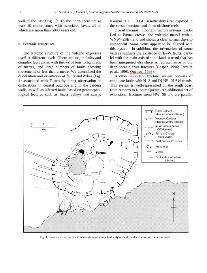
The tectonic structure of the volcano expressesitself at different levels. There are major faults andcomplex fault zones with throws of tens to hundredsof metres, and large numbers of faults showingmovements of less than a metre. We determined the
Ždistribution and orientation of faults and dykes Fig..4 associated with Furnas by direct observation of
dislocations in coastal outcrops and in the calderawalls, as well as inferred faults based on geomorpho-logical features such as linear valleys and scarps
Ž .Gaspar et al., 1995 . Basaltic dykes are exposed inthe coastal sections and form offshore reefs.
One of the most important fracture systems identi-fied at Furnas crosses the volcanic massif with aWNW–ESE trend and shows a clear normal dip-slipcomponent. Some vents appear to be aligned withthis system. In addition, the orientation of somevalleys suggests the existence of E–W faults, paral-lel with the main axis of the island, a trend that hasbeen interpreted elsewhere as representative of old
Ždeep oceanic crust fractures Gaspar, 1996; Ferreira.et al., 1998; Queiroz, 1998 .
Another important fracture system consists ofŽ . Ž .conjugate faults with N–S and N NE– S SW trends.
This system is well-represented on the south coastfrom Amoras to Ribeira Quente. An additional set ofextensional fractures trend NW–SE and are parallel
Fig. 4. Sketch map of Furnas Volcano showing major faults, dykes and the distribution of fumarole fields.
( )J.E. Guest et al.rJournal of Volcanology and Geothermal Research 92 1999 1–29 11
to the so-called Terceira Rift regional fault systemŽ .Fig. 1 .
The following conclusions emerge from the pat-tern of structures shown in Fig. 4. First, the conver-gence of the different structural systems may beresponsible for the localisation of a trachytic centreat Furnas, a situation similar to that at the two other
Ž .major trachytic centres on the island Queiroz, 1998 ,Žand also found on other Azorean islands Gaspar,
.1996 ; second, the outlines of the calderas tend tomimic the main fault trends, suggesting that thewalls of the two major caldera collapses are stronglycontrolled by structural weaknesses, especially theNE–SW system; and third, the WNW–ESE system
of fractures played a major role in the transfer ofmagma to the surface.
6. Petrology
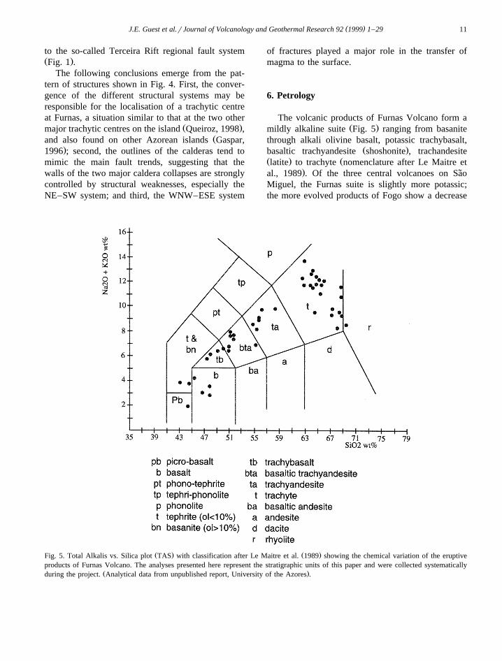
The volcanic products of Furnas Volcano form aŽ .mildly alkaline suite Fig. 5 ranging from basanite
through alkali olivine basalt, potassic trachybasalt,Ž .basaltic trachyandesite shoshonite , trachandesite
Ž . Žlatite to trachyte nomenclature after Le Maitre et.al., 1989 . Of the three central volcanoes on Sao˜
Miguel, the Furnas suite is slightly more potassic;the more evolved products of Fogo show a decrease
Ž . Ž .Fig. 5. Total Alkalis vs. Silica plot TAS with classification after Le Maitre et al. 1989 showing the chemical variation of the eruptiveproducts of Furnas Volcano. The analyses presented here represent the stratigraphic units of this paper and were collected systematically
Ž .during the project. Analytical data from unpublished report, University of the Azores .
( )J.E. Guest et al.rJournal of Volcanology and Geothermal Research 92 1999 1–2912
in K O and have a peralkaline tendency, whereas the2ŽSete Cidades trend is more sodic Moore, 1991b;
.Queiroz, 1998 . These mildly alkaline suites aretypical of many oceanic volcanic islands associated
Ž .with spreading centres Wilson, 1989 .At Furnas, materials erupted within the caldera
complex are trachytic in composition, consisting oflatites and trachytes. Vents erupting basic magmasare restricted to the flanks of the volcano. It appearsthat basaltic magmas have been prevented fromerupting within the caldera complex during the his-tory of Furnas Volcano. A basanite lava that occursat the base of the exposed caldera fill at Salto dosIngleses may have either flowed into the caldera
Ž .from a vent outside Moore, 1991b or represent theunderlying basement of Nordeste Volcano lavas.
The products of Furnas form a compositionallycontinuous sequence from basalt through to trachyte,though intermediate members are present in only
Ž .subordinate amounts Fig. 5 . The volcanics of Sao˜Miguel are broadly bimodal in composition, eitherbasaltic or trachytic, with a scarcity of intermediate
Ž . Ž .products; both Booth et al. 1978 and Moore 1991bestimated the relative volumes of material of differ-ent composition and substantiated the presence of
Ž .this Daly Gap. Self and Gunn 1976 identified asimilar scarcity of intermediate products in theerupted material of Terceira, one of the central groupislands of the Azores. This Daly Gap could representeither a genuine scarcity of magmas of intermediatecomposition or some physical control that inhibitsthe eruption of magmas of intermediate composition.
Ž .Self and Gunn 1976 suggest that an efficient differ-entiation system may generate salic residues leavinglittle in the way of intermediate products. Storey et
Ž .al. 1989 , in a study of Fogo Volcano, argue that thepresence of a compositionally zoned magma reser-voir with a cap of trachytic liquid will prevent theeruption of less evolved melts. It is generally ac-
Žcepted by most workers Rodrigues et al., 1989;Storey et al., 1989; Moore, 1991a,b; Widom et al.,
.1992 that the observed compositional range of theerupted magmas on Sao Miguel has been largely˜generated by fractional crystallisation from a basicparent.
In terms of a plumbing model, it is proposed thatbasaltic magma ascends from the mantle along theaxis of Sao Miguel island. Where this axis is cut by˜
NWrSE grabens this has allowed higher rate ofthroughput of magma and enabled significant storagewithin crustal reservoirs. With time, these crustalreservoirs differentiated into zoned trachytic bodieswhich have given rise to periodic explosive trachyticeruptions. Eruption of basaltic magma is restricted tozones outside these long-standing trachytic reser-voirs.
7. Stratigraphy
The products of Furnas, being mainly of pyroclas-tic origin, are deeply dissected, both within thecaldera complex and on the flanks. Many deep val-leys have been carved along fault zones. Superfi-cially, however, much of Furnas appears to be abland terrain in which the lush vegetation disguisesthe valleys and the steep caldera walls that haveslopes sometimes more than 508. Marine erosion,together with fluvial activity, has also produced asteep and highly incised coastal region.
Despite the deep dissection, establishing thestratigraphy is no easy task because of thick vegeta-tion. The inner caldera walls provide a few discon-tinuous outcrops formed by landslides and two wa-terfall sections. Within the caldera there are manyroad, track and stream cuts that expose some of theyounger deposits.
The best exposures are in the sea cliffs that cutthe southern flank of the volcano in a generallyproximal zone. We derive most of our informationfor the stratigraphy before 5000 years ago from thissection. The cliffs show a relatively well-definedsequence of deposits. Fig. 6, which represents asection of the sea cliff from just east of Ponta Garcato just west of Povoacao, is constructed from de-˜tailed studies of outcrops accessible on narrow cliffpaths, from seaborne visits to beach sections, andfrom a set of overlapping photographs taken from aboat along the whole coastline. The key stratigraphichorizon in the coastal section is the Povoacao Ign-˜imbrite, which can be traced from the Povoacao area˜on the flanks of the Furnas Volcano to the western
Ž .end of the cliff section Figs. 6 and 8 .Below the Furnas sequence is a pile of basaltic
lavas belonging to the Nordeste Volcano. They occur
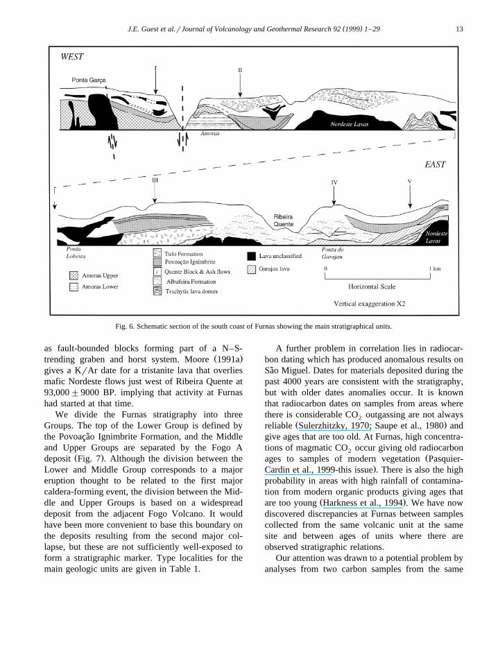
( )J.E. Guest et al.rJournal of Volcanology and Geothermal Research 92 1999 1–29 13
Fig. 6. Schematic section of the south coast of Furnas showing the main stratigraphical units.
as fault-bounded blocks forming part of a N–S-Ž .trending graben and horst system. Moore 1991a
gives a KrAr date for a tristanite lava that overliesmafic Nordeste flows just west of Ribeira Quente at93,000"9000 BP. implying that activity at Furnashad started at that time.
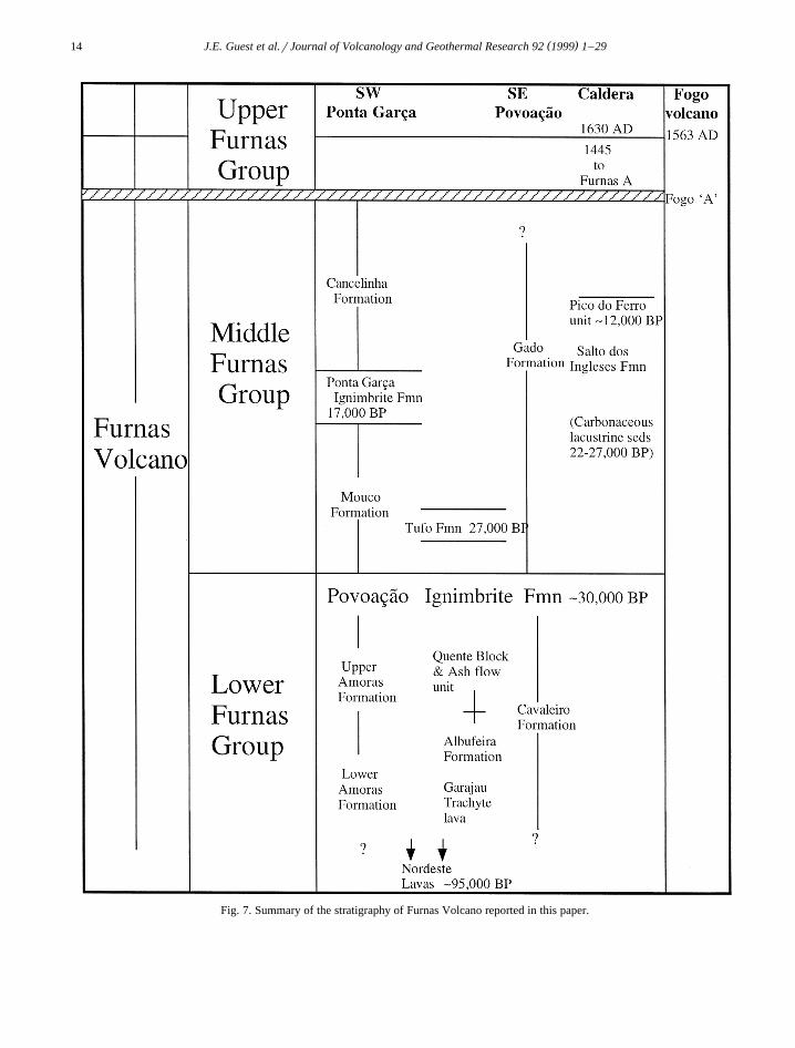
We divide the Furnas stratigraphy into threeGroups. The top of the Lower Group is defined bythe Povoacao Ignimbrite Formation, and the Middle˜and Upper Groups are separated by the Fogo A
Ž .deposit Fig. 7 . Although the division between theLower and Middle Group corresponds to a majoreruption thought to be related to the first majorcaldera-forming event, the division between the Mid-dle and Upper Groups is based on a widespreaddeposit from the adjacent Fogo Volcano. It wouldhave been more convenient to base this boundary onthe deposits resulting from the second major col-lapse, but these are not sufficiently well-exposed toform a stratigraphic marker. Type localities for themain geologic units are given in Table 1.
A further problem in correlation lies in radiocar-bon dating which has produced anomalous results onSao Miguel. Dates for materials deposited during the˜past 4000 years are consistent with the stratigraphy,but with older dates anomalies occur. It is knownthat radiocarbon dates on samples from areas wherethere is considerable CO outgassing are not always2
Ž .reliable Sulerzhitzky, 1970; Saupe et al., 1980 andgive ages that are too old. At Furnas, high concentra-tions of magmatic CO occur giving old radiocarbon2
Žages to samples of modern vegetation Pasquier-.Cardin et al., 1999-this issue . There is also the high
probability in areas with high rainfall of contamina-tion from modern organic products giving ages that
Ž .are too young Harkness et al., 1994 . We have nowdiscovered discrepancies at Furnas between samplescollected from the same volcanic unit at the samesite and between ages of units where there areobserved stratigraphic relations.
Our attention was drawn to a potential problem byanalyses from two carbon samples from the same
( )J.E. Guest et al.rJournal of Volcanology and Geothermal Research 92 1999 1–2914
Fig. 7. Summary of the stratigraphy of Furnas Volcano reported in this paper.
( )J.E. Guest et al.rJournal of Volcanology and Geothermal Research 92 1999 1–29 15
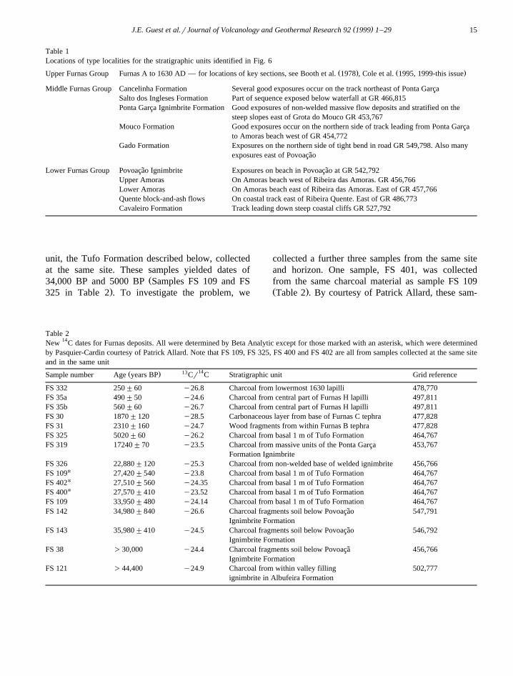
Table 1Locations of type localities for the stratigraphic units identified in Fig. 6
Ž . Ž .Upper Furnas Group Furnas A to 1630 AD — for locations of key sections, see Booth et al. 1978 , Cole et al. 1995, 1999-this issue
Middle Furnas Group Cancelinha Formation Several good exposures occur on the track northeast of Ponta GarcaSalto dos Ingleses Formation Part of sequence exposed below waterfall at GR 466,815Ponta Garca Ignimbrite Formation Good exposures of non-welded massive flow deposits and stratified on the
steep slopes east of Grota do Mouco GR 453,767Mouco Formation Good exposures occur on the northern side of track leading from Ponta Garca
to Amoras beach west of GR 454,772Gado Formation Exposures on the northern side of tight bend in road GR 549,798. Also many
exposures east of Povoacao˜
Lower Furnas Group Povoacao Ignimbrite Exposures on beach in Povoacao at GR 542,792˜ ˜Upper Amoras On Amoras beach west of Ribeira das Amoras. GR 456,766Lower Amoras On Amoras beach east of Ribeira das Amoras. East of GR 457,766Quente block-and-ash flows On coastal track east of Ribeira Quente. East of GR 486,773Cavaleiro Formation Track leading down steep coastal cliffs GR 527,792
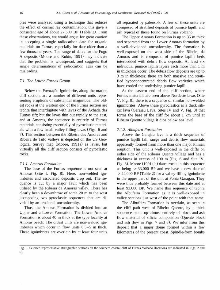
unit, the Tufo Formation described below, collectedat the same site. These samples yielded dates of
Ž34,000 BP and 5000 BP Samples FS 109 and FS.325 in Table 2 . To investigate the problem, we
collected a further three samples from the same siteand horizon. One sample, FS 401, was collectedfrom the same charcoal material as sample FS 109Ž .Table 2 . By courtesy of Patrick Allard, these sam-
Table 2New 14C dates for Furnas deposits. All were determined by Beta Analytic except for those marked with an asterisk, which were determinedby Pasquier-Cardin courtesy of Patrick Allard. Note that FS 109, FS 325, FS 400 and FS 402 are all from samples collected at the same siteand in the same unit
1413Ž .Sample number Age years BP Cr C Stratigraphic unit Grid reference
FS 332 250"60 y26.8 Charcoal from lowermost 1630 lapilli 478,770FS 35a 490"50 y24.6 Charcoal from central part of Furnas H lapilli 497,811FS 35b 560"60 y26.7 Charcoal from central part of Furnas H lapilli 497,811FS 30 1870"120 y28.5 Carbonaceous layer from base of Furnas C tephra 477,828FS 31 2310"160 y24.7 Wood fragments from within Furnas B tephra 477,828FS 325 5020"60 y26.2 Charcoal from basal 1 m of Tufo Formation 464,767FS 319 17240"70 y23.5 Charcoal from massive units of the Ponta Garca 453,767
Formation IgnimbriteFS 326 22,880"120 y25.3 Charcoal from non-welded base of welded ignimbrite 456,766
UFS 109 27,420"540 y23.8 Charcoal from basal 1 m of Tufo Formation 464,767UFS 402 27,510"560 y24.35 Charcoal from basal 1 m of Tufo Formation 464,767UFS 400 27,570"410 y23.52 Charcoal from basal 1 m of Tufo Formation 464,767
FS 109 33,950"480 y24.14 Charcoal from basal 1 m of Tufo Formation 464,767FS 142 34,980"840 y26.6 Charcoal fragments soil below Povoacao 547,791˜
Ignimbrite FormationFS 143 35,980"410 y24.5 Charcoal fragments soil below Povoacao 546,792˜
Ignimbrite FormationFS 38 )30,000 y24.4 Charcoal fragments soil below Povoaca 456,766˜
Ignimbrite FormationFS 121 )44,400 y24.9 Charcoal from within valley filling 502,777
ignimbrite in Albufeira Formation
( )J.E. Guest et al.rJournal of Volcanology and Geothermal Research 92 1999 1–2916
ples were analyzed using a technique that reducesthe effect of cosmic ray contamination; this gave a
Ž .consistent age of about 27,500 BP Table 2 . Fromthese observations, we would argue for great cautionin accepting a single radiocarbon date for organicmaterials on Furnas, especially for date older than afew thousand years. The range of dates for the Fogo
Ž .A deposits Moore and Rubin, 1991 may indicatethat the problem is widespread, and suggests thatsingle determinations of radiocarbon ages can bemisleading.
7.1. The Lower Furnas Group
Below the Povoacao Ignimbrite, along the marine˜cliff section, are a number of different units repre-senting eruptions of substantial magnitude. The old-est rocks at the western end of the Furnas section aretephra that interdigitate with lavas of the Achada dasFurnas rift; but the lavas thin out rapidly to the east,and at Amoras, the sequence is entirely of Furnasmaterials consisting essentially of pyroclastic materi-
Žals with a few small valley-filling lavas Figs. 6 and.7 . This section between the Ribeira das Amoras and
Ribeira do Tufo valleys is depicted on the US Geo-Ž .logical Survey map Moore, 1991a as lavas, but
virtually all the cliff section consists of pyroclasticrocks.
7.1.1. Amoras FormationThe base of the Furnas sequence is not seen at
Ž .Amoras Site I, Fig. 8 . Here, non-welded ign-imbrites and associated deposits crop out. The se-quence is cut by a major fault which has beenutilised by the Ribeira da Amoras valley. There hasclearly been a downthrow of some 20 m to the westjuxtaposing two pyroclastic sequences that are di-vided by an erosional unconformity.
Thus, the Amoras Formation is divided into anUpper and a Lower Formation. The Lower AmorasFormation is about 40 m thick at the type locality atAmoras beach. The oldest units are non-welded ign-imbrites which occur in flow units 0.5–5 m thick.These ignimbrites are overlain by at least four units
all separated by paleosols. A few of these units arecomposed of stratified deposits of pumice lapilli andash typical of those found on Furnas volcano.
The Upper Amoras Formation is up to 35 m thickand separated from the Lower Amoras formation bya well-developed unconformity. The formation iswell-exposed on the west side of the Ribeira daAmoras and is composed of pumice lapilli bedsinterbedded with debris flow deposits. At least sixindividual pumice lapilli layers each more than 1 min thickness occur. The debris flow deposits are up to3 m in thickness; there are both massive and strati-fied hypoconcentrated debris flow varieties whichhave eroded the underlying pumice lapilli.
At the eastern end of the cliff section, whereŽFurnas materials are seen above Nordeste lavas Site
.V, Fig. 8 , there is a sequence of similar non-weldedignimbrites. Above these pyroclastics is a thick sili-
Ž .cic lava Garajau Lava, Sites IV and V, Fig. 8 thatforms the base of the cliff for about 1 km until atRibeira Quente village it dips below sea level.
7.1.2. Albufeira FormationAbove the Garajau lava is a thick sequence of
pumice lapilli fall, surge and debris flow materialsapparently formed from more than one major Plinianeruption. This unit is well-exposed in the cliffs oneither side of the Ribeira Quente village and has a
Žthickness in excess of 100 m Fig. 6 and Site IV,. Ž .Fig. 8 . Moore 1991a,b dates rocks in this sequence
as being )33,000 BP and we have a new date ofŽ .)44,000 BP Table 2 for a valley-filling ignimbrite
in the upper part of the unit at Ponta Garagau. Theywere thus probably formed between this date and atleast 93,000 BP. We name this sequence of tephrathe Albufeira Formation as it is well-exposed invalley sections just west of the point with that name.
The Albufeira Formation is overlain, as seen inthe cliff path west of Ribeira Quente, by a thicksequence made up almost entirely of block-and-ash
Žflow material of silicic composition Quente block.and ash flow in Figs. 7 and 8 . We infer from this
deposit that a major dome formed within a fewkilometres of the present coast. Spindle-form bombs
ŽFig. 8. Selected representative stratigraphic sections on the southern coastal cliff of Furnas Volcano locations are indicated in Figs. 2 and.6 .
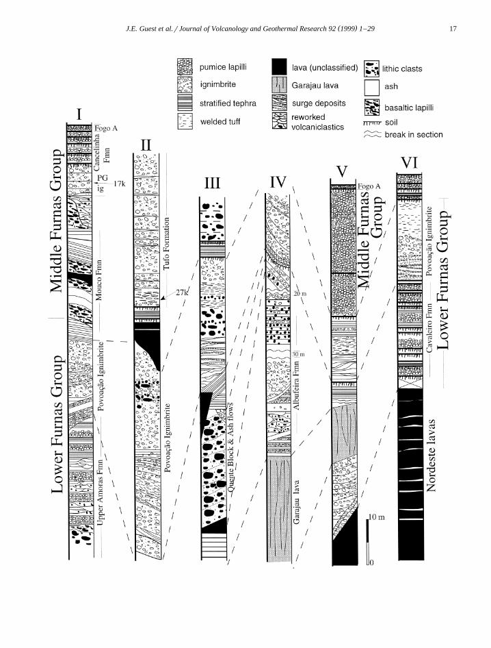
( )J.E. Guest et al.rJournal of Volcanology and Geothermal Research 92 1999 1–29 17
( )J.E. Guest et al.rJournal of Volcanology and Geothermal Research 92 1999 1–2918
in the deposit indicate contemporary explosive activ-ity from the dome as some of the flows were form-ing. This unit has been dated at 22,000 BP by Moore
Ž .and Rubin 1991 , but, since it underlies the Povoacao˜Ž .Ignimbrite, it is older than that date Figs. 7 and 8 .
Between the block-and-ash flow sequence in thecliff section and the deposits of the next majoreruption that formed the Povoacao Ignimbrite mate-˜rials, there are alternating ash and lapilli beds up to 8m thick including a paleosol and a pyroclastic flowdeposit.
7.1.3. CaÕaleiro FormationThis rock unit, that overlies the Nordeste lavas
Ž .just west of Povoacoao Site VI, Fig. 8 , consists of˜more than 18 distinct beds separated by palaeosols.All, except one surge deposit, are fallout beds of ashand pumice. There is no characteristic unit thatallows correlation with other sequences, but the posi-tion below the Povoacao Ignimbrite Formation means˜that these materials are older than 30,000 BP.
7.1.4. The PoÕoacao Ignimbrite Formation˜ŽThe Povoacao Ignimbrite Formation Schmincke˜
.and Weibel, 1972; Booth et al., 1978 is a distinctivepyroclastic flow deposit, with associated material,that covers much of the floor of the Povoacao˜Caldera. It is exposed in valley sides and the coastalcliffs. It has a densely welded zone that achieves
Žthicknesses of up to 60 m Moore, 1990, 1991b;.Duncan et al., 1999-this issue where it fills deeper
palaeovalleys.Distribution of the deposit indicates that it origi-
nated from Furnas. It occurs in the major valleysleading down from the eastern side of the FurnasCaldera complex rim to Povoacao. It appears that the˜major exit for the pyroclastic flows was close to the
Ž .site of the Bodes dome Figs. 2 and 4 , where a deepvalley occupying a complex graben, following theESE structural trend, existed before the eruption. Thevalley is filled with this ignimbrite which is well-ex-posed in the caldera wall on the road from Furnas toPovoacao. Here, on the northern side of the palaeo-˜valley, there is a welded ignimbrite that thickens intothe valley overlain by about 25 m of altered tephra
belonging to the same eruption. Although MooreŽ .1991a,b argues that the ignimbrite here is youngerthan the Bodes dome, the presence of welded ign-imbrite in the caldera wall topographically below theBodes outcrop strongly suggests that the ignimbriteis older than the dome. If this is the case, then thepalaeovalley may have had a width on the order of 1km, and the axis of the valley is roughly below thedome. Both the dome and the Povoacao Ignimbrite˜are cut by the wall of the younger caldera indicatingthat they predate the younger collapse.
The Povoacao Ignimbrite Formation is made up˜of a number of different lithologies including lapilli-fall beds, thick surge deposits, massive non-weldedignimbrite units as well as the distinctive densely
Žwelded ignimbrite horizons Duncan et al., 1999-this.issue . The welded zones thicken in the valleys. On
the valley sides there are some places where morethan one welded zone is separated by non-weldedmaterial, but these units generally merge into asingle welded unit in the axes of all but the smallestvalleys. This suggests that the ignimbrite consists ofa number of hot pyroclastic flow deposits whichbecame a single cooling unit.
Radiocarbon dates from soils immediately under-Ž .lying the Povoacao Ignimbrite Formation Table 2˜
range from 30,000 to 35,000 BP indicating that it isyounger than these dates. To the east of Amoras, thePovoacao Ignimbrite is overlain by the Tufo Forma-˜
Ž .tion described later which has a well-establishedradiocarbon date of 27,000 BP. The age of thePovoacao Ignimbrite Formation eruption must there-˜fore lie between these dates at about 30,000 BP.Inconsistent with this age is the date provided fromcharcoal within ashes at the base of a welded ign-imbrite exposed on the path from Ponta Garca to theAmoras beach. This gave an age of 22,880 BPimplying that, either this is a different ignimbrite, orthere are problems with the date as described earlier.
ŽHowever, a date from the soil directly below Table.2 is consistent with this ignimbrite having the same
age as that of the Povoacao Ignimbrite Formation.˜A younger age for the Povoacao Ignimbrite of˜
Žabout 12,000 BP is inferred by Moore 1990,.1991a,b . This is based on one radiocarbon date of
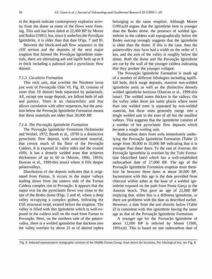
Fig. 9. Selected representative stratigraphic sections of the Middle Furnas Group. Inset shows the locations. For lithological key, see Fig. 8.
( )J.E. Guest et al.rJournal of Volcanology and Geothermal Research 92 1999 1–29 19
( )J.E. Guest et al.rJournal of Volcanology and Geothermal Research 92 1999 1–2920
about 11,230 BP for a soil overlying a weldedignimbrite exposed near the top of what we interpretas the old caldera fill below the Pico do Ferro domeŽ .Fig. 9 . As shown earlier, the Povoacao Ignimbrite˜is older than the material filling the old caldera and
Ž .the date of Moore 1990, 1991a,b relates to ayounger welded tuff.
The eruption that formed the Povoacao Ignimbrite˜was obviously a major event in the history of Furnas,and probably the largest eruption on the volcano. Itappears to have begun with a Plinian eruptive phasegiving rise to lapilli fall followed by a phase ofphreatomagmatic activity generating pyroclasticsurges that travelled south of the caldera. Given themagnitude of the eruption, it is most probable that itrelates to the formation of the old caldera.
Ž .Moore 1991b identifies the best outcrop of whathe refers to as the outflow deposit in a quarry in thelower part of the Ribeira Quente valley on the westside. Exposed here is a welded ignimbrite 40 mthick, with three lithic-rich layers about 0.5 to 1 mthick with a lensoid form some 100 m long. Theoutcrop is surrounded by pyroclastics and does notoccur on the opposite side of the valley. As this is afault controlled valley, the ignimbrite may be faultedout on that side. It is underlain by more than 50 m ofweathered pyroclastics of the Lower Furnas Groupas exposed in the waterfall on the west side of thetunnel on the Ribeira Quente road, and is overlain bypyroclastics of the Salto dos Ingleses Formation. Weidentify this outcrop of welded tuff as the Povoacao˜ignimbrite within the old caldera. It is at a lowerlevel than the point where it exited the caldera northof the Bodes dome, and we consider that is waslowered by synrpost-eruption collapse of the caldera.
7.2. Middle Furnas Group
Materials of this group are exposed in a numberof localities on the southern and southeastern flanksof the volcano and also as a fill in the old calderaŽ .Fig. 9 . It is not possible to correlate betweenindividual units from one major outcrop to another.
7.2.1. Tufo FormationOn the southern flank of the volcano, the Povoacao˜
Ignimbrite Formation is overlain by a sequence ofbedded lapilli and ashes, together with at least twovalley filling-lava flows, followed by a 6-m-thick
sequence of bedded ash. The deposits of the nextmajor eruption at Furnas after the Povoacao Ign-˜imbrite eruption lie above this. We name the deposits
Ž .from this eruption the Tufo Formation Figs. 6–8 .The type locality is in the sea cliff above Ribeira doTufo; good examples of the welded tuff within thisunit occur as fallen blocks on the beach below.
The Tufo Formation crops out intermittently alonga 2-km section of the southern coastline betweenRibeira das Amoras and Ponta da Lobeira. It is morethan 45 m thick at the type locality at Ribeira doTufo in the cliffs east of Amoras. The lower 50 cm isa moderately sorted pumice lapilli bed which gradesup into a densely welded tuff 2–4 m thick. It is madeup of flattened blebs of lava, and owing to theabsence of a fine-grained matrix and the mantlingnature of this unit, we interpret this as a weldedfallout deposit.
Above the welded horizon, the unit is composedof angular, relatively dense pumice lapilli with scarcematrix also indicating a fallout origin. These falloutdeposits occur as massive units 2–5 m thick sepa-rated by more thinly bedded discontinuous layerswhich are probably pyroclastic surge deposits. Mas-sive ignimbrite about 10 m thick occurs locally nearthe base of the sequence in Ribeira do Tufo.
The lower non-welded material is rich in char-coal. As discussed earlier, there were considerableproblems with radiocarbon dating of this material,
Ž .but a consistent date of about 27,000 BP Table 2 isnow determined.
7.2.2. Mouco FormationThis sequence lies directly on top of the Povoacao˜
ŽIgnimbrite Formation in the Ponta Garca region Site.I, Fig. 6 . The Mouco Formation is 30 m thick and
overlain by the Ponta Garca Ignimbrites that haveŽ .been dated at about 17,000 BP Table 2 . The forma-
tion is composed of three separate basaltic scorialapilli layers, each up to 4 m thick, a lava flow andtwo separate units of alternating lapilli and ash. Thebasaltic lapilli layers and lava flow were probablyderived from local centres outside the Furnas calderacomplex whereas the alternating ash and lapilli lay-ers are more likely to have been derived from withinthe Furnas caldera complex. A sequence, up to 10 mthick, of discontinuous hypoconcentrated debris flowdeposits caps the Mouco formation.
( )J.E. Guest et al.rJournal of Volcanology and Geothermal Research 92 1999 1–29 21
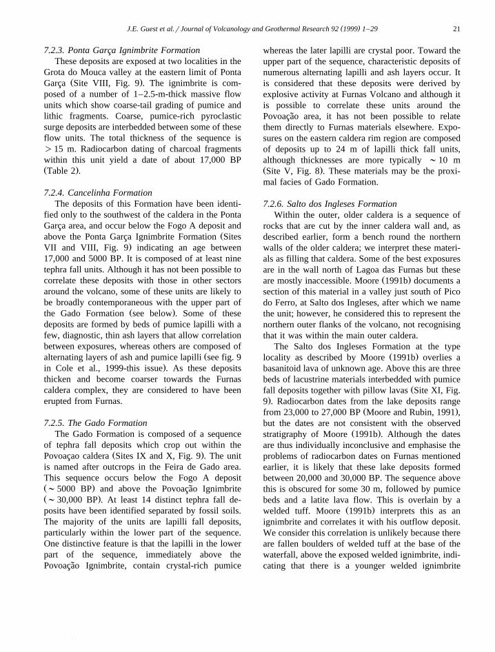
7.2.3. Ponta Garca Ignimbrite FormationThese deposits are exposed at two localities in the
Grota do Mouca valley at the eastern limit of PontaŽ .Garca Site VIII, Fig. 9 . The ignimbrite is com-
posed of a number of 1–2.5-m-thick massive flowunits which show coarse-tail grading of pumice andlithic fragments. Coarse, pumice-rich pyroclasticsurge deposits are interbedded between some of theseflow units. The total thickness of the sequence is)15 m. Radiocarbon dating of charcoal fragmentswithin this unit yield a date of about 17,000 BPŽ .Table 2 .
7.2.4. Cancelinha FormationThe deposits of this Formation have been identi-
fied only to the southwest of the caldera in the PontaGarca area, and occur below the Fogo A deposit and
Žabove the Ponta Garca Ignimbrite Formation Sites.VII and VIII, Fig. 9 indicating an age between
17,000 and 5000 BP. It is composed of at least ninetephra fall units. Although it has not been possible tocorrelate these deposits with those in other sectorsaround the volcano, some of these units are likely tobe broadly contemporaneous with the upper part of
Ž .the Gado Formation see below . Some of thesedeposits are formed by beds of pumice lapilli with afew, diagnostic, thin ash layers that allow correlationbetween exposures, whereas others are composed of
Žalternating layers of ash and pumice lapilli see fig. 9.in Cole et al., 1999-this issue . As these deposits
thicken and become coarser towards the Furnascaldera complex, they are considered to have beenerupted from Furnas.
7.2.5. The Gado FormationThe Gado Formation is composed of a sequence
of tephra fall deposits which crop out within theŽ .Povoacao caldera Sites IX and X, Fig. 9 . The unit
is named after outcrops in the Feira de Gado area.This sequence occurs below the Fogo A depositŽ .;5000 BP and above the Povoacao Ignimbrite˜Ž .;30,000 BP . At least 14 distinct tephra fall de-posits have been identified separated by fossil soils.The majority of the units are lapilli fall deposits,particularly within the lower part of the sequence.One distinctive feature is that the lapilli in the lowerpart of the sequence, immediately above thePovoacao Ignimbrite, contain crystal-rich pumice˜
whereas the later lapilli are crystal poor. Toward theupper part of the sequence, characteristic deposits ofnumerous alternating lapilli and ash layers occur. Itis considered that these deposits were derived byexplosive activity at Furnas Volcano and although itis possible to correlate these units around thePovoacao area, it has not been possible to relate˜them directly to Furnas materials elsewhere. Expo-sures on the eastern caldera rim region are composedof deposits up to 24 m of lapilli thick fall units,although thicknesses are more typically ;10 mŽ .Site V, Fig. 8 . These materials may be the proxi-mal facies of Gado Formation.
7.2.6. Salto dos Ingleses FormationWithin the outer, older caldera is a sequence of
rocks that are cut by the inner caldera wall and, asdescribed earlier, form a bench round the northernwalls of the older caldera; we interpret these materi-als as filling that caldera. Some of the best exposuresare in the wall north of Lagoa das Furnas but these
Ž .are mostly inaccessible. Moore 1991b documents asection of this material in a valley just south of Picodo Ferro, at Salto dos Ingleses, after which we namethe unit; however, he considered this to represent thenorthern outer flanks of the volcano, not recognisingthat it was within the main outer caldera.
The Salto dos Ingleses Formation at the typeŽ .locality as described by Moore 1991b overlies a
basanitoid lava of unknown age. Above this are threebeds of lacustrine materials interbedded with pumice
Žfall deposits together with pillow lavas Site XI, Fig..9 . Radiocarbon dates from the lake deposits range
Ž .from 23,000 to 27,000 BP Moore and Rubin, 1991 ,but the dates are not consistent with the observed
Ž .stratigraphy of Moore 1991b . Although the datesare thus individually inconclusive and emphasise theproblems of radiocarbon dates on Furnas mentionedearlier, it is likely that these lake deposits formedbetween 20,000 and 30,000 BP. The sequence abovethis is obscured for some 30 m, followed by pumicebeds and a latite lava flow. This is overlain by a
Ž .welded tuff. Moore 1991b interprets this as anignimbrite and correlates it with his outflow deposit.We consider this correlation is unlikely because thereare fallen boulders of welded tuff at the base of thewaterfall, above the exposed welded ignimbrite, indi-cating that there is a younger welded ignimbrite
( )J.E. Guest et al.rJournal of Volcanology and Geothermal Research 92 1999 1–2922
higher in the sequence. A welded tuff also crops outat a higher level in the caldera wall just below the
Ž .Pico do Ferro. Moore 1991a,b dates this at 12,000BP based on a soil layer between it and the overlyingdome. This tuff is probably the upper one in thewaterfall section.
Within the intra-caldera sequence elsewhere thereare sheets of massive, poorly sorted pyroclastic ma-terials. These are exposed in the road between Fur-nas and Ribeira Quente where most of the outcropsare strongly weathered and it is often difficult todistinguish between primary pyroclastic flow anddebris flow deposits.
The materials of the Salto dos Ingleses Formationspan the ages of deposits exposed in the marine cliffsection but a detailed correlation is not possible withthe present exposure. However, the Ponta GarcaIgnimbrite represents a substantial eruption at about17,000 BP and could be equivalent to the lowerwelded ignimbrite at the Salto site.
7.2.7. Inner caldera collapseCollapse of the inner caldera brought to an end
this phase of caldera infilling. It is not clear which ofthe eruptive deposits is associated with this event.One candidate is the welded ignimbrite immediatelybelow the Pico do Ferro domes. If this is the case,then it presents a difficulty as the south easternmostof the Pico do Ferro domes, which lies above the soillayer above welded ignimbrite, is sliced in half bythe caldera wall, implying that collapse occurred asignificant time after the emplacement of the ign-imbrite. Thus, either this ignimbrite is not related tothe caldera and may be a small local welded deposit;or it is related and the caldera at this point had morethan one collapse episode. Whichever is the case, thelast collapse must have taken place at about 12,000BP or somewhat more recently.
7.2.8. Pico do Canario Formation´The Pico do Canario forms a distinct cone that´
straddles the younger caldera scarp. Its deposits areonly exposed in cuts on the road between Salto do
Ž .Cavalo and Povoacao Fig. 2 . The deposits from˜this centre are overlain by Fogo A materials and arethus older than 5000 years. This cone, which hadseveral eruptive phases, was probably one of theearliest after the collapse of the younger caldera. It is
abnormal in being a trachytic centre ‘outside’ thecaldera. However, it lies at the intersection betweenthe old caldera bounding faults and those of theyounger caldera, a situation that may have facilitatedmovement from the central trachytic reservoir to aposition outside the original caldera. It clearly had awell-established link with the reservoir as it eruptedmore than once.
A quarry cut in the east side of Pico do Canario´cone shows at least 4.5 m of coarse, proximal lapillibeds with differing amounts of lithic material. Weobserve at least four soil horizons suggesting that thecone formed during several eruptions. Within se-quences from a single eruption, beds of pumice are,in some cases, divided by thin layers of coarse, dark,gritty ash which we interpret as lithic materialsformed during vent clearing activity between phases
Ž .in the eruption. Moore 1991a,b suggests a date of6600 BP for Pico do Canario based on radiocarbon´dating of lacustrine materials on the nearby calderafloor which he interprets as being of similar age.
7.3. Upper Furnas Group
The base of the Upper Furnas Group is defined bythe top of the Fogo A deposit, and the last eruptionto contribute to this sequence was that of 1630 AD.The date of the Fogo A eruption is generally given
Ž .as 5000 BP Booth et al., 1978 , although the rangeof radiocarbon dates obtained is from 4480"160 to
Ž .5380"210 BP Moore and Rubin, 1991 , yet againindicating the lack of consistency in radiocarbondating. Although the Fogo A deposit came fromanother volcano, it is one of the best known andidentifiable deposits in the area. In addition, thesequence of deposits that follow have been the focusof a number of studies of various aspects of pyro-clastic rocks and the hazard posed by explosiveactivity. We therefore consider this to be a well-de-fined sequence that is important enough to haveGroup status. The events from Furnas that followedthe Fogo A eruption were first described by Booth et
Ž .al. 1978 , and are discussed further by Cole et al.Ž .1999-this issue .
Although each of the deposits from individualeruptions in this Group is well-defined and charac-terised, there is a general uniformity in the type ofdeposit. The dominant lithologies are fine ashes and
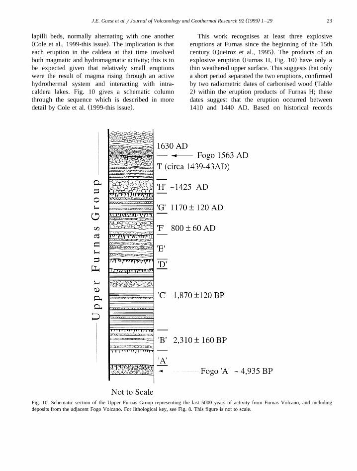
( )J.E. Guest et al.rJournal of Volcanology and Geothermal Research 92 1999 1–29 23
lapilli beds, normally alternating with one anotherŽ .Cole et al., 1999-this issue . The implication is thateach eruption in the caldera at that time involvedboth magmatic and hydromagmatic activity; this is tobe expected given that relatively small eruptionswere the result of magma rising through an activehydrothermal system and interacting with intra-caldera lakes. Fig. 10 gives a schematic columnthrough the sequence which is described in more
Ž .detail by Cole et al. 1999-this issue .
This work recognises at least three explosiveeruptions at Furnas since the beginning of the 15th
Ž .century Queiroz et al., 1995 . The products of anŽ .explosive eruption Furnas H, Fig. 10 have only a
thin weathered upper surface. This suggests that onlya short period separated the two eruptions, confirmed
Žby two radiometric dates of carbonised wood Table.2 within the eruption products of Furnas H; these
dates suggest that the eruption occurred between1410 and 1440 AD. Based on historical records
Fig. 10. Schematic section of the Upper Furnas Group representing the last 5000 years of activity from Furnas Volcano, and includingdeposits from the adjacent Fogo Volcano. For lithological key, see Fig. 8. This figure is not to scale.
( )J.E. Guest et al.rJournal of Volcanology and Geothermal Research 92 1999 1–2924
Ž .Queiroz et al., 1995 , the eruption is unlikely tohave been as late as 1440 AD.
8. Historical eruptions
8.1. The first historical narratiÕe
The details of the discovery and settlement of theŽ .Azores are confused Admiralty, 1945 . Santa Maria
is reported as the first island to be settled and thistook place in the autumn of 1431 under the leader-ship of Goncalo Velho Cabral. The island of Sao˜Miguel was apparently observed from a high pointon Santa Maria and Cabral was sent to search for it.His first landing was at a place on the south coastwhich was later to become the site of the village of
Ž .Povoacao Fig. 2 . Leaving some animals on the˜island, he then returned to Portugal where he col-lected a group of colonists who returned with him,arriving back on the island sometime between 1439and 1443. They landed at the same site where theybuilt shelters. But from the beginning they were ingreat fear because of earth tremors, as well as loudnoises, lightning and ‘tongues of fire’ coming from a
Ž .valley to the west of their encampment Dias, 1936 .To discover what was happening, a priest climbed
into the valley to investigate. This was no easy taskas the terrain was rugged and heavily vegetated, buta track was cut to take him to a point from which hecould overlook what we now call the Furnas caldera.He saw vapour rising from a depression that waswithout vegetation and was completely covered withwhite material. The vapour sometimes glowed red;we infer he was observing the glow from fresh lavaof the dome reflecting in the fumes.
Later, the priest went back with others and climbeddown into the valley. They discovered three lakes,one of which probably corresponds roughly to thepresent Lagoa das Furnas. The two smaller lakeswere located in the area where the eruption of 1630AD occurred. The priest also described three distinctfumarolic regions which correspond to those on thenorth side of Lagoa das Furnas, those now within theFurnas village, and those near the present road to
Ž .Ribeira Quente Fructuoso, 1583; Dias, 1936 .These first-hand observations indicate that an
eruption started some time in the late 1430s or early
Ž .1440s Queiroz et al., 1995 . This eruption almostcertainly corresponds to the last eruption of Gaspar
Ž .Crater Furnas I , during which there was an earlyphase of explosive activity covering the ground withwhite ash, followed by the emplacement of a domeas observed by the priest.
9. The 1630 AD eruption
The deposits and the sequence of events of the1630 AD eruption of Furnas have been discussed in
Ž .detail by Cole et al. 1995 The eruption involvedboth explosive and effusive phases, and took placefrom a site near the southern margin of the calderaŽ .Figs. 2 and 3 . At distal localities, the tephra ap-pears as sequences of alternating pumice lapilli andash beds; deposits of the eruption have been foundup to 8 km west of the vent. More than six discretepumice lapilli layers have been identified within thepyroclastic sequence and are considered to have beengenerated by magmatic explosive activity. Dispersaldirections for the lapilli layers, initially to the south-west and finally northeast of the vent, indicate achange in wind direction during the 3-day explosivephase of the eruption.
Ashes are interbedded with the lapilli layers andrepresent the deposits formed by phreatomagmaticphases that punctuated the magmatic activity. Someash layers show lateral thickness variations, as wellas cross-bedding and sand-wave structures suggest-ing deposition from low-concentration, turbulent
Ž .flows surges . These pyroclastic surges were proba-bly responsible for the 80 people reported burned to
Ž .death 4 km SW of the vent Cole et al., 1995 . Highparticle-concentration, non-turbulent pyroclasticflows were channelled down steep valleys to thesouthern coast contemporaneous with the low-con-centration surges.
Effusive activity followed the explosive activitybuilding a trachytic lava dome within the tuff ringcomplex formed during the earlier explosive phaseŽ .Fig. 2 . Historic records suggest that dome buildingoccurred over a period of at least 2 months. Ourmeasurements yield a volume of 67=106 m3 DREfor the explosive products, and ;20=106 m3 for
Ž .the lava dome Cole et al., 1995 .Based on contemporary records it is possible to
Ž .put together the eruption history Cole et al., 1995 .
( )J.E. Guest et al.rJournal of Volcanology and Geothermal Research 92 1999 1–29 25
The following are the salient points:Ž .1 At the time the eruption started, a group of
friars were living in the caldera; and farmers fromPonta Garca cultivated land at Furnas.
Ž .2 For some days before the eruption, earth-quakes were felt; on September 2, 1630 the inhabi-tants of Sao Miguel were subjected to numerous˜
Žalmost continuous earthquakes Dias, 1936; Homen,.1980 . Landslides occurred, notably a slide from the
sea cliffs above the present village of Ribeira Quente,Ž .which did not exist then Jeronimo, 1989 .´
Ž .3 In the early morning of September 3, theexplosive phase of the eruption started and wasobserved by the friars who escaped to the north thussaving their lives; some 30 people from Ponta Garcaready to start picking fruit and vegetables were killed
Žas a result of the first explosions Dias, 1936; Homen,.1980 ; and in Ponta Garca 80 to 115 people died
from pyroclastic surges and building collapses.Pumice covered the sea near the shore.
Ž .4 By September 4, the whole island was coveredŽ .by an ash cloud Homen, 1980 . A total of 80 people
left alive in Ponta Garca travelled west to VilaŽ .Franca do Campo Anonymous, 1880 .
Ž .5 On the 5th of September the sky was darkŽ .Manoel da Purificacao, 1980 and people tried to˜clear ash from roofs of buildings. The next day,people of Ponta Delgada had been 3 days with onlybread and water and the city was covered with
Ž .several centimetres of ash Homen, 1980 .Ž .6 The explosive phase of the eruption lasted for
3 days, but during that time, the whole island wascovered with ash.
Ž .7 Dome growth lasted until early November.Ž . Ž8 At most 195 people were killed Correa, 1924;ˆ
.Dias, 1936 . In Ponta Garca, some 100 houses weredestroyed; in Povoacao, one out of 250 houses sur-˜
Ž .vived the earthquakes Jeronimo, 1989 .´Ž .9 The population of Vila Franca do Campo
returned after about 7 days. The Furnas caldera itselfŽ .was uninhabited until about 1640 Correa, 1924ˆ
Žwith no new permanent settlement until 1665 Dias,.1936 .
10. Volcanic history of Furnas Volcano
Furnas is apparently the youngest of the CentralTrachytic volcanoes on Sao Miguel. It began life as a˜
subaerial volcano at least 93,000 years ago based ona date for a lava at the base of the observed volcanic
Ž .pile Moore and Rubin, 1991 . Prior to the birth ofFurnas, the lava shield of Nordeste, which must havebeen massive, had become deeply eroded. ThePovoacao caldera formed next, on the flanks of the˜Nordeste shield.
Ž .Moore 1990 has dated rocks at the base of bothSete Cidades and Fogo indicating that they hadsubaerial lavas some 200,000 years ago. It appearstherefore that when Furnas started to build up thereexisted not only the Nordeste block, but also sub-aerial volcanoes on the axis of the present island ofSao Miguel. Their size and extent at that time is˜unknown, and clearly, they continued to grow asFurnas evolved.
Products of the earliest eruptions from Furnas areprobably not seen in the exposed materials, butproducts of early activity were both effusive andexplosive, erupting materials of trachytic composi-tion. However, unlike the other trachytic centres onSao Miguel, Furnas had no early basaltic shield-for-˜ming phase above sea level. In consequence, therewas no resistant basement to protect the developingconstruct from marine erosion. The early activityinvolved plinian eruptions with heavy pumice fall,non-welded ignimbrites, surges and lahars togetherwith the formation of at least one large dome withassociated block and ash flows. Phreatomagmaticactivity was not so common in the early phases of
Ž .the volcano’s history Cole et al., 1999-this issue asit became after the Povoacao Ignimbrite Formation˜eruption.
A major eruption involving the production of aŽ .thick welded ignimbrite Povoacao Ignimbrite oc-˜
curred about 30,000 years ago. Plinian activityŽ .Duncan et al., 1999-this issue was associated witha series of pyroclastic flows that filled valleys on thesouthern and eastern flanks of the volcano. As this isthe largest magnitude and most violent eruptionrecorded at Furnas, and is also older than the fill ofthe early caldera, we relate it to the first majorcollapse.
For about the next 20,000 years, eruptions tookplace in the early caldera, filling it with pyroclasticrocks resulting from mainly fall and surge activity.Lakes formed within the caldera, and lavas enteringthe lakes developed pillow-like forms. On the flanks,
( )J.E. Guest et al.rJournal of Volcanology and Geothermal Research 92 1999 1–2926
pyroclastics were also emplaced including non-welded ignimbrites, surges and fall deposits, as wellas small valley-filling lavas. Extensive coastal ero-sion continued, removing most of the deposits formedon the southern flank of the volcano.
A second caldera collapse occurred about12,000–10,000 years ago. The deposits associatedwith this eruption are difficult to identify in thepresently exposed sequences. They may have in-volved a welded ignimbrite exposed in the calderawalls and dated at about 12,000 BP, but the evidenceis ambiguous.
Since that time, the second caldera has continuedto fill with the products mainly of subplinianrplinianeruptions most of which alternated between mag-matic and hydromagmatic activity. Dome formationalso took place either as the end product of aneruption or as an effusive eruption with little or noexplosive activity. By that time, the caldera area hadbecome a wet environment with a high water tableand presumably a developed hydrothermal system.
11. The hydrothermal system
Fumaroles and hot springs occur in a number ofplaces on Furnas reflecting the hydrothermal system
Ž .below the volcano Ferreira, 1994 . These have beenactive throughout historical times and their distribu-tion appears to be controlled by the regional fault
Ž .pattern Fig. 4 . In addition, CO is currently being2
evolved over wide areas in the Caldera complex.Ž .Baubron et al. 1995 have mapped the concentra-
tions of CO being discharged in the Furnas village2
area showing that in some parts of the village thereare lethal quantities of gas that kill small animals andinsects. Further details of the geochemistry and na-
Žture of the system are given by Baxter et al. 1999-this. Ž .issue , Cruz et al. 1999-this issue , Ferreira and
Ž .Oskarsson 1999-this issue and Oskarsson et al.Ž .1999-this issue .
12. Present status of the volcano
One of the purposes of the present study ofFurnas was to establish the hazard that this volcanopresents. Given the active hydrothermal system and
the prodigious venting of CO , Furnas is considered2
to be an active volcano that could erupt again. Basedon the frequency of eruptions during the 2000-yearperiod before AD 1000, activity might be expected
Ž .soon Guest et al., 1994 ; but using the frequency ofthe later, more active period, an eruption is long
Ž .overdue Moore, 1990 . It is also possible that thevolcano is in a state of long repose similar to thatwhich occurred between about 1000 and 3000 BCŽ .Guest et al., 1994 . Discussion of volcanic hazard isexpanded, based on this study, in the work of Cole et
Ž . Ž .al. 1999-this issue and Chester et al. 1999 . Thestatistics of the likely timing of a future eruptionbased on the distribution with time of previous erup-tions during the last 5000 years are presented by
Ž .Jones et al. 1999-this issue .The Furnas area is also subject to seismic activity
independent of volcanic manifestations. In 1998,there was a seismic crisis to the south of Povocacao˜
Žwith 900 earthquakes, of which 40 were felt Ferreira.et al., 1998 . Since then to the time of writing, there
have been, within the Furnas Caldera complex, occa-sional seismic swarms each of a few dozen events.Based on the historical account of the 1630 eruption,strong seismic activity is expected in the hours be-fore an eruption, and this would certainly causedisruption in the form of landslides that could isolatecommunities in the area.
Because the volcano is mainly built of unconsoli-dated pyroclastic rocks, and has been deeply erodedgiving steep slopes, it is subject to landslides withoutvolcanic or seismic activity, especially following orduring heavy rainfall: long periods of rain and severerain storms are not unusual in this part of the island.During late October 1997, a nocturnal catastrophicstorm initiated hundreds of slides that killed 29inhabitants of Ribeira Quente, destroyed houses, andcut roads, power and communications on the vol-cano. Although the scale of this event is rare, indi-vidual slope failures are an ongoing hazard. TheLagoa das Furnas also presents a hazard as its sur-face is above the Furnas village, from which it isseparated by a narrow embankment. Should thisbarrier be breached by slope failure caused by anearthquake, high water levels from enhanced rainfallor landslides from the caldera wall into the lake, thenserious flooding could be expected in Furnas villageand the Ribeira Quente valley.

( )J.E. Guest et al.rJournal of Volcanology and Geothermal Research 92 1999 1–29 27
13. Conclusions
Furnas Volcano is essentially trachytic in compo-sition, and most of the activity has been explosiveaccompanied in some cases by dome formation.Basaltic cinder cones and lavas have formed outsidethe caldera. Because Furnas has built up on theflanks of an existing island, most of the eruptedmaterial either entered the sea, or was veneered overancient topography. Much of this latter material hassince been removed by fluvial activity or by marineerosion which has provided good coastal exposuresof relatively proximal material.
Stratigraphic correlation is not easy on Furnas,first, because of poor exposure, and second, becauseexcept for deposits formed during the last few thou-sand years, most of the remaining materials fromindividual eruptions are proximal and are thus nottraceable over large areas because they were de-posited at sea, or have been lost to marine erosion.Important exceptions are the Fogo A deposit, whichcomes from an eruption on another volcano, and thePovoacao Ignimbrite from the Furnas Centre.˜
Major tectonic trends have controlled vent distri-bution, the bounds of caldera collapse, parts of thecoastal cliffs and the current surface expression ofthe hydrothermal system. The caldera complex is themain topographic expression of the volcano, and wasthe result of two large collapses together with somesmaller ones. The first collapse probably occurredsomewhat less than 30,000 years ago. Substantialinfilling of the first major caldera before the secondcollapse occurred which exposed the earlier fill ma-terial in its walls. This occurred about 12,000 to10,000 years ago, and since then the caldera hasagain been in a phase of infilling by the products oferuptions that have taken place at an average rate ofone every few hundred years.
Several major plinian and welded ignimbrite-for-ming eruptions have taken place in the history ofFurnas, at least two of which we suggest wererelated to the observed caldera structures. However,the majority of eruptions have been relatively small,involving sub-Plinian and phreatomagmatic explo-sive activity. Eruptions of more mafic magmas haveoccurred around the periphery of the volcano, but allactivity within the caldera has been silicic. Maficvolcanism is subordinate to silicic activity.
Furnas must be considered to be an active volcanothat could erupt again. Based on what we understandof the last historical eruption in 1630 AD, it is clearthat a relatively small trachytic eruption in Furnascould present a serious problem affecting most formsof communication, agriculture and living standardsover nearly the whole island of Sao Miguel.˜
Acknowledgements
Field work for this project was funded by aEuropean Commission Environment Programme
Ž .Grant DG XII , that supported fieldwork as well asPDC as a Post Doctoral Research Assistant at Uni-versity College London. The work was also sup-ported by the University of the Azores. We espe-
Ž .cially thank Rui Coutinho University of the Azores ,for his valuable help in so many ways, includingsafely transporting us by boat to the coastal sectionsof Furnas. Discussions with other workers on the ECFurnas Laboratory Volcano Project were of value, aswere meetings with members of the Civil Protectionof the Azores and the Mayor of Povoacao. We˜particularly thank Steven Self, and Wendell Duffieldfor comments on an earlier manuscript.
References
ŽAdmiralty, 1945. Spain and Portugal, The Atlantic Islands, BR..502 Vol. 5 , Naval Intelligence Division, London.
Adel-Monem, A.A., Fernandez, L.A., Boone, G.M., 1975. K–ArŽages from the eastern Azores group Santa Maria, Sao Miguel˜
and the Formigas islands. Lithos 8, 247–254.Agostinho, J., 1932. Vulcanismo dos Acores. Vista geral. A Terra
4, 32–36.Anonymous, 1880. In Castro EVPC. Anno de 1630. Erupcao no˜
Valle das Furnas. Archivo dos Acores, 2, pp. 527–547.Assuncao, C.F.T., 1961. Estudo petrografico da ilha de S. Miguel˜ ´
Ž .Acores . Comunicacoes Servicos Geologicos de Portugal 45,˜ ´81–117.
Baxter, P.J., Baubron, J.-C., Coutinho, R., 1999. Health hazardsand disaster potential of ground gas emissions at Furnasvolcano, Sao Miguel, Azores. J. Volcanol. Geotherm. Res. 92,95–106.
Booth, B., Walker, G.P.L., Croasdale, R., 1978. A quantitativestudy of five thousand years of volcanism on Sao Miguel,˜Azores. Philos. Trans. R. Soc. London, Ser. A. 228, 271–319.
Booth, B., Croasdale, R., Walker, G.P.L., 1983. Volcanic hazardŽ .on Sao Miguel, Azores. In: Tazieff, H., Sabroux, J.-C. Eds. ,˜
Forecasting Volcanic Events. Elsevier, Amsterdam, pp. 99–109.
( )J.E. Guest et al.rJournal of Volcanology and Geothermal Research 92 1999 1–2928
Chester, D.K., Dibben, C., Countinho, R., Duncan, A.M., Cole,P.D., Guest, J.E. Baxter, P.J., 1999. The impact of recentdevelopments in social theory on volcanic hazard mapping andevacuation planning: the case of Furnas Volcano, Sao Miguel,
Ž .Acores. In: Firth, C., McGuire, W.J. Eds. , Geological Soci-ety London Special Publication, in press.
Cole, P.D., Queiroz, G., Wallenstein, N., Gaspar, J.L., Guest, J.E.,1995. An historic subplinianrphreatomagmatic eruption: the1630 AD eruption of Furnas volcano, Azores. J. Volcanol.Geotherm. Res. 69, 117–135.
Cole, P.D., Guest, J.E., Queiroz, G., Wallenstein, N., Pacheco,J.M., Gaspar, J.L., Ferreira, T., Duncan, A.M., 1999. Styles ofvolcanism and volcanic hazards on Furnas volcano, Sao˜Miguel, Azores. J. Volcanol. Geotherm. Res. 92, 39–53.
Correa, J., 1924. Leituras sobre a Historia do Valle das Furnas.ˆ ´Oficina de Artes Graficas, S. Miguel, Acores, 217 pp.
Dias, U.M., 1936. Historia do valle das Furnas. Empressa Tip´Lda. Vila Franca do Camp, 159 pp.
Duncan, A.M., Queiroz, G., Guest, J.E., Cole, P.D., 1999. ThePovoacao Ignimbrite, Furnas volcano, Sao Miguel, Azores. J.˜ ˜Volcanol. Geotherm. Res. 92, 55–65.
Ferreira, T., 1994. Contribuicao para o estudo das emanacoes˜ ˜gasosas associadas a processos de vulcanismo no arquipelago´dos Acores. Tese de Aptidao Pedagogica e Capacidade Cien-˜ ´
Ž .tifica Ed. , Universidade dos Acores, 183 pp.Ferreira, T., Oskarsson, N., 1999. Chemistry and isotope composi-
tion of fumarole discharges of the Furnas caldera. J. Volcanol.Geotherm. Res. 92, 169–179.
Ferreira, T., Gaspar, J.L., Aumento, F.E., Queiroz, G., 1998.Cartografia geoquimica das emissos de 222 Rn na ilha Graciosa˜Ž . aAcores : implicacoes geostructurais 1 Assembleia Luso-˜
Ž .Espanhola de Geodesia e Geofisica in press .Ž .Fetter, P., 1981. Ile de Sao Miguel Acores structurologie et˜
petrologie. These presentee a l’Universite de Paris-Sud Centre´ ´ ´ ´ ´d’Orsay.
Forjaz, V.H., 1976. Ilha de Sao Miguel — Carta vulcanologica˜ ´preliminar na escala 1:50,000. Ed. Institut de Geociencias eTecnologia dos Acores.
Fructuoso, 1583. Livro quarto das saudades da Terra. Ed. InstitutoCultural de Ponta Delgada, 1877, 1 and 2.
Ž .Gaspar, J.L., 1996. Ilha Graciosa Acores : Historia vulcanologica´ ´e avaliacao do hazard. Unpublished PhD thesis, University of˜the Azores.
Gaspar, J.L., Ferreira, T., Queiroz, G., Wallenstein, N., Pacheco,J., Guest, J., Duncan, A., Cole, P., 1995. Evolucao mor-˜
Ž .foestructural do vulcao das Furnas ilha de S Miguel, Acores˜Universidade do Porto Faculdade de Ciencias, Museu e Labo-ˆratorio Mineralogico e Geologico, IV Congresso Nacional de´ ´ ´Geologia. Membrane 4, 999–1003.
Guest, J.E., Duncan, A.M., Cole, P.D., Gaspar J.L., Queiroz, G.,Wallenstein, N., Ferreira, T., 1994. Preliminary report on thevolcanic geology of Furnas Volcano, Sao Miguel, The Azores,˜Eruptive history and hazard, Open File Report 1, EU FurnasVolcano Project, University College London.
Harkness, D.D., Roobol, M.J., Smith, A.L., Stipp, J.J., Baker,P.E., 1994. Radiocarbon dating of contaminated samples froma tropical volcano: the Mansion ‘Series’ of St. Kitts, WestIndies. Bull. Volcanol. 56, 326–334.
Homen, J.G., 1980. Anno de 1630. Erupcao no no Vale das˜Ž .Furnas. In: Castro, E. Ed. , Archivo dos Acores. Vol. 2, pp.
536–541.Jeronimo, G.M., 1989. Nos, acorianos e os sismos. Correio dos´ ´
Acores.Jones, G., Chester, D.K., Shooshtarian, F., 1999. Statistical analy-
sis of the frequency of eruptions at Furnas Volcano. J. Vol-canol. Geotherm. Res. 92, 31–38.
Kurase, D., Watkins, N., 1970. North atlantic crustal genesis inthe vicinity of the Azores. Geophys. J. Astron. Soc. 19,261–283.
Le Maitre, R.W., Bateman, P., Dubek, A. Keller, J., Lameyre, L.,Le Bas, M.J., Sabine, P.A., Schmid, R., Sorensen, H., Streck-
Ž .heisen, A., Wooley, A.R., Zarettia, B. Eds. . 1989. A classifi-cation of igneous rocks and glossary of terms. Recommenda-tions of the IUGS Subcommission on the systematics ofigneous rocks. Blackwell, Oxford, 193 pp.
Machado, F., 1959. Submarine pits of the Azores Plateau. Bull.Volcanol., TXXI, pp. 109–116.
Madeira, J., Ribeiro, A., 1990. Geodynamic models for the Azorestriple junction: a contribution from tectonics. Tectonophysics184, 405–415.
Manoel da Purificacao, 1980. In Castro EVPC. Anno de 1630.˜Erupcao no vale das Furnas. Archivo dos Acores 2, 527–547.˜
McKenzie, D., O’Nions, R.K., 1995. The source regions of oceanisland basalts. J. Petrol. 36, 133–159.
Moore, R.B., 1983. Preliminary Geologic map of Furnas VolcanoSao Miguel, Azores. U.S. Geol. Surv. Open-File Report. 83-˜395 scale 1:15,000.
Moore, R.B., 1990. Volcanic geology and eruption frequency, Sao˜Miguel, Azores. Bull. Volcanol. 52, 602–614.
Moore, R.B. 1991a. Geologic map of Sao Miguel, Azore. U.S.˜Geol. Surv. Misc. Invest. Ser. Map I — 2007, Scale 1:50,000.
Moore, R.B., 1991b. Geology of three late quaternary stratovolca-noes on Sao Miguel, Azores. US. Geol. Survey Bull. 1900.˜
Moore, R.B., Rubin, M., 1991. Radiocarbon dates for lava flowsan pyroclastic deposits on Sao Miguel, Azores. Radiocarbon˜33, 151–164.
Needham, H., Francheteau, J., 1974. Some characteristics of therift valley in the Atlantic Ocean near 36848X north. EarthPlanet. Sci. Lett. 22, 29–43.
Oskarsson, N., Palsson, Olafsson, H., 1999. Experimental moni-toring of carbon dioxide by low power IR-sensors: soil de-gassing in the Furnas volcanic centre, Azores. J. Volcanol.Geotherm. Res. 92, 181–193.
Pasquier-Cardin, A., Allard, P., Ferreira, T., Coutinho, R.,Fontugne, I., Jaudon, M., 1999. Magma-derived CO2 emis-sions recorded in 14C and 13C content of plants growing inFurnas caldera, Azores. J. Volcanol. Geotherm. Res. 92, 195–207.
Ž .Queiroz, G., 1998. Vulcao das Sete Cidades S. Miguel, Acores˜historia eruptiva e avaliacao do hazard. Unpublished PhD˜Thesis, University of the Azores.
Queiroz, G., Gaspar, J.L., Cole, P.D., Guest, J.E., Wallenstein, N.,Duncan, A.M., Pacheco, J., 1995. Erupcoes volcanicas no˜
Ž .valle das Furnas Ilha de S. Miguel, Acores na primeiraŽ .metade do seculo XV Acoreana, 8 1 , 159–165.
Rodrigues, B., Forjaz, V.H., Gaspar, J.L., 1989. A preliminary
( )J.E. Guest et al.rJournal of Volcanology and Geothermal Research 92 1999 1–29 29
note on the geochemical evolution of volcanism in S. MiguelŽ .Azores . Doc CVrINIC 07r89.
Saupe, F., Strappa, O., Coppens, R., Guillet, B., Jaegy, R., 1980.A possible source of error in 14C dates: volcanic emanationsŽexamples from the Monte Amiata district, Provinces of the
.Grosseto and Siena, Italy . Radiocarbon 22, 525–531.Schmincke, H.-U., Weibel, M., 1972. Chemical study of rocks
Ž .from Madeira, Porto Santo and Sao Miguel, Terceira Azores .˜Neues. Jahrb. Mineral Abh. 117, 253–281.
Self, S., Gunn, B.M., 1976. Petrology, volume, and age relationsof alkaline and saturated peralkaline volcanics from Terceira,Azores. Contrib. Mineral. Petrol. 54, 293–313.
Searle, R., 1980. Tectonic pattern of the Azores spreading centreand triple junction. Earth Planet. Sci. Lett. 51, 415–434.
Shotton, F.W., 1969. Birmingham University Radiocarbon datesV. Radiocarbon 13, 141–156.
Shotton, F.W., Williams, R.E.G., 1971. Birmingham UniversityRadiocarbon dates III. Radiocarbon 11, 266.
Steinmetz, L., Hirn, A., Sapin, M., Whitmarsh, R., Moreira, V.,1976. Zone of P wave attenuation beneath the crest of Mid-Atlantic Ridge. Bull. Soc. Geol. France, 4.
Storey, M., Wolff, J.A., Morry, M.G., Morroson, G.F., 1989.Origin of hybrid lava from Agua de Pau volcano, Sao Miguel,˜
Ž .Azores. In: Saunders, A.D., Norry, M.G. Eds. , Magmatismin the Ocean Basins. Geol. Soc. London Special Pub. 42.
Sulerzhitzky, C.D., 1970. Radiocarbon dating of volcanoes. Bull.Volcanol. 35, 85–94.
Walker, G.P.L., Croasdale, R., 1971. Two plinian type eruptionsin the Azores. J. Geol. Soc. London 127, 17–55.
Widom, E., Gill, J.B., Schmincke, H.-U., 1992. Syenite nodules asa long term record of magmatic activity in Agua de Pauvolcano, Sao Miguel, Azores. J. Petrol. 34, 929–953.˜
Wilson, M. 1989. Igneous Petrogenesis. Unwin Hymen, London,551 pp.
Weston, F., 1994. List of recorded volcanic eruptions in theAzores with brief reports. Bol. Mus. Lab. Min. Geol. Fac.Cincias de Lisboa 10, 3–18.
White, M., Schilling, J.-E., Hart, S., 1976. Evidence for theAzores mantle plume from strontium isotope geochemistry ofthe central north Atlantic. Nature 263, 659–663.
Zbyszewski, G., 1961. Etude Geologique de l’ile de Sao Miguel˜Ž .Acores 1961 Communications de la Service Geologique dePortugal 45, pp. 5–79.
Zbyszewski, G., Veiga Ferreira, O., 1959. Carta Geologica deŽ .Portugal na escala de 1:50,000 Sao Miguel : Servicos Geo-˜
logicos de Portugal, Lisbon.Zbyszewski, G., Medeiros, A.C., Almeida, F.M., Veiga Ferreira,
O., 1958. Carta Geologica de Portugal na escala de 1:50,000Ž .Sao Miguel : Servicos Geologicos de Portugal, Lisbon.˜
Related Documents