Virginia Geospatial Clearinghouse Workgroup Data Sharing Presentation 8/18/2010 Data Sharing

Virginia Geospatial Clearinghouse Workgroup Data Sharing Presentation 8/18/2010 Data Sharing.
Jan 05, 2016
Welcome message from author
This document is posted to help you gain knowledge. Please leave a comment to let me know what you think about it! Share it to your friends and learn new things together.
Transcript

Virginia Geospatial Clearinghouse Workgroup
Data Sharing Presentation
8/18/2010
Data Sharing
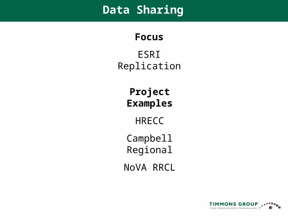
Project Examples
HRECC
Campbell Regional
NoVA RRCL
Focus
ESRI Replication
Data Sharing

Solution
•ESRI Replication
• Best practice for data sharing
• 1 way replication
• Updates Only
HRECC
Rockingham County
GIS data
City of Harrisonburg GIS
Data
Harrisonburg -Rockingham Emergency
Communications Center
9-1-1Dispatch
Workstation
9-1-1Dispatch
Workstation
9-1-1Dispatch
Workstation
Objective
•Near-real time Geospatial updates of critical infrastructure and address layers by
• consolidating disparate data sets
• facilitating the consumption of these layers into E-911 mapping system and the state GIS program

Solution
Database replication • Provide seamless,
instant updates
• City
• County
• VITA
• Other Localities
• Thru VITA
HRECC
Rockingham County City of Harrisonburg
HRECC
ArcGIS Server 9.2 Minimum Enterprise Basic
SQL Server 2000 / 05ArcEditor+ 9.2
Scripted push to Vela Stations
VGIN
ArcGIS Server 9.2 Minimum Enterprise Basic
SQL Server 2000 / 05ArcEditor+ 9.2
Orion VelaWorkstation
Replic
atio
n of
Locality
Lay
ers
Replication of
County Layers
Not Critical Path
County XYZ
Rep
licat
ion
of
Cit
y L
ayer
sR
eplic
atio
n o
f L
oca
lity
Lay
ers R
eplication of
Locality Layers

HRECC

HRECC
Solution
Geoprocessing Tasks• Evaluate data
• Integrate data
• Output E-911 updates
• SHP
• GDB

HRECC
Lessons Learned•Insure robust infrastructure (network and servers)
•Define/refine security issues early
•Coordinate changes to data model
• No longer islands of excellence!
•Basic GIS admin knowledge important
•White paper available

Solution
•ESRI Replication
• Best practice for data sharing
• 1 way replication
• Hands off process once implemented
• Updates Only
•Data provision thru Geodata services
Campbell Regional
Amherst County
Appomattox County
TG Webserver
Geodata Services
Campbell Co Webserver
CampbellCounty
CombinedDataset
Amherst County
File GDB
CombinedDataset
File GDB
Amherst County
Timmons GroupCampbell County
Lynchburg CityWebserver
LynchburgCity
CombinedDataset
Lynchburg City
Bedford Co Webserver
Bedford County
CombinedDataset
Bedford County
Appomattox Co.
File GDB
CombinedDataset
File GDB
Appomattox Co.
Objective
•Streamline the process of sharing data between localities to support E 9-1-1 mapping and GIS operations Needs

Project status
•Internal replication to staging DB
• Geodata services are published from staging
• Subset focused on PSAP needs
•Geodata services
• Are setup (Bedford, Appomattox, Campbell) , Lynchburg pending
Campbell Regional
• Each local is pulling from surrounding county geodata services
• Other local data replicas are on staging DB
• ETL process (GP tools) used to consolidate and export data and format for E-911

NoVA RRCL
Objective
•Develop a standard regional routable centerline (RRCL) data model and data set usable by computer aided dispatch (CAD) systems throughout the region
• Incorporated into the Virginia Geographic Information Network (VGIN) State road centerline file format (RCL)
• Provide a framework of exchanging routable centerline data in the future
Solution
•Develop regional data model
•Migrate to regional model
•Extensive use of ESRI
• PLTS – Data mgt & QA/QC
• GP Tools – automate QA/QC
•Use ESRI Replication
• Data exchange in the future

NoVA RRCL
Status
Develop Summary of Existing Sources, Data Quality and Completeness - Complete
Define Model and Standards – Complete
Development Statement of Work for Data Conversion and QA/QC – Complete
Migrate Data available from each Jurisdiction into the New Model - In process
Perform QA/QC on the data conversion deliverables - In process
Develop Data Maintenance Tools - In process
Provide for Specific Changes to Support Local Installation - In process
Develop Best Practices Guide – Not Started
Optional Task 10: Publication and Dissemination – Not Started

Virginia Geospatial Clearinghouse Workgroup
Data Sharing Presentation
8/18/2010
Data Sharing
Questions?
Related Documents