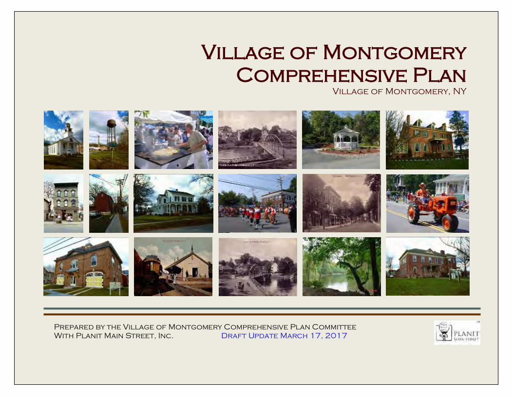
Village of Montgomery Comprehensive Plan Village of Montgomery, NY Prepared by the Village of Montgomery Comprehensive Plan Committee With Planit Main Street, Inc. Draft Update March 17, 2017

Welcome message from author
This document is posted to help you gain knowledge. Please leave a comment to let me know what you think about it! Share it to your friends and learn new things together.
Transcript
Village of Montgomery Comprehensive Plan
Village of Montgomery, New York i
Village of Montgomery
Comprehensive Plan Village of Montgomery, NY
Prepared by the Village of Montgomery Comprehensive Plan Committee
With Planit Main Street, Inc. Draft Update March 17, 2017
Village of Montgomery Comprehensive Plan
Village of Montgomery, New York ii
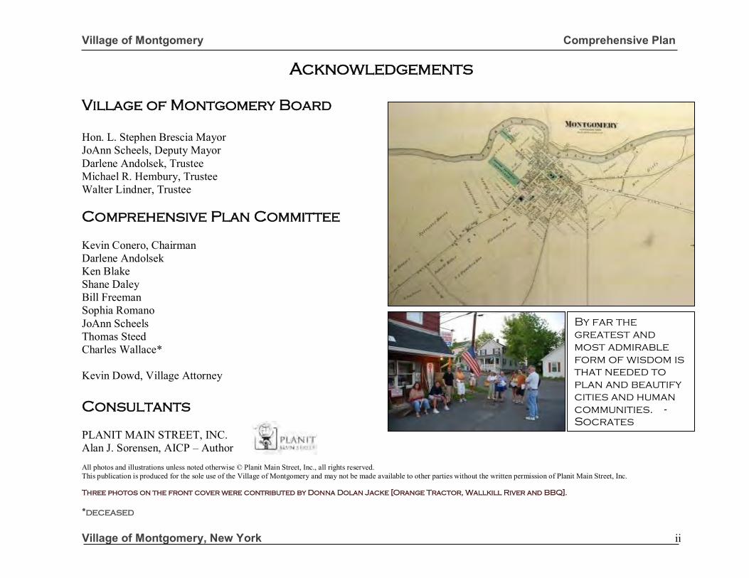
Acknowledgements
Village of Montgomery Board
Hon. L. Stephen Brescia Mayor JoAnn Scheels, Deputy Mayor Darlene Andolsek, Trustee Michael R. Hembury, Trustee Walter Lindner, Trustee Comprehensive Plan Committee
Kevin Conero, Chairman Darlene Andolsek Ken Blake Shane Daley Bill Freeman Sophia Romano JoAnn Scheels Thomas Steed Charles Wallace* Kevin Dowd, Village Attorney
Consultants
PLANIT MAIN STREET, INC. Alan J. Sorensen, AICP – Author All photos and illustrations unless noted otherwise © Planit Main Street, Inc., all rights reserved. This publication is produced for the sole use of the Village of Montgomery and may not be made available to other parties without the written permission of Planit Main Street, Inc.
Three photos on the front cover were contributed by Donna Dolan Jacke [Orange Tractor, Wallkill River and BBQ].
*deceased
By far the
greatest and
most admirable
form of wisdom is
that needed to
plan and beautify
cities and human
communities. -
Socrates
Village of Montgomery Comprehensive Plan
Village of Montgomery, New York iii
Acknowledgements Continued
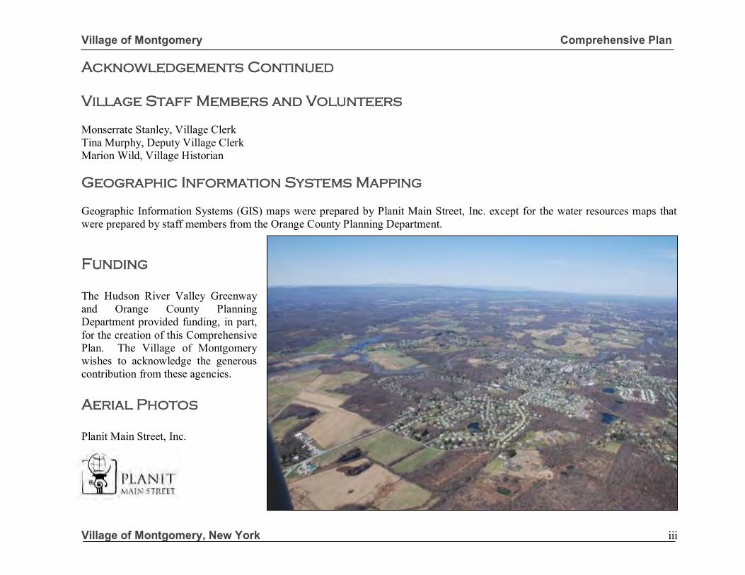
Village Staff Members and Volunteers
Monserrate Stanley, Village Clerk Tina Murphy, Deputy Village Clerk Marion Wild, Village Historian Geographic Information Systems Mapping
Geographic Information Systems (GIS) maps were prepared by Planit Main Street, Inc. except for the water resources maps that were prepared by staff members from the Orange County Planning Department. Funding
The Hudson River Valley Greenway and Orange County Planning Department provided funding, in part, for the creation of this Comprehensive Plan. The Village of Montgomery wishes to acknowledge the generous contribution from these agencies.
Aerial Photos
Planit Main Street, Inc.
Village of Montgomery Comprehensive Plan
Village of Montgomery, New York iv
Preface
The Village of Montgomery adopted it last Comprehensive Plan in 2008. That plan recognized that community planning is an ongoing process and recommended additional actions, plans and detailed studies to pursue the recommendations of the Comprehensive Plan. The 2008 Plan also recommended periodic updating of the Comprehensive Plan to incorporate the results of subsequent plans and studies and to reflect any unanticipated events or new issues. This draft of the 2016 update of the Village of Montgomery Comprehensive Plan is not a new departure. Rather it incorporates and builds upon the recommendations and land use policies set forth in the 2008 Plan. Therefore, it should not be viewed as a change of direction but, rather, as a refinement of the course already established.
Vision Statement
In our Vision for the Village of Montgomery in the future, our community character is preserved, civic pride sustained and quality of life enhanced. In the coming years, we carefully manage new growth and development to protect the integrity of our village, its historic districts, neighborhoods, downtown business district, cultural & civic institutions, public parks, and other natural resources; preserve historic buildings, open space, a vibrant business community and scenic vistas to and from the Wallkill River; enhance the convenience of pedestrian access to services and facilities within our walkable community; provide sustainable public infrastructure and services to meet growing community needs in a cost-effective manner; provide housing opportunities for a range of household incomes; and set quality design standards to ensure that new growth and redevelopment enriches our community aesthetics and is in harmony with the existing fabric of the Village of Montgomery.
Village of Montgomery Comprehensive Plan
Village of Montgomery, New York v
Table of Contents
Village of Montgomery Comprehensive Plan
EXECUTIVE SUMMARY Chapter 1 - Introduction…...………………....…………………………....………………………… 1 Chapter 2 - Historical & Regional Context……….………………………………………………… 3 Chapter 3 - Population & Housing…………..……….……………………………………………… 8 Chapter 4 - Natural Resources……………………………………………………..………………… 16 Chapter 5 - Transportation……………………..……………………….…………………………… 29 Chapter 6 - Cultural, Recreational & Historic Resources……………..…………..……………… 50 Chapter 7 - Community Facilities…………………………………….……………………………… 64 Chapter 8 - Downtown Revitalization…………………………….……………...………………….. 72 Chapter 9- Economic Development …………………………….……………...……………………. 83 Chapter 10 - Land Use & Zoning……………………….………..….……………………….………… 85 Chapter 11 - Plan Implementation……………………….…………………………………………… 105 APPENDICES Lighting Design, New Urbanism Concepts and Definitions Maps: Steep Slopes …………………………………………………………………………………………………………………………… ………17 Hydric Soils and Floodplains………………………………………………………………………………………………………………….. 19 Wetlands……………………………………………….……………………………………………................................................................. 20 Roadway Classification…. ….……………………………………………………………………..………………………………………… 30 Sidewalk Improvement…..……………………………………………………………………..……………………………………...…. 39-42 Historic Districts……………………………………………………………………………………………………………………………… 53 Parks & Open Space….…………………………………………………………………………….…………………………………………. 61 Land Use…….…………………………………..…………………………………………….……………………………………………… 88 Zoning ………………………………………………………………………………….…………………………….……………………… 91
Village of Montgomery EXECUTIVE SUMMARY
Village of Montgomery, New York E-1
EXECUTIVE SUMMARY The Village of Montgomery’s Comprehensive Plan was last updated in 2008. Nine years have passed since the 2008 Plan was adopted and some issues discussed have either come to pass or are no longer relevant to the challenges facing the Village today. For these reasons, and others, the Village Board formed a Comprehensive Plan Review Committee in 2014 to lead the effort to update the adopted 2008 Comprehensive Plan for the Village of Montgomery, New York. The Comprehensive Plan update forms the basis for future land use regulations and subsequent zoning or subdivision revisions that may be necessary to implement the recommendations contained within this Plan. It is also intended to help guide other Village policies related to recreation, open space preservation, housing, historic preservation and business development. This Plan is intended to respond to challenges facing the Village today and during the next five to ten years. The Committee created specific future land use policies intended to achieve the broad goal of preserving the character of the Village including its traditional neighborhoods, central business district, historic districts and overall quality of life. These policies are discussed in the context of specific goals and recommendations that are discussed in greater detail below. The process of implementing these goals is discussed in Chapter 12 Implementation.
VISION STATEMENT
In our Vision for the Village of Montgomery in the future, our community character is preserved, civic pride sustained and quality of life enhanced. In the coming years, we carefully manage new growth and development to protect the integrity of our village, its historic districts, neighborhoods, Downtown Business District, cultural & civic institutions, public parks, and other natural resources; preserve historic buildings, open space, a vibrant business community and scenic vistas to and from the Wallkill River; enhance the convenience of pedestrian access to services and facilities within our walkable community; provide sustainable public infrastructure and services to meet growing community needs in a cost-effective manner; provide housing opportunities for a range of household incomes; and set quality design standards to ensure that new growth and redevelopment enriches our community aesthetics and is in harmony with the existing fabric of our Village .
Comprehensive Plan Committee
Above (top to bottom): Old Fashioned Deli in the Downtown Business District; historic house within the Union Street- Academy Hill Historic District, circa 1800; and View of Wallkill River from the vicinity of Ward Street (Route 17K).
Village of Montgomery Introduction
Village of Montgomery, New York 1
1.0 INTRODUCTION The Village of Montgomery’s Comprehensive Master Plan was last updated in 2008. Since that time certain land use activities (e.g. home wind and solar generation) and planning concepts such as complete streets have emerged, which warrant an update of the 2008 Comprehensive Plan. In 2014, the Village Board retained the services of Planit Main Street, Inc. to work with a Village Board-appointed Comprehensive Plan Review Committee to lead the effort in updating the 2008 Comprehensive Plan. The purpose of the new Comprehensive Plan is to develop the land use policies needed to guide future land use decisions so that our community character is preserved, civic pride sustained and quality of life enhanced. It is also intended to respond to emerging trends so the Plan remains relevant. This Comprehensive Plan Update was prepared in accordance with New York State Village Law, §7-722(2)(a) that states that the plan will “identify the goals and objectives, principals, guidelines, policies, standards, devices, and instruments for the immediate and long-range protection, enhancement, growth and development of the Village.” While the creation of a Comprehensive Plan is not required under New York State Village Law, §7-722(2)(a), once one is adopted, all subsequent land use regulations must be in accordance with a community’s adopted Comprehensive Plan. The Comprehensive Plan will help to guide land use policies within the Village of Montgomery.
Three distinct phases were involved in the update of the Village of Montgomery’s Comprehensive Plan: 1) preparation of baseline data including population, housing, natural resources, community facilities, open space, and infrastructure, etc., 2) identification of issues facing the Village based upon baseline data, a review of existing land use regulations, monthly Comprehensive Plan Committee meetings, along with public input, and 3) the creation of broad goals, objectives and policies. An analysis of baseline conditions along with public input was used to identify a list of challenges facing the Village. These include:
• Protecting the integrity of the Village’s historic districts;
• Preventing overcrowding and overdevelopment;
• Traffic congestion along major arterials including Route 17K and Route 211;
• Appearance and maintenance of commercial properties;
• Natural resource protection and open space preservation;
• Declining enrollment in the school district;
• Sustaining a vibrant business community within the historic downtown;
• Maintaining the pedestrian-friendly feel and expanding the sidewalk network;
• Providing community services to serve growing community needs; and
• Housing opportunities for a range of household incomes in the Village.
Above (top to bottom): Patchett House, that was an Early Inn on the Cochecton Turnpike (NYS Route 17K), circa 1881; scene from General Montgomery Day; and picture of Village Hall, circa 1818.
Photo of Tractor Courtesy Donna Dolan Jacke
Village of Montgomery Introduction
Village of Montgomery, New York 2
1.1 Purpose of the Plan This Comprehensive Plan is meant to build upon the 1965 and 2008 Comprehensive Plans and is intended to guide the Village’s growth for the next 5 to 10 years. The Comprehensive Plan serves as the Village’s official policy document, providing a general set of planning principals relating to land use; natural, and historic resources; housing, economic development, downtown revitalization and other related issues. The purpose of the Comprehensive Plan is to realize the community’s vision for the future and to guide growth in a manner that fosters orderly, coordinated and beneficial development. It should also be periodically reviewed and updated to ensure that it continues to reflect the long-range goals of the community. 1.2 Implementation In order for this Comprehensive Plan to be effective, the Village of Montgomery must actively apply the policies that are contained within this Plan. Furthermore, its Planning Board and Zoning Board of Appeals must use the Plan as a framework to guide their decisions with respect to the review of development proposals. Certain recommendations contained herein will require the subsequent action of the Village Board in order to enact recommended revisions to the Zoning Code and other land use regulations such as the Village’s sign regulations or subdivision regulations and/or the creation of design guidelines for commercial development.
Other actions such as the preservation of historic resources, transportation improvements, or the development of linear parks or bicycle travel lanes will require the collaboration between the Village, Town, County, State and not-for-profit entities. These actions are outlined in Chapter 12 – Plan Implementation of this Plan along with the party responsible for taking a leadership role in the implementation of the policy or program. Each member of the Village Board, Planning Board and Zoning Board of Appeals should have a copy of this Comprehensive Plan. The Village Board may want to appoint a Comprehensive Plan subcommittee to spend time each month reviewing progress on the implementation of this Comprehensive Plan and coordinating efforts with other entities where necessary. The Village of Montgomery has a long-established tradition of respecting its history and protecting its historic resources. Its rich sense of history is defined by its residents, neighborhoods, institutions, parklands, business community, and community events such as General Montgomery Day that define its unique sense of place today. If we are to properly plan for our future, we must have an understanding and appreciation for our past. In Chapter 2 Historic & Regional Context a brief summary of the Village’s history and its relationship to the surrounding region is provided to help set the stage as we plan for the future of the Village of Montgomery.
VISION STATEMENT
“In our Vision for the Village of Montgomery in the future, our community character is preserved, civic pride sustained and quality of life enhanced. In the coming years, we carefully manage new growth and development to protect
the integrity of our village, its historic districts, neighborhoods, downtown business district, cultural & civic institutions, public parks, and other natural resources; preserve historic buildings, open space, a vibrant business community and scenic vistas to and from the Wallkill River; enhance the convenience of pedestrian access to services and facilities within our walkable community; provide sustainable public infrastructure and services to meet growing community needs in a cost-effective manner; provide housing opportunities for a range of household incomes; and set quality design standards to ensure that new growth and redevelopment enriches our community aesthetics and is in harmony with the existing fabric of the Village of Montgomery.” Comp Plan Committee
Village of Montgomery Historical & Regional Context
Village of Montgomery, New York 3
CHAPTER 2.0 - HISTORIC & REGIONAL CONTEXT During the Colonial Era (1700-1783), the Wallkill Valley began to be settled by Europeans of German, English, Scots, and Irish origin. These settlers established small farms on the fertile lands in the river valley helping to build a strong agricultural economy. As the agricultural economy grew, so too did agricultural-related industries including grist mills, logging mills, blacksmith shops and mercantile stores. Over time, settlers came together to form the first churches, schools and service organizations. Around 1730, the waterpower of the Wallkill River began to be harnessed for larger industries. About this time, Johannes Mingus established a grist mill on the northern banks of the Wallkill River (across the river from where the Village of Montgomery sits today). In 1744, the mill was purchased by James Ward who constructed a bridge across the Wallkill River to improve access to the mill. A small settlement grew up on the southern banks of the Wallkill River that became known as Ward’s Bridge. The first streets in Ward’s Bridge (today’s Village of Montgomery) were Bridge Street, Clinton Street (as it ran from Bridge Street to Goodwill Road) and Union Street (leading to Goshen). These roadways also defined early settlement patterns. For example, many of the earliest houses were built along these streets.
Following the Revolutionary War, a company formed by a local group of men and a woman purchased the mill and a 200-acre tract of land that was owned by James Ward. They hired James Clinton, a surveyor from Little Brittain, to create a master plan (that became known as the Clinton Map) for a village. Clinton created a master plan with a rectangular grid street pattern, a village green, a site for an academy and even a common area for a public spring or water supply. The street pattern for the village was integrated into the existing layout of Bridge Street, Clinton Street and Union Street. James Clinton defined the street pattern and named many of the streets that exist in the Village today. Some time after the Clinton Map was created, Ward’s Bridge was renamed Montgomery in honor of General Richard Montgomery, a Revolutionary War hero who died in the Battle of Quebec in 1775. During the Early Republic Era (1784-1825) a number of the institutions and architectural styles that define the Village of Montgomery today were established. In 1787, early founders of the village erected a two-story academy building and petitioned the Board of Regents of the University of New York to grant a charter school where science and language could be taught. In 1791, the Academy was incorporated under the N.Y.S. Board of Regents. The Village of Montgomery was formally incorporated as a village in 1810. In 1818, the original Academy building was replaced with a new two-story Federal style brick building that is home to Village Hall today.
Above (top to bottom): Historical map of Village of Montgomery, circa 1800’s and Photo of J. Haskin Horse Shoeing & Jogging, circa late-1800’s.
Village of Montgomery Historical & Regional Context
Village of Montgomery, New York 4
In that same year, the Montgomery Fire Department was also established making it one of the first fire departments in New York State. The predominant architectural styles during this period were Federal, Colonial Revival and Gothic Revival. Houses that were constructed during this period can be found throughout the Village’s historic districts. These buildings help to define the Village’s unique sense of place. Early transportation routes helped to define the Village of Montgomery. During the Early Republic Era, there was unprecedented growth in the development of turnpikes in New York State that were a vast improvement over pioneer roads and trails. Turnpikes provided a more direct travel route and better roads on which to move goods and people more effectively. In 1801, the Newburgh & Cochecton (N&C) Turnpike was one of the first chartered turnpikes in the Hudson Valley. The N&C Turnpike (today’s Route 17K) ran through the Village of Montgomery and crossed the Wallkill at Ward’s Bridge. While the City of Newburgh was the main port for the turnpike, the Village of Montgomery was an important stopping place. Stagecoaches made daily trips on the turnpike with stops in the Village of Montgomery. The construction of the Newburgh and Cochecton Turnpike played an important role in the early growth of the Village. The construction of the turnpike spurred growth in blacksmith shops, stores, taverns and inns that provided services to the traveling public as well as growth in the Village’s population.
In 1809, the Minisink and Montgomery Turnpike was chartered. It ran from the New Jersey State Line in the Town of Minisink and intersected the Newburgh and Cochecton Turnpike at Union Street in the Village of Montgomery. These turnpikes helped to make the Village of Montgomery an important center of commerce within the surrounding region. As the nation grew, so too did its means of transportation. The D&H canal, which ran from Honesdale Pennsylvania to Kingston, New York, played a role in the Village’s growth. To save costs in shipping from Wurtsboro to Kingston, many goods from Pennsylvania were picked up in Wurtsboro and transported through the Village of Montgomery on their way to Newburgh. This activity brought commerce to the Village and helped it to continue to grow. The Romantic Era (1826-1865)
This era is defined by the conflict between the political interests in New York City and those interests of the agricultural community in upstate. During this period, a distinctive country style of architecture emerged. Predominant housing styles of this era include Greek Revival, Gothic Revival and Italianate styles. This was a period of steady growth. Many houses, commercial businesses and institutional buildings were constructed during this time. In 1831, the Neo-classical First Presbyterian Church on the southwest corner of Clinton Street and Wallkill Avenue was constructed.
Above (top to bottom): Historic Marker at site of Ward’s Bridge; former Academy that is now home to Village Hall, Library, and Village Museum circa 1818; and the Mead Tooker Bed & Breakfast on Clinton Street circa 1800.
Village of Montgomery Historical & Regional Context
Village of Montgomery, New York 5
A few years before, in 1823, the Methodist Church on the northeast corner of Clinton Street and Wallkill Avenue was constructed (Wesley Hall). These churches still stand today which contributes to the Village’s rich sense of history. During the Romantic Era, there were modest improvements in transportation. This would change following the Civil War due to proactive measures by Village business leaders. National Era 1866-1920
Following the Civil War, the nation went through a period of industrialization and with it came the predominance of the railroad as the primary transportation mode for industry and passengers. In 1866, Montgomery businessmen came together to form the Montgomery &
Goshen Railroad. It opened in 1867 and ran 10.2 miles from Montgomery to Goshen. The creation of the railroad ensured the Village’s place as a center for commerce for the surrounding region. Passengers could take the train from Montgomery to Goshen. From there they could transfer to the Erie Railroad that would then take them into New York City. Rail service also opened up the opportunity for area dairy farmers to ship their milk to New York City rather than solely producing cheese and butter. The construction of the railroad spurred growth in the dairy industry (within the Wallkill Valley) that in turn spurred growth in the Village’s business community through the sale of goods and services to area dairy farmers.
The railroad had several sidings within the Village that directly served feed stores that sold grain to area dairy farmers. The importance of the Village as a center for the agricultural industry is further reflected in the establishment of the Grange on Wallkill Avenue in 1900. Shortly after it opened, the Montgomery & Goshen railroad was extended to provide service from Montgomery to Kingston. It was renamed the Wallkill Valley Railroad and provided service from Kingston to Goshen by 1872. Completion of the Wallkill Valley Railroad also created growth in a new industry – tourism. “But to a greater benefit of Montgomery, the railroad allowed the city people to reach the Wallkill Valley more easily. The whole valley became a summer resort, and every farmer’s wife, a boarding house keeper” (Emma C. Locke – A Short History of Montgomery, NY). Industry also played an important role in the growth of the Village. In 1880, Crabtree &
Patchett established the Worsted Yarn mill on Factory Street along the banks of the Wallkill River. The mill harnessed the power of the Wallkill River and was a major industry in the Village well into 20th Century. Many of the Italianate commercial buildings in the Downtown Business District were constructed during this time. Dominant architectural styles constructed in the Village during the National Era were Queen Ann,
Craftsman, Gothic Revival and French Second Empire.
Above (top to bottom): Wesley Hall circa 1827 and Presbyterian Church, circa 1831 at the corners of Clinton Street and Wallkill Avenue.
Village of Montgomery Historical & Regional Context
Village of Montgomery, New York 6
In 1905, the National Bank of Montgomery opened in the Mead Building on Clinton Street - adding finance as an important industry in the Village. This was still a period of time when most people walked to stores, churches or to work. As a result, neighborhoods were densely developed and in close proximity to these local institutions or businesses. This pattern of growth began to change during the Modern Era. Modern Era (1921-1944)
The Modern Era was a period of time that marked the growing dominance of the automobile and gradual decline of the railroad as the primary form of passenger transportation. Improvements to State roadways during this period of time ensured that the Village continued to have excellent transportation access to the surrounding region. The former Newburgh & Cochecton Turnpike became State Highway Route 17K. State Highway Route 211 was also constructed linking the Village of Montgomery to the City of Middletown. These improvements helped to ensure that the Village remained an important place of commerce within the region.
Many of the homes constructed during this time reflected the prototypical Colonial Revival and Craftsman style houses. These homes were built on larger lots as people became less dependent on walking due to the invention of the automobile. After World War II, suburban development (characterized by single-family houses on large lots) became more common.
Post WWII Era (1945-present)
Following WWII, the Village’s population grew dramatically. In 1960, the population was 1,312 persons. Today, the population is 4,238 persons. The housing styles after WWII differ from previous eras in its form and style. Post WWII, suburban ranch style housing was developed on larger lots and multi-family housing became more common in the Village. However, recent trends in housing (such as new-urbanism) would better respect the traditional residential development pattern that exists within the Village’s Historic Districts. Today, the Village has retained its place as a residential, educational, industrial and commercial center. Montgomery Elementary School is located on Union Street in the heart of the community. The former Worsted Yarn Mill on Factory Street still produces yarn and the building looks as it did when it was constructed over 120 years ago. Chambers Tractor & Supplies sells tractors & equipment to the surrounding farming community – although horse farms, nurseries and vegetable farms have largely replaced dairy farming. Today, there are a variety of banks, restaurants, personal service establishments, shops and bed & breakfasts in the Downtown Business District. The Village’s historic districts, Chamber Music Series, General Montgomery Day and museums attract visitors from throughout the Hudson Valley and the surrounding region.
Above (top to bottom): Union Station and turntable circa 1900 (no longer existing); Orange County Firefighters Museum (formerly the Montgomery Firehouse), circa 1913; and the Senior Department Store circa late 1800’s (destroyed by fire). The latter building was replaced with a one-story building.
Village of Montgomery Historical & Regional Context
Village of Montgomery, New York 7
For every season there is a turn. Village residents’ can look fondly upon the past and learn from it as they plan ahead for the future of the community. There is a unique opportunity in the 21st Century to reconnect the community to the Wallkill River through passive recreation along the river. It can encourage infill development on vacant lots and undeveloped parcels in a manner that complements the more densely developed and walkable development pattern within the Village’s historic districts. It can also explore the feasibility of again having passenger rail service within the Village to strengthen its transportation access to New York City. This during a time when passenger rail service is increasing in popularity as a result of rising fuel costs and area roadways become even more congested. The Village of Montgomery has a rich history and many competitive advantages such as an excellent highway system, well-respected educational system, vibrant Downtown Business District, niche industries, historic districts, excellent park system and well-kept residential neighborhoods. Having an understanding of the Village’s history is important as we plan for its future growth. There is much to build upon within the Village. Chapter 3.0 – Population & Housing, which follows, provides an overview of population, housing, educational attainment, occupation and employment trends from 2000 to 2010.
This Column Reserved.
Village of Montgomery Population & Housing
Village of Montgomery, New York 8
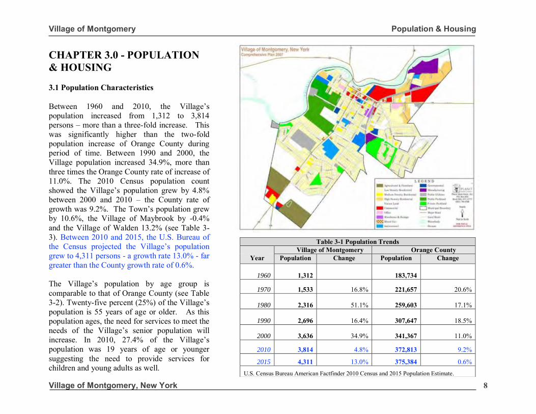
CHAPTER 3.0 - POPULATION & HOUSING 3.1 Population Characteristics Between 1960 and 2010, the Village’s population increased from 1,312 to 3,814 persons – more than a three-fold increase. This was significantly higher than the two-fold population increase of Orange County during period of time. Between 1990 and 2000, the Village population increased 34.9%, more than three times the Orange County rate of increase of 11.0%. The 2010 Census population count showed the Village’s population grew by 4.8% between 2000 and 2010 – the County rate of growth was 9.2%. The Town’s population grew by 10.6%, the Village of Maybrook by -0.4% and the Village of Walden 13.2% (see Table 3-3). Between 2010 and 2015, the U.S. Bureau of the Census projected the Village’s population grew to 4,311 persons - a growth rate 13.0% - far greater than the County growth rate of 0.6%. The Village’s population by age group is comparable to that of Orange County (see Table 3-2). Twenty-five percent (25%) of the Village’s population is 55 years of age or older. As this population ages, the need for services to meet the needs of the Village’s senior population will increase. In 2010, 27.4% of the Village’s population was 19 years of age or younger suggesting the need to provide services for children and young adults as well.
Table 3-1 Population Trends Village of Montgomery Orange County
Year Population Change Population Change
1960 1,312 183,734
1970 1,533 16.8% 221,657 20.6%
1980 2,316 51.1% 259,603 17.1%
1990 2,696 16.4% 307,647 18.5%
2000 3,636 34.9% 341,367 11.0%
2010 3,814 4.8% 372,813 9.2%
2015 4,311 13.0% 375,384 0.6%
U.S. Census Bureau American Factfinder 2010 Census and 2015 Population Estimate.
Village of Montgomery Population & Housing
Village of Montgomery, New York 9
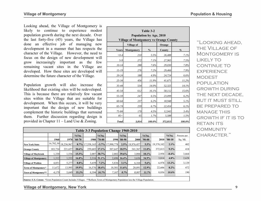
Looking ahead, the Village of Montgomery is likely to continue to experience modest population growth during the next decade. Over the last forty-five (45) years, the Village has done an effective job of managing new development in a manner that has respects the character of the Village. However, the need to focus on the design of new development will grow increasingly important as the few remaining vacant sites in the Village are developed. How these sites are developed will determine the future character of the Village. Population growth will also increase the likelihood that existing sites will be redeveloped. This is because there are relatively few vacant sites within the Village that are suitable for development. When this occurs, it will be very important that the design of new buildings complement the historic buildings that surround them. Further discussion regarding design is provided in Chapter 11 – Land Use & Zoning.
Table 3-2
Population by Age, 2010 Village of Montgomery vs Orange County
Village of Orange
Years Montgomery % County %
+0-4 210 5.5% 26,488 7.1%
5-9 272 7.1% 27,965 7.5%
10-14 288 7.6% 29,030 7.8%
15-19 276 7.2% 29,466 7.9%
20-24 188 4.9% 24,724 6.6%
25-34 456 11.9% 41,671 11.2%
35-44 534 14.0% 52,325 14.1%
45-54 612 16.1% 58,112 15.6%
55-59 247 6.5% 23,099 6.2%
60-64 237 6.2% 18,948 5.1%
65-74 259 6.7% 22,454 6.1%
75-84 170 4.5% 12,943 3.4%
85+ 65 1.7% 5,588 1.5%
Total 3,814 100.0% 372,813 100.0%
Table 3-3 Population Change 1960-2010
%Chg. %Chg. %Chg. %Chg. %Chg. Persons per
1960 1970 '60-70 1980 '70-80 1990 '80-90 2000 '90-00 2010 '00-10 Sq. Mi.
New York State 16,782,304
18,236,967 8.7% 17,558,165 -3.7% 17,990,778 2.5% 18,976,457 5.5% 19,378,102 2.1% 402
Orange County 183,734 221,657 20.6% 259,603 17.1% 307,647 18.5% 341,367 11.0% 372,813 9.2% 418
Village of Maybrook 1,330 1,536 15.5% 2,007 30.7% 2,802 39.6% 3,084 10.1% 2,958 -0.4% 3,664
Village of Montgomery 1,312 1,533 16.8% 2,316 51.1% 2,696 16.4% 3,636 34.9% 3,814 4.8% 2,628
Village of Walden 4,851 5,277 8.8% 5,659 7.2% 5,836 3.1% 6,164 5.6% 6,978 13.2% 3,129
Town of Montgomery* 11,672 13,995 19.9% 16,576 18.4% 18,501 11.6% 20,891 12.9% 22,606 8.2% 472
Town of Montgomery** 4,179 5,649 35.2% 6,594 16.7% 7,167 8.7% 8,007 11.7% 8,856 10.6% 190 Source: U.S. Census *Town Population Count Includes Villages **Reflects Town of Montgomery Population less the Village Population.
“Looking ahead,
the Village of
Montgomery is
likely to
continue to
experience
modest
population
growth during
the next decade,
but it must still
be prepared to
manage this
growth if it is to
retain its
community
character.”
Village of Montgomery Population & Housing
Village of Montgomery, New York 10
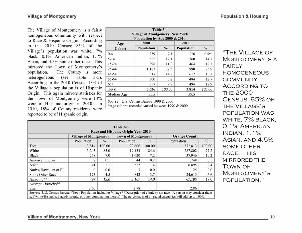
The Village of Montgomery is a fairly homogeneous community with respect to Race & Hispanic Origin. According to the 2010 Census; 85% of the Village’s population was white, 7% black, 0.1% American Indian, 1.1% Asian, and 4.5% some other race. This mirrored the Town of Montgomery’s population. The County is more heterogeneous (see Table 3-5). According to the 2010 Census, 13% of the Village’s population is of Hispanic Origin. This again mirrors statistics for the Town of Montgomery were 14% were of Hispanic origin in 2010. In 2010, 18% of County residents were reported to be of Hispanic origin.
Table 3-4 Village of Montgomery, New York
Population by Age 2000 & 2010 Age 2000 2010
Cohort Population % Population %
0-4 259 7.1 210 5.5%
5-14 622 17.1 560 14.7 15-24 398 11.0 464 12.1 25-44 1,183 32.5 990 25.9 45-54 517 14.2 612 16.1 55-64 300 8.2 484 12.7 65+ 357 9.8 494 12.9 Total 3,636 100.00 3,814 100.00
Median Age 35.3 39.5
Source: U.S. Census Bureau 1990 & 2000 *Age cohorts recorded varied between 1990 & 2000
Table 3-5 Race and Hispanic Origin Year 2010
Village of Montgomery Town of Montgomery Orange County Population % Population % Population % Total 3,814 100.00 22,606 100.00 372,813 100.00 White 3,243 85.0 19,133 84.6 287,802 77.2 Black 268 7.0 1,620 7.2 37,946 10.2 American Indian 2 0.1 44 0.2 1,748 0.5 Asian 41 1.1 322 1.4 8,895 2.4 Native Hawaiian or PI 0 0.0 3 0.0 125 0.0 Some Other Race 173 4.5 842 3.7 24,615 6.6 Hispanic** 497 13.0 3,167 14.0 67,185 18.0 Average Household
Size 2.60 2.78 2.86 Source: U.S. Census Bureau *Town Population Including Village **Description of ethnicity not race. A person may consider them self white/Hispanic, black/Hispanic, or other combination thereof. The percentages of all racial categories will add up to 100%.
“The Village of
Montgomery is a
fairly
homogeneous
community.
According to
the 2000
Census; 85% of
the Village’s
population was
white, 7% black,
0.1% American
Indian, 1.1%
Asian, and 4.5%
some other
race. This
mirrored the
Town of
Montgomery’s
population.”
Village of Montgomery Population & Housing
Village of Montgomery, New York 11
The Village has a well-educated population and recent trends show a growing level of educational attainment among local residents between 2000 and 2010. In 2010, the U.S. Bureau of the Census reported that 94.1% of Village residents had at least a high school diploma. The Orange County rate was slightly lower at 87.3%. Between 2000 and 2010, the percent of Village residents with a Bachelors Degree or higher decreased slightly from 26.8% to 25.8%. During this time period, the County rate increased from 22.5% to 28.7% - showing a higher level of educational attainment in the Village versus the County. Between 2000 and 2010, the percentage of Village residents with a Bachelor’s Degree decreased from 14.8% to 13.2% , but the number grew from 332 to 404.
The most dramatic trend in educational attainment related to the percentage of persons possessing some college, no degree in the Village. Between 2000 and 2010, the number of persons with some college, no degree increased from 440 to 807, a 83.4% increase. The number of residents with a graduate or professional degree was almost unchanged between 2000 and 2010, increasing from 270 to 272 persons. There are two factors influencing educational attainment within the Village. The first factor is residents who may have pursued higher education between 2000 and 2010. The second factor is the educational attainment of new residents who have moved into the Village between 2000 and 2010. Both factors have contributed to a highly educated population in the community.
Table 3-6 Trends in Educational Attainment Educational Village of Montgomery, New York Orange County Percent Percent Attainment Trends from 2000-2010 Trends from 2000-2010 Change Change
2000 2010 2000 2010 VILLAGE COUNTY % % % %
Total Persons 25 Years and over 2,245 100.0% 2,620 100.0% 212,816 100.0% 235,732 100.0% 16.7% 10.7% Less Than 9th Grade 62 2.8% 45 1.7% 11,942 5.6% 10,136 4.3% -27.4% -15.1% 9th-12th, no diploma 209 9.3% 110 4.2% 26,687 12.5% 18,858 8.0% -47.3% -29.3% High school graduate 648 28.9% 749 28.6% 66,119 31.1% 69,069 29.3% 15.6% 4.5% Some college, no degree 440 19.6% 807 30.8% 42,767 20.1% 49,503 21.0% 83.4% 15.7% Associate’s degree 284 12.7% 233 8.9% 17,348 8.2% 20,744 8.8% -17.9% 19.6% Bachelor’s degree 332 14.8% 404 15.4% 28,169 13.2% 39,602 16.8% 21.6% 40.6% Graduate or professional 270 12.0% 272 10.4% 19,784 9.3% 28,052 11.9% 0.7% 41.2% Percent high school graduate or higher 87.9% 94.1% 81.9% 87.3% Percent Bachelors Degree or higher 26.8% 25.8% 22.5% 28.7% Source: U.S. Census Bureau STF3 Data
“Percent of
residents with a
Bachelor’s
Degree - 15.4%.
Percent of
village resident’s
with a graduate
or professional
degree 10.4% -
with a percent
increase of 0.7%
between 2000
and 2010.”
Village of Montgomery Population & Housing
Village of Montgomery, New York 12
3.1.1 Employment by Industry
In 2010, the largest industry in Montgomery was in Educational & Health Services, representing 24.6% of all village employment. This was slightly lower than the County where 26.3% of all workers were employed in this industry. The second largest industry was in Retail Trade -
comprising 11.2% of the local economy. The number of jobs in the Manufacturing Industry increased from a 83 in 2000 to 163 in 2010, representing a 96.4% increase. The sectors with the largest percentage growth were Other Services, Manufacturing and Transportation - increasing by 253.8%, 96.4%, and 17.3% respectively.
Table 3-7 Labor Force & Employment by Industry
Employment Characteristics Village of Montgomery Orange County Percent Percent
(Age 16 and over) Trends from 2000-2010 Trends from 2000-2010 Change Change
2000 % 2010 % 2000 % 2010 % VILLAGE COUNTY
Total In Labor Force 1,874 72.3% 2,017 68.8% 164,858 65.2% 191,163 66.9% 7.6% 16.0% Civilian Labor Force 1,874 72.3% 1,991 67.9% 159,946 63.3% 186,406 65.3% 6.2% 16.5%
Employed 1,784 68.8% 1,842 62.8% 151,744 60.1% 170,981 59.9% Not Employed 90 3.5% 149 5.1% 8,202 3.2% 15,425 5.4%
Not In Labor Force 718 27.7% 914 31.2% 87,810 34.8% 94,400 33.1% Industry Educational & Health Services 485 27.2% 453 24.6% 36,167 23.8% 45,042 26.3% -6.6% 24.5% Retail Trade 189 10.6% 206 11.2% 20,399 13.4% 23,148 13.5% 9.0% 13.5% Construction 199 11.2% 203 11.0% 10,297 6.8% 10,645 6.2% 2.0% 3.4% Public administration 182 10.2% 197 10.7% 11,457 7.6% 11,601 6.8% 8.2% 1.3% Manufacturing 83 4.7% 163 8.8% 15,404 10.2% 12,034 7.0% 96.4% -21.9% Finance, Insurance & Real Estate 115 6.5% 128 6.9% 9,702 6.4% 10,344 6.0% 11.3% 6.6% Transportation, warehousing & utilities 98 5.5% 115 6.2% 9,081 6.0% 10,846 6.3% 17.3% 19.4% Wholesale Trade 96 5.4% 94 5.1% 6,146 4.1% 5,618 3.3% -2.1% -8.6% Other Services (except public admin). 26 1.5% 92 5.0% 6,332 4.2% 7,519 4.4% 253.8% 18.7% Professional services 118 6.6% 82 4.5% 11,579 7.6% 14,651 8.6% -30.5% 26.5% Communications and Information 81 4.5% 62 3.4% 5,255 3.5% 4,434 2.6% -23.5% -15.6% Arts, Entertainment & Recreation 112 6.3% 47 2.6% 8,379 5.5% 13,124 7.7% -58.0% 56.6% Agriculture, forestry and mining 0 0.0% 0 0.0% 1,546 1.0% 1,985 1.2% NA 28.4%
“Between 2000
and 2010, the
Village saw a
96.4 percent
increase in
manufacturing.”
Village of Montgomery Population & Housing
Village of Montgomery, New York 13
Within the Village, eighty (80) jobs were gained in the Manufacturing Industry from 2000 to 2010. This shift bucked national declines in the Manufacturing Industry. Between 2000 and 2010, there was also an increase in the Other Services Industry – increasing 253%. Retail trade experienced a gain of 17 jobs between 2000 and 2010 – a 9% increase. The increase in retail trade was impressive given the growing competition from big-box retailers that where developed along Route 208 and Route 17K outside of the Village of Montgomery. The Village has been able to retain a vibrant Downtown Business District in the face of growing competition due to the quality of its establishments and its unique sense of place. The Village Board has assisted in this endeavor by investing in public infrastructure such as the new bandstand, which is situated in the heart of Downtown. If the business district is to remain competitive, public/private efforts to promote and market downtown to customers and businesses alike must be sustained in the future. Between 2000 and 2010, there were a number of industries that increased their employment numbers in the Village. Jobs in Public Administration grew from 182 jobs in 2000 to 197 jobs in 2010 – a 15-job increase. Employment in Finance, Insurance and Real Estate grew from 115 jobs in 2000 to 128 in 2010 – a 13-job or 11.3% increase. The historic character of the Village lends itself to continued growth in the Arts & Entertainment Industry.
Other industries that saw an increase in the number of jobs were in the Public Administration; Wholesale Trade; Finance, Insurance and Retail Estate; Professional Services; Transportation & Warehousing industries (see Table 3-7). In 2000, the top three industries in the Village comprised 48.93% of all employment. In 2010, the top three industries provided 46.80% of employment opportunities in the Village. These trends show a diversification of the local economy. While a number residents’ work within the Village, a large percentage commute to work each day. The mean travel time to work for local residents is 38.7 minutes, slightly higher than the average for Orange County which was 33.3 minutes according the 2010 Census. 3.1.2 Occupation
Table 3-9 provides a breakdown of the Village of Montgomery’s workforce (persons 16 years of age and over) by occupation. Thirty-seven percent of Village resident’s are employed in Management or Professional occupations. This reflects the educational attainment of the community as reported in Table 3-6. A total of 577, or 31.3% of residents were employed in Sales and office jobs and another 11.3% in Service jobs. A total of 11.1% of village residents worked in Construction with another 9.0% employed in Production and Transportation occupations.
Table 3-8 Mean Travel Time to Work 2010
Village County Mean Travel Time - Minutes 38.7 33.3
Table 3-9 Village of Montgomery
Occupation 2010 # % Management, professional 687 37.3 Service 208 11.3 Sales and office 577 31.3 Construction, extraction 204 11.1 Production, transportation 166 9.0 Total 1,842 100
Above: The new Village of Montgomery Bandstand, which is situated on the site of the former Post Office. This Plan supports such public investments in the downtown business district as a means of sustaining a socially and economically vibrant center.
Village of Montgomery Population & Housing
Village of Montgomery, New York 14
3.2 Housing Characteristics In 2010, the Village of Montgomery had a total of 1,428 housing units. The majority of these housing units, 57.6%, are single-family dwelling units (see Table 3-10). Of all dwelling units, 96.8% were occupied and 3.2% were vacant. In 2010, the vacancy rate for the Village was significantly lower than the County rate that was recorded at 9.0%. The higher rate for the County is, in part, due to the higher percentage of second homes in the County that are counted as vacant when the Census is taken in April. The higher percentage in 2010 also reflected the residue of the housing crises. The Village was less affected by the economic downturn than the County. The 2010 Census showed a slight shift in owner versus renter occupied housing units within the Village. In 2000, 73.0% of all occupied housing units were owner occupied. By 2010, this number decreased to 67.0%. The County owner occupancy rate in the Year 2010 was of 69.2% (see Table 3-11 and Table 3-12).
Table 3-10
Housing Units In Structure 1990 - 2000 Village of Montgomery, New York Orange County 2000
Year Round
2000 Units
%
2010 Units
%
2010 Units
%
1-unit detached 866 68.2 823 57.6 85,507 62.1 1-unit attached 100 7.7 115 8.1 8,876 6.4 2-4 units 170 13.1 259 18.1 19,540 14.2 5-9 units 48 3.7 31 2.2 9,157 6.6 10 or more units 95 7.3 200 14.0 11,324 8.2 Mobile Home 0 0.0 0 0.0 3,287 2.4 Boat, RV, Van, Etc. 0 0.0 0 0.0 12 0.0 Total 1,299 1,428 137,703
Source: U.S. Census Bureau
Table 3-12 Housing Village of Montgomery, New York Orange County, New York Percent Percent
Characteristics Trends from 2000-2010 Trends from 2000-2010 Change Change 2000 2010 2000 2010 TOWN COUNTY
Housing Units Units % Units % Units % Units % Total 1,338 100% 1,428 100% 122,754 100% 137,703 100% 6.7% 12.2% Occupied 1,304 97.5% 1,383 96.8% 114,788 93.4% 125,317 93.4%
Owner Occupied 952 71.2% 920 64.4% 76,959 62.7% 86,713 62.9% Renter Occupied 352 25.5% 463 32.4% 37,829 30.8% 38,604 28.0%
Vacant 34 2.5% 45 3.2% 7,966 6.5% 12,386 9.0% Seasonal 3 0.0% 2,215 1.8%
Source: U.S. Census Bureau * Seasonal units are part of the vacant unit count.
Table 3-11
Village of Montgomery, New York Tenure by Occupied Units 2000 - 2010
Orange County, New York Tenure by Occupied Units 2000 - 2010
Year Round
2000 2010 2000 2010 Units % Units % Units % Units %
Owner Occupied 952 73.0% 920 66.5% 76,959 67.0% 86,713 69.2% Renter Occupied 352 27.0% 463 33.5% 37,829 33.0% 38,604 308% Total 1,304 100% 1,383 100% 114,788 100% 125,317 100%
Source: U.S. Census Bureau SFT1 Data
Village of Montgomery Population & Housing
Village of Montgomery, New York 15
Summary As the Village’s population continues to grow, so too will the demand for community services such as fire, police, ambulance, water, and sewer services. New residential construction will likely increase the demand for public education that may necessitate capital improvements in the Valley Central School District. Continued growth in regional retailers will require ongoing cooperation between the Village and the local business community to maintain a vibrant Downtown Business District. As the community’s population grows so too will the demand for parks & recreational services. It is important that the increase in demand for such services are anticipated and carefully reviewed during the environmental review process for development projects. The Village can use the State environmental review process to assess such impacts and to ensure that appropriate measures are put in place to mitigate potential adverse impacts to the community. As is the case in most communities, the most suitable sites for development in the Village of Montgomery were the first to be developed. These sites are becoming increasingly scarce - leaving less desirable sites (i.e. those with environmental or other site constraints) for development. Development on such sites will require careful review to protect natural resources such as steep slopes, wetlands, and water resources.
Care must also be taken to protect important vistas that help to define the small-town character of the Village. Infill development and redevelopment of parcels within or near the Village’s historic districts must be carefully reviewed in order to protect the integrity of these districts. The desirability of the Village (demonstrated by its population growth) will also continue to put pressure on the housing market. Looking ahead, policies to ensure that housing opportunities are made available to meet the needs of a variety of household incomes in the community (including volunteer ambulance corps members, teachers, and its growing workforce) may be necessary. The Village has many assets and with careful planning it is well-positioned to grow in a manner that will strengthen the community’s economic and social vitality for years to come. The following chapters provide a broader discussion of natural resources, transportation, recreation, community facilities, downtown revitalization, historic preservation and economic development. Each of these chapters will frame the challenges facing the Village in the years ahead as well as policies that it can put in place to help the Village to meet these challenges.
Village of Montgomery Natural Resources
Village of Montgomery, New York 16
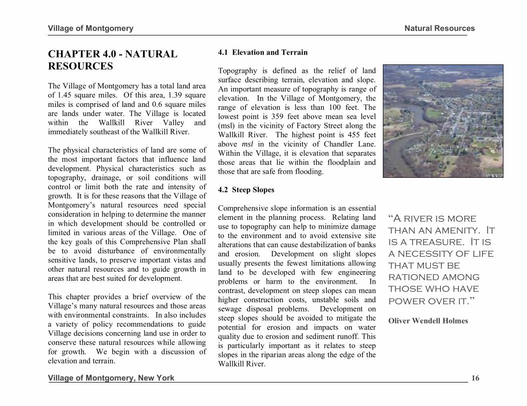
CHAPTER 4.0 - NATURAL RESOURCES The Village of Montgomery has a total land area of 1.45 square miles. Of this area, 1.39 square miles is comprised of land and 0.6 square miles are lands under water. The Village is located within the Wallkill River Valley and immediately southeast of the Wallkill River. The physical characteristics of land are some of the most important factors that influence land development. Physical characteristics such as topography, drainage, or soil conditions will control or limit both the rate and intensity of growth. It is for these reasons that the Village of Montgomery’s natural resources need special consideration in helping to determine the manner in which development should be controlled or limited in various areas of the Village. One of the key goals of this Comprehensive Plan shall be to avoid disturbance of environmentally sensitive lands, to preserve important vistas and other natural resources and to guide growth in areas that are best suited for development. This chapter provides a brief overview of the Village’s many natural resources and those areas with environmental constraints. In also includes a variety of policy recommendations to guide Village decisions concerning land use in order to conserve these natural resources while allowing for growth. We begin with a discussion of elevation and terrain.
4.1 Elevation and Terrain Topography is defined as the relief of land surface describing terrain, elevation and slope. An important measure of topography is range of elevation. In the Village of Montgomery, the range of elevation is less than 100 feet. The lowest point is 359 feet above mean sea level (msl) in the vicinity of Factory Street along the Wallkill River. The highest point is 455 feet above msl in the vicinity of Chandler Lane. Within the Village, it is elevation that separates those areas that lie within the floodplain and those that are safe from flooding. 4.2 Steep Slopes Comprehensive slope information is an essential element in the planning process. Relating land use to topography can help to minimize damage to the environment and to avoid extensive site alterations that can cause destabilization of banks and erosion. Development on slight slopes usually presents the fewest limitations allowing land to be developed with few engineering problems or harm to the environment. In contrast, development on steep slopes can mean higher construction costs, unstable soils and sewage disposal problems. Development on steep slopes should be avoided to mitigate the potential for erosion and impacts on water quality due to erosion and sediment runoff. This is particularly important as it relates to steep slopes in the riparian areas along the edge of the Wallkill River.
“A river is more
than an amenity. It
is a treasure. It is
a necessity of life
that must be
rationed among
those who have
power over it.” Oliver Wendell Holmes
Village of Montgomery Natural Resources
Village of Montgomery, New York 17
Village of Montgomery Natural Resources
Village of Montgomery, New York 18
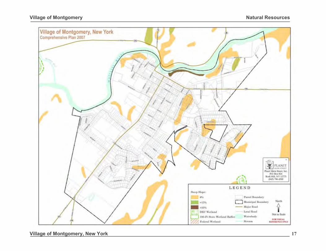
Slope indicates the percentage of incline of the land. Those areas with a slope of greater than 8.5º or 15% are generally considered to be too steep for development purposes. Within the Village of Montgomery, there are few areas with slopes that are greater than 15%. These are found along Crabtree Lane in the northeastern corner of the Village and are shown in orange on the Steep Slope Map on the preceding page. Those areas with slopes greater than 35% are found along the Wallkill River. Disturbance of this area, including existing vegetation, should be avoided. Three of the most common difficulties associated with disturbance of steep slopes are: 1) Sewage disposal – soils on steep slopes
are shallow, making it impractical to install subsurface disposal systems;
2) Drainage – the removal of trees, grading,
and erection of buildings will destabilize the bank while increasing runoff. These factors contribute to erosion and sediment control problems; and
3) Driveway and street layout – as a general
rule, the slope of driveways and roadways should not exceed 6.8º or 12%. Development on steep slopes makes alignments and safe intersections very difficult. They also may result in rapid runoff onto adjoining roads causing erosion and icing problems in the winter.
4.3 Water Resources The Village’s groundwater resources are located within the Wallkill Valley Aquifer that consists of sand and gravel deposits along the Wallkill River. These deposits recharge by stream runoff caused by precipitation and have a direct hydraulic contact with the Wallkill River. The Village’s public water supply is derived from wells that are drilled into these sands and gravels that yield up to 300 gallons per minute. It is important that the Village wells be protected and that any development in the vicinity of its wells is carefully reviewed to ensure that its wells are not contaminated. It is equally important that stormwater runoff be managed to avoid potential impacts on aquifer recharge areas. The Village can take proactive measures to protect its water resources through stream course or wetland buffers and/or the creation of wellhead and/or aquifer protection zones. 4.3.1 Flood Hazard Areas
The Federal Emergency Management Agency has identified potential flood hazard areas in the Village of Montgomery. Areas in the Village that are subject to flooding include those lands adjoining the Wallkill River where flooding results from snow melt, heavy rains or other weather conditions. By identifying these areas, it is possible to restrict development to open space uses, including recreation, which are tolerant of flooding and do not obstruct the flow of water.
“America is a
great story
and there is a
river on every
page.” Charles Kuralt
Village of Montgomery Natural Resources
Village of Montgomery, New York 19
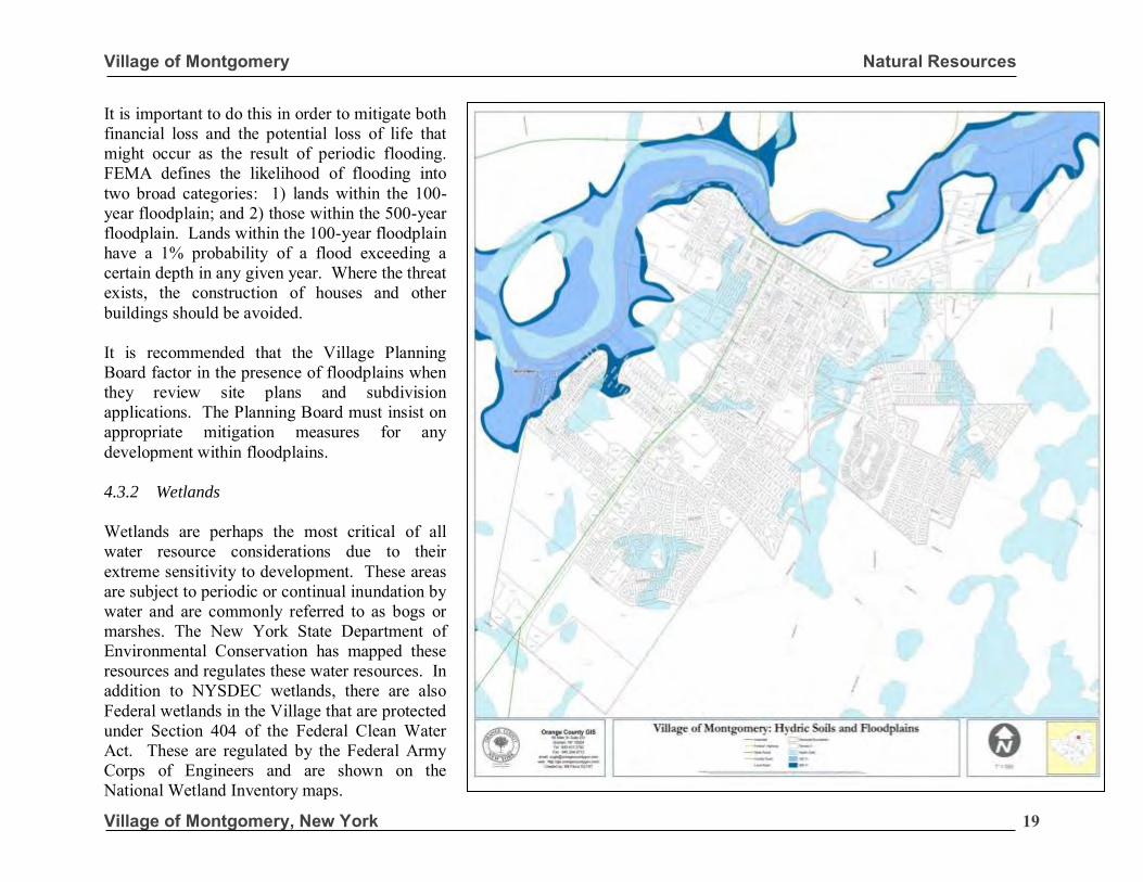
It is important to do this in order to mitigate both financial loss and the potential loss of life that might occur as the result of periodic flooding. FEMA defines the likelihood of flooding into two broad categories: 1) lands within the 100-year floodplain; and 2) those within the 500-year floodplain. Lands within the 100-year floodplain have a 1% probability of a flood exceeding a certain depth in any given year. Where the threat exists, the construction of houses and other buildings should be avoided. It is recommended that the Village Planning Board factor in the presence of floodplains when they review site plans and subdivision applications. The Planning Board must insist on appropriate mitigation measures for any development within floodplains. 4.3.2 Wetlands
Wetlands are perhaps the most critical of all water resource considerations due to their extreme sensitivity to development. These areas are subject to periodic or continual inundation by water and are commonly referred to as bogs or marshes. The New York State Department of Environmental Conservation has mapped these resources and regulates these water resources. In addition to NYSDEC wetlands, there are also Federal wetlands in the Village that are protected under Section 404 of the Federal Clean Water Act. These are regulated by the Federal Army Corps of Engineers and are shown on the National Wetland Inventory maps.
Village of Montgomery Natural Resources
Village of Montgomery, New York 20
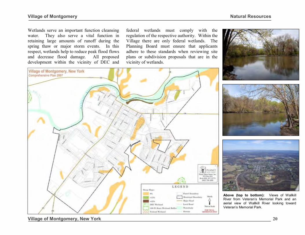
Wetlands serve an important function cleansing water. They also serve a vital function in retaining large amounts of runoff during the spring thaw or major storm events. In this respect, wetlands help to reduce peak flood flows and decrease flood damage. All proposed development within the vicinity of DEC and
federal wetlands must comply with the regulation of the respective authority. Within the Village there are only federal wetlands. The Planning Board must ensure that applicants adhere to these standards when reviewing site plans or subdivision proposals that are in the vicinity of wetlands.
Above (top to bottom): Views of Wallkill River from Veteran’s Memorial Park and an aerial view of Wallkill River looking toward Veteran’s Memorial Park.
Village of Montgomery Natural Resources
Village of Montgomery, New York 21
4.3.3 Stormwater Management
Stormwater is water that accumulates on land as a result of storms or melting snow. The porous and varied terrain of natural landscapes like forests, wetlands, and grasslands trap rainwater and snowmelt and allow it to slowly filter into the ground. Runoff tends to reach receiving waters gradually. In contrast, nonporous landscapes like roads, bridges, parking lots, and buildings don't let runoff slowly percolate into the ground. Water remains above the surface, accumulates and runs off in large amounts. The Village’s stormwater management system includes its storm sewers and ditches that are designed to quickly channel runoff from roads and other impervious surfaces. These devices are important to control high flows that may be a threat to public safety. Unfortunately, there are adverse environmental impacts associated with traditional stormwater management.
Runoff gathers speed once it enters the storm sewer system and when it leaves the sewer system and empties into the Wallkill River. During storm events, large volumes of high velocity runoff can erode streambanks, damage streamside vegetation and widen stream channels. In turn, this will result in lower water depths during non-storm periods, higher than normal water levels during wet weather periods, increased sediment loads and higher water temperatures. It is thus important to control stormwater runoff associated with development.
In New York State, any construction operation that will disturb or expose one or more acres of soil requires a State Pollutant Discharge Elimination System (SPDES) Permit for Stormwater Management Discharges from Construction Activity. Soil disturbance includes clearing vegetation, grubbing, filling, grading, excavation, demolition and any current or proposed construction activity. If the proposed action is anything other than a single-family home it will also require the development of a Stormwater Pollution Prevention Plan (SWPPP). A SWPPP addresses both construction and pos-construction activities. During construction activities, erosion & sediment control devices such as silt fences are used to prevent silts from soils from be carried off the site during storm events. Detention and retention basins are used to ensure that post-development runoff rates from a site do not exceed pre-development rates. Detention basins are dry basins that fill with water during a storm event. They work by delaying the storm water so that it is released at a rate that mimics predevelopment flow. Retention basins hold water in a pool and release water through an overflow spillway during storm events. These basins provide for the release of runoff at controlled rates to protect the quality of surface waters and to prevent flooding during storm events.
“A Stormwater
Pollution
Prevention
Plan, in
accordance
with NYSDEC
regulations, is
required for any
construction
operation that
will disturb one
or more acres if
constructing
something other
than a single-
family
residence.”
Village of Montgomery Natural Resources
Village of Montgomery, New York 22
Detention and retention basins are also important stormwater treatment systems. Stormwater treatment is the capture and reduction of pollution in stormwater runoff prior to discharge into receiving waters such as the Wallkill River and groundwater aquifer. By capturing the runoff, the basins allow particulates to settle to the bottom that removes pollutants from the runoff before it is discharged. Within off-street parking areas, catch basins are used to retain and filter contaminants before they leave the site. Other measures that can be employed include the use of infiltration trenches that capture runoff and treat it through a pea gravel of sand filter layer before it is discharged into receiving waters. An increasingly common means of retaining stormwater runoff on residential home sites is the use of an underground cistern that captures the runoff from the gutters. The water that is captured is stored underground and the water subsequently used to water gardens or lawns. This approach to stormwater management serves two purposes. First it reduces stormwater runoff. Secondly, it stores rainwater for irrigation, which reduces the demand on groundwater resources. As the Planning Board reviews site plan, planned development district and subdivision applications it must ensure that appropriate stormwater management measures are put in place. Such measures will help to protect water quality and mitigate potential damage during major storm events.
4.4 Soils Proper siting of development must include an analysis of soil types within a community. Soils differ according to variations in composition, particle-size gradation, and compaction; factors which control permeability, porosity and strength. Each of these factors and depth to bedrock is important in determining how much and what kind of development the land is capable of supporting. It is useful to consider the specific soil conditions in a community in directing growth to areas that can support development without high construction costs. Soil porosity and permeability is a major consideration in determining development capability. Within the Village there are areas with Ca – Carlisle muck soils that are hydric soils that are not well-suited for development (see map page 19). These soils are characterized as very deep, nearly level and very poorly drained soils in depressions. The seasonal high water table is above or near the surface in fall, winter and spring with a depth to bedrock of more than 60 inches. Such soils are prone to seasonal high water table and ponding of surface runoff. Hydric soils have poor potential for building site development. Wetness and frequent ponding are severe problems that are difficult and costly to overcome. Lower density and less intensive development should be directed to these areas with severe building constraints.
“It is useful to
consider the
specific soil
conditions in a
community in
directing
growth to areas
that can
support
development
without high
construction
costs.”
Village of Montgomery Natural Resources
Village of Montgomery, New York 23
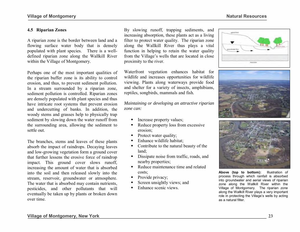
4.5 Riparian Zones A riparian zone is the border between land and a flowing surface water body that is densely populated with plant species. There is a well-defined riparian zone along the Wallkill River within the Village of Montgomery.
Perhaps one of the most important qualities of the riparian buffer zone is its ability to control erosion, and thus, to prevent sediment pollution. In a stream surrounded by a riparian zone, sediment pollution is controlled. Riparian zones are densely populated with plant species and thus have intricate root systems that prevent erosion and undercutting of banks. In addition, the woody stems and grasses help to physically trap sediment by slowing down the water runoff from the surrounding area, allowing the sediment to settle out.
The branches, stems and leaves of these plants absorb the impact of raindrops. Decaying leaves and low-growing vegetation form a ground cover that further lessens the erosive force of raindrop impact. This ground cover slows runoff, increasing the amount of water that is absorbed into the soil and then released slowly into the stream, reservoir, groundwater or atmosphere. The water that is absorbed may contain nutrients, pesticides, and other pollutants that will eventually be taken up by plants or broken down over time.
By slowing runoff, trapping sediments, and increasing absorption, these plants act as a living filter to protect water quality. The riparian zone along the Wallkill River thus plays a vital function in helping to retain the water quality from the Village’s wells that are located in close proximity to the river. Waterfront vegetation enhances habitat for wildlife and increases opportunities for wildlife viewing. Plants along waterways provide food and shelter for a variety of insects, amphibians, reptiles, songbirds, mammals and fish. Maintaining or developing an attractive riparian
zone can:
▪ Increase property values; ▪ Reduce property loss from excessive
erosion; ▪ Protect water quality; ▪ Enhance wildlife habitat; ▪ Contribute to the natural beauty of the
land; ▪ Dissipate noise from traffic, roads, and
nearby properties; ▪ Reduce maintenance time and related
costs; ▪ Provide privacy; ▪ Screen unsightly views; and ▪ Enhance scenic views.
Above (top to bottom): Illustration of process through which rainfall is absorbed into groundwater and aerial views of riparian zone along the Wallkill River within the Village of Montgomery. The riparian zone along the Wallkill River plays a very important role in protecting the Village’s wells by acting as a natural filter.
Village of Montgomery Natural Resources
Village of Montgomery, New York 24
Research shows riparian zones are instrumental in water quality improvement for both surface runoff and water flowing into streams through subsurface or groundwater flow. Particularly the attenuation of nitrate or denitrification of the nitrates from fertilizer. Riparian zones can play a role in lowering nitrate contamination in surface runoff from agricultural fields, which runoff would otherwise damage ecosystems and human health. Since agriculture is a predominant land use along the Wallkill it is important to maintain the riparian zone along the Wallkill River to protect the quality of the Wallkill River Aquifer and the Village’s wells. 4.6 Tree Preservation & Conservation Trees, shrubs and other plant materials add four-season living color, texture and visual interest to the landscape of the Village of Montgomery. There is an abundance of street trees, lawn trees, shrubs and other plantings throughout Village that help to define its small town charm and make it an attractive community in which to live and visit. It is thus important that the Village play an active role in conserving this natural resource and encouraging new tree plantings. Throughout the Village, mature street trees are the most prominent form of plantings along the street. Street trees help to soften the hard surfaces of sidewalks, off-street parking areas and streets and help to define the pedestrian right-of-way by providing a buffer between the street and the sidewalk.
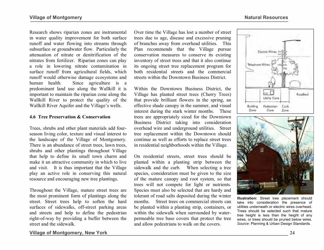
Over time the Village has lost a number of street trees due to age, disease and excessive pruning of branches away from overhead utilities. This Plan recommends that the Village pursue conservation measures to conserve its existing inventory of street trees and that it also continue its ongoing street tree replacement program for both residential streets and the commercial streets within the Downtown Business District. Within the Downtown Business District, the Village has planted street trees (Cherry Trees) that provide brilliant flowers in the spring, an effective shade canopy in the summer, and visual interest during the stark winter months. These trees are appropriately sized for the Downtown Business District taking into consideration overhead wire and underground utilities. Street tree replacement within the Downtown should continue as well as efforts to replace street trees in residential neighborhoods within the Village. On residential streets, street trees should be planted within a planting strip between the sidewalk and the curb. When selecting a tree species, consideration must be given to the size of the mature canopy and root system, so that trees will not compete for light or nutrients. Species must also be selected that are hardy and tolerant of road salts deposited during the winter months. Street trees on commercial streets can be planted within a planting strip, containers, or within the sidewalk when surrounded by water-permeable tree base covers that protect the tree and allow pedestrians to walk on the covers.
Illustration: Street tree placement should take into consideration the presence of utilities underneath or electric wires overhead. Trees should be selected such that mature tree height is less than the height of any wires, or trees should be pruned below wires. Source: Planning & Urban Design Standards.
Village of Montgomery Natural Resources
Village of Montgomery, New York 25
Within the Downtown Business District, the existing buildings are in close proximity to the sidewalks and/or planting strips. It is important that the shape of the mature crown of the tree is taken into consideration to avoid the tree canopy from growing into the building wall and requiring severe pruning over time. Street trees provide many community benefits. There are studies that show that drivers tend to drive slower on streets that are lined with street trees. The trees provide a canopy that encloses the street that creates a calming effect. Street trees also help to protect air quality by absorbing carbon dioxide from automobiles and releasing oxygen. A large mature canopy of leafy deciduous trees also helps to absorb noise generated from traffic that in turn reduces ambient noise levels within the Village. Trees
also add to the natural beauty of the Village.
Street trees also provide a physical and psychological buffer between the sidewalk and the street that makes pedestrians feel safer which encourages walking.
In summary, street trees provide these benefits:
▪ Calm traffic; ▪ Protect air; ▪ Encourage walking; ▪ Contribute to Village’s natural beauty ▪ Reduce noise; and ▪ The International Society of
Arboriculture estimates the improvement in curb appeal due to street trees increases real estate values by 20%.
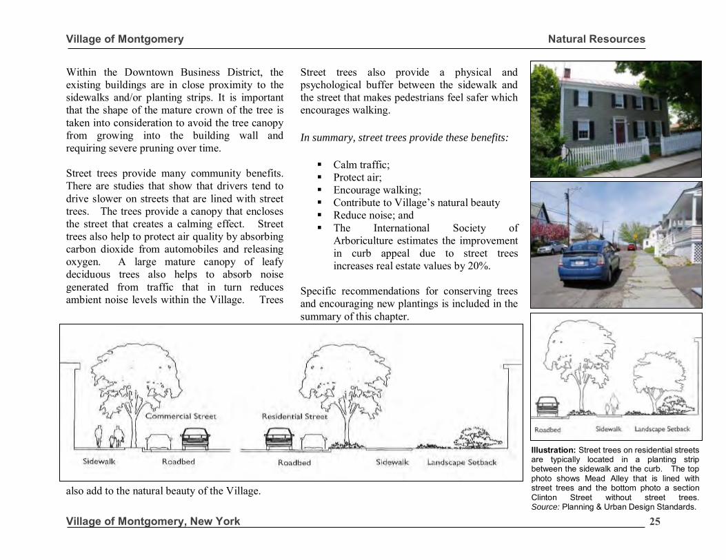
Specific recommendations for conserving trees and encouraging new plantings is included in the summary of this chapter.
Illustration: Street trees on residential streets are typically located in a planting strip between the sidewalk and the curb. The top photo shows Mead Alley that is lined with street trees and the bottom photo a section Clinton Street without street trees. Source: Planning & Urban Design Standards.
Village of Montgomery Natural Resources
Village of Montgomery, New York 26
4.7 Energy Conservation The Leadership in Energy and Environmental Design (LEED) Green Building Rating System is a voluntary standard for developing high-performance, sustainable buildings. Members of the U.S. Green Building Council (USGBC), representing all segments of the building industry, developed LEED. LEED standards have been developed for the following:
▪ New commercial construction and major renovation projects;
▪ Existing building operations; and
▪ Commercial interior projects. LEED defines quantifiable measures for rating development projects based upon the number of points achieved by a project, out of a 69 possible. The scale is as follows: LEED certified: 26 to 32 points; Silver level: 33 to 38 points; Gold level: 39 to 51 points; and Platinum level: 52 plus points. Within the rating system six (6) general LEED categories: Sustainable sites, water efficiency, energy and atmosphere, materials and resources, indoor environmental quality, and innovation in design. Each of these categories impacts the overall LEED score. The following is a brief summary of each category.
Sustainable sites. Development on prime farmland, lands less than five feet above the floodplain, or closer than 100 feet from a wetland or stream are not considered sustainable. Credits are given for infill development, development near existing infrastructure and redevelopment of brownfield sites. Water efficiency. Points are given for water-efficient fixtures and landscaping that reduces the need for irrigation. Energy and atmosphere. Emphasis is on energy savings through insulation, efficient mechanical systems, alternative energy sources and renewable energy. Materials and resources. Focuses on the environmentally preferable materials. Indoor environmental quality. Focus is on low or no volatile organic compounds materials. Innovation in design. Given to performance above the five other categories. The Village should encourage the use of LEED technologies in the design of new buildings. The Planning Board when reviewing developments should ask applicants to consider the placement of new buildings in a manner that maximizes energy efficiency and sustainability. The Village should provide education and outreach regarding LEED techniques in order to raise community awareness of its benefits.
“The Village
should
encourage
Leadership in
Energy and
Environmental
Design (LEED) in
new
developments
that are planned
within the
community as
well as
alterations to
its existing
buildings in
order to
conserve
energy.”
Village of Montgomery Natural Resources
Village of Montgomery, New York 27
4.8 Recommendations
There are a variety of land use policies that the Village can employ to protect its natural resources including the following: 4.8.1 Steep Slopes
Restrict development on slopes that are greater
than 15% (steep slopes). When a developer proposes to disturb a portion of a site with steep slopes a sediment & erosion control plan should be required by the Planning Board. 4.8.2 Water Resources
Strictly enforce NYSDEC requirements to
maintain a 100-foot setback between
development and adjacent watercourses. During the site plan and special permit review process, applicants must be required to show existing watercourses and required setbacks on their site plans. Such features must also be shown on subdivision plats. Early identification of natural resources will help the Planning Board in its review and ensure protection of these resources. Restrict the development of buildings and
impervious surfaces within the 100-year
floodplain. The Village must carefully review applications for development on lands within the 100-year floodplain. This will help to prevent future loss of property and life due to flooding.
Require Storm Water Pollution Prevention Plans
(SWPPP) in accordance with the NYSDEC State
Pollution Discharge Elimination System
(SPDES) general permit for commercial
developments or major subdivision applications.
SWPPP’s helps to ensure that post-development runoff rates from a site do not exceed the rates that existed pre-development. Such plans also provide for the treatment of runoff and the release runoff at controlled rates to protect the quality of surface waters and prevent flooding from storm events. The NYSDEC regulations require basic SWPPP for single-family developments that disturb between 1 and 5 acres of topsoil. A full SWPPP is required for commercial developments that disturb one or more acres of soil.
Encourage the use of retention/detention basins
that are an integral part of the overall site plan
or subdivision plan. Detention and retention basins should be used to ensure that post-development runoff from sites is not increased. Create wellhead protection and aquifer
protection overlay districts. The Village obtains its water supplies from wells within the Wallkill Valley Aquifer. Presently, there is a 200-foot buffer area designated around the Village’s wells. The Village can take additional steps to protect its potable water supply by limiting certain land uses within close proximity to its wells and/or developing additional standards for land uses within its aquifer recharge areas.
“Require Storm
Water
Pollution
Prevention
Plans (SWPPP)
in accordance
with the
NYSDEC State
Pollution
Discharge
Elimination
System (SPDES)
general permit
for commercial
developments,
Planned
Developments
or major
subdivision
applications.”
Village of Montgomery Natural Resources
Village of Montgomery, New York 28
4.8.3 Soils
Where proposed development involves grading
of the site or cutting and filling operations
require a Sediment & Erosion Control Plan.
Generally, development on sites should work with the topography of the site and avoid excessive grading of the site. Where grading is proposed, a sediment & erosion control plan should be provided. 4.8.4 Riparian Zones
Restrict the cutting of trees along the banks of
the Wallkill River. The cutting of trees along the banks of the Wallkill River should be prohibited. Create a public information brochure regarding
the importance of retaining the riparian zone
along the Wallkill River. The Village should take proactive measures to educate the public about the importance of retaining mature trees within the riparian zone along the Wallkill and the conservation of matures trees along the banks of the river promoted.
4.8.4 Tree Preservation & Conservation
Enlist the services of an arborist to develop a
coherent long-term plan for street tree
conservation in the Village. Such a plan would identify existing trees with diseases, areas where trees are needed, techniques pruning trees, the species of trees that are desirable and tree planting schedule for the Village.
Develop standards for the planting of street trees
associated with new developments. The Village requires that developers provide a tree survey showing all trees with a caliper of over six (6) inches when seeking site plan, subdivision or planned development district approval. It should use this tool to conserve as many mature trees on site as possible and should take the additional step of developing standards for the planting of street trees associated with all new development. Street trees should be planted outside of the Village right-of-way. 4.8.6 Encourage Leadership in Energy
Conservation and Design (LEED). The Village should encourage the use of LEED technologies in the design of new buildings. The Planning Board when reviewing developments should ask applicants to consider the placement of new buildings in a manner that maximizes energy efficiency and sustainability. The Village should provide education and outreach regarding LEED techniques in order to raise community awareness of its benefits. 4.8.7 Require strict Fire Code compliance for
new construction and the renovation of older
buildings. Ensure Fire Code compliance for all new buildings and renovated buildings in order to protect the public. When building use is changed, a careful review is needed to determine if Fire Code improvements are warranted such as the installation of sprinklers.
“given a limited
budget, the most
effective
expenditure of
funds to
improve a street
would probably
be on trees.
Moreover, for
many people
trees are the
most important
single
characteristic
of a good
street.”
Allan B. Jacobs
Village of Montgomery Transportation
Village of Montgomery, New York
1
Village of Montgomery Comprehensive Plan
Village of Montgomery, NY
Prepared by the Village of Montgomery Comprehensive Plan Committee With Planit Main Street, Inc. Draft Update March 17, 2017
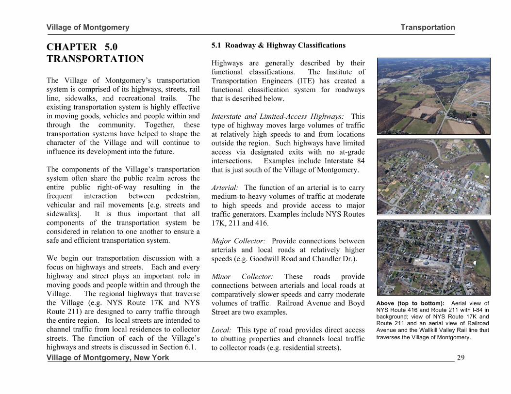
Village of Montgomery Transportation
Village of Montgomery, New York
29
CHAPTER 5.0 TRANSPORTATION The Village of Montgomery’s transportation system is comprised of its highways, streets, rail line, sidewalks, and recreational trails. The existing transportation system is highly effective in moving goods, vehicles and people within and through the community. Together, these transportation systems have helped to shape the character of the Village and will continue to influence its development into the future. The components of the Village’s transportation system often share the public realm across the entire public right-of-way resulting in the frequent interaction between pedestrian, vehicular and rail movements [e.g. streets and sidewalks]. It is thus important that all components of the transportation system be considered in relation to one another to ensure a safe and efficient transportation system. We begin our transportation discussion with a focus on highways and streets. Each and every highway and street plays an important role in moving goods and people within and through the Village. The regional highways that traverse the Village (e.g. NYS Route 17K and NYS Route 211) are designed to carry traffic through the entire region. Its local streets are intended to channel traffic from local residences to collector streets. The function of each of the Village’s highways and streets is discussed in Section 6.1.
5.1 Roadway & Highway Classifications Highways are generally described by their functional classifications. The Institute of Transportation Engineers (ITE) has created a functional classification system for roadways that is described below. Interstate and Limited-Access Highways: This type of highway moves large volumes of traffic at relatively high speeds to and from locations outside the region. Such highways have limited access via designated exits with no at-grade intersections. Examples include Interstate 84 that is just south of the Village of Montgomery. Arterial: The function of an arterial is to carry medium-to-heavy volumes of traffic at moderate to high speeds and provide access to major traffic generators. Examples include NYS Routes 17K, 211 and 416. Major Collector: Provide connections between arterials and local roads at relatively higher speeds (e.g. Goodwill Road and Chandler Dr.). Minor Collector: These roads provide connections between arterials and local roads at comparatively slower speeds and carry moderate volumes of traffic. Railroad Avenue and Boyd Street are two examples. Local: This type of road provides direct access to abutting properties and channels local traffic to collector roads (e.g. residential streets).
Above (top to bottom): Aerial view of NYS Route 416 and Route 211 with I-84 in background; view of NYS Route 17K and Route 211 and an aerial view of Railroad Avenue and the Wallkill Valley Rail line that traverses the Village of Montgomery.
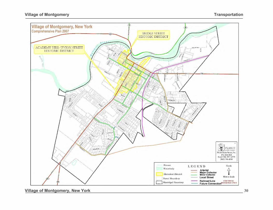
Village of Montgomery Transportation
Village of Montgomery, New York
30
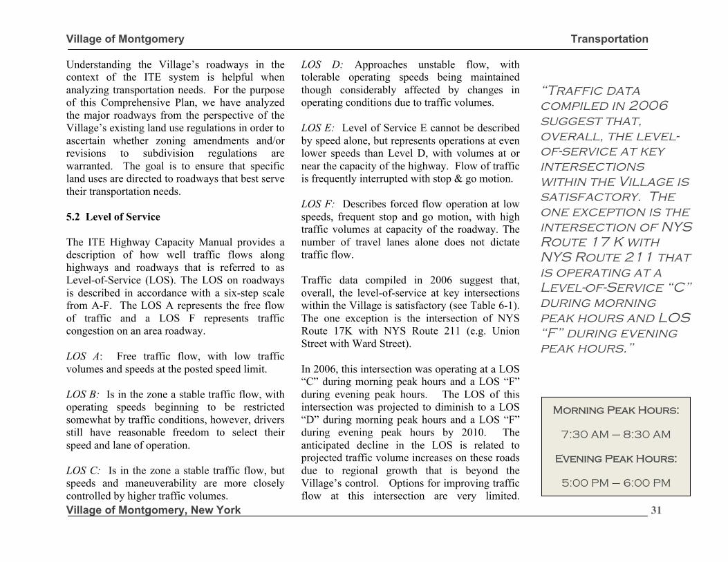
Village of Montgomery Transportation
Village of Montgomery, New York
31
Understanding the Village’s roadways in the context of the ITE system is helpful when analyzing transportation needs. For the purpose of this Comprehensive Plan, we have analyzed the major roadways from the perspective of the Village’s existing land use regulations in order to ascertain whether zoning amendments and/or revisions to subdivision regulations are warranted. The goal is to ensure that specific land uses are directed to roadways that best serve their transportation needs. 5.2 Level of Service The ITE Highway Capacity Manual provides a description of how well traffic flows along highways and roadways that is referred to as Level-of-Service (LOS). The LOS on roadways is described in accordance with a six-step scale from A-F. The LOS A represents the free flow of traffic and a LOS F represents traffic congestion on an area roadway. LOS A: Free traffic flow, with low traffic volumes and speeds at the posted speed limit. LOS B: Is in the zone a stable traffic flow, with operating speeds beginning to be restricted somewhat by traffic conditions, however, drivers still have reasonable freedom to select their speed and lane of operation. LOS C: Is in the zone a stable traffic flow, but speeds and maneuverability are more closely controlled by higher traffic volumes.
LOS D: Approaches unstable flow, with tolerable operating speeds being maintained though considerably affected by changes in operating conditions due to traffic volumes. LOS E: Level of Service E cannot be described by speed alone, but represents operations at even lower speeds than Level D, with volumes at or near the capacity of the highway. Flow of traffic is frequently interrupted with stop & go motion. LOS F: Describes forced flow operation at low speeds, frequent stop and go motion, with high traffic volumes at capacity of the roadway. The number of travel lanes alone does not dictate traffic flow. Traffic data compiled in 2006 suggest that, overall, the level-of-service at key intersections within the Village is satisfactory (see Table 6-1). The one exception is the intersection of NYS Route 17K with NYS Route 211 (e.g. Union Street with Ward Street). In 2006, this intersection was operating at a LOS “C” during morning peak hours and a LOS “F” during evening peak hours. The LOS of this intersection was projected to diminish to a LOS “D” during morning peak hours and a LOS “F” during evening peak hours by 2010. The anticipated decline in the LOS is related to projected traffic volume increases on these roads due to regional growth that is beyond the Village’s control. Options for improving traffic flow at this intersection are very limited.
“Traffic data compiled in 2006 suggest that, overall, the level-of-service at key intersections within the Village is satisfactory. The one exception is the intersection of NYS Route 17 K with NYS Route 211 that is operating at a Level-of-Service “C” during morning peak hours and LOS “F” during evening peak hours.”
Morning Peak Hours:
7:30 AM – 8:30 AM
Evening Peak Hours:
5:00 PM – 6:00 PM Allan B. Jacobs
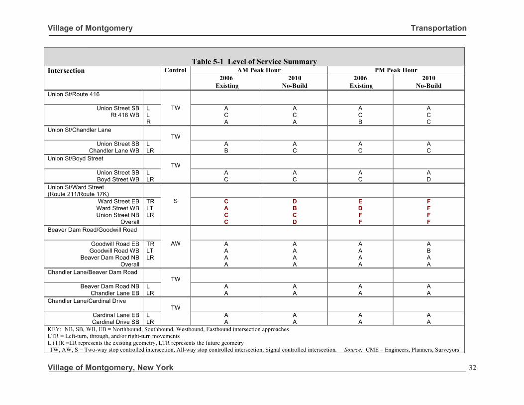
Village of Montgomery Transportation
Village of Montgomery, New York
32
Table 5-1 Level of Service Summary
Intersection Control AM Peak Hour PM Peak Hour 2006
Existing 2010
No-Build 2006
Existing 2010
No-Build Union St/Route 416
TW
Union Street SB Rt 416 WB
L L R
A C A
A C A
A C B
A C C
Union St/Chandler Lane
TW
Union Street SB Chandler Lane WB
L LR
A B
A C
A C
A C
Union St/Boyd Street
TW
Union Street SB Boyd Street WB
L LR
A C
A C
A C
A D
Union St/Ward Street (Route 211/Route 17K)
S
Ward Street EB Ward Street WB Union Street NB
Overall
TR LT LR
C A C C
D B C D
E D F F
F F F F
Beaver Dam Road/Goodwill Road
AW
Goodwill Road EB Goodwill Road WB
Beaver Dam Road NB Overall
TR LT LR
A A A A
A A A A
A A A A
A B A A
Chandler Lane/Beaver Dam Road
TW
Beaver Dam Road NB Chandler Lane EB
L LR
A A
A A
A A
A A
Chandler Lane/Cardinal Drive
TW
Cardinal Lane EB Cardinal Drive SB
L LR
A A
A A
A A
A A
KEY: NB, SB, WB, EB = Northbound, Southbound, Westbound, Eastbound intersection approaches LTR = Left-turn, through, and/or right-turn movements L (T)R =LR represents the existing geometry, LTR represents the future geometry TW, AW, S = Two-way stop controlled intersection, All-way stop controlled intersection, Signal controlled intersection. Source: CME – Engineers, Planners, Surveyors
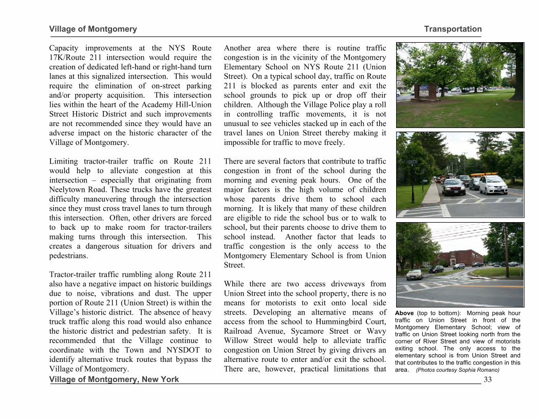
Village of Montgomery Transportation
Village of Montgomery, New York
33
Capacity improvements at the NYS Route 17K/Route 211 intersection would require the creation of dedicated left-hand or right-hand turn lanes at this signalized intersection. This would require the elimination of on-street parking and/or property acquisition. This intersection lies within the heart of the Academy Hill-Union Street Historic District and such improvements are not recommended since they would have an adverse impact on the historic character of the Village of Montgomery. Limiting tractor-trailer traffic on Route 211 would help to alleviate congestion at this intersection – especially that originating from Neelytown Road. These trucks have the greatest difficulty maneuvering through the intersection since they must cross travel lanes to turn through this intersection. Often, other drivers are forced to back up to make room for tractor-trailers making turns through this intersection. This creates a dangerous situation for drivers and pedestrians. Tractor-trailer traffic rumbling along Route 211 also have a negative impact on historic buildings due to noise, vibrations and dust. The upper portion of Route 211 (Union Street) is within the Village’s historic district. The absence of heavy truck traffic along this road would also enhance the historic district and pedestrian safety. It is recommended that the Village continue to coordinate with the Town and NYSDOT to identify alternative truck routes that bypass the Village of Montgomery.
Another area where there is routine traffic congestion is in the vicinity of the Montgomery Elementary School on NYS Route 211 (Union Street). On a typical school day, traffic on Route 211 is blocked as parents enter and exit the school grounds to pick up or drop off their children. Although the Village Police play a roll in controlling traffic movements, it is not unusual to see vehicles stacked up in each of the travel lanes on Union Street thereby making it impossible for traffic to move freely. There are several factors that contribute to traffic congestion in front of the school during the morning and evening peak hours. One of the major factors is the high volume of children whose parents drive them to school each morning. It is likely that many of these children are eligible to ride the school bus or to walk to school, but their parents choose to drive them to school instead. Another factor that leads to traffic congestion is the only access to the Montgomery Elementary School is from Union Street. While there are two access driveways from Union Street into the school property, there is no means for motorists to exit onto local side streets. Developing an alternative means of access from the school to Hummingbird Court, Railroad Avenue, Sycamore Street or Wavy Willow Street would help to alleviate traffic congestion on Union Street by giving drivers an alternative route to enter and/or exit the school. There are, however, practical limitations that
must be taken into consideration.
Above (top to bottom): Morning peak hour traffic on Union Street in front of the Montgomery Elementary School; view of traffic on Union Street looking north from the corner of River Street and view of motorists exiting school. The only access to the elementary school is from Union Street and that contributes to the traffic congestion in this area. (Photos courtesy Sophia Romano)
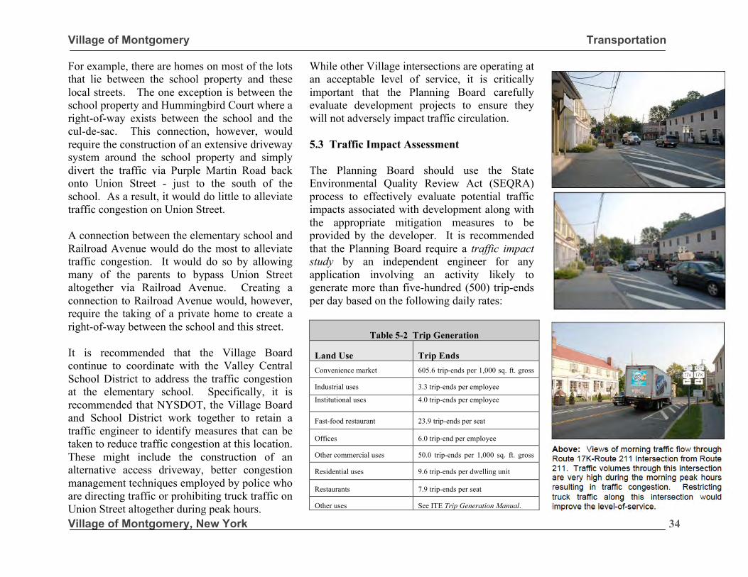
Village of Montgomery Transportation
Village of Montgomery, New York
34
For example, there are homes on most of the lots that lie between the school property and these local streets. The one exception is between the school property and Hummingbird Court where a right-of-way exists between the school and the cul-de-sac. This connection, however, would require the construction of an extensive driveway system around the school property and simply divert the traffic via Purple Martin Road back onto Union Street - just to the south of the school. As a result, it would do little to alleviate traffic congestion on Union Street. A connection between the elementary school and Railroad Avenue would do the most to alleviate traffic congestion. It would do so by allowing many of the parents to bypass Union Street altogether via Railroad Avenue. Creating a connection to Railroad Avenue would, however, require the taking of a private home to create a right-of-way between the school and this street. It is recommended that the Village Board continue to coordinate with the Valley Central School District to address the traffic congestion at the elementary school. Specifically, it is recommended that NYSDOT, the Village Board and School District work together to retain a traffic engineer to identify measures that can be taken to reduce traffic congestion at this location. These might include the construction of an alternative access driveway, better congestion management techniques employed by police who are directing traffic or prohibiting truck traffic on Union Street altogether during peak hours.
While other Village intersections are operating at an acceptable level of service, it is critically important that the Planning Board carefully evaluate development projects to ensure they will not adversely impact traffic circulation. 5.3 Traffic Impact Assessment The Planning Board should use the State Environmental Quality Review Act (SEQRA) process to effectively evaluate potential traffic impacts associated with development along with the appropriate mitigation measures to be provided by the developer. It is recommended that the Planning Board require a traffic impact study by an independent engineer for any application involving an activity likely to generate more than five-hundred (500) trip-ends per day based on the following daily rates:
Table 5-2 Trip Generation
Land Use Trip Ends Convenience market 605.6 trip-ends per 1,000 sq. ft. gross
floor area Industrial uses 3.3 trip-ends per employee
Institutional uses 4.0 trip-ends per employee
Fast-food restaurant 23.9 trip-ends per seat
Offices 6.0 trip-end per employee
Other commercial uses 50.0 trip-ends per 1,000 sq. ft. gross
floor area Residential uses 9.6 trip-ends per dwelling unit
Restaurants 7.9 trip-ends per seat
Other uses See ITE Trip Generation Manual.
Transportation Engineers
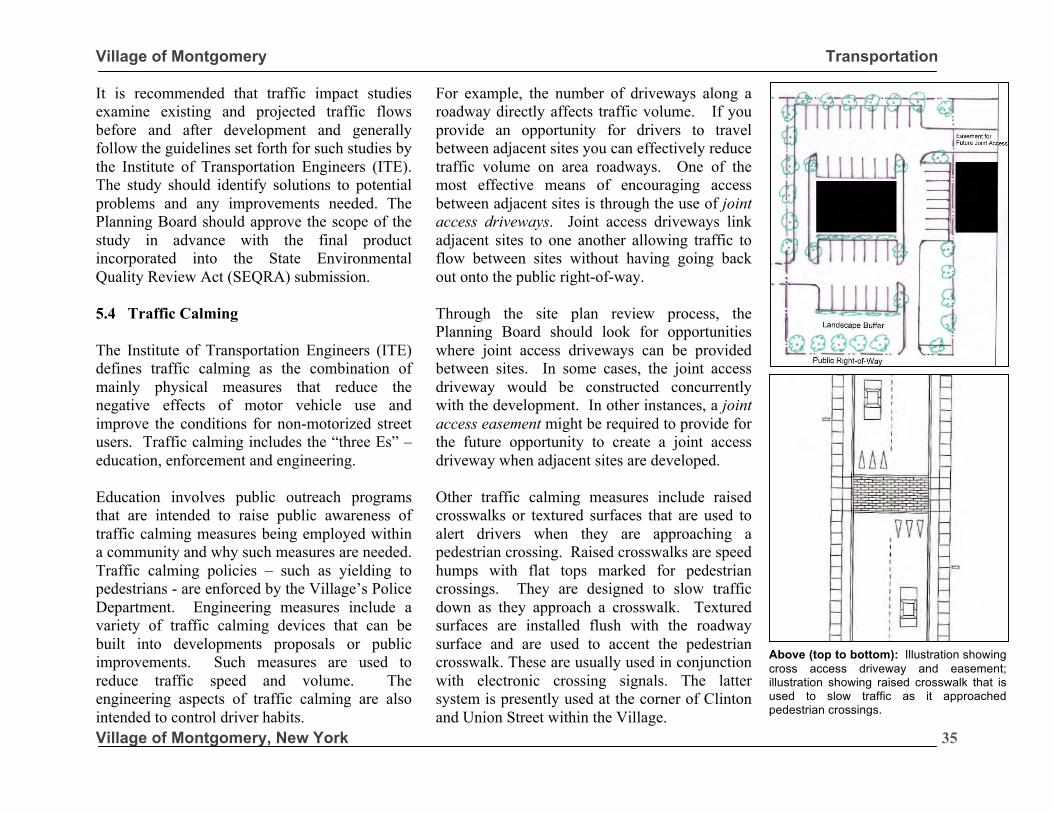
Village of Montgomery Transportation
Village of Montgomery, New York
35
It is recommended that traffic impact studies examine existing and projected traffic flows before and after development and generally follow the guidelines set forth for such studies by the Institute of Transportation Engineers (ITE). The study should identify solutions to potential problems and any improvements needed. The Planning Board should approve the scope of the study in advance with the final product incorporated into the State Environmental Quality Review Act (SEQRA) submission. 5.4 Traffic Calming The Institute of Transportation Engineers (ITE) defines traffic calming as the combination of mainly physical measures that reduce the negative effects of motor vehicle use and improve the conditions for non-motorized street users. Traffic calming includes the “three Es” – education, enforcement and engineering. Education involves public outreach programs that are intended to raise public awareness of traffic calming measures being employed within a community and why such measures are needed. Traffic calming policies – such as yielding to pedestrians - are enforced by the Village’s Police Department. Engineering measures include a variety of traffic calming devices that can be built into developments proposals or public improvements. Such measures are used to reduce traffic speed and volume. The engineering aspects of traffic calming are also intended to control driver habits.
For example, the number of driveways along a roadway directly affects traffic volume. If you provide an opportunity for drivers to travel between adjacent sites you can effectively reduce traffic volume on area roadways. One of the most effective means of encouraging access between adjacent sites is through the use of joint access driveways. Joint access driveways link adjacent sites to one another allowing traffic to flow between sites without having going back out onto the public right-of-way. Through the site plan review process, the Planning Board should look for opportunities where joint access driveways can be provided between sites. In some cases, the joint access driveway would be constructed concurrently with the development. In other instances, a joint access easement might be required to provide for the future opportunity to create a joint access driveway when adjacent sites are developed. Other traffic calming measures include raised crosswalks or textured surfaces that are used to alert drivers when they are approaching a pedestrian crossing. Raised crosswalks are speed humps with flat tops marked for pedestrian crossings. They are designed to slow traffic down as they approach a crosswalk. Textured surfaces are installed flush with the roadway surface and are used to accent the pedestrian crosswalk. These are usually used in conjunction with electronic crossing signals. The latter system is presently used at the corner of Clinton and Union Street within the Village.
Above (top to bottom): Illustration showing cross access driveway and easement; illustration showing raised crosswalk that is used to slow traffic as it approached pedestrian crossings.
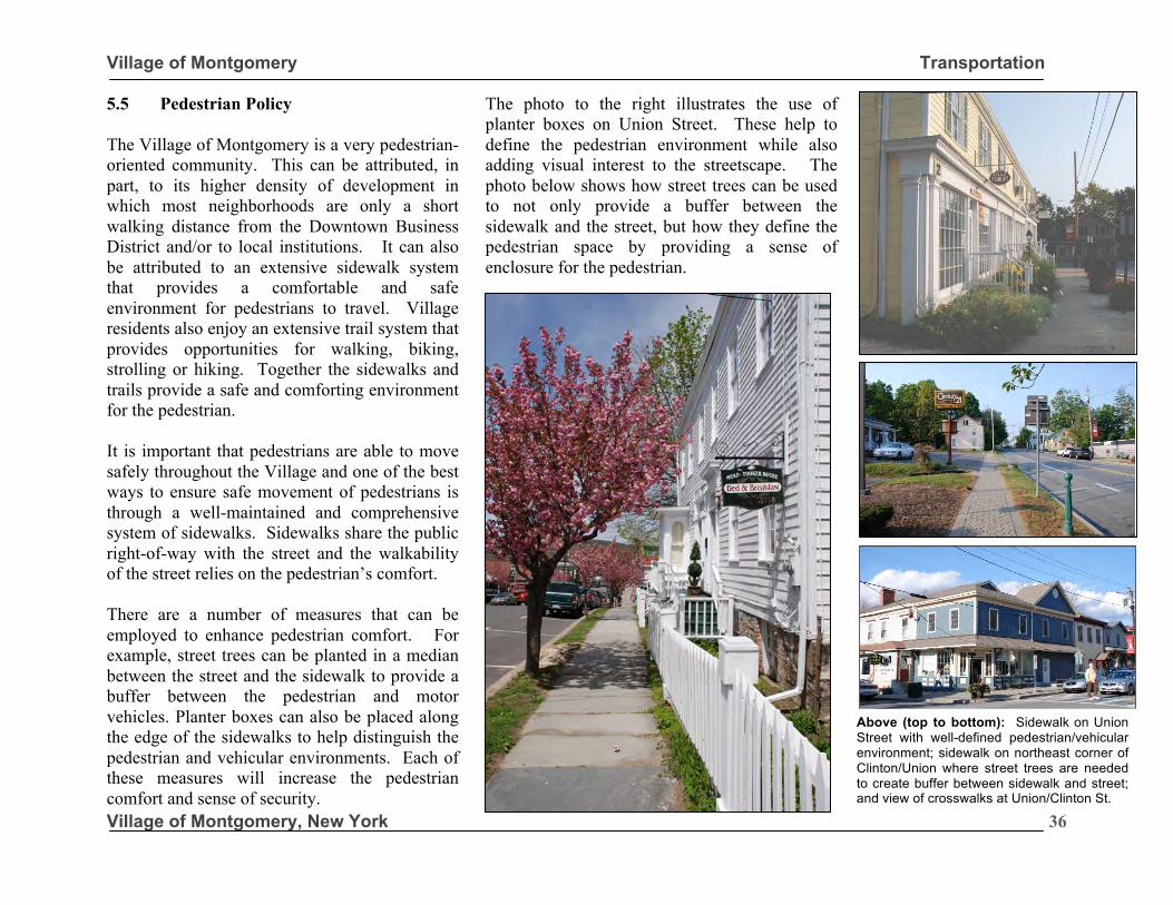
Village of Montgomery Transportation
Village of Montgomery, New York
36
5.5 Pedestrian Policy The Village of Montgomery is a very pedestrian-oriented community. This can be attributed, in part, to its higher density of development in which most neighborhoods are only a short walking distance from the Downtown Business District and/or to local institutions. It can also be attributed to an extensive sidewalk system that provides a comfortable and safe environment for pedestrians to travel. Village residents also enjoy an extensive trail system that provides opportunities for walking, biking, strolling or hiking. Together the sidewalks and trails provide a safe and comforting environment for the pedestrian. It is important that pedestrians are able to move safely throughout the Village and one of the best ways to ensure safe movement of pedestrians is through a well-maintained and comprehensive system of sidewalks. Sidewalks share the public right-of-way with the street and the walkability of the street relies on the pedestrian’s comfort. There are a number of measures that can be employed to enhance pedestrian comfort. For example, street trees can be planted in a median between the street and the sidewalk to provide a buffer between the pedestrian and motor vehicles. Planter boxes can also be placed along the edge of the sidewalks to help distinguish the pedestrian and vehicular environments. Each of these measures will increase the pedestrian comfort and sense of security.
The photo to the right illustrates the use of planter boxes on Union Street. These help to define the pedestrian environment while also adding visual interest to the streetscape. The photo below shows how street trees can be used to not only provide a buffer between the sidewalk and the street, but how they define the pedestrian space by providing a sense of enclosure for the pedestrian.
Above (top to bottom): Sidewalk on Union Street with well-defined pedestrian/vehicular environment; sidewalk on northeast corner of Clinton/Union where street trees are needed to create buffer between sidewalk and street; and view of crosswalks at Union/Clinton St.
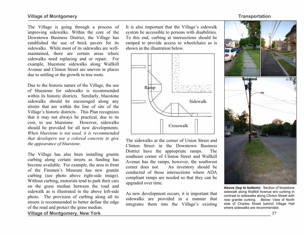
Village of Montgomery Transportation
Village of Montgomery, New York
37
The Village is going through a process of improving sidewalks. Within the core of the Downtown Business District, the Village has established the use of brick pavers for its sidewalks. While most of its sidewalks are well-maintained, there are certain areas where sidewalks need replacing and or repair. For example, bluestone sidewalks along Wallkill Avenue and Clinton Street are uneven in places due to settling or the growth in tree roots. Due to the historic nature of the Village, the use of bluestone for sidewalks is recommended within its historic districts. Similarly, bluestone sidewalks should be encouraged along any streets that are within the line of site of the Village’s historic districts. This Plan recognizes that it may not always be practical, due to its cost, to use bluestone. However, sidewalks should be provided for all new developments. When bluestone is not used, it is recommended that developers use a colored concrete to give the appearance of bluestone. The Village has also been installing granite curbing along certain streets as funding has become available. For example, the area in front of the Firemen’s Museum has new granite curbing (see photo above right-side image). Without curbing, motorists tend to park their cars on the grass median between the road and sidewalk as is illustrated in the above left-side photo. The provision of curbing along all its streets is recommended to better define the edge of the road and protect the grass median.
It is also important that the Village’s sidewalk system be accessible to persons with disabilities. To this end, curbing at intersections should be ramped to provide access to wheelchairs as is shown in the illustration below.
The sidewalks at the corner of Union Street and Clinton Street in the Downtown Business District have the appropriate ramps. The southeast corner of Clinton Street and Wallkill Avenue has the ramps, however, the southwest corner does not. An inventory should be conducted of those intersections where ADA compliant ramps are needed so that they can be upgraded over time. As new development occurs, it is important that sidewalks are provided in a manner that integrates them into the Village’s existing
sidewalk system. Doing so will ensure that the Village retains a pedestrian-friendly environment in the future.
Crosswalk
Sidewalk
Ramp
Above (top to bottom): Section of bluestone sidewalk along Wallkill Avenue w/o curbing in contrast to sidewalks along Clinton Street with new granite curbing. Below: View of North side of Charles Street behind Village Hall where sidewalks are recommended.
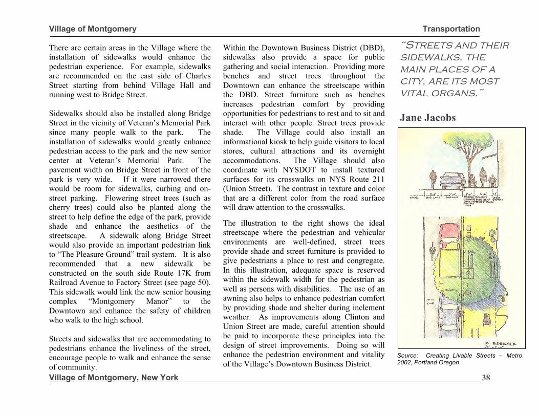
Village of Montgomery Transportation
Village of Montgomery, New York
38
There are certain areas in the Village where the installation of sidewalks would enhance the pedestrian experience. For example, sidewalks are recommended on the east side of Charles Street starting from behind Village Hall and running west to Bridge Street. Sidewalks should also be installed along Bridge Street in the vicinity of Veteran’s Memorial Park since many people walk to the park. The installation of sidewalks would greatly enhance pedestrian access to the park and the new senior center at Veteran’s Memorial Park. The pavement width on Bridge Street in front of the park is very wide. If it were narrowed there would be room for sidewalks, curbing and on-street parking. Flowering street trees (such as cherry trees) could also be planted along the street to help define the edge of the park, provide shade and enhance the aesthetics of the streetscape. A sidewalk along Bridge Street would also provide an important pedestrian link to “The Pleasure Ground” trail system. It is also recommended that a new sidewalk be constructed on the south side Route 17K from Railroad Avenue to Factory Street (see page 50). This sidewalk would link the new senior housing complex “Montgomery Manor” to the Downtown and enhance the safety of children who walk to the high school. Streets and sidewalks that are accommodating to pedestrians enhance the liveliness of the street, encourage people to walk and enhance the sense of community.
Within the Downtown Business District (DBD), sidewalks also provide a space for public gathering and social interaction. Providing more benches and street trees throughout the Downtown can enhance the streetscape within the DBD. Street furniture such as benches increases pedestrian comfort by providing opportunities for pedestrians to rest and to sit and interact with other people. Street trees provide shade. The Village could also install an informational kiosk to help guide visitors to local stores, cultural attractions and its overnight accommodations. The Village should also coordinate with NYSDOT to install textured surfaces for its crosswalks on NYS Route 211 (Union Street). The contrast in texture and color that are a different color from the road surface will draw attention to the crosswalks. The illustration to the right shows the ideal streetscape where the pedestrian and vehicular environments are well-defined, street trees provide shade and street furniture is provided to give pedestrians a place to rest and congregate. In this illustration, adequate space is reserved within the sidewalk width for the pedestrian as well as persons with disabilities. The use of an awning also helps to enhance pedestrian comfort by providing shade and shelter during inclement weather. As improvements along Clinton and Union Street are made, careful attention should be paid to incorporate these principles into the design of street improvements. Doing so will enhance the pedestrian environment and vitality of the Village’s Downtown Business District.
“Streets and their sidewalks, the main places of a city, are its most vital organs.” Jane Jacobs
Source: Creating Livable Streets – Metro 2002, Portland Oregon
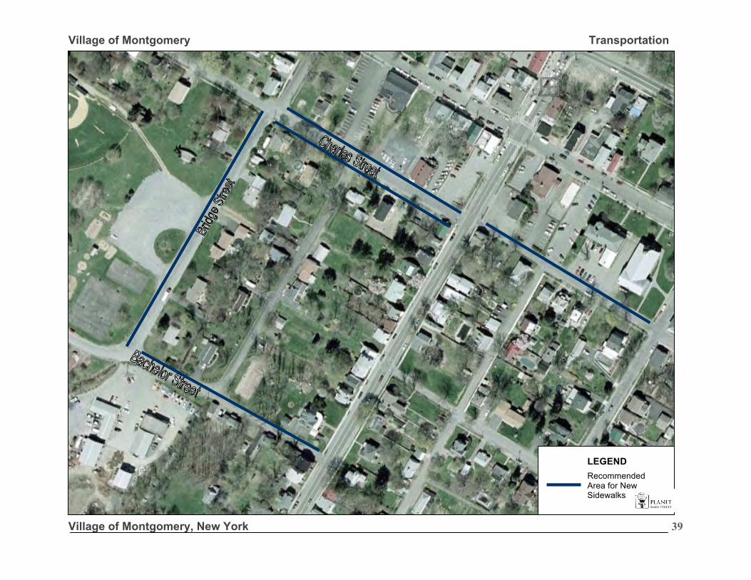
Village of Montgomery Transportation
Village of Montgomery, New York
39
Recommended Area for New Sidewalks
LEGEND
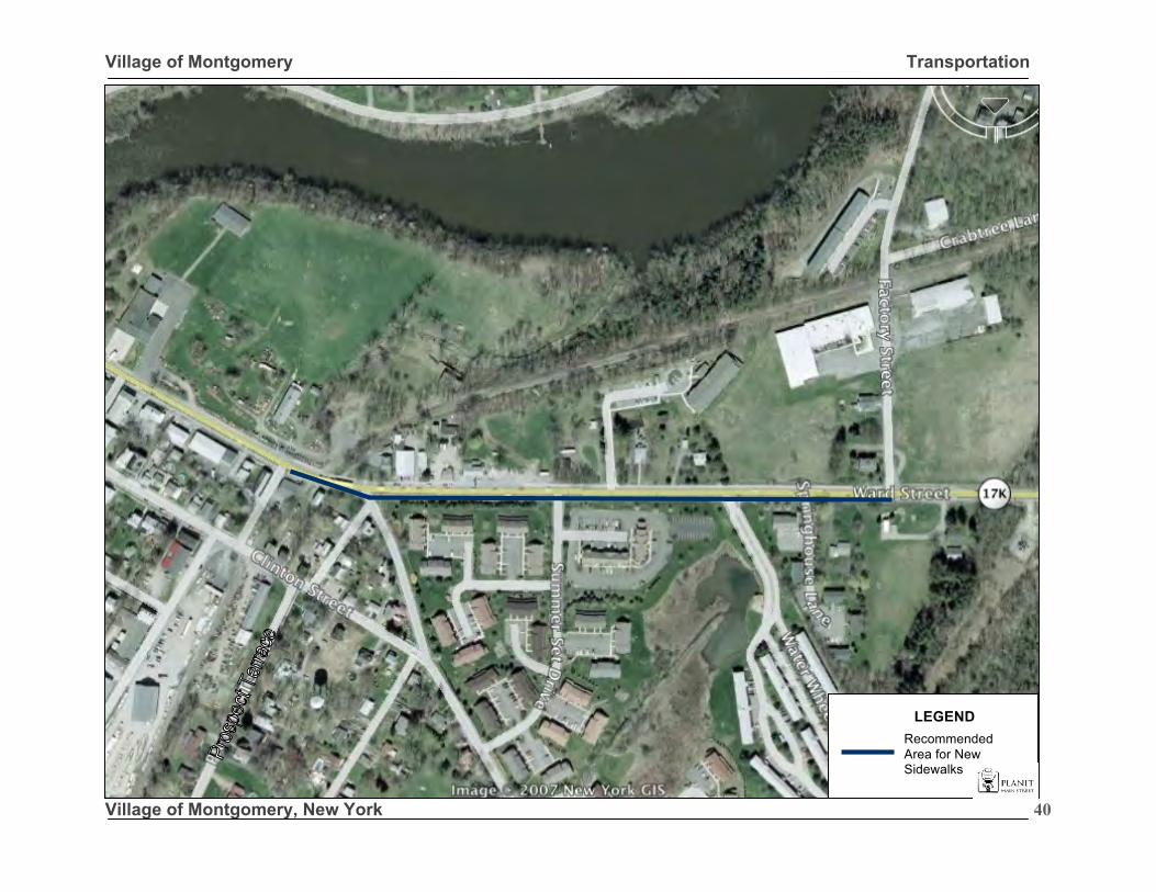
Village of Montgomery Transportation
Village of Montgomery, New York
40
Recommended Area for New Sidewalks
LEGEND
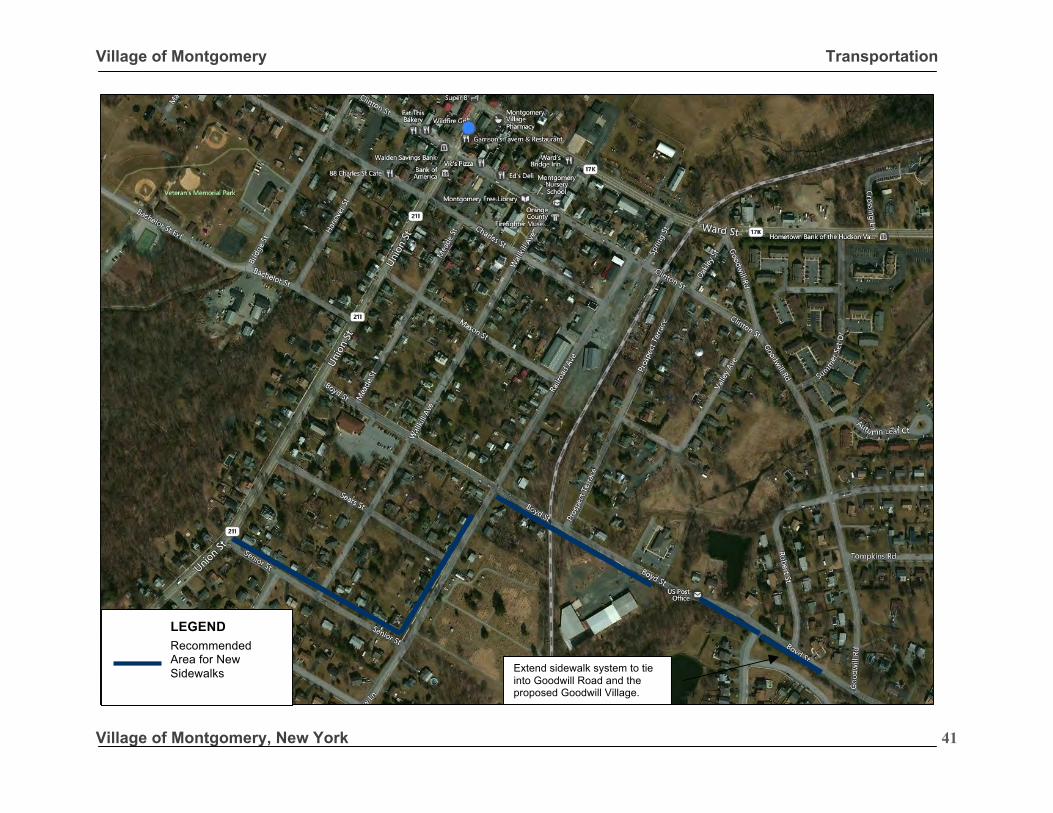
Village of Montgomery Transportation
Village of Montgomery, New York
41
Extend sidewalk system to tie into Goodwill Road and the proposed Goodwill Village.
Recommended Area for New Sidewalks
LEGEND
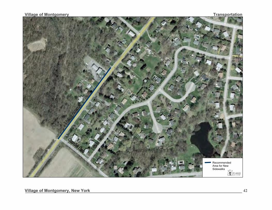
Village of Montgomery Transportation
Village of Montgomery, New York
42
Recommended Area for New Sidewalks
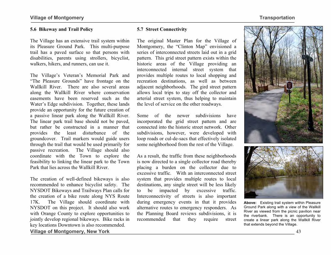
Village of Montgomery Transportation
Village of Montgomery, New York
43
5.6 Bikeway and Trail Policy The Village has an extensive trail system within its Pleasure Ground Park. This multi-purpose trail has a paved surface so that persons with disabilities, parents using strollers, bicyclist, walkers, hikers, and runners, can use it. The Village’s Veteran’s Memorial Park and “The Pleasure Grounds” have frontage on the Wallkill River. There are also several areas along the Wallkill River where conservation easements have been reserved such as the Water’s Edge subdivision. Together, these lands provide an opportunity for the future creation of a passive linear park along the Wallkill River. The linear park trail base should not be paved, but rather be constructed in a manner that provides the least disturbance of the groundcover. Trail markers would guide users through the trail that would be used primarily for passive recreation. The Village should also coordinate with the Town to explore the feasibility to linking the linear park to the Town Park that lies across the Wallkill River. The creation of well-defined bikeways is also recommended to enhance bicyclist safety. The NYSDOT Bikeways and Trailways Plan calls for the creation of a bike route along NYS Route 17K. The Village should coordinate with NYSDOT on this project. It should also work with Orange County to explore opportunities to jointly develop regional bikeways. Bike racks in key locations Downtown is also recommended.
5.7 Street Connectivity The original Master Plan for the Village of Montgomery, the “Clinton Map” envisioned a series of interconnected streets laid out in a grid pattern. This grid street pattern exists within the historic areas of the Village providing an interconnected internal street system that provides multiple routes to local shopping and recreation destinations, as well as between adjacent neighborhoods. The gird street pattern allows local trips to stay off the collector and arterial street system, thus helping to maintain the level of service on the other roadways. Some of the newer subdivisions have incorporated the grid street pattern and are connected into the historic street network. Other subdivisions, however, were developed with loop roads or cul-de-sacs that effectively isolated some neighborhood from the rest of the Village. As a result, the traffic from these neighborhoods is now directed to a single collector road thereby placing a burden on the collector due to excessive traffic. With an interconnected street system that provides multiple routes to local destinations, any single street will be less likely to be impacted by excessive traffic. Interconnectivity of streets is also important during emergency events in that it provides alternative routes to emergency responders. As the Planning Board reviews subdivisions, it is recommended that they require street
connectivity between subdivisions and/or the easements for future street connections.
Above: Existing trail system within Pleasure Ground Park along with a view of the Wallkill River as viewed from the picnic pavilion near the riverbank. There is an opportunity to create a linear park along the Wallkill River that extends beyond the Village.
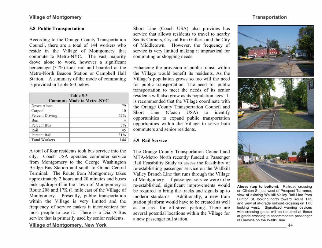
Village of Montgomery Transportation
Village of Montgomery, New York
44
5.8 Public Transportation According to the Orange County Transportation Council, there are a total of 144 workers who reside in the Village of Montgomery that commute to Metro-NYC. The vast majority drove alone to work, however a significant percentage (31%) took rail and boarded at the Metro-North Beacon Station or Campbell Hall Station. A summary of the mode of commuting is provided in Table 6-3 below.
Table 5-3 Commute Mode to Metro-NYC
Drove Alone 79 Carpool 10 Percent Driving 62% Bus 4 Percent Bus 3% Rail 45 Percent Rail 31% Total Workers 144
A total of four residents took bus service into the city. Coach USA operates commuter service from Montgomery to the George Washington Bridge Bus Station and south to Grand Central Terminal. The Route from Montgomery takes approximately 2 hours and 20 minutes and buses pick up/drop-off in the Town of Montgomery at Route 208 and 17K (1 mile east of the Village of Montgomery. Presently, public transportation within the Village is very limited and the frequency of service makes it inconvenient for most people to use it. There is a Dial-A-Bus service that is primarily used by senior residents.
Short Line (Coach USA) also provides bus service that allows residents to travel to nearby Scotts Corners, Crystal Run Galleria and the City of Middletown. However, the frequency of service is very limited making it impractical for commuting or shopping needs. Enhancing the provision of public transit within the Village would benefit its residents. As the Village’s population grows so too will the need for public transportation. The need for public transportation to meet the needs of its senior residents will also grow as its population ages. It is recommended that the Village coordinate with the Orange County Transportation Council and Short Line (Coach USA) to identify opportunities to expand public transportation opportunities within the Village to serve both commuters and senior residents. 5.9 Rail Service The Orange County Transportation Council and MTA-Metro North recently funded a Passenger Rail Feasibility Study to assess the feasibility of re-establishing passenger service on the Wallkill Valley Branch Line that runs through the Village of Montgomery. If passenger service were to be re-established, significant improvements would be required to bring the tracks and signals up to modern standards. Additionally, a new train station platform would have to be created as well as an area for off-street parking. There are several potential locations within the Village for a new passenger rail station.
Above (top to bottom): Railroad crossing on Clinton St. just west of Prospect Terrance, view of existing Wallkill Valley Rail Line from Clinton St. looking north toward Route 17K and view of at-grade railroad crossing on 17K looking west. Signalized warning devices with crossing gates will be required at these at grade crossing to accommodate passenger rail service on the Wallkill line.
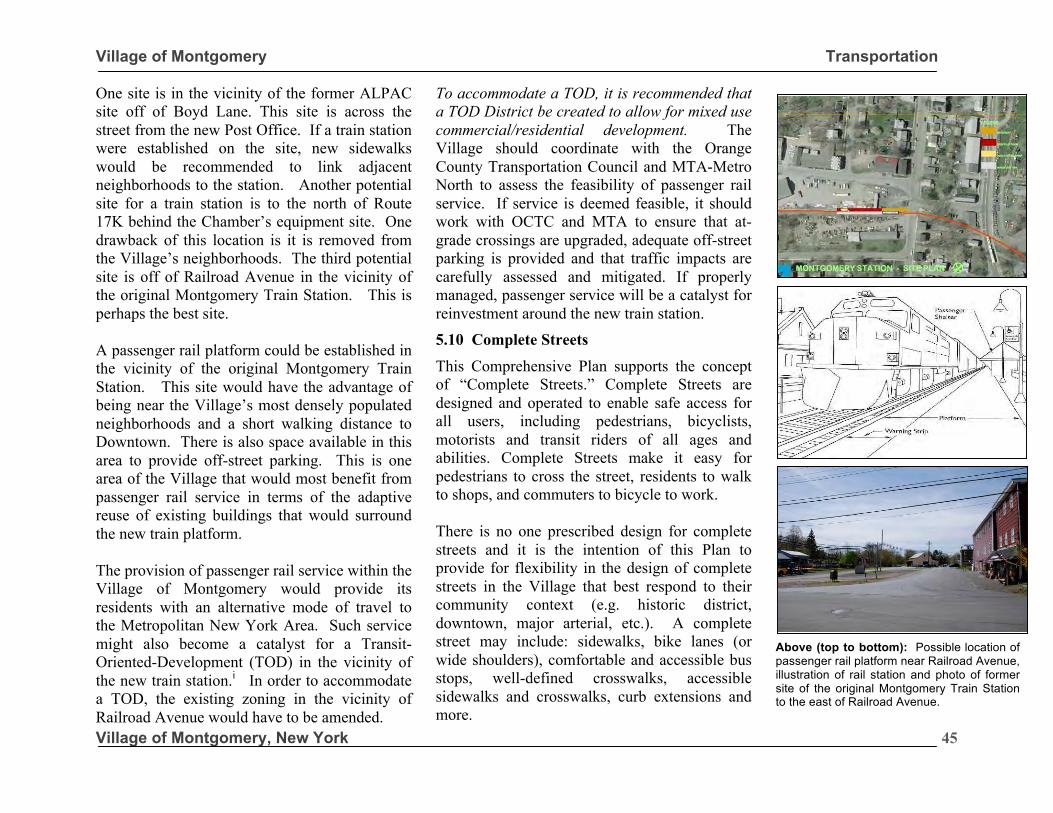
Village of Montgomery Transportation
Village of Montgomery, New York
45
One site is in the vicinity of the former ALPAC site off of Boyd Lane. This site is across the street from the new Post Office. If a train station were established on the site, new sidewalks would be recommended to link adjacent neighborhoods to the station. Another potential site for a train station is to the north of Route 17K behind the Chamber’s equipment site. One drawback of this location is it is removed from the Village’s neighborhoods. The third potential site is off of Railroad Avenue in the vicinity of the original Montgomery Train Station. This is perhaps the best site. A passenger rail platform could be established in the vicinity of the original Montgomery Train Station. This site would have the advantage of being near the Village’s most densely populated neighborhoods and a short walking distance to Downtown. There is also space available in this area to provide off-street parking. This is one area of the Village that would most benefit from passenger rail service in terms of the adaptive reuse of existing buildings that would surround the new train platform. The provision of passenger rail service within the Village of Montgomery would provide its residents with an alternative mode of travel to the Metropolitan New York Area. Such service might also become a catalyst for a Transit-Oriented-Development (TOD) in the vicinity of the new train station.i In order to accommodate a TOD, the existing zoning in the vicinity of Railroad Avenue would have to be amended.
To accommodate a TOD, it is recommended that a TOD District be created to allow for mixed use commercial/residential development. The Village should coordinate with the Orange County Transportation Council and MTA-Metro North to assess the feasibility of passenger rail service. If service is deemed feasible, it should work with OCTC and MTA to ensure that at-grade crossings are upgraded, adequate off-street parking is provided and that traffic impacts are carefully assessed and mitigated. If properly managed, passenger service will be a catalyst for reinvestment around the new train station. 5.10 Complete Streets
This Comprehensive Plan supports the concept of “Complete Streets.” Complete Streets are designed and operated to enable safe access for all users, including pedestrians, bicyclists, motorists and transit riders of all ages and abilities. Complete Streets make it easy for pedestrians to cross the street, residents to walk to shops, and commuters to bicycle to work. There is no one prescribed design for complete streets and it is the intention of this Plan to provide for flexibility in the design of complete streets in the Village that best respond to their community context (e.g. historic district, downtown, major arterial, etc.). A complete street may include: sidewalks, bike lanes (or wide shoulders), comfortable and accessible bus stops, well-defined crosswalks, accessible sidewalks and crosswalks, curb extensions and more.
Above (top to bottom): Possible location of passenger rail platform near Railroad Avenue, illustration of rail station and photo of former site of the original Montgomery Train Station to the east of Railroad Avenue.
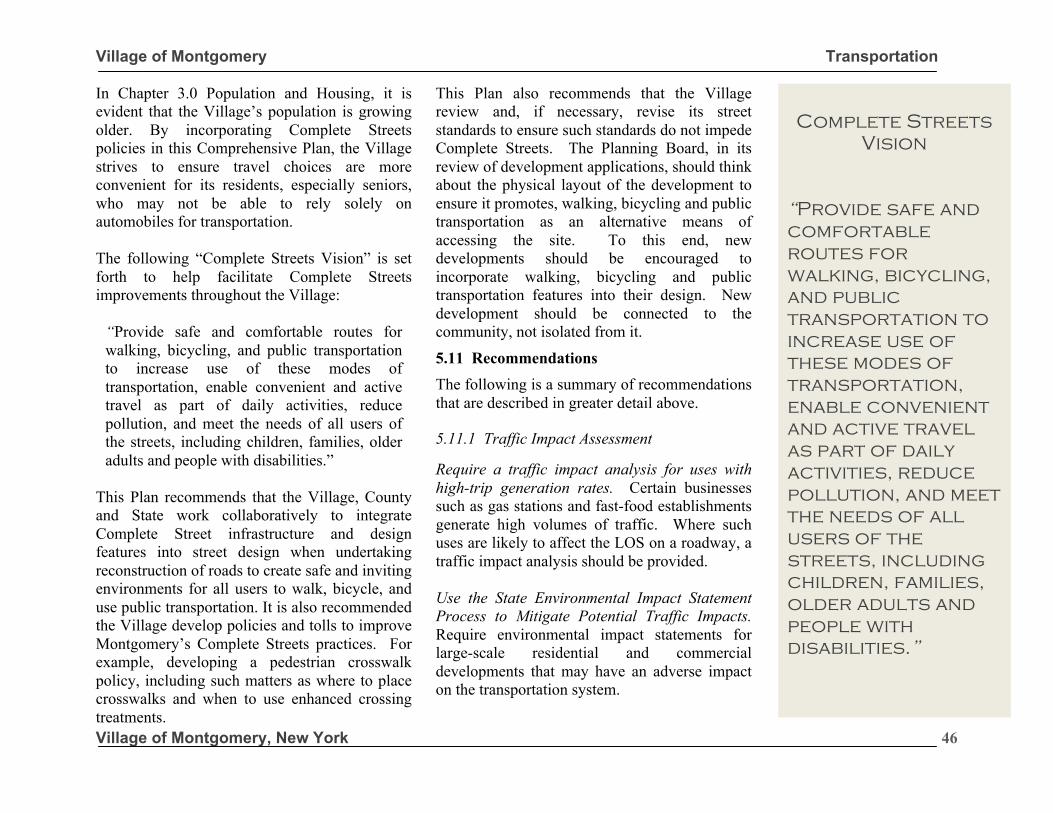
Village of Montgomery Transportation
Village of Montgomery, New York
46
In Chapter 3.0 Population and Housing, it is evident that the Village’s population is growing older. By incorporating Complete Streets policies in this Comprehensive Plan, the Village strives to ensure travel choices are more convenient for its residents, especially seniors, who may not be able to rely solely on automobiles for transportation. The following “Complete Streets Vision” is set forth to help facilitate Complete Streets improvements throughout the Village:
“Provide safe and comfortable routes for walking, bicycling, and public transportation to increase use of these modes of transportation, enable convenient and active travel as part of daily activities, reduce pollution, and meet the needs of all users of the streets, including children, families, older adults and people with disabilities.”
This Plan recommends that the Village, County and State work collaboratively to integrate Complete Street infrastructure and design features into street design when undertaking reconstruction of roads to create safe and inviting environments for all users to walk, bicycle, and use public transportation. It is also recommended the Village develop policies and tolls to improve Montgomery’s Complete Streets practices. For example, developing a pedestrian crosswalk policy, including such matters as where to place crosswalks and when to use enhanced crossing treatments.
This Plan also recommends that the Village review and, if necessary, revise its street standards to ensure such standards do not impede Complete Streets. The Planning Board, in its review of development applications, should think about the physical layout of the development to ensure it promotes, walking, bicycling and public transportation as an alternative means of accessing the site. To this end, new developments should be encouraged to incorporate walking, bicycling and public transportation features into their design. New development should be connected to the community, not isolated from it.
5.11 Recommendations
The following is a summary of recommendations that are described in greater detail above. 5.11.1 Traffic Impact Assessment Require a traffic impact analysis for uses with high-trip generation rates. Certain businesses such as gas stations and fast-food establishments generate high volumes of traffic. Where such uses are likely to affect the LOS on a roadway, a traffic impact analysis should be provided. Use the State Environmental Impact Statement Process to Mitigate Potential Traffic Impacts. Require environmental impact statements for large-scale residential and commercial developments that may have an adverse impact on the transportation system.
Complete Streets
Vision “Provide safe and comfortable routes for walking, bicycling, and public transportation to increase use of these modes of transportation, enable convenient and active travel as part of daily activities, reduce pollution, and meet the needs of all users of the streets, including children, families, older adults and people with disabilities.” Allan B. Jacobs
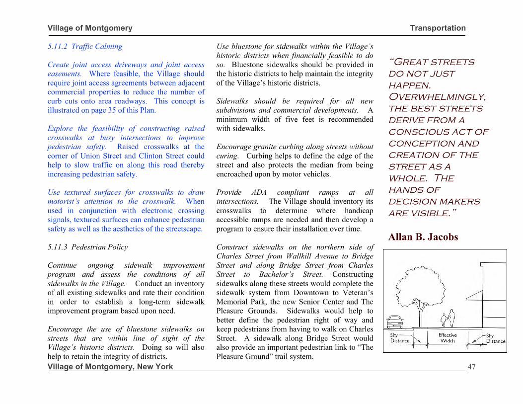
Village of Montgomery Transportation
Village of Montgomery, New York
47
5.11.2 Traffic Calming Create joint access driveways and joint access easements. Where feasible, the Village should require joint access agreements between adjacent commercial properties to reduce the number of curb cuts onto area roadways. This concept is illustrated on page 35 of this Plan. Explore the feasibility of constructing raised crosswalks at busy intersections to improve pedestrian safety. Raised crosswalks at the corner of Union Street and Clinton Street could help to slow traffic on along this road thereby increasing pedestrian safety. Use textured surfaces for crosswalks to draw motorist’s attention to the crosswalk. When used in conjunction with electronic crossing signals, textured surfaces can enhance pedestrian safety as well as the aesthetics of the streetscape. 5.11.3 Pedestrian Policy Continue ongoing sidewalk improvement program and assess the conditions of all sidewalks in the Village. Conduct an inventory of all existing sidewalks and rate their condition in order to establish a long-term sidewalk improvement program based upon need. Encourage the use of bluestone sidewalks on streets that are within line of sight of the Village’s historic districts. Doing so will also help to retain the integrity of districts.
Use bluestone for sidewalks within the Village’s historic districts when financially feasible to do so. Bluestone sidewalks should be provided in the historic districts to help maintain the integrity of the Village’s historic districts. Sidewalks should be required for all new subdivisions and commercial developments. A minimum width of five feet is recommended with sidewalks. Encourage granite curbing along streets without curing. Curbing helps to define the edge of the street and also protects the median from being encroached upon by motor vehicles. Provide ADA compliant ramps at all intersections. The Village should inventory its crosswalks to determine where handicap accessible ramps are needed and then develop a program to ensure their installation over time. Construct sidewalks on the northern side of Charles Street from Wallkill Avenue to Bridge Street and along Bridge Street from Charles Street to Bachelor’s Street. Constructing sidewalks along these streets would complete the sidewalk system from Downtown to Veteran’s Memorial Park, the new Senior Center and The Pleasure Grounds. Sidewalks would help to better define the pedestrian right of way and keep pedestrians from having to walk on Charles Street. A sidewalk along Bridge Street would also provide an important pedestrian link to “The Pleasure Ground” trail system.
“Great streets do not just happen. Overwhelmingly, the best streets derive from a conscious act of conception and creation of the street as a whole. The hands of decision makers are visible.” Allan B. Jacobs
Source: Illustration – Planning and Urban Design Standards -2006, Hoboken, NJ.
“Great streets do not just happen. Overwhelmingly, the best streets derive from a conscious act of conception and creation of the street as a whole. The hands of decision makers are visible.” Allan B. Jacobs
Village of Montgomery Transportation
Village of Montgomery, New York
48
5.11.4 Bicycle and Trail Policy Work with Orange County, neighboring towns, and the NYSDOT to develop linear trails that pass through the Village of Montgomery. Coordinate with Region 8 of NYSDOT to advance the plans for the NYS Route 17K bike routes. The Village could show its support for these efforts by reaching out to NYSDOT to help bring these projects to fruition. Place bicycle racks in key locations within the Downtown Business District and near community and institutional uses. Placement of bicycle racks will help to promote bicycle use. Create more winter-oriented activities. Such as cross-country skiing and other winter sports. 5.11.5 Street Connectivity Require interconnection of roadways between subdivisions and/or provide for future connectivity. When reviewing subdivision applications, the Village should carefully review proposed roadways in the context of its existing transportation system. New roads should provide connections to existing roads where they are feasible. To this end, the use of cul-de-sacs should be discouraged unless an applicant can make a compelling reason otherwise. The Village also needs to coordinate with the Town to ensure that opportunities to interconnect into streets within the Town are realized.
5.11.6 Public Transportation Coordinate with the OCTC and Short Line (Coach USA) to provide public transportation that meets the needs of Village residents and businesses. The Village needs to play an active role in ensuring regional agencies provide necessary services to meet resident needs. 5.11.7 Rail Service Support efforts to bring passenger rail service along the Wallkill Valley Line. Passenger rail service would provide an important mode of transportation for residents and the surrounding region. It can also be a catalyst for reinvestment in the area around Railroad Avenue. Coordinate with OCTC and MTA-Metro North to ensure that local issues and concerns are addressed and appropriate mitigation measures employed. The Village should reach out to MTA-Metro North to assess potential impacts at-grade crossings may have on the LOS along area roadways, especially during peak travel hours. 5.11.8 Ward’s Bridge Form committee to work with New York State Department of Transportation to ensure the redesign and alignment of new Ward’s Bridge respects the historic character of the community and the importance this river crossing placed in the founding of the Village of Montgomery. The Village Board should work with NYSDOT in the redesign and placement of Ward’s Bridge.
Ward’s Bridge
“Work with New York State Department of Transportation to ensure the redesign and alignment of new Ward’s Bridge respects the historic character of the community and the importance this river crossing placed in the founding of the Village of Montgomery.”

Village of Montgomery Transportation
Village of Montgomery, New York
49
5.11.8 Ward’s Bridge (continued)
The redesigned bridge should not only be functional, but it should also be of a form that makes a statement to travelers that they are entering the Village of Montgomery. To this end, a bridge with trusses and/or other design features to maintain views of the Wallkill River and provide a focal point and sense of entry into the Village is desired.
5.11.9 Other
Work with NYSDOT to establish alternative truck routes that avoid NYS Route 17K and Route 211.
5.11.10 Complete Streets Ensure that land use patterns and decisions encourage walking, bicycling, and public transportation use, and make these transportation options a safe and convenient choice. In the review of development and redevelopment proposals, the Planning Board and Village Board should think about the physical layout of the development to ensure it promotes, walking, bicycling and public transportation as an alternative means of accessing the site. Encourage mixed-use development to allow siting of residential, retail, office, recreational, and educational facilities within close proximity to each other to encourage walking and
bicycling as a routine part of everyday life. In its review of PDD projects, Complete Streets strategies should be employed to ensure such development are integrated into the surrounding vehicular and pedestrian transportation system rather than isolated from it. Encourage safe and convenient walking, bicycling, and public transportation features in new or renovated development. Such feature may as simple as installing bike rakes, providing benches along sidewalks, or ensuring sidewalks are ADA compliant at all crosswalks. Improvements like these should be considered when streets are reconstructed or sidewalks replaced. Encourage transit-oriented development by developing public transportation in downtown and encouraging dense infill development near fixed transportation facilities. This is intended to be a long-term strategy tied to the future potential for passenger rail service to the Village.
Alternate Truck
Routes
“Work with New York State Department of Transportation to identify alternative truck routes that avoid the Village of Montgomery and to limit certain classes of trucks on NYS Route 17K and Route 211.”
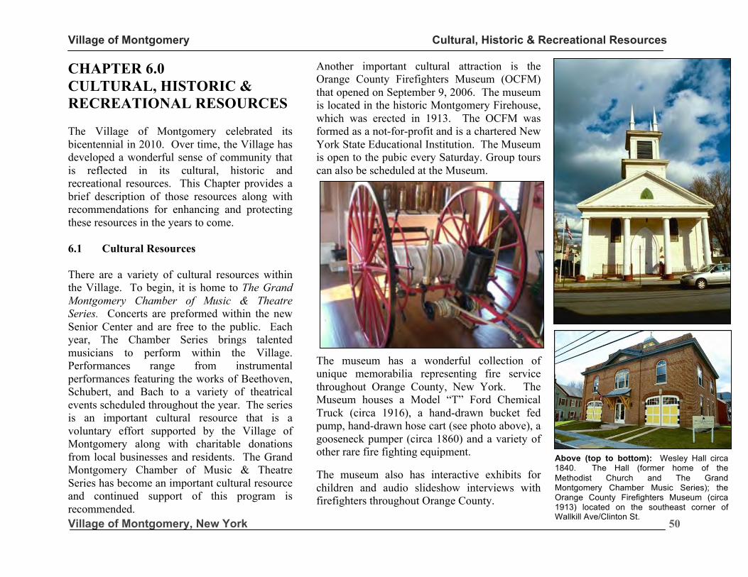
Village of Montgomery Cultural, Historic & Recreational Resources
Village of Montgomery, New York
50
CHAPTER 6.0 CULTURAL, HISTORIC & RECREATIONAL RESOURCES The Village of Montgomery celebrated its bicentennial in 2010. Over time, the Village has developed a wonderful sense of community that is reflected in its cultural, historic and recreational resources. This Chapter provides a brief description of those resources along with recommendations for enhancing and protecting these resources in the years to come. 6.1 Cultural Resources There are a variety of cultural resources within the Village. To begin, it is home to The Grand Montgomery Chamber of Music & Theatre Series. Concerts are preformed within the new Senior Center and are free to the public. Each year, The Chamber Series brings talented musicians to perform within the Village. Performances range from instrumental performances featuring the works of Beethoven, Schubert, and Bach to a variety of theatrical events scheduled throughout the year. The series is an important cultural resource that is a voluntary effort supported by the Village of Montgomery along with charitable donations from local businesses and residents. The Grand Montgomery Chamber of Music & Theatre Series has become an important cultural resource and continued support of this program is recommended.
Another important cultural attraction is the Orange County Firefighters Museum (OCFM) that opened on September 9, 2006. The museum is located in the historic Montgomery Firehouse, which was erected in 1913. The OCFM was formed as a not-for-profit and is a chartered New York State Educational Institution. The Museum is open to the pubic every Saturday. Group tours can also be scheduled at the Museum.
The museum has a wonderful collection of unique memorabilia representing fire service throughout Orange County, New York. The Museum houses a Model “T” Ford Chemical Truck (circa 1916), a hand-drawn bucket fed pump, hand-drawn hose cart (see photo above), a gooseneck pumper (circa 1860) and a variety of other rare fire fighting equipment. The museum also has interactive exhibits for children and audio slideshow interviews with firefighters throughout Orange County.
Above (top to bottom): Wesley Hall circa 1840. The Hall (former home of the Methodist Church and The Grand Montgomery Chamber Music Series); the Orange County Firefighters Museum (circa 1913) located on the southeast corner of Wallkill Ave/Clinton St.
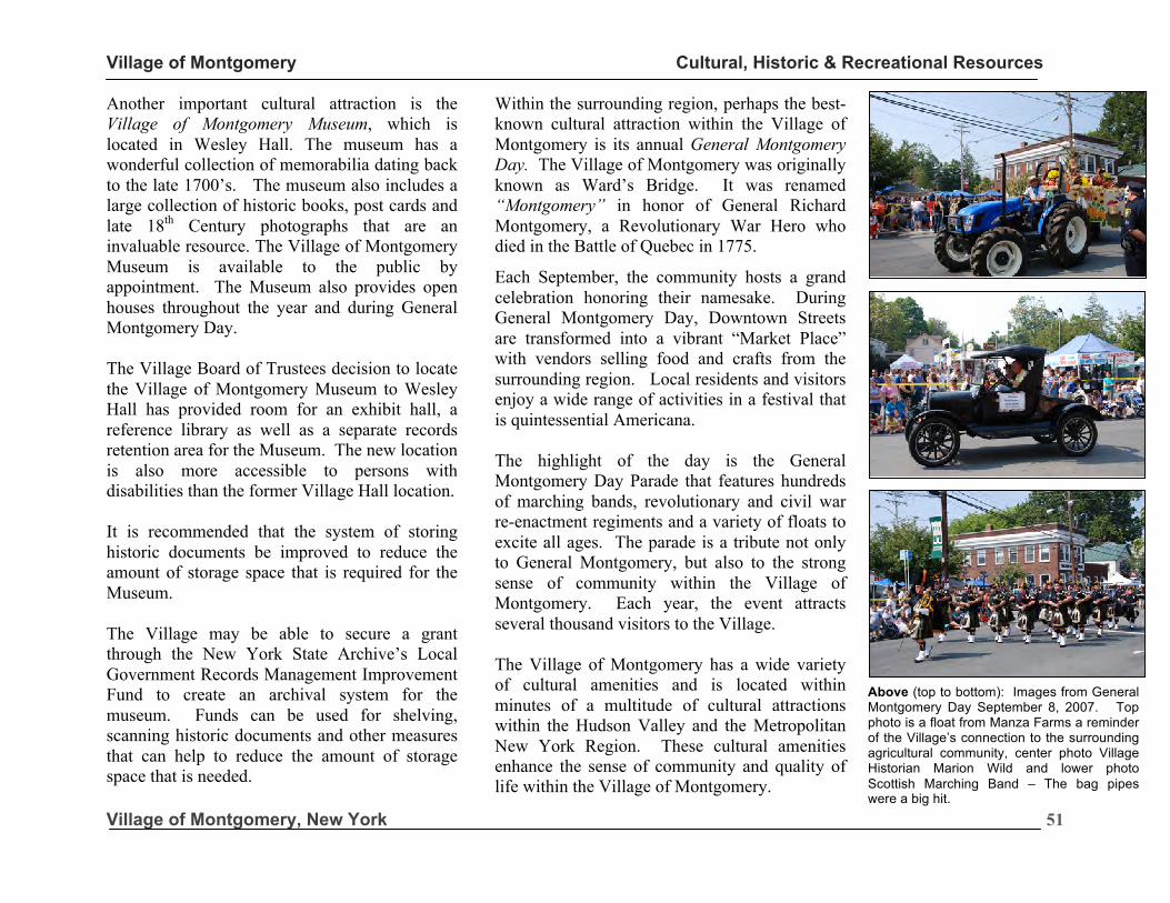
Village of Montgomery Cultural, Historic & Recreational Resources
Village of Montgomery, New York
51
Another important cultural attraction is the Village of Montgomery Museum, which is located in Wesley Hall. The museum has a wonderful collection of memorabilia dating back to the late 1700’s. The museum also includes a large collection of historic books, post cards and late 18th Century photographs that are an invaluable resource. The Village of Montgomery Museum is available to the public by appointment. The Museum also provides open houses throughout the year and during General Montgomery Day. The Village Board of Trustees decision to locate the Village of Montgomery Museum to Wesley Hall has provided room for an exhibit hall, a reference library as well as a separate records retention area for the Museum. The new location is also more accessible to persons with disabilities than the former Village Hall location. It is recommended that the system of storing historic documents be improved to reduce the amount of storage space that is required for the Museum. The Village may be able to secure a grant through the New York State Archive’s Local Government Records Management Improvement Fund to create an archival system for the museum. Funds can be used for shelving, scanning historic documents and other measures that can help to reduce the amount of storage space that is needed.
Within the surrounding region, perhaps the best-known cultural attraction within the Village of Montgomery is its annual General Montgomery Day. The Village of Montgomery was originally known as Ward’s Bridge. It was renamed “Montgomery” in honor of General Richard Montgomery, a Revolutionary War Hero who died in the Battle of Quebec in 1775.
Each September, the community hosts a grand celebration honoring their namesake. During General Montgomery Day, Downtown Streets are transformed into a vibrant “Market Place” with vendors selling food and crafts from the surrounding region. Local residents and visitors enjoy a wide range of activities in a festival that is quintessential Americana. The highlight of the day is the General Montgomery Day Parade that features hundreds of marching bands, revolutionary and civil war re-enactment regiments and a variety of floats to excite all ages. The parade is a tribute not only to General Montgomery, but also to the strong sense of community within the Village of Montgomery. Each year, the event attracts several thousand visitors to the Village. The Village of Montgomery has a wide variety of cultural amenities and is located within minutes of a multitude of cultural attractions within the Hudson Valley and the Metropolitan New York Region. These cultural amenities enhance the sense of community and quality of life within the Village of Montgomery.
Above (top to bottom): Images from General Montgomery Day September 8, 2007. Top photo is a float from Manza Farms a reminder of the Village’s connection to the surrounding agricultural community, center photo Village Historian Marion Wild and lower photo Scottish Marching Band – The bag pipes were a big hit.
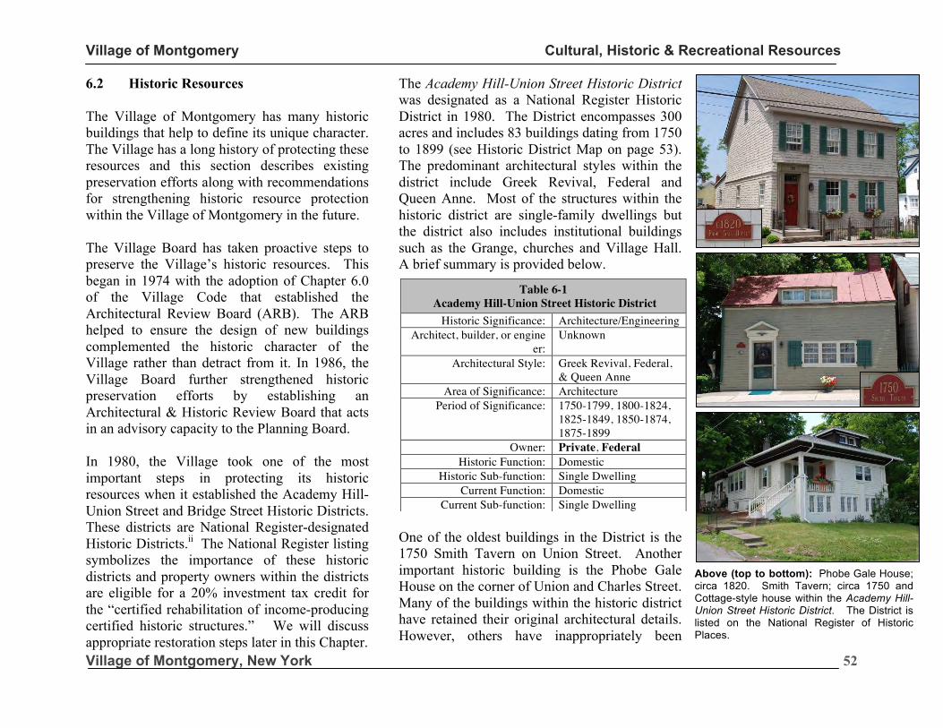
Village of Montgomery Cultural, Historic & Recreational Resources
Village of Montgomery, New York
52
6.2 Historic Resources The Village of Montgomery has many historic buildings that help to define its unique character. The Village has a long history of protecting these resources and this section describes existing preservation efforts along with recommendations for strengthening historic resource protection within the Village of Montgomery in the future. The Village Board has taken proactive steps to preserve the Village’s historic resources. This began in 1974 with the adoption of Chapter 6.0 of the Village Code that established the Architectural Review Board (ARB). The ARB helped to ensure the design of new buildings complemented the historic character of the Village rather than detract from it. In 1986, the Village Board further strengthened historic preservation efforts by establishing an Architectural & Historic Review Board that acts in an advisory capacity to the Planning Board. In 1980, the Village took one of the most important steps in protecting its historic resources when it established the Academy Hill-Union Street and Bridge Street Historic Districts. These districts are National Register-designated Historic Districts.ii The National Register listing symbolizes the importance of these historic districts and property owners within the districts are eligible for a 20% investment tax credit for the “certified rehabilitation of income-producing certified historic structures.” We will discuss appropriate restoration steps later in this Chapter.
The Academy Hill-Union Street Historic District was designated as a National Register Historic District in 1980. The District encompasses 300 acres and includes 83 buildings dating from 1750 to 1899 (see Historic District Map on page 53). The predominant architectural styles within the district include Greek Revival, Federal and Queen Anne. Most of the structures within the historic district are single-family dwellings but the district also includes institutional buildings such as the Grange, churches and Village Hall. A brief summary is provided below.
One of the oldest buildings in the District is the 1750 Smith Tavern on Union Street. Another important historic building is the Phobe Gale House on the corner of Union and Charles Street. Many of the buildings within the historic district have retained their original architectural details. However, others have inappropriately been
covered vinyl or aluminum siding that masks the original architecture of the buildings.
Table 6-1 Academy Hill-Union Street Historic District
Historic Significance: Architecture/Engineering Architect, builder, or engine
er: Unknown
Architectural Style: Greek Revival, Federal, & Queen Anne
Area of Significance: Architecture Period of Significance: 1750-1799, 1800-1824,
1825-1849, 1850-1874, 1875-1899
Owner: Private, Federal Historic Function: Domestic
Historic Sub-function: Single Dwelling Current Function: Domestic
Current Sub-function: Single Dwelling
Above (top to bottom): Phobe Gale House; circa 1820. Smith Tavern; circa 1750 and Cottage-style house within the Academy Hill-Union Street Historic District. The District is listed on the National Register of Historic Places.
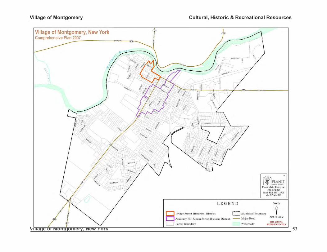
Village of Montgomery Cultural, Historic & Recreational Resources
Village of Montgomery, New York
53
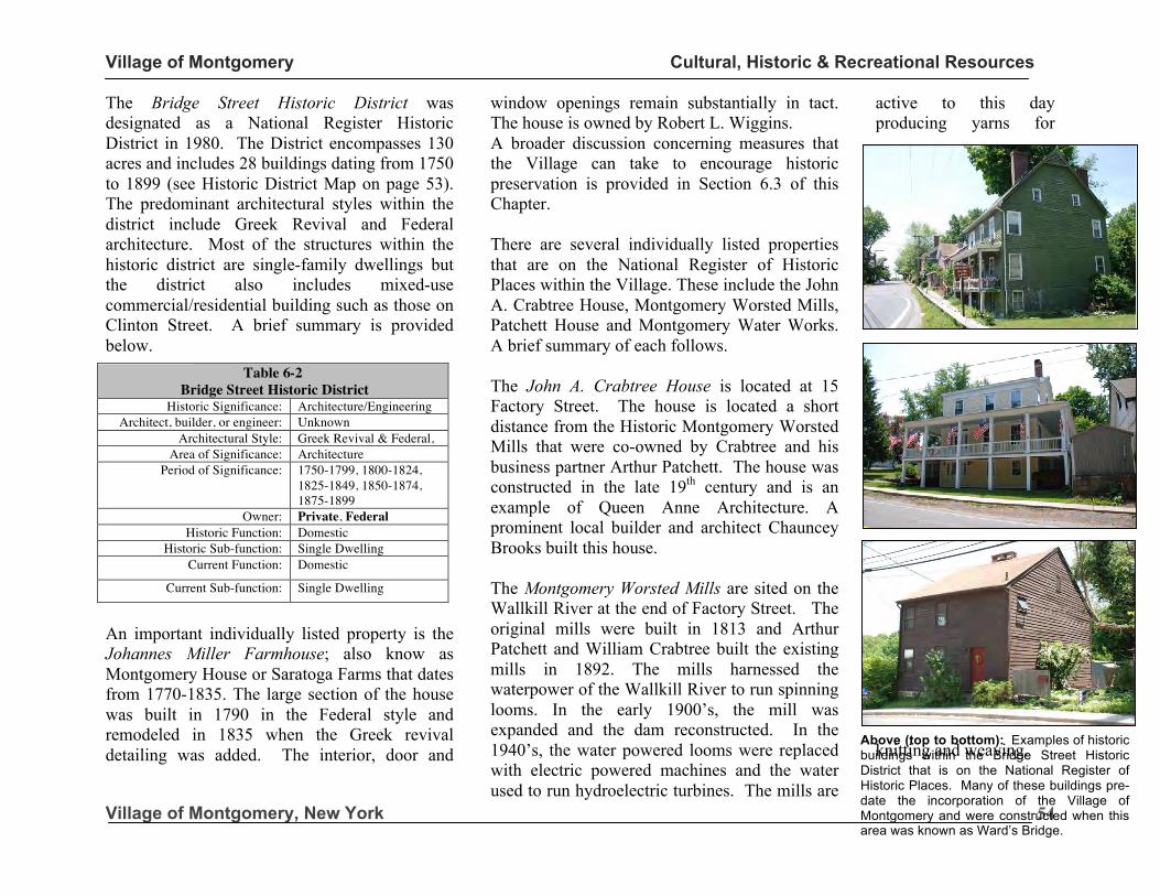
Village of Montgomery Cultural, Historic & Recreational Resources
Village of Montgomery, New York
54
The Bridge Street Historic District was designated as a National Register Historic District in 1980. The District encompasses 130 acres and includes 28 buildings dating from 1750 to 1899 (see Historic District Map on page 53). The predominant architectural styles within the district include Greek Revival and Federal architecture. Most of the structures within the historic district are single-family dwellings but the district also includes mixed-use commercial/residential building such as those on Clinton Street. A brief summary is provided below.
An important individually listed property is the Johannes Miller Farmhouse; also know as Montgomery House or Saratoga Farms that dates from 1770-1835. The large section of the house was built in 1790 in the Federal style and remodeled in 1835 when the Greek revival detailing was added. The interior, door and
window openings remain substantially in tact. The house is owned by Robert L. Wiggins. A broader discussion concerning measures that the Village can take to encourage historic preservation is provided in Section 6.3 of this Chapter. There are several individually listed properties that are on the National Register of Historic Places within the Village. These include the John A. Crabtree House, Montgomery Worsted Mills, Patchett House and Montgomery Water Works. A brief summary of each follows. The John A. Crabtree House is located at 15 Factory Street. The house is located a short distance from the Historic Montgomery Worsted Mills that were co-owned by Crabtree and his business partner Arthur Patchett. The house was constructed in the late 19th century and is an example of Queen Anne Architecture. A prominent local builder and architect Chauncey Brooks built this house. The Montgomery Worsted Mills are sited on the Wallkill River at the end of Factory Street. The original mills were built in 1813 and Arthur Patchett and William Crabtree built the existing mills in 1892. The mills harnessed the waterpower of the Wallkill River to run spinning looms. In the early 1900’s, the mill was expanded and the dam reconstructed. In the 1940’s, the water powered looms were replaced with electric powered machines and the water used to run hydroelectric turbines. The mills are
active to this day producing yarns for
knitting and weaving.
Table 6-2 Bridge Street Historic District
Historic Significance: Architecture/Engineering Architect, builder, or engineer: Unknown
Architectural Style: Greek Revival & Federal, Area of Significance: Architecture
Period of Significance: 1750-1799, 1800-1824, 1825-1849, 1850-1874, 1875-1899
Owner: Private, Federal Historic Function: Domestic
Historic Sub-function: Single Dwelling Current Function: Domestic
Current Sub-function: Single Dwelling
Above (top to bottom): Examples of historic buildings within the Bridge Street Historic District that is on the National Register of Historic Places. Many of these buildings pre-date the incorporation of the Village of Montgomery and were constructed when this area was known as Ward’s Bridge.
Above (top to bottom): Examples of historic buildings within the Bridge Street Historic District that is on the National Register of Historic Places. Many of these buildings pre-date the incorporation of the Village of Montgomery and were constructed when this area was known as Ward’s Bridge.
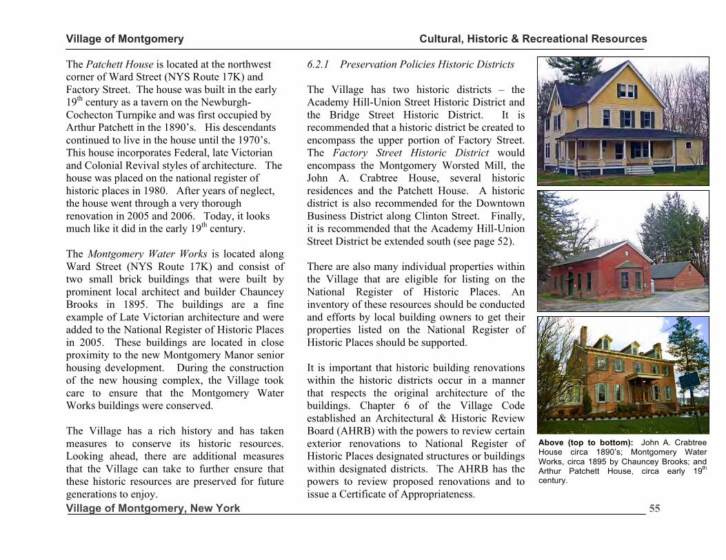
Village of Montgomery Cultural, Historic & Recreational Resources
Village of Montgomery, New York
55
The Patchett House is located at the northwest corner of Ward Street (NYS Route 17K) and Factory Street. The house was built in the early 19th century as a tavern on the Newburgh-Cochecton Turnpike and was first occupied by Arthur Patchett in the 1890’s. His descendants continued to live in the house until the 1970’s. This house incorporates Federal, late Victorian and Colonial Revival styles of architecture. The house was placed on the national register of historic places in 1980. After years of neglect, the house went through a very thorough renovation in 2005 and 2006. Today, it looks much like it did in the early 19th century. The Montgomery Water Works is located along Ward Street (NYS Route 17K) and consist of two small brick buildings that were built by prominent local architect and builder Chauncey Brooks in 1895. The buildings are a fine example of Late Victorian architecture and were added to the National Register of Historic Places in 2005. These buildings are located in close proximity to the new Montgomery Manor senior housing development. During the construction of the new housing complex, the Village took care to ensure that the Montgomery Water Works buildings were conserved. The Village has a rich history and has taken measures to conserve its historic resources. Looking ahead, there are additional measures that the Village can take to further ensure that these historic resources are preserved for future generations to enjoy.
6.2.1 Preservation Policies Historic Districts The Village has two historic districts – the Academy Hill-Union Street Historic District and the Bridge Street Historic District. It is recommended that a historic district be created to encompass the upper portion of Factory Street. The Factory Street Historic District would encompass the Montgomery Worsted Mill, the John A. Crabtree House, several historic residences and the Patchett House. A historic district is also recommended for the Downtown Business District along Clinton Street. Finally, it is recommended that the Academy Hill-Union Street District be extended south (see page 52). There are also many individual properties within the Village that are eligible for listing on the National Register of Historic Places. An inventory of these resources should be conducted and efforts by local building owners to get their properties listed on the National Register of Historic Places should be supported. It is important that historic building renovations within the historic districts occur in a manner that respects the original architecture of the buildings. Chapter 6 of the Village Code established an Architectural & Historic Review Board (AHRB) with the powers to review certain exterior renovations to National Register of Historic Places designated structures or buildings within designated districts. The AHRB has the powers to review proposed renovations and to issue a Certificate of Appropriateness.
Above (top to bottom): John A. Crabtree House circa 1890’s; Montgomery Water Works, circa 1895 by Chauncey Brooks; and Arthur Patchett House, circa early 19th century.
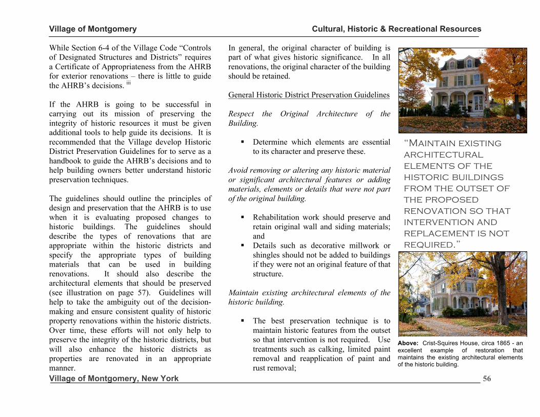
Village of Montgomery Cultural, Historic & Recreational Resources
Village of Montgomery, New York
56
While Section 6-4 of the Village Code “Controls of Designated Structures and Districts” requires a Certificate of Appropriateness from the AHRB for exterior renovations – there is little to guide the AHRB’s decisions. iii If the AHRB is going to be successful in carrying out its mission of preserving the integrity of historic resources it must be given additional tools to help guide its decisions. It is recommended that the Village develop Historic District Preservation Guidelines for to serve as a handbook to guide the AHRB’s decisions and to help building owners better understand historic preservation techniques. The guidelines should outline the principles of design and preservation that the AHRB is to use when it is evaluating proposed changes to historic buildings. The guidelines should describe the types of renovations that are appropriate within the historic districts and specify the appropriate types of building materials that can be used in building renovations. It should also describe the architectural elements that should be preserved (see illustration on page 57). Guidelines will help to take the ambiguity out of the decision-making and ensure consistent quality of historic property renovations within the historic districts. Over time, these efforts will not only help to preserve the integrity of the historic districts, but will also enhance the historic districts as properties are renovated in an appropriate manner.
In general, the original character of building is part of what gives historic significance. In all renovations, the original character of the building should be retained. General Historic District Preservation Guidelines Respect the Original Architecture of the Building.
§ Determine which elements are essential to its character and preserve these.
Avoid removing or altering any historic material or significant architectural features or adding materials, elements or details that were not part of the original building.
§ Rehabilitation work should preserve and retain original wall and siding materials; and
§ Details such as decorative millwork or shingles should not be added to buildings if they were not an original feature of that structure.
Maintain existing architectural elements of the historic building.
§ The best preservation technique is to maintain historic features from the outset so that intervention is not required. Use treatments such as calking, limited paint removal and reapplication of paint and rust removal;
“Maintain existing architectural elements of the historic buildings from the outset of the proposed renovation so that intervention and replacement is not required.”
Above: Crist-Squires House, circa 1865 - an excellent example of restoration that maintains the existing architectural elements of the historic building.
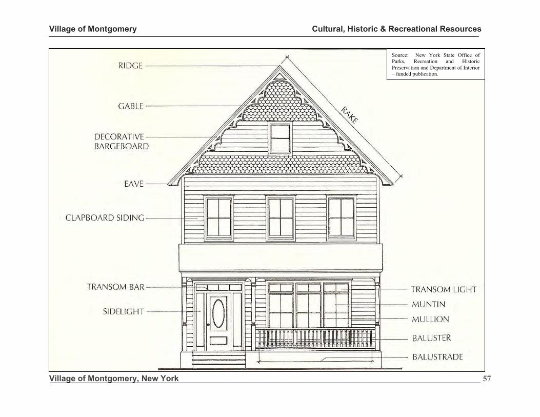
Village of Montgomery Cultural, Historic & Recreational Resources
Village of Montgomery, New York
57
Source: New York State Office of Parks, Recreation and Historic Preservation and Department of Interior – funded publication.
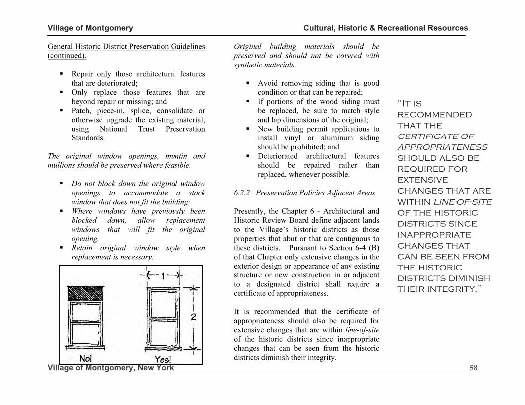
Village of Montgomery Cultural, Historic & Recreational Resources
Village of Montgomery, New York
58
General Historic District Preservation Guidelines (continued).
§ Repair only those architectural features that are deteriorated;
§ Only replace those features that are beyond repair or missing; and
§ Patch, piece-in, splice, consolidate or otherwise upgrade the existing material, using National Trust Preservation Standards.
The original window openings, muntin and mullions should be preserved where feasible.
§ Do not block down the original window openings to accommodate a stock window that does not fit the building;
§ Where windows have previously been blocked down, allow replacement windows that will fit the original opening.
§ Retain original window style when replacement is necessary.
Original building materials should be preserved and should not be covered with synthetic materials.
§ Avoid removing siding that is good condition or that can be repaired;
§ If portions of the wood siding must be replaced, be sure to match style and lap dimensions of the original;
§ New building permit applications to install vinyl or aluminum siding should be prohibited; and
§ Deteriorated architectural features should be repaired rather than replaced, whenever possible.
6.2.2 Preservation Policies Adjacent Areas Presently, the Chapter 6 - Architectural and Historic Review Board define adjacent lands to the Village’s historic districts as those properties that abut or that are contiguous to these districts. Pursuant to Section 6-4 (B) of that Chapter only extensive changes in the exterior design or appearance of any existing structure or new construction in or adjacent to a designated district shall require a certificate of appropriateness. It is recommended that the certificate of appropriateness should also be required for extensive changes that are within line-of-site of the historic districts since inappropriate changes that can be seen from the historic districts diminish their integrity.
“It is recommended that the certificate of appropriateness should also be required for extensive changes that are within line-of-site of the historic districts since inappropriate changes that can be seen from the historic districts diminish their integrity.”
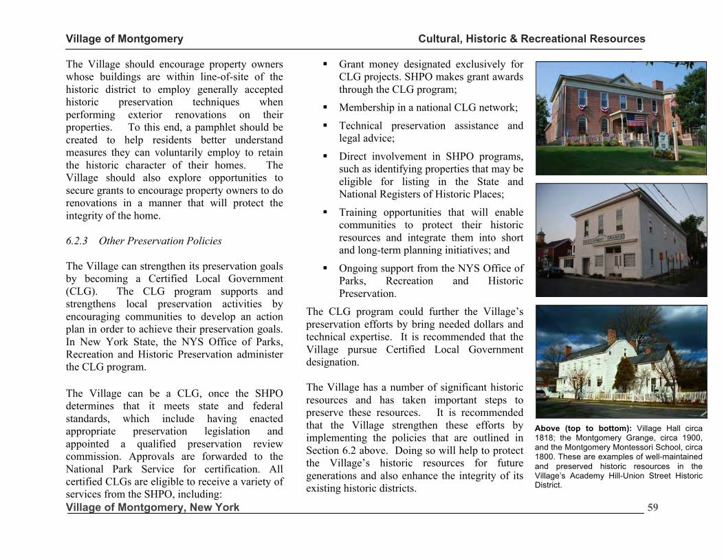
Village of Montgomery Cultural, Historic & Recreational Resources
Village of Montgomery, New York
59
The Village should encourage property owners whose buildings are within line-of-site of the historic district to employ generally accepted historic preservation techniques when performing exterior renovations on their properties. To this end, a pamphlet should be created to help residents better understand measures they can voluntarily employ to retain the historic character of their homes. The Village should also explore opportunities to secure grants to encourage property owners to do renovations in a manner that will protect the integrity of the home. 6.2.3 Other Preservation Policies The Village can strengthen its preservation goals by becoming a Certified Local Government (CLG). The CLG program supports and strengthens local preservation activities by encouraging communities to develop an action plan in order to achieve their preservation goals. In New York State, the NYS Office of Parks, Recreation and Historic Preservation administer the CLG program.
The Village can be a CLG, once the SHPO determines that it meets state and federal standards, which include having enacted appropriate preservation legislation and appointed a qualified preservation review commission. Approvals are forwarded to the National Park Service for certification. All certified CLGs are eligible to receive a variety of services from the SHPO, including:
§ Grant money designated exclusively for CLG projects. SHPO makes grant awards through the CLG program;
§ Membership in a national CLG network;
§ Technical preservation assistance and legal advice;
§ Direct involvement in SHPO programs, such as identifying properties that may be eligible for listing in the State and National Registers of Historic Places;
§ Training opportunities that will enable communities to protect their historic resources and integrate them into short and long-term planning initiatives; and
§ Ongoing support from the NYS Office of Parks, Recreation and Historic Preservation.
The CLG program could further the Village’s preservation efforts by bring needed dollars and technical expertise. It is recommended that the Village pursue Certified Local Government designation. The Village has a number of significant historic resources and has taken important steps to preserve these resources. It is recommended that the Village strengthen these efforts by implementing the policies that are outlined in Section 6.2 above. Doing so will help to protect the Village’s historic resources for future generations and also enhance the integrity of its existing historic districts.
Above (top to bottom): Village Hall circa 1818; the Montgomery Grange, circa 1900, and the Montgomery Montessori School, circa 1800. These are examples of well-maintained and preserved historic resources in the Village’s Academy Hill-Union Street Historic District.
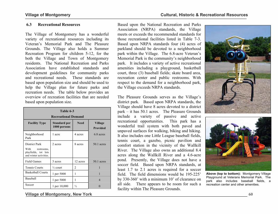
Village of Montgomery Cultural, Historic & Recreational Resources
Village of Montgomery, New York
60
Above (top to bottom): Montgomery Village Playground at Veterans Memorial Park. The park also includes baseball fields, a recreation center and other amenities.
6.3 Recreational Resources
The Village of Montgomery has a wonderful variety of recreational resources including its Veteran’s Memorial Park and The Pleasure Grounds. The Village also holds a Summer Recreation Program for children 5-12, for the both the Village and Town of Montgomery residents. The National Recreation and Parks Association have established standards and development guidelines for community parks and recreational needs. These standards are based upon population size and should be used to help the Village plan for future parks and recreation needs. The table below provides an overview of recreation facilities that are needed based upon population size.
Based upon the National Recreation and Parks Association (NRPA) standards, the Village meets or exceeds the recommended standards for those recreational facilities listed in Table 7-3. Based upon NRPA standards four (4) acres of parkland should be devoted to a neighborhood park within the Village. The 6.8-acre Veteran’s Memorial Park is the community’s neighborhood park. It includes a variety of active recreational amenities including a playground, basketball court, three (3) baseball fields; skate board area, recreation center and public restrooms. With respect to the demand for a neighborhood park, the Village exceeds NRPA standards. The Pleasure Grounds serves as the Village’s district park. Based upon NRPA standards, the Village should have 8 acres devoted to a district park – it has 50.1 acres. The Pleasure Grounds include a variety of passive and active recreational opportunities. This park has a wonderful trail system with both paved and unpaved surfaces for walking, biking and hiking. It also includes one Little League baseball fields, tennis court, a gazebo, picnic pavilion and comfort station in the vicinity of the Wallkill River. The Village also owns an additional 8.4 acres along the Wallkill River and a 4.6-acre pond. Presently, the Village does not have a soccer field. Based upon NRPA standards, at least 1.7 to 2.1 acres is required for a soccer field. The field dimensions would be 195-225’ by 330-360’ with a minimum 10’ of clearance on all side. There appears to be room for such a facility within The Pleasure Grounds.
Table 6-3
Recreational Demand
Facility Type Standard per 1000 persons
Need Village
Provided
Neighborhood Park
1 acre 4 acres 6.8 acres
District Park With restrooms, playfields, tot lots and winter activities.
2 acres 8 acres 50.1 acres
Field Games 3 acres 12 acres 50.1 acres
Tennis Courts ½ court 2 1 Basketball Courts 1 per 5000 1 1 Baseball 1 per 5000 1 4 Soccer 1 per 10,000 ½ 0
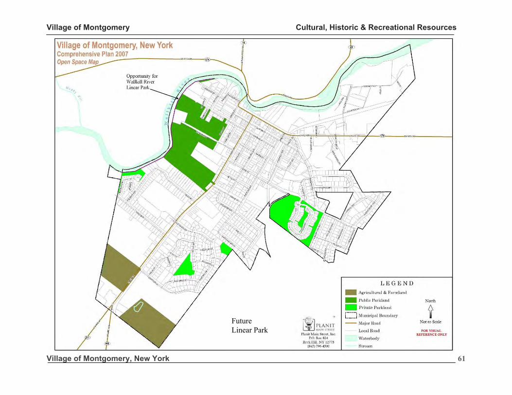
Village of Montgomery Cultural, Historic & Recreational Resources
Village of Montgomery, New York
61
Future Linear Park
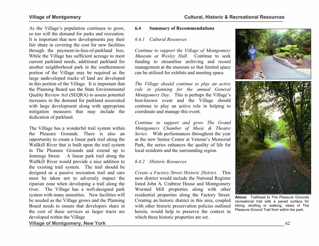
Village of Montgomery Cultural, Historic & Recreational Resources
Village of Montgomery, New York
62
Above: Trailhead to The Pleasure Grounds recreational trail with a paved surface for biking, strolling or walking; views of The Pleasure Ground Trail from within the park.
As the Village’s population continues to grow, so too will the demand for parks and recreation. It is important that new developments pay their fair share in covering the cost for new facilities through the payment-in-lieu-of-parkland fees. While the Village has sufficient acreage to meet current parkland needs, additional parkland for another neighborhood park in the southernmost portion of the Village may be required as the large undeveloped tracks of land are developed in this portion of the Village. It is important that the Planning Board use the State Environmental Quality Review Act (SEQRA) to assess potential increases in the demand for parkland associated with large development along with appropriate mitigation measures that may include the dedication of parkland. The Village has a wonderful trail system within the Pleasure Grounds. There is also an opportunity to create a linear park trail along the Wallkill River that is built upon the trail system in The Pleasure Grounds and extend up to Jennings Street. A linear park trail along the Wallkill River would provide a nice addition to the existing trail system. The trail should be designed as a passive recreation trail and care must be taken not to adversely impact the riparian zone when developing a trail along the river. The Village has a well-designed park system with many amenities. New facilities will be needed as the Village grows and the Planning Board needs to ensure that developers share in the cost of these services as larger tracts are developed within the Village
6.4 Summary of Recommendations 6.4.1 Cultural Resources Continue to support the Village of Montgomery Museum at Wesley Hall. Continue to seek funding to streamline archiving and record management at the museum so that limited space can be utilized for exhibits and meeting space. The Village should continue to play an active role in planning for the annual General Montgomery Day. This is perhaps the Village’s best-known event and the Village should continue to play an active role in helping to coordinate and manage this event. Continue to support and grow The Grand Montgomery Chamber of Music & Theatre Series. With performances throughout the year at the new Senior Center at Veteran’s Memorial Park, the series enhances the quality of life for local residents and the surrounding region. 6.4.2 Historic Resources Create a Factory Street Historic District. This new district would include the National Register listed John A. Crabtree House and Montgomery Worsted Mill properties along with other residential properties along the Factory Street. Creating an historic district in this area, coupled with other historic preservation policies outlined herein, would help to preserve the context in which these historic properties are set.
Village of Montgomery Cultural, Historic & Recreational Resources
Village of Montgomery, New York
63
Develop Historic District Design Guidelines. These are needed to help guide the Architectural and Historic Review Board decisions. Some general parameters for the recommended guidelines are contained herein. Require a Certificate of Appropriateness for extensive changes to the exterior of buildings that are within line-of-site of the Village’s historic districts. Inappropriate changes to historic structures that are within line-of-site of the historic districts could have an adverse impact on the integrity of these districts. Develop voluntary renovation guidelines pamphlet for property owners that are within line-of-site of the Village’s historic districts. This would be an informational pamphlet to encourage homeowners to pursue renovations in as historically appropriate manner as possible. It would outline restoration techniques, appropriate window treatments and might include a list of pre-certified contractors and vendors that are trained in historic preservation work. Require Annual Training for Members of the Architectural and Historic Review Board Members. The AHRB is responsible for reviewing requests to renovate historic structures within the historic districts. The decision of its members requires basic knowledge of historic preservation techniques and it is highly recommended that AHRB members receive training to keep abreast of current practices.
6.4.3 Recreational Resources Ensure that payment-in-lieu of parkland fees are collected to offset expenditures associated with new development within the community. With growth, additional facilities will be needed. Additional parkland may also be needed to provide a better geographic distribution of parkland. Explore opportunities to develop a linear park trail along the banks of the Wallkill River. There is an opportunity to create a linear park trail along the Wallkill River from The Pleasure Ground to Jennings Street. With the cooperation of adjacent landowners, the linear park could also be extended south of The Pleasure Grounds and onto the common open space that was set aside for the Water’s Edge development. One tool that could be employed to encourage private landowner participation is the new Conservation Tax Credit Program described below. Support efforts by property owners to participate in the Conservation Tax Credit (CTC) Program. The New York State Legislature passed the CTC in 2006 that gives landowners whose land is restricted by a permanent conservation easement an annual rebate of 25% of the property taxes paid on that land, up to $5,000 per year. Support applications for funding through the New York State Office of Parks Recreation & Historic Preservation for preservation efforts.
“It is recommended that an historic District be created to encompass the Downtown Business District on Clinton Street and that the Academy Hill-Union Street Historic District be extended down to Purple Martin Drive.”
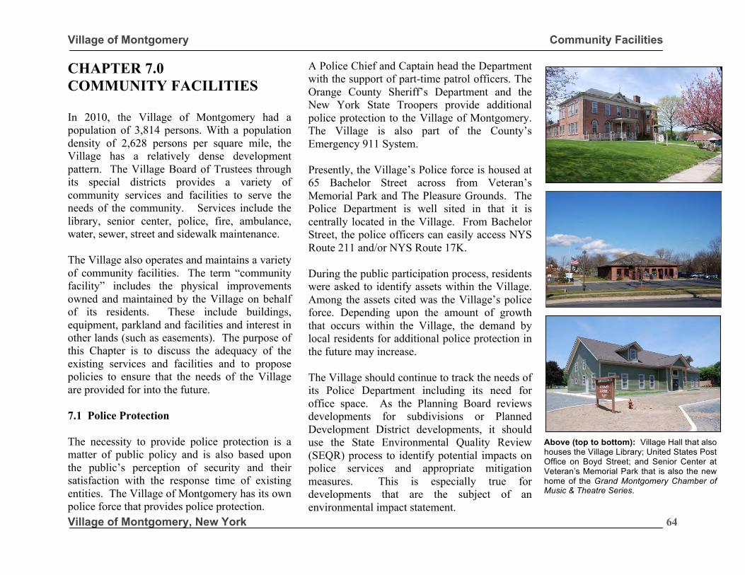
Village of Montgomery Community Facilities
Village of Montgomery, New York
64
CHAPTER 7.0 COMMUNITY FACILITIES In 2010, the Village of Montgomery had a population of 3,814 persons. With a population density of 2,628 persons per square mile, the Village has a relatively dense development pattern. The Village Board of Trustees through its special districts provides a variety of community services and facilities to serve the needs of the community. Services include the library, senior center, police, fire, ambulance, water, sewer, street and sidewalk maintenance. The Village also operates and maintains a variety of community facilities. The term “community facility” includes the physical improvements owned and maintained by the Village on behalf of its residents. These include buildings, equipment, parkland and facilities and interest in other lands (such as easements). The purpose of this Chapter is to discuss the adequacy of the existing services and facilities and to propose policies to ensure that the needs of the Village are provided for into the future. 7.1 Police Protection The necessity to provide police protection is a matter of public policy and is also based upon the public’s perception of security and their satisfaction with the response time of existing entities. The Village of Montgomery has its own police force that provides police protection.
A Police Chief and Captain head the Department with the support of part-time patrol officers. The Orange County Sheriff’s Department and the New York State Troopers provide additional police protection to the Village of Montgomery. The Village is also part of the County’s Emergency 911 System. Presently, the Village’s Police force is housed at 65 Bachelor Street across from Veteran’s Memorial Park and The Pleasure Grounds. The Police Department is well sited in that it is centrally located in the Village. From Bachelor Street, the police officers can easily access NYS Route 211 and/or NYS Route 17K. During the public participation process, residents were asked to identify assets within the Village. Among the assets cited was the Village’s police force. Depending upon the amount of growth that occurs within the Village, the demand by local residents for additional police protection in the future may increase. The Village should continue to track the needs of its Police Department including its need for office space. As the Planning Board reviews developments for subdivisions or Planned Development District developments, it should use the State Environmental Quality Review (SEQR) process to identify potential impacts on police services and appropriate mitigation measures. This is especially true for developments that are the subject of an environmental impact statement.
What follows is a discussion on fire services.
Above (top to bottom): Village Hall that also houses the Village Library; United States Post Office on Boyd Street; and Senior Center at Veteran’s Memorial Park that is also the new home of the Grand Montgomery Chamber of Music & Theatre Series.
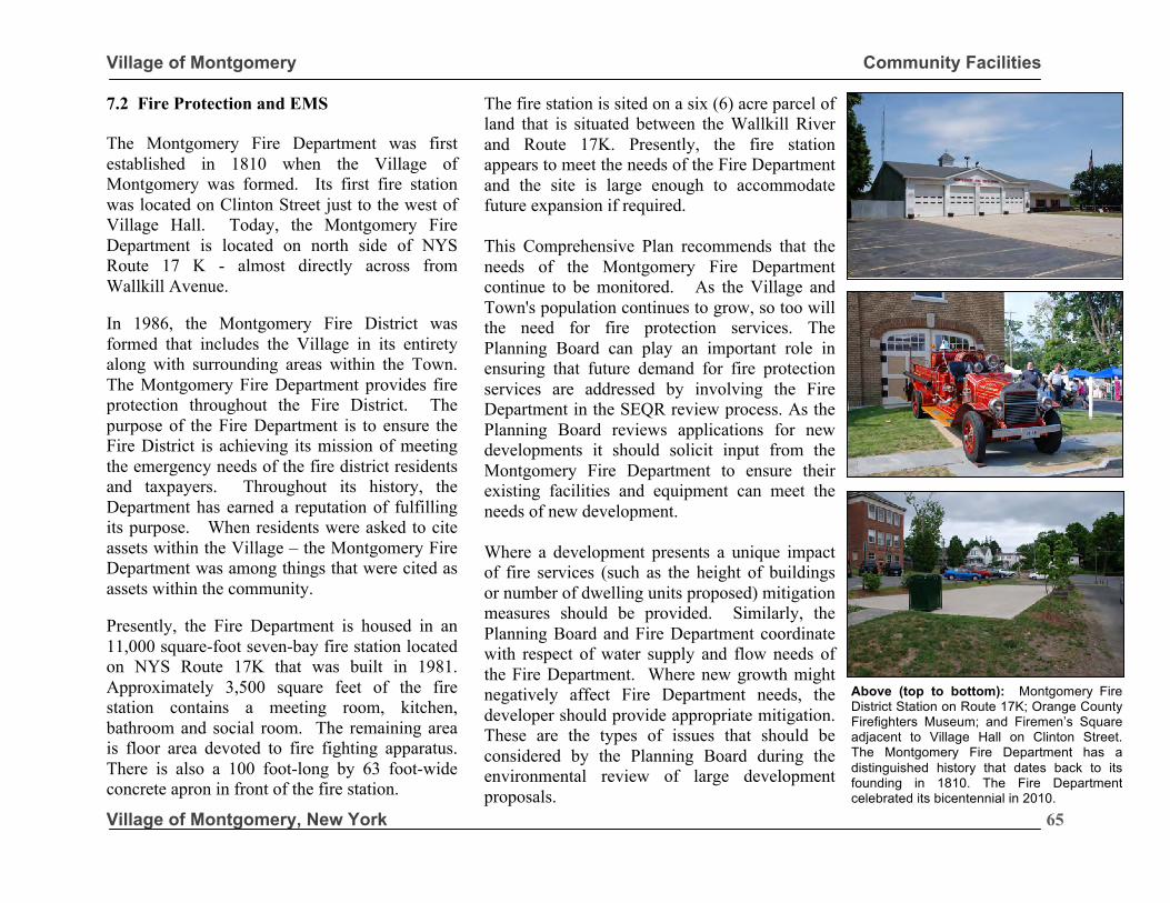
Village of Montgomery Community Facilities
Village of Montgomery, New York
65
7.2 Fire Protection and EMS The Montgomery Fire Department was first established in 1810 when the Village of Montgomery was formed. Its first fire station was located on Clinton Street just to the west of Village Hall. Today, the Montgomery Fire Department is located on north side of NYS Route 17 K - almost directly across from Wallkill Avenue. In 1986, the Montgomery Fire District was formed that includes the Village in its entirety along with surrounding areas within the Town. The Montgomery Fire Department provides fire protection throughout the Fire District. The purpose of the Fire Department is to ensure the Fire District is achieving its mission of meeting the emergency needs of the fire district residents and taxpayers. Throughout its history, the Department has earned a reputation of fulfilling its purpose. When residents were asked to cite assets within the Village – the Montgomery Fire Department was among things that were cited as assets within the community. Presently, the Fire Department is housed in an 11,000 square-foot seven-bay fire station located on NYS Route 17K that was built in 1981. Approximately 3,500 square feet of the fire station contains a meeting room, kitchen, bathroom and social room. The remaining area is floor area devoted to fire fighting apparatus. There is also a 100 foot-long by 63 foot-wide concrete apron in front of the fire station.
The fire station is sited on a six (6) acre parcel of land that is situated between the Wallkill River and Route 17K. Presently, the fire station appears to meet the needs of the Fire Department and the site is large enough to accommodate future expansion if required. This Comprehensive Plan recommends that the needs of the Montgomery Fire Department continue to be monitored. As the Village and Town's population continues to grow, so too will the need for fire protection services. The Planning Board can play an important role in ensuring that future demand for fire protection services are addressed by involving the Fire Department in the SEQR review process. As the Planning Board reviews applications for new developments it should solicit input from the Montgomery Fire Department to ensure their existing facilities and equipment can meet the needs of new development. Where a development presents a unique impact of fire services (such as the height of buildings or number of dwelling units proposed) mitigation measures should be provided. Similarly, the Planning Board and Fire Department coordinate with respect of water supply and flow needs of the Fire Department. Where new growth might negatively affect Fire Department needs, the developer should provide appropriate mitigation. These are the types of issues that should be considered by the Planning Board during the environmental review of large development proposals.
Above (top to bottom): Montgomery Fire District Station on Route 17K; Orange County Firefighters Museum; and Firemen’s Square adjacent to Village Hall on Clinton Street. The Montgomery Fire Department has a distinguished history that dates back to its founding in 1810. The Fire Department celebrated its bicentennial in 2010.
Village of Montgomery Community Facilities
Village of Montgomery, New York
66
7.3 Library The Montgomery Free Library is located at within at 133 Clinton Street within the Village Hall building. The library was founded in 1912 and has grown to 15,000 volumes since moving to the Academy Building in 1970. The Village and Town of Montgomery and the State of New York through the Ramapo-Catskill Library System provide funding for the library. The library hours of operation are as follows:
Based upon the Village’s 2010 population of 3,814 persons, a total of 2,411 square feet should be provided for staff work area, children’s area, reading stacks, reference, periodical, adult browsing and bathrooms. Presently, the library is housed in a 2,256 square-foot area within the Academy Building. The American Library Association (ALA) recommends that libraries maintain two (2) volumes per capita. The Montgomery Free Library has a total cataloged book collection of 15,000 books or 3.93 volumes per capita, almost twice the ALA minimum. The Montgomery Free Library also belongs to the Ramapo-Catskill Library System that allows for the loan of books, supplementing the Montgomery Free Library’s holdings.
The Library houses collections of books for all ages and interests including a children’s corner, local history section, large print books and paperbacks. Other services that the library and staff offer are copying and the Inter-Library Loan service that covers New York State. The library offers a large assortment new and award winning children’s books. In addition to books, the library houses audio and videos, records, recorded books and magazine subscriptions. The Village should continue to work with the library to assess its needs as the community grows. 7.4 Post Office The Village of Montgomery Post Office is located on the Boyd Street Extension. The US Postal Service chose this site because it provided more room for deliveries and off-street parking. Unfortunately, it is located outside of the Village’s Downtown Business District and a distance from most residential neighborhoods. Pedestrian access to the Post Office is less than ideal. It is recommended that the Village work with the Post Office to install sidewalks along the Boyd Street extension to improve the pedestrian connection between the Post Office building and surrounding neighborhoods. If a passenger rail station is established in the future on the ALPAC site, consideration should also be given to integrating the Post Office into a larger Transit-Oriented-Development. If the Post Office were relocated in the future a Downtown location would be strongly recommended to enhance the vitality of the business district.
Open Open Monday 10:00 am -12:00 pm 2:00 pm - 6:00 pm
Tuesday 10:00 am -12:00 pm 2:00 pm - 6:00 pm
Wednesday 10:00 am -12:00 pm 2:00 pm - 6:00 pm
Thursday 10:00 am -12:00 pm 2:00 pm - 6:00 pm
Friday 10:00 am -12:00 pm 2:00 pm - 6:00 pm
Saturday 10:00 am 1:00 pm
“The American Library Association (ALA) recommends that libraries maintain two (2) volumes per capita. The Montgomery Free Library has a total cataloged book collection of 15,000 books or 3.93 volumes per capita – almost twice the ALA minimum.”
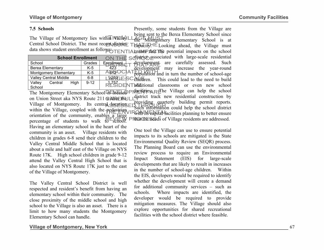
Village of Montgomery Community Facilities
Village of Montgomery, New York
67
7.5 Schools The Village of Montgomery lies within Valley Central School District. The most recent district data shows student enrollment as follows:
The Montgomery Elementary School is located on Union Street aka NYS Route 211 within the Village of Montgomery. Its central location within the Village, coupled with the pedestrian orientation of the community, enables a large percentage of students to walk to school. Having an elementary school in the heart of the community is an asset. Village residents with children in grades 6-8 send their children to the Valley Central Middle School that is located about a mile and half east of the Village on NYS Route 17K. High school children in grade 9-12 attend the Valley Central High School that is also located on NYS Route 17K just to the east of the Village of Montgomery. The Valley Central School District is well respected and resident’s benefit from having an elementary school within their community. The close proximity of the middle school and high school to the Village is also an asset. There is a limit to how many students the Montgomery Elementary School can handle.
Presently, some students from the Village are being sent to the Berea Elementary School since the Montgomery Elementary School is at capacity. Looking ahead, the Village must ensure that the potential impacts on the school district associated with large-scale residential development are carefully assessed. Such development may increase the year-round population and in turn the number of school-age children. This could lead to the need to build additional classrooms or even new school facilities. The Village can help the school district track new residential construction by providing quarterly building permit reports. Such information could help the school district with its capital facilities planning to better ensure that the needs of Village residents are addressed. One tool the Village can use to ensure potential impacts to its schools are mitigated is the State Environmental Quality Review (SEQR) process. The Planning Board can use the environmental review process to require an Environmental Impact Statement (EIS) for large-scale developments that are likely to result in increases in the number of school-age children. Within the EIS, developers would be required to identify whether the development will create a demand for additional community services – such as schools. Where impacts are identified, the developer would be required to provide mitigation measures. The Village should also explore opportunities for shared recreational facilities with the school district where feasible.
School Enrollment School Grades Enrollment Berea Elementary K-5 423 Montgomery Elementary K-5 612 Valley Central Middle 6-8 1,213 Valley Central High School
9-12 1,757
Top photo: M. Clifford Miller Middle School. Bottom photo: Chambers Elementary School.
“The Village must ensure that the potential impacts on the school district that are associated with large-scale residential development are carefully assessed through the environmental review process.”
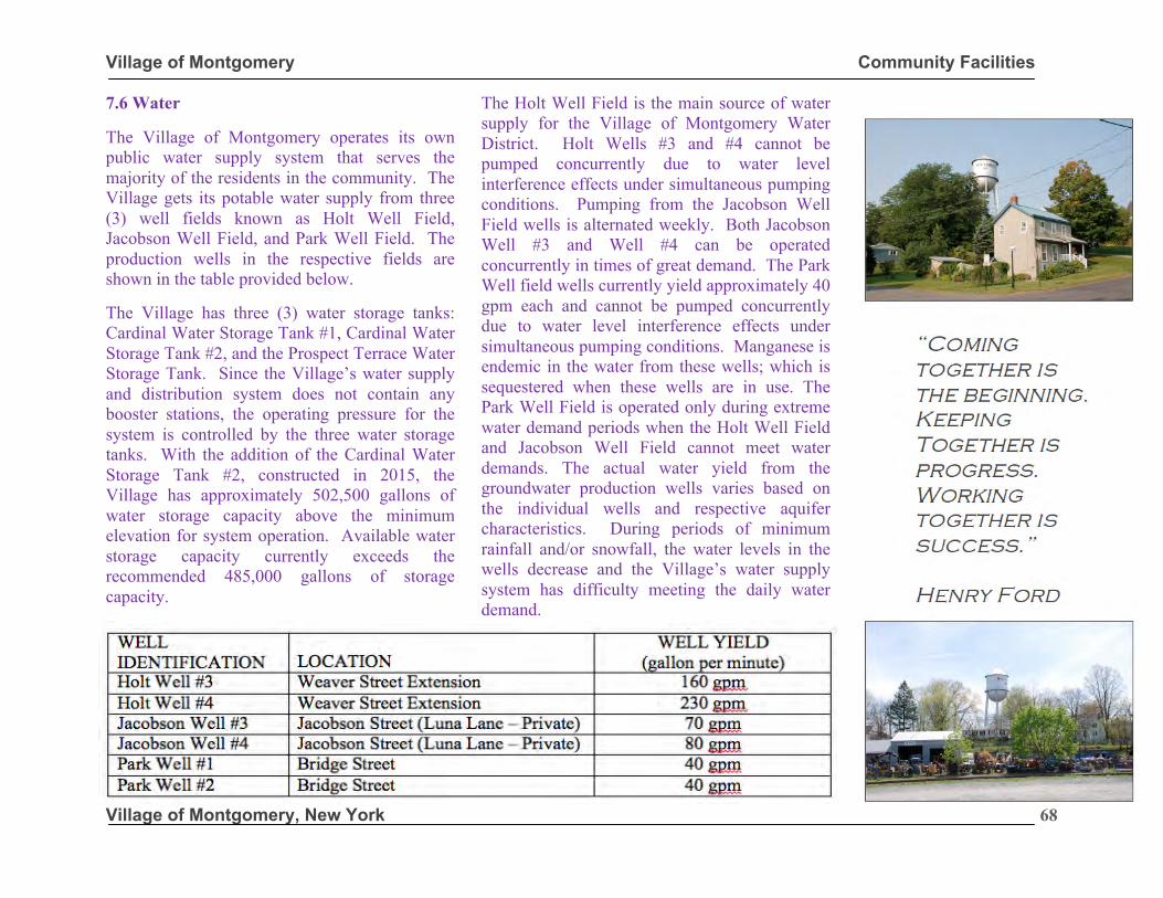
Village of Montgomery Community Facilities
Village of Montgomery, New York
68
7.6 Water The Village of Montgomery operates its own public water supply system that serves the majority of the residents in the community. The Village gets its potable water supply from three (3) well fields known as Holt Well Field, Jacobson Well Field, and Park Well Field. The production wells in the respective fields are shown in the table provided below. The Village has three (3) water storage tanks: Cardinal Water Storage Tank #1, Cardinal Water Storage Tank #2, and the Prospect Terrace Water Storage Tank. Since the Village’s water supply and distribution system does not contain any booster stations, the operating pressure for the system is controlled by the three water storage tanks. With the addition of the Cardinal Water Storage Tank #2, constructed in 2015, the Village has approximately 502,500 gallons of water storage capacity above the minimum elevation for system operation. Available water storage capacity currently exceeds the recommended 485,000 gallons of storage capacity.
The Holt Well Field is the main source of water supply for the Village of Montgomery Water District. Holt Wells #3 and #4 cannot be pumped concurrently due to water level interference effects under simultaneous pumping conditions. Pumping from the Jacobson Well Field wells is alternated weekly. Both Jacobson Well #3 and Well #4 can be operated concurrently in times of great demand. The Park Well field wells currently yield approximately 40 gpm each and cannot be pumped concurrently due to water level interference effects under simultaneous pumping conditions. Manganese is endemic in the water from these wells; which is sequestered when these wells are in use. The Park Well Field is operated only during extreme water demand periods when the Holt Well Field and Jacobson Well Field cannot meet water demands. The actual water yield from the groundwater production wells varies based on the individual wells and respective aquifer characteristics. During periods of minimum rainfall and/or snowfall, the water levels in the wells decrease and the Village’s water supply system has difficulty meeting the daily water demand.
Village of Montgomery Community Facilities
Village of Montgomery, New York
69
In addition to the production limitations, water quality from the well fields has aesthetically changed recently. The water quality from the well fields continues to meet all State drinking water standards. However, increased manganese levels are now present in the Holt Well Field and hydrogen sulfide is present in the Jacobson Well #4, which impacts the water’s appearance and odor. Jacobson Well #4 will remain off-line until a treatment system is installed. Excess manganese produces a brownish color or black particles in the water. Hydrogen sulfide, commonly called sulfur water, gives water a distinctive “rotten egg” odor. Both manganese and hydrogen sulfide are common groundwater wells throughout Orange County. Both well fields require treatment/filtration systems to remediate these naturally occurring conditions and the Village is pursuing treatment/filtration options. To ensure that existing users have a sufficient supply of quality potable water, large scale developers should be required to demonstrate they can provide enough water to satisfy the needs of the proposed development. This can be accomplished by providing suitable well(s) and treatment systems on the development site that would then be integrated into the Village’s water supply system. This is the type of issue that the Planning Board should thoroughly assess as projects go through the State Environmental Quality Review (SEQR) process.
7.7 Sewer The Village Wastewater Treatment Plant has a NYSDEC permitted flow of 500,000 gallons per day (0.5 MGD). The plant treats an average of 351,000 gallons per day but experiences peak flows in excess of 520,000 gallons per day. Plans and technical specifications to upgrade and expand the existing wastewater treatment plant to treat and discharge 0.75 MGD have been approved by the New York State Department of Environmental Conservation; however, funding availability has precluded construction of the upgrade and expansion. There are large undeveloped properties in the southern portion of the Village that, if developed in a short period of time, could produce volumes of wastewater that could result in the existing wastewater treatment plant exceeding its permitted capacity. It is important that the Planning Board carefully review development proposals in the context of the wastewater treatment plant’s available sewage capacity and funding limitations of the approved expansion. Again, the Planning Board should use the SEQR process to assess the impacts a development will have on wastewater capacity along with potential mitigation measures that could be provided by the developer(s).
“Coming together is the beginning. Keeping Together is progress. Working together is success.” Henry Ford
“To ensure that existing users have a sufficient supply of quality potable water, large scale developers should be required to demonstrate they can provide enough water to satisfy the needs of the proposed development. This can be accomplished by providing suitable well(s) and treatment systems on the development site that would then be integrated into the Village’s water supply system.”
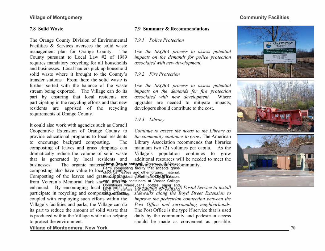
Village of Montgomery Community Facilities
Village of Montgomery, New York
70
7.8 Solid Waste The Orange County Division of Environmental Facilities & Services oversees the solid waste management plan for Orange County. The County pursuant to Local Law #2 of 1989 requires mandatory recycling for all households and businesses. Local haulers pick up household solid waste where it brought to the County’s transfer stations. From there the solid waste is further sorted with the balance of the waste stream being exported. The Village can do its part by ensuring that local residents are participating in the recycling efforts and that new residents are apprised of the recycling requirements of Orange County. It could also work with agencies such as Cornell Cooperative Extension of Orange County to provide educational programs to local residents to encourage backyard composting. The composting of leaves and grass clippings can dramatically reduce the volume of solid waste that is generated by local residents and businesses. The organic materials that are composting also have value to local gardeners. Composting of the leaves and grass clippings from Veteran’s Memorial Park should also be enhanced. By encouraging local residents to participate in recycling and composting efforts, coupled with employing such efforts within the Village’s facilities and parks, the Village can do its part to reduce the amount of solid waste that is produced within the Village while also helping to protect the environment.
7.9 Summary & Recommendations 7.9.1 Police Protection Use the SEQRA process to assess potential impacts on the demands for police protection associated with new development. 7.9.2 Fire Protection Use the SEQRA process to assess potential impacts on the demands for fire protection associated with new development. Where upgrades are needed to mitigate impacts, developers should contribute to the cost. 7.9.3 Library Continue to assess the needs to the Library as the community continues to grow. The American Library Association recommends that libraries maintain two (2) volumes per capita. As the Village’s population continues to grow additional resources will be needed to meet the growing needs of the community. 7.9.4 Post Office Coordinate with the US Postal Service to install sidewalks along the Boyd Street Extension to improve the pedestrian connection between the Post Office and surrounding neighborhoods. The Post Office is the type if service that is used daily by the community and pedestrian access should be made as convenient as possible.
Above (top to bottom): Greenway @ Vassar Farm composting facility that accepts grass clippings, leaves and other organic material; Beacon Composting Facility in City of Beacon; and recycling containers at Vassar College Dormitories where cans, bottles, paper and organic materials are collected for recycling and composting.
Village of Montgomery Community Facilities
Village of Montgomery, New York
71
7.9.5 Schools The Planning Board can use the environmental review process to require an Environmental Impact Statement (EIS) for large-scale developments that are likely to result in increases in the number of school-age children. Within the EIS, developers would be required to identify whether the development will create a demand for additional community services – such as schools. Where impacts are identified, the developer would be required to provide mitigation measures. 7.9.6 Water To ensure that existing users have a sufficient supply of quality potable water, large scale developers should be required to demonstrate they can provide enough water to satisfy the needs of the proposed development. This can be accomplished by providing suitable well(s) and treatment systems on the development site that would then be integrated into the Village’s water supply system. 7.9.7 Sewer It is important that the Planning Board carefully review development proposals in the context of the wastewater treatment plant’s available sewage capacity and funding limitations of the approved expansion.
Again, the Planning Board should use the SEQR process to assess the impacts a development will have on wastewater capacity along with potential mitigation measures that could be provided by the developer(s). 7.9.8 Solid Waste By encouraging local residents to participate in recycling and composting efforts, coupled with employing such efforts within the Village’s facilities and parks, the Village can do its part to reduce the amount of solid waste that is produced within the Village while also helping to protect the environment.
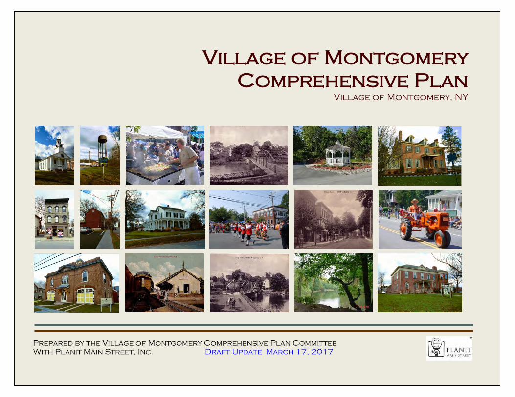
Village of Montgomery Downtown Revitalization
Village of Montgomery, New York
1
Village of Montgomery Comprehensive Plan
Village of Montgomery, NY
Prepared by the Village of Montgomery Comprehensive Plan Committee With Planit Main Street, Inc. Draft Update March 17, 2017
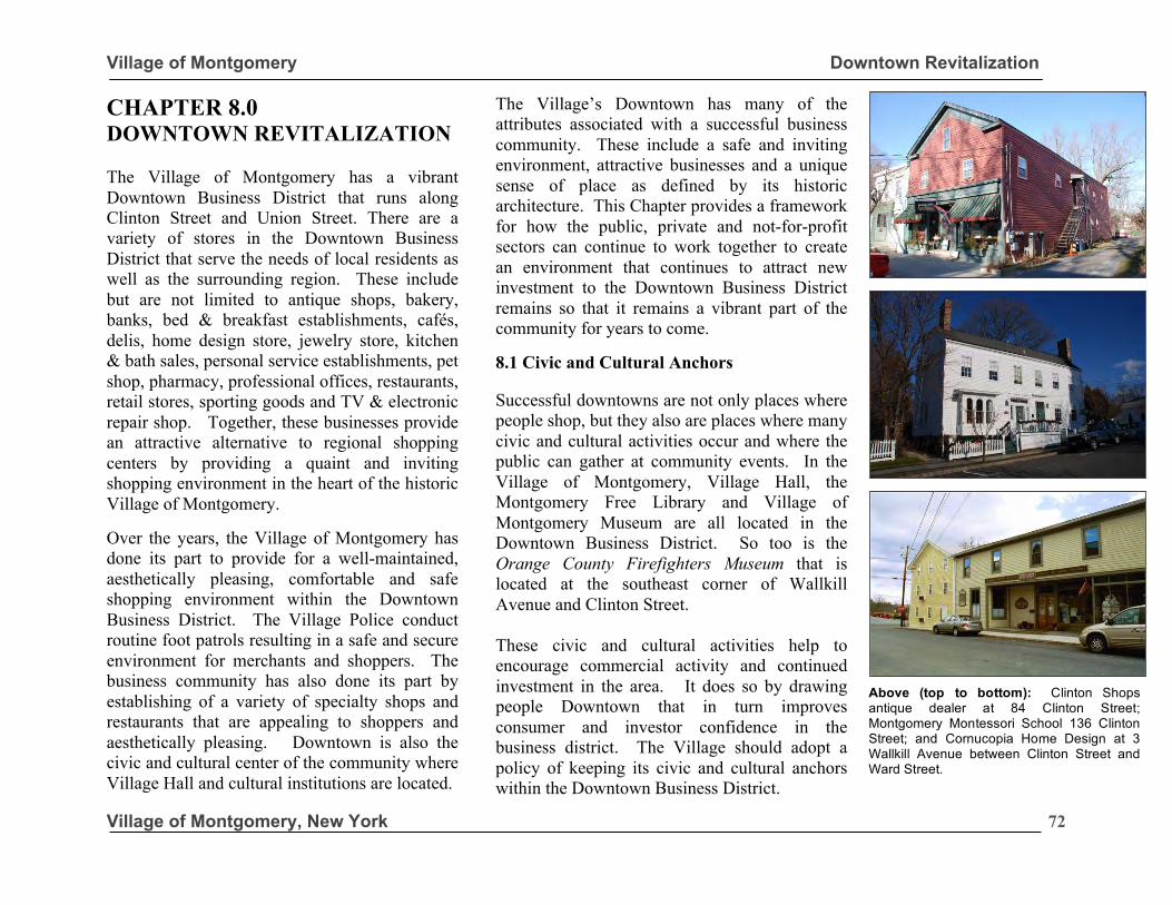
Village of Montgomery Downtown Revitalization
Village of Montgomery, New York
72
CHAPTER 8.0 DOWNTOWN REVITALIZATION The Village of Montgomery has a vibrant Downtown Business District that runs along Clinton Street and Union Street. There are a variety of stores in the Downtown Business District that serve the needs of local residents as well as the surrounding region. These include but are not limited to antique shops, bakery, banks, bed & breakfast establishments, cafés, delis, home design store, jewelry store, kitchen & bath sales, personal service establishments, pet shop, pharmacy, professional offices, restaurants, retail stores, sporting goods and TV & electronic repair shop. Together, these businesses provide an attractive alternative to regional shopping centers by providing a quaint and inviting shopping environment in the heart of the historic Village of Montgomery. Over the years, the Village of Montgomery has done its part to provide for a well-maintained, aesthetically pleasing, comfortable and safe shopping environment within the Downtown Business District. The Village Police conduct routine foot patrols resulting in a safe and secure environment for merchants and shoppers. The business community has also done its part by establishing of a variety of specialty shops and restaurants that are appealing to shoppers and aesthetically pleasing. Downtown is also the civic and cultural center of the community where Village Hall and cultural institutions are located.
The Village’s Downtown has many of the attributes associated with a successful business community. These include a safe and inviting environment, attractive businesses and a unique sense of place as defined by its historic architecture. This Chapter provides a framework for how the public, private and not-for-profit sectors can continue to work together to create an environment that continues to attract new investment to the Downtown Business District remains so that it remains a vibrant part of the community for years to come. 8.1 Civic and Cultural Anchors Successful downtowns are not only places where people shop, but they also are places where many civic and cultural activities occur and where the public can gather at community events. In the Village of Montgomery, Village Hall, the Montgomery Free Library and Village of Montgomery Museum are all located in the Downtown Business District. So too is the Orange County Firefighters Museum that is located at the southeast corner of Wallkill Avenue and Clinton Street. These civic and cultural activities help to encourage commercial activity and continued investment in the area. It does so by drawing people Downtown that in turn improves consumer and investor confidence in the business district. The Village should adopt a policy of keeping its civic and cultural anchors within the Downtown Business District.
Above (top to bottom): Clinton Shops antique dealer at 84 Clinton Street; Montgomery Montessori School 136 Clinton Street; and Cornucopia Home Design at 3 Wallkill Avenue between Clinton Street and Ward Street.
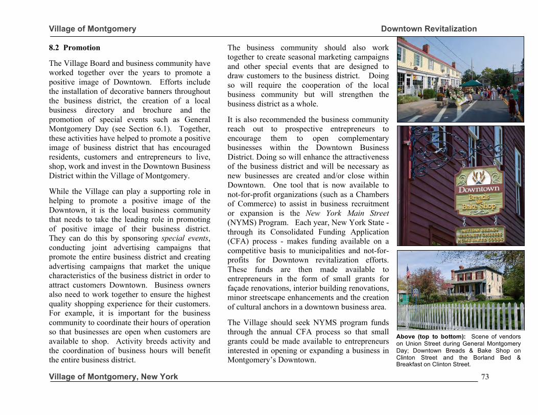
Village of Montgomery Downtown Revitalization
Village of Montgomery, New York
73
8.2 Promotion
The Village Board and business community have worked together over the years to promote a positive image of Downtown. Efforts include the installation of decorative banners throughout the business district, the creation of a local business directory and brochure and the promotion of special events such as General Montgomery Day (see Section 6.1). Together, these activities have helped to promote a positive image of business district that has encouraged residents, customers and entrepreneurs to live, shop, work and invest in the Downtown Business District within the Village of Montgomery. While the Village can play a supporting role in helping to promote a positive image of the Downtown, it is the local business community that needs to take the leading role in promoting of positive image of their business district. They can do this by sponsoring special events, conducting joint advertising campaigns that promote the entire business district and creating advertising campaigns that market the unique characteristics of the business district in order to attract customers Downtown. Business owners also need to work together to ensure the highest quality shopping experience for their customers. For example, it is important for the business community to coordinate their hours of operation so that businesses are open when customers are available to shop. Activity breeds activity and the coordination of business hours will benefit the entire business district.
The business community should also work together to create seasonal marketing campaigns and other special events that are designed to draw customers to the business district. Doing so will require the cooperation of the local business community but will strengthen the business district as a whole. It is also recommended the business community reach out to prospective entrepreneurs to encourage them to open complementary businesses within the Downtown Business District. Doing so will enhance the attractiveness of the business district and will be necessary as new businesses are created and/or close within Downtown. One tool that is now available to not-for-profit organizations (such as a Chambers of Commerce) to assist in business recruitment or expansion is the New York Main Street (NYMS) Program. Each year, New York State -through its Consolidated Funding Application (CFA) process - makes funding available on a competitive basis to municipalities and not-for-profits for Downtown revitalization efforts. These funds are then made available to entrepreneurs in the form of small grants for façade renovations, interior building renovations, minor streetscape enhancements and the creation of cultural anchors in a downtown business area. The Village should seek NYMS program funds through the annual CFA process so that small grants could be made available to entrepreneurs interested in opening or expanding a business in Montgomery’s Downtown.
Above (top to bottom): Scene of vendors on Union Street during General Montgomery Day; Downtown Breads & Bake Shop on Clinton Street and the Borland Bed & Breakfast on Clinton Street.
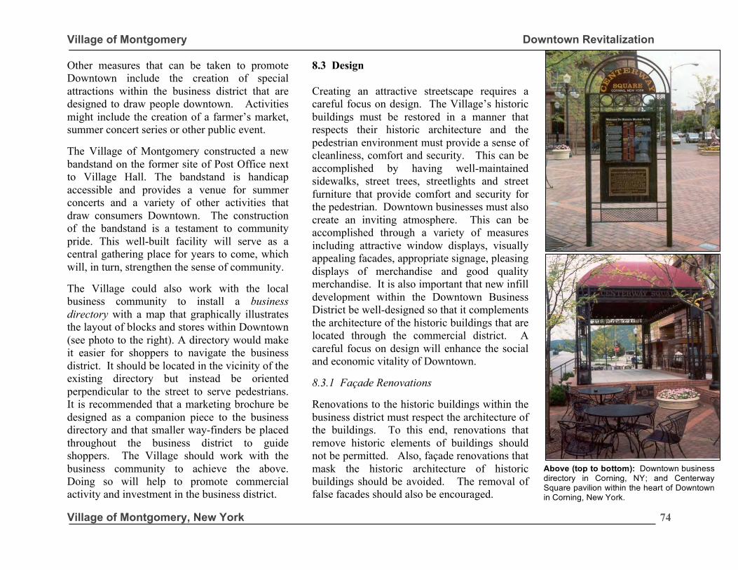
Village of Montgomery Downtown Revitalization
Village of Montgomery, New York
74
Other measures that can be taken to promote Downtown include the creation of special attractions within the business district that are designed to draw people downtown. Activities might include the creation of a farmer’s market, summer concert series or other public event. The Village of Montgomery constructed a new bandstand on the former site of Post Office next to Village Hall. The bandstand is handicap accessible and provides a venue for summer concerts and a variety of other activities that draw consumers Downtown. The construction of the bandstand is a testament to community pride. This well-built facility will serve as a central gathering place for years to come, which will, in turn, strengthen the sense of community. The Village could also work with the local business community to install a business directory with a map that graphically illustrates the layout of blocks and stores within Downtown (see photo to the right). A directory would make it easier for shoppers to navigate the business district. It should be located in the vicinity of the existing directory but instead be oriented perpendicular to the street to serve pedestrians. It is recommended that a marketing brochure be designed as a companion piece to the business directory and that smaller way-finders be placed throughout the business district to guide shoppers. The Village should work with the business community to achieve the above. Doing so will help to promote commercial activity and investment in the business district.
8.3 Design Creating an attractive streetscape requires a careful focus on design. The Village’s historic buildings must be restored in a manner that respects their historic architecture and the pedestrian environment must provide a sense of cleanliness, comfort and security. This can be accomplished by having well-maintained sidewalks, street trees, streetlights and street furniture that provide comfort and security for the pedestrian. Downtown businesses must also create an inviting atmosphere. This can be accomplished through a variety of measures including attractive window displays, visually appealing facades, appropriate signage, pleasing displays of merchandise and good quality merchandise. It is also important that new infill development within the Downtown Business District be well-designed so that it complements the architecture of the historic buildings that are located through the commercial district. A careful focus on design will enhance the social and economic vitality of Downtown. 8.3.1 Façade Renovations Renovations to the historic buildings within the business district must respect the architecture of the buildings. To this end, renovations that remove historic elements of buildings should not be permitted. Also, façade renovations that mask the historic architecture of historic buildings should be avoided. The removal of false facades should also be encouraged.
Above (top to bottom): Downtown business directory in Corning, NY; and Centerway Square pavilion within the heart of Downtown in Corning, New York.
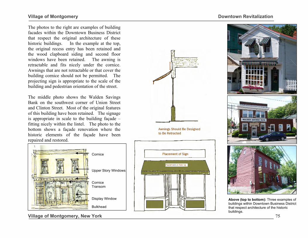
Village of Montgomery Downtown Revitalization
Village of Montgomery, New York
75
The photos to the right are examples of building facades within the Downtown Business District that respect the original architecture of these historic buildings. In the example at the top, the original recess entry has been retained and the wood clapboard siding and second floor windows have been retained. The awning is retractable and fits nicely under the cornice. Awnings that are not retractable or that cover the building cornice should not be permitted. The projecting sign is appropriate to the scale of the building and pedestrian orientation of the street. The middle photo shows the Walden Savings Bank on the southwest corner of Union Street and Clinton Street. Most of the original features of this building have been retained. The signage is appropriate in scale to the building façade – fitting nicely within the lintel. The photo to the bottom shows a façade renovation where the historic elements of the façade have been repaired and restored.
Above (top to bottom): Three examples of buildings within Downtown Business District that respect architecture of the historic buildings.
Cornice Upper Story Windows Cornice Transom Display Window Bulkhead
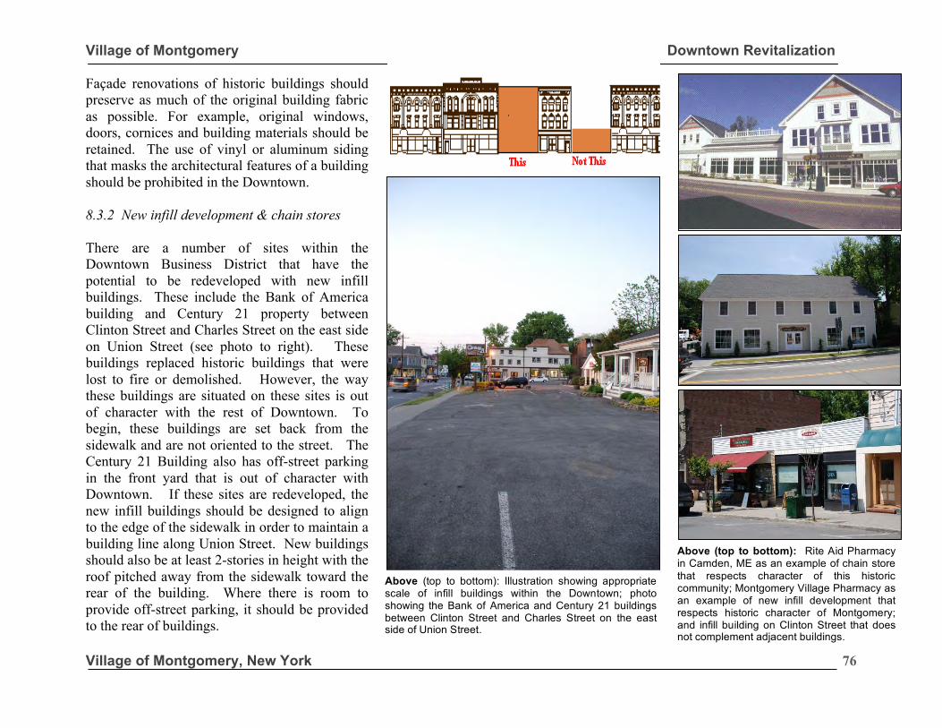
Village of Montgomery Downtown Revitalization
Village of Montgomery, New York
76
Façade renovations of historic buildings should preserve as much of the original building fabric as possible. For example, original windows, doors, cornices and building materials should be retained. The use of vinyl or aluminum siding that masks the architectural features of a building should be prohibited in the Downtown. 8.3.2 New infill development & chain stores There are a number of sites within the Downtown Business District that have the potential to be redeveloped with new infill buildings. These include the Bank of America building and Century 21 property between Clinton Street and Charles Street on the east side on Union Street (see photo to right). These buildings replaced historic buildings that were lost to fire or demolished. However, the way these buildings are situated on these sites is out of character with the rest of Downtown. To begin, these buildings are set back from the sidewalk and are not oriented to the street. The Century 21 Building also has off-street parking in the front yard that is out of character with Downtown. If these sites are redeveloped, the new infill buildings should be designed to align to the edge of the sidewalk in order to maintain a building line along Union Street. New buildings should also be at least 2-stories in height with the roof pitched away from the sidewalk toward the rear of the building. Where there is room to provide off-street parking, it should be provided to the rear of buildings.
Above (top to bottom): Rite Aid Pharmacy in Camden, ME as an example of chain store that respects character of this historic community; Montgomery Village Pharmacy as an example of new infill development that respects historic character of Montgomery; and infill building on Clinton Street that does not complement adjacent buildings.
Above (top to bottom): Illustration showing appropriate scale of infill buildings within the Downtown; photo showing the Bank of America and Century 21 buildings between Clinton Street and Charles Street on the east side of Union Street.
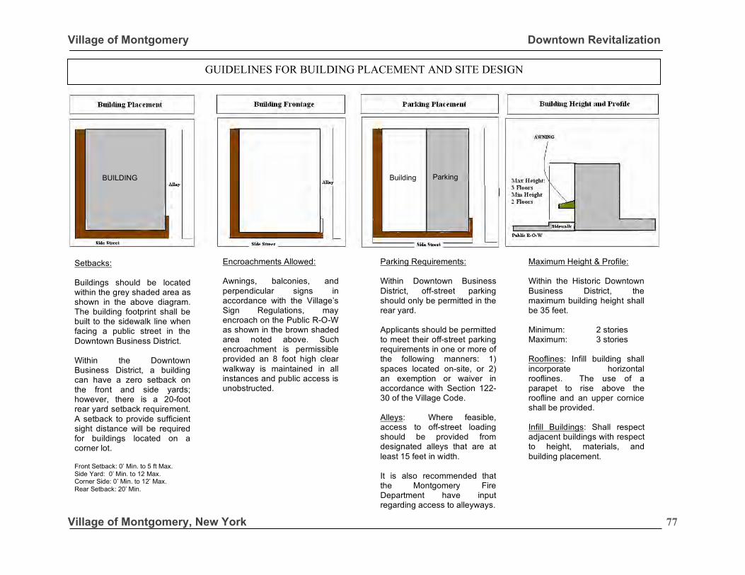
Village of Montgomery Downtown Revitalization
Village of Montgomery, New York
77
Setbacks: Buildings should be located within the grey shaded area as shown in the above diagram. The building footprint shall be built to the sidewalk line when facing a public street in the Downtown Business District. Within the Downtown Business District, a building can have a zero setback on the front and side yards; however, there is a 20-foot rear yard setback requirement. A setback to provide sufficient sight distance will be required for buildings located on a corner lot. Front Setback: 0’ Min. to 5 ft Max. Side Yard: 0’ Min. to 12 Max. Corner Side: 0’ Min. to 12’ Max. Rear Setback: 20’ Min.
Encroachments Allowed: Awnings, balconies, and perpendicular signs in accordance with the Village’s Sign Regulations, may encroach on the Public R-O-W as shown in the brown shaded area noted above. Such encroachment is permissible provided an 8 foot high clear walkway is maintained in all instances and public access is unobstructed.
Parking Requirements: Within Downtown Business District, off-street parking should only be permitted in the rear yard. Applicants should be permitted to meet their off-street parking requirements in one or more of the following manners: 1) spaces located on-site, or 2) an exemption or waiver in accordance with Section 122-30 of the Village Code. Alleys: Where feasible, access to off-street loading should be provided from designated alleys that are at least 15 feet in width. It is also recommended that the Montgomery Fire Department have input regarding access to alleyways.
Maximum Height & Profile: Within the Historic Downtown Business District, the maximum building height shall be 35 feet. Minimum: 2 stories Maximum: 3 stories Rooflines: Infill building shall incorporate horizontal rooflines. The use of a parapet to rise above the roofline and an upper cornice shall be provided. Infill Buildings: Shall respect adjacent buildings with respect to height, materials, and building placement.
BUILDING Parking Building
GUIDELINES FOR BUILDING PLACEMENT AND SITE DESIGN
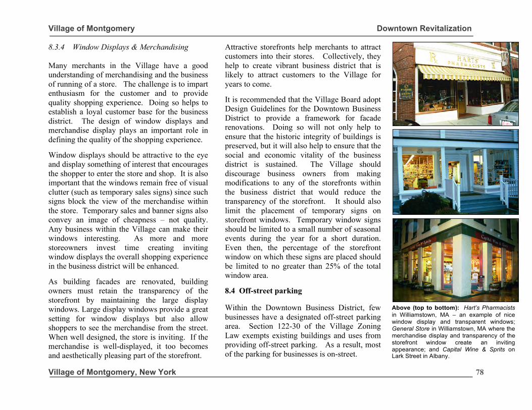
Village of Montgomery Downtown Revitalization
Village of Montgomery, New York
78
8.3.4 Window Displays & Merchandising Many merchants in the Village have a good understanding of merchandising and the business of running of a store. The challenge is to impart enthusiasm for the customer and to provide quality shopping experience. Doing so helps to establish a loyal customer base for the business district. The design of window displays and merchandise display plays an important role in defining the quality of the shopping experience. Window displays should be attractive to the eye and display something of interest that encourages the shopper to enter the store and shop. It is also important that the windows remain free of visual clutter (such as temporary sales signs) since such signs block the view of the merchandise within the store. Temporary sales and banner signs also convey an image of cheapness – not quality. Any business within the Village can make their windows interesting. As more and more storeowners invest time creating inviting window displays the overall shopping experience in the business district will be enhanced. As building facades are renovated, building owners must retain the transparency of the storefront by maintaining the large display windows. Large display windows provide a great setting for window displays but also allow shoppers to see the merchandise from the street. When well designed, the store is inviting. If the merchandise is well-displayed, it too becomes and aesthetically pleasing part of the storefront.
Attractive storefronts help merchants to attract customers into their stores. Collectively, they help to create vibrant business district that is likely to attract customers to the Village for years to come. It is recommended that the Village Board adopt Design Guidelines for the Downtown Business District to provide a framework for facade renovations. Doing so will not only help to ensure that the historic integrity of buildings is preserved, but it will also help to ensure that the social and economic vitality of the business district is sustained. The Village should discourage business owners from making modifications to any of the storefronts within the business district that would reduce the transparency of the storefront. It should also limit the placement of temporary signs on storefront windows. Temporary window signs should be limited to a small number of seasonal events during the year for a short duration. Even then, the percentage of the storefront window on which these signs are placed should be limited to no greater than 25% of the total window area. 8.4 Off-street parking Within the Downtown Business District, few businesses have a designated off-street parking area. Section 122-30 of the Village Zoning Law exempts existing buildings and uses from providing off-street parking. As a result, most of the parking for businesses is on-street.
Above (top to bottom): Hart’s Pharmacists in Williamstown, MA – an example of nice window display and transparent windows; General Store in Williamstown, MA where the merchandise display and transparency of the storefront window create an inviting appearance; and Capital Wine & Sprits on Lark Street in Albany.
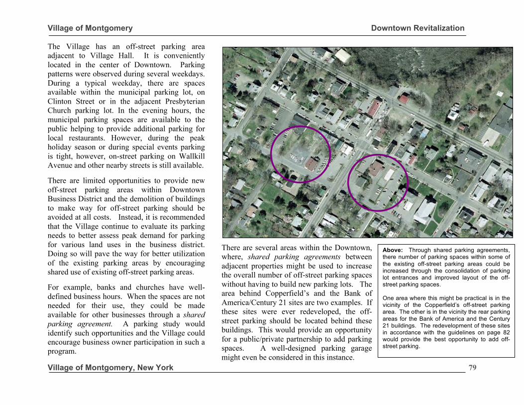
Village of Montgomery Downtown Revitalization
Village of Montgomery, New York
79
The Village has an off-street parking area adjacent to Village Hall. It is conveniently located in the center of Downtown. Parking patterns were observed during several weekdays. During a typical weekday, there are spaces available within the municipal parking lot, on Clinton Street or in the adjacent Presbyterian Church parking lot. In the evening hours, the municipal parking spaces are available to the public helping to provide additional parking for local restaurants. However, during the peak holiday season or during special events parking is tight, however, on-street parking on Wallkill Avenue and other nearby streets is still available.
There are limited opportunities to provide new off-street parking areas within Downtown Business District and the demolition of buildings to make way for off-street parking should be avoided at all costs. Instead, it is recommended that the Village continue to evaluate its parking needs to better assess peak demand for parking for various land uses in the business district. Doing so will pave the way for better utilization of the existing parking areas by encouraging shared use of existing off-street parking areas. For example, banks and churches have well-defined business hours. When the spaces are not needed for their use, they could be made available for other businesses through a shared parking agreement. A parking study would identify such opportunities and the Village could encourage business owner participation in such a program.
There are several areas within the Downtown, where, shared parking agreements between adjacent properties might be used to increase the overall number of off-street parking spaces without having to build new parking lots. The area behind Copperfield’s and the Bank of America/Century 21 sites are two examples. If these sites were ever redeveloped, the off-street parking should be located behind these buildings. This would provide an opportunity for a public/private partnership to add parking spaces. A well-designed parking garage might even be considered in this instance.
Above: Through shared parking agreements, there number of parking spaces within some of the existing off-street parking areas could be increased through the consolidation of parking lot entrances and improved layout of the off-street parking spaces. One area where this might be practical is in the vicinity of the Copperfield’s off-street parking area. The other is in the vicinity the rear parking areas for the Bank of America and the Century 21 buildings. The redevelopment of these sites in accordance with the guidelines on page 82 would provide the best opportunity to add off-street parking.
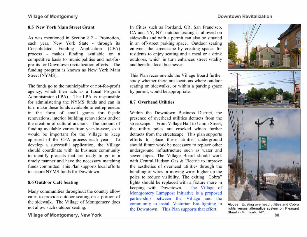
Village of Montgomery Downtown Revitalization
Village of Montgomery, New York
80
8.5 New York Main Street Grant As was mentioned in Section 8.2 – Promotion, each year, New York State - through its Consolidated Funding Application (CFA) process - makes funding available on a competitive basis to municipalities and not-for-profits for Downtown revitalization efforts. The funding program is known as New York Main Street (NYMS). The funds go to the municipality or not-for-profit agency, which then acts as a Local Program Administrator (LPA). The LPA is responsible for administering the NYMS funds and can in turn make these funds available to entrepreneurs in the form of small grants for façade renovations, interior building renovations and/or the creation of cultural anchors. The amount of funding available varies from year-to-year, so it would be important for the Village to keep apprised of the CFA process each year. To develop a successful application, the Village should coordinate with its business community to identify projects that are ready to go in a timely manner and have the necessary matching funds committed. This Plan supports local efforts to secure NYMS funds for Downtown. 8.6 Outdoor Café Seating Many communities throughout the country allow cafés to provide outdoor seating on a portion of the sidewalk. The Village of Montgomery does not allow such outdoor seating.
In Cities such as Portland, OR, San Francisco, CA and NY, NY, outdoor seating is allowed on sidewalks and with a permit can also be situated in an off-street parking space. Outdoor seating enlivens the streetscape by creating spaces for residents to enjoy seating and a meal or a drink outdoors, which in turn enhances street vitality and benefits local businesses. This Plan recommends the Village Board further study whether there are locations where outdoor seating on sidewalks, or within a parking space by permit, would be appropriate. 8.7 Overhead Utilities Within the Downtown Business District, the presence of overhead utilities detracts from the streetscape. From Village Hall to Union Street, the utility poles are crooked which further detracts from the streetscape. This plan supports efforts to place these utilities underground should future work be necessary to replace other underground infrastructure such as water and sewer pipes. The Village Board should work with Central Hudson Gas & Electric to improve the aesthetics of overhead utilities through the bundling of wires or moving wires higher up the poles to reduce visibility. The exiting “Cobra” lights should be replaced with a fixture more in keeping with Downtown. The Village of Montgomery Lamppost Initiative is a proposed partnership between the Village and the community to install Victorian Era lighting in the Downtown. This Plan supports that effort.
Above: Existing overhead utilities and Cobra lights versus alternative system on Pleasant Street in Monticello, NY.
Village of Montgomery Downtown Revitalization
Village of Montgomery, New York
81
8.8 Summary of Recommendations 8.8.1 Civic and Cultural Anchors: Keep civic and cultural anchors within the Downtown Business District. 8.8.2. Promotion: Work with businesses to create a Downtown Business Directory & Brochure. A directory should be erected near the old Post Office site on Clinton Street showing the layout of buildings in the Downtown with a corresponding legend. 8.8.3 Design: Ensure that building façade renovations respect the original architecture of building within the Downtown Business District. The thing that makes Montgomery’s Downtown unique is its historic architecture. The Village needs to take proactive measures to ensure that the integrity of its historic Downtown buildings is retained. The Village must ensure quality design related to all aspects of the Downtown Business District. This includes the appearance of the streetscape, building maintenance, signage, and other factors that contribute to the overall image of the business district. Create Downtown Design Guidelines. The Village should create Downtown Design Guidelines that can be used by building owners as they plan for façade renovations and by the
AHRB as they review proposals to undertake façade renovations. The Design Guidelines would also address infill buildings that could be developed on vacant lots or redeveloped sites in the Downtown Area. Create a Downtown Historic District along Clinton Street between the Academy Hill and Bridge Street Historic Districts. This area sits between the Village’s existing historic districts and includes a number of historically significant buildings. The creation of an historic district covering this area is recommended to protect the integrity of the Village’s Downtown. 8.8.4 Parking: Encourage the creation of shared parking agreements. Shared parking agreements could be used to ensure that existing spaces are fully utilized in the most effective manner. Shared parking agreements between adjacent properties might be used to create a more logical configuration of parking spaces that would result in more off-street parking spaces without creating new lots. There are limited opportunities to create new parking lots within the Downtown District and removing buildings to create new off-street parking area is not recommended. 8.8.5 Café Outdoor Seating Study whether there are locations where outdoor seating on sidewalks, or within a parking space by permit, would be appropriate.
“Maintain our Downtown as the economic, cultural and governmental center of the community and encourage well-design infill development to strengthen the integrity of the core.”
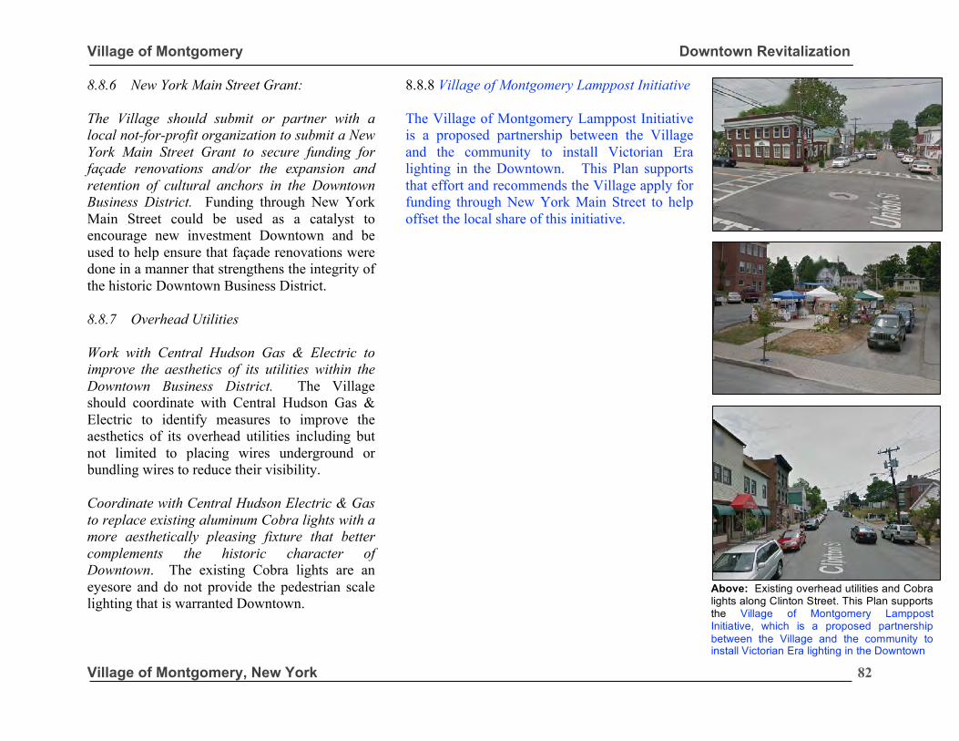
Village of Montgomery Downtown Revitalization
Village of Montgomery, New York
82
8.8.6 New York Main Street Grant: The Village should submit or partner with a local not-for-profit organization to submit a New York Main Street Grant to secure funding for façade renovations and/or the expansion and retention of cultural anchors in the Downtown Business District. Funding through New York Main Street could be used as a catalyst to encourage new investment Downtown and be used to help ensure that façade renovations were done in a manner that strengthens the integrity of the historic Downtown Business District. 8.8.7 Overhead Utilities Work with Central Hudson Gas & Electric to improve the aesthetics of its utilities within the Downtown Business District. The Village should coordinate with Central Hudson Gas & Electric to identify measures to improve the aesthetics of its overhead utilities including but not limited to placing wires underground or bundling wires to reduce their visibility. Coordinate with Central Hudson Electric & Gas to replace existing aluminum Cobra lights with a more aesthetically pleasing fixture that better complements the historic character of Downtown. The existing Cobra lights are an eyesore and do not provide the pedestrian scale lighting that is warranted Downtown.
8.8.8 Village of Montgomery Lamppost Initiative The Village of Montgomery Lamppost Initiative is a proposed partnership between the Village and the community to install Victorian Era lighting in the Downtown. This Plan supports that effort and recommends the Village apply for funding through New York Main Street to help offset the local share of this initiative.
Above: Existing overhead utilities and Cobra lights along Clinton Street. This Plan supports the Village of Montgomery Lamppost Initiative, which is a proposed partnership between the Village and the community to install Victorian Era lighting in the Downtown
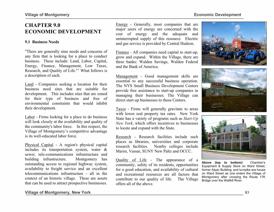
Village of Montgomery Economic Development
Village of Montgomery, New York
83
CHAPTER 9.0 ECONOMIC DEVELOPMENT 9.1 Business Needs "There are generally nine needs and concerns of any firm that is looking for a place to conduct business. These include: Land, Labor, Capital, Energy, Finance, Management, Low Taxes, Research, and Quality of Life." i What follows is a description of each. Land - Companies seeking a location for their business need sites that are suitable for development. This includes sites that are zoned for their type of business and free of environmental constraints that would inhibit their development. Labor - Firms looking for a place to do business will look closely at the availability and quality of the community's labor force. In this respect, the Village of Montgomery’s competitive advantage is its well-educated labor force. Physical Capital - A region's physical capital includes its transportation system, water & sewer, tele-communications infrastructure and building infrastructure. Montgomery has outstanding access to regional highway system, availability to freight service and an excellent telecommunications infrastructure - all in the context of an historic village. These are assets that can be used to attract prospective businesses.
Energy - Generally, most companies that are major users of energy are concerned with the cost of energy and the adequate and uninterrupted supply of this resource. Electric and gas service is provided by Central Hudson. Finance - All companies need capital to start-up, grow and expand. Within the Village, there are three banks: Walden Savings, Walden Federal and the Bank of America. Management - Good management skills are essential to any successful business operation. The NYS Small Business Development Centers provide free assistance to start-up companies in managing their businesses. The Village can direct start-up businesses to these Centers. Taxes - Firms will generally gravitate to areas with lower real property tax rates. New York State has a variety of programs such as Start-Up New York, which offers incentives to businesses to locate and expand with the State. Research - Research facilities include such places as libraries, universities and corporate research facilities. Nearby colleges include Marist, Vassar, SUNY New Paltz and OCCC. Quality of Life - The appearance of a community, safety of its residents, opportunities for a good education, and availability of cultural and recreational resources are all factors that contribute to our quality of life. The Village offers all of the above.
Above (top to bottom): Chamber’s Equipment & Supply Store on Ward Street; former Alpac Building; and turnpike era house on Ward Street as one enters the Village of Montgomery after crossing the Route 17K Bridge over the Wallkill River.
Village of Montgomery Economic Development
Village of Montgomery, New York
84
9.2 Shovel-Ready Sites Shovel-ready refers to a process where potential development sites are pre-permitted for future development. The Build Now-NY Program provides funding to help pay for professional services related to engineering, environmental assessments, and legal support needed to pre-permit a development site. Pre-permitting insures that the necessary approvals are already in place to allow construction and enables businesses to get a shovel in the ground in months rather than years. Pre-permitting will make the Village more attractive for developers. The Build Now New York program is geared toward High Tech Manufacturing, Warehouse and Logistics Centers and Multi-Tenant and Technology Parks. There are still areas in the Village that are zoned Industrial and that have few environmental constraints for future development. Participation in the Build-Now New York Program may help in the marketing of such sites for such development.
9.3 Other Measures
The following are a few measures that should be further explored by the Village. § Work with NYS ESDC, Orange County
Partnership and IDA to develop a coherent strategy to attract businesses to the Village of Montgomery;
§ Conduct an inventory of office, manufacturing, and industrial floor space that is available in the Village by square footage, class of space, and site location so tenants can be matched with suitable space in a timely and effective manner;
§ Secure funding through the Empire State Development Corporation’s Build Now New York Shovel-Ready Fund to assess public infrastructure needs and to conduct studies to determine the feasibility of commercial and industrial development or to construct necessary supporting public infrastructure;
§ Reach out to existing businesses to identify complementary businesses that the Village should be trying to attract;
§ Streamline the development review process for businesses that are looking to expand within the Village;
§ Ensure existing businesses are made aware of the economic development programs that are available to help such as: NYMS, Start-up New York and Build Now-NY;
§ Explore opportunities for growth in the arts & entertainment, hospitality and heritage tourism industries; and
§ Create a Planned Business Park Overlay District in order to allow for the development of light industrial parks in the context of a Planned Unit Development. This will give developers greater flexibility in design and phasing of their development while ensuring better and more compatible design of light industrial uses within the Village’s I-1 Industrial District.
“Streamline the development review process for businesses that are looking to expand and ensure that existing businesses are made aware of the economic development programs that could be used to help them to grow.”
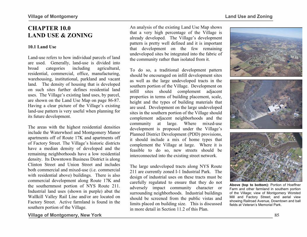
Village of Montgomery Land Use and Zoning
Village of Montgomery, New York
85
CHAPTER 10.0 LAND USE & ZONING 10.1 Land Use Land-use refers to how individual parcels of land are used. Generally, land-use is divided into broad categories including agricultural, residential, commercial, office, manufacturing, warehousing, institutional, parkland and vacant land. The density of housing that is developed on such sites further defines residential land uses. The Village’s existing land uses, by parcel, are shown on the Land Use Map on page 86-87. Having a clear picture of the Village’s existing land-use pattern is very useful when planning for its future development. The areas with the highest residential densities include the Waterwheel and Montgomery Manor apartments off of Route 17K and apartments off of Factory Street. The Village’s historic districts have a median density of developed and the remaining neighborhoods have a low residential density. Its Downtown Business District is along Clinton Street and Union Street and includes both commercial and mixed-use (i.e. commercial with residential above) buildings. There is also commercial development along Route 17K and the southernmost portion of NYS Route 211. Industrial land uses (shown in purple) abut the Wallkill Valley Rail Line and/or are located on Factory Street. Active farmland is found in the southern portion of the Village.
An analysis of the existing Land Use Map shows that a very high percentage of the Village is already developed. The Village’s development pattern is pretty well defined and it is important that development on the few remaining undeveloped sites be integrated into the fabric of the community rather than isolated from it. To do so, a traditional development pattern should be encouraged on infill development sites as well as the large undeveloped tracts in the southern portion of the Village. Development on infill sites should complement adjacent properties in terms of building placement, scale, height and the types of building materials that are used. Development on the large undeveloped sites in the southern portion of the Village should complement adjacent neighborhoods and the community at large. Where mixed-use development is proposed under the Village’s Planned District Development (PDD) provisions, it should include a mix of home types that complement the Village at large. Where it is feasible to do so, new streets should be interconnected into the existing street network. The large undeveloped tracts along NYS Route 211 are currently zoned I-1 Industrial Park. The design of industrial uses on these tracts must be carefully regulated to ensure that they do not adversely impact community character or surrounding neighborhoods. Industrial buildings should be screened from the public vistas and limits placed on building size. This is discussed in more detail in Section 11.2 of this Plan.
Above (top to bottom): Portion of Hoeffner Farm and other farmland in southern portion of the Village; view of Montgomery Worsted Mill and Factory Street; and aerial view showing Railroad Avenue, Downtown and ball fields at Veteran’s Memorial Park.
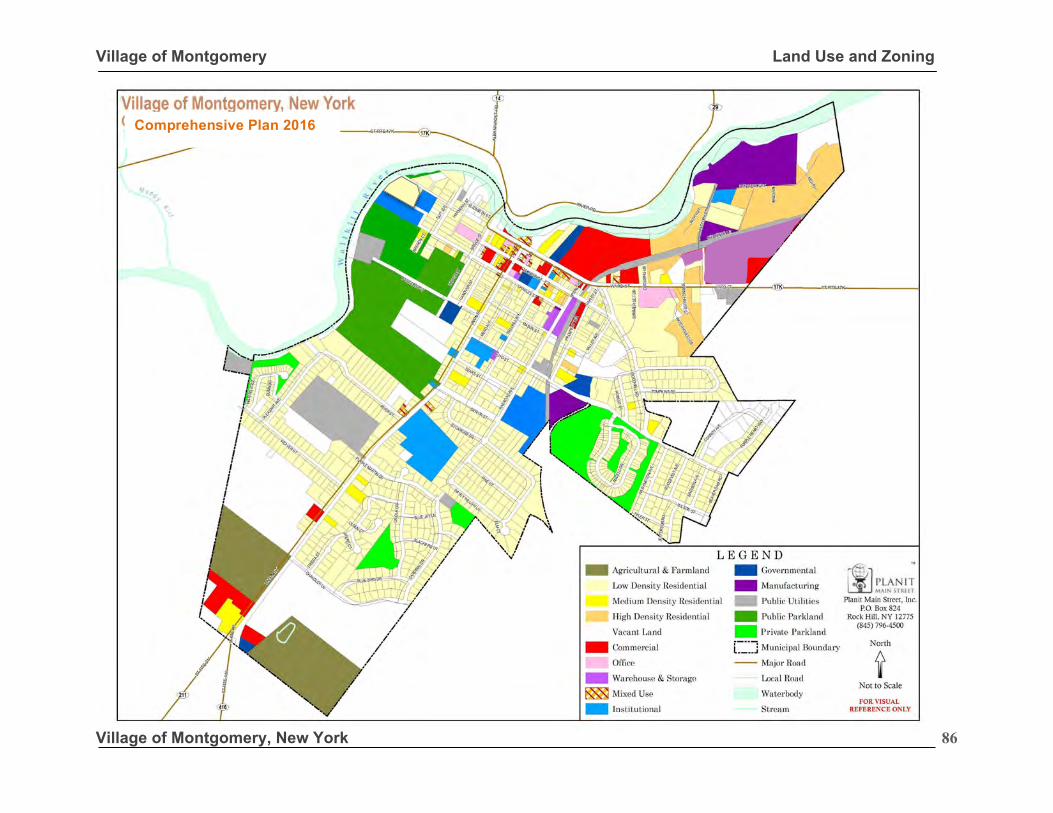
Village of Montgomery Land Use and Zoning
Village of Montgomery, New York
86
2008 Comprehensive Plan 2016
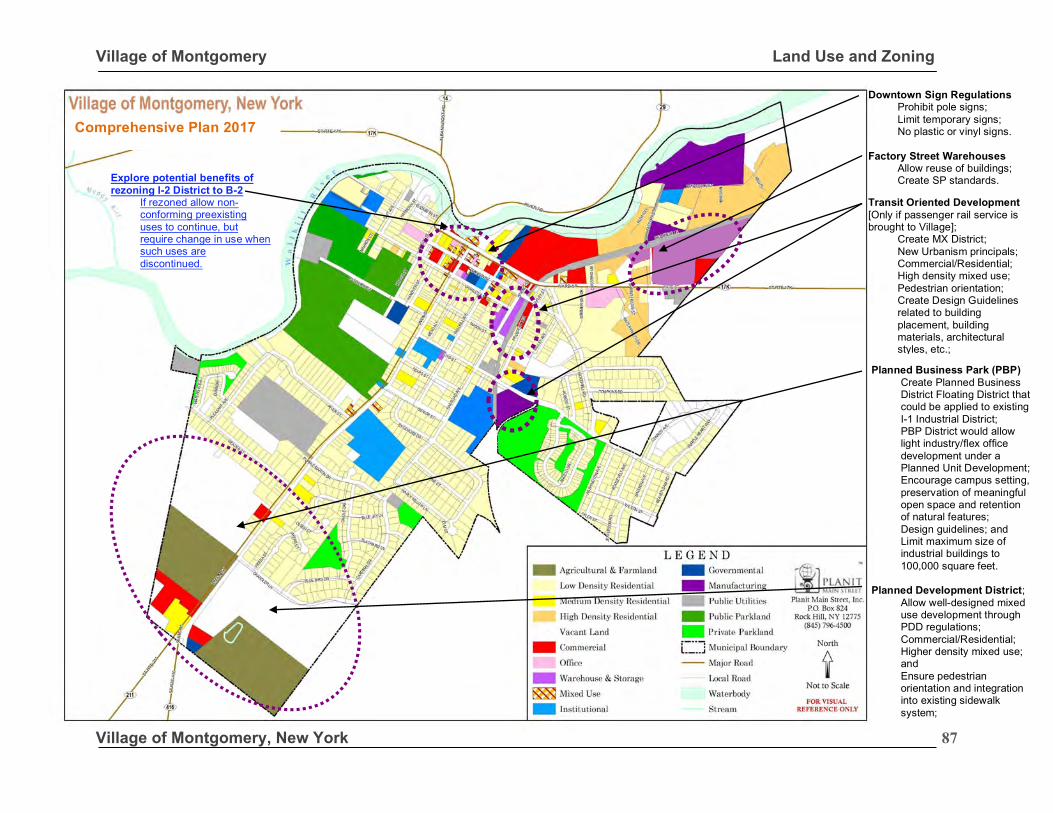
Village of Montgomery Land Use and Zoning
Village of Montgomery, New York
87
2008
Downtown Sign Regulations Prohibit pole signs; Limit temporary signs; No plastic or vinyl signs.
Factory Street Warehouses
Allow reuse of buildings; Create SP standards.
Transit Oriented Development [Only if passenger rail service is brought to Village];
Create MX District; New Urbanism principals; Commercial/Residential; High density mixed use; Pedestrian orientation; Create Design Guidelines related to building placement, building materials, architectural styles, etc.;
Planned Business Park (PBP)
Create Planned Business District Floating District that could be applied to existing I-1 Industrial District; PBP District would allow light industry/flex office development under a Planned Unit Development; Encourage campus setting, preservation of meaningful open space and retention of natural features; Design guidelines; and Limit maximum size of industrial buildings to 100,000 square feet.
Planned Development District;
Allow well-designed mixed use development through PDD regulations; Commercial/Residential; Higher density mixed use; and Ensure pedestrian orientation and integration into existing sidewalk system;
Explore potential benefits of rezoning I-2 District to B-2
If rezoned allow non-conforming preexisting uses to continue, but require change in use when such uses are discontinued.
Comprehensive Plan 2017
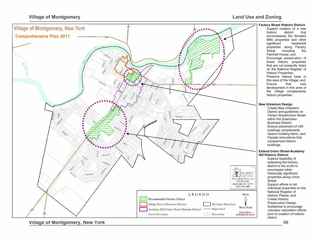
Village of Montgomery Land Use and Zoning
Village of Montgomery, New York
88
Factory Street Historic District Support creation of a new historic district that encompasses the Worsted Mills properties and other significant residential properties along Factory Street including the Patchett House; and Encourage preservation of those historic properties that are not presently listed on the National Register of Historic Properties; Preserve mature trees in this area of the Village; and Ensure that new development in this area of the Village complements historic properties.
New Urbanism Design Create New Urbanism District and guidelines on Clinton Street/Union Street within the Downtown Business District; Ensure placement of infill buildings complements historic building fabric; and Façade renovations that complement historic buildings. .
Extend Union Street-Academy Hill Historic District.
Explore feasibility of extending the historic district to the south to encompass other historically significant properties along Union Street; Support efforts to list individual properties on the National Register of Historic Places; and Create Historic Preservation Design Guidelines to encourage voluntary restoration efforts prior to creation of historic district.
2008 Comprehensive Plan 2017
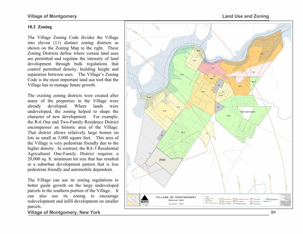
Village of Montgomery Land Use and Zoning
Village of Montgomery, New York
89
10.2 Zoning The Village Zoning Code divides the Village into eleven (11) distinct zoning districts as shown on the Zoning Map to the right. These Zoning Districts define where certain land uses are permitted and regulate the intensity of land development through bulk regulations that control permitted density, building height and separation between uses. The Village’s Zoning Code is the most important land use tool that the Village has to manage future growth. The existing zoning districts were created after many of the properties in the Village were already developed. Where lands were undeveloped, the zoning helped to shape the character of new development. For example, the R-6 One and Two-Family Residence District encompasses an historic area of the Village. That district allows relatively large homes on lots as small as 5,000 square feet. This area of the Village is very pedestrian friendly due to the higher density. In contrast, the RA-3 Residential Agricultural One-Family District requires a 20,000 sq. ft. minimum lot size that has resulted in a suburban development pattern that is less pedestrian friendly and automobile dependent. The Village can use its zoning regulations to better guide growth on the large undeveloped parcels in the southern portion of the Village. It can also use its zoning to encourage redevelopment and infill development on smaller parcels.
PDD
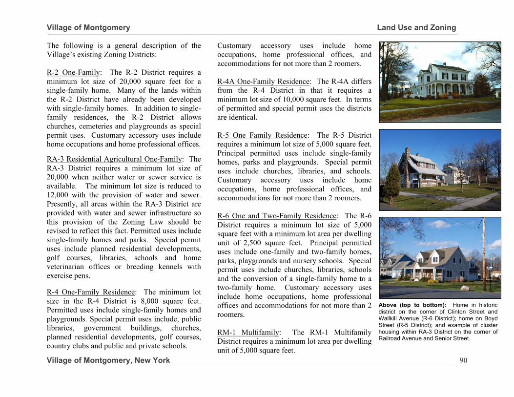
Village of Montgomery Land Use and Zoning
Village of Montgomery, New York
90
The following is a general description of the Village’s existing Zoning Districts: R-2 One-Family: The R-2 District requires a minimum lot size of 20,000 square feet for a single-family home. Many of the lands within the R-2 District have already been developed with single-family homes. In addition to single-family residences, the R-2 District allows churches, cemeteries and playgrounds as special permit uses. Customary accessory uses include home occupations and home professional offices. RA-3 Residential Agricultural One-Family: The RA-3 District requires a minimum lot size of 20,000 when neither water or sewer service is available. The minimum lot size is reduced to 12,000 with the provision of water and sewer. Presently, all areas within the RA-3 District are provided with water and sewer infrastructure so this provision of the Zoning Law should be revised to reflect this fact. Permitted uses include single-family homes and parks. Special permit uses include planned residential developments, golf courses, libraries, schools and home veterinarian offices or breeding kennels with exercise pens. R-4 One-Family Residence: The minimum lot size in the R-4 District is 8,000 square feet. Permitted uses include single-family homes and playgrounds. Special permit uses include, public libraries, government buildings, churches, planned residential developments, golf courses, country clubs and public and private schools.
Customary accessory uses include home occupations, home professional offices, and accommodations for not more than 2 roomers. R-4A One-Family Residence: The R-4A differs from the R-4 District in that it requires a minimum lot size of 10,000 square feet. In terms of permitted and special permit uses the districts are identical. R-5 One Family Residence: The R-5 District requires a minimum lot size of 5,000 square feet. Principal permitted uses include single-family homes, parks and playgrounds. Special permit uses include churches, libraries, and schools. Customary accessory uses include home occupations, home professional offices, and accommodations for not more than 2 roomers. R-6 One and Two-Family Residence: The R-6 District requires a minimum lot size of 5,000 square feet with a minimum lot area per dwelling unit of 2,500 square feet. Principal permitted uses include one-family and two-family homes, parks, playgrounds and nursery schools. Special permit uses include churches, libraries, schools and the conversion of a single-family home to a two-family home. Customary accessory uses include home occupations, home professional offices and accommodations for not more than 2 roomers. RM-1 Multifamily: The RM-1 Multifamily District requires a minimum lot area per dwelling unit of 5,000 square feet.
Above (top to bottom): Home in historic district on the corner of Clinton Street and Wallkill Avenue (R-6 District); home on Boyd Street (R-5 District); and example of cluster housing within RA-3 District on the corner of Railroad Avenue and Senior Street.
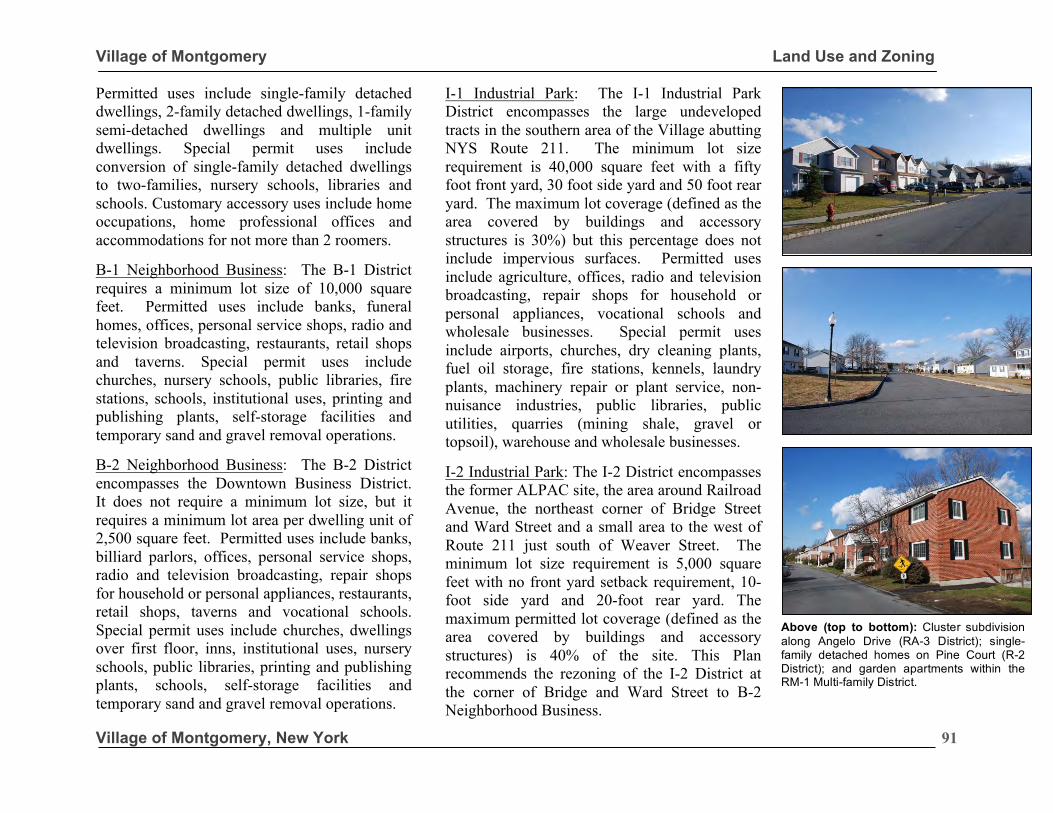
Village of Montgomery Land Use and Zoning
Village of Montgomery, New York
91
Permitted uses include single-family detached dwellings, 2-family detached dwellings, 1-family semi-detached dwellings and multiple unit dwellings. Special permit uses include conversion of single-family detached dwellings to two-families, nursery schools, libraries and schools. Customary accessory uses include home occupations, home professional offices and accommodations for not more than 2 roomers.
B-1 Neighborhood Business: The B-1 District requires a minimum lot size of 10,000 square feet. Permitted uses include banks, funeral homes, offices, personal service shops, radio and television broadcasting, restaurants, retail shops and taverns. Special permit uses include churches, nursery schools, public libraries, fire stations, schools, institutional uses, printing and publishing plants, self-storage facilities and temporary sand and gravel removal operations.
B-2 Neighborhood Business: The B-2 District encompasses the Downtown Business District. It does not require a minimum lot size, but it requires a minimum lot area per dwelling unit of 2,500 square feet. Permitted uses include banks, billiard parlors, offices, personal service shops, radio and television broadcasting, repair shops for household or personal appliances, restaurants, retail shops, taverns and vocational schools. Special permit uses include churches, dwellings over first floor, inns, institutional uses, nursery schools, public libraries, printing and publishing plants, schools, self-storage facilities and temporary sand and gravel removal operations.
I-1 Industrial Park: The I-1 Industrial Park District encompasses the large undeveloped tracts in the southern area of the Village abutting NYS Route 211. The minimum lot size requirement is 40,000 square feet with a fifty foot front yard, 30 foot side yard and 50 foot rear yard. The maximum lot coverage (defined as the area covered by buildings and accessory structures is 30%) but this percentage does not include impervious surfaces. Permitted uses include agriculture, offices, radio and television broadcasting, repair shops for household or personal appliances, vocational schools and wholesale businesses. Special permit uses include airports, churches, dry cleaning plants, fuel oil storage, fire stations, kennels, laundry plants, machinery repair or plant service, non-nuisance industries, public libraries, public utilities, quarries (mining shale, gravel or topsoil), warehouse and wholesale businesses.
I-2 Industrial Park: The I-2 District encompasses the former ALPAC site, the area around Railroad Avenue, the northeast corner of Bridge Street and Ward Street and a small area to the west of Route 211 just south of Weaver Street. The minimum lot size requirement is 5,000 square feet with no front yard setback requirement, 10-foot side yard and 20-foot rear yard. The maximum permitted lot coverage (defined as the area covered by buildings and accessory structures) is 40% of the site. This Plan recommends the rezoning of the I-2 District at the corner of Bridge and Ward Street to B-2 Neighborhood Business.
Above (top to bottom): Cluster subdivision along Angelo Drive (RA-3 District); single-family detached homes on Pine Court (R-2 District); and garden apartments within the RM-1 Multi-family District.
Village of Montgomery Land Use and Zoning
Village of Montgomery, New York
92
Permitted uses include agriculture, offices, radio and television broadcasting, repair shops for household or personal appliances, vocational schools and wholesale businesses. Special permit uses include airports, churches, dry cleaning plants, fuel oil storage, fire stations, kennels, laundry plants, machinery repair or plant service, non-nuisance industries, public libraries, public utilities, quarries (mining shale, gravel or topsoil), and warehouse/wholesale). Overlay Districts: The Village has two overlay districts 1) Antique Overlay District and 2) Senior Citizen Development Overlay Districts. The Antique Overlay District is an overlay of various residential areas where the Village Board felt the introduction of small antique dealerships as home occupations was appropriate. This district includes all residential properties fronting on Union Street from the south side of Charles Street to the north side of Dunn Road and all residential properties fronting on Bridge Street from the north of Bachelor Street to the south side of Ward Street. The standards for antique shop home occupations specify that not more than ½ of the ground floor may be used for the antique shop, no outdoor displays shall be allowed and only one announcement sign shall be permitted. Standards are not provided for off-street parking or the hours of operation. The Senior Citizen Development Overlay District is intended to provide affordable housing opportunities for the Village’s senior citizens.
Site plan approval by the Planning Board is required for any proposed Senior Citizen Development Overlay Development. The minimum lot size for a senior development is three (3) acres (with the property fronting on NYS Route 17K or Route 211), the gross density shall not exceed 24 units per acre, maximum building height shall be 40 feet and maximum lot coverage is restricted to 35% of the site. Dwelling units are limited to one bedroom.
PDD-Planned Development District (PDD): The PDD was created as a Floating District. The PDD is intended to provide for flexibility of use, area and site development restrictions in order to encourage responsible and high quality developments that will be a long-lasting asset to the Village. No applicant is entitled to a PDD. The Board of Trustees can accept or reject a PDD. An approved PDD application results in a new zoning district on the parcel or parcels that are the subject of the PDD. There is no minimum area requirement for a PDD application.
This Plan recommends a minimum lot size requirement for PDDs. It further recommends a requirement for PDDs to be implemented within a certain timeframe and approvals not be open ended. PDDs, which are not implemented within 5 years should be subject to a cost-benefit analysis to determine whether cumulative impacts of new development over time may have affected impacts on municipal services. This Plan also recommends that PDDs should be prohibited within historic districts.
“This Plan recommends that off-street parking and hours of operations standards be developed for the antique overlay district.”
Village of Montgomery Land Use and Zoning
Village of Montgomery, New York
93
Zoning Summary: A review of the Village’s residential zoning district reveals the districts are well tailored to the residential neighborhoods in terms of bulk regulations, permitted height and allowable land uses. The Table of Dimensional Regulations for Residence and Agricultural Districts should be revised, however, to reflect the fact that water and sewer infrastructure is available throughout the Village. It is also recommended that some permitted uses be stricken from the Table of Use Regulations, as they may no longer be compatible with existing land use. These include golf courses and breeding kennels with exercise pens. The former should be deleted since it is impractical to construct a golf course in the Village. The latter due to the concern related to nuisance concerns related to the operation of a kennel in existing residential neighborhoods. The Village’s B-1 Neighborhood Business District encompasses lands along Route 17K. The permitted uses in this district are appropriate for the Village. The B-2 Business District encompasses Downtown. The bulk regulations, permitted height and allowable uses are appropriate for Downtown. It is recommended that Bed & Breakfast establishments be specifically added to the list of permitted uses within the B-2 District. Special permit standards for B&Bs should also be established.
The Table of Use Regulations related to the I-1 Industrial Park District should be revised to remove a number of permitted and special exception uses that are no longer appropriate within the Village. These include airports, kennels, dry cleaning plants, fuel oil storage facilities and laundry plants. The I-1 Industrial Park District caps the building footprint on a site to 30% of the site, but it does not limit the amount of impervious surfaces. There is also no provision to set aside a portion of the site for open space. As a result, the amount of impervious surface, and maximum size of a building is only restricted by the practical limitations such as the need to provide off-street parking and stormwater management. The lack of design standards within the I-1 Industrial Park District presents a great deal of uncertainty for the Village in terms of the design or form of industrial development. It is recommended that a new Planned Business Park (PBP) District be created as a floating zone that could be applied to I-1 Industrial Park zoned properties. The PBP District would allow for planned unit developments that would provide an opportunity for innovative design of industrial/office/warehouse and flex space uses in the context of a campus setting. This would help to retain natural features on these sites and retain meaningful open space. Key to achieving such goals is placing a limit on the maximum permitted size of buildings and establishing thresholds for the minimum required open space.
“The lack of design standards within the I-1 Industrial Park District presents a great deal of uncertainty for the village in terms of the design or form of industrial development. It is recommended that a Planned Business Park District be created to ensure quality design of new industrial developments.”
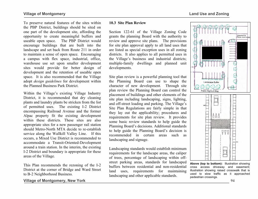
Village of Montgomery Land Use and Zoning
Village of Montgomery, New York
94
To preserve natural features of the sites within the PBP District, buildings should be sited on one part of the development site, affording the opportunity to create meaningful buffers and useable open space. The PBP District would encourage buildings that are built into the landscape and set back from Route 211 in order to maintain a sense of open space. Encouraging a campus with flex space, industrial, office, warehouse use set upon smaller development sites would provide for better design of development and the retention of useable open space. It is also recommended that the Village adopt design guidelines for development within the Planned Business Park District. Within the Village’s existing Village Industry District, it is recommended that dry cleaning plants and laundry plants be stricken from the list of permitted uses. The existing I-2 District encompassing Railroad Avenue and the former Alpac property fit the existing development within these districts. These sites are also appropriate sites for a new passenger rail station should Metro-North MTA decide to re-establish service along the Wallkill Valley Line. If this occurs, a Mixed Use District is recommended to accommodate a Transit-Oriented-Development around a train station. In the interim, the existing I-2 District and boundary is appropriate for these areas of the Village. This Plan recommends the rezoning of the I-2 District at the corner of Bridge and Ward Street to B-2 Neighborhood Business.
10.3 Site Plan Review Section 122-61 of the Village Zoning Code grants the planning Board with the authority to review and approve site plans. The provisions for site plan approval apply to all land uses that are listed as special exception uses in all zoning districts. It also applies to all permitted uses in the Village’s business and industrial districts; multiple-family dwellings and planned unit developments. Site plan review is a powerful planning tool that the Planning Board can use to shape the character of new development. Through site plan review the Planning Board can control the placement of buildings and other elements of the site plan including landscaping, signs, lighting, and off-street loading and parking. The Village’s Site Plan Regulations are fairly simple in that they lay out the applicability; procedures and requirements for site plan review. It provides some basic review standards to help guide the Planning Board’s decisions. Additional standards to help guide the Planning Board’s decision is recommended in certain areas such as landscaping and signage. Landscaping standards would establish minimum requirements for the landscape areas, the caliper of trees, percentage of landscaping within off-street parking areas, standards for landscaped buffers between residential and non-residential land uses, requirements for maintaining landscaping and other applicable standards.
Above (top to bottom): Illustration showing cross access driveway and easement; illustration showing raised crosswalk that is used to slow traffic as it approached pedestrian crossings.
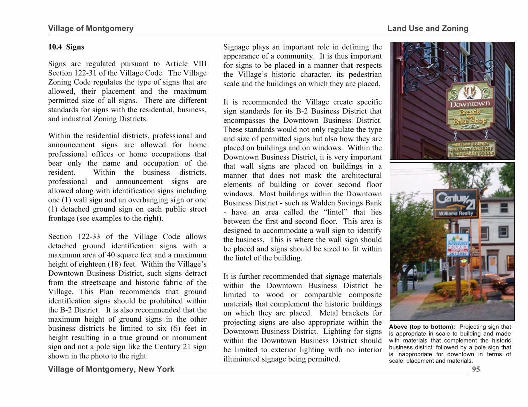
Village of Montgomery Land Use and Zoning
Village of Montgomery, New York
95
10.4 Signs Signs are regulated pursuant to Article VIII Section 122-31 of the Village Code. The Village Zoning Code regulates the type of signs that are allowed, their placement and the maximum permitted size of all signs. There are different standards for signs with the residential, business, and industrial Zoning Districts. Within the residential districts, professional and announcement signs are allowed for home professional offices or home occupations that bear only the name and occupation of the resident. Within the business districts, professional and announcement signs are allowed along with identification signs including one (1) wall sign and an overhanging sign or one (1) detached ground sign on each public street frontage (see examples to the right). Section 122-33 of the Village Code allows detached ground identification signs with a maximum area of 40 square feet and a maximum height of eighteen (18) feet. Within the Village’s Downtown Business District, such signs detract from the streetscape and historic fabric of the Village. This Plan recommends that ground identification signs should be prohibited within the B-2 District. It is also recommended that the maximum height of ground signs in the other business districts be limited to six (6) feet in height resulting in a true ground or monument sign and not a pole sign like the Century 21 sign shown in the photo to the right.
Signage plays an important role in defining the appearance of a community. It is thus important for signs to be placed in a manner that respects the Village’s historic character, its pedestrian scale and the buildings on which they are placed. It is recommended the Village create specific sign standards for its B-2 Business District that encompasses the Downtown Business District. These standards would not only regulate the type and size of permitted signs but also how they are placed on buildings and on windows. Within the Downtown Business District, it is very important that wall signs are placed on buildings in a manner that does not mask the architectural elements of building or cover second floor windows. Most buildings within the Downtown Business District - such as Walden Savings Bank - have an area called the “lintel” that lies between the first and second floor. This area is designed to accommodate a wall sign to identify the business. This is where the wall sign should be placed and signs should be sized to fit within the lintel of the building. It is further recommended that signage materials within the Downtown Business District be limited to wood or comparable composite materials that complement the historic buildings on which they are placed. Metal brackets for projecting signs are also appropriate within the Downtown Business District. Lighting for signs within the Downtown Business District should be limited to exterior lighting with no interior illuminated signage being permitted.
Above (top to bottom): Projecting sign that is appropriate in scale to building and made with materials that complement the historic business district; followed by a pole sign that is inappropriate for downtown in terms of scale, placement and materials.
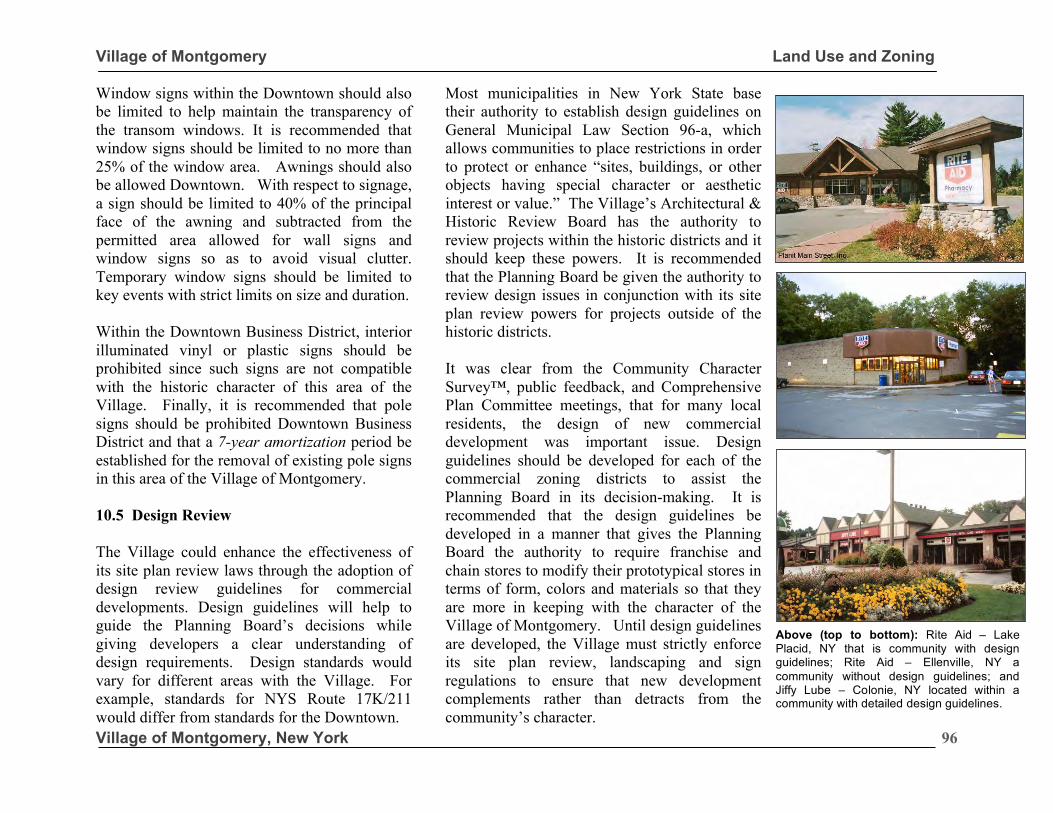
Village of Montgomery Land Use and Zoning
Village of Montgomery, New York
96
Window signs within the Downtown should also be limited to help maintain the transparency of the transom windows. It is recommended that window signs should be limited to no more than 25% of the window area. Awnings should also be allowed Downtown. With respect to signage, a sign should be limited to 40% of the principal face of the awning and subtracted from the permitted area allowed for wall signs and window signs so as to avoid visual clutter. Temporary window signs should be limited to key events with strict limits on size and duration. Within the Downtown Business District, interior illuminated vinyl or plastic signs should be prohibited since such signs are not compatible with the historic character of this area of the Village. Finally, it is recommended that pole signs should be prohibited Downtown Business District and that a 7-year amortization period be established for the removal of existing pole signs in this area of the Village of Montgomery. 10.5 Design Review The Village could enhance the effectiveness of its site plan review laws through the adoption of design review guidelines for commercial developments. Design guidelines will help to guide the Planning Board’s decisions while giving developers a clear understanding of design requirements. Design standards would vary for different areas with the Village. For example, standards for NYS Route 17K/211 would differ from standards for the Downtown.
Most municipalities in New York State base their authority to establish design guidelines on General Municipal Law Section 96-a, which allows communities to place restrictions in order to protect or enhance “sites, buildings, or other objects having special character or aesthetic interest or value.” The Village’s Architectural & Historic Review Board has the authority to review projects within the historic districts and it should keep these powers. It is recommended that the Planning Board be given the authority to review design issues in conjunction with its site plan review powers for projects outside of the historic districts. It was clear from the Community Character Survey™, public feedback, and Comprehensive Plan Committee meetings, that for many local residents, the design of new commercial development was important issue. Design guidelines should be developed for each of the commercial zoning districts to assist the Planning Board in its decision-making. It is recommended that the design guidelines be developed in a manner that gives the Planning Board the authority to require franchise and chain stores to modify their prototypical stores in terms of form, colors and materials so that they are more in keeping with the character of the Village of Montgomery. Until design guidelines are developed, the Village must strictly enforce its site plan review, landscaping and sign regulations to ensure that new development complements rather than detracts from the community’s character.
Above (top to bottom): Rite Aid – Lake Placid, NY that is community with design guidelines; Rite Aid – Ellenville, NY a community without design guidelines; and Jiffy Lube – Colonie, NY located within a community with detailed design guidelines.
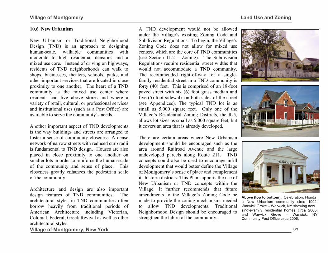
Village of Montgomery Land Use and Zoning
Village of Montgomery, New York
97
10.6 New Urbanism New Urbanism or Traditional Neighborhood Design (TND) is an approach to designing human-scale, walkable communities with moderate to high residential densities and a mixed use core. Instead of driving on highways, residents of TND neighborhoods can walk to shops, businesses, theaters, schools, parks, and other important services that are located in close proximity to one another. The heart of a TND community is the mixed use center where residents can live above stores and where a variety of retail, cultural, or professional services and institutional uses (such as a Post Office) are available to serve the community’s needs.
Another important aspect of TND developments is the way buildings and streets are arranged to foster a sense of community closeness. A dense network of narrow streets with reduced curb radii is fundamental to TND design. Houses are also placed in close proximity to one another on smaller lots in order to reinforce the human-scale of the community and sense of place. This closeness greatly enhances the pedestrian scale of the community.
Architecture and design are also important design features of TND communities. The architectural styles in TND communities often borrow heavily from traditional periods of American Architecture including Victorian, Colonial, Federal, Greek Revival as well as other architectural styles.
A TND development would not be allowed under the Village’s existing Zoning Code and Subdivision Regulations. To begin, the Village’s Zoning Code does not allow for mixed use centers, which are the core of TND communities (see Section 11.2 – Zoning). The Subdivision Regulations require residential street widths that would not accommodate a TND community. The recommended right-of-way for a single-family residential street in a TND community is forty (40) feet. This is comprised of an 18-foot paved street with six (6) foot grass median and five (5) foot sidewalk on both sides of the street (see Appendices). The typical TND lot is as small as 5,000 square feet. Only one of the Village’s Residential Zoning Districts, the R-5, allows lot sizes as small as 5,000 square feet, but it covers an area that is already developed.
There are certain areas where New Urbanism development should be encouraged such as the area around Railroad Avenue and the large undeveloped parcels along Route 211. TND concepts could also be used to encourage infill development that would better define the Village of Montgomery’s sense of place and complement its historic districts. This Plan supports the use of New Urbanism or TND concepts within the Village. It further recommends that future amendments to the Village’s Zoning Code be made to provide the zoning mechanisms needed to allow TND developments. Traditional Neighborhood Design should be encouraged to strengthen the fabric of the community.
.
Above (top to bottom): Celebration, Florida a New Urbanism community circa 1992; Warwick Grove – Warwick, NY showing new single-family residential homes circa 2006; and Warwick Grove – Warwick, NY Community Post Office circa 2006.
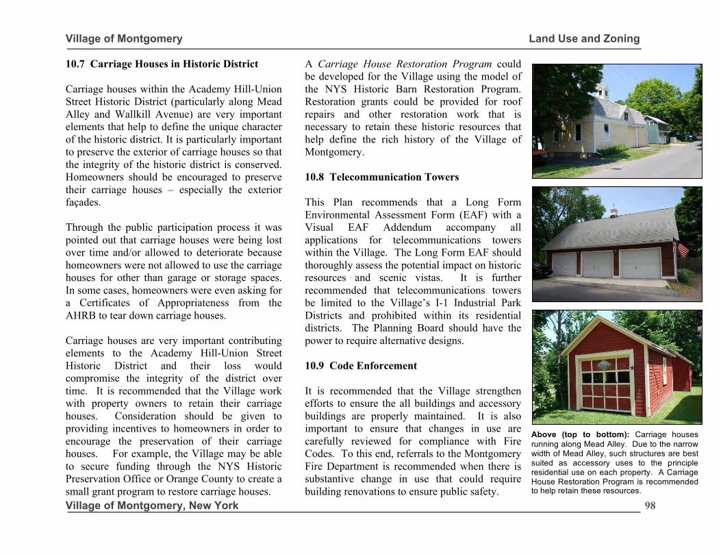
Village of Montgomery Land Use and Zoning
Village of Montgomery, New York
98
10.7 Carriage Houses in Historic District Carriage houses within the Academy Hill-Union Street Historic District (particularly along Mead Alley and Wallkill Avenue) are very important elements that help to define the unique character of the historic district. It is particularly important to preserve the exterior of carriage houses so that the integrity of the historic district is conserved. Homeowners should be encouraged to preserve their carriage houses – especially the exterior façades. Through the public participation process it was pointed out that carriage houses were being lost over time and/or allowed to deteriorate because homeowners were not allowed to use the carriage houses for other than garage or storage spaces. In some cases, homeowners were even asking for a Certificates of Appropriateness from the AHRB to tear down carriage houses. Carriage houses are very important contributing elements to the Academy Hill-Union Street Historic District and their loss would compromise the integrity of the district over time. It is recommended that the Village work with property owners to retain their carriage houses. Consideration should be given to providing incentives to homeowners in order to encourage the preservation of their carriage houses. For example, the Village may be able to secure funding through the NYS Historic Preservation Office or Orange County to create a small grant program to restore carriage houses.
A Carriage House Restoration Program could be developed for the Village using the model of the NYS Historic Barn Restoration Program. Restoration grants could be provided for roof repairs and other restoration work that is necessary to retain these historic resources that help define the rich history of the Village of Montgomery. 10.8 Telecommunication Towers This Plan recommends that a Long Form Environmental Assessment Form (EAF) with a Visual EAF Addendum accompany all applications for telecommunications towers within the Village. The Long Form EAF should thoroughly assess the potential impact on historic resources and scenic vistas. It is further recommended that telecommunications towers be limited to the Village’s I-1 Industrial Park Districts and prohibited within its residential districts. The Planning Board should have the power to require alternative designs. 10.9 Code Enforcement It is recommended that the Village strengthen efforts to ensure the all buildings and accessory buildings are properly maintained. It is also important to ensure that changes in use are carefully reviewed for compliance with Fire Codes. To this end, referrals to the Montgomery Fire Department is recommended when there is substantive change in use that could require building renovations to ensure public safety.
Above (top to bottom): Carriage houses running along Mead Alley. Due to the narrow width of Mead Alley, such structures are best suited as accessory uses to the principle residential use on each property. A Carriage House Restoration Program is recommended to help retain these resources.
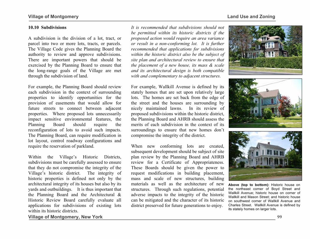
Village of Montgomery Land Use and Zoning
Village of Montgomery, New York
99
10.10 Subdivisions A subdivision is the division of a lot, tract, or parcel into two or more lots, tracts, or parcels. The Village Code gives the Planning Board the authority to review and approve subdivisions. There are important powers that should be exercised by the Planning Board to ensure that the long-range goals of the Village are met through the subdivision of land. For example, the Planning Board should review each subdivision in the context of surrounding properties to identify opportunities for the provision of easements that would allow for future streets to connect between adjacent properties. Where proposed lots unnecessarily impact sensitive environmental features, the Planning Board should require the reconfiguration of lots to avoid such impacts. The Planning Board, can require modification in lot layout, control roadway configurations and require the reservation of parkland. Within the Village’s Historic Districts, subdivisions must be carefully assessed to ensure that they do not compromise the integrity of the Village’s historic district. The integrity of historic properties is defined not only by the architectural integrity of its houses but also by its yards and outbuildings. It is thus important that the Planning Board and the Architectural & Historic Review Board carefully evaluate all applications for subdivisions of existing lots within its historic districts.
It is recommended that subdivisions should not be permitted within its historic districts if the proposed action would require an area variance or result in a non-conforming lot. It is further recommended that applications for subdivisions within the historic district also be the subject of site plan and architectural review to ensure that the placement of a new house, its mass & scale and its architectural design is both compatible with and complementary to adjacent structures. For example, Wallkill Avenue is defined by its stately homes that are set upon relatively large lots. The homes are set back from the edge of the street and the houses are surrounding by nicely maintained lawns. In its review of proposed subdivisions within the historic district, the Planning Board and AHRB should assess the merits of each subdivision in the context of its surroundings to ensure that new homes don’t compromise the integrity of the district. When new conforming lots are created, subsequent development should be subject of site plan review by the Planning Board and AHRB review for a Certificate of Appropriateness. These Boards should be given the power to request modifications in building placement, mass and scale of new structures, building materials as well as the architecture of new structures. Through such regulations, potential adverse impacts to the integrity of the historic can be mitigated and the character of its historic district preserved for future generations to enjoy.
Above (top to bottom): Historic house on the northeast corner of Boyd Street and Wallkill Avenue; historic house on corner of Wallkill and Mason Street; and historic house on southwest corner of Wallkill Avenue and Charles Street. Wallkill Avenue is defined by its stately homes on larger lots.
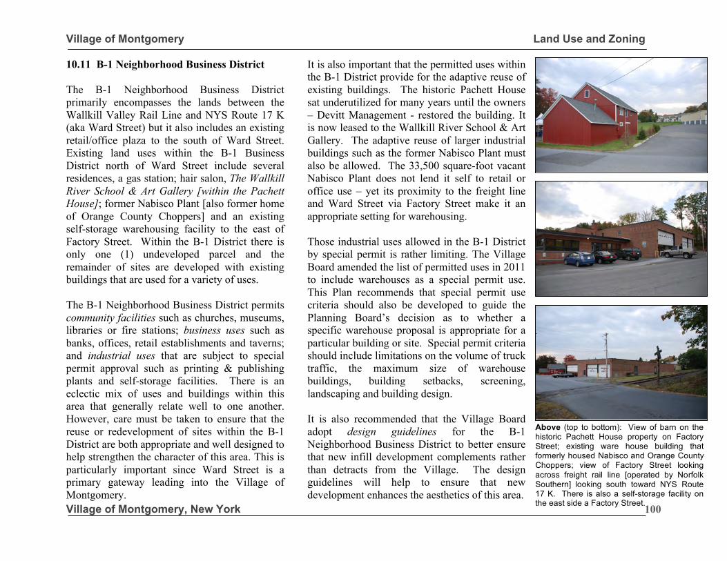
Village of Montgomery Land Use and Zoning
Village of Montgomery, New York
100
10.11 B-1 Neighborhood Business District The B-1 Neighborhood Business District primarily encompasses the lands between the Wallkill Valley Rail Line and NYS Route 17 K (aka Ward Street) but it also includes an existing retail/office plaza to the south of Ward Street. Existing land uses within the B-1 Business District north of Ward Street include several residences, a gas station; hair salon, The Wallkill River School & Art Gallery [within the Pachett House]; former Nabisco Plant [also former home of Orange County Choppers] and an existing self-storage warehousing facility to the east of Factory Street. Within the B-1 District there is only one (1) undeveloped parcel and the remainder of sites are developed with existing buildings that are used for a variety of uses. The B-1 Neighborhood Business District permits community facilities such as churches, museums, libraries or fire stations; business uses such as banks, offices, retail establishments and taverns; and industrial uses that are subject to special permit approval such as printing & publishing plants and self-storage facilities. There is an eclectic mix of uses and buildings within this area that generally relate well to one another. However, care must be taken to ensure that the reuse or redevelopment of sites within the B-1 District are both appropriate and well designed to help strengthen the character of this area. This is particularly important since Ward Street is a primary gateway leading into the Village of Montgomery.
It is also important that the permitted uses within the B-1 District provide for the adaptive reuse of existing buildings. The historic Pachett House sat underutilized for many years until the owners – Devitt Management - restored the building. It is now leased to the Wallkill River School & Art Gallery. The adaptive reuse of larger industrial buildings such as the former Nabisco Plant must also be allowed. The 33,500 square-foot vacant Nabisco Plant does not lend it self to retail or office use – yet its proximity to the freight line and Ward Street via Factory Street make it an appropriate setting for warehousing. Those industrial uses allowed in the B-1 District by special permit is rather limiting. The Village Board amended the list of permitted uses in 2011 to include warehouses as a special permit use. This Plan recommends that special permit use criteria should also be developed to guide the Planning Board’s decision as to whether a specific warehouse proposal is appropriate for a particular building or site. Special permit criteria should include limitations on the volume of truck traffic, the maximum size of warehouse buildings, building setbacks, screening, landscaping and building design. It is also recommended that the Village Board adopt design guidelines for the B-1 Neighborhood Business District to better ensure that new infill development complements rather than detracts from the Village. The design guidelines will help to ensure that new development enhances the aesthetics of this area.
Above (top to bottom): View of barn on the historic Pachett House property on Factory Street; existing ware house building that formerly housed Nabisco and Orange County Choppers; view of Factory Street looking across freight rail line [operated by Norfolk Southern] looking south toward NYS Route 17 K. There is also a self-storage facility on the east side a Factory Street.
Village of Montgomery Land Use and Zoning
Village of Montgomery, New York
101
10.12 Renewable Energy
This Plan supports the use of alternative renewable energy resources such as solar/photovoltaic, but recognizes that such facilities could adversely affect the historic character of the community if they are poorly placed or designed. To address these competing interests, the following goals, objectives and strategies are provided to help guide future land use decisions. Goals: • Promote effective and efficient use of solar energy
resources; • Promote safe development of solar energy systems
that minimally impact adjacent land uses, properties and environments;
• Ensure placement of solar facilities minimize potentially significant aesthetic impacts on historic resources;
• Use solar energy to promote economic development and to expand the community’s tax base; and
• Reduce barriers to and incentivize small-scale solar systems.
Objectives:
• New residential and nonresidential developments should be designed so that buildings are able to utilize passive solar strategies. Buildings should be designed to maximum southern exposure;
• As upgrades and renovations become necessary, municipal facilities and infrastructure should incorporate energy conservation measures;
• Review the land use laws to ensure that required lighting levels are set at the minimum levels necessary for public safety and convenience in
order to reduce energy consumption and light pollution;
• Encourage new developments to harness solar/photovoltaic or hydroelectric power either at the time of development or in the future; and
• Promote renewable energy production as principal uses, including both promotion of renewable energy structures, but also nonresidential uses which support the renewable energy industry.
Strategies:
• Within historic districts, solar/photovoltaic shall be permitted; however, their placement and design should be compatible with the historic character of the building/district or screened to the extent practical. Specifically, renewable energy structures, such as solar panels, should be placed such that they are not visible on the front of an historic building or a building located in a historic district;
• Encourage property owners to cover rooftops with solar/photovoltaic structures.
• Prohibit ground mounted solar panels within historic districts.
• Permit small wind energy facilities where appropriate based on neighborhood character and surrounding land uses.
• Encourage the use of other renewable energy technologies such as, but not limited to, geothermal heating.
• The Village should consider infrastructure upgrades and changes to facility operations that utilize renewable energy. Infrastructure upgrade examples include but are not limited to solar powered streetlights. Changes to facility operations include but are not limited to installation of energy efficient lighting.
•
“This Plan supports the use of alternative renewable energy resources such as solar/photovoltaic, but recognizes that such facilities could adversely affect the historic character of the community if they are poorly placed or designed.”
Village of Montgomery Land Use and Zoning
Village of Montgomery, New York
102
10.13 Summary & Recommendations The Village of Montgomery’s buildings and pattern of development define its community character. It is important that development of undeveloped sites occurs in a manner that compliments the existing development pattern. To this end, the following land use and zoning policies are recommended to help manage new growth in manner that enhances the character of the Village of Montgomery. 10.12.1 Land Use Support Transit-Oriented-Development (TOD) around passenger rail station. If passenger rail service is ultimately provided to the Village, transit-oriented-development should be supported around the train station including the creation of a mixed use zoning district. Encourage Planned Business Park (PBP) development within the Village’s Industrial Park District. 10.12.2 Zoning Create sign regulations for the Downtown Business District. There is a need for sign regulations that specifically address the placement of signs within the Downtown Business District. Specific standards for window signage and the placement and duration of temporary signs should be established for this area of the Village.
Update the Table of Use Regulations for the Business and Industrial Zoning Districts. It is recommended that airports, dry cleaning plants, fuel oil storage, kennels and laundry plants be deleted from the list of permitted uses within the I-1 Industrial Park and I-2 Industrial Park Districts. Such uses are no longer appropriate.
Add Bed & Breakfast establishments to the list of permitted uses within the B-2 District. It is also recommended that special permit standards for B&B establishments should also be created to help regulate such uses in the Village.
Create a new Planned Business Park (PBP) Floating District. It is recommended that a PBP District is created as a floating zone that could then be applied to I-1 Industrial Park Districts.
The Table of Dimensional Regulations should be revised to reflect the fact that water & sewer infrastructure is now available throughout the Village. This affects permitted density.
Further evaluation as to weather there should be a minimum lot size requirement for PDDs.
Set timeframe for implementing approved PDDs so that approvals not be open ended. This Plan recommends approved PDDs, which are not implemented within 5 years be subject to a cost-benefit analysis to determine whether cumulative impacts of new development over time may have affected impacts on municipal services. The Village Board should be explicitly authorized to rezone dormant PDDs back to the prior zoning district after a period of 5 years.
“We shape our Buildings and Afterward Our Buildings shape us.” Sir Winston Churchill
Village of Montgomery Land Use and Zoning
Village of Montgomery, New York
103
10.12.3 Site Plan Review Adopted more detailed landscaping standards as part the Site Plan Review Regulations. It is recommended that the Village establish minimum requirements for landscaping of commercial properties including the caliper of trees at planting, percentage of landscaping within off-street parking areas and standards for landscape buffers between residential and commercial properties. 10.12.4 Signs Prohibit pole signs within the B-2 Business District. Pole signs detract from the historic character of the Downtown Business District and should be prohibited within the B-2 Business District. Create specific sign regulations for the B-2 Zoning District that encompasses the Downtown Business District. These regulations would prohibit pole signs, interior illuminated plastic or vinyl signs and establish standards for window and temporary window display signage within the Downtown. Special attention would be given to ensuring that the sign materials and size of signage complements the historic properties. Ensure that wall signs do not mask architectural features of buildings. Sign guidelines that ensure the appropriate placement and size of wall signs must be established for the Downtown Business District.
Establish a seven (7) year amortization period for the removal of signs that would be made non-conforming due to the new sign regulations for Downtown. This would require that non-conforming signs be removed at the end of the 7-year amortization period or the discontinuance of the business – whichever came first. 10.12.5 Design Review Grant the Planning Board the authority to review design issues in conjunction with its site plan review powers for projects outside of the historic districts. Giving the Planning Board specific powers to review design-related issues will help to ensure better quality design of new commercial and industrial developments within the Village. Develop design guidelines for commercial and industrial districts to help guide the Planning Board’s decisions. Design should be established for the Village’s Downtown Business District outlying business districts, and industrial districts. The Design Guidelines should include standards related to site design, building mass, scale, form and roofline; building entrances; architectural features; signs; and lighting. 10.12.6 New Urbanism Encourage of the use of New Urbanism or Traditional Neighborhood Design in conjunction with new subdivisions and PDD’s. This will strengthen the historic character of the Village.
“Grant the Planning Board the authority to review design issues in conjunction with its Site Plan review powers for projects outside of historic districts.” Comprehensive Plan Committee
Village of Montgomery Land Use and Zoning
Village of Montgomery, New York
104
10.12.7 Carriage Houses Create a Carriage House Restoration Program. Work with Orange County and the State Historic Preservation Office to create a Carriage House Restoration Grant Program using the model of the NYS Barn Restoration Grant Program. 10.12.8 Telecommunications Towers Require a Long Form Environmental Assessment Form (EAF) with a Visual Addendum to accompany applications for telecommunications towers within the Village. The Long Form EAF should thoroughly assess the potential impact on historic resources and scenic vistas. It is further recommended that telecommunications towers be limited to the I-1 Industrial Park Districts and prohibited within its residential districts. 10.12.9 Subdivisions Do not allow subdivisions within any historic district if the proposed action would require an area variance or result in non-conforming lot. The ZBA should not grant variances to create non-conforming lots. Applications for subdivisions within the historic districts should be subject of site plan and architectural review. The Planning Board and AHRB should ensure that the placement of a new house, its mass & scale and its architectural design is both compatible with and complementary to adjacent structures.
10.12.10 Code Enforcement Strengthen efforts to ensure that all buildings and accessory buildings are properly maintained. Also ensure that changes in use are carefully reviewed for compliance with fire codes with Montgomery Fire Department input. Require an As-Built Survey Prior to Issuing a Certificate of Occupancy. It is recommended that the building department adopt a policy of requiring an as-built survey for commercial and industrial development prior to issuing a Certificate-of-Occupancy to ensure that the development conform to approved site plans. Withhold a Certificate of Occupancy (CO) until all site improvements are completed in accordance with an approved site plan. It is recommended that a CO be withheld until all site improvements are completed in accordance with an approved site plan. 10.12.11 B-1 Neighborhood Business Add warehouse as a special permit use and adopt Design Guidelines for the B-1 District. 10.12.12 Renewable Energy Support the use of alternative renewable energy resources such as solar and wind, but ensure their placement and design do not adversely affect community character.
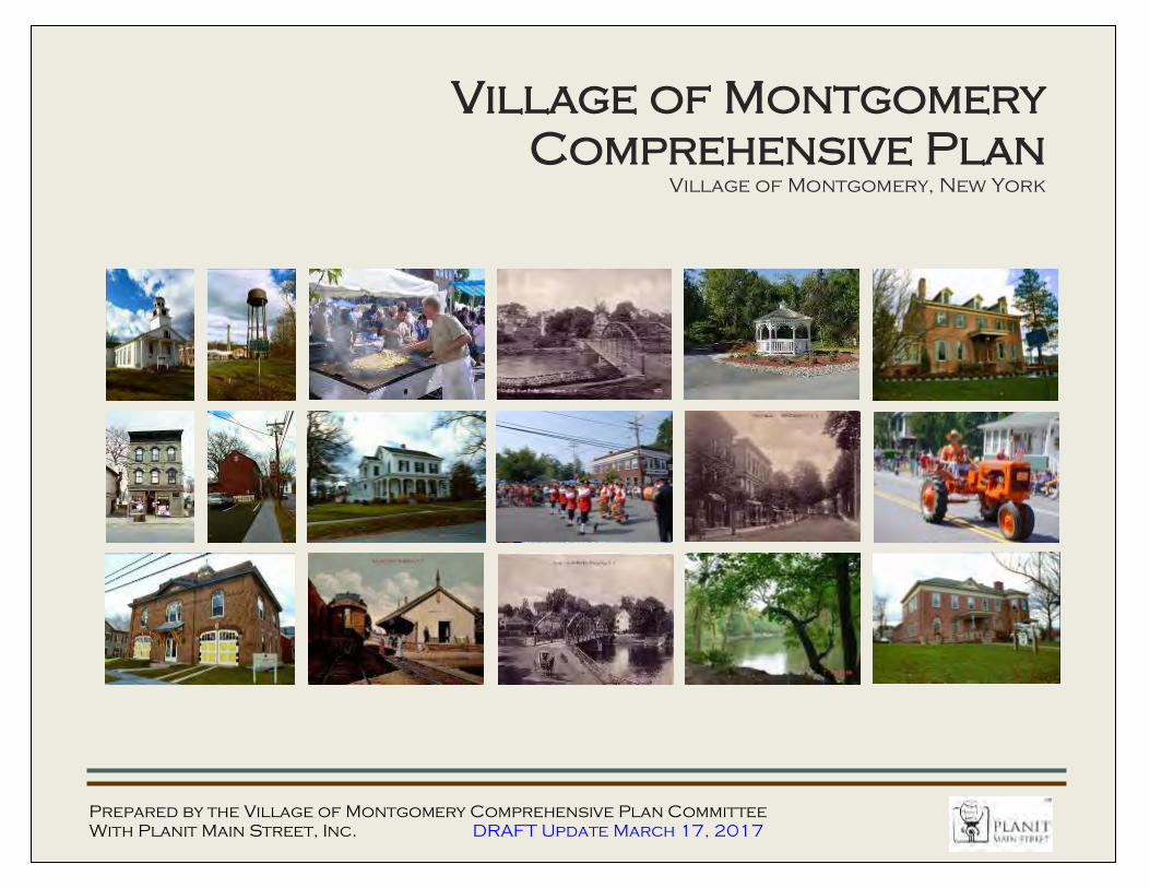
Village of Montgomery
Comprehensive Plan Village of Montgomery, New York
Prepared by the Village of Montgomery Comprehensive Plan Committee
With Planit Main Street, Inc. DRAFT Update March 17, 2017
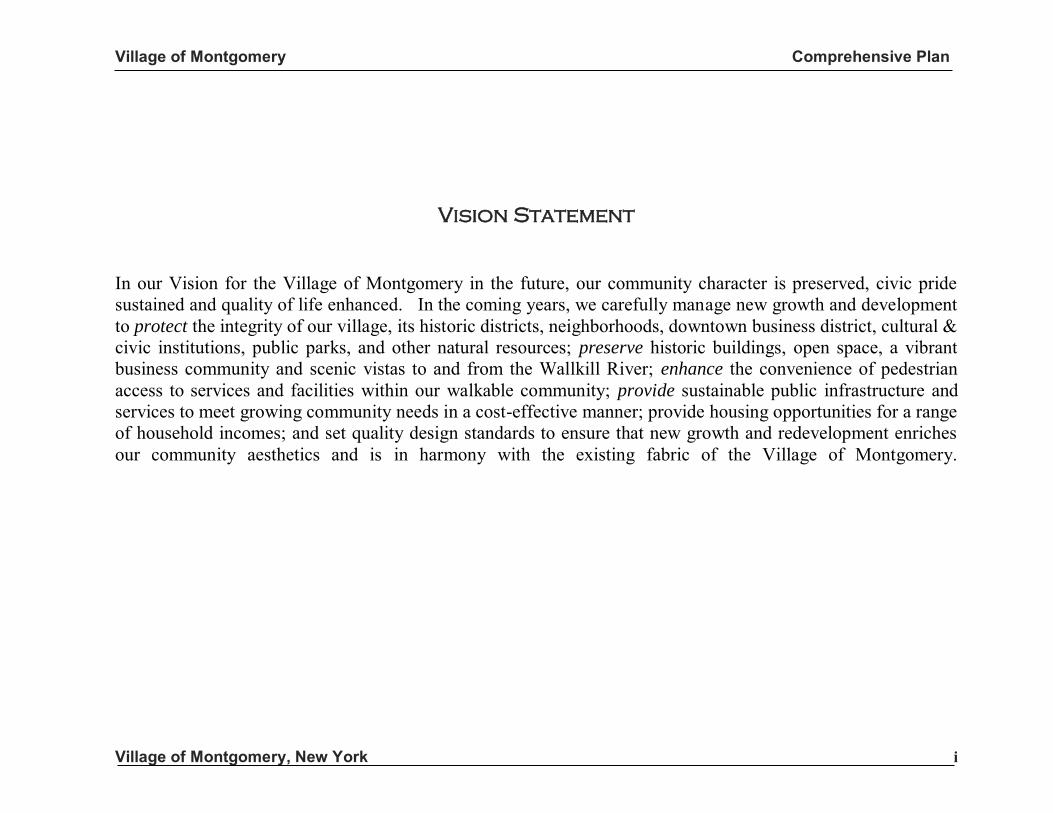
Village of Montgomery Comprehensive Plan
Village of Montgomery, New York i
Vision Statement
In our Vision for the Village of Montgomery in the future, our community character is preserved, civic pride sustained and quality of life enhanced. In the coming years, we carefully manage new growth and development to protect the integrity of our village, its historic districts, neighborhoods, downtown business district, cultural & civic institutions, public parks, and other natural resources; preserve historic buildings, open space, a vibrant business community and scenic vistas to and from the Wallkill River; enhance the convenience of pedestrian access to services and facilities within our walkable community; provide sustainable public infrastructure and services to meet growing community needs in a cost-effective manner; provide housing opportunities for a range of household incomes; and set quality design standards to ensure that new growth and redevelopment enriches our community aesthetics and is in harmony with the existing fabric of the Village of Montgomery.
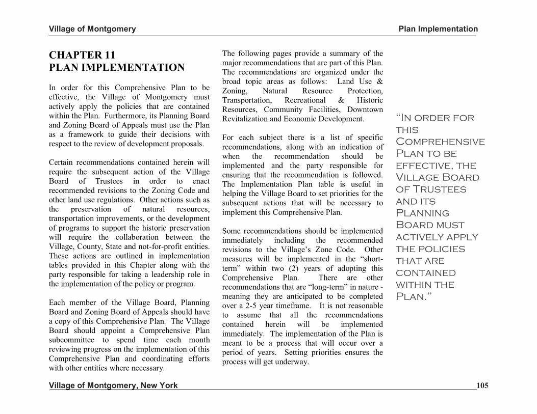
Village of Montgomery Plan Implementation
Village of Montgomery, New York 105
CHAPTER 11 PLAN IMPLEMENTATION In order for this Comprehensive Plan to be effective, the Village of Montgomery must actively apply the policies that are contained within the Plan. Furthermore, its Planning Board and Zoning Board of Appeals must use the Plan as a framework to guide their decisions with respect to the review of development proposals. Certain recommendations contained herein will require the subsequent action of the Village Board of Trustees in order to enact recommended revisions to the Zoning Code and other land use regulations. Other actions such as the preservation of natural resources, transportation improvements, or the development of programs to support the historic preservation will require the collaboration between the Village, County, State and not-for-profit entities. These actions are outlined in implementation tables provided in this Chapter along with the party responsible for taking a leadership role in the implementation of the policy or program. Each member of the Village Board, Planning Board and Zoning Board of Appeals should have a copy of this Comprehensive Plan. The Village Board should appoint a Comprehensive Plan subcommittee to spend time each month reviewing progress on the implementation of this Comprehensive Plan and coordinating efforts with other entities where necessary.
The following pages provide a summary of the major recommendations that are part of this Plan. The recommendations are organized under the broad topic areas as follows: Land Use & Zoning, Natural Resource Protection, Transportation, Recreational & Historic Resources, Community Facilities, Downtown Revitalization and Economic Development. For each subject there is a list of specific recommendations, along with an indication of when the recommendation should be implemented and the party responsible for ensuring that the recommendation is followed. The Implementation Plan table is useful in helping the Village Board to set priorities for the subsequent actions that will be necessary to implement this Comprehensive Plan. Some recommendations should be implemented immediately including the recommended revisions to the Village’s Zone Code. Other measures will be implemented in the “short-term” within two (2) years of adopting this Comprehensive Plan. There are other recommendations that are “long-term” in nature - meaning they are anticipated to be completed over a 2-5 year timeframe. It is not reasonable to assume that all the recommendations contained herein will be implemented immediately. The implementation of the Plan is meant to be a process that will occur over a period of years. Setting priorities ensures the process will get underway.
“In order for
this
Comprehensive
Plan to be
effective, the
Village Board
of Trustees
and its
Planning
Board must
actively apply
the policies
that are
contained
within the
Plan.”
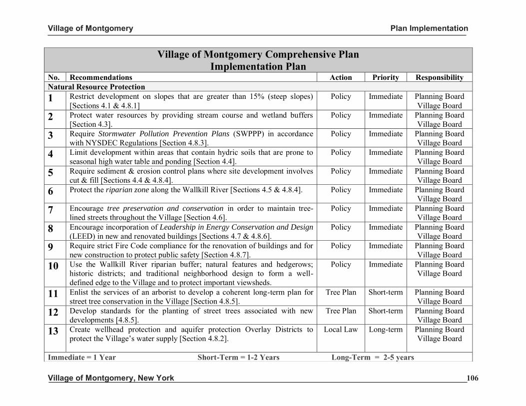
Village of Montgomery Plan Implementation
Village of Montgomery, New York 106
Village of Montgomery Comprehensive Plan Implementation Plan
No. Recommendations Action Priority Responsibility Natural Resource Protection
1 Restrict development on slopes that are greater than 15% (steep slopes) [Sections 4.1 & 4.8.1]
Policy Immediate Planning Board Village Board
2 Protect water resources by providing stream course and wetland buffers [Section 4.3].
Policy Immediate Planning Board Village Board
3 Require Stormwater Pollution Prevention Plans (SWPPP) in accordance with NYSDEC Regulations [Section 4.8.3].
Policy Immediate Planning Board Village Board
4 Limit development within areas that contain hydric soils that are prone to seasonal high water table and ponding [Section 4.4].
Policy Immediate Planning Board Village Board
5 Require sediment & erosion control plans where site development involves cut & fill [Sections 4.4 & 4.8.4].
Policy Immediate Planning Board Village Board
6 Protect the riparian zone along the Wallkill River [Sections 4.5 & 4.8.4]. Policy Immediate Planning Board Village Board
7 Encourage tree preservation and conservation in order to maintain tree-lined streets throughout the Village [Section 4.6].
Policy Immediate Planning Board Village Board
8 Encourage incorporation of Leadership in Energy Conservation and Design (LEED) in new and renovated buildings [Sections 4.7 & 4.8.6].
Policy Immediate Planning Board Village Board
9 Require strict Fire Code compliance for the renovation of buildings and for new construction to protect public safety [Section 4.8.7].
Policy Immediate Planning Board Village Board
10 Use the Wallkill River riparian buffer; natural features and hedgerows; historic districts; and traditional neighborhood design to form a well-defined edge to the Village and to protect important viewsheds.
Policy Immediate Planning Board Village Board
11 Enlist the services of an arborist to develop a coherent long-term plan for street tree conservation in the Village [Section 4.8.5].
Tree Plan Short-term Planning Board Village Board
12 Develop standards for the planting of street trees associated with new developments [4.8.5].
Tree Plan Short-term Planning Board Village Board
13
Create wellhead protection and aquifer protection Overlay Districts to protect the Village’s water supply [Section 4.8.2].
Local Law Long-term Planning Board Village Board
Immediate = 1 Year Short-Term = 1-2 Years Long-Term = 2-5 years
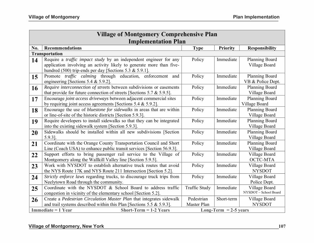
Village of Montgomery Plan Implementation
Village of Montgomery, New York 107
Village of Montgomery Comprehensive Plan Implementation Plan
No. Recommendations Type Priority Responsibility Transportation
14 Require a traffic impact study by an independent engineer for any application involving an activity likely to generate more than five-hundred (500) trip-ends per day [Sections 5.3 & 5.9.1].
Policy Immediate Planning Board Village Board
15 Promote traffic calming through education, enforcement and engineering [Sections 5.4 & 5.9.2].
Policy Immediate Planning Board VB & Police Dept.
16 Require interconnection of streets between subdivisions or easements that provide for future connection of streets [Sections 5.7 & 5.9.5].
Policy Immediate Planning Board Village Board
17 Encourage joint access driveways between adjacent commercial sites by requiring joint access agreements [Sections 5.4 & 5.9.2].
Policy Immediate Planning Board Village Board
18 Encourage the use of bluestone for sidewalks in areas that are within or line-of-site of the historic districts [Section 5.9.3].
Policy Immediate Planning Board Village Board
19 Require developers to install sidewalks so that they can be integrated into the existing sidewalk system [Section 5.9.3].
Policy Immediate Planning Board Village Board
20 Sidewalks should be installed within all new subdivisions [Section 5.9.3].
Policy Immediate Planning Board Village Board
21 Coordinate with the Orange County Transportation Council and Short Line (Coach USA) to enhance public transit services [Section 56.9.3].
Policy Immediate Planning Board Village Board
22 Support efforts to bring passenger rail service to the Village of Montgomery along the Wallkill Valley line [Section 5.9.5].
Policy Immediate Village Board OCTC-MTA
23 Work with NYSDOT to establish alternative truck routes that avoid the NYS Route 17K and NYS Route 211 Intersection [Section 5.2].
Policy Immediate Village Board NYSDOT
24 Strictly enforce laws regarding trucks, to discourage truck trips from Neelytown Road through the community.
Policy Immediate Village Board Police Dept.
25 Coordinate with the NYSDOT & School Board to address traffic congestion in vicinity of the elementary school [Section 5.2].
Traffic Study Immediate Village Board NYSDOT – School Board
26 Create a Pedestrian Circulation Master Plan that integrates sidewalk and trail systems described within this Plan [Sections 5.5 & 5.9.3].
Pedestrian Master Plan
Short-term Village Board NYSDOT
Immediate = 1 Year Short-Term = 1-2 Years Long-Term = 2-5 years
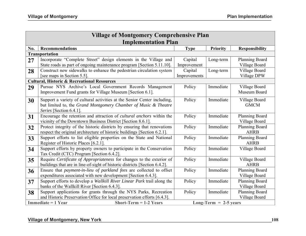
Village of Montgomery Plan Implementation
Village of Montgomery, New York 108
Village of Montgomery Comprehensive Plan Implementation Plan
No. Recommendations Type Priority Responsibility Transportation
27 Incorporate “Complete Street” design elements in the Village and State roads as part of ongoing maintenance program [Section 5.11.10].
Capital Improvement
Long-term Planning Board Village Board
28 Construct new sidewalks to enhance the pedestrian circulation system [see maps in Section 5.5].
Capital Improvements
Long-term Village Board Village DPW
Cultural, Historic & Recreational Resources
29 Pursue NYS Archive’s Local Government Records Management Improvement Fund grants for Village Museum [Section 6.1].
Policy Immediate Village Board Museum Board
30 Support a variety of cultural activities at the Senior Center including, but limited to, the Grand Montgomery Chamber of Music & Theatre
Series [Section 6.4.1].
Policy Immediate Village Board GMCM
31 Encourage the retention and attraction of cultural anchors within the vicinity of the Downtown Business District [Section 8.6.1].
Policy Immediate Planning Board Village Board
32 Protect integrity of the historic districts by ensuring that renovations respect the original architecture of historic buildings [Section 6.2.1].
Policy Immediate Planning Board AHRB
33 Support efforts to list eligible properties on the State and National Register of Historic Places [6.2.1].
Policy Immediate Planning Board AHRB
34 Support efforts by property owners to participate in the Conservation Tax Credit (CTC) Program [Section 6.4.2].
Policy Immediate Village Board
35 Require Certificate of Appropriateness for changes to the exterior of buildings that are in line-of-sight of historic districts [Section 6.4.2].
Policy Immediate Village Board AHRB
36 Ensure that payment-in-lieu of parkland fees are collected to offset expenditures associated with new development [Section 6.4.3].
Policy Immediate Planning Board Village Board
37 Support efforts to develop a Wallkill River Linear Park trail along the banks of the Wallkill River [Section 6.4.3].
Policy Immediate Planning Board Village Board
38 Support applications for grants through the NYS Parks, Recreation and Historic Preservation Office for local preservation efforts [6.4.3].
Policy Immediate Planning Board Village Board
Immediate = 1 Year Short-Term = 1-2 Years Long-Term = 2-5 years
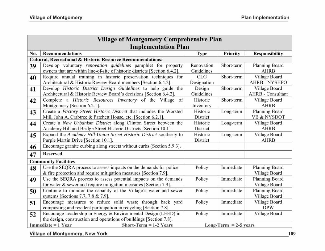
Village of Montgomery Plan Implementation
Village of Montgomery, New York 109
Village of Montgomery Comprehensive Plan Implementation Plan
No. Recommendations Type Priority Responsibility Cultural, Recreational & Historic Resource Recommendations:
39 Develop voluntary renovation guidelines pamphlet for property owners that are within line-of-site of historic districts [Section 6.4.2].
Renovation Guidelines
Short-term Planning Board AHRB
40 Require annual training in historic preservation techniques for Architectural & Historic Review Board members [Section 6.4.2].
CLG Designation
Short-term Village Board AHRB - NYSHPO
41 Develop Historic District Design Guidelines to help guide the Architectural & Historic Review Board’s decisions [Section 6.4.2].
Design Guidelines
Short-term Village Board AHRB - Consultant
42 Complete a Historic Resources Inventory of the Village of Montgomery [Section 6.2.1].
Historic Inventory
Short-term Village Board AHRB
43 Create a Factory Street Historic District that includes the Worsted Mill, John A. Crabtree & Patchett House, etc. [Section 6.2.1].
Historic District
Long-term Planning Board VB & NYSDOT
44 Create a New Urbanism District along Clinton Street between the Academy Hill and Bridge Street Historic Districts [Section 10.1].
Historic District
Long-term Village Board AHRB
45 Expand the Academy Hill-Union Street Historic District southerly to Purple Martin Drive [Section 10.1].
Historic District
Long-term Village Board AHRB
46 Encourage granite curbing along streets without curbs [Section 5.9.3].
47 Reserved Community Facilities
48 Use the SEQRA process to assess impacts on the demands for police & fire protection and require mitigation measures [Section 7.9].
Policy Immediate Planning Board Village Board
49 Use the SEQRA process to assess potential impacts on the demands for water & sewer and require mitigation measures [Section 7.9].
Policy Immediate Planning Board Village Board
50 Continue to monitor the capacity of the Village’s water and sewer systems [Sections 7.7, 7.8 & 7.9].
Policy Immediate Planning Board Village Board
51 Encourage measures to reduce solid waste through back yard composting and resident participation in recycling [Section 7.8].
Policy Immediate Village Board DPW
52 Encourage Leadership in Energy & Environmental Design (LEED) in the design, construction and operations of buildings [Section 7.8].
Policy Immediate Village Board
Immediate = 1 Year Short-Term = 1-2 Years Long-Term = 2-5 years
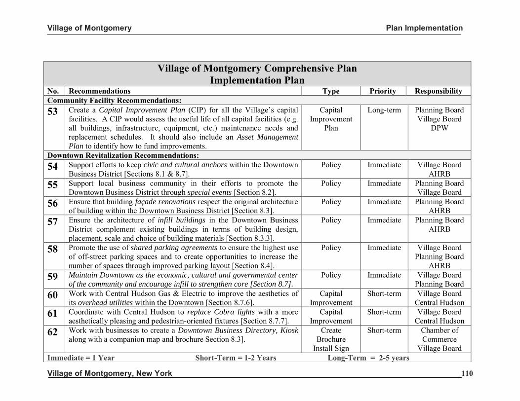
Village of Montgomery Plan Implementation
Village of Montgomery, New York 110
Village of Montgomery Comprehensive Plan Implementation Plan
No. Recommendations Type Priority Responsibility Community Facility Recommendations:
53 Create a Capital Improvement Plan (CIP) for all the Village’s capital facilities. A CIP would assess the useful life of all capital facilities (e.g. all buildings, infrastructure, equipment, etc.) maintenance needs and replacement schedules. It should also include an Asset Management
Plan to identify how to fund improvements.
Capital Improvement
Plan
Long-term Planning Board Village Board
DPW
Downtown Revitalization Recommendations: 54 Support efforts to keep civic and cultural anchors within the Downtown
Business District [Sections 8.1 & 8.7]. Policy Immediate Village Board
AHRB 55 Support local business community in their efforts to promote the
Downtown Business District through special events [Section 8.2]. Policy Immediate Planning Board
Village Board 56 Ensure that building façade renovations respect the original architecture
of building within the Downtown Business District [Section 8.3]. Policy Immediate Planning Board
AHRB 57 Ensure the architecture of infill buildings in the Downtown Business
District complement existing buildings in terms of building design, placement, scale and choice of building materials [Section 8.3.3].
Policy Immediate Planning Board AHRB
58 Promote the use of shared parking agreements to ensure the highest use of off-street parking spaces and to create opportunities to increase the number of spaces through improved parking layout [Section 8.4].
Policy Immediate Village Board Planning Board
AHRB 59 Maintain Downtown as the economic, cultural and governmental center
of the community and encourage infill to strengthen core [Section 8.7].
Policy Immediate Village Board Planning Board
60 Work with Central Hudson Gas & Electric to improve the aesthetics of its overhead utilities within the Downtown [Section 8.7.6].
Capital Improvement
Short-term Village Board Central Hudson
61 Coordinate with Central Hudson to replace Cobra lights with a more aesthetically pleasing and pedestrian-oriented fixtures [Section 8.7.7].
Capital Improvement
Short-term Village Board Central Hudson
62 Work with businesses to create a Downtown Business Directory, Kiosk along with a companion map and brochure Section 8.3].
Create Brochure
Install Sign
Short-term Chamber of Commerce
Village Board Immediate = 1 Year Short-Term = 1-2 Years Long-Term = 2-5 years
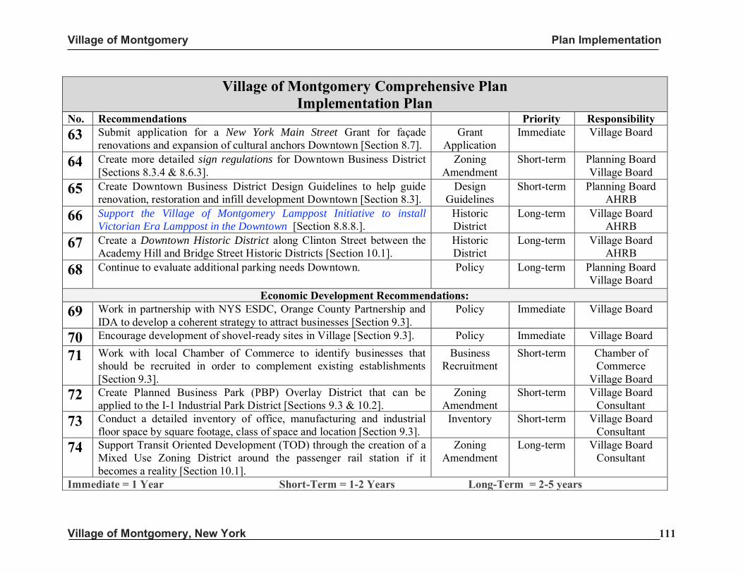
Village of Montgomery Plan Implementation
Village of Montgomery, New York 111
Village of Montgomery Comprehensive Plan Implementation Plan
No. Recommendations Priority Responsibility
63 Submit application for a New York Main Street Grant for façade renovations and expansion of cultural anchors Downtown [Section 8.7].
Grant Application
Immediate Village Board
64 Create more detailed sign regulations for Downtown Business District [Sections 8.3.4 & 8.6.3].
Zoning Amendment
Short-term Planning Board Village Board
65 Create Downtown Business District Design Guidelines to help guide renovation, restoration and infill development Downtown [Section 8.3].
Design Guidelines
Short-term Planning Board AHRB
66 Support the Village of Montgomery Lamppost Initiative to install
Victorian Era Lamppost in the Downtown [Section 8.8.8.]. Historic District
Long-term Village Board AHRB
67 Create a Downtown Historic District along Clinton Street between the Academy Hill and Bridge Street Historic Districts [Section 10.1].
Historic District
Long-term Village Board AHRB
68 Continue to evaluate additional parking needs Downtown. Policy Long-term Planning Board Village Board
Economic Development Recommendations:
69 Work in partnership with NYS ESDC, Orange County Partnership and IDA to develop a coherent strategy to attract businesses [Section 9.3].
Policy Immediate Village Board
70 Encourage development of shovel-ready sites in Village [Section 9.3]. Policy Immediate Village Board
71 Work with local Chamber of Commerce to identify businesses that should be recruited in order to complement existing establishments [Section 9.3].
Business Recruitment
Short-term Chamber of Commerce
Village Board 72 Create Planned Business Park (PBP) Overlay District that can be
applied to the I-1 Industrial Park District [Sections 9.3 & 10.2]. Zoning
Amendment Short-term Village Board
Consultant 73 Conduct a detailed inventory of office, manufacturing and industrial
floor space by square footage, class of space and location [Section 9.3]. Inventory Short-term Village Board
Consultant 74 Support Transit Oriented Development (TOD) through the creation of a
Mixed Use Zoning District around the passenger rail station if it becomes a reality [Section 10.1].
Zoning Amendment
Long-term Village Board Consultant
Immediate = 1 Year Short-Term = 1-2 Years Long-Term = 2-5 years
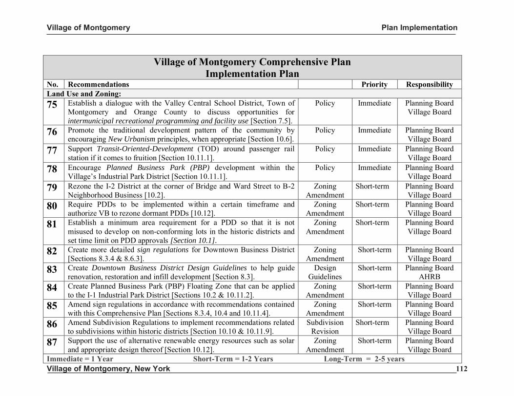
Village of Montgomery Plan Implementation
Village of Montgomery, New York 112
Village of Montgomery Comprehensive Plan Implementation Plan
No. Recommendations Priority Responsibility Land Use and Zoning: 75 Establish a dialogue with the Valley Central School District, Town of
Montgomery and Orange County to discuss opportunities for intermunicipal recreational programming and facility use [Section 7.5].
Policy Immediate Planning Board Village Board
76 Promote the traditional development pattern of the community by encouraging New Urbanism principles, when appropriate [Section 10.6].
Policy Immediate Planning Board Village Board
77 Support Transit-Oriented-Development (TOD) around passenger rail station if it comes to fruition [Section 10.11.1].
Policy Immediate Planning Board Village Board
78 Encourage Planned Business Park (PBP) development within the Village’s Industrial Park District [Section 10.11.1].
Policy Immediate Planning Board Village Board
79 Rezone the I-2 District at the corner of Bridge and Ward Street to B-2 Neighborhood Business [10.2].
Zoning Amendment
Short-term Planning Board Village Board
80 Require PDDs to be implemented within a certain timeframe and authorize VB to rezone dormant PDDs [10.12].
Zoning Amendment
Short-term Planning Board Village Board
81 Establish a minimum area requirement for a PDD so that it is not misused to develop on non-conforming lots in the historic districts and set time limit on PDD approvals [Section 10.1].
Zoning Amendment
Short-term Planning Board Village Board
82 Create more detailed sign regulations for Downtown Business District [Sections 8.3.4 & 8.6.3].
Zoning Amendment
Short-term Planning Board Village Board
83 Create Downtown Business District Design Guidelines to help guide renovation, restoration and infill development [Section 8.3].
Design Guidelines
Short-term Planning Board AHRB
84 Create Planned Business Park (PBP) Floating Zone that can be applied to the I-1 Industrial Park District [Sections 10.2 & 10.11.2].
Zoning Amendment
Short-term Planning Board Village Board
85 Amend sign regulations in accordance with recommendations contained with this Comprehensive Plan [Sections 8.3.4, 10.4 and 10.11.4].
Zoning Amendment
Short-term Planning Board Village Board
86 Amend Subdivision Regulations to implement recommendations related to subdivisions within historic districts [Section 10.10 & 10.11.9].
Subdivision Revision
Short-term Planning Board Village Board
87 Support the use of alternative renewable energy resources such as solar and appropriate design thereof [Section 10.12].
Zoning Amendment
Short-term Planning Board Village Board
Immediate = 1 Year Short-Term = 1-2 Years Long-Term = 2-5 years
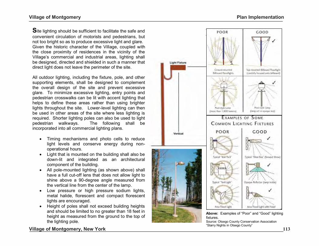
Village of Montgomery Plan Implementation
Village of Montgomery, New York 113
Design Guidelines: Lighting
All Industrial Districts
Site lighting should be sufficient to facilitate the safe and convenient circulation of motorists and pedestrians, but not too bright so as to produce excessive light and glare. Given the historic character of the Village, coupled with the close proximity of residences in the vicinity of the Village’s commercial and industrial areas, lighting shall be designed, directed and shielded in such a manner that direct light does not leave the perimeter of the site. All outdoor lighting, including the fixture, pole, and other supporting elements, shall be designed to complement the overall design of the site and prevent excessive glare. To minimize excessive lighting, entry points and pedestrian crosswalks can be lit with accent lighting that helps to define these areas rather than using brighter lights throughout the site. Lower-level lighting can then be used in other areas of the site where less lighting is required. Shorter lighting poles can also be used to light pedestrian walkways. The following shall be incorporated into all commercial lighting plans.
• Timing mechanisms and photo cells to reduce light levels and conserve energy during non-operational hours.
• Light that is mounted on the building shall also be down-lit and integrated as an architectural component of the building.
• All pole-mounted lighting (as shown above) shall have a full cut-off lens that does not allow light to shine above a 90-degree angle measured from the vertical line from the center of the lamp.
• Low pressure or high pressure sodium lights, metal halide, florescent and compact florescent lights are encouraged.
• Height of poles shall not exceed building heights and should be limited to no greater than 18 feet in height as measured from the ground to the top of the lighting pole.
Above: Examples of “Poor” and “Good” lighting fixtures. Source: Otsego County Conservation Association “Starry Nights in Otsego County”
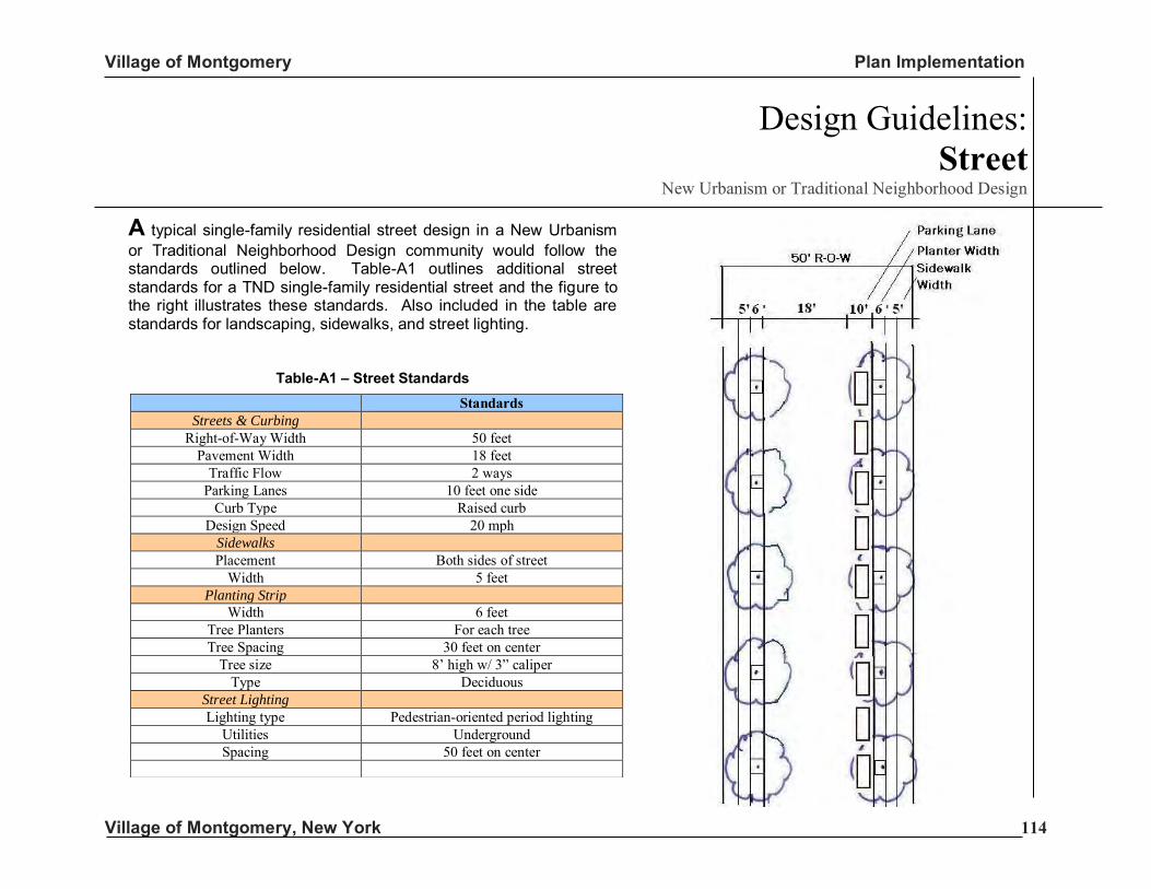
Village of Montgomery Plan Implementation
Village of Montgomery, New York 114
Standards Streets & Curbing
Right-of-Way Width 50 feet Pavement Width 18 feet
Traffic Flow 2 ways Parking Lanes 10 feet one side
Curb Type Raised curb Design Speed 20 mph
Sidewalks Placement Both sides of street
Width 5 feet Planting Strip
Width 6 feet Tree Planters For each tree Tree Spacing 30 feet on center
Tree size 8’ high w/ 3” caliper Type Deciduous
Street Lighting Lighting type Pedestrian-oriented period lighting
Utilities Underground Spacing 50 feet on center
A typical single-family residential street design in a New Urbanism or Traditional Neighborhood Design community would follow the standards outlined below. Table-A1 outlines additional street standards for a TND single-family residential street and the figure to the right illustrates these standards. Also included in the table are standards for landscaping, sidewalks, and street lighting.
Table-A1 – Street Standards
Design Guidelines: Street
New Urbanism or Traditional Neighborhood Design
Village of Montgomery Plan Implementation
Village of Montgomery, New York 115
Definitions Detention Basin: Are usually dry basins that fill with water during a storm event. They work by delaying the storm water so that it is released at a rate that mimics the predevelopment flow. Light Manufacturing: A use engaged in the manufacture, predominantly from previously prepared materials, of finished products or parts, including processing, fabrication, assembly, treatment, packaging, and incidental storage, sales, and distribution of such products, but excluding basic industrial processing. Retention Basin: A basin that holds water in a pool. The only outlet is through an emergency spillway that allows the basin to overflow in a controlled manner should it become too full. The retention basin loses water through infiltration and evaporation but is designed with capacity to hold the runoff from average storm events. Recreation, Active: Leisure Time activities, usually of a formal nature and often performed with others, requiring equipment and taking place in prescribed places, sites, or fields. Recreation, Passive: Activities that involve relatively inactive or less energetic activities, such as walking, sitting, picnicking, and hiking.
Endnotes
i The National Register of Historic Places is the United States government's official list of districts, sites, buildings, structures, and objects worthy of preservation. The National Register was established in 1966 with the passage of the National Historic Preservation Act (NHPA). Out of the over one million properties on the National Register, 80,000 are listed individually, the others are contributing members within historic districts. ii The AHRB uses the Secretary of the Interior’s guidelines for historic preservation for guidance, however, it is recommended that Village of Montgomery-specific standards be developed. iii Source: Lyons, Thomas S., and Roger E. Hamlin. Creating an Economic Development Action Plan: A Guide for Development Professional. Praeger Publishers, Westport CT, 1991.
Related Documents