Welcome message from author
This document is posted to help you gain knowledge. Please leave a comment to let me know what you think about it! Share it to your friends and learn new things together.
Transcript
VERTEBRATE FAUNA SURVEY
NEW SOUTH WALES NATIONAL PARKS AND WILDLIFE SERVICE
A project undertaken forthe Joint Commonwealth NSW Regional Forest Agreement Steering Committee
as part of theNSW Comprehensive Regional Assessments
project number NA 01/EH
December 1998
2
For more information and for information on access to data contact the:Resource and Conservation Division, Department of Urban Affairs and PlanningGPO Box 3927SYDNEY NSW 2001Phone: (02) 9228 3166Fax: (02) 9228 4967Forests Taskforce, Department of the Prime Minister and Cabinet 3-5 National CircuitBARTON ACT 2600Phone: 1800 650 983Fax: (02) 6271 5511© Crown copyright December 1998ISBN 1 74029 022 4This project has been jointly funded by the New South Wales and Commonwealth Governments and managed through the Resource and Conservation Division, Department of Urban Affairs and Planning, and the Forests Taskforce, Department of the Prime Minister and Cabinet.The project has been overseen and the methodology has been developed through the Environment and Heritage Technical Committee which includes representatives from the New South Wales and Commonwealth Governments and stakeholder groups.
DisclaimerWhile every reasonable effort has been made to ensure that this document is correct at the time of printing, the State of New South Wales, its agents and employees, and the Commonwealth of Australia, its agents and employees, do not assume any responsibility and shall have no liability, consequential or otherwise, of any kind, arising from the use of or reliance on any of the information contained in this document.
3
AcknowledgementsCRA UNIT MANAGERS Simon Ferrier (NSW NPWS) Mike Crowley (SFNSW)Keith Cherry Glenn Hoye Alan Douch (SFNSW)Daniel Connolly Sandy Inglby (AM) Paul FlowerNic Gellie Ross Knowles Ross KnowlesTessa Lock Michael Mahony Michael MahonyGeoff Moore Dave Milledge Michael MurryJo White Greg Richards and
AssociatesHarry Parnaby
KEY CONTRIBUTORS Harry Parnaby Michael PennayMick Andren Ross Sadlier (AM) Dave ScottsLesley Forward Michael Saxon (NSW
NPWS)Graham Turner
Miranda Gott Dave Scotts (NSW NPWS) Phil SparkTessa Lock Barbara Triggs FIELD TEAM MEMBERSKylie Madden Richard Wells Jeff BetteridgeEDITOR Ray Williams Glen CrombieTessa Lock BAT CALL ANALYSIS Alan Douch (SFNSW)REPORT PRODUCTION Glen Hoye Alexander DudleyKathy Cowie Doug Mills Rebecca DruryGIS SUPPORT Harry Parnaby Robert Evans (SFNSW)Anni Blaxland-Fuad Greg Richards Mandy Flaxman (SFNSW)Tessa Lock Ray Williams David GeeringStephen House BIRD AND FROG CALL
ANALYSISPavel German
Kylie Madden Dave Stewart Don Goodridge (SFNSW)Stephen Thornton HAIR AND SCAT
IDENTIFICATIONCarl Gosper
Julian Wall EcoPlan Australia Roger Heyward (SFNSW)Steve Wall Barbara Triggs Russell JagoSarah Young VOUCHER SPECIMEN
IDENTIFICATIONDavid Kelly
PROJECT MANAGEMENT Kylie MaddenMick Andren (UNE and LNE) Australian Museum Dean MetcalfPeter Banks (Sydney Basin and LNE)
Glenn Hoye Jackie Miles
Lesley Forward (Southern and Eden)
Michael Mahony Alan Morris
Miranda Gott (statewide) SURVEY COORDINATORS
Michael Murray
Susie Jackson (Eden) Helen Achurch Phil LamrockPeter Wilson (statewide) Rebecca Drury Brett LaneDATABASE DESIGN AND Greg Elks Phil Oliver (SFNSW)
4

DEVELOPMENTJeremy Little Peter Owen (SFNSW)
Mick Andren Kylie Madden Jim ResideCol Barber Michael Pennay Peter Richards (SFNSW)Peter Banks Michael Sullivan Peter RobertsonPeter Ewin Jessica Szigethy-Gyula Michael Shooks (SFNSW)Guy Hodgson Julian Wall Chris Slack (SFNSW)Tessa Lock Stephen Wall Rosemary SmithStephen Thornton FIELD EQUIPMENT Phil SparkDATABASE MANAGEMENT Karen Baggett Dick TurnerMichael Andren David Page Grant TurnerPeter Banks SYSTEMATIC SURVEY
FIELD TEAM LEADERSGraham Turner
Guy Hodgson Stephen WallSteve House Debbie Andrew Paul WebberJoanna Knight Clive Barker Rick WebsterKylie Madden Hank Bower Richard WellsRachel Miller Keith Cherry Ross WellingtonMartin Stuart Mike Crowley (SFNSW) Tanya WilliamsStephen Thornton Garry Daly Arthur WhitePRINCIPLE DATA ENTRY Stephen Eberhard Thanks also to the NSW NPWS
Zone andPERSONNEL Wayne Longmore (SFNSW) District staff and all volunteers
whoJoanna Knight George McKay contributed to field surveys.Jeremy Little Doug Mills DATA AUDITRachel Miller Greg Clancy Karen BaggettChris Parker Mark Fitzgerald Frances KnightMichael Pennay Keith Kendall Joanna KnightJane Puddephatt Chris Lehman Jeremy LittleNaomi Robbie Jeremy Little Kylie MaddenMartin Stuart Dave Milledge Angela McCauleyEXTERNAL DATASETS Martin Schulz Deyarne PlowmanThanks also to the many organisations and
Dave Stewart Martin Stuart
private individuals who generously prepared
Ray Williams Sarah Young
and provided fauna records. All contributors
TARGETED SURVEY FIELD TEAM LEADERS
are listed in Appendix 2.EXPERT ADVICE Helen AchurchLinda Broome (NSW NPWS) Mick AndrenGarry Daly Clive Barker
5
6
CONTENTSAcknowledgements.........................................................................................................4Abbreviations................................................................................................................10Nomenclature................................................................................................................11Project Summary...........................................................................................................121. INTRODUCTION.........................................................................................................13
1.1 Project Objectives.................................................................................................131.2 STUDY AREAS.......................................................................................................14
1.2.1 UNE study area...............................................................................................141.2.2 LNE study area...............................................................................................191.2.3 Sydney Basin study area................................................................................201.2.4 Southern study area.......................................................................................201.2.5 Eden study area..............................................................................................28
2. METHODOLOGY.........................................................................................................322.1 SITE SELECTION....................................................................................................32
2.1.1 Site selection for systematic surveys..............................................................322.1.2 Site selection for targeted surveys.................................................................38
2.2 SURVEY TECHNIQUES...........................................................................................402.2.1 Survey techniques used in systematic surveys...............................................402.2.2 Survey techniques used in targeted surveys..................................................432.2.3 Incidental records...........................................................................................46
2.3 DEVIATIONS FROM STANDARD TECHNIQUES........................................................463. DATA MANAGEMENT..................................................................................................473. DATA MANAGEMENT..................................................................................................48
3.1 DATA AUDIT..........................................................................................................483.1.1 Identification of existing datasets...................................................................483.1.2 Collation of prioritised datasets......................................................................48
3.2 DATA STORAGE....................................................................................................494. RESULTS....................................................................................................................52
4.1 UNE......................................................................................................................524.1.1 Systematic surveys.........................................................................................524.1.2 Targeted surveys............................................................................................52
4.2 LNE.......................................................................................................................604.2.1 Systematic surveys.........................................................................................604.2.2 Targeted surveys............................................................................................60
4.3 SYDNEY BASIN......................................................................................................764.3.1 Systematic surveys.........................................................................................764.3.2 Targeted surveys............................................................................................76
4.4 SOUTHERN...........................................................................................................844.5 EDEN....................................................................................................................84
4.5.1 Systematic surveys.........................................................................................84
7
4.5.2 Targeted surveys............................................................................................845. DISCUSSION..............................................................................................................92
5.1 SURVEY TECHNIQUES...........................................................................................925.2 MANAGEMENT ISSUES..........................................................................................92
REFERENCES.................................................................................................................93APPENDIX 1 RECORDS OF TARGET AND PRIORITY TAXA...............................................94APPENDIX 2 COLLATED DATASETS................................................................................99APPENDIX 2 COLLATED DATASETS..............................................................................100APPENDIX 3 GAP ANALYSIS.........................................................................................102APPENDIX 4 FIELD SURVEY PROFORMAS.....................................................................107APPENDIX 5 SURVEY LICENCES AND VOUCHER COLLECTION GUIDELINES..................125APPENDIX 6 RECORDS FROM CRA VERTEBRATE FAUNA SURVEYS..............................129APPENDIX 7 VOUCHERS SPECIMENS COLLECTED DURING CRA FAUNA SURVEYS........168
FIGURESFIGURE 1.2(A) NSW CRA study areas...............................................................................14FIGURE 1.2(B) Land tenure and forest cover within the UNE CRA study area...................16FIGURE 1.2(C) Land tenure and forest cover within the LNE CRA study area...................21FIGURE 1.2(D) Land tenure and forest cover within Sydney basin CRA study area..........23FIGURE 1.2(E) Land tenure and forest cover within the Southern CRA study area...........25FIGURE 1.2(F) Land tenure and forest cover within the Eden CRA study area..................29FIGURE 2.1.2 Selection of targeted survey sites in UNE and LNE study areas..................38FIGURE 4.1.1 UNE systematic survey sites.......................................................................55FIGURE 4.1.2 UNE targeted survey sites..........................................................................57FIGURE 4.2.1 LNE systematic survey sites.......................................................................70FIGURE 4.2.1 LNE systematic survey sites.......................................................................71FIGURE 4.2.2 LNE targeted survey sites...........................................................................73FIGURE 4.3.1 Sydney basin systematic survey sites........................................................79FIGURE 4.3.2 Sydney basin targeted survey sites............................................................81FIGURE 4.5.1 Eden systematic survey sites.....................................................................87FIGURE 4.5.2 Eden targeted survey sites.........................................................................89
TABLESTABLE 1.2(A): Component LGAS of NSW CRA study areas...............................................14TABLE 1.2(B) Major land tenures within NSW CRA study areas........................................14TABLE 2.1.1(A) Environmental variables and classes used for stratification of the UNE study area........................................................................................................................33TABLE 2.1.1(B) Environmental variables and classes used for stratification of the Sydney basin study area..............................................................................................................34TABLE 2.1.1(D) Environmental variables and classes used for stratification of the Southern study area.........................................................................................................35
8
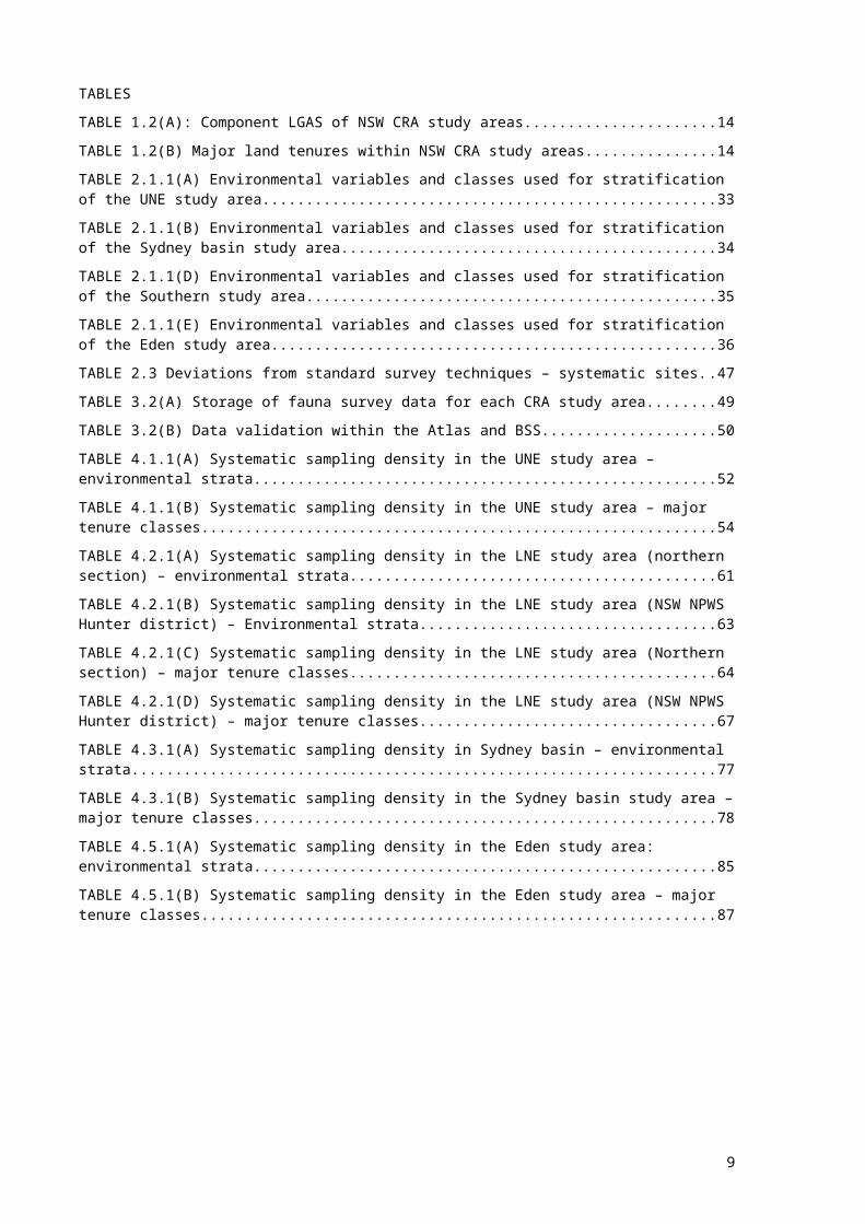
TABLE 2.1.1(E) Environmental variables and classes used for stratification of the Eden study area........................................................................................................................36TABLE 2.3 Deviations from standard survey techniques – systematic sites.....................47TABLE 3.2(A) Storage of fauna survey data for each CRA study area..............................49TABLE 3.2(B) Data validation within the Atlas and BSS....................................................50TABLE 4.1.1(A) Systematic sampling density in the UNE study area – environmental strata...............................................................................................................................52TABLE 4.1.1(B) Systematic sampling density in the UNE study area – major tenure classes......................................................................................................................................... 54TABLE 4.2.1(A) Systematic sampling density in the LNE study area (northern section) – environmental strata........................................................................................................61TABLE 4.2.1(B) Systematic sampling density in the LNE study area (NSW NPWS Hunter district) – Environmental strata........................................................................................63TABLE 4.2.1(C) Systematic sampling density in the LNE study area (Northern section) – major tenure classes........................................................................................................64TABLE 4.2.1(D) Systematic sampling density in the LNE study area (NSW NPWS Hunter district) – major tenure classes........................................................................................67TABLE 4.3.1(A) Systematic sampling density in Sydney basin – environmental strata.....77TABLE 4.3.1(B) Systematic sampling density in the Sydney basin study area – major tenure classes..................................................................................................................78TABLE 4.5.1(A) Systematic sampling density in the Eden study area: environmental strata......................................................................................................................................... 85TABLE 4.5.1(B) Systematic sampling density in the Eden study area – major tenure classes.............................................................................................................................87
9

AbbreviationsAPAIS Australian Public Affairs Information ServiceBSS Biological Survey SystemCAR Comprehensive, Adequate, RepresentativeCRA Comprehensive Regional AssessmentsCSIRO Commonwealth Scientific and Industrial Research OrganisationDEM Digital Elevation ModelEIS Environmental Impact StatementESFM Ecologically Sustainable Forest ManagementESRI Environmental Systems Research InstituteIBRA Interim Bioregionalisation of AustraliaJANIS Joint ANZECC / MCFFA National Policy Statement Implementation
SubcommitteeJOGP Joint Oldgrowth ProjectLandsat TM Landsat Thematic MappingLGA Local Government AreaLNE Lower North EastNEFBS North East Forests Biodiversity StudyNRAC Natural Resources Audit CouncilNRDD Natural Resources Data DirectoryPVA Population Viability AnalysisRACD Resource and Conservation Division, Dept. Urban Affairs and PlanningRAOU Royal Australasian Ornithologists’ UnionRFA Regional Forest AgreementSFNSW State Forests of NSWUNE Upper North East
10

NomenclatureNomenclature used in this report follows the Census of Australian Vertebrate Species (CAVS, version 1995), as maintained by the Biological Resources Study, Commonwealth Department of Environment, Sports and Territories.Both common and scientific names are given in the first reference to a species. Thereafter, ‘report’ names are used. Common names, where available, are the report names for birds and mammals (except bats). Scientific names are used for all other taxa.
11
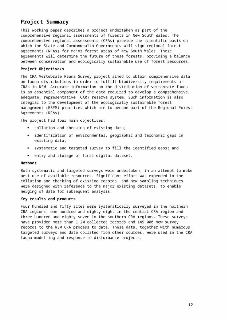
Project SummaryThis working paper describes a project undertaken as part of the comprehensive regional assessments of forests in New South Wales. The comprehensive regional assessments (CRAs) provide the scientific basis on which the State and Commonwealth Governments will sign regional forest agreements (RFAs) for major forest areas of New South Wales. These agreements will determine the future of these forests, providing a balance between conservation and ecologically sustainable use of forest resources.Project Objective/sThe CRA Vertebrate Fauna Survey project aimed to obtain comprehensive data on fauna distributions in order to fulfill biodiversity requirements of CRAs in NSW. Accurate information on the distribution of vertebrate fauna is an essential component of the data required to develop a comprehensive, adequate, representative (CAR) reserve system. Such information is also integral to the development of the ecologically sustainable forest management (ESFM) practices which are to become part of the Regional Forest Agreements (RFAs).The project had four main objectives:
collation and checking of existing data; identification of environmental, geographic and taxonomic gaps in existing data; systematic and targeted survey to fill the identified gaps; and entry and storage of final digital dataset.
MethodsBoth systematic and targeted surveys were undertaken, in an attempt to make best use of available resources. Significant effort was expended in the collation and checking of existing records, and new sampling techniques were designed with reference to the major existing datasets, to enable merging of data for subsequent analysis.Key results and productsFour hundred and fifty sites were systematically surveyed in the northern CRA regions, one hundred and eighty eight in the central CRA region and three hundred and eighty seven in the southern CRA regions. These surveys have provided more than 1.2M collected records and 145 000 new survey records to the NSW CRA process to date. These data, together with numerous targeted surveys and data collated from other sources, were used in the CRA fauna modelling and response to disturbance projects.
12
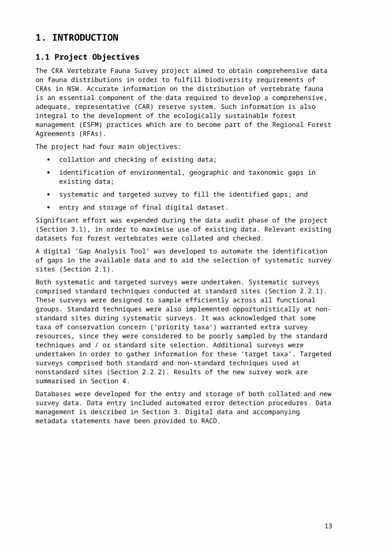
1. INTRODUCTION1.1 Project ObjectivesThe CRA Vertebrate Fauna Survey project aimed to obtain comprehensive data on fauna distributions in order to fulfill biodiversity requirements of CRAs in NSW. Accurate information on the distribution of vertebrate fauna is an essential component of the data required to develop a comprehensive, adequate, representative (CAR) reserve system. Such information is also integral to the development of the ecologically sustainable forest management (ESFM) practices which are to become part of the Regional Forest Agreements (RFAs).The project had four main objectives:
collation and checking of existing data; identification of environmental, geographic and taxonomic gaps in existing data; systematic and targeted survey to fill the identified gaps; and entry and storage of final digital dataset.
Significant effort was expended during the data audit phase of the project (Section 3.1), in order to maximise use of existing data. Relevant existing datasets for forest vertebrates were collated and checked.A digital ‘Gap Analysis Tool’ was developed to automate the identification of gaps in the available data and to aid the selection of systematic survey sites (Section 2.1).Both systematic and targeted surveys were undertaken. Systematic surveys comprised standard techniques conducted at standard sites (Section 2.2.1). These surveys were designed to sample efficiently across all functional groups. Standard techniques were also implemented opportunistically at non-standard sites during systematic surveys. It was acknowledged that some taxa of conservation concern (‘priority taxa’) warranted extra survey resources, since they were considered to be poorly sampled by the standard techniques and / or standard site selection. Additional surveys were undertaken in order to gather information for these ‘target taxa’. Targeted surveys comprised both standard and non-standard techniques used at nonstandard sites (Section 2.2.2). Results of the new survey work are summarised in Section 4.Databases were developed for the entry and storage of both collated and new survey data. Data entry included automated error detection procedures. Data management is described in Section 3. Digital data and accompanying metadata statements have been provided to RACD.
13
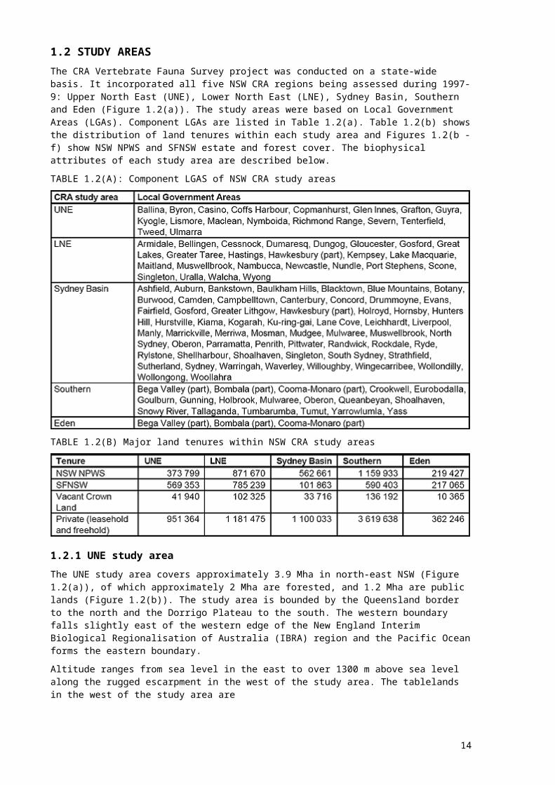
1.2 STUDY AREASThe CRA Vertebrate Fauna Survey project was conducted on a state-wide basis. It incorporated all five NSW CRA regions being assessed during 1997-9: Upper North East (UNE), Lower North East (LNE), Sydney Basin, Southern and Eden (Figure 1.2(a)). The study areas were based on Local Government Areas (LGAs). Component LGAs are listed in Table 1.2(a). Table 1.2(b) shows the distribution of land tenures within each study area and Figures 1.2(b - f) show NSW NPWS and SFNSW estate and forest cover. The biophysical attributes of each study area are described below.TABLE 1.2(A): Component LGAS of NSW CRA study areas
TABLE 1.2(B) Major land tenures within NSW CRA study areas
1.2.1 UNE study areaThe UNE study area covers approximately 3.9 Mha in north-east NSW (Figure 1.2(a)), of which approximately 2 Mha are forested, and 1.2 Mha are public lands (Figure 1.2(b)). The study area is bounded by the Queensland border to the north and the Dorrigo Plateau to the south. The western boundary falls slightly east of the western edge of the New England Interim Biological Regionalisation of Australia (IBRA) region and the Pacific Ocean forms the eastern boundary. Altitude ranges from sea level in the east to over 1300 m above sea level along the rugged escarpment in the west of the study area. The tablelands in the west of the study area are
14

FIGURE 1.2(A) NSW CRA study areas
15

Blank page follows map
16

FIGURE 1.2(B) Land tenure and forest cover within the UNE CRA study area
17

Blank page follows colour map
18

typified by gentle relief to the north with steeper areas in the higher country to the south. The coastal plain has a rugged, dissected topography near the escarpment and flattens towards the coast. Extensive floodplains occur along the Clarence, Richmond and Tweed rivers.The climate of the UNE study area is largely warm temperate. Annual rainfall is influenced by distance from the coast and topography. Mean annual rainfall ranges from 628 mm near Ebor to almost 3500 mm near Whian Whian State Forest. Mean annual temperature ranges from 9.4°C at Round Mountain to 20.1°C at Tweed Heads.The wide range of environmental variation within this study area is reflected in the richness of plant species and communities. About half of the vascular plant species found in NSW are known from the study area. The major vegetation systems of the area are rainforest, open forest and woodlands, swamp forest, heath, scrub and grasslands (NSW NPWS 1995).The UNE study area is of great zoogeographical significance. It supports unique faunal assemblages and a high number of endemic and threatened species. The study area contains elements of four major Australian zoogeographic subdivisions, as identified by Schodde and Calaby (1972); the only region in Australia to do so (NSW NPWS 1994). The study area supports 75 Vulnerable and 11 Endangered forest dependent species, as listed in the NSW Threatened Species Conservation (TSC) Act (1995).
1.2.2 LNE study areaThe LNE study area covers approximately 5.8 Mha in north-east NSW (Figure 1.2(a)), of which approximately 3.1 Mha are forested and 2 Mha are public lands (Figure 1.2(c)). The study area includes the Dorrigo Plateau to the north and is bounded by the Hawkesbury River to the south. The western boundary approximates the western edge of the New England Tablelands and Sydney Basin IBRA regions. The Pacific Ocean forms the eastern boundary.Altitude ranges from sea level to over 1400 m above sea level. The Great Escarpment bisects the study area in a north-south direction. Associated steep gorges are also a dominant feature, with lower elevation foothills and a coastal plain to the east. The Northern Tablelands occupy much of the western part of the study area (NSW NPWS 1994).The climate of the LNE study area is largely warm temperate. Annual rainfall is influenced by distance from the coast and topography. Mean annual rainfall ranges from under 400 mmyr-1 near Walcha to almost 2900 mmyr-1 near Dorrigo. Mean annual temperature ranges from 8.4°C in Barrington Tops National Park to 18.7°C between Bellingen and Dorrigo.The wide range of environmental variation within the UNE study area is also apparent in the LNE study area, although sub-tropical influences are less evident. Plant species and communities are once again diverse. Forest vegetation ranges from subtropical rainforests, through wet and dry sclerophyll forests to dry open woodlands.The LNE is an area of highly diverse habitat. Five IBRA regions occur within this study area; NSW North Coast, New England Tablelands, Nandewar, Sydney Basin and Brigalow Belt South. The study area supports 33 Vulnerable and five Endangered forest dependent species, as listed in the NSW TSC Act (1995).
19
1.2.3 Sydney Basin study areaThe Sydney Basin study area covers about 2 Mha in central eastern NSW (Figure 1.2(a)), of which almost 1.2 Mha is forested (Figure 1.2(d)). The study area incorporates approximately half of the Sydney Basin bioregion. The area stretches along the coast from Gerroa in the south to Broken Bay where the Hawkesbury River forms part of the northern boundary. The boundary then follows the Colo River and Wollemi Creek north-west to Goulburn River National Park. The western boundary runs north-south through the western ranges towns of Sofala and Tarana and approximates the boundary of the Blue Mountains and Kanangra-Boyd national parks. The southern boundary cuts through the northern sections of Morton and Budderoo national parks. The Sydney Basin bioregion encompasses the Narrabeen and Hawkesbury Sandstone Groups, and sandstone is the predominant geology of the study area. Other geologies include the underlying Illawarra Coal Measures exposed around Wollongong, the alluvial flats of the Cumberland Plain, and the fertile basalt caps of Mt Corricudgy and Mt Nullo. The rugged topography of the sandstone formations has resulted in much remaining uncleared while the Cumberland Plain and coastal flats have been heavily cleared for agriculture and urbanisation.Rainfall generally decreases from east to west across the study area, however, there is a band of orographic rainfall parallel to the coast where moist ocean air meets a rise in altitude. This supports rainforest communities on the Illawarra Escarpment, at Barrington Tops and the Wattagan Mountains, all of which have an average annual rainfall of approximately 1500 mm. By contrast, the south-western part of the Cumberland Plain, which is in a rain shadow, receives less than 650 mm per annum. Average temperature also relates to elevation and proximity to the coast, with a slight cline with latitude also apparent.Forested environments within the Sydney Basin study area are classed as rainforest, tall open forest (moist forest), open forest (dry forest) and woodland. All except rainforest are eucalypt dominated. Non-forested environments include heath, scrub, sedgeland swamp, freshwater communities, mangrove, saltmarsh and coastal dunes (Fairley and Moore 1989).Within the Sydney Basin study area, 61 forest dependent fauna species are classified as threatened or vulnerable under the NSW Threatened Species Conservation Act (TSC Act) 1995, including five frogs, three reptiles, 21 mammals and 32 birds. There are ten forest dependent species whose range is mostly or wholly within the Sydney Basin study area, including Pseudophryne australis (Red-crowned Toadlet) and Hoplocephalus bungaroides (Broadheaded Snake).
1.2.4 Southern study areaThe Southern study area covers about 5.55 Mha in south-east NSW (Figure 1.2(a)), of which almost 2.8 Mha is forested (Figure 1.2(e)). The study area extends southwards along the coast from Nowra to the Eden study area at Bermagui. The southern boundary abuts the northern and western boundaries of the Eden study area and then follows the NSW/Victorian state border westwards and along the upper River Murray almost to Albury. The western boundary follows various LGA boundaries northeastwards to just north of Oberon in the southern Blue Mountains. Here the boundary turns southeast towards Nowra. Much of the forested land within the Southern study area is managed by SFNSW or NSW NPWS (see Table 1.2(b).The Snowy Mountains extend north-south through the centre of the Southern study area. Maximum altitude is 2228 m asl at Mount Kosciuszko, decreasing westwards to 192 m on the far western slopes, and decreasing eastwards across the tablelands and down the escarpment to the
20

coastal areas of Narooma, Bateman’s Bay and Ulladulla. The northern tip of the study area extends into the southern Blue Mountains.
21

FIGURE 1.2(C) Land tenure and forest cover within the LNE CRA study area
22

Blank page follows colour map
23

FIGURE 1.2(D) Land tenure and forest cover within Sydney basin CRA study area
24

Blank page follows colour map
25

FIGURE 1.2(E) Land tenure and forest cover within the Southern CRA study area
26

Blank page follows colour map
27

Mean annual rainfall varies from 465 mm at Cooma on the Monaro grasslands to 2357 mm at Charlottes Pass in the mountains. Rainfall is lowest around the Monaro plains, increasing east towards the coast and west to the mountains. Mean annual temperature ranges from 2°C near Mount Kosciuszko to 16°C along the coastal plains north of Ulladulla. Temperature increases both east and westwards away from the mountain ranges.The northeastern section of the Southern study area is dominated by Permian siltstones and sandstones, with a band of Ordovician sediments extending southwards through Yadboro and Dampier state forests. The north-south running escarpment is characterised by low fertility sediments. Granitic outcrops occur throughout coastal plains and in the central northern and southern sections of the tablelands. The high plateaux in the north comprise Ordovician and Devonian sediments and in the south metamorphic sediments with granite outcrops. The western slopes are predominantly granitic and sedimentary.Vegetation is highly varied, due to the wide altitudinal and geographic range. The north of the study area supports vegetation types typical of the warm temperate sandstone environments around Sydney and Wollongong. Cooler climates are reflected further south. Vegetation communities in coastal areas comprise predominantly wet and dry sclerophyll forests with patches of rainforest in the escarpment gullies, and coastal and plateau heathlands. The tablelands and western slopes are dominated by dry sclerophyll forests, grassy woodlands and open native grasslands. The mountains support dry and wet sclerophyll forests on the lower to mid altitude slopes, with pockets of rainforest in the western gullies. Higher slopes are dominated by moister forests grading into sub-alpine woodland with increasing altitude. Alpine heathlands and herbfields are found at the highest altitudes.The wide range of habitats supported by the Southern study area is reflected in a high diversity of fauna species. Forty-nine vertebrate species are classified as Endangered or Vulnerable under the NSW TSC Act (1995), including the highly threatened Potorous longipes (Longfooted Potoroo), Litoria spenceri (Spotted Tree Frog) and Xanthomyza phrygia (Regent Honeyeater). The area supports several species that are endemic to southeastern NSW and eastern Victoria including Pseudomys fumeus (Smoky Mouse), Pseudophryne corroboree (Corroboree Frog) and the Potorous longipes (Long-footed Potoroo), as well as almost 40 species of regional conservation significance.
1.2.5 Eden study areaThe Eden study area is based on the State Forests of NSW (SFNSW) Eden Native Forest Management Area. This area covers just over 800 000 ha in south-east NSW (Figure 1.2(a)), of which almost 550 000 ha is forested (Figure 1.2(f)). The study area extends north to Bermagui and south to the Victorian border. The western boundary is formed by the Monaro Tableland, along a line between Nimmitabel and Bombala. The Pacific Ocean forms the eastern boundary.Altitude peaks at around 1000 m asl along the Monaro Tableland escarpment, falling away towards the Bega Valley and the coastal areas of Eden and Narooma.Mean annual rainfall varies from 447 mm near Nimmitabel in the extreme northwest of the study area to 1116 mm at Mt Imlay southwest of Eden, generally decreasing east to west, but with a higher band along the escarpment parallel to the coast. Mean annual temperature ranges from 7oC north-east of Bega to 15oC in Nadgee Nature Reserve. There is generally a decrease in temperature from east to west relating to elevation and from north to south due to latitude.
28
The geology of the Eden CRA region is dominated by granites with Ordovician sediments and alluvial fans. Basalt outcrops are dispersed amongst these rock types. To the north, in Wadbilla National Park, is a large dissected sandstone plateau, and in the south deep alluvial sediments cover the Bega Valley. Aeolian sand systems are found in the flat coastal areas from Nadgee Nature Reserve to Bermagui.Vegetation is dominated by wet and dry sclerophyll forests, with small patches of rainforest on the escarpment and south facing gullies; coastal and plateau heathlands; and scattered patches of grasslands and grassy woodlands. Much of the forested area is managed by SFNSW or NSW NPWS (see Table 1.2(b)).The Eden study area supports 32 species listed as Endangered or Vulnerable under the NSW TSC Act (1995) (2 frogs, 12 birds, 18 mammals). Seven of these species have their NSW range mostly or wholly in the Eden study area, including Isoodon obesulus (Southern Brown Bandicoot), Sminthopsis leucopus (White-footed Dunnart) and the highly threatened Potorous longipes (Long-footed Potoroo).
29

FIGURE 1.2(F) Land tenure and forest cover within the Eden CRA study area
30
Blank page follows colour map
31

2. METHODOLOGY2.1 SITE SELECTIONThree approaches were used for the selection of CRA fauna survey sites:
automated Gap Analysis, using a computer application designed as part of this project (standard survey sites);
‘traditional’ GIS-based stratification of study areas, using mapped biotic and abiotic variables (standard survey sites)
targeted site selection, based on expert knowledge and maps of predicted habitat (targeted survey sites).
The following sections describes site selection for both systematic and targeted surveys
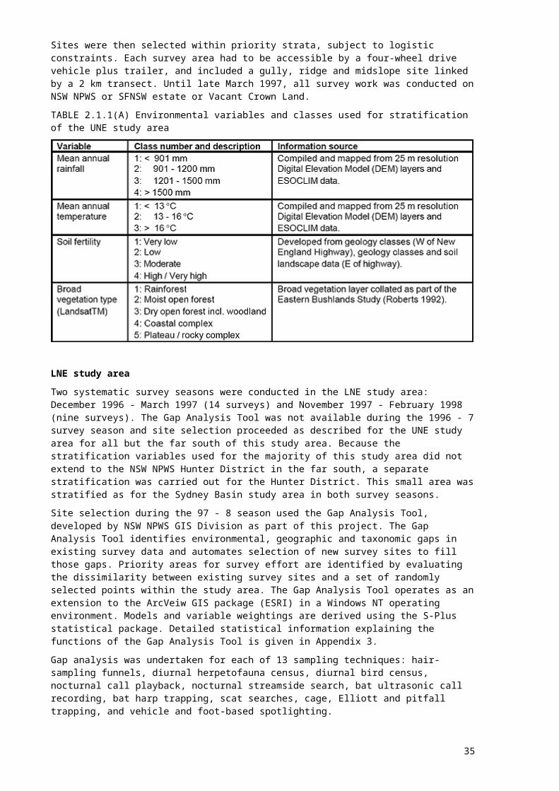
2.1.1 Site selection for systematic surveysUNE study areaFourteen systematic surveys were conducted in the UNE study area during the period December 1996 - March 1997. The computer Gap Analysis Tool was not operational for this survey season. Traditional stratification of environmental variables was therefore used to select survey sites. Because of the high number of existing systematic survey sites, it was possible to further enhance the traditional NSW NPWS stratification methodology (used for example by the North East Forests Biodiversity Study (NEFBS) and Natural Resources Audit Council (NRAC) projects). Details of survey technique were included, to allow consideration of existing sites where only a subset of standard techniques had been undertaken.Four environmental variables were used to identify 142 environmental strata which occurred within the UNE study area. Table 2.1.1(a) shows the selected variables and component classes.In order to prioritise strata for CRA survey effort, sampling intensity of existing datasets was first calculated. Existing survey sites for eight techniques were plotted in turn against environmental strata and the intensity of sampling within each stratum was derived for each technique. Each stratum was then assigned a ranking of 0, 1 or 2 for each technique, according to the intensity of previous survey. A ranking of 0 indicated previous survey of at least average intensity (according to the average intensity of that technique across all strata), 1 denoted an intensity less than the average but not less than half of the average value, and 2 denoted an existing intensity of less than half the average value. The eight rankings were summed for each stratum to indicate the need for systematic survey effort in that stratum.
32

Sites were then selected within priority strata, subject to logistic constraints. Each survey area had to be accessible by a four-wheel drive vehicle plus trailer, and included a gully, ridge and midslope site linked by a 2 km transect. Until late March 1997, all survey work was conducted on NSW NPWS or SFNSW estate or Vacant Crown Land.TABLE 2.1.1(A) Environmental variables and classes used for stratification of the UNE study area
LNE study areaTwo systematic survey seasons were conducted in the LNE study area: December 1996 - March 1997 (14 surveys) and November 1997 - February 1998 (nine surveys). The Gap Analysis Tool was not available during the 1996 - 7 survey season and site selection proceeded as described for the UNE study area for all but the far south of this study area. Because the stratification variables used for the majority of this study area did not extend to the NSW NPWS Hunter District in the far south, a separate stratification was carried out for the Hunter District. This small area was stratified as for the Sydney Basin study area in both survey seasons.Site selection during the 97 - 8 season used the Gap Analysis Tool, developed by NSW NPWS GIS Division as part of this project. The Gap Analysis Tool identifies environmental, geographic and taxonomic gaps in existing survey data and automates selection of new survey sites to fill those gaps. Priority areas for survey effort are identified by evaluating the dissimilarity between existing survey sites and a set of randomly selected points within the study area. The Gap Analysis Tool operates as an extension to the ArcVeiw GIS package (ESRI) in a Windows NT operating environment. Models and variable weightings are derived using the S-Plus statistical package. Detailed statistical information explaining the functions of the Gap Analysis Tool is given in Appendix 3.Gap analysis was undertaken for each of 13 sampling techniques: hair-sampling funnels, diurnal herpetofauna census, diurnal bird census, nocturnal call playback, nocturnal streamside search, bat ultrasonic call recording, bat harp trapping, scat searches, cage, Elliott and pitfall trapping, and vehicle and foot-based spotlighting.
33
Gap Analysis operated across all forested land, thus avoiding any tenure bias in prioritisation of strata for sampling. However, surveys were conducted on public land within selected strata whenever possible.
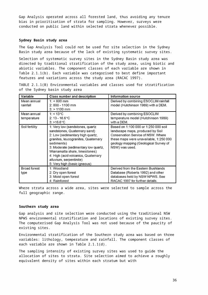
Sydney Basin study areaThe Gap Analysis Tool could not be used for site selection in the Sydney Basin study area because of the lack of existing systematic survey sites.Selection of systematic survey sites in the Sydney Basin study area was directed by traditional stratification of the study area, using biotic and abiotic variables. The component classes of each variable are shown in Table 2.1.1(b). Each variable was categorised to best define important features and variations across the study area (RACAC 1997).TABLE 2.1.1(B) Environmental variables and classes used for stratification of the Sydney basin study area
Where strata across a wide area, sites were selected to sample across the full geographic range.
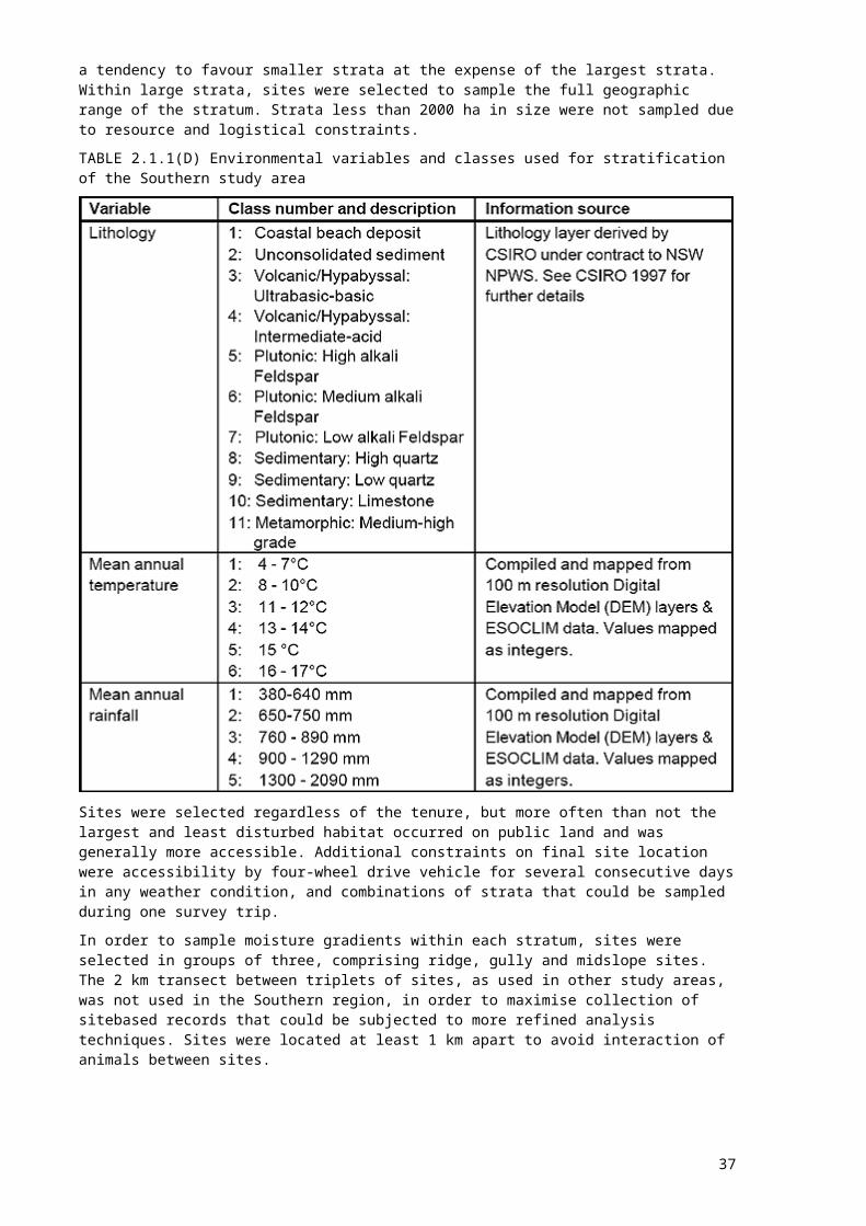
Southern study areaGap analysis and site selection were conducted using the traditional NSW NPWS environmental stratification and locations of existing survey sites. The computerised Gap Analysis Tool was not used because of the paucity of existing sites.Environmental stratification of the Southern study area was based on three variables: lithology, temperature and rainfall. The component classes of each variable are shown in Table 2.1.1(d).The sampling intensity of existing survey sites was used to guide the allocation of sites to strata. Site selection aimed to achieve a roughly equivalent density of sites within each stratum but with
34
a tendency to favour smaller strata at the expense of the largest strata. Within large strata, sites were selected to sample the full geographic range of the stratum. Strata less than 2000 ha in size were not sampled due to resource and logistical constraints.TABLE 2.1.1(D) Environmental variables and classes used for stratification of the Southern study area
Sites were selected regardless of the tenure, but more often than not the largest and least disturbed habitat occurred on public land and was generally more accessible. Additional constraints on final site location were accessibility by four-wheel drive vehicle for several consecutive days in any weather condition, and combinations of strata that could be sampled during one survey trip.In order to sample moisture gradients within each stratum, sites were selected in groups of three, comprising ridge, gully and midslope sites. The 2 km transect between triplets of sites, as used in other study areas, was not used in the Southern region, in order to maximise collection of sitebased records that could be subjected to more refined analysis techniques. Sites were located at least 1 km apart to avoid interaction of animals between sites.
Eden study areaThe Gap Analysis Tool was not operational during site selection for the Eden study area. Gap analysis and site selection used traditional NSW NPWS environmental stratification and locations
35
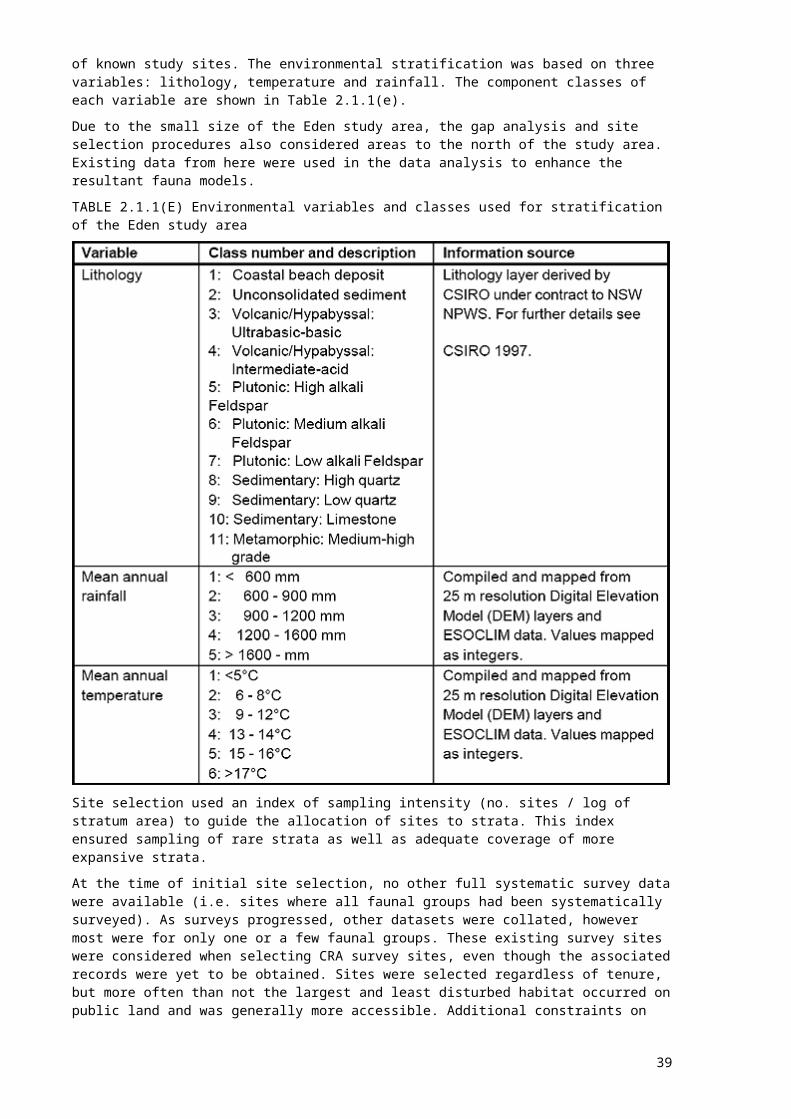
of known study sites. The environmental stratification was based on three variables: lithology, temperature and rainfall. The component classes of each variable are shown in Table 2.1.1(e).Due to the small size of the Eden study area, the gap analysis and site selection procedures also considered areas to the north of the study area. Existing data from here were used in the data analysis to enhance the resultant fauna models.TABLE 2.1.1(E) Environmental variables and classes used for stratification of the Eden study area
Site selection used an index of sampling intensity (no. sites / log of stratum area) to guide the allocation of sites to strata. This index ensured sampling of rare strata as well as adequate coverage of more expansive strata.At the time of initial site selection, no other full systematic survey data were available (i.e. sites where all faunal groups had been systematically surveyed). As surveys progressed, other datasets were collated, however most were for only one or a few faunal groups. These existing survey sites were considered when selecting CRA survey sites, even though the associated records were yet to be obtained. Sites were selected regardless of tenure, but more often than not the largest and least disturbed habitat occurred on public land and was generally more accessible. Additional constraints on final site location were accessibility by four-wheel drive vehicle for several consecutive days in any weather condition, and combinations of strata that could be sampled during one survey trip.In order to sample moisture gradients within each stratum, sites were selected in groups of three, comprising ridge, gully and midslope sites linked by a 2 km transect. Within large strata, sites were selected to sample the full geographic range of the stratum.
36
2.1.2 Site selection for targeted surveysWhilst systematic survey design is preferred for analysis of resulting data, very poor returns are obtained for some rare and cryptic taxa. CRA targeted surveys aimed to record target taxa (see box) via purpose-designed surveys.
PRIORITY AND TARGET TAXAPriority taxa were identified for each study area. These were taxa of conservation concern, identified via the CRA Response to Disturbance project’s interpretation of the various JANIS criteria. Field teams were encouraged to implement extra survey effort (standard or non-standard techniques) within suitable habitat to detect these taxa.Target taxa were a subset of the priority taxa for each study area. Selection was based on rarity and / or poor detection rates in previous systematic surveys. Only those taxa for which targeted survey was expected to yield good returns were selected. Taxa considered as candidates for Population Viability Analysis (PVA) were also targeted. CRA targeted surveys were designed specifically to detect these taxa.Appendix 1 lists priority and target taxa for each study area.
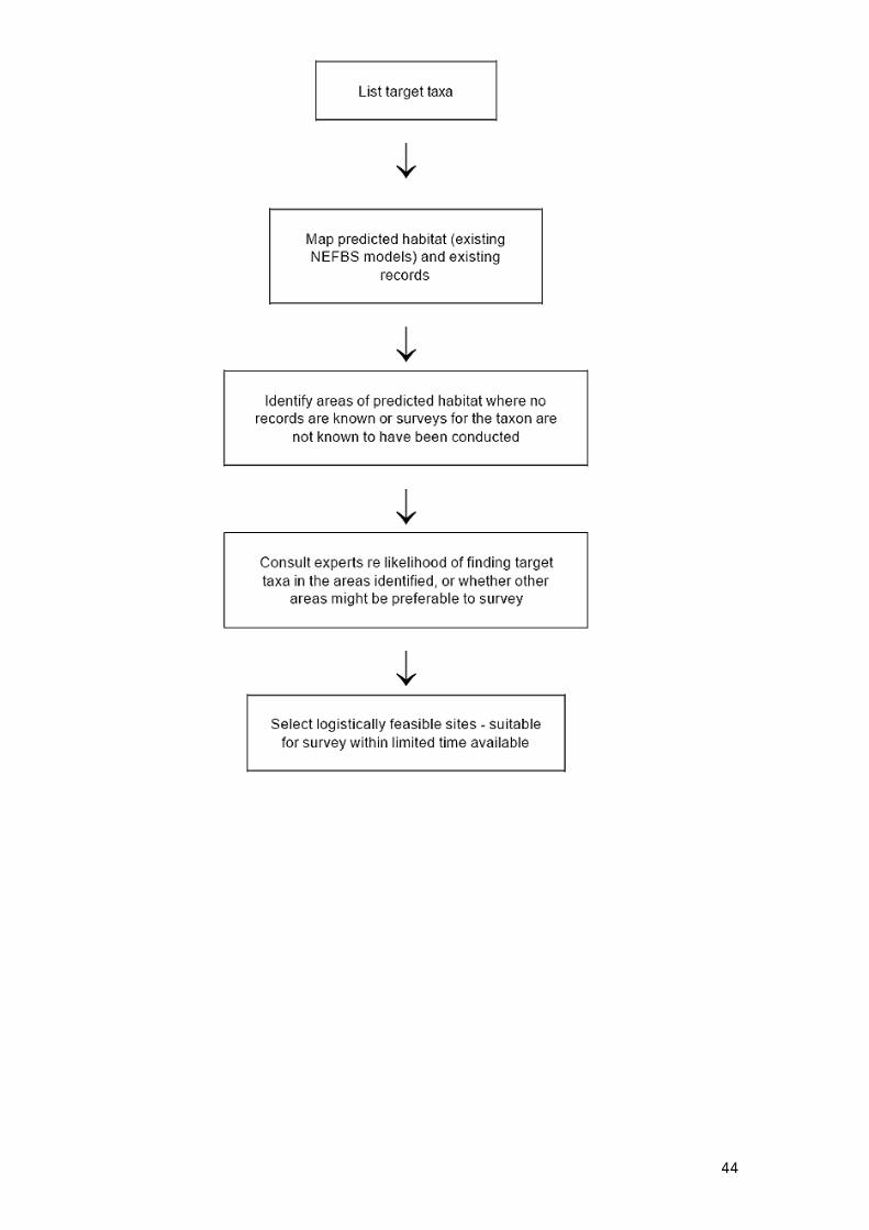
UNE and LNE study areasSelection of target survey sites followed the steps outlined in Figure 2.1.2.
Sydney Basin study areaTargeted surveys in the Sydney Basin study area were designed to sample large forest owls (Ninox strenua (Powerful Owl), N. connivens (Barking Owl), Tyto tenebricosa (Sooty Owl) and T. novaehollandiae (Masked Owl)) during winter. Most existing systematic surveys had been conducted during spring and summer, when owls are not breeding and so are less likely to respond to call playback. These surveys had two aims: to gather records for poorly sampled species and to investigate the effect of variations in survey season and methodology.Strata were selected as for systematic survey sites in this study area (see Section 2.1.1), with the aim of filling geographic and environmental gaps in existing survey coverage. Sites were located at least 2 km apart, but not necessarily across the moisture gradient within each stratum.
Southern and Eden study areasAs there were very few existing systematic survey data for these study areas, most CRA survey effort was channeled into standard systematic surveys which sampled all species. However, more intensive specialised surveys were conducted for Phascolarctos cinereus (Koala), Pseudomys fumeus (Smoky Mouse) and Dasyurus maculatus (Tiger Quoll). Koala and Tiger Quoll surveys within the Southern study area were conducted jointly with SFNSW.Elliott traps and/or small hair-sampling funnels were used during the 1997 field season to survey suitable habitats for Smoky Mouse at 22 survey sites (11 in Southern and 11 in Eden). Suitable habitat was identified by experts.Koala sites were selected in a grid over the whole coastal area, using a broad environmental stratification to allow sampling within accessible areas. This sampling protocol ensured
37

compatibility with previous surveys conducted by SFNSW in the Eden area (Jurskis et al. 1997). Over 350 sites were surveyed in spring 1998.Tiger Quoll survey sites were selected in the Southern study area using the same environmental stratification as for systematic CRA sites and current known records of the species. Forty sites were surveyed in spring 1998 throughout Buckenbowra, Dampier and Yadboro state forests and Deua, Wadbilliga and Budawang national parks. Suitable habitats for quolls in each priority stratum were sampled, where accessible for the required trapping period.In addition to these specific targeted surveys, field teams on the standard systematic surveys surveyed extra opportunistic targeted sites in suitable areas for particular groups of species using standard methods. In this way, over 50 extra sites were surveyed for either reptiles, frogs, birds, bats, ground mammals and/or arboreal mammals/nocturnal birds. As the Southern CRA surveys will not be completed until February 1999, further targeted work may be conducted in this study area.FIGURE 2.1.2 Selection of targeted survey sites in UNE and LNE study areas
38
2.2 SURVEY TECHNIQUESThis project used both standard and non-standard sampling techniques.Standard sampling techniques expend a measured search effort in undertaking a well defined sampling technique. Because systematic surveys use standard site selection and standard sampling techniques, both species presence and absence records can be included in subsequent data analysis, allowing use of more discriminating statistical techniques. A set of nine standard techniques was endorsed for systematic surveys (Section 2.2.1).Because many cryptic and/or rare animals are poorly sampled by the standard techniques used on systematic surveys, non-standard (specialised) techniques were also used during targeted surveys (Section 2.2.2). Although of limited use in statistical analysis, non-standard techniques often generate important records for priority taxa.Sampling techniques were designed with reference to the major existing datasets, to enable merging of data for analysis. Field survey proformas are shown in Appendix 4.Incidental observations of priority fauna were recorded during all surveys.Surveys were conducted under appropriate licences, see Appendix 5 for details.
2.2.1 Survey techniques used in systematic surveysSystematic surveys were designed to sample all functional groups via standard sampling techniques at standard (stratified) sampling sites. They were an efficient way to gather presence/absence data for a wide range of taxa.Each systematic survey was sampled in groups of three: a gully, midslope and ridge site, generally in the same stratum. Sampling sites were 2 ha in size, generally configured as a 100 x 200 m rectangle. Field teams comprising a team leader and three to four other team members who generally completed nine standard sites over six days.In general, the full suite of standard techniques was conducted at each standard survey site. Because of the large number of survey teams (nineteen team leaders across five CRA study areas), and extended period of fauna survey (December 1996 - January 1999) it was inevitable that survey techniques would evolve during the project and that differences would appear between study areas. Deviations from the standard methodology are described in Section 2.3.Voucher specimens were collected according to the guidelines shown in Appendix 5.Standard techniques used at standard survey sitesSite attributesSeveral attributes were measured at each standard site in order to characterise fauna habitat and provide environmental variables which could later be used in modeling the predicted distribution of sampled taxa. Recorded attributes included physiogeographic, disturbance, vegetation structure and floristics, microhabitat and stream data. Vegetation attributes were developed in consultation with CRA flora survey staff to avoid duplication and to maximise the efficient use of resources.
39

A 20 m x 20 m quadrat was sampled within each 2 ha survey site to estimate typical habitat characteristics. This size quadrat is the NSW NPWS standard for sampling detailed structural and floristic information (NPWS 1994c, 1995a, 1996b).Standard codes for soil and vegetation types were used wherever possible, as provided by the Australian Soil and Land Survey Handbook (McDonald et al. 1990).
Hair-sampling funnelsFifty large hair-sampling funnels (approximately 12.5 cm maximum diameter; Faunatech Wildlife Technical Consultants) were used within each stratum (i.e. each set of ridge, midslope and gully sites). Each funnel was fitted with a sticky wafer designed to collect hairs of small and medium sized mammals investigating the bait. Twenty funnels were placed at 100 m intervals along a transect, where possible running between the ridge, midslope and gully site within each stratum. Ten funnels were placed within each standard survey site at 10 - 15 m intervals. Alternate funnels were baited with singed meat (usually chicken) or a vegetarian bait comprising a mixture of peanut butter, oats and essence of pistachio nut oil, with or without honey. Meat baited funnels were set to attract carnivorous and omnivorous species: Dasyurus maculatus (Tiger Quoll), Dasyurus viverrinus (Eastern Quoll), Felis catus (Cat), Canis familiaris (Dog, including Dingo), bandicoots etc. Potorous tridactylus (Long-nosed Potoroo), Aepyprymnus rufescens (Rufous Bettong) and other small macropods were targeted by vegetarian bait.Funnels were left on site for approximately ten nights. Hair samples were identified by specialists using the techniques described by Brunner and Coman (1974). Identifications were divided into three levels of reliability: definite, probable and possible. Whilst all records were entered into the database, only definite identifications were included in the subsequent analyses.
Diurnal herpetofauna censusA 0.5 ha plot (50 x 100 m) was sampled at each standard CRA fauna survey site. The search was standardised to one person-hour at each site. Censuses were restricted to the mid-morning to late afternoon period, when temperature and insolation were sufficient to ensure maximum reptile activity. This technique was not conducted on overcast or rainy days.Potential reptile and frog microhabitats were actively searched within the 0.5 ha sample area. Active or basking reptiles were identified by sight or by capture and keying out where possible. Sheltering or cryptic species were detected by destructively searching fallen logs, litter, decorticating and fallen bark, rock outcrops and other likely substrates. Voucher specimens were taken as necessary. These were preserved, numbered and lodged with the Australian Museum for verification of field identifications and as representatives for taxonomic studies. Census time and temperature at ground level were recorded at the time of the search.
Nocturnal call playbackThe standard CRA survey census included broadcasting the calls of the four large forest owls, Ninox strenua (Powerful Owl), N. connivens (Barking Owl), Tyto novaehollandiae (Masked Owl and T. tenebricosa (Sooty Owl), from the centre of each site. The calls of other nocturnal birds and arboreal marsupials were also played at the discretion of the team leader.The site was initially searched by spotlight. A pre-recorded tape of each species’ call series was then played on a Sony Professional Walkman, amplified through a nine volt transistor megaphone. Each species’ call was played for three minutes, followed by a two minute listening period. The surrounding area was again searched by spotlight after the last listening period. After the census the date, time, and amount of cloud cover were recorded, as well as any fauna
40
records. Very windy and rainy nights were avoided where possible. Censuses conducted in poor weather were noted as such by the team leader.
Bat ultrasonic (‘Anabat’) call recording Insectivorous microchiropteran bats were sampled by two techniques: ultrasonic recording and harp trapping. Harp trapping is discussed later in this section.Ultrasonic recorders (Corben 1989) are an important tool in bat surveys. They are particularly useful for detection of high flying species, which often comprise more than one third of an area’s bat species (Parnaby 1992a), but are under sampled by harp trapping (Richards 1992). The basic recording equipment for the CRA surveys comprised an ‘Anabat II’ detector and a tape recorder. Census duration was 30 minutes of continuous recording. Censuses begun at or soon after dusk, and were conducted up to two hours after dusk, a peak activity period for microchiropteran bats.Bat detectors were used according to the protocol specified by Parnaby (1992a). That is, detectors were placed on the ground and microphones inclined upwards at 45° to the substrate. A 40 kHz calibration tone was recorded for a few seconds at the start and finish of each recording session.Recordings were analysed by recognised experts in this field. Identification was classed as either definite, probable or possible, as per the methodology of Parnaby (1992a).
Diurnal bird censusDiurnal bird censuses comprised a standard 20 minute search within each standard site, conducted by an experienced bird surveyor. Censuses were conducted only during periods of relatively high bird activity (early morning, late afternoon) and reasonable detectability (i.e. low cicada activity). All bird species and individuals seen or heard were recorded. Individuals were scored as ‘on-site’ if they were detected within the 2 ha plot. Individuals recorded outside the plot, in adjacent vegetation types or flying overhead, were recorded as ‘off-site’. Sample plot configurations were varied according to the nature and configuration of the habitat being sampled at the site. For example, plots at gully sites tended to be more linear than those at midslope and ridge sites.
Foot-based spotlightingSpotlight surveys for arboreal marsupials were undertaken along a 2 km transect running between and through the gully, midslope and ridge site within each stratum. All fauna seen or heard within 50 m of the transect were recorded. Two 50 W spotlights were used.
Predator and herbivore scat searchThe analysis of predator scats and pellets to identify prey remains is proven as an efficient sampling technique. The large numbers of hairs and sometimes skeletal remains in predator scats results in a high level of confidence in identifications of prey species. However, the immeasurable time delay between prey ingestion and defecation means that the location in which the prey lived cannot be accurately known. For predictive modeling purposes such records are obviously of lower value than actual known localities, although they may constitute a useful adjunct to more accurately located records. Some species are known only from a particular area by scat records. The predator species that deposits the scat will usually be identified as part of
41

the analysis, providing locality records for Dasyurus maculatus (Tiger Quoll), Vulpes vulpes (Fox), Canis familiaris (Dog/Dingo) and Sus scrofa (Pig). Standard CRA sites were searched on foot for predator scats. All predator scats and unassigned scats of other fauna were collected. Each scat was identified and analysed by a specialist in this field, using the methods used for hair funnel samples.
Bat (harp) trappingThis method complements bat ultrasonic call recording. While ultrasonic recorders are used principally to detect high flying bat species, collapsible harp traps (Tidemann and Woodside 1978) generally capture low flying species.Many microchiropteran bat species forage along forest streams and harp traps across streams have the potential to trap a number of target species. Each CRA standard survey used a harp trap for two nights at one location within the gully site. If the gully site was unsuitable (e.g. inaccessible or overgrown) an alternative trap position was selected in a suitable area as near as possible to the site within the same environmental stratum.Another two nights survey were conducted in the same environmental stratum but the exact location was at the team leader’s discretion. These sites were usually perceived ‘flyways’ on forest roads, over creeks or at water bodies where bats could potentially be interrupted along their flight paths.Traps were checked each morning. Captured bats were identified by external morphology, forearm measurement and body weight, and keyed using Parnaby (1992b). Animals were released on the following night at the point of capture.Representative voucher specimens were retained, preserved and lodged with the Australian Museum for verification of field identifications. This regional collection will be valuable in resolving some of the many uncertainties of bat taxonomy (Parnaby 1991).
Nocturnal streamside searchNocturnal streamside searches were conducted at each gully site to target frogs. A standard census comprised one person-hour of searching for active, basking or calling frogs for 200 m along the drainage line, stream or river.Time, temperature, identity and number of frogs and other detected fauna were recorded at the completion of the census.Voucher specimens were retained, preserved and lodged with the Australian Museum for verification of field identifications and as representatives for taxonomic studies. Most captured individuals were not required for collection and were released that night at the point of capture. This technique was conducted only at gully sites.
2.2.2 Survey techniques used in targeted surveysTargeted surveys were designed to record target taxa. They were conducted in areas of known and predicted habitat, based on expert knowledge and predictions from existing habitat models (primarily for the UNE and LNE regions). Because target taxa are inherently difficult to detect, a range of techniques believed most likely to detect these taxa was used.
42
In order to maximise returns from limited time and resources, target surveys were designed to sample one or more target taxa, whilst also being appropriate for other priority taxa. These techniques were also implemented during standard systematic surveys at the discretion of the team leader.
Non-standard techniques used at non-standard sites
Wet weather frog transectsFrog activity increases during wet weather when individuals can be found crossing and sitting on forest roads. An efficient way to sample at these times is to drive along these roads slowly (5 - 15 kmh-1) during and soon after rainy periods. Individual frogs were captured by hand during these surveys and either released following identification or retained as voucher specimens. Resulting data were treated as incidental records. Diurnal bird and frog playback and recording Playback and recording of bird and frog calls can be an efficient sampling technique to assist in species identification. These techniques were implemented opportunistically.
Predator scatsPredator scats were collected opportunistically during targeted surveys and away from standard sites during systematic surveys. Scats were sent to specialists for identification and analysis.
Vehicle-based spotlightingTeams traveling between standard sites within the same environmental stratum implemented this technique where time permitted. The location of all identified sightings was noted by odometer readings from known landmarks. The road-based transects and the location of records were later digitised for incorporation into GIS layers.
Cage trappingLimited cage trapping was conducted in the Sydney Basin study area and southern LNE, targeting Tiger Quoll and Long-nosed Potoroo. Ten traps were laid along each of three 2 km transects. Alternate traps were baited with sardines or a peanut butter / rolled oats mix. Traps were left out for four nights.
Targeted winter owl playbacksOwls records are more easily obtained during the winter breeding season (Kavanagh 1997). Owl playback was conducted at 187 sites within Sydney Basin and southern LNE regions during the winters of 1997 and 1998.
Targeted Tableland frog surveys (UNE and LNE study areas)These surveys were designed to sample several species.
Litoria booroolongensis CRA systematic surveys did not sample the Tablelands habitat of this possibly regionally extinct species. Targeted surveys for L. booroolongensis provided the opportunity to survey for other
43
Tablelands stream frogs known to be in decline. The standard nocturnal streamside search technique was used.Philoria sp.1 Very rare southern form of P. sphagnicolus, predicted to occur over much wider area than existing records. Calls during day from soaks, none sampled by the CRA systematic survey. Non-standard technique used for targeted surveys.Philoria richmondensis Similar habitats to P. sp.1, so not well covered by CRA systematic surveys.Mixophyes iteratus Predicted, but not previously recorded, from regions known to support P. richmondensis.
Rapid Vulnerable bat searches (UNE study area)Vulnerable microchiropteran bats were targeted within the UNE study area by identifying species’ calls recorded directly onto a laptop computer. This efficient technique was used at a large number of sites not sampled by the corresponding systematic technique (recording onto a tape recorder).
Small terrestrial mammal trappingElliott and pitfall traps were used to target species of particular conservation concern, for example Pseudomys gracilicaudatus (Eastern Chestnut Mouse), Planigale maculata (Common Planigale) and Phascogale tapoatafa (Brush-tailed Phascogale) in the UNE and LNE study areas and Smoky Mouse in the Eden and Southern areas.
Black-breasted Button Quail searches (UNE and LNE study areas)This species is predicted, but not recorded, in northern NSW, close to recent Queensland records. The Black-breasted Button Quail was not surveyed by standard techniques. Characteristic ‘scrapes’ were sought within suitable habitat. Individuals were then sought in the vicinity of scrapes.
Tablelands diurnal herpetofauna search (UNE and LNE study areas)The standard diurnal herpetofauna search technique was used to sample Underwoodisaurus sphyrurus at targeted sites. U. sphyrurus is threatened under the Threatened Species Conservation Act, endemic to north-east NSW. Sites were selected in areas of predicted habitat. These surveys allowed a significant number of gaps in tablelands reptile surveys to be filled.
Tiger Quoll trapping (Southern study area)Five cage traps, baited with chicken and placed at 50 m intervals, were used at 40 quoll survey sites. Traps were wired open and quolls free fed for the first two days, then traps set for ten days. Traps were placed in riparian zones or saddles between catchments in undersampled strata.
44
Koala surveys (Southern study area)Koalas were surveyed using call playback at over 350 sites throughout the coastal area of the Southern study area using the methods of Jurskis et al. (1997). Although this technique detected only male Koalas, it is an accepted and relatively quick and effective method to survey a large area in a short time.
Standard techniques used at non-standard sitesThe following techniques were implemented opportunistically during systematic surveys, sometimes away from the standard survey sites.
Elliott trappingA CRA Elliott trapping session was configured to suit the individual site, but included at least ten small (10 x 10 x 30 cm) Elliott traps set at 10 m intervals for four nights. Traps were baited with peanut butter, honey and oats. Trapped animals were identified by species and sex, then either released or retained as voucher specimens. Hair samples were taken from some captured individuals and retained as reference material for specialists conducting hair funnel and scat analysis.
Pitfall trappingDry pitfall traps were used when appropriate for priority species. Twenty litre plastic buckets were set so that the bucket lip was level with the ground. The number of buckets, use of drift fencing, search effort (number of nights x number of buckets) and prevailing weather conditions were recorded.
Trip linesLimited triplining was conducted in the Sydney Basin study area and southern LNE. Multiple wires of fishing line were erected over small dams or ponds. Bats hitting the lines fell into the water and were retrieved for identification then set free.
Mist netting (bats)Mist netting for microchiropteran bats was conducted in Sydney Basin study area and southern LNE. Mist nets were erected across perceived flyways and monitored constantly. Trapped bats were removed immediately for identification, then freed.
2.2.3 Incidental recordsTeams driving through survey areas recorded grid references when significant records were obtained. All mammals, less common birds, large and less common reptiles, and frogs were recorded in this manner (i.e. all priority species plus some others). In order to facilitate accurate mapping and recording of sampling locations, odometer readings were also noted for track intersections and standard and additional survey sites.
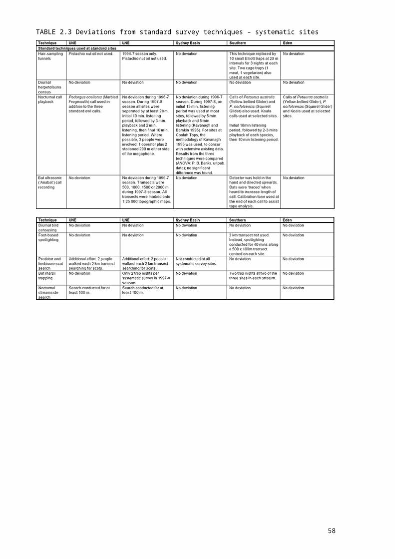
2.3 DEVIATIONS FROM STANDARD TECHNIQUESDeviations from the standard sampling techniques are described in Table 2.3. Deviations generally appear minor. In the case of nocturnal call playback, the playback and listening periods were deliberately varied to provide data for statistical tests of the compatibility of existing datasets - see table for details.
45

TABLE 2.3 Deviations from standard survey techniques – systematic sites
46
3. DATA MANAGEMENT3.1 DATA AUDITThe data audit component of this project involved identification of relevant existing datasets followed by the prioritised collation of selected data. Several large, readily available datasets were collated prior to site selection to allow previous survey effort to contribute to the identification of priority areas for new work. These and other collated datasets contributed to the final vertebrate fauna database, and thus to the following tasks within CRA projects:
identification of areas of high species diversity or abundance; derivation of new or refinement of existing fauna distribution models; classification of forest ecosystems; and establishment of long term biodiversity monitoring sites or programs as part of
implementing ESFM.
3.1.1 Identification of existing datasetsExternal datasets were identified via data libraries such as the Natural Resources Data Directory (NRDD) and the Australian Public Affairs Information Service (APAIS); an advertisement placed in the Sydney Morning Herald and major regional newspapers; and through contacts with field zoologists, NSW NPWS and SFNSW staff, the Australian Museum, Universities and other organisations. Questionnaires were sent to all local councils in the UNE, LNE and Sydney Basin regions, seeking information about relevant data.
3.1.2 Collation of prioritised datasetsHighest priority was given to acquisition of data which met any of the following criteria: systematic surveys, presence/absence sampling techniques, datasets including abundance information, priority taxa (see Appendix 1), datasets likely to have high accuracy, data in digital format and records from poorly-sampled forest.Datasets were not acquired if they contained only records prior to 1970, or site localities were not accurately specified.Appendix 2 lists datasets collated for each CRA study area. Collated datasets may be subject to various licence conditions, including restriction of use to this project.
47

3.2 DATA STORAGEThe NSW NPWS maintains the ‘Atlas of NSW Wildlife’, a centralised, remotely-accessible relational database for the storage of flora and fauna records. Until 1997, the Atlas did not contain fields for the storage of systematic site-based fauna survey data. The ‘Biological Survey System’ (BSS) was developed by NSW NPWS during 1997 as a fully integrated component of the Atlas, specifically designed for systematic site-based data. However, the BSS was not fully operational for all sampling techniques during the CRA Vertebrate Fauna Survey project. Some CRA data were therefore entered into the existing Atlas of NSW Wildlife, or directly into local Microsoft Access relational databases (one for each CRA study area). Table 3.2(a) shows databases used to store data for each study area.TABLE 3.2(A) Storage of fauna survey data for each CRA study area
* Entered into BSS as opportunistic data, since BSS did not contain all data fields. Records from non-standard techniques were entered into Atlas as incidental observations.
Relational databases contain several data tables, linked via common fields. They are preferred for storage of complex datasets because they allow compact storage and efficient data entry and processing. Data stored in the BSS or Atlas were copied into the relevant MS Access database in preparation for data analysis, to enable easy data manipulation.
Data checking
Manual data entry checks
48
Once data entry was complete, all data sheets were checked against the database to detect typographical errors. Plotted site locations and AMGs were also checked. This was conducted for UNE, LNE, Sydney and Southern databases. Checking was limited for the Eden CRA data due to the very short timeframe for data preparation. The Eden data was later more thoroughly checked before inclusion in the Southern data analysis.
Manual checks of CRA field proformasIncoming CRA field survey proformas were checked for completeness and unusual entries. Any problems were resolved in consultation with the relevant team leader.
Automated data entry checksAll databases (BSS, Atlas of NSW Wildlife and local MS Access databases) incorporated automated checking procedures. These performed two types of validations; sighting validations, used to detect errors in species and observation details, and location validations, which confirmed that site details were correct. Sighting and location validations within the Atlas and BSS are outlined in Table 3.2(b). Sighting validations apply to individual records; location validations apply to all records from the affected site. Similar validations were performed within other databases.TABLE 3.2(B) Data validation within the Atlas and BSS
* Map sheets are included in the accepted distributions for fauna according to the following criteria:Frogs and reptiles Map sheets containing at least one record from the Australian Museum or
Commonwealth Scientific and Industrial Research Organisation (CSIRO) specimen registers
Mammals Map sheets containing at least one record from the AM specimen registerBirds Map sheets containing at least one record from the Royal Australasian
Ornithologists’ Union (RAOU) Atlas of Australian Birds
49

All fauna species Map sheets containing at least five existing records within the Atlas of NSW WildlifeAccepted distributions are under continuous review.
For the BSS and MS Access databases, data entry screens were designed to resemble CRA field proformas, to reduce risk of data entry error.For MS Access database, data entry could not proceed for records which failed a validation. These records were investigated by data entry staff and rectified if possible. The Atlas and BSS databases operated slightly differently. If no error could be found, the operator could continue to enter the record, but only into the ‘Quarantine’ area of the database. This was an important difference from MS Access, since records which failed validation were not necessarily incorrect. Database administrators were able to accept Quarantined records into Atlas and BSS in a modified or unmodified form, or with lowered reliability ranking.
50
4. RESULTSAppendix 6 lists CRA survey records by technique and also notes the number of collated records from other sources for each taxon. Appendix 7 details voucher specimens lodged with the Australian Museum.
4.1 UNE
4.1.1 Systematic surveysFourteen systematic surveys were conducted during the period December 1996 - March 1997. A total of 172 sites were sampled. Figure 4.1.1 shows the location of these sites. Table 4.1.1(a) shows systematic sampling density (sites / 1000 ha) in UNE environmental strata both before and after the CRA Vertebrate Fauna Survey project. Table 4.1.1(b) shows sampling density by stratum for major land tenures.
4.1.2 Targeted surveysThirteen targeted surveys were conducted during the period January - March 1997. Figure 4.1.2 shows the location of survey sites.TABLE 4.1.1(A) Systematic sampling density in the UNE study area – environmental strataNote: strata are coded according to values of the four stratification variables, in the following order; mean annual rainfall, mean annual temperature, soil fertility and broad vegetation type. Variable codes are shown below.Key to strata listed in Table 4.1.1
Thus code 1111 represents land with mean annual rainfall of < 901 mm, mean annual temperature of < 13C, very low soil fertility and supporting rainforest vegetation.
51
Sixty-seven strata, each less than 10 000 ha in areal extent and containing no systematic survey sites have been omitted from the following tables. These strata account for 21 950 ha in total.
52
TABLE 4.1.1(B) Systematic sampling density in the UNE study area – major tenure classes
53

Table 4.4.1(b) cont.
54
FIGURE 4.1.1 UNE systematic survey sites
55
Blank page after map
56

FIGURE 4.1.2 UNE targeted survey sites
57
Blank page after map
58
4.2 LNE
4.2.1 Systematic surveysTwo systematic survey seasons were conducted in the LNE study area: December 1996 - March 1997 (14 systematic surveys) and November 1997 - February 1998 (9 systematic surveys). A total of 279 sites were surveyed. Figure 4.2.1 shows the location of these sites. Because of the availability of stratification variables, the southern part of the LNE study area (NSW NPWS Hunter District) was stratified separately. Results for the northern section are shown in parts a and c, results for Hunter District are in parts b and d.
4.2.2 Targeted surveysTwo targeted surveys were conducted in the LNE study area, one in January 1997 and one in March 1997. Figure 4.2.2 shows the location of these survey sites.
59
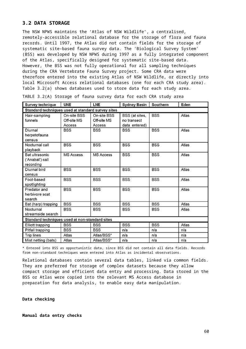
TABLE 4.2.1(A) Systematic sampling density in the LNE study area (northern section) – environmental strataNote: strata are coded according to values of the four stratification variables, in the following order; mean annual rainfall, mean annual temperature, soil fertility and broad vegetation type. Variable codes are shown below.Key to strata listed in Table 4.2.1(a) and (c) – northern section
Thus code 1111 represents land with mean annual rainfall of < 901 mm, meanc oamnnpuleaxl temperature of < 13°C, very low soil fertility and supporting rainforest vegetation.
Ninety-two strata, each less than 10 000 ha in areal extent and containing no systematic survey sites, have been omitted from tables a and c. These strata account for 129 930 ha in total.
60
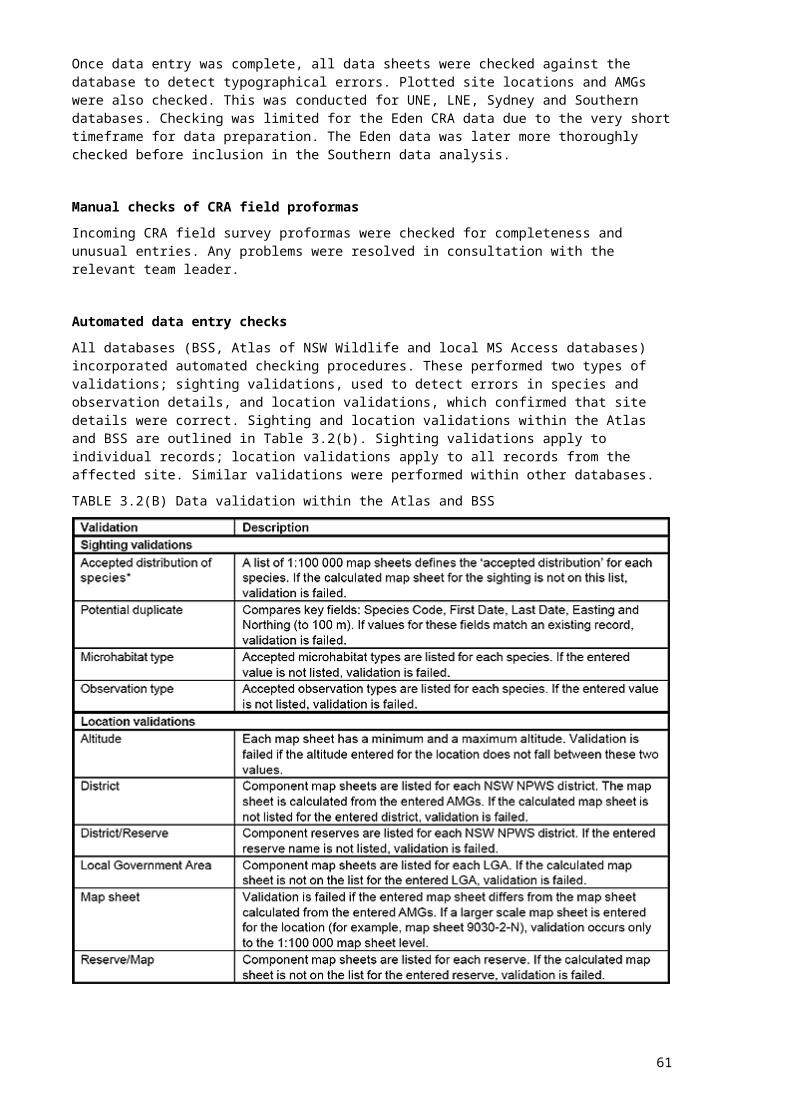
Table 4.2.1(a) cont.
61
TABLE 4.2.1(B) Systematic sampling density in the LNE study area (NSW NPWS Hunter district) – Environmental strataKey to strata listed in Tables 4.2.1(b) and (d) – NSW NPSW Hunter District
Thus code 1111 represents land with mean annual rainfall < 800 m, mean annual temperature < 13°C, very low soil fertility and supporting woodland vegetation.
Sixty-four strata, each less than 2000 ha in areal extent and containing no systematic survey sites, have been omitted from tables b and d. These strata account for 23 180 ha in total.
62
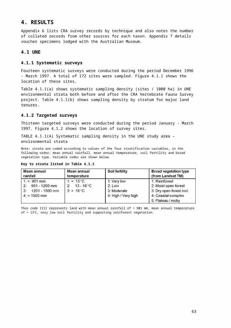
Table 4.2.1(b) cont.
TABLE 4.2.1(C) Systematic sampling density in the LNE study area (Northern section) – major tenure classes
63
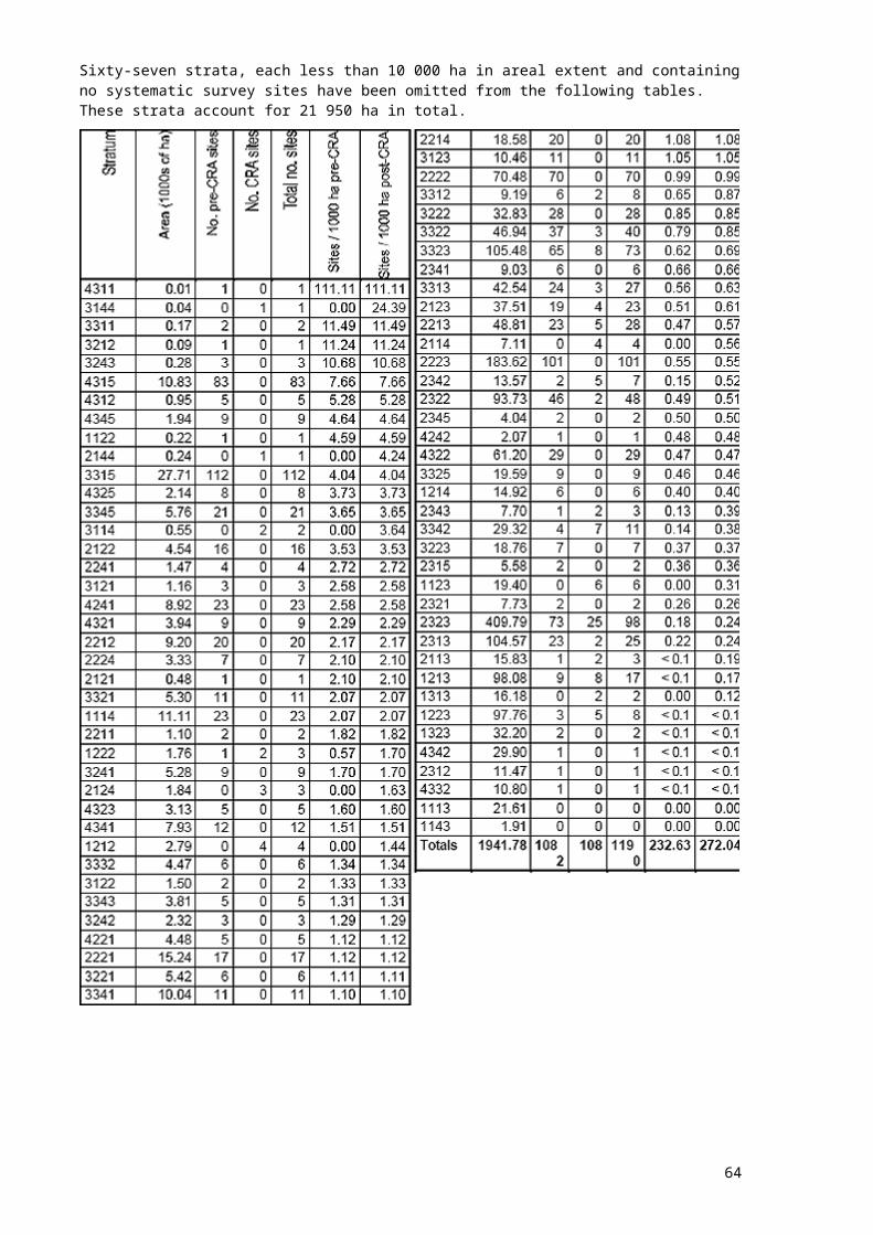
Table 4.2.1(c) cont.
64
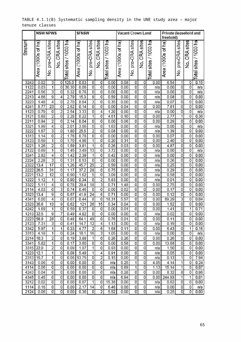
Table 4.2.1(c) cont.
65
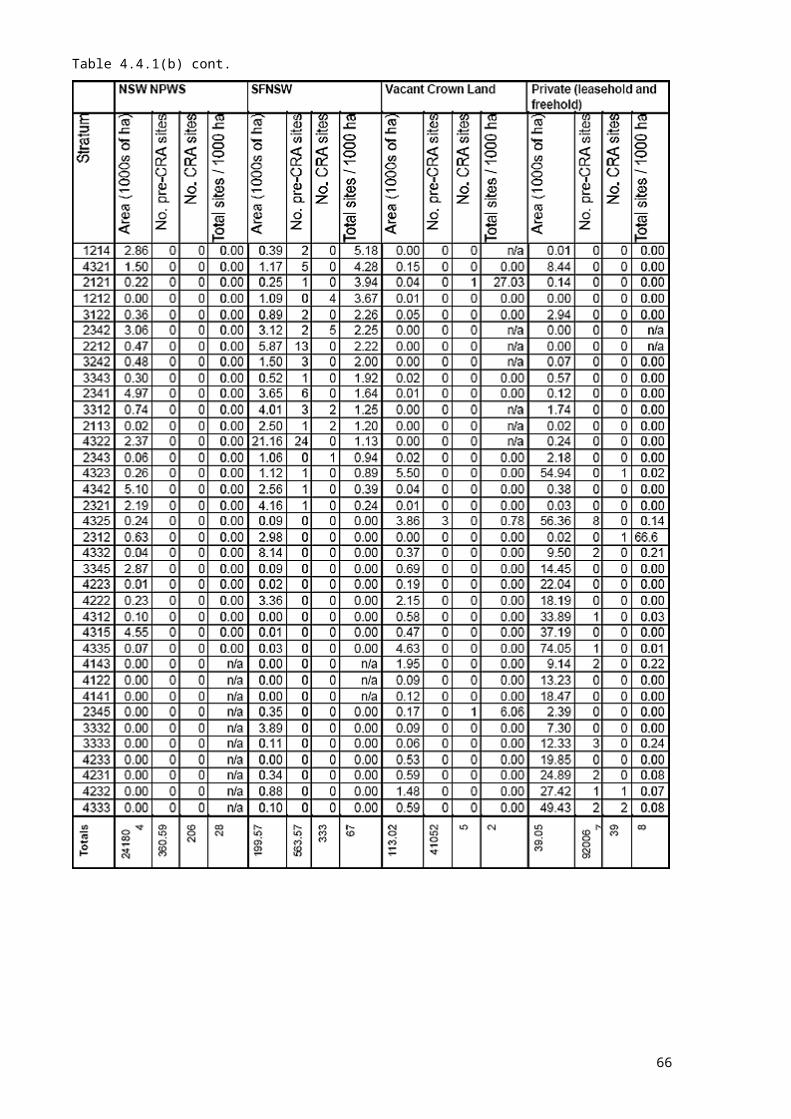
TABLE 4.2.1(D) Systematic sampling density in the LNE study area (NSW NPWS Hunter district) – major tenure classes
66

Table 4.2.1(d) cont.
67

Table 4.2.1(d) cont.
68

Table 4.2.1(d) cont.
69

FIGURE 4.2.1 LNE systematic survey sites
70
FIGURE 4.2.1 LNE systematic survey sites
71
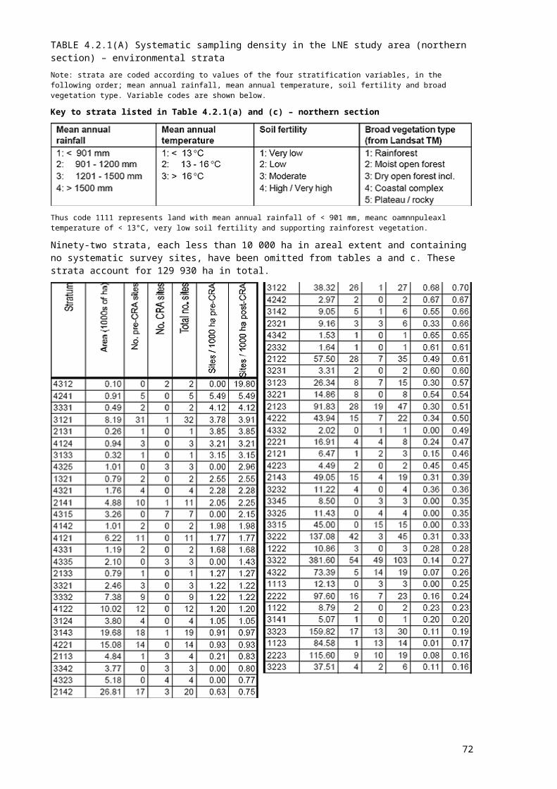
Blank page after map
72

FIGURE 4.2.2 LNE targeted survey sites
73
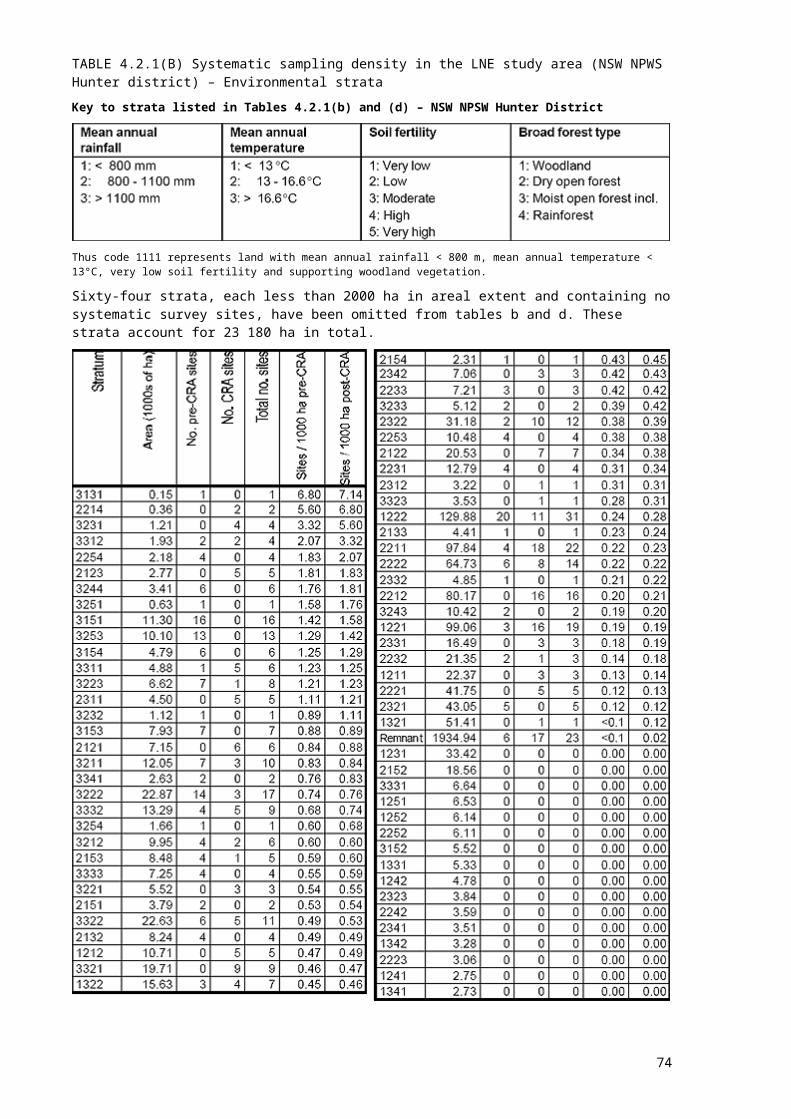
Blank page after map
74
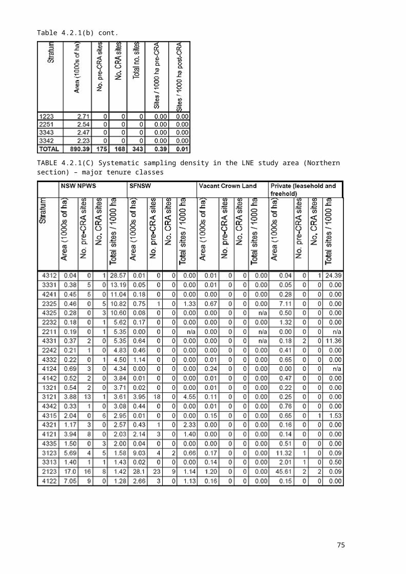
4.3 SYDNEY BASIN
4.3.1 Systematic surveysSixty-three systematic surveys were conducted during the period January 1997 - March 1998. A total of 188 sites were sampled. Figure 4.3.1 shows the location of these sites.
4.3.2 Targeted surveysTargeted owl surveys were conducted during the period July - September 1997. A total of 117 sites were sampled. Figure 4.3.2 shows the location of these sites.
75
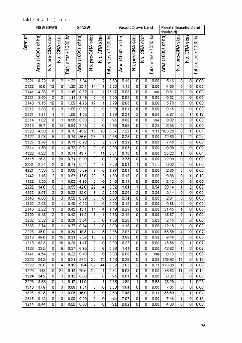
TABLE 4.3.1(A) Systematic sampling density in Sydney basin – environmental strataNote: strata are coded according to values of the four stratification variables, in the following order; mean annual rainfall, mean annual temperature, soil fertility and broad forest type. Variable codes are shown below.There were no existing systematic survey sites in the Sydney Basin study area.Key to strata listed in Table 4.3.1
Thus code 1111 represents areas with mean annual rainfall < 800 m, mean annual temperature < 13°C, very low soil fertility and supporting woodland vegetation.
Eighty-six strata, each less than 2000 ha in areal extent and containing no systematic survey sites, have been omitted from the following table. These strata account for 33 690 ha in total.
76

Table 4.3.1(a) cont.
TABLE 4.3.1(B) Systematic sampling density in the Sydney basin study area – major tenure classesNote: the ‘other’ category included in this table comprises other public land (i.e. not NSW NPWS, SFNSW or VCL) - mostly owned by the Water Board. This category was insignificant in other study areas.
77
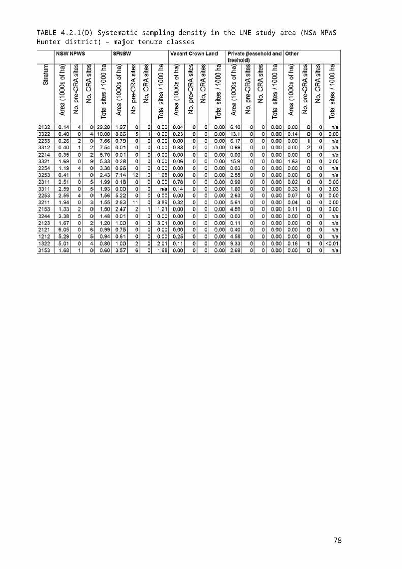
Table 4.3.1(b) cont.
78
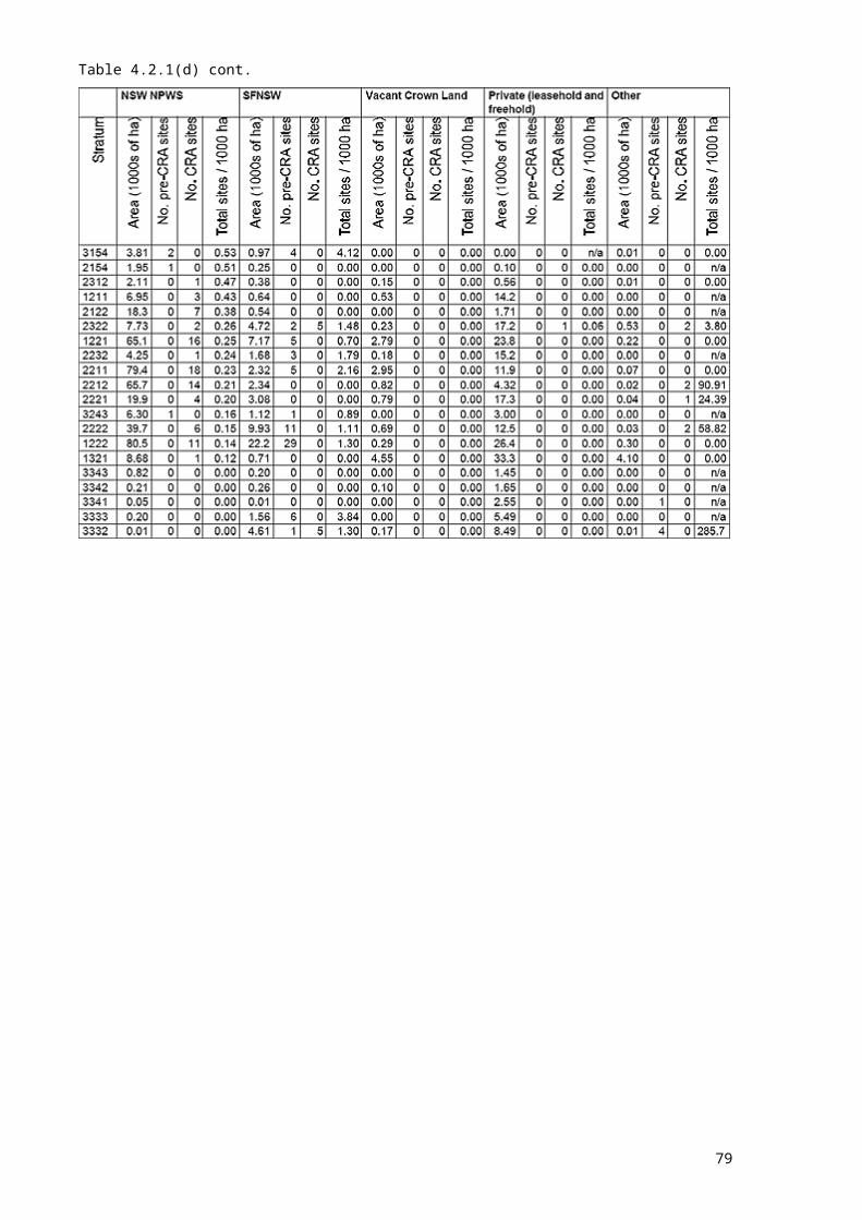
FIGURE 4.3.1 Sydney basin systematic survey sites
79
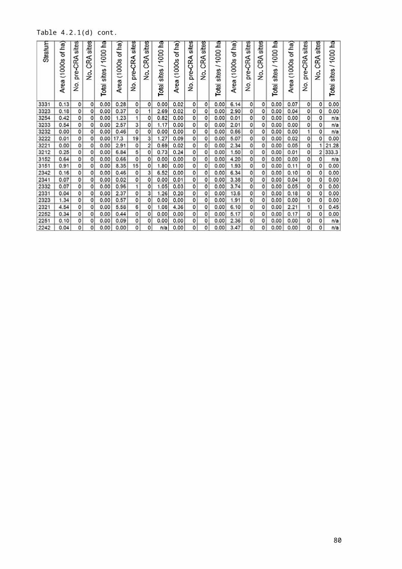
Blank page after map
80
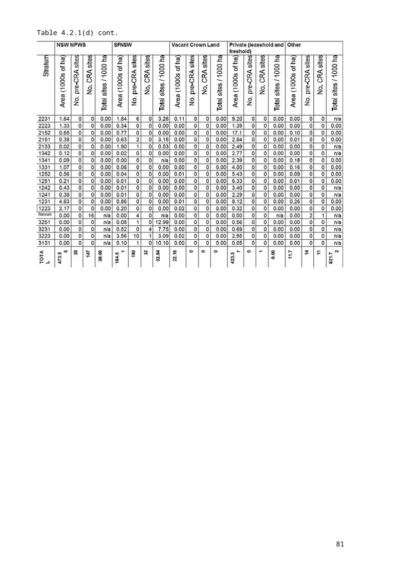
FIGURE 4.3.2 Sydney basin targeted survey sites
81

Blank page after map
82

4.4 SOUTHERNOne hundred and thirty-seven systematic sites were surveyed in the coastal section of the Southern study area in the periods January - April 1997 (80 sites) and January - March 1998 (57 sites). Fifteen sites in the tablelands part of the study area were surveyed in the 1997 survey season, and 72 surveyed during the 1998 - 99 spring-summer season. Because field survey is still underway, it is not possible to present results here. It is anticipated that a supplementary report detailing results for this study area will be prepared during March 1999.
4.5 EDEN
4.5.1 Systematic surveysOne hundred and fifty-five systematic sites were sampled in the period January - April 1997. Figure 4.5.1 shows the location of these sites.
4.5.2 Targeted surveysTargeted surveys for Smokey Mouse, (11 sites), were conducted during the period January - April 1997. Elliott traps and/or small hair tubes were set at nine CRA survey sites and at two other selected sites in suitable habitat, as advised by scientific experts. Figure 4.5.2 shows the location of these sites.
83

TABLE 4.5.1(A) Systematic sampling density in the Eden study area: environmental strataNote: Strata are coded according to values of the three stratification variables, in the following order; lithology, mean annual rainfall and mean annual temperature. Variable codes are shown below.Existing systematic survey sites in the Eden study area were scarce, compared with other study areas, and limited sampling techniques had been undertaken at these sites. CRA systematic site selection was able to take these existing sites into account by examining sampling density on a functional group basis.Key to strata listed in Table 4.5.1
Thus code 111 represents areas of coastal beach deposit with mean annual rainfall < 600 mm and mean annual temperature < 5°C.
Forty strata, each less than 2000 ha in areal extent and containing no systematic survey sites, have been omitted from the following tables. These strata account for 14 834 ha in total. Areas given in the following tables reflect forested land only within each stratum.
84

Table 4.5.1(a) cont.
* Pre-CRA site numbers have been divided by six, to allow comparison with CRA systematic survey sites where techniques were employed to detect all six fauna detection groups (amphibians, reptiles, arboreal mammals and nocturnal birds, bats, diurnal birds, ground mammals).
85

TABLE 4.5.1(B) Systematic sampling density in the Eden study area – major tenure classes
* Pre-CRA site numbers have been divided by six, to allow comparison with CRA systematic survey sites where techniques were employed to detect all six fauna detection groups (amphibians, reptiles, arboreal mammals and nocturnal birds, bats, diurnal birds, ground mammals).
86
FIGURE 4.5.1 Eden systematic survey sites
87
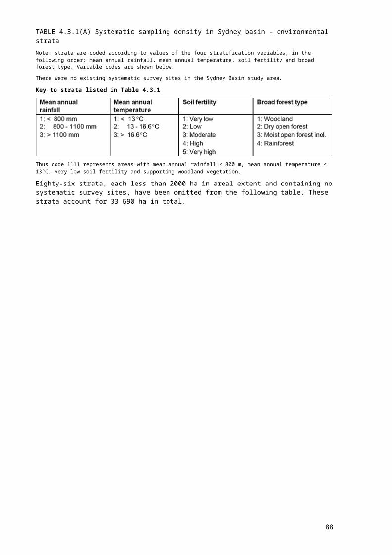
Blank page after map
88
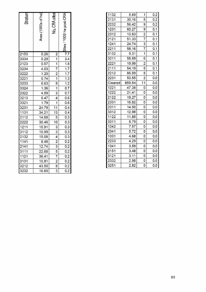
FIGURE 4.5.2 Eden targeted survey sites
89
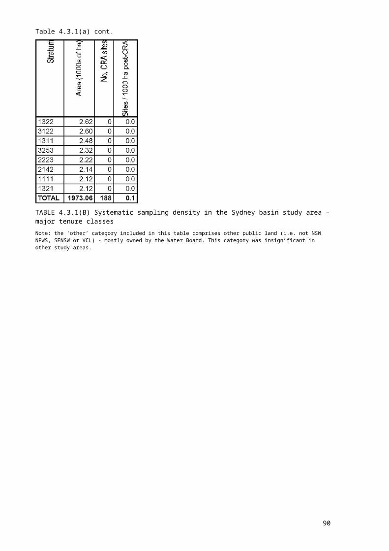
Blank page after map
90
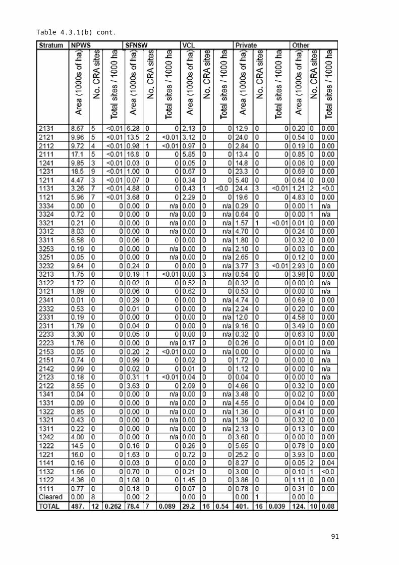
5. DISCUSSIONThe CRA fauna survey project has provided more than 1.2M collated records and 145 000 new survey records to the NSW CRA process to date. The project was one of the largest of its kind ever undertaken in that state, in terms of study area size and survey effort. An inter-agency (NSW NPWS and SFNSW) project debrief was held in May 1997, to assess the merits and shortcomings of both the technical and management aspects of the project. The following comments draw heavily on the outcomes of that review.
5.1 SURVEY TECHNIQUESSurvey techniques were discussed in turn. Whilst all techniques were deemed effective for at least some taxa, the review suggested minor modifications to many techniques. For example, walking spotlight transects could be improved by ensuring a minimum distance between surveyors, thus reducing noise. It was also recognised such improvements might have been implemented by some team leaders during the course of the project, and process was needed whereby such modifications could be officially adopted and implemented statewide.The review also suggested efficiencies to be made in the deployment of survey resources. For example, it was acknowledged that non-specialist (and therefore cheaper) personnel could be employed to lay out and collect hair-sampling funnels. This would release specialist staff for more appropriate tasks. Another suggestion was the relaxation of strict guidelines on the placement of point techniques such as bat traps and streamside searches. It was felt that specialist opinion in the field might yield more records, although at the expense of tightly-defined methodological detail.
5.2 MANAGEMENT ISSUESThe review noted that survey team structures generally worked well, although there was some concern that specialists’ time was spent on logistic tasks which would have been better performed by agency staff.Discrepancies were identified between the CRA survey techniques and those currently used by NSW NPWS Operations Division. Methodologies should be standardised, ideally for all major contributors, but initially at least within agencies involved in CRAs.Fauna survey involves certain unavoidable hazards. Whilst this project was without major incident, and safety procedures were in place for each study area, it was acknowledged that statewide standardisation of safety training is desirable.
91

REFERENCESBrunner, H. and Coman, B. 1974. Identification of Mammalian Hair. Inkata Press, Melbourne.Corben, C. 1989. Computer-based call analysis for microbat identification. Macroderma 5:7.CSIRO Division of Wildlife and Ecology 1997. Production of a lithology and nutrient index layer – Southern and Eden CRA regions. Unpublished report and maps prepared for NSW National Parks and Wildlife Service.Fairley, A. and Moore, P. 1989. Native Plants of the Sydney District - An Identification Guide. Kangaroo Press, Sydney.Faith, D. P. and Walker, P. A. 1996. Environmental diversity: on the best-possible use of surrogate data for assessing the relative biodiversity of sets of areas. Biology and Conservation 5: 399-415.Jurskis, V., Douch, A., McCray, K. and Shields, J. 1997. A playback survey of the Koala, Phascolarctos cinereus, in the Eden region of south-eastern New South Wales. Unpublished report to State Forests of NSW.Kavanagh, R.P. 1995. Nocturnal forest birds and arboreal marsupials of Coolah Tops, Warung Management Area, Western Region. Forest Resources Series No.28. State Forests of New South Wales, Sydney.Kavanagh, R.P. 1997. Ecology and management of large forest owls in south-eastern Australia. PhD Thesis, School of Biological Sciences, University of Sydney.Kavanagh, R.P. and Bamkin, K.L. 1995. Distribution of nocturnal forest birds and mammals in relation to the logging mosaic in south-eastern New South Wales, Australia. Biological Conservation 71:41-53.NSW National Parks and Wildlife Service 1994. Fauna of north-east NSW forests. North East Forests Biodiversity Study Report No. 3, unpublished report, NSW National Parks and Wildlife Service.NSW National Parks and Wildlife Service 1995. Vertebrates of Upper North East New South Wales. Report to the Natural Resources Audit Council.Schodde, R. and Calaby, J.H. 1972. The biogeography of the Australo-Papuan bird and mammal faunas in relation to Torres Strait. Pp. 257-300 in Walker, D. (ed.) Bridge and Barrier: The Natural and Cultural History of Torres Strait. Australian National University, Canberra.Parnaby, H. 1991. A sound species taxonomy is crucial to the conservation of forest bats. Pp. 101-12 in D. Lunney (ed.) Conservation of Australia's Forest Fauna. Royal Zoological Society of NSW, Mosman.Parnaby, H. 1992a. An ultrasonic survey of microchiropteran bats of north-east NSW forests. North East Forests Biodiversity Study Report No. 3b. NSW National Parks and Wildlife Service, Hurstville.Parnaby, H. 1992b. An interim guide to identification of insectivorous bats of south-eastern Australia. Technical Reports of the Australian Museum Number 8. Australian Museum, Sydney.Richards, G. C. 1992. Fauna Survey: Wingham Management Area, Port Macquarie Region. Part 4. Bats. Forestry Commission of New South Wales, Forest Resources Services Report No. 22.Roberts, G. 1992. Report to NPWS Regions- Progress on Eastern Bushlands Database. Unpublished.RACAC, 1997. Data preparation – Central Study Area. Unpublished report. Resource Conservation and Assessment Council: Sydney.Tidemann, C. R. and Woodside, D. P. 1978. A collapsible bat trap compared with mist-nets. Australian Wildlife Research 5: 363-384.
92

APPENDIX 1 RECORDS OF TARGET AND PRIORITY TAXAThis appendix lists all records of target and priority taxa obtained from CRA surveys. Lists of priority taxa were not finalised prior to commencement of surveys. The following list therefore reflects the draft lists provided to survey team leaders in each study area. Priority and target taxa were specific to each study area: non-priority taxa for each study area are marked as ‘n/a’, target taxa are denoted by shading.No data are provided for the Southern study area because survey work is still underway. These results will be available in March 1999.
Key to legal status fieldE Listed as Endangered on Schedule 1 of the NSW Threatened Species
Conservation Act, 1995NE Listed as Nationally Endangered on Schedule 1 Part 1 of the Commonwealth
Endangered Species Protection Act, 1992V Listed as Vulnerable on Schedule 2 of the NSW Threatened Species Conservation
Act, 1995NV Listed as Nationally Vulnerable on Schedule 1 Part 2 of the Commonwealth
Endangered Species Protection Act, 1992
93

94

95
96
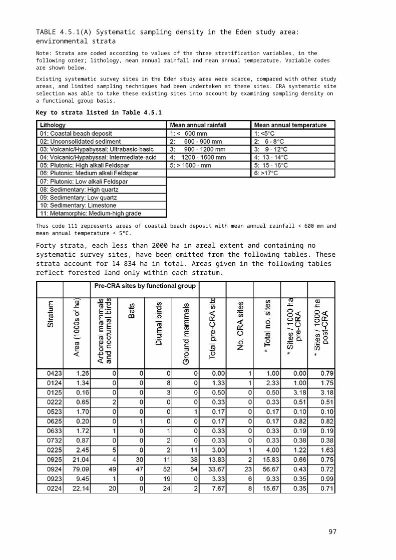
97
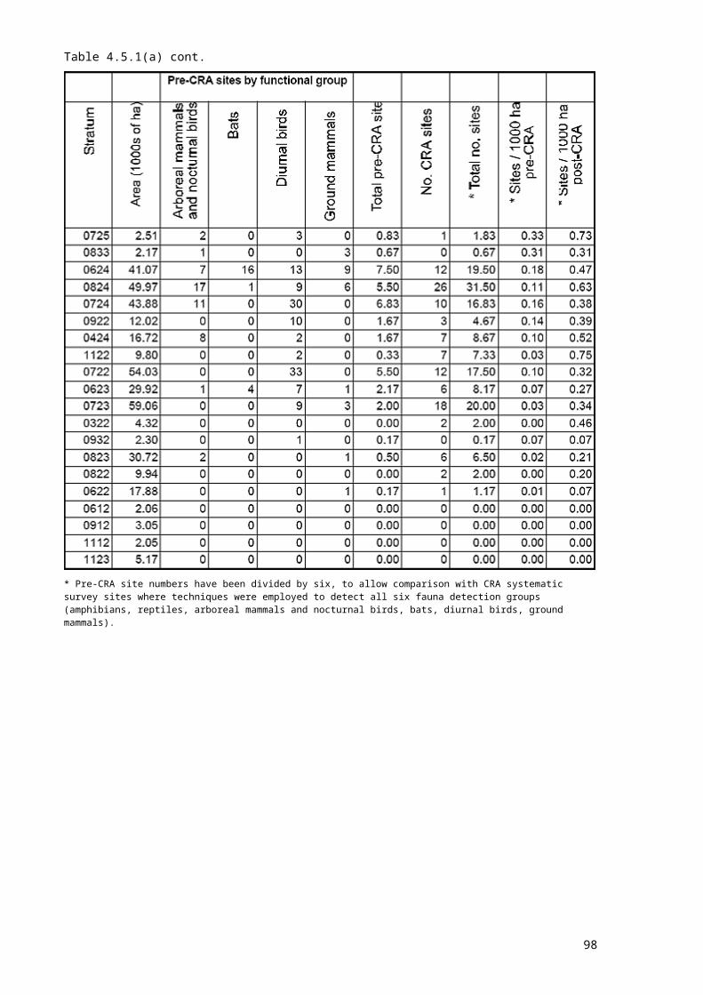
98
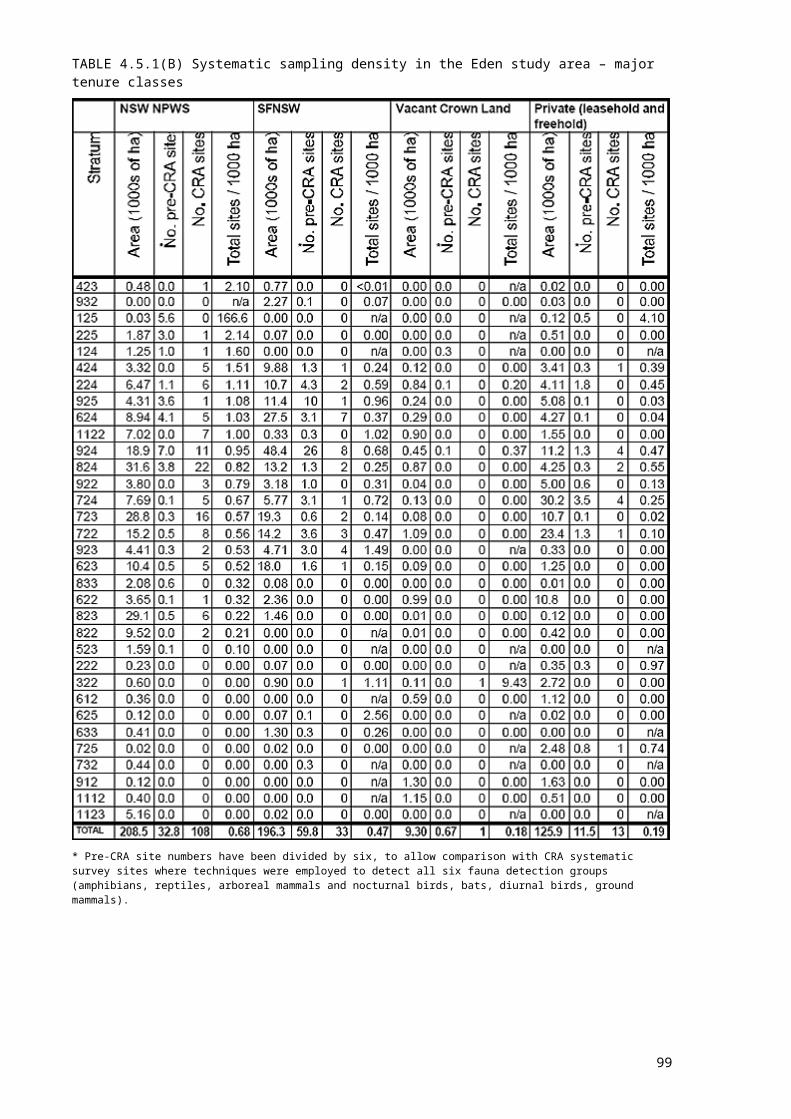
APPENDIX 2 COLLATED DATASETSUNE AND LNE* STUDY AREAS*excludes NSW NPWS Hunter District
99

Sydney Basin and LNE* study areas*NSW NPWS Hunter District only
100

APPENDIX 3 GAP ANALYSIS
IntroductionA new Survey Gap Analysis Tool was developed by NSW NPWS as part of the CRA vertebrate fauna survey project, with some supplementary funding from the CRA UNE and LNE vegetation mapping projects. This software is designed to assist in evaluating the adequacy of existing survey coverage within a region and in locating additional survey sites to fill gaps in this coverage. The tool was used to select survey sites in the LNE study area during the second survey season of the CRA vertebrate fauna project. It was also used to select flora survey sites in UNE and LNE study areas during the CRA vegetation mapping project.The analytical methodology underpinning the Survey Gap Analysis Tool is a refinement of the basic approach to survey design employed in previous forest surveys conducted by NSW NPWS in north-east NSW (North East Forest Biodiversity Study and NRAC Upper North East Audit). The aim of the original approach was to ensure that survey sites for a given biological group were spread representatively across major environmental gradients within a region. This was achieved by dividing each environmental variable (e.g. mean annual rainfall, soil fertility) into a small number of discrete classes (usually three or four) and then using a GIS to derive all possible combinations of these classes. For example, if four environmental variables are each divided into three classes then 3 x 3 x 3 x 3 = 81 combinations are generated. The objective of the survey design is then to locate a specified number or density of sites within each of these combinations, or ‘strata’ (Ferrier and Smith 1990). This basic approach has also been employed recently within CRA data audit software developed by Environment Australia.The major advantage of the above approach is that it is conceptually simple and easy to apply. Nevertheless, extensive experience in the application of this technique over the past 10 years has identified a number of shortcomings:
the strata generated by combining classes of environmental variables are essentially arbitrary divisions of a continuous environmental space. The pattern of gaps in survey coverage is sensitive to the number of classes used for each variable and the location of thresholds for these classes. In other words, if the classes for the variables are altered then the resulting pattern of survey gaps, and therefore priorities, may also change markedly;
the approach does not properly consider information on the relationship (or similarity) between classes within each variable, or between strata derived by combining these classes. Each stratum is treated as being equally dissimilar from each of the other strata. In other words, the priority for additional survey effort within a stratum is based purely on the density of existing survey sites within that stratum, with little consideration of the density of survey
101

sites in closely related strata (i.e. strata with similar combinations of environmental classes). This problem is particularly apparent if a stratification is fine (i.e. has a large number of strata) relative to the number of sites that can be surveyed. If an adequate number of sites cannot be placed in every stratum then strata need to be prioritised in a sensible manner. This prioritisation is difficult without incorporating information on the relationships between strata; and
the approach aims to spread sites environmentally but does not necessarily ensure that sites are also spread geographically. Previous attempts to incorporate geographical stratification into the approach (e.g. by using latitudinal classes) have been ad hoc and cumbersome.
The analytical approach employed in the Survey Gap Analysis Tool is designed to address all three of the above shortcomings. The main difference between the new approach and that employed previously is that survey coverage is analysed directly in relation to the underlying continuous environmental and geographical space rather than an arbitrary categorisation of this space. The approach is based largely on pioneering research by Faith and Walker (1996) into analytical techniques for selecting conservation reserves to provide the best possible coverage of environmental variation within a region. Faith and Walker employ coverage indices such as the p-median, derived from operations research, to measure how well a set of reserved sites covers (or represents) the continuous environmental space of a region and to evaluate the potential improvement that any given unreserved site would make to this coverage if it was added to the reserve system. While this analytical technique was originally developed as a reserve selection tool it is equally applicable to the problem of selecting survey sites. The basic objective is the same in both cases; to select a set of sites that representatively covers environmental and geographical variation.
SoftwareThe Survey Gap Analysis Tool was developed by the NSW NPWS GIS Research and Development Unit in Armidale. The software is an ArcView GIS extension, written in the Avenue scripting language with calls to the ArcView GridIO library and DLLs written in C++.
Data inputs
Survey domainThe survey domain is provided to the software as a grid theme, and defines the surveyable area of the region of interest. For example, for the LNE fauna surveys this domain was defined as all extant forest within the study area.
Existing survey sitesThe locations of any existing survey sites for the biological group or survey technique of interest are provided to the software as an ArcView point theme.
Candidate sites
102

Candidate sites are a set of sites located randomly throughout the surveyable domain of the region of interest. Candidate sites are the points at which the various indices of survey adequacy and priority will be calculated and displayed by the software. These sites can also be selected interactively as new survey sites. The software includes a function for automatically generating a specified number of candidate sites within the survey domain. Increasing the number of candidate sites improves the quality and useability of evaluation results but also increases computation time. A sample of 10 000 candidate sites provides a good compromise between computation speed and accuracy.
Environmental layersEach of the environmental layers to be used in analysing survey coverage is provided to the software as an ordinal or interval level grid theme. For example, the environmental layers used in designing the LNE fauna surveys were mean annual temperature (°C), mean annual rainfall (mm), soil fertility rating (1-5) and broad vegetation type (1 = rainforest, 2 = moist open forest, 3 = dry open forest, 4 = coastal complex, 5 = Plateau / rocky complex).
Weights for environmental variables The indices used to evaluate survey coverage and priority are all derived from estimates of the likely biological difference, or dissimilarity, between pairs of sites. The software predicts the biological dissimilarity between any two sites using a simple linear model based on the environmental values at those sites:
Biological dissimilarity = W1D1 + W2D2 + ... +WnDn where Dx is the absolute difference between the values of variable x at the two sites Wx is the specified weight to be applied to that difference
The weights to be used in this formula are provided by the user for each survey analysis. A weight can also be provided for the geographical separation (in metres) between two sites. This allows geographical space to be readily incorporated into the analysis alongside environmental space. The environmental and geographical weights can be estimated based on expert knowledge of the relative importance of each of the variables in driving biological variation. Alternatively the weights can be estimated through statistical analysis of biological and environmental data from previous surveys. For the LNE survey design, weights were estimated by applying matrix regression analysis (Manly 1986) to the results of previous fauna surveys within north-east NSW, using the S-PLUS statistical package. These weights were: mean annual temperature 0.022, mean annual rainfall 0.000382, soil fertility 0.00835, broad vegetation type 0.103, geographic distance 0.00000164.
IndicesTwo indices of survey adequacy and priority can be calculated for each of the candidate sites in the dataset:
Delta p-median index
103
Faith and Walker (1996) provide a detailed introduction to, and description of, the p-median index. The p-median is a measure of the extent to which a selected subset of sites (in this case the existing survey sites) covers the space defined by a larger set of sites (in this case the candidate sites). It is calculated as the sum of the distances (in this case the predicted biological dissimilarity) between each candidate site and the nearest existing survey site. Smaller p-median values indicate better coverage of the region of interest. The ‘delta p-median’ index generated by the gap analysis software is calculated as the difference between two p-median values. The first value is simply the p-median index achieved with all existing survey sites. The second value, for a given candidate site, is the p-median index that would be achieved if that site were to be surveyed. The difference between these two values therefore measures the improvement in survey coverage that would be achieved by surveying the site in question.
Distance weighted density indexThis index is derived as the ratio between two inverse distance weighted site densities, estimated around each candidate site. The first density is the density of existing survey sites, while the second density is the density of candidate sites. The measure of distance used in these calculations is the predicted biological dissimilarity between sites, as described above.
Application 1: Evaluation of adequacy of survey coverageThe Survey Gap Analysis Tool can be applied in two main ways. In the first application the software can be used to obtain an overview of the relative adequacy of existing survey coverage in different parts of a region. This is achieved by using the software to calculate an index of survey adequacy for every candidate site in the region. The distance weighted density index is particularly well suited for this purpose. Values for the index can be displayed as a point theme, using different coloured symbols for the candidate sites. Alternatively, standard ArcView functionality can be used to interpolate these values across the entire region thereby generating a grid theme of relative survey adequacy.This process can be repeated at various stages during a survey program to give a graphical indication of improvement in survey coverage as additional sites are surveyed. A single quantitative measure of survey adequacy at each of these stages can also be obtained by calculating the overall p-median index.
Application 2: Selection of additional survey sitesIn the second application the software can be used to provide guidance in selecting new survey sites. This is achieved by calculating an index of survey priority for every candidate site in the region. The delta p-median index is best suited to this purpose. Values for this index can be displayed as a point theme with coloured symbols chosen to accentuate the highest priority candidate sites. Other themes relating to accessibility (e.g. roads, tenure) can also be displayed to assist in selecting sites. The user can interactively select one or more sites as being flagged for survey, and these are then added to a log of selected sites. The software then automatically recalculates the delta p-median index for the remaining candidate sites, now treating the selected sites as having been surveyed. This process is repeated iteratively until the required number of new survey sites is obtained.
104
ReferencesFaith, D.P. and Walker, P.A. 1996. Environmental diversity: on the best-possible use of surrogate data for assessing the relative biodiversity of sets of areas. Biodiversity and Conservation 5: 399-415.Ferrier, S. and Smith, A.P. 1990. Using geographical information systems for biological survey design, analysis and extrapolation. Australian Biologist 3: 105-16.Manly, B.F.J. 1986. Randomization and regression methods for testing associations with geographical, environmental and biological distances between populations. Res. Popul. Ecol. 28:201-18.
105

APPENDIX 4 FIELD SURVEY PROFORMAS
106
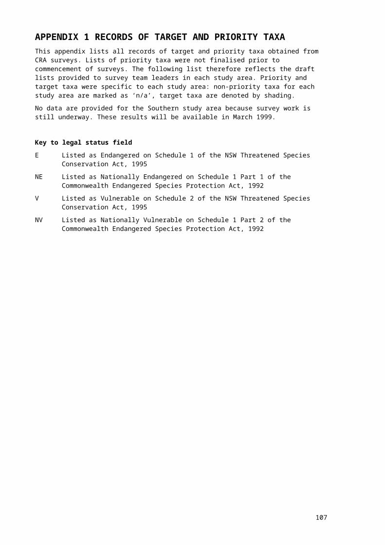
107
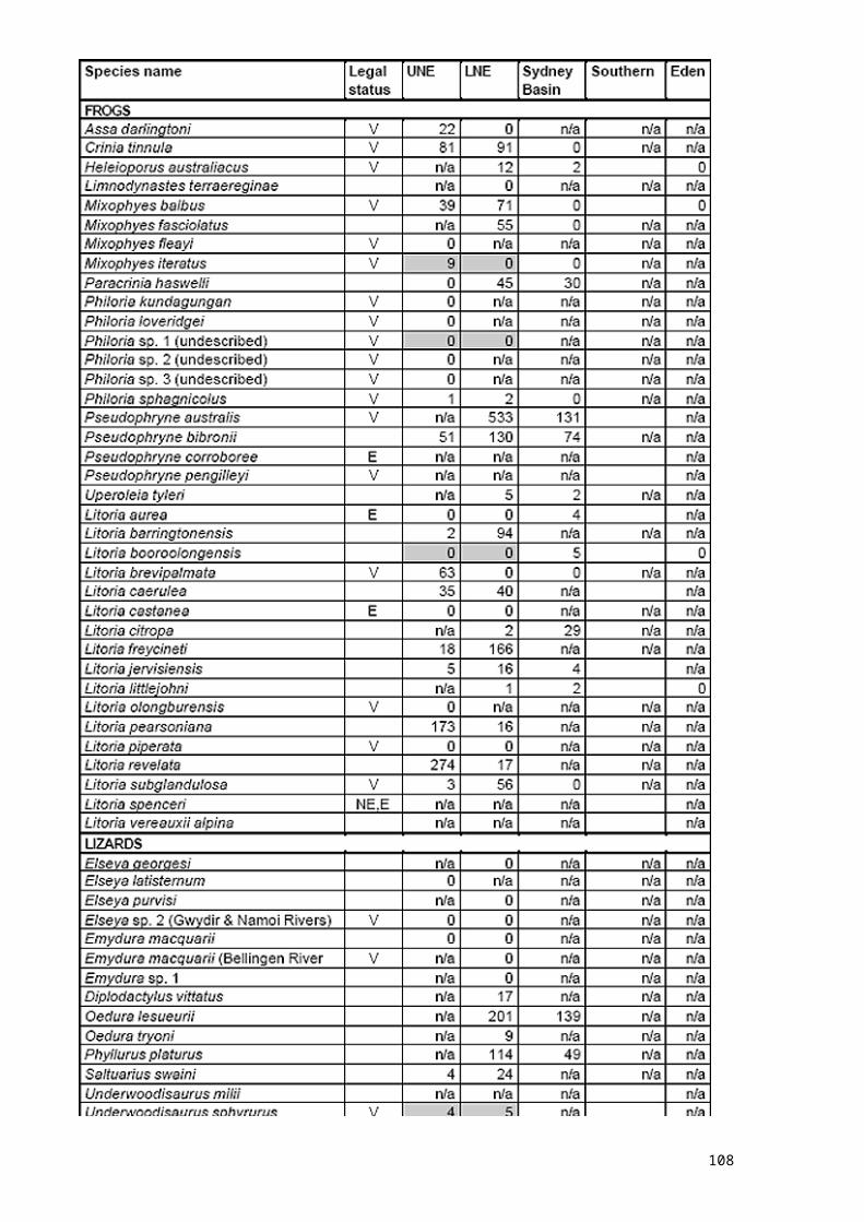
108
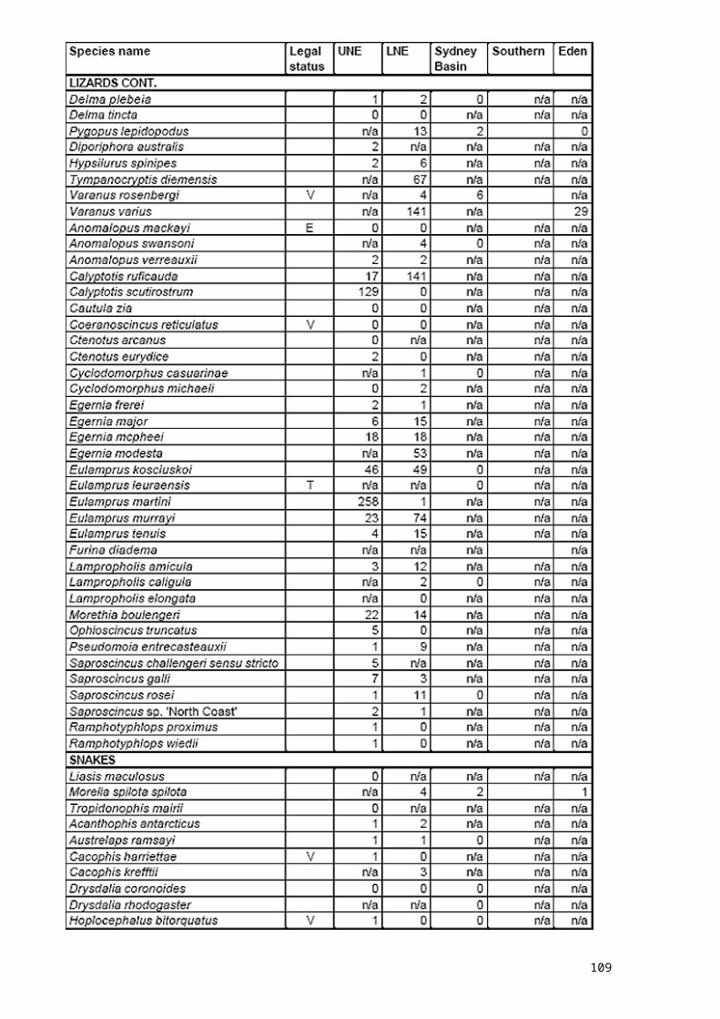
109
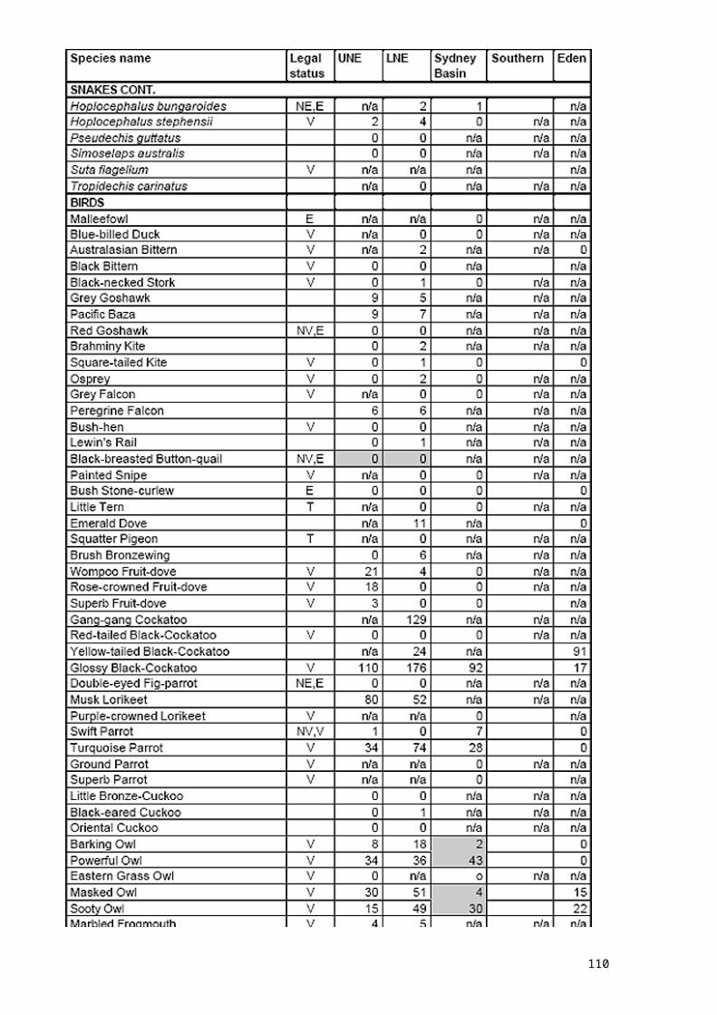
110
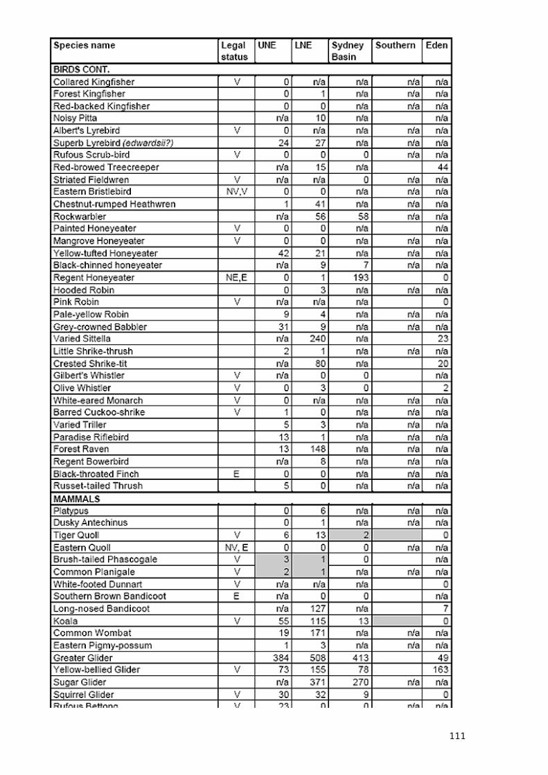
111
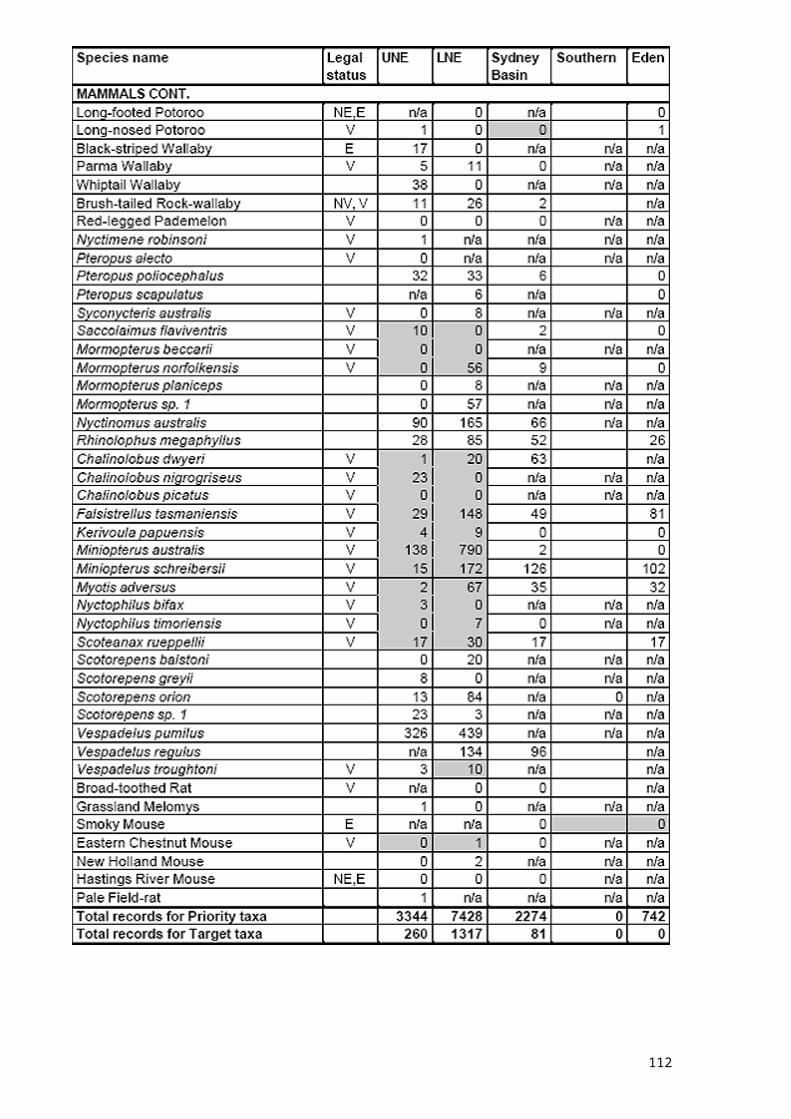
112
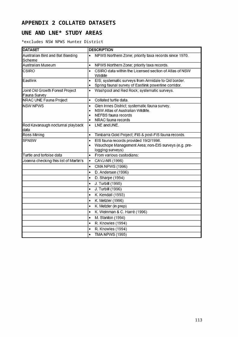
113
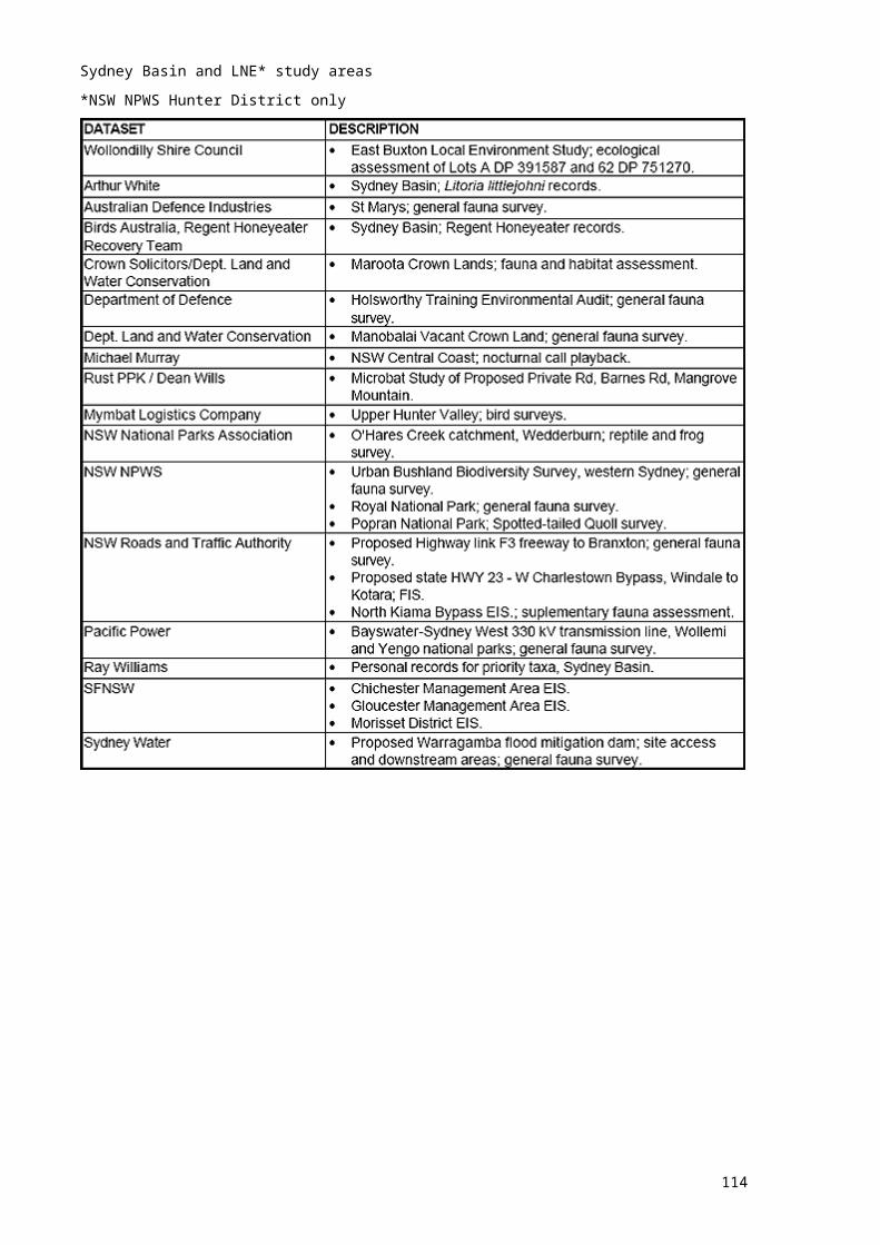
114
115
116

117
118

119
120

121

122

123
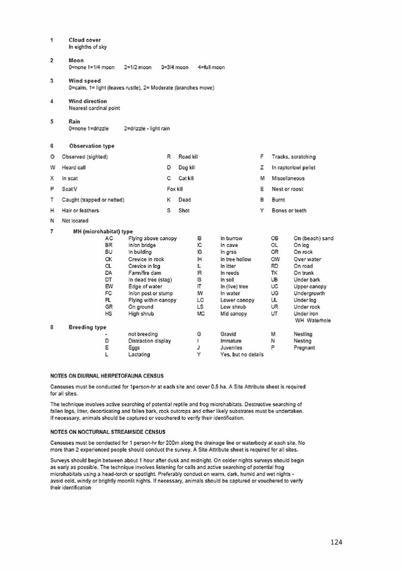
APPENDIX 5 SURVEY LICENCES AND VOUCHER COLLECTION GUIDELINES
PART A - SURVEY LICENCESThe CRA vertebrate surveys were conducted under the following licences:Type Issuing authority Licence numbersAnimal Research Authority NSW NPWS Animal Care and
Ethics Committee46, 46a and 46b
Special Purpose Permit (for activities on land administered by SFNSW)
State Forests of NSW 05107, 05207, 05313
Scientific Investigation Licence (Section120 & 131 of the NPWS Act, 1974)
NSW NPWS A2053, A2062, A2083.
Concessional Spirits Permit Australian Customs Service 199806/005763/A
124
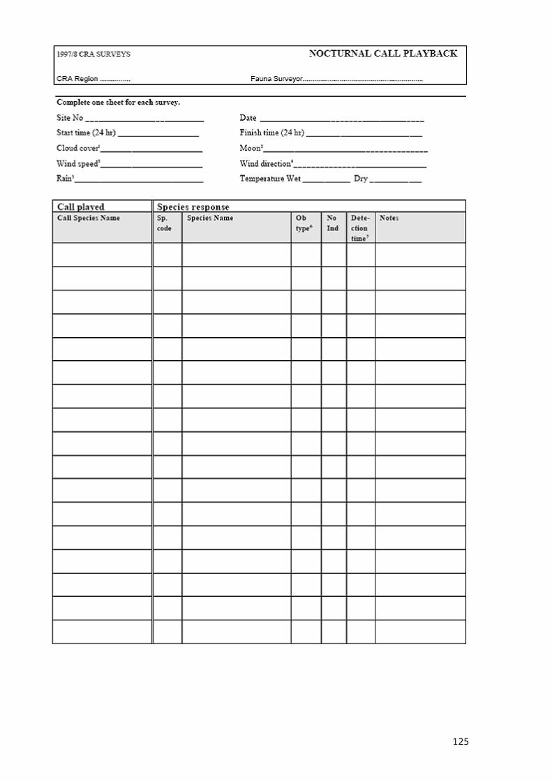
PART B - GUIDELINES FOR COLLECTION OF VOUCHER SPECIMENSThe following guidelines were issued to all survey team leaders. Voucher specimens form a permenant record of the identity of a capture or sighting, and in some cases are the only form of record which is still useful after a taxonomic revision of a species. They should never be discarded.Under the terms of the Animal Research Authority issued to fauna surveys, all research must be carried out according to the Australian code of practice for the care and use of animals for scientific purposes. Voucher specimens must be lodged with the Australian Museum (Sydney). Complete documentation (proformas provided) must be recorded and kept with the specimen. Copies of the same information must be kept by NPWS.MethodsEuthanasiaThe NPWS Animal Care and Ethics Committee (ACEC) has authorised the use of intraperitoneal injection of Lethobarb for animal euthanasia in the CRA surveys. No other method should be used.Preservation of voucher specimensAll road kill or predated remains should be identified, recorded and collected if regarded as being species of special interest. For large vertebrates, collection of the skull (if intact) and hair should be adequate.Herpetology specimens should be slit carefully along the abdomen, and preserved initially in 10% formalin, followed by 75% ethanol.The Australian Museum has requested that we preserve a sample of breast muscle from batvoucher specimens separately from the main body of the bat. The muscle sample should only be preserved in ethanol, so it can be used in genetic sampling. The bat body should be preserved initially in 10% formalin, followed by 75% ethanol.EquipmentFor muscle tissue sample: cryovials, 70-75% ethanol, scalpel, forceps, perminant marker pen. For body: Vials, formalin (10% formaldehyde buffered with calcium carbonate), 75% ethanol, AMissued field tags, syringe and needles or scalpel and forceps, plastic gloves.Method for muscle samples from bats
clean scalpel and forceps prior to use with flame (cigarette lighter is OK) followed by ethanol
remove muscle sample ASAP after death using scalpel and forceps; where a delay between death and preservation occurs, this should be noted on the voucher specimen data form.
take sample from largest skeletal muscle mass: on micro-bats and birds - breast muscle;
sample should be at least a match head in size (if possible; this may be difficult on microbats)
preserve muscle sample immediately in 70-75% ethanol in sterile cryovialMethod for all specimens
make slit through to abdominal cavity, making sure not to damage internal organs;
preserve body in formalin for 48 hours for mammals and herpetofauna as small or smaller than house mice; up to 3 weeks for larger vertebrates
transfer body to 70-75% ethanol after draining formalin from body label both cryovial and body vial with the same field number ensure the voucher specimen data form is completed, including the noting of any
tissue samples taken.
125
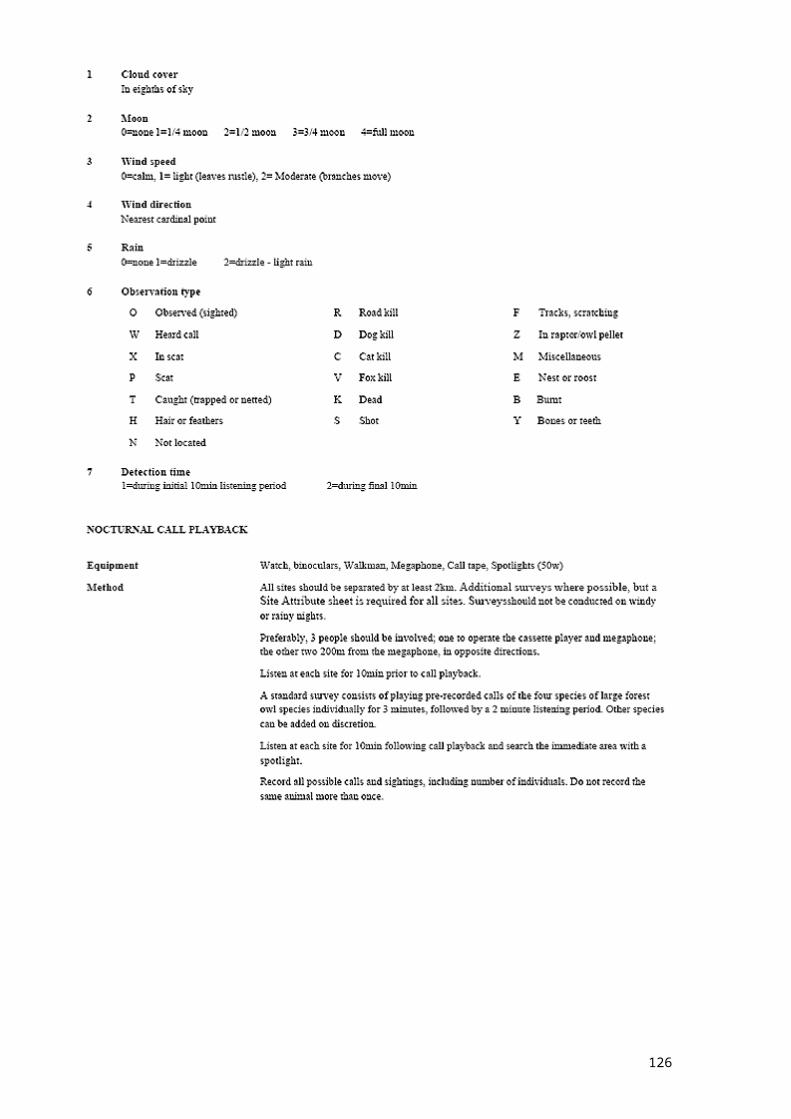
SafetyFormalin and formaldehyde are extremely corrosive to living tissue, and will cause skin to peel; wear plastic gloves at all times when handling; do not breathe vapours; only use in a wellventilated space; avoid all contact with eyes.Transport formalin and formaldehyde only in clearly labled bottles with secure, leak-proof safety caps, and inside a second, sealed container that will protect the bottle from extremes of heat and breakage on rough roads. Formalin and formaldehyde should never be kept in close proximity to food or cooking equipment.Identification and accession of voucher specimensAgreement has been made with the Australian Museum to identify vertebrate voucher specimens, and to lodge all vertebrate specimens with the Australian Museum. Mammal specimens should be sent in separate packages from reptiles and frogs, and addressed as follows:Mammal specimens should be marked: ATTENTION: SANDY INGLEBY, MAMMALOGYHerpetology specimens should be marked: ATTENTION: ROSS SADLIER, HERPETOLOGYFollowed by: Australian Museum6 College StSydney NSW 2000The phone number of the Museum is: (02) 9320 6000When sending voucher specimens to the Australian Museum, please do the following:
ensure that specimens are preserved in alcohol, not formalin, and that all containers are tightly sealed and do not leak;
ensure that every individual animal has a unique number on a tag attached firmly to the body, preferably to one of the limbs. Tags for snakes and legless lizards should pierce a fleshy part of the tail. Tissue samples taken from individuals should have the same number as the remainder of the body.
Tags for reptiles and frogs have been supplied by the Museum. Mammals may be tagged with either heavy paper and string tags (often available in newsagents) or preferably using a plastic tag made by punching the number into a ‘dynamo’ labeller.Each individual sent to the Museum must be accompanied by a completed voucher specimen form. Forms should be filled out in dark pencil or ink which is indelible to alcohol. Drawing pen ink and some special felt-tipped marker are alcohol-proof, but most felt-tipped markers and ballpoint ink will run badly.Please keep photocopies of the completed voucher specimen forms in a safe place in the CRA Zone, along with a record of when you sent the material to the Museum. Voucher specimens should be accompanied by a proforma which lists the specimens. The Museum should complete the sheet and return it to the CRA fauna coordinator or data manager, in order to verify the identification of the specimen. Do not forget to provide a return name, address and phone number at the bottom of the form. This is an important step in ensuring that any misidentifications are corrected in the CRA databases.Ensure specimens vials are packaged with plenty of padding and in a crush-resistant box. Send voucher specimens by road courier, not by Australia Post or air freight. Decompression in air travel may cause the vials to leak. Sending flammable liquids by Australia Post is illegal.
126

As a courtesy to the Museum, please phone or fax the relevant collection manager to inform them that you are sending the material.For Herpetology specimens. Ross Sadlier Ph. (02) 9320 6000, Fax: 9320 6050 For Mammal specimens: Sandy Ingleby Ph. (02) 9320 6000, Fax: 9320 6073
127
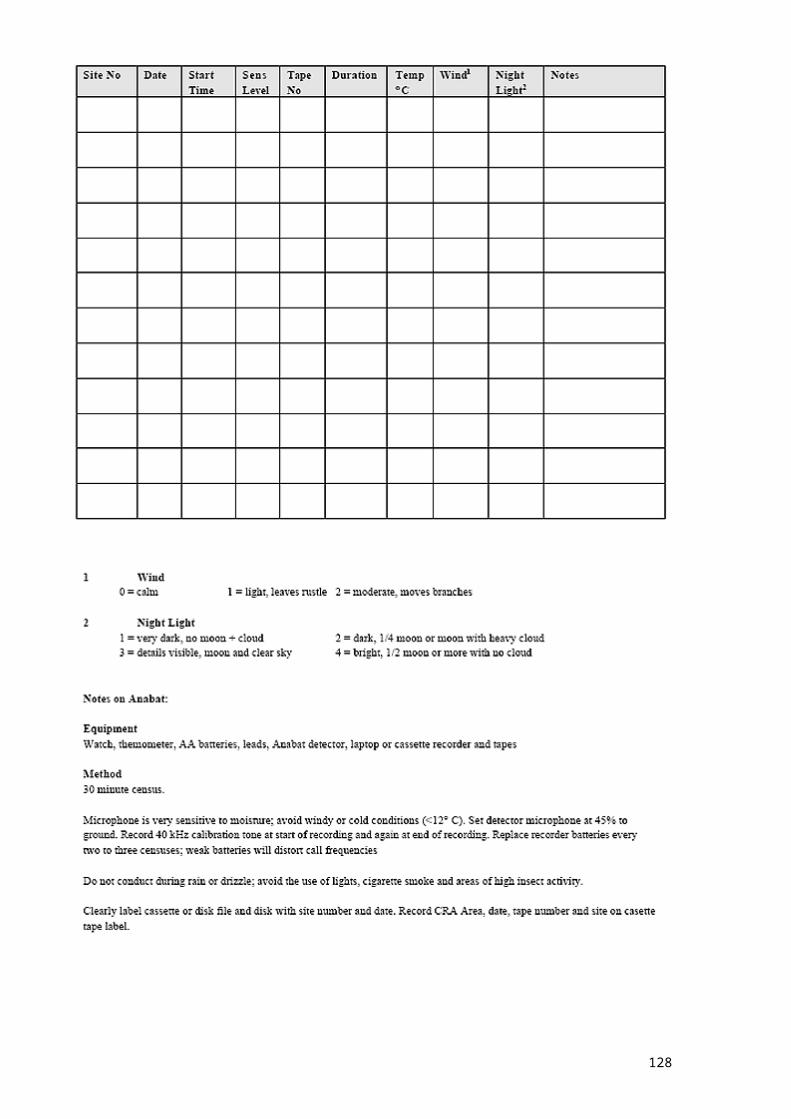
APPENDIX 6 RECORDS FROM CRA VERTEBRATE FAUNA SURVEYSParts 1 - 5 detail fauna records available for data analysis in each CRA study area. Records from CRA surveys are allocated to the appropriate survey technique, collated records are pooled into a single column. No data are given for the Southern study area because field surveys are still underway. It is anticipated that these results will be available in March 1999.
128
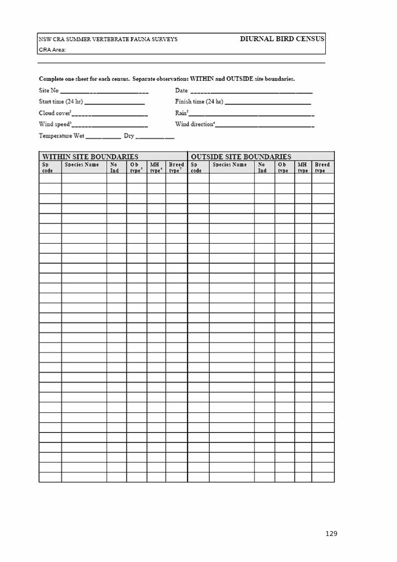
PART 1: UNE STUDY AREA
129
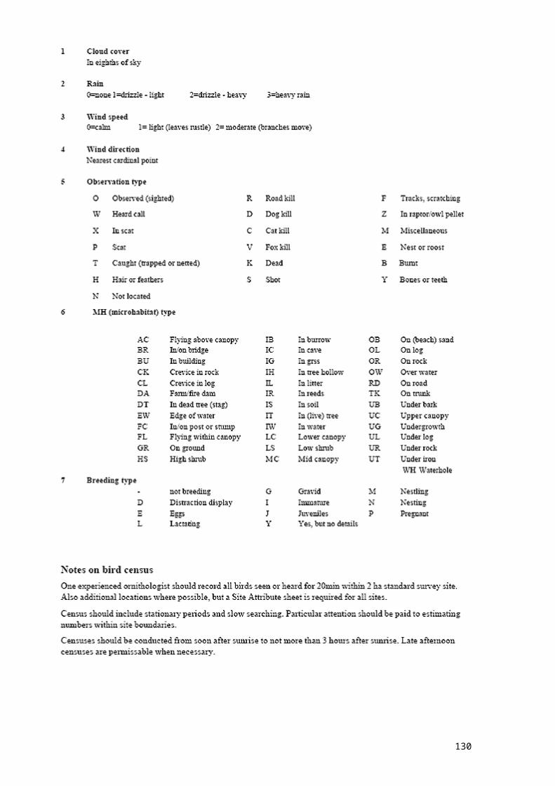
130
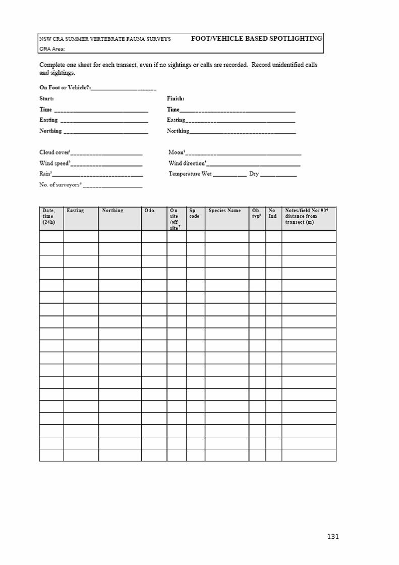
131
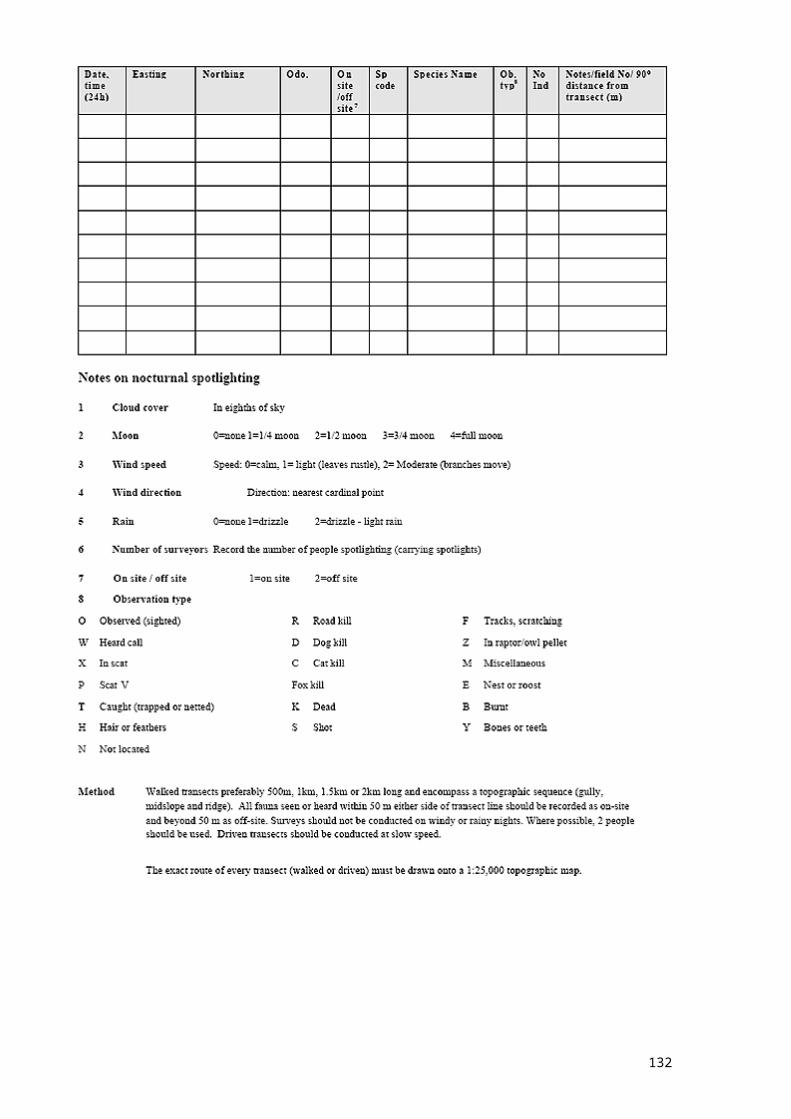
132
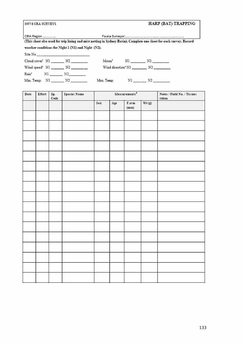
133
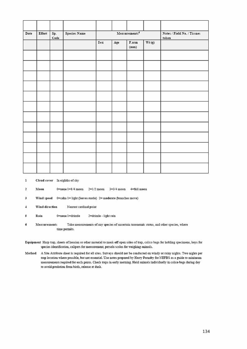
134

135
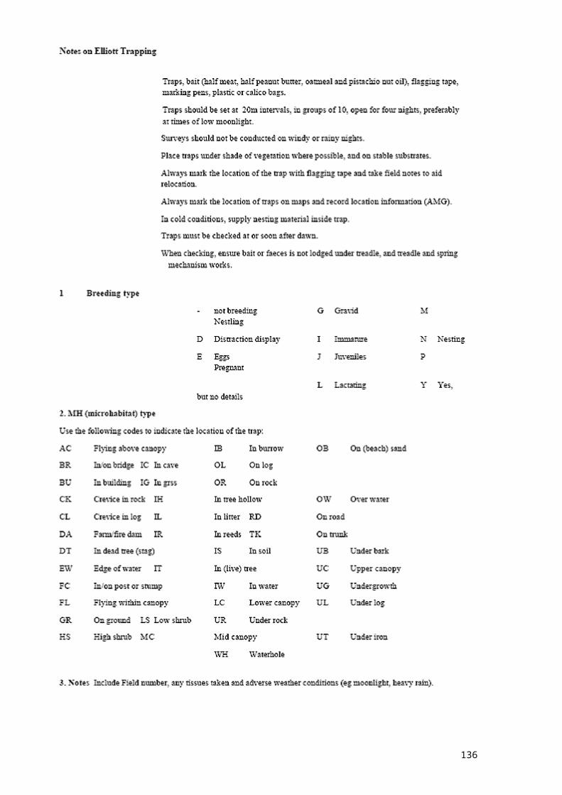
136
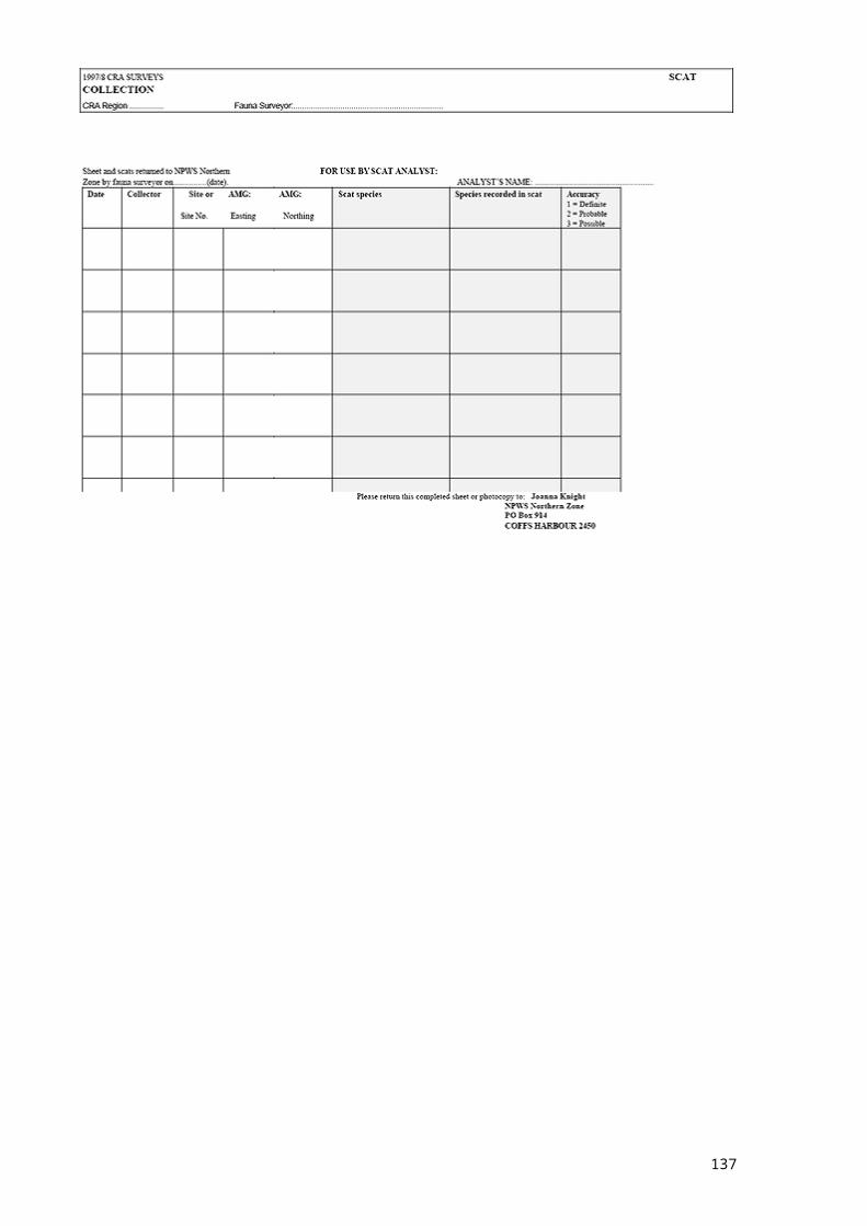
137
138
PART 4: SOUTHERN STUDY AREASurveys in this study area have not been completed and will be incorporated into the report once finalised.
139
PART 5: EDEN STUDY AREANote: only the Koala and Smoky Mouse were selected as target species for the Eden study area.
140
Part 5: Eden study area cont.
141
Part 5: Eden study area cont.
142
Part 5: Eden study area cont.
143
Part 5: Eden study area cont.
144

PART 2: LNE STUDY AREA
145

Part 2: LNE study area cont.
146
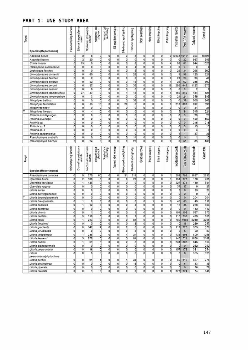
Part 2: LNE study area cont.
147
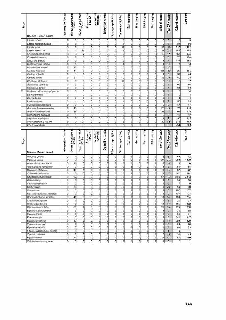
Part 2: LNE study area cont.
148

Part 2: LNE study area cont.
149
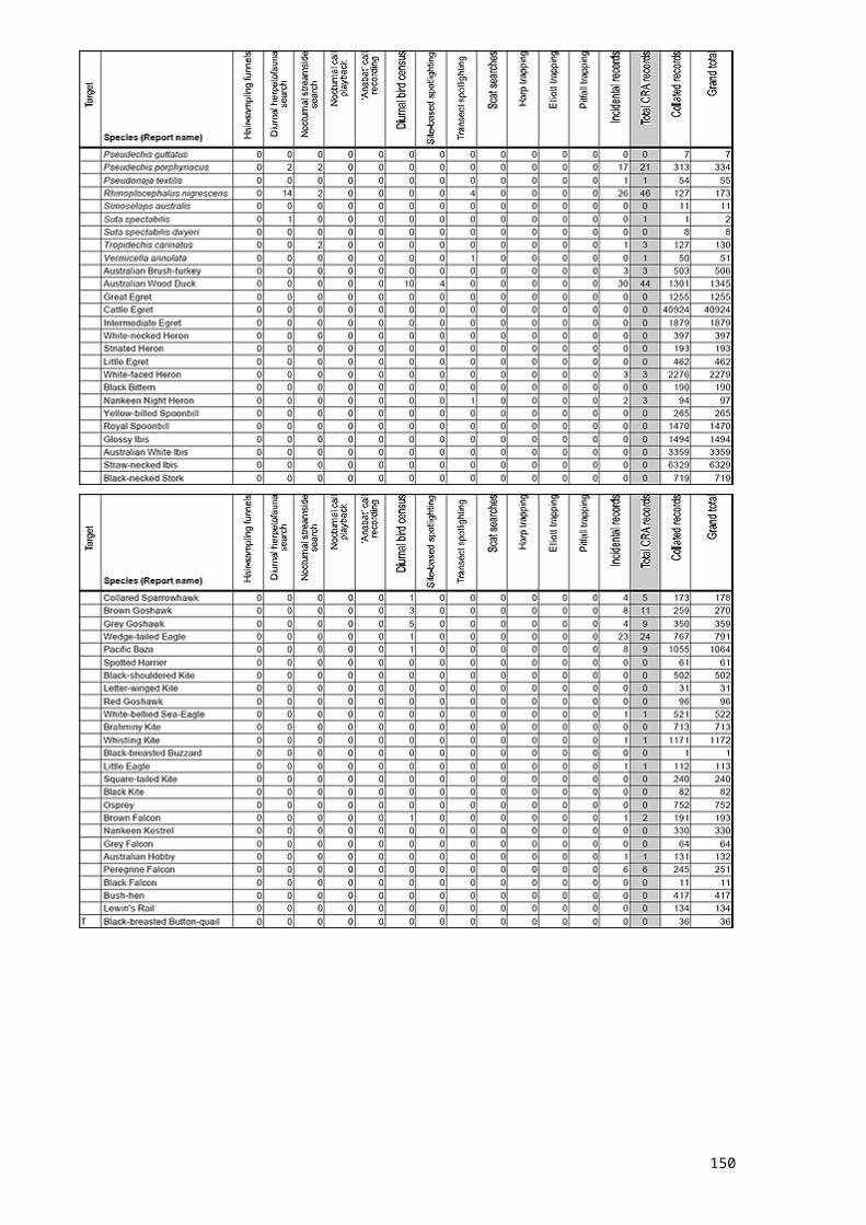
Part 2: LNE study area cont.
150
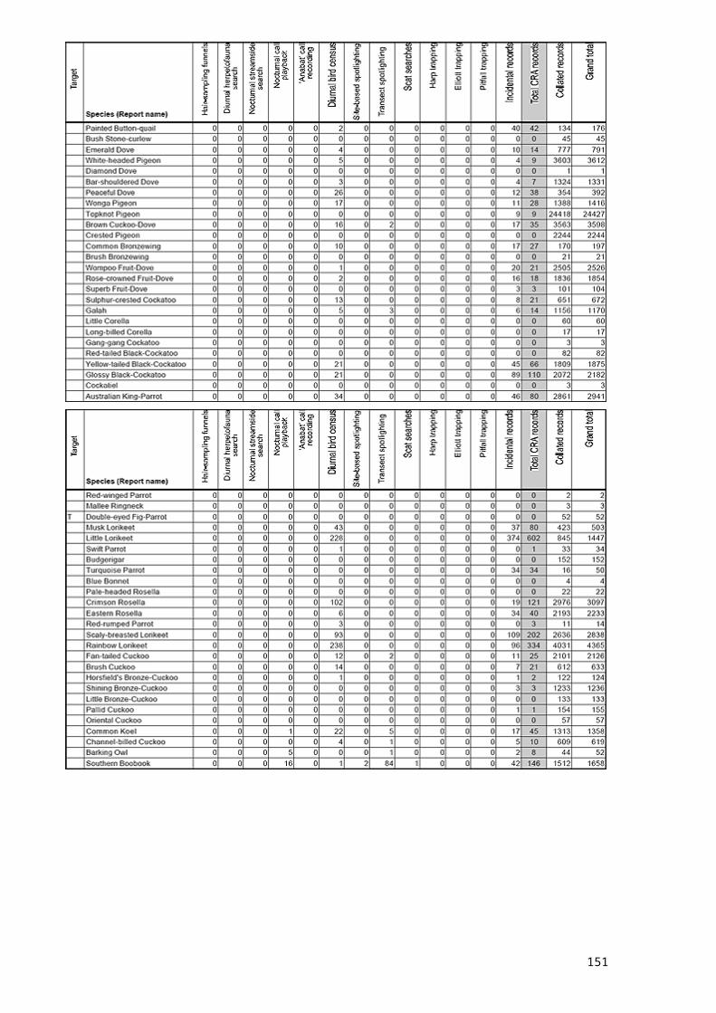
Part 2: LNE study area cont.
151
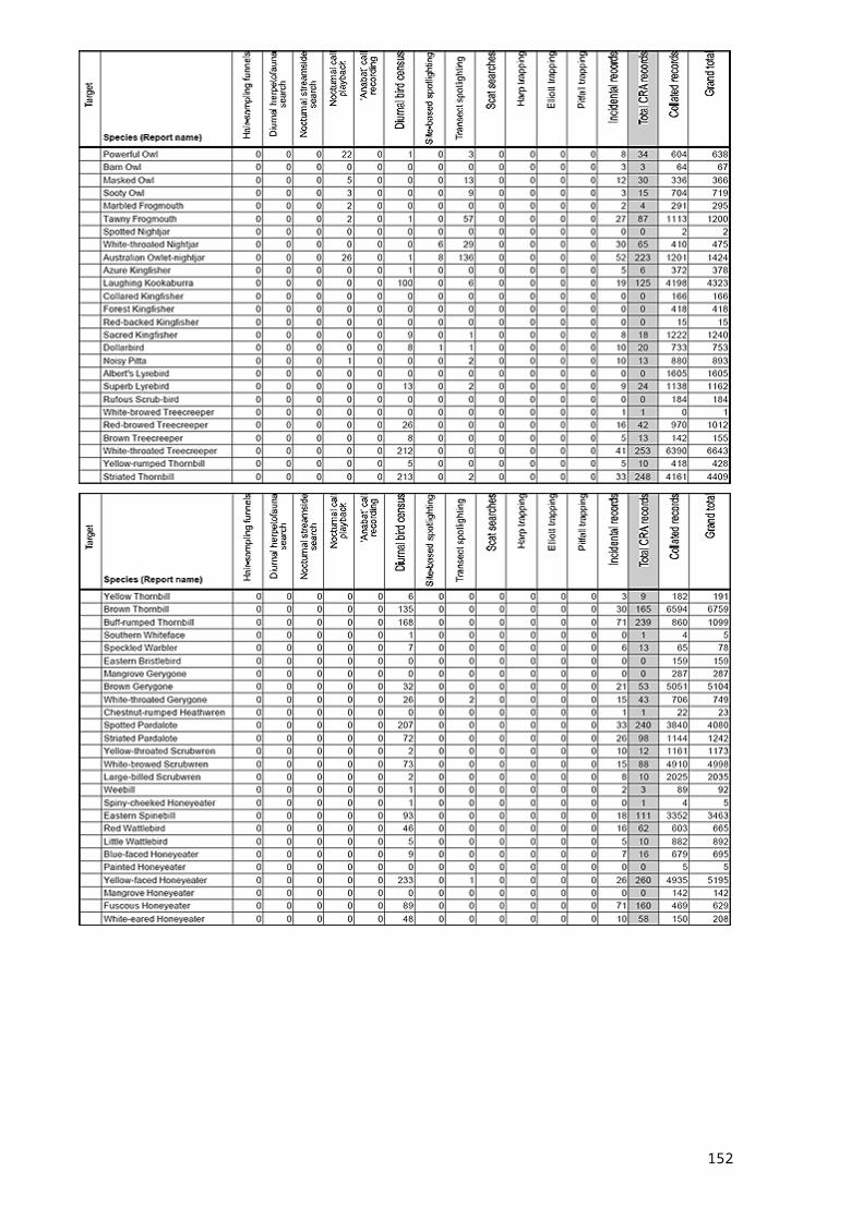
Part 2: LNE study area cont.
152
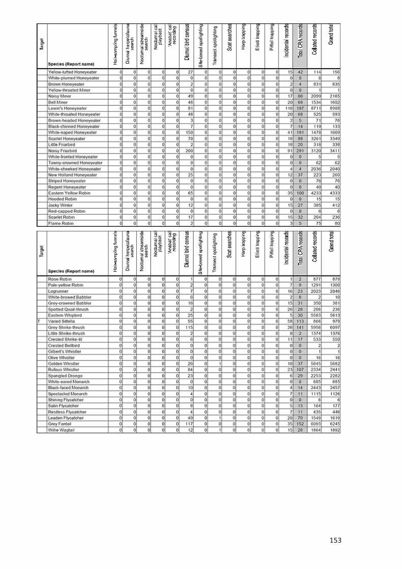
Part 2: LNE study area cont.
153
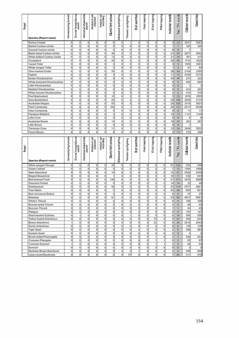
Part 2: LNE study area cont.
154
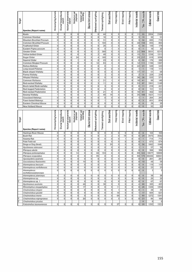
Part 2: LNE study area cont.
155
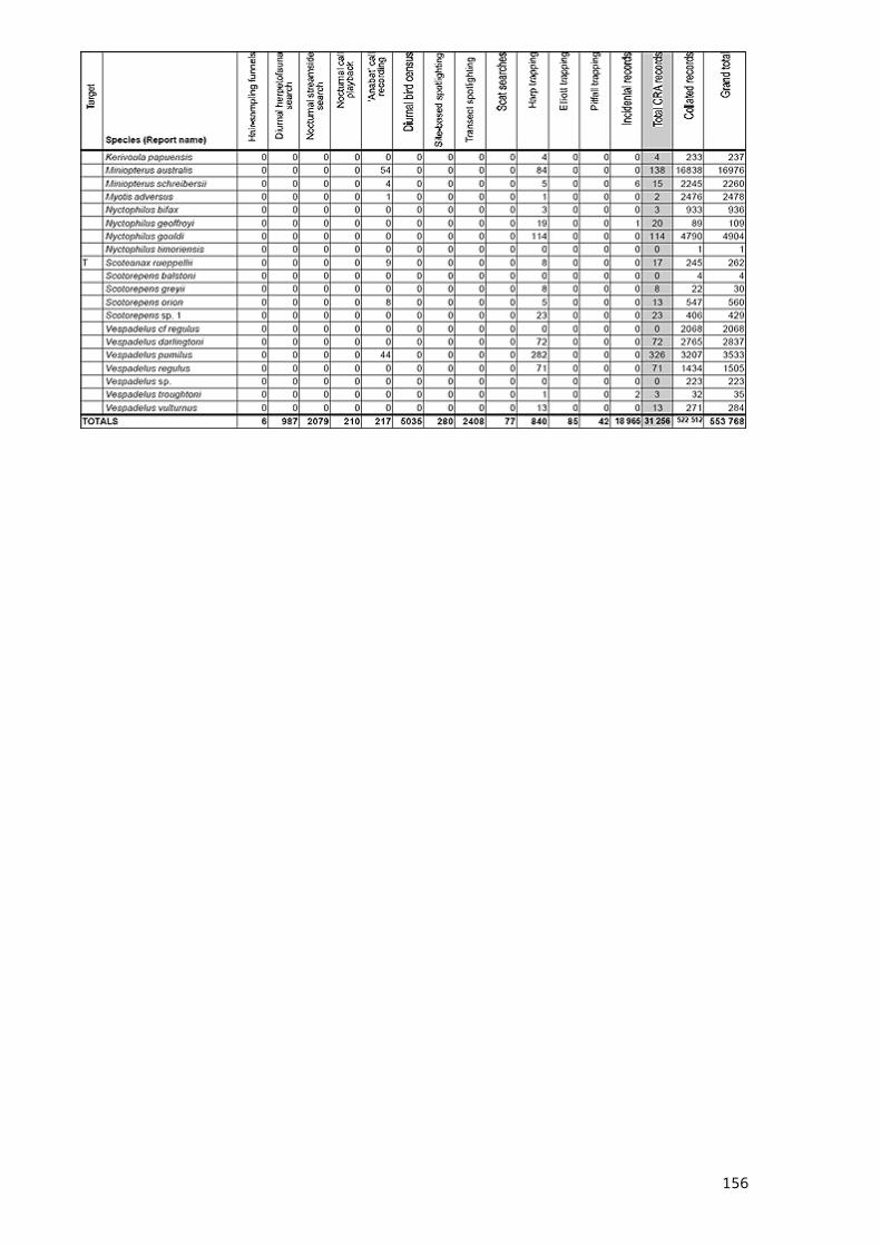
PART 3: SYDNEY BASIN STUDY AREA
156

Part 3: Sydney basin study area cont.
157
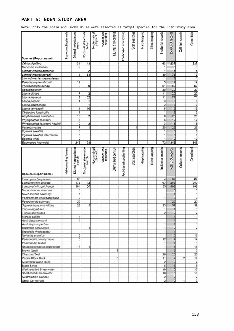
Part 3: Sydney basin study area cont.
158
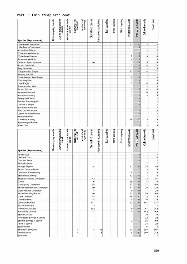
Part 3: Sydney basin study area cont.
159
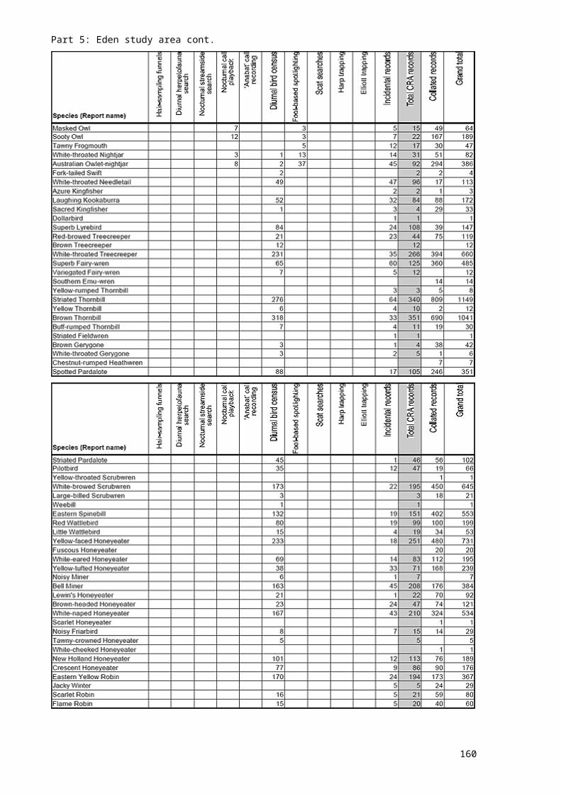
Part 3: Sydney basin study area cont.
160
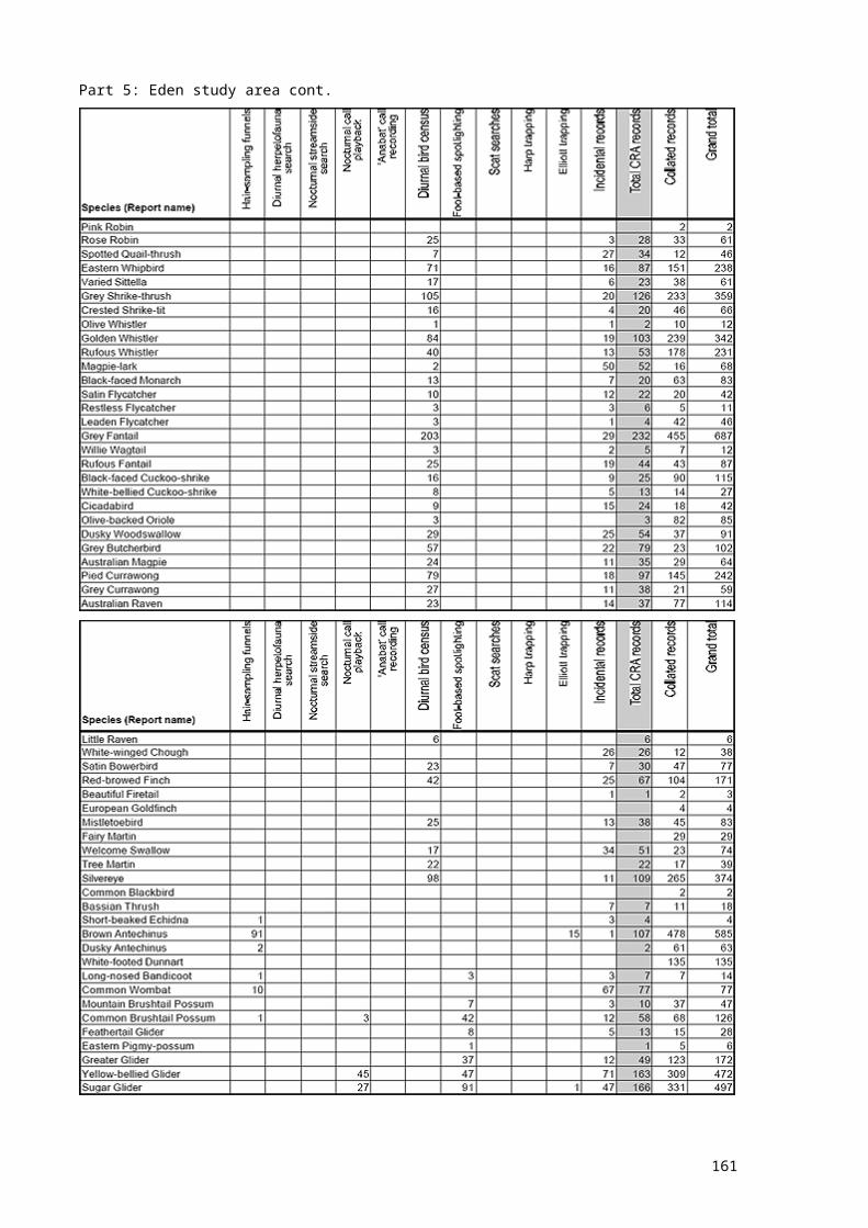
Part 3: Sydney basin study area cont.
161
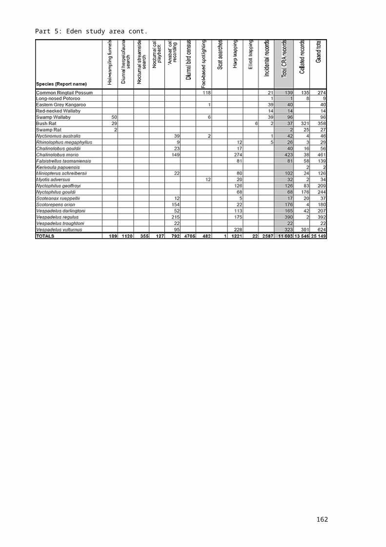
Part 3: Sydney basin study area cont.
162
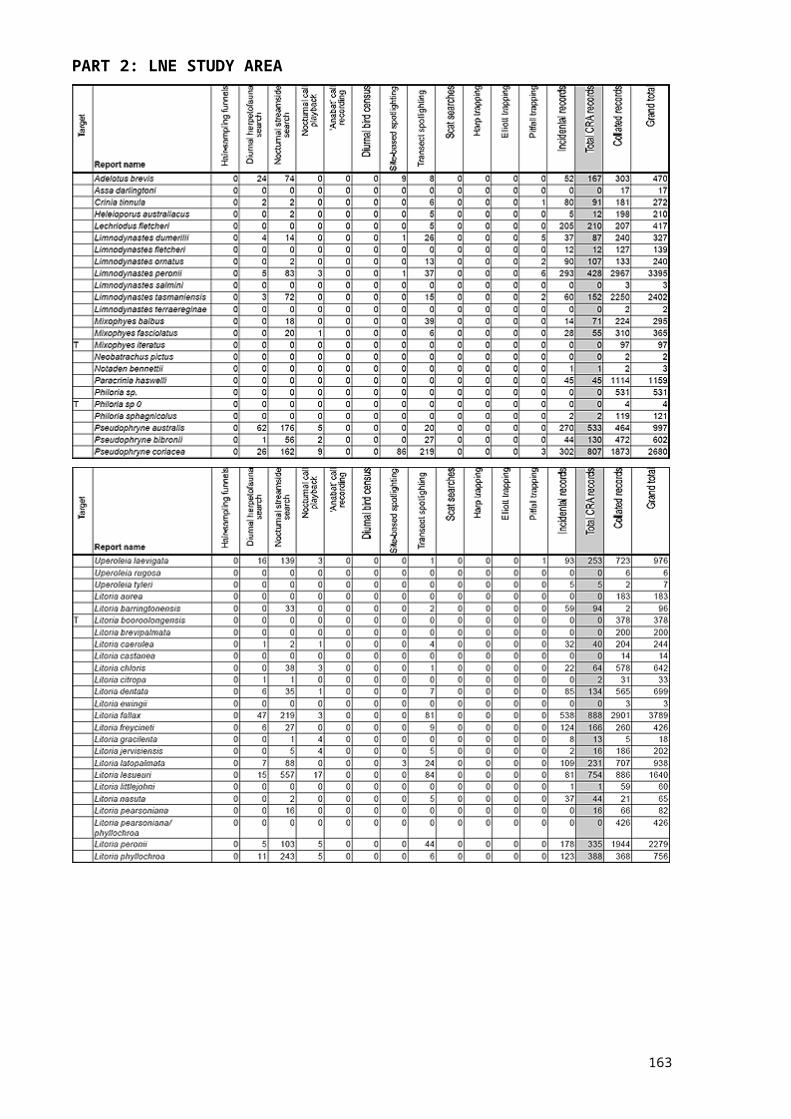
Part 3: Sydney basin study area cont.
163
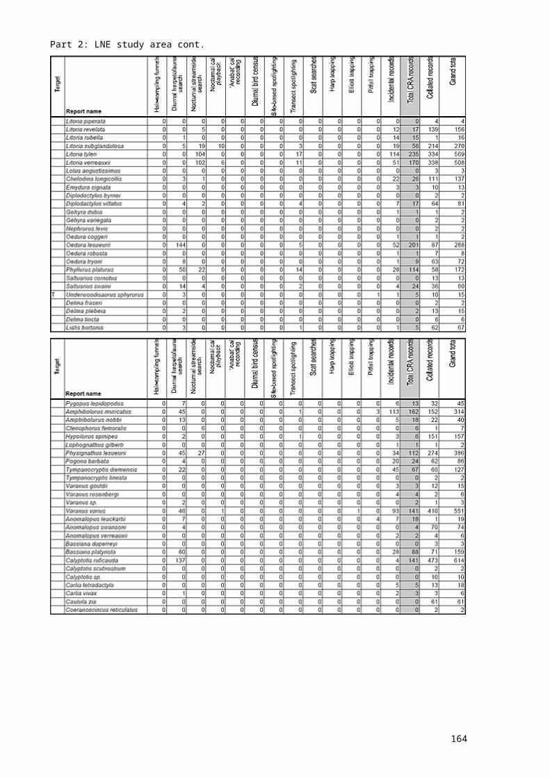
Part 3: Sydney basin study area cont.
164
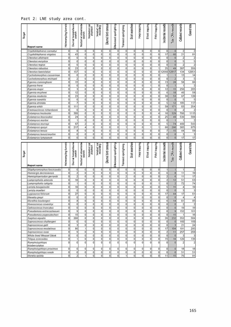
Part 3: Sydney basin study area cont.
165
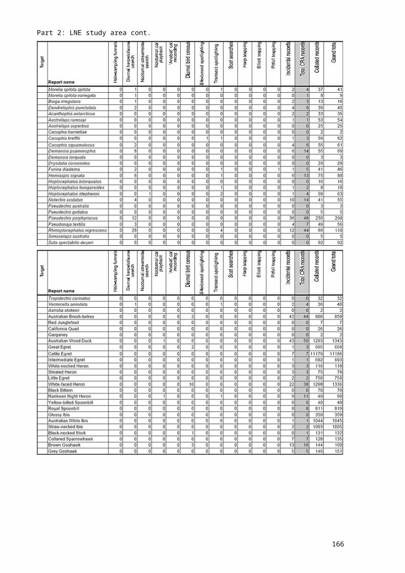
Part 3: Sydney basin study area cont.
166

APPENDIX 7 VOUCHERS SPECIMENS COLLECTED DURING CRA FAUNA SURVEYSVoucher specimens were collected during all CRA fauna surveys and lodged with the Australian Museum. Most specimens were collected because of taxonomic uncertainty, particularly for small skinks and bats. Parts A to E list the confirmed identity of specimens lodged with the Australian Museum.*Note that ‘No.’ includes specimens collected by euthanasia, trap deaths and road-kill. Not all specimens were allocated registration or field numbers prior to delivery to the Australian Museum.
167

168
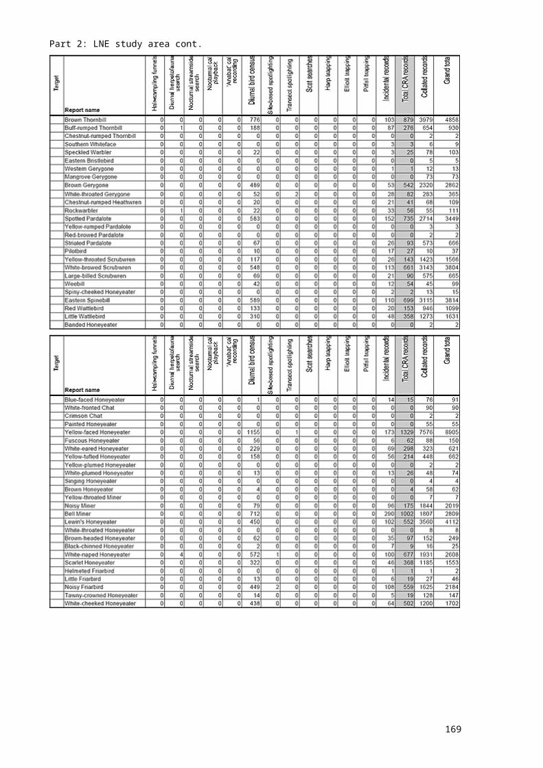
169
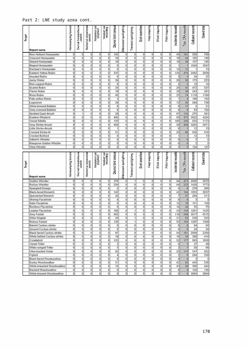
170
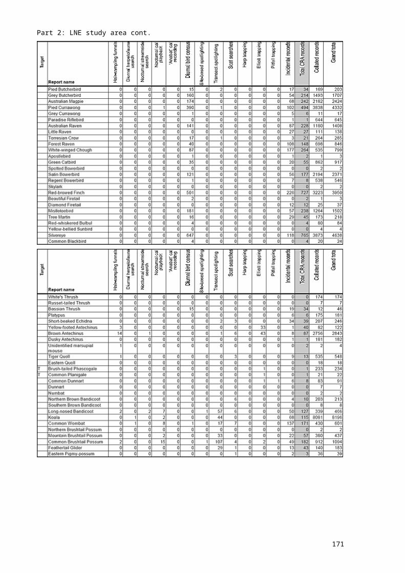
171
Related Documents