Assignments for ArcGIS Online Exploring Natural Events In Canada Exploring Natural Events in Canada Introduction Natural events are sudden events that occur as a result of a natural process, such as floods, earthquakes, storms and forest fires. These events can sometimes cause significant damage and fatalities. In this assignment, you will select a natural event from four options and explore where and when it occurred in Canada. Using ArcGIS Online, you will analyze the chosen natural event and examine relationships between the event and the human and climatic characteristics of the local area. Learning Outcomes By completing this assignment, you will be able to: 1. Identify where and when natural events occur in Canada 2. Discover the human and climatic characteristics found in the location where the natural event occurred 3. Understand how natural events influence and are influenced by human and natural systems. Skills By completing this assignment, you will become comfortable with the following GIS skills: 1. Filtering your data in a table [email protected] edu.esri.ca Page 1 of 7

Welcome message from author
This document is posted to help you gain knowledge. Please leave a comment to let me know what you think about it! Share it to your friends and learn new things together.
Transcript
Assignments for ArcGIS Online Exploring Natural Events In Canada
Exploring Natural Events in Canada
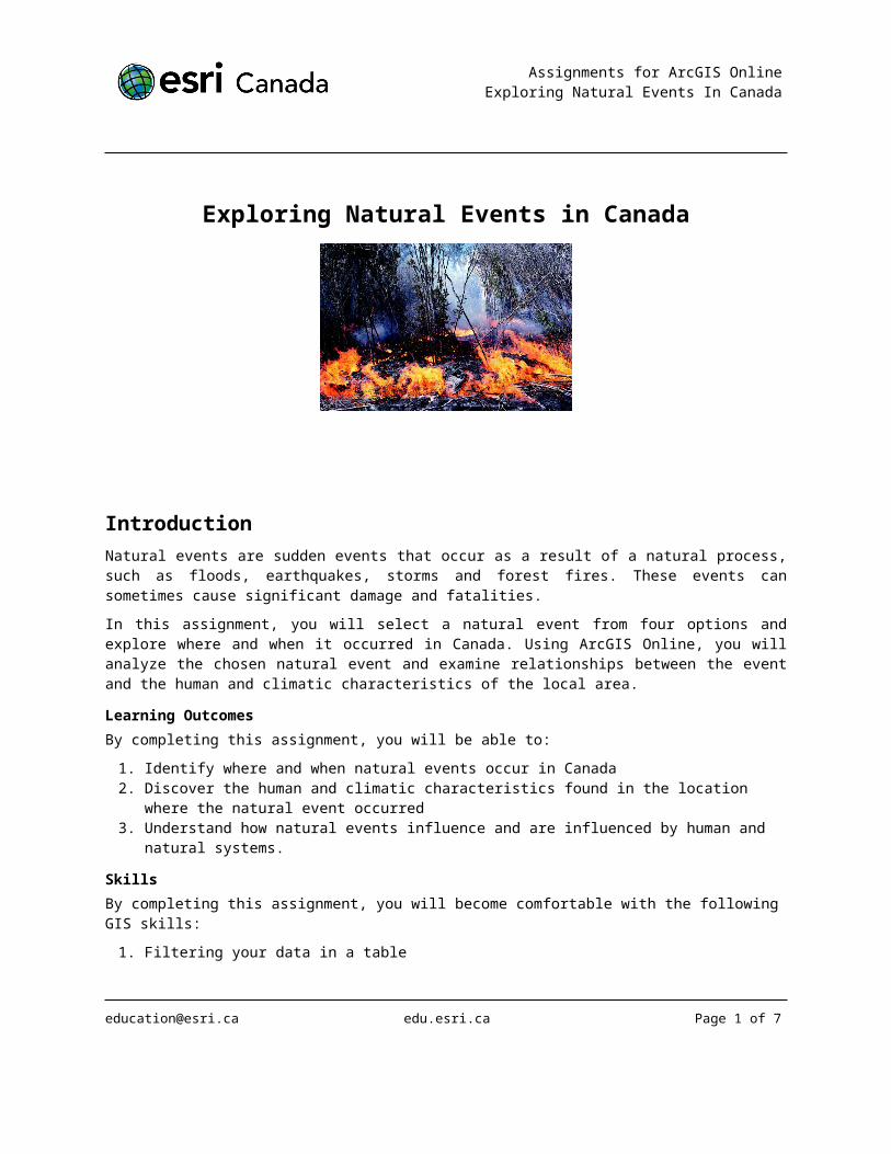
IntroductionNatural events are sudden events that occur as a result of a natural process, such as floods, earthquakes, storms and forest fires. These events can sometimes cause significant damage and fatalities.
In this assignment, you will select a natural event from four options and explore where and when it occurred in Canada. Using ArcGIS Online, you will analyze the chosen natural event and examine relationships between the event and the human and climatic characteristics of the local area.
Learning OutcomesBy completing this assignment, you will be able to:
1. Identify where and when natural events occur in Canada 2. Discover the human and climatic characteristics found in the location where the natural event
occurred3. Understand how natural events influence and are influenced by human and natural systems.
SkillsBy completing this assignment, you will become comfortable with the following GIS skills:
1. Filtering your data in a table2. Searching and adding map layers from ArcGIS Online3. Changing the symbology of a layer4. Create a Web application.
[email protected] edu.esri.ca Page 1 of 6
Assignments for ArcGIS Online Exploring Natural Events In Canada
Tutorial ConnectionsA Tutorial Connection indicates that there is a tutorial available on a skill that is necessary to complete an assignment instruction. Instructions with a connection to a tutorial are denoted with a . The following
tutorials are referenced throughout this assignment.
Introduction to ArcGIS Online Working with Table and Filters Creating Features in ArcGIS Online.
Data SourcesThe following data sources were used in the creation of this assignment:
Natural Resources Canada - Earthquake Database, http://www.earthquakescanada.nrcan.gc.ca/stndon/NEDB-BNDS/bull-eng.php
The Canadian Disasters Database, http://www.publicsafety.gc.ca/prg/em/cdd/index-eng.aspx Canadian Wildland Fire Information System, http://cwfis.cfs.nrcan.gc.ca/en_CA/datamart (To
maintain the performance of the Natural Events Web map in ArcGIS Online, the fire dataset contains only human and lightning caused fires in 2006).
Production DateThe Education and Research Group at Esri Canada makes every effort to present accurate and reliable information. The Web sites and URLs used in this Lesson Pack are from sources that were current at the time of production but are subject to change without notice to Esri Canada.
Production Date: June, 2013
Part A: Getting StartedFirst, you must save a copy of the Web map identified below to use for this assignment.
1. Start by typing the URL https://www.arcgis.com/home/ into your Web browser.
2. Sign In using your ArcGIS Online account. If you do not have an account, create a Public Account. You will need an account to save your map.
Tutorial Connection: Introduction to ArcGIS Online
3. In the search box in the top right of the homepage, search for “Natural Events in Canada”.
4. Locate the Web map titled “Natural Events in Canada (Web Lesson)” by EsriCanadaEducation as shown below.
[email protected] edu.esri.ca Page 2 of 6

Assignments for ArcGIS Online Exploring Natural Events In Canada
5. Open this map in the ArcGIS Viewer.
Part B: Select and Explore your Natural Event You will begin by selecting a natural event to explore and analyze.
1. Go to Show Contents of Map.
2. Turn off all the natural events layers except the natural event you have selected to explore.
Q1 Describe in a paragraph the distribution of the natural event you selected.
3. Now you will filter and analyze the data related to your natural event.
a. Create two expressions using the filter window
Tutorial Connection: Using Tables and Filters in ArcGIS Online
Q2 State the expressions you used to filter your data.
Q3 Summarize the new information have you discovered about your natural event?
2. Change the symbology of your layer.
Tutorial Connection: Creating Features in ArcGIS Online
3. Click Save As. Name your map based on the natural event you are exploring. For example: Summer Storms: Tornadoes That Occurred from 2006-2011 in Canada, Your Name
Part C: Exploring Climatic and Human CharacteristicsIn this part of the assignment, you will analyze the human and climatic characteristics around the location of your natural event.
[email protected] edu.esri.ca Page 3 of 6
Assignments for ArcGIS Online Exploring Natural Events In Canada
1. Search and add the following data layers to your map:
a. Canada’s Climate
b. Population Density in Canada
Tutorial Connection: Introduction to ArcGIS Online
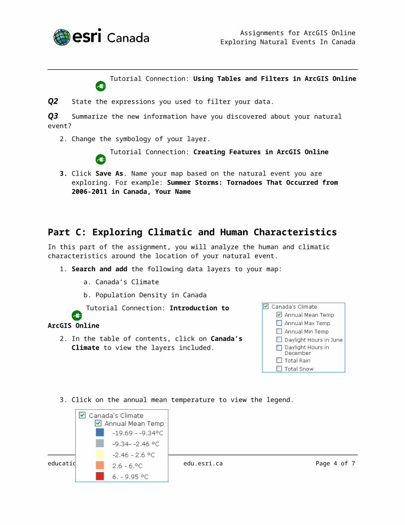
2. In the table of contents, click on Canada’s Climate to view the layers included.
3. Click on the annual mean temperature to view the legend.
4. Explore the annual mean temperature in the areas where your natural event is located.
5. Move on to explore the annual maximum temperature and annual minimum temperature.
Q4 Write a paragraph to explain how a climate characteristic can affect your natural event.
Q5 Write a paragraph to explain how climate change could affect your natural event.
6. Turn off all layers except:
a. The natural event layer you are exploring
b. Canada: Population Density.
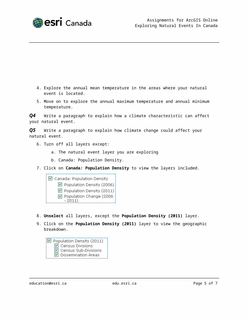
7. Click on Canada: Population Density to view the layers included.
8. Unselect all layers, except the Population Density (2011) layer.
9. Click on the Population Density (2011) layer to view the geographic breakdown.
[email protected] edu.esri.ca Page 4 of 6
Assignments for ArcGIS Online Exploring Natural Events In Canada
10. In the table of contents, click on the Show Map Legend button.
11. Explore the areas where your natural event is found.
Q6 Discuss the level of damage that could have been experienced based on the population density around a location where your natural event occurred.
12. Click Save.
Part D: Putting it All TogetherNow that you have completed your analysis, you will create a Web application and prepare a printable map.
1. Set up your map to include:
a. A climate or human characteristic.
b. Ensure that your natural event is present.
2. Once your map is ready, Share you map and Make a Web Application.
Tutorial Connection: Introduction to ArcGIS Online
3. Select the Basic Viewer as your new Web application by clicking Publish .
a. Add your title. Make sure you include a title that clearly represents the data on your map. For example: Summer Storms: Tornados That Occurred from 2006-2011 in Canada
b. Add a summary. This is information about your map.
4. Save and Publish the Web application
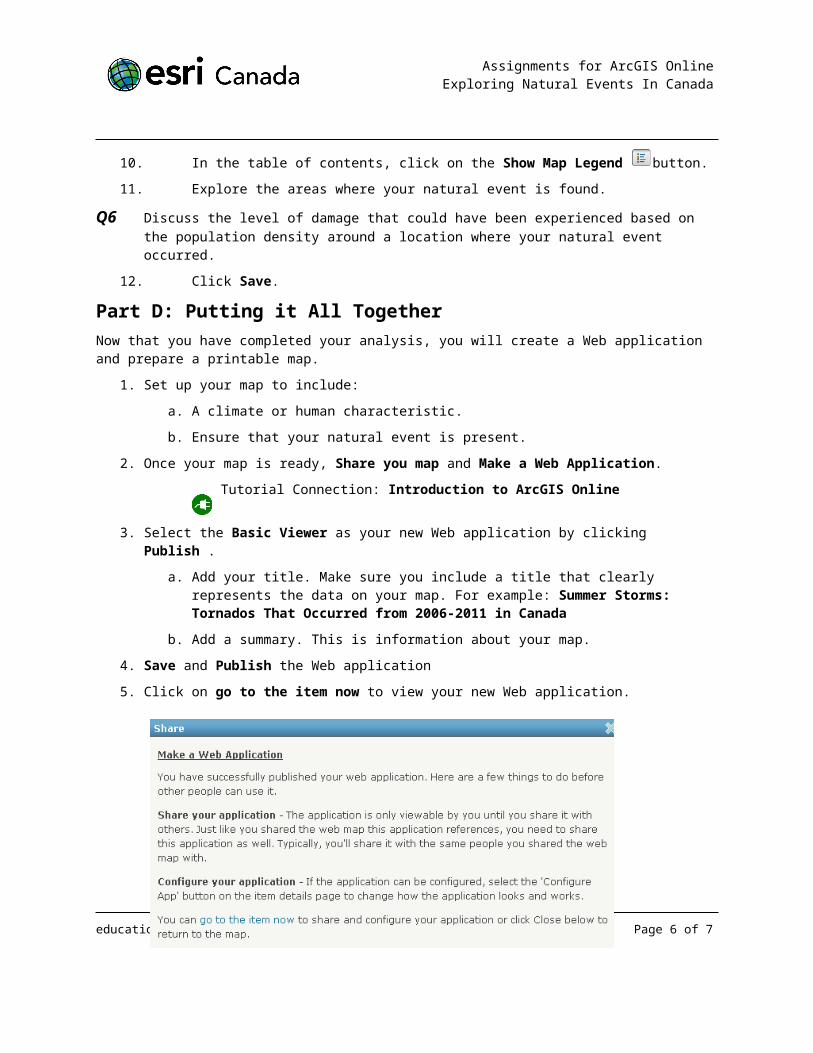
5. Click on go to the item now to view your new Web application.
[email protected] edu.esri.ca Page 5 of 6
Assignments for ArcGIS Online Exploring Natural Events In Canada
6. Print your map to hand in with your written answers or send the Web application link to your teacher.
© 2013 Esri Canada. All rights reserved. Trademarks provided under license from Environmental Systems Research Institute Inc. Other product and company names mentioned herein may be trademarks or registered trademarks of their respective owners. Errors and omissions excepted.
[email protected] edu.esri.ca Page 6 of 6
Related Documents