Presented below are water quality standards that are in effect for Clean Water Act purposes. EPA is posting these standards as a convenience to users and has made a reasonable effort to assure their accuracy. Additionally, EPA has made a reasonable effort to identify parts of the standards that are not approved, disapproved, or are otherwise not in effect for Clean Water Act purposes.

Welcome message from author
This document is posted to help you gain knowledge. Please leave a comment to let me know what you think about it! Share it to your friends and learn new things together.
Transcript

Presented below are water quality standards that are in effect for Clean Water Act purposes. EPA is posting these standards as a convenience to users and has made a reasonable effort to assure their accuracy. Additionally, EPA has made a reasonable effort to identify parts of the standards that are not approved, disapproved, or are otherwise not in effect for Clean Water Act purposes.

State of Vermont
AGENCY OF NATURAL RESOURCES
Department of Environmental Conservation
Watershed Management Division
One National Life Drive, Main 2
Montpelier, VT 05620
(802) 828-1535
http://www.anr.state.vt.us/dec/rulessum.htm
Vermont Water Quality Standards
Environmental Protection Rule Chapter 29(a)
Effective October 30, 2014

Vermont Water Quality Standards, Environmental Protection Rule Chapter 29(a) 2
Contents
Chapter 1 GENERAL POLICY ...................................................................................................... 5
Section 1-01 Applicability and Definitions .................................................................................. 5
A. Applicability ....................................................................................................................... 5
B. Definitions .......................................................................................................................... 5
Section 1-02 General Policy ......................................................................................................... 9
A. Water Quality Policy (See 10 V.S.A. §1250) ..................................................................... 9
B. Water Conservation Policy ............................................................................................... 10
C. Riparian Policy ................................................................................................................. 10
D. Basin Planning .................................................................................................................. 10
E. Hydrology Policy .............................................................................................................. 11
F. Classification of Waters .................................................................................................... 11
Section 1-03 Anti-Degradation Policy ........................................................................................ 11
A. General Policy .................................................................................................................. 11
B. Determination of Existing Uses ........................................................................................ 12
C. Protection and Maintenance of High Quality Waters ....................................................... 12
D. Protection of Outstanding Resource Waters ..................................................................... 13
Section 1-04 Discharge Policy .................................................................................................... 13
A. Discharge Criteria ............................................................................................................. 13
B. Assimilative Capacity ....................................................................................................... 14
C. Compliance Schedules ..................................................................................................... 14
Section 1-05 Interpretation ......................................................................................................... 14
Chapter 2 APPLICATION OF STANDARDS ............................................................................. 14
Section 2-01 Sampling and Analysis .......................................................................................... 14
Section 2-02 Flow Values Used to Evaluate Compliance with Applicable Numeric Criteria for
Rivers, Streams, Brooks, Creeks, and Riverine Impoundments ..................................................... 15
A. Natural Flow Regime........................................................................................................ 15
B. Natural Flow Regime Altered by Human-made Structures .............................................. 15
Section 2-03 Nonpoint Source Pollution .................................................................................... 16
A. Policy ................................................................................................................................ 16
B. Use of Management Practices and Planning .................................................................... 16
Section 2-04 Special Zones ......................................................................................................... 16

Vermont Water Quality Standards, Environmental Protection Rule Chapter 29(a) 3
A. Mixing Zones .................................................................................................................... 16
B. Waste Management Zones ................................................................................................ 17
Section 2-05 Public Water Supply .............................................................................................. 18
A. Designation ....................................................................................................................... 18
B. Public Water Supply Management ................................................................................... 18
Chapter 3 DETERMINATION OF CRITERIA ............................................................................ 18
Section 3-01 Water Quality Criteria and Indices - General ........................................................ 18
A. Natural Influences ............................................................................................................. 18
B. General Criteria ................................................................................................................ 18
C. Hydrology Criteria ............................................................................................................ 23
D. Numeric Biological Indices .............................................................................................. 25
Section 3-02 Class A(1) Ecological Waters................................................................................ 26
A. Management Objectives ................................................................................................... 26
B. Water Quality Criteria for Class A(1) Ecological Waters ................................................ 26
Section 3-03 Class A(2) Public Water Supplies ......................................................................... 29
A. Management Objectives ................................................................................................... 29
B. Water Quality Criteria for Class A(2) Public Water Supplies .......................................... 29
Section 3-04 Class B Waters....................................................................................................... 32
A. Management Objectives ................................................................................................... 32
B. Water Quality Criteria for Class B waters ........................................................................ 32
Section 3-05 Fish Habitat Designation ....................................................................................... 37
Section 3-06 Water Management Types ..................................................................................... 37
A. Purpose ............................................................................................................................. 37
B. Water Management Type Designation Process ................................................................ 37
Chapter 4 WATER QUALITY CLASSIFICATIONS .................................................................. 39
Section 4-01. Classification of the Batten Kill Walloomsac and Hoosic Basin (Basin 1) .......... 39
Section 4-02. Classification of the Poultney-Mettawee Basin (Basin 2) ..................................... 41
Section 4-03. Classification of the Otter Creek Basin (Basin 3) ................................................. 41
Section 4.04. Classification of the Southern Champlain Basin (Basin #4) ................................. 43
Section 4-05. Classification of the Northern Champlain Basin (Basin #5) ................................. 44
Section 4.06. Classification of the Missisquoi Basin (Basin 6)................................................... 45
Section 4-07. Classification of Lamoille Basin (Basin 7)............................................................ 46
Section 4-08. Classification of the Winooski Basin (Basin 8)..................................................... 47

Vermont Water Quality Standards, Environmental Protection Rule Chapter 29(a) 4
Section 4-09. Classification of the White River Basin (Basin 9)2Section 4-09. Classification of
the White Basin (Basin 9) ............................................................................................................... 49
Section 4-10. Classification of the Ottauquechee-Black Basin (Basin 10) ................................. 49
Section 4-11. Classification of the West-Williams-Saxtons Basin (Basin 11) ............................ 50
Section 4-12 Classification of the Deerfield Basin (Basin 12) ................................................... 52
Section 4-13. Classification of the Lower Connecticut Basin (Basin 13) ................................... 52
Section 4-14. Classification of the Stevens-Wells-Waits-Ompompanoosuc Basin (Basin 14) ... 54
Section 4-15. Classification of the Passumpsic Basin (Basin 15) ............................................... 54
Section 4-16. Classification of the Northern Connecticut Basin (Basin 16) ............................... 56
Section 4-17. Classification of the Memphremagog Basin (Basin 17) ........................................ 57
APPENDIX A - Fish Habitat Designation.......................................................................................... 59
Appendix B - Phosphorus Criteria §3-01(A)(2)(c), Description of Lake Champlain and Lake
Memphremagog segments. ................................................................................................................. 65
Appendix C: Water Quality Criteria for the Protection of Human Health and the Aquatic Biota .... 68
Appendix D: Conversion factors for estimating dissolved metals from total values. ........................ 82
Appendix E: Parameters for Calculating Freshwater Total Metals Criteria that are Hardness-
Dependent. .......................................................................................................................................... 83

Vermont Water Quality Standards, Environmental Protection Rule Chapter 29(a) 5
Chapter 1 GENERAL POLICY
Section 1-01 Applicability and Definitions
A. Applicability
1. Pursuant to 10 V.S.A. Chapter 47, after the classification of any waters has
been established, those waters shall be managed by the Secretary in order to
obtain and maintain the classification. The Secretary may enforce a
classification and these rules against any person affected thereby who, with
notice of the classification, has failed to comply.
2. Concerning any application, the Water Quality Standards in effect at the time
of the filing shall apply. These Water Quality Standards shall apply to those
applications, including applications for the renewal of existing approvals, that
are filed on or after the date upon which the amended standards become
effective, and to all other activities that occur after that date. These rules shall
apply to all “waters of the United States” as defined in 40 C.F.R. §122.2
(1995). Application of these rules to waters of the United States shall not
require the issuance of a state or federal permit, license, certification or
approval for discharges or activities where no such permit, license,
certification or approval requirement exists under applicable state or federal
law, including, but not limited to, discharges and activities that satisfy the
exemptions and exclusions set forth at 40 C.F.R. §122.3 and §232.3 (1995).
3. In the event any of these rules, or any portion thereof, is found by a court of
competent jurisdiction to be illegal or void, the remainder thereof shall be
deemed unaffected and shall continue in full force and effect.
4. The following exclusions apply only to artificial bodies of water that were not
originally created in waters or did not result from impoundment of waters:
a. Off stream reservoirs (such as snowmaking ponds) may be subject to
water level fluctuations that are necessary to achieve the purposes for
which the reservoir was constructed and accordingly, shall not be
required to meet the criteria of these rules impacted by water level
fluctuations in the reservoir;
b. Waste treatment systems (including waste management systems
constructed as part of Best Management Practices under 6 V.S.A.
Chapter 215 and treatment ponds, lagoons, or wetlands created solely
to meet the requirements of a permit issued for a discharge)
determined to be necessary to achieve compliance with these rules
shall not be required to be managed as waters under these rules.
5. Waters created exclusively by rainfall or snowmelt events, such as puddles
and overland flow, that are so temporary in nature that they do not support the
existing and designated uses, shall not be considered waters.
B. Definitions

Vermont Water Quality Standards, Environmental Protection Rule Chapter 29(a) 6
For the purposes of these Water Quality Standards, the terms below shall have the following
meanings unless a different meaning clearly appears from the context.
1. Accepted agricultural or silvicultural practices means those land management practices
adopted by the secretary of agriculture, food and markets, and the commissioner of forests,
parks and recreation, respectively, in accordance with applicable state law.
2. Act means the “Vermont Water Pollution Control Act.” See, 10 V.S.A., Chapter 47.
3. Applicable water quality criteria means all criteria specified in § 3-01, as well as those
specified in §§ 3-02(B), 3-03(B) and 3-04(B) that are applicable to the classification and
Water Management Type of the waters in question.
4. Application means any request for a permit required by state or federal law when filed with,
and deemed complete by, the reviewing authority.
5. Aquatic biota means all organisms that, as part of their natural life cycle, live in or on
waters.
6. Aquatic habitat means the physical, chemical, and biological components of the water
environment.
7. Assimilative capacity means a measure of the capacity of the receiving waters to assimilate
wastes without lowering their quality below the applicable water quality criteria.
8. Basin plan means a plan prepared by the Secretary for each of Vermont’s 17 basins (see
Chapter 4 of these rules) in conjunction with the basin planning process required by the
Federal Clean Water Act and 40 C.F.R. Part 130, the Act, and the provisions of § 1-02 (D) of
these rules.
9. Best management practices means a practice or combination of practices that may be
necessary, in addition to any applicable Accepted Agricultural or Silvicultural Practices, to
prevent or reduce pollution from nonpoint source wastes to a level consistent with the
applicable provisions of these rules.
10. Biological integrity means the ability of an aquatic ecosystem to support and maintain, when
consistent with reference conditions, a community of organisms that is not dominated by any
particular species or functions (balanced), is fully functional (integrated), and is resilient to
change or impact (adaptive), and which has the expected species composition, diversity, and
functional organization.
11. Board means the Vermont Water Resources Board.
12. Classification means the water quality classification designated for a specific body of water
in accordance with the provisions of 10 V.S.A. §1253.
13. csm (cubit feet per second per square mile) means the streamflow from each square mile
of area drained, assuming the runoff is distributed uniformly in time and area.
14. Designated use means any value or use, whether presently occurring or not, that is specified
in the management objectives for each class of water as set forth in
§§3-02(A), 3-03(A), and 3-04(A) of these rules.

Vermont Water Quality Standards, Environmental Protection Rule Chapter 29(a) 7
15. Discharge means the placing, depositing, or emissions of any wastes, directly or indirectly,
into an injection well or into waters.
16. EPA means the U.S. Environmental Protection Agency.
17. Existing discharge means any discharge to the extent authorized by a valid permit issued
under the provisions of 10 V.S.A. §1263 or §1265 as of January 7, 1985.
18. Existing use means a use which has actually occurred on or after November 28, 1975, in or
on waters, whether or not the use is included in the standard for classification of the waters,
and whether or not the use is presently occurring.
19. Full support of uses, or fully support uses means the achievement of the level of water
quality necessary to consistently maintain and protect existing and designated uses.
20. Functional component of the aquatic ecosystem means a portion of the aquatic biological
community identified by its role in the processing of energy within the aquatic ecosystem
(e.g., primary producers, predators, detritivores, etc.).
21. Groundwater means water below the land surface.
22. Indirect discharge means any discharge to groundwater, whether subsurface, land-based or
otherwise.
23. Intolerant aquatic organisms means those organisms which are particularly sensitive to,
and likely to be adversely affected by, the stress of pollution, flow modification or habitat
alteration (e.g., mayflies and stoneflies).
24. Low median monthly flow means the median monthly flow for that month having the
lowest median monthly flow.
25. Mean daily flow means the arithmetic mean of the sum of individual flow values measured
over a calendar day which is representative of the total flow over that 24-hour period.
26. Median monthly flow means, for a given calendar month, the mean daily flow that is
equaled or exceeded 50 percent of the time, based on a long-term record.
27. Median annual flow means that mean daily flow which is equaled or exceeded 50 percent of
the time.
28. Mixing zone means a length or area within the waters of the state required for the dispersion
and dilution of waste discharges adequately treated to meet federal and state treatment
requirements and within which it is recognized that specific water uses or water quality
criteria associated with the assigned classification for such waters may not be realized. A
mixing zone shall not extend more than 200 feet from the point of discharge.
29. Natural condition means the condition representing chemical, physical, and biological
characteristics that occur naturally with only minimal effects from human influences.
30. Natural flow regime means a water’s characteristic variability in flow rates and water levels,
annually, seasonally, and daily, without the influence of artificial flow regulation.
31. New discharge means any discharge not authorized under the provisions of 10 V.S.A. §1263
as of January 7, 1985 or any increased pollutant loading or demand on the assimilative

Vermont Water Quality Standards, Environmental Protection Rule Chapter 29(a) 8
capacity of the receiving waters from an existing discharge that requires the issuance of a
new or amended permit.
32. Nonpoint source waste means waste that reaches waters in a diffuse manner from any
source other than a point source including, but not limited to, overland runoff from
construction sites, or as a result of agricultural or silvicultural practices.
33. Nonpolluting waste means waste that prior to treatment does not have the potential to impair
the condition of waters.
34. Permit means a certification, dam order, or other authorization in which during the
application review process, compliance with the Vermont Water Quality Standards is
evaluated pursuant to applicable state or federal law.
35. Point Source means any discernable, confined and discrete conveyance including but not
limited to any pipe, ditch, channel, tunnel, conduit, well, discrete fissure, container, rolling
stock, concentrated animal feeding operation, landfill leachate collection system, vessel or
other floating craft from which either a pollutant or waste is or may be discharged.
36. Public Interest means that which shall be for the greatest benefit to the people of the state as
determined by the Secretary in accordance with the criteria set forth in subsection (e) of
§1253 of the Act.
37. Publicly owned treatment works means any device or system used in the storage,
treatment, disposal or recycling of wastes that is owned by any governmental unit.
38. Receiving waters means all waters adjacent to a discharge, and all downstream or other
waters the quality of which may be affected by that discharge.
39. Reference condition means the range of chemical, physical, and biological characteristics of
waters minimally affected by human influences. In the context of an evaluation of biological
indices, or where necessary to perform other evaluations of water quality, the reference
condition establishes attainable chemical, physical, and biological conditions for specific
water body types against which the condition of waters of similar water body type is
evaluated.
40. Riparian vegetation means the vegetation adjacent to surface waters.
41. Riverine impoundment means a reach of river or stream subject to the backwater influence
of a human-made dam with the water remaining generally within the natural channel.
42. Seven day low flow, ten year return period (7Q10) means a drought flow equal to the
lowest mean flow for seven consecutive days, adjusted to nullify any effects of artificial flow
regulation, that has a 10% chance of occurring in any given year.
43. Secretary means the Secretary of the Agency of Natural Resources or the Secretary’s duly
authorized representative.
44. Taxonomic component of the aquatic ecosystem means a portion of the biological
community identified by a hierarchical classification system for identifying biological
organisms that uses physical and biological characteristics (e.g., Insecta: Plecoptera:
Perlidae: Agnetina capitata).

Vermont Water Quality Standards, Environmental Protection Rule Chapter 29(a) 9
45. Tolerant aquatic organisms means organisms (e.g., midges and annelids) that, although
they may be affected by the stress of pollution, flow modification or habitat alteration, are
less sensitive and less likely to be adversely affected than are intolerant aquatic organisms.
46. Toxic wastes means those wastes combinations of wastes which, after discharge and upon
exposure, ingestion, inhalation, or assimilation into any organism, either directly from the
environment or indirectly by ingestion through food chains, will, on the basis of available
information cause death, disease, behavioral abnormalities, cancer, genetic mutations,
physiological or reproductive malfunctions or physical deformations in such organisms or
their offspring.
47. Waste means effluent, sewage, or any substance or material, liquid, gaseous, solid or
radioactive, including heated liquids, whether or not harmful or deleterious to waters;
provided however, the term “sewage” as used in 10 V.S.A. Chapter 47 shall not include the
rinse or process water from a cheese manufacturing process.
48. Waste Management Zone means a specific reach of Class B waters designated by a permit
to accept the discharge of properly treated wastes that prior to treatment contained organisms
pathogenic to human beings. Throughout the receiving waters, water quality criteria must be
achieved, but increased health risks exist in a waste management zone due to the authorized
discharge.
49. Waters include all rivers, streams, creeks, brooks, reservoirs, ponds, lakes, springs and all
bodies of surface waters, artificial or natural, which are contained within, flow through or
border upon the State or any portion of it.
Section 1-02 General Policy
These rules are intended to achieve the goals of the Vermont Water Quality Policy set forth
below, as well as the objective of the federal Clean Water Act (33 U.S.C. §1251 et seq.) which is to
restore and maintain the chemical, physical, and biological integrity of the Nation’s waters.
A. Water Quality Policy (See 10 V.S.A. §1250)
It is the policy of the State of Vermont to:
1. protect and enhance the quality, character and usefulness of its surface waters
and to assure the public health;
2. maintain the purity of drinking water;
3. control the discharge of wastes to waters, prevent degradation of high quality
waters and prevent, abate or control all activities harmful to water quality;
4. assure the maintenance of water quality necessary to sustain existing aquatic
communities;
5. provide clear, consistent and enforceable standards for the permitting and
management of discharges;
6. protect from risk and preserve in their natural state certain high quality waters
including fragile high-altitude waters, and the ecosystems they sustain;

Vermont Water Quality Standards, Environmental Protection Rule Chapter 29(a) 10
7. manage waters to promote a healthy and prosperous agricultural community,
to increase the opportunities for use of the state’s forest, parks and
recreational facilities, and to allow beneficial and environmentally sound
development.
It is further the policy of the state to seek over the long term to upgrade the quality of waters
and to reduce existing risks to water quality.
B. Water Conservation Policy
Water is a natural resource that should be managed efficiently to reduce waste through
promotion of water conservation. It shall be the policy of the state to conserve the water resources
of Vermont through technology, methods, and procedures designed to promote efficient use of
water; to consider water conservation in all water use decisions; and to reduce or minimize the waste
of water through water supply management practices.
C. Riparian Policy
The State of Vermont recognizes the importance of conserving riparian vegetation adjacent
to surface waters to provide benefits that include but are not limited to: a) shading of surface water to
maintain cooler summer temperatures; b) reducing soil loss, streambank and shoreline erosion, and
sedimentation of aquatic habitat; c) filtering sediment, nutrients, and pollutants in runoff; and d)
providing cover habitat for aquatic biota.
D. Basin Planning
1. The Secretary is required to adopt basin plans. Such plans inventory the
existing and potential causes and sources of pollution that may impair the
waters. Basin plans establish a strategy to improve or restore waters, and to
ensure full support of uses. Basin plans serve as the guide, consistent with
applicable state and federal law, for how various sources of pollution within
each basin will be managed in order to achieve compliance with the Vermont
Water Quality Standards and the Vermont water quality policy. The Secretary
is required by state law to revise all 15 basin plans by January 1, 2000 and to
complete at least one basin plan per year beginning in 1992. Basin plans shall
be updated every five years.
2. As part of the basin planning process, public participation shall be sought to
identify and inventory problems, solutions, high quality waters, existing uses,
other water uses, and significant resources of high public interest.
3. In preparing basin plans, the Secretary shall, to the extent required by
applicable law, consider all relevant aspects of approved municipal plans and
regional plans adopted under 24 V.S.A. Chapter 117 and coordinate and
cooperate with the Secretary of the Agency of Agriculture, Food, and Markets
as provided for in 6 V.S.A. Chapter 215.
4. Each basin plan shall identify strategies, where necessary, by which to
allocate levels of pollution between various sources as well as between
individual discharges. Basin plans should, to the extent appropriate, contain
specific recommendations by the Secretary that include but are not limited to

Vermont Water Quality Standards, Environmental Protection Rule Chapter 29(a) 11
the identification of all known existing uses, salmonid spawning or nursery
areas important to the establishment or maintenance of such fisheries,
reference conditions appropriate for specific waters, any recommended
changes in classification and designation of waters, schedules and funding or
remediation, stormwater management, riparian zone management, and other
measures or strategies pertaining to the enhancement and maintenance of the
quality of waters within the basin.
5. In basins that include Class B waters which have not been allocated into one
or more Water Management Types pursuant to § 3-06 of these rules, the basin
plan shall propose the appropriate Water Management Type or Types based
on both the existing water quality and reasonably attainable and desired water
quality management goals.
6. Upon adoption of a basin plan, the Secretary shall promptly initiate
rulemaking and shall give due consideration to the recommendations
contained in the basin plan.
E. Hydrology Policy
1. The proper management of water resources now and for the future requires
careful consideration of the interruption of the natural flow regime and the
fluctuation of water levels resulting from the construction of new, and the
operation of existing, dams, diversions, and other control structures. These
rules, in conjunction with other applicable law, provide a means for
determining conditions which preserve, to the extent practicable, the natural
flow regime of waters.
2. When determining necessary streamflows or conditions necessary to further
the goals of this policy through application of the applicable Agency of
Natural Resources procedures or regulations, the Secretary, as provided for in
10 V.S.A. §1003, may cooperate with appropriate federal, state, municipal,
and private interests in achieving voluntary agreements relating to artificial
streamflow regulation that assure consistency with these rules.
F. Classification of Waters
Existing classifications of waters shall be maintained unless reclassified in a manner
consistent with the Act and in compliance with all applicable federal requirements including 40
C.F.R. §131.10 (g).
Section 1-03 Anti-Degradation Policy
A. General Policy
All waters shall be managed in accordance with these rules to protect, maintain, and improve
water quality.

Vermont Water Quality Standards, Environmental Protection Rule Chapter 29(a) 12
B. Determination of Existing Uses
1. General
Existing uses of waters and the level of water quality necessary to protect
those existing uses shall be maintained and protected regardless of the water’s
classification. Determinations of what constitute existing uses of particular waters
shall be made either during the basin planning process or on a case-by-case basis
during consideration of an application. The use of waters to receive or transport
discharges of waste shall not constitute an existing use for purposes of these rules. In
making a determination of the existing uses to be protected and maintained under this
section and all other sections of these rules, the Secretary shall consider at least the
following factors:
a. Aquatic biota and wildlife that utilize or are present in the waters;
b. Habitat that supports existing aquatic biota, wildlife, or plant life;
c. The use of the waters for recreation or fishing;
d. The use of the water for water supply, or commercial activity that depends
directly on the preservation of an existing high level of water quality; and
e. with regarding to the factors considered under paragraphs (a) and (b) above,
evidence of the use’s ecological significance in the functioning of the
ecosystem or evidence of the use’s rarity.
C. Protection and Maintenance of High Quality Waters
1. Waters the existing quality of which exceeds any applicable water quality
criteria provide important environmental, economic, social and other benefits
to the people of the state. Except as provided in subsection 2 of this part, such
waters shall be managed to maintain and protect the higher water quality and
minimize risk to existing and designated uses. In all cases, the level of water
quality necessary to maintain and protect all existing uses as well as
applicable water quality criteria shall be maintained.
2. A limited reduction in the existing higher quality of such waters may be
allowed only when it is shown that:
a. the adverse economic or social impacts on the people of the state
specifically resulting from the maintenance of the higher quality of the
waters would be substantial and widespread;
b. these adverse impacts would exceed the environmental, economic,
social, and other benefits of maintaining the higher water quality; and
c. there shall be achieved the highest statutory and regulatory
requirements for all new or existing point sources, and all cost
effective and reasonable accepted agricultural practices and best
management practices, as appropriate for nonpoint source control,
consistent with state law.

Vermont Water Quality Standards, Environmental Protection Rule Chapter 29(a) 13
3. To the extent any reduction in the quality of high quality waters is allowed,
such reduction shall be limited to that which is necessary to comply with
subsections C(2) above.
D. Protection of Outstanding Resource Waters
The Secretary may under 10 V.S.A. §1424a designate certain waters as Outstanding
Resource Waters. Where the Secretary so designates such waters because of their water quality
values, their existing quality shall, at a minimum, be protected and maintained.
Section 1-04 Discharge Policy
A. Discharge Criteria
In addition to the other provisions of these rules, new discharges of wastes may be allowed
only when all the following criteria are met:
1. The proposed discharge is in conformance with all applicable provisions of
these rules including the classification of the receiving waters adopted by the
Secretary as set forth in Chapter 4 of these rules.
2. There is neither an alternative method of waste disposal, nor an alternative
location for waste disposal, that would have a lesser impact on water quality
including the quality of groundwater, or if there is such an alternative method
or location, it would be clearly unreasonable to require its use.
3. The design and operation of any waste treatment or disposal facility is
adequate and sufficiently reliable to ensure the full support of uses and to
ensure compliance with these rules and with all applicable state and federal
treatment requirements and effluent limitations.
4. Except as provided for in 10 V.S.A. §1259(d) and (f), the discharge of wastes
other than nonpolluting wastes and stormwater runoff is prohibited in Class A
waters regardless of the degree of treatment provided.
5. Except as provided for in 10 V.S.A. §1259, the discharge of wastes that, prior
to treatment, contained organisms pathogenic to human beings into waters is
prohibited.
6. The receiving waters will have sufficient assimilative capacity to
accommodate the proposed discharge.
7. Assimilative capacity has been allocated to the proposed discharge consistent
with the classification set forth in Chapter 4 of these rules.
8. The discharge of wastes to the thermocline or hypolimnion of any lake in
manner that may prevent the full support of uses is prohibited.
9. The discharge of sewage into Class B waters shall not pose more than a
negligible risk to public health. Compliance with this criterion shall include
an assessment of both the level and reliability of treatment achieved and the
impact of the discharge on the water quality of the receiving waters.

Vermont Water Quality Standards, Environmental Protection Rule Chapter 29(a) 14
B. Assimilative Capacity
The capacity of waters to assimilate both the discharge of wastes and the impact of
other activities that may adversely affect water quality, and at the same time to be maintained
at a level of water quality that is compatible with their classification, is finite. The Secretary
may hold a portion of the assimilative capacity in reserve to provide for future needs,
including the abatement of future sources of pollution and future social and economic
development.
Accordingly, the assimilative capacity of waters shall be carefully allocated in
accordance with the “Wasteload Allocation Process” as adopted by the Secretary.
C. Compliance Schedules
A permit issued pursuant to Vermont’s federally-delegated National Pollutant
Discharge Elimination System (NPDES) program may, when appropriate, specify a
schedule leading to compliance with the Vermont and Federal Clean Water Acts and
regulations. The purpose of a schedule of compliance generally is to afford a
permittee adequate time to comply with one or more permit requirements or
limitations that are based on new, newly interpreted or revised water quality standards
that became effective after both issuance of the initial permit for a discharge and July
1, 1977. For a permit requirement or limitation that is based on such a new, newly
interpreted, or revised water quality standard, the Secretary may include a schedule of
compliance in a permit at the time of permit reissuance or modification where the
permittee either cannot comply with the permit requirement or limitation, or there is
insufficient information available to determine whether the permittee can comply with
the permit requirement or limitation. A schedule of compliance shall require
compliance at the earliest possible time, as determined by the Secretary. A schedule
of compliance shall include dates for specified tasks or activities leading to
compliance and may include interim effluent limitations, as the Secretary deems
appropriate. This provision does not limit the Secretary’s authority to include
compliance schedules in permits as provided by state law.
Section 1-05 Interpretation
The Secretary may issue declaratory rulings regarding the water quality standards pursuant to
10 V.S.A. §1252 (f).
Chapter 2 APPLICATION OF STANDARDS
Section 2-01 Sampling and Analysis
All numeric water quality criteria shall be applied by rounding to the nearest significant
number in accordance with standard mathematic practice. For the purposes of these rules, sample
collection, preservation, handling and analysis shall conform as closely as practicable to methods
established in the most current edition or publication of any of the following sources:
(a) “Standard Methods For the Examination of Water and Wastewaters,” Public Health
Association, New York.

Vermont Water Quality Standards, Environmental Protection Rule Chapter 29(a) 15
(b) “American Society for Testing and Materials,” part 23, “Water; Atmospheric
Analysis,” American Society for Testing and Materials.
(c) “Methods for Chemical Analysis of Water and Wastes,” U.S. Environmental
Protection Agency.
(d) “Microbiological Methods for Monitoring the Environment - Water and Wastes,”
U.S. Environmental Protection Agency.
(e) The “Quality Assurance Program and Project Plan” prepared by the Secretary and as
approved by EPA.
(f) Any applicable practice or procedure adopted by the Secretary under the provisions of
3 V.S.A. §835 or any rule adopted as part of the “Vermont Water Pollution Control
Permit Regulations” under the provisions of 3 V.S.A. §836.
(g) Any applicable practices or procedures adopted by the Secretary for conducting
nonpoint source pollution monitoring. Such procedures shall be adopted after public
notice and comment. Until such procedures are adopted, nonpoint source pollution
monitoring shall be conducted in accordance with generally accepted scientific
monitoring or evaluation methodologies which the Secretary determines to be
appropriate.
Section 2-02 Flow Values Used to Evaluate Compliance with Applicable Numeric
Criteria for Rivers, Streams, Brooks, Creeks, and Riverine Impoundments
A. Natural Flow Regime
Where the natural flow regime is not altered or substantially influenced by any
human-made structure or device, compliance with the applicable numeric water
quality criteria shall be calculated on the basis of the 7Q10 flow value unless an
alternate flow statistic is specified in Section 3-01 of these rules. This rule shall not
be construed to allow less than normal design operation of any treatment facility
during periods of low streamflow or to otherwise waive the terms of any permit.
B. Natural Flow Regime Altered by Human-made Structures
1. Where there is a Minimum Flow Agreement/Requirement
For waters where the natural flow regime is altered by a human- made
structure and where a minimum flow agreement or requirement has been
established under 10 V.S.A. §1003, compliance with the applicable numeric
water quality criteria shall be calculated on the basis of the 7Q10 flow value
or at the agreed/required minimum flow, whichever is less, unless an
alternative flow statistic is specified in Section 3-01 of these rules.
2. Where there is No Minimum Flow Agreement/Requirement
For waters where the natural flow regime is altered by human-made
structures and where no minimum flow agreement or requirement has been
established, compliance with the applicable numeric water quality criteria
shall be calculated on the basis of the 7Q10 flow value or at the absolute low

Vermont Water Quality Standards, Environmental Protection Rule Chapter 29(a) 16
flow resulting from flow regulation, whichever is less, unless an alternative
flow statistic is specified in Section 3-01 of these rules.
Section 2-03 Nonpoint Source Pollution
A. Policy
1. It is the policy of the State of Vermont to recognize that certain wastes from
nonpoint sources, including but not limited to nonpoint source waste from
agricultural or silvicultural practices, are of such a nature that strategies
required by the Act or by 6 V.S.A. Chapter 215, and those strategies
developed in the basin planning process, represent a practicable basis for
achieving compliance with these rules.
2. In implementing Section 2-03 (A), the Secretary and the Secretary of the
Agency of Agriculture, Food and Markets are encouraged to exercise the full
range of discretion authorized by the Act and 6 V.S.A. Chapter 215 and to
manage discharges of nonpoint source waste in as cost-effective a manner as
possible consistent with the provisions of these rules.
B. Use of Management Practices and Planning
1. The requirements of these rules for any activity causing a nonpoint source
discharge shall be presumed to be satisfied when the activity:
(a) Is conducted in accordance with the Accepted Agricultural Practice
Rules (6 V.S.A. Chapter 215) or, where required, agricultural best
management practices; the Acceptable Management Practices for
Maintaining Water Quality on Logging Jobs in Vermont; or is
conducted in accordance with a best management practice (BMP) for
nonpoint source wastes when the best management practice has been
adopted as a rule or procedure by the Secretary after public notice and
the opportunity for public comment.
(b) Is consistent with the strategy for managing nonpoint source wastes
within any applicable basin plan.
2. Any presumption provided by this section shall be negated when a water
quality analysis conducted according to Section 2-01(g) of these rules
demonstrates that there is a violation of these rules.
Section 2-04 Special Zones
A. Mixing Zones
1. Designation
Mixing zones shall not be created in any Class A water. In Class B waters the
Secretary may, in conjunction with the issuance of a permit, designate a specific portion of
the receiving waters not exceeding 200 feet from the point of discharge as a mixing zone for
any waste that has been properly treated to comply with all applicable state and federal

Vermont Water Quality Standards, Environmental Protection Rule Chapter 29(a) 17
treatment requirements and effluent limitations. Within any mixing zone the Secretary may,
in accordance with the terms of a permit, waive specific provisions of §§ 1-03, 3-01, and 3-
04(B) when consistent with the criteria in § 2-04(A)(2) of these rules, provided that the
quality of the waters outside of the mixing zone complies with all applicable provisions of
these rules.
2. Mixing Zone Criteria
The Secretary shall insure that conditions due to discharges of waste within any
mixing zone shall:
a. Not result in a significant increase in public health risk when evaluated using
reasonable assumptions about exposure pathways;
b. Not constitute a barrier to the passage or movement of fish or prevent the full
support of aquatic biota, wildlife, and aquatic habitat uses in the receiving
waters outside the mixing zone;
c. Not kill organisms passing through the mixing zone;
d. Protect and maintain the existing uses of the waters;
e. Be free from materials in concentrations that settle to form objectionable
deposits;
f. Be free from floating debris, oil, scum, and other material in concentrations
that form nuisances;
g. Be free from substances in concentrations that produce objectionable color,
odor, taste, or turbidity; and
h. Be free from substances in concentrations that produce undesirable aquatic
life or result in a dominance of nuisance species.
B. Waste Management Zones
1. Designation
The designation of waste management zones is provided for in 10 V.S.A. §1252(b)-
(d). In Class B waters the Secretary may, in conjunction with the issuance of a permit for the
direct discharge of properly treated wastes that prior to treatment contained organisms
pathogenic to human beings, designate a specific portion of the receiving waters as a waste
management zone when the criteria in subsection 2 of this section are met. Waste
management zones shall not be created in any Class A water. Within such zones, all water
quality criteria shall be met.
2. Waste Management Zone Criteria
The Secretary shall insure that, in addition to complying with all other applicable
provisions of the statute and these rules, any waste management zone meets the following
criteria:
a. It shall be the minimum length necessary to accommodate the authorized
discharge;

Vermont Water Quality Standards, Environmental Protection Rule Chapter 29(a) 18
b. It shall be consistent with the anti-degradation policy (Section 1-03) of these
rules;
c. It shall not result in significantly increased health risks when evaluated using
reasonable assumptions about exposure pathways;
d. It will be located and managed so as to not result in more than a negligible
increased risk to public health adjacent to or downstream of the waste
management zone; and
e. It will not constitute a barrier to the passage or movement of fish or prevent
the full support of aquatic biota, wildlife, and aquatic habitat uses.
Section 2-05 Public Water Supply
A. Designation
In accordance with 10 V.S.A. §1252, waters that are managed for the purpose of
public water supplies may be designated in Chapter 4 as Class A(2) Public Water Supplies.
B. Public Water Supply Management
In accordance with 10 V.S.A. §1250, it is the policy of the State of Vermont that
public water supplies shall be managed in a manner that assures compliance with these rules.
The Secretary is encouraged to exercise the full range of discretion consistent with 10
V.S.A., Chapters 47 and 56 to manage public water supplies to achieve such compliance.
Chapter 3 DETERMINATION OF CRITERIA
Section 3-01 Water Quality Criteria and Indices - General
A. Natural Influences
Waters in which one or more applicable water quality criteria are not met due to
natural influences shall not be considered to be in noncompliance with respect to such
criteria. In such waters, activities may be specifically authorized by a permit, provided that
those activities do not further reduce the quality of the receiving waters and would comply
with all other applicable criteria.
B. General Criteria
The following water quality criteria shall be achieved in all waters, regardless of their
classification:
1. Temperature
a. General
The change or rate of change in temperature, either upward or downward,
shall be controlled to ensure full support of aquatic biota, wildlife, and aquatic habitat
uses. For the purpose of applying this criterion, ambient temperature shall mean the
water temperature measured at a control point determined by the Secretary to be
outside the influence of a discharge or activity.

Vermont Water Quality Standards, Environmental Protection Rule Chapter 29(a) 19
b. Cold Water Fish Habitat
The total increase from the ambient temperature due to all discharges and
activities shall not exceed 1.00F except as provided for in paragraph (d) below.
c. Warm Water Fish Habitat
The total increase from the ambient temperature due to all discharges and
activities shall not exceed the temperature criteria derived from tables 1 or 2 except as
provided for in paragraph (d) below:

Vermont Water Quality Standards, Environmental Protection Rule Chapter 29(a) 20
Table 1. Lakes, Ponds, and Reservoirs not including Riverine impoundments.
Ambient temperature
Total allowable increase above ambient
temperature
Above 600 10F
500F - 600F 20F
Below 500F 30F
Table 2. All Other Waters.
Ambient temperature
Total allowable increase above ambient
temperature
Above 660F 10F
630 to 660F 20F
590 to 620F 30F
550 to 580F 40F
Below 550F 50F

Vermont Water Quality Standards, Environmental Protection Rule Chapter 29(a) 21
d. Assimilation of Thermal Wastes
The Secretary may, by permit condition, specify temperature limits that
exceed the values specified above in order to authorize discharges of thermal wastes
when it is shown that:
(1) The discharge will comply with all other applicable provisions of these rules;
(2) A mixing zone of 200 feet in length is not adequate to provide for assimilation
of the thermal waste; and
(3) After taking into account the interaction of thermal effects and other wastes,
that change or rate of change in temperature will not result in thermal shock or
prevent the full support of uses of the receiving waters.
2. Phosphorus
a. All waters - general policy
In all waters, total phosphorous loadings shall be limited so that they will not
contribute to the acceleration of eutrophication or the stimulation of the growth of
aquatic biota in a manner that prevents the full support of uses.
b. Lakes, ponds, or reservoirs that have drainage areas of less than 40 square miles and a
drainage area to surface area ratio of less than 500:1, and their tributaries.
(1) In addition to compliance with the general policy above, there shall be no
significant increase over currently permitted phosphorus loadings. Discharges
to tributaries shall not increase in-stream conditions by more than 0.001 mg/l
at low median monthly flow. Indirect discharges to lakes, ponds, or reservoirs
shall not increase total dissolved phosphorus as measured in the groundwater
100 feet from the mean water level of the lake, pond, or reservoir by more
than 0.001 mg/l.
(2) Applicable basin plans, other applicable plans, permit limitations, and other
measures adopted or approved by the Secretary, may define “no significant
increase” so as to allow new or increased discharges of phosphorus, only
when the permit for such discharges provides for a corresponding reduction in
phosphorus loadings to the receiving waters in question.
3. Nitrates
a. General Policy
In all waters nitrates shall be limited so that they will not contribute to the
acceleration of eutrophication, or the stimulation of the growth of aquatic biota, in a manner
that prevents the full support of uses.
b. Lakes, Ponds and Reservoirs not including Riverine Impoundments
Not to exceed 5.0 mg/l as NO3-N regardless of classification.
c. All Other Waters

Vermont Water Quality Standards, Environmental Protection Rule Chapter 29(a) 22
(1) Not to exceed 0.20 mg/l, as nitrate-nitrogen (NO3-N) at flows exceeding low
median monthly flows, in Class A(1) and A(2) waters above 2,500 feet
altitude, National Geodetic Vertical Datum.
(2) Not to exceed 2.0 mg/l as NO3-N at flows exceeding low median monthly
flows, in Class A(1) and A(2) waters at or below 2,500 feet altitude, National
Geodetic Vertical Datum.
(3) Not to exceed 5.0 mg/l as NO3-N at flows exceeding low median monthly
flows, in Class B waters.
4. Sludge deposits or solid refuse
None
5. Settleable solids, floating solids, oil, grease, scum, or total suspended solids
None in such concentrations or combinations that would prevent the full support of
uses.
6. Taste and Odor
None that would prevent the full support of any designated uses or existing use or
have an adverse effect on the taste or odor of fish.
7. Color
None that would prevent the full support of uses.
8. Alkalinity
No change from reference conditions that would prevent the full support of the
aquatic biota, wildlife, and aquatic habitat uses.
9. pH
pH values shall be maintained within the range of 6.5 and 8.5. Both the change and
the rate of change in pH values shall be controlled to ensure the full support of the
aquatic biota, wildlife, and aquatic habitat uses.
10. Toxic substances
a. General
Where necessary to fully support uses an existing or designated use, waters
shall be managed to prevent the discharge of toxic substances in concentrations,
quantities or combinations that exceed:
(1) For toxic substances that are carcinogenic, a maximum individual lifetime risk
to human health greater than 10-6;
(2) For toxic substances that are noncarcinogenic, a maximum individual life time
risk of no adverse effect to human health; or
(3) Acute or chronic toxicity to aquatic biota or wildlife.
b. Human health based criteria
Vermont Water Quality Standards, Environmental Protection Rule Chapter 29(a) 23
In rivers, streams, brooks, creeks, and riverine impoundments, the human
health based toxic pollutant criteria listed in Appendix C shall be applied at the
median annual flow for toxic substances that are classified as known, probable, or
possible human carcinogens or at the 7Q10 flow for toxic substances that are
classified as threshold toxicants (not known or probable carcinogens). In all other
waters, the human health based toxic pollutant criteria listed in Appendix C shall
apply at all times.
c. Aquatic biota based criteria
In rivers, streams, brooks, creeks, and riverine impoundments, the aquatic
biota based toxic pollutants criteria that prevent acute or chronic toxicity listed in
Appendix C shall be applied at 7Q10 flows. In all other waters, the aquatic biota
based toxic pollutant criteria for acute or chronic toxicity listed in Appendix C shall
apply at all times.
d. Other toxic substances
Where numeric criteria for a toxic substance are not established by these rules,
the Secretary may establish such criteria consistent with general policy in subsection
10(a.) above, based on the procedures set forth in the Vermont Toxic Discharge
Control Strategy (1994).
In establishing such limits the Secretary shall give consideration to the
potential for bio-accumulation as well as any antagonistic or synergistic relationship
that may exist between the wastes being discharged and the concentration of other
wastes or constituents in the receiving waters.
In implementing these criteria, the Secretary should consider the full range of
discretion authorized by the Act and apply these criteria in as cost effective a manner
as possible consistent with the provisions of this subsection.
11. Radioactive Substances
Waters shall be managed so as to prevent the discharge of radioactive substances in
concentrations, quantities or combinations that may create a significant likelihood of an
adverse impact on human health or a risk of acute or chronic toxicity of aquatic biota or
wildlife. Unless otherwise required by these rules, the Secretary shall determine limits for
discharges containing radioactive substances based on the results of biological toxicity
assessments and the appropriate available scientific data, including but not limited to:
a. The Vermont State Health Regulation, Part 5, Chapter 3 “Radiological Health,”
effective as of 12/10/77
b. 10 CFR 50, Appendix l
The discharge of radioactive substances shall not exceed the lowest limits which are
reasonably achievable.
C. Hydrology Criteria

Vermont Water Quality Standards, Environmental Protection Rule Chapter 29(a) 24
In order to effectively implement the water conservation and hydrology policies set
forth in Section 1-02(E) of these rules, and to ensure full support of uses, the following
hydrology criteria shall be achieved and maintained where applicable. Where there are
multiple activities that affect flow in a basin, a determination of compliance with the
following criteria shall include consideration of the cumulative effects of these activities.
1. Streamflow Protection
a. Class A(1) Waters - Changes from the natural flow regime shall not cause the
natural flow regime to be diminished, in aggregate, by more than 5% of 7Q10
at any time;
b. Class B WMT 1 Waters - Changes from the natural flow regime, in aggregate,
shall not result in natural flows being diminished by more than a minimal
amount provided that all uses are fully supported; and when flows are equal to
or less than 7Q10, by not more than 5% of 7Q10.
c. Class A(2) Waters and Class B Waters other than WMT1 - Any change from
the natural flow regime shall provide for maintenance of flow characteristics
that ensure the full support of uses and comply with the applicable water
quality criteria. The preferred method for ensuring compliance with this
subsection is a site-specific flow study or studies. In the absence of site
specific studies, the Secretary may establish hydrologic standards and impose
additional hydrologic constraints, consistent with any applicable Agency of
Natural Resources rule or procedure, to ensure compliance with the
requirements of this subsection.
2. Flow Study Requirements
a. Parameters for study-based, site specific streamflow protection requirements:
Site specific studies shall be sufficiently based on scientific knowledge
so that the study will aid in the Secretary’s consideration of appropriate site-
specific flow criteria. In the case of aquatic habitat studies, those
methodologies that are acceptable for determining streamflow protection
requirements pursuant to this section include the Instream Flow Incremental
Methodology (IFIM), as well as other comparable methods of evaluation
deemed appropriate by the Secretary, provided that such evaluation complies
with each of the following requirements:
(1) the methodology is tailored to provide information from which to
determine the relationship between aquatic habitat and streamflow;
(2) the methodology, or the scientific evaluations upon which it is based,
have been subjected to peer review and evaluation, and the results of
such peer review and evaluation support the conclusion that the
methodology is generally acceptable.
b. When considering proposals for developing site-specific flow criteria in
conjunction with review of an application, the Secretary may first require the
filing of a study plan that defines the method to be used and provides any

Vermont Water Quality Standards, Environmental Protection Rule Chapter 29(a) 25
study details that the Secretary deems necessary, and, in the case of a study
designed to evaluate the relationship between aquatic habitat and streamflow,
the Secretary shall make a ruling as to the acceptability of the methodology.
The Secretary need not consider any flow study unless the study plans have
obtained the Secretary’s approval. The plan may include Agency of Natural
Resources oversight during study execution and study refinement and
modification as the study proceeds. The Secretary should also establish a
procedure by which completeness of the evidence in support of the proposed
study based flow could be determined prior to the Secretary’s determination
on the application. If the proposal is determined to be incomplete, or if the
methodology which is employed is unacceptable to the Secretary, the
Secretary shall issue a written request for the submission of additional
evidence, with general instructions to the applicant as to the deficiency of the
evidence previously submitted.
3. Water Level Fluctuations
a. Class A(1)/Class B WMT 1 Waters - Manipulation of the water level of lakes,
ponds, reservoirs, riverine impoundments, and any other waters shall result in
no more than a minimal deviation from the natural flow regime.
b. Class A(2) Class B WMT 2/Class B WMT 3 Waters - Lakes, ponds,
reservoirs, riverine impoundments, and any other waters may exhibit artificial
variations in water level when subject to water level management, but only to
the extent that such variations ensure full support of uses.
4. High Flow Regime
a. Class A(1)/Class B WMT 1 Waters - No change from the natural flow regime
that would result in more than a minimal impact upon these waters.
b. Class A(2)/Class B WMT 2/Class B WMT 3 Waters - No change from the
natural flow regime that would result in runoff causing an increase in the
frequency, magnitude, or duration of peak flows adversely affecting channel
integrity or prevent the full support of uses.
D. Numeric Biological Indices
1. In addition to other applicable provisions of these rules and other appropriate
methods of evaluation, the Secretary may establish and apply numeric
biological indices to determine whether there is full support of aquatic biota
and aquatic habitat uses. These numeric biological indices shall be derived
from measures of the biological integrity of the reference condition for
different water body types. In establishing numeric biological indices, the
Secretary shall establish procedures that employ standard sampling and
analytical methods to characterize the biological integrity of the appropriate
reference condition. Characteristic measures of biological integrity include
but are not limited to community level measurements such as: species

Vermont Water Quality Standards, Environmental Protection Rule Chapter 29(a) 26
richness, diversity, relative abundance of tolerant and intolerant species,
density, and functional composition.
2. In addition, the Secretary may determine whether there is full support of
aquatic biota and aquatic habitat uses through other appropriate methods of
evaluation, including habitat assessments.
Section 3-02 Class A(1) Ecological Waters
A. Management Objectives
Managed to achieve and maintain waters in a natural condition, compatible with the
following designated uses:
1. Aquatic Biota, Wildlife, and Aquatic Habitat - consistent with waters in their
natural condition.
2. Aesthetics - water character, flows, water level, bed and channel characteristics, and
flowing and falling waters in their natural condition.
3. Swimming and Other Primary Contact Recreation - highest quality in waters, in
their natural condition with negligible risk of illness or injury from conditions that are
a result of human activities.
4. Boating, Fishing, and Other Recreational Uses - highest quality as compatible with
waters in their natural condition.
B. Water Quality Criteria for Class A(1) Ecological Waters
The following water quality criteria shall be achieved in all Class A(1) ecological waters.
1. Turbidity - None in such amounts or concentrations that would prevent the full
support of uses, and not to exceed 10 NTU (nepholometric turbidity units) as an
annual average under dry weather base-flow conditions.
2. Escherichia coli - Not to exceed a geometric mean of 126 organisms /100ml obtained
over a representative period of 60 days, and no more than 10% of samples above 235
organisms/100 ml. None attributable to the discharge of wastes.
3. Aquatic Biota, Wildlife, and Aquatic Habitat - Change from the natural condition
limited to minimal impacts from human activity. Measures of biological integrity for
aquatic macroinvertebrates and fish assemblages are within the range of the natural
condition. Uses related to either the physical, chemical, or biological integrity of the
aquatic habitat or the composition or life cycle functions of aquatic biota or wildlife
are fully supported. All life cycle functions, including overwintering and
reproductive requirements are maintained and protected.
4. Dissolved Oxygen - as exists in waters in their natural condition.
5. Nutrients - Compliance with nutrient criteria for Class A(1) waters shall be achieved
either by compliance with the nutrient concentration values in Table 3 or by
compliance with all nutrient response conditions in Table 3. In situations where the
applicable nutrient concentrations are achieved but the nutrient response conditions

Vermont Water Quality Standards, Environmental Protection Rule Chapter 29(a) 27
are not met as a result of nutrient enrichment, the Secretary may establish alternate
nutrient concentration values on a site-specific basis as necessary to achieve
compliance with the nutrient response conditions. All waters shall maintain a level of
water quality that provides for the attainment and maintenance of the water quality
standards of downstream waters.

Vermont Water Quality Standards, Environmental Protection Rule Chapter 29(a) 28
Table 3. Nutrient Criteria for Class A(1) Waters.
Small,
High-
Gradient
Streams1
Medium,
High-
Gradient
Streams1
Warm-
Water,
Medium-
Gradient
Streams1
Lakes and
Reservoirs2
All Other
Waters
Nutrient Concentrations
Total Phosphorus (µg/L) 103 93 183 124
Nutrient Response Conditions
Secchi Disk Depth (meters) 5.05
Chlorophyll-a (µg/L) 2.64
pH Not to exceed 8.5 standard units.
Turbidity Consistent with the criteria in Section 3-02 B.1 of these rules.
Dissolved Oxygen Consistent with the criteria in Section 3-02 B.4 of these rules.
Aquatic Biota, Wildlife, and
Aquatic Habitat
Consistent with the criteria in Section 3-02 B.3 of these rules,
implemented according to the numeric thresholds established in the
Vermont Department of Environmental Conservation Biocriteria for
Fish and Macroinvertebrate Assemblages in Vermont Wadeable
Streams and Rivers - Implementation Phase, dated February 10,
2004 or as more recently updated.
1. Stream type determinations made by the Secretary for application of numerical biological indices in accordance with
Section 3-01 D of these rules shall be used for the application of these nutrient criteria.
2. Applies to lakes and reservoirs greater than 20 acres in surface area with a drainage area to surface area ratio less than
500:1.
3. Not to be exceeded at low median monthly flow during June through October in a section of the stream representative of
well-mixed flow.
4. June through September mean not to be exceeded in the photosynthetic depth (euphotic) zone at a central location in the
lake.
5. June through September mean not to be less at a central location in the lake.

Vermont Water Quality Standards, Environmental Protection Rule Chapter 29(a) 29
Section 3-03 Class A(2) Public Water Supplies
A. Management Objectives
Water managed for public water supply purposes to achieve and maintain waters with a
uniformly excellent character and a level of water quality that is compatible with the following
designated uses:
1. Aquatic Biota, Wildlife, and Aquatic Habitat - high quality aquatic biota and
wildlife sustained by high quality aquatic habitat necessary to support their life-cycle
and reproductive requirements.
2. Aesthetics - water character, flows, water level, and bed and channel characteristics
consistently exhibiting aesthetic value.
3. Swimming and other primary contact recreation - in waters that pose negligible
risk of illness due to conditions that are a result of human activities, but managed as
necessary for consistency with use as a public water supply.
4. Boating, Fishing, and Other Recreational Uses - suitable for good quality boating,
fishing, and other recreational uses.
5. Public Water Supplies - highly suited as a source for public water supply with
disinfection, and filtration when necessary.
B. Water Quality Criteria for Class A(2) Public Water Supplies
The following water quality criteria shall be achieved in all Class A(2) public water supplies.
1. Turbidity - None in such amounts or concentrations that would prevent the full
support of uses, and not to exceed 10 NTU (nepholometric turbidity units) as an
annual average under dry weather base-flow conditions.
2. Escherichia coli - Not to exceed a geometric mean of 126 organisms /100ml obtained
over a representative period of 60 days, and no more than 10% of samples above 235
organisms/100 ml. None attributable to the discharge of wastes.
3. Aquatic Biota, Wildlife and Aquatic Habitat - Biological integrity is maintained,
no change from the reference condition that would prevent the full support of aquatic
biota, wildlife or aquatic habitat uses. Change from the reference condition for
aquatic macroinvertebrates and fish assemblages shall not exceed moderate changes
in the relative proportions of taxonomic, functional, tolerant and intolerant
components. All expected functional groups are present in a high quality habitat and
none shall be eliminated. All life cycle functions, including overwintering and
reproductive requirements are maintained and protected. Changes in the aquatic
habitat shall not exceed moderate differences from the reference condition consistent
with full support of all aquatic biota and wildlife uses.
4. Dissolved Oxygen
The specified dissolved oxygen criteria for each designated fish habitat type
will be considered absolute instantaneous minimum values. In addition, fluctuations

Vermont Water Quality Standards, Environmental Protection Rule Chapter 29(a) 30
above the minimum values shall be maintained as necessary to support aquatic
habitat.
a. Cold Water Fish Habitat - Not less than 7 mg/l and 75% saturation at all
times, nor less than 95% saturation during late egg maturation and larval
development of salmonids in areas that the Secretary determines are salmonid
spawning or nursery areas important to the establishment or maintenance of
the fishery resource. Not less than 6 mg/l and 70% saturation at all times in
all other waters designated as a cold water fish habitat.
b. Warm Water Fish Habitat - Not less than 5 mg/l and 60% saturation at all
times.
5. Nutrients - Compliance with nutrient criteria for Class A(2) waters shall be achieved
either by compliance with the nutrient concentration values in Table 4 or by
compliance with all nutrient response conditions in Table 4. In situations where the
applicable nutrient concentrations are achieved but the nutrient response conditions
are not met as a result of nutrient enrichment, the Secretary may establish alternate
nutrient concentration criteria on a site-specific basis as necessary to achieve
compliance with the nutrient response conditions. All waters shall maintain a level of
water quality that provides for the attainment and maintenance of the water quality
standards of downstream waters.
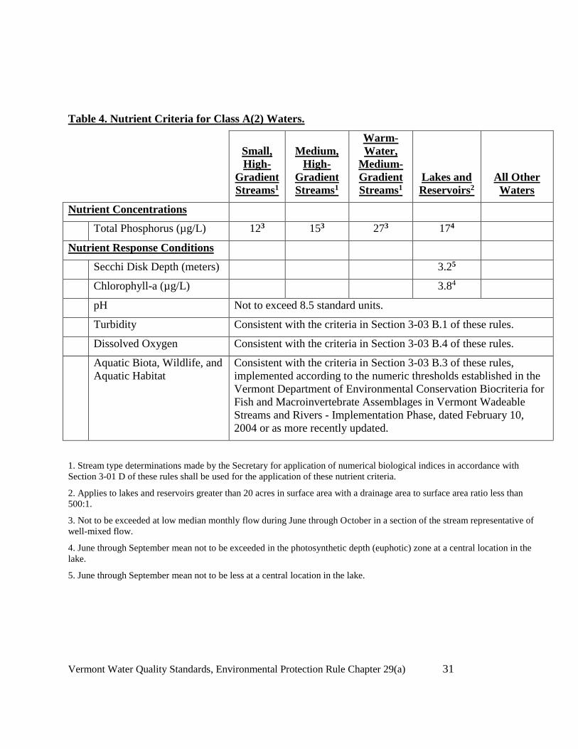
Vermont Water Quality Standards, Environmental Protection Rule Chapter 29(a) 31
Table 4. Nutrient Criteria for Class A(2) Waters.
Small,
High-
Gradient
Streams1
Medium,
High-
Gradient
Streams1
Warm-
Water,
Medium-
Gradient
Streams1
Lakes and
Reservoirs2
All Other
Waters
Nutrient Concentrations
Total Phosphorus (µg/L) 123 153 273 174
Nutrient Response Conditions
Secchi Disk Depth (meters) 3.25
Chlorophyll-a (µg/L) 3.84
pH Not to exceed 8.5 standard units.
Turbidity Consistent with the criteria in Section 3-03 B.1 of these rules.
Dissolved Oxygen Consistent with the criteria in Section 3-03 B.4 of these rules.
Aquatic Biota, Wildlife, and
Aquatic Habitat
Consistent with the criteria in Section 3-03 B.3 of these rules,
implemented according to the numeric thresholds established in the
Vermont Department of Environmental Conservation Biocriteria for
Fish and Macroinvertebrate Assemblages in Vermont Wadeable
Streams and Rivers - Implementation Phase, dated February 10,
2004 or as more recently updated.
1. Stream type determinations made by the Secretary for application of numerical biological indices in accordance with
Section 3-01 D of these rules shall be used for the application of these nutrient criteria.
2. Applies to lakes and reservoirs greater than 20 acres in surface area with a drainage area to surface area ratio less than
500:1.
3. Not to be exceeded at low median monthly flow during June through October in a section of the stream representative of
well-mixed flow.
4. June through September mean not to be exceeded in the photosynthetic depth (euphotic) zone at a central location in the
lake.
5. June through September mean not to be less at a central location in the lake.
Vermont Water Quality Standards, Environmental Protection Rule Chapter 29(a) 32
Section 3-04 Class B Waters
A. Management Objectives
Class B waters shall be managed to achieve and maintain a level of quality that fully supports
the following designated uses:
1. Aquatic Biota, Wildlife, and Aquatic Habitat - aquatic biota and wildlife sustained
by high quality aquatic habitat with additional protection in those waters where these
uses were sustainable at a higher level based on Water Management Type
designation.
2. Aesthetics - water character, flows, water level, bed and channel characteristics,
exhibiting good aesthetic value and, where attainable, excellent aesthetic value based
on Water Management Type designation.
3. Public water supply - Suitable for use as a source for a public water supply with
filtration and disinfection.
4. Irrigation of crops and other agricultural uses - suitable, without treatment, for
irrigation of crops used for human consumption without cooking and suitable for
other agricultural uses.
5. Swimming and other primary contact recreation - suitable for swimming and
other forms of water based recreation where sustained direct contact with the water
occurs and, where attainable, suitable for these uses at very low risk of illness based
on Water Management Type designation.
6. Boating, fishing and other recreational uses - Suitable for these uses with
additional protection in those waters where these uses are sustainable at a higher level
based on Water Management Type designation.
B. Water Quality Criteria for Class B waters
In addition to the criteria specified in §3-01 of these rules, the following criteria shall be met
in all Class B waters:
1. Turbidity - The following criteria shall be achieved:
a. In Cold Water Fish Habitat waters - None in such amounts or concentrations
that would prevent the full support of uses, and not to exceed 10 NTU
(nepholometric turbidity units) as an annual average under dry weather base-
flow conditions; and
b. In Warm Water Fish Habitat waters - None in such amounts or concentrations
that would prevent the full support of uses, and not to exceed 25 NTU
(nepholometric turbidity units) as an annual average under dry weather base-
flow conditions.
2. Dissolved Oxygen -

Vermont Water Quality Standards, Environmental Protection Rule Chapter 29(a) 33
The specified dissolved oxygen criteria for each designated fish habitat type
will be considered absolute instantaneous minimum values. In addition, fluctuations
above the minimum values shall be maintained as necessary to support aquatic
habitat.
a. Cold Water Fish Habitat waters - Not less than 7 mg/l and 75% saturation at
all times, nor less than 95% saturation during late egg maturation and larval
development of salmonids in areas that the Secretary determines are
salmonids spawning or nursery areas important to the establishment or
maintenance of the fishery resource. Not less than 6 mg/l and 70% saturation
at all times in all other waters designated as a cold water fish habitat, and
b. Warm Water Fish Habitat waters - Not less than 5 mg/l and 60% saturation at
all times.
3. Escherichia coli -
In all Class B waters - Not to exceed a geometric mean of 126 organisms /100ml
obtained over a representative period of 60 days, and no more than 10% of samples
above 235 organisms/100 ml. In waters receiving combined sewer overflows, the
representative period shall be 30 days. The Secretary may, by permit condition, waive
compliance with this criterion during all or any portion of the period between October
31 and April 1, provided that a health hazard is not created. The Secretary shall
provide written notice to the Vermont Department of Health prior to issuing a permit
waiving compliance with the Escherichia coli criterion.
4. Aquatic Biota, Wildlife and Aquatic Habitat - No change from the reference
condition that would prevent the full support of aquatic biota, wildlife, or aquatic
habitat uses. Biological integrity is maintained and all expected functional groups are
present in a high quality habitat. All life-cycle functions, including overwintering and
reproductive requirements are maintained and protected. In addition, the following
criteria shall be achieved:
a. In Water Management Type One waters - change from the reference condition
for aquatic macroinvertebrate and fish assemblages shall be limited to minor
changes in the relative proportions of taxonomic and functional components;
relative proportions of tolerant and intolerant components are within the range
of the reference condition. Changes in the aquatic habitat shall be limited to
minimal differences from the reference condition consistent with the full
support of all aquatic biota and wildlife uses.
b. In Water Management Type Two waters - change from the reference
condition for aquatic macroinvertebrate and fish assembledges shall be limited
to moderate changes in the relative proportions of tolerant, intolerant,
taxonomic, and functional components. Changes in the aquatic habitat shall
be limited to minor differences from the reference condition consistent with
the full support of all aquatic biota and wildlife uses.

Vermont Water Quality Standards, Environmental Protection Rule Chapter 29(a) 34
c. In Water Management Type Three waters - change from the reference
condition for aquatic macroinvertebrate and fish assemblages shall be limited
to moderate changes in the relative proportions of tolerant, intolerant,
taxonomic, and functional components. Changes in the aquatic habitat shall
be limited to moderate differences from the reference condition consistent
with the full support of all aquatic biota and wildlife uses. When such habitat
changes are a result of hydrological modification or water level fluctuation,
compliance may be determined on the basis of aquatic habitat studies.
d. In all other Class B waters - no change from reference conditions that would
have an undue adverse effect on the composition of the aquatic biota, the
physical or chemical nature of the substrate or the species composition or
propagation of fishes.
5. Nutrients
a. In all Class B waters except for segments within Lake Champlain and Lake
Memphremagog, compliance with nutrient criteria shall be achieved either by
compliance with the nutrient concentration values in Table 5 or by compliance
with all nutrient response conditions in Table 5. In situations where the
applicable nutrient concentrations are achieved but the nutrient response
conditions are not met as a result of nutrient enrichment, the Secretary may
establish alternate nutrient concentration criteria on a site-specific basis as
necessary to achieve compliance with the nutrient response conditions. All
waters shall maintain a level of water quality that provides for the attainment
and maintenance of the water quality standards of downstream waters.

Vermont Water Quality Standards, Environmental Protection Rule Chapter 29(a) 35
Table 5. Nutrient Criteria for Class B Waters Other Than Segments Within Lake Champlain and
Lake Memphremagog.
Small,
High-
Gradient
Streams1
Medium,
High-
Gradient
Streams1
Warm-
Water,
Medium-
Gradient
Streams1
Lakes and
Reservoirs2
All Other
Waters
Nutrient Concentrations
Total Phosphorus (µg/L) 123 153 273 184
Nutrient Response Conditions
Secchi Disk Depth (meters) 2.65
Chlorophyll-a (µg/L) 7.04
pH Not to exceed 8.5 standard units.
Turbidity Consistent with the criteria in Section 3-04 B.1 of these rules.
Dissolved Oxygen Consistent with the criteria in Section 3-04 B.2 of these rules.
Aquatic Biota, Wildlife, and
Aquatic Habitat
Consistent with the criteria in Section 3-03 B.4 of these rules,
implemented according to the numeric thresholds established in the
Vermont Department of Environmental Conservation Biocriteria for
Fish and Macroinvertebrate Assemblages in Vermont Wadeable
Streams and Rivers - Implementation Phase, dated February 10,
2004 or as more recently updated.
1. Stream type determinations made by the Secretary for application of numerical biological indices in accordance with
Section 3-01 D of these rules shall be used for the application of these nutrient criteria.
2. Applies to lakes and reservoirs greater than 20 acres in surface area with a drainage area to surface area ratio less than
500:1, excluding Lake Champlain and Lake Memphremagog.
3. Not to be exceeded at low median monthly flow during June through October in a section of the stream representative of
well-mixed flow.
4. June through September mean not to be exceeded in the photosynthetic depth (euphotic) zone at a central location in the
lake.
5. June through September mean not to be less at a central location in the lake.

Vermont Water Quality Standards, Environmental Protection Rule Chapter 29(a) 36
b. Lake Champlain and Lake Memphremagog
All discharges into each of the lake segments identified in Table 6, or
into tributaries within the basin, shall comply with the applicable Total
Maximum Daily Load (TMDL), basin plans, other applicable plans, permit
limitations and any other measures adopted or approved by the Secretary
reasonably designed to achieve the criteria in Table 6.
Table 6. Phosphorus Criteria for Segments Within Lake Champlain and Lake
Memphremagog.
Lake Segment (See Appendix B) Phosphorus Criterion (mg/L as P)1
Lake Champlain
Main Lake 0.010
Malletts Bay 0.010
Burlington Bay 0.014
Shelburne Bay 0.014
Northeast Arm 0.014
Isle LaMotte 0.014
Otter Creek 0.014
Port Henry 0.014
St. Albans Bay 0.017
Missisquoi Bay 0.025
South Lake A 0.025
South Lake B 0.054
Lake Memphremagog
Main Lake 0.014
South Bay 0.025
1. These criteria shall be achieved as the annual mean total phosphorus concentration in the
photosynthetic depth (euphotic) zone in central, open water areas of each lake segment.

Vermont Water Quality Standards, Environmental Protection Rule Chapter 29(a) 37
6. Aesthetics - The following criteria shall be achieved:
a. In Water Management Type One waters - consistently exhibit excellent
aesthetic values;
b. In Water Management Type Two waters - consistently exhibit very good
aesthetic values;
c. In Water Management Type Three waters - seasonal and temporal variability
may be allowed provided that good aesthetics value is achieved;
d. In all other Class B waters - water of quality that consistently exhibits good
aesthetic value.
7. Boating - The following criteria shall be achieved:
a. In Water Management Type One waters - to the full extent naturally feasible
without degradation due to artificial flow and water level management or
artificial physical impediments;
b. In Water Management Type Two waters - to the extent naturally feasible with
no more than minor degradation due to artificial flow and water level
management or artificial impediments, and with appropriate mitigation for
artificial physical impediments;
c. In Water Management Type Three waters - to the extent feasible, and with
appropriate mitigation for artificial physical impediments;
d. In all other Class B waters - a high level of quality that is compatible with
boating.
Section 3-05 Fish Habitat Designation
To provide for the protection and management of fisheries, the waters of the State are
designated in Appendix A as being either a cold or a warm water fish habitat. Where appropriate,
such designations may be seasonal.
Section 3-06 Water Management Types
A. Purpose
To provide for the protection and management of Class B waters in a manner that more
explicitly recognizes their attainable uses and the level of water quality protection already afforded
under the anti-degradation policy (see § 1-03 of these rules), all Class B waters shall eventually be
designated as being either Water Management Type 1, Type 2 or Type 3. Such Water Management
Type designations shall be made by amending these rules in accordance with the provisions of
applicable law and the provisions of subsection B below. Until waters are designated as a specific
Water Management Type, the criteria based on such designations shall not apply.
B. Water Management Type Designation Process

Vermont Water Quality Standards, Environmental Protection Rule Chapter 29(a) 38
The Secretary may increase or decrease the level of protection for a designated use in Class
B Waters only when it is shown that:
1. the current level of protection is not in the public interest after giving due
consideration to the provisions of 10 V.S.A. §1253(e);
2. the proposed level of protection is appropriate after consideration of any
recommendations of any Basin plan that pertains to the waters in question; and
3. the proposed level of protection is in compliance with all applicable federal
requirements, including 40 CFR Section 131.10(g).

Vermont Water Quality Standards, Environmental Protection Rule Chapter 29(a) 39
Chapter 4 WATER QUALITY CLASSIFICATIONS
The classification of all waters has been established by a combination of legislative acts and
by classification or reclassification decisions issued by the Secretary pursuant to 10 V.S.A. §1253.
Those wasters reclassified by the Secretary to Class A shall include all waters within the entire
watershed of the reclassified waters unless expressly provided otherwise in the rule. Watershed shall
mean that region which contains waters that drain into a particular brook, stream, river, or other
body of water.
Section 4-01. Classification of the Batten Kill Walloomsac and Hoosic Basin (Basin 1)
All waters within this basin are Class B except as provided for below:
A. Batten Kill
Waters Class Date Approx. Miles/Acres
An unnamed tributary to
Bromley Brook A2 6/30/64 0.5 mile
Description
Village of Manchester water supply. (No longer used). The first unnamed tributary to Bromley
Brook and all waters within its watershed upstream of the Manchester Water Co. intake. The
tributary is the first tributary on the right upstream of Bromley Brook’s confluence with Bourn
Brook. The intake is approximately 0.5 mile upstream of its juncture with Bromley Brook.
B. Walloomsac River
Basin Brook and Furnace Brook A2 12/23/52 5.0 miles
Village of North Bennington water supply. Basin Brook and all waters within its watershed to and
including the North Bennington Reservoir in the Towns of Glastenbury and Shaftsbury. (Furnace
Brook is not a water supply).
Bolles Brook A2 7/1/711 5.3 miles
Village of Bennington water supply. That portion of Bolles Brook and all waters within its
watershed in the Towns of Glastenbury and Woodford upstream of the Bennington water intake.
Sucker Pond (Lake Hancock) & tributaries A2 12/23/52 70 acres
Village of Bennington water supply. Lake surface and all waters within its watershed in Stamford.
Barney Brook A2 7/1/711 1.3 miles
Village of Bennington water supply. That portion of Barney Brook and all waters within its
watershed in the Town of Woodford upstream of the water intake.
1 The Water Resources Board did not classify these waters. They are
included as a result of the 1949 and 7/1/71 legislation which defined what
constituted Class A waters.

Vermont Water Quality Standards, Environmental Protection Rule Chapter 29(a) 40
Unnamed tributary to South Stream A2 7/1/711 1.0 mile
Village of Bennington water supply. That a portion tributary to South Stream and all waters within
its watershed in the Town of Woodford upstream of the water intake in Bennington.
C. Hoosic River
Roaring Branch A2 7/1/711 2.3 miles
Town of Bennington Water supply. That portion of Roaring Branch and all waters within its
watershed in the Town of Stamford upstream of the water intake in Pownal.
Unnamed tributaries A2 3/6/59 2.9 miles
Village of Pownal water supply. That portion of unnamed tributaries and their watersheds on
Mann Hill in the Town of Pownal upstream of the water intake in Oak Hill Cemetery.
Unnamed tributaries (Reservoir (a) 0.8 miles
Hollow Brook and Ladd Brook)2 A2 3/6/59 (b) 1.5 miles
Village of North Pownal water supply. (a) Reservoir Hollow Brook and reservoir and all waters
within its watershed. (Reservoir is approx. 0.5 mile upstream of the Hoosic River).
Village of Pownal water supply. (b) Ladd Brook and all waters within its watershed in the Town
of Pownal.
D. Entire Basin
All waters located above 2,500 feet
altitude, National Geodetic Vertical
Datum, unless specifically classified
as A(2) above. A1 5/17/86 No record
2 Previously described as “unnamed tributaries” in the 3/6/59
classification proceedings.

Vermont Water Quality Standards, Environmental Protection Rule Chapter 29(a) 41
Section 4-02. Classification of the Poultney-Mettawee Basin (Basin 2)
All waters within this basin are Class B except as provided for below:
A. Poultney River
Waters Class Date Approx. Miles/Aces
Inman Pond A2 6/15/67 79 acres
(Pond only)
Description
Village of Fair Haven water supply. Inman Pond and all waters within its watershed in Fair
Haven.
Sucker Creek A2 7/1/711 0.6 mile
Village of Fair Haven water supply. Sucker Creek and all waters within its watershed upstream of
the Howard Dam and Sheldon Dam, both of which are located in Fair Haven.
B. Entire Basin
All waters located above 2,500 feet
altitude National Geodetic Vertical
Datum unless specifically classified
as A(2) above. A1 5/17/86 No record
Section 4-03. Classification of the Otter Creek Basin (Basin 3)
All waters within this basin are Class B except as provided for below:
A. Upper Otter Creek
Waters Class Date Approx. Miles/Acres
Unnamed tributary to Cold River A2 2/17/61 2.0 miles
Description
City of Rutland water supply. Unnamed tributary to Cold River and all waters within its
watershed upstream of its diversion into the Mendon Brook watershed in Sherburne.
Mendon Brook A2 2/17/61 6.0 miles
City of Rutland water supply. Mendon Brook and all waters within its watershed upstream of the
water intake just south of Meadow Lake Drive in the Town of Mendon.
Tenney Brook A2 2/17/61 2.0 miles
Rutland-Mendon Town water supply. Tenney Brook and all waters with its watershed upstream
of and including a small intake impoundment.

Vermont Water Quality Standards, Environmental Protection Rule Chapter 29(a) 42
Rutland City Reservoir A2 Legis.1 No Record
City of Rutland water supply. Rutland City Reservoir in Rutland Town and all waters within its
watershed in Rutland Town and Mendon.
Moon Brook A2 Legis.1 2.0 miles
Rutland-Mendon F.D. #2 water system. (Gleason Road System - now abandoned.) Moon Brook
and all waters within its watershed in Mendon upstream of and including a small intake
impoundment.
Unnamed Tributary to Tenney
Brook A2 Legis.1 1.1 miles
Rutland F.D. #2 (Gleason Road) water system. Unnamed tributary to Tenney Brook and all
waters within its watershed in Mendon upstream of the water intake.
Young’s Brook A2 2/17/61 2.0 miles
Village of West Rutland water supply. (No longer used). Young’s Brook and reservoir and all
waters within its watershed in West Rutland and Ira upstream of the water intake.
Furnace Brook and Kiln Brook A2 2/17/61 5.5 miles
Village of Proctor water supply. (Kiln Brook in the main source, with Furnace Brook used as a
backup). Furnace Brook and Kiln Brook and all waters within their watersheds in Chittenden
upstream of their confluence.
Sugar Hollow Brook A2 2/17/61 2. 0 miles
Town of Brandon water supply. (No longer used). Sugar Hollow Brook and all waters within its
watershed in Goshen and Chittenden upstream of the water intake.
Leicester Hollow Brook A2 2/17/61 2.0 miles
Town of Brandon Water Supply. (No longer used). Leicester Hollow Brook and all waters within
its watershed in Leicester upstream of the water intake.
B. Lower Otter Creek
Brandy Brook A2 11/13/61 1.0 miles
Now or former water supply for Breadloaf School. Brandy Brook and all waters within its
watershed.
Unnamed tributary to Beaver Meadow
Brook A2 11/13/61 1.3 miles
Village of Bristol water supply. Unnamed tributary to Beaver Meadow Brook and all waters
within its watershed upstream of the water intake in Lincoln.
Unnamed tributary to Lewis Creek A2 7/1/711 2.0 miles

Vermont Water Quality Standards, Environmental Protection Rule Chapter 29(a) 43
Village of Starksboro water supply. (No longer used). Unnamed tributary to Lewis Creek and all
waters within its watershed in Starksboro upstream of the water intake.
Two unnamed tributaries to Little 1.6 and
Otter Creek A2 7/1/711 1.4 miles
City of Vergennes water supply. (Not used since 1973). Two unnamed tributaries to Little Otter
Creek and all waters within their watersheds in Monkton and Bristol upstream of two water intakes.
Notch Brook A2 11/13/61 2.0 miles
Village of Middlebury water supply. (Reserved for emergency use). Notch Brook and all waters
within its watershed upstream of the water intake in Bristol.
Roaring Brook A2 7/1/711 3.3 miles
Wallingford F.D. #1 water supply. Roaring Brook and all waters within its watershed upstream of
the water intake.
C. Entire Basin
All waters located above 2,500 feet
altitude, National Geodetic Vertical
Datum unless specifically classified
as A(2) above. A1 5/17/86 No record
Section 4.04. Classification of the Southern Champlain Basin (Basin #4)
All waters within this basin at or below 2,500 feet altitude National Geodetic Vertical Datum
are Class B. All waters within this basin above 2,500 feet altitude, National Geodetic Vertical
Datum, are Class A. No other waters are Class A.

Vermont Water Quality Standards, Environmental Protection Rule Chapter 29(a) 44
Section 4-05. Classification of the Northern Champlain Basin (Basin #5)
All waters within this basin are Class B except as provided for below:
A. Lake Champlain Including Minor Tributaries
Waters Class Date Approx. Miles/Acres
Milton Pond A2 3/21/68 20 acres
(Pond only)
Description
Village of Milton water supply (No longer used). Milton Pond and all waters within its watershed
in Milton.
Indian Brook Reservoir A2 3/21/68 95 acres
(Reservoir only)
Former Essex Town water supply (No longer used - sold to developer). Indian Brook Reservoir
and all waters within its watershed in Essex Town.
Colchester Pond A2 3/21/68 93 acres
(Pond only)
Village of Colchester water supply. (Not used since 1974, but reserved for emergency use).
Colchester Pond and all waters within its watershed in the Town of Colchester.
B. St. Albans Bay
Mill River A2 6/28/541 62 acres
(Reservoir only)
City of St. Albans water supply. Two reservoirs which drain to the Mill River and all waters
within their watersheds in the Towns of Fairfax, St. Albans, and Fairfield.
C. Entire Basin
All waters located above 2,500 feet
altitude National Geodetic Vertical
Datum, unless specifically classified
as A(2) above. A1 5/17/86 No Record

Vermont Water Quality Standards, Environmental Protection Rule Chapter 29(a) 45
Section 4.06. Classification of the Missisquoi Basin (Basin 6)
All waters within this basin are Class B except as provided for below:
A. Missisquoi River
Waters Class Date Approx. Miles/Acres
Mountain Brook A2 5/28/70 1.6 and 1.1
miles
Description
Village of North Troy water supply. (Reserved for emergency use). Mountain Brook and a
tributary and all waters within their watersheds upstream of two separate water intakes in Jay.
Coburn Brook Reservoir and
tributaries A2 5/28/70 2.0 miles
Village of North Troy water supply. (Reserved for emergency use). Coburn Brook and Coburn
Brook Reservoir in Westfield and all waters within their watersheds upstream of the water intake in
Coburn Brook.
Unnamed tributary to Trout River A2 5/28/70 0.6 mile
Village of East Bershire water supply. Unnamed tributary to the Trout River in Enosburg and all
waters within its watershed upstream of the water intake.
Hannah Clark Brook A2 5/28/70 4.0 miles
Village of Montgomery Ctr. water supply. (Reserved for emergency use). Hannah Clark Brook
in Montogmery and all waters in its watershed upstream of the water intake.
Stanhope Brook A2 5/28/70 5.0 miles
Village of Richford water supply. Stanhope Brook in Richford and all waters in its watershed
upstream of the water intake.
Trout Brook A2 5/28/70 2.0 miles
Village of Enosburg Falls water supply. (Reserved for emergency use). Trout Brook in Berkshire
and all waters within its watershed upstream of the outlet of Enosburg Reservoir.
Loveland Brook A2 7/1/711 2.0 miles
Village of Richford water supply. Loveland Brook in Richford and all waters within its watershed
upstream of the water intake.
Black Falls Brook A2 7/1/711 5.0 miles
Village of Montgomery Ctr. (Reserved for emergency use). Black Falls Brook in Montgomery
and Richford and all waters within its watershed upstream of the water intake.
B. Entire Basin

Vermont Water Quality Standards, Environmental Protection Rule Chapter 29(a) 46
All waters located above 2,500 feet
altitude, National Geodetic Vertical
Datum, unless specifically classified
as A(2) above. A1 5/17/86 No Record
Section 4-07. Classification of Lamoille Basin (Basin 7)
All waters within this basin are Class B except as provided for below:
A. Lamoille River
Waters Class Date Approx. Miles/Acres
Smith Brook A2 7/1/711 1.6 miles
Description
Village of Johnson water supply. Smith Brook in Johnson and all waters in its watershed upstream
of the water intake.
French Hill Brook A2 7/1/711 2.4 miles
Village of Johnson water supply. French Hill Brook in Johnson and all waters in its watershed
upstream of the water intake.
Silver Lake A2 2/13/701 30 acres (lake
only)
City of St. Albans water supply. Silver Lake and all waters in its watershed in the Towns of
Georgia and Fairfax.
Unnamed Tributary to the Lamoille
River A2 7/1/711 1.0 mile
Village of Hardwick water supply. (No longer used). Unnamed tributary to the Lamoille River
and all waters in its watershed in Hardwick upstream of the water intake.
Unnamed Tributary to the Lamoille
River A2 7/1/711 0.1 mile
Village of Fairfax water supply. (No longer used). Unnamed tributary to the Lamoille River and
all waters in its watershed in Fairfax upstream of the water intake.
B. Entire Basin
All waters located above 2,500 feet
altitude, National Geodetic Vertical
Datum, unless specifically classified
as A(2) above. A1 5/27/86 No record

Vermont Water Quality Standards, Environmental Protection Rule Chapter 29(a) 47
Section 4-08. Classification of the Winooski Basin (Basin 8)
All waters within this basin are Class B except as provided for below:
A. Lower Winooski River
Waters Class Date Approx. Miles/acres
Unnamed tributary to Alder Brook A2 6/6/691 0.4 mile
Description
Former water supply for Winooski, Essex Center, Essex Jct., & Pinewood Manor (No longer
used). Unnamed tributary and all waters within its watershed in Essex.
B. Middle Winooski River
Unnamed tributaries to Brook.
Formerly “Thatcher Brk & tribs” A2 5/14/63 2.5 miles
Village of Waterbury water supply. Unnamed tributaries to Thatcher Brook (Known locally as
Tyler & Miriam Brooks).
Unnamed tributary to the West
Branch of the Little River A2 7/1/711 1.3 miles
Village of Stowe water supply. (Reserved for emergency use). An unnamed tributary to the West
Branch of the Little River and all waters within its watershed in Stowe to the water intake.
C. Stevens Branch
Martin Brook, Reservoir &
Tributaries A2 8/7/69 3.5 miles
City of Barre water supply. (Reserved for emergency use). Martin Brook in Williamstown and all
waters within its watershed, including unnamed tributaries, to the water intake.
Bolster Reservoir and tributaries A2 8/7/62 2.0 acres (Res.)
& 2.2 miles
(tribs).
Old City of Barre water supply. (It has been disconnected). Bolster Reservoir in South Barre and
all waters within its watershed including Bolster Reservoir Brook, Pecks Pond and unnamed
tributaries.
Thurman W. Dix Reservoir 119 acres &
Lower Reservoir & tributaries A2 8/7/62 9.9 miles
City of Barre water supply. Thurman W. Dix Reservoir, Lower Reservoir and all waters within
their watersheds in the Towns of Barre and Orange including Orange Brook, Nelson Brook, Nate
Smith Brook and unnamed tributaries.
Vermont Water Quality Standards, Environmental Protection Rule Chapter 29(a) 48
Unnamed brook & tributaries A2 8/7/62 1.4 miles
Old Village of East Barre water supply. (Reserved for emergency use). Unnamed brook and
tributaries in the Town of Barre and all waters within their watersheds to the water intake.
Little John & Milne quarries A2 8/7/62 No Record
Emergency Barre Town District #1 water supply for Village of East Barre. (Milne Quarry no
longer used). Little John Quarry in Barre Town (Located just south of East Barre Village, at approx.
elev. 1380').
Standard & Consolidated Quarries A2 8/7/62 No Record
Barre Town District #3 water supply for Websterville. Quarry Hole #1 in the Town of Barre
located at approx. elev. 1420'.
Websterville emergency water supply. Location of quarry unknown.
Old Granite Quarry A2 8/7/62 No Record
Town of Barre Fire District #4 water supply. Standard Quarry in the Town of Barre is the quarry
referred to. It is located at approx. elev. 1530'. Note: All quarry holes in the
Websterville/Graniteville area should be considered as reservoirs. The primary sources are springs
and wells. When the wells and springs are overflowing, they are piped to the Standard Quarry.
When Standard is full, it goes to the Barclay Quarry, then to the Murphy & Saldi quarries, all by
gravity.
Berlin Pond A2 8/7/62 256 acres
City of Montpelier water supply. Berlin Pond upstream of the dam and all waters within its
watershed in the Towns of Berlin, Northfield, and Williamstown. The dam is located 300'
downstream of where Paine Turnpike crosses the pond.
D. Entire Basin
All waters located above 2,500 feet
altitude, National Geodetic Vertical
Datum, unless specifically classified
as A(2) above. A1 5/17/86 No record

Vermont Water Quality Standards, Environmental Protection Rule Chapter 29(a) 49
Section 4-09. Classification of the White River Basin (Basin 9)2Section 4-09. Classification of
the White Basin (Basin 9)
All waters within this basin are Class B except as provided for below:
A. White River
Waters Class Date Approx. Miles/Acres
Farnsworth Brook A2 12/28/77 2.0 miles
Description
Village of East Braintree public water supply. Farnsworth Brook and all waters within its
watershed in the Town of Braintree upstream of the water intake.
Lake Casper & Lake John A2 12/28/77 No Record
Village of South Royalton and F.D. #1 water supply. Lake Casper and Lake John and all waters
within their watersheds in the Town of Royalton.
B. Entire Basin
All waters located above 2,500 feet A1 5/17/86 No Record
altitude, National Geodetic Vertical
Datum, unless specifically classified
as A(2) above.
Section 4-10. Classification of the Ottauquechee-Black Basin (Basin 10)
All waters within this basin are Class B except as provided for below:
A. Ottauquechee River
Water Class Date Approx. miles/acres
Spring and unnamed tributary to
the Ottauquechee River A2 11/16/67 0.3 miles
Description
Village of North Hartland water supply. (Reserved for emergency use). A spring and unnamed
tributary to the Ottauquechee River and all waters within its watershed upstream of the water intake.
The spring and brook are located approx. 1 mile north-northwest of North Hartland Village.
Cox, Vandell and Carlton Hill Approx. 2.5
Reservoirs A2 11/16/67 miles (Stream
only)
Village of Woodstock water supply. (Private. Reserved for emergency use. Carlton Hill no
longer in the system). Cox, Vandell and Carlton Hill Reservoirs in the Town of Woodstock and all
waters within their watersheds.

Vermont Water Quality Standards, Environmental Protection Rule Chapter 29(a) 50
Grant Brook (Off Jewell Brook) A2 3/30/66 Approx. 3.2
miles
Village of Ludlow water supply. (No longer in use). Grant Brook and all waters within its
watershed upstream of the flood control dam.
B. Black River
Springfield Reservoir Brook A2 3/30/66 1.8 miles
Village of Springfield water supply. (Reserved for emergency use). Springfield Reservoir Brook
and tributaries and all waters in its watershed upstream of Springfield Reservoir.
Springfield Reservoir and tributaries A2 3/30/066 9.8 acres
Village of Springfield water supply. (Reserved for emergency use). Springfield Reservoir all
waters within its watershed.
C. Entire Basin
All waters located above 2,500 feet
altitude, National Geodetic Vertical
Datum, unless specifically classified
as A(2) above A1 5/17/86 No Record
Section 4-11. Classification of the West-Williams-Saxtons Basin (Basin 11)
All waters within this basin are Class B except as provided for below:
A. West-Williams-Saxtons River
Waters Class Date Approx. Miles/Acres
Sunset Lake & Stickney Brook A2 7/26/78 3.0 sq. miles
Description
Town of Brattleboro water supply. Sunset Lake and Stickney Brook and all waters in their
watersheds above the water intake in the Towns of Marlboro, Newfane, and Brattleboro. (Water
intake is located at the so-called third dam, a distance of approx. 2.5 miles from Sunset Lake).
Styles Brooks A2 7/26/78 1.0 sq. miles
Stratton Corp. water supply. (Reserved for emergency use). Styles Brook and all waters in its
watershed above the diversion to Styles Reservoir.
Chester Reservoir & the outlet
stream above the water intake. A2 7/26/78 1.0 sq. miles

Vermont Water Quality Standards, Environmental Protection Rule Chapter 29(a) 51
Village of Chester water supply. (Reserved for emergency use). Chester Reservoir, the outlet
stream above the water intake and all waters within their watersheds in the Town of Chester. The
water intake is approx. 0.3 mile below the reservoir.
Bolles Brook A2 7/26/78 1.0 sq. miles
Village of Saxtons River & Vermont Academy water supply. (Reserved for emergency use).
Bolles Pond Brook and all waters in its watershed above the water intake in the Town of
Rockingham.
Kidder Brook & tributaries A1 10/11/89 Approx. 2.5 miles
That portion of Kidder Brook and all its headwaters, including named and unnamed tributaries,
beginning in the Town of Stratton at an elevation of 2,500 feet and continuing downstream to its
confluence with the North Branch in the Town of Jamaica.
Cobb Brook A1 10/09/91 Approx. 6.0 miles
That portion of Cobb Brook and its tributaries beginning in the Town of Windham at an elevation of
2,500 feet and continuing downstream to its confluence with the West River in the Town of Jamaica.
Upper Reach of the Winhall River A1 10/09/91 7.4 miles
That portion of the upper reach of the Winhall River including the river’s two principal headwaters,
beginning at an elevation of 2,500' in the Town of Stratton, and continuing downstream a distance of
approx. 7.4 miles to the point at which the river crosses the current boundary of the Green Mountain
National Forest in the Town of Winhall.
B. Entire Basin
All waters located above 2,500 feet
altitude, National Geodetic Vertical
Datum, unless specifically classified
as A(2) above. A1 5/17/86 No record

Vermont Water Quality Standards, Environmental Protection Rule Chapter 29(a) 52
Section 4-12 Classification of the Deerfield Basin (Basin 12)
All waters within the basin are Class B except as provided for below:
A. Deerfield River
Waters Class Date Approx. Miles/Acres
Haystack Pond A2 1/27/61 36 acres
Description
Village of Wilmington water supply. Haystack Pond and all waters within its watershed in the
Town of Wilmington.
Howe Pond and Howe Pond
Brook A2 1/27/61 62 acres
Village of Readsboro water supply. Howe Pond and all waters within its watershed. Howe Pond
Brook and all waters within its watershed above the water intake, which is located approx. 1.1 miles
downstream from Howe Pond. Both pond and brook are located in the Town of Readsboro.
Cold Brook A1 10/7/96 1.5 miles
That portion of Cold Brook and its tributaries between an elevation of 2,500 feet and continuing
downstream to its confluence with Mountain Brook in the Town of Dover.
B. Entire Basin
All waters located above 2,500 feet
altitude, National Geodetic Vertical
Datum, unless specifically classified
as A(2) above. A1 5/17/86 No record
Section 4-13. Classification of the Lower Connecticut Basin (Basin 13)
All waters within this basin are Class B except as provided for below:
A. Lower Connecticut River
Waters Class Date Approx. Miles/Acres
Back Pond A2 3/21/68 2.0 acres
Description
Village of Bellows Falls water supply. Back Pond and all water within its watershed, which is
diverted to Minards Pond. Back Pond is located .1 mile north-west of Minards Pond in the Town of
Rockingham.
Ellis Brook A2 7/1/711 246 acres

Vermont Water Quality Standards, Environmental Protection Rule Chapter 29(a) 53
(watershed)
Village of Bellows Falls water supply. Ellis Brook and all waters in its watershed above the water
intake, which is situated at elev. 715' MSL in the Town of Rockingham.
Farr Brook A2 7/1/711 154 acres
(watershed)
Village of Bellows Falls water supply. Farr Brook and all waters in its watershed above the water
intake, which is located at elev. 710' MSL in the Town of Rockingham.
Unnamed tributary to Mill Brook A2 7/1/711 1.7 miles
Village of Ascutney water supply. (Reserved for emergency use). Unnamed tributary to Mill
Brook and all waters in its watershed above the water intake. The unnamed tributary is the first
tributary to Mill Brook in the Town of Weathersfield.
Pleasant Valley Reservoir A2 3/21/681 25 acres
Village of Brattleboro water supply. Pleasant Valley Reservoir and all waters in its watershed in
the Town of Brattleboro. (Also refer to the classification of Sunset Lake & Stickney Brook - Basin
#11)
Mill Brook A2 3/21/681 Approx. 3.0
miles
Kurn Hattin School water supply. (Reserved for emergency use). Mill Brook and all water within
its watershed above the water intake in the Town of Westminster. The intake is located approx. 1.0
miles upstream of its confluence with the Connecticut River.
Wright, Upper Hurricane & Lower
Hurricane Reservoir A2 7/1/711 10.4 acres
Hartford Town water supply. Wright, Upper Hurricane and Lower Hurricane Reservoirs and all
waters within their watersheds in the Town of Hartford.
B. Entire Basin
All waters located above 2,500 feet
altitude, National Geodetic Vertical
Datum, unless specifically classified
as A(2) above A1 5/17/86 No record

Vermont Water Quality Standards, Environmental Protection Rule Chapter 29(a) 54
Section 4-14. Classification of the Stevens-Wells-Waits-Ompompanoosuc Basin (Basin
14)
All waters within this basin are Class B except as provided for below:
A. Waits River
Waters Class Date Approx. Miles/Acres
Mill Pond Brook A2 2/19/60 3.0 miles
Description
Village of Bradford water supply. (Reserved for emergency use). Mill Pond Brook and all waters
within its watershed above the intake dam in the Towns of Fairlee, Bradford and West Fairlee.
Artificial impoundment on South
Peacham Hollow Brook A2 4/28/761 No record
Peacham Fire District #1 water supply. (The intake has been removed, and the town has gone to
wells. No record of system anymore). An artificial impoundment on South Peacham Hollow Brook,
and all waters within its watershed above the intake. The impoundment is located approx. 1/2 mile
east of Fosters Road in the Town of Peacham.
B. Entire Basin
All waters located above 2,500 feet
altitude, National Geodetic Vertical
Datum, unless specifically classified
as A(2) above. A1 5/17/86 No record
Section 4-15. Classification of the Passumpsic Basin (Basin 15)
All waters within this basin are Class B except as provided for below:
A. Passsumpsic River
Waters Class Date Approx. miles/acres
Unnamed tributary to Miller Run
including Mathewson Reservoir A2 4/28/761 Approx. 1.5 miles
Description
Village of Lyndonville water supply. (Reserved for emergency uses). Unnamed tributary to Miller
Run including Mathewson Reservoir and all waters within their watersheds above the intake in the
Towns of Lyndon and Sutton.
Unnamed tributary to Miller Run
including Copeland Reservoir A2 4/28/761 Approx. 1.5 miles

Vermont Water Quality Standards, Environmental Protection Rule Chapter 29(a) 55
Village of Lyndonville water supply. (Reserved for emergency uses). Unnamed tributary to Miller
Run including Copeland Reservoir and all waters within their watersheds above the intake in the
Towns of Lyndon and Sutton.
Two unnamed tributaries to
Sutton River A2 4/28/761 Approx. 0.8 mile
Unknown water supply. Two unnamed tributaries to the Sutton River, near W. Burke, and all
waters within their watersheds above the Murray water system intakes.
Chandler Pond A2 4/28/761 59 acres
Lyndonville Village water supply. (Reserved for emergency use) Chandler Pond and all waters
within its watershed in the Town of Wheelock. Wheelock Pond drains to the South Wheelock
Branch.
Woodworth Reservoir A2 4/28/761 No Record
Lyndonville water supply. (Reserved for emergency use) Woodworth Reservoir and all waters
within its watershed in the Town of Lyndon. Woodworth Reservoir flows to the South Wheelock
Branch.
Stiles Pond A2 4/28/761 5.5 miles 146
acres (Stiles
Pond)
St. Johnsbury Village water supply. Stiles Pond and all waters within its watershed in the Town
of Waterford. Stiles Pond is in the St. Johnsbury municipal forest and flows to the Moose River.
Danville Reservoir A2 4/28/761 2.0 miles
Danville Fire District No. 1 water supply. Danville Reservoir on tributary of Brown Brook and all
waters within its watershed in Danville.
B. Entire Basin
All waters located above 2,500 feet
altitude, National Geodetic Vertical
Datum, unless specifically classified
as A(2) above. A1 5/17/86 No record

Vermont Water Quality Standards, Environmental Protection Rule Chapter 29(a) 56
Section 4-16. Classification of the Northern Connecticut Basin (Basin 16)
All waters within this basin are Class B except as provided for below:
A. Upper Connecticut River
Waters Class Date Approx. Miles/Acres
Charles Brown Brook A2 7/1/711 2.5 miles
Description
Village of Norwich water supply. (Reserved for emergency use). Charles Brown Brook and all
waters within its watershed above the water intake in the Town of Norwich.
Unnamed tributary to Connecticut
River A2 7/1/711 1.0 mile
Village of Newbury water supply. An unnamed tributary to the Connecticut River and all waters
within its watershed above the water intake in the Town of Newbury. The tributary is approx. one
mile south of Pulaski Mt. The intake is located approx. 0.7 mile upstream of its confluence with the
Connecticut River.
Unnamed tributary to Connecticut
River A2 7/1/711 0.2 mile
Village of Bloomfield water supply. An unnamed tributary to the Connecticut River and all waters
within its watershed above the water intake in the Town of Bloomfield. The intake is approx. 0.5
mile above “Basin Hole.”
Unnamed tributary to Lake Morey A2 7/1/711 1.1 miles
Village of Fairlee water supply. (Reserved for emergency use). An unnamed tributary to Lake
Morey and all waters in its watershed in the Town of Fairlee to the water intake dam, including a
man-made impoundment.
B. Entire Basin
All waters located above 2,500 feet
altitude, National Geodetic Vertical
Datum, unless specifically classified
as A(2) above. A1 5/17/86 No record

Vermont Water Quality Standards, Environmental Protection Rule Chapter 29(a) 57
Section 4-17. Classification of the Memphremagog Basin (Basin 17)
All waters within this basin are Class B except as provided for below:
A. Lake Memphremagog and International Stream
Waters Class Date Approx. miles/acres
Unnamed reservoir near Derby Line A2 7/1/711 No record
Description
Derby Line water supply. An unnamed reservoir and all waters in its watershed in the Town of Derby.
May Pond Brook and May Pond A2 10/30/87 13 acres
Village of Barton water supply. May Pond Brook and all waters within its watershed in the Town of
Barton above and including the water supply reservoir and May Pond. The reservoir is located
approximately 3/4 mile upstream of the brook’s confluence with Crystal Lake.
B. Black-Barton-Clyde Rivers
Unnamed tributary to the Black River A2 2/20/751 1.0 mile
Coventry Fire District #1 water supply. (Reserved for emergency use.) An unnamed tributary to the
Black River and all waters within its watershed above the water intake in the Town of Coventry.
Unnamed tributary to Island Pond A2 2/20/75 1.0 mile
Town of Brighton water supply. An unnamed tributary to Island Pond and all waters within its
watershed in the Town of Brighton above the water intake at approx. elev. of 1544.0' MSL. The
tributary flows northerly to Island Pond.
Unnamed tributary to Lightning Brook A2 2/20/75 2.0 miles
Town of Brighton water supply. Two unnamed tributaries to an unnamed tributary to Lightning Brook
and all waters in their watersheds in the Town of Brighton above the intakes. The main intake is at
approx. elevation 1526.0' MSL, and the upper, more northerly intake is diverted to the main intake.
C. Entire Basin
All waters located above 2,500 feet
altitude, National Geodetic Vertical
Datum, unless specifically classified
as A(2) above. A1 5/17/86 No record.

Vermont Water Quality Standards, Environmental Protection Rule Chapter 29(a) 59
APPENDIX A - Fish Habitat Designation
A. Warm Water Fish Habitat
All wetlands, except those designated as cold water fish habitat in paragraph B below, and the following waters are designated as warm water fish habitat for purposes of these rules:
1. Battenkill, Walloomsac, Hoosic Basin
(a) Lake Hancock (Sucker Pond), Stamford
(b) Thompsons Pond, Pownal
2. Poultney, Mettawee Basin
(a) All waters west of Vermont Route 22A.
(b) Austin Pond, Hubbardton
(c) Beebe Pond, Hubbardton
(d) Billings Marsh Pond, West Haven
(e) Burr Pond, Sudbury
(f) Coggman Pond, West Haven
(g) Echo Lake (Keeler Pond) Hubbardton/Sudbury
(h) Half Moon Pond, Hubbardton
(i) Hinkum Pond, Sudbury
(j) Lake Hortonia, Hubbardton/Sudbury
(k) Inman Pond, Fair Haven
(l) Lily Pond, Poultney
(m) Little Pond, Wells
(n) Love's Marsh, Castleton
(o) Mill Pond (Parson's Mill Pond), Benson
(p) Northeast Developer's Pond, Wells
(q) Old Marsh Pond, Fair Haven
(r) Pine Pond, Castleton
(s) Poultney River from Carvers Falls in West Haven to its confluence with Lake Champlain

Vermont Water Quality Standards, Environmental Protection Rule Chapter 29(a) 60
(t) Sunrise Lake, Benson/Orwell
3. Otter Creek, Little Otter Creek and Lewis Creek Basin
(a) All waters lying west of Vermont Route 22A and south of the City of Vergennes.
(b) Brilyea East Pond, Addison
(c) Brilyea West Pond, Addison
(d) Chipman Lake (Tinmouth Pond), Tinmouth
(e) Danby Pond, Danby
(f) East Creek Site I, Orwell
(g) Fern Lake, Leicester
(h) Lemon Fair River
(i) Mud Pond, Leicester (j) Otter Creek from the outfall of the Proctor wastewater treatment facility
in Proctor, to its confluence with Lake Champlain, except that portion between the Beldens Dam and the Huntington Falls Dam in New Haven/Weybridge.
(k) Richville Pond, Shoreham
(l) Stone Bridge Pond, Panton/Addison
(m) Wallingford Pond, Wallingford
4. Lower Lake Champlain Basin
(a) Lake Champlain south of the Crown Point Bridge.
(b) Lake Champlain, between the Crown Point Bridge and the Ferrisburg-Charlotte town boundary, where depths are
less than 25 feet at Low Lake Level (93 feet NGVD) - June 1, through September 30, only.
(c) Perch Pond, Benson
5. Upper Lake Champlain Basin
(a) All streams, creeks and brooks lying with Grand Isle County.
(b) Lake Carmi, Franklin(c)

Vermont Water Quality Standards, Environmental Protection Rule Chapter 29(a) 61
(c) Lake Champlain, between the Ferrisberg-Charlotte town boundary and the Canadian boundary, where depths are less than 25 feet at Low Lake Level (93 feet NGVD) - June 1, through September 30, only.
(d) Cutler Pond, Highgate
(e) Holmes Creek, Charlotte,
(f) Indian Brook, Colchester from Vermont Routes 2 & 7 to its confluence with Lake Champlain
(g) Lake Iroquois, Hinesburg/Williston
(h) LaPlatte River from its confluence with Patrick Brook in Hinesburg extending downstream to the Spear Street extension bridge in Charlotte annually from the period June 1 through September 30, only.
(i) Long Pond, Milton (j) Lower Lake, (Lake Sunset), Hinesburg
(k) Malletts Creek, Colchester, from Vermont Routes 2 & 7 to its confluence with Lake Champlain
(l) Milton Pond, Milton
(m) Mud Creek Pond, Alburg
(n) Murr (Monroe) Brook, Shelburne
(o) Rock River from the Canadian boundary to its confluence with Lake Champlain
(p) Round Pond, Milton
(q) St. Albans Reservoir (N), Fairfax
(r) Stevens Brook, St. Albans

Vermont Water Quality Standards, Environmental Protection Rule Chapter 29(a) 62
6. Missisquoi Basin
(a) Metcalf Pond, Fletcher
(b) Fairfield Pond, Fairfield
(c) Fairfield Swamp Pond, Fairfield
(d) Missisquoi River from the outfall of the Enosburg Falls wastewater treatment facility to the Swanton Dam Swanton
7. Lamoille Basin
(a) Arrowhead Mountain Lake, Milton/Georgia
(b) Flagg Pond, Wheelock
(c) Halfman Pond, Fletcher
(d) Hardwick Lake, Hardwick
(e) Horse Pond, Greensboro
(f) Lake Elmore, Elmore
(g) Lamoille River from the Peterson Dam in Milton to its confluence with Lake Champlain - June 1, through September 30, only.
(h) Long Pond (Belvidere Pond), Eden
(i) Long Pond, Greensboro
(j) Tuttle Pond, Hardwick
(k) Wapanaki Lake, Wolcott
8. Winooski Basin
(a) Berlin Pond, Berlin
(b) Bliss Pond, Calais
(c) Coits Pond, Cabot
(d) Cranberry Meadow Pond, Woodbury
(e) Curtis Pond, Calais
(f) Gillett Pond, Richmond
(g) Harwood Pond, Elmore
(h) Molly's Pond, Cabot
(i) North Montpelier Pond, East Montpelier/Calais

Vermont Water Quality Standards, Environmental Protection Rule Chapter 29(a) 63
(j) Richmond Pond, Richmond
(k) Shelburne Pond, Shelburne
(l) Sodom Pond, East Montpelier/Calais
(m) Valley Lake (Dog Pond), Woodbury
(n) Winooski River from Green Mountain Power
Corporation #19, in Essex/Williston to its confluence
with Lake Champlain - June 1, through September 30, only.
9. White River Basin
(a) Lamson Pond, Brookfield
(b) Silver Lake, Barnard
10. Ottauquechee, Black Basin
(a) Black River from the Lovejoy Dam in Springfield to its confluence with the Connecticut River - June 1, through September 30, only.
(b) Deweys Mill Pond, Hartford
(c) Lake Ninevah, Mount Holly
(d) Lake Pinneo, Hartford
(e) North Hartland Reservoir, Hartland/Hartford
(f) North Springfield Reservoir, Springfield/Weathersfield
(g) Ottauquechee River from the North Hartland Dam in Hartland to its confluence with the Connecticut River.
11. West, Williams, and Saxtons Basin
(a) Burbee Pond, Windham
(b) Cole Pond, Jamaica
(c) Lily Pond, Londonderry
(d) Lowell Lake, Londonderry
12. Deerfield Basin
(a) Gates Pond, Whitingham
(b) Grout Pond, Stratton

Vermont Water Quality Standards, Environmental Protection Rule Chapter 29(a) 64
(c) Howe Pond, Readsboro
(d) Jacksonville Pond, Whitingham
(e) North Pond, Whitingham
(f) Sadawaga Pond, Whitingham
(g) Shippee Pond, Whitingham
13. Lower Connecticut, Mill Brook Basin
(a) Lake Runnemede (Evart's Pond), Windsor
(b) Lily Pond, Vernon
(c) Mindards Pond, Rockingham
14. Stevens, Wells, Waits, Ompompanoosuc Basin
(a) Lake Abenaki, Thetford
(b) Ticklenaked Pond, Ryegate
(c) Waits River from the CVPS Dam in Bradford to its confluence with the Connecticut River - June 1, to September 30.
15. Passumpsic Basin
(a) Bruce Pond, Sheffield
(b) Chandler, Wheelock
(c) Keiser Pond, Peacham/Danville
16. Upper Connecticut, Nulhegan, Willard Stream, Paul Stream Basin
(a) Dennis Pond, Brunswick
(b) Halls Lake, Newbury
(c) Harriman Pond, Newbury
(d) Lake Morey, Fairlee
(e) Lower Symes Pond, Ryegate
(f) Stevens Pond, Maidstone
17. Lake Memphremagog, Black, Barton, Clyde, Coaticock, Basin
(a) Daniels Pond, Glover
(b) Lake Derby, Derby

Vermont Water Quality Standards, Environmental Protection Rule Chapter 29(a) 65
(c) Long Pond, Sheffield
(d) Little Hosmer Pond, Craftsbury
(e) Mud Pond, Craftsbury
(f) Mud Pond, (North) Morgan
(g) Tildy's Pond (Clark Pond), Glover
(h) Toad Pond, Charleston
(i) Turtle Pond, Holland
B. Cold Water Fish Habitat
1. All waters not designated as warm water fish habitat by subsection A are hereby designated as cold water fish habitat for purposes of these rules.
2. The following wetlands are designated as cold water fish habitat:
(a) Those wetlands adjacent to the Dog River and its tributaries from the headwaters of the Dog River to the point where it first crosses State Aid highway #62 in Roxbury, a distance of approximately 1.5 miles.
(b) Those wetlands adjacent to the headwaters of the Winhall River and its tributaries on the east and west side from the outlet of Stratton Pond to the Stratton-Winhall boundary, a distance of approximately 2.0 miles.
(c) Those wetlands adjacent to the Batten Kill River from a point .75 miles north of East Dorset and extending to its confluence with Dufresne Pond in Manchester, a distance of approximately 5.5 miles.
(d) Those wetlands adjacent to the New Haven River and its tributaries from its confluence with Blue Bank Brook in Lincoln upstream to the headwaters of the respective tributaries, a distance of approximately 1.75 miles.
Appendix B - Phosphorus Criteria §3-01(A)(2)(c), Description of Lake Champlain and Lake
Memphremagog segments.
Segment Description
Lake Champlain
Missisquoi Bay Area north of East Alburg
(Route 78) bridge and south of the international border.
Isle La Motte Area within Vermont waters

Vermont Water Quality Standards, Environmental Protection Rule Chapter 29(a) 66
west of Grand Isle and North Hero Islands, and north of a line from Cumberland Head, NY to Wilcox Point on Grand Isle.
St. Albans Bay Area northeast of a line from
Hathaway Point to Lime Rock Point.
Northeast Arm Area within Vermont Waters
east of Grand Isle and North Hero Islands, and north of the Sandbar Bridge, excluding St. Albans Bay, and including the large bays on Grand Isle and North Hero.
Malletts Bay Area south of Sandbar Bridge
and east of the causeway from Colchester Point to Grand Isle.
Main Lake Area within Vermont waters
south of a line from Cumberland Head, NY to Wilcox Point on Grand Isle, and north of a line from Split Rock Point, NY to Thompsons Point, VT, excluding Malletts Bay, Burlington Bay and Shelburne Bay.
Burlington Bay Area east of a line from Lone Rock Point to Oakledge.
Shelburne Bay Area south of a line from
Shelburne Point to Red Rock Point.
Otter Creek Area within Vermont waters
south of a line from Split

Vermont Water Quality Standards, Environmental Protection Rule Chapter 29(a) 67
Rock Point, NY to Thompsons Point, VT, and north of a line from Rock Harbor, NY to Basin Harbor, VT.
Port Henry Area within Vermont waters
south of a line from Rock Harbor, NY to Basin Harbor, VT, and north of Crown Point Bridge.
South Lake A Area within Vermont waters
south of Crown Point Bridge and north Benson Landing.
South Lake B Area within Vermont waters
south of Benson Landing.
Lake Memphremagog
Main Lake Area within Vermont waters
north of the Route 5 Bridge.
South Bay Area south of the Route 5
bridge and north of the mouth of the Barton River.

Vermont Water Quality Standards, Environmental Protection Rule Chapter 29(a) 68
Appendix C: Water Quality Criteria for the Protection of Human Health and the Aquatic Biota
Criteria are in micrograms per liter (µg/l - parts per billion) unless indicated otherwise.
Compound
FR Cite/Source
CAS
Number
Protection of Human Health Protection of Aquatic Biota
Tox Class
Consumption of Water & Organisms
Consumption of Organisms
Only
Maximum Allowable
Concentration -
Acute Criteriaa.
Average Allowable
Concentration -
Chronic Criteriaa.
Toxic Metals
Antimony 65FR66443 7440360 TT 5.6 640 --- ---
Arsenic 65FR31682 7440382 A 0.02g 1.5g 340 150
Cadmium d. e. 65FR31682 7440439 TT --- --- 1.03 0.15
Chromium (VI)d. 65FR31682 18540299 TT --- --- 16 11
Chromium (III) d. e. EPA820/B-96-
001 16065831 TT --- --- 322 42
Copper d. e. 65FR31682 7440508 TT --- --- 7.0 4.95
Cyanide
EPA820/B-96-001
68FR75510 57125 TT 140 140
22 n 5.2 n
Iron c. EPA 440/5-86-001 7439896 TT 300 --- --- 1,000
Lead d. e. 65FR31682 7439921 TT --- --- 30.1 1.17

Vermont Water Quality Standards, Environmental Protection Rule Chapter 29(a) 69
Appendix C: Water Quality Criteria for the Protection of Human Health and the Aquatic Biota
Criteria are in micrograms per liter (µg/l - parts per billion) unless indicated otherwise.
Compound
FR Cite/Source
CAS
Number
Protection of Human Health Protection of Aquatic Biota
Tox Class
Consumption of Water & Organisms
Consumption of Organisms
Only
Maximum Allowable
Concentration -
Acute Criteriaa.
Average Allowable
Concentration -
Chronic Criteriaa.
Mercury
62FR42160
EPA 440/5-86-001
7439976 TT/BC --- ---
1.4 d.f.
0.012 (1986)
Methylmercury EPA823-R-01-001 22967926 --- --- 0.3 mg/kg l. --- ---
Nickel d. e. 65FR31682 7440020 TT 610 4,600 260 29
Selenium
62FR42160
65FR31682
65FR66443 7782492 TT 170 4200
i. 5
Silver d. e. 65FR31682 7440224 TT --- --- 1.02 ---
Thallium 68FR75510 7440280 TT 0.24 0.47 --- ---
Zinc d. e 65FR31682 7440666 TT --- --- 65 65
Volatile Organic Compounds
Acrolein
74FR27535
74FR46587 107028 TT 6 9 3 3

Vermont Water Quality Standards, Environmental Protection Rule Chapter 29(a) 70
Appendix C: Water Quality Criteria for the Protection of Human Health and the Aquatic Biota
Criteria are in micrograms per liter (µg/l - parts per billion) unless indicated otherwise.
Compound
FR Cite/Source
CAS
Number
Protection of Human Health Protection of Aquatic Biota
Tox Class
Consumption of Water & Organisms
Consumption of Organisms
Only
Maximum Allowable
Concentration -
Acute Criteriaa.
Average Allowable
Concentration -
Chronic Criteriaa.
Acrylonitrile 65FR66443 107131 C 0.051h 0.25 h --- ---
Benzene
IRIS 01/19/00
65FR66443 71432 A 2.2 h 51 h --- ---
Bromoform 65FR66443 75252 C 4.3 h 140 h --- ---
Carbon Tetrachloride 65FR66443 56235 C 0.23h 1.6 h --- ---
Chlorodibromomethane 65FR66443 124481 C 0.40 h 13 h --- ---
Chloroform 62FR42160 67663 C 5.7 470 --- ---
Dichlorobromomethane 65FR66443 75274 C 0.55 h 17 h --- ---
1,2-Dichloroethane 65FR66443 107062 C 0.38 h 37 h --- ---
1,1-Dichloroethylene 68FR75510 75354 C 330 7,100 --- ---
1,2-Dichloropropane 65FR66443 78875 --- 0.50 h 15 h --- ---
1,3-Dichloropropylene 68FR75510 542756 TT 0.34 21 --- ---
Ethylbenzene 68FR75510 100414 TT 530 2,100 --- ---
Methyl Bromide 65FR66443 74839 TT 47 h 1,500 h --- ---

Vermont Water Quality Standards, Environmental Protection Rule Chapter 29(a) 71
Appendix C: Water Quality Criteria for the Protection of Human Health and the Aquatic Biota
Criteria are in micrograms per liter (µg/l - parts per billion) unless indicated otherwise.
Compound
FR Cite/Source
CAS
Number
Protection of Human Health Protection of Aquatic Biota
Tox Class
Consumption of Water & Organisms
Consumption of Organisms
Only
Maximum Allowable
Concentration -
Acute Criteriaa.
Average Allowable
Concentration -
Chronic Criteriaa.
Methylene Chloride 65FR66443 75092 C 4.6 h 590 h 1,600 --- ---
Monochlorobenzene 68FR75510 108907 TT 130 1,600 21,000 --- ---
1,1,2,2-Tetrachloroethane 65FR66443 79345 C/BC 0.17 h 4.0 h 11 --- ---
Tetrachloroethylene 65FR66443 127184 C 0.69 3.3 8.85 --- ---
Toluene 68FR75510 108883 TT 1,300 15,000 200,000 --- ---
1,2-Trans-Dichloroethylene 68FR75510 156605 --- 140 10,000 --- ---
1,1,2-Trichloroethane 65FR66443 79005 C 0.59 h 16 h 42 --- ---
Trichloroethylene 65FR66443 79016 C 2.5 30 81 --- ---
Acid Organic Compounds
Vinyl Chloride 68FR75510 75014 C 0.025 2.4 --- ---
2-Chlorophenol 65FR66443 95578 --- 81 h 150 h --- ---
2,4-Dichlorophenol 65FR66443 120832 TT 77 h 290 h --- ---
2,4-Dimethylphenol 65FR66443 105679 --- 380 h 850 h --- ---
2,4 Dinitrophenol 65FR66443 51285 TT 69 h 5,300 h --- ---

Vermont Water Quality Standards, Environmental Protection Rule Chapter 29(a) 72
Appendix C: Water Quality Criteria for the Protection of Human Health and the Aquatic Biota
Criteria are in micrograms per liter (µg/l - parts per billion) unless indicated otherwise.
Compound
FR Cite/Source
CAS
Number
Protection of Human Health Protection of Aquatic Biota
Tox Class
Consumption of Water & Organisms
Consumption of Organisms
Only
Maximum Allowable
Concentration -
Acute Criteriaa.
Average Allowable
Concentration -
Chronic Criteriaa.
2-Methyl-4,6-Dinitrophenol 65FR66443 534521 TT 13 280 --- ---
Pentachlorophenol
65FR31682
65FR66443 87865 C/BC 0.27 h 3.0 h
19k 15k
Phenol 74FR27535 108952 TT 10,000 860,000 --- --- Nonylphenol EPA-822-F05-003 84852153 C/BC --- --- 28 6.6
2,4,6-Trichlorophenol 65FR66443 88062 C/BC 1.4 h 2.4 h --- ---
Base Neutral Compounds
Acenaphthene 65FR66443 83329 --- 670 h 990 h --- ---
Anthracene 65FR66443 120127 TT/BC 8,300 h 40,000 h --- ---
Benzidine 65FR66443 92875 A 0.000086 h 0.00020 h --- ---
Benzo(a)Anthracene 65FR66443 56553 C/BC 0.0038 h 0.018 h --- ---
Benzo(a)Pyrene 65FR66443 50328 C/BC 0.0038 h 0.018 h --- ---
Benzo(b)Fluoranthene 65FR66443 205992 C/BC 0.0038 h 0.018 h --- ---
Benzo(k)Fluoranthene 65FR66443 207089 C/CB 0.0038 h 0.018 h --- ---
Bis(2-Ethylhexyl)Phthalate 65FR66443 117817 C/BC 1.2 h 2.2 h --- ---

Vermont Water Quality Standards, Environmental Protection Rule Chapter 29(a) 73
Appendix C: Water Quality Criteria for the Protection of Human Health and the Aquatic Biota
Criteria are in micrograms per liter (µg/l - parts per billion) unless indicated otherwise.
Compound
FR Cite/Source
CAS
Number
Protection of Human Health Protection of Aquatic Biota
Tox Class
Consumption of Water & Organisms
Consumption of Organisms
Only
Maximum Allowable
Concentration -
Acute Criteriaa.
Average Allowable
Concentration -
Chronic Criteriaa.
Butylbenzyl Phthalatew IRIS 02/01/93 85687 C/BC 1,500h 1,900h --- ---
Chloroethyl ether (Bis-2) 65FR66443 111444 C 0.031 h 0.53 h --- ---
Chloroisopropyl ether(Bis-2) 65FR66443 108601 TT 1,400 h 65,000 h --- ---
Chrysene 65FR66443 218019 C/BC 0.0038 h 0.018 h --- ---
Dibenzo(a,h)Anthracene 65FR66443 53703 C/BC 0.0038 h 0.018 h --- ---
1,2-Dichlorobenzene 68FR75510 95501 TT/BC 420 1,300 --- ---
1,3-Dichlorobenzene 65FR66443 541731 TT/BC 320 960 --- ---
1,4-Dichlorobenzene 68FR75510 106467 TT/BC 63 190 --- ---
3,3'-Dichlorobenzidine 65FR66443 91941 C/BC 0.021 h 0.028 h --- ---
Diethyl Phthalate 65FR66443 84662 TT 17,000 h 44,000 h --- ---
Dimethyl Phthalate 65FR66443 131113 TT 270,000 1,100,000 --- ---
Di-n-butyl Phthalate 65FR66443 84742 TT/BC 2,000 4,500 --- ---
2,4-Dinitrotoluene 65FR66443 121142 C 0.11 3.4 --- ---
1,2-Diphenylhydrazine 65FR66443 122667 C 0.036 h 0.2 h --- ---

Vermont Water Quality Standards, Environmental Protection Rule Chapter 29(a) 74
Appendix C: Water Quality Criteria for the Protection of Human Health and the Aquatic Biota
Criteria are in micrograms per liter (µg/l - parts per billion) unless indicated otherwise.
Compound
FR Cite/Source
CAS
Number
Protection of Human Health Protection of Aquatic Biota
Tox Class
Consumption of Water & Organisms
Consumption of Organisms
Only
Maximum Allowable
Concentration -
Acute Criteriaa.
Average Allowable
Concentration -
Chronic Criteriaa.
Fluoranthene 65FR66443 206440 TT/BC 130 h 140 h --- ---
Fluorene 65FR66443 86737 TT/BC 1,100 h 5,300 h --- ---
Hexachlorobenzene 65FR66443 118741 C/BC 0.00028 0.00029 --- ---
Hexachlorobutadiene 65FR66443 87683 C/BC 0.44 h 18 h 50 --- ---
Hexachlorocyclopentadiene 68FR75510 77474 TT/BC 40 1,100 --- ---
Hexachloroethane 65FR66443 67721 C/BC 1.4 h 3.3 h --- ---
Indeno(1,2,3-cd)Pyrene 65FR66443 193395 C/BC 0.0038 h 0.018 h --- ---
Isophorone 65FR66443 78591 TT 35 h 960 h --- ---
Nitrobenzene 65FR66443 98953 TT 17 h 690 h --- ---
N-Nitrosodimethylamine 65FR66443 62759 C 0.00069 h 3.0 h --- ---
N-Nitrosodi-n-Propylamine 65FR66443 621647 --- 0.0050 h 0.51 h --- ---
N-Nitrosodiphenylamine 65FR66443 86306 C 3.3 h 6.0 h --- ---
Pyrene 68FR75510 129000 TT/BC 830 h 4,000 h --- ---
1,2,4-Trichlorobenzene 68FR75510 120821 --- 35 70 --- ---

Vermont Water Quality Standards, Environmental Protection Rule Chapter 29(a) 75
Appendix C: Water Quality Criteria for the Protection of Human Health and the Aquatic Biota
Criteria are in micrograms per liter (µg/l - parts per billion) unless indicated otherwise.
Compound
FR Cite/Source
CAS
Number
Protection of Human Health Protection of Aquatic Biota
Tox Class
Consumption of Water & Organisms
Consumption of Organisms
Only
Maximum Allowable
Concentration -
Acute Criteriaa.
Average Allowable
Concentration -
Chronic Criteriaa.
Pesticides/PCBs
Aldrin
65FR31682
65FR66443 309002 C/BC 0.000049 h 0.000050 h
3.0 b ---
Carbaryl EPA-820-R-12-
007 63252 TT --- ---
2.1 2.1
Chlordane
65FR31682
65FR66443 57749 C/BC 0.00080 h 0.00081 h
2.4 b .004 b
Chlorpyrifos c. EPA 440/5-86-
001 2921882 --- --- --- 0.083 0.041
4,4'-DDT
65FR31682
65FR66443 50293 C/BC 0.00022 h 0.00022 h
1.1 b 0.001 b
4,4'-DDE 65FR66443 72559 C/BC 0.00022 h 0.00022 h --- ---
4,4'-DDD 65FR66443 72548 C/BC 0.00031 h 0.00031 h --- ---
Demeton c. EPA 440/5-86-
001 8065483 --- --- --- --- 0.1
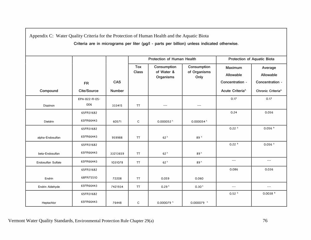
Vermont Water Quality Standards, Environmental Protection Rule Chapter 29(a) 76
Appendix C: Water Quality Criteria for the Protection of Human Health and the Aquatic Biota
Criteria are in micrograms per liter (µg/l - parts per billion) unless indicated otherwise.
Compound
FR Cite/Source
CAS
Number
Protection of Human Health Protection of Aquatic Biota
Tox Class
Consumption of Water & Organisms
Consumption of Organisms
Only
Maximum Allowable
Concentration -
Acute Criteriaa.
Average Allowable
Concentration -
Chronic Criteriaa.
Diazinon EPA-822-R-05-
006 333415 TT --- ---
0.17 0.17
Dieldrin
65FR31682
65FR66443 60571 C 0.000052 h 0.000054 h
0.24 0.056
alpha-Endosulfan
65FR31682
65FR66443 959988 TT 62 h 89 h
0.22 b 0.056 b
beta-Endosulfan
65FR31682
65FR66443 33213659 TT 62 h 89 h
0.22 b 0.056 b
Endosulfan Sulfate 65FR66443 1031078 TT 62 h 89 h --- ---
Endrin
65FR31682
68FR75510 72208 TT 0.059 0.060
0.086 0.036
Endrin Aldehyde 65FR66443 7421934 TT 0.29 h 0.30 h --- ---
Heptachlor
65FR31682
65FR66443 76448 C 0.000079 h 0.000079 h
0.52 b 0.0038 b

Vermont Water Quality Standards, Environmental Protection Rule Chapter 29(a) 77
Appendix C: Water Quality Criteria for the Protection of Human Health and the Aquatic Biota
Criteria are in micrograms per liter (µg/l - parts per billion) unless indicated otherwise.
Compound
FR Cite/Source
CAS
Number
Protection of Human Health Protection of Aquatic Biota
Tox Class
Consumption of Water & Organisms
Consumption of Organisms
Only
Maximum Allowable
Concentration -
Acute Criteriaa.
Average Allowable
Concentration -
Chronic Criteriaa.
Heptachlor Epoxide
65FR31682
65FR66443 1024573 C 0.000039 h 0.000039 h
0.52 b 0.0038 b
Benzene hexachloride-alpha 65FR66443 319846 C/BC 0.0026 h 0.0049 h --- ---
Benzene hexachloride- beta 65FR66443 319857 C/BC 0.0091 h 0.017 h --- ---
Benzene hexachloride-
gamma (Lindane)
65FR31682
68FR75510 58899 TT/BC 0.98 1.8
0.95 ---
Malathion c. EPA 440/5-86-
001 121755 --- --- --- --- 0.1
Parathion c. EPA 440/5-86-
001 56382 --- --- --- 0.065 0.013
Total PCB’s m
65FR31682
65FR66443 53469219 C/BC 0.000064 h 0.000064 h
--- 0.014 b
Dioxin (2,3,7,8-TCDD) 65FR66443 1746016 C/BC 5.0x10⁻⁹ 5.1x10⁻⁹ --- ---
Toxaphene 65FR31682 8001352 C/BC 0.00028 h 0.00028 h 0.73 0.0002

Vermont Water Quality Standards, Environmental Protection Rule Chapter 29(a) 78
Appendix C: Water Quality Criteria for the Protection of Human Health and the Aquatic Biota
Criteria are in micrograms per liter (µg/l - parts per billion) unless indicated otherwise.
Compound
FR Cite/Source
CAS
Number
Protection of Human Health Protection of Aquatic Biota
Tox Class
Consumption of Water & Organisms
Consumption of Organisms
Only
Maximum Allowable
Concentration -
Acute Criteriaa.
Average Allowable
Concentration -
Chronic Criteriaa.
65FR66443
Other Substances
Ammonia c. EPA 822-R-13-
001 7664417 --- --- ---
see EPA April 2013 water quality criteria document for Ammonia. Tables 5a and 5b
provide the acute criteria values and Table 6 provides
the chronic criteria. Asbestos 57FR60848 1332214 A 7 million fibers/L --- --- ---
Barium c EPA 440/5-86-
001 7440393 --- 1,000 --- --- ---
Chlorine c. EPA 440/5-86-
001 7782505 --- --- --- 19 11
Chloride c 53FR19028 16887006 --- --- --- 860,000 230,000
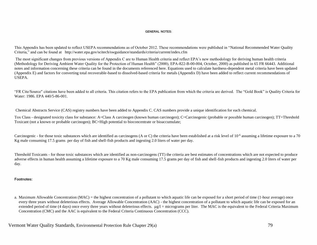
Vermont Water Quality Standards, Environmental Protection Rule Chapter 29(a) 79
GENERAL NOTES:
This Appendix has been updated to reflect USEPA recommendations as of October 2012. These recommendations were published in “National Recommended Water Quality
Criteria,” and can be found at http://water.epa.gov/scitech/swguidance/standards/criteria/current/index.cfm
The most significant changes from previous versions of Appendix C are to Human Health criteria and reflect EPA’s new methodology for deriving human health criteria
(Methodology for Deriving Ambient Water Quality for the Protection of Human Health” (2000), EPA-822-B-00-004, October, 2000) as published in 65 FR 66443. Additional
notes and information concerning these criteria can be found in the documents referenced here. Equations used to calculate hardness-dependent metal criteria have been updated
(Appendix E) and factors for converting total recoverable-based to dissolved-based criteria for metals (Appendix D) have been added to reflect current recommendations of
USEPA.
“FR Cite/Source" citations have been added to all criteria. This citation refers to the EPA publication from which the criteria are derived. The “Gold Book” is Quality Criteria for
Water: 1986. EPA 440/5-86-001.
Chemical Abstracts Service (CAS) registry numbers have been added to Appendix C. CAS numbers provide a unique identification for each chemical.
Tox Class - designated toxicity class for substance: A=Class A carcinogen (known human carcinogen); C=Carcinogenic (probable or possible human carcinogen); TT=Threshold
Toxicant (not a known or probable carcinogen); BC=High potential to bioconcentrate or bioaccumulate;
Carcinogenic - for those toxic substances which are identified as carcinogens (A or C) the criteria have been established at a risk level of 10-6 assuming a lifetime exposure to a 70
Kg male consuming 17.5 grams per day of fish and shell-fish products and ingesting 2.0 liters of water per day.
Threshold Toxicants - for those toxic substances which are identified as non-carcinogens (TT) the criteria are best estimates of concentrations which are not expected to produce
adverse effects in human health assuming a lifetime exposure to a 70 Kg male consuming 17.5 grams per day of fish and shell-fish products and ingesting 2.0 liters of water per
day.
Footnotes:
a. Maximum Allowable Concentration (MAC) = the highest concentration of a pollutant to which aquatic life can be exposed for a short period of time (1-hour average) once
every three years without deleterious effects. Average Allowable Concentration (AAC) - the highest concentration of a pollutant to which aquatic life can be exposed for an
extended period of time (4 days) once every three years without deleterious effects. µg/l = micrograms per liter. The MAC is the equivalent to the Federal Criteria Maximum
Concentration (CMC) and the AAC is equivalent to the Federal Criteria Continuous Concentration (CCC).

Vermont Water Quality Standards, Environmental Protection Rule Chapter 29(a) 80
b. The aquatic life criteria for this compound were developed in 1980 using 1980 EPA guidelines for criteria development. The MAC (CMC) or acute value shown is a final acute
value (FAV) which by the 1980 guidelines is an instantaneous value.
c. Compound is not listed in EPA's Section 304(a) Criteria for Priority Toxic Pollutants as published in the December 22, 1992, pages 60911-60917, of the Federal Register but is
included in Appendix C of the Vermont Water Quality Standards because the pollutant can be deleterious to aquatic life and criteria have been developed for the protection of
aquatic organisms.
d. Criteria for this metal are expressed in terms of dissolved metal in the water column. Dissolved metal concentrations in the water column can be determined analytically or can
be estimated from total metal concentrations using the conversion factors in Appendix D.
e. Aquatic life criteria for this metal is expressed as a function of total hardness (mg/l as CaCO3) in the water column and as a function of the pollutant's water effect ratio, WER,
as defined in §131.36(c). Unless otherwise determined by the Secretary, in a manner consistent with the most current USEPA guidance, the WER shall be 1.0. The specific
value given here corresponds to a hardness of 50 mg/l. Criteria values for other hardness may be calculated from the equations shown in Appendix E.
f. This criterion was derived from data for inorganic mercury (II) but is applied here to total mercury.
g. Vermont promulgated numerical criteria for arsenic based on freshwater fish species bioconcentration factors (BCF). A BCF of 4 was used to calculate human health protection
criteria.
h. This criterion has been revised to reflect The Environmental Protection Agency’s q1* or RfD, as contained in the Integrated Risk Information System (IRIS) as of May 17,
2002. The fish tissue bioconcentration factor (BCF) from the 1980 Ambient Water Quality Criteria document was retained in each case.
i. The MAC = 1/[(f1/MAC1) + (f2/MAC2)] where f1 and f2 are the fractions of total selenium that are treated as selenite and selenate, respectively, and MAC1 and MAC2 are
185.9 g/l and 12.82 g/l, respectively. This value for selenium is expressed in terms of total recoverable metal in the water column. It can be expressed in terms of dissolved metal
by using the conversion factor (0.996- MAC or 0.922- AAC).
j. This human health criterion is the same as originally published in the Red Book which predates the 1980 methodology and did not utilize the fish ingestion BCF approach. This
same criterion value is now published in the Gold Book.
k. Freshwater aquatic life values for pentachlorophenol are expressed as a function of pH, and are calculated as follows: MAC = exp(1.005(pH)-4.869); AAC = exp(1.005(pH)-
5.134). Values displayed in table correspond to a pH of 7.8.

Vermont Water Quality Standards, Environmental Protection Rule Chapter 29(a) 81
l. This fish tissue residue criterion for methylmercury is used for the purpose of determination of attainment pursuant to these Standards. Fish consumption advisory guidance for
mercury in fish taken from the waters of Vermont is developed by the Vermont Department of Health and is available on their website.
m. These criteria apply to total PCB’s (e.g. the sum of all congenor or all isomer or homolog or Arochlor analyses).
n. These criteria expressed as ug free cyanide (as CN)/l.

Vermont Water Quality Standards, Environmental Protection Rule Chapter 29(a) 82
Appendix D: Conversion factors for estimating dissolved metals from total values.
To convert total metal values to dissolved metal, multiply total metal values/concentrations by the conversion factor listed (or calculated)
in the table below. Alternative methods for translating total to dissolved values following USEPA guidance (“The Metals Translator:
Guidance for Calculating a Total Recoverable Metals Permit Limit from a Dissolved Criterion”; EPA 823-B-96-007) may be considered
on a case-by-case basis.
Metal Conversion Factor for MAC Conversion Factor for AAC
Arsenic 1.0 1.0
Cadmium 1.136672 – [(ln hardness)(0.041838)] 1.101672[(ln hardness)(0.041838)]
Chromium III 0.316 0.860
Chromium VI 0.982 0.962
Copper 0.96 0.96
Lead 1.46204 – [(ln hardness)(0.145712)] 1.46203 – [(ln hardness)(0.145712)
Mercury 0.85 0.85
Nickel 0.998 0.997
Selenium --- ---
Silver 0.85 ---
Zinc 0.978 0.986

Vermont Water Quality Standards, Environmental Protection Rule Chapter 29(a) 83
Appendix E: Parameters for Calculating Freshwater Total Metals Criteria that are Hardness-Dependent.
MAC and AAC values are calculated using the equations below the table and inserting the metal-specific values shown in the table.
Metal mA bA mC bC
Cadmium 1.0166 -3.924 0.7409 -4.719
Chromium III 0.8190 3.7256 0.8190 0.6848
Copper 0.9422 -1.700 0.8545 -1.702
Lead 1.273 -1.460 1.273 -4.705
Nickel 0.8460 2.255 0.8460 0.0584
Silver 1.72 -6.59 --- ---
Zinc 0.8473 0.884 0.8473 0.884
Hardness-dependent metals criteria can be calculated from the following equations:
MAC (dissolved) = exp{mA [ln (hardness)] + bA} (Conversion Factor from Appendix D)
AAC (dissolved) = exp{mC [ln (hardness)] + bC} (Conversion Factor from Appendix D)
Related Documents