Ventana at Duncan Canyon Specific Plan Amendment Draft Supplemental Environmental Impact Report SCH #2021100400 prepared by City of Fontana 8353 Sierra Avenue Fontana, California 92335 Contact: Salvador Quintanilla, Associate Planner prepared with the assistance of Rincon Consultants, Inc. 250 East 1 st Street, Suite 1400 Los Angeles, California 90012 April 2022

Welcome message from author
This document is posted to help you gain knowledge. Please leave a comment to let me know what you think about it! Share it to your friends and learn new things together.
Transcript
Ventana at Duncan Canyon Specific Plan Amendment
Draft Supplemental Environmental Impact Report SCH #2021100400
prepared by
City of Fontana 8353 Sierra Avenue
Fontana, California 92335 Contact: Salvador Quintanilla, Associate Planner
prepared with the assistance of
Rincon Consultants, Inc. 250 East 1st Street, Suite 1400 Los Angeles, California 90012
April 2022

This report prepared on 50% recycled paper with 50% post-consumer content.
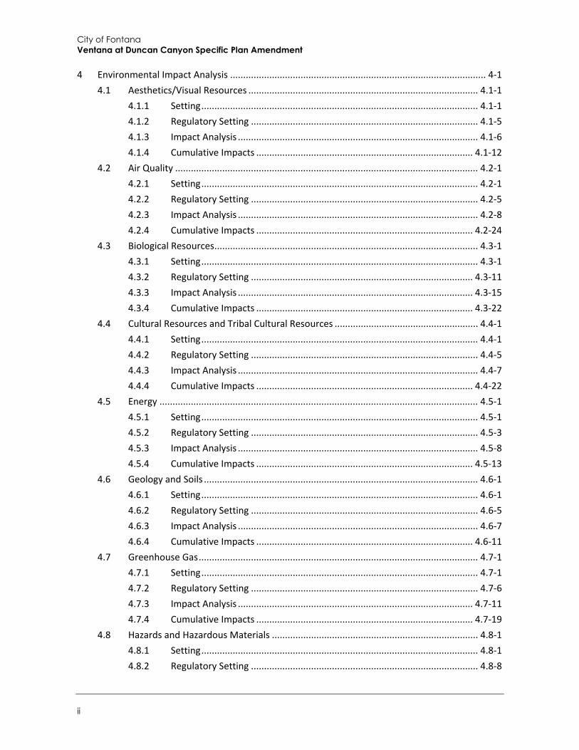
Table of Contents
Draft Supplemental Environmental Impact Report i
Table of Contents
Executive Summary ...........................................................................................................................ES-1 Project Synopsis .........................................................................................................................ES-1 Project Objectives ......................................................................................................................ES-3 Alternatives ................................................................................................................................ES-3 Areas of Known Controversy .....................................................................................................ES-4 Issues to be Resolved .................................................................................................................ES-4 Issues Not Studied in Detail in the SEIR .....................................................................................ES-4 Summary of Impacts and Mitigation Measures ........................................................................ES-4
1 Introduction ................................................................................................................................ 1-1 1.1 Notice of Preparation and Scoping ................................................................................. 1-1 1.2 Purpose and Legal Authority ........................................................................................... 1-2 1.3 Scope and Content .......................................................................................................... 1-3
1.3.1 Drafting of Supplemental EIR ......................................................................... 1-3 1.4 Issues Not Studied in Detail in the SEIR .......................................................................... 1-5 1.5 Lead, Responsible, and Trustee Agencies ....................................................................... 1-6 1.6 Environmental Review Process ....................................................................................... 1-6
2 Project Description ..................................................................................................................... 2-1 2.1 Project Applicant ............................................................................................................. 2-1 2.2 Lead Agency Contact Person ........................................................................................... 2-1 2.3 Project Location .............................................................................................................. 2-1 2.4 Existing Site Characteristics ............................................................................................ 2-1 2.5 Existing Land Use Designation and Zoning ..................................................................... 2-4 2.6 Project Setting and Surrounding Land Uses .................................................................... 2-4 2.7 Existing Specific Plan Characteristics .............................................................................. 2-6 2.8 Proposed Project Land Use Plan ..................................................................................... 2-6
2.8.1 Changes from the Existing Specific Plan ......................................................... 2-8 2.8.2 Project Characteristics .................................................................................... 2-9
2.9 Project Objectives ......................................................................................................... 2-17 2.10 Required Approvals ....................................................................................................... 2-17
2.10.1 City of Fontana .............................................................................................. 2-17 2.10.2 Other Agency Approvals ............................................................................... 2-17
3 Environmental Setting ................................................................................................................ 3-1 3.1 Regional Setting .............................................................................................................. 3-1 3.2 Project Site Setting .......................................................................................................... 3-1 3.3 Cumulative Development ............................................................................................... 3-2
City of Fontana Ventana at Duncan Canyon Specific Plan Amendment
ii
4 Environmental Impact Analysis .................................................................................................. 4-1 4.1 Aesthetics/Visual Resources ........................................................................................ 4.1-1
4.1.1 Setting .......................................................................................................... 4.1-1 4.1.2 Regulatory Setting ....................................................................................... 4.1-5 4.1.3 Impact Analysis ............................................................................................ 4.1-6 4.1.4 Cumulative Impacts ................................................................................... 4.1-12
4.2 Air Quality .................................................................................................................... 4.2-1 4.2.1 Setting .......................................................................................................... 4.2-1 4.2.2 Regulatory Setting ....................................................................................... 4.2-5 4.2.3 Impact Analysis ............................................................................................ 4.2-8 4.2.4 Cumulative Impacts ................................................................................... 4.2-24
4.3 Biological Resources ..................................................................................................... 4.3-1 4.3.1 Setting .......................................................................................................... 4.3-1 4.3.2 Regulatory Setting ..................................................................................... 4.3-11 4.3.3 Impact Analysis .......................................................................................... 4.3-15 4.3.4 Cumulative Impacts ................................................................................... 4.3-22
4.4 Cultural Resources and Tribal Cultural Resources ....................................................... 4.4-1 4.4.1 Setting .......................................................................................................... 4.4-1 4.4.2 Regulatory Setting ....................................................................................... 4.4-5 4.4.3 Impact Analysis ............................................................................................ 4.4-7 4.4.4 Cumulative Impacts ................................................................................... 4.4-22
4.5 Energy .......................................................................................................................... 4.5-1 4.5.1 Setting .......................................................................................................... 4.5-1 4.5.2 Regulatory Setting ....................................................................................... 4.5-3 4.5.3 Impact Analysis ............................................................................................ 4.5-8 4.5.4 Cumulative Impacts ................................................................................... 4.5-13
4.6 Geology and Soils ......................................................................................................... 4.6-1 4.6.1 Setting .......................................................................................................... 4.6-1 4.6.2 Regulatory Setting ....................................................................................... 4.6-5 4.6.3 Impact Analysis ............................................................................................ 4.6-7 4.6.4 Cumulative Impacts ................................................................................... 4.6-11
4.7 Greenhouse Gas ........................................................................................................... 4.7-1 4.7.1 Setting .......................................................................................................... 4.7-1 4.7.2 Regulatory Setting ....................................................................................... 4.7-6 4.7.3 Impact Analysis .......................................................................................... 4.7-11 4.7.4 Cumulative Impacts ................................................................................... 4.7-19
4.8 Hazards and Hazardous Materials ............................................................................... 4.8-1 4.8.1 Setting .......................................................................................................... 4.8-1 4.8.2 Regulatory Setting ....................................................................................... 4.8-8
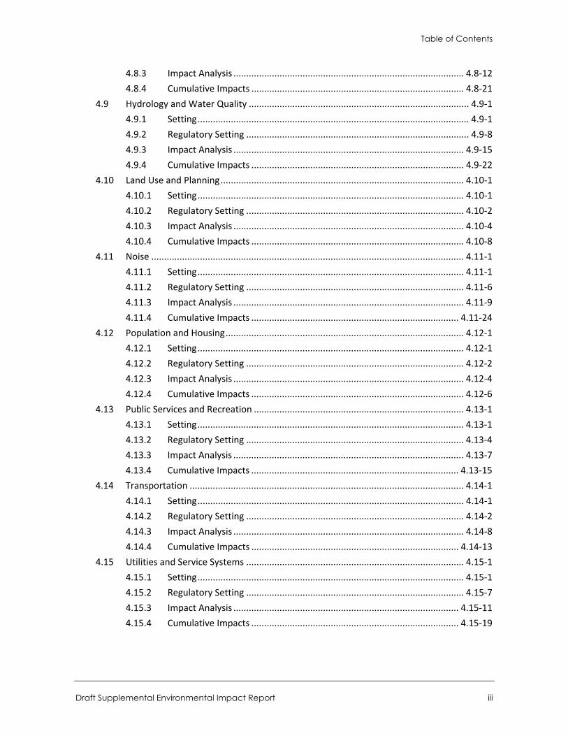
Table of Contents
Draft Supplemental Environmental Impact Report iii
4.8.3 Impact Analysis .......................................................................................... 4.8-12 4.8.4 Cumulative Impacts ................................................................................... 4.8-21
4.9 Hydrology and Water Quality ...................................................................................... 4.9-1 4.9.1 Setting .......................................................................................................... 4.9-1 4.9.2 Regulatory Setting ....................................................................................... 4.9-8 4.9.3 Impact Analysis .......................................................................................... 4.9-15 4.9.4 Cumulative Impacts ................................................................................... 4.9-22
4.10 Land Use and Planning ............................................................................................... 4.10-1 4.10.1 Setting ........................................................................................................ 4.10-1 4.10.2 Regulatory Setting ..................................................................................... 4.10-2 4.10.3 Impact Analysis .......................................................................................... 4.10-4 4.10.4 Cumulative Impacts ................................................................................... 4.10-8
4.11 Noise .......................................................................................................................... 4.11-1 4.11.1 Setting ........................................................................................................ 4.11-1 4.11.2 Regulatory Setting ..................................................................................... 4.11-6 4.11.3 Impact Analysis .......................................................................................... 4.11-9 4.11.4 Cumulative Impacts ................................................................................. 4.11-24
4.12 Population and Housing ............................................................................................. 4.12-1 4.12.1 Setting ........................................................................................................ 4.12-1 4.12.2 Regulatory Setting ..................................................................................... 4.12-2 4.12.3 Impact Analysis .......................................................................................... 4.12-4 4.12.4 Cumulative Impacts ................................................................................... 4.12-6
4.13 Public Services and Recreation .................................................................................. 4.13-1 4.13.1 Setting ........................................................................................................ 4.13-1 4.13.2 Regulatory Setting ..................................................................................... 4.13-4 4.13.3 Impact Analysis .......................................................................................... 4.13-7 4.13.4 Cumulative Impacts ................................................................................. 4.13-15
4.14 Transportation ........................................................................................................... 4.14-1 4.14.1 Setting ........................................................................................................ 4.14-1 4.14.2 Regulatory Setting ..................................................................................... 4.14-2 4.14.3 Impact Analysis .......................................................................................... 4.14-8 4.14.4 Cumulative Impacts ................................................................................. 4.14-13
4.15 Utilities and Service Systems ..................................................................................... 4.15-1 4.15.1 Setting ........................................................................................................ 4.15-1 4.15.2 Regulatory Setting ..................................................................................... 4.15-7 4.15.3 Impact Analysis ........................................................................................ 4.15-11 4.15.4 Cumulative Impacts ................................................................................. 4.15-19
City of Fontana Ventana at Duncan Canyon Specific Plan Amendment
iv
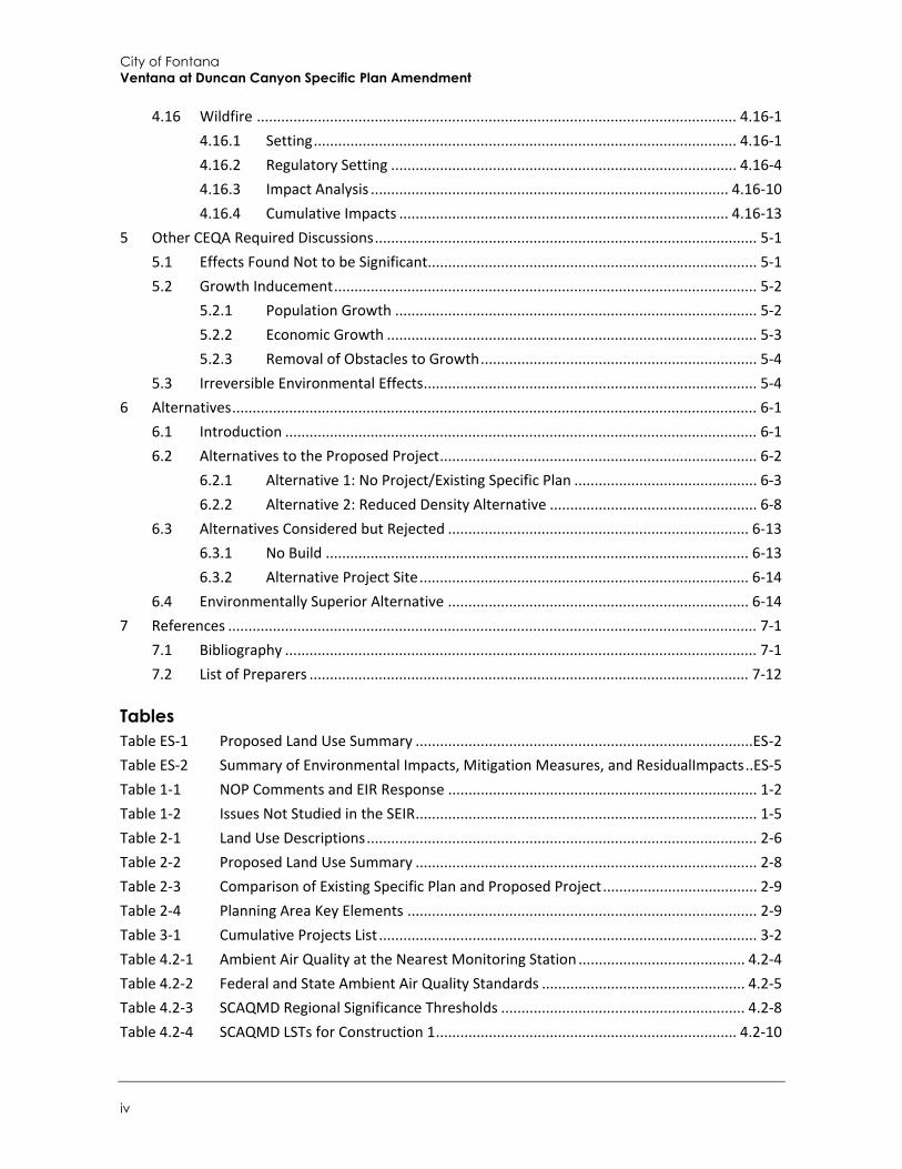
4.16 Wildfire ...................................................................................................................... 4.16-1 4.16.1 Setting ........................................................................................................ 4.16-1 4.16.2 Regulatory Setting ..................................................................................... 4.16-4 4.16.3 Impact Analysis ........................................................................................ 4.16-10 4.16.4 Cumulative Impacts ................................................................................. 4.16-13
5 Other CEQA Required Discussions .............................................................................................. 5-1 5.1 Effects Found Not to be Significant................................................................................. 5-1 5.2 Growth Inducement ........................................................................................................ 5-2
5.2.1 Population Growth ......................................................................................... 5-2 5.2.2 Economic Growth ........................................................................................... 5-3 5.2.3 Removal of Obstacles to Growth .................................................................... 5-4
5.3 Irreversible Environmental Effects .................................................................................. 5-4 6 Alternatives ................................................................................................................................. 6-1
6.1 Introduction .................................................................................................................... 6-1 6.2 Alternatives to the Proposed Project .............................................................................. 6-2
6.2.1 Alternative 1: No Project/Existing Specific Plan ............................................. 6-3 6.2.2 Alternative 2: Reduced Density Alternative ................................................... 6-8
6.3 Alternatives Considered but Rejected .......................................................................... 6-13 6.3.1 No Build ........................................................................................................ 6-13 6.3.2 Alternative Project Site ................................................................................. 6-14
6.4 Environmentally Superior Alternative .......................................................................... 6-14 7 References .................................................................................................................................. 7-1
7.1 Bibliography .................................................................................................................... 7-1 7.2 List of Preparers ............................................................................................................ 7-12
Tables Table ES-1 Proposed Land Use Summary ...................................................................................ES-2 Table ES-2 Summary of Environmental Impacts, Mitigation Measures, and ResidualImpacts ..ES-5 Table 1-1 NOP Comments and EIR Response ............................................................................ 1-2 Table 1-2 Issues Not Studied in the SEIR .................................................................................... 1-5 Table 2-1 Land Use Descriptions ................................................................................................ 2-6 Table 2-2 Proposed Land Use Summary .................................................................................... 2-8 Table 2-3 Comparison of Existing Specific Plan and Proposed Project ...................................... 2-9 Table 2-4 Planning Area Key Elements ...................................................................................... 2-9 Table 3-1 Cumulative Projects List ............................................................................................. 3-2 Table 4.2-1 Ambient Air Quality at the Nearest Monitoring Station ......................................... 4.2-4 Table 4.2-2 Federal and State Ambient Air Quality Standards .................................................. 4.2-5 Table 4.2-3 SCAQMD Regional Significance Thresholds ............................................................ 4.2-8 Table 4.2-4 SCAQMD LSTs for Construction 1 .......................................................................... 4.2-10
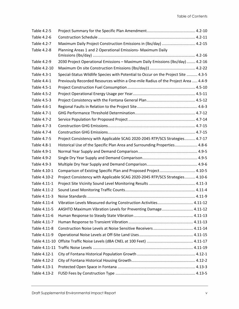
Table of Contents
Draft Supplemental Environmental Impact Report v
Table 4.2-5 Project Summary for the Specific Plan Amendment ............................................. 4.2-10 Table 4.2-6 Construction Schedule .......................................................................................... 4.2-11 Table 4.2-7 Maximum Daily Project Construction Emissions in (lbs/day) ............................... 4.2-15 Table 4.2-8 Planning Areas 1 and 2 Operational Emissions- Maximum Daily
Emissions (lbs/day) ............................................................................................... 4.2-16 Table 4.2-9 2030 Project Operational Emissions – Maximum Daily Emissions (lbs/day) ........ 4.2-16 Table 4.2-10 Maximum On site Construction Emissions (lbs/day)1 .......................................... 4.2-22 Table 4.3-1 Special-Status Wildlife Species with Potential to Occur on the Project Site .......... 4.3-5 Table 4.4-1 Previously Recorded Resources within a One-mile Radius of the Project Area ..... 4.4-9 Table 4.5-1 Project Construction Fuel Consumption ............................................................... 4.5-10 Table 4.5-2 Project Operational Energy Usage per Year .......................................................... 4.5-11 Table 4.5-3 Project Consistency with the Fontana General Plan ............................................. 4.5-12 Table 4.6-1 Regional Faults in Relation to the Project Site ........................................................ 4.6-3 Table 4.7-1 GHG Performance Threshold Determination........................................................ 4.7-12 Table 4.7-2 Service Population for Proposed Project .............................................................. 4.7-14 Table 4.7-3 Construction GHG Emissions ................................................................................. 4.7-15 Table 4.7-4 Construction GHG Emissions ................................................................................. 4.7-15 Table 4.7-5 Project Consistency with Applicable SCAG 2020-2045 RTP/SCS Strategies .......... 4.7-17 Table 4.8-1 Historical Use of the Specific Plan Area and Surrounding Properties ..................... 4.8-6 Table 4.9-1 Normal Year Supply and Demand Comparison ....................................................... 4.9-5 Table 4.9-2 Single Dry Year Supply and Demand Comparison ................................................... 4.9-5 Table 4.9-3 Multiple Dry Year Supply and Demand Comparison ............................................... 4.9-6 Table 4.10-1 Comparison of Existing Specific Plan and Proposed Project ................................. 4.10-5 Table 4.10-2 Project Consistency with Applicable SCAG 2020-2045 RTP/SCS Strategies .......... 4.10-6 Table 4.11-1 Project Site Vicinity Sound Level Monitoring Results ........................................... 4.11-3 Table 4.11-2 Sound Level Monitoring Traffic Counts ................................................................. 4.11-4 Table 4.11-3 Noise Standards .................................................................................................... 4.11-9 Table 4.11-4 Vibration Levels Measured during Construction Activities ................................. 4.11-12 Table 4.11-5 AASHTO Maximum Vibration Levels for Preventing Damage ............................. 4.11-12 Table 4.11-6 Human Response to Steady State Vibration ....................................................... 4.11-13 Table 4.11-7 Human Response to Transient Vibration ............................................................ 4.11-13 Table 4.11-8 Construction Noise Levels at Noise Sensitive Receivers ..................................... 4.11-14 Table 4.11-9 Operational Noise Levels at Off-Site Land Uses .................................................. 4.11-15 Table 4.11-10 Offsite Traffic Noise Levels (dBA CNEL at 100 Feet) ........................................... 4.11-17 Table 4.11-11 Traffic Noise Levels ............................................................................................. 4.11-19 Table 4.12-1 City of Fontana Historical Population Growth ...................................................... 4.12-1 Table 4.12-2 City of Fontana Historical Housing Growth ........................................................... 4.12-2 Table 4.13-1 Protected Open Space in Fontana ........................................................................ 4.13-3 Table 4.13-2 FUSD Fees by Construction Type .......................................................................... 4.13-5
City of Fontana Ventana at Duncan Canyon Specific Plan Amendment
vi
Table 4.13-3 Fontana Development Impact Fees ...................................................................... 4.13-6 Table 4.13-4 Student Generation Factors and Resulting Student Population in Specific Plan
Area ..................................................................................................................... 4.13-12 Table 4.13-5 Current Capacity vs. Enrollment ......................................................................... 4.13-12 Table 4.14-1 Project VMT Per Service Population ................................................................... 4.14-12 Table 4.14-2 Project VMT Per Service Population Comparison ............................................... 4.14-12 Table 4.15-1 WVWD Water Supplies – Current and Projected .................................................. 4.15-4 Table 4.15-2 Supply and Demand in Multiple Dry Years ........................................................... 4.15-5 Table 4.15-3 Wastewater Treatment Plant Capacity ............................................................... 4.15-13 Table 4.15-4 Project Share of WVWD Normal Year Supply and Demand ................................ 4.15-16 Table 4.15-5 Project Share of WVWD Single-Dry Year Supply and Demand ........................... 4.15-16 Table 5-1 Impacts Found to be Less than Significant Impacts or No Impacts ........................... 5-1 Table 5-2 Employment Generated by Proposed Project ........................................................... 5-4 Table 6-1 Comparison of Project Alternatives’ Buildout Characteristics ................................... 6-2 Table 6-2 Impact Comparison of Alternatives ......................................................................... 6-14
Figures Figure 1-1 Environmental Review Process .................................................................................. 1-7 Figure 2-1 Regional Location ....................................................................................................... 2-2 Figure 2-2 Project Site Location .................................................................................................. 2-3 Figure 2-3 Photographs of the Project Site ................................................................................. 2-5 Figure 2-4 Existing and Proposed Land Use Plans ....................................................................... 2-7 Figure 2-5 Conceptual Site Plan for Planning Areas 1, 2 and 5 ................................................. 2-10 Figure 2-6 Conceptual Site Plan for Planning Area 3 ................................................................. 2-11 Figure 2-7 Conceptual Site Plan for Planning Area 4 ................................................................. 2-12 Figure 2-8 Conceptual Site Plan for Planning Area 6 ................................................................. 2-13 Figure 2-9 Conceptual Site Plan for Proposed Project .............................................................. 2-14 Figure 3-1 Cumulative Projects ................................................................................................... 3-5 Figure 4.1-1 Northern Site Photographs ..................................................................................... 4.1-3 Figure 4.1-2 Southern Site Photographs ..................................................................................... 4.1-4 Figure 4.1-3 Tuscan Village Concept Photographs .................................................................... 4.1-10 Figure 4.3-1 Critical Habitat......................................................................................................... 4.3-9 Figure 4.6-1 Reqional Earthquake Fault Zones ........................................................................... 4.6-4 Figure 4.8-1 Fire Hazard Severity Zones Near the Project .......................................................... 4.8-5 Figure 4.9-1 Surface Waters ........................................................................................................ 4.9-2 Figure 4.9-2 Groundwater Subbasins .......................................................................................... 4.9-3 Figure 4.9-3 FEMA Flood Hazard Zones ...................................................................................... 4.9-7 Figure 4.11-1 Noise Measurement Locations ............................................................................. 4.11-5 Figure 4.11-2 HVAC Contours .................................................................................................... 4.11-16 Figure 4.11-3 Traffic Noise Contours ......................................................................................... 4.11-22
Table of Contents
Draft Supplemental Environmental Impact Report vii
Figure 4.14-1 Bicycle Facilities in Fontana .................................................................................. 4.14-3 Figure 4.14-2 Existing Transit Routes .......................................................................................... 4.14-4 Figure 4.15-1 West Valley Water District Service Area ............................................................... 4.15-2 Figure 4.15-2 Groundwater Basins .............................................................................................. 4.15-3 Figure 4.16-1 Very High Fire Hazard Severity Zone ..................................................................... 4.16-3
Appendices Appendix A-1 Notice of Preparation – Scoping Comments Appendix A-2 Initial Study Appendix B Air Quality and Greenhouse Gas Study Appendix C-1 Habitat Assessment Appendix C-2 Tree Survey and Arborist Report Appendix D Cultural Resources Assessment Report Appendix E Energy Calculations Appendix F Hazardous Materials Review Letter Appendix G Water Supply Assessment Appendix H Noise and Vibration Study Appendix I Traffic Study Appendix J Fire Protection Plan

City of Fontana Ventana at Duncan Canyon Specific Plan Amendment
viii
This page intentionally left blank
Executive Summary
Draft Supplemental Environmental Impact Report ES-1
Executive Summary
This document is a Supplemental Environmental Impact Report (SEIR) analyzing the environmental effects of the proposed Ventana at Duncan Canyon Specific Plan Amendment (hereafter referred to as “proposed project” or “project”). This section summarizes the characteristics of the proposed project, alternatives to the proposed project, and the environmental impacts and mitigation measures associated with the proposed project.
Project Synopsis
Project Applicant Frontier Enterprises 2151 East Convention Center Drive, Suite 114 Ontario, California 91764
Lead Agency Contact Person Salvador Quintanilla, Associate Planner City of Fontana 8353 Sierra Avenue Fontana, California 92335 (909) 350-7625
Project Location and Description This SEIR has been prepared to examine the potential environmental effects of proposed project. The following is a summary of the full project description, which can be found in Section 2, Project Description.
The project site is comprised of approximately 102-acres located in the northern part of the City of Fontana, within San Bernardino County, California. The project is bound by Interstate 15 (I-15) to the north and west, Citrus Avenue to the east, and a Southern California Edison (SCE) Transmission Line Corridor to the south. The project site is currently undeveloped and relatively flat, and consists of Assessor Parcel Numbers 022607531, 022607545, 022607538, 022607546, 022607546, 110726208, 110726207, 110726206, 110726205, and 110726204.
The City’s Zoning District map designates the project area as the Ventana at Duncan Canyon Specific Plan (i.e., existing Specific Plan). The existing Specific Plan area has two designations of General Commercial (C-G) and Multi Family Residential (R-MF). The existing Specific Plan includes allows for the following uses: Medium Density Residential (MDR), Medium-High Density Residential (MHDR), Mixed Use (MU), and Commercial (C). The existing Specific Plan identified ten Planning Areas (PA) and included the development of up to 574,500 square feet of commercial uses and 842 dwelling units. The Final EIR for the existing Specific Plan (State Clearinghouse No. 2005111048) was certified and the project approved by the City of Fontana on March 27, 2007.
The proposed project includes a General Plan Amendment (GPA 21-0006) to remove the existing Multi Family Residential (R-MF) land use designation, modify the locations of the existing Commercial (C-G) land use designation, and add the Regional Mixed Use (RMU) and Residential
City of Fontana Ventana at Duncan Canyon Specific Plan Amendment
ES-2
Multi Family Medium/High (R-MFMH) land use designations for consistency with the proposed Specific Plan Amendment (SPA 21-001). The proposed Specific Plan Amendment includes a comprehensive modification and update to the overall development plan under the existing Specific Plan to reflect current planning and market demands. Notably, the Specific Plan Amendment includes a change from Medium-High Density Residential (MHDR) to High Density Residential (HDR).
Project Characteristics
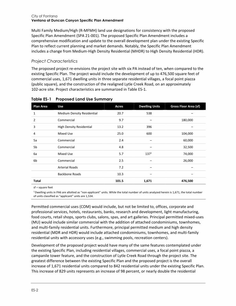
The proposed project re-envisions the project site with six PA instead of ten, when compared to the existing Specific Plan. The project would include the development of up to 476,500 square feet of commercial uses, 1,671 dwelling units in three separate residential villages, a focal point piazza (public square), and the construction of the realigned Lytle Creek Road, on an approximately 102-acre site. Project characteristics are summarized in Table ES-1.
Table ES-1 Proposed Land Use Summary Plan Area Use Acres Dwelling Units Gross Floor Area (sf)
1 Medium Density Residential 20.7 538 –
2 Commercial 9.7 – 180,000
3 High Density Residential 13.2 396 –
4 Mixed Use 25.0 600 104,000
5a Commercial 2.4 – 60,000
5b Commercial 4.8 – 32,500
6a Mixed Use 5.7 1371 74,000
6b Commercial 2.5 – 26,000
Arterial Roads 7.2 – –
Backbone Roads 10.3 – –
Total 101.5 1,671 476,500
sf = square feet 1 Dwelling units in PA6 are allotted as “non-applicant” units. While the total number of units analyzed herein is 1,671, the total number of units classified as “applicant” units are 1,534.
Permitted commercial uses (COM) would include, but not be limited to, offices, corporate and professional services, hotels, restaurants, banks, research and development, light manufacturing, food courts, retail shops, sports clubs, salons, spas, and art galleries. Principal permitted mixed-uses (MU) would include similar commercial with the addition of attached condominiums, townhomes, and multi-family residential units. Furthermore, principal permitted medium and high density residential (MDR and HDR) would include attached condominiums, townhomes, and multi-family residential units with accessory uses (e.g., swimming pools, recreation centers).
Development of the proposed project would have many of the same features contemplated under the existing Specific Plan, including residential villages, commercial uses, a focal point piazza, a campanile tower feature, and the construction of Lytle Creek Road through the project site. The greatest difference between the existing Specific Plan and the proposed project is the overall increase of 1,671 residential units compared to 842 residential units under the existing Specific Plan. This increase of 829 units represents an increase of 98 percent, or nearly double the residential
Executive Summary
Draft Supplemental Environmental Impact Report ES-3
units. In addition, the total commercial area would be reduced by 98,000 square feet (17 percent), from 574,500 square feet under the existing Specific Plan to 476,500 square feet for the proposed project.
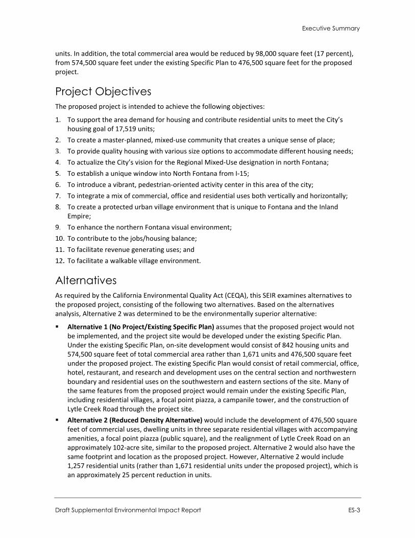
Project Objectives The proposed project is intended to achieve the following objectives:
To support the area demand for housing and contribute residential units to meet the City’s housing goal of 17,519 units;
To create a master-planned, mixed-use community that creates a unique sense of place; To provide quality housing with various size options to accommodate different housing needs; To actualize the City’s vision for the Regional Mixed-Use designation in north Fontana; To establish a unique window into North Fontana from I-15; To introduce a vibrant, pedestrian-oriented activity center in this area of the city; To integrate a mix of commercial, office and residential uses both vertically and horizontally; To create a protected urban village environment that is unique to Fontana and the Inland
Empire; To enhance the northern Fontana visual environment; To contribute to the jobs/housing balance; To facilitate revenue generating uses; and To facilitate a walkable village environment.
Alternatives As required by the California Environmental Quality Act (CEQA), this SEIR examines alternatives to the proposed project, consisting of the following two alternatives. Based on the alternatives analysis, Alternative 2 was determined to be the environmentally superior alternative:
Alternative 1 (No Project/Existing Specific Plan) assumes that the proposed project would not be implemented, and the project site would be developed under the existing Specific Plan. Under the existing Specific Plan, on-site development would consist of 842 housing units and 574,500 square feet of total commercial area rather than 1,671 units and 476,500 square feet under the proposed project. The existing Specific Plan would consist of retail commercial, office, hotel, restaurant, and research and development uses on the central section and northwestern boundary and residential uses on the southwestern and eastern sections of the site. Many of the same features from the proposed project would remain under the existing Specific Plan, including residential villages, a focal point piazza, a campanile tower, and the construction of Lytle Creek Road through the project site.
Alternative 2 (Reduced Density Alternative) would include the development of 476,500 square feet of commercial uses, dwelling units in three separate residential villages with accompanying amenities, a focal point piazza (public square), and the realignment of Lytle Creek Road on an approximately 102-acre site, similar to the proposed project. Alternative 2 would also have the same footprint and location as the proposed project. However, Alternative 2 would include 1,257 residential units (rather than 1,671 residential units under the proposed project), which is an approximately 25 percent reduction in units.
City of Fontana Ventana at Duncan Canyon Specific Plan Amendment
ES-4
Refer to Section 6, Alternatives, for the complete alternatives analysis.
Areas of Known Controversy The SEIR scoping process did not identify any areas of known controversy for the proposed project. Responses to the Notice of Preparation of a Draft SEIR and input received at the SEIR scoping meeting held by the City are summarized in Section 1, Introduction. As discussed in Section 4.2, Air Quality, of the Draft SEIR, the proposed project would have a significant and unavoidable impact (even with implementation of mitigation) related to air quality emissions from mobile sources at operation (i.e., Impact AQ-2). However, this finding is consistent with the significant and unavoidable air quality impact associated with operation of the existing Specific Plan, as previously identified in the 2007 EIR.
Issues to be Resolved The proposed project would require approval of a Specific Plan Amendment to change the land uses, planning areas, and other elements of the Specific Plan, including a change from Medium-High Density Residential (MHDR) to High Density Residential (HDR). The project would also require approval of a General Plan Amendment to amend a portion of the site’s current land use designations from Commercial (C-G) and Multi Family Residential (R-MF) to Regional Mixed Use (RMU) and Residential Multi Family Medium/High (R-MFMH).
Issues Not Studied in Detail in the SEIR Table 1-2 in Section 1, Introduction, summarizes issues from the environmental checklist that were addressed in the Initial Study (Appendix A-2). As indicated in the Initial Study, there is no substantial evidence that significant impacts would occur to the following issue areas: Agricultural Resources and Mineral Resources. However, various issue areas related to Aesthetics/Visual Resources, Air Quality, Biological Resources, Cultural Resources and Tribal Cultural Resources, Energy, Geology and Soils, Greenhouse Gas, Hazards and Hazardous Materials, Hydrology and Water Quality, Land Use and Planning, Noise, Population and Housing, Public Services and Recreation, Transportation, Utilities, and Wildfire are further analyzed in this SEIR for the purposes of public review and comment.
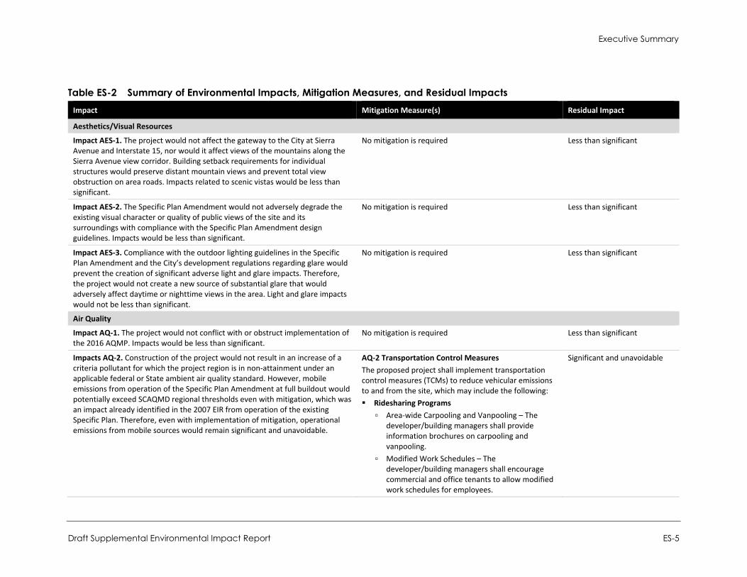
Summary of Impacts and Mitigation Measures Table ES-2 summarizes the environmental impacts of the proposed project, proposed mitigation measures, and residual impacts (the impact after application of mitigation, if required).
Significant and Unavoidable. An impact that cannot be reduced to below the threshold level given reasonably available and feasible mitigation measures. Such an impact requires a Statement of Overriding Considerations to be issued if the project is approved per Section 15093 of the CEQA Guidelines.
Less than Significant with Mitigation Incorporated. An impact that can be reduced to below the threshold level given reasonably available and feasible mitigation measures. Such an impact requires findings under Section 15091 of the CEQA Guidelines.
Less than Significant. An impact that may be adverse but does not exceed the threshold levels and does not require mitigation measures. However, mitigation measures that could further lessen the environmental effect may be suggested if readily available and easily achievable.
No Impact: The proposed project would have no effect on environmental conditions or would reduce existing environmental problems or hazards.
Executive Summary
Draft Supplemental Environmental Impact Report ES-5
Table ES-2 Summary of Environmental Impacts, Mitigation Measures, and Residual Impacts Impact Mitigation Measure(s) Residual Impact
Aesthetics/Visual Resources
Impact AES-1. The project would not affect the gateway to the City at Sierra Avenue and Interstate 15, nor would it affect views of the mountains along the Sierra Avenue view corridor. Building setback requirements for individual structures would preserve distant mountain views and prevent total view obstruction on area roads. Impacts related to scenic vistas would be less than significant.
No mitigation is required Less than significant
Impact AES-2. The Specific Plan Amendment would not adversely degrade the existing visual character or quality of public views of the site and its surroundings with compliance with the Specific Plan Amendment design guidelines. Impacts would be less than significant.
No mitigation is required Less than significant
Impact AES-3. Compliance with the outdoor lighting guidelines in the Specific Plan Amendment and the City’s development regulations regarding glare would prevent the creation of significant adverse light and glare impacts. Therefore, the project would not create a new source of substantial glare that would adversely affect daytime or nighttime views in the area. Light and glare impacts would not be less than significant.
No mitigation is required Less than significant
Air Quality
Impact AQ-1. The project would not conflict with or obstruct implementation of the 2016 AQMP. Impacts would be less than significant.
No mitigation is required Less than significant
Impacts AQ-2. Construction of the project would not result in an increase of a criteria pollutant for which the project region is in non-attainment under an applicable federal or State ambient air quality standard. However, mobile emissions from operation of the Specific Plan Amendment at full buildout would potentially exceed SCAQMD regional thresholds even with mitigation, which was an impact already identified in the 2007 EIR from operation of the existing Specific Plan. Therefore, even with implementation of mitigation, operational emissions from mobile sources would remain significant and unavoidable.
AQ-2 Transportation Control Measures The proposed project shall implement transportation control measures (TCMs) to reduce vehicular emissions to and from the site, which may include the following: Ridesharing Programs
▫ Area-wide Carpooling and Vanpooling – The developer/building managers shall provide information brochures on carpooling and vanpooling.
▫ Modified Work Schedules – The developer/building managers shall encourage commercial and office tenants to allow modified work schedules for employees.
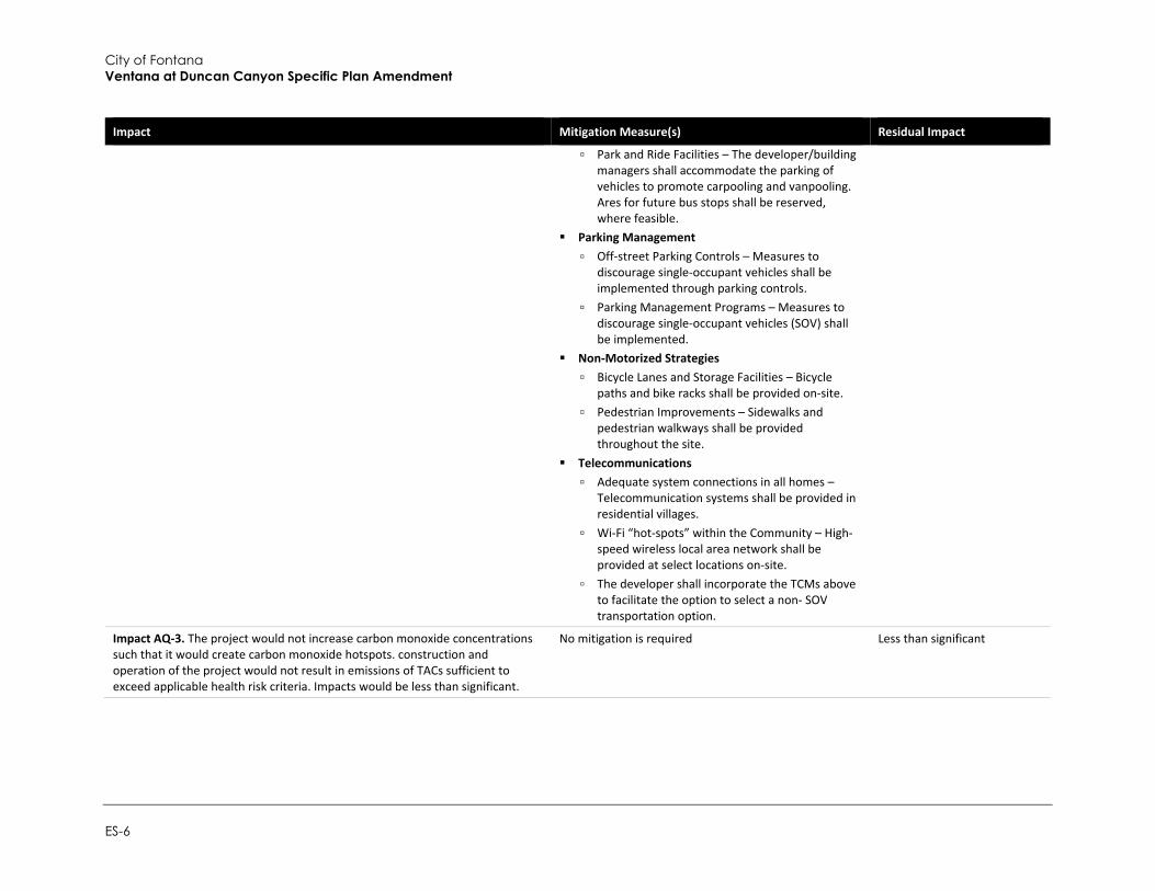
Significant and unavoidable
City of Fontana Ventana at Duncan Canyon Specific Plan Amendment
ES-6
Impact Mitigation Measure(s) Residual Impact
▫ Park and Ride Facilities – The developer/building managers shall accommodate the parking of vehicles to promote carpooling and vanpooling. Ares for future bus stops shall be reserved, where feasible.
Parking Management ▫ Off-street Parking Controls – Measures to
discourage single-occupant vehicles shall be implemented through parking controls.
▫ Parking Management Programs – Measures to discourage single-occupant vehicles (SOV) shall be implemented.
Non-Motorized Strategies ▫ Bicycle Lanes and Storage Facilities – Bicycle
paths and bike racks shall be provided on-site. ▫ Pedestrian Improvements – Sidewalks and
pedestrian walkways shall be provided throughout the site.
Telecommunications ▫ Adequate system connections in all homes –
Telecommunication systems shall be provided in residential villages.
▫ Wi-Fi “hot-spots” within the Community – High-speed wireless local area network shall be provided at select locations on-site.
▫ The developer shall incorporate the TCMs above to facilitate the option to select a non- SOV transportation option.
Impact AQ-3. The project would not increase carbon monoxide concentrations such that it would create carbon monoxide hotspots. construction and operation of the project would not result in emissions of TACs sufficient to exceed applicable health risk criteria. Impacts would be less than significant.
No mitigation is required Less than significant
Executive Summary
Draft Supplemental Environmental Impact Report ES-7
Impact Mitigation Measure(s) Residual Impact
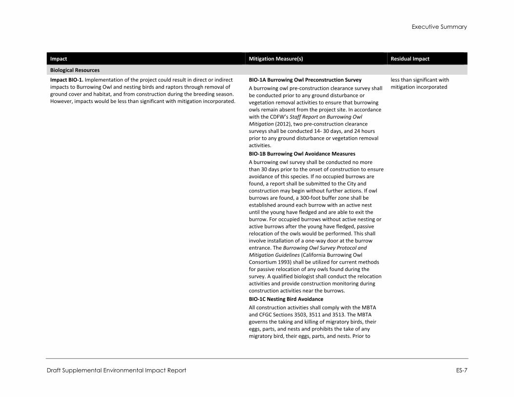
Biological Resources
Impact BIO-1. Implementation of the project could result in direct or indirect impacts to Burrowing Owl and nesting birds and raptors through removal of ground cover and habitat, and from construction during the breeding season. However, impacts would be less than significant with mitigation incorporated.
BIO-1A Burrowing Owl Preconstruction Survey A burrowing owl pre-construction clearance survey shall be conducted prior to any ground disturbance or vegetation removal activities to ensure that burrowing owls remain absent from the project site. In accordance with the CDFW’s Staff Report on Burrowing Owl Mitigation (2012), two pre-construction clearance surveys shall be conducted 14- 30 days, and 24 hours prior to any ground disturbance or vegetation removal activities. BIO-1B Burrowing Owl Avoidance Measures A burrowing owl survey shall be conducted no more than 30 days prior to the onset of construction to ensure avoidance of this species. If no occupied burrows are found, a report shall be submitted to the City and construction may begin without further actions. If owl burrows are found, a 300-foot buffer zone shall be established around each burrow with an active nest until the young have fledged and are able to exit the burrow. For occupied burrows without active nesting or active burrows after the young have fledged, passive relocation of the owls would be performed. This shall involve installation of a one-way door at the burrow entrance. The Burrowing Owl Survey Protocol and Mitigation Guidelines (California Burrowing Owl Consortium 1993) shall be utilized for current methods for passive relocation of any owls found during the survey. A qualified biologist shall conduct the relocation activities and provide construction monitoring during construction activities near the burrows. BIO-1C Nesting Bird Avoidance All construction activities shall comply with the MBTA and CFGC Sections 3503, 3511 and 3513. The MBTA governs the taking and killing of migratory birds, their eggs, parts, and nests and prohibits the take of any migratory bird, their eggs, parts, and nests. Prior to
less than significant with mitigation incorporated
City of Fontana Ventana at Duncan Canyon Specific Plan Amendment
ES-8
Impact Mitigation Measure(s) Residual Impact
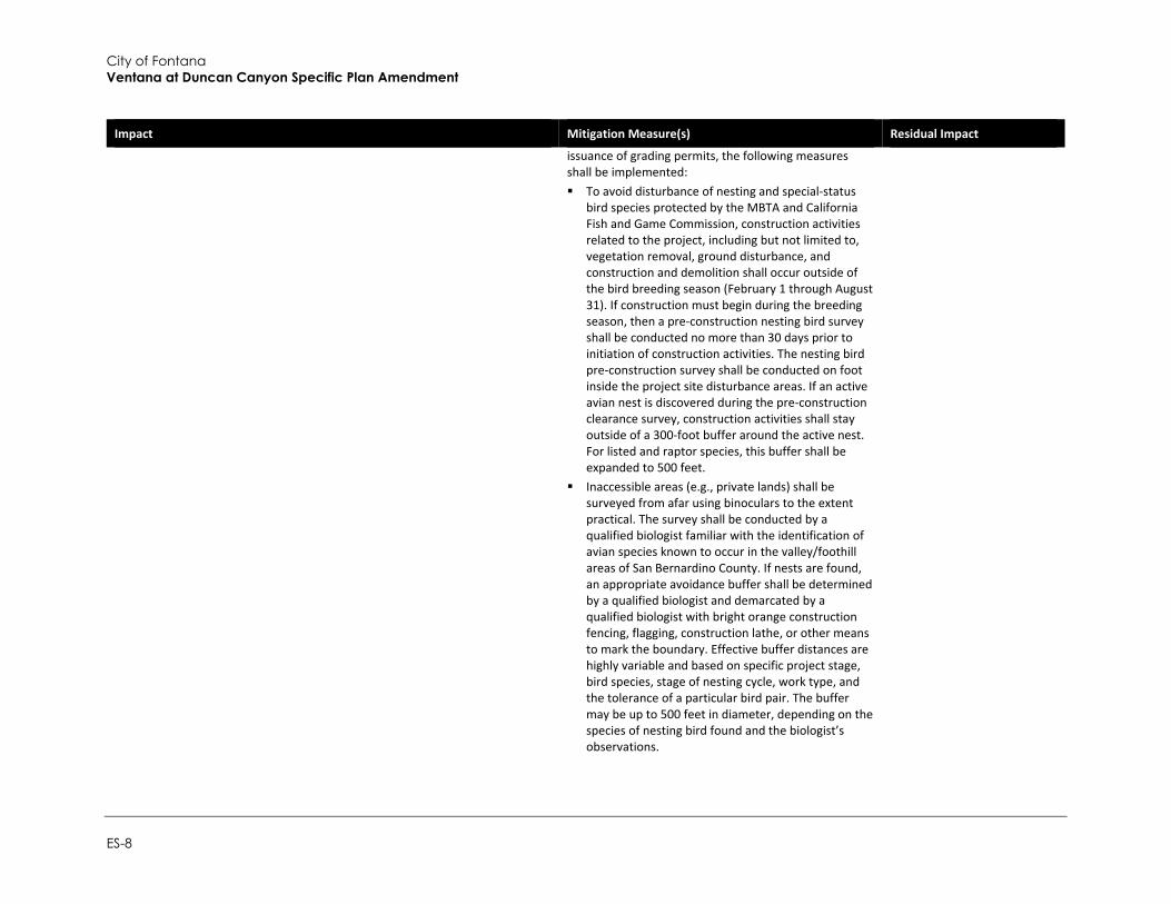
issuance of grading permits, the following measures shall be implemented: To avoid disturbance of nesting and special-status
bird species protected by the MBTA and California Fish and Game Commission, construction activities related to the project, including but not limited to, vegetation removal, ground disturbance, and construction and demolition shall occur outside of the bird breeding season (February 1 through August 31). If construction must begin during the breeding season, then a pre-construction nesting bird survey shall be conducted no more than 30 days prior to initiation of construction activities. The nesting bird pre-construction survey shall be conducted on foot inside the project site disturbance areas. If an active avian nest is discovered during the pre-construction clearance survey, construction activities shall stay outside of a 300-foot buffer around the active nest. For listed and raptor species, this buffer shall be expanded to 500 feet.
Inaccessible areas (e.g., private lands) shall be surveyed from afar using binoculars to the extent practical. The survey shall be conducted by a qualified biologist familiar with the identification of avian species known to occur in the valley/foothill areas of San Bernardino County. If nests are found, an appropriate avoidance buffer shall be determined by a qualified biologist and demarcated by a qualified biologist with bright orange construction fencing, flagging, construction lathe, or other means to mark the boundary. Effective buffer distances are highly variable and based on specific project stage, bird species, stage of nesting cycle, work type, and the tolerance of a particular bird pair. The buffer may be up to 500 feet in diameter, depending on the species of nesting bird found and the biologist’s observations.
Executive Summary
Draft Supplemental Environmental Impact Report ES-9
Impact Mitigation Measure(s) Residual Impact
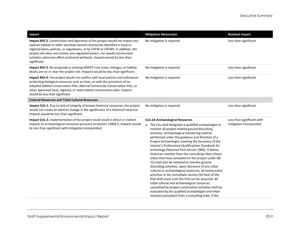
Impact BIO-2. Construction and operation of the project would not impact any riparian habitat or other sensitive natural community identified in local or regional plans, policies, or regulations, or by CDFW or USFWS. In addition, the project site does not contain any regulated waters, nor would construction activities adversely affect protected wetlands. Impacts would be less than significant.
No mitigation is required Less than significant
Impact BIO-3. No proposed or existing MSHCP core areas, linkages, or habitat blocks are on or near the project site. Impacts would be less than significant.
No mitigation is required Less than significant
Impact BIO-4. The project would not conflict with local policies and ordinances protecting biological resources such as trees, or with the provisions of an adopted Habitat Conservation Plan, Natural Community Conservation Plan, or other approved local, regional, or state habitat conservation plan. Impacts would be less than significant.
No mitigation is required Less than significant
Cultural Resources and Tribal Cultural Resources
Impact CUL-1. Due to lack of integrity of known historical resources, the project would not create an adverse change in the significance of a historical resource. Impacts would be less than significant.
No mitigation is required Less than significant
Impact CUL-2. Implementation of the project could result in direct or indirect impacts to archaeological resources pursuant to Section 15064.5. Impacts would be less than significant with mitigation incorporated.
CUL-2A Archaeological Resources a. The City shall designate a qualified archaeologist to
monitor all project-related ground disturbing activities. Archaeological monitoring shall be performed under the guidance and direction of a Project Archaeologist meeting the Secretary of the Interior’s Professional Qualifications Standards for archeology (National Park Service 1983). A Native American monitor from the consulting tribes (those tribes that have consulted on the project under AB 52) shall also be retained to monitor ground disturbing activities. Upon discovery of any tribal cultural or archaeological resources, all construction activities in the immediate vicinity (50 feet) of the find shall cease until the find can be assessed. All tribal cultural and archaeological resources unearthed by project construction activities shall be evaluated by the qualified archaeologist and tribal monitor/consultant from a consulting tribe. If the
Less than significant with mitigation incorporated
City of Fontana Ventana at Duncan Canyon Specific Plan Amendment
ES-10
Impact Mitigation Measure(s) Residual Impact
resources are Native American in origin, interested Tribes (as a result of correspondence with area Tribes) shall coordinate with the landowner regarding treatment (including evaluations for CRHR listing) and curation of these resources. Work may continue on other parts of the project while evaluation takes place.
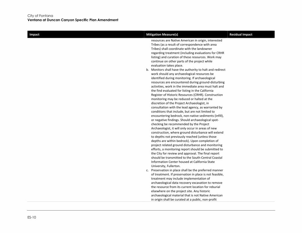
b. Monitors shall have the authority to halt and redirect work should any archaeological resources be identified during monitoring. If archaeological resources are encountered during ground-disturbing activities, work in the immediate area must halt and the find evaluated for listing in the California Register of Historic Resources (CRHR). Construction monitoring may be reduced or halted at the discretion of the Project Archaeologist, in consultation with the lead agency, as warranted by conditions that include, but are not limited to encountering bedrock, non-native sediments (infill), or negative findings. Should archaeological spot-checking be recommended by the Project Archaeologist, it will only occur in areas of new construction, where ground disturbance will extend to depths not previously reached (unless those depths are within bedrock). Upon completion of project related ground disturbance and monitoring efforts, a monitoring report should be submitted to the City for review and approval. The final report should be transmitted to the South-Central Coastal Information Center housed at California State University, Fullerton.
c. Preservation in place shall be the preferred manner of treatment. If preservation in place is not feasible, treatment may include implementation of archaeological data recovery excavation to remove the resource from its current location for reburial elsewhere on the project site. Any historic archaeological material that is not Native American in origin shall be curated at a public, non-profit
Executive Summary
Draft Supplemental Environmental Impact Report ES-11
Impact Mitigation Measure(s) Residual Impact
institution with a research interest in the materials, if such an institution agrees to accept the material. If no institution accepts the archaeological material, they shall be reburied on the project site.
CUL-2B Worker’s Environmental Awareness Program A qualified archaeologist who meets or exceeds the Secretary of Interior’s Professional Qualifications Standards for archeology (National Park Service [NPS] 1983) shall conduct worker environmental awareness program (WEAP) training, prior to the commencement of any ground-disturbing activities. The sensitivity training shall include a description of the types of cultural material that may be encountered, cultural sensitivity issues, the regulatory environment, and the proper protocol for treatment and disposition of cultural materials in the event of a find. The training shall be required for all earthmoving construction personnel and a sign-in-sheet shall also be required
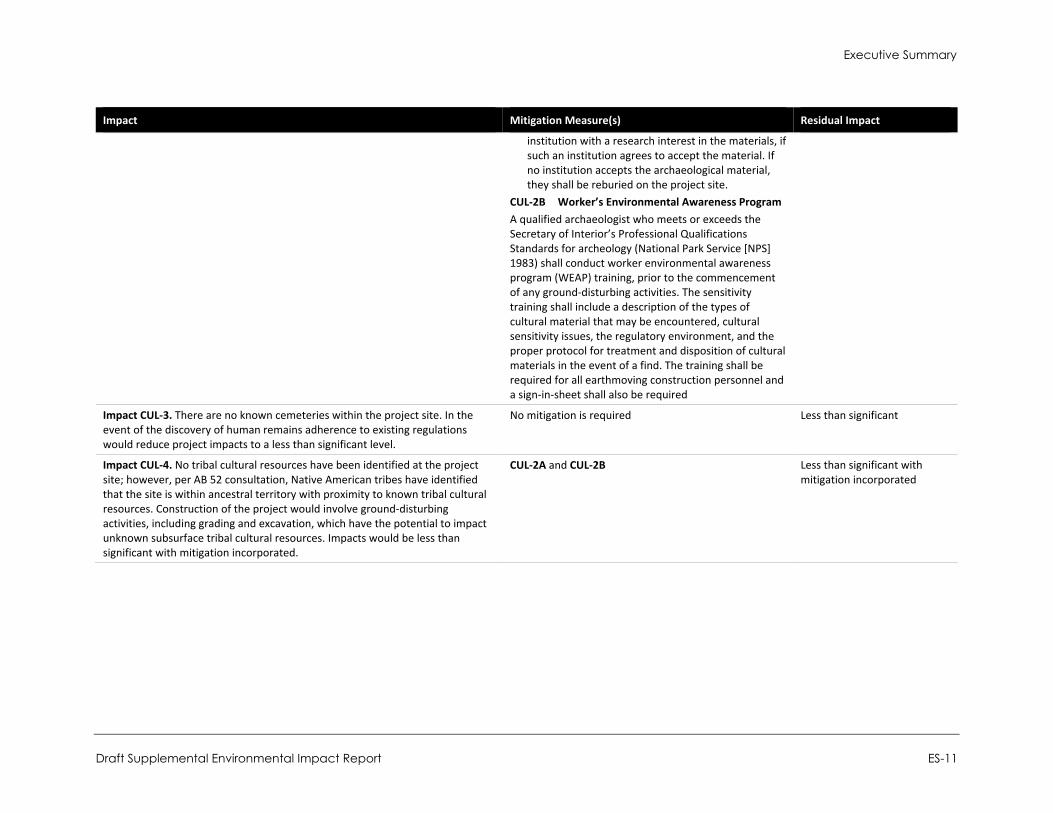
Impact CUL-3. There are no known cemeteries within the project site. In the event of the discovery of human remains adherence to existing regulations would reduce project impacts to a less than significant level.
No mitigation is required Less than significant
Impact CUL-4. No tribal cultural resources have been identified at the project site; however, per AB 52 consultation, Native American tribes have identified that the site is within ancestral territory with proximity to known tribal cultural resources. Construction of the project would involve ground-disturbing activities, including grading and excavation, which have the potential to impact unknown subsurface tribal cultural resources. Impacts would be less than significant with mitigation incorporated.
CUL-2A and CUL-2B Less than significant with mitigation incorporated

City of Fontana Ventana at Duncan Canyon Specific Plan Amendment
ES-12
Impact Mitigation Measure(s) Residual Impact
Energy
Impact E-1. The project would consume electricity, natural gas, and fuel during construction and operation. However, the project would not place significant additional demand on SCE or SCG and would comply with applicable conservation standards. Neither project construction nor operation would result in wasteful, inefficient, or unnecessary consumption of energy. Impacts would be less than significant.
No mitigation is required Less than significant
Impact E-2. Development facilitated by the project would not conflict with or obstruct an applicable renewable energy or energy efficiency plan. This impact would be less than significant.
No mitigation is required Less than significant
Geology and Soils
Impact GEO-1. The project site is not located in an Alquist-Priolo Fault Zone and no fault lines traverse directly under the site. Though there is potential for both earthquakes and groundshaking in the project area, compliance with City General Plan goals and policies and the CBC would reduce potential impacts related to seismic ground shaking to a less than significant level.
No mitigation is required Less than significant
Impact GEO-2. The project site is underlain by soils possessing moderate collapse potential and low expansive potential. However, impacts associated with soil characteristics would be less than significant with implementation of mitigation.
GEO-2 Implement Engineering Recommendations Final design for each planning area shall incorporate engineering recommendations based on site specific soil investigations, and shall consider collapsible soils, protection from corrosive soils, and other applicable soil conditions. More specifically, final design shall incorporate recommendations from the Preliminary Geological Investigation Approximately 81.1-Acre Site Duncan Canyon, City of Fontana California, prepared by Converse Consultants in September 2005, or subsequent analysis.
Less than significant with mitigation incorporated
Impact GEO-3. The project site is underlain by geologic units possessing paleontological sensitivity ranging from low to high. Potential for paleontological resources may occur during ground-disturbing activities for certain projects. Mitigation measures have been identified to reduce impacts in the event of an unanticipated discovery of paleontological resources. Impacts would be less than significant with mitigation.
GEO-3 Paleontological Monitoring Monitoring shall be conducted for excavation activities extending to estimated depths of eight feet or more below the existing ground surface. If required, the paleontologic monitor shall be equipped to salvage fossils as they are unearthed to avoid construction delays and to remove samples of sediments that are likely to contain the remains of small fossil invertebrates and vertebrates. Monitors are empowered to
Less than significant with mitigation incorporated
Executive Summary
Draft Supplemental Environmental Impact Report ES-13
Impact Mitigation Measure(s) Residual Impact
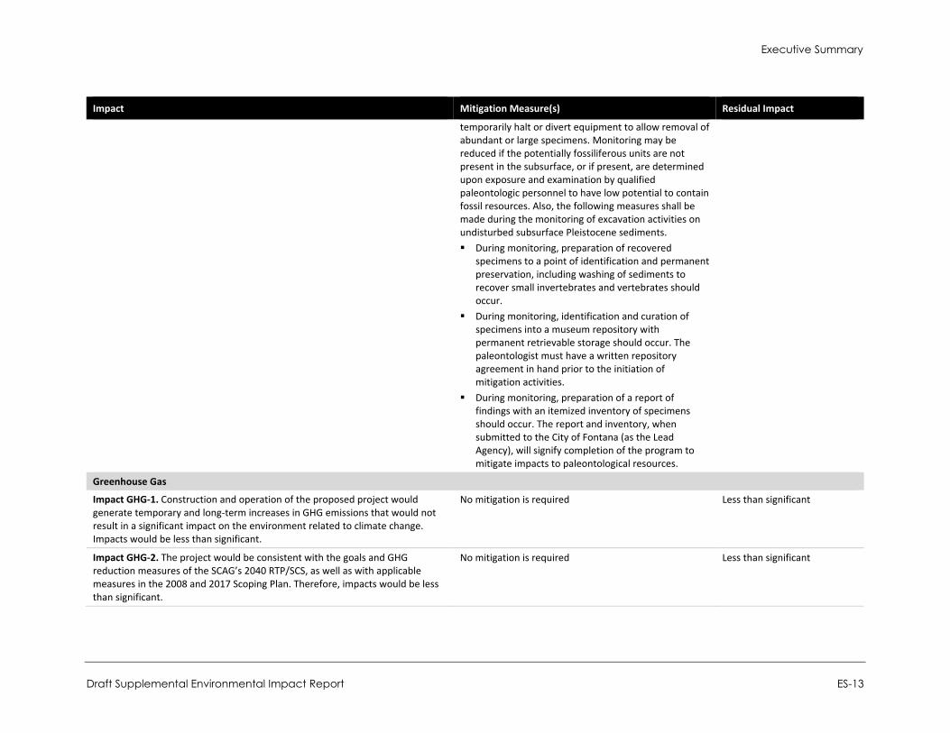
temporarily halt or divert equipment to allow removal of abundant or large specimens. Monitoring may be reduced if the potentially fossiliferous units are not present in the subsurface, or if present, are determined upon exposure and examination by qualified paleontologic personnel to have low potential to contain fossil resources. Also, the following measures shall be made during the monitoring of excavation activities on undisturbed subsurface Pleistocene sediments. During monitoring, preparation of recovered
specimens to a point of identification and permanent preservation, including washing of sediments to recover small invertebrates and vertebrates should occur.
During monitoring, identification and curation of specimens into a museum repository with permanent retrievable storage should occur. The paleontologist must have a written repository agreement in hand prior to the initiation of mitigation activities.
During monitoring, preparation of a report of findings with an itemized inventory of specimens should occur. The report and inventory, when submitted to the City of Fontana (as the Lead Agency), will signify completion of the program to mitigate impacts to paleontological resources.
Greenhouse Gas
Impact GHG-1. Construction and operation of the proposed project would generate temporary and long-term increases in GHG emissions that would not result in a significant impact on the environment related to climate change. Impacts would be less than significant.
No mitigation is required Less than significant
Impact GHG-2. The project would be consistent with the goals and GHG reduction measures of the SCAG’s 2040 RTP/SCS, as well as with applicable measures in the 2008 and 2017 Scoping Plan. Therefore, impacts would be less than significant.
No mitigation is required Less than significant
City of Fontana Ventana at Duncan Canyon Specific Plan Amendment
ES-14
Impact Mitigation Measure(s) Residual Impact
Hazards and Hazardous Materials
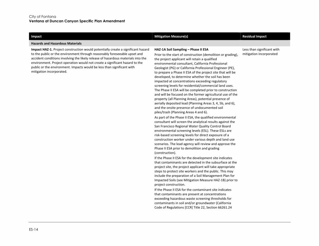
Impact HAZ-1. Project construction would potentially create a significant hazard to the public or the environment through reasonably foreseeable upset and accident conditions involving the likely release of hazardous materials into the environment. Project operation would not create a significant hazard to the public or the environment. Impacts would be less than significant with mitigation incorporated.
HAZ-1A Soil Sampling – Phase II ESA Prior to the start of construction (demolition or grading), the project applicant will retain a qualified environmental consultant, California Professional Geologist (PG) or California Professional Engineer (PE), to prepare a Phase II ESA of the project site that will be developed, to determine whether the soil has been impacted at concentrations exceeding regulatory screening levels for residential/commercial land uses. The Phase II ESA will be completed prior to construction and will be focused on the former agricultural use of the property (all Planning Areas), potential presence of aerially deposited lead (Planning Areas 3, 4, 5b, and 6), and the onsite presence of undocumented soil piles/trash (Planning Areas 4 and 6). As part of the Phase II ESA, the qualified environmental consultant will screen the analytical results against the San Francisco Regional Water Quality Control Board environmental screening levels (ESL). These ESLs are risk-based screening levels for direct exposure of a construction worker under various depth and land use scenarios. The lead agency will review and approve the Phase II ESA prior to demolition and grading (construction). If the Phase II ESA for the development site indicates that contaminants are detected in the subsurface at the project site, the project applicant will take appropriate steps to protect site workers and the public. This may include the preparation of a Soil Management Plan for Impacted Soils (see Mitigation Measure HAZ-1B) prior to project construction. If the Phase II ESA for the contaminant site indicates that contaminants are present at concentrations exceeding hazardous waste screening thresholds for contaminants in soil and/or groundwater (California Code of Regulations [CCR] Title 22, Section 66261.24
Less than significant with mitigation incorporated
Executive Summary
Draft Supplemental Environmental Impact Report ES-15
Impact Mitigation Measure(s) Residual Impact
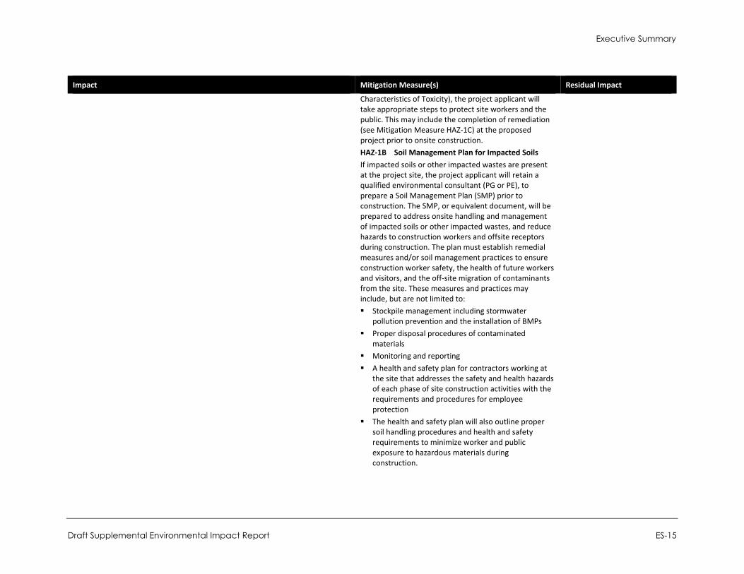
Characteristics of Toxicity), the project applicant will take appropriate steps to protect site workers and the public. This may include the completion of remediation (see Mitigation Measure HAZ-1C) at the proposed project prior to onsite construction. HAZ-1B Soil Management Plan for Impacted Soils If impacted soils or other impacted wastes are present at the project site, the project applicant will retain a qualified environmental consultant (PG or PE), to prepare a Soil Management Plan (SMP) prior to construction. The SMP, or equivalent document, will be prepared to address onsite handling and management of impacted soils or other impacted wastes, and reduce hazards to construction workers and offsite receptors during construction. The plan must establish remedial measures and/or soil management practices to ensure construction worker safety, the health of future workers and visitors, and the off-site migration of contaminants from the site. These measures and practices may include, but are not limited to: Stockpile management including stormwater
pollution prevention and the installation of BMPs Proper disposal procedures of contaminated
materials Monitoring and reporting A health and safety plan for contractors working at
the site that addresses the safety and health hazards of each phase of site construction activities with the requirements and procedures for employee protection
The health and safety plan will also outline proper soil handling procedures and health and safety requirements to minimize worker and public exposure to hazardous materials during construction.
City of Fontana Ventana at Duncan Canyon Specific Plan Amendment
ES-16
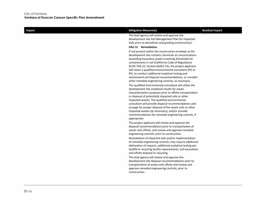
Impact Mitigation Measure(s) Residual Impact
The lead agency will review and approve the development site Soil Management Plan for Impacted Soils prior to demolition and grading (construction). HAZ-1C Remediation If soil present within the construction envelope at the development site contains chemicals at concentrations exceeding hazardous waste screening thresholds for contaminants in soil (California Code of Regulations [CCR] Title 22, Section 66261.24), the project applicant will retain a qualified environmental consultant (PG or PE), to conduct additional analytical testing and recommend soil disposal recommendations, or consider other remedial engineering controls, as necessary. The qualified environmental consultant will utilize the development site analytical results for waste characterization purposes prior to offsite transportation or disposal of potentially impacted soils or other impacted wastes. The qualified environmental consultant will provide disposal recommendations and arrange for proper disposal of the waste soils or other impacted wastes (as necessary), and/or provide recommendations for remedial engineering controls, if appropriate. The project applicant will review and approve the disposal recommendations prior to transportation of waste soils offsite, and review and approve remedial engineering controls, prior to construction. Remediation of impacted soils and/or implementation of remedial engineering controls, may require additional delineation of impacts; additional analytical testing per landfill or recycling facility requirements; soil excavation; and offsite disposal or recycling. The lead agency will review and approve the development site disposal recommendations prior to transportation of waste soils offsite and review and approve remedial engineering controls, prior to construction.
Executive Summary
Draft Supplemental Environmental Impact Report ES-17
Impact Mitigation Measure(s) Residual Impact
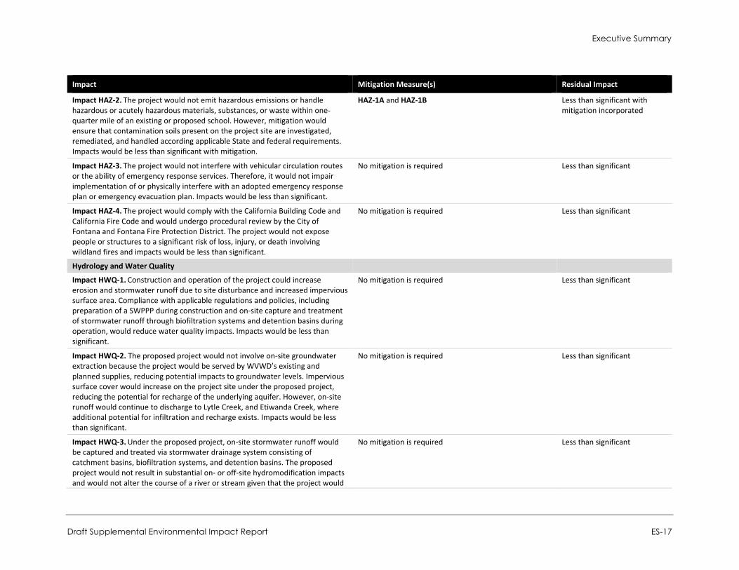
Impact HAZ-2. The project would not emit hazardous emissions or handle hazardous or acutely hazardous materials, substances, or waste within one-quarter mile of an existing or proposed school. However, mitigation would ensure that contamination soils present on the project site are investigated, remediated, and handled according applicable State and federal requirements. Impacts would be less than significant with mitigation.
HAZ-1A and HAZ-1B Less than significant with mitigation incorporated
Impact HAZ-3. The project would not interfere with vehicular circulation routes or the ability of emergency response services. Therefore, it would not impair implementation of or physically interfere with an adopted emergency response plan or emergency evacuation plan. Impacts would be less than significant.
No mitigation is required Less than significant
Impact HAZ-4. The project would comply with the California Building Code and California Fire Code and would undergo procedural review by the City of Fontana and Fontana Fire Protection District. The project would not expose people or structures to a significant risk of loss, injury, or death involving wildland fires and impacts would be less than significant.
No mitigation is required Less than significant
Hydrology and Water Quality
Impact HWQ-1. Construction and operation of the project could increase erosion and stormwater runoff due to site disturbance and increased impervious surface area. Compliance with applicable regulations and policies, including preparation of a SWPPP during construction and on-site capture and treatment of stormwater runoff through biofiltration systems and detention basins during operation, would reduce water quality impacts. Impacts would be less than significant.
No mitigation is required Less than significant
Impact HWQ-2. The proposed project would not involve on-site groundwater extraction because the project would be served by WVWD’s existing and planned supplies, reducing potential impacts to groundwater levels. Impervious surface cover would increase on the project site under the proposed project, reducing the potential for recharge of the underlying aquifer. However, on-site runoff would continue to discharge to Lytle Creek, and Etiwanda Creek, where additional potential for infiltration and recharge exists. Impacts would be less than significant.
No mitigation is required Less than significant
Impact HWQ-3. Under the proposed project, on-site stormwater runoff would be captured and treated via stormwater drainage system consisting of catchment basins, biofiltration systems, and detention basins. The proposed project would not result in substantial on- or off-site hydromodification impacts and would not alter the course of a river or stream given that the project would
No mitigation is required Less than significant
City of Fontana Ventana at Duncan Canyon Specific Plan Amendment
ES-18
Impact Mitigation Measure(s) Residual Impact
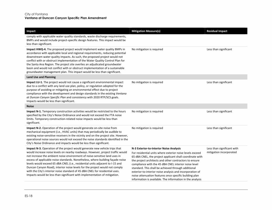
comply with applicable water quality standards, waste discharge requirements, BMPs and would include project-specific design features. This impact would be less than significant.
Impact HWQ-4. The proposed project would implement water quality BMPs in accordance with applicable local and regional requirements, reducing potential downstream water quality impacts. As such, the proposed project would not conflict with or obstruct implementation of the Water Quality Control Plan for the Santa Ana Region. The project site overlies an adjudicated groundwater basin and would not conflict with or obstruct implementation of a sustainable groundwater management plan. This impact would be less than significant.
No mitigation is required Less than significant
Land Use and Planning
Impact LU-1. The project would not cause a significant environmental impact due to a conflict with any land use plan, policy, or regulation adopted for the purpose of avoiding or mitigating an environmental effect due to project compliance with the development and design standards in the existing Ventana at Duncan Canyon Specific Plan and consistency with 2020 RTP/SCS goals. Impacts would be less than significant.
No mitigation is required Less than significant
Noise
Impact N-1. Temporary construction activities would be restricted to the hours specified by the City’s Noise Ordinance and would not exceed the FTA noise limits. Temporary construction-related noise impacts would be less than significant.
No mitigation is required Less than significant
Impact N-2. Operation of the project would generate on-site noise from mechanical equipment (i.e., HVAC units) that may periodically be audible to existing noise-sensitive receivers in the vicinity and on the project site. However, operational noise sources would not exceed the noise standards identified in the City’s Noise Ordinance and impacts would be less than significant.
No mitigation is required Less than significant
Impact N-3. Operation of the project would generate new vehicle trips that would increase noise levels on nearby roadways. However, project traffic would not increase the ambient noise environment of noise-sensitive land uses in excess of applicable noise standards. Nonetheless, where building façade noise levels would exceed 65 dBA CNEL (i.e., residential units adjacent to I-15 and Duncan Canyon Road), interior noise levels for the project would not comply with the City’s interior noise standard of 45 dBA CNEL for residential uses. Impacts would be less than significant with implementation of mitigation.
N-3 Exterior-to-Interior Noise Analysis For residential units where exterior noise levels exceed 65 dBA CNEL, the project applicant shall coordinate with the project architects and other contractors to ensure compliance with the 45 dBA CNEL interior noise level standard. This shall be achieved through additional exterior-to-interior noise analysis and incorporation of noise attenuation features once specific building plan information is available. The information in the analysis
Less than significant with mitigation incorporated
Executive Summary
Draft Supplemental Environmental Impact Report ES-19
Impact Mitigation Measure(s) Residual Impact
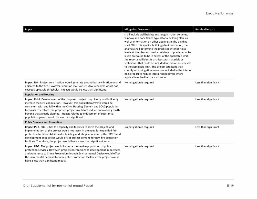
shall include wall heights and lengths, room volumes, window and door tables typical for a building plan, as well as information on other openings in the building shell. With this specific building plan information, the analysis shall determine the predicted interior noise levels at the planned on-site buildings. If predicted noise levels are found to be in excess of the applicable limit, the report shall identify architectural materials or techniques that could be included to reduce noise levels to the applicable limit. The project applicant shall comply with mitigation measures included in the interior noise report to reduce interior noise levels where applicable noise limits are exceeded.
Impact N-4. Project construction would generate ground-borne vibration on and adjacent to the site. However, vibration levels at sensitive receivers would not exceed applicable thresholds. Impacts would be less than significant.
No mitigation is required Less than significant
Population and Housing
Impact PH-1. Development of the proposed project may directly and indirectly increase the City’s population. However, this population growth would be consistent with and fall within the City’s Housing Element and SCAG population forecasts. Therefore, the proposed project would not induce population growth beyond that already planned. Impacts related to inducement of substantial population growth would be less than significant.
No mitigation is required Less than significant
Public Services and Recreation
Impact PS-1. SBCFD has the capacity and facilities to serve the project, and implementation of the project would not result in the need for expanded fire protection facilities. Additionally, building and site plan review by the SBCFD and development impact fees would offset project demand for new fire protection facilities. Therefore, the project would have a less than significant impact.
No mitigation is required Less than significant
Impact PS-2. The project would increase the service population of police protection services. However, project contributions to development impact fees and Adherence to Crime Prevention through Environmental Design would offset the incremental demand for new police protection facilities. The project would have a less than significant impact.
No mitigation is required Less than significant
City of Fontana Ventana at Duncan Canyon Specific Plan Amendment
ES-20
Impact Mitigation Measure(s) Residual Impact
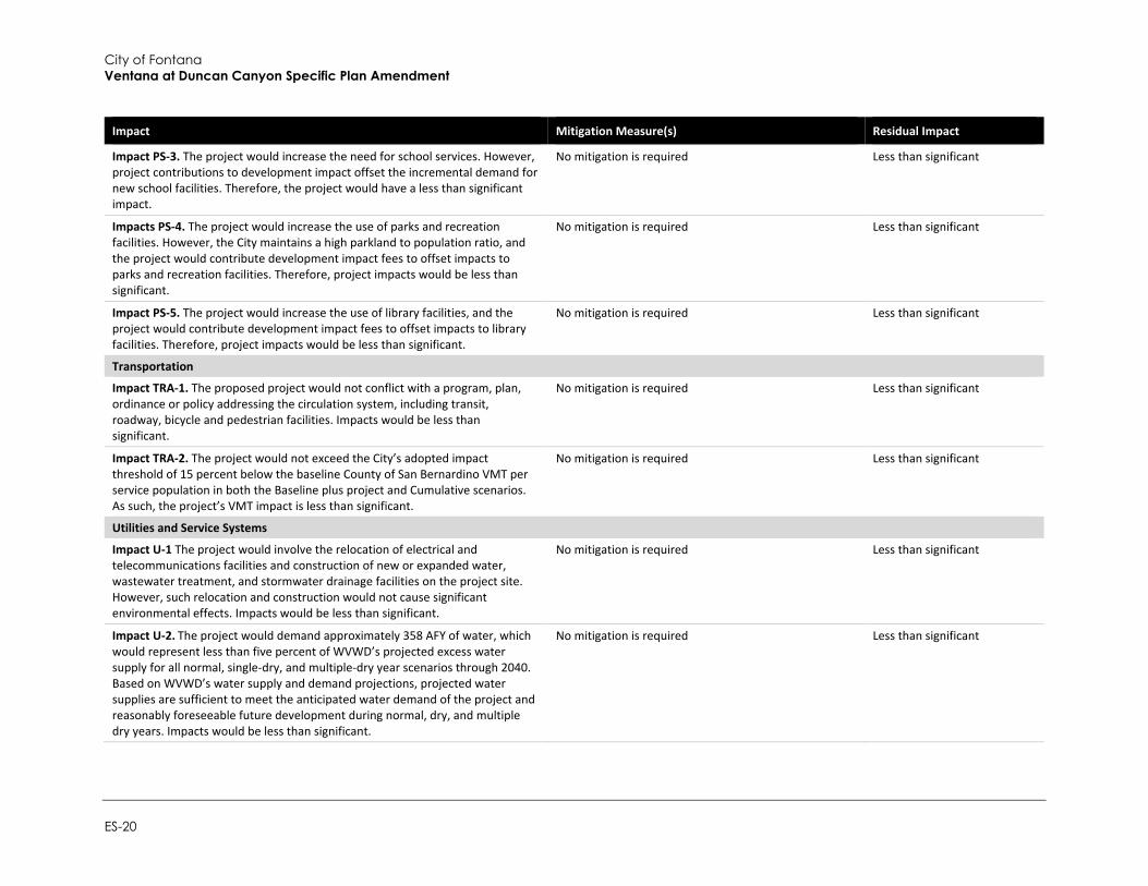
Impact PS-3. The project would increase the need for school services. However, project contributions to development impact offset the incremental demand for new school facilities. Therefore, the project would have a less than significant impact.
No mitigation is required Less than significant
Impacts PS-4. The project would increase the use of parks and recreation facilities. However, the City maintains a high parkland to population ratio, and the project would contribute development impact fees to offset impacts to parks and recreation facilities. Therefore, project impacts would be less than significant.
No mitigation is required Less than significant
Impact PS-5. The project would increase the use of library facilities, and the project would contribute development impact fees to offset impacts to library facilities. Therefore, project impacts would be less than significant.
No mitigation is required Less than significant
Transportation
Impact TRA-1. The proposed project would not conflict with a program, plan, ordinance or policy addressing the circulation system, including transit, roadway, bicycle and pedestrian facilities. Impacts would be less than significant.
No mitigation is required Less than significant
Impact TRA-2. The project would not exceed the City’s adopted impact threshold of 15 percent below the baseline County of San Bernardino VMT per service population in both the Baseline plus project and Cumulative scenarios. As such, the project’s VMT impact is less than significant.
No mitigation is required Less than significant
Utilities and Service Systems
Impact U-1 The project would involve the relocation of electrical and telecommunications facilities and construction of new or expanded water, wastewater treatment, and stormwater drainage facilities on the project site. However, such relocation and construction would not cause significant environmental effects. Impacts would be less than significant.
No mitigation is required Less than significant
Impact U-2. The project would demand approximately 358 AFY of water, which would represent less than five percent of WVWD’s projected excess water supply for all normal, single-dry, and multiple-dry year scenarios through 2040. Based on WVWD’s water supply and demand projections, projected water supplies are sufficient to meet the anticipated water demand of the project and reasonably foreseeable future development during normal, dry, and multiple dry years. Impacts would be less than significant.
No mitigation is required Less than significant
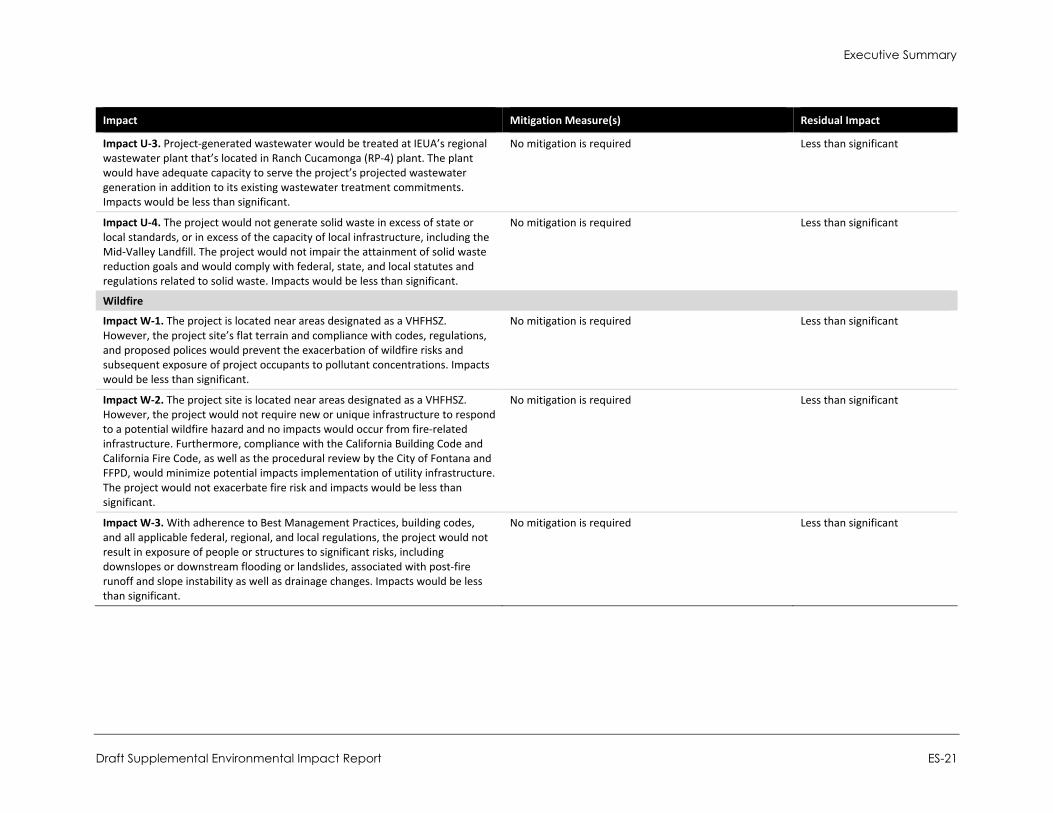
Executive Summary
Draft Supplemental Environmental Impact Report ES-21
Impact Mitigation Measure(s) Residual Impact
Impact U-3. Project-generated wastewater would be treated at IEUA’s regional wastewater plant that’s located in Ranch Cucamonga (RP-4) plant. The plant would have adequate capacity to serve the project’s projected wastewater generation in addition to its existing wastewater treatment commitments. Impacts would be less than significant.
No mitigation is required Less than significant
Impact U-4. The project would not generate solid waste in excess of state or local standards, or in excess of the capacity of local infrastructure, including the Mid-Valley Landfill. The project would not impair the attainment of solid waste reduction goals and would comply with federal, state, and local statutes and regulations related to solid waste. Impacts would be less than significant.
No mitigation is required Less than significant
Wildfire
Impact W-1. The project is located near areas designated as a VHFHSZ. However, the project site’s flat terrain and compliance with codes, regulations, and proposed polices would prevent the exacerbation of wildfire risks and subsequent exposure of project occupants to pollutant concentrations. Impacts would be less than significant.
No mitigation is required Less than significant
Impact W-2. The project site is located near areas designated as a VHFHSZ. However, the project would not require new or unique infrastructure to respond to a potential wildfire hazard and no impacts would occur from fire-related infrastructure. Furthermore, compliance with the California Building Code and California Fire Code, as well as the procedural review by the City of Fontana and FFPD, would minimize potential impacts implementation of utility infrastructure. The project would not exacerbate fire risk and impacts would be less than significant.
No mitigation is required Less than significant
Impact W-3. With adherence to Best Management Practices, building codes, and all applicable federal, regional, and local regulations, the project would not result in exposure of people or structures to significant risks, including downslopes or downstream flooding or landslides, associated with post-fire runoff and slope instability as well as drainage changes. Impacts would be less than significant.
No mitigation is required Less than significant
City of Fontana Ventana at Duncan Canyon Specific Plan Amendment
ES-22
This page intentionally left blank.
Introduction
Draft Supplemental Environmental Impact Report 1-1
Introduction
This document is a Supplemental Environmental Impact Report (SEIR) for the Ventana at Duncan Canyon Specific Plan Amendment (hereafter referred to as “proposed project” or “project”). The proposed project includes a request for a modification to the Ventana at Duncan Canyon Specific Plan (hereafter referred to as “existing Specific Plan”), originally approved by the City of Fontana on March 27, 2007. The existing Specific Plan was established in March 2007 to create a unique master planned development that captured the City’s vision for the “Regional Mixed Use” zoning classification in northern Fontana, and the City’s vision for a “Corporate Corridor” along Interstate 15 (I-15). The proposed project includes a comprehensive Specific Plan Amendment to modify and update the overall development plan to reflect current planning and market demands. The project re-envisions the project site with six Planning Areas.
The project would include the development of up to 476,500 square feet (sf) of commercial uses, 1,671 dwelling units in three separate residential villages with accompanying amenities, a focal point piazza (public square), and the construction of the realigned Lytle Creek Road, on an approximately 102-acre site.
The proposed project would have many of the same features as envisioned under the existing Specific Plan, including residential villages, commercial uses, a focal point piazza, a campanile tower feature, and the construction of Lytle Creek Road through the project site.
The greatest difference between the existing Specific Plan and the proposed project is the overall increase of 1,671 residential units compared to 842 residential units under the existing Specific Plan. This increase of 829 units represents an increase of 98 percent, or nearly double the residential units. The additional units are accommodated via an increase in density from 15.0 to 25.9 units per acre, as well as a small increase in residential acreage of 8.6 acres (15 percent). In addition, the total commercial area would be reduced by 98,000 sf (17 percent), from 574,500 sf under the existing Specific Plan, to 476,500 sf for the proposed project.
This section discusses (1) the project and SEIR background; (2) the legal basis for preparing an EIR; (3) the scope and content of the SEIR; (4) issue areas found not to be significant by the Initial Study; (5) the lead, responsible, and trustee agencies; and (6) the environmental review process required under the California Environmental Quality Act (CEQA). The proposed project is described in detail in Section 2, Project Description.
1.1 Notice of Preparation and Scoping The City of Fontana issued a Notice of Preparation (NOP) of an EIR in October 2021. The NOP also included notice of a scoping meeting for the proposed EIR and provided a link to the Initial Study prepared for the project on the City’s website.
The City of Fontana distributed the NOP for a 30-day agency and public review period starting on October 20, 2021 and ending on November 19, 2021. The City held a Scoping Meeting on October 27, 2021 from 5:00 p.m. to 6:00 p.m. via an on-line meeting. The meeting included a presentation providing information about the proposed project and the CEQA process to members of public agencies, interested stakeholders and residents/community members, and invited comments and questions. Approximately eight parties participated in the scoping meeting, including planning staff from the City of Rancho Cucamonga.
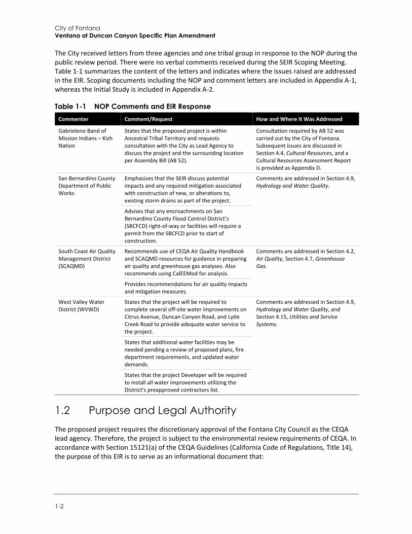
City of Fontana Ventana at Duncan Canyon Specific Plan Amendment
1-2
The City received letters from three agencies and one tribal group in response to the NOP during the public review period. There were no verbal comments received during the SEIR Scoping Meeting. Table 1-1 summarizes the content of the letters and indicates where the issues raised are addressed in the EIR. Scoping documents including the NOP and comment letters are included in Appendix A-1, whereas the Initial Study is included in Appendix A-2.
Table 1-1 NOP Comments and EIR Response Commenter Comment/Request How and Where It Was Addressed
Gabrieleno Band of Mission Indians – Kizh Nation
States that the proposed project is within Ancestral Tribal Territory and requests consultation with the City as Lead Agency to discuss the project and the surrounding location per Assembly Bill (AB 52).
Consultation required by AB 52 was carried out by the City of Fontana. Subsequent issues are discussed in Section 4.4, Cultural Resources, and a Cultural Resources Assessment Report is provided as Appendix D.
San Bernardino County Department of Public Works
Emphasizes that the SEIR discuss potential impacts and any required mitigation associated with construction of new, or alterations to, existing storm drains as part of the project.
Comments are addressed in Section 4.9, Hydrology and Water Quality.
Advises that any encroachments on San Bernardino County Flood Control District’s (SBCFCD) right-of-way or facilities will require a permit from the SBCFCD prior to start of construction.
South Coast Air Quality Management District (SCAQMD)
Recommends use of CEQA Air Quality Handbook and SCAQMD resources for guidance in preparing air quality and greenhouse gas analyses. Also recommends using CalEEMod for analysis.
Comments are addressed in Section 4.2, Air Quality, Section 4.7, Greenhouse Gas.
Provides recommendations for air quality impacts and mitigation measures.
West Valley Water District (WVWD)
States that the project will be required to complete several off-site water improvements on Citrus Avenue, Duncan Canyon Road, and Lytle Creek Road to provide adequate water service to the project.
Comments are addressed in Section 4.9, Hydrology and Water Quality, and Section 4.15, Utilities and Service Systems.
States that additional water facilities may be needed pending a review of proposed plans, fire department requirements, and updated water demands.
States that the project Developer will be required to install all water improvements utilizing the District’s preapproved contractors list.
1.2 Purpose and Legal Authority The proposed project requires the discretionary approval of the Fontana City Council as the CEQA lead agency. Therefore, the project is subject to the environmental review requirements of CEQA. In accordance with Section 15121(a) of the CEQA Guidelines (California Code of Regulations, Title 14), the purpose of this EIR is to serve as an informational document that:
Introduction
Draft Supplemental Environmental Impact Report 1-3
...will inform public agency decision makers and the public generally of the significant environmental effect of a project, identify possible ways to minimize the significant effects, and describe reasonable alternatives to the project.
This EIR has been prepared as a SEIR pursuant to Section 15163 of the CEQA Guidelines. A SEIR is an appropriate CEQA document rather than a subsequent EIR if any of the conditions for a subsequent EIR are met, but only minor additions or changes would be necessary to make the previous EIR adequate for the project in the changed situation. As stated in the CEQA Guidelines Sections 15162 and 15163, a supplement to an EIR may be distinguished from a subsequent EIR. A supplement augments a previously certified EIR to the extent necessary to address the conditions described in Section 15162, and to examine mitigation and project alternatives accordingly. It is intended to revise the previous EIR through supplementation.
This SEIR serves as an informational document for the public, City of Fontana decision-makers and any responsible agencies. Prior to making a decision on the project itself, the Fontana City Council will be required to certify that the Final SEIR has been completed in compliance with CEQA; the City Council has reviewed and considered the information contained in the Final SEIR; and the Final SEIR reflects, as the lead agency, the City Council’s independent judgment and analysis.
1.3 Scope and Content
1.3.1 Drafting of Supplemental EIR As stated in Section 1.2, Purpose and Legal Authority, an SEIR will be prepared for this project. A description of this CEQA documentation option and reasoning for its selection is described below.
Environmental Impact Review Determination Following Initial Study CEQA Guidelines, Section 15063 (b)(1) states that if the lead agency determines that there is substantial evidence that any aspect of the project, either individually or cumulatively, may cause a significant effect on the environment, regardless of whether the overall effect of the project is adverse or beneficial, the lead agency shall do one of the following:
a. Prepare an EIR, or b. Use a previously prepared EIR which the Lead Agency determines would adequately analyze the
project at hand, or c. Determine, pursuant to a program EIR, tiering, or another appropriate process, which of a
project’s effects were adequately examined by an earlier EIR or negative declaration. Another appropriate process may include, for example, a master EIR, a master environmental assessment, approval of housing and neighborhood commercial facilities in urban areas, approval of residential projects pursuant to a specific plan described in Section 15182, approval of residential projects consistent with a community plan, general plan or zoning as described in Section 15183, or an environmental document prepared under a State certified regulatory program. The lead agency shall then ascertain which effects, if any, should be analyzed in a later EIR or negative declaration.
The Initial Study determined the following issues could include potentially significant impacts or are areas of public concern and are therefore studied in the SEIR:
City of Fontana Ventana at Duncan Canyon Specific Plan Amendment
1-4
Aesthetics Air Quality Biological Resources Cultural Resources Energy Geology and Soil Greenhouse Gas Emissions Hazards and Hazardous Materials Hydrology and Water Quality
Land use and Planning Noise Population and Housing Public Services Recreation Transportation Tribal Cultural Resources Utilities and Service Systems Wildfire
In preparing the SEIR, use was made of pertinent City policies and guidelines, certified EIRs and adopted CEQA documents, and other background documents. A full reference list is contained in Section 7, References, of the SEIR.
The alternatives section of the SEIR (Section 6) was prepared in accordance with Section 15126.6 of the CEQA Guidelines and focuses on alternatives that are capable of eliminating or reducing significant adverse effects associated with the project while feasibly attaining most of the basic project objectives. In addition, the alternatives section identifies the “environmentally superior” alternative among the alternatives assessed. The alternatives evaluated include the CEQA-required “No Project” alternative and three alternative development scenarios for the project area.
Supplemental EIR The CEQA Guidelines provide for preparation of a supplemental EIR in appropriate circumstances, as follows:
(a) The Lead or Responsible Agency may choose to prepare a supplement to an EIR rather than a subsequent EIR if: (1) Any of the conditions described in Section 15162 would require the preparation of a
subsequent EIR, and (2) Only minor additions or changes would be necessary to make the previous EIR
adequately apply to the project in the changed situation.
(b) The supplement to the EIR need contain only the information necessary to make the previous EIR adequate for the project as revised.
(c) A supplement to an EIR shall be given the same kind of notice and public review as is given to a draft EIR under Section 15087.
(d) A supplement to an EIR may be circulated by itself without recirculating the previous draft or final EIR.
(e) When the agency decides whether to approve the project, the decision-making body shall consider the previous EIR as revised by the supplemental EIR. A finding under Section 15091 shall be made for each significant effect shown in the previous EIR as revised.
The level of detail contained throughout this SEIR is consistent with the requirements of CEQA and applicable court decisions. Section 15151 of the CEQA Guidelines provides the standard of adequacy on which this document is based:

Introduction
Draft Supplemental Environmental Impact Report 1-5
An EIR should be prepared with a sufficient degree of analysis to provide decision makers with information which enables them to make a decision which intelligently takes account of environmental consequences. An evaluation of the environmental effects of the proposed project need not be exhaustive, but the sufficiency of an EIR is to be reviewed in light of what is reasonably feasible. Disagreement among experts does not make an EIR inadequate, but the EIR should summarize the main points of disagreement among the experts. The courts have looked not for perfection, but for adequacy, completeness, and a good faith effort at full disclosure.
1.4 Issues Not Studied in Detail in the SEIR Table 1-2 summarizes issues from the environmental checklist that were addressed in the Initial Study (Appendix A-2). As indicated in the Initial Study, there is no substantial evidence that significant impacts would occur in any of these issues.
Table 1-2 Issues Not Studied in the SEIR Topic Subtopic
Aesthetics Substantially damage scenic resources, including but not limited to, trees, rock outcroppings, and historic buildings within a State scenic highway
Agricultural Resources Convert Prime Farmland, Unique Farmland, or Farmland of Statewide Importance (Farmland) to non-agricultural use
Agricultural Resources Conflict with existing zoning for agricultural use or a Williamson Act contract
Agricultural Resources Conflict with existing zoning for, or cause rezoning of, forest land; timberland; or timberland zoned Timberland Production
Agricultural Resources Result in the loss of forest land or conversion of forest land to non-forest use
Agricultural Resources Involve other changes in the existing environment which could result in conversion of Farmland to non-agricultural use or conversion of forest land to non-forest use
Air Quality Result in other emissions (such as those leading to odors) adversely affecting a substantial number of people
Geology and Soils Cause substantial adverse effects, including the risk of loss, injury, or death involving seismic-related ground failure, including liquefaction
Geology and Soils Cause potential substantial adverse effects, including the risk of loss, injury, or death involving landslides
Geology and Soils Result in substantial soil erosion or the loss of topsoil
Geology and Soils Be located on a geologic unit or soil that is unstable, or that would become unstable as a result of the project, and potentially result in on- or off-site landslide, lateral spreading, subsidence, liquefaction, or collapse
Geology and Soils Have soils incapable of adequately supporting the use of septic tanks or alternative wastewater disposal systems where sewers are not available for the disposal of wastewater
Hazards and Hazardous Materials
Create a significant hazard to the public or the environment through the routine transport, use, or disposal of hazardous materials
Hazards and Hazardous Materials
Be located on a site that is included on a list of hazardous material sites compiled pursuant to Government Code Section 65962.5 and, as a result, would it create a significant hazard to the public or the environment
Hazards and Hazardous Materials
For a project located within an airport land use plan or, where such a plan has not been adopted, within two miles of a public airport or public use airport, result in a safety hazard or excessive noise for people residing or working in the project area
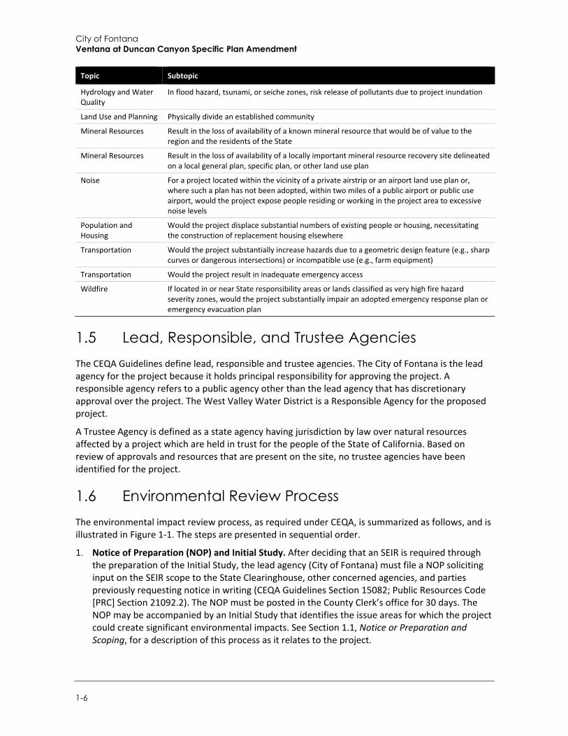
City of Fontana Ventana at Duncan Canyon Specific Plan Amendment
1-6
Topic Subtopic
Hydrology and Water Quality
In flood hazard, tsunami, or seiche zones, risk release of pollutants due to project inundation
Land Use and Planning Physically divide an established community
Mineral Resources Result in the loss of availability of a known mineral resource that would be of value to the region and the residents of the State
Mineral Resources Result in the loss of availability of a locally important mineral resource recovery site delineated on a local general plan, specific plan, or other land use plan
Noise For a project located within the vicinity of a private airstrip or an airport land use plan or, where such a plan has not been adopted, within two miles of a public airport or public use airport, would the project expose people residing or working in the project area to excessive noise levels
Population and Housing
Would the project displace substantial numbers of existing people or housing, necessitating the construction of replacement housing elsewhere
Transportation Would the project substantially increase hazards due to a geometric design feature (e.g., sharp curves or dangerous intersections) or incompatible use (e.g., farm equipment)
Transportation Would the project result in inadequate emergency access
Wildfire If located in or near State responsibility areas or lands classified as very high fire hazard severity zones, would the project substantially impair an adopted emergency response plan or emergency evacuation plan
1.5 Lead, Responsible, and Trustee Agencies The CEQA Guidelines define lead, responsible and trustee agencies. The City of Fontana is the lead agency for the project because it holds principal responsibility for approving the project. A responsible agency refers to a public agency other than the lead agency that has discretionary approval over the project. The West Valley Water District is a Responsible Agency for the proposed project.
A Trustee Agency is defined as a state agency having jurisdiction by law over natural resources affected by a project which are held in trust for the people of the State of California. Based on review of approvals and resources that are present on the site, no trustee agencies have been identified for the project.
1.6 Environmental Review Process The environmental impact review process, as required under CEQA, is summarized as follows, and is illustrated in Figure 1-1. The steps are presented in sequential order.
Notice of Preparation (NOP) and Initial Study. After deciding that an SEIR is required through the preparation of the Initial Study, the lead agency (City of Fontana) must file a NOP soliciting input on the SEIR scope to the State Clearinghouse, other concerned agencies, and parties previously requesting notice in writing (CEQA Guidelines Section 15082; Public Resources Code [PRC] Section 21092.2). The NOP must be posted in the County Clerk’s office for 30 days. The NOP may be accompanied by an Initial Study that identifies the issue areas for which the project could create significant environmental impacts. See Section 1.1, Notice or Preparation and Scoping, for a description of this process as it relates to the project.
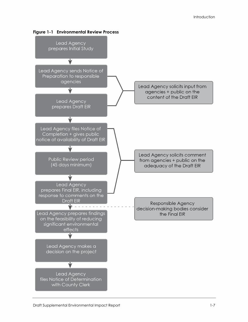
Introduction
Draft Supplemental Environmental Impact Report 1-7
Figure 1-1 Environmental Review Process
City of Fontana Ventana at Duncan Canyon Specific Plan Amendment
1-8
Draft SEIR Prepared. After the NOP and Initial Study have been circulated for public review and comment, the Draft SEIR is prepared. Per the CEQA Guidelines Sections 15122 through 15131, the Draft SEIR contains: (a) table of contents or index; (b) summary; (c) project description; (d) environmental setting; (e) discussion of significant impacts (direct, indirect, cumulative, growth-inducing, and unavoidable impacts); (f) a discussion of alternatives; (g) mitigation measures; and (h) discussion of irreversible changes. In addition, organizations and persons consulted and references used in the preparation of the SEIR are required.
Notice of Availability/Notice of Completion (NOA/NOC). The lead agency must file a NOC with the State Clearinghouse when it completes a Draft SEIR and prepare a Public NOA of a Draft SEIR. The lead agency must place the NOA in the County Clerk’s office for 30 days and send a copy of the NOA to anyone requesting it (CEQA Guidelines Section 15087; PRC Section 21092.3). Additionally, public notice of Draft SEIR availability must be given through at least one of the following procedures: (a) publication in a newspaper of general circulation; (b) posting on and off the project site; or (c) direct mailing to owners and occupants of contiguous properties. The lead agency must solicit input from other agencies and the public and respond in writing to all comments received (CEQA Guidelines Sections 15087 and 15088). The public review period for a Draft SEIR ranges from 30 to 45 days depending upon project characteristics. When a Draft SEIR is sent to the State Clearinghouse for review, the public review period must be a minimum of 45 days unless the State Clearinghouse approves a shorter period (CEQA Guidelines Section 15105; PRC Section 21091).
Final SEIR. Upon circulation and receipt of comments on the Draft SEIR, the lead agency must prepare a Final SEIR. A Final SEIR includes: (a) the Draft SEIR; (b) copies of comments received during public review; (c) list of persons and entities commenting; and (d) responses to comments, including any revisions to the text in the body of the Draft SEIR based on comments received, if applicable.
Certification of Final SEIR. Prior to making a decision on a proposed project, the lead agency must certify that: (a) the Final SEIR has been completed in compliance with CEQA; (b) the Final SEIR was presented to the decision-making body of the lead agency; and (c) the decision-making body reviewed and considered the information in the Final SEIR prior to approving a project (CEQA Guidelines Section 15090).
Lead Agency Project Decision. The lead agency may: (a) disapprove the project because of its significant environmental effects; (b) require changes to the project to reduce or avoid significant environmental effects; or (c) approve the project despite its significant environmental effects, if the proper Findings and Statement of Overriding Considerations are adopted (CEQA Guidelines Sections 15042 and 15043).
Findings/Statement of Overriding Considerations. For each significant impact of the project identified in the SEIR, the lead agency must find, based on substantial evidence, that either: (a) the project has been changed to avoid or substantially reduce the magnitude of the impact; (b) changes to the project are within another agency's jurisdiction and such changes have or should be adopted; or (c) specific economic, social, or other considerations make the mitigation measures or project alternatives infeasible (CEQA Guidelines Section 15091). If an agency approves a project with unavoidable significant environmental effects, it must prepare a written Statement of Overriding Considerations that sets forth the specific social, economic, or other reasons supporting the agency’s decision.
Mitigation Monitoring Reporting Program. When the lead agency makes Findings on significant effects identified in the SEIR, it must adopt a reporting or monitoring program for mitigation
Introduction
Draft Supplemental Environmental Impact Report 1-9
measures that were adopted or made conditions of project approval to mitigate significant effects.
Notice of Determination (NOD). The lead agency must file a NOD after deciding to approve a project for which an SEIR is prepared. A local agency must file the NOD with the County Clerk. The NOD must be posted for 30 days and sent to anyone previously requesting notice. Posting of the NOD starts a 30-day statute of limitations on CEQA legal challenges (CEQA Guidelines Section 15094).
Use of Certified Final Supplemental EIR by Responsible Agencies. Once the lead agency has certified the Final SEIR in this case, that document may be used by a CEQA Responsible Agency pursuant to CEQA Guidelines Section 15096.

City of Fontana Ventana at Duncan Canyon Specific Plan Amendment
1-10
This page intentionally left blank.
Project Description
Draft Supplemental Environmental Impact Report 2-1
2 Project Description
This section describes the Ventana at Duncan Canyon Specific Plan Amendment (hereafter referred to as “proposed project” or “project”), including the project applicant, the project site and surrounding land uses, major project characteristics, project objectives, and discretionary actions needed for approval.
2.1 Project Applicant Frontier Enterprises 2151 East Convention Center Drive, Suite 114 Ontario, California 91764
2.2 Lead Agency Contact Person Salvador Quintanilla, Associate Planner City of Fontana 8353 Sierra Avenue Fontana, California 92335 (909) 350-7625
2.3 Project Location The project site is located within the City of Fontana, east of Interstate 15 (I-15), west of Citrus Avenue, and both north and south of Duncan Canyon Road. The approximately 102-acre project site is in the northern part of the City of Fontana, within San Bernardino County, California. The project is bound by I-15 to the north and west, Citrus Avenue to the east, and a Southern California Edison (SCE) Transmission Line Corridor to the south. Figure 2-1 shows the regional context of the project site, and Figure 2-2 shows the project site in its vicinity context.
Regional access to the project site is available via I-15, which is adjacent to the site. Direct access to the project site is provided by Duncan Canyon Road, which bisects the project area to the west to the east and Citrus Avenue, which provides north and south access. Citrus Avenue currently terminates to the north at the intersection of Duncan Canyon Road, while Duncan Canyon Road terminates to the east of Citrus Avenue.
2.4 Existing Site Characteristics The project site is currently undeveloped. The project area includes five eucalyptus windrows containing approximately 185 trees, which are located on the triangular parcel north of Duncan Canyon Road. In addition, there are distribution lines located along Duncan Canyon Road and Citrus Avenue. The site is predominately flat, with a gentle slope from approximately 1,835 above mean sea level (amsl) at the northern edge of the project to approximately 1,675 amsl at the southern edge along Lytle Creek Road and I-15. The site drains from the northeast to the southwest. The project area is located on an alluvial plain formed by Lytle Creek, which is the primary collector for a significant watershed that includes large portions of the San Gabriel Mountains to the north.
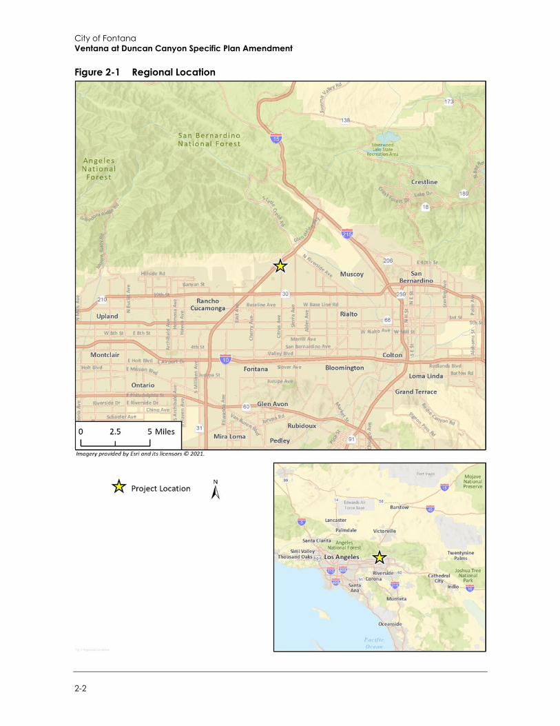
City of Fontana Ventana at Duncan Canyon Specific Plan Amendment
2-2
Figure 2-1 Regional Location
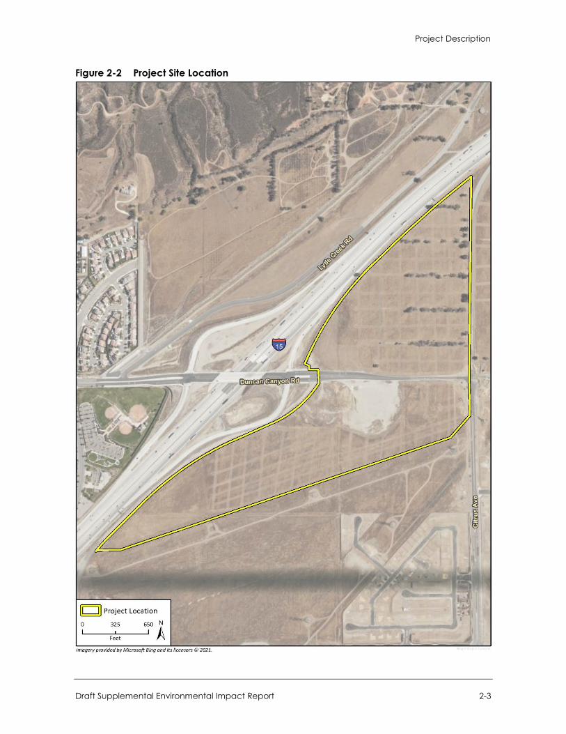
Project Description
Draft Supplemental Environmental Impact Report 2-3
Figure 2-2 Project Site Location

City of Fontana Ventana at Duncan Canyon Specific Plan Amendment
2-4
2.5 Existing Land Use Designation and Zoning The City’s Zoning District map designates the project area as the Ventana at Duncan Canyon Specific Plan (i.e., existing Specific Plan). According to the City’s General Plan Land Use Map, the existing Specific Plan area has two designations of General Commercial (C-G) and Multi Family Residential (R-MF). The C-G designation land use designation generally allows a 0.1-1.0 Floor Area Ratio (FAR) for commercial uses and the R-MF land use designation generally allows 12.1-24 dwelling units per acre (du/ac). Areas designated C-G include retail, malls, wholesale, auto dealerships and offices, including medical offices and clinics, that can serve a broader, regional population. Areas designated R-MF include multi-family developments, from duplexes and townhouses to condos and rental apartments with required amenities.
The existing Specific Plan allows for the following uses:
Medium Density Residential (MDR) Medium-High Density Residential (MHDR)
Commercial (C) Mixed Use (MU)
Areas designated Commercial include retail, restaurant, hotel, office, research and development, and light manufacturing, and included up to 462,500 square feet of development. Areas designated Mixed Use include retail, restaurant, office, and residential, and included up to 112,000 square feet of commercial development and 45 dwelling units. Areas designated Medium Density Residential or Medium-High Density Residential include up to 797 dwelling units.
2.6 Project Setting and Surrounding Land Uses Figure 2-3 shows the project site and surrounding land uses, which is currently undeveloped. Surrounding land uses include neighboring specific plan areas such as Arboretum (east), Summit at Rosena (southeast), Citrus Heights North (south), Westgate (southwest), Hunter’s Ridge (southwest), and Coyote Canyon (west). Both the Arboretum and Citrus Heights feature residential development near the Plan area. Other surrounding land uses include the following:
Land to the north and northeast is vacant. Coyote Canyon Park is located west of, and adjacent to I-15, south of Duncan Canyon Road. Vacant and residential uses are located to the east of the project site. Land to the south is vacant. I-15 and the Duncan Canyon Road interchange is adjacent to the northwestern project
boundary. An SCE transmission line corridor is adjacent to the southeaster project boundary.
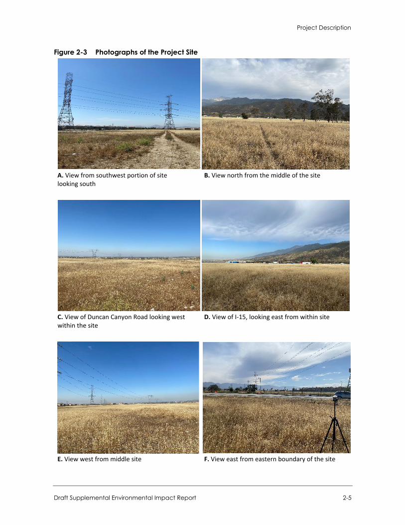
Project Description
Draft Supplemental Environmental Impact Report 2-5
Figure 2-3 Photographs of the Project Site
A. View from southwest portion of site looking south
B. View north from the middle of the site
C. View of Duncan Canyon Road looking west within the site
D. View of I-15, looking east from within site
E. View west from middle site F. View east from eastern boundary of the site
City of Fontana Ventana at Duncan Canyon Specific Plan Amendment
2-6
2.7 Existing Specific Plan Characteristics The existing Specific Plan was established in March 2007 to create a unique master planned development that captured the City’s vision for the “Regional Mixed Use” zoning classification in northern Fontana, and the City’s vision for a Corporate Corridor along I-15. Ten distinct development areas, designated as “Planning Areas,” were established to implement the goals and objectives of the Specific Plan.
The ten Planning Areas consisted of four types of land use designations including Commercial, Mixed Use, Medium Density Residential, and Medium-High Density Residential, as discussed in Section 2.5. The existing Specific Plan included the development of up to 574,500 square feet of commercial uses; 842 dwelling units in three separate residential villages; a Corporate Office Corridor, including mid-rise office buildings, a multi-story hotel, quality business restaurants; a focal point “Piazza;” a “campanile” tower feature; pedestrian corridors and bridges; and the construction of the realigned Lytle Creek Road on a 105-acre project site.
The Final EIR for the Ventana at Duncan Canyon Specific Plan (State Clearinghouse No. 2005111048) was certified and the project approved by the City of Fontana on March 27, 2007.
2.8 Proposed Project Land Use Plan The proposed project includes a General Plan Amendment (GPA 21-0006) to remove the existing Multi Family Residential (R-MF) land use designation, modify the locations of the existing Commercial (C-G) land use designation, and add the Regional Mixed Use (RMU) and Residential Multi Family Medium/High (R-MFMH) land use designations for consistency with the proposed Specific Plan Amendment (SPA 21-001). The proposed Specific Plan Amendment includes a comprehensive modification and update to the overall development plan under the existing Specific Plan to reflect current planning and market demands. The project also re-envisions the project site with six Planning Areas (PA) instead of ten when compared to the existing Specific Plan, involving the following uses described in Table 2-1 and shown as PA1 through PA6 in Figure 2-4. Notably, the Specific Plan Amendment includes a change from Medium-High Density Residential (MHDR) to High Density Residential (HDR). In reference to Figure 2.0-4, areas designated “AR” and “BR” consist of arterial roads and backbone roads, respectively.
Table 2-1 Land Use Descriptions Use Description
Medium Density Residential (MDR) Areas designated MDR include up to 538 dwelling units at a maximum of 26 du/ac, amenities, and open space.
High Density Residential (HDR) Areas designated HDR include up to 396 dwelling units at a maximum of 30 du/ac, amenities, and open space.
Mixed-Use (MU) Areas designated for MU include up to 600 dwelling units at a maximum of 24 du/ac; commercial uses including restaurants, retail, office space up to 104,000 square feet, and amenities.
Commercial (COM) Areas designated for COM include up to a total of 344,000 square feet. The southernmost COM area is a remainder space between Lytle Creek Road and the SCE Transmission Line Corridor and would be integrated with future improvements within the SCE Transmission Line Corridor that runs along the southern edge of the Plan Area.
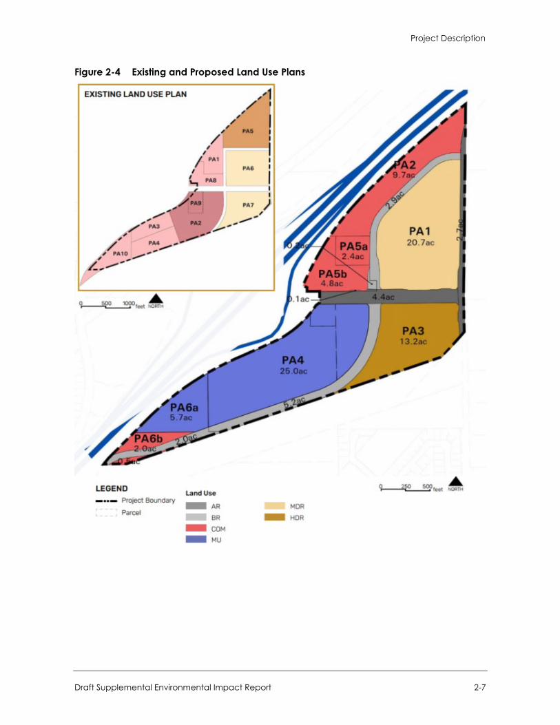
Project Description
Draft Supplemental Environmental Impact Report 2-7
Figure 2-4 Existing and Proposed Land Use Plans

City of Fontana Ventana at Duncan Canyon Specific Plan Amendment
2-8
Notably, development of PA6, as identified under the existing Specific Plan (identified as PA1 under the Specific Plan Amendment), was recently reviewed as part of an addendum to the 2007 EIR and was approved by the City in September 2021. This area of the project site is already under construction at the time of this writing. Nonetheless, proposed development (i.e., up to 538 residential units) within this PA is still incorporated into the impact analysis in this Draft SEIR for a conservative view of impacts associated with full buildout of the Specific Plan Amendment.
The proposed project would include the development of up to 476,500 square feet of commercial uses, 1,671 dwelling units in three separate residential villages, a focal point piazza (public square), and the construction of the realigned Lytle Creek Road, on an approximately 102-acre site. Table 2-2 provides a breakdown of proposed land use by planning area.
Table 2-2 Proposed Land Use Summary Plan Area Use Acres Dwelling Units Gross Floor Area (sf)
1 Medium Density Residential 20.7 538 –
2 Commercial 9.7 – 180,000
3 High Density Residential 13.2 396 –
4 Mixed Use 25.0 600 104,000
5a Commercial 2.4 – 60,000
5b Commercial 4.8 – 32,500
6a Mixed Use 5.7 1371 74,000
6b Commercial 2.5 – 26,000
Arterial Roads 7.2 – –
Backbone Roads 10.3 – –
Total 101.5 1,671 476,500
sf = square feet 1 Dwelling units in PA6 are allotted as “non-applicant” units. While the total number of units analyzed herein is 1,671, the total number of units classified as “applicant” units are 1,534.
Principal permitted commercial uses (COM) would include, but not be limited to, offices, corporate and professional services, hotels, restaurants, banks, research and development, light manufacturing, food courts, retail shops, sports clubs, salons, spas, and art galleries that do not exceed 65 feet in height. Principal permitted mixed-uses (MU) would include similar commercial with the addition of attached condominiums, townhomes, and multi-family residential units that do not exceed 65 feet in height. Furthermore, principal permitted medium and high density residential (MDR and HDR) would include attached condominiums, townhomes, and multi-family residential units with accessory uses (e.g., swimming pools, recreation centers) that do not exceed 50 feet in height if designated medium density or 60 feet in height if designated high density.
2.8.1 Changes from the Existing Specific Plan The proposed project would have many of the same features as envisioned under the existing Specific Plan, including residential villages, commercial uses, a focal point piazza, a campanile tower feature, and the construction of Lytle Creek Road through the project site. Table 2-3 on the following page illustrates the key differences between the approved project, and the proposed project, in terms of land use, dwelling units and square footage for commercial development.
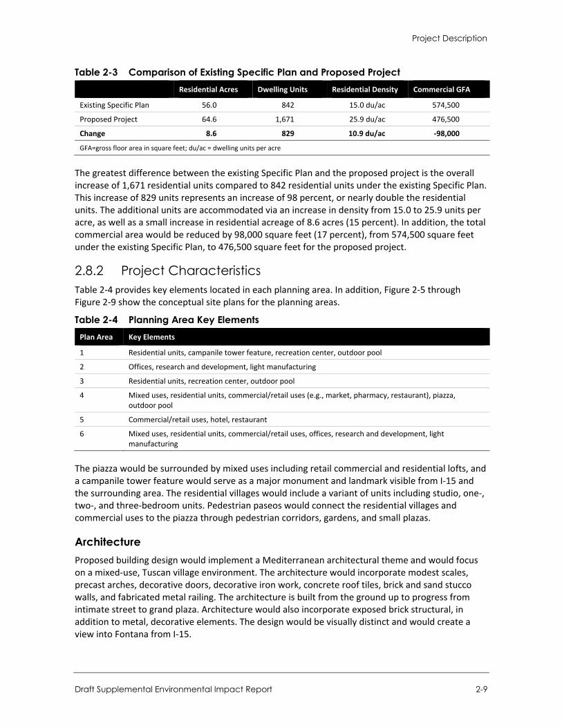
Project Description
Draft Supplemental Environmental Impact Report 2-9
Table 2-3 Comparison of Existing Specific Plan and Proposed Project Residential Acres Dwelling Units Residential Density Commercial GFA
Existing Specific Plan 56.0 842 15.0 du/ac 574,500
Proposed Project 64.6 1,671 25.9 du/ac 476,500
Change 8.6 829 10.9 du/ac -98,000
GFA=gross floor area in square feet; du/ac = dwelling units per acre
The greatest difference between the existing Specific Plan and the proposed project is the overall increase of 1,671 residential units compared to 842 residential units under the existing Specific Plan. This increase of 829 units represents an increase of 98 percent, or nearly double the residential units. The additional units are accommodated via an increase in density from 15.0 to 25.9 units per acre, as well as a small increase in residential acreage of 8.6 acres (15 percent). In addition, the total commercial area would be reduced by 98,000 square feet (17 percent), from 574,500 square feet under the existing Specific Plan, to 476,500 square feet for the proposed project.
2.8.2 Project Characteristics Table 2-4 provides key elements located in each planning area. In addition, Figure 2-5 through Figure 2-9 show the conceptual site plans for the planning areas.
Table 2-4 Planning Area Key Elements Plan Area Key Elements
1 Residential units, campanile tower feature, recreation center, outdoor pool
2 Offices, research and development, light manufacturing
3 Residential units, recreation center, outdoor pool
4 Mixed uses, residential units, commercial/retail uses (e.g., market, pharmacy, restaurant), piazza, outdoor pool
5 Commercial/retail uses, hotel, restaurant
6 Mixed uses, residential units, commercial/retail uses, offices, research and development, light manufacturing
The piazza would be surrounded by mixed uses including retail commercial and residential lofts, and a campanile tower feature would serve as a major monument and landmark visible from I-15 and the surrounding area. The residential villages would include a variant of units including studio, one-, two-, and three-bedroom units. Pedestrian paseos would connect the residential villages and commercial uses to the piazza through pedestrian corridors, gardens, and small plazas.
Architecture Proposed building design would implement a Mediterranean architectural theme and would focus on a mixed-use, Tuscan village environment. The architecture would incorporate modest scales, precast arches, decorative doors, decorative iron work, concrete roof tiles, brick and sand stucco walls, and fabricated metal railing. The architecture is built from the ground up to progress from intimate street to grand plaza. Architecture would also incorporate exposed brick structural, in addition to metal, decorative elements. The design would be visually distinct and would create a view into Fontana from I-15.
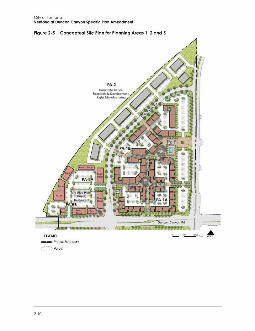
City of Fontana Ventana at Duncan Canyon Specific Plan Amendment
2-10
Figure 2-5 Conceptual Site Plan for Planning Areas 1, 2 and 5
Project Description
Draft Supplemental Environmental Impact Report 2-11
Figure 2-6 Conceptual Site Plan for Planning Area 3
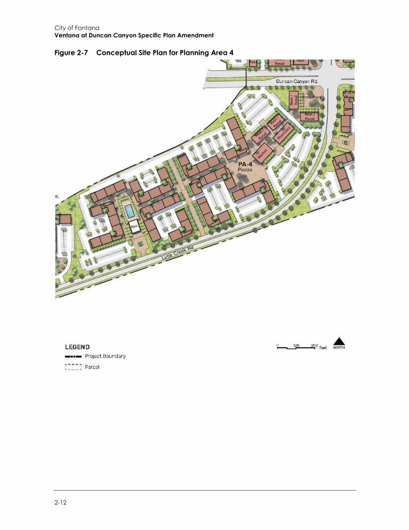
City of Fontana Ventana at Duncan Canyon Specific Plan Amendment
2-12
Figure 2-7 Conceptual Site Plan for Planning Area 4
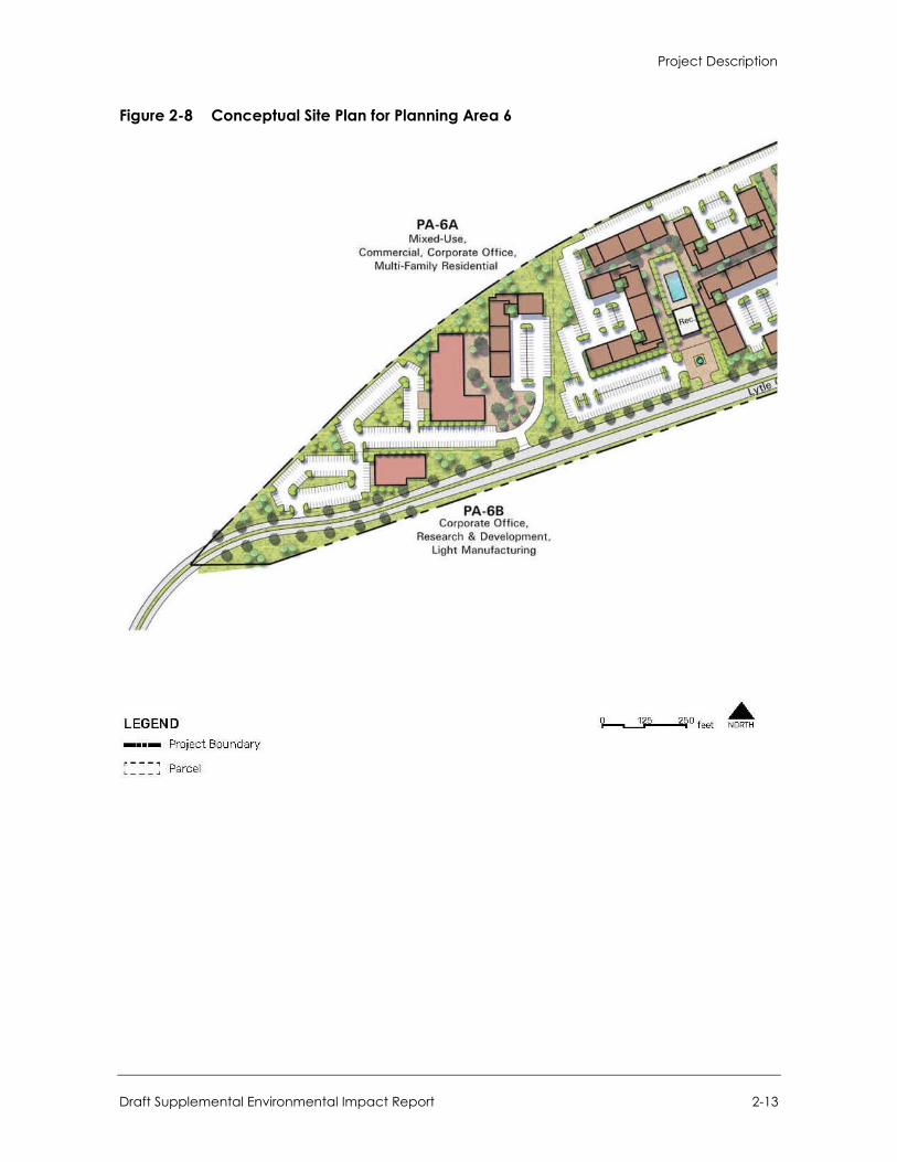
Project Description
Draft Supplemental Environmental Impact Report 2-13
Figure 2-8 Conceptual Site Plan for Planning Area 6

City of Fontana Ventana at Duncan Canyon Specific Plan Amendment
2-14
Figure 2-9 Conceptual Site Plan for Proposed Project
Project Description
Draft Supplemental Environmental Impact Report 2-15
Landscaping Proposed landscaping would include shade trees, shrubs, plants, grasses and hardscape selected from the Specific Plan Amendment plant palette or as supplemented by the City. In general, the plant material designs should provide a layered appearance, with lower growing plants in the foreground and larger growing plants in the background. The plants and planting methods would be selected based on compatibility with the soil and climate conditions to maximize efficient water use. Irrigation systems would be designed to conserve water and accommodate hydrozones accordingly, separating high, medium, and low water-use plants.
Green Building Features Development facilitated by the project would comply with the 2019 California Building Energy Efficiency Standards and CALGreen (CCR Title 24, Parts 6 and 11) or later versions, which are anticipated to be more stringent than the 2019 codes. The 2019 standards require the provision of electric vehicle charging equipment, water-efficient plumbing fixtures and fittings, recycling services, solar on low-rise residential development, and other energy efficiency measures that would reduce the potential for the inefficient use of energy.
Road Improvements and Site Access Similar to the existing Specific Plan, the project would be responsible for the development of roads within the Specific Plan area. Two primary roads and a collector road currently provide access to the project site. The two primary roads—Duncan Canyon Road and Citrus Avenue—directly connect the site to I-15 and would be fully developed to General Plan requirements through the project site. Lytle Creek Road would be developed diagonally through the project area and offers improved internal connection from the primary roads to each of the individual planning areas. As detailed n the Specific Plan Amendment, the project would include the following roadway improvements as design features, which would be constructed in conjunction with development of the site:
Construction of Duncan Canyon Road at its ultimate half-width (north side) as a Major Highway (134-foot right-of-way) from the western project boundary to Citrus Avenue consistent with the City’s standards; and at its ultimate half-width (south side) as a Major Highway (134-foot right-of-way) from the western project boundary to Citrus Avenue consistent with the City’s standards.
Construction of Citrus Avenue at its ultimate half-width as a Primary Highway (104-foot right-of-way) from the northern Project boundary to Duncan Canyon Road consistent with the City’s standards; and at its ultimate half-width as a Primary Highway (104-foot right-of-way) from the southern project boundary to Duncan Canyon Road consistent with the City’s standards.
Construction of Lytle Creek Road at its ultimate full-width as a Local Street (68-foot right-of-way) between Duncan Canyon Road to Citrus Avenue consistent with the City’s standards; and at its ultimate full-width as a Secondary (92-foot right-of-way) between Duncan Canyon Road to Citrus Avenue consistent with the City’s standards.
In addition, on‐site and site-adjacent traffic signing and striping would be implemented consistent with the provisions of the California Manual on Uniform Traffic Control Devices and in conjunction with detailed construction plans for the project site.
City of Fontana Ventana at Duncan Canyon Specific Plan Amendment
2-16
Sidewalk and paseos are the two main categories of pedestrian access serving the project area. The sidewalks would serve as a backbone to the site’s pedestrian traffic while the paseos would establish a network of experiential pedestrian corridors inspired by Tuscan villages.
Utilities Utility design and development would proceed similar to the existing Specific Plan.
Water service to the project area would be provided by the West San Bernardino County Water District. Duncan Canyon Road, and Citrus Avenue south of Duncan Canyon Road, have existing water infrastructure. Planned water infrastructure on Citrus Avenue is anticipated to be completed as part of the nearby Monterado development. A new water main line is expected to follow the alignment of Lytle Creek Road. The main line would create a loop connection with the planned infrastructure on Citrus Avenue to the north and would connect to an existing line along I-15, south of Duncan Canyon Road. Laterals would be provided to each Planning Area as needed.
Sewer service for the project area is provided by the Inland Empire Utilities Agency (IEUA). A sewer main line is expected to follow the Lytle Creek Road alignment and gravity flow to the southwest, connecting to an existing sewer line south of the project area. Points of Connection (POC) would be provided to each Planning Area as needed.
Dry utility services (i.e., electrical, gas, telecommunication) would be extended north and south along Lytle Creek Road from existing facilities on Duncan Canyon Road. Electrical services would be provided by SCE, gas service would be provided by SoCal Gas, and telecommunication services would be provided by AT&T.
New storm drain lines would be installed on Citrus Avenue north of Duncan Canyon Road and on Duncan Canyon Road between the project area’s western edge and Citrus Avenue. The new lines would intercept a main line that follows the Lytle Creek Road alignment north of Duncan Canyon Road. The area south of Duncan Canyon Road would drain to a main line in Lytle Creek Road that connects to an existing storm drain south of the project area. In addition, lateral lines would be extended to each Planning Area as needed.
Construction and Grading The project would be built out in six complete phases with construction estimated to begin in late 2022 and be completed by 2030. The arterial roads (Duncan Canyon Road and Citrus Avenue) and backbone road (Lytle Creek Road) would be developed together during the first phase of development. Once this backbone infrastructure is in place, the remaining Planning Areas have the flexibility to be developed at any time. Actual build-out would be subject to market and economic conditions, jurisdictional processing of approvals, and infrastructure timing, and may vary from the construction phasing currently anticipated.
The project site would be rough graded into a series of development pads with a two percent slope that respond to individual development areas. Development pads would be further fine graded in response to specific development typologies. In addition, the proposed design can accommodate a minimum of three entry and exit points per Planning Area. Based on preliminary earthwork estimates, project grading would require approximately 150,000 cubic yards (cy) of combined cut and fill. All material would be balanced on site. As stated above, the proposed project would have many of the same features as envisioned under the existing Specific Plan. The greatest difference between the existing Specific Plan and the proposed project is the overall increase in density.
Project Description
Draft Supplemental Environmental Impact Report 2-17
2.9 Project Objectives The proposed project is intended to achieve the following objectives:
To support the area demand for housing, and contribute residential units to meet the City’s housing goal of 17,519 units;
To create a master-planned, mixed-use community that creates a unique sense of place; To provide quality housing with various size options to accommodate different housing needs; To actualize the City’s vision for the Regional Mixed-Use designation in north Fontana; To establish a unique window into North Fontana from I-15; To introduce a vibrant, pedestrian-oriented activity center in this area of the city; To integrate a mix of commercial, office and residential uses both vertically and horizontally; To create a protected urban village environment that is unique to Fontana and the Inland
Empire; To enhance the northern Fontana visual environment; To contribute to the jobs/housing balance; To facilitate revenue generating uses; and To facilitate a walkable village environment.
2.10 Required Approvals
2.10.1 City of Fontana The project would require the following approvals by the Fontana City Council:
A Specific Plan Amendment (SPA 21-0001) to change the land uses, planning areas, and other elements of the Specific Plan, including a change from Medium-High Density Residential (MHDR) to High Density Residential (HDR).
A General Plan Amendment (GPA 21-0006) to amend a portion of the site’s current land use designations from Commercial (C-G) and Multi Family Residential (R-MF) to Regional Mixed Use (RMU) and Residential Multi Family Medium/High (R-MFMH).
A tree removal permit for removal of on-site “heritage trees” per Section 28-64 of the Fontana Municipal Code.
Design review of the development plan for each planning area associated with the Specific Plan. Certification an EIR prepared in accordance with CEQA. The City of Fontana will consider
certification of the EIR prior to taking action on the other requested approvals.
2.10.2 Other Agency Approvals West Valley Water District: Approval of a Water Supply Assessment for the project (Approved
on December 17, 2020).
Burrtec Waste Industries, Inc: Approval of trash enclosure and bin placements.

City of Fontana Ventana at Duncan Canyon Specific Plan Amendment
2-18
This page intentionally left blank.
Environmental Setting
Draft Supplemental Environmental Impact Report 3-1
3 Environmental Setting
This section provides a general overview of the environmental setting for the proposed project. More detailed descriptions of the environmental setting for each environmental issue area can be found in Section 4, Environmental Impact Analysis.
3.1 Regional Setting The project site is in the City of Fontana, east of Interstate 15 (I-15), west of Citrus Avenue, and both north and south of Duncan Canyon Road. The approximately 102-acre project site is located in the northern part of the City of Fontana, within San Bernardino County, California. The project is bound by I-15 to the north and west, Citrus Avenue to the east, and a Southern California Edison (SCE) Transmission Line Corridor to the south. Figure 2-1 in Section 2, Project Description, shows the location of the project site in the region and Figure 2-2 shows the location of the project site in relationship to the surrounding neighborhood.
A grid system of east-west and north-south roadways, including arterials, collectors, and local streets, provide vehicular access throughout the City. The major roadways near the project site include Citrus Avenue, Summit Avenue, Duncan Canyon Road, and Coyote Canyon Road. The closest freeways are I-15, State Route 210 (SR-210) and Interstate 10 (I-10). The SR-210 is located approximately two miles south of the project site while the SR-210 is located approximately seven miles south.
Fontana is in southwestern San Bernardino County, within the Inland Valley region of southern California surrounded by the San Bernardino Mountains to the north and San Gabriel Mountains to the west. The climate is typical of San Bernardino County and surrounding cities: hot, dry summers and mild, relatively wet winters with rainfall concentrated in the winter months. The City of Fontana is located approximately 47 miles inland from the coastline of the Pacific Ocean.
3.2 Project Site Setting As shown in Figure 2-2 in Section 2, Project Description, the project site is bordered by neighboring Specific Plan areas such as Arboretum (east), Summit at Rosena (southeast), Citrus Heights North (south), Westgate (southwest), Hunter’s Ridge (southwest), and Coyote Canyon (west). Both the Arboretum and Citrus Heights feature residential development near the plan area. Furthermore, lands to the north and northeast are vacant. Coyote Canyon Park is located west of, and adjacent to I-15, south of Duncan Canyon Road. The I-15 and the Duncan Canyon Road interchange is adjacent to the northwestern project boundary. An SCE transmission line corridor is adjacent to the southeaster project boundary.
The project site is currently undeveloped. The project area includes five eucalyptus windrows containing approximately 185 trees, which are located on the triangular parcel north of Duncan Canyon Road. In addition, there are distribution lines located along Duncan Canyon Road and Citrus Avenue. The site is predominately flat, with a gentle slope from approximately 1,835 above mean sea level (amsl) at the northern edge of the project to approximately 1,675 amsl at the southern edge along Lytle Creek Road and I-15. The site drains from the northeast to the southwest. The
City of Fontana Ventana at Duncan Canyon Specific Plan Amendment
3-2
project area is located on an alluvial plain formed by Lytle Creek, which is the primary collector for a significant watershed that includes large portions of the San Gabriel Mountains to the north.
3.3 Cumulative Development In addition to the specific impacts of individual projects, CEQA requires EIRs to consider potential cumulative impacts of the proposed project. CEQA defines “cumulative impacts” as two or more individual impacts that, when considered together, are substantial or will compound other environmental impacts. Cumulative impacts are the combined changes in the environment that result from the incremental impact of development of the proposed project and other nearby projects. For example, traffic impacts of two nearby projects may be less than significant when analyzed separately but could have a significant impact when analyzed together. Cumulative impact analysis allows the EIR to provide a reasonable forecast of future environmental conditions and can more accurately gauge the effects of a series of projects.
CEQA requires cumulative impact analysis in EIRs to consider either a list of planned and pending projects that may contribute to cumulative effects or a forecast of future development potential. Currently planned and pending projects in Fontana and surrounding areas such as the City of Rialto, are listed in Table 3-1. In particular, the Hunter’s Ridge Project, Monarch Hills Project, Monterado Project, and the North Fontana Industrial Complex (Acacia and Shea Projects) are either located in proximity or along the same major arterial as the project site and construction schedules may overlap. These projects are considered in the cumulative analyses in Section 4, Environmental Impact Analysis. Figure 3-1 displays where the cumulative projects are in the vicinity of the project.
Table 3-1 Cumulative Projects List TAZ1 Project2 Project Location Land Use Quantity3
City of Fontana
F1 Hunter's Ridge Summit Avenue and Duncan Canyon Road
Single Family Detached
20 DU
F2 Monarch Hills Near Lytle Creek Road Single Family Detached
489 DU
F3 Monterado Northeast corner of Duncan Canyon Road and Citrus Avenue
Single Family Detached
198 DU
F4 PAM 20-062 City of Fontana Single Family Detached
182 DU
F5 Sierra Crest II Sierra Avenue and Segovia Lane
Single Family Detached
179 DU
F6 Frome 5253 Lytle Creek Road Single Family Detached
155 DU
F7 Citrus Heights North (Shady Trails) PA3
15800 S. Park Lane Single Family Detached
99 DU
F8 Arboretum The Meadows Sierra Avenue and Casa Grande Avenue
Single Family Detached
585 DU
F9 Summit at Rosena PA 1, 10-19 Summit Avenue and Sierra Avenue
Single Family Detached
553 DU
F10 The Gardens at Arboretum PA G-5, G-6, G-7
Sierra Avenue and Casa Grande Avenue
Single Family Detached
278 DU
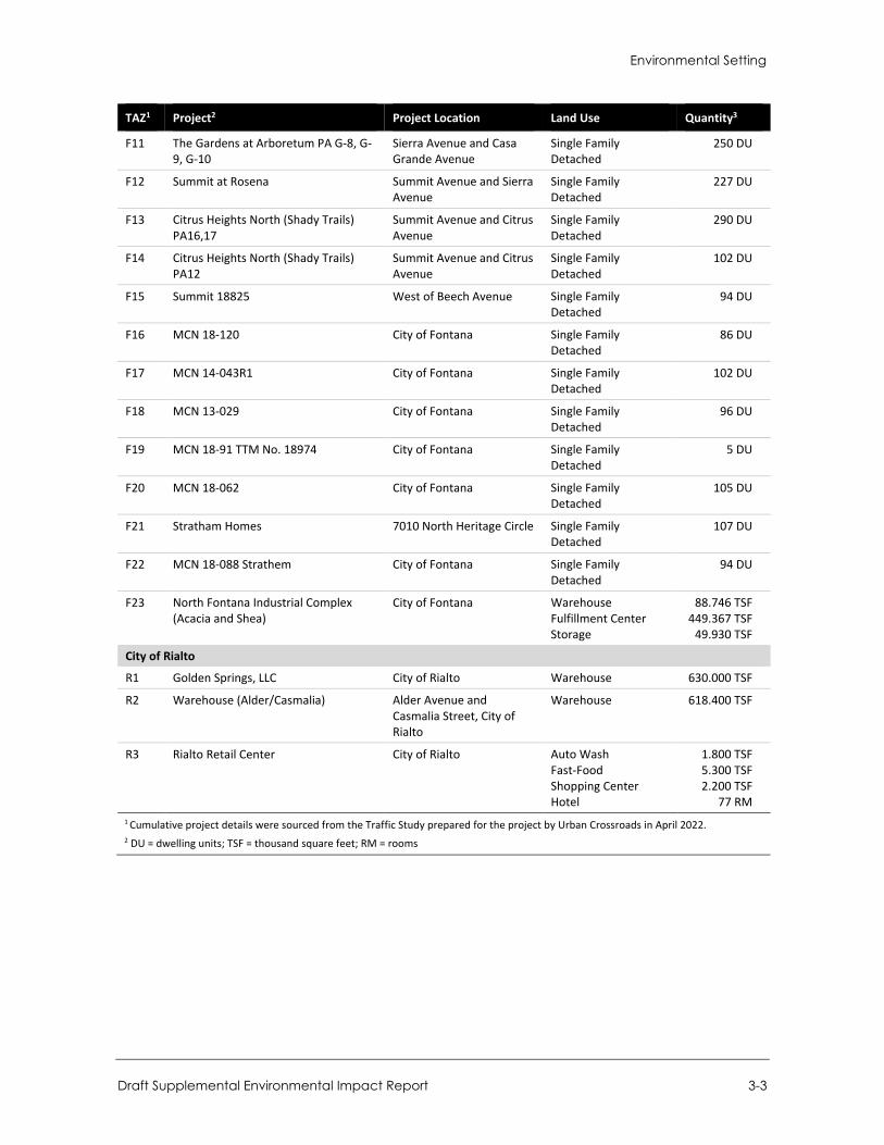
Environmental Setting
Draft Supplemental Environmental Impact Report 3-3
TAZ1 Project2 Project Location Land Use Quantity3
F11 The Gardens at Arboretum PA G-8, G-9, G-10
Sierra Avenue and Casa Grande Avenue
Single Family Detached
250 DU
F12 Summit at Rosena Summit Avenue and Sierra Avenue
Single Family Detached
227 DU
F13 Citrus Heights North (Shady Trails) PA16,17
Summit Avenue and Citrus Avenue
Single Family Detached
290 DU
F14 Citrus Heights North (Shady Trails) PA12
Summit Avenue and Citrus Avenue
Single Family Detached
102 DU
F15 Summit 18825 West of Beech Avenue Single Family Detached
94 DU
F16 MCN 18-120 City of Fontana Single Family Detached
86 DU
F17 MCN 14-043R1 City of Fontana Single Family Detached
102 DU
F18 MCN 13-029 City of Fontana Single Family Detached
96 DU
F19 MCN 18-91 TTM No. 18974 City of Fontana Single Family Detached
5 DU
F20 MCN 18-062 City of Fontana Single Family Detached
105 DU
F21 Stratham Homes 7010 North Heritage Circle Single Family Detached
107 DU
F22 MCN 18-088 Strathem City of Fontana Single Family Detached
94 DU
F23 North Fontana Industrial Complex (Acacia and Shea)
City of Fontana Warehouse Fulfillment Center Storage
88.746 TSF 449.367 TSF
49.930 TSF
City of Rialto
R1 Golden Springs, LLC City of Rialto Warehouse 630.000 TSF
R2 Warehouse (Alder/Casmalia) Alder Avenue and Casmalia Street, City of Rialto
Warehouse 618.400 TSF
R3 Rialto Retail Center City of Rialto Auto Wash Fast-Food Shopping Center Hotel
1.800 TSF 5.300 TSF 2.200 TSF
77 RM 1 Cumulative project details were sourced from the Traffic Study prepared for the project by Urban Crossroads in April 2022. 2 DU = dwelling units; TSF = thousand square feet; RM = rooms

City of Fontana Ventana at Duncan Canyon Specific Plan Amendment
3-4
This page intentionally left blank.
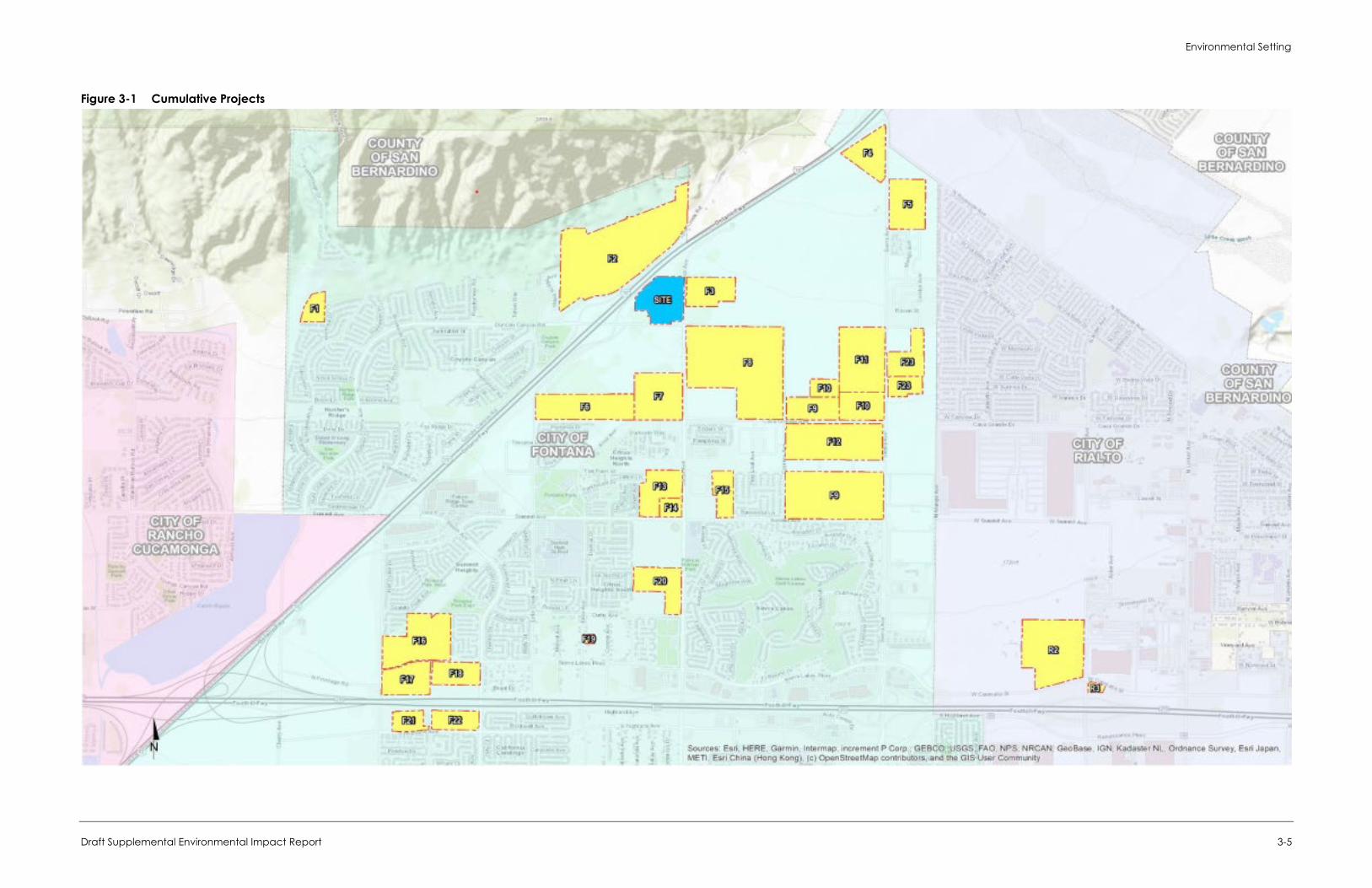
Environmental Setting
Draft Supplemental Environmental Impact Report 3-5
Figure 3-1 Cumulative Projects

City of Fontana Ventana at Duncan Canyon Specific Plan Amendment
3-6
This page intentionally left blank
Environmental Impact Analysis
Draft Supplemental Environmental Impact Report 4-1
4 Environmental Impact Analysis
This section discusses the possible environmental effects of the proposed project for the specific topics that were identified through the scoping process as having the potential to experience significant effects. A “significant effect” as defined by the CEQA Guidelines Section 15382:
means a substantial, or potentially substantial, adverse change in any of the physical conditions within the area affected by the project, including land, air, water, minerals, flora, fauna, ambient noise, and objects of historic or aesthetic significance. An economic or social change by itself shall not be considered a significant effect on the environment. A social or economic change related to a physical change may be considered in determining whether the physical change is significant.
The assessment of each issue area begins with a discussion of the environmental setting related to the issue, which is followed by the impact analysis. In the impact analysis, the first subsection identifies the methodologies used and the “significance thresholds,” which are those criteria adopted by the City and other agencies, universally recognized, or developed specifically for this analysis to determine whether potential effects are significant. The next subsection describes each impact of the proposed project, mitigation measures for significant impacts, and the level of significance after mitigation. Each effect under consideration for an issue area is separately listed in bold text with the discussion of the effect and its significance. Each bolded impact statement also contains a statement of the significance determination for the environmental impact as follows:
Significant and Unavoidable. An impact that cannot be reduced to below the threshold level given reasonably available and feasible mitigation measures. Such an impact requires a Statement of Overriding Considerations to be issued if the project is approved per Section 15093 of the CEQA Guidelines.
Less than Significant with Mitigation Incorporated. An impact that can be reduced to below the threshold level given reasonably available and feasible mitigation measures. Such an impact requires findings under Section 15091 of the CEQA Guidelines.
Less than Significant. An impact that may be adverse but does not exceed the threshold levels and does not require mitigation measures. However, mitigation measures that could further lessen the environmental effect may be suggested if readily available and easily achievable.
No Impact. The proposed project would have no effect on environmental conditions or would reduce existing environmental problems or hazards.
Following each environmental impact discussion is a list of mitigation measures (if required) and the residual effects or level of significance remaining after implementation of the measure(s). In cases where the mitigation measure for an impact could have a significant environmental impact in another issue area, this impact is discussed and evaluated as a secondary impact. The impact analysis concludes with a discussion of cumulative effects, which evaluates the impacts associated with the proposed project in conjunction with other planned and pending developments in the area listed in Section 3, Environmental Setting.
The Executive Summary section of this SEIR summarizes all impacts and mitigation measures that apply to the proposed project.

City of Fontana Ventana at Duncan Canyon Specific Plan Amendment
4-2
This page intentionally left blank
Environmental Impact Analysis Aesthetics/Visual Resources
Draft Supplemental Environmental Impact Report 4.1-1
4.1 Aesthetics/Visual Resources
This section evaluates the project’s potential impacts to scenic vistas, scenic resources, visual character or quality, and light or glare. The analysis consists of a description of the visual setting for the project and the surrounding area, a discussion of potential impacts the project would have, and any mitigation measures required to reduce impacts.
4.1.1 Setting
a. Existing Visual Setting Visual quality is defined as the overall visual impression or attractiveness of an area based on the scenic resources, both natural and built. The attributes of visual quality include variety, vividness, coherence, uniqueness, harmony, and pattern. Viewshed is a term used to describe a range of resources and their context that relate to what people can see in the immediate environment in terms of foreground, middle ground, and background distances. Viewsheds refer to the visual qualities of a geographical area defined by the horizon, topography, and other natural features that give an area its visual boundary and context. Viewsheds are defined further by development that forms a prominent visual component of the area. Public views are those available from publicly accessible vantage points, such as streets, freeways, parks, and vista points. These views are available to a greater number of persons than private views, which are those available from vantage points on private property.
Visual Character of the Surrounding Area The visual character of the surrounding area is a mix of natural features and residential. Sensitive viewer groups include people who reside in the area, permanently or temporarily, and those who pass through or otherwise appear in the area (e.g., commuters), who have the potential to be affected by the area’s scenic features and visual quality, and by the character of scenic vistas and viewsheds.
Immediate land surrounding the site include undeveloped, vacant land to the north and west and paved roads to the east and south, including Interstate 15 (I-15). A Southern California Edison (SCE) corridor and a new residential development is located to the south and east of the project site. There are no native plant communities on or adjacent to the project site, and vegetation is substantially limited to non-native grassland, and eucalyptus windrows.
Neighboring Specific Plan areas include Arboretum (east), Summit at Rosena (southeast), Citrus Heights North (south), Westgate (southwest), Hunter’s Ridge (southwest), and Coyote Canyon (west). Both the Arboretum and Citrus Heights feature residential development near the plan area. The land to the northeast is vacant and Coyote Canyon Park is located west of, and adjacent to I-15, south of Duncan Canyon Road.
Visual Character of the Project Site The project site consists of a slightly sloping open area, supporting non-native grasses, with five windrows of eucalyptus trees on the northern section. I-15 runs along the northwestern boundary of the site, with Citrus Avenue on the east and the SCE transmission towers on the south. Figure 4.1-1 and Figure 4.1-2, provide views of the open land on the northern and southern sections
City of Fontana Ventana at Duncan Canyon Specific Plan Amendment
4.1-2
of the project site from various viewpoints. As shown in these photographs, the project site is a large open area. Trash and scattered debris are found at various locations along the roadsides.
Citrus Avenue is a two-lane roadway that runs north south along the eastern boundary of the site and then turns northeasterly along I-15, see Figure 4.1-1, Photograph 1. The roadway has undeveloped shoulders along the project site. Overhead power lines run along the eastern edge of this road, tying into the SCE utility boxes and monitoring pole at the northern end of the site.
I-15 is visible to the northwest, with views of the San Gabriel and San Bernardino Mountains beyond as seen in Figure 4.1-1, Photographs 1 and 2. Views of the northern section of the site show an open field, with low grasses and five rows of eucalyptus trees as seen in Figure 4.1-1, Photographs 2 and 3.
Southwest of the site, Lytle Creek Road runs north-south but starting at the southwestern corner of the site, the road turns northeasterly following the edge of I-15 and ends at Duncan Canyon Road.
South of the site is the SCE right-of-way with high voltage power lines on steel trusses (see Figure 4.1-2, Photographs 2 and 3). West of the site is I-15, with new single-family homes on the west side of the freeway. East of the site is land being developed for residential use, with a water tank farther northeast and a natural gas pumping facility east on Duncan Canyon Road. The southern section of the site is largely vacant except for the area occupied by the residence and accessory structures.
Duncan Canyon Road cuts through the site in an east-west direction, see Figure 4.1-1, Photograph 4 and Figure 4.1-2, Photograph 4. Duncan Canyon Road is a two-lane roadway, with a bridge over I-15 and an eastern terminus at Citrus Avenue. Overhead utility lines run along both sides of this road. A curb is present along the residential parcel, but the roadway has soft shoulders at other locations.
Existing residences are located just east of Lytle Creek Road and south of Duncan Canyon Road. The SCE right-of-way runs along the southern boundary of the site, with high-voltage transmission lines on four steel towers within the right-of-way along the site. Further south of the SCE right-of-way is a vacant land and land that is currently being developed as a residential tract.
Scenic Views and Vistas Major views in the area include those of the San Bernardino and San Gabriel Mountains located north and northwest of the project site.
Light and Glare The project site is surrounded by residential development and is adjacent to I-15 and other residential uses. The project site is largely vacant, and sources of light in the area are limited to streetlights along Citrus Avenue, Lytle Creek Road, and Duncan Canyon Road, and exterior lighting at the existing single-family residence. No sources of glare are present on the site. Other sources of light in the project area include headlights from passing vehicles on I-15 and local roadways and lights on freeway signs, as well as outdoor lighting at nearby residential tracts.
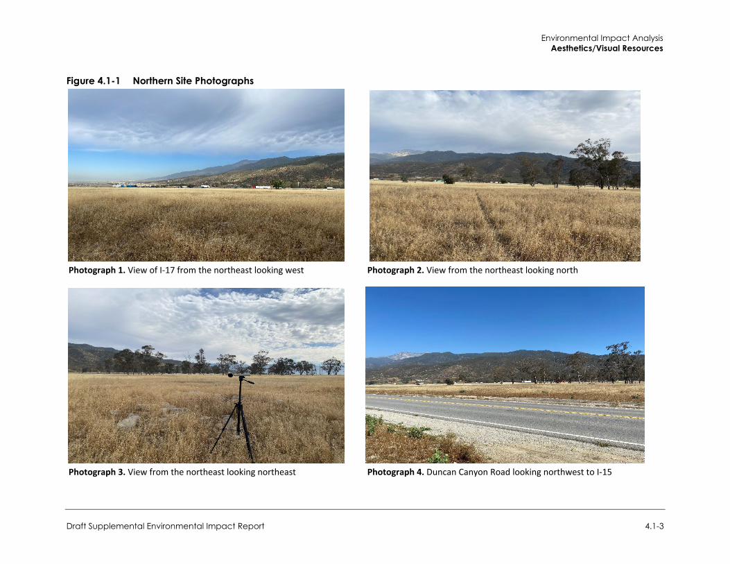
Environmental Impact Analysis Aesthetics/Visual Resources
Draft Supplemental Environmental Impact Report 4.1-3
Figure 4.1-1 Northern Site Photographs
Photograph 1. View of I-17 from the northeast looking west Photograph 2. View from the northeast looking north
Photograph 3. View from the northeast looking northeast Photograph 4. Duncan Canyon Road looking northwest to I-15
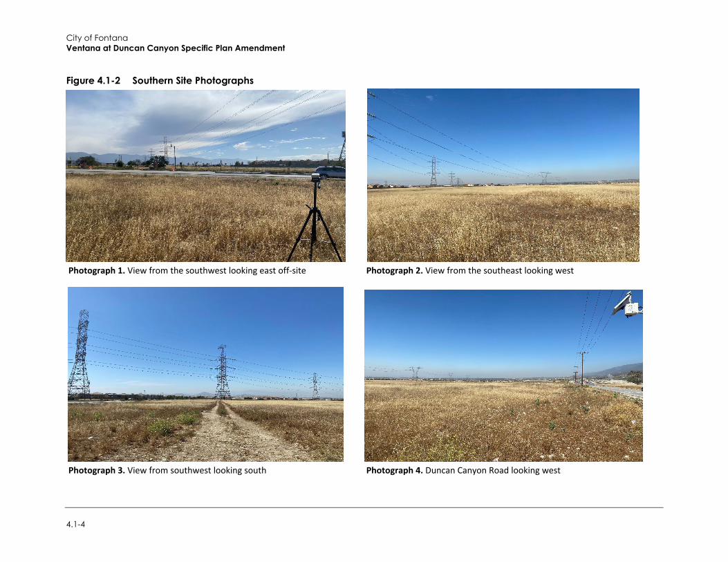
City of Fontana Ventana at Duncan Canyon Specific Plan Amendment
4.1-4
Figure 4.1-2 Southern Site Photographs
Photograph 1. View from the southwest looking east off-site Photograph 2. View from the southeast looking west
Photograph 3. View from southwest looking south Photograph 4. Duncan Canyon Road looking west
Environmental Impact Analysis Aesthetics/Visual Resources
Draft Supplemental Environmental Impact Report 4.1-5
4.1.2 Regulatory Setting
a. State Regulations
2019 California Green Building Standards Code Section 5.106.8 of the California Green Building Standards Code (CALGreen), the California Green Building Standards Code—Part 11, Title 24, California Code of Regulations—is the first-in-the-nation mandatory green building standards code. CALGreen addresses policies for light pollution reduction. It complies with lighting power requirements in the California Energy Code, California Code Regulations (CCR), Part 6, and design interior and exterior lighting such that zero direct-beam illumination leaves the building site. The 2018 Supplemental Update to CALGreen included a clarified Section 5.106.8 on backlight, uplight, and glare, with references to new tables. Buildings must meet or exceed exterior light levels and uniformity ratios for lighting zones 1-4 as defined in Chapter 10 of the California Administrative Code, CCR, Part 1, using the strategies listed below. The project would likely be in Lighting Zone 3 (Urban areas, as defined by the 2000 U.S. Census) which allows moderately high ambient illumination.
1. Shield all luminaries or provide cutoff luminaries per Section 132 (b) of the California Energy Code
2. Contain interior lighting within each source 3. Allow no more than .01 horizontal lumen foot-candles to escape 15 feet beyond the site
boundary 4. Automatically control exterior lighting dusk to dawn to turn off or lower light Levels during
incentive periods
CalGreen includes directions to the California Energy Code for ambient lighting regulations for additions and alterations.
b. Local Regulations
City of Fontana General Plan The Fontana General Plan expresses the community’s vision of its long-term physical form and development in its Community and Neighborhood and Land Use, Zoning and Urban Development chapters (City of Fontana 2018). The following objectives and policies pertaining to aesthetics from the City’s General Plan are applicable to the proposed project:
Community and Neighborhood
This chapter focuses on attributes that contribute to the form, character and quality of life in the communities and neighborhoods where people live.
Goal 5: New housing developments promote walkable neighborhoods with mixed-use amenities and connections to city destinations.
Policy: Support regulations that promote creation of compact and walkable urban village-style design in new developments.
City of Fontana Ventana at Duncan Canyon Specific Plan Amendment
4.1-6
Goal 6: The safe, attractive, and lively central area of the city has new infill development and public improvements.
Policy: Support revitalization of the central area of the city with an integrated approach, including mixed-use development, infill housing, infrastructure improvements, interconnections and placemaking programs that create great public amenities.
Land Use, Zoning and Urban Development
This chapter describes present and planned land uses and their relationship to Fontana’s goals for development in terms of the City’s character.
Goal 7: Public and private development meets high standards of design.
Policy: Support high-quality development in design standards and in land use decisions.
4.1.3 Impact Analysis
a. Significance Thresholds In accordance with Appendix G of the CEQA Guidelines, the project would have a significant impact related to aesthetics if it would:
1. Have a substantial adverse effect on a scenic vista 2. Substantially degrade the existing visual character or quality of public views of the site and its
surroundings? (Public views are those that are experienced from a publicly accessible vantage point). If the project is in an urbanized area, would the project conflict with applicable zoning and other regulations governing scenic quality
3. Create a new source of substantial light or glare that would adversely affect daytime or nighttime views in the area
Impacts to aesthetics were analyzed in an Initial Study (see Appendix A-2). The Initial Study determined that impacts related to substantial damage to scenic resources, including but not limited to, trees, rock outcroppings, and historic buildings within a State scenic highway would be less than significant because the project site is not within or near a designated State scenic highway and does not feature rock outcroppings or historic buildings. Therefore, impacts related to scenic resources and State scenic highways are not further evaluated in this section.
b. Standard Conditions The following standard conditions related to aesthetics, and identified in the 2007 EIR, remain applicable to the proposed project: Standard Condition 4.16.1: Future development on the project site shall be subject to site plan
and design review for compliance with the development regulations and design guidelines in the adopted Specific Plan and applicable regulations in the City’s Zoning and Development Code.
Environmental Impact Analysis Aesthetics/Visual Resources
Draft Supplemental Environmental Impact Report 4.1-7
c. Project Impacts
Threshold 1: Would the project have a substantial adverse effect on a scenic vista?
Impact AES-1 THE PROJECT WOULD NOT AFFECT THE GATEWAY TO THE CITY AT SIERRA AVENUE AND INTERSTATE 15, NOR WOULD IT AFFECT VIEWS OF THE MOUNTAINS ALONG THE SIERRA AVENUE VIEW CORRIDOR. BUILDING SETBACK REQUIREMENTS FOR INDIVIDUAL STRUCTURES WOULD PRESERVE DISTANT MOUNTAIN VIEWS AND PREVENT TOTAL VIEW OBSTRUCTION ON AREA ROADS. IMPACTS RELATED TO SCENIC VISTAS WOULD BE LESS THAN SIGNIFICANT.
Scenic vistas can be impacted by development through the construction of a structure which blocks the view of a vista or by impacting the vista itself, for example, through development of a scenic hillside. Scenic vistas in the area include those inclusive of views of the San Bernardino and San Gabriel Mountains, located north and northwest of the project site. The project site is not within a scenic vista.
In the 2007 EIR, it was found that views from areas to the south of the site would change as the proposed residential villages and commercial areas are built on the site. This development would lead to structures up to four stories high that would change the foreground views from vacant land to a mix of residential and commercial structures. The 2007 EIR concluded that with the proposed maximum building height, changes in mountain views were not expected to be significant and adverse. Additionally, the 2007 EIR states that the project would not have an impact on the designated Sierra Avenue as a view corridor and that building separation/setback requirements for individual structures would preserve distant mountain views and prevent total view obstruction.
The project would develop nearly double the residential units—1,671 units, compared to 842 units under the existing Specific Plan. The additional units are accommodated via an increase in density from 15.0 to 25.9 units per acre, as well as a small increase in residential acreage of 8.6 acres (15 percent). In addition, the total commercial area would be reduced by 98,000 square-feet (17 percent), from 574,500 square-feet under the existing Specific Plan, to 476,500 for the proposed project. The increase in density would place buildings closer together and result in an increase in the overall intensity of development in residential areas of the site.
Similar to what is stated in the 2007 EIR, development of the project site has the potential to change and interrupt views of scenic vistas from local roads, especially Duncan Canyon Road east of I-15. However, the project would not adversely affect views of vistas from I-15.
The City of Fontana has designated Sierra Avenue as a view corridor to allow for the preservation of mountain views in North Fontana. The project would not affect the gateway to the City at Sierra Avenue and I-15, nor would it affect views of the mountains along the Sierra Avenue view corridor. Building setback requirements for individual structures would preserve distant mountain views and prevent total view obstruction on area roads. Additionally, the construction of the realigned Lytle Creek Road is expected to provide new views to the area. Impacts related to scenic vistas would be less than significant.
Mitigation Measures Mitigation measures are not required.
City of Fontana Ventana at Duncan Canyon Specific Plan Amendment
4.1-8
Threshold 2: Would the project, in non-urbanized areas, substantially degrade the existing visual character or quality of public views of the site and its surroundings? (Public views are those that are experienced from a publicly accessible vantage point). If the project is in an urbanized area, would the project conflict with applicable zoning and other regulations governing scenic quality?
Impact AES-2 THE SPECIFIC PLAN AMENDMENT WOULD NOT ADVERSELY DEGRADE THE EXISTING VISUAL CHARACTER OR QUALITY OF PUBLIC VIEWS OF THE SITE AND ITS SURROUNDINGS WITH COMPLIANCE WITH THE SPECIFIC PLAN AMENDMENT DESIGN GUIDELINES. IMPACTS WOULD BE LESS THAN SIGNIFICANT.
The visual character of the project site is composed of previously disturbed land, non-native grass, SCE transmission lines, I-15, and eucalyptus windrows. The project site occurs in an area that consist of a mosaic of undeveloped/vacant land and new residential developments. Immediate land uses surrounding the site include undeveloped, vacant land to the north and west, and paved roads and new residential development to the east and south, including I-15. An SCE corridor and a new residential development is located to the south and east of the project site.
In the existing Specific Plan, as many as 842 condominium units and a total of 574,500 square feet of retail commercial and office uses would have been developed. The 2007 EIR found that these developments would change the open land characteristic of the site to one with several structures surrounded by improved landscapes and streetscapes. However, determination of whether the changes in visual quality of the site would degrade the site or its surroundings, and thus, be significant and adverse, is highly subjective as some individuals prefer open and natural settings, while others prefer urban and improved environments. Similarly, preferences for one architectural style over another made it difficult to conclude that a development would have a negative or positive aesthetic impact. Therefore, it was concluded that with the review and approval of site plans by the City, the change in visual appearance related to implementation of the Specific Plan was not expected to have an adverse aesthetic impact assuming development projects comply with the Specific Plan design guidelines.
As previously discussed, the greatest difference between the existing Specific Plan and the proposed project is the overall increase in residential units.
Similar to what is stated in the 2007 EIR, the proposed project would change the visual appearance of the project site from a disturbed “natural” area to a more structured setting. The perception of this change would be different from one person to another and visual preferences between the existing and future conditions are highly subjective. However, with the site being devoid of native plant species, notable outcroppings, buildings, and other defining features the development of the project site will add defined edges between roads, parkways, improved landscaped areas, parking lots, buildings, pathways and a cohesive aesthetic to the area.
The proposed project is designed to emulate charming Tuscan villages to add authentic character to the area. Proposed building design would implement a Mediterranean architectural theme and would focus on a mixed-use, Tuscan village environment as seem in Figure 4.1-3. The architecture would incorporate precast arches, decorative doors, decorative iron work, concrete roof tiles, brick and sand stucco walls, and fabricated metal railing. The architecture is built from the ground up to progress from intimate street to grand plaza. Architecture would also incorporate exposed brick structural, in addition to metal, decorative elements.
The design of the project would be visually distinct and would create a view into Fontana from I-15. This visually distinct view into Fontana would be consistent with the City’s intent to define Duncan
Environmental Impact Analysis Aesthetics/Visual Resources
Draft Supplemental Environmental Impact Report 4.1-9
Canyon Road as an entryway to the city. Furthermore, the project would support the transition of the surrounding area from agricultural use to an urban setting. In order to maintain this consistent look, all plans for development will be subject to review for consistency with the Specific Plan. Thus, if the City approves the proposed design guidelines for the development of Tuscan Village on the site, it is assumed that compliance with the design guidelines in the Specific Plan would be in keeping with the aesthetic standards for future development on the site.
The City would review and approve the site plans for the commercial areas and residential villages for compliance with development standards, sign regulations, and design guidelines in the proposed Specific Plan, prior to the approval of building permits. Thus, with compliance with the Specific Plan design guidelines, the project would not have an adverse impact on the quality of public views. Therefore, the Specific Plan Amendment would not adversely degrade the existing visual character or quality of public views of the site and its surroundings. Impacts would be less than significant.
Mitigation Measures Mitigation measures are not required.
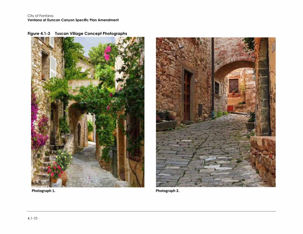
City of Fontana Ventana at Duncan Canyon Specific Plan Amendment
4.1-10
Figure 4.1-3 Tuscan Village Concept Photographs
Photograph 1. Photograph 2.
Environmental Impact Analysis Aesthetics/Visual Resources
Draft Supplemental Environmental Impact Report 4.1-11
Threshold 3: Create a new source of substantial light or glare that would adversely affect daytime or nighttime views in the area?
Impact AES-3 COMPLIANCE WITH THE OUTDOOR LIGHTING GUIDELINES IN THE SPECIFIC PLAN AMENDMENT AND THE CITY’S DEVELOPMENT REGULATIONS REGARDING GLARE WOULD PREVENT THE CREATION OF SIGNIFICANT ADVERSE LIGHT AND GLARE IMPACTS. THEREFORE, THE PROJECT WOULD NOT CREATE A NEW SOURCE OF SUBSTANTIAL GLARE THAT WOULD ADVERSELY AFFECT DAYTIME OR NIGHTTIME VIEWS IN THE AREA. LIGHT AND GLARE IMPACTS WOULD BE LESS THAN SIGNIFICANT.
The project site is undeveloped and does not have any sources of light or glare. New sources of light and glare from the project would come from windows, outdoor landscaping and safety lighting, and light and glare from vehicles accessing the project site. Therefore, development of the project would increase the intensity of lighting and add glare sources on the project site associated with the commercial, mixed use, and residential uses.
The 2007 EIR found that future development would be accompanied by new sources of light and glare. Increased lighting levels could impact the adjacent residential uses to the west and south. However, it was determined that increased light levels would not lead to a significant adverse effect on these residences since the homes are separated from the site by the SCE right-of-way and I-15. Any light spillover would be within these corridors and not farther south or west. Furthermore, it was found that with compliance to the outdoor lighting guidelines in the Specific Plan and the City’s development regulations regarding lighting would prevent the creation of significant adverse light and glare impacts.
The area around the project site has been further developed since Specific Plan approval, and the surrounding area includes recent residential development, along with the reconstruction of the I-15 and Duncan Canyon Road interchange. The former emits daytime and nighttime light and glare in the area typical for residential uses. Similarly, to what is stated in the 2007 EIR, the Specific Plan Amendment would introduce new sources of light and glare. However, the proposed project is largely consistent with the existing Specific Plan in terms of lighting. The Specific Plan includes outdoor lighting guidelines that would provide a unified design within the developments. These guidelines include the following:
The use of outdoor lighting that are focused, directed and arranged to minimize glare and light spillover
The use of vandal-proof fixtures Prohibition of neon lighting Lighting of community entry areas and public plazas to develop a sense of place and arrival Security lighting Shielding of exterior lights to minimize spill light into the night sky and adjacent properties
As previously discussed, the greatest difference between the existing Specific Plan and the proposed project is the overall increase in residential units. Similar to the existing Specific Plan, the proposed project places commercial uses along I-15. Commercial lighting would be typical for the proposed uses, and compatible with the freeway setting. Residential villages would be located between the commercial uses, and adjacent residential projects to the east, and also separated by roads such as Citrus Avenue. The residential villages would be denser than those under the existing Specific Plan, but still typical of a multi-family residential area. Therefore, implementation of the proposed project would not significantly increase the ambient lighting compared to the existing Specific Plan.
City of Fontana Ventana at Duncan Canyon Specific Plan Amendment
4.1-12
Similar to what is stated in the 2007 EIR, the project would comply with the lighting requirements in the revised Specific Plan and the development standards in the City’s Zoning and Development Code. The City’s Development Code requires all light sources to be directed and/or shielded to prevent spillover and glare. Lighting plans would need to be reviewed by the City to ensure that there is no spillover into adjacent properties. Section 30-471 states that all lights shall be directed and/or shielded to prevent the light from adversely affecting adjacent properties. Future development on the site would be required to submit lighting plans for design review and approval by the City. Compliance with the outdoor lighting guidelines in the Specific Plan and the City’s development regulations regarding lighting would prevent the creation of significant adverse light and glare impacts. Therefore, the project would not create a new source of substantial light that would adversely affect nighttime views in the area.
Cars in parking lots could potentially produce glare under operational conditions, particularly on bright, sunny days. The construction of the commercial areas would also create new sources of glare in the form of glazed building surfaces, use of mirrors and glass as exterior building surfaces, and other reflective materials that would reflect the sun or light sources and create glare. The project’s Tuscan themed architectures emphasize the use of natural, textured, and colored materials and would serve to further reduce sources of glare associated with buildings and structures.
As previously discussed, the project will be subject to the City’s Development Code requirements such as Section 30-471, which states that no structure or feature shall be permitted that creates adverse glare effects. Several additional development standards and design guidelines for parking areas are set forth by Section 30-697. Compliance with the outdoor lighting guidelines in the Specific Plan and the City’s development regulations regarding glare would prevent the creation of significant adverse light and glare impacts. Therefore, the project would not create a new source of substantial glare that would adversely affect daytime or nighttime views in the area. Light and glare impacts would be less than significant.
Mitigation Measures Mitigation measures are not required.
4.1.4 Cumulative Impacts Planned and pending projects in Fontana and surrounding areas are listed in Table 3-1 in Section 3, Environmental Setting, and include residential, commercial, and industrial land uses.
As previously discussed, the project would continue the transition of the area and adjacent uses from rural agricultural to urban non-agricultural use. All new development would be consistent with applicable building regulations and guidelines from the Fontana General Plan and the Ventana at Duncan Canyon Specific Plan. Adherence to these policies would reduce impacts associated with the visual character or quality of public views of the site and its surroundings and maintain visual consistency and quality with surrounding development. Additionally, this would reduce cumulative impacts to light, and glare.
Development of the proposed project and cumulative projects within north Fontana and adjacent areas along the I-15 corridor would create an overall increase in nighttime ambient lighting conditions, as well as glare associated with development compared to predevelopment conditions. New development would be subject to design review and City design requirements for lighting and architectural, as well as General Plan policy supporting high-quality development in design standards and in land use decisions. Projects developed under a Specific Plan, such as the proposed
Environmental Impact Analysis Aesthetics/Visual Resources
Draft Supplemental Environmental Impact Report 4.1-13
project, will provide additional guidance for quality design and cohesiveness in architecture across a planning area. Compliance with such standards would result in less than significant cumulative impacts related to increases in nighttime ambient lighting and daytime glare.
The project site and surrounding areas are not located near state-designated scenic highways, or highways eligible for designation as a scenic highway. Additionally, the proposed project would not impact Sierra Avenue as a view corridor. Development of the project site has the potential to change and interrupt views of scenic vistas from local roads, especially Duncan Canyon Road east of I-15. However, the project would not adversely affect views from I-15 of these vistas. Building separation and setback requirements for individual structures would preserve distant mountain views and prevent total view obstruction. Additionally, the construction of the realigned Lytle Creek Road is expected to provide new scenic view to the area. Cumulative impacts to aesthetics, light, and glare would be less than significant.

City of Fontana Ventana at Duncan Canyon Specific Plan Amendment
4.1-14
This page intentionally left blank.

Environmental Impact Analysis Air Quality
Draft Supplemental Environmental Impact Report 4.2-1
4.2 Air Quality
This section analyzes the potential air quality impacts of the proposed project related to both temporary construction activity and long-term operation of the project. The analysis herein is substantially based on the project-specific Air Quality and Greenhouse Gas Study prepared for the proposed project (Rincon 2021a; Appendix B).
4.2.1 Setting The project site is in the South Coast Air Basin (the Basin), which is bounded by the Pacific Ocean to the west; the San Gabriel, San Bernardino, and San Jacinto mountains to the north and east; and the Riverside County/San Diego County border to the south. The Basin includes all of Orange County and the non-desert portions of Los Angeles, Riverside, and San Bernardino counties, as well as the San Gorgonio Pass in Riverside County. The regional climate in the Basin is considered semi-arid and is characterized by warm summers, mild winters, infrequent seasonal rainfall, moderate daytime onshore breezes, and moderate humidity. Air quality in the Basin is influenced primarily by meteorology and a wide range of emissions sources, such as dense population centers, substantial vehicular traffic, and industry.
Air pollutant emissions in the Basin are generated primarily by stationary and mobile sources. Stationary sources can be divided into two major subcategories: point sources and area sources. Point sources occur at a specific location and are often identified by an exhaust vent or stack. Examples include boilers or combustion equipment that produce electricity or generate heat. Area sources are distributed widely and include sources such as painting operations, lawn mowers, agricultural fields, landfills, and some consumer products. Mobile sources refer to emissions from motor vehicles and other modes of transportation, including tailpipe and evaporative emissions, and are classified as either on-road or off-road. On-road sources may be legally operated on roadways and highways. Off-road sources include aircraft, ships, trains, and self-propelled construction equipment. Air pollutants can also be generated by the natural environment, such as when high winds suspend fine dust particles.
a. Air Pollutants of Primary Concern Primary criteria pollutants are emitted directly from a source (e.g., vehicle tailpipe, an exhaust stack of a factory, etc.) into the atmosphere. Primary criteria pollutants include CO, NO2, PM10, PM2.5, SO2, and lead. Ozone is considered a secondary criteria pollutant because it is created by atmospheric chemical and photochemical reactions between volatile organic compounds (VOC) and nitrogen oxides (NOX). The following subsections describe the characteristics, sources, and health and atmospheric effects of critical air contaminants.
Ozone
Ozone is produced by a photochemical reaction (triggered by sunlight) between NOX and VOC.1 Nitrogen oxides are formed during the combustion of fuels, while VOC are formed during
1 Organic compound precursors of ozone are routinely described by a number of variations of three terms: hydrocarbons (HC), organic gases (OG), and organic compounds (OC). These terms are often modified by adjectives such as total, reactive, or volatile, and result in a rather confusing array of acronyms: HC, THC (total hydrocarbons), RHC (reactive hydrocarbons), TOG (total organic gases), ROG (reactive organic gases), TOC (total organic compounds), ROC (reactive organic compounds), and VOC (volatile organic compounds). While most of these differ in some significant way from a chemical perspective, two groups are important from an air quality perspective: non-
City of Fontana Ventana at Duncan Canyon Specific Plan Amendment
4.2-2
combustion and evaporation of organic solvents. Because ozone requires sunlight to form, it usually occurs in substantial concentrations between the months of April and October. Ozone is a pungent, colorless, toxic gas with direct health effects on humans including respiratory and eye irritation and possible changes in lung functions. Groups most sensitive to ozone include children, the elderly, people with respiratory disorders, and people who exercise strenuously outdoors.
Carbon Monoxide
Carbon monoxide is a local pollutant that is found in high concentrations only near fuel combustion equipment and other sources of CO. The primary source of CO, a colorless, odorless, poisonous gas, is automobile traffic. Therefore, elevated concentrations are usually only found near areas of high traffic volumes. Carbon monoxide’s health effects are related to its affinity for hemoglobin in the blood. At high concentrations, CO reduces the amount of oxygen in the blood, causing heart difficulty in people with chronic diseases, reduced lung capacity, and impaired mental abilities.
Nitrogen Dioxide
Nitrogen dioxide is a by-product of fuel combustion, with the primary source being motor vehicles and industrial boilers and furnaces. The principal form of nitrogen oxide produced by combustion is nitric oxide (NO), but NO reacts rapidly to form NO2, creating the mixture of NO and NO2 commonly called NOX. Nitrogen dioxide is an acute irritant. A relationship between NO2 and chronic pulmonary fibrosis may exist, and an increase in bronchitis in young children at concentrations below 0.3 parts per million (ppm) may occur. Nitrogen dioxide absorbs blue light, gives a reddish-brown cast to the atmosphere, and reduces visibility. It can also contribute to the formation of ozone/smog and acid rain.
Sulfur Dioxide
Sulfur dioxide is a colorless, pungent, irritating gas formed primarily by the combustion of sulfur-containing fossil fuels. When SO2 oxidizes in the atmosphere, it forms sulfur trioxide. Collectively, these pollutants are referred to as sulfur oxides (SOX). In humid atmospheres, SO2 can also form sulfuric acid mist, which can eventually react to produce sulfate particulates that can inhibit visibility. Combustion of high sulfur-content fuels is the major source of SO2, while chemical plants, sulfur recovery plants, and metal processing are minor contributors. At sufficiently high concentrations, SO2 irritates the upper respiratory tract. At lower concentrations, when in conjunction with particulates, SO2 appears to do still greater harm by injuring lung tissues. This compound also constricts the breathing passages, especially in people with asthma and people involved in moderate to heavy exercise. Sulfur dioxide causes respiratory irritation, including wheezing, shortness of breath, and coughing. Long-term SO2 exposure has been associated with increased risk of mortality from respiratory or cardiovascular disease. Sulfur oxides, in combination with moisture and oxygen, can yellow leaves on plants, dissolve marble, and eat away iron and steel.
Suspended Particulates
Atmospheric particulate matter is comprised of finely divided solids and liquids such as dust, soot, aerosols, fumes, and mists. The particulates that are of particular concern are PM10 (small particulate matter that measures no more than 10 microns in diameter) and PM2.5 (fine particulate
photochemically reactive in the lower atmosphere, or photochemically reactive in the lower atmosphere (HC, RHC, ROG, ROC, and VOC). South Coast Air Quality Management District (SCAQMD) uses the term VOC to denote organic precursors.
Environmental Impact Analysis Air Quality
Draft Supplemental Environmental Impact Report 4.2-3
matter that measures no more than 2.5 microns in diameter). The characteristics, sources, and potential health effects associated with PM10 and PM2.5 can be different. Major man-made sources of PM10 are agricultural operations, industrial processes, combustion of fossil fuels, construction, demolition operations, and entrainment of road dust into the atmosphere. Natural sources include windblown dust, wildfire smoke, and sea spray salt. The finer PM2.5 particulates are generally associated with combustion processes as well as formation in the atmosphere as a secondary pollutant through chemical reactions. PM2.5 is more likely to penetrate deeply into the lungs and poses a serious health threat to all groups, but particularly to the elderly, children, and those with respiratory problems. More than half of the small and fine particulate matter that is inhaled into the lungs remains there, which can cause permanent lung damage. These materials can damage health by interfering with the body’s mechanisms for clearing the respiratory tract or by acting as carriers of an absorbed toxic substance.
Lead
Lead is a metal found naturally in the environment, as well as in manufacturing products. Lead occurs in the atmosphere as particulate matter. The major sources of lead emissions historically have been mobile and industrial sources. In the early 1970s, the United States Environmental Protection Agency (USEPA) set national regulations to gradually reduce the lead content in gasoline. In 1975, unleaded gasoline was introduced for motor vehicles equipped with catalytic converters. The USEPA completed the ban prohibiting the use of leaded gasoline in highway vehicles in December 1995. As a result of the USEPA’s regulatory efforts to remove lead from gasoline, atmospheric lead concentrations have declined substantially over the past several decades. The most dramatic reductions in lead emissions occurred prior to 1990 due to the removal of lead from gasoline sold for most highway vehicles. Lead emissions were further reduced substantially between 1990 and 2008, with reductions occurring in the metals industries in part due to national emissions standards for hazardous air pollutants (USEPA 2013). As a result of phasing out leaded gasoline, metal processing is currently the primary source of lead emissions. The highest levels of lead in the air are generally found near lead smelters. Other stationary sources include waste incinerators, utilities, and lead-acid battery manufacturers. Lead may cause a range of health effects, including anemia, kidney disease, and neuromuscular and neurological dysfunction (in severe cases). The proposed project does not include any stationary sources of lead emissions. Therefore, implementation of the project would not result in substantial emissions of lead, and this pollutant is not discussed further in this analysis.
Toxic Air Contaminants
Toxic air contaminants (TACs) are a diverse group of air pollutants that may cause or contribute to an increase in deaths or serious illness or that may pose a present or potential hazard to human health. TACs include both organic and inorganic chemical substances that may be emitted from a variety of common sources, including gasoline stations, motor vehicles, dry cleaners, industrial operations, painting operations, and research and teaching facilities. One of the main sources of TACs in California is diesel engines that emit exhaust containing solid material known as diesel particulate matter (DPM) (California Air Resources board [CARB] 2021a). TACs are different than the criteria pollutants previously discussed because ambient air quality standards have not been established for TACs. TACs occurring at extremely low levels may still cause health effects, and it is typically difficult to identify levels of exposure that do not produce adverse health effects. TAC impacts are described by carcinogenic risk and by chronic (i.e., of long duration) and acute (i.e., severe but of short duration) adverse effects on human health.
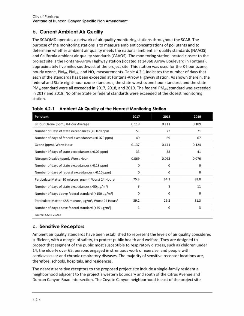
City of Fontana Ventana at Duncan Canyon Specific Plan Amendment
4.2-4
b. Current Ambient Air Quality The SCAQMD operates a network of air quality monitoring stations throughout the SCAB. The purpose of the monitoring stations is to measure ambient concentrations of pollutants and to determine whether ambient air quality meets the national ambient air quality standards (NAAQS) and California ambient air quality standards (CAAQS). The monitoring station located closest to the project site is the Fontana-Arrow Highway station (located at 14360 Arrow Boulevard in Fontana), approximately five miles southwest of the project site. This station was used for the 8-hour ozone, hourly ozone, PM10, PM2.5, and NO2 measurements. Table 4.2-1 indicates the number of days that each of the standards has been exceeded at Fontana-Arrow Highway station. As shown therein, the federal and State eight-hour ozone standards, the state worst ozone hour standard, and the state PM10 standard were all exceeded in 2017, 2018, and 2019. The federal PM2.5 standard was exceeded in 2017 and 2018. No other State or federal standards were exceeded at the closest monitoring station.
Table 4.2-1 Ambient Air Quality at the Nearest Monitoring Station
Pollutant 2017 2018 2019
8 Hour Ozone (ppm), 8-Hour Average 0.119 0.111 0.109
Number of Days of state exceedances (>0.070 ppm 51 72 71
Number of days of federal exceedances (>0.070 ppm) 49 69 67
Ozone (ppm), Worst Hour 0.137 0.141 0.124
Number of days of state exceedances (>0.09 ppm) 33 38 41
Nitrogen Dioxide (ppm), Worst Hour 0.069 0.063 0.076
Number of days of state exceedances (>0.18 ppm) 0 0 0
Number of days of federal exceedances (>0.10 ppm) 0 0 0
Particulate Matter 10 microns, µg/m3, Worst 24 Hours1 75.3 64.1 88.8
Number of days of state exceedances (>50 µg/m3) 8 8 11
Number of days above federal standard (>150 µg/m3) 0 0 0
Particulate Matter <2.5 microns, µg/m3, Worst 24 Hours2 39.2 29.2 81.3
Number of days above federal standard (>35 µg/m3) 1 0 3
Source: CARB 2021c
c. Sensitive Receptors Ambient air quality standards have been established to represent the levels of air quality considered sufficient, with a margin of safety, to protect public health and welfare. They are designed to protect that segment of the public most susceptible to respiratory distress, such as children under 14, the elderly over 65, persons engaged in strenuous work or exercise, and people with cardiovascular and chronic respiratory diseases. The majority of sensitive receptor locations are, therefore, schools, hospitals, and residences.
The nearest sensitive receptors to the proposed project site include a single-family residential neighborhood adjacent to the project’s western boundary and south of the Citrus Avenue and Duncan Canyon Road intersection. The Coyote Canyon neighborhood is east of the project site
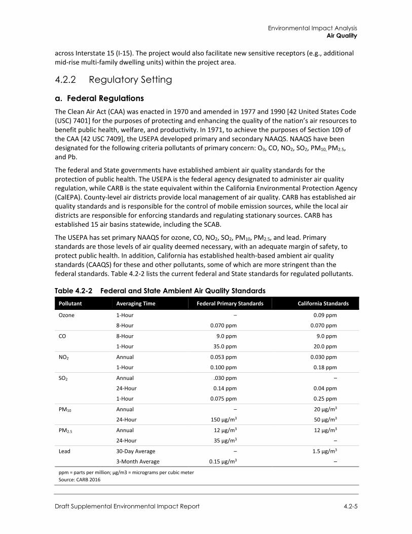
Environmental Impact Analysis Air Quality
Draft Supplemental Environmental Impact Report 4.2-5
across Interstate 15 (I-15). The project would also facilitate new sensitive receptors (e.g., additional mid-rise multi-family dwelling units) within the project area.
4.2.2 Regulatory Setting
a. Federal Regulations The Clean Air Act (CAA) was enacted in 1970 and amended in 1977 and 1990 [42 United States Code (USC) 7401] for the purposes of protecting and enhancing the quality of the nation’s air resources to benefit public health, welfare, and productivity. In 1971, to achieve the purposes of Section 109 of the CAA [42 USC 7409], the USEPA developed primary and secondary NAAQS. NAAQS have been designated for the following criteria pollutants of primary concern: O3, CO, NO2, SO2, PM10, PM2.5, and Pb.
The federal and State governments have established ambient air quality standards for the protection of public health. The USEPA is the federal agency designated to administer air quality regulation, while CARB is the state equivalent within the California Environmental Protection Agency (CalEPA). County-level air districts provide local management of air quality. CARB has established air quality standards and is responsible for the control of mobile emission sources, while the local air districts are responsible for enforcing standards and regulating stationary sources. CARB has established 15 air basins statewide, including the SCAB.
The USEPA has set primary NAAQS for ozone, CO, NO2, SO2, PM10, PM2.5, and lead. Primary standards are those levels of air quality deemed necessary, with an adequate margin of safety, to protect public health. In addition, California has established health-based ambient air quality standards (CAAQS) for these and other pollutants, some of which are more stringent than the federal standards. Table 4.2-2 lists the current federal and State standards for regulated pollutants.
Table 4.2-2 Federal and State Ambient Air Quality Standards Pollutant Averaging Time Federal Primary Standards California Standards
Ozone 1-Hour – 0.09 ppm
8-Hour 0.070 ppm 0.070 ppm
CO 8-Hour 9.0 ppm 9.0 ppm
1-Hour 35.0 ppm 20.0 ppm
NO2 Annual 0.053 ppm 0.030 ppm
1-Hour 0.100 ppm 0.18 ppm
SO2 Annual .030 ppm –
24-Hour 0.14 ppm 0.04 ppm
1-Hour 0.075 ppm 0.25 ppm
PM10 Annual – 20 µg/m3
24-Hour 150 µg/m3 50 µg/m3
PM2.5 Annual 12 µg/m3 12 µg/m3
24-Hour 35 µg/m3 –
Lead 30-Day Average – 1.5 µg/m3
3-Month Average 0.15 µg/m3 –
ppm = parts per million; µg/m3 = micrograms per cubic meter Source: CARB 2016
City of Fontana Ventana at Duncan Canyon Specific Plan Amendment
4.2-6
The SCAQMD is the designated air quality control agency in the SCAB, which is a non-attainment area for the federal standards for ozone and PM2.5 and the State standards for ozone, PM10, and PM2.5. The SCAB is designated unclassifiable or in attainment for all other federal and State standards.
b. State Regulations
California Clean Air Act The California Clean Air Act (CCAA) was enacted in 1988 (California Health & Safety Code (H&SC) Section 39000 et seq.). Under the CCAA, the State has developed the California Ambient Air Quality Standards (CAAQS), some of which are more stringent than the NAAQS. Table 4.2-2 lists the current state standards for regulated pollutants. In addition to the federal criteria pollutants, the CAAQS also specify standards for visibility-reducing particles, sulfates, hydrogen sulfide, and vinyl chloride. Similar to the federal CAA, the CCAA classifies specific geographic areas as either “attainment” or “nonattainment” areas for each pollutant, based on the comparison of measured data within the CAAQS.
Toxic Air Contaminants In 1983, the California Legislature enacted a program to identify the health effects of TACs and to reduce exposure to these contaminants to protect the public health (Assembly Bill [AB] 1807: H&SC Sections 39650–39674). The Legislature established a two-step process to address the potential health effects from TACs. The first step is the risk assessment (or identification) phase. The second step is the risk management (or control) phase of the process.
The California Air Toxics Program establishes the process for the identification and control of TACs and includes provisions to make the public aware of significant toxic exposures and for reducing risk. Additionally, the Air Toxics "Hot Spots" Information and Assessment Act (AB 2588, 1987, Connelly Bill) was enacted in 1987 and requires stationary sources to report the types and quantities of certain substances routinely released into the air. The goals of the Air Toxics "Hot Spots" Act are to collect emission data, identify facilities having localized impacts, ascertain health risks, notify nearby residents of significant risks, and reduce those significant risks to acceptable levels. The Children's Environmental Health Protection Act, California Senate Bill 25 (Chapter 731, Escutia, Statutes of 1999), focuses on children's exposure to air pollutants. The act requires CARB to review its air quality standards from a children's health perspective, evaluate the statewide air quality monitoring network, and develop any additional air toxic control measures needed to protect children's health.
The SCAQMD regulates TAC emissions in the SCAB. SCAQMD’s Rule 1401, New Source Review of Toxic Air Contaminants, establishes limits for maximum individual cancer risk, cancer burden, and non-cancer acute and chronic hazard indices from new permit units, relocations, or modifications to existing permit units emitting various TACs.
State Implementation Plan The SIP is a collection of documents that set forth the State’s strategies for achieving the NAAQS. In California, the SIP is a compilation of new and previously submitted plans, programs (such as monitoring, modeling, and permitting), district rules, state regulations, and federal controls. The CARB is the lead agency for all purposes related to the SIP under state law. Local air districts and other agencies, such as the Department of Pesticide Regulation and the Bureau of Automotive Repair, prepare SIP elements and submit them to CARB for review and approval. CARB then
Environmental Impact Analysis Air Quality
Draft Supplemental Environmental Impact Report 4.2-7
forwards SIP revisions to the USEPA for approval and publication in the Federal Register. All of the items included in the California SIP are listed in the Code of Federal Regulations (CFR) at 40 CFR 52.220. As the regional air quality management district, the SCAQMD is responsible for preparing and implementing the portion of the SIP applicable to the portion of the SCAB within its jurisdiction. The air pollution control district for each county adopts rules, regulations, and programs to attain federal and state air quality standards and appropriates money (including permit fees) to achieve these objectives.
c. Regional Regulations
Air Quality Management Plan Under State law, the SCAQMD is required to prepare a plan for air quality improvement for pollutants for which its jurisdiction is in non-compliance. Each iteration of the SCAQMD’s Air Quality Management Plan (AQMP) is an update of the previous plan and has a 20-year horizon. The latest AQMP, the 2016 AQMP, was adopted on March 3, 2017. It incorporates new scientific data and notable regulatory actions that have occurred since adoption of the 2012 AQMP, including the approval of the new federal eight-hour ozone standard of 0.070 ppm that was finalized in 2015. The Final 2016 AQMP addresses several state and federal planning requirements and incorporates new scientific information, primarily in the form of updated emissions inventories, ambient measurements, and meteorological air quality models. The Southern California Association of Governments’ (SCAG) projections for socio-economic data (e.g., population, housing, employment by industry) and transportation activities from the 2016-2040 Regional Transportation Plan/Sustainable Communities Strategy (RTP/SCS) are integrated into the 2016 AQMP. The 2016 AQMP builds upon the approaches taken in the 2012 AQMP for the attainment of federal PM and ozone standards and highlights the significant amount of reduction to be achieved. It emphasizes the need for interagency planning to identify additional strategies to achieve reductions within the timeframes allowed under the federal Clean Air Act, especially in the area of mobile sources. The 2016 AQMP also includes a discussion of emerging issues and opportunities, such as fugitive toxic particulate emissions, zero-emission mobile source control strategies, and the interacting dynamics among climate, energy, and air pollution. The 2016 AQMP also demonstrates strategies for attainment of the new federal eight-hour ozone standard and vehicle miles travelled (VMT) emissions offsets, pursuant to recent USEPA requirements (SCAQMD 2017).
Ambient air quality standards have been established to represent the levels of air quality considered sufficient, with a margin of safety, to protect public health and welfare. They are designed to protect that segment of the public most susceptible to respiratory distress, such as children under 14; the elderly over 65; people engaged in strenuous work or exercise; and people with cardiovascular and chronic respiratory diseases. Therefore, the majority of sensitive receptor locations are schools, hospitals, and residences. Sensitive receptors in the project vicinity include residences located north, east and west of the project site.
d. Local Regulations
City of Fontana General Plan The Fontana General Plan Building and Healthier Fontana chapter includes the following goal and policy pertaining to air quality that are applicable to the proposed project:
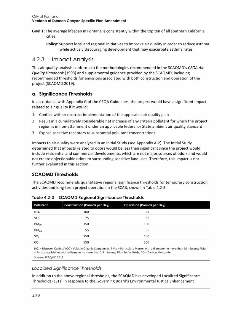
City of Fontana Ventana at Duncan Canyon Specific Plan Amendment
4.2-8
Goal 1: The average lifespan in Fontana is consistently within the top ten of all southern California cities.
Policy: Support local and regional initiatives to improve air quality in order to reduce asthma while actively discouraging development that may exacerbate asthma rates.
4.2.3 Impact Analysis This air quality analysis conforms to the methodologies recommended in the SCAQMD’s CEQA Air Quality Handbook (1993) and supplemental guidance provided by the SCAQMD, including recommended thresholds for emissions associated with both construction and operation of the project (SCAQMD 2019).
a. Significance Thresholds In accordance with Appendix G of the CEQA Guidelines, the project would have a significant impact related to air quality if it would:
Conflict with or obstruct implementation of the applicable air quality plan Result in a cumulatively considerable net increase of any criteria pollutant for which the project
region is in non-attainment under an applicable federal or State ambient air quality standard Expose sensitive receptors to substantial pollutant concentrations
Impacts to air quality were analyzed in an Initial Study (see Appendix A-2). The Initial Study determined that impacts related to odors would be less than significant since the project would include residential and commercial developments, which are not major sources of odors and would not create objectionable odors to surrounding sensitive land uses. Therefore, this impact is not further evaluated in this section.
SCAQMD Thresholds The SCAQMD recommends quantitative regional significance thresholds for temporary construction activities and long-term project operation in the SCAB, shown in Table 4.2-3.
Table 4.2-3 SCAQMD Regional Significance Thresholds Pollutant Construction (Pounds per Day) Operation (Pounds per Day)
NOx 100 55
VOC 75 55
PM10 150 150
PM2.5 55 55
SOx 150 150
CO 550 550
NOx = Nitrogen Oxides; VOC = Volatile Organic Compounds; PM10 = Particulate Matter with a diameter no more than 10 microns; PM2.5 = Particulate Matter with a diameter no more than 2.5 microns; SOx = Sulfur Oxide; CO = Carbon Monoxide
Source: SCAQMD 2019
Localized Significance Thresholds
In addition to the above regional thresholds, the SCAQMD has developed Localized Significance Thresholds (LSTs) in response to the Governing Board’s Environmental Justice Enhancement
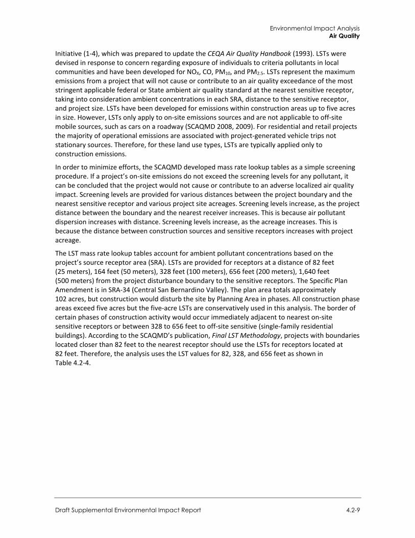
Environmental Impact Analysis Air Quality
Draft Supplemental Environmental Impact Report 4.2-9
Initiative (1-4), which was prepared to update the CEQA Air Quality Handbook (1993). LSTs were devised in response to concern regarding exposure of individuals to criteria pollutants in local communities and have been developed for NOX, CO, PM10, and PM2.5. LSTs represent the maximum emissions from a project that will not cause or contribute to an air quality exceedance of the most stringent applicable federal or State ambient air quality standard at the nearest sensitive receptor, taking into consideration ambient concentrations in each SRA, distance to the sensitive receptor, and project size. LSTs have been developed for emissions within construction areas up to five acres in size. However, LSTs only apply to on-site emissions sources and are not applicable to off-site mobile sources, such as cars on a roadway (SCAQMD 2008, 2009). For residential and retail projects the majority of operational emissions are associated with project-generated vehicle trips not stationary sources. Therefore, for these land use types, LSTs are typically applied only to construction emissions.
In order to minimize efforts, the SCAQMD developed mass rate lookup tables as a simple screening procedure. If a project’s on-site emissions do not exceed the screening levels for any pollutant, it can be concluded that the project would not cause or contribute to an adverse localized air quality impact. Screening levels are provided for various distances between the project boundary and the nearest sensitive receptor and various project site acreages. Screening levels increase, as the project distance between the boundary and the nearest receiver increases. This is because air pollutant dispersion increases with distance. Screening levels increase, as the acreage increases. This is because the distance between construction sources and sensitive receptors increases with project acreage.
The LST mass rate lookup tables account for ambient pollutant concentrations based on the project’s source receptor area (SRA). LSTs are provided for receptors at a distance of 82 feet (25 meters), 164 feet (50 meters), 328 feet (100 meters), 656 feet (200 meters), 1,640 feet (500 meters) from the project disturbance boundary to the sensitive receptors. The Specific Plan Amendment is in SRA-34 (Central San Bernardino Valley). The plan area totals approximately 102 acres, but construction would disturb the site by Planning Area in phases. All construction phase areas exceed five acres but the five-acre LSTs are conservatively used in this analysis. The border of certain phases of construction activity would occur immediately adjacent to nearest on-site sensitive receptors or between 328 to 656 feet to off-site sensitive (single-family residential buildings). According to the SCAQMD’s publication, Final LST Methodology, projects with boundaries located closer than 82 feet to the nearest receptor should use the LSTs for receptors located at 82 feet. Therefore, the analysis uses the LST values for 82, 328, and 656 feet as shown in Table 4.2-4.
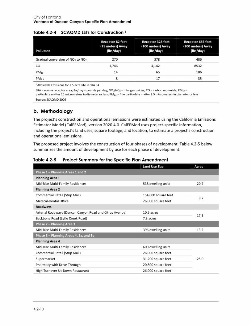
City of Fontana Ventana at Duncan Canyon Specific Plan Amendment
4.2-10
Table 4.2-4 SCAQMD LSTs for Construction 1
Pollutant
Receptor 82 feet (25 meters) Away
(lbs/day)
Receptor 328 feet (100 meters) Away
(lbs/day)
Receptor 656 feet (200 meters) Away
(lbs/day)
Gradual conversion of NOX to NO2 270 378 486
CO 1,746 4,142 8532
PM10 14 65 106
PM2.5 8 17 35 1 Allowable Emissions for a 5-acre site in SRA 34
SRA = source receptor area; lbs/day = pounds per day; NOx/NO2 = nitrogen oxides; CO = carbon monoxide; PM10 = particulate matter 10 micrometers in diameter or less; PM2.5 = fine particulate matter 2.5 micrometers in diameter or less
Source: SCAQMD 2009
b. Methodology The project’s construction and operational emissions were estimated using the California Emissions Estimator Model (CalEEMod), version 2020.4.0. CalEEMod uses project-specific information, including the project’s land uses, square footage, and location, to estimate a project’s construction and operational emissions.
The proposed project involves the construction of four phases of development. Table 4.2-5 below summarizes the amount of development by use for each phase of development.
Table 4.2-5 Project Summary for the Specific Plan Amendment Land Use Size Acres Phase 1 – Planning Areas 1 and 2 Planning Area 1 Mid-Rise Multi-Family Residences 538 dwelling units 20.7 Planning Area 2 Commercial Retail (Strip Mall) 154,000 square feet
9.7 Medical-Dental Office 26,000 square feet Roadways Arterial Roadways (Duncan Canyon Road and Citrus Avenue) 10.5 acres
17.8 Backbone Road (Lytle Creek Road) 7.3 acres Phase 2 – Planning Area 3 Mid-Rise Multi-Family Residences 396 dwelling units 13.2 Phase 3 – Planning Areas 4, 5a, and 5b Planning Area 4 Mid-Rise Multi-Family Residences 600 dwelling units
25.0
Commercial Retail (Strip Mall) 26,000 square feet
Supermarket 31,200 square feet
Pharmacy with Drive-Through 20,800 square feet
High Turnover Sit-Down Restaurant 26,000 square feet
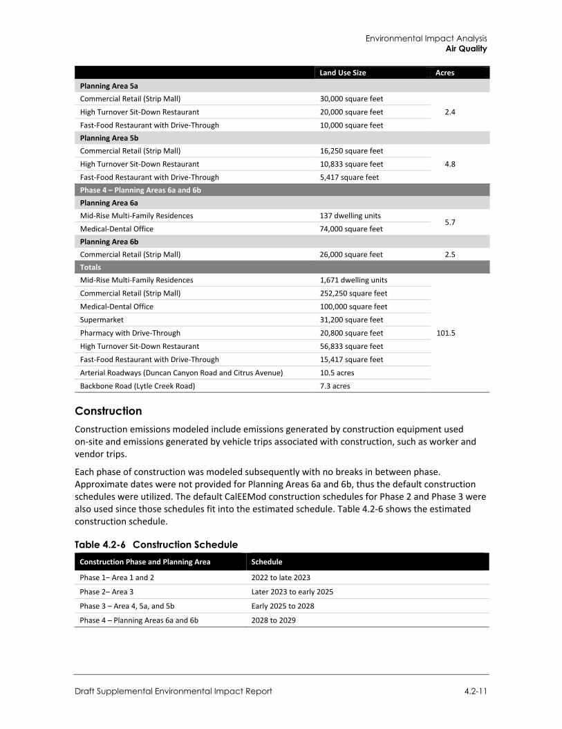
Environmental Impact Analysis Air Quality
Draft Supplemental Environmental Impact Report 4.2-11
Land Use Size Acres
Planning Area 5a Commercial Retail (Strip Mall) 30,000 square feet
2.4 High Turnover Sit-Down Restaurant 20,000 square feet
Fast-Food Restaurant with Drive-Through 10,000 square feet Planning Area 5b Commercial Retail (Strip Mall) 16,250 square feet
4.8 High Turnover Sit-Down Restaurant 10,833 square feet
Fast-Food Restaurant with Drive-Through 5,417 square feet Phase 4 – Planning Areas 6a and 6b Planning Area 6a Mid-Rise Multi-Family Residences 137 dwelling units
5.7 Medical-Dental Office 74,000 square feet Planning Area 6b Commercial Retail (Strip Mall) 26,000 square feet 2.5 Totals Mid-Rise Multi-Family Residences 1,671 dwelling units
101.5
Commercial Retail (Strip Mall) 252,250 square feet
Medical-Dental Office 100,000 square feet
Supermarket 31,200 square feet
Pharmacy with Drive-Through 20,800 square feet
High Turnover Sit-Down Restaurant 56,833 square feet
Fast-Food Restaurant with Drive-Through 15,417 square feet
Arterial Roadways (Duncan Canyon Road and Citrus Avenue) 10.5 acres
Backbone Road (Lytle Creek Road) 7.3 acres
Construction Construction emissions modeled include emissions generated by construction equipment used on-site and emissions generated by vehicle trips associated with construction, such as worker and vendor trips.
Each phase of construction was modeled subsequently with no breaks in between phase. Approximate dates were not provided for Planning Areas 6a and 6b, thus the default construction schedules were utilized. The default CalEEMod construction schedules for Phase 2 and Phase 3 were also used since those schedules fit into the estimated schedule. Table 4.2-6 shows the estimated construction schedule.
Table 4.2-6 Construction Schedule Construction Phase and Planning Area Schedule
Phase 1– Area 1 and 2 2022 to late 2023
Phase 2– Area 3 Later 2023 to early 2025
Phase 3 – Area 4, 5a, and 5b Early 2025 to 2028
Phase 4 – Planning Areas 6a and 6b 2028 to 2029

City of Fontana Ventana at Duncan Canyon Specific Plan Amendment
4.2-12
For Phase 1 (Planning Areas 1 and 2), the CalEEMod default scheduling assumptions would extend past the planned phase duration (2022 to late 2023). To compensate for the accelerated schedule, the default construction equipment was scaled (doubled) and the duration of site preparation, grading, building, and paving activities were halved. Architectural coatings would be applied as individual buildings and subphases were constructed; to reflect this, architectural coatings activities were assumed to overlap with building construction activities and the duration of architectural coating activities was assumed to be approximately half the length of building construction.
For Phase 2 (Planning Area 3), Phase 3 (Planning Areas 4, 5a, and 5b), and Phase 4 (Planning Areas 6a and 6b), the CalEEMod default scheduling assumptions are consistent with the planned phase durations. Construction activities included site preparation, grading, building, and paving activities. Like Phase 1, architectural coating activities were assumed to overlap with building construction activities and the duration of architectural coating activities were modeled as half the phase length of building construction. Equipment lists were generated by CalEEMod using default values.
In addition, this analysis assumes that the project would comply with all applicable regulatory standards. In particular, the project would comply with SCAQMD Rule 403 for dust control measures and Rule 1113 for architectural coating VOC limits.
Operational For Planning Areas 1 and 2, the first year of operation was assumed to be 2023. Full buildout of the Specific Plan Amendment was assumed to be in year 2030. Operational emissions modeled include mobile source emissions (i.e., vehicle emissions), energy emissions, and area source emissions. Area source emissions would be generated by landscape maintenance equipment, consumer products, and reapplication of architectural coating. Emissions attributed to energy use include natural gas consumption for space and water heating. Mobile source emissions are generated by motor vehicle trips to and from the Plan Area associated with operation of on-site development. Trip generation rates provided in the Traffic Study prepared by Urban Crossroads (2021) were used in the modeling.
c. Project Impacts
Threshold 1: Would the project conflict with or obstruct implementation of the applicable air quality plan?
Impact AQ-1 THE PROJECT WOULD NOT CONFLICT WITH OR OBSTRUCT IMPLEMENTATION OF THE 2016 AQMP. IMPACTS WOULD BE LESS THAN SIGNIFICANT.
The 2007 EIR analysis found that the housing and population growth from the project would be consistent with regional and local growth forecasts, and therefore impacts related to conflicts or consistency with the AQMP would be less than significant. The existing Specific Plan facilitated the construction of 842 housing units and 574,500 square feet of commercial space. By comparison, the proposed project increases the housing of the project to 1,671 units and reduces the commercial space to 476,500 square feet.
A project may be inconsistent with the AQMP if it would generate population, housing, or employment growth exceeding the forecasts used in the development of the AQMP. The 2016 AQMP, the most recent AQMP adopted by the SCAQMD, incorporates local city general plans and
Environmental Impact Analysis Air Quality
Draft Supplemental Environmental Impact Report 4.2-13
SCAG’s 2016-2040 RTP/SCS socioeconomic forecast projections of regional population housing, and employment growth.2
SCAG is the regional planning agency for Los Angeles, Orange, Ventura, Riverside, San Bernardino, and Imperial Counties, and addresses regional issues relating to transportation, economy, community development, and environment. With regard to air quality planning, SCAG has prepared the RTP/SCS, a long-range transportation plan that uses growth forecasts to project trends for regional population, housing and employment growth out to 2040 to identify regional transportation strategies to address mobility needs. These growth forecasts form the basis for the land use and transportation control portions of the 2016 AQMP. The updated growth forecasts in SCAG’s 2016 RTP/SCS estimate that the population City of Fontana would be 280,900 in 2040, which is an 80,700 person increase from 2012. The growth forecasts in SCAG’s 2016 RTP/SCS also anticipate an increase of approximately 23,800 jobs in Fontana between 2012 and 2040 with the 2040 employment totaling 70,800 employees (SCAG 2016).
The proposed project would allow for development of 476,500 square feet of commercial use and 1,671 dwelling units. The population increase from the project were compared to the growth forecasts in the SCAG 2016 RTP/SCS for the City of Fontana.
The populations were estimated using available rates. The household size rate was assumed to be 4.07 persons per dwelling unit based on the City of Fontana’s General Plan (City of Fontana 2017), which is sourced from the California Department of Finance’s 2016 persons per household rate. For the commercial uses, the rate of 1,009 square feet per employee from the SCAG Employment Density Study Summary Report was used (SCAG 2001). These rates are also consistent with the service population rates used in the Traffic Study prepared by Urban Crossroads (2021). Based on these rates, there would be 6,801 residents and 473 employees. This would equate to a total of 7,274 persons.
The population increase would be within the anticipated growth increase of 80,700 persons. The anticipated employment under the Specific Plan Amendment would also be within the forecast growth of 23,800 employees. Therefore, the project would not generate air pollution emissions that would impede or conflict with the 2016 AQMP. There would be no new or substantially more severe impacts than what was analyzed in the 2007 EIR. Impacts would be less than significant.
Mitigation Measures Mitigation measures are not required.
2 On September 3, 2020, SCAG’s Regional Council formally adopted the 2020-2045 RTP/SCS (titled Connect SoCal). However, the 2016 AQMP was adopted prior to this date and relies on the demographic and growth forecasts of the 2016-2040 RTP/SCS; therefore, these forecasts are utilized in the analysis of the project’s consistency with the AQMP.
City of Fontana Ventana at Duncan Canyon Specific Plan Amendment
4.2-14
Threshold 2: Would the project result in a cumulatively considerable net increase of any criteria pollutant for which the project region is non-attainment under an applicable federal or state ambient air quality standard?
Impact AQ-2 CONSTRUCTION OF THE PROJECT WOULD NOT RESULT IN AN INCREASE OF A CRITERIA POLLUTANT FOR WHICH THE PROJECT REGION IS IN NON-ATTAINMENT UNDER AN APPLICABLE FEDERAL OR STATE AMBIENT AIR QUALITY STANDARD. HOWEVER, MOBILE EMISSIONS FROM OPERATION OF THE SPECIFIC PLAN AMENDMENT AT FULL BUILDOUT WOULD POTENTIALLY EXCEED SCAQMD REGIONAL THRESHOLDS EVEN WITH MITIGATION, WHICH WAS AN IMPACT ALREADY IDENTIFIED IN THE 2007 EIR FROM OPERATION OF THE EXISTING SPECIFIC PLAN. THEREFORE, AS PREVIOUSLY IDENTIFIED IN THE 2007 EIR, OPERATIONAL EMISSIONS FROM MOBILE SOURCES WOULD REMAIN SIGNIFICANT AND UNAVOIDABLE.
The impact analysis from the 2007 EIR found that the project would result in a cumulatively considerable net increase of a criteria pollutants for which the project region is in nonattainment under an applicable federal or state ambient air quality state. The construction activities associated with the proposed project and vehicle emissions generated from operation of the project in the 2007 EIR would exceed the SCAQMD thresholds. Therefore, the 2007 EIR found that impacts would be significant and unavoidable even with mitigation.
Construction Emissions The Specific Plan Amendment would allow for development of 1,671 mid-rise multi-family dwelling units and 476,500 square feet of commercial use in phases by Planning Area. Construction would involve site preparation, grading, building construction, paving, and architectural coating activities that have the potential to generate air pollutant emissions. Exhaust emissions would be associated with use of heavy-duty construction equipment and truck trips hauling debris, soils, and construction materials; fugitive dust (PM10) emissions would primarily result from demolition and site preparation (e.g., grading) activities. During the finishing phase, paving operations, and the application of architectural coatings (e.g., paints) and other building materials would release VOCs. Construction emissions can vary substantially from day to day, depending on the level of activity, the specific type of operation and, for dust, the prevailing weather conditions.
As discussed above, construction emission estimates reflect the applicant-provided construction schedule. Details such as heavy equipment use, the number of construction workers, delivery trips, etc. are estimated using default assumptions in the CalEEMod based on site acreage; these assumptions were developed based on surveys of construction sites by SCAQMD. Table 4.2-7 summarizes the estimated maximum daily emissions of pollutants associated with construction of the proposed project. As shown below, VOC, NOX, CO, SOx, PM10, and PM2.5 emissions would not exceed SCAQMD regional thresholds or LSTs.
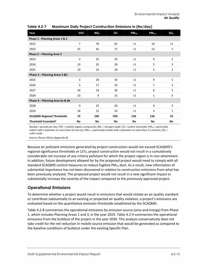
Environmental Impact Analysis Air Quality
Draft Supplemental Environmental Impact Report 4.2-15
Table 4.2-7 Maximum Daily Project Construction Emissions in (lbs/day) Year VOC NOX CO PM10 PM2.5 SOX
Phase 1 - Planning Areas 1 & 2
2022 7 78 65 <1 19 11
2023 35 42 71 <1 13 5
Phase 2 – Planning Area 3
2023 3 35 29 <1 9 5
2024 19 32 30 <1 5 3
2025 19 16 29 <1 5 2
Phase 3 – Planning Areas 4 &5
2025 3 28 33 <1 9 5
2026 3 17 32 <1 7 2
2027 26 18 36 <1 8 3
2028 23 9 15 <1 1 0
Phase 4 – Planning Area 6a & 6b
2028 3 25 20 <1 9 5
2029 18 15 23 <1 3 1
SCAQMD Regional Thresholds 75 100 550 150 150 55
Threshold Exceeded? No No No No No No
lbs/day = pounds per day; VOC = volatile organic compounds; NOx = nitrogen oxide; CO = carbon monoxide; PM10 = particulate matter with a diameter no more than 10 microns; PM2.5 = particulate matter with a diameter no more than 2.5 microns; SOx = sulfur oxide
Source: Rincon 2021a (Appendix B)
Because air pollutant emissions generated by project construction would not exceed SCAQMD’s regional significance thresholds or LSTs, project construction would not result in a cumulatively considerable net increase of any criteria pollutant for which the project region is in non-attainment. In addition, future development allowed for by the proposed project would need to comply with all standard SCAQMD control measures to reduce fugitive PM10 dust. As a result, new information of substantial importance has not been discovered in relation to construction emissions from what has been previously analyzed. The proposed project would not result in a new significant impact or substantially increase the severity of the impact compared to the previously approved project.
Operational Emissions To determine whether a project would result in emissions that would violate an air quality standard or contribute substantially to an existing or projected air quality violation, a project’s emissions are evaluated based on the quantitative emission thresholds established by the SCAQMD.
Table 4.2-8 summarizes the operational emissions by emission source (area and energy) from Phase 1, which includes Planning Areas 1 and 3, in the year 2023. Table 4.2-9 summarizes the operational emissions from the buildout of the project in the year 2030. This analysis conservatively does not take credit for the net reduction in mobile source emission that would be generated as compared to the baseline conditions of buildout under the existing Specific Plan.
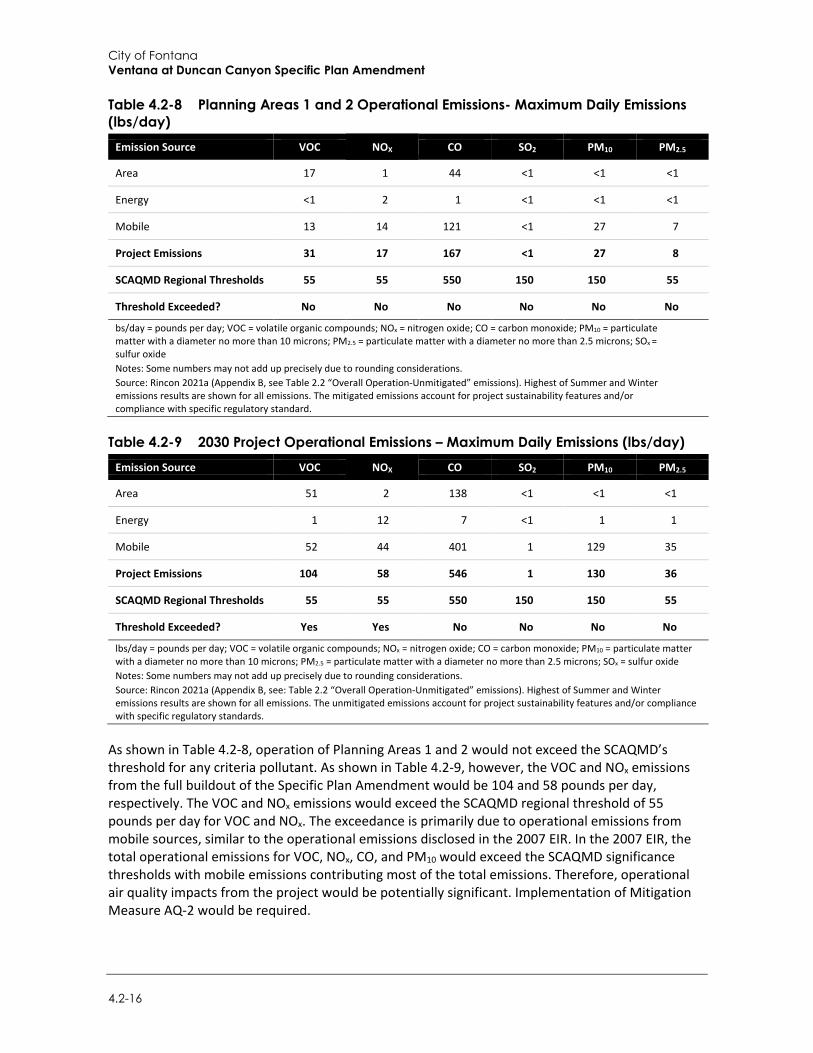
City of Fontana Ventana at Duncan Canyon Specific Plan Amendment
4.2-16
Table 4.2-8 Planning Areas 1 and 2 Operational Emissions- Maximum Daily Emissions (lbs/day)
Emission Source VOC NOX CO SO2 PM10 PM2.5
Area 17 1 44 <1 <1 <1
Energy <1 2 1 <1 <1 <1
Mobile 13 14 121 <1 27 7
Project Emissions 31 17 167 <1 27 8
SCAQMD Regional Thresholds 55 55 550 150 150 55
Threshold Exceeded? No No No No No No
bs/day = pounds per day; VOC = volatile organic compounds; NOx = nitrogen oxide; CO = carbon monoxide; PM10 = particulate matter with a diameter no more than 10 microns; PM2.5 = particulate matter with a diameter no more than 2.5 microns; SOx = sulfur oxide Notes: Some numbers may not add up precisely due to rounding considerations. Source: Rincon 2021a (Appendix B, see Table 2.2 “Overall Operation-Unmitigated” emissions). Highest of Summer and Winter emissions results are shown for all emissions. The mitigated emissions account for project sustainability features and/or compliance with specific regulatory standard.
Table 4.2-9 2030 Project Operational Emissions – Maximum Daily Emissions (lbs/day) Emission Source VOC NOX CO SO2 PM10 PM2.5
Area 51 2 138 <1 <1 <1
Energy 1 12 7 <1 1 1
Mobile 52 44 401 1 129 35
Project Emissions 104 58 546 1 130 36
SCAQMD Regional Thresholds 55 55 550 150 150 55
Threshold Exceeded? Yes Yes No No No No
lbs/day = pounds per day; VOC = volatile organic compounds; NOx = nitrogen oxide; CO = carbon monoxide; PM10 = particulate matter with a diameter no more than 10 microns; PM2.5 = particulate matter with a diameter no more than 2.5 microns; SOx = sulfur oxide Notes: Some numbers may not add up precisely due to rounding considerations. Source: Rincon 2021a (Appendix B, see: Table 2.2 “Overall Operation-Unmitigated” emissions). Highest of Summer and Winter emissions results are shown for all emissions. The unmitigated emissions account for project sustainability features and/or compliance with specific regulatory standards.
As shown in Table 4.2-8, operation of Planning Areas 1 and 2 would not exceed the SCAQMD’s threshold for any criteria pollutant. As shown in Table 4.2-9, however, the VOC and NOx emissions from the full buildout of the Specific Plan Amendment would be 104 and 58 pounds per day, respectively. The VOC and NOx emissions would exceed the SCAQMD regional threshold of 55 pounds per day for VOC and NOx. The exceedance is primarily due to operational emissions from mobile sources, similar to the operational emissions disclosed in the 2007 EIR. In the 2007 EIR, the total operational emissions for VOC, NOx, CO, and PM10 would exceed the SCAQMD significance thresholds with mobile emissions contributing most of the total emissions. Therefore, operational air quality impacts from the project would be potentially significant. Implementation of Mitigation Measure AQ-2 would be required.
Environmental Impact Analysis Air Quality
Draft Supplemental Environmental Impact Report 4.2-17
Mitigation Measures The 2007 EIR included mitigation measures requiring the development of transportation control measures to reduce emissions from vehicle activity. Development proposed under the Specific Plan Amendment would be required to implement measures under Mitigation Measure AQ-2A, which is a reinstatement of and similar to Mitigation Measure 4.5.4 from the 2007 EIR for consistency, to address impacts related to emissions from mobile sources.
AQ-2 Transportation Control Measures
The proposed project shall implement transportation control measures (TCMs) to reduce vehicular emissions to and from the site, which may include the following: Ridesharing Programs Area-wide Carpooling and Vanpooling – The developer/building managers shall provide
information brochures on carpooling and vanpooling. Modified Work Schedules – The developer/building managers shall encourage commercial
and office tenants to allow modified work schedules for employees. Park and Ride Facilities – The developer/building managers shall accommodate the parking
of vehicles to promote carpooling and vanpooling. Ares for future bus stops shall be reserved, where feasible.
Parking Management Off-street Parking Controls – Measures to discourage single-occupant vehicles shall be
implemented through parking controls. Parking Management Programs – Measures to discourage single-occupant vehicles (SOV)
shall be implemented.
Non-Motorized Strategies Bicycle Lanes and Storage Facilities – Bicycle paths and bike racks shall be provided on-site. Pedestrian Improvements – Sidewalks and pedestrian walkways shall be provided
throughout the site.
Telecommunications Adequate system connections in all homes – Telecommunication systems shall be provided
in residential villages. Wi-Fi “hot-spots” within the Community – High-speed wireless local area network shall be
provided at select locations on-site. The developer shall incorporate the TCMs above to facilitate the option to select a non- SOV
transportation option.
Significance After Mitigation While incorporation of Mitigation Measure AQ-2 would reduce impacts associated with mobile operational air quality emissions, the exact amount of VOC and NOx emissions that would be reduced cannot be quantified at the plan level since the measures would be implemented by individual development. Therefore, similar to the impact identified in the 2007 EIR, buildout of the Specific Plan Amendment would potentially exceed SCAQMD regional thresholds even with mitigation.

City of Fontana Ventana at Duncan Canyon Specific Plan Amendment
4.2-18
Infeasibility of Additional Health Risk Analysis
Pursuant to the Sierra Club v. County of Fresno (“Friant Ranch”) (2018) California Supreme Court decision, an EIR should relate expected adverse air quality impacts to likely health consequences or explain in meaningful detail why it is not feasible at the time of drafting to provide such an analysis. As explained below, it is not scientifically feasible at the time of drafting of this report to substantively connect this individual project’s criteria pollutant impacts to likely health consequences.
The SCAQMD provided an amicus brief in connection with the Friant Ranch case that is included in Appendix B. With regard to the analysis of air quality-related health impacts, the SCAQMD, the air quality authority for the SCAB, explained that “EIRs must generally quantify a project’s pollutant emissions, but in some cases, it is not feasible to correlate these emissions to specific, quantifiable health impacts (e.g., premature mortality; hospital admissions).” In such cases, a general description of the adverse health impacts resulting from the pollutants at issue may be sufficient.
The SCAQMD stated that from a scientific standpoint, it takes a large amount of additional precursor emissions to cause a modeled increase in ambient O3 levels over an entire region. For example, the SCAQMD’s 2012 AQMP showed that reducing NOX by 432 tons per day and reducing VOC by 187 tons per day would reduce O3 levels at the SCAQMD’s monitor site with the highest levels by only 9 parts per billion (SCAQMD 2013). SCAQMD staff does not currently know of a way to accurately quantify O3-related health impacts caused by NOX or VOC precursor emissions from relatively small projects.
SCAQMD acknowledged that it may be feasible to analyze air quality related health impacts for projects on a regional scale with very high emissions of NOX and VOCs, where impacts are regional. The example SCAQMD provided was for proposed Rule 1315, which authorized various newly permitted sources to use offsets from the “internal bank” of emission reductions. The CEQA analysis accounted for essentially all of the increases in emissions due to new or modified sources in the District between 2010 and 2030, or approximately 6,620 pounds per day of NOX and 89,947 pounds per day of VOC, to expected health outcomes from O3 (e.g., 20 premature deaths per year and 89,947 school absences in the year 2030 due to O3).
The SCAQMD stated its staff does not currently know of a way to accurately quantify O3-related health impacts from relatively small projects. Thus, a general description of the adverse health impacts resulting from the pollutants at issue, described in this report, is all that can be provided at this time. Please refer to Section 4.2.1, Setting, for a description of general adverse health impacts resulting from O3.
The San Joaquin Valley Air Pollution Control District (SJVAPCD) also submitted an amicus brief, which is included in Appendix B, and further addresses the scientific limitations regarding correlating an individual project’s air quality emissions to specific health impacts. Human health impacts associated with criteria pollutants are analyzed and taken into consideration when the US EPA sets the NAAQS for each criteria pollutant (42 U.S.C. Section 7409(b)(1)). The health impact of a particular criteria pollutant is analyzed on a regional, not a facility level, based on how close the area is to complying with (attaining) the NAAQS. As discussed by the SJVAPCD, it is not feasible to conduct a criteria air pollutant analysis detailing health impacts, as currently available computer modeling tools are not equipped for this task.
In proposing a health risk type analysis for criteria air pollutants, it is important to understand how the relevant criteria pollutant (O3) is formed, dispersed and regulated. Ground level O3 (smog) is not directly emitted into the air but is instead formed when precursor pollutants, such as NOX and VOC
Environmental Impact Analysis Air Quality
Draft Supplemental Environmental Impact Report 4.2-19
are emitted into the atmosphere and undergo complex chemical reactions in the process of sunlight. Once formed, O3 can be transported long distances by wind. Because of the complexity of O3 formation, a specific tonnage amount of NOX or VOCs emitted in a particular area does not equate to a particular concentration of O3 in that area. Even rural areas that have relatively low tonnages of emissions of NOX or VOC can have high levels of O3 concentrations simply due to wind transport. Conversely, areas that have substantially more NOX and VOC emissions could experience lower concentrations of O3 simply because sea breezes disperse the emissions (SJVAPCD 2014).
The disconnect between the tonnage of precursor pollutants and the concentration of O3 formed is important, because it is not necessarily the tonnage of precursor pollutants that causes human health effects; rather, it is the concentration of resulting O3 that causes these effects. The NAAQS, which are statutorily required to be set by USEPA at levels that are requisite to protect the public health, are established as concentrations of O3 and not as tonnages of their precursor pollutants. Because the NAAQS are focused on achieving a particular concentration region-wide, the SJVAPCD’s tools and plans for attaining the NAAQS are regional in nature.
The computer models used to simulate and predict an attainment date for O3 are based on regional inventories of precursor pollutants and meteorology in the air basin. At a very basic level, the models simulate future O3 levels based on predicted changes in precursor emissions basin-wide. The computer models are not designed to determine whether the emissions generated by an individual development project will affect the date that the air basin attains the NAAQS. Instead, the models help inform regional planning strategies based on the extent all of the emission-generating sources in the air basin must be controlled in order to reach attainment.
In the case of the project, operational emissions exceed the SCAQMD operational significance thresholds for VOC and NOX. However, this does not mean that one can feasibly determine the concentration of O3 that would be created at or near a project site on a particular day or month of the year, or the specific human health impacts that may occur. This is especially true for the project, where most of the criteria pollutant emissions derive not from a single “point source,” but from mobile sources (cars and trucks) driving to and from the site, or from consumer product and architectural coating use that can occur in many individual areas of the project site.
In addition, it would be infeasible to model the impact on NAAQS attainment that these emissions from the project may have. As discussed above, the currently available tools are equipped to model the impact of all emission sources in the air basin on attainment. According to the SCAQMD’s 2016 AQMP, basin-wide emissions in 2012 of VOC was 162.4 tons per day and 293.1 tons per day of NOX, (SCAQMD 2017). Running the photochemical grid model used for predicting O3 attainment with the emissions solely from a project (which equates to less than one percent for VOC and NOx) would not yield valid information given the relatively small scale involved.
HEALTH CONSEQUENCES OF O3 A summary discussion of air pollution and potential health effects was provided in Section 4.2.1, Setting. In addition, the national and State criteria pollutants and the applicable ambient air quality standards were also provided in Section 4.2.1, Setting. As stated above, air pollution is a major public health concern, and the adverse health effects associated with air pollution are diverse. O3 is a pungent, colorless, toxic gas with direct health effects on humans, including respiratory and eye irritation and possible changes in lung functions. Groups most sensitive to O3 include children, the elderly, persons with respiratory disorders, and people who exercise strenuously outdoors.
City of Fontana Ventana at Duncan Canyon Specific Plan Amendment
4.2-20
The adverse effects reported with short-term O3 exposure are greater with increased activity, because activity increases the breathing rate and the volume of air reaching the lungs, resulting in an increased amount of O3 reaching the lungs. Children may be a particularly vulnerable population to air pollution effects, because they spend more time outdoors, are generally more active, and have a higher ventilation rate than adults. A number of adverse health effects associated with ambient O3 levels have been identified from laboratory and epidemiological studies. These include increased respiratory symptoms, damage to cells of the respiratory tract, decreases in lung function, increased susceptibility to respiratory infection, and increased risk of hospitalization.
The Children’s Health Study, conducted by researchers at the University of Southern California, followed a cohort of children that live in 12 communities in southern California with differing levels of air pollution for several years. A publication from this study found that school absences in fourth graders for respiratory illnesses were associated with ambient O3 levels. An increase of 20 parts per billion of O3 was associated with an 83 percent increase in illness-related absence rates (Gilliland et al. 2004). The number of hospital admissions and emergency room visits for all respiratory causes (infections, respiratory failure, chronic bronchitis, etc.), including asthma, show a consistent increase as ambient O3 levels increase in a community. These excess hospital admissions and emergency room visits are observed when hourly O3 concentrations are as low as 0.08 to 0.10 ppm.
Numerous recent studies have found positive associations between increases in O3 levels and excess risk of mortality. These associations persist even when other variables including season and levels of PM are accounted for. This indicates that O3 mortality effects are independent of other pollutants (Bell et al. 2004). Several population-based studies suggest that asthmatics are more adversely affected by ambient O3 levels, as evidenced by increased hospitalizations and emergency room visits. Laboratory studies have attempted to compare the degree of lung function change seen in age and gender-matched healthy individuals versus asthmatics and those with chronic obstructive pulmonary disease. While the degree of change evidenced did not differ significantly, that finding may not accurately reflect the true impact of exposure on these respiration-compromised individuals. Since the respiration-compromised group may have lower lung function to begin with, the same degree of change may represent a substantially greater adverse effect overall.
A publication from the Children’s Health Study focused on children and outdoor exercise. In communities with high O3 concentrations, the relative risk of developing asthma in children playing three or more sports was found to be over three times higher than in children playing no sports (McConnell et al. 2002). These findings indicate that new cases of asthma in children are associated with heavy exercise in communities with high levels of O3. The susceptibility to O3 observed under ambient conditions could be due to the combination of pollutants that coexist in the atmosphere or O3 may actually sensitize these subgroups to the effects of other pollutants. A study of birth outcomes in southern California found an increased risk for birth defects in the aortic and pulmonary arteries associated with O3 exposure in the second month of pregnancy (Ritz et al. 2000). In summary, acute adverse effects associated with O3 exposures have been well documented, although the specific causal mechanism is still somewhat unclear. Additional research efforts are required to evaluate the long-term effects of air pollution and to determine the role of O3 in influencing chronic effects.
The evidence linking these effects to air pollutants is derived from population based observational and field studies (epidemiological) as well as controlled laboratory studies involving human subjects and animals. There have been an increasing number of studies focusing on the mechanisms (that is, on learning how specific organs, cell types, and biochemicals are involved in the human body’s response to air pollution) and specific pollutants responsible for individual effects. Yet the
Environmental Impact Analysis Air Quality
Draft Supplemental Environmental Impact Report 4.2-21
underlying biological pathways for these effects are not always clearly understood. Although individuals inhale pollutants as a mixture under ambient conditions, the regulatory framework and the control measures developed are mostly pollutant specific. This is appropriate, in that different pollutants usually differ in their sources, their times and places of occurrence, the kinds of health effects they may cause, and their overall levels of health risk. Different pollutants, from the same or different sources, may sometimes act together to harm health more than they would acting separately. Nevertheless, as a practical matter, health scientists, as well as regulatory officials, usually must deal with one pollutant at a time in determining health effects and in adopting air quality standards. To meet the air quality standards, comprehensive plans are developed such as the SCAQMD’s AQMP.
Conclusions
Consistent with the California Supreme Court’s Friant Ranch decision, the above information provides additional details regarding the potential health effects from the project’s significant and unavoidable criteria pollutant emissions. It also explains why it is not scientifically feasible at the time of drafting of this report to precisely connect this individual project’s criteria pollutant impacts to likely health consequences.
In summary, project design features and mitigation are not available that would feasibly reduce impacts from operational VOC and NOX emissions to a less-than-significant level. Therefore, impacts from operational emissions would be significant and unavoidable.
Threshold 3: Would the project expose sensitive receptors to substantial pollutant concentrations?
Impact AQ-3 THE PROJECT WOULD NOT INCREASE CARBON MONOXIDE CONCENTRATIONS SUCH THAT IT WOULD CREATE CARBON MONOXIDE HOTSPOTS. CONSTRUCTION AND OPERATION OF THE PROJECT WOULD NOT RESULT IN EMISSIONS OF TACS SUFFICIENT TO EXCEED APPLICABLE HEALTH RISK CRITERIA. IMPACTS WOULD BE LESS THAN SIGNIFICANT.
The 2007 EIR found that the project would not result in increased carbon monoxide concentration such that it would create carbon monoxide hotspots. Therefore, the 2007 EIR found that impacts would be less than significant. For construction-related TAC emissions, the 2007 EIR found that impacts would be less than significant with Mitigation Measures 4.5.1, 4.5.2, and 4.5.3.
Localized Carbon Monoxide Hotspot Impact A CO hotspot is a localized concentration of CO that is above a CO ambient air quality standard. Localized CO hotspots can occur at intersections with heavy peak hour traffic. Specifically, hotspots can be created at intersections where traffic levels are sufficiently high such that the local CO concentration exceeds the federal one-hour standard of 35.0 ppm or the federal and state eight-hour standard of 9.0 ppm (CARB 2016).
A detailed CO analysis was conducted during the preparation of SCAQMD’s 2003 AQMP (SCAQMD 2003). The locations selected for microscale modeling in the 2003 AQMP included high average daily traffic (ADT) intersections in the SCAB, those which would be expected to experience the highest CO concentrations. The highest CO concentration observed was at the intersection of Wilshire Boulevard and Veteran Avenue on the west side of Los Angeles near the I-405 Freeway. The concentration of CO at this intersection was 4.6 ppm, which is well below the state and federal
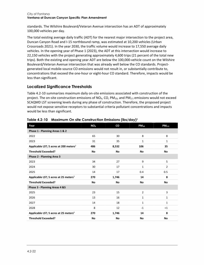
City of Fontana Ventana at Duncan Canyon Specific Plan Amendment
4.2-22
standards. The Wilshire Boulevard/Veteran Avenue intersection has an ADT of approximately 100,000 vehicles per day.
The total existing average daily traffic (ADT) for the nearest major intersection to the project area, Duncan Canyon Road and I-15 northbound ramp, was estimated at 10,200 vehicles (Urban Crossroads 2021). In the year 2030, the traffic volume would increase to 17,550 average daily vehicles. In the opening year of Phase 1 (2023), the ADT at this intersection would increase to 22,150 vehicles with the project generating approximately 4,600 trips (21 percent of the total new trips). Both the existing and opening year ADT are below the 100,000-vehicle count on the Wilshire Boulevard/Veteran Avenue intersection that was already well below the CO standards. Project-generated local mobile-source CO emissions would not result in, or substantially contribute to, concentrations that exceed the one-hour or eight-hour CO standard. Therefore, impacts would be less than significant.
Localized Significance Thresholds Table 4.2-10 summarizes maximum daily on-site emissions associated with construction of the project. The on-site construction emissions of NOX, CO, PM10, and PM2.5 emissions would not exceed SCAQMD LST screening levels during any phase of construction. Therefore, the proposed project would not expose sensitive receptors to substantial criteria pollutant concentrations and impacts would be less than significant.
Table 4.2-10 Maximum On site Construction Emissions (lbs/day)1
Year NOX CO PM10 PM2.5
Phase 1 - Planning Areas 1 & 2
2022 65 30 8 8
2023 31 35 1 1
Applicable LST; 5 acres at 200 meters2 486 8,532 106 35
Threshold Exceeded? No No No No
Phase 2 - Planning Area 3
2023 34 27 9 5
2024 30 17 1 2
2025 14 17 0.4 0.5
Applicable LST; 5 acres at 25 meters3 270 1,746 14 8
Threshold Exceeded? No No No No
Phase 3 - Planning Areas 4 &5
2025 23 15 2 3
2026 13 16 1 1
2027 14 18 1 1
2028 8 12 -1 <1
Applicable LST; 5 acres at 25 meters4 270 1,746 14 8
Threshold Exceeded? No No No No
Environmental Impact Analysis Air Quality
Draft Supplemental Environmental Impact Report 4.2-23
Year NOX CO PM10 PM2.5
Phase 4 - Planning Area 6a & 6b
2028 24 16 7 4
2029 14 18 <1 1
Applicable LST; 5 acres at 100 meters5 378 4,142 65 17
Threshold Exceeded? No No No No 1 SRA = source receptor area; lbs/day = pounds per day; NOx/NO2 = nitrogen oxides; CO = carbon monoxide; PM10 = particulate matter 10 micrometers in diameter or less; PM2.5 = fine particulate matter 2.5 micrometers in diameter or less. 2 The applicable LST is the thresholds for a 5-acre site at a distance of 656 feet (200 meters) for SRA 34. The nearest sensitive receptors would be single-family residences located approximately 640 feet (195 feet) southeast of the Planning Area 1’s eastern boundary at the intersection of Duncan Canyon Road and Citrus Avenue. 3 The applicable LST is the thresholds for a 5-acre site at a distance of 82 feet (25 meters). The nearest sensitive receptors would be the multi-family residences in Planning Area 1 located approximately 80 feet (24 meters) north of the northern boundary of Planning Area 3. 4 The applicable LST is the thresholds for a 5-acre site at a distance of 82 feet (25 meters). The nearest sensitive receptors would be the multi-family residences in Planning Area 1. 5 The applicable LST is the thresholds for a 5-acre site at a distance of 328 feet (100 meters) for SRA 34. The nearest sensitive receptors would be single-family residences located approximately 450 feet (137 feet) northwest of the Planning Area 6A’s western boundary across I-15.
Source: Rincon 2021a (Appendix B: see Table 2.1, Overall Construction-mitigated emissions).
Toxic Air Contaminants (TACs) TACs are defined by California law as air pollutants that may cause or contribute to an increase in mortality or an increase in serious illness, or which may pose a present or potential hazard to human health. The following subsections discuss the project’s potential to result in impacts related to TAC emissions during construction and operation.
Construction
Construction-related activities would result in temporary project-generated emissions of diesel particulate matter (DPM) exhaust emissions from off-road, heavy-duty diesel equipment for site preparation, grading, building construction, and other construction activities. DPM was identified as a TAC by CARB in 1998. The potential cancer risk from the inhalation of DPM (discussed in the following paragraphs) outweighs the potential non-cancer health impacts (CARB 2021a) and is therefore the focus of this analysis. Buildout of the proposed project would involve construction of residential, retail, hotel, and civic land uses. While such land uses are not typically associated with emissions of TACs, temporary TAC emissions may be associated with construction equipment and long-term stationary sources of TACs, such as diesel-powered emergency-use power generators may be associated with certain land uses. The type and quantity of TAC emissions emitted would depend upon the nature of the land use and the specific methods and operations that involve toxic air emissions. TAC emissions generated from construction would not be anticipated to result in an increased risk to nearby sensitive receptors that would result in an exceedance of applicable significance thresholds because the project would comply with applicable SCAQMD standards. Therefore, the proposed project would not increase the TAC emissions impacts compared to the previously approved project, nor expose nearby sensitive receptors to new or significantly more severe TAC emissions.
City of Fontana Ventana at Duncan Canyon Specific Plan Amendment
4.2-24
Operation
CARB’s Air Quality and Land Use Handbook: A Community Health Perspective (2005) provides recommendations regarding the siting of new sensitive land uses near potential sources of air toxic emissions (e.g., freeways, distribution centers, rail yards, ports, refineries, chrome plating facilities, dry cleaners, and gasoline dispensing facilities). SCAQMD adopted similar recommendations in its Guidance Document for Addressing Air Quality Issues in General Plans and Local Planning (2005). Together, the CARB and SCAQMD guidelines recommend siting distances both for the development of sensitive land uses in proximity to TAC sources and for the addition of new TAC sources in proximity to existing sensitive land uses. Residential land uses are not considered land uses that generate substantial TAC emissions based on review of the air toxic sources listed in SCAQMD’s and CARB’s guidelines. It is expected that quantities of hazardous TACs generated on-site (e.g., cleaning solvents, paints, landscape pesticides, etc.) for the types of proposed land uses would be below thresholds warranting further study under the California Accidental Release Program.
Buildout of the proposed project may also involve the installation of new TAC sources. Pursuant to SCAQMD rules and regulations, including SCAQMD Rule 1401 (New Source Review of Toxic Air Contaminants), major stationary sources having the potential to emit TACs would be required to obtain permits from the SCAQMD. Permits may be issued provided the source is constructed and operated in accordance with applicable SCAQMD rules and regulations. Given that compliance with applicable standards and regulations would be required, TAC emissions from new stationary sources would not be anticipated to result in an increased risk to nearby sensitive receptors that would exceed applicable significance thresholds.
Development allowed by the project would increase emissions from mobile sources. However, the project is expected to have a lower VMT per service population compared to the baseline and cumulative scenarios. According to Table 9-4 in the Traffic Study, which analyzes the cumulative effect on VMT associated with the project, the baseline VMT per service population without the Specific Plan (i.e., under the existing Specific Plan) would be 12.81, the cumulative VMT per service population without the Specific Plan (i.e., under the existing Specific Plan) would be 13.17. With the Specific Plan, the baseline VMT per service population with the project would be 12.51 (a net decrease of 0.30), and the cumulative VMT per service population with the project would be 12.95 (a net decrease of 0.22). Buildout and operation of the project would locate new commercial and retail development near existing residences, which would shorten the miles traveled for similar services and goods. Therefore, the increase in traffic generated by the project would not result in substantial mobile emissions as compared to the cumulative without Specific Plan scenario (Urban Crossroads 2021). The TAC emissions from project mobile sources would not be more severe than the existing conditions.
Because land uses proposed under the project are not associated with emissions of TACs and forecast growth would not result in the generation of mobile source TACs along area roadways in excess of applicable health risk screening criteria, operational impacts would be less than significant.
Mitigation Measures No mitigation measures are required.
4.2.4 Cumulative Impacts The cumulative context for air quality is regional. The SCAB is designated a nonattainment area for the federal and State 1-hour and 8-hour ozone standards, the State PM10 standards, the federal 24-
Environmental Impact Analysis Air Quality
Draft Supplemental Environmental Impact Report 4.2-25
hour PM2.5 standard, and the federal and State annual PM2.5 standard. SCAB is in attainment of all other federal and State standards. Despite the current nonattainment status and local air quality standard exceedances, air quality in the basin has generally improved since the inception of air pollutant monitoring in 1976. This improvement is mainly due to lower-polluting on-road motor vehicles, more stringent regulation of industrial sources, and the implementation of emission reduction strategies by the SCAQMD. This trend toward cleaner air has occurred in spite of continued population growth, as discussed in the 2012 AQMP for the SCAB (SCAQMD 2013).3
Despite this growth, air quality has improved significantly over the years, primarily due to the impacts of the region’s air quality control program…PM10 levels have declined almost 50 percent since 1990, and PM2.5 levels have also declined 50 percent since measurements began in 1999…the only air monitoring station that is currently exceeding or projected to exceed the 24-hour PM2.5
standard from 2011 forward is the Mira Loma station in Western Riverside County. Similar improvements are observed with O3, although the rate of O3 decline has slowed in recent years.
The project would contribute PM and the ozone precursors, VOC and NOX, to the area during construction and operation. As described under Impact AQ-2 above, regional emissions during construction would not exceed SCAQMD thresholds, would not contribute substantially to an existing or projected air quality violation, and would not be potentially significant. Therefore, the proposed Specific Plan Amendment would not have a significant and unavoidable cumulatively considerable contribution of VOC, NOX, CO, SOx, PM10, or PM2.5 from construction emissions. However, VOC and NOx emissions from operation of the full buildout of the project would exceed the SCAQMD thresholds due to mobile emissions. VOC emission would total 104 pounds per day with 50 percent of the emissions coming from mobile sources (52 pounds per day would be from mobile sources). NOx emissions would total 58 pounds per day with mobile emissions accounting for approximately 76 percent (44 pounds per day would be from mobile sources). Compliance with Mitigation Measure AQ-2 would help reduce the project’s contribution to a potential cumulative impact by requiring implementation of transportation control measures; however, as discussed under Impact AQ-2, the exact reduction of emissions cannot be quantified at the plan level. Therefore, even with mitigation, this impact would remain be significant and unavoidable in the cumulative scenario. The proposed project would have a significant and unavoidable cumulatively considerable contribution of VOC and NOX, from operational emissions.
As identified in Impact AQ-3, the project would not have a significant impact from CO hotspots or construction or operational emissions of TACs. In addition, as described in the Initial Study, the land uses proposed as part of the project would not be associated with odor-generation. Therefore, while cumulative impacts associated with exposure of sensitive receptors to substantial pollutant concentrations or odors may be potentially significant, the proposed project’s contribution to such impacts would not be cumulatively considerable. In addition, the project site is not located near existing or planned projects that would generate TAC or odor emissions affecting a substantial number of people. SCAQMD Rule 402 Nuisance, which prohibits the discharge of air contaminants that would cause injury, detriment, nuisance, or annoyance to the public, would minimize the potential for nuisance odors. Therefore, no cumulative TAC or odor emissions impacts would occur.
3 These trends are show in greater detail on SCAQMD’s website at: http://www.aqmd.gov/home/air-quality/historical-air-quality-data.

City of Fontana Ventana at Duncan Canyon Specific Plan Amendment
4.2-26
This page intentionally left blank.
Environmental Impact Analysis Biological Resources
Draft Supplemental Environmental Impact Report 4.3-1
4.3 Biological Resources
This section analyzes potential impacts related to biological resources. This analysis is supported by the Habitat Assessment and Tree Survey and Arborist Report, both were prepared for the project by ELMT Consulting, Inc. (2021) and are included as Appendix C-1 and Appendix C-2, respectively.
4.3.1 Setting
a. Existing Biological Resource Setting The project site is in the County of San Bernardino. The County is divided into three different regions which includes the valley, desert, and mountain regions. Each region supports a variety of biological resources. The valley region, which includes the project site is characterized by its valleys and foothills. This region includes 31 special-status plant species and 42 special-status animal species. The foothill areas of the San Gabriel and San Bernardino Mountains and associated washes are considered habitat linkage and wildlife corridors in the valley region. Currently there are efforts to conserve local habitats through the Fontana Municipal Code, and the county is planning additional plans. Furthermore, there are 12 protected and wilderness areas within the valley region of the county (County of San Bernardino 2019).
The project site occurs in an area that is undergoing a conversion from natural habitats into residential, commercial, and institutional land uses in the northern portion of the City of Fontana, east of Interstate 15 (I-15) and north of State Route 210 (SR 210). The site is predominately flat, with a gentle slope from approximately 1,835 above mean sea level (amsl) at the northern edge of the project to approximately 1,675 amsl at the southern edge along Lytle Creek Road and I-15. The site drains from the northeast to the southwest. The project site is located on an alluvial plain formed by Lytle Creek, which is the primary collector for a significant watershed that includes large portions of the San Gabriel Mountains to the north (ELMT Consulting, Inc. 2021).
Immediate land uses surrounding the site include a Southern California Edison utility easement and undeveloped, vacant land to the south and paved roads and highways to the west, north, and east. Beyond these land uses, the site is further surrounded by undeveloped, vacant land to the north; undeveloped, vacant land and residential development to the east and south, and undeveloped, vacant land residential development, and a sports park to the west (ELMT Consulting, Inc. 2021). The project area includes five eucalyptus windrows containing approximately 185 trees, which are located on the triangular parcel north of Duncan Canyon Road. In addition, there are distribution lines located along Duncan Canyon Road and Citrus Avenue.
Prior to conducting the field investigation, ELMT Consulting, Inc. reviewed current and historical aerial photographs (1985-2020) of the project site as available from Google Earth Pro Imaging (Version 7.3.4.8248). Per the review of aerial photographs, the project site appears to consist primarily of vacant/undeveloped land and disturbed areas that have been subject to various anthropogenic disturbances. The site has remained virtually unchanged since 2009, when various structures associated with historic agricultural activities were removed from the northwest corner of the southern portion.
Vegetation Plant communities provide foraging habitat, nesting/denning site, and shelter from adverse weather or predation. Due to existing site conditions, no native plant communities of special concern were
City of Fontana Ventana at Duncan Canyon Specific Plan Amendment
4.3-2
observed on or adjacent to the project site. The project site consists of vacant, undeveloped land that have been subject to a variety of disturbances associated with surrounding development and routine weed abatement activities. These disturbances have eliminated and/or greatly disturbed the natural plant communities that historically occurred within the immediate vicinity of the project site. The projects site supports two vegetation communities: non-native grassland and eucalyptus rows. In addition, the site also supports two land cover types that would be classified as disturbed and developed, further described below. Early successional/ruderal and non-native weedy plant species compose a majority of the project site as a result of routine weed abatement activities.
Disturbed land refers to unpaved or dirt areas that are routinely exposed to continuous anthropogenic disturbances and typically do not comprise a plant community. Surface soils within these areas are generally devoid of vegetation or support primarily non-native and ruderal/weedy plant species and have been heavily disturbed/compacted from anthropogenic disturbances. Some disturbed areas on-site also support small, isolated populations California buckwheat (Eriogonum fasciculatum), California sagebrush (Artemisia californica), castor (Ricinus communis), and mulefat (Baccharis salicifolia). Disturbed areas encompass the project site boundaries that occur adjacent to roads, the southwest corner of the northern portion of the site, a dirt access road, and a large area in the southern portion of the site that formerly supported fill dirt stockpiles associated with surrounding development. During the field investigation it was revealed that the site supported truck/trailer parking and swathes of debris dumping. Developed land refers to paved or otherwise impermeable land. Developed land on the project site includes paved sidewalks along adjacent roads, and access roads in the western portion of the site. These areas are generally devoid of vegetation.
The non-native grassland community occurs throughout the project site. This community is dominated by non-native grasses, including slender wild oat (Avena barbata), ripgut brome (Bromus diandrus), and cheatgrass (Bromus tectorum). Other plant species observed in this community include telegraph weed (Heterotheca grandiflora), western ragweed (Ambrosia psilostachya), doveweed (Croton setigerus), rod wire lettuce (Stephanomeria virgata), Mediterranean mustard (Hirschfeldia incana), red-stemmed filaree (Erodium cicutarum), Russian thistle (Salsola tragus), jimsonweed (Datura wrightii), common sunflower (Helianthus annuus), flax-leaved horseweed (Erigeron bonariensis), Pomona milkvetch (Astragalus pomonensis), and lambs quarters (Chenopodium album).
A total of 154 trees were identified on the project site during the tree inventory within the windrows on the northeastern boundary of the project site, all composed of a single distinct species river gum (Eucalyptus camaldulensis). No trees onsite were native to California. Several eucalyptus (Eucalyptus sp.) rows are present, remnant from historic agricultural activities, on the northeast portion of the project site (ELMT Consulting, Inc. 2021).
A heritage tree is defined as any tree which:
Is of historical value because of its association with a place, building, natural feature or event of local, regional or national historical significance as identified by city council resolution; or
Is representative of a significant period of the city's growth or development (windrow tree, European Olive tree); or
Is a protected or endangered species as specified by federal or State statute; or Is deemed historically or culturally significant by the city manager or his or her designee because
of size, condition, location or aesthetic qualities.
Environmental Impact Analysis Biological Resources
Draft Supplemental Environmental Impact Report 4.3-3
Windrow means a series of trees (minimum of four), usually a variety of eucalyptus, planted in a closely spaced line no more than ten feet apart to provide a windbreak for the protection of property and/or agricultural crops. Significant tree means any tree that is one of the following species:
Southern California black walnut (Juglans californica) Coast live oak (Quercus agrifollia) Deodora cedar (Cedrus deodora) California (western) sycamore (Platanus racemose) London plane (Platanus acerifolia)
Wildlife Wildlife detections were based on observations that occurred during the field survey or that are expected to occur within the project site.
Fish and Amphibians
No fish, amphibians or hydrogeomorphic features (e.g., perennial creeks, ponds, lakes, reservoirs) that would provide suitable habitat for fish or amphibians were observed on or within the vicinity of the project site. Therefore, no fish or amphibians are expected to occur and are presumed absent from the project site.
Reptiles
The project site provides marginal foraging and cover habitat for reptilian species adapted to a high degree of human disturbance. The only reptilian species observed during the field investigation was Great Basin fence lizard (Sceloporus occidentalis longipes). Common reptilian species adapted to a high degree of anthropogenic disturbance that may be expected to occur on-site include alligator lizard (Elgaria multicarinata), western fence lizard (Sceloporus occidentalis), and gopher snake (Pituophis catenifer annectens). Due to the high level of anthropogenic disturbances onsite and surrounding development, no special-status reptilian species are expected to occur within project site.
Birds
The project site provides foraging habitat for bird species adapted to a high degree of human disturbance. Bird species detected during the field investigation included house finch (Haemorhous mexicanus), American crow (Corvus brachyrhynchos), mourning dove (Zenaida macroura), western meadowlark (Sturnella neglecta), red-tailed hawk (Buteo jamaicensis), and peregrine falcon (Falco peregrinus).
Mammals
The project site provides marginal habitat to mammalian species adapted to a high degree of anthropogenic disturbance. Mammalian species detected during the field investigation were pocket gopher (Thomomys sp.), and California ground squirrel (Otospermophilus beecheyi). Common mammalian species that could be expected to occur within the project site include desert cottontail (Sylvilagus audubonii), opossum (Didelphis virginiana), and coyote (Canis latrans). No bat species are expected to occur due to a lack of suitable roosting habitat (i.e., suitable trees, crevices, abandoned structures) within and surrounding the project site.
City of Fontana Ventana at Duncan Canyon Specific Plan Amendment
4.3-4
Special-Status Biological Resources Special-status species are those plants and animals listed, proposed for listing, or candidates for listing as Threatened or Endangered by the United States Fish and Wildlife Service (USFWS) under the Federal Endangered Species Act (FESA); those considered “Species of Concern” by the USFWS; those listed or candidates for listing as Rare, Threatened, or Endangered by the California Department of Fish and Wildlife (CDFW) under the California Endangered Species Act (CESA); animals designated as “Fully Protected” by the California Fish and Game Code (CFGC); animals listed as “Species of Special Concern” (SSC) by the CDFW; CDFW Special Plants, specifically those with California Rare Plant Ranks (CRPR) of 1B, 2, 3, and 4 in the California Native Plant Society’s (CNPS’s) Inventory of Rare and Endangered Vascular Plants of California (CNPS 2021); and birds identified as sensitive or watch list species by San Bernardino County.
The project site is depicted on the Devore quadrangle of the United States Geological Survey’s (USGS) 7.5-minute topographic map series within and Sections 13 and 24 of Township 1 North, Range 6 West. Queries of the following databases were conducted for the Devore quadrangle of the USGS 7.5-minute topographic map series to obtain comprehensive information for federally and state-listed species, sensitive communities, and federally designated Critical Habitat known to or considered to have potential to occur on or near the project site:
USFWS Critical Habitat Portal (USFWS 2021a); USFWS National Wetlands Inventory (USFWS 2021b); Calflora Database CDFW’s QuickView Tool in the Biogeographic Information and Observation System (BIOS)
(CDFW 2021); California Natural Diversity Database Rarefind 5 (CNDDB) (CDFW 2021) CNPS Online Inventory of Rare, Threatened and Endangered Plants of California (CNPS 2021).
The literature search identified 20 special-status plant species, 43 special-status wildlife species, and three special-status plant communities as having potential to occur in the vicinity of the project site. Special-status plant and wildlife species were evaluated for their potential to occur within the project boundaries based on habitat requirements, availability and quality of suitable habitat, and known distributions.
Special-Status Wildlife Species
Table 4.3-1 includes an evaluation of the species potential to occur on the project site based on habitat suitability and project conditions.
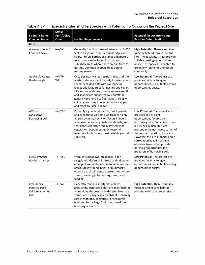
Environmental Impact Analysis Biological Resources
Draft Supplemental Environmental Impact Report 4.3-5
Table 4.3-1 Special-Status Wildlife Species with Potential to Occur on the Project Site
Scientific Name Common Name
Status FESA/CESA/ Other Habitat Requirements
Potential for Occurrence and Basis for Determination
Birds
Accipiter cooperii Cooper’s hawk
–/–/WL Generally found in forested areas up to 3,000 feet in elevation, especially near edges and rivers. Prefers hardwood stands and mature forests but can be found in urban and suburban areas where there are tall trees for nesting. Common in open areas during nesting season.
High Potential. There is suitable foraging habitat throughout the site. The eucalyptus trees provide suitable nesting opportunities onsite. This species is adapted to urban environments and occurs commonly.
Aquila chrysaetos Golden eagle
–/–/FP, WL
Occupies nearly all terrestrial habitats of the western states except densely forested areas. Favors secluded cliffs with overhanging ledges and large trees for nesting and cover. Hilly or mountainous country where takeoff and soaring are supported by updrafts is generally preferred to flat habitats. Deeply cut canyons rising to open mountain slopes and crags are ideal habitat
Low Potential. The project site provides minimal foraging opportunities. No suitable nesting opportunities onsite.
Athene cunicularia Burrowing owl
–/–/SSC Primarily a grassland species, but it persists and even thrives in some landscapes highly altered by human activity. Occurs in open, annual or perennial grasslands, deserts, and scrublands characterized by low-growing vegetation. Dependent upon fossorial mammals for burrows, most notable ground squirrels.
Low Potential. The project site provides line of-sight opportunities favored by burrowing owls. Suitable burrows (>4 inches in diameter) are present in the northwest corner of the southern portion of the site. However, the site supports and is surrounded by tall trees and electrical towers that provide perching opportunities for predators of burrowing owl.
Circus cyaneus northern harrier
–/–/SSC Frequents meadows, grasslands, open rangelands, desert sinks, fresh and saltwater emergent wetlands; seldom found in wooded areas. Mostly found in flat, or hummocky, open areas of tall, dense grasses moist or dry shrubs, and edges for nesting, cover, and feeding.
Low Potential. The project site provides minimal foraging opportunities. No suitable nesting opportunities onsite.
Eremophila alpestris actia California horned lark
–/–/WL Generally found in shortgrass prairies, grasslands, disturbed fields, or similar habitat types along the coast or in deserts. Trees are shrubs are usually scarce or absent. Generally rare in montane, coniferous, or chaparral habitats. Forms large flocks outside of the breeding season.
High Potential. There is suitable foraging and nesting habitat present within the project site.
City of Fontana Ventana at Duncan Canyon Specific Plan Amendment
4.3-6
Scientific Name Common Name
Status FESA/CESA/ Other Habitat Requirements
Potential for Occurrence and Basis for Determination
Falco mexicanus prairie falcon
–/–/WL Commonly occur in arid and semiarid shrubland and grassland community types. Also occasionally found in open parklands within coniferous forests. During the breeding season, they are found commonly in foothills and mountains which provide cliffs and escarpments suitable for nest sites.
Low Potential. The site provides minimal foraging habitat but does not provide suitable nesting opportunities.
FP = Fully Protected Species, MSHCP = Covered Species, SSC = State Species of Special Concern, ST = State Threatened, WL = State Watchlist Species
Source: ELMT Consulting, Inc. 2021 (Appendix C-1)
Based on habitat requirements for specific species and the availability and quality of onsite habitats, it was determined that the project site has a high potential to support the following bird species:
Cooper’s hawk (Accipiter cooperii) California horned lark (Eremophila alpestris actia)
The project site has a low potential to provide suitable habitat for the following bird species:
Golden eagle (Aquila chrysaetos) Burrowing owl (Athene cunicularia)
Northern harrier (Circus cyaneus) Prairie falcon (Falco mexicanus)
No special-status reptiles, mammals, or other animals have the potential to occur on the project site and are presumed absent. In addition, the project site does not provide suitable habitat for other special-status wildlife species known to occur in the area, since the project site has been heavily disturbed from onsite disturbances and surrounding development.
Burrowing Owl
The burrowing owl is currently listed as a California Species of Special Concern. It is a grassland species that is distributed throughout western North America where it occupies open areas with short vegetation and bare ground within shrub, desert, and grassland environments. Burrowing owls use a wide variety of arid and semi-arid environments with well-drained, level to gently-sloping areas characterized by sparse vegetation and bare ground. Burrowing owls are dependent upon the presence of burrowing mammals (such as ground squirrels) whose burrows are used for roosting and nesting. The presence or absence of colonial mammal burrows is often a major factor that limits the presence or absence of burrowing owls. Where mammal burrows are scarce, burrowing owls have been found occupying man-made cavities, such as buried and non-functioning drainpipes, stand-pipes, and dry culverts. Burrowing mammals may burrow beneath rocks and debris or large, heavy objects such as abandoned cars, concrete blocks, or concrete pads. They also require open vegetation allowing line-of-sight observation of the surrounding habitat to forage as well as watch for predators (ELMT Consulting, Inc. 2021).
The project site is vegetated with a variety of low-growing plant species that allow for line-of-sight observation favored by burrowing owls. In addition, several suitable burrows (>4 inches in diameter) generally capable of providing roosting and nesting opportunities were observed among dirt spoils piles in the northwest corner of the southern portion of the site. However, the site supports and is surrounded by tall trees and electrical poles and towers, which decrease the likelihood that
Environmental Impact Analysis Biological Resources
Draft Supplemental Environmental Impact Report 4.3-7
burrowing owls would occur on the project site as these features provide perching opportunities for larger raptor species (i.e., red-tailed hawk [Buteo jamaicensis]) that prey on burrowing owls (ELMT Consulting, Inc. 2021).
San Bernardino Kangaroo Rat
The San Bernardino kangaroo rat, federally listed as endangered, is one of several kangaroo rat species in its range, such as the Dulzura, the Pacific kangaroo rat (Dipodomys agilis) and the Stephens kangaroo rat (Dipodomys stephensi). The habitat of the San Bernardino kangaroo rat is typically confined to pioneer and intermediate Riversidean Alluvial Fan Sage Scrub (RAFSS) habitats, with sandy soils deposited by fluvial (water) rather than Aeolian (wind) processes. The San Bernardino kangaroo rat make burrows dug in loose soil, usually near or beneath shrubs. This kangaroo rat is one of three subspecies of the Merriam’s kangaroo rat. The Merriam’s kangaroo rat is a widespread species that can be found from the inland valleys to the deserts.
San Bernardino kangaroo rat is known to occur within Lytle Creek. The project site consists of vacant, heavily disturbed land with compacted soils that have been disturbed from previous land uses. Field sign for kangaroo rat, including San Bernardino kangaroo rat, is distinctive and readily noted in the field. No sign (e.g., San Bernardino kangaroo rat characteristic burrows, dusting baths, and/or tail drags) were observed on the project site during the field investigation. Additionally, the project site no longer is subject to the hydrologic influence of Lytle Creek due to the channelization of Lytle Creek and San Sevaine Creek for flood control purposes.
As noted above, the project site and surrounding areas have not been exposed to fluvial processes associated with Lytle Creek since the mid-1950s when I-15 was constructed, and the upper reaches of Lytle Creek were channelized. The project site is not subject to dynamic geomorphological and hydrological processes needed to scour and reset the onsite habitats back to pioneer or intermediate RAFSS habitats. Further, the project site no longer receives sand or sandy loam soils from scouring events needed by San Bernardino kangaroo rat for burrowing. Instead, the site supports compact and rocky soils. Based on these conditions, it was determined that the project site does not provide the requisite habitat elements needed by San Bernardino kangaroo rat to be present.
Nesting Birds
No active nests or birds displaying nesting behavior were observed during the field survey, which was conducted during breeding season. Although subjected to routine disturbance, ornamental vegetation found onsite has the potential to provide suitable nesting habitat for year-round and seasonal avian residents, as well as migrating songbirds that could occur in the area that area adapted to urban environments (Charadrius vociferans). No raptors are expected to nest onsite due to lack of suitable nesting opportunities.
Special-Status Plant Communities
According to the CNDDB, three special-status plant communities have been reported in the Devore USGS 7.5-minute quadrangle: Riversidean Alluvial Fan Sage Scrub, southern riparian forest, and Southern Sycamore Alder Riparian Woodland. Based on the results of the field investigation, no special-status plant communities were observed onsite.
City of Fontana Ventana at Duncan Canyon Specific Plan Amendment
4.3-8
Special-Status Plant Species
The project site consists of vacant, undeveloped land that has been subject to a variety of anthropogenic disturbances from historic agricultural activities, surrounding development and routine weed abatement activities. These disturbances have eliminated the natural plant communities that once occurred onsite which has removed the ability of the habitat on the project site to provide suitable habitat for special-status plant species known to occur in the general vicinity.
According to the CNDDB and CNPS data searches conducted by ELMT Consulting, Inc., 20 special-status plant species have been recorded in the Devore quadrangle. No special-status plant species were observed onsite during the habitat assessment. Based on habitat requirements for specific special-status plant species and the availability and quality of habitats needed by each species, it was determined that the project site does not provide suitable habitat for any of the special-status plant species known to occur in the area and they are presumed to be absent. No focused surveys were recommended (ELMT Consulting, Inc. 2021).
Critical Habitat Under the Federal Endangered Species Act (FESA), “Critical Habitat” is designated at the time of listing of a species or within one year of listing. Critical Habitat refers to specific areas within the geographical range of a species that include the physical or biological features essential to the survival and eventual recovery of that species. Maintenance of these physical and biological features requires special management considerations or protection, regardless of whether individuals or the species are present or not. In 2002 the USFWS designated Critical Habitat for San Bernardino kangaroo rat, and the project site was included within the designated area. Subsequently, in 2008 the USFWS reduced the boundaries of their previously designated Critical Habitat which removed the project site from designation. The lack of the needed habitat features within the project site, as well as in north Fontana, prompted USFWS to remove the Critical Habitat designation in this area (ELMT Consulting, Inc. 2021).
Finally, at the beginning of 2011 the original (2002) designated Critical Habitat was reinstated by a federal district court ruling which overturned the reduced (2008) designated Critical Habitat. Currently the project site is located within designated Critical Habitat Unit 2, Lytle Creek/Cajon Wash as shown in Figure 4.3-1 below. However, since the project does not have a federal nexus, a Section 7 consultation with the USFWS would not be required for loss or adverse modification of Critical Habitat. If a federal nexus does occur, a Section 7 Consultation would have to be initiated with USFWS.
Jurisdictional Features
Riparian/Riverine Habitat
The project site does not support any discernible drainage courses, inundated areas, wetland vegetation, or hydric soils that would be considered jurisdictional. The project site is isolated from regional wildlife corridors and linkages and there are no riparian corridors, creeks, or useful patches of steppingstone habitat (natural areas) within or connecting the project site to any identified wildlife corridors or linkages (ELMT Consulting, Inc. 2021).
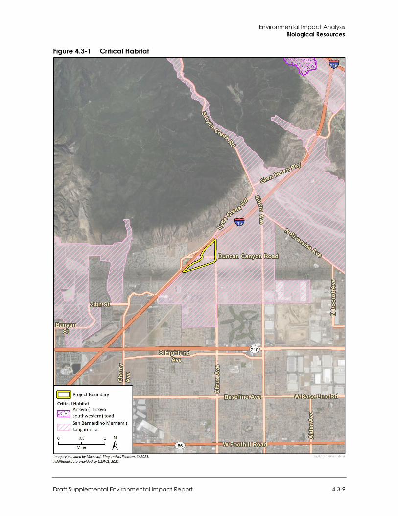
Environmental Impact Analysis Biological Resources
Draft Supplemental Environmental Impact Report 4.3-9
Figure 4.3-1 Critical Habitat
City of Fontana Ventana at Duncan Canyon Specific Plan Amendment
4.3-10
Vernal Pools
Vernal pools are seasonally inundated, ponded areas that only form in regions where specialized soil and climatic conditions exist. The city of Fontana falls under the Mediterranean climate zone. During fall and winter rains typical of Mediterranean climates, water collects in shallow depressions where downward percolation of water is prevented by the presence of a hard pan or clay pan layer (duripan) below the soil surface. Later in the spring when rains decrease and the weather warms, the water evaporates, and the pools generally disappear by May. The shallow depressions remain relatively dry until late fall and early winter with the advent of greater precipitation and cooler temperatures. Vernal pools provide unusual “flood and drought” habitat conditions to which certain plant and wildlife species have specifically adapted, as well as invertebrate species such as fairy shrimp. No special-status plant and wildlife species associated with vernal pools were observed, and routine disturbances along with soil type on-site also preclude vernal pools from existing onsite (ELMT Consulting, Inc. 2021).
Wildlife Corridors and Linkages Habitat linkages provide links between larger undeveloped habitat areas that are separated by development. Habitat linkages differ somewhat from wildlife corridors in that they may be identified by the presence of certain resources rather than by areas of linear movement. Linkage zones may extend for many miles between primary habitat areas, and their adequacy for supporting genetic flow often depends upon the combined presence of specific resources, sufficient width (to buffer against adjacent disturbances), and sufficient shelter or cover. Certain specific resources (such as rock outcroppings, vernal pools, or oak trees) may be needed at particular intervals to ensure that slower-moving species are able to traverse the linkage zone. For highly mobile or flying organisms, habitat linkages may consist of a series of discontinuous patches of suitable resources, spaced sufficiently close together to permit movement along a route in a short period of time. The “landscape linkage” concept includes habitat linkages intended to serve this purpose.
Wildlife corridors are similar to linkages but provide specific opportunities for animals to disperse or migrate between habitat areas. A corridor can be defined as a linear landscape feature of sufficient width to allow animal movement between two comparatively undisturbed habitat fragments. Adequate cover is essential for a corridor to function as a wildlife movement area. It is possible for a habitat corridor to be adequate for one species yet inadequate for others. Wildlife corridors are significant features for dispersal, seasonal migration, breeding, and foraging. Additionally, open space can provide a buffer against both human disturbance and natural fluctuations in resources.
According to the San Bernardino County General Plan, the project site has not been identified as occurring within a wildlife corridor or linkage. As designated by the San Bernardino County General Plan Open Space Element, major open space areas documented in the vicinity of the project site include Lytle Creek, located approximately 1.5 miles to the northeast, and separated from the project site by existing development.
The proposed project would be confined to existing disturbed areas and is surrounded by development and disturbed areas which have removed natural plant communities from the surrounding area. The project site is isolated from regional wildlife corridors and linkages and there are no riparian corridors, creeks, or useful patches of steppingstone habitat (natural areas) within the project site (ELMT Consulting, Inc. 2021).
Environmental Impact Analysis Biological Resources
Draft Supplemental Environmental Impact Report 4.3-11
4.3.2 Regulatory Setting
a. Federal Regulations
Federal Endangered Species Act Federally listed threatened and endangered species and their habitats are protected under provisions of FESA. Section 9 of the FESA prohibits “take” of threatened or endangered species. “Take” under the FESA is defined as to “harass, harm, pursue, hunt, shoot, wound, kill, trap, capture, or collect, or to attempt to engage in any of the specifically enumerated conduct.” The presence of any federally threatened or endangered species that are in a project area generally imposes severe constraints on development, particularly if development would result in “take” of the species or its habitat. Under the regulations of the FESA, USFWS may authorize “take” when it is incidental to, but not the purpose of, an otherwise lawful act.
If USFWS determines that Critical Habitat would be adversely modified or destroyed from a proposed action, the USFWS will develop reasonable and prudent alternatives in cooperation with the federal institution to ensure the purpose of the proposed action can be achieved without loss of Critical Habitat. If the action is not likely to adversely modify or destroy Critical Habitat, USFWS will include a statement in its biological opinion concerning any incidental take that may be authorized and specify terms and conditions to ensure the agency is in compliance with the opinion.
U.S. Army Corps of Engineers Under Section 404 of the federal Clean Water Act (CWA), the United States Army Corps of Engineers (USACE) has authority to regulate activities that could discharge dredge or fill material into wetlands or other “waters of the United States” (WOTUS). The definition of WOTUS has been the subject of recent litigation, regulatory guidance, and agency rulemaking. In current practice, jurisdictional waters are defined using the USACE’s and United States Environmental Protection Agency’s joint 2015 regulatory definition (80 FR 37054). In summary, WOTUS include:
Navigable waters Interstate waters, including interstate wetlands The territorial seas All impoundments of waters of the United States All tributaries of waters of the United States All waters adjacent to waters of the United States Specific waters (including western vernal pools) if there is significant nexus to a navigable or
interstate water, or territorial sea
The following waters are considered WOTUS if they possess a significant chemical, hydrologic, or ecological nexus to navigable waters, interstate waters, or the territorial seas:
All waters within or partially within 4,000 feet of the high tide line or ordinary high water mark of a navigable or interstate water, territorial sea, impoundment, or tributary
All waters within or partially within the 100-year floodplain of a navigable or interstate water or territorial sea

City of Fontana Ventana at Duncan Canyon Specific Plan Amendment
4.3-12
The USACE also implements the federal policy embodied in Executive Order 11990, which is intended to result in no net loss of wetland value or acres. In achieving the goals of the CWA, the USACE seeks to avoid adverse impacts and offset unavoidable adverse impacts on existing aquatic resources. Any fill or adverse modification of wetlands that are hydrologically connected to jurisdictional waters would require a permit from the USACE prior to the start of work. Typically, when a project involves impacts to WOTUS, the goal of no net loss of wetland acres or values is met through compensatory mitigation involving the creation or enhancement of similar habitats.
U.S. Fish and Wildlife Service The USFWS implements the Migratory Bird Treaty Act (MBTA) (16 United States Code Section 703-711) and the Bald and Golden Eagle Protection Act (16 United States Code Section 668). The USFWS and National Marine Fisheries Service (NMFS) share responsibility for implementing the FESA (16 United States Code Section 153 et seq.). The USFWS generally implements the FESA for terrestrial and freshwater species, while the NMFS implements the FESA for marine and anadromous species. Projects that would result in “take” of any federally listed threatened or endangered species are required to obtain authorization from the USFWS or NMFS through either Section 7 (interagency consultation with a federal nexus) or Section 10 (Habitat Conservation Plan) of FESA, depending on the involvement by the federal government in permitting and/or funding of the project. “Take” under federal definition means to harass, harm (which includes habitat modification), pursue, hunt, shoot, wound, kill, trap, capture, or collect, or to attempt to engage in any such conduct. The permitting process is used to determine if a project would jeopardize the continued existence of a listed species and what measures would be required to avoid jeopardizing the species. Proposed or candidate species do not have the full protection of FESA; the USFWS and NMFS advise project applicants the species could be elevated to listed status at any time.
The federal MBTA of 1918 was originally enacted between the United States and Great Britain (acting on behalf of Canada) for the protection of migratory birds between the two countries. The MBTA has since been expanded to include Mexico, Japan, and Russia. Under MBTA provisions, it is unlawful “by any means or manner to pursue, hunt, take, capture (or) kill” any migratory birds as defined by the MBTA except as permitted by regulations issued by the USFWS. The term “take” is defined by the USFWS regulation to mean to “pursue, hunt, shoot, wound, kill, trap, capture or collect” any migratory bird or any part, nest, or egg of any migratory bird covered by the conventions, or to attempt those activities.
b. State Regulations
California Environmental Quality Act The California Environmental Quality Act (CEQA) provides for the protection of the environment within the State of California by establishing State policy to prevent significant, avoidable damage to the environment through the use of alternatives or mitigation measures for projects. It applies to actions directly undertaken, financed, or permitted by State lead agencies. Under CEQA, “endangered” species of plants or animals are defined as those whose survival and reproduction in the wild are in immediate jeopardy, while “rare” species are defined as those who are in such low numbers that they could become endangered if their environment worsens.
Environmental Impact Analysis Biological Resources
Draft Supplemental Environmental Impact Report 4.3-13
Porter-Cologne Water Quality Act The State Water Resources Control Board (SWRCB) works in coordination with nine Regional Water Quality Control Boards (RWQCBs) to preserve, protect, enhance, and restore water quality throughout the state. Each RWQCB makes decisions related to water quality for its region, and may approve, with or without conditions, or deny projects that could affect waters of the state. Their authority to regulate activities that could result in a discharge of dredged or fill material comes from the CWA and the Porter-Cologne Water Quality Control Act (Porter-Cologne).
Porter-Cologne broadly defines “waters of the state” as “any surface water or groundwater, including saline waters, within the boundaries of the state.” Since Porter-Cologne applies to any water, whereas the CWA applies only to certain waters, California’s jurisdictional reach overlaps and may exceed the boundaries of WOTUS. For example, Water Quality Order No. 2004-0004-DWQ states that “shallow” waters of the state include headwaters, wetlands, and riparian areas. In practice, the RWQCBs may claim jurisdiction over riparian areas. Where riparian habitat is not present, such as may be the case at headwaters and urbanized areas, jurisdiction is taken to the top of bank.
The SWRCB adopted a State Wetland Definition and Procedures for Discharges of Dredged or Fill Material to Waters of the State, for inclusion in the forthcoming Water Quality Control Plan for Inland Surface Waters and Enclosed Bays and Estuaries and Ocean Waters of California. The Procedures consist of four major elements: a wetland definition; a framework for determining if a feature that meets the wetland definition is a water of the state; wetland delineation procedures; and procedures for the submittal, review and approval of applications for Water Quality Certifications and Waste Discharge Requirements for dredge or fill activities (SWRCB 2019).
Pursuant to Section 401 of the CWA, projects regulated by the USACE must obtain a Water Quality Certification from the RWQCB. This certification ensures the proposed project would uphold State water quality standards. Because California’s jurisdiction to regulate its water resources is much broader than that of the federal government, proposed impacts on waters of the state require Water Quality Certification even if the area occurs outside of USACE jurisdiction.
California Endangered Species Act CFGC, Chapter 1.5, Sections 2050- 2116 (CESA) prohibits the take of any plant or animal listed or proposed for listing as rare (plants only), threatened, or endangered. In accordance with CESA, CDFW has jurisdiction over state-listed species (CFGC Section 2070). The CDFW regulates activities that may result in take of individuals (i.e., hunt, pursue, catch, capture, or kill, or attempt to hunt, pursue, catch, capture, or kill). Habitat degradation or modification is not expressly included in the definition of take under the CFGC. The CDFW has interpreted take, however, to include the killing of a member of a species as the proximate result of habitat modification.
California Fish and Game Code The CDFW derives its authority from the CFGC. CESA (CFGC Section 2050 et. seq.) prohibits take of State-listed threatened or endangered species. Take of fully protected species is prohibited under CFGC Sections 3511, 4700, 5050, and 5515. Section 86 of CFGC defines “take” as hunt, pursue, catch, capture, or kill, or attempt to hunt, pursue, capture, or kill. This definition does not include indirect harm by way of habitat modification.
CFGC Sections 3503, 3503.5, and 3511 restrict the take, possession, and destruction of birds, nests, and eggs. Section 3503.5 of the CFGC protects all birds-of-prey and their eggs and nests against
City of Fontana Ventana at Duncan Canyon Specific Plan Amendment
4.3-14
take, possession, or destruction. Fully protected birds may not be taken or possessed except under specific permit (Section 3511).
SSC is a category CDFW uses for those species considered to be indicators of regional habitat changes or considered to be potential future protected species. SSC do not have any special legal status except that which may be afforded by the CFGC, as noted above. CDFW intends the SSC category as a management tool to include these species into special consideration when decisions are made concerning the development of natural lands.
The CDFW also has authority to administer the Native Plant Protection Act (CFGC Section 1900 et seq.). The Native Plant Protection Act requires the CDFW to establish criteria for determining if a species, subspecies, or variety of native plant is endangered or rare. Under Section 1913(c) of the Native Plant Protection Act, the owner of land where a rare or endangered native plant grows is required to notify the department at least 10 days in advance of changing the land use to allow for salvage of plant(s).
Perennial, intermittent, and ephemeral streams and associated riparian vegetation, when present, also fall under the jurisdiction of the CDFW. Section 1600 et seq. of the CFGC (Lake and Streambed Alteration Agreements) gives CDFW regulatory authority over work in the bed, bank, and channel (which could extend to the 100-year flood plain), consisting of, but not limited to, the diversion or obstruction of the natural flow or changes in the channel, bed, or bank of any river, stream or lake.
Regional Water Quality Control Board The SWRCB have jurisdiction over WOTUS, with federal authority under the CWA Section 401 and state authority under Porter-Cologne to protect water quality, which prohibits discharges to such waters. As indicated above, “waters of the state” are defined more broadly than WOTUS as any surface water or groundwater, including saline waters, in the boundaries of the state.
Native Plant Protection Act Sections 1900–1913 of the Fish and Game Code were developed to preserve, protect, and enhance Rare and Endangered plants in the state of California. The act requires all state agencies to use their authority to carry out programs to conserve Endangered and Rare native plants. Provisions of the Native Plant Protection Act prohibit the taking of listed plants from the wild and require notification of the CDFW at least ten days in advance of any change in land use which would adversely impact listed plants. This allows the CDFW to salvage listed plant species that would otherwise be destroyed.
c. Local Regulations
City of Fontana General Plan The City’s General Plan Conservation, Open Space, Parks and Trails chapter seeks to preserve existing natural resources in Fontana (City of Fontana 2018). Goals and policies that relate to biological resources and would apply to the project include the following:
Conservation, Open Space, Parks and Trails
Goal 1: Fontana continues to preserve sensitive natural open space in the foothills of the San Gabriel Mountains and Jurupa Hills.
Environmental Impact Analysis Biological Resources
Draft Supplemental Environmental Impact Report 4.3-15
Policy: Consider permanent protection for sensitive foothill lands through potential partnerships with conservation organizations or acquisition and deed restrictions.
Goal 2: Large city parks and open spaces include plantings and natural areas attractive to birds and other wildlife.
Policy: Inform the public about the natural ecological character of Fontana.
Policy: Use public open space to support wildlife habitat where appropriate.
Goal 3: Fontana has a healthy, drought-resistant urban forest.
Policy: Support tree conservation and planting that enhances shade and drought resistance.
Policy: Expand Fontana’s tree canopy.
North Fontana Conservation Program The City of Fontana and USFWS is currently developing a Multiple Species Habitat Conservation Plan (MSHCP) for North Fontana to address the critical habitats for the San Bernardino kangaroo rat and the California gnatcatcher in this area. The MSHCP is pending adoption (City of Fontana 2018). The North Fontana Conservation Program (previously referred to as the North Fontana Interim Program) was prepared to address lands in north Fontana and the listed and special-status species that have the potential to occur on these lands prior to the adoption of the MSHCP. To adequately mitigate for the loss of sensitive habitats, as required by the CEQA, a tiered development mitigation fee was created for new development in north Fontana. The mitigation fee is based on the quality of the habitat on the development site and a site’s potential to support San Bernardino kangaroo rat, coastal California gnatcatcher, or other special-status species occurring in the vicinity. A mitigation fee is assessed for each acre of applicable land proposed for development based on the habitat quality rating.
4.3.3 Impact Analysis
a. Significance Thresholds
Impacts to biological resources may be considered less than significant where their effects have little or no importance to a given habitat. In accordance with Appendix G of the CEQA Guidelines, the project would have a significant impact on biological resources if it would:
Have a substantial adverse effect, either directly or through habitat modifications, on any species identified as a candidate, sensitive, or special-status species in local or regional plans, policies, or regulations, or by the California Department of Fish and Wildlife or U.S. Fish and Wildlife Service
Have a substantial adverse effect on any riparian habitat or other sensitive natural community identified in local or regional plans, policies, regulations, or by the California Department of Fish and Wildlife or U.S. Fish and Wildlife Service
Have a substantial adverse effect on state or federally protected wetlands (including, but not limited to marsh, vernal pool, coastal, etc.) through direct removal, filling, hydrological interruption, or other means
Interfere substantially with the movement of any native resident or migratory fish or wildlife species or with established native resident or migratory wildlife corridors, or impede the use of native wildlife nursery sites
City of Fontana Ventana at Duncan Canyon Specific Plan Amendment
4.3-16
Conflict with any local policies or ordinances protecting biological resources, such as a tree preservation policy or ordinance
Conflict with the provisions of an adopted Habitat Conservation Plan, Natural Community Conservation Plan, or other approved local, regional, or state habitat conservation plan
b. Methodology Prior to conducting the habitat assessment, a literature review and records search was conducted for special-status biological resources potentially occurring on or within the vicinity of the project site. Previously recorded occurrences of special-status plant and wildlife species and their proximity to the project site were determined through a query of the CDFW’s QuickView Tool in the Biogeographic Information and Observation System (BIOS), CNDDB Rarefind 5, CNPS’s Electronic Inventory of Rare and Endangered Vascular Plants of California, Calflora Database, compendia of special-status species published by CDFW, and USFWS species listings.
A field survey was conducted on June 3, 2021, to document baseline conditions and assess the potential for special-status plant and wildlife species to occur on the project site that could pose a constraint to development of the proposed project. The Habitat Assessment provides an in-depth assessment of the suitability of the on-site habitat to support special-status plant and wildlife species identified by CDFW California Natural Diversity Database (CNDDB) and other electronic databases as potentially occurring in the vicinity of the project site.
Data used for this analysis included aerial photographs, topographic maps, a CNDDB database query, accepted scientific texts to identify species, previous biological studies, survey reports prepared for the project site and the surrounding area, results of the reconnaissance field surveys, and other available literature regarding existing biological resources in and around the project area.
c. Standard Conditions The following standard conditions related to biological resources, and identified in the 2007 EIR, remain applicable to the proposed project:
Standard Condition 4.9.1: The removal of trees on-site shall be subject to the City’s Preservation of Heritage, Significant and Specimen Trees (Fontana Municipal Code Section 28-60) for the replacement of any Heritage, Significant and Specimen Trees that may be affected by the project.
Standard Condition 4.9.2: In accordance with the City’s North Fontana Conservation Program, the developer shall pay a fee for the future acquisition of preserved habitat for sensitive species.
Environmental Impact Analysis Biological Resources
Draft Supplemental Environmental Impact Report 4.3-17
d. Project Impacts
Threshold 1: Would the project have a substantial adverse effect, either directly or through habitat modifications, on any species identified as a candidate, sensitive, or special status species in local or regional plans, policies, or regulations, or by the California Department of Fish and Wildlife or U.S. Fish and Wildlife Service?
Impact BIO-1 IMPLEMENTATION OF THE PROJECT COULD RESULT IN DIRECT OR INDIRECT IMPACTS TO BURROWING OWL AND NESTING BIRDS AND RAPTORS THROUGH REMOVAL OF GROUND COVER AND HABITAT, AND FROM CONSTRUCTION DURING THE BREEDING SEASON. HOWEVER, IMPACTS WOULD BE LESS THAN SIGNIFICANT WITH MITIGATION INCORPORATED.
Special-Status Plant Communities Based on the results of the field investigation, no special-status plant communities were observed onsite. Therefore, no special-status plant communities would be impacted by project implementation (ELMT Consulting, Inc. 2021).
San Bernardino Kangaroo Rat The San Bernardino kangaroo rat is presumed absent from the project site due to the lack of suitable habitat onsite. Therefore, no focused surveys are recommended (ELMT Consulting, Inc. 2021).
Burrowing Owl The 2007 EIR determined that development under the existing Specific Plan would potentially impact migratory birds. The 2007 EIR determined that the project site had a low potential to support burrowing owl. The most current field investigation found no burrowing owl or recent sign (i.e., pellets, feathers, castings, or whitewash) on the project site. Although potentially suitable burrows for the owl are found onsite, the presence of larger raptors explains the absence of burrowing owl and owl sign. Nonetheless, impacts to burrowing owl, if present, would be potentially significant under the proposed project.
Nesting Birds and Raptors The 2007 EIR determined that development under the existing Specific Plan would potentially lead to loss of existing vegetation and animal habitats on the site, and may impact migratory birds and burrowing owls. Therefore, mitigation measures would be required to reduce potential impacts to migratory and nesting birds, raptors and burrowing owls. Furthermore, the 2007 EIR identified standard conditions to further reduce potential impacts to wildlife habitat by requiring the project to comply with City regulations such as Section 28.60 of the Fontana Municipal Code and the North Fontana Conservation Program.
As detailed in Section 4.3.2, Regulatory Setting, the nests of most native birds and raptors are federally and state protected. No bird or raptor nests were specifically identified during field reconnaissance; however, it is likely birds use the project site for nesting (generally from early February through late August), which could be impacted by construction activities associated with the project. Vegetation within and surrounding the project site has the potential to provide refuge cover from predators, perching sites, and foraging opportunities that could also be impacted by project implementation. Notably, as discussed in Section 4.3.1, Setting, the project site has a high
City of Fontana Ventana at Duncan Canyon Specific Plan Amendment
4.3-18
potential to support Cooper’s hawk and California horned lark. However, the project site consists of vacant, undeveloped land that has been subject to a variety of anthropogenic disturbances from historic agricultural activities, surrounding development, and routine weed abatement activities. These disturbances have eliminated the natural plant communities that once occurred onsite which has reduced potential foraging, coverage, and nesting/denning opportunities for special-status wildlife species.
While the project site continues to provide some foraging habitat for bird species adapted to a high degree of human disturbance, project implementation would be limited to the already disturbed site and would not modify other quality habitat available to wildlife. Therefore, these species would not be impacted by the loss of on-site foraging habitat since the potential for foraging opportunities has already been reduced due to the elimination of natural plant communities on the project site. The project would not result in significant impacts related to foraging habitat loss.
Nonetheless, project implementation has potential to result in direct and indirect impacts to nesting birds, including year-round and seasonal avian residents, as well as migrating songbirds protected under the MBTA, if they nest on the project site and/or in the immediate vicinity during construction activities. Direct impacts from construction activities include ground disturbance and removal of trees, which could contain bird nests. Indirect impacts include construction noise, lighting, and fugitive dust. These impacts could lead to individual mortality or harassment that might reduce nesting success. Nesting birds are protected pursuant to the MBTA and CFGC (Sections 3503, 3503.5, 3511, and 3513 prohibit the take, possession, or destruction of birds, their nests or eggs). Potential impacts would be similar to the impacts determined in the 2007 EIR, and impacts would be potentially significant.
Mitigation Measures The 2007 EIR included mitigation measures to address potential impacts to migratory and nesting birds, raptors and burrowing owl. The original mitigation measures have been replaced with Mitigation Measures BIO-1A through BIO-IC, to update to current requirements, and are considered functionally equivalent. Mitigation Measures BIO-1A and 1B address potential impacts on burrowing owls while BIO-IC addresses potential impacts on nesting birds.
BIO-1A Burrowing Owl Preconstruction Survey
A burrowing owl pre-construction clearance survey shall be conducted prior to any ground disturbance or vegetation removal activities to ensure that burrowing owls remain absent from the project site. In accordance with the CDFW’s Staff Report on Burrowing Owl Mitigation (2012), two pre-construction clearance surveys shall be conducted 14- 30 days, and 24 hours prior to any ground disturbance or vegetation removal activities.
BIO-1B Burrowing Owl Avoidance Measures
A burrowing owl survey shall be conducted no more than 30 days prior to the onset of construction to ensure avoidance of this species. If no occupied burrows are found, a report shall be submitted to the City and construction may begin without further actions. If owl burrows are found, a 300-foot buffer zone shall be established around each burrow with an active nest until the young have fledged and are able to exit the burrow. For occupied burrows without active nesting or active burrows after the young have fledged, passive relocation of the owls would be performed. This shall involve installation of a one-way door at the burrow entrance. The Burrowing Owl Survey Protocol and Mitigation Guidelines (California Burrowing Owl Consortium 1993) shall be utilized for current
Environmental Impact Analysis Biological Resources
Draft Supplemental Environmental Impact Report 4.3-19
methods for passive relocation of any owls found during the survey. A qualified biologist shall conduct the relocation activities and provide construction monitoring during construction activities near the burrows.
BIO-1C Nesting Bird Avoidance
All construction activities shall comply with the MBTA and CFGC Sections 3503, 3511 and 3513. The MBTA governs the taking and killing of migratory birds, their eggs, parts, and nests and prohibits the take of any migratory bird, their eggs, parts, and nests. Prior to issuance of grading permits, the following measures shall be implemented:
To avoid disturbance of nesting and special-status bird species protected by the MBTA and California Fish and Game Commission, construction activities related to the project, including but not limited to, vegetation removal, ground disturbance, and construction and demolition shall occur outside of the bird breeding season (February 1 through August 31). If construction must begin during the breeding season, then a pre-construction nesting bird survey shall be conducted no more than 30 days prior to initiation of construction activities. The nesting bird pre-construction survey shall be conducted on foot inside the project site disturbance areas. If an active avian nest is discovered during the pre-construction clearance survey, construction activities shall stay outside of a 300-foot buffer around the active nest. For listed and raptor species, this buffer shall be expanded to 500 feet.
Inaccessible areas (e.g., private lands) shall be surveyed from afar using binoculars to the extent practical. The survey shall be conducted by a qualified biologist familiar with the identification of avian species known to occur in the valley/foothill areas of San Bernardino County. If nests are found, an appropriate avoidance buffer shall be determined by a qualified biologist and demarcated by a qualified biologist with bright orange construction fencing, flagging, construction lathe, or other means to mark the boundary. Effective buffer distances are highly variable and based on specific project stage, bird species, stage of nesting cycle, work type, and the tolerance of a particular bird pair. The buffer may be up to 500 feet in diameter, depending on the species of nesting bird found and the biologist’s observations.
Significance After Mitigation Mitigation Measures BIO-1A, BIO-1B, and BIO-1C, would reduce potential impacts to special-status species to less than significant levels by avoiding impacts to individual burrowing owl and nesting birds in accordance with the guidelines in the MBTA. Impacts would be less than significant with implementation of mitigation.
City of Fontana Ventana at Duncan Canyon Specific Plan Amendment
4.3-20
Threshold 2: Would the project have a substantial adverse effect on any riparian habitat or other sensitive natural community identified in local or regional plans, policies, or regulations, or by the California Department of Fish and Wildlife or U.S. Fish and Wildlife Service?
Threshold 3: Would the project have a substantial adverse effect on state or federally protected wetlands (including, but not limited to marsh, vernal pool, coastal, etc.) through direct removal, filling, hydrological interruption, or other means?
Impact BIO-2 CONSTRUCTION AND OPERATION OF THE PROJECT WOULD NOT IMPACT ANY RIPARIAN HABITAT OR OTHER SENSITIVE NATURAL COMMUNITY IDENTIFIED IN LOCAL OR REGIONAL PLANS, POLICIES, OR REGULATIONS, OR BY CDFW OR USFWS. IN ADDITION, THE PROJECT SITE DOES NOT CONTAIN ANY REGULATED WATERS, NOR WOULD CONSTRUCTION ACTIVITIES ADVERSELY AFFECT PROTECTED WETLANDS. IMPACTS WOULD BE LESS THAN SIGNIFICANT.
The 2007 EIR determined that there were no drainage channels, wetland areas, or hydric soils on or near the site. Thus, no areas subject to USACE and CDFW jurisdiction were present. In addition, the 2007 EIR determined that there were no wetland areas on the project sites (City of Fontana 2007).
As previously described in Section 4.3.1, Setting, there were no areas found on the project site that qualify as riparian/riverine habitat or other sensitive habitat. The project site has been effectively cut off from the historic fluvial flow patterns and scouring regimes of Lytle Creek and flows exiting out of the San Gabriel Mountains due to the construction of I-15, and developments north of the project site, which have disrupted the natural flood regime within the area, resulting in poor quality habitats onsite. The project site does not support any discernible drainage courses, inundated areas, wetland features, or hydric soils that would be considered jurisdictional by the USACE, RWQCB, or CDFW. Project activities would not result in impacts to USACE, RWQCB, or CDFW jurisdictional areas and regulatory approvals would not be required.
Furthermore, there are no native plant communities on or adjacent to the project site, and vegetation is substantially limited to non-native grassland, and Eucalyptus windrows. As a result, the project site lacks riparian habitat and is not located within any sensitive natural community. Therefore, the project would not have a substantial adverse effect on any riparian habitat or other sensitive natural community identified in local or regional plans, policies, or regulations, or by CDFW or USFWS and impacts would be less than significant.
Furthermore, based on an assessment of habitat communities on the project site discussed above and the national wetlands inventory, it was determined that the project site does not contain wetlands considered jurisdictional or qualify as riparian/riverine habitat, nor would project activities impact federal or state jurisdictional areas. The project does not contain federally protected wetlands, nor would project construction have any impacts to federally protected wetlands (USFW 2021b). Therefore, these conditions are similar to the previous 2007 EIR and the project would not have a substantial adverse effect on state or federally protected wetlands. Impacts would be less than significant.
Mitigation Measures Mitigation measures are not required.
Environmental Impact Analysis Biological Resources
Draft Supplemental Environmental Impact Report 4.3-21
Threshold 4: Would the project interfere substantially with the movement of any native resident or migratory fish or wildlife species or with established native resident or migratory wildlife corridors, or impede the use of native wildlife nursery sites?
Impact BIO-3 NO PROPOSED OR EXISTING MSHCP CORE AREAS, LINKAGES, OR HABITAT BLOCKS ARE ON OR NEAR THE PROJECT SITE. IMPACTS WOULD BE LESS THAN SIGNIFICANT.
The 2007 EIR determined that the project site is located near the foothills of the San Gabriel and San Bernardino Mountains which is a location with potential for wildlife movement. However, the site does not serve as a major wildlife corridor for the region and nearby open areas may be better utilized as wildlife corridors closer to the foothills, northeast of the project site as I-15 forms a barrier to terrestrial wildlife movement (City of Fontana 2007).
The project site is currently located within designated Critical Habitat Unit 2, Lytle Creek/Cajon Wash. However, since the project does not have a federal nexus, a Section 7 consultation with the USFWS would not be required for loss or adverse modification of Critical Habitat. If a federal nexus does occur, a Section 7 Consultation will have to be initiated with USFWS. In addition, according to the San Bernardino County General Plan, the project site has not been identified as occurring within a Wildlife Corridor or Linkage. As designated by the San Bernardino County General Plan Natural Resources Element, major open space areas documented in the vicinity of the project site include Lytle Creek, located approximately 1.5 miles to the northeast, and is separated from the project site by existing development (San Bernardino County 2020).
The proposed project would be confined to existing disturbed areas and is surrounded by development and disturbed areas which have removed natural plant communities from the surrounding area. The project site is isolated from regional wildlife corridors and linkages by I-15 and there are no riparian corridors, creeks, or useful patches of steppingstone habitat (natural areas) within or connecting the project site to any identified wildlife corridors or linkages. Therefore, the conditions are similar to the previous 2007 EIR and the project would not interfere substantially with the movement of any native resident or migratory fish or wildlife species or with established native resident or migratory wildlife corridors, or impede the use of native wildlife nursery sites. Impacts would be less than significant.
Mitigation Measures Mitigation measures are not required.
Threshold 5: Would the project conflict with any local policies or ordinances protecting biological resources, such as a tree preservation policy or ordinance?
Threshold 6: Conflict with the provisions of an adopted Habitat Conservation Plan, Natural Community Conservation Plan, or other approved local, regional, or state habitat conservation plan?
Impact BIO-4 THE PROJECT WOULD NOT CONFLICT WITH LOCAL POLICIES AND ORDINANCES PROTECTING BIOLOGICAL RESOURCES SUCH AS TREES, OR WITH THE PROVISIONS OF AN ADOPTED HABITAT CONSERVATION PLAN, NATURAL COMMUNITY CONSERVATION PLAN, OR OTHER APPROVED LOCAL, REGIONAL, OR STATE HABITAT CONSERVATION PLAN. IMPACTS WOULD BE LESS THAN SIGNIFICANT.
The 2007 EIR determined that the project features Eucalyptus trees from historic windrows that are considered heritage trees under Fontana Municipal Code Section 28.61.75. The project would
City of Fontana Ventana at Duncan Canyon Specific Plan Amendment
4.3-22
require a tree removal permit for removal of the trees, and would incorporate the planting of new trees into its landscape plan to comply with the Municipal Code. The project would comply with the standard conditions in the previous 2007 EIR, which require adherence to the City’s Preservation of Heritage, Significant and Specimen Trees (Fontana Municipal Code Section 28-60) and the payment of applicable fees under the North Conservation Program, as discussed above (City of Fontana 2007).
As stated in Section 4.3.1, Setting, a total of 154 trees were identified on the project site during the tree inventory within the windrows on the northeastern boundary of the project site, all composed of a single distinct species river gum (Eucalyptus camaldulensis). No trees onsite were native to California. Due to the poor maintenance and landscaping, only 66 (43 percent) of the trees onsite are in fair to good health and can be preserved. However, 121 of the 154 trees (79 percent) onsite were arranged within existing windrows qualifying them as Heritage Trees under the City of Fontana Tree Ordinance. No other trees onsite have any other special designations. A tree removal permit would need to be acquired from the City to remove these trees from the project site. Chapter 28.61.75 of the Fontana Municipal Code addresses tree protection, maintenance, and replacement policies. It outlines the definition of a “heritage tree”, “significant tree”, and “specimen tree” and the procedures necessary to replacing them within a property. As stated in the City’s Code, “Except as provided in section 28-65, no person shall remove or cause the removal of any heritage, significant or specimen tree unless a tree removal permit is first obtained.”
Furthermore, the North Fontana Conservation Program was prepared to address lands in north Fontana and the listed and special-status species that have the potential to occur on these lands. The program is intended to adequately mitigates the loss of sensitive habitats, by requiring a tiered development mitigation fee. The mitigation fee is charged for each acre of land proposed for development based on the habitat quality rating. The habitat quality for the land within the Specific Plan area is “Unsuitable Habitat.” Thus, the project would be subject to applicable fees associated with this habitat quality.
In addition, with the standard conditions discussed above, the project would not conflict with any local policies or ordinances protecting biological resources, such as a tree preservation policy or ordinance. Impacts would be less than significant.
Mitigation Measures Mitigation measures are not required.
4.3.4 Cumulative Impacts Planned and pending projects in Fontana and surrounding areas are listed in Table 3-1 in Section 3, Environmental Setting, and include residential, commercial, and industrial land uses. The project, in conjunction with other planned and pending projects in the project site vicinity, would cumulatively increase the potential to impact biological resources. In the event that biological resources are encountered, each individual project would be required to comply with the applicable regulatory requirements and mitigate any potential impacts to resources on the individual project site.
The following factors are considered with respect to analyzing cumulative impacts to biological resources:
The cumulative contribution of other approved and proposed projects to fragmentation of open space in the project vicinity
Environmental Impact Analysis Biological Resources
Draft Supplemental Environmental Impact Report 4.3-23
The loss of sensitive habitats and species The contribution of the project to urban expansion into natural areas Isolation of open space in the vicinity by proposed/future projects
Potential impacts of the project would be reduced to a less-than-significant level due to implementation of Mitigation Measures BIO-1A, BIO-1B, and BIO-1C that would address potential impacts to migratory and nesting birds, in addition to burrowing owls. Compliance with CEQA requirements by individual projects, including the implementation of recommendations provided in project-specific biological resources studies, on all new development would ensure that the project would not be cumulatively significant. In the event that biological resources are encountered, each individual project would be required to comply with the applicable regulatory requirements to determine and mitigate any potential impacts. Such recommendations may include nesting bird surveys, preconstruction burrowing owl surveys, avoidance measures and/or other measures determined to be necessary based on the situation. In addition, all projects are required to comply with the North Fontana Conservation Program which requires the payment of mitigation fees based on the quality of the habitat on the development site and a site’s potential to support San Bernardino kangaroo rat, coastal California gnatcatcher, or other special-status species occurring in the vicinity. Therefore, cumulative impacts related to biological resources would be less than significant.

City of Fontana Ventana at Duncan Canyon Specific Plan Amendment
4.3-24
This page intentionally left blank.
Environmental Impact Analysis Cultural Resources and Tribal Cultural Resources
Draft Supplemental Environmental Impact Report 4.4-1
4.4 Cultural Resources and Tribal Cultural Resources
This section evaluates the project’s potential impacts to cultural and tribal cultural resources (TCR). The analysis consists of the identification and evaluation of the significance of any cultural resources within the project area and area of potential impacts; a determination if implementation of the proposed project would have any adverse impacts on those resources; and identification of mitigation measures for any significant impacts (pursuant to CEQA Guidelines Section 15126.2) on cultural and tribal cultural resources.
The analysis herein relies on the Cultural Resources Assessment Report prepared for the project by Rincon Consultants, Inc. (2021), which is included as Appendix D. Project impacts on TCRs rely on the results of consultation completed with local California Native American tribes, conducted pursuant to Assembly Bill (AB) 52 and Senate Bill (SB) 18.
4.4.1 Setting
a. Prehistoric Context During the twentieth century, many archaeologists developed chronological sequences to explain prehistoric cultural changes within all or portions of Southern California. Wallace devised a prehistoric chronology for the Southern California region based on early studies and focused on data synthesis that included four horizons: Early Man, Milling Stone, Intermediate, and Late Prehistoric. Though initially lacking the chronological precision of absolute dates, Wallace’s synthesis has been modified and improved using thousands of radiocarbon dates obtained by Southern California researchers over recent decades. The prehistoric chronological sequence for Southern California presented below is a composite based on Wallace and Warren as well as later studies, including Koerper and Drover.
Early Man Horizon (ca. 10,000 – 6000 BCE) Numerous pre-8000 BCE sites have been identified along the mainland coast and Channel Islands of southern California. The Arlington Springs site on Santa Rosa Island produced human femurs dating to approximately 13,000 years ago. On nearby San Miguel Island, human occupation at Daisy Cave (CA-SMI-261) has been dated to nearly 13,000 years ago and included basketry greater than 12,000 years old, the earliest on the Pacific Coast.
Although few Clovis or Folsom style fluted points have been found in southern California, Early Man Horizon sites are generally associated with a greater emphasis on hunting than later horizons. Recent data indicates that the Early Man economy was a diverse mixture of hunting and gathering, including a significant focus on aquatic resources in coastal areas and on inland Pleistocene lakeshores. A warm and dry 3,000-year period called the Altithermal began around 6000 BCE. The conditions of the Altithermal are likely responsible for the change in human subsistence patterns at this time, including a greater emphasis on plant foods and small game.
Milling Stone Horizon (6000–3000 BCE) Wallace (1955:219) defined the Milling Stone Horizon as “marked by extensive use of milling stones and mullers, a general lack of well-made projectile points, and burials with rock cairns.” The dominance of such artifact types indicate a subsistence strategy oriented around collecting plant foods and small animals. A broad spectrum of food resources were consumed including small and

City of Fontana Ventana at Duncan Canyon Specific Plan Amendment
4.4-2
large terrestrial mammals, sea mammals, birds, shellfish and other littoral and estuarine species, near-shore fishes, yucca, agave, and seeds and other plant products. Variability in artifact collections over time and from the coast to inland sites indicates that Milling Stone Horizon subsistence strategies adapted to environmental conditions. Lithic artifacts associated with Milling Stone Horizon sites are dominated by locally available tool stone and in addition to ground stone tools, such as manos and metates, chopping, scraping, and cutting tools, are very common. Kowta attributes the presence of numerous scraper-plane tools in Milling Stone Horizon collections to the processing of agave or yucca for food or fiber. The mortar and pestle, associated with acorns or other foods processed through pounding, were first used during the Milling Stone Horizon and increased dramatically in later periods.
Two types of artifacts that are considered diagnostic of the Milling Stone period are the cogged stone and discoidal, most of which have been found within sites dating between 4000 and 1000 BCE, though possibly as far back as 5500 BCE. The cogged stone is a ground stone object that has gear-like teeth on the perimeter and is produced from a variety of materials. The function of cogged stones is unknown, but many scholars have postulated ritualistic or ceremonial uses based on the materials used and their location near to burials and other established ceremonial artifacts as compared to typical habitation debris. Similar to cogged stones, discoidals are found in the archaeological record subsequent to the introduction of the cogged stone. Cogged stones and discoidals were often purposefully buried, or “cached.” They are most common in sites along the coastal drainages from southern Ventura County southward and are particularly abundant at some Orange County sites, although a few specimens have been found inland as far east as Cajon Pass. Cogged stones have been collected in Riverside County and their distribution appears to center on the Santa Ana River basin.
Intermediate Horizon (3000 BCE. – CE 500) Wallace’s Intermediate Horizon dates from approximately 3000 BCE - CE 500 and is characterized by a shift toward a hunting and maritime subsistence strategy, as well as greater use of plant foods. During the Intermediate Horizon, a noticeable trend occurred toward greater adaptation to local resources including a broad variety of fish, land mammal, and sea mammal remains along the coast. Tool kits for hunting, fishing, and processing food and materials reflect this increased diversity, with flake scrapers, drills, various projectile points, and shell fishhooks being manufactured.
Mortars and pestles became more common during this transitional period, gradually replacing manos and metates as the dominant milling equipment. Many archaeologists believe this change in milling stones signals a change from the processing and consuming of hard seed resources to the increasing reliance on acorn. Mortuary practices during the Intermediate typically included fully flexed burials oriented toward the north or west.
Late Prehistoric Horizon (CE 500–Historic Contact) During Wallace’s Late Prehistoric Horizon the diversity of plant food resources and land and sea mammal hunting increased even further than during the Intermediate Horizon. More classes of artifacts were observed during this period and high quality exotic lithic materials were used for small finely worked projectile points associated with the bow and arrow. Steatite containers were made for cooking and storage and an increased use of asphalt for waterproofing is noted. More artistic artifacts were recovered from Late Prehistoric sites and cremation became a common mortuary custom. Larger, more permanent villages supported an increased population size and social structure.
Environmental Impact Analysis Cultural Resources and Tribal Cultural Resources
Draft Supplemental Environmental Impact Report 4.4-3
Warren attributes this dramatic change in material culture, burial practices, and subsistence focus to the westward migration of desert people he called the Takic, or Numic, Tradition in Los Angeles, Orange, and western Riverside counties. This Takic Tradition was formerly referred to as the “Shoshonean wedge”, but this nomenclature is no longer used to avoid confusion with ethnohistoric and modern Shoshonean groups. Modern Gabrielino/Tongva in western Riverside County are generally considered by archaeologists to be descendants of these prehistoric Uto-Aztecan, Takic-speaking populations that settled along the California coast during the Late Prehistoric Horizon.
b. Ethnographic Overview The project area is located in within the Gabrieleño territory. The name “Gabrieleño” denotes those people who were administered by the Spanish from the San Gabriel Mission and included people from the Gabrieleño area proper, as well as other social groups. Archaeological evidence points to the Gabrieleño arriving in the Los Angeles Basin sometime around 500 BCE, but this has been a subject of debate. The term Gabrieleno was imposed upon the tribe by Spanish Missionaries, and descendants have chosen to use their original name, Tongva. This term is used in the remainder of this section to refer to the pre-contact inhabitants of the Los Angeles basin and their descendants.
The Tongva language belongs to the Takic branch of the Uto-Aztecan language family, which can be traced to the Great Basin region. This language family includes dialects spoken by the nearby Juaneño and Luiseño to the southeast, the Serrano and Cahuilla to the northeast, and the Tataviam to the northwest, but is considerably different from those of the Chumash people living to the northwest and the Diegueño (including Ipai, Tipai, and Kumeyaay) people living to the south.
Tongva lands encompassed the greater Los Angeles Basin and three Channel Islands: San Clemente, San Nicolas, and Santa Catalina. The Tongva established large, permanent villages in the fertile lowlands along rivers and streams, and in sheltered areas along the coast, stretching from the foothills of the San Gabriel Mountains to the Pacific Ocean. A total tribal population has been estimated of at least 5,000, but recent ethnohistoric work suggests a number approaching 10,000. Political organization followed a patrilocal and patrilineal pattern. Typically, the oldest son would lead a family. Chieftainship was also passed down patrilineally. A Chari, or chief of a village or political grouping, was separated from any religious leadership.
At the time of Spanish contact, the basis of Tongva religious life was the Chinigchinich cult, centered on the last of a series of heroic mythological figures. Chinigchinich gave instruction on laws and institutions, and taught the people how to dance, the primary religious act for this society. He later withdrew into heaven, where he rewarded the faithful and punished those who disobeyed his laws. The Chinigchinich religion seems to have been relatively new when the Spanish arrived. It was spreading south into the Southern Takic groups even as Christian missions were being built, and elements of Chinigchinich beliefs suggest it was a syncretic mixture of Christianity and native religious practices.
Houses constructed by the Tongva were large, circular, domed structures made of willow poles thatched with tule that could hold up to 50 people. Other structures served as sweathouses, menstrual huts, ceremonial enclosures, and probably communal granaries. Cleared fields for races and games, such as lacrosse and pole throwing, were created adjacent to Tongva villages.
The Tongva subsistence economy was centered on gathering and hunting. The surrounding environment was rich and varied, and the tribe exploited mountains, foothills, valleys, deserts, riparian, estuarine, and open and rocky coastal eco-niches. Like most native Californians, acorns were the staple food (an established industry by the time of the early Intermediate Period). Acorns
City of Fontana Ventana at Duncan Canyon Specific Plan Amendment
4.4-4
were supplemented by the roots, leaves, seeds, and fruits of a wide variety of flora. Fresh water and saltwater fish, shellfish, birds, reptiles, insects, and large and small mammals, were also consumed.
The Tongva used a wide variety of tools and implements to gather food resources. These included the bow and arrow, traps, digging sticks, nets, blinds, throwing sticks and slings, spears, harpoons, and hooks. Like the Chumash, the Tongva made oceangoing plank canoes (known as a ti’at) capable of holding six to 14 people and used for fishing, travel, and trade between the mainland and the Channel Islands. Tule reed canoes were employed for near-shore fishing. Tongva people processed food with a variety of tools, including hammerstones and anvils, mortars and pestles, manos and metates, strainers, leaching baskets and bowls, knives, bone saws, and wooden drying racks. Food was consumed from a variety of vessels. Catalina Island steatite was used to make ollas and cooking vessels.
Deceased Tongva were either buried or cremated, with inhumation more common on the Channel Islands and the neighboring mainland coast and cremation predominating on the remainder of the coast and in the interior. At the behest of the Spanish missionaries, cremation essentially ceased during the post-Contact period.
c. Historical Overview Post-Contact history for the state of California is generally divided into three periods: the Spanish Period (1769–1822), Mexican Period (1822–1848), and American Period (1848–present). Although Spanish, Russian, and British explorers visited the area for brief periods between 1529 and 1769, the Spanish Period in California begins with the establishment in 1769 of a settlement at San Diego and the founding of Mission San Diego de Alcalá, the first of 21 missions constructed between 1769 and 1823. Independence from Spain in 1821 marks the beginning of the Mexican Period, and the signing of the Treaty of Guadalupe Hidalgo in 1848, ending the Mexican American War, signals the beginning of the American Period when California became a territory of the United States.
Spanish Period (1769–1822) Spanish exploration of what was then known as Alta (upper) California began when Juan Rodriguez Cabrillo led the first European expedition into the region in 1542. For more than 200 years after his initial expedition, Spanish, Portuguese, British, and Russian explorers sailed the Alta California coast and made limited inland expeditions, but they did not establish permanent settlements (Bean 1968; Rolle 2003). Spanish entry into what was to become Riverside County did not occur until 1774 when Juan Bautista de Anza led an expedition from Sonora, Mexico to Monterey in northern California.
In 1769, Gaspar de Portolá and Franciscan Father Junipero Serra established the first Spanish settlement at Mission San Diego de Alcalá. This was the first of 21 missions erected by the Spanish between 1769 and 1823. The establishment of the missions marks the first sustained occupation of Alta California by the Spanish. In addition to the missions, four presidios and three pueblos (towns) were established throughout the state (State Lands Commission 1982).
During this period, Spain also deeded ranchos to prominent citizens and soldiers, though very few in comparison to the subsequent Mexican Period. To manage and expand their herds of cattle on these large ranchos, colonists enlisted the labor of the surrounding Native American population (Engelhardt 1927a). The missions were responsible for administrating to the local Indians as well as converting the population to Christianity (Engelhardt 1927b). The influx of European settlers brought the local Native American population in contact with European diseases which they had no
Environmental Impact Analysis Cultural Resources and Tribal Cultural Resources
Draft Supplemental Environmental Impact Report 4.4-5
immunity against, resulting in catastrophic reduction in native populations throughout the state (McCawley 1996).
Mexican Period (1822–1848) The Mexican Period commenced when news of the success of the Mexican War of Independence (1810-1821) reached California in 1822. This period saw the federalization of mission lands in California with the passage of the Secularization Act of 1833. This Act enabled Mexican governors in California to distribute former mission lands to individuals in the form of land grants. Successive Mexican governors made more than 700 land grants between 1822 and 1846, putting most of the state’s lands into private ownership for the first time (Shumway 2007). About eight land grants (ranchos) were located in San Bernardino County.
American Period (1848–Present) The American Period officially began with the signing of the Treaty of Guadalupe Hidalgo in 1848, in which the United States agreed to pay Mexico $15 million for ceded territory, including California, Nevada, Utah, and parts of Colorado, Arizona, New Mexico, and Wyoming, and pay an additional $3.25 million to settle American citizens’ claims against Mexico. Settlement of southern California increased dramatically in the early American Period. Many ranchos in the county were sold or otherwise acquired by Americans, and most were subdivided into agricultural parcels or towns.
The discovery of gold in northern California in 1848 led to the California Gold Rush, despite the first California gold being previously discovered in southern California at Placerita Canyon in 1842 (Guinn 1977; Workman 1935:26). Southern California remained dominated by cattle ranches in the early American period, though droughts and increasing population resulted in farming and more urban professions supplanting ranching through the late nineteenth century. In 1850, California was admitted into the United States and by 1853, the population of California exceeded 300,000. Thousands of settlers and immigrants continued to move into the state, particularly after completion of the transcontinental railroad in 1869.
City of Fontana Located near the San Bernardino Mountains in southwest San Bernardino County, the City of Fontana was founded in 1913. Fontana started as an agricultural town with vineyards, citrus orchards, and chicken ranches, becoming an industrial town by 1942 as the Kaiser Steel Mill, founded by Henry J. Kaiser, opened and became a primary source of employment. The industrial industry continued to rise and prosper in Fontana as the city is located along major trade routes: Interstate 10 (I-10), I-15, State Route 210, and near a Union Pacific Railroad line. The placement of the city continued to allow Fontana to grow, and the city currently serves over 200,000 residents.
4.4.2 Regulatory Setting
a. Federal Regulations
Native American Involvement Several federal and State laws address Native American involvement in the development review process. The most notable of these are the federal Native American Graves Protection and Repatriation Act (1990) and the California Native American Graves Protection and Repatriation Act
City of Fontana Ventana at Duncan Canyon Specific Plan Amendment
4.4-6
(2001). These acts ensure that Native American human remains, and cultural items be treated with respect and dignity.
b. State Regulations
California Public Resources Code California Public Resources Code (PRC), Sections 5097-5097.6, state that the unauthorized disturbance or removal of archaeological, historical, or paleontological resources located on public lands is a misdemeanor. It prohibits the knowing destruction of objects of antiquity without a permit (express permission) on public lands, and it provides for criminal sanctions. This section was amended in 1987 to require consultation with the Native American Heritage Commission (NAHC) whenever Native American graves are found. Violations that involve taking or possessing remains or artifacts are felonies. As such, PRC Section 5097.5 states:
“A person shall not knowingly and willfully excavate upon, or remove, destroy, injure, or deface, any historic or prehistoric ruins, burial grounds, archaeological or vertebrate paleontological site, including fossilized footprints, inscriptions made by human agency, rock art, or any other archaeological, paleontological or historical feature, situated on public lands, except with the express permission of the public agency having jurisdiction over the lands….A violation of this section is a misdemeanor.”
Here “public lands” means those owned by or under the jurisdiction of the State or any city, county, district, authority, public corporation, or any agency thereof. Consequently, local agencies are required to comply with PRC Section 5097.5 for their own activities, including construction and maintenance, as well as for permit actions (e.g., encroachment permits) undertaken by others.
California Health and Safety Code 7050.5 California law protects Native American burials, skeletal remains, and associated grave goods, regardless of their antiquity, and provides for the sensitive treatment and disposition of those remains. California Health and Safety Code (PRC Section 7050.5 et seq.) requires that if human remains are discovered in any place other than a dedicated cemetery, no further disturbance or excavation of the site or nearby area reasonably suspected to contain human remains shall occur until the County Coroner has examined the remains (PCR Section 7050.5b).
PRC Section 5097.98 also outlines the process to be followed in the event that remains are discovered. If the coroner determines or has reason to believe the remains are those of a Native American, the coroner must contact the NAHC within 24 hours (PRC Section 7050.5c). The NAHC will notify a Most Likely Descendant (MLD). With the permission of the landowner, the MLD may inspect the site of discovery. The inspection must be completed within 24 hours of notification of the MLD by the NAHC. The MLD may recommend means of treating or disposing of, with appropriate dignity, the human remains, and items associated with Native Americans.
Senate Bill 18 Enacted on March 1, 2005, SB 18 (California Government Code Sections 65352.3 and 65352.4) requires cities and counties to notify and consult with California Native American tribal groups and individuals regarding proposed local land use planning decisions for the purpose of protecting traditional tribal cultural places (sacred sites), prior to adopting or amending a General Plan or

Environmental Impact Analysis Cultural Resources and Tribal Cultural Resources
Draft Supplemental Environmental Impact Report 4.4-7
designating land as open space. Tribal groups or individuals have 90 days to request consultation following the initial contact.
Assembly Bill 52 California Assembly Bill (AB) 52 of 2014 was enacted in 2015, expanding CEQA by defining a new resource category: “tribal cultural resources.” AB 52 establishes that “a project with an effect that may cause a substantial adverse change in the significance of a tribal cultural resource is a project that may have a significant effect on the environment” (PRC Section 21084.2). It further states the lead agency shall establish measures to avoid impacts that would alter the significant characteristics of a tribal cultural resource, when feasible (PRC Section 21084.3). PRC Section 21074 (a)(1)(A) and (B) defines tribal cultural resources as “sites, features, places, cultural landscapes, sacred places, and objects with cultural value to a California Native American tribe” and that are either:
Listed or eligible for listing in the California Register of Historical Resources, or in a local register of historical resources as defined in PRC Section 5020.1(k)
A resource determined by the lead agency, in its discretion and supported by substantial evidence, to be significant pursuant to criteria set forth in subdivision (c) of PRC Section 5024.1. In applying the criteria set forth in subdivision (c) of PRC Section 5024.1, the lead agency shall consider the significance of the resource to a California Native American tribe.
AB 52 also establishes a formal consultation process for California tribes regarding TCRs that must be completed before a CEQA document can be certified. Under AB 52, lead agencies are required to “begin consultation with a California Native American tribe that is traditionally and culturally affiliated with the geographic area of the proposed project.” Native American tribes to be included in the process are those that have requested notice of projects proposed under the jurisdiction of the lead agency.
4.4.3 Impact Analysis
a. Significance Thresholds
Cultural Resources Appendix G of the CEQA Guidelines states cultural resource impacts of the project would be significant if the project would:
Cause a substantial adverse change in the significance of a historical resource pursuant to CEQA Guidelines Section 15064.5;
Cause a substantial adverse change in the significance of an archaeological resource pursuant to CEQA Guidelines Section 15064.5;
Disturb any human remains, including those interred outside of formal cemeteries.
Tribal Cultural Resources The significance criteria used to evaluate the project impacts to TCRs are based on Appendix G of the CEQA Guidelines. A significant impact related to TCRs would occur if the project would cause a substantial adverse change in the significance of a tribal cultural resource, defined in PRC Section 21074 as either a site, feature, place, cultural landscape that is geographically defined
City of Fontana Ventana at Duncan Canyon Specific Plan Amendment
4.4-8
in terms of the size and scope of the landscape, sacred place, or object with cultural value to a California Native American tribe, and that is:
Listed or eligible for listing in the California Register of Historical Resources, or in a local register of historical resources as defined in PRC Section 5020.1(k), or
A resource determined by the lead agency, in its discretion and supported by substantial evidence, to be significant pursuant to criteria set forth in PRC Section 5024.1(c). In applying the criteria set forth in PRC Section 5024.1(c), the lead agency shall consider the significance of the resource to a California Native American tribe.
b. Methodology
Background Research Background research for the cultural resources study included records searches, a review of historical maps and aerial photographs, Sacred Lands File search, and Native American outreach. A summary of each of these efforts follows.
California Historical Resources Information System
On January 26, 2021, Rincon received records search results from the California Historical Resources Information System at the South-Central Coastal Information Center (SCCIC) at California State University, Fullerton for the proposed project. The purpose of the records search was to identify previously conducted cultural resources studies and previously recorded cultural resources located within the existing project site and within a one-mile radius of the project site. In addition to the SCCIC records search, a review of the National Register of Historic Places, the California Register of Historical Resources (CRHR), the California Inventory of Historic Resources, the Built Environment Resource Directory, and the Archaeological Determinations of Eligibility list was conducted. Appendix D provides a summary of the records search results.
The SCCIC records search project site identified 35 cultural resources located within a one-mile radius of the project site. Four of these resources, or portions thereof (P-36-012739: Perdew School foundation, P-36-012740: Waters Homestead Site, P-36-012742: Lytle Creek Winery, and P-36-015376: Grapeland Irrigation District), are recorded within the project site. All 35 resources are historic-period resources, including 24 archaeological sites, five built environment resources (three structures and one building), one historic district, three historic-aged roads, and three multi-categorized resources. None of which will be impacted by the proposed project. Table 4.4-1 below summarizes the resources.
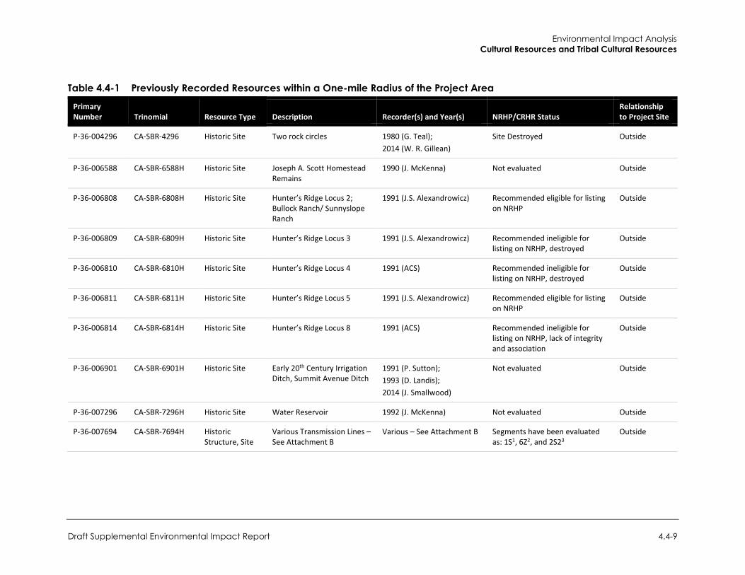
Environmental Impact Analysis Cultural Resources and Tribal Cultural Resources
Draft Supplemental Environmental Impact Report 4.4-9
Table 4.4-1 Previously Recorded Resources within a One-mile Radius of the Project Area
Primary Number Trinomial Resource Type Description Recorder(s) and Year(s) NRHP/CRHR Status
Relationship to Project Site
P-36-004296 CA-SBR-4296 Historic Site Two rock circles 1980 (G. Teal); 2014 (W. R. Gillean)
Site Destroyed Outside
P-36-006588 CA-SBR-6588H Historic Site Joseph A. Scott Homestead Remains
1990 (J. McKenna) Not evaluated Outside
P-36-006808 CA-SBR-6808H Historic Site Hunter’s Ridge Locus 2; Bullock Ranch/ Sunnyslope Ranch
1991 (J.S. Alexandrowicz) Recommended eligible for listing on NRHP
Outside
P-36-006809 CA-SBR-6809H Historic Site Hunter’s Ridge Locus 3 1991 (J.S. Alexandrowicz) Recommended ineligible for listing on NRHP, destroyed
Outside
P-36-006810 CA-SBR-6810H Historic Site Hunter’s Ridge Locus 4 1991 (ACS) Recommended ineligible for listing on NRHP, destroyed
Outside
P-36-006811 CA-SBR-6811H Historic Site Hunter’s Ridge Locus 5 1991 (J.S. Alexandrowicz) Recommended eligible for listing on NRHP
Outside
P-36-006814 CA-SBR-6814H Historic Site Hunter’s Ridge Locus 8 1991 (ACS) Recommended ineligible for listing on NRHP, lack of integrity and association
Outside
P-36-006901 CA-SBR-6901H Historic Site Early 20th Century Irrigation Ditch, Summit Avenue Ditch
1991 (P. Sutton); 1993 (D. Landis); 2014 (J. Smallwood)
Not evaluated Outside
P-36-007296 CA-SBR-7296H Historic Site Water Reservoir 1992 (J. McKenna) Not evaluated Outside
P-36-007694 CA-SBR-7694H Historic Structure, Site
Various Transmission Lines – See Attachment B
Various – See Attachment B Segments have been evaluated as: 1S1, 6Z2, and 2S23
Outside
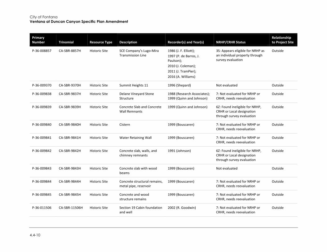
City of Fontana Ventana at Duncan Canyon Specific Plan Amendment
4.4-10
Primary Number Trinomial Resource Type Description Recorder(s) and Year(s) NRHP/CRHR Status
Relationship to Project Site
P-36-008857 CA-SBR-8857H Historic Site SCE Company’s Lugo-Mira Transmission Line
1986 (J. F. Elliott); 1997 (P. de Barros, J. Paulson); 2010 (J. Coleman); 2011 (J. TramPier); 2016 (A. Williams)
3S: Appears eligible for NRHP as an individual property through survey evaluation
Outside
P-36-009370 CA-SBR-9370H Historic Site Summit Heights 11 1996 (Shepard) Not evaluated Outside
P-36-009838 CA-SBR-9837H Historic Site Delane Vineyard Stone Structure
1988 (Research Associates); 1999 (Quinn and Johnson)
7: Not evaluated for NRHP or CRHR, needs reevaluation
Outside
P-36-009839 CA-SBR-9839H Historic Site Concrete Slab and Concrete Wall Remnants
1999 (Quinn and Johnson) 6Z: Found ineligible for NRHP, CRHR or Local designation through survey evaluation
Outside
P-36-009840 CA-SBR-9840H Historic Site Cistern 1999 (Bouscaren) 7: Not evaluated for NRHP or CRHR, needs reevaluation
Outside
P-36-009841 CA-SBR-9841H Historic Site Water Retaining Wall 1999 (Bouscaren) 7: Not evaluated for NRHP or CRHR, needs reevaluation
Outside
P-36-009842 CA-SBR-9842H Historic Site Concrete slab, walls, and chimney remnants
1991 (Johnson) 6Z: Found ineligible for NRHP, CRHR or Local designation through survey evaluation
Outside
P-36-009843 CA-SBR-9843H Historic Site Concrete slab with wood beams
1999 (Bouscaren) Not evaluated Outside
P-36-009844 CA-SBR-9844H Historic Site Concrete structural remains, metal pipe, reservoir
1999 (Bouscaren) 7: Not evaluated for NRHP or CRHR, needs reevaluation
Outside
P-36-009845 CA-SBR-9845H Historic Site Concrete and wood structure remains
1999 (Bouscaren) 7: Not evaluated for NRHP or CRHR, needs reevaluation
Outside
P-36-011506 CA-SBR-11506H Historic Site Section 19 Cabin foundation and well
2002 (R. Goodwin) 7: Not evaluated for NRHP or CRHR, needs reevaluation
Outside
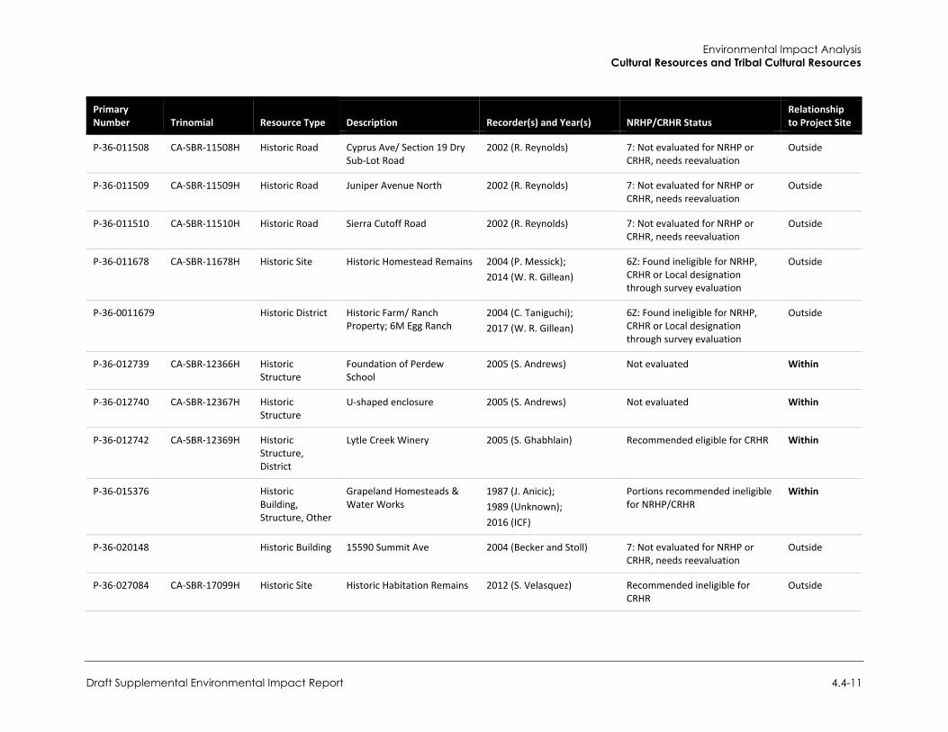
Environmental Impact Analysis Cultural Resources and Tribal Cultural Resources
Draft Supplemental Environmental Impact Report 4.4-11
Primary Number Trinomial Resource Type Description Recorder(s) and Year(s) NRHP/CRHR Status
Relationship to Project Site
P-36-011508 CA-SBR-11508H Historic Road Cyprus Ave/ Section 19 Dry Sub-Lot Road
2002 (R. Reynolds) 7: Not evaluated for NRHP or CRHR, needs reevaluation
Outside
P-36-011509 CA-SBR-11509H Historic Road Juniper Avenue North 2002 (R. Reynolds) 7: Not evaluated for NRHP or CRHR, needs reevaluation
Outside
P-36-011510 CA-SBR-11510H Historic Road Sierra Cutoff Road 2002 (R. Reynolds) 7: Not evaluated for NRHP or CRHR, needs reevaluation
Outside
P-36-011678 CA-SBR-11678H Historic Site Historic Homestead Remains 2004 (P. Messick); 2014 (W. R. Gillean)
6Z: Found ineligible for NRHP, CRHR or Local designation through survey evaluation
Outside
P-36-0011679 Historic District Historic Farm/ Ranch Property; 6M Egg Ranch
2004 (C. Taniguchi); 2017 (W. R. Gillean)
6Z: Found ineligible for NRHP, CRHR or Local designation through survey evaluation
Outside
P-36-012739 CA-SBR-12366H Historic Structure
Foundation of Perdew School
2005 (S. Andrews) Not evaluated Within
P-36-012740 CA-SBR-12367H Historic Structure
U-shaped enclosure 2005 (S. Andrews) Not evaluated Within
P-36-012742 CA-SBR-12369H Historic Structure, District
Lytle Creek Winery 2005 (S. Ghabhlain) Recommended eligible for CRHR Within
P-36-015376 Historic Building, Structure, Other
Grapeland Homesteads & Water Works
1987 (J. Anicic); 1989 (Unknown); 2016 (ICF)
Portions recommended ineligible for NRHP/CRHR
Within
P-36-020148 Historic Building 15590 Summit Ave 2004 (Becker and Stoll) 7: Not evaluated for NRHP or CRHR, needs reevaluation
Outside
P-36-027084 CA-SBR-17099H Historic Site Historic Habitation Remains 2012 (S. Velasquez) Recommended ineligible for CRHR
Outside
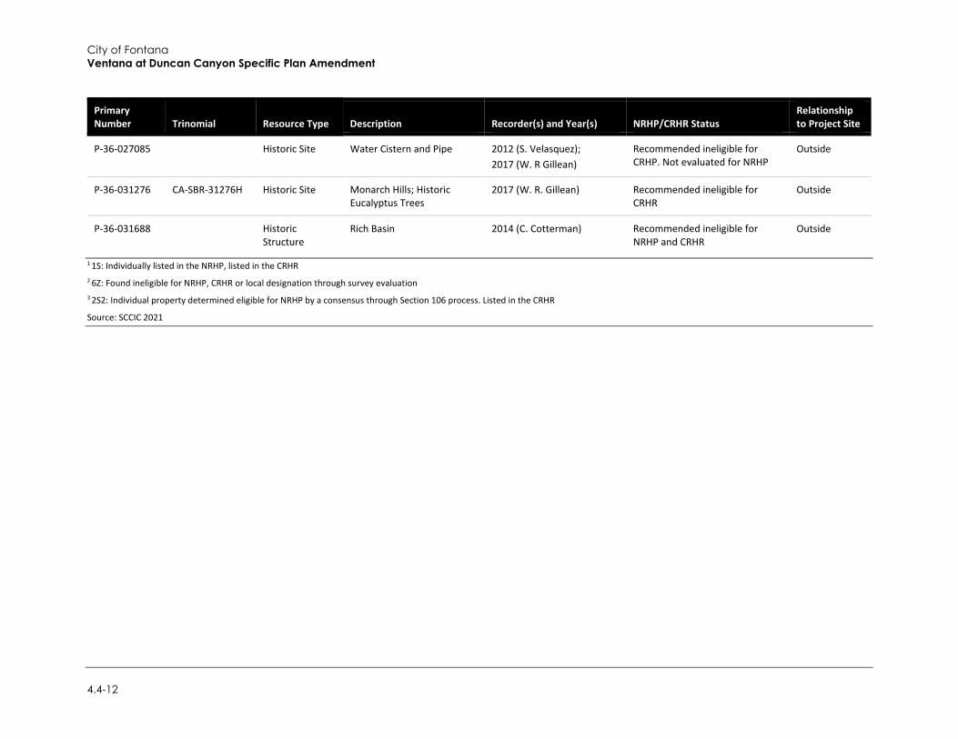
City of Fontana Ventana at Duncan Canyon Specific Plan Amendment
4.4-12
Primary Number Trinomial Resource Type Description Recorder(s) and Year(s) NRHP/CRHR Status
Relationship to Project Site
P-36-027085 Historic Site Water Cistern and Pipe 2012 (S. Velasquez); 2017 (W. R Gillean)
Recommended ineligible for CRHP. Not evaluated for NRHP
Outside
P-36-031276 CA-SBR-31276H Historic Site Monarch Hills; Historic Eucalyptus Trees
2017 (W. R. Gillean) Recommended ineligible for CRHR
Outside
P-36-031688 Historic Structure
Rich Basin 2014 (C. Cotterman) Recommended ineligible for NRHP and CRHR
Outside
1 1S: Individually listed in the NRHP, listed in the CRHR 2 6Z: Found ineligible for NRHP, CRHR or local designation through survey evaluation 3 2S2: Individual property determined eligible for NRHP by a consensus through Section 106 process. Listed in the CRHR
Source: SCCIC 2021
Environmental Impact Analysis Cultural Resources and Tribal Cultural Resources
Draft Supplemental Environmental Impact Report 4.4-13
Based on the records search and as summarized in Table 4.4-1, the following resources are associated with the project site and are described as previously observed in years prior:
P-36-012739: Perdew School Foundation. Recorded in 2005 as a one to two course high stone foundation constructed of cobbles and concrete measuring approximately 16 inches wide in cross section. The foundation was in good condition when recorded, except for the northern wall. A solitary church key-opened can was found to the south of the resource but was not associated the can to the foundation. No other cultural resources were identified, and the resource had not been evaluated for inclusion in the NRHP or CRHR.
P-36-012740: Waters Homestead Site. Recorded in 2005, the Waters Homestead Site is a U-shaped rock and cobble enclosure with a trash scatter and a rectangular concrete reservoir. The resource had been previously identified in a resource inventory as the Waters home site. The associated trash scatter consists of glass fragments, machine parts, and building debris. The resource had not been evaluated for inclusion in the NRHP or CRHR.
P-36-012742: Lytle Creek Winery. Recorded in 2005, the resource is recorded as a two-story home with two cobblestone winery buildings, a concrete warehouse, stables, garage, barn, and privy. The house, stables, and barn are believed to be constructed in the 1880s. The cobblestone winery buildings were dated in 1930s, the warehouse in the 1940s, and a cinder block add-on to one of the cobblestone winery buildings in 1945. The property operated an 80-acre vineyard and wine production following prohibition to 1960 when the property was sold. In addition to the buildings, the resource includes a cistern, cobblestone fencing, and landscaping features. It was recommended in 2005 that the winery is eligible for listing in the CRHR under Criterion 1 for its association with wine production in Fontana and concluded that the Lytle Creek Winery appears eligible for listing as a historic district. Additionally, the two cobble stone buildings were recommended eligible for listing in the CRHR under Criterion 3 for their distinctive characteristics within the region and method of construction.
P-36-015376: Grapeland Irrigation District. In 1987, the resource area was identified as the Grapeland Irrigation District. Grapeland consists of historic-period structures and irrigation ditches associated with the town of Grapeland. Grapeland consisted of stores, a school, small ranches, and a post office along Lytle Creek Road north of Fontana. In 1989, the Grapeland Irrigation District was submitted as a Point of Historical Interest to the State of California Department of Parks and Recreation. According to the submission, the Grapeland Irrigation District emerged in 1890 as an early settlement of North Fontana for farming; however, the venture north failed. Although the venture failed, remnants of the operation remained, including irrigation ditches, homesteads, and reservoirs. ICF revisited segments of the district in 2016 and reported that no remnants of the historic district were left within the ICF study area, all of which are located outside of the current project area. ICF (2016) recommended the portions studied as not eligible for the NRHP or CRHR.
Historical Imagery Review
Rincon completed a review of historical topographic maps and aerial imagery to ascertain the development history of the project site. In a review of historical topographic maps dating from 1896 to 1929 of the project sites, the land is depicted as undeveloped depict the project site as undeveloped land with a north-south trending dirt road intersecting the central portion of the project site. The 1936 Devore, California Quadrangle 1:31680 scale map depicts the project site bounded by Citrus Avenue to the east, Duncan Canyon Road running east-west through the project site, and Lytle Creek Road to the west, which is carried through the 1966 Devore, California 1:24,000
City of Fontana Ventana at Duncan Canyon Specific Plan Amendment
4.4-14
quadrangle. Additionally, the 1936 Devore, California 1:31860 scale map quadrangle no longer depicts the north-west trending dirt road through the central portion of the project site. Aerial imagery from 1938 confirms that the project site was bounded by Duncan Canyon Road to the south and Citrus Avenue to the east, with no north-south trending road intersecting the central portion of the project site. Imagery from 1938 additionally depicts two properties to the south of Duncan Canyon Road, presumed to be previously discussed resources P-36-012740 (Waters Homestead Site) and P-36-012472 (Lytle Creek Winery). By 1980, the Devore, California quadrangle map shows I-15, and the project site is bound by I-15 to the west. Aerial imagery from 1980 does not depict resource P-36-012740 (Waters Homestead Site), but resource P-36-012742 (Lytle Creek Winery) is depicted next to Lytle Creek Road with the development of I-15 to the west. Imagery from 2002 to 2005 depicts portions of resource P-36-012742 (Lytle Creek Winery) as being demolished. By 2009, the resource is no longer present on the aerial images and the project site is depicted in its current condition. From 1994 to present, grading across the project site is evidenced by square patterns observed throughout the project site.
Native American Heritage Commission
On December 2, 2020, Rincon contacted the Native American Heritage Commission (NAHC) to request a Sacred Lands File (SLF) search of the project site. As part of this request, Rincon asked the NAHC to provide a contact list of Native American groups and/or individuals culturally affiliated with the area who may have knowledge of tribal heritage resources at the project site and/or in the vicinity. The City received a response from NAHC on December 9, 2020 that the search of the SLF was positive. The NAHC provided a list of 17 tribes who may have knowledge of cultural resources within the project site. On February 10, 2021, in accordance with AB 52 consultation, Rincon sent email letters on behalf of the City to the contacts provided by the NAHC. Under AB 52, the tribes have 30 days to respond and request consultation. The following comments were received in response:
On February 10, 2021, the Quechan Tribe of the Fort Yuma Reservation responded via email stating that they have no comment on the project and they defer to more local tribes.
Ryan Nordness, Cultural Resources Analyst of the San Manuel Band of Mission Indians, responded to the outreach on February 10, 2021, via email. Mr. Nordness stated that the proposed project site is located within the Serrano ancestral territory and is in close proximately to three known tribal cultural resources, and that the tribe would like to consult under Assembly Bill 52 consultation as required by CEQA. On December 1, 2021, after follow up outreach from the City, Mr. Nordness requested additional project information for further project review.
Rincon received a response via email from Lucy Padilla, Archaeologist for the Agua Caliente Band of Cahuilla Indians on March 10, 2021, stating that the project is not located within the Tribe’s Traditional Use Area and that they defer to other tribes.
On November 5, 2021 the Gabrieleno Band of Mission Indians – Kizh Nation responded via email stating that the project site is within their ancestral territory and that the tribe would like to consult to discuss the project and surrounding location in further detail.
Furthermore, in accordance with the requirements of SB 18 consultation, the City mailed letters to 17 Native American tribes on February 28, 2022. Under SB 18, tribes have 90 days to respond and request consultation. The City has received the following comments thus far in response:
Environmental Impact Analysis Cultural Resources and Tribal Cultural Resources
Draft Supplemental Environmental Impact Report 4.4-15
On February 28, 2022, the City received a response from the Quechan Tribe of the Fort Yuma Reservation stating that they have no comment on the project and that they defer to more local tribes.
Ryan Nordness, Cultural Resources Analyst of the San Manuel Band of Mission Indians, responded to the outreach on March 7, 2022, confirming that the site is located within the Serrano ancestral territory and the project is of interest, but that the tribe sees no conflicts with the zoning changes at this time.
The City received a response via email from Arysa Gonzalez Romero, Cultural Resources Analyst for the Agua Caliente Band of Cahuila Indians on March 15, 2022, stating that a records check revelated that the project is not located within the tribe’s Traditional Use Area and that they defer to other tribes.
Although the 90-day period is not yet complete at the time of this writing, the City will incorporate into the Final EIR for this project all subsequent correspondence from local tribes received after the publication of the Draft EIR and prior to the close of the 90-day review period.
Field Survey
Methodology
Rincon Senior Archaeologist Christopher Purtell, MA, RPA, and Archaeologist Ryan Glenn, MA, RPA, conducted a pedestrian survey of the project site on February 11 and February 12, 2021. The archaeologists surveyed the project site using transects spaced 10 meters apart and generally oriented north-south. Areas of exposed ground surface were examined for artifacts (e.g., flaked stone tools, tool-making debris, stone milling tools, ceramics, fire-affected rock [FAR]), ecofacts (marine shell and bone), soil discoloration that might indicate the presence of a cultural midden, soil depressions, and features indicative of the former presence of structures or buildings (e.g., standing exterior walls, postholes, foundations) or historic-period debris (e.g., metal, glass, ceramics). Ground disturbances such as burrows and drainages were visually inspected. Survey notes were prepared by the surveyor and are available upon request.
Additionally, the four previously recorded historic-period resource locations were visited during the survey. The survey consisted of a visual inspection of the resource locations to assess the overall condition of the resources. Three of the resources P-36-012739: Perdew School foundation, P-36-012742: Lytle Creek Winery, and P-36-015376: Grapeland Irrigation District) were not relocated during the survey efforts. One resource (P-36-012740: Waters Homestead Site) was relocated during the survey. For the purposes of this section, “relocated” refers to the act of confirming the location of the resources within the project site again for verification of resource presence following the previous recordings.
Results
The project site is generally located on an alluvial plain and soils consisted of medium to dark colored brown sediment, with a silty-loamy texture that exhibited large quantities of round cobles and rocks that measured between 2 centimeters and 20 centimeters in diameter. Ground visibility was generally poor throughout the site, ranging from 30 to 40 percent, except for a few locations throughout the project site where visibility was approximately 90 percent. Additionally, one portion of the project site had zero percent ground visibility due to gravel and showed evidence of being used as a parking area and dumping zone. Low ground visibility across the project site was due to
City of Fontana Ventana at Duncan Canyon Specific Plan Amendment
4.4-16
the present of vegetation, evidence of plowing and disking approximately 3 to 4 inches in depth, and modern trash dumping throughout the project site. No other disturbances were observed during the current survey efforts.
The pedestrian survey updated the four previously recorded resources within the project site. These resources consist of four previously recorded historic-aged resources [P-36-012739 (Perdew School Foundation), P-012740 (Waters Homestead Site), P-36-012742 (Lytle Creek Winery), and P-36-015376 (Grapeland Irrigation District)]. No new resources were recorded as a part of the current efforts. The survey results as they relate to each resource are described in further detail under Project Impacts.
c. Standard Conditions The following standard condition identified in the 2007 EIR, remains applicable to the proposed project:
Standard Condition 4.10.1: If human remains are encountered during excavation activities at the site, all work shall halt, and the County Coroner shall be notified (Section 5097.98 of the Public Resources Code). The Coroner will determine whether the remains are of forensic interest. If the Coroner, with the aid of the County-approved archaeologist, determines that the remains are prehistoric, he/she will contact the Native American Heritage Commission (NAHC). The NAHC will be responsible for designating the most likely descendant (MLD), who will be responsible for the ultimate disposition of the remains, as required by Section 7050.5 of the California Health and Safety Code. The MLD will make his/her recommendation within 24 hours of their notification by the NAHC. This recommendation may include scientific removal and nondestructive analysis of the human remains and any items associated with Native American burials (Section 7050.5 of the Health and Safety Code).
d. Project Impacts
Cultural Resources
Threshold 1: Would the project cause a substantial adverse change in the significance of a historical resource pursuant to Section 15064.5?
Impact CUL-1 DUE TO LACK OF INTEGRITY OF KNOWN HISTORICAL RESOURCES, THE PROJECT WOULD NOT CREATE AN ADVERSE CHANGE IN THE SIGNIFICANCE OF A HISTORICAL RESOURCE. IMPACTS WOULD BE LESS THAN SIGNIFICANT.
The 2007 EIR found the project site had existing buildings on site, and that the buildings and building foundations were significant historic resources, as further described below.
The project would involve development of the same project footprint as the existing Specific Plan. The SCCIC records search project site identified 35 cultural resources located within a one-mile radius of the project site. Table 4.4-1 summarizes the known historical resources within a one-mile radius of the project. The records search identified four historic-period cultural resources previously recorded within the project site:
P-36-012739: Perdew School Foundation. This site was recorded in 2005 as a one to two course high stone foundation constructed of cobbles and concrete measuring approximately 16 inches wide in cross section. The foundation was in good condition when recorded, except for the

Environmental Impact Analysis Cultural Resources and Tribal Cultural Resources
Draft Supplemental Environmental Impact Report 4.4-17
northern wall. A solitary church key-opened can was found to the south of the resource but could not be associated to the foundation. In the 2007 EIR it was stated that the foundations of the Perdew School are not considered eligible for the CRHR due to lack of building integrity. During Rincon’s field survey between February 11 and February 12, 2021, the resource was not relocated, and no other cultural materials or features were observed. Based on the 2007 EIR finding, in conjunction with the confirmation that the resource is no longer present on-site per Rincon’s field surveys, it is further determined that the resource does not possess the ability to convey any potentially significant historical associations under any CRHR criteria. The project would have no impact on this site.
P-36-012740: Waters Homestead Site. This resource is recorded as a U-shaped rock and cobble enclosure with an associated trash scatter and rectangular concrete reservoir. While the house has been demolished, foundation remains are present at the site. In the 2007 EIR it was stated that surface deposits at the site of the Waters house did not identify the presence of intact archaeological or historical resources. Thus, the site of the Water house was not eligible for the CRHR and removal of the building foundations would not result in significant adverse impacts on historical resources. During Rincon’s 2021 surveys, portions of the resource were relocated. Surveyors relocated a concentration of rocks and cobbles corresponding with the wall around the Waters Homestead as previously recorded. The feature has since been deflated, but the overall shape is observable. There is a raised berm (two feet in height) that can be observed with associated cobbles. Several historic-period artifacts were observed within the wall as noted in the previous site record (glass, metal, and ceramic fragments), and a depression consistent with remnants of the cistern was also present. However, the site area appears to be highly disturbed from previous disking and plowing. As documented in the 2007 EIR, the site was previously found to be in poor condition; as a result, the 2007 EIR concluded that the resource was not eligible for listing in the CRHR under any of the criteria due to a lack of integrity. The site does not meet the definition of a historical resource under PRC Section 21084.1. Rincon concurs with these findings. Therefore, the project would not impact this site.
P-36-012742: Lytle Creek Winery. The resource was originally recorded as a two-story home with two cobblestone winery buildings, a concrete warehouse, stables, garage, barn, and privy. The 2007 EIR states that while the Specific Plan disuses that Planning Area 9 would include the adaptive reuse of existing structures as a restaurant/winery or office development, the illustrative site plan did not reflect the layout of the existing structures. Thus, a potential for the need to relocate or demolish the existing structures within the former Lytle Creek Winery would have possibly occured under the existing Specific Plan. The impacts related to Lytle Creek Winery would have been made less than significant by Mitigation Measure 4.10.2 and Mitigation Measure 4.10.3 within the 2007 EIR. However, Rincon’s 2021 surveys did not relocate the resource, which appears to have been demolished between 2002 and 2009 based on historic aerial images and other available (albeit limited) information. The current owner of the property acquired the property in November 2020, years after the winery was apparently removed from the property and was unable to provide any information regarding the former structures. Rincon’s survey was unable to relocate extant remains of the resource due to prior disturbance that has dislocated the cultural constituents such that they are no longer in situ. No other cultural materials or features associated with the site were observed. For this reason, this resource does not possess the ability to convey any potentially significant historical associations under any CRHR criteria. Therefore, the project would have no impact on this site.
P-36-015376: Grapeland Irrigation District. Grapeland consisted of historic-period structures and irrigation ditches associated with the town of Grapeland. In 1989, the Grapeland Irrigation
City of Fontana Ventana at Duncan Canyon Specific Plan Amendment
4.4-18
District was submitted as a Point of Historical Interest to the State of California Department of Parks and Recreation. ICF revisited segments of the district in 2016 and reported that no remnants of the historic district were left within the ICF study area, all of which are located outside of the current project area. ICF (2016) recommended the portions studied as not eligible for the NRHP or CRHR. Furthermore, during Rincon’s 2021 surveys, no remnants of the resource were relocated, and no other cultural materials or features were observed. Based on the 2016 ICF finding, in conjunction with the confirmation that the resource is no longer present on-site per Rincon’s field surveys, it is further determined that the project would have no impact on this site.
Of these four resources, only the Lytle Creek Winery appears to have been eligible for listing in the CRHR. However, as mentioned in this analysis, the resource was demolished between 2002 and 2009 (based on historic aerial images and other limited information) and Rincon’s survey efforts were unable to relocate the resource; therefore, extant remains of the resource do not contain integrity. Therefore, project implementation would not result in substantial adverse changes in the significance of a historical resource pursuant to Section 15064.5 of the CEQA Guidelines. Impacts would be less than significant.
Mitigation Measures The 2007 EIR includes mitigation measures to rehabilitate or relocate the structures within the Lytle Creek Winery and the Taylor house as follows:
Mitigation Measure 4.10.2 provides specific guidance on the rehabilitation of structures within the Lytle Creek Winery, including the Taylor House consistent with specific standards by the Secretary of Interior, with regards to the rehabilitation and reuse of historic properties.
Mitigation Measure 4.10.3 indicates that if required, relocation of the Taylor House be relocated into the Lytle Creek Winery complex or other location, under the direction of an architectural historian.
Mitigation Measure 4.10.4 requires Historic American Building Survey (HABS) documentation be performed prior to relocation of historic structures.
Mitigation Measure 4.10.5 requires giving the Fontana Historical Society the option to move the Perdew School foundations to another site, prior to the disturbance or development of the area formerly occupied by the school.
However, the resources discussed in these mitigation measures are no longer present on the project site. Therefore, these mitigation measures are no longer applicable and additional mitigation measures are not required.
Threshold 2: Would the project cause a substantial adverse change in the significance of an archaeological resource pursuant to Section 15064.5?
Impact CUL-2 IMPLEMENTATION OF THE PROJECT COULD RESULT IN DIRECT OR INDIRECT IMPACTS TO ARCHAEOLOGICAL RESOURCE PURSUANT TO SECTION 15064.5. IMPACTS WOULD BE LESS THAN SIGNIFICANT WITH MITIGATION INCORPORATED.
The 2007 EIR, indicated several archaeological resources were recorded in the project vicinity, but none were found on the project site. The 2007 EIR determined that because of the highly disturbed condition of the surface soils, project development was not expected to have significant adverse
Environmental Impact Analysis Cultural Resources and Tribal Cultural Resources
Draft Supplemental Environmental Impact Report 4.4-19
impacts on archaeological resources. The 2007 EIR also indicated that the Gabrieleno/Tongva Tribal Council requested that monitoring occur during ground disturbance activities. The 2007 EIR also found that based on the highly disturbed condition of the surface soils, excavation and grading activities associated with development under the existing Specific Plan was not expected to have significant adverse impacts on archaeological resources.
Similarly, the recent records search and pedestrian survey did not identify any archaeological resources within the project site. However, the surveyors noted poor surface visibility based on heavy disturbance throughout the project site in the form of three to four inches of plowing and disking, several large modern trash dumps, and dense vegetation. Historical aerial imagery indicates that the project site has had moderate disturbance due to agricultural use, grading and building, demolition, or removal over the last 50 years. Due to the poor visibility on site, the potential for subsurface archaeological resources cannot be ruled out, and the project site is considered to have a moderate sensitivity for archaeological cultural resources. Therefore, the project has the potentially to adversely affect subsurface archeological resources, if present. Impacts to archaeological resources would be potentially significant without mitigation.
Mitigation Measures The 2007 EIR included mitigation measure to address Tribal concerns related to archaeological resources. The original mitigation measure has been replaced with Mitigation Measure CUL-2A below and reflects the City’s current mitigation related to Tribal concerns and archaeological resources and is considered functionally equivalent. Mitigation Measure CUL-2B would also be required to prepare construction workers on the types of cultural material that may be encountered and discuss proper protocol prior to the commencement of any ground-disturbing activities.
CUL-2A Archaeological Resources
The City shall designate a qualified archaeologist to monitor all project-related ground disturbing activities. Archaeological monitoring shall be performed under the guidance and direction of a Project Archaeologist meeting the Secretary of the Interior’s Professional Qualifications Standards for archeology (National Park Service 1983). A Native American monitor from the consulting tribes (those tribes that have consulted on the project under AB 52) shall also be retained to monitor ground disturbing activities. Upon discovery of any tribal cultural or archaeological resources, all construction activities in the immediate vicinity (50 feet) of the find shall cease until the find can be assessed. All tribal cultural and archaeological resources unearthed by project construction activities shall be evaluated by the qualified archaeologist and tribal monitor/consultant from a consulting tribe. If the resources are Native American in origin, interested Tribes (as a result of correspondence with area Tribes) shall coordinate with the landowner regarding treatment (including evaluations for CRHR listing) and curation of these resources. Work may continue on other parts of the project while evaluation takes place.
Monitors shall have the authority to halt and redirect work should any archaeological resources be identified during monitoring. If archaeological resources are encountered during ground-disturbing activities, work in the immediate area must halt and the find evaluated for listing in the California Register of Historic Resources (CRHR). Construction monitoring may be reduced or halted at the discretion of the Project Archaeologist, in consultation with the lead agency, as warranted by conditions that include, but are not limited to encountering bedrock, non-native sediments (infill), or negative findings. Should archaeological spot-checking be recommended by
City of Fontana Ventana at Duncan Canyon Specific Plan Amendment
4.4-20
the Project Archaeologist, it will only occur in areas of new construction, where ground disturbance will extend to depths not previously reached (unless those depths are within bedrock). Upon completion of project related ground disturbance and monitoring efforts, a monitoring report should be submitted to the City for review and approval. The final report should be transmitted to the South-Central Coastal Information Center housed at California State University, Fullerton.
Preservation in place shall be the preferred manner of treatment. If preservation in place is not feasible, treatment may include implementation of archaeological data recovery excavation to remove the resource from its current location for reburial elsewhere on the project site. Any historic archaeological material that is not Native American in origin shall be curated at a public, non-profit institution with a research interest in the materials, if such an institution agrees to accept the material. If no institution accepts the archaeological material, they shall be reburied on the project site.
CUL-2B Worker’s Environmental Awareness Program
A qualified archaeologist who meets or exceeds the Secretary of Interior’s Professional Qualifications Standards for archeology (National Park Service [NPS] 1983) shall conduct worker environmental awareness program (WEAP) training, prior to the commencement of any ground-disturbing activities. The sensitivity training shall include a description of the types of cultural material that may be encountered, cultural sensitivity issues, the regulatory environment, and the proper protocol for treatment and disposition of cultural materials in the event of a find. The training shall be required for all earthmoving construction personnel and a sign-in-sheet shall also be required.
Significance After Mitigation Implementation of Mitigation Measures CUL-2A and 2B would reduce potential impacts to archaeological resource to a less than significant.
Threshold 3: Would the project disturb any human remains, including those interred outside of formal cemeteries?
Impact CUL-3 THERE ARE NO KNOWN CEMETERIES WITHIN THE PROJECT SITE. IN THE EVENT OF THE DISCOVERY OF HUMAN REMAINS ADHERENCE TO EXISTING REGULATIONS WOULD REDUCE PROJECT IMPACTS TO LESS THAN SIGNIFICANT LEVELS.
The project would include ground disturbing activities. The 2007 EIR, stated that no Native American sacred sites are known to be present in the area, however, past human occupation was present within the Grapeland community, which included the site and nearby areas. Therefore, the potential for finding human remains could not be precluded.
Similarly, no cemeteries are known to exist within the project site; however, the project is required to adhere to State regulations regarding the unanticipated discovery of human remains. The discovery of human remains is always a possibility during ground disturbing activities. If human remains are found, the State of California Health and Safety Code Section 7050.5 states that no further disturbance shall occur until the County coroner has made a determination of origin and disposition pursuant to PRC Section 5097.98. In the event of an unanticipated discovery of human remains, the County coroner would be notified immediately. If the human remains are determined to be prehistoric, the County coroner would notify the NAHC, which would determine and notify a
Environmental Impact Analysis Cultural Resources and Tribal Cultural Resources
Draft Supplemental Environmental Impact Report 4.4-21
most likely descendant (MLD). The MLD would complete the inspection of the site within 48 hours of being granted access to the site. With adherence to existing regulations, project impacts to human remains would be less than significant.
Mitigation Measures Mitigation measures are not required.
Tribal Cultural Resources
Threshold 4: Would the project cause a substantial adverse change in the significance of a tribal cultural resource as defined in PRC Section 21074 that is listed or eligible for listing in the California Register of Historical Resources, or in a local register of historical resources as defined in PRC Section 5020.1(k)?
Threshold 5: Would the project cause a substantial adverse change in the significance of a tribal cultural resource as defined in PRC Section 21074 that is a resource determined by the lead agency, in its discretion and supported by substantial evidence, to be significant pursuant to criteria set forth in subdivision (c) of PRC Section 5024.1?
Impact CUL-4 NO TRIBAL CULTURAL RESOURCES HAVE BEEN IDENTIFIED AT THE PROJECT SITE; HOWEVER, PER AB 52 CONSULTATION, NATIVE AMERICAN TRIBES HAVE IDENTIFIED THAT THE SITE IS WITHIN ANCESTRAL TERRITORY WITH PROXIMITY TO KNOWN TRIBAL CULTURAL RESOURCES. CONSTRUCTION OF THE PROJECT WOULD INVOLVE GROUND-DISTURBING ACTIVITIES, INCLUDING GRADING AND EXCAVATION, WHICH HAVE THE POTENTIAL TO IMPACT UNKNOWN SUBSURFACE TRIBAL CULTURAL RESOURCES. IMPACTS WOULD BE LESS THAN SIGNIFICANT WITH MITIGATION INCORPORATED.
Ground-disturbing activities associated with individual development projects under the Specific Plan Amendment could expose previously unidentified subsurface archaeological deposits that may qualify as tribal cultural resources and could be adversely affected by the project construction.
As part of its tribal cultural resource identification process, and in accordance with the requirements of AB 52 consultation, the City of Fontana mailed letters to 17 Native American tribes on February 10, 2021 notifying them of the project and providing the opportunity for consultation. As per AB 52 requirements, the tribes had 30 days to respond and request consultation. As discussed under Methodology of this section, of the tribes contacted under AB 52, only two tribes responded. The San Manuel Band of Mission Indians and the Gabrieleno Band of Mission Indians – Kizh Nation responded via email on February 10, 2021, and November 5, 2021, respectively. Both the San Manuel Band of Mission Indians and the Gabrieleno Band of Mission Indians – Kizh Nation responded stating that the project site is within their ancestral territories and that they would like to consult to discuss the project in further detail.
On December 1, 2021, after written follow up from the City, Ryan Nordness, Cultural Resources Analyst of the San Manuel Band of Mission Indians, requested additional project information for further project review to resume consultation per AB 52 requirements. Additional project materials were provided to Mr. Nordness by the City and a follow up email was sent on April 6, 2022 to continue consultation efforts. Because consultation with Mr. Nordness has not closed at the time of this writing, the City will continue to pursue consultation with the tribe during the 45-day public review period for the Draft SEIR and prior to completion of the Final EIR. The results of consultation will be incorporated into the Final EIR for this project.
City of Fontana Ventana at Duncan Canyon Specific Plan Amendment
4.4-22
On February 28, 2022, in conformance with the requirements of SB 18 consultation, the City of Fontana mailed letters to the same 17 Native American tribes initially consulted per AB 52. Under SB 18 requirements, the tribes have 90 days to respond and request consultation. Of the tribes contacted under SB 18, responses have been received thus far from the Quechan Tribe of the Fort Yuma Reservation (February 28, 2022), San Manuel Band of Mission Indians (March 7, 2022), and the Agua Caliente Band of Cahuila Indians (March 15, 2022) stating in that they either have no comment on the project and defer to more local tribes or that the project is of interest but the tribe sees no conflict with the zoning changes at this time. All three tribes have closed consultation efforts per SB 18. Nonetheless, the 90-day period is not yet complete at the time of this writing. Therefore, the City will incorporate into the Final EIR for this project all subsequent correspondence per SB 18 from local tribes received after the publication of the Draft EIR and prior to the close of the 90-day review period.
On March 15, 2022, the City of Fontana met with Andrew Salas, Chairperson of the Gabrieleno Band of Mission Indians – Kizh Nation, to discuss the project. In this meeting, the Kizh Nation shared confidential materials regarding areas of potential sensitivity for tribal cultural resources and provided proposed mitigation measures to reduce potential impacts to tribal cultural resources. The mitigation developed for this document is modeled after the measures provided by the Kizh Nation. However, given that multiple tribes requested consultation under AB 52, the mitigation developed allows for inclusion of all consulting tribes.
No additional responses were received from local Native American tribes per SB 18 or AB 52.
Due to the grading involved with the proposed project, the possibility for the discovery of such resources exists. Therefore, impacts would be potentially significant.
Mitigation Measures The 2007 EIR included a mitigation measure to address Tribal concerns related to archaeological resources. The original mitigation measure has been replaced with Mitigation Measure CUL-2A (as presented under Impact CUL-2), which considers comments received thus far as part of the tribal consultation process and is considered functionally equivalent. Mitigation Measures CUL-2B (also presented under Impact CUL-2) would also be required to prepare construction workers on the types of cultural material that may be encountered and discuss proper protocol prior to the commencement of any ground-disturbing activities.
Significance After Mitigation Implementation of Mitigation Measures CUL-2A and 2B would reduce potential impacts to cultural resources and tribal cultural resources to less than significant.
4.4.4 Cumulative Impacts Planned and pending projects in Fontana and surrounding areas are listed in Table 3-1 in Section 3, Environmental Setting, and include residential, commercial, and industrial land uses. The project, in conjunction with other planned and pending projects in the project site vicinity, would cumulatively increase the potential to encounter sensitive cultural, archaeological, and tribal cultural resources and human remains. In the event that cultural, archaeological, tribal cultural resources, and/or human remains are discovered, each individual project would be required to comply with the applicable regulatory requirements and mitigate any potential impacts to resources on the individual project site.
Environmental Impact Analysis Cultural Resources and Tribal Cultural Resources
Draft Supplemental Environmental Impact Report 4.4-23
Potential impacts of the project would be reduced to a less-than-significant level due to implementation of Mitigation Measures CUL-2A and 2B that would protect cultural, archaeological, and tribal cultural resources and human remains. Compliance with CEQA requirements, including the implementation of recommendations provided in project-specific cultural resource studies, on all new development would ensure that the project would not be cumulatively significant. In the event that tribal cultural resources are discovered, each individual project would be required to comply with the applicable regulatory requirements and the consultation requirements of AB 52, and if applicable SB 18, to determine and mitigate any potential impacts to tribal cultural resources. Such recommendations may include site avoidance, in-situ preservation, site salvage and documentation, and/or other measures determined to be necessary based on the resources identified. Therefore, cumulative impacts to cultural and tribal cultural resources would be less than significant.

City of Fontana Ventana at Duncan Canyon Specific Plan Amendment
4.4-24
This page intentionally left blank.
Environmental Impact Analysis Energy
Draft Supplemental Environmental Impact Report 4.5-1
4.5 Energy
This section analyzes the energy impacts of the proposed project. To assure project decisions consider energy implications, CEQA requires a discussion of the potential energy impacts of proposed projects, with particular emphasis on avoiding or reducing inefficient, wasteful, and unnecessary consumption of energy. The analysis herein is supported by the Air Quality and Greenhouse Gas Study (Appendix B) and Energy Calculations (Appendix E) prepared for the project by Rincon Consultants, Inc.
4.5.1 Setting Energy relates directly to environmental quality because energy use can adversely affect air quality and other natural resources. Fossil fuels are burned to create electricity to power homes and vehicles, which creates heat. Transportation energy use relates to the fuel efficiency of cars and trucks, and the availability and use of public transportation, the choice of different travel modes (auto, carpool, and public transit), and the miles traveled by these modes. Construction and routine operation and maintenance of infrastructure also consume energy, as do residential land uses, typically in the form of natural gas and electricity.
a. Energy Consumption and Sources Total energy consumption in the United States in 2020 was approximately 104.53 quadrillion British thermal units (Btu) (Energy Information Administration [EIA] 2021b). In 2020, petroleum provided approximately 35 percent of that energy, with other sources of energy coming from natural gas (approximately 34 percent), coal (approximately 10 percent), total renewable sources (approximately 12 percent), and nuclear power (approximately 9 percent). On a per capita basis in 2019, California was ranked the second lowest state in terms of total energy consumption (197.8 million Btu [MMBtu] per person), or about 35 percent less than the U.S. average per capita consumption of 305.4 MMBtu per person (EIA 2019a).
Energy Supply Natural gas-fired generation has dominated electricity production in California for many years. In 2019, however, the two largest sources of energy produced in California were crude oil at approximately 920.1 trillion Btu, and renewable energy sources at approximately 1,139.6 trillion Btu, while natural gas production was 220.8 trillion Btu and nuclear electric power was 168.8 trillion Btu (EIA 2021a). The City of Fontana contains no oil/gas fields. The nearest well is located in Ontario, approximately 9.6 miles southwest of the project site in the city, but it has a status of “idle”. The nearest active well is in the City of San Bernardino, approximately 10.3 miles southeast of the project site (California Department of Conservation, Division of Oil, Gas & Geothermal Resources 2021).
Electricity and Natural Gas Natural gas-fired power plants provided approximately 35 percent of the total electricity in California generated in 2020 (California Energy Commission [CEC] 2020). In 2020, California produced 70 percent of the electricity it used and imported the rest from outside the state. In 2019, California used 263,329 gigawatt hours (GWh) of electricity, with 201,784 GWh produced in-state (EIA 2020).
City of Fontana Ventana at Duncan Canyon Specific Plan Amendment
4.5-2
San Bernardino County as a whole consumed approximately 527.2 million therms of natural gas in 2020 in both residential and non-residential uses (CEC 2021a). San Bernardino County also consumed approximately 15,968.5 GWh of electricity in 2020 from residential and non-residential uses (CEC 2021b).
Southern California Edison (SCE) provides electricity to Fontana, including the project site. SCE maintains substations and distribution lines in the region, including the Rancho Vista substation, approximately six miles southwest of the project site in Rancho Cucamonga and the Calectric substation, approximately nine miles southeast of the project site in San Bernardino. Additionally, as discussed in Section 2, Project Description, a SCE transmission line corridor is adjacent to the southeastern project boundary.
Southern California Gas (SCG) provides natural gas service to approximately six million residential and business customers across 20,000 square miles of southern California, including Fontana (SCG 2021a). The project site is located in SCG’s Northern Zone. An existing natural gas transmission line and high-pressure distribution line owned and operated by SCG is located approximately 430 feet southeast and 600 feet east, respectively of the project site (SCG 2021b).
Petroleum Energy consumed by the transportation sector accounts for roughly 39.4 percent of California’s energy demand, amounting to approximately 3,073.3 trillion Btu in 2019 (EIA 2019a). Petroleum-based fuels are used for approximately 98.4 percent of the state’s transportation activity (EIA 2019b). Most gasoline and diesel fuel sold in California for motor vehicles is refined in California to meet state-specific formulations required by the California Air Resources Board (CARB). California’s transportation sector, including on-road and rail transportation, consumed approximately 662 million barrels of petroleum fuels in 2019 (EIA 2021c).
Approximately 982 million gallons of fuel were consumed in San Bernardino County in 2020, of which approximately 823 million gallons were gasoline and approximately 159 million gallons were diesel fuel (CEC 2021c). This equates to approximately 2.7 million gallons of fuel per day or 1.2 gallons of fuel per person per day, based on a 2021 countywide population of 2,175,909 people (California Department of Finance [DOF] 2021). The City of Fontana consumed approximately 82 million gallons of gasoline in 2020 (CEC 2021c). This equates to approximately 224,657 gallons of fuel per day or 1.1 gallons of fuel per person per day, based on a 2021 countywide population of 213,944 people (DOF 2021).
Alternative Fuels A variety of alternative fuels are used to reduce petroleum-based fuel demand. The use of these fuels is encouraged through various statewide regulations and plans (e.g., Low Carbon Fuel Standard and Health and Safety Code Section 38566 [Senate Bill (SB) 32]). Conventional gasoline and diesel may be replaced, depending on the capability of the vehicle, with many alternative fuels including the following:
Hydrogen is being explored for use in combustion engines and fuel cell electric vehicles. The interest in hydrogen as an alternative transportation fuel stems from its clean-burning qualities, its potential for domestic production, and the fuel cell vehicle's potential for high efficiency (two to three times more efficient than gasoline vehicles). Currently, 48 open hydrogen refueling stations are in California. A station is planned for development in Fontana; however it is in the permitting stage and is not currently open (California Fuel Cell Partnership 2021).
Environmental Impact Analysis Energy
Draft Supplemental Environmental Impact Report 4.5-3
Biodiesel is a renewable alternative fuel that can be manufactured from vegetable oils, animal fats, or recycled restaurant greases. Biodiesel is biodegradable and cleaner-burning than petroleum-based diesel fuel. Biodiesel can run in any diesel engine generally without alterations but fueling stations have been slow to make it available. There are nine biodiesel refueling stations in California and the nearest to the project site is located approximately 10.8 miles southwest of the project site in the City of Ontario (U.S. Department of Energy 2021).
Electricity can be used to power electric and plug-in hybrid electric vehicles directly from the power grid. The electricity grid usually provides electricity used to power vehicles, which store it in the vehicle's batteries. The electricity provided by SCE will be 100 percent carbon free by 2045 (SCE 2022). Fuel cells are being explored to use electricity generated on board the vehicle to power electric motors. Electrical charging stations are available throughout Fontana and San Bernardino County.
b. Energy and Fuel Efficiency Though the demand for gasoline and diesel fuel is rising because of population growth and limited mass transit, the increase in demand can be offset partially by efficiency improvements. Land use policies that encourage infill and growth near transit centers (e.g., following SB 375, the Sustainable Communities and Climate Protection Act of 2008), improvements to fuel efficiency, and gradual replacement of the vehicle fleet with new, more fuel-efficient and alternative-fuel as well as electric cars will all reduce fuel use. In the future, increasing gasoline prices may apply downward pressure to gasoline demand in the state.
4.5.2 Regulatory Setting Programs and policies at the federal, state, and local levels have emerged to enhance the previous trend towards energy efficiency; these are discussed in the following section.
a. Federal Regulations
Corporate Average Fuel Economy Standards The Corporate Average Fuel Economy (CAFE) standards are federal rules established by the National Highway Traffic Safety Administration (NHTSA) that set fuel economy and greenhouse gas (GHG) emissions standards for new passenger cars and light trucks sold in the United States. The CAFE standards become more stringent each year, reaching an estimated 38.3 miles per gallon (mpg) for the combined industry-wide fleet for model year 2020 (77 Federal Register 62624 et seq. [October 15, 2021, Table I-1). It is, however, legally infeasible for individual municipalities to adopt more stringent fuel efficiency standards. The Clean Air Act (CAA) (42 United States Code [USC] Section 7543[a]) states that “no state or any political subdivision therefore shall adopt or attempt to enforce any standard relating to the control of emissions from new motor vehicles or new motor vehicle engines subject to this part.” In August 2016, the United States Environmental Protection Agency (USEPA) and NHTSA announced the adoption of the phase two programs related to the fuel economy and GHG standards for medium- and heavy-duty trucks. The phase two program will apply to vehicles with model year 2018 through 2027 for certain trailers, and model years 2021 through 2027 for semi- trucks, large pickup trucks, vans, and all types and sizes of buses and work trucks. The final standards are expected to lower carbon dioxide (CO2) emissions by approximately 1.1 billion metric tons (MT) of CO2 and reduce oil consumption by up to two billion barrels over the lifetime of the vehicles sold under the program.
City of Fontana Ventana at Duncan Canyon Specific Plan Amendment
4.5-4
Energy Policy and Conservation Act Enacted in 1975, this legislation established fuel economy standards for new light-duty vehicles (autos, pickups, vans, and sport-utility vehicles). The law placed responsibility on the NHTSA, a part of the U.S. Department of Transportation, for establishing and regularly updating vehicle standards. The USEPA administers the CAFE program, which determines vehicle manufacturers’ compliance with existing fuel economy standards. Since the inception of the program, the average fuel economy standard for new light-duty vehicles steadily increased from 13.1 mpg for the 1975 model year to 30.7 mpg for the 2014 model year and increase to 54.5 mpg by 2025.
Energy Star Program In 1992, the USEPA introduced Energy Star as a voluntary labeling program to identify and promote energy-efficient products to reduce GHG emissions. The program applies to major household appliances, lighting, computers, and building components, such as windows, doors, roofs, and heating and cooling systems. Under this program, appliances that meet specification for maximum energy use established under the program are certified to display the Energy Star label. In 1996, the USEPA joined with the Energy Department to expand the program, which now includes qualifying commercial and industrial buildings as well as homes.
Energy Independence and Security Act of 2007 The Energy Independence and Security Act of 2007 was designed to improve vehicle fuel economy and help reduce nationwide dependence on foreign oil. It expands the production of renewable fuels, reducing dependence on oil, and confronting global climate change. Specifically, it increases the supply of alternative fuel sources by setting a mandatory Renewable Fuel Standard by requiring fuel producers to use at least 36 billion gallons of biofuel in 2022 and reduces U.S. demand for oil by setting a national fuel economy standard of 35 mpg by 2020.
b. State Regulations
California Energy Action Plan The CEC, in collaboration with California Public Utilities Commission (CPUC), is responsible for preparing the California Energy Action Plan (EAP), which identifies emerging trends related to energy supply, demand, conservation, public health and safety, and the maintenance of a healthy economy. The 2003 California EAP calls for the state to assist in the transformation of the transportation system to improve air quality, reduce congestion, and increase the efficient use of fuel supplies with the least environmental and energy costs. To further this policy, the plan identifies a number of strategies, including assistance to public agencies and fleet operators in implementing incentive programs for zero-emission vehicles and addressing their infrastructure needs; and encouragement of urban designs that reduce vehicle miles traveled (VMT) and accommodate pedestrian and bicycle access.
In the October 2005 EAP II, the CEC and CPUC updated their energy policy vision by adding some important dimensions to the policy areas included in the original EAP, such as information on the emerging importance of climate change, transportation-related energy issues, and research and development activities. The CEC adopted an update to the EAP II in February 2008 that supplements the earlier EAPs and examines the state’s ongoing actions in the context of global climate change. In
Environmental Impact Analysis Energy
Draft Supplemental Environmental Impact Report 4.5-5
2008, the CEC determined an update to the plan was not needed due to state regulations such as Assembly Bill (AB) 32.
Assembly Bill 2076: Reducing Dependence on Petroleum Pursuant to AB 2076 (Chapter 936, Statutes of 2000), the CEC and California Air Resources Board (CARB) prepared and adopted a joint-agency report, Reducing California’s Petroleum Dependence. Included in this report are recommendations to increase the use of alternative fuels to 20 percent of on-road transportation fuel use by 2020 and 30 percent by 2030, significantly increase the efficiency of motor vehicles, and reduce per capita VMT. One performance-based goal for AB 2076 is to reduce petroleum demand to 15 percent below 2003 demand. Furthermore, in response to the CEC’s 2003 and 2005 Integrated Energy Policy Reports, the Governor directed the CEC to take the lead in developing a long-term plan to increase alternative fuel use.
Integrated Energy Policy Report SB 1389 (Chapter 568, Statutes of 2002) required the CEC to conduct assessments and forecasts of energy industry supply, production, transportation, delivery and distribution, demand, and prices. The CEC uses these assessments and forecasts to develop energy policies and recommendations to conserve resources, protect the environment, ensure energy reliability, enhance the State’s economy, and protect public health and safety.
Senate Bill X1-2: California Renewable Energy Resources Act In 2011, the Governor signed SB X1-2, which requires retail sellers of electricity, including investor-owned utilities and community choice aggregators, to provide at least 33 percent of their electricity supply from renewable sources by 2020. The CPUC and CEC implement the statewide RPS program through rulemakings and monitoring the activities of electric energy utilities in the State.
Senate Bill 1078: California Renewables Portfolio Standard Program SB 1078 (Chapter 516, Statutes of 2002), and as expanded under SB X1-2, establishes a Renewables Portfolio Standard (RPS) for electricity supply. The initial RPS program only required electrical corporations to provide 20 percent of their supply from renewable sources by increasing its total procurement at least one percent each year to reach the 20 percent goal. SB X1-2 expanded this law by making it applicable to retail sellers of electricity and required procurement from eligible renewable energy resources to 33 percent by 2020.
Senate Bill 350: Clean Energy and Pollution Reduction Act of 2015 The Clean Energy and Pollution Reduction Act of 2015 (SB 350) requires the amount of electricity generated and sold to retail customers per year from eligible renewable energy resources to be increased to 50 percent by December 31, 2030. This act also requires doubling of the energy efficiency savings in electricity and natural gas for retail customers through energy efficiency and conservation by December 31, 2030.
Senate Bill 100 Adopted on September 10, 2018, SB 100 supports the reduction of GHG emissions from the electricity sector by accelerating the state’s RPS Program, which was last updated by SB 350 in 2015. SB 100 requires electricity providers to increase procurement from eligible renewable energy
City of Fontana Ventana at Duncan Canyon Specific Plan Amendment
4.5-6
resources to 33 percent of total retail sales by 2020, 44 percent by 2024, 60 percent by 2030, and 100 percent by 2045.
Assembly Bill 1493: Reduction of Greenhouse Gas Emissions AB 1493 (Chapter 200, Statutes of 2002), known as the Pavley Bill, amended Health and Safety Code sections 42823 and added 43018.5 requiring CARB to develop and adopt regulations that achieve maximum feasible and cost-effective reduction of GHG emissions from passenger vehicles, light-duty trucks, and other vehicles used for noncommercial personal transportation in California.
Assembly Bill 1007: State Alternative Fuels Plan AB 1007 (Chapter 371, Statutes of 2005) required the CEC to prepare a state plan to increase the use of alternative fuels in California. The CEC prepared the State Alternative Fuels Plan (SAF Plan) in partnership with CARB and in consultation with other federal, state, and local agencies. The SAF Plan presents strategies and actions California must take to increase the use of alternative nonpetroleum fuels in a manner that minimizes costs to California and maximizes the economic benefits of in-state production. The SAF Plan assessed various alternative fuels and developed fuel portfolios to meet California’s goals to reduce petroleum consumption, increase alternative fuels use, reduce GHG emissions, and increase in-state production of biofuels without causing a significant degradation of public health and environmental quality.
Bioenergy Action Plan, Executive Order S-06-06 Executive Order (EO) S-06-06, April 25, 2006, establishes targets for the use and production of biofuels and biopower, and directs State agencies to work together to advance biomass programs in California, while providing environmental protection and mitigation. The EO establishes the following target to increase the production and use of bioenergy, including ethanol and biodiesel fuels made from renewable resources: produce a minimum of 20 percent of its biofuels in California by 2010, 40 percent by 2020, and 75 percent by 2050. EO S-06-06 also calls for the state to meet a target for use of biomass electricity. The 2011 Bioenergy Action Plan identifies those barriers and recommends actions to address them so that the State can meet its clean energy, waste reduction, and climate protection goals. The 2012 Bioenergy Action Plan updates the 2011 Plan and provides a more detailed action plan to achieve the following goals:
Increase environmentally and economically sustainable energy production from organic waste Encourage development of diverse bioenergy technologies that increase local electricity
generation, combined heat and power facilities, renewable natural gas, and renewable liquid fuels for transportation and fuel cell applications
Create jobs and stimulate economic development, especially in rural regions of the State Reduce fire danger, improve air and water quality, and reduce waste
Title 24, California Code of Regulations California Code of Regulations, Title 24, Part 6, is California’s Energy Efficiency Standards for Residential and Non-residential Buildings. The CEC established Title 24 in 1978 in response to a legislative mandate to create uniform building codes to reduce California’s energy consumption and provide energy efficiency standards for residential and nonresidential buildings. The standards are updated on an approximately three-year cycle to allow consideration and possible incorporation of new efficient technologies and methods.
Environmental Impact Analysis Energy
Draft Supplemental Environmental Impact Report 4.5-7
In 2016, the CEC updated Title 24 standards with more stringent requirements effective January 1, 2017. The building efficiency standards are enforced through the local plan check and building permit process. Local government agencies may adopt and enforce additional energy standards for new buildings as reasonably necessary due to local climatologic, geologic, or topographic conditions, provided these standards exceed those provided in Title 24.
The 2019 update to the Building Energy Efficiency Standards under Title 24 applies to buildings for which an application for a building permit is submitted on or after January 1, 2020. In nonresidential buildings, the standards mainly update indoor and outdoor lighting and use of light emitting diode (LED) technology as well as HVAC ventilation and filtration requirements (CEC 2018a).
2019 California Green Building Standards Code The California Green Building Standards Code (CALGreen) was developed to provide a consistent approach to green building within the State. CALGreen lays out the minimum requirements for newly constructed residential and nonresidential buildings to reduce GHG emissions through improved efficiency and process improvements. The requirements pertain to energy efficiency (in excess of the California Energy Code requirements), water conservation, material conservation, and internal air contaminants. It also includes voluntary tiers to further encourage building practices that improve public health, safety, and general welfare by promoting a more sustainable design.
California Air Resources Board CARB has a number of regulations and standards that seek to limit emissions from mobile sources and pollution from specific types of operation or source pollution. These policies indirectly impact energy consumption. These include:
In-Use Off-Road Diesel Rule: Imposes limits on idling, restricts the addition of older vehicles, and requires the retirement or replacement of older engines depending on their fleet size category.
Phase 1 Medium- and Heavy-Duty Engine and Vehicle GHG Emission Standards: establishes standards for new medium- and heavy-duty engines and vehicles sold in California.
Advanced Clean Cars Plan: Coordinates regulating smog-causing pollutants and GHG emissions through developing more stringent emissions standards for vehicles and improving the number of zero-emission vehicles on the roadways.
Airborne Toxic Control Measure (ACTM) to Limit Diesel-Fueled Commercial Motor Vehicle Idling: prohibits idling of diesel-fueled commercial motor vehicles with gross vehicle weight ratings greater than 10,000 pounds, including buses and trucks, for more than five minutes at any location.
c. Local Regulations
City of Fontana General Plan The Fontana General Plan contains objectives and policies that seek to reduce energy use in Fontana and to provide renewable energy sources. The Sustainability and Resilience chapter contains energy conservation items. Goals and policies that relate to the project include:
Goal 3: Renewable sources of energy, including solar wind, and other energy-conservation strategies are available to city households and business.
City of Fontana Ventana at Duncan Canyon Specific Plan Amendment
4.5-8
Policy: Promote renewable energy programs for government, Fontana businesses, and Fontana residences.
Goal 5: Green building techniques are used in new development and retrofits.
Policy: Promote green building through guidelines, awards, and nonfinancial incentives.
4.5.3 Impact Analysis
a. Significance Thresholds According to Appendix G of the CEQA Guidelines, an energy-related impact would be considered significant if the project would result in one or more of the following conditions:
Result in potentially significant environmental impact due to wasteful, inefficient, or unnecessary consumption of energy resources, during project construction or operation.
Conflict with or obstruct a state or local plan for renewable energy or energy efficiency.
b. Methodology The physical environmental impacts associated with the use of energy, including the generation of electricity and burning of fuels, have been accounted for in Section 4.2, Air Quality, and Section 4.7, Greenhouse Gas Emissions. Energy consumption is analyzed herein in terms of construction and operational energy.
Construction energy demand and operational energy demand were calculated based on information contained in the California Emissions Estimator Model (CalEEMod) run prepared for the project’s air quality and GHG emissions studies (Appendix B, respectively). This analysis then determined whether energy consumed during construction and operation would be wasteful, inefficient, or unnecessary. Construction energy demand accounts for anticipated energy consumption during construction of development facilitated by the proposed project, such as fuel consumed by construction equipment and construction workers’ vehicles traveling to and from the construction site. These construction activities would temporarily create a higher demand for energy supplies. The extent of energy use generated by construction equipment would depend on the quantity of equipment used and the hours of operation for each project. Energy demand from construction activities would be primarily from gasoline and diesel fuel consumption. Operational energy demand accounts for the anticipated energy consumption during operation of the development facilitated by the project, such as fuel consumed by cars, trucks, and public transit; natural gas consumed for on-site power generation and heating building spaces; and electricity consumed for building power needs, including, but not limited to, lighting, water conveyance, and air conditioning.
Construction and operational fuel consumption were calculated using the CalEEMod outputs and post-model spreadsheets. For operational electricity and natural gas consumption, the CalEEMod outputs were used.
Environmental Impact Analysis Energy
Draft Supplemental Environmental Impact Report 4.5-9
c. Project Impacts
Threshold 1: Would the project result in potentially significant environmental impact due to wasteful, inefficient, or unnecessary consumption of energy resources, during project construction or operation?
Impact E-1 THE PROJECT WOULD CONSUME ELECTRICITY, NATURAL GAS, AND FUEL DURING CONSTRUCTION AND OPERATION. HOWEVER, THE PROJECT WOULD NOT PLACE SIGNIFICANT ADDITIONAL DEMAND ON SCE OR SCG AND WOULD COMPLY WITH APPLICABLE CONSERVATION STANDARDS. NEITHER PROJECT CONSTRUCTION NOR OPERATION WOULD RESULT IN WASTEFUL, INEFFICIENT, OR UNNECESSARY CONSUMPTION OF ENERGY. IMPACTS WOULD BE LESS THAN SIGNIFICANT.
Construction Energy Demand During project construction, energy would be consumed in the form of petroleum-based fuels used to power off-road construction vehicles and equipment on the project site, construction worker travel to and from the project site, and vehicles used to deliver materials to the site. The manufacturing of construction materials would also involve energy use. Due to the large number of materials and manufacturers involved in the production of construction materials, including manufacturers in other states and countries, upstream energy use cannot be estimated reasonably or accurately. Furthermore, the California Natural Resources Agency’s Final Statement of Reasons notes that “a full ‘lifecycle’ analysis that would account for energy used in building materials and consumer products will generally not be required” (California Natural Resources Agency 2018). Also, it is reasonable to assume that manufacturers of building materials such as concrete, steel, lumber, or other building materials would employ energy conservation practices in the interest of minimizing the cost of doing business. Therefore, the consumption of energy required for the manufacturing of building and construction material is not part of the quantitative analysis.
The proposed project would require site preparation and grading; pavement and asphalt installation; building construction; architectural coating; and landscaping and hardscaping. The total consumption of gasoline and diesel fuel during project construction was estimated using the assumptions and factors from the CalEEMod run used to estimate construction air emissions in the air quality assessment. Worker trips to and from the project site are assumed to use gasoline fuel from passenger cars and light/medium trucks.
Table 4.5-1 presents the estimated construction phase energy consumption. Construction equipment and vendor/hauling trips would consume approximately 475,157 gallons of diesel fuel over the entire duration of construction. Worker trips would consume approximately 690,724 gallons of gasoline fuel over the project’s construction period.
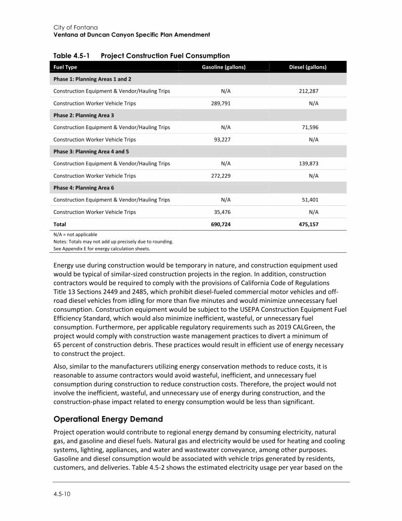
City of Fontana Ventana at Duncan Canyon Specific Plan Amendment
4.5-10
Table 4.5-1 Project Construction Fuel Consumption Fuel Type Gasoline (gallons) Diesel (gallons)
Phase 1: Planning Areas 1 and 2
Construction Equipment & Vendor/Hauling Trips N/A 212,287
Construction Worker Vehicle Trips 289,791 N/A
Phase 2: Planning Area 3
Construction Equipment & Vendor/Hauling Trips N/A 71,596
Construction Worker Vehicle Trips 93,227 N/A
Phase 3: Planning Area 4 and 5
Construction Equipment & Vendor/Hauling Trips N/A 139,873
Construction Worker Vehicle Trips 272,229 N/A
Phase 4: Planning Area 6
Construction Equipment & Vendor/Hauling Trips N/A 51,401
Construction Worker Vehicle Trips 35,476 N/A
Total 690,724 475,157
N/A = not applicable Notes: Totals may not add up precisely due to rounding. See Appendix E for energy calculation sheets.
Energy use during construction would be temporary in nature, and construction equipment used would be typical of similar-sized construction projects in the region. In addition, construction contractors would be required to comply with the provisions of California Code of Regulations Title 13 Sections 2449 and 2485, which prohibit diesel-fueled commercial motor vehicles and off-road diesel vehicles from idling for more than five minutes and would minimize unnecessary fuel consumption. Construction equipment would be subject to the USEPA Construction Equipment Fuel Efficiency Standard, which would also minimize inefficient, wasteful, or unnecessary fuel consumption. Furthermore, per applicable regulatory requirements such as 2019 CALGreen, the project would comply with construction waste management practices to divert a minimum of 65 percent of construction debris. These practices would result in efficient use of energy necessary to construct the project.
Also, similar to the manufacturers utilizing energy conservation methods to reduce costs, it is reasonable to assume contractors would avoid wasteful, inefficient, and unnecessary fuel consumption during construction to reduce construction costs. Therefore, the project would not involve the inefficient, wasteful, and unnecessary use of energy during construction, and the construction-phase impact related to energy consumption would be less than significant.
Operational Energy Demand Project operation would contribute to regional energy demand by consuming electricity, natural gas, and gasoline and diesel fuels. Natural gas and electricity would be used for heating and cooling systems, lighting, appliances, and water and wastewater conveyance, among other purposes. Gasoline and diesel consumption would be associated with vehicle trips generated by residents, customers, and deliveries. Table 4.5-2 shows the estimated electricity usage per year based on the
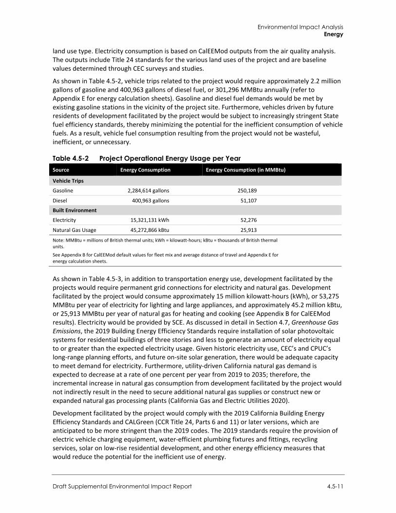
Environmental Impact Analysis Energy
Draft Supplemental Environmental Impact Report 4.5-11
land use type. Electricity consumption is based on CalEEMod outputs from the air quality analysis. The outputs include Title 24 standards for the various land uses of the project and are baseline values determined through CEC surveys and studies.
As shown in Table 4.5-2, vehicle trips related to the project would require approximately 2.2 million gallons of gasoline and 400,963 gallons of diesel fuel, or 301,296 MMBtu annually (refer to Appendix E for energy calculation sheets). Gasoline and diesel fuel demands would be met by existing gasoline stations in the vicinity of the project site. Furthermore, vehicles driven by future residents of development facilitated by the project would be subject to increasingly stringent State fuel efficiency standards, thereby minimizing the potential for the inefficient consumption of vehicle fuels. As a result, vehicle fuel consumption resulting from the project would not be wasteful, inefficient, or unnecessary.
Table 4.5-2 Project Operational Energy Usage per Year Source Energy Consumption Energy Consumption (in MMBtu)
Vehicle Trips
Gasoline 2,284,614 gallons 250,189
Diesel 400,963 gallons 51,107
Built Environment
Electricity 15,321,131 kWh 52,276
Natural Gas Usage 45,272,866 kBtu 25,913
Note: MMBtu = millions of British thermal units; kWh = kilowatt-hours; kBtu = thousands of British thermal units.
See Appendix B for CalEEMod default values for fleet mix and average distance of travel and Appendix E for energy calculation sheets.
As shown in Table 4.5-3, in addition to transportation energy use, development facilitated by the projects would require permanent grid connections for electricity and natural gas. Development facilitated by the project would consume approximately 15 million kilowatt-hours (kWh), or 53,275 MMBtu per year of electricity for lighting and large appliances, and approximately 45.2 million kBtu, or 25,913 MMBtu per year of natural gas for heating and cooking (see Appendix B for CalEEMod results). Electricity would be provided by SCE. As discussed in detail in Section 4.7, Greenhouse Gas Emissions, the 2019 Building Energy Efficiency Standards require installation of solar photovoltaic systems for residential buildings of three stories and less to generate an amount of electricity equal to or greater than the expected electricity usage. Given historic electricity use, CEC’s and CPUC’s long-range planning efforts, and future on-site solar generation, there would be adequate capacity to meet demand for electricity. Furthermore, utility-driven California natural gas demand is expected to decrease at a rate of one percent per year from 2019 to 2035; therefore, the incremental increase in natural gas consumption from development facilitated by the project would not indirectly result in the need to secure additional natural gas supplies or construct new or expanded natural gas processing plants (California Gas and Electric Utilities 2020).
Development facilitated by the project would comply with the 2019 California Building Energy Efficiency Standards and CALGreen (CCR Title 24, Parts 6 and 11) or later versions, which are anticipated to be more stringent than the 2019 codes. The 2019 standards require the provision of electric vehicle charging equipment, water-efficient plumbing fixtures and fittings, recycling services, solar on low-rise residential development, and other energy efficiency measures that would reduce the potential for the inefficient use of energy.
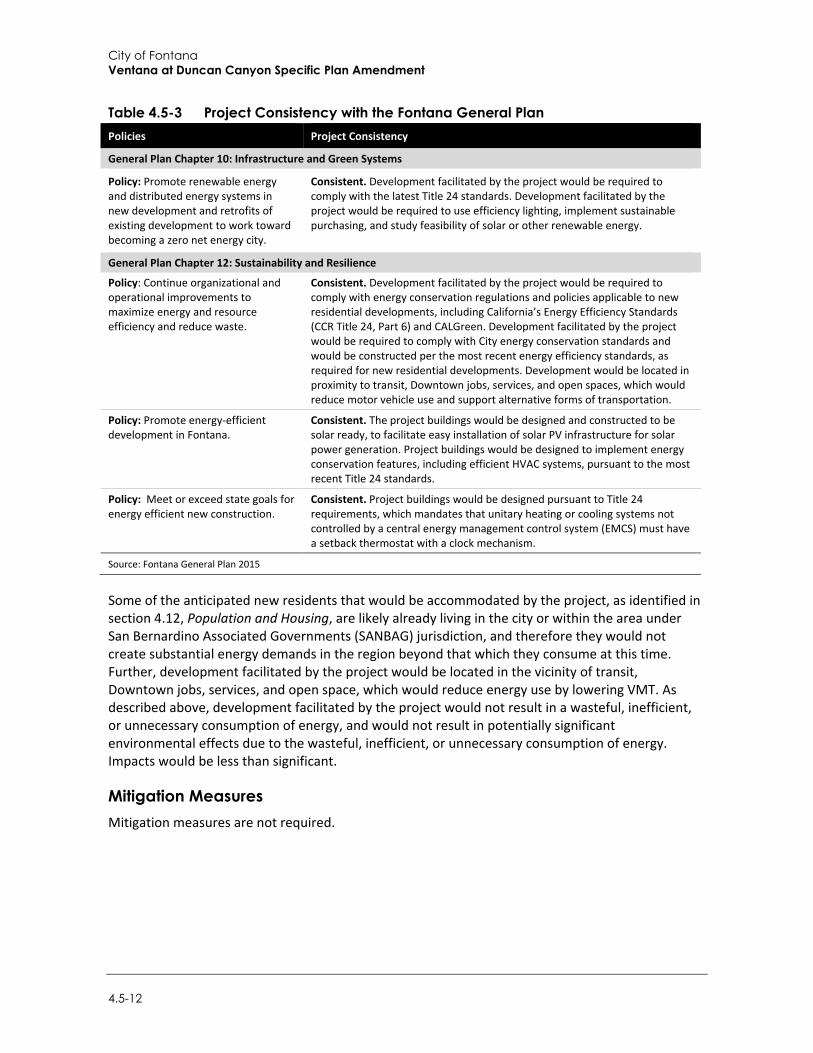
City of Fontana Ventana at Duncan Canyon Specific Plan Amendment
4.5-12
Table 4.5-3 Project Consistency with the Fontana General Plan Policies Project Consistency
General Plan Chapter 10: Infrastructure and Green Systems
Policy: Promote renewable energy and distributed energy systems in new development and retrofits of existing development to work toward becoming a zero net energy city.
Consistent. Development facilitated by the project would be required to comply with the latest Title 24 standards. Development facilitated by the project would be required to use efficiency lighting, implement sustainable purchasing, and study feasibility of solar or other renewable energy.
General Plan Chapter 12: Sustainability and Resilience
Policy: Continue organizational and operational improvements to maximize energy and resource efficiency and reduce waste.
Consistent. Development facilitated by the project would be required to comply with energy conservation regulations and policies applicable to new residential developments, including California’s Energy Efficiency Standards (CCR Title 24, Part 6) and CALGreen. Development facilitated by the project would be required to comply with City energy conservation standards and would be constructed per the most recent energy efficiency standards, as required for new residential developments. Development would be located in proximity to transit, Downtown jobs, services, and open spaces, which would reduce motor vehicle use and support alternative forms of transportation.
Policy: Promote energy-efficient development in Fontana.
Consistent. The project buildings would be designed and constructed to be solar ready, to facilitate easy installation of solar PV infrastructure for solar power generation. Project buildings would be designed to implement energy conservation features, including efficient HVAC systems, pursuant to the most recent Title 24 standards.
Policy: Meet or exceed state goals for energy efficient new construction.
Consistent. Project buildings would be designed pursuant to Title 24 requirements, which mandates that unitary heating or cooling systems not controlled by a central energy management control system (EMCS) must have a setback thermostat with a clock mechanism.
Source: Fontana General Plan 2015
Some of the anticipated new residents that would be accommodated by the project, as identified in section 4.12, Population and Housing, are likely already living in the city or within the area under San Bernardino Associated Governments (SANBAG) jurisdiction, and therefore they would not create substantial energy demands in the region beyond that which they consume at this time. Further, development facilitated by the project would be located in the vicinity of transit, Downtown jobs, services, and open space, which would reduce energy use by lowering VMT. As described above, development facilitated by the project would not result in a wasteful, inefficient, or unnecessary consumption of energy, and would not result in potentially significant environmental effects due to the wasteful, inefficient, or unnecessary consumption of energy. Impacts would be less than significant.
Mitigation Measures Mitigation measures are not required.
Environmental Impact Analysis Energy
Draft Supplemental Environmental Impact Report 4.5-13
Threshold 2: Would the project conflict with or obstruct a state or local plan for renewable energy or energy efficiency?
Impact E-2 DEVELOPMENT FACILITATED BY THE PROJECT WOULD NOT CONFLICT WITH OR OBSTRUCT AN APPLICABLE RENEWABLE ENERGY OR ENERGY EFFICIENCY PLAN. THIS IMPACT WOULD BE LESS THAN SIGNIFICANT.
The City of Fontana has not adopted any specific renewable energy or energy efficiency plan. As described Section 4.5.2, Regulatory Setting, the Fontana General Plan contains policies targeting energy efficiency. As demonstrated in Table 4.5-3, the project would be consistent with applicable General Plan policies intended to encourage energy efficiency. As such, the project would not conflict with or obstruct a state or local plan for renewable energy or energy efficiency, and there would be no impact.
Mitigation Measures Mitigation measures are not required.
4.5.4 Cumulative Impacts A project’s environmental impacts are “cumulatively considerable” if the “incremental effects of an individual project are significant when viewed in connection with the effects of past projects, the effects of other current projects, and the effects of probable future projects” (CEQA Guidelines Section 15065[a][3]). The geographic scope for energy consumption is the City of Fontana. This geographic scope is appropriate because the smallest scale at which energy consumption information is readily available is the city level. Cumulative buildout of the Fontana General Plan is considered part of this cumulative analysis. Cumulative development would increase demand for energy resources, but those resources would not be consumed in a wasteful, inefficient, or unnecessary manner. Moreover, new iterations of the California Building Energy Efficiency Standards and CALGreen would require increasingly more efficient appliances and building materials that reduce energy consumption in new development. In addition, vehicle fuel efficiency is anticipated to continue improving through implementation of the existing Pavley Bill regulations under AB 1493.
As described under Impact E-1, development facilitated by the project would be constructed in accordance with the California Building Energy Efficiency Standards and CALGreen. Additionally, housing development under the proposed project is presumed to lower VMT due to the proximity to office and commercial uses. Therefore, the project’s contribution to a significant cumulative energy impact is not cumulatively considerable. Development facilitated by the project would not result in a wasteful, inefficient, or unnecessary consumption of energy, and operation of the new residential structures would not result in potentially significant environmental effects due to the wasteful, inefficient, or unnecessary consumption of energy. Therefore, the project would not make a cumulatively considerable contribution to a significant cumulative impact.
The geographic scopes for the cumulative impact analysis of consistency with renewable energy and energy efficiency plans are the State of California and the City of Fontana. Projects throughout the State of California are required to adhere to applicable renewable energy and energy efficiency laws, programs, and policies such as California’s RPS, AB 1493, and Title 24 standards. All other pending and future projects in the county would be required to adhere to General Plan policies to mitigate energy impacts where feasible. In addition, all pending and future projects would be

City of Fontana Ventana at Duncan Canyon Specific Plan Amendment
4.5-14
reviewed for consistency with the Fontana General Plan. Therefore, the cumulative impact would be less than significant. As discussed under Impact E-2, development facilitated by the project would be consistent with the energy-related goals, policies, and actions of the statewide plans, and the Fontana General Plan. Therefore, the project would not make a cumulatively considerable contribution to a significant cumulative impact with respect to consistency with renewable energy and energy efficiency plans.
Environmental Impact Analysis Geology and Soils
Draft Supplemental Environmental Impact Report 4.6-1
4.6 Geology and Soils
This section analyzes potential impacts related to geology and soils. Specific issues addressed include seismic hazards, underlying soil characteristics, slope stability, and erosion. Data used to prepare this section was obtained from the Fontana General Plan, the United States Geological Survey, California Geological Survey, California Department of Conservation, and Southern California Earthquake Data Center.
4.6.1 Setting
a. Regional Geology and Drainage San Bernardino County is geographically and topographically diverse, encompassing mountains, hills, and flatlands. The city of Fontana is located in the southwest portion of San Bernardino County. The numerous faults in southern California include active, potentially active, and inactive faults. The criteria for these major groups are based on criteria developed by the California Geologic Survey (CGS) for the Alquist-Priolo Earthquake Fault Zone Program. By definition, an active fault is one that has had surface displacement within Holocene time (about the last 11,000 years). A potentially active fault has demonstrated surface displacement during Quaternary time (approximately the last 1.6 million years) but has had no known Holocene movement. Faults that have not moved in the last 1.6 million years are considered inactive.
The Sierra Madre-Cucamonga Fault System includes several fault segments along the southern margin of the San Gabriel Mountains in the County. The Sierra Madre Fault Zone runs along the base of the central San Gabriel Mountains and the Cucamonga Fault Zone runs along the base of the eastern San Gabriel Mountains. The United States Geological Survey (USGS) National Seismic Hazard Maps have indicated this fault as active, with a maximum magnitude of 7.0. Several additional faults run throughout the county; the second closest fault being the San Jacinto Fault located approximately 1.6 miles northeast of the city; the farthest being the Sierra Madre (central) Fault located approximately 14.5 miles west of the city.
The County of San Bernardino is underlain by various soil types. Particularly, alluvium, lake, playa, and terrace deposits along with mesozoic granite, quartz monzonite, granodiorite, and quartz diorite can be found in and near the City of Fontana (California Department of Conservation (DOC) 2018). Areas within the county that are susceptible to seismic hazards include most locations in the southwestern region of the county and some areas located in the northwestern region. As denoted in Geology and Soils of the County’s Countywide Plan EIR, areas within the county that are susceptible to landslides exists along the northern boundary of the mountain region and the southern portion of the valley region. Furthermore, areas with high susceptibility for liquefaction occur in areas with alluvial fans and floodplain deposits along the Santa Ana River, Mill Creek, City Creek, Cajon Creek, and Lytle Creek, Southern Chino and much of southern San Bernardino are also susceptible to liquefaction. In addition, Ontario’s New Model Colony (the Ranch area) has also been found to be susceptible to liquefaction. Liquefaction is also a concern in some smaller areas near water bodies such as Big Bear Lake, Erwin Lake, and Baldwin Lake (County of San Bernardino 2019).
The project site lays within the Rialto-Colton Groundwater Basin (RCGB) which is controlled and monitored by the West Valley Water District (WVWD). The Rialto-Colton subbasin underlies a portion of the upper Santa Ana Valley in southwestern San Bernardino County and northwestern Riverside County. This subbasin is about 10 miles long and varies in width from about 3.5 miles in
City of Fontana Ventana at Duncan Canyon Specific Plan Amendment
4.6-2
the northwestern portion located along foothills near Lytle Creek Road, to about 1.5 miles in the southeastern portion located near the I-10 and I-215 intersection. This subbasin is bounded by the San Gabriel Mountains on the northwest, the San Jacinto fault on the northeast, the Badlands on the southeast, and the Rialto-Colton fault on the southwest. The WVWD and its predecessors have been utilizing the Rialto Basin for water supply for more than 80 years. The basin shows quick rises of water levels during high precipitation years and slower decline over several years. Under normal conditions, when the basin is not in adjudication, WVWD has unlimited extraction rights. During drought conditions when the adjudication is in effect, the WVWD’s extraction right ranges from 3,067 AFY in the most severe drought periods to a maximum of 6,134 AFY. Existing wells in the Rialto Basin have the capacity to extract up to 10,000 AFY during normal conditions (Water Systems Consulting, Inc. 2020).
b. Local Geology The City of Fontana is divided into two distinct geographical areas. The southern and central portions of the city are primarily flat with areas of gradual slopes to the south and west. The northern portion of the city consists of gently rising foothills (City of Fontana 2018).
The city is located within the northern portion of the Peninsular Ranges Geomorphic Province of California, near the boundary with the Transverse Ranges Province. The project site is located at the northeastern corner of a structural block within the Peninsular Ranges. This block is known as the Perris Block. The Perris Block is bounded by two faults, the San Jacinto Fault on the northeast and the Elsinore Fault on the southwest. The city is underlain by relatively young (Holocene and late Pleistocene) alluvial deposits of the Lytle Creek alluvial fan. In the southern portion of the city, the deposits are relatively fine-grained (mainly pebbles and cobbles) and become coarser grained (cobbles and boulders) to the north (City of Fontana 2018).
Sediments on the site consist of alluvial fan deposits, which include sandy gravels and gravelly sands with silty sand interbeds. Colluvial deposits are present on the project site and include clayey silt, sandy silt and silty clays with scattered rocks and pebbles. Bedrock materials are undivided igneous and metamorphic rock complex of marble, slate-like material and massive coarse-crystalline rocks (City of Fontana 2007). There are no large open bodies of water near the site, which may create tsunami hazards during an earthquake event in the area. Also, no enclosed bodies of water that can experience seiche during an earthquake are present in the project area. Flooding due to failure of a dam or other water retaining structure is considered negligible due to the absence of dams near the site.
Geologic Hazards
Soils
The City of Fontana is highly urbanized. Surface soils in the city may no longer reflect natural soil associations and characteristics since topsoil in the city has been developed. The project site is underlain by Hanford coarse sandy loam (Hac) on the northern section and Tujunga gravelly loamy sand (Tvc) on the southern section (USDA 2019). This type of soil is characterized of having low to moderate erosion hazard, and expansive properties. Runoff is typically low to medium, and the erosion hazard is slight to moderate. The soil retains a relatively high amount of water (City of Fontana 2007).
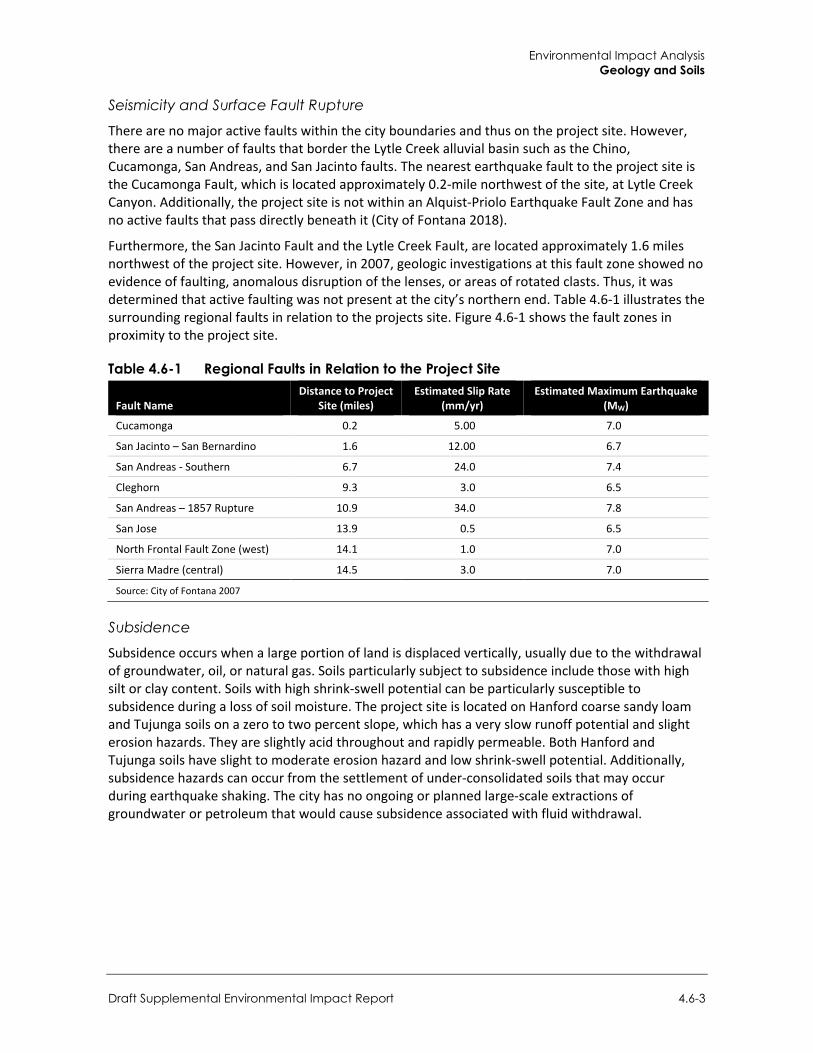
Environmental Impact Analysis Geology and Soils
Draft Supplemental Environmental Impact Report 4.6-3
Seismicity and Surface Fault Rupture
There are no major active faults within the city boundaries and thus on the project site. However, there are a number of faults that border the Lytle Creek alluvial basin such as the Chino, Cucamonga, San Andreas, and San Jacinto faults. The nearest earthquake fault to the project site is the Cucamonga Fault, which is located approximately 0.2-mile northwest of the site, at Lytle Creek Canyon. Additionally, the project site is not within an Alquist-Priolo Earthquake Fault Zone and has no active faults that pass directly beneath it (City of Fontana 2018).
Furthermore, the San Jacinto Fault and the Lytle Creek Fault, are located approximately 1.6 miles northwest of the project site. However, in 2007, geologic investigations at this fault zone showed no evidence of faulting, anomalous disruption of the lenses, or areas of rotated clasts. Thus, it was determined that active faulting was not present at the city’s northern end. Table 4.6-1 illustrates the surrounding regional faults in relation to the projects site. Figure 4.6-1 shows the fault zones in proximity to the project site.
Table 4.6-1 Regional Faults in Relation to the Project Site
Fault Name Distance to Project
Site (miles) Estimated Slip Rate
(mm/yr) Estimated Maximum Earthquake
(MW)
Cucamonga 0.2 5.00 7.0
San Jacinto – San Bernardino 1.6 12.00 6.7
San Andreas - Southern 6.7 24.0 7.4
Cleghorn 9.3 3.0 6.5
San Andreas – 1857 Rupture 10.9 34.0 7.8
San Jose 13.9 0.5 6.5
North Frontal Fault Zone (west) 14.1 1.0 7.0
Sierra Madre (central) 14.5 3.0 7.0
Source: City of Fontana 2007
Subsidence
Subsidence occurs when a large portion of land is displaced vertically, usually due to the withdrawal of groundwater, oil, or natural gas. Soils particularly subject to subsidence include those with high silt or clay content. Soils with high shrink-swell potential can be particularly susceptible to subsidence during a loss of soil moisture. The project site is located on Hanford coarse sandy loam and Tujunga soils on a zero to two percent slope, which has a very slow runoff potential and slight erosion hazards. They are slightly acid throughout and rapidly permeable. Both Hanford and Tujunga soils have slight to moderate erosion hazard and low shrink-swell potential. Additionally, subsidence hazards can occur from the settlement of under-consolidated soils that may occur during earthquake shaking. The city has no ongoing or planned large-scale extractions of groundwater or petroleum that would cause subsidence associated with fluid withdrawal.
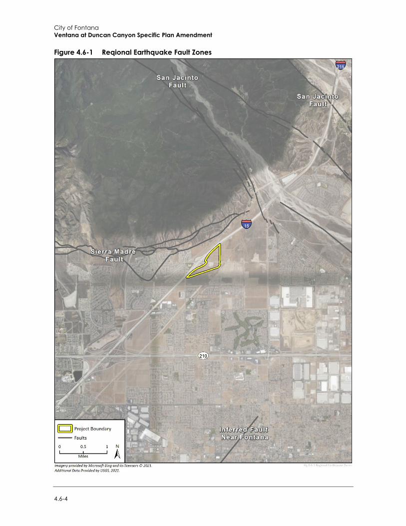
City of Fontana Ventana at Duncan Canyon Specific Plan Amendment
4.6-4
Figure 4.6-1 Reqional Earthquake Fault Zones
Environmental Impact Analysis Geology and Soils
Supplemental Draft Environmental Impact Report 4.6-5
4.6.2 Regulatory Setting
a. Federal Regulations
Earthquake Hazards Reduction Act U.S. Congress passed the Earthquake Hazards Reduction Act in 1977 to reduce the risks to life and property from future earthquakes through the establishment and maintenance of an effective earthquake hazards reduction program. To accomplish this goal, the act established the National Earthquake Hazards Reduction Program. This program was substantially amended in November 1990 by the National Earthquake Hazards Reduction Program Act, which refined the description of agency responsibilities, program goals, and objectives to focus on minimizing loss from earthquakes after they occur. The National Earthquake Hazards Reduction Program promotes the adoption of earthquake hazard reduction activities by all scales of government and works to develop national building standards and model codes for use by engineers, architects, and all others involved in the planning and construction of buildings and infrastructure.
b. State Regulations
Alquist-Priolo Earthquake Fault Zoning Act The Alquist-Priolo Earthquake Fault Zoning Act of 1972 provides a mechanism for reducing losses from surface fault rupture on a statewide basis. The intent of the Act is to ensure public safety by prohibiting the siting of most structures for human occupancy across traces of active faults that constitute a potential hazard to structures from surface faulting or fault creep. Generally, siting of structures for human occupancy must be set back from the fault by approximately 50 feet. This Act groups faults into categories of active, potentially active, and inactive. Historic and Holocene age faults are considered active, Late Quaternary and Quaternary age faults are considered potentially active, and pre-Quaternary age faults are considered inactive.
Seismic Hazards Mapping Act The Seismic Hazards Mapping Act of 1990 directs the California Geological Survey (CGS) to delineate Seismic Hazard Zones. The purpose of the Act is to reduce the threat to public health and safety and to minimize the loss of life and property by identifying and mitigating seismic hazards. Cities, counties, and State agencies are directed to use seismic hazard zone maps developed by CGS in their land-use planning and permitting processes. The Act requires that site-specific the preparation of geotechnical investigations, including mitigation measures based on site-specific conditions, prior to permitting most urban development projects in seismic hazard zones.
California Public Resources Code Section 5097.5 California Public Resources Code Section 5097.5 provides protection for paleontological resources on public lands, where Section 5097.5(a) states, in part, that:
No person shall knowingly and willfully excavate upon, or remove, destroy, injure, or deface, any historic or prehistoric ruins, burial grounds, archaeological or vertebrate paleontological site, including fossilized footprints, inscriptions made by human agency, rock art, or any other archaeological, paleontological or historical feature, situated on public lands, except with the express permission of the public agency having jurisdiction over the lands.
City of Fontana Ventana at Duncan Canyon Specific Plan Amendment
4.6-6
California Building Code The California Building Code (CBC) is contained in the California Code of Regulations, Title 24, Part 2, which is a portion of the California Building Standards Code. Title 24 is assigned to the California Building Standards Commission, which by law is responsible for coordinating all building standards. The CBC incorporates by reference the federal Uniform Building Code with necessary California amendments. The CBC is the regulatory tool that includes building code standards to address geologic and seismic hazards. Approximately one-third of the text in the CBC has been tailored for California earthquake conditions. Fontana, along with all of southern California, is in Seismic Zone 4, the area of greatest risk and subject the strictest building standards.
c. Local Regulations
City of Fontana General Plan The Fontana General Plan Noise and Safety chapter seeks to reduce risks from geologic hazards in the city of Fontana (City of Fontana 2018). Goals and policies that relate to geologic hazards and would apply to the project include the following:
Goal 4: Seismic injury and loss of life, property damage, and other impacts caused by seismic shaking, fault rupture, ground failure, earthquake-induced landslides, and other earthquake-induced ground deformation are minimized in Fontana.
Policy: The City shall monitor development or redevelopment in areas where faults have been mapped through the city.
Policy: The City shall continue to ensure that current geologic knowledge and peer (third party) review are incorporated into the design, planning, and construction stages of a project and that site-specific data are applied to each project.
Policy: The City shall continue to ensure to the fullest extent possible that, in the event of a major disaster, essential structures and facilities remain safe and functional, as required by current law. Essential facilities include hospitals, police stations, fire stations, emergency operation centers, communication centers, generators and substations, and reservoirs.
Goal 5: Risk to life or limb and property damage resulting from geologic hazards are minimized in Fontana.
Policy: The City shall continue to participate in regional programs designed to protect the groundwater resources and to protect the area from the hazard of regional ground subsidence through careful management of the regional groundwater basin that underlies the area.
Goal 6: Injury, loss of life, property damage, and economic and social disruption caused by flood and inundation hazards are minimized in Fontana.
Policy: The City shall discourage new development in flood-hazard areas and implement mitigation measures to reduce the hazard to existing developments located within the 100- and 500-year flood zones.
Environmental Impact Analysis Geology and Soils
Supplemental Draft Environmental Impact Report 4.6-7
4.6.3 Impact Analysis
a. Significance Thresholds The following thresholds of significance were developed based on the Appendix G of the CEQA Guidelines. The project would have a significant impact with respect to geology and soils if it would:
Directly or indirectly cause potential substantial adverse effects, including the risk of loss, injury, or death involving:
Rupture of a known earthquake fault, as delineated on the most recent Alquist-Priolo Earthquake Fault Zoning Map issued by the State Geologist for the area or based on other substantial evidence of a known fault
Strong seismic ground shaking
Be located on expansive soil, as defined in Table 18-1-B of the Uniform Building Code (1994), creating substantial direct or indirect risks to life or property
Directly or indirectly destroy a unique paleontological resource or site or unique geologic feature
Impacts to geology and soils were analyzed in an Initial Study (see appendix A-2). The Initial Study determined that impacts related to risk of loss, injury, or death involving seismic-related ground failure, including liquefaction or landslide would be less than significant because the project site is not within a fault or liquefication hazard zone, no portion of the project site is in a landslide hazard area, and there are no designated landslide hazard areas in the vicinity. In addition, impacts related to soil erosion or the loss of topsoil would be less than significant based on compliance with existing regulatory requirements, including implementation of applicable best management practices (BMPs) related to wind and water erosion control. Furthermore, the project would not have any impacts related to use of septic tanks or alternative wastewater disposal systems because the project be connected to the city’s sewer system for wastewater collection. Therefore, these impacts are not further evaluated in this section.
b. Methodology To evaluate project impacts, resource conditions that could pose a risk to development of the project were identified through review of documents pertaining to these topics. Sources consulted include the City of Fontana General Plan, U.S. Geological Survey and California Geological Survey technical maps and guides; the Natural Resources Conservation Service Soil Survey (available through the Soil Survey Geographic Database); the 2007 EIR; and published geologic literature. The information obtained from these sources was reviewed and summarized to establish the existing conditions (described above) and identify potential environmental hazards. In determining level of significance, the analysis assumes that the project would comply with relevant laws, regulations, and guidelines.
c. Standard Conditions The following standard conditions related to geology and soils, and identified in the 2007 EIR, remain applicable to the proposed project:
Standard Condition 4.7.1: The project shall comply with seismic design criteria in the California Building Code, the City’s building standards, and other pertinent building regulations.
City of Fontana Ventana at Duncan Canyon Specific Plan Amendment
4.6-8
Standard Condition 4.7.2: Recommendations of the geotechnical investigation for the project site, as they pertain to structural design and construction recommendations for earthwork (excavation, grading, volume adjustments, soil disposal, slopes), foundation design (types of foundations and slabs on grade, pavements, retaining walls, trench backfill, sulfate exposure), and other necessary geologic and seismic considerations would need to be implemented for building construction.
Standard Condition 4.7.3: Site-specific geotechnical investigations shall be performed for proposed commercial structures to determine the factors to be considered in the structural design of these structures.
d. Project Impacts
Threshold 1a: Would the project directly or indirectly cause potential substantial adverse effects, including the risk of loss, injury, or death involving rupture of a known earthquake fault, as delineated on the most recent Alquist-Priolo Earthquake Fault Zoning Map issued by the State Geologist for the area or based on other substantial evidence of a known fault?
Threshold 1b: Would the project directly or indirectly cause potential substantial adverse effects, including the risk of loss, injury, or death involving strong seismic ground shaking?
Impact GEO-1 THE PROJECT SITE IS NOT LOCATED IN AN ALQUIST-PRIOLO FAULT ZONE AND NO FAULT LINES TRAVERSE DIRECTLY UNDER THE SITE. THOUGH THERE IS POTENTIAL FOR BOTH EARTHQUAKES AND GROUNDSHAKING IN THE PROJECT AREA, COMPLIANCE WITH CITY GENERAL PLAN GOALS AND POLICIES AND THE CBC WOULD REDUCE POTENTIAL IMPACTS RELATED TO SEISMIC GROUND SHAKING TO A LESS THAN SIGNIFICANT LEVEL.
The southern California region is considered to be seismically active. Ground shaking can result in significant structural damage or structural failure in the absence of appropriate seismic design. Settlement of the ground surface (settlement) can be accelerated and accentuated by earthquakes due to the rearrangement of soil particles during prolonged ground shaking. Settlement can also cause damage to structures and infrastructure. However, the project site is not directly located in an Alquist-Priolo Fault Zone and does not contain any known fault lines (CGS 2016; City of Fontana 2007). However, there are a number of regional fault lines in close proximity to the project area, which have the potential to cause moderate to large earthquakes. The nearest earthquake zone includes the Cucamonga Fault Zone in the Sierra Madre Fault System, located approximately 0.2-mile northwest of the project site, at Lytle Creek Canyon. In addition, the San Jacinto Fault is located approximately 1.6 miles northeast of the project site. The project site could potentially be subject to ground shaking generated from fault activities from the Cucamonga Fault, approximately 0.2 mile north of the projects site, and the San Jacinto fault, approximately 1.6 miles northeast of the project site (DOC 2018).
Project implementation would include residential villages, commercial uses, a focal point piazza, a campanile tower feature, and the construction of Lytle Creek Road, as described in Section 2, Project Description. The project site may thus experience moderate to potentially severe ground shaking from earthquakes generated on known faults such as the Cucamonga and the San Jacinto Faults. The project site is located approximately 0.4 mile south of an Alquist-Priolo Fault Zone (DOC 2018). However, based on previous geologic investigations, the 2007 EIR determined that the fault
Environmental Impact Analysis Geology and Soils
Supplemental Draft Environmental Impact Report 4.6-9
zone presented no evidence of active faulting. Therefore, active faulting was determined to not be present at the city’s northern end (City of Fontana 2007).
Furthermore, proposed structures would be constructed to comply with the seismic design criteria of the CBC. The CBC requires various measures of all construction in California to minimize risks associated with seismic shaking. These measures include standards for structural design, necessary tests and inspections, provisions addressing building foundations, and standards for the use of certain materials (City of Fontana 2018). With adherence to the requirements of the CBC, as required by the Fontana Code of Ordinances, the project would result in less than significant impacts related to seismically-induced ground shaking from nearby faults. The project would be required to comply with the City Seismic Requirements and the latest CBC, to ensure that all new and modified buildings would be capable of withstanding anticipated levels of ground shaking. Thus, compliance with City General Plan Goals and Policies and CBC would reduce the potential impacts related to seismic ground shaking to less than significant.
Mitigation Measures Mitigation measures are not required.
Threshold 2: Would the project be located on expansive soil, as defined in Table 1-B of the Uniform Building Code (1994), creating substantial direct or indirect risks to life or property?
Impact GEO-2 THE PROJECT SITE IS UNDERLAIN BY SOILS POSSESSING MODERATE COLLAPSE POTENTIAL AND LOW EXPANSIVE POTENTIAL. HOWEVER, IMPACTS ASSOCIATED WITH SOIL CHARACTERISTICS WOULD BE LESS THAN SIGNIFICANT WITH IMPLEMENTATION OF MITIGATION.
Newly constructed buildings, pavements, and utilities could be damaged by differential settlement due to soil expansion and contraction. When structures are located on expansive soils, foundations have the tendency to rise during the wet season and shrink during the dry season. Movements can vary under the structures, which in turn create new stresses on various sections of the foundation and connected utilities. These variations in ground settlement can lead to structural failure and damage to infrastructure. Soil borings at the site determined that the on-site soils are not expansive but have moderate collapse potential. In addition, they have negligible sulfate exposure to concrete and are moderately corrosive to ferrous metals. Future development associated with the project would be constructed on vacant undeveloped land surrounded by existing development and thus, would not be subject to changes in soil type than what is already existing on the project site. Therefore, the project site does not have expansive soil. However, the site has onsite soil characteristics which warrant consideration for collapse potential and corrosivity.
Site characteristics including on-site soils, the expansion, compaction, moisture content, and other geologic properties of the site need to be considered in the design of structures and infrastructure, to ensure that the structural integrity of on-site buildings and infrastructures is not compromised. The geotechnical investigation included in the 2007 EIR provides structural design and construction recommendations for earthwork (subgrade preparation, rock removal, backfill, over excavation, shrinkage and subsidence, site drainage, utility trench backfill,) foundation design (foundations, lateral earth pressures, settlement, slabs on grade, pavement design, retaining walls, pipe bedding), and other necessary geologic and seismic considerations that would need to be considered in design and implemented for building construction. In addition, the project would comply with design requirements in the UBC, which would minimize risks to life and property related to soil
City of Fontana Ventana at Duncan Canyon Specific Plan Amendment
4.6-10
characteristics. Therefore, the impacts related to soil characteristics would be potentially significant without specific design considerations.
Mitigation Measure The 2007 EIR identified specific mitigation based on recommendations in a preliminary geotechnical investigation to address the subjects of collapse in temporary excavations, corrosion and other soil characteristics in final design. These mitigation measures are supplanted by new Mitigation Measure GEO-2, which allows for the consideration of additional geotechnical and/or engineering analysis based on the specific design for each planning area:
GEO-2 Implement Engineering Recommendations
Final design for each planning area shall incorporate engineering recommendations based on site specific soil investigations, and shall consider collapsible soils, protection from corrosive soils, and other applicable soil conditions. More specifically, final design shall incorporate recommendations from the Preliminary Geological Investigation Approximately 81.1-Acre Site Duncan Canyon, City of Fontana California, prepared by Converse Consultants in September 2005, or subsequent analysis.
Significance After Mitigation Impacts would be less than significant with mitigation incorporated.
Threshold 3: Would the project directly or indirectly destroy a unique paleontological resource or site or unique geologic feature?
Impact GEO-3 THE PROJECT SITE IS UNDERLAIN BY GEOLOGIC UNITS POSSESSING PALEONTOLOGICAL SENSITIVITY RANGING FROM LOW TO HIGH. POTENTIAL FOR PALEONTOLOGICAL RESOURCES MAY OCCUR DURING GROUND-DISTURBING ACTIVITIES FOR CERTAIN PROJECTS. MITIGATION MEASURES HAVE BEEN IDENTIFIED TO REDUCE IMPACTS IN THE EVENT OF AN UNANTICIPATED DISCOVERY OF PALEONTOLOGICAL RESOURCES. IMPACTS WOULD BE LESS THAN SIGNIFICANT WITH MITIGATION.
The project site is underlain by old alluvial fan deposits including sandy gravels and gravelly sands with silty sand interbeds, which includes marine and nonmarine (continental) sedimentary rocks. Of all the geological formations present within the city, only the Pleistocene deposits have the potential to contain fossils. According to the City’s General Plan EIR (2018), review of online databases found no fossil localities in the city. Due to the paucity of fossils recovered from Pleistocene alluvium near the San Gabriel Mountains, Pleistocene deposits found south of SR-210, located approximately 2.73 miles from the project site, are considered to have moderate but unknown sensitivity for paleontological resources, though the possibility of discovering such resources may increase beyond eight feet below the ground surface (City of Fontana 2018). The 2007 EIR determined that no paleontological resources have been identified in the city or the project site based on the General Plan. However, native soils may have the potential for paleontological resources.
Ground-disturbing activities during project construction may impact previously unknown paleontological resources that may be present below the project site surface. Therefore, disturbance of potential paleontological resources may occur during ground-disturbing activities at depths beyond eight feet below ground surface. A significant impact on paleontological resources could result if an inadvertent discovery is made during ground-disturbing activities associated with
Environmental Impact Analysis Geology and Soils
Supplemental Draft Environmental Impact Report 4.6-11
construction of the project. Therefore, impacts to paleontological resources would be potentially significant.
Mitigation Measure The 2007 EIR identified specific mitigation to address potential for paleontological resources by requiring monitoring throughout excavation activities extending to estimated depths of 10 feet or more below the ground surface. The project would be required to implement measures under Mitigation Measure GEO-3, which is a reinstatement and similar to Mitigation Measure 4.10.6, with a minor update for monitoring throughout excavation activities extending to depths of eight feet or more instead of 10 feet to acknowledge the possibility of discovering resources at eight feet per the City’s General Plan EIR.
GEO-3 Paleontological Monitoring
Monitoring shall be conducted for excavation activities extending to estimated depths of eight feet or more below the existing ground surface. If required, the palaeontologic monitor shall be equipped to salvage fossils as they are unearthed to avoid construction delays and to remove samples of sediments that are likely to contain the remains of small fossil invertebrates and vertebrates. Monitors are empowered to temporarily halt or divert equipment to allow removal of abundant or large specimens. Monitoring may be reduced if the potentially fossiliferous units are not present in the subsurface, or if present, are determined upon exposure and examination by qualified palaeontologic personnel to have low potential to contain fossil resources. Also, the following measures shall be made during the monitoring of excavation activities on undisturbed subsurface Pleistocene sediments.
During monitoring, preparation of recovered specimens to a point of identification and permanent preservation, including washing of sediments to recover small invertebrates and vertebrates should occur.
During monitoring, identification and curation of specimens into a museum repository with permanent retrievable storage should occur. The paleontologist must have a written repository agreement in hand prior to the initiation of mitigation activities.
During monitoring, preparation of a report of findings with an itemized inventory of specimens should occur. The report and inventory, when submitted to the City of Fontana (as the Lead Agency), will signify completion of the program to mitigate impacts to paleontological resources.
Significance After Mitigation Impacts would be less than significant with mitigation incorporated.
4.6.4 Cumulative Impacts The planned and pending projects in the project site vicinity are listed in Table 3-1 of Section 3, Environmental Setting. Cumulative projects considered in this analysis include 22 residential projects, three warehouse/storage projects, and a commercial center/hotel project. The project, in conjunction with other planned and pending projects in the project site vicinity, would cumulatively increase the potential to encounter geologic phenomena (faults, seismic ground shaking, landslides, etc.), similar soil conditions, and paleontological resources.
City of Fontana Ventana at Duncan Canyon Specific Plan Amendment
4.6-12
Each individual project would be required to investigate and address the site specific geologic and soil conditions in conjunction with engineering recommendations incorporated into the final design, consistent with CBC requirements. Similarly, in the event that paleontological resources are discovered, each individual project would be required to comply with the applicable regulatory requirements and mitigate any potential impacts to resources on the individual project site.
Compliance with CEQA requirements, including the implementation of recommendations provided in project-specific resource studies, on all new development, would reduce impacts at a project level, and in-turn avoid significant impacts on a cumulative basis. Potential impacts of the project would be reduced to a less-than-significant level due to implementation of Mitigation Measures GEO-2 and GEO-3. The site-specific soil characteristics of the project site will be considered in the engineering requirements and the final design for each planning area.
In the event that paleontological resources are uncovered, each individual project would be required to comply with the applicable regulatory requirements to mitigate potential impacts. Such recommendations may include implementation of a mitigation plan, monitoring, recovery and curation. Therefore, cumulative impacts to geology and soils, including paleontological resources, would be less than significant.
Environmental Impact Analysis Greenhouse Gas
Draft Supplemental Environmental Impact Report 4.7-1
4.7 Greenhouse Gas
This section analyzes greenhouse gas (GHG) emissions associated with the project and potential impacts related to climate change. It considers both the temporary impacts relating to construction activity and potential long-term impacts associated with project operation. The 2007 EIR did not consider GHG emissions, therefore no comparison will be drawn between analysis in the 2007 EIR and that for the proposed project contained herein. The analysis herein is supported by the Air Quality and Greenhouse Gas Study (Appendix B) prepared for the project by Rincon Consultants, Inc.
4.7.1 Setting
a. Climate Change and Greenhouse Gases Climate change is the observed increase in the average temperature of the Earth’s atmosphere and oceans along with other substantial changes in climate (such as wind patterns, precipitation, and storms) over an extended period. The term “climate change” is often used interchangeably with the term “global warming,” but climate change is preferred because it conveys other changes are happening in addition to rising temperatures. The baseline against which these changes are measured originates in historical records that identify temperature changes that occurred in the past, such as during previous ice ages. The global climate is changing continuously, as evidenced in the geologic record which indicates repeated episodes of substantial warming and cooling. The rate of change has typically been incremental, with warming or cooling trends occurring over the course of thousands of years. The past 10,000 years have been marked by a period of incremental warming, as glaciers have steadily retreated across the globe. However, scientists have observed acceleration in the rate of warming over the past 150 years. The United Nations Intergovernmental Panel on Climate Change (IPCC) expressed that the rise and continued growth of atmospheric CO2 concentrations is unequivocally due to human activities in the IPCC’s Sixth Assessment Report (2021). Human influence has warmed the atmosphere, ocean, and land, which has led the climate to warm at an unprecedented rate in the last 2,000 years. It is estimated that between the period of 1850 through 2019, a total of 2,390 gigatons of anthropogenic CO2 was emitted. It is likely that anthropogenic activities have increased the global surface temperature by approximately 1.07 degrees Celsius between the years 2010 through 2019 (IPCC 2021). Furthermore, since the late 1700s, estimated concentrations of CO2, methane, and nitrous oxide in the atmosphere have increased by over 43 percent, 156 percent, and 17 percent, respectively, primarily due to human activity (U.S. EPA 2021a). Emissions resulting from human activities are thereby contributing to an average increase in Earth’s temperature.
Gases that absorb and re-emit infrared radiation in the atmosphere are called GHGs. The gases widely seen as the principal contributors to human-induced climate change include carbon dioxide (CO2), methane (CH4), nitrous oxides (N2O), fluorinated gases such as hydrofluorocarbons (HFCs) and perfluorocarbons (PFCs), and sulfur hexafluoride (SF6). Water vapor is excluded from the list of GHGs because it is short-lived in the atmosphere, and natural processes, such as oceanic evaporation, largely determine its atmospheric concentrations.
GHGs are emitted by natural processes and human activities. Of these gases, CO2 and CH4 are emitted in the greatest quantities from human activities. Emissions of CO2 are usually by-products of fossil fuel combustion, and CH4 results from off-gassing associated with agricultural practices and
City of Fontana Ventana at Duncan Canyon Specific Plan Amendment
4.7-2
landfills. Human-made GHGs, many of which have greater heat-absorption potential than CO2, include fluorinated gases and SF6 (U.S. EPA 2021a).
Different types of GHGs have varying global warming potentials (GWP). The GWP of a GHG is the potential of a gas or aerosol to trap heat in the atmosphere over a specified timescale (generally, 100 years). Because GHGs absorb different amounts of heat, a common reference gas (CO2) is used to relate the amount of heat absorbed to the amount of the gas emitted, referred to as “carbon dioxide equivalent” (CO2e), which is the amount of GHG emitted multiplied by its GWP. Carbon dioxide has a 100-year GWP of one. By contrast, methane has a GWP of 30, meaning its global warming effect is 30 times greater than CO2 on a molecule per molecule basis (IPCC 2021).
The accumulation of GHGs in the atmosphere regulates the earth’s temperature. Without the natural heat-trapping effect of GHGs, the earth’s surface would be about 33 degrees Celsius (°C) cooler (World Meteorological Organization 2020). However, since 1750, estimated concentrations of CO2, CH4, and N2O in the atmosphere have increased by 47 percent, 156 percent, and 23 percent, respectively, primarily due to human activity (IPCC 2021). GHG emissions from human activities, particularly the consumption of fossil fuels for electricity production and transportation, are believed to have elevated the concentration of these gases in the atmosphere beyond the level of concentrations that occur naturally.
b. Greenhouse Gas Emissions Inventory In 2015, worldwide anthropogenic GHG emissions totaled 47,000 million MT of CO2e, which is a 43 percent increase from 1990 GHG levels (U.S. EPA 2021b). Specifically, 34,522 million metric tons (MMT) of CO2e of CO2, 8,241 MMT of CO2e of CH4, 2,997 MMT of CO2e of N2O, and 1,001 MMT of CO2e of fluorinated gases were emitted in 2015. The largest source of GHG emissions was energy production and use (which includes fuels used by vehicles and buildings), which accounted for 75 percent of global GHG emissions. Agriculture uses and industrial processes contributed 12 percent and six percent, respectively. Waste sources and international transportation sources contributed for three percent and two percent, respectively. These sources account for approximately 98 percent of total GHG emissions because there was a net sink of two percent from land-use change and forestry. (U.S. EPA 2021b).
Federal Emissions Inventory Total U.S. GHG emissions were 6,558 MMT of CO2e in 2019. Emissions decreased by 1.7 percent from 2018 to 2019; since 1990, total U.S. emissions have increased by an average annual rate of 0.06 percent for a total increase of 1.8 percent between 1990 and 2019. The decrease from 2018 to 2019 reflects the combined influences of several long-term trends, including population changes, economic growth, energy market shifts, technological changes such as improvements in energy efficiency, and decrease carbon intensity of energy fuel choices. In 2019, the industrial and transportation end-use sectors accounted for 30 percent and 29 percent, respectively, of nationwide GHG emissions while the commercial and residential end-use sectors accounted for 16 percent and 15 percent of nationwide GHG emissions, respectively, with electricity emissions distributed among the various sectors (U.S. EPA 2021c).
California Emissions Inventory Based on the CARB California Greenhouse Gas Inventory for 2000-2019, California produced 418.2 MMT of CO2e in 2019, which is 7.2 MMT of CO2e lower than 2018 levels. The major source of GHG emissions in California is the transportation sector, which comprises 40 percent of the state’s total
Environmental Impact Analysis Greenhouse Gas
Draft Supplemental Environmental Impact Report 4.7-3
GHG emissions. The industrial sector is the second largest source, comprising 21 percent of the state’s GHG emissions, while electric power accounts for approximately 14 percent (California Air Resources Board [CARB] 2021). The magnitude of California’s total GHG emissions is due in part to its large size and large population compared to other states. However, a factor that reduces California’s per capita fuel use and GHG emissions as compared to other states is its relatively mild climate. In 2016, the State of California achieved its 2020 GHG emission reduction target of reducing emissions to 1990 levels as emissions fell below 431 MMT of CO2e (CARB 2021). The annual 2030 statewide target emissions level is 260 MMT of CO2e (CARB 2017).
Local Emissions Inventory The City of Fontana generated a total of 1,238,926 MT CO2e in a 2008 GHG baseline inventory. Transportation GHG emissions were the largest contributor at approximately 51 percent of the total GHG emissions or 635,066 MT CO2e. The second largest sector was building energy, which generated approximately 483,783 MT CO2e or 39 percent of the total. Off-road equipment generated 73,650 MT CO2e or 6 percent of the total. The remaining four percent of the total GHG emissions are generated from solid waste management (19,570 MT CO2e), water conveyance (15,265 CO2e), wastewater treatment (7,842 MT CO2e), and agriculture (3,850 MT CO2e) (City of Fontana 2015).
c. Potential Effects of Climate Change Globally, climate change has the potential to affect numerous environmental resources though potential impacts related to future air temperatures and precipitation patterns. Scientific modeling predicts that continued GHG emissions at or above current rates would induce more extreme climate changes during the twenty-first century than were observed during the twentieth century. Long-term trends have found that each of the past three decades has been warmer than all the previous decades in the instrumental record. The World Meteorological Organization observed that the 2011 through 2020 decade was the warmest decade on record with 2020 being the warmest year to date (World Meteorological Organization 2021). The average global temperature in 2020 was about 14.9 degrees Celsius (°C), which is 1.2 (± 0.1) °C above the pre-industrial levels from 1850 through 1900 level. Furthermore, several independently analyzed data records of global and regional Land-Surface Air Temperature (LSAT) obtained from station observations confirm that LSAT as well as sea surface temperatures have increased. Due to past and current activities, anthropogenic GHG emissions are increasing global mean surface temperature at a rate of 0.2°C per decade. In addition to these findings, there are identifiable signs that global warming is currently taking place, including substantial ice loss in the Arctic over the past two decades (IPCC 2014 and 2018).
According to California’s Fourth Climate Change Assessment, statewide temperatures from 1986 to 2016 were approximately 1° Fahrenheit (F) to 2°F higher than those recorded from 1901 to 1960. Potential impacts of climate change in California may include loss in water supply from snowpack, sea level rise, more extreme heat days per year, more large forest fires, and more drought years (State of California 2018). While there is growing scientific consensus about the possible effects of climate change at a global and statewide level, current scientific modeling tools are unable to predict what local impacts may occur with a similar degree of accuracy. In addition to statewide projections, California’s Fourth Climate Change Assessment includes regional reports that summarize climate impacts and adaptation solutions for nine regions of the state as well as
City of Fontana Ventana at Duncan Canyon Specific Plan Amendment
4.7-4
regionally specific climate change case studies (State of California 2018). Below is a summary of some of the potential effects that could be experienced in California as a result of climate change.
Air Quality Scientists project that the annual average maximum daily temperatures in California could rise by 2.5 to 5.8°F in the next 50 years and by 5.6 to 8.8°F in the next century. Higher temperatures are conducive to air pollution formation, and rising temperatures could therefore result in worsened air quality in California. As a result, climate change may increase the concentration of ground-level ozone, but the magnitude of the effect, and therefore its indirect effects, are uncertain. In addition, as temperatures have increased in recent years, the area burned by wildfires throughout the state has increased, and wildfires have occurred at higher elevations in the Sierra Nevada Mountains. In southern California, the average size of summertime non-Santa Ana based fires has significantly increased from 1,129 hectares in the 1960s to 2,121 hectares in the 2000s (State of California 2018). If higher temperatures continue to be accompanied by an increase in the incidence and extent of large wildfires, air quality could worsen. Severe heat accompanied by drier conditions and poor air quality could increase the number of heat-related deaths, illnesses, and asthma attacks throughout the state. However, if higher temperatures are accompanied by wetter, rather than drier conditions, the rains could tend to temporarily clear the air of particulate pollution, which would effectively reduce the number of large wildfires and thereby ameliorate the pollution associated with them (California Natural Resources Agency 2009).
Water Supply Analysis of paleoclimatic data (such as tree-ring reconstructions of stream flow and precipitation) indicates a history of naturally and widely varying hydrologic conditions in California and the west, including a pattern of recurring and extended droughts. Uncertainty remains with respect to the overall impact of climate change on future precipitation trends and water supplies in California. For example, many southern California cities have experienced their lowest recorded annual precipitation twice within the past decade; however, in a span of only two years, Los Angeles experienced both its driest and wettest years on record (California Department of Water Resources [DWR] 2008). This uncertainty regarding future precipitation trends complicates the analysis of future water demand, especially where the relationship between climate change and its potential effect on water demand is not well understood. However, the average early spring snowpack in the western United States, including the Sierra Nevada Mountains, decreased by about ten percent during the last century. During the same period, sea level rose over 5.9 inches along the central and southern California coast (State of California 2018). The Sierra snowpack provides most of the California's water supply by accumulating snow during the state’s wet winters and releasing it slowly during the state’s dry springs and summers. A warmer climate is predicted to reduce the fraction of precipitation falling as snow and result in less snowfall at lower elevations, thereby reducing the total snowpack (DWR 2008; State of California 2018). The State of California projects that average spring snowpack in the Sierra Nevada and other mountain catchments in central and northern California will decline by approximately 66 percent from its historical average by 2050 (State of California 2018).
Hydrology and Sea Level Rise Climate change could potentially affect the amount of snowfall, rainfall, and snowpack; the intensity and frequency of storms; flood hydrographs (flash floods, rain or snow events, coincidental high tide
Environmental Impact Analysis Greenhouse Gas
Draft Supplemental Environmental Impact Report 4.7-5
and high runoff events); sea level rise and coastal flooding; coastal erosion; and the potential for saltwater intrusion. Climate change has the potential to induce substantial sea level rise in the coming century (State of California 2018). The rising sea level increases the likelihood and risk of flooding. The rate of increase of global mean sea levels over the 2001-2010 decade, as observed by satellites, ocean buoys and land gauges, was approximately 3.2 millimeters (mm) per year, which is double the observed 20th century trend of 1.6 mm per year (World Meteorological Organization [WMO] 2013). As a result, global mean sea levels averaged over the last decade were about eight inches higher than those of 1880 (WMO 2013). Sea levels are rising faster now than in the previous two millennia, and the rise is expected to accelerate, even with robust GHG emission control measures. The most recent IPCC report predicts a mean sea–level rise of 10 to 37 inches by 2100 (IPCC 2018). A rise in sea levels could completely erode 31 to 67 percent of southern California beaches, result in flooding of approximately 370 miles of coastal highways during 100-year storm events, jeopardize California’s water supply due to saltwater intrusion, and induce groundwater flooding and/or exposure of buried infrastructure (State of California 2018). In addition, increased CO2 emissions can cause oceans to acidify due to the carbonic acid it forms. Increased storm intensity and frequency could affect the ability of flood-control facilities, including levees, to handle storm events (State of California 2018).
Agriculture California has a $50 billion annual agricultural industry that produces over a third of the country’s vegetables and two-thirds of the country’s fruits and nuts (California Department of Food and Agriculture 2018). Higher CO2 levels can stimulate plant production and increase plant water-use efficiency. However, if temperatures rise and drier conditions prevail, certain regions of agricultural production could experience water shortages of up to 16 percent; water demand could increase as hotter conditions lead to the loss of soil moisture; crop-yield could be threatened by water-induced stress and extreme heat waves; and plants may be susceptible to new and changing pest and disease outbreaks (State of California 2018). In addition, temperature increases could change the time of year certain crops, such as wine grapes, bloom or ripen, and thereby affect their quality (California Climate Change Center 2006).
Ecosystems Climate change and the potential resulting changes in weather patterns could have ecological effects on a global and local scale. Increasing concentrations of GHGs are likely to accelerate the rate of climate change. Scientists project that the annual average maximum daily temperatures in California could rise by 4.4 to 5.8°F in the next 50 years and by 5.6 to 8.8°F in the next century (State of California 2018). Soil moisture is likely to decline in many regions, and intense rainstorms are likely to become more frequent. Rising temperatures could have four major impacts on plants and animals related to: (1) timing of ecological events; (2) geographic distribution and range; (3) species’ composition and the incidence of nonnative species within communities; and (4) ecosystem processes, such as carbon cycling and storage (Parmesan 2006; State of California 2018).

City of Fontana Ventana at Duncan Canyon Specific Plan Amendment
4.7-6
4.7.2 Regulatory Setting
a. Federal Regulations
Federal Clean Air Act The U.S. Supreme Court in Massachusetts et al. v. Environmental Protection Agency et al. ([2007] 549 U.S. 05-1120) held that the USEPA has the authority to regulate motor-vehicle GHG emissions under the federal Clean Air Act. The USEPA issued a Final Rule for mandatory reporting of GHG emissions in October 2009. This Final Rule applies to fossil fuel suppliers, industrial gas suppliers, direct GHG emitters, and manufacturers of heavy-duty and off-road vehicles and vehicle engines and requires annual reporting of emissions. In 2012, the USEPA issued a Final Rule that establishes the GHG permitting thresholds that determine when Clean Air Act permits under the New Source Review Prevention of Significant Deterioration (PSD) and Title V Operating Permit programs are required for new and existing industrial facilities.
In 2014, the U.S. Supreme Court in Utility Air Regulatory Group v. EPA (134 S. Ct. 2427 [2014]) held that USEPA may not treat GHGs as an air pollutant for purposes of determining whether a source is a major source required to obtain a PSD or Title V permit. The Court also held that PSD permits that are otherwise required (based on emissions of other pollutants) may continue to require limitations on GHG emissions based on the application of Best Available Control Technology (BACT).
Safer Affordable Fuel-Efficient Vehicles Rule On September 27, 2019, the USEPA and the National Highway Traffic Safety Administration published the Safer Affordable Fuel-Efficient (SAFE) Vehicles Rule Part One: One National Program. The SAFE Rule Part One revokes California’s authority to set its own GHG emissions standards and to adopt its own zero-emission vehicle mandates. On April 30, 2020, the USEPA and the National Highway Traffic Safety Administration published Part Two of the SAFE Vehicles Rule, which revised corporate average fuel economy and CO2 emissions standards for passenger cars and trucks of model years 2021 to 2026 such that the standards increase by approximately 1.5 percent each year through model year 2026 as compared to the approximately five percent annual increase required under the 2012 standards (National Highway Traffic Safety Administration 2020). To account for the effects of the SAFE Vehicles Rule, CARB released off-model adjustment factors on June 26, 2020, to adjust GHG emissions outputs from the EMFAC model.
b. State Regulations CARB is responsible for the coordination and oversight of State and local air pollution control programs in California. California has numerous regulations aimed at reducing the State’s GHG emissions. These initiatives are summarized below.
California Global Warming Act of 2006 (Assembly Bill 32 and Senate Bill 32) The “California Global Warming Solutions Act of 2006,” Assembly Bill (AB) 32, outlines California’s major legislative initiative for reducing GHG emissions. AB 32 codifies the statewide goal of reducing GHG emissions to 1990 levels by 2020 and requires CARB to prepare a Scoping Plan that outlines the main state strategies for reducing GHG emissions to meet the 2020 target. In addition, AB 32 requires CARB to adopt regulations to require reporting and verification of statewide GHG emissions. Based on this guidance, CARB approved a 1990 statewide GHG level and 2020 target of
Environmental Impact Analysis Greenhouse Gas
Draft Supplemental Environmental Impact Report 4.7-7
431 MMT of CO2e. On December 11, 2008, CARB approved the Climate Change Scoping Plan, which included measures to address GHG emission reduction strategies related to energy efficiency, water use, and recycling and solid waste, among other sectors (CARB 2008). Many of the GHG emission reduction measures included in the Scoping Plan (e.g., Low Carbon Fuel Standard and Cap-and-Trade) have been adopted since the plan’s approval.
CARB approved the 2013 Scoping Plan Update in May 2014. The update defined CARB’s climate change priorities for the next five years and set the groundwork to reach post-2020 statewide goals. The update highlighted California’s progress toward meeting the “near-term” 2020 GHG emission reduction goals defined in the original Scoping Plan. It also evaluated how to align the state’s longer term GHG reduction strategies with other state policy priorities, including those for water, waste, natural resources, clean energy, transportation, and land use (CARB 2014).
On September 8, 2016, the governor signed Senate Bill (SB) 32 into law, extending the California Global Warming Solutions Act of 2006 by requiring the state to further reduce GHG emissions to 40 percent below 1990 levels by 2030 (the other provisions of AB 32 remain unchanged). On December 14, 2017, CARB adopted the 2017 Scoping Plan, which provides a framework for achieving the 2030 target. The 2017 Scoping Plan relies on the continuation and expansion of existing policies and regulations, such as the Cap-and-Trade Program, and implementation of recently adopted policies and legislation, such as SB 1383 (detailed below). The 2017 Scoping Plan also puts an increased emphasis on innovation, adoption of existing technology, and strategic investment to support its strategies. As with the 2013 Scoping Plan Update, the 2017 Scoping Plan does not provide project-level thresholds for land use development. Instead, it recommends that local governments adopt policies and locally appropriate quantitative thresholds consistent with statewide per capita goals of six metric tons (MT) of CO2e by 2030 and two MT of CO2e by 2050 (CARB 2017). As stated in the 2017 Scoping Plan, these goals may be appropriate for plan-level analyses (city, county, sub-regional, or regional level), but not for specific individual projects because they include all emissions sectors in the state (CARB 2017).
Senate Bill 375 SB 375, signed in August 2008, enhances the state’s ability to reach AB 32 goals by directing CARB to develop regional GHG emission reduction targets to be achieved from passenger vehicles by 2020 and 2035. In addition, SB 375 directs each of the state’s 18 major Metropolitan Planning Organizations (MPOs) to prepare a “sustainable communities strategy” (SCS) that contains a growth strategy to meet these emission targets for inclusion in the Regional Transportation Plan (RTP). On March 22, 2018, CARB adopted updated regional targets for reducing GHG emissions from 2005 levels by 2020 and 2035. Western Regional Council of Governments (WRCOG) is a subregion within the Southern California Association of Governments (SCAG) region. SCAG was assigned targets of an eight percent reduction in GHGs from transportation sources by 2020 and a 19 percent reduction in GHGs from transportation sources by 2035. In the SCAG region, SB 375 also provides the option for the coordinated development of subregional plans by the subregional councils of governments and the county transportation commissions to meet SB 375 requirements.
Senate Bill 1383 Adopted in September 2016, SB 1383 requires CARB to approve and begin implementing a comprehensive strategy to reduce emissions of short-lived climate pollutants. The bill requires the strategy to achieve a reduction of 40 percent of both Methane and Hydrofluorocarbon below 2013 levels. Additionally, anthropogenic black carbon emissions must be reduced to 50 percent of 2013
City of Fontana Ventana at Duncan Canyon Specific Plan Amendment
4.7-8
levels. The bill also requires the California Department of Resources Recycling and Recovery (CalRecycle), in consultation with the CARB, to adopt regulations that achieve specified targets for reducing organic waste in landfills.
Senate Bill 100 Adopted on September 10, 2018, SB 100 supports the reduction of GHG emissions from the electricity sector by accelerating the state’s Renewables Portfolio Standard Program, which was last updated by SB 350 in 2015. SB 100 requires electricity providers to increase procurement from eligible renewable energy resources to 33 percent of total retail sales by 2020, 60 percent by 2030, and 100 percent by 2045.
Executive Order B-55-18 On September 10, 2018, the governor issued Executive Order (EO) B-55-18, which established a new statewide goal of achieving carbon neutrality by 2045 and maintaining net negative emissions thereafter. This goal is in addition to the existing statewide GHG reduction targets established by SB 375, SB 32, SB 1383, and SB 100.
California Building Code Title 24 of the California Code of Regulations (CCR) is referred to as the California Building Code (CBC). It consists of a compilation of several distinct standards and codes related to building construction including plumbing, electrical, interior acoustics, energy efficiency, and handicap accessibility for persons with physical and sensory disabilities. The current iteration is the 2019 Title 24 standards. The CBC’s energy-efficiency and green building standards are outlined below.
Part 6 – Building Energy Efficiency Standards/Energy Code
CCR Title 24, Part 6 is the Building Energy Efficiency Standards or California Energy Code. This code, originally enacted in 1978, establishes energy-efficiency standards for residential and non-residential buildings in order to reduce California’s energy demand. New construction and major renovations must demonstrate their compliance with the current Energy Code through submittal and approval of a Title 24 Compliance Report to the local building permit review authority and the California Energy Commission (CEC).
Part 11 – 2019 California Green Building Standards Code
The California Green Building Standards Code (CALGreen) was added to Title 24 as Part 11, first in 2009 as a voluntary code, which then became mandatory effective January 1, 2011 (as part of the 2010 California Building Standards Code). The 2019 CALGreen includes mandatory minimum environmental performance standards for all ground-up new construction of residential and non-residential structures. It also includes voluntary tiers (Tiers I and II) with stricter environmental performance standards for these same categories of residential and non-residential buildings. Local jurisdictions must enforce the minimum mandatory CALGreen standards and may adopt additional amendments for stricter requirements.
Environmental Impact Analysis Greenhouse Gas
Draft Supplemental Environmental Impact Report 4.7-9
The mandatory standards require:
20 percent reduction in indoor water use relative to specified baseline levels;1 65 percent construction/demolition waste diverted from landfills; Inspections of energy systems to ensure optimal working efficiency; Low-pollutant emitting exterior and interior finish materials such as paints, carpets, vinyl
flooring, and particleboards; Dedicated circuitry to facilitate installation of electric vehicle (EV) charging stations in newly
constructed attached garages for single-family and duplex dwellings (“EV ready”); and Designation of at least ten percent of parking spaces for multi-family residential developments
as electric vehicle charging spaces capable of supporting future electric vehicle supply equipment (“EV capable”).
The voluntary standards require:
Tier I: stricter energy efficiency requirements, stricter water conservation requirements for specific fixtures, 65 percent reduction in construction waste with third-party verification, 10 percent recycled content for building materials, 20 percent permeable paving, 20 percent cement reduction, and cool/solar reflective roof; and
Tier II: stricter energy efficiency requirements, stricter water conservation requirements for specific fixtures, 75 percent reduction in construction waste with third-party verification, 15 percent recycled content for building materials, 30 percent permeable paving, 25 percent cement reduction, and cool/solar reflective roof.
California Integrated Waste Management Act (Assembly Bill 341) The California Integrated Waste Management Act of 1989, as modified by AB 341 in 2011, requires each jurisdiction’s source reduction and recycling element to include an implementation schedule that shows: (1) diversion of 25 percent of all solid waste by January 1, 1995, through source reduction, recycling, and composting activities and (2) diversion of 50 percent of all solid waste on and after January 1, 2000.
California Environmental Quality Act Pursuant to the requirements of SB 97, the Resources Agency has adopted amendments to the CEQA Guidelines for the feasible mitigation of GHG emissions or the effects of GHG emissions. The adopted CEQA Guidelines provide general regulatory guidance on the analysis and mitigation of GHG emissions in CEQA documents, while giving lead agencies the discretion to set quantitative or qualitative thresholds for the assessment and mitigation of GHGs and climate change impacts. To date, a variety of air districts have adopted quantitative significance thresholds for GHGs.
For more information on the Senate and Assembly Bills, Executive Orders, and reports discussed above, and to view reports and research referenced above, please refer to the following websites: www.climatechange.ca.gov d www.arb.ca.gov/cc/cc.htm.
1 Similar to the compliance reporting procedure for demonstrating Energy Code compliance in new buildings and major renovations, compliance with the CALGreen water-reduction requirements must be demonstrated through completion of water use reporting forms. Buildings must demonstrate a 20 percent reduction in indoor water use by either showing a 20 percent reduction in the overall baseline water use as identified by CALGreen or a reduced per-plumbing-fixture water use rate.
City of Fontana Ventana at Duncan Canyon Specific Plan Amendment
4.7-10
c. Regional and Local Regulations
2020-2045 SCAG RTP/SCS On May 7, 2020, SCAG’s Regional Council adopted the 2020-2045 RTP/SCS (titled Connect SoCal) for federal transportation conformity purposes and considered approval of the full plan and for all other purposes within 120 days of this date. Following initial adoption, SCAG formally adopted the 2020-2045 RTP/SCS on September 3, 2020, to provide a roadmap for sensible ways to expand transportation options, improve air quality and bolster Southern California’s long-term economic viability. The 2020-2045 RTP/SCS builds upon the progress made through implementation of the 2016-2040 RTP/SCS and includes ten goals focused on promoting economic prosperity, improving mobility, protecting the environment, and supporting healthy/complete communities. The SCS implementation strategies include focusing growth near destinations and mobility options, promoting diverse housing choices, leveraging technology innovations, and supporting implementation of sustainability policies. The SCS establishes a land use vision of center-focused placemaking, concentrating growth in and near Priority Growth Areas, transferring of development rights, urban greening, creating greenbelts and community separators, and implementing regional advance mitigation (SCAG 2020).
City of Fontana General Plan The Fontana General Plan does not have a specific GHG chapter. However, the following policies from the Infrastructure and Green Systems and the Sustainability and Resilience chapters would be applicable:
Infrastructure and Green Systems
Goal 2 Policy: Encourage use of processed water from the IEUA systems using recycled water for all non-drinking water purposes.
Goal 3 Policy: Support landscaping in public and private spaces with drought-resistant plants. Goal 5 Policy: Support incorporation of greywater systems in new developments. Goal 7 Policy: Promote renewable energy and distributed energy systems in new development
and retrofits of existing development to work towards the highest levels of low-carbon energy-efficiency.
Goal 8 Policy: Continue to maximize landfill capacity by supporting recycling innovations, such as organic waste recycling for compost.
Sustainability and Resilience
Goal 3 Policy: Promote renewable energy programs for government, Fontana business, and Fontana residences.
Goal 5 Policy: Promote green building through guidelines, awards, and nonfinancial incentives. Goal 6 Policy: Promote energy-efficient development in Fontana. Goal 6 Policy: Meet or exceed state goals for energy-efficient new construction. Goal 7 Policy: Continue to promote and implement best practices to conserve water.
Environmental Impact Analysis Greenhouse Gas
Draft Supplemental Environmental Impact Report 4.7-11
4.7.3 Impact Analysis
a. Significance Thresholds Individual projects do not generate sufficient GHG emissions to create significant project-specific environment effects. However, the environmental effects of a project’s GHG emissions can contribute incrementally to cumulative environmental effects that are significant, contributing to climate change, even if an individual project’s environmental effects are limited (CEQA Guidelines Section 15064[h][1]). The issue of a project’s environmental effects and contribution towards climate change typically involves an analysis of whether or not a project’s contribution towards climate change is cumulatively considerable. Cumulatively considerable means that the incremental effects of an individual project are significant when viewed in connection with the effects of past projects, other current projects, and probable future projects (CEQA Guidelines Section 15064[h][1]).
CEQA Guidelines Section 15064.4 recommends that lead agencies quantify GHG emissions of projects and consider several other factors that may be used in the determination of significance of GHG emissions from a project, including the extent to which the project may increase or reduce GHG emissions; whether a project exceeds an applicable significance threshold; and the extent to which the project complies with regulations or requirements adopted to implement a plan for the reduction or mitigation of GHG emissions.
CEQA Guidelines Section 15064.4 does not establish a threshold of significance. Lead agencies have the discretion to establish significance thresholds for their respective jurisdictions, and in establishing those thresholds, a lead agency may appropriately look to thresholds developed by other public agencies, or suggested by other experts, as long as any threshold chosen is supported by substantial evidence (CEQA Guidelines Section 15064.7[c]).
According to the CEQA Guidelines Section 15183.5, one option for analyzing a project’s GHG impacts is its consistency with a qualified GHG reduction plan adopted by a local agency. However, the City has not adopted such a plan.
In the absence of a qualified GHG reduction plan, the 2017 Scoping Plan recommends statewide targets that are appropriate at the plan-level. As discussed in the 2017 Scoping Plan goals, local jurisdictions may demonstrate consistency with Scoping Plan goals (i.e., SB 32’s emission reduction target) by establishing communitywide emissions targets tied to the statewide per capita goals of 6 MT CO2e per capita by 2030. Based on SCAG Regional Growth Forecasts, the City of Fontana is anticipated to have a population of approximately 247,196 persons and 65,619 jobs in 2030. As shown in Table 4.7-1 on the following page, the communitywide emissions target of 6 MT CO2e may be equated to approximately 4.7 MT CO2e/SP.
Project-Specific Efficiency Thresholds For the proposed project, a 2030 efficiency threshold was calculated based on the year 2030 GHG emission levels for Fontana that would be consistent with the State’s 2030 target. This locally appropriate, project-specific quantitative threshold is derived, in part, from the City’s baseline 2008 GHG emissions inventory in line with the CARB’s recommendations in the 2008 Climate Change Scoping Plan and the 2017 Scoping Plan (CARB 2008 and 2017). Consistent with the legal guidance provided in the Golden Door (2018) and Newhall Ranch (2015) decisions regarding the correlation between state and local conditions, the City’s 2008 baseline GHG emissions inventory was used to calculate a locally appropriate, evidence-based, project-specific threshold consistent with the State’s
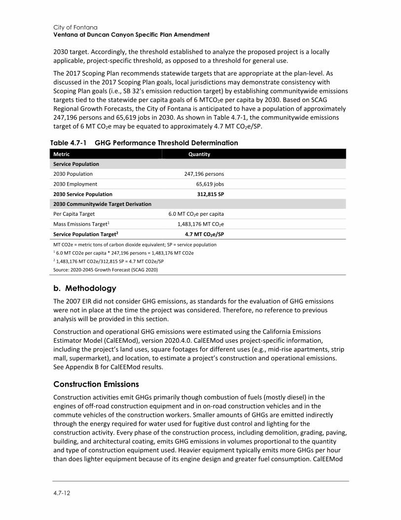
City of Fontana Ventana at Duncan Canyon Specific Plan Amendment
4.7-12
2030 target. Accordingly, the threshold established to analyze the proposed project is a locally applicable, project-specific threshold, as opposed to a threshold for general use.
The 2017 Scoping Plan recommends statewide targets that are appropriate at the plan-level. As discussed in the 2017 Scoping Plan goals, local jurisdictions may demonstrate consistency with Scoping Plan goals (i.e., SB 32’s emission reduction target) by establishing communitywide emissions targets tied to the statewide per capita goals of 6 MTCO2e per capita by 2030. Based on SCAG Regional Growth Forecasts, the City of Fontana is anticipated to have a population of approximately 247,196 persons and 65,619 jobs in 2030. As shown in Table 4.7-1, the communitywide emissions target of 6 MT CO2e may be equated to approximately 4.7 MT CO2e/SP.
Table 4.7-1 GHG Performance Threshold Determination Metric Quantity
Service Population
2030 Population 247,196 persons
2030 Employment 65,619 jobs
2030 Service Population 312,815 SP
2030 Communitywide Target Derivation
Per Capita Target 6.0 MT CO2e per capita
Mass Emissions Target1 1,483,176 MT CO2e
Service Population Target2 4.7 MT CO2e/SP
MT CO2e = metric tons of carbon dioxide equivalent; SP = service population 1 6.0 MT CO2e per capita * 247,196 persons = 1,483,176 MT CO2e 2 1,483,176 MT CO2e/312,815 SP = 4.7 MT CO2e/SP
Source: 2020-2045 Growth Forecast (SCAG 2020)
b. Methodology The 2007 EIR did not consider GHG emissions, as standards for the evaluation of GHG emissions were not in place at the time the project was considered. Therefore, no reference to previous analysis will be provided in this section.
Construction and operational GHG emissions were estimated using the California Emissions Estimator Model (CalEEMod), version 2020.4.0. CalEEMod uses project-specific information, including the project’s land uses, square footages for different uses (e.g., mid-rise apartments, strip mall, supermarket), and location, to estimate a project’s construction and operational emissions. See Appendix B for CalEEMod results.
Construction Emissions Construction activities emit GHGs primarily though combustion of fuels (mostly diesel) in the engines of off-road construction equipment and in on-road construction vehicles and in the commute vehicles of the construction workers. Smaller amounts of GHGs are emitted indirectly through the energy required for water used for fugitive dust control and lighting for the construction activity. Every phase of the construction process, including demolition, grading, paving, building, and architectural coating, emits GHG emissions in volumes proportional to the quantity and type of construction equipment used. Heavier equipment typically emits more GHGs per hour than does lighter equipment because of its engine design and greater fuel consumption. CalEEMod
Environmental Impact Analysis Greenhouse Gas
Draft Supplemental Environmental Impact Report 4.7-13
estimates construction emissions by multiplying the time equipment is in operation by emission factors.
Construction would generally consist of site preparation, grading, erection of the proposed buildings, paving, and architectural coating. Construction emissions were modeled in accordance with the methodology outlined in in Section 2, Air Quality. In accordance with the South Coast Air Quality Management District’s (SCAQMD’s) recommendation, GHG emissions from construction of the proposed project were amortized over a 30-year period and added to annual operational emissions to determine the project’s total annual GHG emissions (SCAQMD 2008).
Energy Emissions GHGs are emitted on-site during the combustion of natural gas for space and water heating and off-site during the generation of electricity from fossil fuels in power plants. CalEEMod estimates GHG emissions from energy use by multiplying average rates of residential and non-residential energy consumption by the quantities of residential units and non-residential square footage entered in the land use module to obtain total projected energy use. This value is then multiplied by electricity and natural gas GHG emission factors applicable to the project location and utility provider. Building energy use is typically divided into energy consumed by the built environment and energy consumed by uses that are independent of the building, such as plug-in appliances. Non-building energy use, or “plug-in energy use,” can be further subdivided by specific end-use (refrigeration, cooking, office equipment, etc.). In California, Title 24 governs energy consumed by the built environment, mechanical systems, and some types of fixed lighting.
The project would be served by Southern California Edison (SCE). Therefore, SCE’s specific energy intensity factors (i.e., the amount of CO2e per megawatt-hour) are used in the calculations of GHG emissions (California Air Pollution Control Officers Association [CAPCOA] 2021). Also, the CalEEMod version 2020.4.0 includes the building energy efficiency requirements stipulated under the 2019 Title 24 standards.
Area Source Emissions Area sources include GHG emissions that would occur from the use of landscaping equipment and fireplaces, which emit GHGs associated with fuel combustion. The landscaping equipment emission values were derived from the 2011 Off-Road Equipment Inventory Model (CAPCOA 2021). In accordance with SCAQMD Rule 445, no wood-burning devices would be installed.
Solid Waste Emissions The disposal of solid waste produces GHG emissions from the transportation of waste, anaerobic decomposition in landfills, and incineration. To calculate the GHG emissions generated by solid waste disposal, the total volume of solid waste was calculated using waste disposal rates identified by the CalRecycle. The methods for quantifying GHG emissions from solid waste are based on the IPCC method, using the degradable organic content of waste.
Water and Wastewater Emissions The amount of water used and the amount of wastewater generated by a project generate indirect GHG emissions. These emissions are a result of the energy used to supply, convey, and treat water and wastewater. In addition to the indirect GHG emissions associated with energy use, the wastewater treatment process itself can directly emit both methane and nitrous oxide.
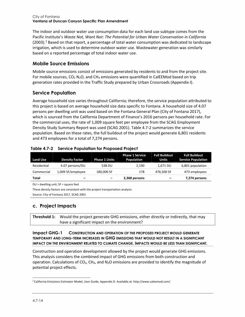
City of Fontana Ventana at Duncan Canyon Specific Plan Amendment
4.7-14
The indoor and outdoor water use consumption data for each land use subtype comes from the Pacific Institute’s Waste Not, Want Not: The Potential for Urban Water Conservation in California (2003).2 Based on that report, a percentage of total water consumption was dedicated to landscape irrigation, which is used to determine outdoor water use. Wastewater generation was similarly based on a reported percentage of total indoor water use.
Mobile Source Emissions Mobile source emissions consist of emissions generated by residents to and from the project site. For mobile sources, CO2 N2O, and CH4 emissions were quantified in CalEEMod based on trip generation rates provided in the Traffic Study prepared by Urban Crossroads (Appendix I).
Service Population Average household size varies throughout California; therefore, the service population attributed to this project is based on average household size data specific to Fontana. A household size of 4.07 persons per dwelling unit was used based on the Fontana General Plan (City of Fontana 2017), which is sourced from the California Department of Finance’s 2016 persons per household rate. For the commercial uses, the rate of 1,009 square feet per employee from the SCAG Employment Density Study Summary Report was used (SCAG 2001). Table 4.7-2 summarizes the service population. Based on these rates, the full buildout of the project would generate 6,801 residents and 473 employees for a total of 7,274 persons.
Table 4.7-2 Service Population for Proposed Project
Land Use Density Factor Phase 1 Units Phase 1 Service
Population Full Buildout
Units Full Buildout
Service Population
Residential 4.07 persons/DU 538 DU 2,190 1,671 DU 6,801 population
Commercial 1,009 SF/employee 180,000 SF 178 476,500 SF 473 employees
Total – − 2,368 persons – 7,274 persons
DU = dwelling unit; SF = square feet
These density factors are consistent with the project transportation analysis.
Source: City of Fontana 2017, SCAG 2001
c. Project Impacts
Threshold 1: Would the project generate GHG emissions, either directly or indirectly, that may have a significant impact on the environment?
Impact GHG-1 CONSTRUCTION AND OPERATION OF THE PROPOSED PROJECT WOULD GENERATE TEMPORARY AND LONG-TERM INCREASES IN GHG EMISSIONS THAT WOULD NOT RESULT IN A SIGNIFICANT IMPACT ON THE ENVIRONMENT RELATED TO CLIMATE CHANGE. IMPACTS WOULD BE LESS THAN SIGNIFICANT.
Construction and operation development allowed by the project would generate GHG emissions. This analysis considers the combined impact of GHG emissions from both construction and operation. Calculations of CO2, CH4, and N2O emissions are provided to identify the magnitude of potential project effects.
2 California Emissions Estimator Model, User Guide, Appendix D. Available at: http://www.caleemod.com/
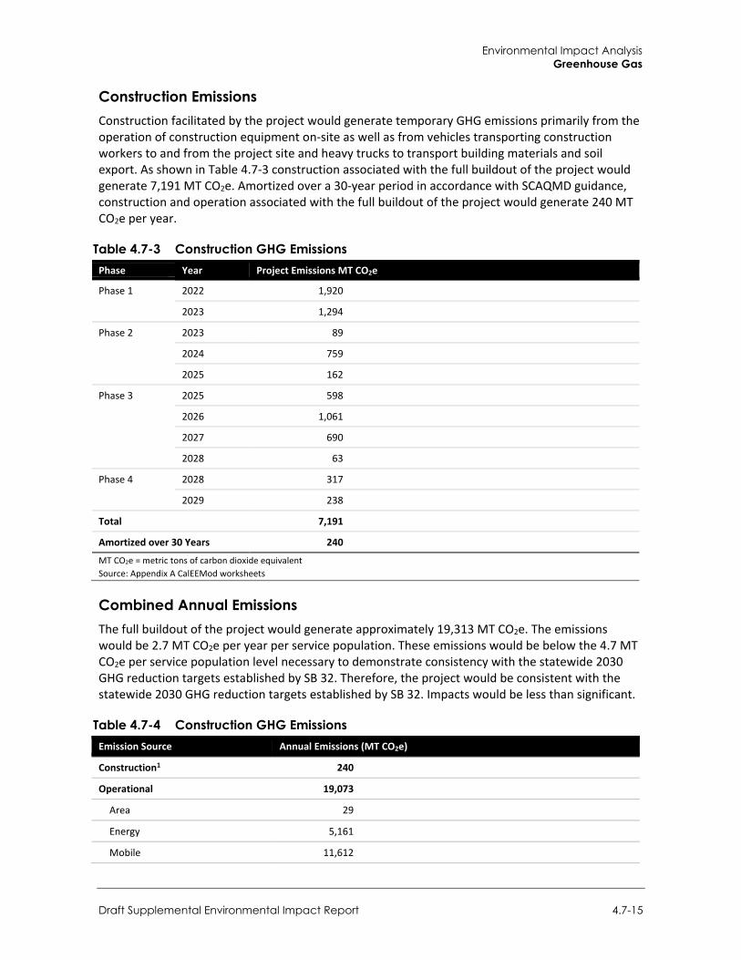
Environmental Impact Analysis Greenhouse Gas
Draft Supplemental Environmental Impact Report 4.7-15
Construction Emissions Construction facilitated by the project would generate temporary GHG emissions primarily from the operation of construction equipment on-site as well as from vehicles transporting construction workers to and from the project site and heavy trucks to transport building materials and soil export. As shown in Table 4.7-3 construction associated with the full buildout of the project would generate 7,191 MT CO2e. Amortized over a 30-year period in accordance with SCAQMD guidance, construction and operation associated with the full buildout of the project would generate 240 MT CO2e per year.
Table 4.7-3 Construction GHG Emissions Phase Year Project Emissions MT CO2e
Phase 1 2022 1,920
2023 1,294
Phase 2 2023 89
2024 759
2025 162
Phase 3 2025 598
2026 1,061
2027 690
2028 63
Phase 4 2028 317
2029 238
Total 7,191
Amortized over 30 Years 240
MT CO2e = metric tons of carbon dioxide equivalent Source: Appendix A CalEEMod worksheets
Combined Annual Emissions The full buildout of the project would generate approximately 19,313 MT CO2e. The emissions would be 2.7 MT CO2e per year per service population. These emissions would be below the 4.7 MT CO2e per service population level necessary to demonstrate consistency with the statewide 2030 GHG reduction targets established by SB 32. Therefore, the project would be consistent with the statewide 2030 GHG reduction targets established by SB 32. Impacts would be less than significant.
Table 4.7-4 Construction GHG Emissions Emission Source Annual Emissions (MT CO2e)
Construction1 240
Operational 19,073
Area 29
Energy 5,161
Mobile 11,612
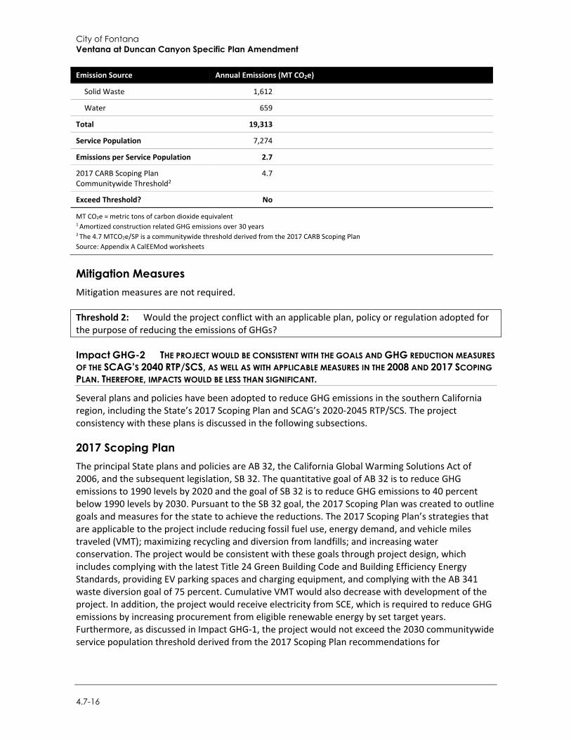
City of Fontana Ventana at Duncan Canyon Specific Plan Amendment
4.7-16
Emission Source Annual Emissions (MT CO2e)
Solid Waste 1,612
Water 659
Total 19,313
Service Population 7,274
Emissions per Service Population 2.7
2017 CARB Scoping Plan Communitywide Threshold2
4.7
Exceed Threshold? No
MT CO2e = metric tons of carbon dioxide equivalent 1 Amortized construction related GHG emissions over 30 years 2 The 4.7 MTCO2e/SP is a communitywide threshold derived from the 2017 CARB Scoping Plan Source: Appendix A CalEEMod worksheets
Mitigation Measures Mitigation measures are not required.
Threshold 2: Would the project conflict with an applicable plan, policy or regulation adopted for the purpose of reducing the emissions of GHGs?
Impact GHG-2 THE PROJECT WOULD BE CONSISTENT WITH THE GOALS AND GHG REDUCTION MEASURES OF THE SCAG’S 2040 RTP/SCS, AS WELL AS WITH APPLICABLE MEASURES IN THE 2008 AND 2017 SCOPING PLAN. THEREFORE, IMPACTS WOULD BE LESS THAN SIGNIFICANT.
Several plans and policies have been adopted to reduce GHG emissions in the southern California region, including the State’s 2017 Scoping Plan and SCAG’s 2020-2045 RTP/SCS. The project consistency with these plans is discussed in the following subsections.
2017 Scoping Plan The principal State plans and policies are AB 32, the California Global Warming Solutions Act of 2006, and the subsequent legislation, SB 32. The quantitative goal of AB 32 is to reduce GHG emissions to 1990 levels by 2020 and the goal of SB 32 is to reduce GHG emissions to 40 percent below 1990 levels by 2030. Pursuant to the SB 32 goal, the 2017 Scoping Plan was created to outline goals and measures for the state to achieve the reductions. The 2017 Scoping Plan’s strategies that are applicable to the project include reducing fossil fuel use, energy demand, and vehicle miles traveled (VMT); maximizing recycling and diversion from landfills; and increasing water conservation. The project would be consistent with these goals through project design, which includes complying with the latest Title 24 Green Building Code and Building Efficiency Energy Standards, providing EV parking spaces and charging equipment, and complying with the AB 341 waste diversion goal of 75 percent. Cumulative VMT would also decrease with development of the project. In addition, the project would receive electricity from SCE, which is required to reduce GHG emissions by increasing procurement from eligible renewable energy by set target years. Furthermore, as discussed in Impact GHG-1, the project would not exceed the 2030 communitywide service population threshold derived from the 2017 Scoping Plan recommendations for
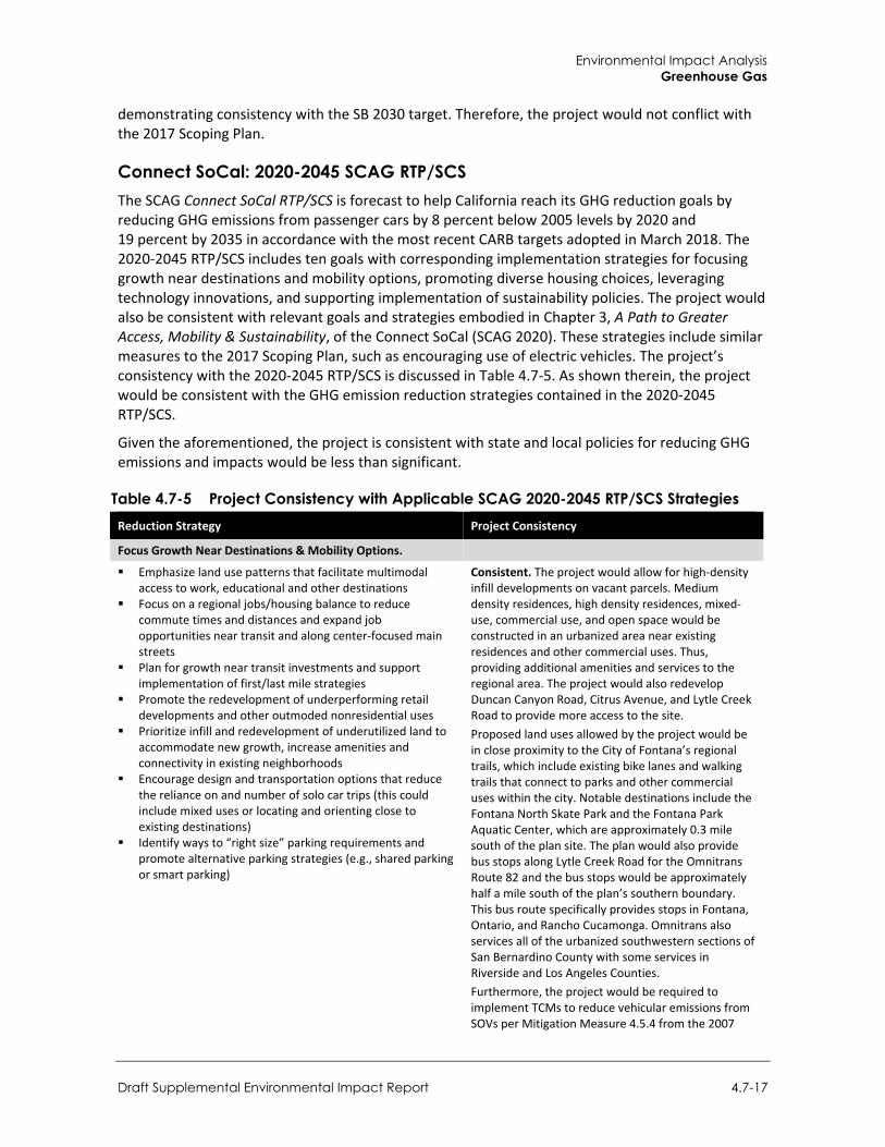
Environmental Impact Analysis Greenhouse Gas
Draft Supplemental Environmental Impact Report 4.7-17
demonstrating consistency with the SB 2030 target. Therefore, the project would not conflict with the 2017 Scoping Plan.
Connect SoCal: 2020-2045 SCAG RTP/SCS The SCAG Connect SoCal RTP/SCS is forecast to help California reach its GHG reduction goals by reducing GHG emissions from passenger cars by 8 percent below 2005 levels by 2020 and 19 percent by 2035 in accordance with the most recent CARB targets adopted in March 2018. The 2020-2045 RTP/SCS includes ten goals with corresponding implementation strategies for focusing growth near destinations and mobility options, promoting diverse housing choices, leveraging technology innovations, and supporting implementation of sustainability policies. The project would also be consistent with relevant goals and strategies embodied in Chapter 3, A Path to Greater Access, Mobility & Sustainability, of the Connect SoCal (SCAG 2020). These strategies include similar measures to the 2017 Scoping Plan, such as encouraging use of electric vehicles. The project’s consistency with the 2020-2045 RTP/SCS is discussed in Table 4.7-5. As shown therein, the project would be consistent with the GHG emission reduction strategies contained in the 2020-2045 RTP/SCS.
Given the aforementioned, the project is consistent with state and local policies for reducing GHG emissions and impacts would be less than significant.
Table 4.7-5 Project Consistency with Applicable SCAG 2020-2045 RTP/SCS Strategies Reduction Strategy Project Consistency
Focus Growth Near Destinations & Mobility Options.
Emphasize land use patterns that facilitate multimodal access to work, educational and other destinations
Focus on a regional jobs/housing balance to reduce commute times and distances and expand job opportunities near transit and along center-focused main streets
Plan for growth near transit investments and support implementation of first/last mile strategies
Promote the redevelopment of underperforming retail developments and other outmoded nonresidential uses
Prioritize infill and redevelopment of underutilized land to accommodate new growth, increase amenities and connectivity in existing neighborhoods
Encourage design and transportation options that reduce the reliance on and number of solo car trips (this could include mixed uses or locating and orienting close to existing destinations)
Identify ways to “right size” parking requirements and promote alternative parking strategies (e.g., shared parking or smart parking)
Consistent. The project would allow for high-density infill developments on vacant parcels. Medium density residences, high density residences, mixed-use, commercial use, and open space would be constructed in an urbanized area near existing residences and other commercial uses. Thus, providing additional amenities and services to the regional area. The project would also redevelop Duncan Canyon Road, Citrus Avenue, and Lytle Creek Road to provide more access to the site. Proposed land uses allowed by the project would be in close proximity to the City of Fontana’s regional trails, which include existing bike lanes and walking trails that connect to parks and other commercial uses within the city. Notable destinations include the Fontana North Skate Park and the Fontana Park Aquatic Center, which are approximately 0.3 mile south of the plan site. The plan would also provide bus stops along Lytle Creek Road for the Omnitrans Route 82 and the bus stops would be approximately half a mile south of the plan’s southern boundary. This bus route specifically provides stops in Fontana, Ontario, and Rancho Cucamonga. Omnitrans also services all of the urbanized southwestern sections of San Bernardino County with some services in Riverside and Los Angeles Counties. Furthermore, the project would be required to implement TCMs to reduce vehicular emissions from SOVs per Mitigation Measure 4.5.4 from the 2007
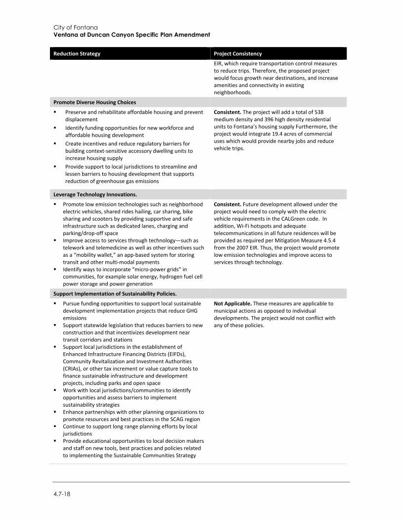
City of Fontana Ventana at Duncan Canyon Specific Plan Amendment
4.7-18
Reduction Strategy Project Consistency
EIR, which require transportation control measures to reduce trips. Therefore, the proposed project would focus growth near destinations, and increase amenities and connectivity in existing neighborhoods.
Promote Diverse Housing Choices
Preserve and rehabilitate affordable housing and prevent displacement
Identify funding opportunities for new workforce and affordable housing development
Create incentives and reduce regulatory barriers for building context-sensitive accessory dwelling units to increase housing supply
Provide support to local jurisdictions to streamline and lessen barriers to housing development that supports reduction of greenhouse gas emissions
Consistent. The project will add a total of 538 medium density and 396 high density residential units to Fontana’s housing supply Furthermore, the project would integrate 19.4 acres of commercial uses which would provide nearby jobs and reduce vehicle trips.
Leverage Technology Innovations.
Promote low emission technologies such as neighborhood electric vehicles, shared rides hailing, car sharing, bike sharing and scooters by providing supportive and safe infrastructure such as dedicated lanes, charging and parking/drop-off space
Improve access to services through technology—such as telework and telemedicine as well as other incentives such as a “mobility wallet,” an app-based system for storing transit and other multi-modal payments
Identify ways to incorporate “micro-power grids” in communities, for example solar energy, hydrogen fuel cell power storage and power generation
Consistent. Future development allowed under the project would need to comply with the electric vehicle requirements in the CALGreen code. In addition, Wi-Fi hotspots and adequate telecommunications in all future residences will be provided as required per Mitigation Measure 4.5.4 from the 2007 EIR. Thus, the project would promote low emission technologies and improve access to services through technology.
Support Implementation of Sustainability Policies.
Pursue funding opportunities to support local sustainable development implementation projects that reduce GHG emissions
Support statewide legislation that reduces barriers to new construction and that incentivizes development near transit corridors and stations
Support local jurisdictions in the establishment of Enhanced Infrastructure Financing Districts (EIFDs), Community Revitalization and Investment Authorities (CRIAs), or other tax increment or value capture tools to finance sustainable infrastructure and development projects, including parks and open space
Work with local jurisdictions/communities to identify opportunities and assess barriers to implement sustainability strategies
Enhance partnerships with other planning organizations to promote resources and best practices in the SCAG region
Continue to support long range planning efforts by local jurisdictions
Provide educational opportunities to local decision makers and staff on new tools, best practices and policies related to implementing the Sustainable Communities Strategy
Not Applicable. These measures are applicable to municipal actions as opposed to individual developments. The project would not conflict with any of these policies.
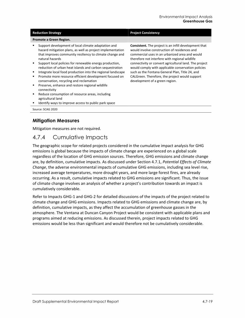
Environmental Impact Analysis Greenhouse Gas
Draft Supplemental Environmental Impact Report 4.7-19
Reduction Strategy Project Consistency
Promote a Green Region.
Support development of local climate adaptation and hazard mitigation plans, as well as project implementation that improves community resiliency to climate change and natural hazards
Support local policies for renewable energy production, reduction of urban heat islands and carbon sequestration
Integrate local food production into the regional landscape Promote more resource efficient development focused on
conservation, recycling and reclamation Preserve, enhance and restore regional wildlife
connectivity Reduce consumption of resource areas, including
agricultural land Identify ways to improve access to public park space
Consistent. The project is an infill development that would involve construction of residences and commercial uses in an urbanized area and would therefore not interfere with regional wildlife connectivity or convert agricultural land. The project would comply with applicable conservation policies such as the Fontana General Plan, Title 24, and CALGreen. Therefore, the project would support development of a green region.
Source: SCAG 2020
Mitigation Measures Mitigation measures are not required.
4.7.4 Cumulative Impacts The geographic scope for related projects considered in the cumulative impact analysis for GHG emissions is global because the impacts of climate change are experienced on a global scale regardless of the location of GHG emission sources. Therefore, GHG emissions and climate change are, by definition, cumulative impacts. As discussed under Section 4.7.1, Potential Effects of Climate Change, the adverse environmental impacts of cumulative GHG emissions, including sea level rise, increased average temperatures, more drought years, and more large forest fires, are already occurring. As a result, cumulative impacts related to GHG emissions are significant. Thus, the issue of climate change involves an analysis of whether a project’s contribution towards an impact is cumulatively considerable.
Refer to Impacts GHG-1 and GHG-2 for detailed discussions of the impacts of the project related to climate change and GHG emissions. Impacts related to GHG emissions and climate change are, by definition, cumulative impacts, as they affect the accumulation of greenhouse gasses in the atmosphere. The Ventana at Duncan Canyon Project would be consistent with applicable plans and programs aimed at reducing emissions. As discussed therein, project impacts related to GHG emissions would be less than significant and would therefore not be cumulatively considerable.

City of Fontana Ventana at Duncan Canyon Specific Plan Amendment
4.7-20
This page intentionally left blank.
Environmental Impact Analysis Hazards and Hazardous Materials
Draft Supplemental Environmental Impact Report 4.8-1
4.8 Hazards and Hazardous Materials
This section analyzes the project’s potential impacts associated with potential exposure to hazards and hazardous materials. This analysis contains a description of hazards and hazardous materials that may exist on site or impact the project; and addresses impacts related to hazardous materials use and transportation, the accidental release of hazardous materials, development on contaminated sites, air traffic hazards, and interference with emergency response and evacuation plans. Appropriate mitigation measures are identified to reduce, lessen, or eliminate the proposed project impacts. The analysis is supported by the Additional Hazardous Materials Review Letter prepared by Rincon Consultants, Inc. (2021), which is included as Appendix F.
4.8.1 Setting
a. Terminology
Hazardous Waste The United States Environmental Protection Agency (USEPA) defines a “hazardous waste” as a substance that: (1) may cause or significantly contribute to an increase in mortality or an increase in serious, irreversible, or incapacitating reversible illness, and (2) poses a substantial present or potential future hazard to human health or the environment when it is improperly treated, stored, transported, disposed of, or otherwise managed (40 Federal Code of Regulations (CFR) 261.10). Hazardous waste is also defined as ignitable, corrosive, explosive, or reactive and is identified by the USEPA by its form: solids, semi-solids, liquids, and gases. Producers of such wastes include private businesses and federal, State, and local government agencies. A material may also be classified as hazardous if it contains defined amounts of toxic chemicals. USEPA regulates the production and distribution of commercial and industrial chemicals to protect human health and the environment. USEPA also prepares and distributes information to inform the public about these chemicals and their effects, and provides guidance to manufacturers in pollution prevention measures, such as more efficient manufacturing processes and recycling used materials.
Hazard versus Risk Public health is potentially at risk whenever hazardous materials have been used or where there could be exposure to such materials. Ecological communities, such as avian and terrestrial habitats and the aquatic environment, may be at risk, depending on the type of populations and locations relative to potential exposure sources. Important to the setting and analyses presented in this section are the concepts of the “hazard” of these materials and the “risk” they pose to human health and the ecological environment.
Exposure to some chemical substances may harm internal organs or systems in the human body, ranging from temporary effects to permanent disability or death. Aquatic, terrestrial, or avian species may be similarly adversely affected. Hazardous materials that result in adverse effects are generally considered toxic. However, chemical materials may be corrosive or react with other substances to form other hazardous materials, but they are not considered toxic because organs or systems are not affected. Because toxic materials can result in adverse health effects, they are considered hazardous materials, but not all hazardous materials are necessarily toxic. For purposes of the information and analyses presented in this section, the terms hazardous substances and hazardous materials are used interchangeably and include materials that are considered toxic.
City of Fontana Ventana at Duncan Canyon Specific Plan Amendment
4.8-2
The risk to human health and the ecological environment is determined by the probability of exposure to a hazardous material and the severity of harm such exposure would pose. The likelihood and means of exposure, along with the inherent toxicity of a material, are used to determine the degree of risk to human health or the ecosystem. For example, a high probability of exposure to a low toxicity chemical would not necessarily pose an unacceptable human health or ecological risk, whereas a low probability of exposure to a very high toxicity chemical might. Various regulatory agencies, such as USEPA, California Environmental Protection Agency (CalEPA), State Water Resources Control Board, California Department of Toxic Substances Control (DTSC), and federal and State Occupational Safety and Health Administrations (OSHA) are responsible for developing and/or enforcing risk-based standards to protect the public and the environment.
b. Physical Setting The project site consists of approximately 105 acres of land located in the southwestern corner of San Bernardino County in the city of Fontana, California. The land is currently vacant and undeveloped. The surrounding properties consist of vacant land, some of which are in the process of being developed, as well as Interstate 15 (I-15) that runs along the west boundary of the project site. The project site is at an elevation of approximately 1,767 feet above mean sea level. The regional topographic gradient is flat in the east/west direction; there is a slight downward gradient from north to south. Based on the topography, surface water on the property infiltrates the ground surface or flows towards the southwest. Furthermore, the project site was historically used as vineyards and the 2007 EIR concluded that residual pesticides concentrations may be present in the soils onsite.
The Additional Hazardous Material Review identified the following recognized environmental conditions associated with the project site:
A 550-gallon gasoline underground storage tank (UST) was removed from the property in December 2006. Excavation bottom soil sample confirmation results were non-detect for TPH-g and VOCs. Based on the review of the closure report, the County Fire Department issued a no further investigation letter for the UST on January 3, 2007. Although the exact location of the UST is unknown, it may have been located in currently proposed Planning Area 2 or Planning Area 4. Although results of the confirmation soil sample were non-detect, there is the potential for residual concentrations of hydrocarbons to be present in the vicinity of the former gasoline UST.
The project area was historically used for agricultural purposes, which are commonly associated with the use of pesticides and arsenic. Shallow soil beneath the project area may be impacted by these chemicals.
The project site features numerous soil piles from an unknown origin, concrete/rubble debris, and trash scattered throughout the project area, indicating the area has been used an illegal dumping ground.
Soil in the project area adjacent to I-15 has the potential to be impacted by aerially deposited lead (ADL).
These conditions warrant further investigation and/or mitigation to address potential for exposure. Though the project site is currently vacant, construction of the proposed project could result in accidental conditions due to any of the following: direct dermal contact with hazardous materials; incidental ingestion of hazardous materials, or inhalation of airborne dust released from dried hazardous materials. Given the potential for residual concentrations of pesticides, arsenic,
Environmental Impact Analysis Hazards and Hazardous Materials
Draft Supplemental Environmental Impact Report 4.8-3
hydrocarbons, ADLs and other hazardous chemicals to be present on site, project construction has the potential to create a significant hazard to construction workers and/or the public and environment during routine activities such as excavation, soil transport, and off-site soil disposal.
Pesticides Historical agricultural activities have the potential for residual pesticides or arsenic associated with herbicide applications and may be present. Residual Agricultural Chemicals Diazinon, chlorpyrifos, and other “Group A” pesticides are insecticides used to control pests on crops as well as in individual home use. Diazinon is a nonsystemic organophosphate insecticide classified by USEPA as a Restricted Use Pesticide (RUP) and is for professional pest control operator use only. In 1988, USEPA canceled registration of diazinon for use on golf courses and sod farms because of die-offs of birds that often congregated in these areas. Diazinon is used to control cockroaches, silverfish, ants, and fleas in residential, non-food buildings. Diazinon bait is used to control scavenger yellow jackets in the western United States. It is used on home gardens and farms to control a wide variety of sucking and leaf-eating insects. It is also used on rice, fruit trees, sugarcane, corn, tobacco, potatoes, and on horticultural plants and used as an ingredient in pest strips. Diazinon may be found in formulations with a variety of other pesticides, including pyrethrins, lindane, and disulfoton. Birds are significantly more susceptible to diazinon poisoning than other wildlife, and it is highly toxic to fish and to bees.
Diazinon has a low persistence in soil. Diazinon seldom migrates below the top half inch in soil, but in some instances, it may contaminate groundwater. Diazinon is absorbed by plant roots when applied to the soil and translocated to other parts of the plant. Chlorpyrifos is a broad-spectrum organophosphate insecticide classified by USEPA as a General Use Pesticide. While originally used primarily to kill mosquitoes, it is no longer registered for this use. Chlorpyrifos is effective in controlling cutworms, corn rootworms, cockroaches, grubs, flea beetles, flies, termites, fire ants, and lice. It is used as an insecticide on grain, cotton, field, fruit, nut, and vegetable crops, as well as on lawns and ornamental plants. It is also registered for direct use on sheep and turkeys, for horse site treatment, dog kennels, domestic dwellings, farm buildings, storage bins, and commercial establishments. Chlorpyrifos acts on pests primarily as a contact poison, with some action as a stomach poison. Chlorpyrifos is moderately to very highly toxic to birds and highly toxic to freshwater fish, aquatic invertebrates, and estuarine and marine organisms. Due to its high acute toxicity and its persistence in sediments, chlorpyrifos may represent a hazard to smaller organisms. Aquatic and general agricultural uses of chlorpyrifos pose a serious hazard to wildlife and honeybees. Various agricultural operations that were once located within the project.
Lead and Asbestos There is potential for aerially deposited lead (ADL) in shallow soil adjacent to I-15. The project site does not contain any existing structures on the site and would not require demolition. Therefore, there are no potential hazards from lead-based paint or asbestos containing building materials on the project site.
Perfluorooctanoic Acid Perfluorooctanoic acid (PFOA) was detected at a concentration of 3.8 nanograms per liter (NG/L) in public drinking water well F-13A, B. This well is located roughly 2.75 miles southeast of the southeast corner of the project area along Citrus Avenue. The well is located south of the Mid-Valley Landfill, across State Route 210 (SR 210). The direction of groundwater flow reported at the Mid-
City of Fontana Ventana at Duncan Canyon Specific Plan Amendment
4.8-4
Valley Landfill for the October 2020-March 2021 semi-annual monitoring event was reported as to the southeast (away from the project area) and depth to groundwater was reported as 320.89 feet below top of casing to 513.14 feet below top of casing.
Landfills The Mid-Valley Landfill is located approximately 2.3 miles southeast of the site at the southeastern corner of Summit and Mango Avenues. Groundwater contamination associated with landfilling activities has been reported at the Mid-Valley Landfill. However, the project site is upgradient of the landfill and groundwater flow is toward the south. Thus, contamination at the landfill is not likely to migrate to the site.
Fire Hazard In California, State and local agencies share responsibility for wildfire prevention and suppression and federal agencies take part as well. Federal agencies are responsible for federal lands in Federal Responsibility Areas (FRA). The State of California has determined that some non-federal lands in unincorporated areas with watershed value are of statewide interest and have classified those lands as State Responsibility Areas (SRA). California Department of Forestry and Fire Protections (CAL FIRE) manages SRAs. All incorporated areas and unincorporated lands not in FRAs or SRAs are classified as Local Responsibility Areas (LRA).
While nearly all of California is subject to some degree of wildfire hazard, there are specific features that make certain areas more hazardous. CAL FIRE is required by law to map areas of significant fire hazards based on fuels, terrain, weather, and other relevant factors (Public Resources Code 4201-4204, California Government Code 51175-89). As described above, the primary factors that increase an area’s susceptibility to fire hazards include slope, vegetation type and condition, and atmospheric conditions. CAL FIRE maps fire hazards based on zones, referred to as Fire Hazard Severity Zones (FHSZ). There are three levels of severity: 1) Moderate FHSZs; 2) High FHSZs; and 3) Very High FHSZs (VHFHSZ). Each of the zones influence how people construct buildings and protect property to reduce risk associated with wildland fires. Under State regulations, areas within VHFHSZs must comply with specific building and vegetation management requirements intended to reduce property damage and loss of life in those areas.
The project site is not a designated VHFHSZ within an LRA or SRA; however, the project site is surrounded to the north, east, and west by lands that are within a VHFHSZ. Specifically, areas west of, and adjacent to Planning Areas 1, 2, and 3 (as identified under the proposed project) are within a VHFHSZ under an LRA. Furthermore, areas north of, and adjacent to Planning Areas 2, 4, and 5 (as identified under the proposed project) are within a VHFHSZ or Moderate FHSZ under an SRA (California Department of Forestry and Fire Protection [CAL FIRE] 2021). Figure 4.8-1 shows fire hazard zones in the project vicinity. Impacts associated with wildfire are further addressed in Section 4.16, Wildfire. Refer to Figure 2-4 in Section 2, Project Description, for a map showing the configuration and location of Planning Areas 1 through 6 within the Specific Plan area.
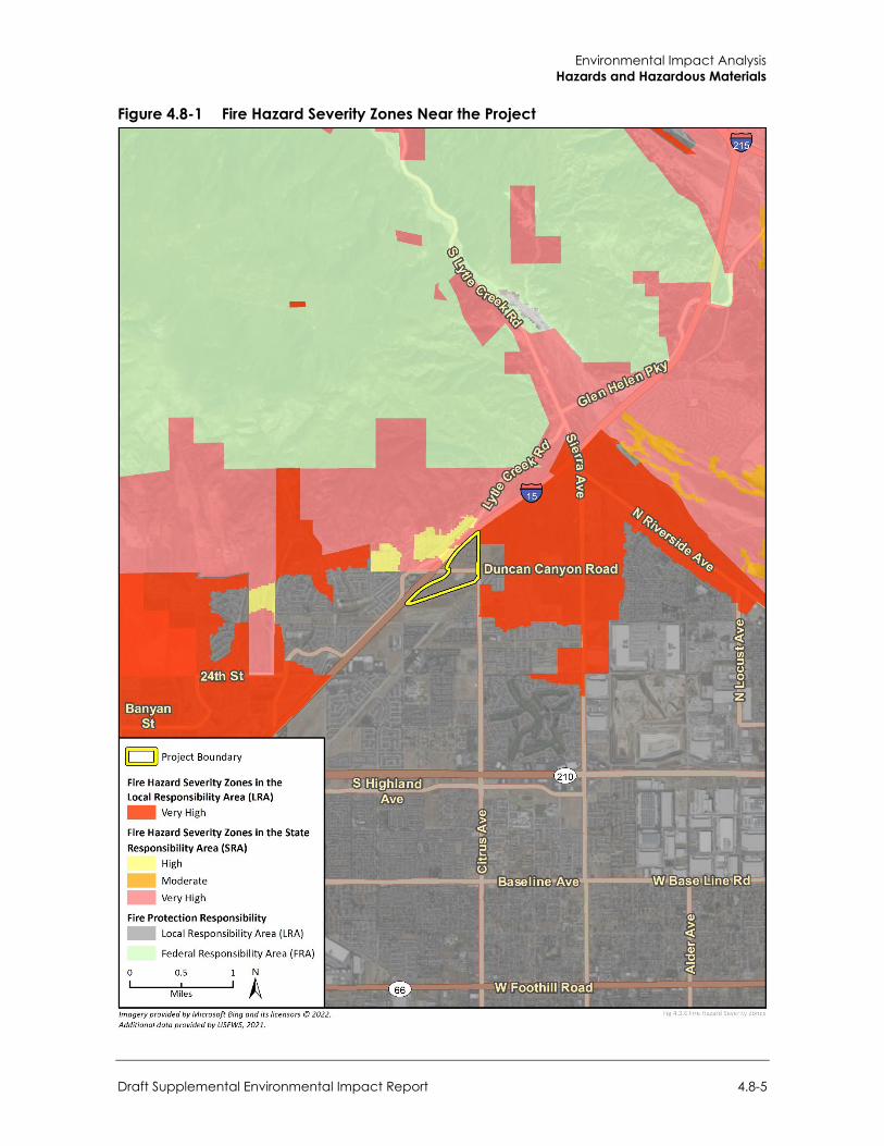
Environmental Impact Analysis Hazards and Hazardous Materials
Draft Supplemental Environmental Impact Report 4.8-5
Figure 4.8-1 Fire Hazard Severity Zones Near the Project
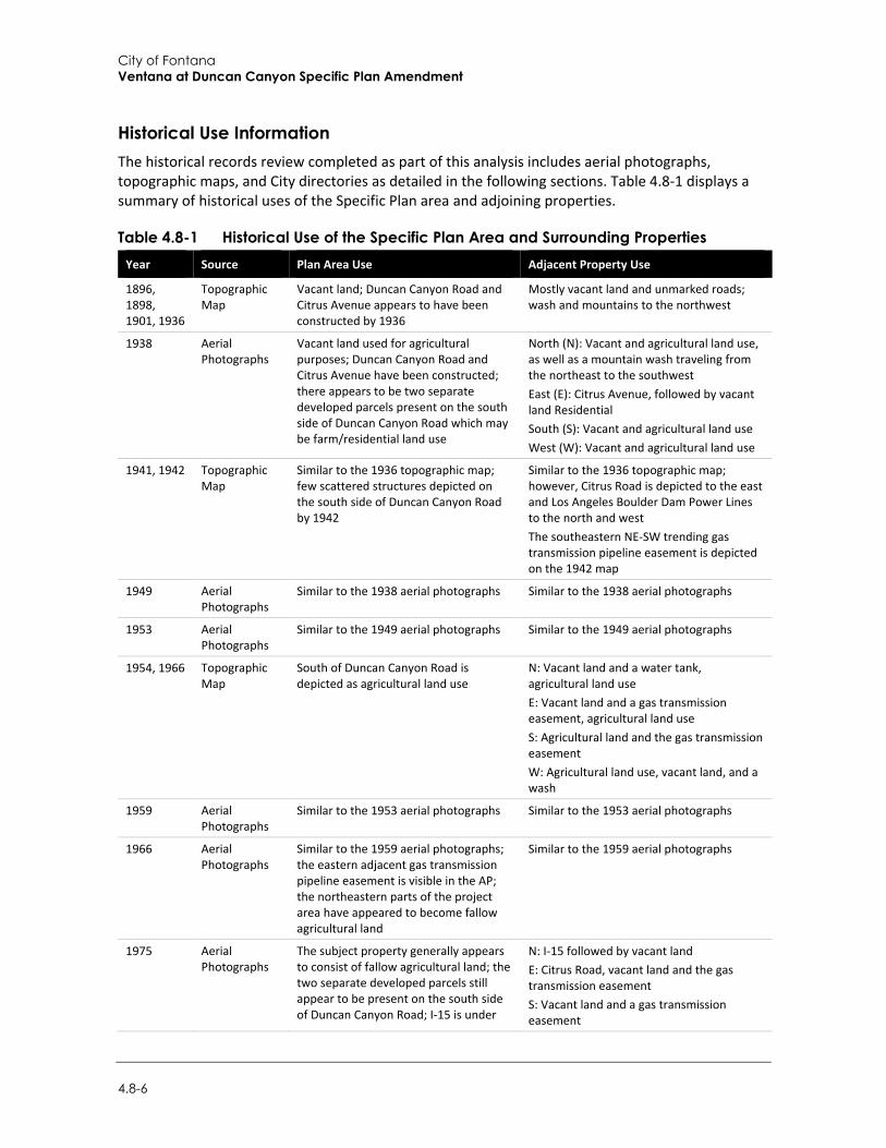
City of Fontana Ventana at Duncan Canyon Specific Plan Amendment
4.8-6
Historical Use Information The historical records review completed as part of this analysis includes aerial photographs, topographic maps, and City directories as detailed in the following sections. Table 4.8-1 displays a summary of historical uses of the Specific Plan area and adjoining properties.
Table 4.8-1 Historical Use of the Specific Plan Area and Surrounding Properties Year Source Plan Area Use Adjacent Property Use
1896, 1898, 1901, 1936
Topographic Map
Vacant land; Duncan Canyon Road and Citrus Avenue appears to have been constructed by 1936
Mostly vacant land and unmarked roads; wash and mountains to the northwest
1938 Aerial Photographs
Vacant land used for agricultural purposes; Duncan Canyon Road and Citrus Avenue have been constructed; there appears to be two separate developed parcels present on the south side of Duncan Canyon Road which may be farm/residential land use
North (N): Vacant and agricultural land use, as well as a mountain wash traveling from the northeast to the southwest East (E): Citrus Avenue, followed by vacant land Residential South (S): Vacant and agricultural land use West (W): Vacant and agricultural land use
1941, 1942 Topographic Map
Similar to the 1936 topographic map; few scattered structures depicted on the south side of Duncan Canyon Road by 1942
Similar to the 1936 topographic map; however, Citrus Road is depicted to the east and Los Angeles Boulder Dam Power Lines to the north and west The southeastern NE-SW trending gas transmission pipeline easement is depicted on the 1942 map
1949 Aerial Photographs
Similar to the 1938 aerial photographs Similar to the 1938 aerial photographs
1953 Aerial Photographs
Similar to the 1949 aerial photographs Similar to the 1949 aerial photographs
1954, 1966 Topographic Map
South of Duncan Canyon Road is depicted as agricultural land use
N: Vacant land and a water tank, agricultural land use E: Vacant land and a gas transmission easement, agricultural land use S: Agricultural land and the gas transmission easement W: Agricultural land use, vacant land, and a wash
1959 Aerial Photographs
Similar to the 1953 aerial photographs Similar to the 1953 aerial photographs
1966 Aerial Photographs
Similar to the 1959 aerial photographs; the eastern adjacent gas transmission pipeline easement is visible in the AP; the northeastern parts of the project area have appeared to become fallow agricultural land
Similar to the 1959 aerial photographs
1975 Aerial Photographs
The subject property generally appears to consist of fallow agricultural land; the two separate developed parcels still appear to be present on the south side of Duncan Canyon Road; I-15 is under
N: I-15 followed by vacant land E: Citrus Road, vacant land and the gas transmission easement S: Vacant land and a gas transmission easement
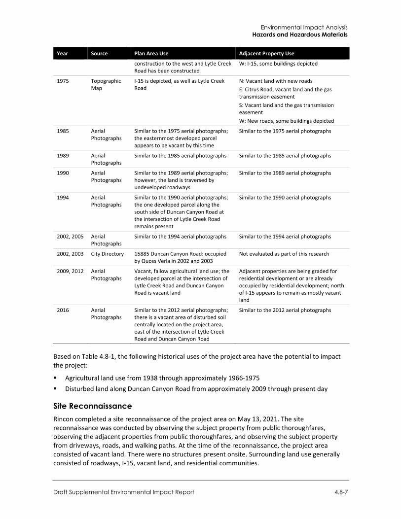
Environmental Impact Analysis Hazards and Hazardous Materials
Draft Supplemental Environmental Impact Report 4.8-7
Year Source Plan Area Use Adjacent Property Use
construction to the west and Lytle Creek Road has been constructed
W: I-15, some buildings depicted
1975 Topographic Map
I-15 is depicted, as well as Lytle Creek Road
N: Vacant land with new roads E: Citrus Road, vacant land and the gas transmission easement S: Vacant land and the gas transmission easement W: New roads, some buildings depicted
1985 Aerial Photographs
Similar to the 1975 aerial photographs; the easternmost developed parcel appears to be vacant by this time
Similar to the 1975 aerial photographs
1989 Aerial Photographs
Similar to the 1985 aerial photographs Similar to the 1985 aerial photographs
1990 Aerial Photographs
Similar to the 1989 aerial photographs; however, the land is traversed by undeveloped roadways
Similar to the 1989 aerial photographs
1994 Aerial Photographs
Similar to the 1990 aerial photographs; the one developed parcel along the south side of Duncan Canyon Road at the intersection of Lytle Creek Road remains present
Similar to the 1990 aerial photographs
2002, 2005 Aerial Photographs
Similar to the 1994 aerial photographs Similar to the 1994 aerial photographs
2002, 2003 City Directory 15885 Duncan Canyon Road: occupied by Quoss Verla in 2002 and 2003
Not evaluated as part of this research
2009, 2012 Aerial Photographs
Vacant, fallow agricultural land use; the developed parcel at the intersection of Lytle Creek Road and Duncan Canyon Road is vacant land
Adjacent properties are being graded for residential development or are already occupied by residential development; north of I-15 appears to remain as mostly vacant land
2016 Aerial Photographs
Similar to the 2012 aerial photographs; there is a vacant area of disturbed soil centrally located on the project area, east of the intersection of Lytle Creek Road and Duncan Canyon Road
Similar to the 2012 aerial photographs
Based on Table 4.8-1, the following historical uses of the project area have the potential to impact the project:
Agricultural land use from 1938 through approximately 1966-1975 Disturbed land along Duncan Canyon Road from approximately 2009 through present day
Site Reconnaissance Rincon completed a site reconnaissance of the project area on May 13, 2021. The site reconnaissance was conducted by observing the subject property from public thoroughfares, observing the adjacent properties from public thoroughfares, and observing the subject property from driveways, roads, and walking paths. At the time of the reconnaissance, the project area consisted of vacant land. There were no structures present onsite. Surrounding land use generally consisted of roadways, I-15, vacant land, and residential communities.
City of Fontana Ventana at Duncan Canyon Specific Plan Amendment
4.8-8
The use, storage, and disposal of hazardous materials was not observed during the site reconnaissance. No evidence of aboveground or underground storage tanks was observed. No odors, pools of liquid, industrial drums, or indications of polychlorinated biphenyls (PCBs) were noted. There were no drains, clarifiers, sumps, degreasers, or parts washers noted onsite. However, Rincon noted a significant amount of soil piles from an unknown origin, concrete/rubble debris, and trash scattered throughout the site.
4.8.2 Regulatory Setting
a. Federal Regulations
United States Environmental Protection Agency USEPA is the agency primarily responsible for enforcement and implementation of Federal laws and regulations pertaining to hazardous materials. Applicable federal regulations pertaining to hazardous materials are contained in the CFR Titles 29, 40, and 49. Hazardous materials, as listed in 49 CFR 172.101. The following laws govern the management of hazardous materials:
Resource Conservation and Recovery Act (RCRA) (42 UUSC 6901 et seq.) Comprehensive Environmental Response, Compensation, and Liability Act of 1980 (CERCLA)
(also called the Superfund Act) (42 USC 9601 et seq.), as amended by the Superfund Amendments and Reauthorization Act (1986)
Toxic Substances Control Act (15 USC 2601 et seq.)
These laws and associated regulations include specific requirements for facilities that generate, use, store, treat, and/or dispose of hazardous materials. USEPA provides oversight and supervision for Federal Superfund investigation/remediation projects, evaluates remediation technologies, and develops hazardous materials disposal restrictions and treatment standards.
Toxic Substances Control Act (1976) and the Resource Conservation and Recovery Act of 1976 These acts established a program administered by the USEPA for the regulation of the generation, transportation, treatment, storage, and disposal of hazardous waste. RCRA was amended in 1984 by the Hazardous and Solid Waste Act, which affirmed and extended the “cradle to grave” system of regulating hazardous wastes and waste generation. Among other things, the use of certain techniques for the disposal of some hazardous wastes was prohibited specifically by Hazardous and Solid Waste Act.
The Hazardous and Solid Waste Amendments of 1984 expanded the scope of RCRA and increased the level of detail in many of its provisions, reaffirming the regulation from generation to disposal and to prohibiting the use of certain techniques for hazardous waste disposal. The USEPA has largely delegated responsibility for implementing the RCRA program in California to the State, which implements this program through the California Hazardous Waste Control Law.
RCRA regulates landfill siting, design, operation, and closure for licensed landfills. In California, RCRA landfill requirements are delegated to the California Department of Resources Recycling and Recovery (CalRecycle).
Environmental Impact Analysis Hazards and Hazardous Materials
Draft Supplemental Environmental Impact Report 4.8-9
Comprehensive Environmental Response, Compensation and Liability Act This law provides broad federal authority to respond directly to releases or threatened releases of hazardous substances that may endanger public health or the environment. Among other things, CERCLA established requirements concerning closed and abandoned hazardous waste sites, provided for liability of persons responsible for releases of hazardous substances at these sites, and established a trust fund to provide for cleanup when no responsible party could be identified. CERCLA also enabled revision of the National Contingency Plan, which provided the guidelines and procedures needed to respond to releases and threatened releases of hazardous substances, pollutants, or contaminants. The National Contingency Plan also established the National Priorities List and in compliance with CERCLA.
U.S. Department of Transportation Hazardous Materials Transport Act (49 USC 5101)
The U.S. Department of Transportation, in conjunction with the USEPA, is responsible for enforcement and implementation of Federal laws and regulations pertaining to transportation of hazardous materials. The Hazardous Materials Transportation Act directs the U.S. Department of Transportation to establish criteria and regulations regarding the safe storage and transportation of hazardous materials. CFR 49, 171–180 and Title 13 California Code of Regulations (CCR), regulates the transportation of hazardous materials, types of material defined as hazardous, and the marking of vehicles transporting hazardous materials. It requires that every employee who transports hazardous materials receive training to recognize and identify hazardous materials and become familiar with hazard materials requirements. Carriers are required to report accidental releases of hazardous materials to the U.S. Department of Transportation at the earliest practical moment. Other incidents that must be reported include deaths, injuries requiring hospitalization, and property damage exceeding $50,000. The California Highway Patrol and California Department of Transportation (Caltrans) are the State agencies with primary responsibility for enforcing federal and State regulations related to transportation within California. These agencies respond to hazardous materials transportation emergencies. Together, these agencies determine container types to be used and grant licenses to hazardous waste haulers for hazardous waste transportation on public roads.
Per- and polyfluoroalkyl Substances Action Plan
In February 2019, the USEPA published the Per- and polyfluoroalkyl Substances (PFAS) Action Plan detailing the agency’s ongoing short-term and long-term regulatory actions pertaining to PFAS detection, research, and remediation. The PFAS Action Plan describes measures the USEPA is pursuing to address PFAS contamination at the federal level, including development of a federal maximum contaminant level under the Safe Drinking Water Act for PFOA and PFOS, creating groundwater cleanup recommendations for contaminated sites, and pursuing and supporting long-term research initiatives.1 The Action Plan further notes that the USEPA has initiated the regulatory process for listing PFOA and PFOS as hazardous substances under CERCLA and is exploring the possibility of developing PFAS ambient water quality criteria for human health under the Clean Water Act Section 304(a).
1 Perfluorooctane Sulfonate (PFOS) and Perfluorooctanoic Acid (PFOA) are part of the larger group of chemicals that comprise PFAS. USEPA. 2017. Technical Fact Sheet – PFOS and PFOA. [online]: https://www.epa.gov/sites/production/files/2017-12/documents/ffrrofactsheet_contaminants_pfos_pfoa_11-20-17_508_0.pdf. Accessed September 2021.
City of Fontana Ventana at Duncan Canyon Specific Plan Amendment
4.8-10
OSHA Worker Safety Requirements
The U.S. Department of Labor Occupational Safety & Health Administration (OSHA) is responsible at the federal level for ensuring worker safety. OSHA sets federal standards for implementation of workplace training, exposure limits, and safety procedures for the handling of hazardous substances (as well as other hazards). OSHA also establishes criteria by which each state can implement its own health and safety program.
b. State Regulations
Department of Toxic Substances Control As a department of the CalEPA, DTSC is the primary agency in California that regulates hazardous waste, oversees the cleanup of existing contamination, and identifies ways to reduce hazardous waste produced in California. DTSC regulates hazardous waste in California primarily under the authority of RCRA and the California Health and Safety Code.
DTSC also administers the California Hazardous Waste Control Law to regulate hazardous wastes. While the California Hazardous Waste Control Law is generally more stringent than RCRA, until the USEPA approves the California program, both State and federal laws apply in California. The California Hazardous Waste Control Law lists 791 chemicals and approximately 300 common materials that may be hazardous; establishes criteria for identifying, packaging, and labeling hazardous wastes; prescribes management controls; establishes permit requirements for treatment, storage, disposal, and transportation; and identifies some wastes that cannot be disposed of in landfills.
Government Code Section 65962.5 requires the DTSC, the State Department of Health Services, the State Water Resources Control Board (SWRCB), and CalRecycle to compile and annually update lists of hazardous waste sites and land designated as hazardous waste sites throughout the State; also referred to as the Cortese List. The Secretary for Environmental Protection consolidates the information submitted by these agencies and distributes it to each city and county where sites on the lists are located. Before the lead agency accepts an application for any development project as complete, the applicant must consult these lists to determine if the site at issue is included.
If any soil is excavated from a site containing hazardous materials, it would be considered a hazardous waste if it exceeded specific criteria identified by the DTSC in Title 22, Division 4.5 Section 66261.10. Remediation of hazardous wastes found at a site may be required if excavation of these materials is performed, or if certain other soil disturbing activities would occur. Even if soil or groundwater at a contaminated site does not have the characteristics required to be defined as hazardous waste, remediation of the site may be required by regulatory agencies subject to jurisdictional authority. Cleanup requirements are determined on a case-by-case basis by the agency taking jurisdiction.
Cal/Occupational Safety and Health Act The Occupational Safety and Health Act of 1970 (CCR Title 8) is implemented by the Cal/OSHA, which is responsible for ensuring worker safety in the handling and use of chemicals in the workplace. In California, Cal/OSHA has primary responsibility to develop and enforce workplace safety regulations concerning the use of hazardous materials in the workplace, including requirements for employee safety training, availability of safety equipment, accident and illness prevention programs, hazardous substance exposure warnings, and emergency action and fire
Environmental Impact Analysis Hazards and Hazardous Materials
Draft Supplemental Environmental Impact Report 4.8-11
prevention plan preparation. For example, under Title 8 CCR 5194 (Hazard Communication Standard), construction workers must be informed about hazardous substances that may be encountered. Compliance with Injury Illness Prevention Program requirements (Title 8 CCR 3203) would ensure that workers are properly trained to recognize workplace hazards and to take appropriate steps to reduce potential risks due to such hazards. This would be relevant if previously unidentified contamination or buried hazards are encountered. If additional investigation or remediation is determined to be necessary, compliance with Cal/OSHA standards for hazardous waste operations (Title 8 CCR 5192) would be required for those individuals involved in the investigation or cleanup work. A Site Health and Safety Plan must be prepared prior to commencing any work at a contaminated site or involving disturbance of building materials containing hazardous substances, to protect workers from exposure to potential hazards. Cal/OSHA also enforces hazard communication program regulations, including procedures for identifying and labeling hazardous substances. It requires Material Safety Data Sheets to be available for employee information and training programs.
California Emergency Services Act The California Emergency Services Act (Government Code Section 8550 et seq.) was adopted to establish the State’s roles and responsibilities during human-made or natural emergencies that result in conditions of disaster and/or extreme peril to life, property, or the resources of the State. This act is intended to protect health and safety by preserving the lives and property of the people of the State.
Assembly Bill 756 On July 31, 2019, California’s governor signed into law Assembly Bill (AB) 756, the State’s premier regulatory response to PFAS contamination. Effective January 1, 2020, AB 756 authorizes SWRCB to require monitoring and reporting of detectable PFAS levels in drinking water supplies. The law establishes tiers of PFAS notification and response, including publication of any detectable levels of PFAS in the public water system’s Consumer Confidence Report. A public water system detecting PFAS in excess of established notification levels—5.1 parts per trillion (ppt) for PFOA and 6.5 ppt for PFOS—must provide notification within 30 days to its governing body and, if applicable, the California Public Utilities Commission, pursuant to Section 116455 of the California Health and Safety Code. Public water systems detecting PFAS in excess of the 70-ppt response level must either remove the water source from use or comply with more stringent notification requirements, including notification to consumers via mail/direct delivery, e-mail, website, and newspaper notices (Aleshire & Wynder LLP 2019; SWRCB 2019).
In advance of AB 756 taking effect, the SWRCB announced updated PFAS detection and reporting guidelines for local water agencies in August 2019. Furthermore, the SWRCB announced that it had requested the Office of Environmental Health Hazard Assessment develop a public health goal for PFAS, an initial step toward establishing a regulatory maximum contaminant level for PFAS in drinking water.
City of Fontana Ventana at Duncan Canyon Specific Plan Amendment
4.8-12
c. Local Regulations
City of Fontana General Plan The Fontana General Plan Noise and Safety chapter contains citywide goals and policies to prevent the loss of life and property, and to minimize injuries and property damage in the event of hazards such as floods, fires, earthquakes, landslides, and other hazards.
Goal 1: Enhanced public safety and the protection of public and private property. Goal 2: Provide effective emergency response to natural or human-induced disasters that
minimizes the loss of life and damage to property, while also reducing disruptions in the delivery of vital public and private services during and following a disaster.
Goal 3: The City of Fontana is a community that implements proactive fire hazard abatement strategies, and as a result, is minimally impacted by wildland and urban fires.
Goal 6: The City shall continue to ensure to the fullest extent possible that, in the event of a major disaster, essential structures and facilities remain safe and functional as required by current law. Essential facilities include hospitals, police stations, fire stations, emergency operation centers, communication centers, generators and substations, and reservoirs.
City of Fontana Local Hazard Mitigation Plan The Local Hazard Mitigation Plan (LHMP) identifies the region’s hazards, reviews and assesses past disaster occurrences, estimates the probability of future occurrences and sets goals to mitigate potential risks to reduce or eliminate long-term risk to people and property from natural and man-made hazards. The LHMP, updated every five years and approved by FEMA, is comprised of participating federal, State and local jurisdictions agencies, special districts, school districts, non-profit communities, universities, businesses, tribes and general public (City of Fontana 2017).
4.8.3 Impact Analysis
a. Significance Thresholds Consistent with the CEQA Guidelines, and for purposes of this EIR, implementation of the project may result in or cause potentially significant hazards/hazardous materials impacts if it would:
Create a significant hazard to the public or the environment through reasonably foreseeable upset and accident conditions involving the likely release of hazardous materials into the environment;
Emit hazardous emissions or handle hazardous or acutely hazardous materials, substances, or waste within 0.25 mile of an existing or proposed school;
Impair implementation of or physically interfere with an adopted emergency response plan or emergency evacuation plan; or
Expose people or structures, either directly or indirectly, to a significant risk of loss, injury or death involving wildland fires.
Impacts related to hazards and hazardous materials were analyzed in the Initial Study (Appendix A-2). The Initial Study concluded that potential impacts associated with the routine transport, use, or disposal of hazardous materials during construction and operation would be less than significant. The project is not located on a site that is included on a list of hazardous material sites compiled
Environmental Impact Analysis Hazards and Hazardous Materials
Draft Supplemental Environmental Impact Report 4.8-13
pursuant to Government Code Section 65962.5 and, thus, would not create a significant hazard to the public or the environment. Additionally, the project is not located within an airport land use plan, and there are no public airports or private airstrips located within two miles of the project site; thus, the project would not result in a related safety hazard or exposure to excessive noise. Therefore, these impacts will not be further discussed in this section. Impacts associated with wildfire are further addressed in Section 4.16, Wildfire.
b. Methodology An Additional Hazardous Material Review assessed potential existing hazards on the project site. Based on the age of the available supporting documents (greater than 10 years), Rincon prepared the Additional Hazardous Material Review to provide updated hazardous materials and waste information with regards to current/recent property uses within the project area. The following tasks were undertaken as part of the Additional Hazardous Material Review (Rincon 2021):
Performed a reconnaissance of the project area to identify obvious indicators of the existence of hazardous materials.
Observed adjacent or nearby properties from public thoroughfares in an attempt to see if such properties are likely to use, store, generate, or dispose of hazardous materials.
Obtained and reviewed an environmental records database search to obtain information about the potential for hazardous materials to exist at the Specific Plan Area or at properties located in the vicinity of the project area.
Reviewed files for the project area and immediately adjacent properties as identified in the database report, as applicable.
Reviewed the current United States Geological Survey (USGS) topographic map to obtain information about the project area and regional topography and uses of the project area and surrounding sites.
Reviewed additional pertinent record sources (e.g., California Geologic Energy Management Division [CalGEM] records, online databases of hazardous substance release sites), as necessary, to identify the presence of environmental concerns.
Reviewed the California State Water Resources Control Board (SWRCB) 2019 Statewide Per- and Polyfluoroalkyl Substances (PFAS) Investigation online Public Map Viewer regarding current PFAS orders at any facilities located in the vicinity of the project area.
Reviewed reasonably ascertainable historical resources (e.g., aerial photographs, topographic maps, fire insurance maps, city directories) to assess the historical land use of the project area and adjacent properties.
c. Standard Conditions The following standard conditions related to hazards and hazardous materials, and identified in the 2007 EIR, remain applicable to the proposed project:
Standard Condition 4.15.1: Construction activities and commercial developments that utilize hazardous materials shall comply with applicable regulations regarding hazardous materials use, handling, storage, transport, and disposal.
Standard Condition 4.15.2: Reconstruction of Lytle Creek Road across the SCE right-of-way shall comply with SCE guidelines for structures and improvements near power transmission lines and towers.
City of Fontana Ventana at Duncan Canyon Specific Plan Amendment
4.8-14
Standard Condition 4.15.3: Work within the I-15 Freeway right-of-way or near the utility boxes by the freeway shall comply with the conditions outlined in the encroachment permit from the California Department of Transportation (Caltrans).
Standard Condition 4.15.4: If unusual soil staining and/or odors are encountered during grading and excavation activities, future assessment of the soils shall be conducted prior to the continuation of grading or excavation activities. If the results of the soil testing show the presence of chemical below regulatory levels, grading or excavation may proceed accordingly. Remediation and/or removal of contaminated soils shall be made prior to development, if chemical levels are above regulatory standards. Remediation shall be made in coordination with the local health department, SCAQMD, the California Department of Toxic Substances Control, the U. S. Environmental Protection Agency or other regulatory agencies and in compliance with established maximum contaminant levels.
d. Project Impacts
Threshold 1: Would the project create a significant hazard to the public or the environment through reasonably foreseeable upset and accident conditions involving the release of hazardous materials into the environment?
Impact HAZ-1 PROJECT CONSTRUCTION WOULD POTENTIALLY CREATE A SIGNIFICANT HAZARD TO THE PUBLIC OR THE ENVIRONMENT THROUGH REASONABLY FORESEEABLE UPSET AND ACCIDENT CONDITIONS INVOLVING THE LIKELY RELEASE OF HAZARDOUS MATERIALS INTO THE ENVIRONMENT. PROJECT OPERATION WOULD NOT CREATE A SIGNIFICANT HAZARD TO THE PUBLIC OR THE ENVIRONMENT. IMPACTS WOULD BE LESS THAN SIGNIFICANT WITH MITIGATION INCORPORATED.
The previous 2007 EIR determined that construction activities associated with the development of the project site would involve the use of hazardous materials for construction. With implementation of the standard conditions and mitigation measures, impacts related to hazardous materials would be reduced to less than significant levels.
Construction-Related Impacts The project site generally consists of undeveloped, vacant land and has undergone changes in uses, including an onsite structure demolition and removal, conducted between October 2007 and June 2009, and use as a soil/materials storage and construction staging area in June 2009. Improvement to the adjacent Duncan Canyon Road traffic interchange was constructed in 2016.
The transportation of hazardous materials on area roadways is regulated by the California Highway Patrol (CHP), U.S. Department of Transportation (Hazardous Materials Transportation Act) and Caltrans, and use of these materials is regulated by the DTSC (22 Cal. Code Regs. Section 66001, et seq.). The use, storage, and transport of hazardous materials by developers, contractors, business owners, and others are required to be in compliance with local, State, and federal regulations during project construction and operation. Facilities that use hazardous materials are required to obtain permits and comply with appropriate regulatory agency standards designed to avoid hazardous waste releases. All existing and future projects on the project site would be required to comply with federal, State, and local regulations regarding the handling, transportation, disposal, and cleanup of hazardous materials.
In addition, the standard conditions as referenced above from the 2007 EIR would also apply to prevent public health and safety hazards associated with the use of hazardous materials by future
Environmental Impact Analysis Hazards and Hazardous Materials
Draft Supplemental Environmental Impact Report 4.8-15
developments on the site. Therefore, impacts associated with worker exposure and environmental release of pesticides, arsenic, hydrocarbons, ADLs or other hazardous chemicals would be potentially significant.
Operation-Related Impacts Implementation of the project with the proposed residential and non-residential uses would involve the storage, use, and transport of hazardous materials (e.g., gasoline fuels, demolition materials, asphalt, lubricants, toxic solvents, pesticides, and herbicides) during construction, demolition, and landscaping activities. In addition, certain commercial uses, including swimming pool facilities, gas stations, and dry cleaners that store, use, and routinely transport hazardous material to and from their facilities, could pose a potential hazard to the environment. Electrical transformers and industrial products containing polychlorinated biphenyls and heavy metals, as well as persistent residual chemicals including pesticides, herbicides, and fertilizers have the potential to pose a health and safety risk via accidental release, misuse, or historic use at the project site.
There is a northeast-southwest trending Southern California Gas Company active natural gas transmission line adjacent to the southeast of the project area. The gas line is associated with a waste description of benzene since benzene can leak from underground storage tanks or other hazardous waste; however, details regarding the waste description listing were not provided by Environmental Database Resources. At its closest location to the project area, the gas transmission line runs adjacent to the southeast and south of the intersection of Citrus Avenue and Duncan Canyon Road. Based on the proximity of the natural gas pipeline to project area, if there was an incident or gas release, impacts could potentially affect the project area, more specifically, Planning Area 2. The 2007 EIR determined that roadway improvements of Citrus Avenue along the eastern edge of the site would not occur over the gas line right-of-way and would not adversely affect the adjacent high-pressure gas lines or the nearby pumping facility (City of Fontana 2007).
Generally, maintenance and upkeep of any onsite facility, including cleaning of workspaces, parking areas, restroom facilities and maintenance of landscaping occasionally require the use of various solvents, cleaners, paints, oils/fuels, and pesticides/herbicides. Transport, use, and storage of hazardous materials during the construction and operation of the site would be conducted pursuant to all applicable local, State, and federal laws.
Adherence to Fontana and San Bernardino County Department of Environmental Health plans and regulations would reduce the potential for contamination from hazardous materials through proper cleanup, disposal, and remediation. The San Bernardino County Office of the Fire Marshall regulates and enforces the provisions of the Uniform Fire Code relating to hazardous materials, including the use and storage of hazardous materials that are ignitable, reactive, corrosive, or toxic. Businesses using such materials are subject to permitting and inspection. Potential hazardous materials, such as fuel, paint products, lubricants, solvents, and cleaning products, may be used and/or stored on-site during the construction of the proposed project. However, due to the limited quantities of these materials to be used by the project, they are not considered hazardous to the public at large (Rincon 2021). Though the previous 2007 EIR did not analyze operation-related impacts, however, the EIR does require project compliance with standard conditions that reduce potential risk related to hazardous materials. Compliance with relevant federal, State, and local regulations by future commercial uses on the site would preclude the creation of hazards to on-site users and adjacent areas (City of Fontana 2007). Therefore, impacts due to reasonably foreseeable upset and accident conditions during operation of the project would be less than significant.
City of Fontana Ventana at Duncan Canyon Specific Plan Amendment
4.8-16
Mitigation Measures The 2007 EIR includes mitigation measures to remove and dispose of asbestos-containing material associated with former structures onsite. However, the relevant structures have been removed, and there are no existing structures on the project site. Therefore, these mitigation measures are no longer applicable. The 2007 EIR included mitigation measure to address contaminated soil. The original mitigation measure has been replaced with Mitigation Measure HAZ-1A and is considered functionally equivalent. Mitigation Measure HAZ-1A, HAZ-1B and HAZ-1C would safeguard construction workers from residual pesticides, arsenic, ADLs, or other hazardous chemicals found on the project site.
HAZ-1A Soil Sampling – Phase II ESA
Prior to the start of construction (demolition or grading), the project applicant will retain a qualified environmental consultant, California Professional Geologist (PG) or California Professional Engineer (PE), to prepare a Phase II ESA of the project site that will be developed, to determine whether the soil has been impacted at concentrations exceeding regulatory screening levels for residential/commercial land uses. The Phase II ESA will be completed prior to construction and will be focused on the former agricultural use of the property (all Planning Areas), potential presence of aerially deposited lead (Planning Areas 3, 4, 5b, and 6), and the onsite presence of undocumented soil piles/trash (Planning Areas 4 and 6).
As part of the Phase II ESA, the qualified environmental consultant will screen the analytical results against the San Francisco Regional Water Quality Control Board environmental screening levels (ESL). These ESLs are risk-based screening levels for direct exposure of a construction worker under various depth and land use scenarios. The lead agency will review and approve the Phase II ESA prior to demolition and grading (construction).
If the Phase II ESA for the development site indicates that contaminants are detected in the subsurface at the project site, the project applicant will take appropriate steps to protect site workers and the public. This may include the preparation of a Soil Management Plan for Impacted Soils (see Mitigation Measure HAZ-1B) prior to project construction.
If the Phase II ESA for the contaminant site indicates that contaminants are present at concentrations exceeding hazardous waste screening thresholds for contaminants in soil and/or groundwater (California Code of Regulations [CCR] Title 22, Section 66261.24 Characteristics of Toxicity), the project applicant will take appropriate steps to protect site workers and the public. This may include the completion of remediation (see Mitigation Measure HAZ-1C) at the proposed project prior to onsite construction.
HAZ-1B Soil Management Plan for Impacted Soils
If impacted soils or other impacted wastes are present at the project site, the project applicant will retain a qualified environmental consultant (PG or PE), to prepare a Soil Management Plan (SMP) prior to construction. The SMP, or equivalent document, will be prepared to address onsite handling and management of impacted soils or other impacted wastes, and reduce hazards to construction workers and offsite receptors during construction. The plan must establish remedial measures and/or soil management practices to ensure construction worker safety, the health of future workers and visitors, and the off-site migration of contaminants from the site. These measures and practices may include, but are not limited to:
Stockpile management including stormwater pollution prevention and the installation of BMPs

Environmental Impact Analysis Hazards and Hazardous Materials
Draft Supplemental Environmental Impact Report 4.8-17
Proper disposal procedures of contaminated materials Monitoring and reporting A health and safety plan for contractors working at the site that addresses the safety and health
hazards of each phase of site construction activities with the requirements and procedures for employee protection
The health and safety plan will also outline proper soil handling procedures and health and safety requirements to minimize worker and public exposure to hazardous materials during construction.
The lead agency will review and approve the development site Soil Management Plan for Impacted Soils prior to demolition and grading (construction).
HAZ-1C Remediation
If soil present within the construction envelope at the development site contains chemicals at concentrations exceeding hazardous waste screening thresholds for contaminants in soil (California Code of Regulations [CCR] Title 22, Section 66261.24), the project applicant will retain a qualified environmental consultant (PG or PE), to conduct additional analytical testing and recommend soil disposal recommendations, or consider other remedial engineering controls, as necessary.
The qualified environmental consultant will utilize the development site analytical results for waste characterization purposes prior to offsite transportation or disposal of potentially impacted soils or other impacted wastes. The qualified environmental consultant will provide disposal recommendations and arrange for proper disposal of the waste soils or other impacted wastes (as necessary), and/or provide recommendations for remedial engineering controls, if appropriate.
The project applicant will review and approve the disposal recommendations prior to transportation of waste soils offsite, and review and approve remedial engineering controls, prior to construction.
Remediation of impacted soils and/or implementation of remedial engineering controls, may require additional delineation of impacts; additional analytical testing per landfill or recycling facility requirements; soil excavation; and offsite disposal or recycling.
The lead agency will review and approve the development site disposal recommendations prior to transportation of waste soils offsite and review and approve remedial engineering controls, prior to construction.
Significance After Mitigation Mitigation Measure HAZ-1A requires a soil investigation for agricultural residue (pesticides, arsenic, etc.). Mitigation Measures HAZ-1B and HAZ-1C would reduce impacts associated with on-site hazards by implementing an SMP to reduce exposure to impacted soil, and would require proper assessment and disposal of trash and soil piles. Impacts would be less than significant with the implementation of mitigation.
City of Fontana Ventana at Duncan Canyon Specific Plan Amendment
4.8-18
Threshold 2: Would the project emit hazardous emissions or handle hazardous or acutely hazardous materials, substances, or waste within 0.25 mile of an existing or proposed school?
Impact HAZ-2 THE PROJECT WOULD NOT EMIT HAZARDOUS EMISSIONS OR HANDLE HAZARDOUS OR ACUTELY HAZARDOUS MATERIALS, SUBSTANCES, OR WASTE WITHIN ONE-QUARTER MILE OF AN EXISTING OR PROPOSED SCHOOL. NONETHELESS, MITIGATION WOULD ENSURE THAT CONTAMINATED SOILS PRESENT ON THE PROJECT SITE ARE INVESTIGATED, REMEDIATED, AND HANDLED ACCORDING TO APPLICABLE STATE AND FEDERAL REQUIREMENTS. IMPACTS WOULD BE LESS THAN SIGNIFICANT WITH MITIGATION.
There is one school located in close proximity to the project site, Falcon Ridge Elementary School, which is located approximately 0.25 mile to the south of the site. Children are particularly susceptible to long-term effects from exposure to hazardous materials. Locations where children spend extended periods of time, such as schools, are considered sensitive to hazardous air emissions and accidental release associated with the handling of extremely hazardous materials, substances, or wastes.
Construction-Related Impacts The 2007 EIR determined that construction activities associated with the development under the existing Specific Plan would involve the use of hazardous materials for construction. However, compliance with relevant federal, state, and local regulations, including standard conditions, on the project site would preclude the creation of hazards to on-site users and adjacent areas and reduce impacts to a less than significant level (City of Fontana 2007).
As described under Impact HAZ-1, the project site generally consists of undeveloped, vacant land. The site has been previously developed with agricultural and residential structures, but subsequently cleared and disturbed. The land uses in the general vicinity consist of vacant and residential land use, as well as freeway (I-15) and a school. Adjacent properties are occupied by single-family residential homes, a park, and residential construction. Project construction would involve the removal and transport of potentially contaminated soils during grading and excavation activities. Project construction has the potential to expose students to hazardous construction wastes if contaminated soils are improperly handled and transported along routes nearby Falcon Ridge Elementary School. This has the potential for significant impacts on nearby residents, students and staff.
However, implementation of Mitigation Measures HAZ-1A and HAZ-1B would ensure that contaminated soils present on the project site are investigated, remediated, and handled according to applicable State and federal requirements. Therefore, project construction would result in less than significant impacts with mitigation.
Operation-Related Impacts As discussed under Impact HAZ-1, project operation would include residential and commercial uses, which would not involve the use or storage of significant quantities of hazardous materials. The occasional use or disposal of hazardous materials generally associated with these types of uses include unused paint, aerosol cans, cleaning agents (solvents), landscaping-related chemicals, and other common cleaning products and household substances. These materials are generally disposed of at non-hazardous Class II and III landfills (along with municipal solid waste). The 2007 EIR does require project compliance with standard conditions, as discussed under Impact HAZ-1, that reduce potential risks associated with hazardous materials. Compliance with the procedures and guidelines
Environmental Impact Analysis Hazards and Hazardous Materials
Draft Supplemental Environmental Impact Report 4.8-19
described in Section 4.8.2, Regulatory Setting, regarding the handling of such materials throughout project operation would ensure that operation of the project would not create a significant hazard to Falcon Ridge Elementary School. Therefore, with compliance with existing regulations, project operational impacts would be less than significant.
Mitigation Measures Mitigation Measures HAZ-1A and HAZ-1B.
Significance After Mitigation Impacts would be less than significant with mitigation.
Threshold 3: Would the project impair implementation of or physically interfere with an adopted emergency response plan or emergency evacuation plan?
Impact HAZ-3 THE PROJECT WOULD NOT INTERFERE WITH VEHICULAR CIRCULATION ROUTES OR THE ABILITY OF EMERGENCY RESPONSE SERVICES. THEREFORE, IT WOULD NOT IMPAIR IMPLEMENTATION OF OR PHYSICALLY INTERFERE WITH AN ADOPTED EMERGENCY RESPONSE PLAN OR EMERGENCY EVACUATION PLAN. IMPACTS WOULD BE LESS THAN SIGNIFICANT.
The 2007 EIR determined that the project site is not used for emergency evacuation, and that development on the project site would not affect evacuation along the surrounding streets including I-15, Duncan Canyon Road, Citrus Avenue and Lytle Creek Road (City of Fontana 2007). Furthermore, development under the existing Specific Plan would be required to comply with applicable City codes and regulations pertaining to emergency response and evacuation plans maintained by the City police and fire departments. The project would not interfere with the implementation of the City’s emergency management plans from the City’s General Plan Safety and Noise Element. Ultimately, the development of the newly aligned Lytle Creek Road would improve connectivity and emergency access for the area. Therefore, the 2007 EIR determined that impacts related to adopted emergency response plans would be less than significant.
An efficient roadway and circulation system is vital for the evacuation of residents and the mobility of fire suppression, emergency response, and law enforcement vehicles. The project includes the construction of commercial and residential land uses and the realigned Lytle Creek Road. The resulting changes in land use patterns could increase the potential for conflicts with existing emergency response or emergency evacuation plans by making implementation of emergency response activities more difficult. This increased difficulty would place more people at risk of serious injury or death and property at greater risk of serious damage. Construction and operation of the project would increase traffic around the project site and vicinity. However, project construction and operational activities would not result in any street closures that could impede emergency access or evacuation.
However, Goal 6 of the General Plan’s Noise and Safety Element provides that the city of Fontana shall ensure that sufficient resources are available to expand emergency protection and safety services as the community grows. As discussed in Section 4.13, Public Services, both San Bernardino County Fire Department (SBCFD) and Fontana Police Department (FPD) would be able to service the project at existing staffing levels. Further, temporary impacts to traffic and access during project construction would be addressed through the implementation of the project Construction Traffic Management Plan, which would include coordination with emergency service providers. Development of the project would not interfere with the city of Fontana’s LHMP, nor cause
City of Fontana Ventana at Duncan Canyon Specific Plan Amendment
4.8-20
permanent alteration to vehicle circulation routes, as discussed in Section 4.14, Transportation. Section 17 of the Initial Study, Transportation, concludes that the project would comply with City of Fontana roads standards and would not include any design features that would increase circulation hazards. The development would not result in roadway uses that would be incompatible with the existing land uses surrounding the project site, which consist of residential and commercial uses. Therefore, impacts related to hazards associated with design features, emergency access, or incompatible uses would be less than significant.
Further, the project does not propose or require facilities or operations that would interfere with any identified emergency response or emergency evacuation plan. In accordance with City policies, coordination with the local fire and police departments during construction would ensure that potential interference with emergency response and evacuation efforts are avoided. Therefore, the potential for the project to impair implementation of, or physically interfere with, an adopted emergency response plan or emergency evacuation plan would be less than significant.
Mitigation Measures Mitigation measures are not required.
Threshold 4: Would the project expose people or structures, either directly or indirectly, to a significant risk of loss, injury, or death involving wildland fires?
Impact HAZ-4 THE PROJECT WOULD COMPLY WITH THE CALIFORNIA BUILDING CODE AND CALIFORNIA FIRE CODE AND WOULD UNDERGO PROCEDURAL REVIEW BY THE CITY OF FONTANA AND FONTANA FIRE PROTECTION DISTRICT. THE PROJECT WOULD NOT EXPOSE PEOPLE OR STRUCTURES TO A SIGNIFICANT RISK OF LOSS, INJURY, OR DEATH INVOLVING WILDLAND FIRES AND IMPACTS WOULD BE LESS THAN SIGNIFICANT.
The 2007 EIR determined that development under the existing Specific Plan would reduce the potential for brush fires on the project site (City of Fontana 2007). Pre-construction coordination and adherence to local fire regulations during construction and operation of the project would be required, acting to reduce potential fire hazards. The existing Specific Plan does not include facilities or operations that would exacerbate or contribute substantively to any existing fire hazards. Therefore, the 2007 EIR determined that impacts would be less than significant.
The City’s Local Hazard Mitigation Plan (LMHP) states that the potential for large and damaging fires to the city of Fontana is present throughout much of the year, specifically during summer and autumn months when the Santa Ana winds are present (City of Fontana 2017). While there are no wildlands located in the vicinity of the project site, the project site is surrounded to the north, east, and west by lands that are within a VHFHSZ, as discussed in Setting. Figure 4.8-1 displays designated fire hazard areas near the project site. The Noise and Safety chapter of the City’s General Plan states that single- and multi-family dwellings located within FHSZs have a greater potential of being impacted by wildfires because the structures are the least fire resistant and the population groups that inhabit them are the least prepared to evacuate in a large-scale wildfire event (City of Fontana 2018).
As discussed in Section 4.13, Public Services, and Section 4.16, Wildfire, the Fontana Fire Protection District (FFPD) provides emergency, preventive, and administrative services across 52.4 square miles within the city limits through a contract with the SBCFD. The SBCFD serves the southwestern section of San Bernardino County. There are seven fire stations, an administrative office, and a fire prevention office serving the City (City of Fontana 2018). Total department staffing at the seven fire stations includes 33 full time fire suppression employees consisting of eight fire captains, eight fire
Environmental Impact Analysis Hazards and Hazardous Materials
Draft Supplemental Environmental Impact Report 4.8-21
engineers, nine firefighter medics, three firefighter paramedics, and five firefighters. The nearest fire station to the project site is Station 79 located approximately 0.1 mile west of the project site, at 4075 Coyote Canyon Road, Fontana. Station 79 operates one medic engine, houses a four-person engine company, and is staffed with one captain, one engineer, and one firefighter medic (City of Fontana 2021, City of Fontana 2018). Fire Station 79 is approximately three minutes travel time from the project site (Herbert Spitzer 2021). The average response time to fires within Fontana is four minutes, 51 seconds.2 The project site’s proximity to Fire Station 79 and other stations with availability to quickly respond to potential fires would help reduce impacts to people and structures associated with wildfire spread. The site is also adjacent to I-15 to the west, which acts as a large fire break from properties on the western portion of the site.
The proposed project would be required to include the fire protection measures for consistency with the California Building Code and Fire Code. The safety measures under the California Fire Code include ignition-resistant construction with exterior walls of noncombustible or ignition resistant material from the surface of the ground to the roof system, and sealing any gaps around doors, windows, eaves and vents to prevent intrusion by flame or embers. Development would also be required to meet California Building Code requirements, including CCR Title 24, Part 2, which includes specific requirements related to exterior wildfire exposure. CCR Title 14 sets forth the minimum development standards for emergency access, fuel modification, setback, signage, and water supply, which help prevent loss of structures or life by reducing wildfire hazards risk. Compliance with existing regulatory requirements for implementation of fire protection measures (e.g., ignition-resistant construction materials and measures) would further reduce impacts associated with wildfire spread. Impacts associated with exposure of people or structures to significant risk involving wildland fires is less than significant.
Mitigation Measures Mitigation measures are not required.
4.8.4 Cumulative Impacts Planned and pending projects in Fontana and surrounding areas are listed in Table 3-1 in Section 3, Environmental Setting, and include residential, commercial, and industrial land uses. The project, in conjunction with other planned and pending projects in the project site vicinity, would cumulatively increase the potential for exposure of people to hazards and hazardous materials when considering the potential for these hazards to be present at other development sites, including soil contamination, pesticides, LBP, asbestos, groundwater contamination of PCE, and upset risks along major transportation routes such as I-15. In the event that hazardous materials are utilized or encountered, each individual project would be required to comply with the applicable regulatory requirements and mitigate any potential impacts to resources on the individual project site.
Potential impacts of the project would be reduced to a less-than-significant level due to implementation of Mitigation Measures HAZ-1A, HAZ-1B, and HAZ-1C that would safeguard construction workers from residual pesticides, arsenic, ADLs, or other hazardous chemicals found on the project site. Compliance with CEQA requirements, including the implementation of recommendations provided in project-specific hazardous materials technical studies, on all new development would ensure that the project would not be cumulatively significant. In the event that hazardous materials are encountered or handled, each individual project would be required to
2 Communication from Lauri Lockwood of the SBCFD (November 2, 2021)

City of Fontana Ventana at Duncan Canyon Specific Plan Amendment
4.8-22
comply with the applicable regulatory requirements to determine and mitigate any potential impacts. Such recommendations may include soil management plans, soil sampling, and/or other measures determined to be necessary based on the situation. Therefore, cumulative impacts related to hazardous materials would be less than significant.

Environmental Impact Analysis Hydrology and Water Quality
Draft Supplemental Environmental Impact Report 4.9-1
4.9 Hydrology and Water Quality
This section analyzes the effects of the proposed project on water quality and hydrological resources. The analysis is based on data and information in the Water Supply Assessment for the Ventana at Duncan Canyon Specific Plan (WSA) prepared by Water Systems Consulting, Inc. for the project (Water Systems Consulting, Inc. 2020; Appendix G). In addition, water demand projections were analyzed from the 2015 San Bernardino Valley Regional Urban Water Management Plan (UWMP) (UWMP 2015).
4.9.1 Setting
a. Existing Hydrologic and Water Conditions The project site is within the South Coast Hydrologic Region, which covers approximately 10,600 square miles of southern California watersheds draining to the Pacific Ocean. The South Coast Hydrological Region includes all of Orange County, most of San Diego and Los Angeles Counties, and parts of Riverside, San Bernardino, and Ventura Counties. The region is bound by the Transverse Ranges (including the San Gabriel and San Bernardino Mountains) to the north, the San Jacinto Mountains and low-lying Peninsular Range to the east, and the international boundary with Mexico to the south (California Department of Water Resources 2020).
The project site is within the Santa Ana River Watershed. The nearest National Hydrography Dataset-delineated flowlines to the project site are Lytle Creek Wash, which runs approximately 1.8 miles northeast of the project site. The project site is approximately 47 miles northeast of the Pacific Ocean. The project site is under the jurisdiction of the Santa Ana Regional Water Quality Control Board (RWQCB) (Region 8). The Santa Ana RWQCB sets water quality objectives and monitors surface water quality through the implementation of the Water Quality Control Plan for Region 8, which includes the project site (Basin Plan). Most of the City of Fontana is underlain by the Chino Groundwater Basin, however, the northern portion of the city, including the project site, is underlain by the Rialto-Colton Groundwater Basin, as shown in Figure 4.9-2.
Fontana receives its water primarily from ground water. West Valley Water District (WVWD) has several local wells that pump water from five ground basins: Lytle Creek, Rialto, Bunker Hill, Chino and North Riverside groundwater basins. WVWD is in the southwest region of San Bernardino County, California, and serves the Cities of Rialto, Fontana, Colton, and Jurupa Valley, and unincorporated areas of San Bernardino County. Water from underground wells is pumped into booster stations where it is blended with imported water (City of Fontana 2007). The project site is located entirely within the WVWD’s northern section. WVWD’s total water service area encompasses approximately 31 square miles and is located approximately 50 miles east of Los Angeles. The project area consists of 105 acres in the northern portion of the City of Fontana, California, north of Lytle Creek Rd and east of Interstate-15. The project site lies within pressure zone 7 of the northern section of WVWD’s water service area, a public water system as defined in CWC Section 10912 (Water Systems Consulting, Inc. 2020).
Watershed and Surface Water Three main creeks flow through the WVWD service area: North Fork Lytle Creek, Middle Fork Lytle Creek, and South Fork Lytle Creek, as shown in Figure 4.9-1. These three creeks serve to convey storm water flows to the lower watershed during the wet season. Smaller flows associated with rare
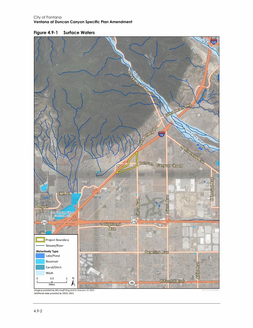
City of Fontana Ventana at Duncan Canyon Specific Plan Amendment
4.9-2
Figure 4.9-1 Surface Waters
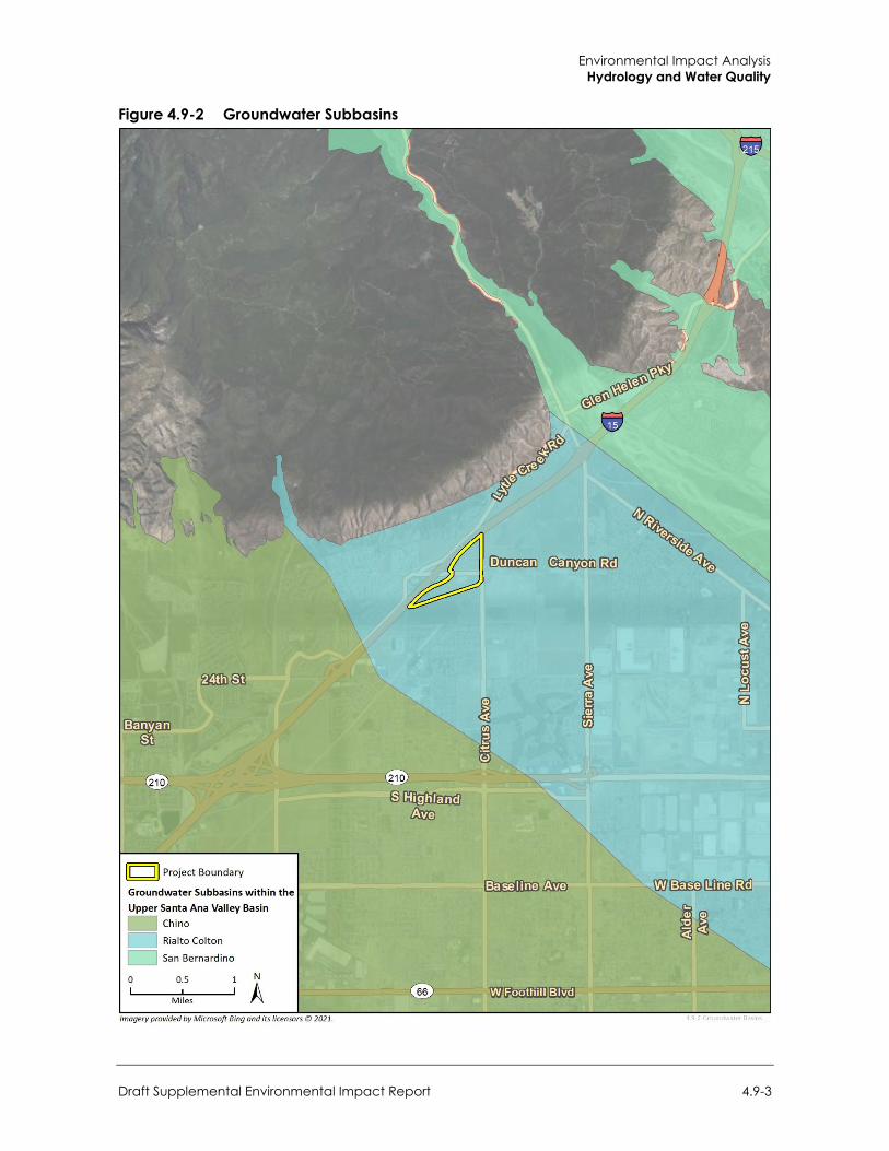
Environmental Impact Analysis Hydrology and Water Quality
Draft Supplemental Environmental Impact Report 4.9-3
Figure 4.9-2 Groundwater Subbasins
City of Fontana Ventana at Duncan Canyon Specific Plan Amendment
4.9-4
summer storm runoff, irrigation runoff, industrial/ commercial runoff, and natural seeps and springs, also pass through the creeks.
WVWD has the right to divert and export out 2,290 gallons per minute (gpm) of the Lytle Creek Region when it is available. WVWD can also purchase an additional 1,350 gpm of Lytle Creek flows through an agreement with the City of San Bernardino (San Bernardino is not able to utilize their surface water flows), which is treated at the Oliver P. Roemer Water Filtration Facility. WVWD also utilizes Lytle Creek surface water flows for groundwater recharge in the Lytle Creek Basin. WVWD has utilized up to 5,500 acre-feet per year (AFY) during normal times from Lytle Creek surface flows and projects a minimum of 2,130 AFY during extended drought conditions. WVWD and its predecessors have utilized Lytle Creek surface flows for water supply for more than 130 years (Water Systems Consulting, Inc. 2020).
Topography The topographical conditions in the City of Fontana varies, consisting of hillside terrain in the northern (San Gabriel Mountains) and southern (Jurupa Hills) portions of the city. Flat or level topography constitutes a large percentage of the terrain in the city (City of Fontana 2018).
The project site is located within northern Fontana in an undeveloped area. The project site is situated at an elevation of 573 meters (1880 feet) above mean sea level. Ridgelines are described in Section 4.1, Aesthetics, and topographic conditions are described in Section 4.6, Geology and Soils.
b. Water Supply WVWD utilizes three primary sources for drinking water supply: local surface water from the east side of the San Gabriel Mountains, including North Fork Lytle Creek, Middle Fork Lytle Creek, and South Fork Lytle Creek; groundwater; and imported water from the State Water Project (SWP). Groundwater is the primary source of supply. WVWD’s distribution system is divided into eight pressure zones and utilizes 25 reservoirs for a total storage capacity of 72.6 million gallons (MG). WVWD also operates a 14.4 MGD water filtration facility. WVWD does not currently have a recycled water distribution system. WVWD’s plans for recycled water are still preliminary, and the expected beneficial use has not been quantified. To the extent feasible, if and when recycled water is available to WVWD, this water will be offered to WVWD customers.
Purchased or Imported Water WVWD purchases SWP water from the San Bernardino Valley Municipal Water District (Valley District) through the Lytle Turnout off the San Gabriel Pipeline Feeder. SWP water is treated at WVWD’s Oliver P. Roemer Water Filtration Facility and used for potable supply, or can be used to supply non-potable customers, or for groundwater recharge in the Lytle Creek Basin. In 2006, the Water Filtration Facility was expanded to increase production capacity to 14.4 MGD and will be expanded to have a capacity of 21.6 MGD. WVWD has utilized SWP water through the Lytle Turnout since 1999 (Water Systems Consulting, Inc. 2020).
Groundwater WVWD extracts groundwater from five regional groundwater basins: Bunker Hill, Lytle Creek, Rialto-Colton, Riverside North, and Chino Basins. All five basins have been adjudicated and are managed. Details on adjudication and management are provided in the 2015 RUWMP. WVWD, in a joint venture with the City of Rialto and Valley District, constructed 25,000 feet of 48-inch transmission
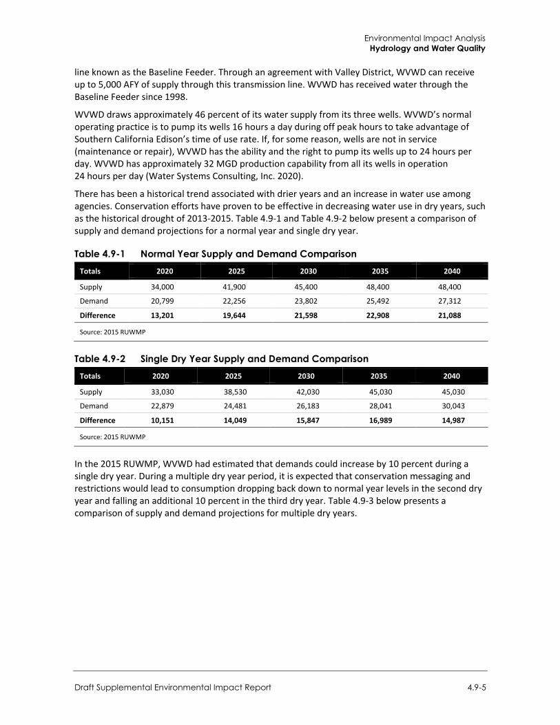
Environmental Impact Analysis Hydrology and Water Quality
Draft Supplemental Environmental Impact Report 4.9-5
line known as the Baseline Feeder. Through an agreement with Valley District, WVWD can receive up to 5,000 AFY of supply through this transmission line. WVWD has received water through the Baseline Feeder since 1998.
WVWD draws approximately 46 percent of its water supply from its three wells. WVWD’s normal operating practice is to pump its wells 16 hours a day during off peak hours to take advantage of Southern California Edison’s time of use rate. If, for some reason, wells are not in service (maintenance or repair), WVWD has the ability and the right to pump its wells up to 24 hours per day. WVWD has approximately 32 MGD production capability from all its wells in operation 24 hours per day (Water Systems Consulting, Inc. 2020).
There has been a historical trend associated with drier years and an increase in water use among agencies. Conservation efforts have proven to be effective in decreasing water use in dry years, such as the historical drought of 2013-2015. Table 4.9-1 and Table 4.9-2 below present a comparison of supply and demand projections for a normal year and single dry year.
Table 4.9-1 Normal Year Supply and Demand Comparison Totals 2020 2025 2030 2035 2040
Supply 34,000 41,900 45,400 48,400 48,400
Demand 20,799 22,256 23,802 25,492 27,312
Difference 13,201 19,644 21,598 22,908 21,088
Source: 2015 RUWMP
Table 4.9-2 Single Dry Year Supply and Demand Comparison Totals 2020 2025 2030 2035 2040
Supply 33,030 38,530 42,030 45,030 45,030
Demand 22,879 24,481 26,183 28,041 30,043
Difference 10,151 14,049 15,847 16,989 14,987
Source: 2015 RUWMP
In the 2015 RUWMP, WVWD had estimated that demands could increase by 10 percent during a single dry year. During a multiple dry year period, it is expected that conservation messaging and restrictions would lead to consumption dropping back down to normal year levels in the second dry year and falling an additional 10 percent in the third dry year. Table 4.9-3 below presents a comparison of supply and demand projections for multiple dry years.
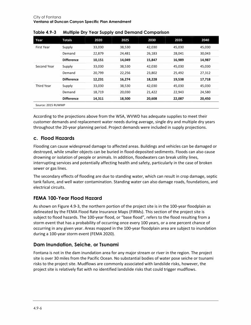
City of Fontana Ventana at Duncan Canyon Specific Plan Amendment
4.9-6
Table 4.9-3 Multiple Dry Year Supply and Demand Comparison Year Totals 2020 2025 2030 2035 2040
First Year Supply 33,030 38,530 42,030 45,030 45,030
Demand 22,879 24,481 26,183 28,041 30,043
Difference 10,151 14,049 15,847 16,989 14,987
Second Year Supply 33,030 38,530 42,030 45,030 45,030
Demand 20,799 22,256 23,802 25,492 27,312
Difference 12,231 16,274 18,228 19,538 17,718
Third Year Supply 33,030 38,530 42,030 45,030 45,030
Demand 18,719 20,030 21,422 22,943 24,580
Difference 14,311 18,500 20,608 22,087 20,450
Source: 2015 RUWMP
According to the projections above from the WSA, WVWD has adequate supplies to meet their customer demands and replacement water needs during average, single dry and multiple dry years throughout the 20-year planning period. Project demands were included in supply projections.
c. Flood Hazards Flooding can cause widespread damage to affected areas. Buildings and vehicles can be damaged or destroyed, while smaller objects can be buried in flood-deposited sediments. Floods can also cause drowning or isolation of people or animals. In addition, floodwaters can break utility lines, interrupting services and potentially affecting health and safety, particularly in the case of broken sewer or gas lines.
The secondary effects of flooding are due to standing water, which can result in crop damage, septic tank failure, and well water contamination. Standing water can also damage roads, foundations, and electrical circuits.
FEMA 100-Year Flood Hazard As shown on Figure 4.9-3, the northern portion of the project site is in the 100-year floodplain as delineated by the FEMA Flood Rate Insurance Maps (FIRMs). This section of the project site is subject to flood hazards. The 100-year flood, or “base flood”, refers to the flood resulting from a storm event that has a probability of occurring once every 100 years, or a one percent chance of occurring in any given year. Areas mapped in the 100-year floodplain area are subject to inundation during a 100-year storm event (FEMA 2020).
Dam Inundation, Seiche, or Tsunami Fontana is not in the dam inundation area for any major stream or river in the region. The project site is over 30 miles from the Pacific Ocean. No substantial bodies of water pose seiche or tsunami risks to the project site. Mudflows are commonly associated with landslide risks, however, the project site is relatively flat with no identified landslide risks that could trigger mudflows.
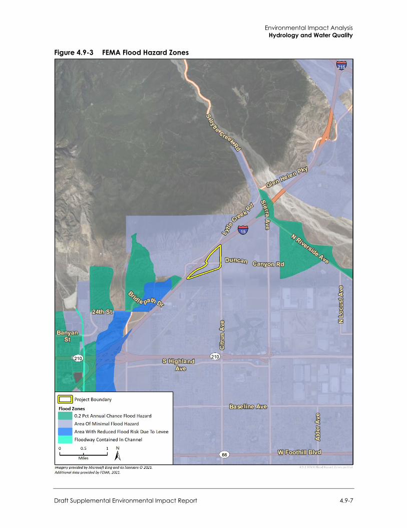
Environmental Impact Analysis Hydrology and Water Quality
Draft Supplemental Environmental Impact Report 4.9-7
Figure 4.9-3 FEMA Flood Hazard Zones
City of Fontana Ventana at Duncan Canyon Specific Plan Amendment
4.9-8
d. Water Quality The primary sources of pollution to surface and groundwater resources include stormwater runoff from paved areas, which can contain hydrocarbons, sediments, pesticides, herbicides, toxic metals, and coliform bacteria. Improperly placed septic tank leach fields and properly placed septic tanks that do not have proper residence time or are not properly maintained or have improperly disposed of household cleaners and other materials can cause similar types of contamination. Illegal waste dumping can introduce contaminants such as gasoline, pesticides, herbicides and other harmful chemicals. Changes to the quality of imported water could directly impact the amount of water supplies available to the WVWD.
As discussed above, WVWD extracts groundwater from five regional groundwater basins: Bunker Hill, Lytle Creek, Rialto-Colton, Riverside North, and Chino Basins. The project site is underlain by the Rialto-Colton Groundwater Basin. The Rialto-Colton subbasin underlies a portion of the upper Santa Ana Valley in southwestern San Bernardino County and northwestern Riverside County. This subbasin is about 10 miles long and is bounded by the San Gabriel Mountains on the northwest, the San Jacinto fault on the northeast, the Badlands on the southeast, and the Rialto-Colton fault on the southwest.
WVWD and its predecessors have been utilizing the Rialto Basin for water supply for more than 80 years. Groundwater storage capacity of the basin is about 210,000 AF, with an estimated 120,000 AF for the Rialto portion of the sub-basin and about 93,000 AF for the Colton portion. The basin shows quick rises of water levels during high precipitation years and slower decline over several years. Under normal conditions, when the basin is not in adjudication, WVWD has unlimited extraction rights. During drought conditions when the adjudication is in effect, the WVWD’s extraction right ranges from 3,067 AFY in the most severe drought periods to a maximum of 6,134 AFY. Existing wells in the Rialto Basin have the capacity to extract up to 10,000 AFY during normal conditions (Water Systems Consulting, Inc. 2020).
4.9.2 Regulatory Setting
a. Federal Regulations
Clean Water Act The Federal Clean Water Act, enacted by Congress in 1972 and amended several times since, is the primary federal law regulating water quality in the United States and forms the basis for several State and local laws throughout the country. The Act established the basic structure for regulating discharges of pollutants into the waters of the United States. The Clean Water Act gave the United States Environmental Protection Agency (USEPA) authority to implement federal pollution control programs, such as setting water quality standards for contaminants in surface water, establishing wastewater and effluent discharge limits for various industry contaminants in surface water, establishing wastewater and effluent discharge limits for various industry categories, and imposing requirements for controlling nonpoint-source pollution. At the federal level, the Clean Water Act is administered by the USEPA and United States Army Corps of Engineers (USACE). At the State and regional levels in California, the act is administered and enforced by the State Water Resources Board (SWRCB) and the nine regional water quality control boards (RWQCBs).
Environmental Impact Analysis Hydrology and Water Quality
Draft Supplemental Environmental Impact Report 4.9-9
Clean Water Act Section 401
Under Section 401 of the Clean Water Act, the RWQCBs have regulatory authority over actions in waters of the United States and/or the State of California through the issuance of water quality certifications, which are issued in conjunction with any federal permit (e.g., permits issued by the USACE under Section 404 of the Clean Water Act, described above). Section 401 of the Clean Water Act provides the SWRCB and the RWQCBs with the regulatory authority to waive, certify, or deny any proposed activity that could result in a discharge to surface waters of the State. To waive or certify an activity, these agencies must find that the proposed discharge would comply with State water quality standards, including those protecting beneficial uses and water quality. If these agencies deny the proposed activity, the federal permit cannot be issued. This water quality certification is generally required for projects requiring Section 404 authorization involving the discharge of dredged or fill material to wetlands or other waters of the United States.
Clean Water Act Section 402
Section 402 of the Clean Water Act requires that all construction sites on an acre or greater of land, as well as municipal, industrial and commercial facilities discharging wastewater or stormwater directly from a point source (e.g., pipe, ditch, or channel) into a surface water of the United States must obtain permission under the National Pollutant Discharge Elimination System (NPDES) permit. All NPDES permits are written to ensure that the surface water receiving discharges will achieve specified water quality standards.
According to federal regulations, NPDES permit coverage for stormwater discharges associated with construction activity can be obtained through individual State permits or general permits. Individual permitting involves the submittal of specific data on a single construction project to the appropriate permitting agency that will issue a site-specific NPDES permit to a project. NPDES coverage under a general permit involves the submittal of a Notice of Intent by the regulated construction project that they intend to comply with a general permit to be developed by USEPA or a state with delegated permitting authority.
In California, the NPDES program is administered by the SWRCB through the RWQCBs and requires municipalities to obtain permits that outline programs and activities to control wastewater and stormwater pollution. The Federal Clean Water Act prohibits discharges of stormwater from construction projects unless the discharge is in compliance with an NPDES permit. The SWRCB is the permitting authority in California, and adopted an NPDES General Permit for Stormwater Discharges Associated with Construction and Land Disturbance Activities (Construction General Permit) (Order 2009-0009, as amended by Orders 2010-0014-DWQ and 2012-006-DWQ). Containment and spill cleanup are also encompassed in the Storm Water Pollution Prevention Plan (SWPPP). SWPPPs are associated with construction and industrial stormwater permits, which are issued by the Regional Water Quality Control Board. This includes inspections for spills, a requirement that chemicals be stored in watertight containers with secondary containment to prevent spillage or leakage, procedures for addresses hazardous and non-hazardous spills, including a spill response and implementation procedure, include on-site equipment for cleanup and spills, and spill training for construction personnel.1
The order applies to construction sites that include one or more acre of soil disturbance. Construction activities include clearing, grading, grubbing, excavation, stockpiling, and reconstruction of existing facilities involving removal or replacement. The Construction General
1 See https://www.waterboards.ca.gov/water_issues/programs/stormwater/docs/constpermits/wqo_2009_0009_complete.pdf
City of Fontana Ventana at Duncan Canyon Specific Plan Amendment
4.9-10
Permit requires that the landowner and/or contractor file permit registration documents prior to commencing construction and then pay a fee annually through the duration of construction. These documents include a notice of intent, risk assessment, site map, SWPPP, and signed certification statement. The SWPPP must include measures to ensure that: all pollutants and their sources are controlled; non-stormwater discharges are identified and eliminated, controlled, or treated; site best management practices (BMPs) are effective and result in the reduction or elimination of pollutants in stormwater discharges and authorized non-stormwater discharges; and BMPs installed to reduce or eliminate pollutants after construction are completed and maintained. The Construction General Permit specifies minimum BMP requirements for stormwater control based on the risk level of the site.
Clean Water Act Section 404
Under Section 404 of the Clean Water Act, proposed discharges of dredged or fill material into waters of the United States require USACE authorization. Waters of the United States generally include tidal waters, lakes, ponds, rivers, streams (including intermittent streams), and wetlands (with the exception of isolated wetlands). Federal regulations are currently pending that would revise the definition of “waters of the United States” subject to Section 404 of the Clean Water Act, as further discussed in Section 4.3, Biological Resources. The USACE identifies wetlands using a multi-parameter approach, which requires positive wetland indicators in three distinct environmental categories: hydrology, soils, and vegetation. According to the Corps of Engineers Wetlands Delineation Manual (1987), except in certain situations, all three parameters must be satisfied for an area to be considered a jurisdictional wetland. The Regional Supplement to the Corps of Engineers Wetland Delineation Manual: Arid West Region (USACE 2008) is also used when conducting jurisdictional wetland determinations in areas identified within the boundaries of the arid west.
When an application for a Section 404 permit is made, the applicant must show it has:
Taken steps to avoid impacts to wetlands or waters of the U.S. where practicable; Minimized unavoidable impacts on waters of the U.S. and wetlands; and Provided mitigation for unavoidable impacts.
National Flood Insurance Act/Flood Disaster Protection Act The National Flood Insurance Act of 1968 made flood insurance available for the first time. The Flood Disaster Protection Act of 1973 made the purchase of flood insurance mandatory for the protection of property located in Special Flood Hazard Areas. These laws are relevant because they led to mapping of regulatory floodplains and to local management of floodplain areas according to guidelines that include prohibiting or restricting development in flood hazard zones.
Drinking Water Regulations The Federal Safe Drinking Water Act was enacted in 1974, allowing the USEPA to promulgate national primary drinking water standards specifying Maximum Contaminants Levels for each contaminant present in a public water system with an adverse effect on human health. Primary Maximum Contaminants Levels have been established for approximately 90 contaminants in drinking water. The USEPA has also adopted secondary Maximum Contaminants Levels as non-enforceable guidelines for contaminants that may cause cosmetic or aesthetic effects. States have the discretion to adopt them as enforceable standards. USEPA has delegated to the State Water
Environmental Impact Analysis Hydrology and Water Quality
Draft Supplemental Environmental Impact Report 4.9-11
Resources Control Board the responsibility for administering California’s drinking-water program. In 1976, California adopted its own safe drinking water act (see California Safe Drinking Water Act described in the State regulatory section below).
Federal Emergency Management Agency FEMA administers the National Flood Insurance Program (NFIP) to provide subsidized flood insurance to communities that comply with FEMA regulations limiting development in floodplains. FEMA also issues Flood Insurance Rate Maps (FIRMs) that identify which land areas are subject to flooding. These maps provide flood information and identify flood hazard zones in the community. The design standard for flood protection is established by FEMA. FEMA’s minimum level of flood protection for new development is the 100-year flood event, also described as a flood that has a one percent change of occurring in any given year.
FEMA has also developed requirements and procedures for evaluating earthen levee systems and mapping the areas affected by those systems. Levee systems are evaluated for their ability to provide protection from 100-year flood events and the results of this evaluation are documented in the FEMA Levee Inventory System (FLIS). Levee systems must meet minimum freeboard standards and must be maintained according to an officially adopted maintenance plan. Other FEMA levee system evaluation criteria include structural design and interior drainage.
National Pollutant Discharge Elimination System The primary regulatory control relevant to the protection of water quality is the NPDES permit administered by the SWRCB. The SWRCB establishes requirements prescribing the quality of point sources of discharge and water quality objectives. These objectives are established based on the designated beneficial uses (e.g., water supply, recreation, and habitat) for a particular surface water body. The NPDES permits are issued to point source dischargers of pollutants to surface waters pursuant to Water Code Chapter 5.5, which implements the federal CWA. Examples include, but are not limited to, public wastewater treatment facilities, industries, power plants, and groundwater cleanup programs discharging to surface waters (SWRCB, Title 23, Chapter 9, Section 2200). The RWQCB establishes and regulates discharge limits under the NPDES permits.
b. State Regulations
Porter-Cologne Water Quality Control Act The Porter-Cologne Water Quality Control Act (Division 7 of the California Water Code) is the primary statute covering the quality of waters in California. Under the act, SWRCB has the ultimate authority over the State’s water quality policy. SWRCB administers water rights, water pollution control, and water quality functions throughout the state, while the nine RWQCBs conduct planning, permitting, and enforcement activities. The RWQCBs also regulate water quality under this act through the regulatory standards and objectives set forth in Water Quality Control Plans (also referred to as Basin Plans) prepared for each region.
California Safe Drinking Water Act The USEPA has delegated to the California Department of Public Health responsibility for administering California’s drinking-water program. In 1976, two years after the Federal Safe Drinking Water Act was passed, California adopted its own safe drinking water act (contained in the Health and Safety Code) and adopted implementing regulations (contained in Title 22 California
City of Fontana Ventana at Duncan Canyon Specific Plan Amendment
4.9-12
Code of Regulations). California’s program sets drinking water standards that are at least as stringent as the Federal standards. Each community water system also must monitor for a specified list of contaminants, and the monitoring results must be reported to the state. Responsibility for the state’s Drinking Water Program was transferred from the Department of Public Health to the Division of Drinking Water, which is a division of the SWRCB that was created in July 2014.
California General Plan Law, Government Code Section 65302 Government Code Section 65302(a) requires cities and counties located within the state to review the Land Use, Conservation, and Safety elements of the general plan "for the consideration of flood hazards, flooding, and floodplains" to address flood risks. The code also requires cities and counties in the state to annually review the land use element with respect "those areas covered by the plan that are subject to flooding identified by floodplain mapping prepared by FEMA or the California DWR."
Sustainable Groundwater Management Act Effective in 2015, the Sustainable Groundwater Management Act (SGMA) creates a framework for sustainable, local groundwater management in California. SGMA allows local agencies to customize groundwater sustainability plans to their regional economic and environmental needs. This act requires local regions to create a GSA and to adopt groundwater management plans for groundwater basins or subbasins that are designated as medium or high priority. High-priority and medium-priority basins or subbasins must adopt groundwater management plans by 2020 or 2022, depending upon whether the basin is in critical overdraft. GSAs will have until 2040 or 2042 to achieve groundwater sustainability.
c. Local Regulations
Water Quality Control Plan for the Santa Ana River Basin Fontana is under the jurisdiction of RWQCB Region 8, the Santa Ana RWQCB (SARWQCB), which provides permits for projects that may affect surface waters and groundwater locally and is responsible to prepare the Water Quality Control Plan for the Santa Ana River Basin (Basin Plan). The Basin Plan designates beneficial uses of waters in the region and establishes narrative and numerical water quality objectives. Water quality objectives, as defined by the CWA Section 13050(h), are the “limits or levels of water quality constituents or characteristics which are established for the reasonable protection of beneficial uses or the prevention of nuisance within a specific area.” California has developed “total maximum daily loads” (TMDLs), which are a calculation of the maximum amount of a pollutant that a water body can receive and still meet water quality objectives established by the region. The Basin Plan serves as the basis for the SARWQCB’s regulatory programs and incorporates an implementation plan to meet water quality objectives. Basin Plans undergo a triennial review process, with the SARWQCB’s Basin Plan most recently updated in June 2019 (SARWQCB 2019).
Municipal Regional Stormwater NPDES Permit On January 29, 2010, the SARWQCB adopted Order R8‐2010‐0033, as amended by Order R8-2013-0024 (NPDES Permit and Waste Discharge Requirements for the San Bernardino County Flood Control and Water Conservation District) otherwise known as the municipal separate storm sewer system (MS4) permit. The City of Fontana is subject to the NPDES permitting process under its MS4

Environmental Impact Analysis Hydrology and Water Quality
Draft Supplemental Environmental Impact Report 4.9-13
codified as Title 14 (Storm Drains and Floodplain Management) of the Municipal Code. One component of the MS4 permit requires the development of site-specific Water Quality Management Plan (WQMPs) for new development and significant redevelopment projects. WQMPs include site design, source control, and treatment elements to reduce stormwater pollution from urban runoff.
On April 7, 2015, the SARWQCB adopted statewide Trash Provisions to address impacts of trash on surface waters in the region. The Trash Provisions outline additional requirements for co-permittees under the MS4 permit, including either installation of Full Capture Systems for all storm drains capturing runoff from priority land uses, or a combination of full capture systems, multi-benefit projects, treatment controls, and/or institutional controls to reduce trash accumulation in surface waters (SARWQCB 2017).
San Bernardino County Municipal Stormwater Management Plan The San Bernardino County Municipal Stormwater Management Plan (MSMP), developed by the SBCFCD and other co-permittees to the MS4 Permit, outlines programs and policies to manage urban runoff. The MSMP includes development review procedures, required construction BMPs and inspection frequency, annual reporting and evaluation framework, and TMDL implementation strategies. The purpose of the MSMP was to satisfy NPDES permit conditions for creating and implementing an Urban Runoff Management Program (URMP) to reduce pollutant discharges (City of Fontana 2018).
Technical Guidance Document for Water Quality Management Plans Developed in 2013 by the County of San Bernardino Areawide Stormwater Program, the Technical Guidance Document for Water Quality Management Plans describes low-impact development (LID) guidelines for projects to reduce downstream erosion by more closely mimicking pre-project hydrology and minimizing pollutant runoff. The Handbook details strategies for selecting appropriate LID BMPs, design capture volume requirements for BMPs, and sizing calculation methodology for BMP implementation in specific watersheds in the County.
City of Fontana General Plan The Fontana General Plan Noise and Safety, Sustainability and Resilience, and Infrastructure and Green Systems chapters contain policies relevant to hydrology and water quality, including the following:
Noise and Safety
Goal 7: The city shall discourage new development in flood-hazard areas and implement mitigation measures to reduce the hazard to existing developments located within the 100- and 500-year flood zones.
Sustainability and Resilience
Goal 7: Conservation of water resources with best practices such as drought-tolerant plant species, recycled water, greywater systems, has become a way of life in Fontana.
Policy: Continue to promote and implement best practices to conserve water
City of Fontana Ventana at Duncan Canyon Specific Plan Amendment
4.9-14
Infrastructure and Green Systems
Goal 1: Fontana collaborates with public and private agencies for an integrated and sustainable water resource management program
Policy: Support initiatives to provide a long-term supply of the right water for the right use through working with regional providers and the One Water One Watershed Plan.
Goal 2: Fontana promotes use of non-potable water for uses where drinking water is not needed.
Policy: Encourage use of processed water from the IEUA systems using recycled water for all non-drinking water purposes.
Policy: Promote laundry-to-landscape greywater systems for single-family housing units.
Goal 3: The city continues to have an effective water conservation program.
Policy: Support landscaping in public and private spaces with drought resistant plants.
Policy: Continue successful city water conservation programs and partnerships.
Goal 4: The City of Fontana consistently seeks reasonable rates from the city’s drinking water providers.
Policy: Support City negotiations to keep drinking water rates reasonable for residents and other users.
Goal 6: The City of Fontana consistently seeks reasonable rates from the city’s drinking water providers.
Policy: Continue to implement the Water Quality Management Plan for stormwater management that incorporates low-impact and green infrastructure standards.
Policy: Promote natural drainage approaches (green infrastructure) and other alternative non-structural and structural best practices to manage and treat stormwater.
Additionally, the Noise and Safety chapter contains policies pertaining to development in floodplain areas and substantial modification of watercourses. As described above, the northern portion of the project site is located in a floodplain, however, the site is no longer subject to surface water flows associated with Lytle Creek due to the construction of levees along the creek. Thus, the project site does not support any discernible drainage courses, inundated areas, wetland vegetation, or hydric soils that would be considered jurisdictional watercourses.
City of Fontana Municipal Code Section 28-111 of Article IV of the Fontana Municipal Code contains the city’s stormwater/urban runoff management and discharge controls ordinance. The ordinance is intended to reduce pollutants in stormwater, regulate illicit connections and discharges to the storm drain system, and protect and enhance the quality of water resources in Fontana in accordance with applicable federal, state, and regional regulations. Article IX of Chapter 23 prohibits the discharge of any pollutants to any street, alley, sidewalk, storm drain, inlet, catch basin, or conduit and applies to all construction sites, new development and redevelopment, existing development, and commercial and industrial facilities in Fontana. Section 5-14 prohibits discharges in violation of the municipal NPDES permit (MS4 permit) or any NPDES permit for industrial or construction activity. Finally, Section 23-516 contains the ordinance’s enforcement provisions and allows Fontana to make BMPs a condition of approval to the issuance of a city permit.
Environmental Impact Analysis Hydrology and Water Quality
Draft Supplemental Environmental Impact Report 4.9-15
4.9.3 Impact Analysis
a. Significance Thresholds In accordance with Appendix G of the CEQA Guidelines, a hydrology and water quality impact is considered significant if the proposed project would:
Violate any water quality standards or waste discharge requirements or otherwise substantially degrade surface or groundwater quality
Substantially decrease groundwater supplies or interfere substantially with groundwater recharge such that the project may impede sustainable groundwater management of the basin
Substantially alter the existing drainage pattern of the site or area, including through the alteration of the course of a stream or river or through the addition of impervious surfaces, in a manner which would:
result in substantial erosion or siltation on- or off-site; substantially increase the rate or amount of surface runoff in a manner which would result
in flooding on- or off-site; create or contribute runoff water which would exceed the capacity of existing or planned
stormwater drainage systems or provide substantial additional sources of polluted runoff; or
impede or redirect flood flows
Conflict with or obstruct implementation of a water quality control plan or sustainable groundwater management plan.
Impacts related to hydrology and water quality were analyzed in an Initial Study (Appendix A-2). The Initial Study concluded that the northern portion of the project site is in the 100-year floodplain as delineated by the FEMA Flood Rate Insurance Maps. However, this portion of the site is no longer subject to surface water flows associated with Lytle Creek due to the construction of levees along the creek. The southern portion of the project site is designated Zone X on the most recent FEMA Flood Insurance Rate Map, indicating an area of minimal flood hazard. In addition, the project site is approximately 47 miles from the Pacific Ocean and not subject to tsunami, and there are no bodies of surface water in the project vicinity that may be subject to seiche. Therefore, the project site is not located in an inundation zone and these impacts are not further evaluated in this section.
b. Methodology The analysis of hydrologic and water quality impacts is based on information and data contained in the WSA prepared for the project (Appendix G), including site runoff estimates, soil properties, impervious surface area, and water quality BMPs. Future water supply and demand from the 2015 RUWMP was also considered in this analysis to determine if there is an adequate supply of water for the project.
In addition to the studies referenced above, aerial imagery, grading plans, and drainage plans for the site were reviewed to analyze pre- and post-construction hydrology. Documents published by the SWRCB and SARWQCB, including plans and permits, were reviewed to provide information on existing water quality as well as required water quality improvement measures. Finally, the federal Flood Insurance Rate Maps were assessed to determine flood potential on the project site.

City of Fontana Ventana at Duncan Canyon Specific Plan Amendment
4.9-16
c. Standard Conditions The following standard conditions related to hydrology and water quality, and identified in the 2007 EIR, remain applicable to the proposed project:
Standard Condition 4.8.1: The project shall comply with the NPDES General Permit for Construction Activity, which requires projects on one acre or more to notify the RWQCB and implement a Stormwater Pollution Prevention Plan (SWPPP) for construction activities.
Standard Condition 4.8.2: The project shall comply with the NPDES regarding the development and implementation of a Water Quality Management Plan for permanent source and treatment control measures and other best management practices for long-term stormwater pollutant mitigation.
Standard Condition 4.8.3: The project shall provide the necessary on-site and off-site storm drain infrastructure to connect to the City of Fontana’s storm drainage system, in order to prevent the creation of flood hazards on-site and in downstream areas, as approved by the Fontana City Engineer.
Standard Condition 4.8.4: The project shall provide the needed storm drain infrastructure and documentation shall be submitted to the Federal Emergency Management Agency to amend the designated floodplain and obtain a Conditional Letter of Map Revision (CLOMR) prior to development of the northern section of the site.
d. Project Impacts
Threshold 1: Would the project violate any water quality standards or waste discharge requirements or otherwise substantially degrade surface or ground water quality?
Impact HWQ-1 CONSTRUCTION AND OPERATION OF THE PROJECT COULD INCREASE EROSION AND STORMWATER RUNOFF DUE TO SITE DISTURBANCE AND INCREASED IMPERVIOUS SURFACE AREA. COMPLIANCE WITH APPLICABLE REGULATIONS AND POLICIES, INCLUDING PREPARATION OF A SWPPP DURING CONSTRUCTION AND ON-SITE CAPTURE AND TREATMENT OF STORMWATER RUNOFF THROUGH BIOFILTRATION SYSTEMS AND DETENTION BASINS DURING OPERATION, WOULD REDUCE WATER QUALITY IMPACTS. IMPACTS WOULD BE LESS THAN SIGNIFICANT.
Construction-Related Impacts The 2007 EIR determined that construction activities associated with the project could lead to pollutants entering drainage systems. Pollutants may include construction debris, construction equipment fuels, oil and grease, construction materials and solvents, loose soils, and organic waste materials. These pollutants could potentially degrade stormwater quality and downstream surface water sources. Implementation of construction BMPs would minimize surficial erosion and transport of pollutants and would occur in compliance with applicable NPDES and city requirements, thereby protecting water quality both on- and off-site (City of Fontana 2007).
Grading, excavation, and other construction activities associated with the project could adversely affect water quality due to erosion resulting from exposed soils and the generation of water pollutants, including trash, construction materials, and equipment fluids. Soil disturbance associated with site preparation and grading activities would result in looser, exposed soils, which are more susceptible to erosion. Erosion factors (K factors) for soils on the project site are estimated at approximately 0.24, indicating moderate potential for sheet and rill erosion by water (SWRCB 2021).
Environmental Impact Analysis Hydrology and Water Quality
Draft Supplemental Environmental Impact Report 4.9-17
Additionally, spills, leakage, or improper handling and storage of substances such as oils, fuels, chemicals, metals, and other substances from vehicles, equipment, and materials used during project construction could contribute to stormwater pollutants or leach to underlying groundwater.
Because the project would result in disturbance of more than one-acre, on-site construction activities would be subject to the NPDES Construction General Permit. For all covered projects, the NPDES construction permit requires visual monitoring of stormwater and non-stormwater discharges, sampling, analysis, and monitoring of non-visible pollutants, and compliance with all applicable water quality standards established for receiving waters potentially affected by construction discharges. As such, coverage under the Construction General Permit would require development and implementation of a project specific SWPPP which identifies BMPs to reduce or eliminate pollutants in storm water discharges and authorized non-storm water discharges from construction sites, as well as post-construction standards to achieve the pre-project volume and rate of stormwater runoff from the project area. A SWPPP typically includes both source-control and treatment-control BMPs to reduce water quality impacts. The BMPs that are most often used during construction include watering exposed soils; covering stockpiles of soil; installing sandbags to minimize off-site runoff; creating temporary desilting basins; construction vehicle maintenance in staging areas to avoid leaks or spills of fuels, motor oil, coolant, and other hazardous materials; installation of silt fences and erosion control blankets; and timing grading to avoid the rainy season (November through April). In addition, coverage under the Construction Permit would also include implementation of post-construction standards to achieve the pre-project volume and rate of stormwater runoff from the project area. The proposed project would meet these standards through installation of active and passive treatment units, as described below.
Furthermore, Section 28-111 Chapter 28 of the FMC contains the city’s policies intended to reduce pollutants in stormwater. The section requires any construction contractors performing work in the city to provide filter materials at the catch basin of the storm sewer system to retain debris and dirt. The section further requires projects subject to the NPDES Construction General Permit to demonstrate possession of the permit prior to issuance of a grading or building permit. Therefore, construction of the proposed project would not violate any water quality standards or waste discharge requirements, nor would it otherwise substantially degrade surface water or groundwater quality.
Operation-Related Impacts The 2007 EIR determined stormwater and wastewater from future residential and commercial on-site uses could also lead to pollutants entering drainage systems. During operation, the biofiltration BMPs and detention basins would capture and treat on-site runoff. Additional permanent structural and operational BMPs would further reduce pollution of stormwater runoff associated with proposed land uses on the project site (City of Fontana 2007).
There are no existing impervious surfaces on the project site since the site is currently undeveloped. The project would increase impervious surface cover on the project site due to the construction of up to 476,500 sf of commercial uses, 1,671 dwelling units in three separate residential villages, a focal point “Piazza,” a “campanile” tower feature, pedestrian paseos, and the construction of the realigned Lytle Creek Road, on an approximately 102-acre site. Increased impervious area on the project site could result in increased runoff flow and volume, which can carry pollutants to downstream water bodies and adversely affect water quality. Common pollutants associated with residential development that could be discharged during operation of the project include automotive chemicals and metals that accumulate on the driveway and parking lots, fertilizers,

City of Fontana Ventana at Duncan Canyon Specific Plan Amendment
4.9-18
pesticides, and herbicides applied to ornamental landscaping, pet waste, trash, debris, and sediments.
The City of Fontana is permittee to the Waste Discharge Requirements for Municipal Separate Storm Sewer System (MS4) Discharges within the Watersheds of San Bernardino County. Under the MS4 permit, permittees, including the City of Fontana, must require the use of control measures, such as BMPs, to reduce the discharge of pollutants from their MS4 facilities to receiving water bodies. Implementation of the proposed project could result in stormwater runoff exiting project sites during project construction. Stormwater runoff during construction could contain pollutants such as soils and sediments released during grading and excavation activities as well as petroleum-related pollutants due to spills or leaks from heavy equipment and machinery. Other common pollutants that may result from construction activities include solid or liquid chemical spills; concrete and related cutting or curing residues; wastes from paints, stains, sealants, solvents, detergents, glues, acids, lime, plaster, and cleaning agents; and heavy metals from equipment. Construction and operation of the proposed project would include compliance with the NPDES program described above.
Storm drain infrastructure for the project would include area drains, roof drain connections, and piped conveyance of stormwater to the water quality treatment basins/devices and connections to the existing storm drain system. Water quality treatment would consist of biofiltration basins, proprietary treatment devices, and/or underground storage vaults. These BMPs would slow the velocity of water and allow sediment and debris to settle out of the water column, thereby minimizing the potential for downstream flooding, erosion/siltation, or exceedances of stormwater drainage system capacity. Operation and maintenance of the proposed project would not violate water quality standards or otherwise substantially degrade water quality. Compliance with federal, state, and local regulations would require that stormwater runoff is captured and treated on-site, thereby protecting water quality both on- and off-site. Therefore, operation of the proposed project would not violate any water quality standards or waste discharge requirements, nor would it otherwise substantially degrade surface water or groundwater quality.
Mitigation Measures Mitigation measures are not required.
Threshold 2: Would the project substantially decrease groundwater supplies or interfere substantially with groundwater recharge such that the project may impede sustainable groundwater management of the basin?
Impact HWQ-2 THE PROPOSED PROJECT WOULD NOT INVOLVE ON-SITE GROUNDWATER EXTRACTION BECAUSE THE PROJECT WOULD BE SERVED BY WVWD’S EXISTING AND PLANNED SUPPLIES, REDUCING POTENTIAL IMPACTS TO GROUNDWATER LEVELS. IMPERVIOUS SURFACE COVER WOULD INCREASE ON THE PROJECT SITE UNDER THE PROPOSED PROJECT, REDUCING THE POTENTIAL FOR RECHARGE OF THE UNDERLYING AQUIFER. HOWEVER, ON-SITE RUNOFF WOULD CONTINUE TO DISCHARGE TO LYTLE CREEK, AND ETIWANDA CREEK, WHERE ADDITIONAL POTENTIAL FOR INFILTRATION AND RECHARGE EXISTS. IMPACTS WOULD BE LESS THAN SIGNIFICANT.
The 2007 EIR determined that the project would lead to a long-term demand for water and likely create an increase in groundwater pumping from local wells operated by the WVWD. The WVWD obtains its water supply from five separate groundwater basins (Lytle Creek, Rialto, Bunker Hill, Chino and North Riverside groundwater basins) and two surface water sources (Lytle Creek and the
Environmental Impact Analysis Hydrology and Water Quality
Draft Supplemental Environmental Impact Report 4.9-19
State Water Project). However, the WSA that was prepared for the previous 2007 EIR indicated that there were adequate water resources to serve future development under the Specific Plan (City of Fontana 2007).
The project site overlies the Rialto-Colton Groundwater Basin. The Groundwater Basin recharge areas are Lytle Creek, Reche Canyon, and the Santa Ana River. Furthermore, adverse impacts to groundwater supply could occur indirectly, by disrupting recharge rates or patterns to the underlying groundwater basin, or directly, by increasing use of local groundwater supply. The project would introduce impervious areas through development of residential and commercial uses. As such, development of the proposed project could substantially interfere with groundwater recharge due to increased impervious surfaces. Implementation of the project would increase water demands on the project site due to the introduction of new residents, visitors and employees. Water service to the project site is provided by the West San Bernardino County Water District. Water delivered by the city is sourced from local groundwater and surface water resources.
According to the 2015 RUWMP, WVWD still has adequate supplies to meet their customer demands and replacement water needs during average, single dry and multiple dry years throughout the 20-year planning period. Water demands determined in the WSA, which included project demands, were less than the projected growth demands provided in the 2015 RUWMP. It is concluded that WVWD has adequate supplies to meet demands during average, single dry and multiple dry years throughout the 20-year planning period. Furthermore, WVWD uses SWP for groundwater recharge. Therefore, given that WVWD has adequate water supplies to meet the project’s water demand, impacts with respect to depletion of groundwater supplies and interference with recharge would be less than significant.
Mitigation Measures Mitigation measures are not required.

City of Fontana Ventana at Duncan Canyon Specific Plan Amendment
4.9-20
Threshold 3a: Would the project substantially alter the existing drainage pattern of the site or area, including through the alteration of the course of a stream or river or through the addition of impervious surfaces, in a manner which would result in substantial erosion or siltation on- or off-site?
Threshold 3b: Would the project substantially alter the existing drainage pattern of the site or area, including through the alteration of the course of a stream or river or through the addition of impervious surfaces, in a manner which would substantially increase the rate or amount of surface runoff in a manner which would result in flooding on- or off-site?
Threshold 3c: Would the project substantially alter the existing drainage pattern of the site or area, including through the alteration of the course of a stream or river or through the addition of impervious surfaces, in a manner that would create or contribute runoff water which would exceed the capacity of existing or planned stormwater drainage systems or provide substantial additional sources of polluted runoff?
Threshold 3d: Would the project substantially alter the existing drainage pattern of the site or area, including through the alteration of the course of a stream or river or through the addition of impervious surfaces, in a manner which would impede or redirect flood flows?
Impact HWQ-3 UNDER THE PROPOSED PROJECT, ON-SITE STORMWATER RUNOFF WOULD BE CAPTURED AND TREATED VIA STORMWATER DRAINAGE SYSTEM CONSISTING OF CATCHMENT BASINS, BIOFILTRATION SYSTEMS, AND DETENTION BASINS. THE PROPOSED PROJECT WOULD NOT RESULT IN SUBSTANTIAL ON- OR OFF-SITE HYDROMODIFICATION IMPACTS AND WOULD NOT ALTER THE COURSE OF A RIVER OR STREAM GIVEN THAT THE PROJECT WOULD COMPLY WITH APPLICABLE WATER QUALITY STANDARDS, WASTE DISCHARGE REQUIREMENTS, BMPS AND WOULD INCLUDE PROJECT-SPECIFIC DESIGN FEATURES. THIS IMPACT WOULD BE LESS THAN SIGNIFICANT.
The 2007 EIR determined that the project would comply with the NPDES regulations, and which would reduce potential stormwater pollution potential and prevent adverse impacts to stormwater quality. Changes in drainage patterns would be internal to the project site and would not impact the regional hydrology or the drainage flows in the surrounding area. Furthermore, onsite runoff would flow into on-site retention/detention basins and conveyed toward the existing storm drainage facilities west of I-15 and south of the site. Runoff from the project site would not affect the course of a stream or river. The city requires catch basin stenciling to discourage waste disposal into the storm drain system and provides street sweeping of public streets to remove and prevent debris from entering the storm drain system (City of Fontana 2007).
The project would not alter the course of a stream or river. However, full build-out of the project would result in site-specific alterations to the local drainage patterns, and the implementation of project-specific design features and BMPs would be required to minimize or avoid adverse impacts associated with soil erosion, sedimentation, and flooding. Planning and design of the project would include stormwater drainage features to accommodate runoff associated with new project features. Additional sources of pollution are addressed under Impact HWQ-1 above, for potential impacts associated with water quality and waste discharge requirements; no additional impacts associated with polluted runoff have been identified.
The project would increase the area of impervious surfaces on the site and would implement post-construction stormwater management control measures on-site through infiltration,
Environmental Impact Analysis Hydrology and Water Quality
Draft Supplemental Environmental Impact Report 4.9-21
evapotranspiration, storm water runoff harvest and use, or a combination of the three. In addition, as described above for significance criterion (a), project specific SWPPPs would be developed and implemented to minimize or avoid potential water quality impacts during construction and operation of individual projects. Also as described above, construction and operation of the project is expected to occur in compliance with applicable water quality standards and waste discharge requirements, based upon project-specific design features and BMPs.
Continued implementation of city-wide programs would further reduce potential stormwater pollution from new developments. Implementation of these existing programs and compliance with NPDES mandates would prevent significant adverse impacts relating to stormwater runoff quality from occurring with the proposed project. Given that the project would comply with applicable water quality standards and waste discharge requirements, in addition to project-specific design features and BMPs, alteration of drainage patterns on the project site would not result in substantial erosion or siltation off-site or provide substantial additional sources of polluted runoff. Impacts would be less than significant.
Mitigation Measures Mitigation measures are not required.
Threshold 4: Would the project conflict with or obstruct implementation of a water quality control plan or sustainable groundwater management plan?
Impact HWQ-4 THE PROPOSED PROJECT WOULD IMPLEMENT WATER QUALITY BMPS IN ACCORDANCE WITH APPLICABLE LOCAL AND REGIONAL REQUIREMENTS, REDUCING POTENTIAL DOWNSTREAM WATER QUALITY IMPACTS. AS SUCH, THE PROPOSED PROJECT WOULD NOT CONFLICT WITH OR OBSTRUCT IMPLEMENTATION OF THE WATER QUALITY CONTROL PLAN FOR THE SANTA ANA REGION. THE PROJECT SITE OVERLIES AN ADJUDICATED GROUNDWATER BASIN AND WOULD NOT CONFLICT WITH OR OBSTRUCT IMPLEMENTATION OF A SUSTAINABLE GROUNDWATER MANAGEMENT PLAN. THIS IMPACT WOULD BE LESS THAN SIGNIFICANT.
The 2007 EIR determined that stormwater pollution control measures would be implemented in addition to citywide programs for public awareness and runoff pollution prevention. Therefore, pollutants that could impact the downstream Santa Ana River would be minimized. Thus, no significant impacts are expected on water quality within the Santa Ana River. No conflict with the Water Quality Control Plan for the Santa Ana River would occur with the project (City of Fontana 2007). These findings still apply for the current project.
The SARWQCB’s Basin Plan designates beneficial uses for surface waters in the region 8 area and associated water quality objectives to fulfill such uses. Lytle Creek, and Etiwanda Creek that are located near the project site, have designated beneficial uses of Municipal and Domestic Supply (potential), Groundwater Recharge (intermittent), and Wildlife Habitat (SARWQCB 2019).
As discussed under Impact HWQ-1, the project would implement on-site storage of stormwater runoff, pursuant to Fontana Municipal Code. The requirements of the applicable MS4 permit are intended to protect water quality and support attainment of water quality standards in downstream receiving water bodies. The project would not involve use of septic systems, agricultural land or other land uses commonly associated with high concentrations of nutrients, indicator bacteria, or chemical toxicity and, therefore, would not exacerbate the existing impairments to Lytle Creek Wash. The project would not impair existing or potential beneficial uses of nearby water bodies and would not conflict with or obstruct implementation of the Basin Plan. The project would result in increased drinking water and irrigation water demand due to the development of residential and
City of Fontana Ventana at Duncan Canyon Specific Plan Amendment
4.9-22
commercial buildings. As discussed above, increased water demand on the project site, construction activities, and expanded impervious surface on the project site could potentially impact water quality and groundwater supplies. Therefore, the project would not conflict with or obstruct implementation of a sustainable groundwater management plan. Impacts would be less than significant.
Mitigation Measures Mitigation measures are not required.
4.9.4 Cumulative Impacts Planned and pending projects in Fontana and surrounding areas are listed in Table 3-1 in Section 3, Environmental Setting, and include residential, commercial, and industrial land uses. The project, in conjunction with other planned and pending projects in the project site vicinity, would cumulatively increase the potential to impact hydrology and water quality. In the event that hydrology and water quality may be impacted, each individual project would be required to comply with the applicable regulatory requirements and mitigate any potential impacts to resources on the individual project site.
Compliance with CEQA requirements, including the implementation of recommendations provided in project-specific hydrology and water quality studies, on all new development would ensure that the project would not be cumulatively significant. In the event that hydrology and water quality may be impacted, each individual project would be required to comply with the applicable regulatory requirements to determine and mitigate any potential impacts. In addition, all projects are required to comply with the requirements of the NPDES Statewide Construction General Permit, including preparation and implementation of a SWPPP to minimize construction-related erosion, sedimentation, and non-point source pollution. All cumulative development projects would also be subject to the requirements of the applicable MS4 permit, which would require BMPs to capture and treat on-site stormwater runoff for new development and significant redevelopment projects. As a result, stormwater detention infrastructure would expand incrementally with the pace of development in the watershed, which would reduce peak flows and minimize the potential for downstream flooding or other hydrologic impacts. Planned and pending projects may be required to implement project-specific flood or HCOC mitigation measures, depending on the significance of these impacts.
Cumulative development could increase the discharge of urban pollutants to surface waters and groundwater. However, all new development would be subject to the water quality requirements of the SARWQCB, the San Bernardino County MS4 permit, and other applicable federal, state, and local regulations. Adherence to such regulations would address any adverse cumulative impacts resulting from individual new developments and reduce cumulative impacts with respect to hydrology and water quality to a less than significant level. Therefore, cumulative impacts related to hydrology and water quality would be less than significant.
Environmental Impact Analysis Land Use and Planning
Draft Supplemental Environmental Impact Report 4.10-1
4.10 Land Use and Planning
This section analyzes the project’s potential impacts on land use and planning. The analysis contains a description of the planning context of the project site, the regulatory setting for project site land use, and a discussion of the project’s consistency with applicable land use plans, policies, and regulations.
4.10.1 Setting
a. Project Area The project site is currently undeveloped. The project area includes five windrows of eucalyptus trees, which are located on the triangular parcel north of Duncan Canyon Road. In addition, there are distribution lines located along Duncan Canyon Road and Citrus Avenue.
The site is predominately flat, with a gentle slope from approximately 1,835 above mean sea level (amsl) at the northern edge of the project to approximately 1,675 amsl at the southern edge along Lytle Creek Road and Interstate 15 (I-15). The site drains from the northeast to the southwest. The project area is located on an alluvial plain formed by Lytle Creek, which is the primary collector for a significant watershed that includes large portions of the San Gabriel Mountains to the north.
b. Surrounding Land Uses Surrounding land uses and major feature are as follows:
Neighboring Specific Plan areas include Arboretum (east), Summit at Rosena (southeast), Citrus Heights North (south), Westgate (southwest), Hunter’s Ridge (southwest), and Coyote Canyon (west). Both the Arboretum and Citrus Heights feature residential development near the plan area.
Vacant land to the north and northeast. Coyote Canyon Park is located west of, and adjacent to I-15, south of Duncan Canyon Road. I-15 and the Duncan Canyon Road interchange is adjacent to the northwestern project
boundary. An SCE transmission line corridor is adjacent to the southeaster project boundary.
c. General Plan Land Use and Zoning Designations According to the City’s General Plan Land Use Map, the Ventana at Duncan Canyon Specific Plan area has two designations of General Commercial (C-G) and Multi Family Residential (R-MF). The City’s General Plan Zoning map designates the project area as the Ventana at Duncan Canyon Specific Plan (i.e., existing Specific Plan). The existing Specific Plan includes the following uses:
Medium Density Residential (MDR) Medium-High Density Residential (MHDR)
Commercial (C) Mixed Use (MU)
A Specific Plan Amendment (SPA No. 21-0001) is proposed and would modify these uses, including a change from Medium-High Density Residential (MHDR) to High Density Residential (HDR). A General Plan Amendment (GPA No. 21-0006) is also proposed to amend a portion of the project from commercial to multi-family use.

City of Fontana Ventana at Duncan Canyon Specific Plan Amendment
4.10-2
4.10.2 Regulatory Setting
a. State Regulations
Senate Bill 330, Housing Crisis Act of 2019 Senate Bill 330 (SB 330) was signed by Governor Gavin Newsom on October 9, 2019 and declared a statewide housing emergency to be in effect until January 1, 2025. SB 330 prohibits cities and counties from the following actions regarding housing and mixed-use projects:
Establishing rules that would change the land use designation or zoning of parcels to a less intensive use or reducing the intensity of the land that was allowed under the specific or general plan as is in effect on January 1, 2018;
Imposing or enforcing a moratorium on housing development within all or a selection of the local agency’s jurisdictions;
Imposing or enforcing new design standards established on or after January 1, 2020, that are not objective design standards;
Establishing or implementing limits on permit numbers issued by the local agency unless the limit was approved before January 1, 2005, in a “predominantly agricultural county.”
b. Regional
Southern California Association of Governments The Southern California Association of Governments (SCAG) is the federally recognized metropolitan planning organization (MPO) for this region, which encompasses over 38,000 square miles, and comprises representatives of Imperial, Los Angeles, Orange, Riverside, San Bernardino, and Ventura counties. SCAG is a regional planning agency and a forum for addressing regional issues concerning transportation, the economy, community development, and the environment. In addition, SCAG serves as data clearinghouse and information hub for the region, conducting research and analysis in pursuit of regional planning goals. In this role, SCAG reviews proposed development and infrastructure projects to analyze their potential impacts on regional planning programs. As Southern California’s MPO, SCAG cooperates with the Southern California Air Quality Management District (SCAQMD), the California Department of Transportation (Caltrans), and other agencies in preparing regional planning documents.
SCAG’s 2020-2045 Regional Transportation Plan/Sustainable Communities Strategy (RTP/SCS), also referred to as Connect SoCal, was adopted on September 3, 2020. SCAG works to support local jurisdictions and partnerships by identifying ways to implement the SCS in a way that fits the vision and needs of each local community. As part of the 2020-2045 RTP/SCS, SCAG also characterized and identified priority growth areas (PGAs), which were used to help direct future growth of employment and households. These PGAs include, but are not limited to, transit priority areas (TPAs), high quality transit areas (HQTAs), livable corridors, and job centers.
Environmental Impact Analysis Land Use and Planning
Draft Supplemental Environmental Impact Report 4.10-3
c. Local Regulations
City of Fontana General Plan The Fontana General Plan expresses the community’s vision of its long-term physical form and development (City of Fontana 2018). The following objectives and policies pertaining to land use and planning are drawn from the City’s General Plan and are applicable to the proposed project:
Land Use, Zoning, and Urban Design
This Element focuses on goals and policies for the following:
Goal 1: The strategic policy map and the future land use map guide land-use decision making.
Policy: Review citywide land use strategies when considering changes to the land use map.
Policy: Keep zoning and other regulations up to date and consistent with the Future Land Use Map
Goal 2: Fontana development patterns support a high quality of life and economic prosperity.
Policy: Preserve and enhance stable residential neighborhoods.
Policy: Locate multi-family development in mixed-use centers, preferably where there is nearby access to retail, services, and public transportation.
Policy: Locate industrial uses where there is easy access to regional transportation routes.
Policy: Promote interconnected neighborhoods with appropriate transitions between lower intensity and higher intensity land uses.
Policy: Preserve land to achieve an interconnected network of environmentally sensitive areas, parks, multi-use paths, and recreation areas.
Goal 4: Compact, walkable, mixed-use centers are located at key locations along corridors to be served by public transit in the future and at intersections where neighborhood retail and diverse housing options can succeed.
Policy: Promote a land use pattern that provides connections among land uses and a mixture of land uses.
Goal 7: Public and private development meets high design standards.
Policy: Support high-quality development in design standards and in land use decisions.
City of Fontana Municipal Code Zoning regulations provide for the types and densities of residential and other uses permitted in each of the City’s zones. Zoning in the City establishes the maximum allowable development in a zone. Zoning also includes height limitations and other development standards which together regulate setbacks, building heights, floor area ratios (FAR), open space and parking for each parcel within the City, as applicable.
City of Fontana Ventana at Duncan Canyon Specific Plan Amendment
4.10-4
Specific Plan Zoning Where Specific Plan zoning applies, the zoning and design requirements of a project are governed by the Specific Plan. On subjects not addressed in the Specific Plan, the project shall be governed by the Fontana Municipal Code.
4.10.3 Impact Analysis
a. Significance Thresholds Appendix G of the CEQA Guidelines states the land use and planning impacts of the project would be significant if the project would:
Cause a significant environmental impact due to a conflict with any land use plan, policy, or regulation adopted for the purpose of avoiding or mitigating an environmental effect.
Impacts to land use and planning were analyzed in an Initial Study; see Appendix A-2. The Initial Study determined that there would be no impact related physically dividing an established community because the project site is currently undeveloped, and the project does not involve construction of freeways, or other features that would divide an established community. Therefore, impacts related to physically dividing an established community will not be further evaluated in this section.
b. Standard Conditions The following standard conditions related to land use and planning, and identified in the 2007 EIR, remain applicable to the proposed project:
Standard Condition 4.2.1: Future developments on the project site shall comply with the development and design standards in the Ventana at Duncan Canyon Specific Plan.
Standard Condition 4.2.2: Future developments on the project site shall comply with the City’s performance standards and the development policies for land use compatibility.
c. Project Impacts
Threshold 1: Would the project cause a significant environmental impact due to a conflict with any land use plan, policy, or regulation adopted for the purpose of avoiding or mitigating an environmental effect?
Impact LU-1 THE PROJECT WOULD NOT CAUSE A SIGNIFICANT ENVIRONMENTAL IMPACT DUE TO A CONFLICT WITH ANY LAND USE PLAN, POLICY, OR REGULATION ADOPTED FOR THE PURPOSE OF AVOIDING OR MITIGATING AN ENVIRONMENTAL EFFECT DUE TO PROJECT COMPLIANCE WITH THE DEVELOPMENT AND DESIGN STANDARDS IN THE EXISTING VENTANA AT DUNCAN CANYON SPECIFIC PLAN AND CONSISTENCY WITH 2020 RTP/SCS GOALS. IMPACTS WOULD BE LESS THAN SIGNIFICANT.
The 2007 EIR indicates that the implementation of existing Specific Plan would not conflict with applicable City plans and programs. The existing Specific Plan was consistent with the Fontana General Plan, as it would help implement the North Fontana Redevelopment Plan through future development of the site and provision of utility infrastructure to serve future development on the site. In addition, the existing Specific Plan would be consistent with the goals of the North Fontana Economic Zone, by the development of future commercial uses on the site. The Specific Plan
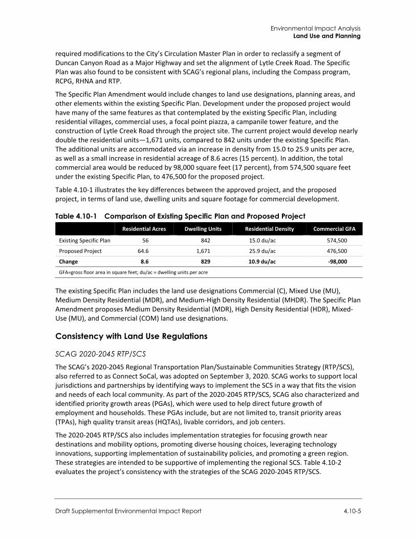
Environmental Impact Analysis Land Use and Planning
Draft Supplemental Environmental Impact Report 4.10-5
required modifications to the City’s Circulation Master Plan in order to reclassify a segment of Duncan Canyon Road as a Major Highway and set the alignment of Lytle Creek Road. The Specific Plan was also found to be consistent with SCAG’s regional plans, including the Compass program, RCPG, RHNA and RTP.
The Specific Plan Amendment would include changes to land use designations, planning areas, and other elements within the existing Specific Plan. Development under the proposed project would have many of the same features as that contemplated by the existing Specific Plan, including residential villages, commercial uses, a focal point piazza, a campanile tower feature, and the construction of Lytle Creek Road through the project site. The current project would develop nearly double the residential units—1,671 units, compared to 842 units under the existing Specific Plan. The additional units are accommodated via an increase in density from 15.0 to 25.9 units per acre, as well as a small increase in residential acreage of 8.6 acres (15 percent). In addition, the total commercial area would be reduced by 98,000 square feet (17 percent), from 574,500 square feet under the existing Specific Plan, to 476,500 for the proposed project.
Table 4.10-1 illustrates the key differences between the approved project, and the proposed project, in terms of land use, dwelling units and square footage for commercial development.
Table 4.10-1 Comparison of Existing Specific Plan and Proposed Project Residential Acres Dwelling Units Residential Density Commercial GFA
Existing Specific Plan 56 842 15.0 du/ac 574,500
Proposed Project 64.6 1,671 25.9 du/ac 476,500
Change 8.6 829 10.9 du/ac -98,000
GFA=gross floor area in square feet; du/ac = dwelling units per acre
The existing Specific Plan includes the land use designations Commercial (C), Mixed Use (MU), Medium Density Residential (MDR), and Medium-High Density Residential (MHDR). The Specific Plan Amendment proposes Medium Density Residential (MDR), High Density Residential (HDR), Mixed-Use (MU), and Commercial (COM) land use designations.
Consistency with Land Use Regulations
SCAG 2020-2045 RTP/SCS
The SCAG’s 2020-2045 Regional Transportation Plan/Sustainable Communities Strategy (RTP/SCS), also referred to as Connect SoCal, was adopted on September 3, 2020. SCAG works to support local jurisdictions and partnerships by identifying ways to implement the SCS in a way that fits the vision and needs of each local community. As part of the 2020-2045 RTP/SCS, SCAG also characterized and identified priority growth areas (PGAs), which were used to help direct future growth of employment and households. These PGAs include, but are not limited to, transit priority areas (TPAs), high quality transit areas (HQTAs), livable corridors, and job centers.
The 2020-2045 RTP/SCS also includes implementation strategies for focusing growth near destinations and mobility options, promoting diverse housing choices, leveraging technology innovations, supporting implementation of sustainability policies, and promoting a green region. These strategies are intended to be supportive of implementing the regional SCS. Table 4.10-2 evaluates the project’s consistency with the strategies of the SCAG 2020-2045 RTP/SCS.
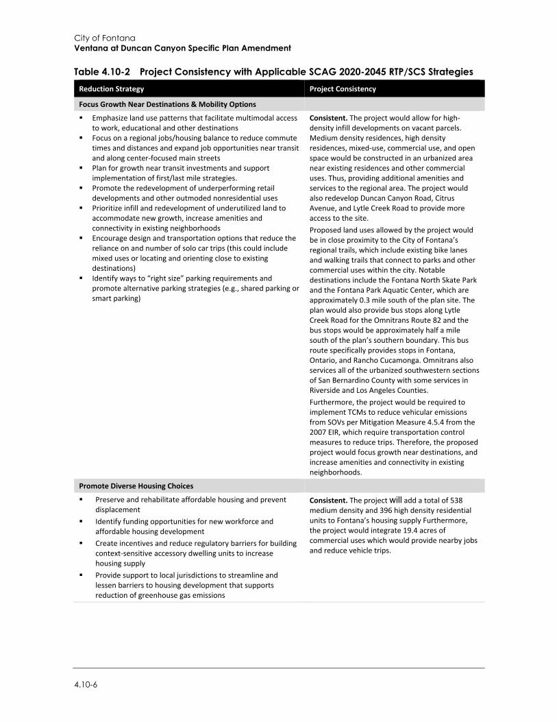
City of Fontana Ventana at Duncan Canyon Specific Plan Amendment
4.10-6
Table 4.10-2 Project Consistency with Applicable SCAG 2020-2045 RTP/SCS Strategies Reduction Strategy Project Consistency
Focus Growth Near Destinations & Mobility Options
Emphasize land use patterns that facilitate multimodal access to work, educational and other destinations
Focus on a regional jobs/housing balance to reduce commute times and distances and expand job opportunities near transit and along center-focused main streets
Plan for growth near transit investments and support implementation of first/last mile strategies.
Promote the redevelopment of underperforming retail developments and other outmoded nonresidential uses
Prioritize infill and redevelopment of underutilized land to accommodate new growth, increase amenities and connectivity in existing neighborhoods
Encourage design and transportation options that reduce the reliance on and number of solo car trips (this could include mixed uses or locating and orienting close to existing destinations)
Identify ways to “right size” parking requirements and promote alternative parking strategies (e.g., shared parking or smart parking)
Consistent. The project would allow for high-density infill developments on vacant parcels. Medium density residences, high density residences, mixed-use, commercial use, and open space would be constructed in an urbanized area near existing residences and other commercial uses. Thus, providing additional amenities and services to the regional area. The project would also redevelop Duncan Canyon Road, Citrus Avenue, and Lytle Creek Road to provide more access to the site. Proposed land uses allowed by the project would be in close proximity to the City of Fontana’s regional trails, which include existing bike lanes and walking trails that connect to parks and other commercial uses within the city. Notable destinations include the Fontana North Skate Park and the Fontana Park Aquatic Center, which are approximately 0.3 mile south of the plan site. The plan would also provide bus stops along Lytle Creek Road for the Omnitrans Route 82 and the bus stops would be approximately half a mile south of the plan’s southern boundary. This bus route specifically provides stops in Fontana, Ontario, and Rancho Cucamonga. Omnitrans also services all of the urbanized southwestern sections of San Bernardino County with some services in Riverside and Los Angeles Counties. Furthermore, the project would be required to implement TCMs to reduce vehicular emissions from SOVs per Mitigation Measure 4.5.4 from the 2007 EIR, which require transportation control measures to reduce trips. Therefore, the proposed project would focus growth near destinations, and increase amenities and connectivity in existing neighborhoods.
Promote Diverse Housing Choices
Preserve and rehabilitate affordable housing and prevent displacement
Identify funding opportunities for new workforce and affordable housing development
Create incentives and reduce regulatory barriers for building context-sensitive accessory dwelling units to increase housing supply
Provide support to local jurisdictions to streamline and lessen barriers to housing development that supports reduction of greenhouse gas emissions
Consistent. The project will add a total of 538 medium density and 396 high density residential units to Fontana’s housing supply Furthermore, the project would integrate 19.4 acres of commercial uses which would provide nearby jobs and reduce vehicle trips.
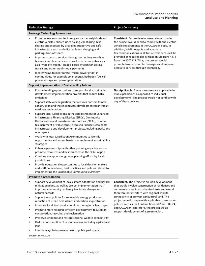
Environmental Impact Analysis Land Use and Planning
Draft Supplemental Environmental Impact Report 4.10-7
Reduction Strategy Project Consistency
Leverage Technology Innovations
Promote low emission technologies such as neighborhood electric vehicles, shared rides hailing, car sharing, bike sharing and scooters by providing supportive and safe infrastructure such as dedicated lanes, charging and parking/drop-off space
Improve access to services through technology—such as telework and telemedicine as well as other incentives such as a “mobility wallet,” an app-based system for storing transit and other multi-modal payments
Identify ways to incorporate “micro-power grids” in communities, for example solar energy, hydrogen fuel cell power storage and power generation
Consistent. Future development allowed under the project would need to comply with the electric vehicle requirements in the CALGreen code. In addition, Wi-Fi hotspots and adequate telecommunications in all future residences will be provided as required per Mitigation Measure 4.5.4 from the 2007 EIR. Thus, the project would promote low emission technologies and improve access to services through technology.
Support Implementation of Sustainability Policies
Pursue funding opportunities to support local sustainable development implementation projects that reduce GHG emissions
Support statewide legislation that reduces barriers to new construction and that incentivizes development near transit corridors and stations
Support local jurisdictions in the establishment of Enhanced Infrastructure Financing Districts (EIFDs), Community Revitalization and Investment Authorities (CRIAs), or other tax increment or value capture tools to finance sustainable infrastructure and development projects, including parks and open space
Work with local jurisdictions/communities to identify opportunities and assess barriers to implement sustainability strategies
Enhance partnerships with other planning organizations to promote resources and best practices in the SCAG region
Continue to support long range planning efforts by local jurisdictions
Provide educational opportunities to local decision makers and staff on new tools, best practices and policies related to implementing the Sustainable Communities Strategy
Not Applicable. These measures are applicable to municipal actions as opposed to individual developments. The project would not conflict with any of these policies.
Promote a Green Region
Support development of local climate adaptation and hazard mitigation plans, as well as project implementation that improves community resiliency to climate change and natural hazards
Support local policies for renewable energy production, reduction of urban heat islands and carbon sequestration
Integrate local food production into the regional landscape Promote more resource efficient development focused on
conservation, recycling and reclamation Preserve, enhance and restore regional wildlife connectivity Reduce consumption of resource areas, including agricultural
land Identify ways to improve access to public park space
Consistent. The project is an infill development that would involve construction of residences and commercial uses in an urbanized area and would therefore not interfere with regional wildlife connectivity or convert agricultural land. The project would comply with applicable conservation policies such as the Fontana General Plan, Title 24, and CALGreen. Therefore, the project would support development of a green region.
Source: SCAG 2020
City of Fontana Ventana at Duncan Canyon Specific Plan Amendment
4.10-8
A portion of the project would require a General Plan Amendment (GPA 21-0006) to amend a portion of the project from commercial to multi-family use. However, the project would be otherwise consistent.
The SCAQMD’s AQMP is discussed in Section 4.2, Air Quality. Future development under the proposed Specific Plan would need to comply with applicable regulations of the SCAQMD that implement the AQMP, including permits for activities and equipment which would generate pollutant emissions.
The Regional Water Quality Control Board’s Water Quality Control Plan for the Santa Ana River Basin is discussed in Section 4.9, Hydrology and Water Quality. The proposed project would implement stormwater pollution control measures to comply with the Water Quality Control Plan for the Santa Ana River Basin and the National Pollutant Discharge Elimination System (NPDES). No conflict is expected from the proposed project.
The project would have similar uses as the existing Specific Plan, with the biggest difference being the increases in residential density. Because of this, the amendment will be consistent with Fontana’s goal of introducing mixed use areas into the city. Future developments will comply with the City’s performance standards and the development policies for land use compatibility. Furthermore, future developments on the project site shall comply with the development and design standards of the revised Specific Plan. The proposed project would additionally be consistent with all applicable 2020 RTP/SCS goals. Thus, the project would not cause a significant environmental impact due to a conflict with any land use plan, policy, or regulation adopted for the purpose of avoiding or mitigating an environmental effect. Impacts would be less than significant.
Mitigation Measures Mitigation measures are not required.
4.10.4 Cumulative Impacts Planned and pending projects in Fontana and surrounding areas are listed in Table 3-1 in Section 3, Environmental Setting, and include residential, commercial, and industrial land uses. Cumulative development in the City and the surrounding area would modify existing land use patterns through the development of vacant lots or through redevelopment.
Similar to the project, land use regulations and policy consistency impacts associated with other cumulative projects would be addressed on a case-by-case basis in order to determine their consistency with applicable plans and policies. With approval of the proposed land use entitlements, the project would be consistent with the underlying land use regulations and policies. Therefore, the project would have a less than significant impact to cumulative land use.
Environmental Impact Analysis Noise
Draft Supplemental Environmental Impact Report 4.11-1
4.11 Noise
This section analyzes the noise effects of the proposed project and considers both the temporary noise impacts related to construction activity and long-term impacts associated with project operations. The analysis is based on data and information from the project-specific Noise and Vibration Study prepared by Rincon Consultants, Inc. (Appendix H).
4.11.1 Setting
a. Overview of Sound Measurement Sound is a vibratory disturbance created by a moving or vibrating source, which is capable of being detected by the hearing organs. Noise is defined as sound that is loud, unpleasant, unexpected, or undesired and may therefore be classified as a more specific group of sounds. The effects of noise on people can include general annoyance, interference with speech communication, sleep disturbance, and, in the extreme, hearing impairment (California Department of Transportation [Caltrans] 2013).
Noise levels are commonly measured in decibels (dB) using the A-weighted sound pressure level (dBA). The A-weighting scale is an adjustment to the actual sound pressure levels so that they are consistent with the human hearing response, which is most sensitive to frequencies around 4,000 Hertz and less sensitive to frequencies around and below 100 Hertz (Kinsler, et. al. 1999). Decibels are measured on a logarithmic scale that quantifies sound intensity in a manner similar to the Richter scale used to measure earthquake magnitudes. A doubling of the energy of a noise source, such as doubling of traffic volume, would increase the noise level by 3 dBA; reducing the energy in half would result in a 3 dBA decrease (Crocker 2007).
Human perception of noise has no simple correlation with sound energy: the perception of sound is not linear in terms of dBA or in terms of sound energy. Two sources do not “sound twice as loud” as one source. It is widely accepted that the average healthy ear can barely perceive changes of 3 dBA, increase or decrease (i.e., twice the sound energy); that a change of 5 dBA is readily perceptible (8 times the sound energy); and that an increase (or decrease) of 10 dBA sounds twice (half) as loud ([10.5x the sound energy] Crocker 2007).
Sound changes in both level and frequency spectrum as it travels from the source to the receiver. The most obvious change is the decrease in level as the distance from the source increases. The manner in which noise reduces with distance depends on factors such as the type of sources (e.g., point or line, the path the sound will travel, site conditions, and obstructions). Noise levels from a point source typically attenuate, or drop off, at a rate of 6 dBA per doubling of distance (e.g., construction, industrial machinery, ventilation units). Noise from a line source (e.g., roadway, pipeline, railroad) typically attenuates at about 3 dBA per doubling of distance (Caltrans 2013). The propagation of noise is also affected by the intervening ground, known as ground absorption. A hard site, such as a parking lot or smooth body of water, receives no additional ground attenuation and the changes in noise levels with distance (drop-off rate) result from simply the geometric spreading of the source. An additional ground attenuation value of 1.5 dBA per doubling of distance applies to a soft site (e.g., soft dirt, grass, or scattered bushes and trees) (Caltrans 2013). Noise levels may also be reduced by intervening structures. The amount of attenuation provided by this “shielding” depends on the size of the object and the frequencies of the noise levels. Natural terrain features such as hills and dense woods, and man-made features such as buildings and walls, can substantially
City of Fontana Ventana at Duncan Canyon Specific Plan Amendment
4.11-2
alter noise levels. Generally, any large structure blocking the line of sight will provide at least a 5-dBA reduction in source noise levels at the receiver (Federal Highway Administration [FHWA] 2011). Structures can substantially reduce exposure to noise as well. The FHWA’s guidelines indicate that modern building construction generally provides an exterior-to-interior noise level reduction of 20 to 35 dBA with closed windows.
The impact of noise is not a function of loudness alone. The time of day when noise occurs and the duration of the noise are also important factors of project noise impact. Most noise that lasts for more than a few seconds is variable in its intensity. Consequently, a variety of noise descriptors have been developed. One of the most frequently used noise metrics is the equivalent noise level (Leq); it considers both duration and sound power level. Leq is defined as the single steady A-weighted level equivalent to the same amount of energy as that contained in the actual fluctuating levels over time. Typically, Leq is summed over a one-hour period. Lmax is the highest root mean squared (RMS) sound pressure level within the sampling period, and Lmin is the lowest RMS sound pressure level within the measuring period (Crocker 2007).
Noise that occurs at night tends to be more disturbing than that occurring during the day. Community noise is usually measured using Day-Night Average Level (Ldn), which is the 24-hour average noise level with a +10 dBA penalty for noise occurring during nighttime (10:00 p.m. to 7:00 a.m.) hours; it is also measured using Community Noise Equivalent Level (CNEL), which is the 24-hour average noise level with a +5 dBA penalty for noise occurring from 7:00 p.m. to 10:00 p.m. and a +10 dBA penalty for noise occurring from 10:00 p.m. to 7:00 a.m. (Caltrans 2013). Noise levels described by Ldn and CNEL usually differ by about 1 dBA or less. The relationship between the peak-hour Leq value and the Ldn/CNEL depends on the distribution of traffic during the day, evening, and night. Quiet suburban areas typically have CNEL noise levels in the range of 40 to 50 dBA, while areas near arterial streets are in the 50 to 60-plus CNEL range. Normal conversational levels are in the 60 to 65-dBA Leq range; ambient noise levels greater than 65 dBA Leq can interrupt conversations (Federal Transit Administration [FTA] 2018).
b. Vibration Groundborne vibration of concern in environmental analysis consists of the oscillatory waves that move from a source through the ground to adjacent structures. The number of cycles per second of oscillation makes up the vibration frequency, described in terms of Hz. The frequency of a vibrating object describes how rapidly it oscillates. The normal frequency range of most groundborne vibration that can be felt by the human body starts from a low frequency of less than 1 Hz and goes to a high of about 200 Hz (Crocker 2007).
While people have varying sensitivities to vibrations at different frequencies, in general they are most sensitive to low-frequency vibration. Vibration in buildings, such as from nearby construction activities, may cause windows, items on shelves, and pictures on walls to rattle. Vibration of building components can also take the form of an audible low-frequency rumbling noise, referred to as groundborne noise. Groundborne noise is usually only a problem when the originating vibration spectrum is dominated by frequencies in the upper end of the range (60 to 200 Hz), or when foundations or utilities, such as sewer and water pipes, physically connect the structure and the vibration source (FTA 2018). Although groundborne vibration is sometimes noticeable in outdoor environments, it is almost never annoying to people who are outdoors. The primary concern from vibration is that it can be intrusive and annoying to building occupants and vibration-sensitive land uses.
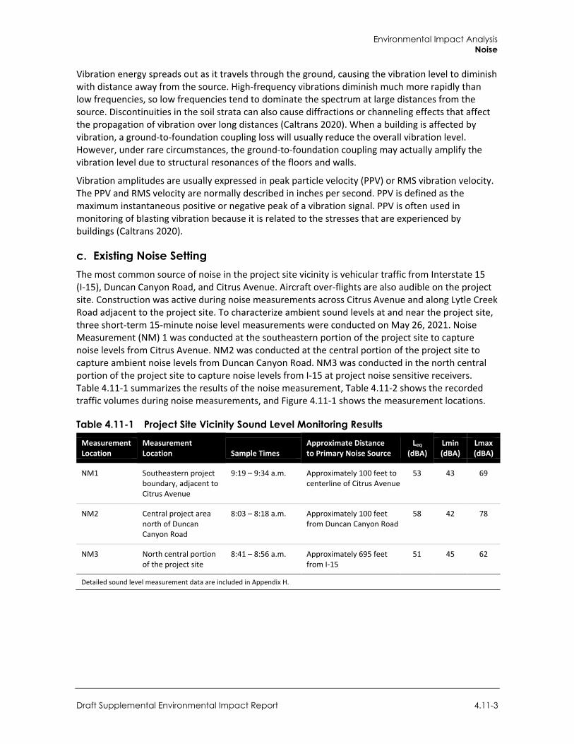
Environmental Impact Analysis Noise
Draft Supplemental Environmental Impact Report 4.11-3
Vibration energy spreads out as it travels through the ground, causing the vibration level to diminish with distance away from the source. High-frequency vibrations diminish much more rapidly than low frequencies, so low frequencies tend to dominate the spectrum at large distances from the source. Discontinuities in the soil strata can also cause diffractions or channeling effects that affect the propagation of vibration over long distances (Caltrans 2020). When a building is affected by vibration, a ground-to-foundation coupling loss will usually reduce the overall vibration level. However, under rare circumstances, the ground-to-foundation coupling may actually amplify the vibration level due to structural resonances of the floors and walls.
Vibration amplitudes are usually expressed in peak particle velocity (PPV) or RMS vibration velocity. The PPV and RMS velocity are normally described in inches per second. PPV is defined as the maximum instantaneous positive or negative peak of a vibration signal. PPV is often used in monitoring of blasting vibration because it is related to the stresses that are experienced by buildings (Caltrans 2020).
c. Existing Noise Setting The most common source of noise in the project site vicinity is vehicular traffic from Interstate 15 (I-15), Duncan Canyon Road, and Citrus Avenue. Aircraft over-flights are also audible on the project site. Construction was active during noise measurements across Citrus Avenue and along Lytle Creek Road adjacent to the project site. To characterize ambient sound levels at and near the project site, three short-term 15-minute noise level measurements were conducted on May 26, 2021. Noise Measurement (NM) 1 was conducted at the southeastern portion of the project site to capture noise levels from Citrus Avenue. NM2 was conducted at the central portion of the project site to capture ambient noise levels from Duncan Canyon Road. NM3 was conducted in the north central portion of the project site to capture noise levels from I-15 at project noise sensitive receivers. Table 4.11-1 summarizes the results of the noise measurement, Table 4.11-2 shows the recorded traffic volumes during noise measurements, and Figure 4.11-1 shows the measurement locations.
Table 4.11-1 Project Site Vicinity Sound Level Monitoring Results
Measurement Location
Measurement Location Sample Times
Approximate Distance to Primary Noise Source
Leq (dBA)
Lmin (dBA)
Lmax (dBA)
NM1 Southeastern project boundary, adjacent to Citrus Avenue
9:19 – 9:34 a.m. Approximately 100 feet to centerline of Citrus Avenue
53 43 69
NM2 Central project area north of Duncan Canyon Road
8:03 – 8:18 a.m. Approximately 100 feet from Duncan Canyon Road
58 42 78
NM3 North central portion of the project site
8:41 – 8:56 a.m. Approximately 695 feet from I-15
51 45 62
Detailed sound level measurement data are included in Appendix H.
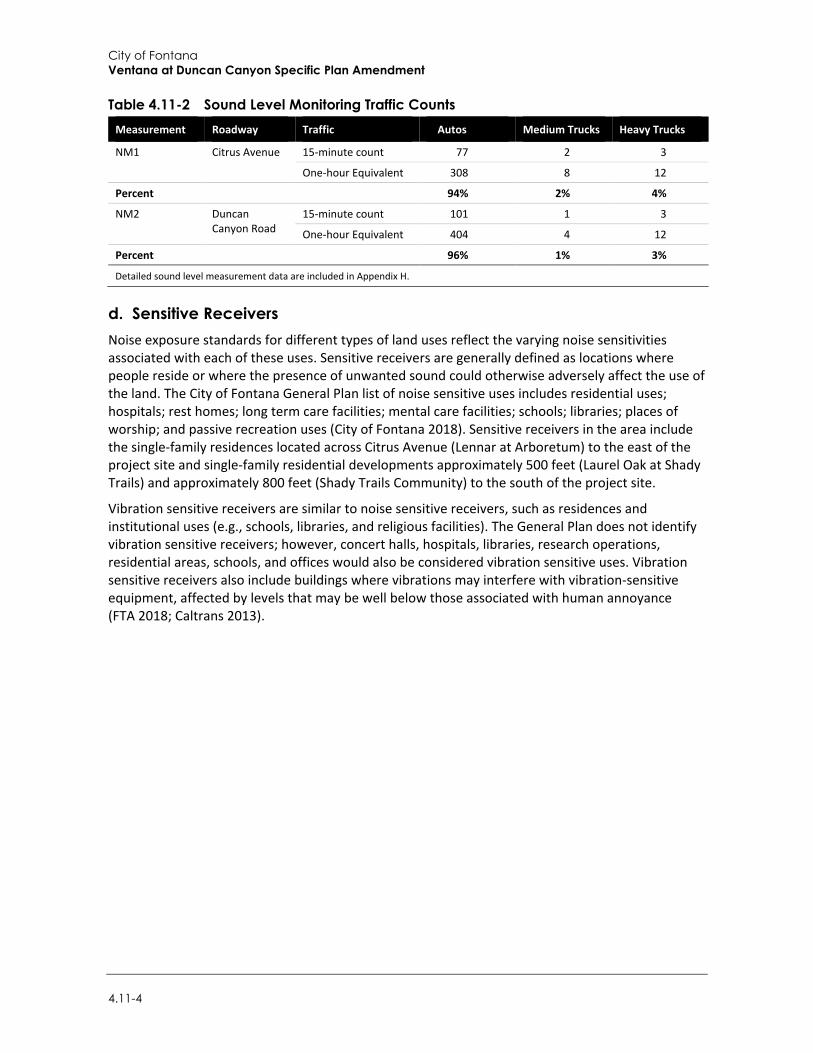
City of Fontana Ventana at Duncan Canyon Specific Plan Amendment
4.11-4
Table 4.11-2 Sound Level Monitoring Traffic Counts Measurement Roadway Traffic Autos Medium Trucks Heavy Trucks
NM1 Citrus Avenue 15-minute count 77 2 3
One-hour Equivalent 308 8 12
Percent 94% 2% 4%
NM2 Duncan Canyon Road
15-minute count 101 1 3
One-hour Equivalent 404 4 12
Percent 96% 1% 3%
Detailed sound level measurement data are included in Appendix H.
d. Sensitive Receivers Noise exposure standards for different types of land uses reflect the varying noise sensitivities associated with each of these uses. Sensitive receivers are generally defined as locations where people reside or where the presence of unwanted sound could otherwise adversely affect the use of the land. The City of Fontana General Plan list of noise sensitive uses includes residential uses; hospitals; rest homes; long term care facilities; mental care facilities; schools; libraries; places of worship; and passive recreation uses (City of Fontana 2018). Sensitive receivers in the area include the single-family residences located across Citrus Avenue (Lennar at Arboretum) to the east of the project site and single-family residential developments approximately 500 feet (Laurel Oak at Shady Trails) and approximately 800 feet (Shady Trails Community) to the south of the project site.
Vibration sensitive receivers are similar to noise sensitive receivers, such as residences and institutional uses (e.g., schools, libraries, and religious facilities). The General Plan does not identify vibration sensitive receivers; however, concert halls, hospitals, libraries, research operations, residential areas, schools, and offices would also be considered vibration sensitive uses. Vibration sensitive receivers also include buildings where vibrations may interfere with vibration-sensitive equipment, affected by levels that may be well below those associated with human annoyance (FTA 2018; Caltrans 2013).
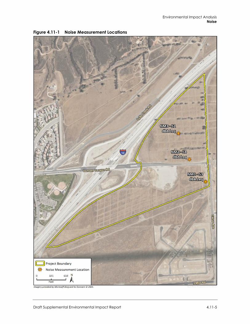
Environmental Impact Analysis Noise
Draft Supplemental Environmental Impact Report 4.11-5
Figure 4.11-1 Noise Measurement Locations
City of Fontana Ventana at Duncan Canyon Specific Plan Amendment
4.11-6
4.11.2 Regulatory Setting
a. Federal Regulations
FTA Transit and Noise Vibration Impact Assessment Manual The FTA provides reasonable criteria for assessing construction noise impacts based on the potential for adverse community reaction in their Transit and Noise Vibration Impact Assessment Manual (FTA 2018). For residential, commercial, and industrial uses, the daytime noise threshold is 80 dBA Leq, 85 dBA Leq, and 90 dBA Leq for an 8-hour period, respectively.
b. State Regulations California regulates freeway noise, sets standards for sound transmission, provides occupational noise control criteria, identifies noise standards, and provides guidance for local land use compatibility. California law requires each county and city to adopt a General Plan that includes a Noise Element prepared based on guidelines adopted by the Governor’s Office of Planning and Research. The purpose of the Noise Element is to limit the exposure of the community to excessive noise levels. CEQA requires known environmental effects of a project be analyzed, including environmental noise impacts.
California Noise Control Act of 1973 California Health and Safety Code Sections 46000 through 46080, known as the California Noise Control Act, find that excessive noise is a serious hazard to public health and welfare and that exposure to certain levels of noise can result in physiological, psychological, and economic damage. The act also finds that there is a continuous and increasing bombardment of noise in urban, suburban, and rural areas. The California Noise Control Act declares that the State of California has a responsibility to protect the health and welfare of its citizens by the control, prevention, and abatement of noise. It is the policy of the State to provide an environment for all Californians that is free from noise that jeopardizes their health or welfare.
California Building Code California Code of Regulations Title 24, Building Standards Administrative Code, Part 2, and the California Building Code codify the state noise insulation standards. These noise standards apply to new construction in California to control interior noise levels as they are affected by exterior noise sources. The regulations specify that interior noise levels for residential and school land uses should not exceed 45 dBA CNEL.
c. Local Regulations
City of Fontana General Plan
The City maintains the health and welfare of its residents with respect to noise through abatement ordinances and land use planning. The Fontana General Plan Noise and Safety chapter includes goals and policies with the intent to reduce excessive noise impacts:
Goal 8: The City of Fontana protects sensitive land uses from excessive noise by diligent` planning through 2035.
Environmental Impact Analysis Noise
Draft Supplemental Environmental Impact Report 4.11-7
Policies:
New sensitive land uses shall be prohibited in incompatible areas. Noise-tolerant land uses shall be guided into areas irrevocably committed to land uses
that are noise-producing, such as transportation corridors. Where sensitive uses are to be placed along transportation routes, mitigation shall be
provided to ensure compliance with state- mandated noise levels. Noise spillover or encroachment from commercial, industrial, and educational land uses
shall be minimized into adjoining residential neighborhoods or noise-sensitive uses.
Actions:
A. The following uses shall be considered noise-sensitive and discouraged in areas in excess of 65 dBA CNEL (Community Noise Equivalent Level): Residential Uses; Hospitals; Rest Homes; Long Term Care Facilities; and Mental Care Facilities.
B. The following uses shall be considered noise-sensitive and discouraged in areas in excess of 65 Leq (12) (Equivalent Continuous Sound Level): Schools; Libraries; Places of Worship; and Passive Recreation Uses.
C. The State of California Office of Planning and Research General Plan Guidelines shall be followed with respect to acoustical study requirements.
Goal 9: The City of Fontana provides a diverse and efficiently operated ground transportation system that generates the minimum feasible noise on its residents through 2035.
Policies:
All noise sections of the State Motor Vehicle Code shall be enforced. Roads shall be maintained such that the paving is in good condition and free of cracks,
bumps, and potholes. Noise mitigation measures shall be included in the design of new roadway projects in
the city.
Actions:
A. On-road trucking activities shall continue to be regulated in the City to ensure noise impacts are minimized, including, including the implementation of truck-routes based on traffic studies.
B. Development that generates increased traffic and subsequent increases in the ambient noise level adjacent to noise-sensitive land uses shall provide appropriate mitigation measures.
C. Noise mitigation practices shall be employed when designing all future streets and highways, and when improvements occur along existing highway segments.
D. Explore the use of “quiet pavement” materials for street improvements
Goal 10: Fontana’s residents are protected from the negative effects of “spillover” noise.
Policy:
Residential land uses and areas identified as noise-sensitive shall be protected from excessive noise from non-transportation sources including industrial, commercial, and residential activities and equipment.
City of Fontana Ventana at Duncan Canyon Specific Plan Amendment
4.11-8
Actions:
A. Projects located in commercial areas shall not exceed stationary- source noise standards at the property line of proximate residential or commercial uses.
B. Industrial uses shall not exceed commercial or residential stationary source noise standards at the most proximate land uses.
C. Non-transportation noise shall be considered in land use planning decisions. D. Construction shall be performed as quietly as feasible when performed in proximity to
residential or other noise sensitive land uses.
City of Fontana Municipal Code Chapter 18, Article II (Noise) and Chapter 30 Articles V (Residential Zoning Districts) and VII (Industrial Zoning Districts) of the Fontana Municipal Code seeks to control unnecessary, excessive, and annoying noise and vibration. As applicable to the proposed project, the code prohibits the following acts, which create loud, excessive, impulsive or intrusive sound or noise:
Section 18-63(b)(6), Loading, unloading or opening boxes. The creation of a loud, excessive, impulsive or intrusive and excessive noise in connection with loading or unloading of any vehicle or the opening and destruction of bales, boxes, crates and containers within 50 feet or more from the edge of the property.
Section 18-63(b)(7), Construction or repairing of buildings or structures. The erection (including excavating), demolition, alteration or repair of any building or structure other than between the hours of 7:00 a.m. and 6:00 p.m. on weekdays and between the hours of 8:00 a.m. and 5:00 p.m. on Saturdays, except in case of urgent necessity in the interest of public health and safety Project construction noise is therefore permissible if activities occur within the hours specified in the City of Fontana Municipal Code, Section 18-63(7) of 7:00 a.m. to 6:00 p.m. on weekdays and between the hours of 8:00 a.m. to 5:00 p.m. on Saturdays. However, if activity occurs outside of these hours, the City of Fontana stationary-source (operational) noise level standards of 70 dBA Leq during the daytime hours, and 65 dBA Leq during the nighttime hours shall apply.
Section 18-63(b)(8), Noise near schools, courts, place of worship or hospitals. The creation of any loud, excessive, impulsive or intrusive noise on any street adjacent to any school, institution of learning, places of worship or court while the premises are in use, or adjacent to any hospital which unreasonably interferes with the workings of such institution, or which disturbs or unduly annoys patients in the hospital; provided conspicuous signs are displayed in such streets indicating that the street is a school, hospital or court street.
Section 18-63(b)(10), Piledrivers, hammers, etc. The operation between the hours of 6:00 p.m. and 7:00 a.m. of any piledriver, steamshovel, pneumatic hammer, derrick, steam or electric hoist or other appliance, the use of which is attended by loud, excessive, impulsive or intrusive noise.
Section 18-63(b)(11), Blowers. The operation of any noise-creating blower or power fan or any internal combustion engine other than from the hours of 7:00 a.m. and 6:00 p.m. on a weekday and the hours of 8:00 a.m. and 5:00 p.m. on a Saturday, the operation of which causes noise due to the explosion of operating gases or fluids, unless the noise from such blower or fan is muffled and such engine is equipped with a muffler device sufficient to deaden such noise.
Section 30-469 states that no use shall create or cause to be created any sound that exceeds the ambient noise standards in Table 4.11-3 in residential zones.
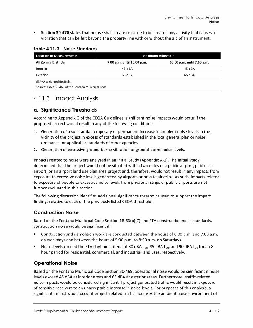
Environmental Impact Analysis Noise
Draft Supplemental Environmental Impact Report 4.11-9
Section 30-470 states that no use shall create or cause to be created any activity that causes a vibration that can be felt beyond the property line with or without the aid of an instrument.
Table 4.11-3 Noise Standards Location of Measurements Maximum Allowable
All Zoning Districts 7:00 a.m. until 10:00 p.m. 10:00 p.m. until 7:00 a.m.
Interior 45 dBA 45 dBA
Exterior 65 dBA 65 dBA
dBA=A-weighted decibels.
Source: Table 30-469 of the Fontana Municipal Code
4.11.3 Impact Analysis
a. Significance Thresholds According to Appendix G of the CEQA Guidelines, significant noise impacts would occur if the proposed project would result in any of the following conditions:
Generation of a substantial temporary or permanent increase in ambient noise levels in the vicinity of the project in excess of standards established in the local general plan or noise ordinance, or applicable standards of other agencies.
Generation of excessive ground-borne vibration or ground-borne noise levels.
Impacts related to noise were analyzed in an Initial Study (Appendix A-2). The Initial Study determined that the project would not be situated within two miles of a public airport, public use airport, or an airport land use plan area project and, therefore, would not result in any impacts from exposure to excessive noise levels generated by airports or private airstrips. As such, impacts related to exposure of people to excessive noise levels from private airstrips or public airports are not further evaluated in this section.
The following discussion identifies additional significance thresholds used to support the impact findings relative to each of the previously listed CEQA threshold.
Construction Noise Based on the Fontana Municipal Code Section 18-63(b)(7) and FTA construction noise standards, construction noise would be significant if:
Construction and demolition work are conducted between the hours of 6:00 p.m. and 7:00 a.m. on weekdays and between the hours of 5:00 p.m. to 8:00 a.m. on Saturdays.
Noise levels exceed the FTA daytime criteria of 80 dBA Leq, 85 dBA Leq, and 90 dBA Leq for an 8-hour period for residential, commercial, and industrial land uses, respectively.
Operational Noise Based on the Fontana Municipal Code Section 30-469, operational noise would be significant if noise levels exceed 45 dBA at interior areas and 65 dBA at exterior areas. Furthermore, traffic-related noise impacts would be considered significant if project-generated traffic would result in exposure of sensitive receivers to an unacceptable increase in noise levels. For purposes of this analysis, a significant impact would occur if project-related traffic increases the ambient noise environment of
City of Fontana Ventana at Duncan Canyon Specific Plan Amendment
4.11-10
noise-sensitive land uses by 3 dBA or more if the locations are subject to noise levels in excess of conditionally compatible levels, or by 5 dBA or more if the locations are not subject to noise levels in excess of the conditionally compatible levels identified in the City of Fontana General Plan.
Groundborne Vibration Vibration levels equal to or below 0.4 in./sec. PPV at residential structures would prevent structural damage for most residential building and vibration levels equal to or less than 1.0 in./sec. PPV would prevent damage to more substantial construction, such as high-rise, commercial, and industrial buildings. Therefore, for the purpose of this analysis, vibration levels above 0.4 in./sec. PPV at residential structures and/or vibration levels above 1.0 in./sec. PPV at commercial and industrial buildings would be significant. For human annoyance, the vibration level threshold at which transient, or temporary, vibration sources are considered distinctly perceptible is 0.24 in./sec. PPV.
b. Methodology
Construction Noise Construction noise was estimated using the FHWA Roadway Construction Noise Model (RCNM) (FHWA 2006). RCNM predicts construction noise levels for a variety of construction operations based on empirical data and the application of acoustical propagation formulas. Using RCNM, construction noise levels were estimated at noise sensitive receivers near the project site. RCNM provides reference noise levels for standard construction equipment, with an attenuation rate of 6 dBA per doubling of distance for stationary equipment.
Construction activity would result in temporary noise in the project site vicinity, exposing surrounding nearby receivers to increased noise levels. Construction noise would typically be higher during the heavier periods of initial construction (i.e., site preparation and grading) and would be lower during the later construction phases (i.e., building construction and paving). Typical heavy construction equipment during project grading could include dozers, loaders, graders, and dump trucks. It is assumed that diesel engines would power all construction equipment. Construction equipment would not all operate at the same time or location. In addition, construction equipment would not be in constant use during the 8-hour operating day.
Project construction would occur nearest to single-family residences to the east (Arboretum Specific Plan) and south (Citrus Heights North Specific Plan) of the project site. Over the course of a typical construction day, construction equipment would be located as close as 300 feet and 400 feet to properties east and south, respectively, but would typically be located at an average distance farther away due to the nature of construction and the size of the project. Therefore, it is assumed that over the course of a typical construction day the construction equipment would operate at an average distance 350 feet from the single-family residences to the east and 450 feet from single family residences to the south of the project site.
Construction noise is typically loudest during activities that involve excavation and move soil, such as site preparation and grading. A potential high-intensity construction scenario includes a grader, loader, dozer, and dump truck working during grading to excavate and move soil. At a distance of 350 feet and 450 feet, a grader, a front-end loader, a dozer, and a dump truck would generate a noise level of 64 dBA Leq and 62 dBA Leq, respectively (RCNM calculations are included in Appendix H).
Environmental Impact Analysis Noise
Draft Supplemental Environmental Impact Report 4.11-11
Operational Noise On-site noise source would include general conversations, landscape maintenance, waste hauling, loading dock, parking lot, and the heating, ventilation, and air conditioning (HVAC) equipment. General conversations would not represent a substantial noise source due to the noise levels associated with conversations and as the pool areas (i.e., areas where larger gatherings might occur) are located internally to the project site and are far away from off-site sensitive receivers. Landscape maintenance and waste hauling typically occur during the less noise sensitive daytime hours and would be active for short periods of time.
Heating, Ventilation, and Air Conditioning Units
Noise-generating mechanical equipment on building rooftops include HVAC units. The equipment was assumed to be placed on the approximate center of the rooftop; noise levels for the equipment are described below. This analysis conservatively assumes the equipment would operate continuously for a full hour (100 percent for 60 minutes) during the daytime and nighttime. For a conservative assessment, it has been assumed that the equipment would not include any type of screening. Noise propagation was estimated in SoundPLAN using algorithms from ISO Standard 9613-2, “Attenuation of Sound during Propagation Outdoors, Part 2: General Method of Calculation.”
Based upon one ton of HVAC per 600 sf of building space and the square footage of each proposed building shown on the conceptual site plan, 10-ton Trane T/YHC120E HVAC units of 87 dB were selected for analysis. Appendix H includes manufacturer’s specifications and additional assumptions.
Traffic Noise
Noise affecting the project site is primarily from traffic on I-15, Duncan Canyon Road, and Citrus Avenue. Future noise levels affecting the compatibility of the project site were estimated in SoundPLAN using algorithms and reference traffic noise reference levels from the FHWA’s Traffic Noise Model (TNM). The off-site traffic noise increases were modeled with the FHWA RD-77-108 Traffic Noise Prediction Model.
The traffic vehicle classification mix for I-15 was based on Caltrans Truck Counts (Caltrans 2016). I-15 was modeled with a vehicle classification mix of 94.4 percent automobiles, 2.5 percent medium trucks, and 3.1 percent heavy trucks and a posted speed limit of 65 miles per hour (mph).
Future traffic volumes on local roadways were obtained from the Ventana Specific Plan Amendment Traffic Study (Urban Crossroads 2021; Appendix I). Refer to Appendix H for details regarding traffic volumes used for modeling purposes. The posted speed limits on Duncan Canyon Road, Citrus Avenue, Casa Grande, Summit Avenue, Sierra Avenue and Lytle Creek Drive are 45 mph, 40 to 45 mph, 35 mph, 45 to 50 mph, 55 mph, and 35 mph, respectively. Traffic counts conducted during noise monitoring consisted of primarily active construction traffic vehicles and are not considered representative of typical vehicle classification mix for Specific Plan area roadways. Therefore, the vehicle classification mix for modeling assumes a typical breakdown of 96 percent automobiles, 2.5 percent medium trucks, and 1.5 percent heavy trucks for local roadways.
Traffic distribution through the day was modeled assuming 75 percent of total daily vehicle traffic during daytime hours, 15 percent of daily vehicle traffic during evening hours, and 10 percent of daily vehicle traffic during nighttime hours. For determining noise-land use compatibility, exterior traffic noise levels at the residential exterior common use areas (pool areas) and residential building
City of Fontana Ventana at Duncan Canyon Specific Plan Amendment
4.11-12
façades were calculated. Receivers were placed on the ground floor at 5 feet above ground level; receivers at 2nd and 3rd stories were placed 15 and 25 feet above ground level.
Groundborne Vibration The project does not include any substantial vibration sources associated with operation. Thus, construction activities have the greatest potential to generate groundborne vibration affecting nearby receivers, especially during grading and excavation of the project site. The greatest vibratory source during construction within the project vicinity would be a vibratory roller. Neither blasting nor pile driving would be required for construction of the project. Construction vibration estimates are based on vibration levels reported by Caltrans and the FTA (Caltrans 2020, FTA 2018). Table 4.11-4 shows typical vibration levels for various pieces of construction equipment used in the assessment of construction vibration (FTA 2018).
Table 4.11-4 Vibration Levels Measured during Construction Activities Equipment PPV at 25 ft. (in/sec)
Large Bulldozer 0.089
Loaded Trucks 0.076
Small Bulldozer 0.003
Source: FTA 2018
Vibration limits used in this analysis to determine a potential impact to local land uses from construction activities, such as blasting, pile-driving, vibratory compaction, demolition, drilling, or excavation, are based on information contained in Caltrans’ Transportation and Construction Vibration Guidance Manual and the Federal Transit Administration and the FTA Transit Noise and Vibration Impact Assessment Manual (Caltrans 2020; FTA 2018). Maximum recommended vibration limits by the American Association of State Highway and Transportation Officials (AASHTO) are identified in Table 4.11-5.
Table 4.11-5 AASHTO Maximum Vibration Levels for Preventing Damage Type of Situation Limiting Velocity (in/sec)
Historic sites or other critical locations 0.1
Residential buildings, plastered walls 0.2–0.3
Residential buildings in good repair with gypsum board walls 0.4–0.5
Engineered structures, without plaster 1.0–1.5
Source: Caltrans 2020
Based on AASHTO recommendations, limiting vibration levels to below 0.2 in/sec PPV at residential structures would prevent structural damage regardless of building construction type. These limits are applicable regardless of the frequency of the source. However, as shown in Table 4.11-6 and Table 4.11-7 potential human annoyance associated with vibration is usually different if it is generated by a steady state or a transient vibration source.
Environmental Impact Analysis Noise
Draft Supplemental Environmental Impact Report 4.11-13
Table 4.11-6 Human Response to Steady State Vibration PPV (in/sec) Human Response
3.6 (at 2 Hz)–0.4 (at 20 Hz) Very disturbing
0.7 (at 2 Hz)–0.17 (at 20 Hz) Disturbing
0.10 Strongly perceptible
0.035 Distinctly perceptible
0.012 Slightly perceptible
Source: Caltrans 2020
Table 4.11-7 Human Response to Transient Vibration PPV (in/sec) Human Response
2.0 Severe
0.9 Strongly perceptible
0.24 Distinctly perceptible
0.035 Barely perceptible
Source: Caltrans 2020
As shown in Table 4.11-7, the vibration level threshold at which transient vibration sources (such as construction equipment) are considered distinctly perceptible is 0.24 in/sec PPV. This analysis uses the distinctly perceptible threshold for purposes of assessing vibration impacts.
Although groundborne vibration is sometimes noticeable in outdoor environments, it is almost never annoying to people who are outdoors; therefore, the vibration level threshold is assessed at occupied structures (FTA 2018). Therefore, all vibration impacts are assessed at the structure of an affected property.
c. Project Impacts
Threshold 1: Would the proposed project generate a substantial temporary increase in ambient noise levels in the vicinity of the project in excess of standards established in the local general plan or noise ordinance, or applicable standards of other agencies?
Impact N-1 TEMPORARY CONSTRUCTION ACTIVITIES WOULD BE RESTRICTED TO THE HOURS SPECIFIED BY THE CITY’S NOISE ORDINANCE AND WOULD NOT EXCEED THE FTA NOISE LIMITS. TEMPORARY CONSTRUCTION-RELATED NOISE IMPACTS WOULD BE LESS THAN SIGNIFICANT.
A grader, a front-end loader, a dozer, and a dump truck would generate a noise level of 64 dBA Leq at a distance of 350 feet from the source and 62 dBA Leq at a distance of 450 feet from the source. The project would not be constructed all at once but built out in six phases. Actual buildout would be subject to market and economic conditions, jurisdictional processing of approvals, and infrastructure timing, and may vary from the construction phasing currently anticipated. As the project Planning Areas are developed, residential uses in Planning Areas 1-A, 1-B, 3, and 4 may be exposed to other Planning Area construction noise. Table 4.11-8 shows the combined hourly and maximum construction noise levels attributable to construction of each Planning Area modeled, noise sensitive receivers analyzed, and resulting exterior and interior noise levels.
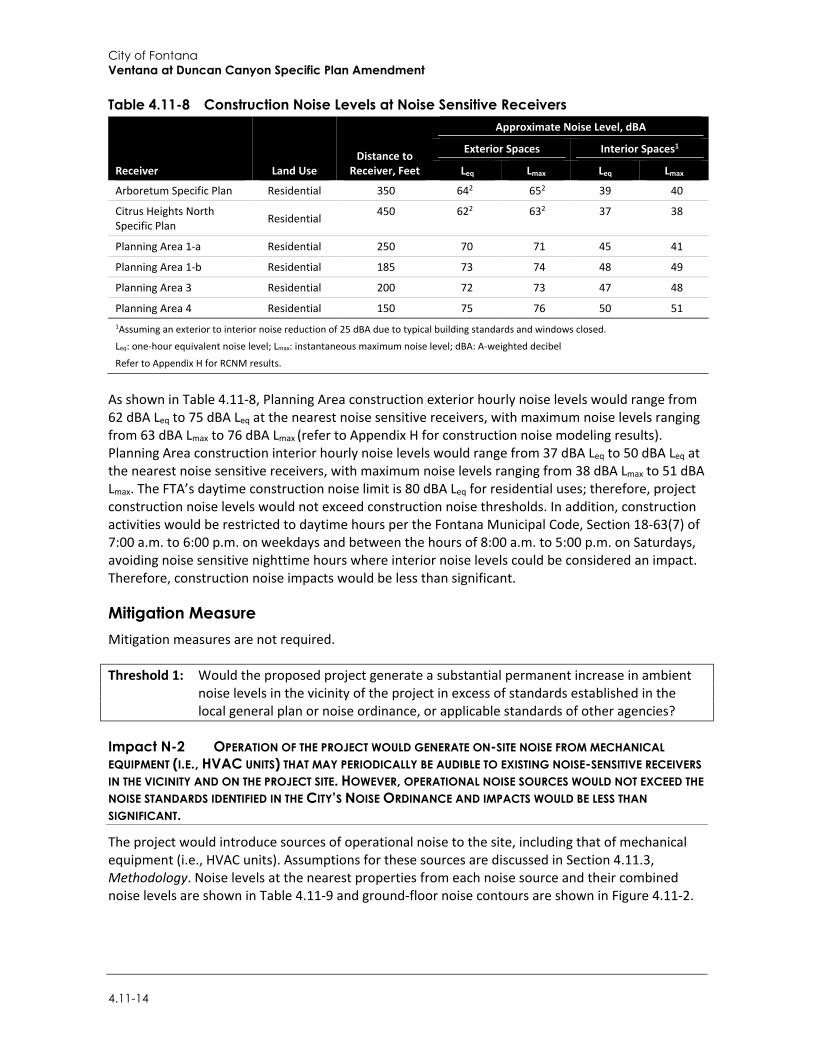
City of Fontana Ventana at Duncan Canyon Specific Plan Amendment
4.11-14
Table 4.11-8 Construction Noise Levels at Noise Sensitive Receivers
Receiver Land Use Distance to
Receiver, Feet
Approximate Noise Level, dBA Exterior Spaces Interior Spaces1
Leq Lmax Leq Lmax Arboretum Specific Plan Residential 350 642 652 39 40 Citrus Heights North Specific Plan Residential 450 622 632 37 38
Planning Area 1-a Residential 250 70 71 45 41 Planning Area 1-b Residential 185 73 74 48 49 Planning Area 3 Residential 200 72 73 47 48 Planning Area 4 Residential 150 75 76 50 51 1Assuming an exterior to interior noise reduction of 25 dBA due to typical building standards and windows closed.
Leq: one-hour equivalent noise level; Lmax: instantaneous maximum noise level; dBA: A-weighted decibel
Refer to Appendix H for RCNM results.
As shown in Table 4.11-8, Planning Area construction exterior hourly noise levels would range from 62 dBA Leq to 75 dBA Leq at the nearest noise sensitive receivers, with maximum noise levels ranging from 63 dBA Lmax to 76 dBA Lmax (refer to Appendix H for construction noise modeling results). Planning Area construction interior hourly noise levels would range from 37 dBA Leq to 50 dBA Leq at the nearest noise sensitive receivers, with maximum noise levels ranging from 38 dBA Lmax to 51 dBA Lmax. The FTA’s daytime construction noise limit is 80 dBA Leq for residential uses; therefore, project construction noise levels would not exceed construction noise thresholds. In addition, construction activities would be restricted to daytime hours per the Fontana Municipal Code, Section 18-63(7) of 7:00 a.m. to 6:00 p.m. on weekdays and between the hours of 8:00 a.m. to 5:00 p.m. on Saturdays, avoiding noise sensitive nighttime hours where interior noise levels could be considered an impact. Therefore, construction noise impacts would be less than significant.
Mitigation Measure Mitigation measures are not required.
Threshold 1: Would the proposed project generate a substantial permanent increase in ambient noise levels in the vicinity of the project in excess of standards established in the local general plan or noise ordinance, or applicable standards of other agencies?
Impact N-2 OPERATION OF THE PROJECT WOULD GENERATE ON-SITE NOISE FROM MECHANICAL EQUIPMENT (I.E., HVAC UNITS) THAT MAY PERIODICALLY BE AUDIBLE TO EXISTING NOISE-SENSITIVE RECEIVERS IN THE VICINITY AND ON THE PROJECT SITE. HOWEVER, OPERATIONAL NOISE SOURCES WOULD NOT EXCEED THE NOISE STANDARDS IDENTIFIED IN THE CITY’S NOISE ORDINANCE AND IMPACTS WOULD BE LESS THAN SIGNIFICANT.
The project would introduce sources of operational noise to the site, including that of mechanical equipment (i.e., HVAC units). Assumptions for these sources are discussed in Section 4.11.3, Methodology. Noise levels at the nearest properties from each noise source and their combined noise levels are shown in Table 4.11-9 and ground-floor noise contours are shown in Figure 4.11-2.
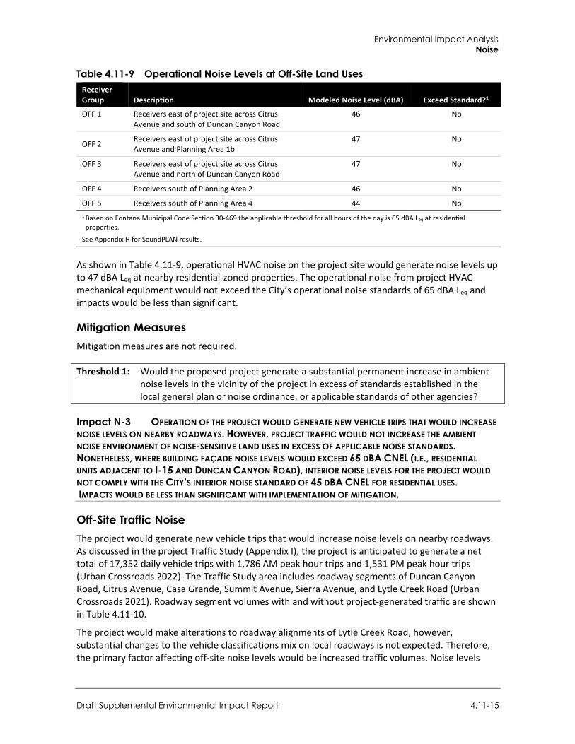
Environmental Impact Analysis Noise
Draft Supplemental Environmental Impact Report 4.11-15
Table 4.11-9 Operational Noise Levels at Off-Site Land Uses Receiver Group Description Modeled Noise Level (dBA) Exceed Standard?1
OFF 1 Receivers east of project site across Citrus Avenue and south of Duncan Canyon Road
46 No
OFF 2 Receivers east of project site across Citrus Avenue and Planning Area 1b
47 No
OFF 3 Receivers east of project site across Citrus Avenue and north of Duncan Canyon Road
47 No
OFF 4 Receivers south of Planning Area 2 46 No
OFF 5 Receivers south of Planning Area 4 44 No 1 Based on Fontana Municipal Code Section 30-469 the applicable threshold for all hours of the day is 65 dBA Leq at residential
properties.
See Appendix H for SoundPLAN results.
As shown in Table 4.11-9, operational HVAC noise on the project site would generate noise levels up to 47 dBA Leq at nearby residential-zoned properties. The operational noise from project HVAC mechanical equipment would not exceed the City’s operational noise standards of 65 dBA Leq and impacts would be less than significant.
Mitigation Measures Mitigation measures are not required.
Threshold 1: Would the proposed project generate a substantial permanent increase in ambient noise levels in the vicinity of the project in excess of standards established in the local general plan or noise ordinance, or applicable standards of other agencies?
Impact N-3 OPERATION OF THE PROJECT WOULD GENERATE NEW VEHICLE TRIPS THAT WOULD INCREASE NOISE LEVELS ON NEARBY ROADWAYS. HOWEVER, PROJECT TRAFFIC WOULD NOT INCREASE THE AMBIENT NOISE ENVIRONMENT OF NOISE-SENSITIVE LAND USES IN EXCESS OF APPLICABLE NOISE STANDARDS. NONETHELESS, WHERE BUILDING FAÇADE NOISE LEVELS WOULD EXCEED 65 DBA CNEL (I.E., RESIDENTIAL UNITS ADJACENT TO I-15 AND DUNCAN CANYON ROAD), INTERIOR NOISE LEVELS FOR THE PROJECT WOULD NOT COMPLY WITH THE CITY’S INTERIOR NOISE STANDARD OF 45 DBA CNEL FOR RESIDENTIAL USES. IMPACTS WOULD BE LESS THAN SIGNIFICANT WITH IMPLEMENTATION OF MITIGATION.
Off-Site Traffic Noise The project would generate new vehicle trips that would increase noise levels on nearby roadways. As discussed in the project Traffic Study (Appendix I), the project is anticipated to generate a net total of 17,352 daily vehicle trips with 1,786 AM peak hour trips and 1,531 PM peak hour trips (Urban Crossroads 2022). The Traffic Study area includes roadway segments of Duncan Canyon Road, Citrus Avenue, Casa Grande, Summit Avenue, Sierra Avenue, and Lytle Creek Road (Urban Crossroads 2021). Roadway segment volumes with and without project-generated traffic are shown in Table 4.11-10.
The project would make alterations to roadway alignments of Lytle Creek Road, however, substantial changes to the vehicle classifications mix on local roadways is not expected. Therefore, the primary factor affecting off-site noise levels would be increased traffic volumes. Noise levels
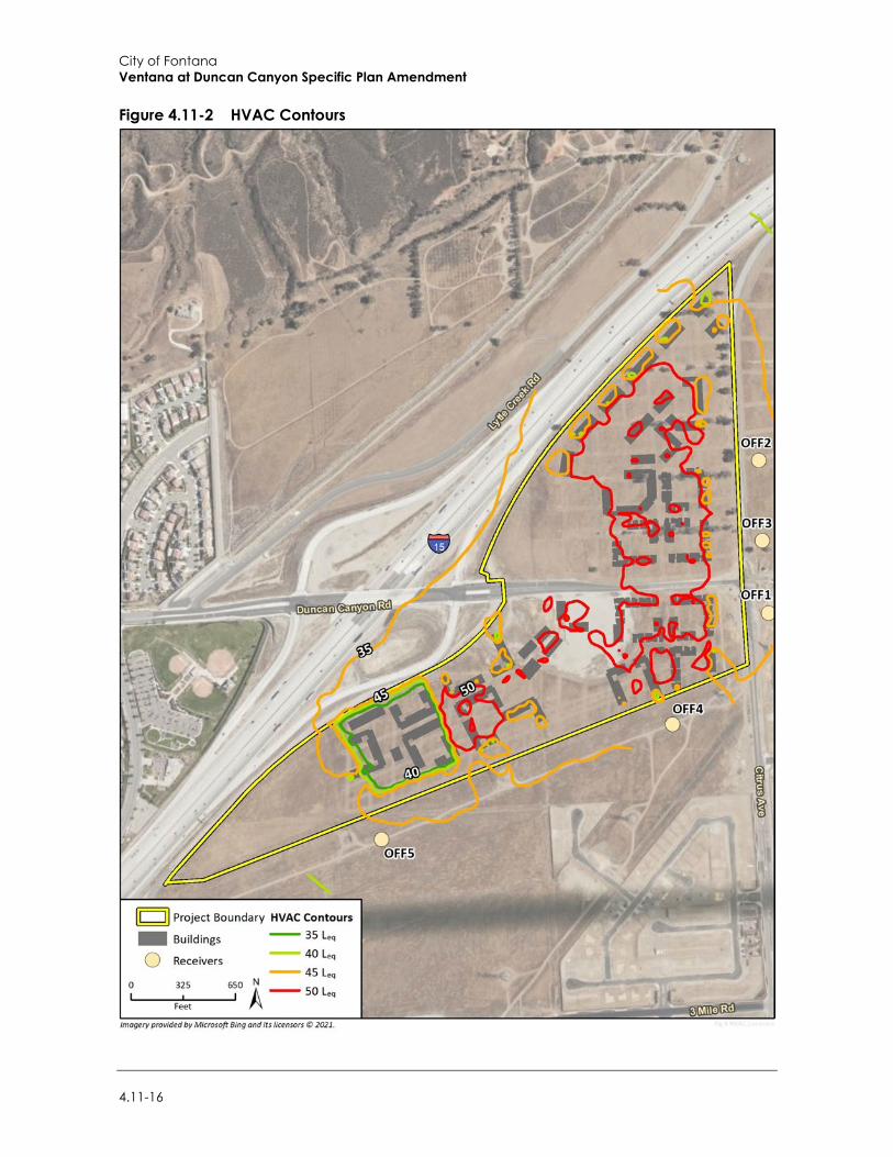
City of Fontana Ventana at Duncan Canyon Specific Plan Amendment
4.11-16
Figure 4.11-2 HVAC Contours
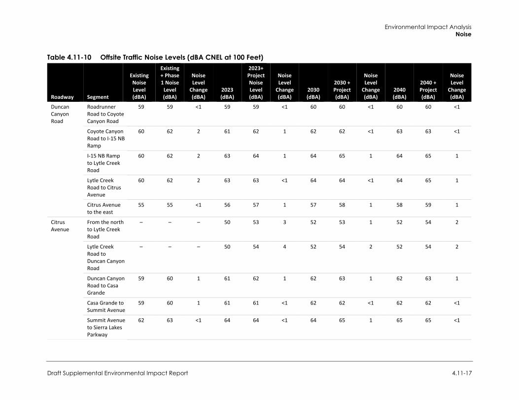
Environmental Impact Analysis Noise
Draft Supplemental Environmental Impact Report 4.11-17
Table 4.11-10 Offsite Traffic Noise Levels (dBA CNEL at 100 Feet)
Roadway Segment
Existing Noise Level (dBA)
Existing + Phase 1 Noise
Level (dBA)
Noise Level
Change (dBA)
2023
(dBA)
2023+ Project Noise Level (dBA)
Noise Level
Change (dBA)
2030 (dBA)
2030 + Project (dBA)
Noise Level
Change (dBA)
2040 (dBA)
2040 + Project (dBA)
Noise Level
Change (dBA)
Duncan Canyon Road
Roadrunner Road to Coyote Canyon Road
59 59 <1 59 59 <1 60 60 <1 60 60 <1
Coyote Canyon Road to I-15 NB Ramp
60 62 2 61 62 1 62 62 <1 63 63 <1
I-15 NB Ramp to Lytle Creek Road
60 62 2 63 64 1 64 65 1 64 65 1
Lytle Creek Road to Citrus Avenue
60 62 2 63 63 <1 64 64 <1 64 65 1
Citrus Avenue to the east
55 55 <1 56 57 1 57 58 1 58 59 1
Citrus Avenue
From the north to Lytle Creek Road
– – – 50 53 3 52 53 1 52 54 2
Lytle Creek Road to Duncan Canyon Road
– – – 50 54 4 52 54 2 52 54 2
Duncan Canyon Road to Casa Grande
59 60 1 61 62 1 62 63 1 62 63 1
Casa Grande to Summit Avenue
59 60 1 61 61 <1 62 62 <1 62 62 <1
Summit Avenue to Sierra Lakes Parkway
62 63 <1 64 64 <1 64 65 1 65 65 <1
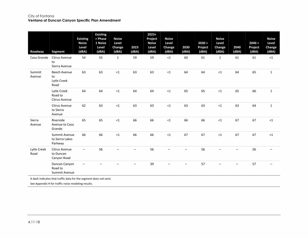
City of Fontana Ventana at Duncan Canyon Specific Plan Amendment
4.11-18
Roadway Segment
Existing Noise Level (dBA)
Existing + Phase 1 Noise
Level (dBA)
Noise Level
Change (dBA)
2023
(dBA)
2023+ Project Noise Level (dBA)
Noise Level
Change (dBA)
2030 (dBA)
2030 + Project (dBA)
Noise Level
Change (dBA)
2040 (dBA)
2040 + Project (dBA)
Noise Level
Change (dBA)
Casa Grande Citrus Avenue to Sierra Avenue
54 55 1 59 59 <1 60 61 1 61 61 <1
Summit Avenue
Beech Avenue to Lytle Creek Road
63 63 <1 63 63 <1 64 64 <1 64 65 1
Lytle Creek Road to Citrus Avenue
64 64 <1 64 64 <1 65 65 <1 65 66 1
Citrus Avenue to Sierra Avenue
62 63 <1 63 63 <1 63 63 <1 63 64 1
Sierra Avenue
Riverside Avenue to Casa Grande
65 65 <1 66 66 <1 66 66 <1 67 67 <1
Summit Avenue to Sierra Lakes Parkway
66 66 <1 66 66 <1 67 67 <1 67 67 <1
Lytle Creek Road
Citrus Avenue to Duncan Canyon Road
– 56 – – 56 – – 56 – – 56 –
Duncan Canyon Road to Summit Avenue
– – – – 39 – – 57 – – 57 –
A dash indicates that traffic data for the segment does not exist.
See Appendix H for traffic noise modeling results.
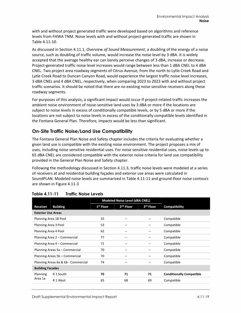
Environmental Impact Analysis Noise
Draft Supplemental Environmental Impact Report 4.11-19
with and without project generated traffic were developed based on algorithms and reference levels from FHWA TNM. Noise levels with and without project-generated traffic are shown in Table 4.11-10.
As discussed in Section 4.11.1, Overview of Sound Measurement, a doubling of the energy of a noise source, such as doubling of traffic volume, would increase the noise level by 3 dBA. It is widely accepted that the average healthy ear can barely perceive changes of 3 dBA, increase or decrease. Project-generated traffic noise level increases would range between less than 1 dBA CNEL to 4 dBA CNEL. Two project area roadway segments of Citrus Avenue, from the north to Lytle Creek Road and Lytle Creek Road to Duncan Canyon Road, would experience the largest traffic noise level increases, 3 dBA CNEL and 4 dBA CNEL, respectively, when comparing 2023 to 2023 with and without project traffic scenarios. It should be noted that there are no existing noise sensitive receivers along these roadway segments.
For purposes of this analysis, a significant impact would occur if project-related traffic increases the ambient noise environment of noise-sensitive land uses by 3 dBA or more if the locations are subject to noise levels in excess of conditionally compatible levels, or by 5 dBA or more if the locations are not subject to noise levels in excess of the conditionally compatible levels identified in the Fontana General Plan. Therefore, impacts would be less than significant.
On-Site Traffic Noise/Land Use Compatibility The Fontana General Plan Noise and Safety chapter includes the criteria for evaluating whether a given land use is compatible with the existing noise environment. The project proposes a mix of uses, including noise sensitive residential uses. For noise sensitive residential uses, noise levels up to 65 dBA CNEL are considered compatible with the exterior noise criteria for land use compatibility provided in the General Plan Noise and Safety chapter.
Following the methodology discussed in Section 4.11.3, traffic noise levels were modeled at a series of receivers at and residential building façades and exterior use areas were calculated in SoundPLAN. Modeled noise levels are summarized in Table 4.11-11 and ground-floor noise contours are shown in Figure 4.11-3
Table 4.11-11 Traffic Noise Levels
Receiver Building
Modeled Noise Level (dBA CNEL)
Compatibility 1st Floor 2nd Floor 3rd Floor
Exterior Use Areas
Planning Area 1B Pool 55 – – Compatible
Planning Area 3 Pool 53 – – Compatible
Planning Area 4 Pool 62 – – Compatible
Planning Area 2 – Commercial 77 – – Compatible
Planning Area 4 – Commercial 71 – – Compatible
Planning Areas 5a – Commercial 70 – – Compatible
Planning Areas 5b – Commercial 70 – – Compatible
Planning Areas 6a & 6b - Commercial 74 – – Compatible
Building Facades
Planning Area 1a
R 1 South 70 71 71 Conditionally Compatible
R 1 West 65 68 69 Compatible
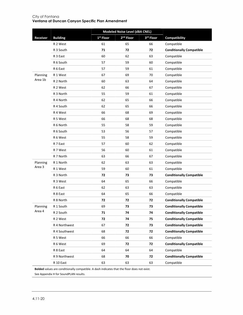
City of Fontana Ventana at Duncan Canyon Specific Plan Amendment
4.11-20
Receiver Building
Modeled Noise Level (dBA CNEL)
Compatibility 1st Floor 2nd Floor 3rd Floor
R 2 West 61 65 66 Compatible
R 3 South 71 72 72 Conditionally Compatible
R 3 East 60 62 63 Compatible
R 6 South 57 59 60 Compatible
R 6 East 57 59 61 Compatible
Planning Area 1b
R 1 West 67 69 70 Compatible
R 2 North 60 63 64 Compatible
R 2 West 62 66 67 Compatible
R 3 North 55 59 61 Compatible
R 4 North 62 65 66 Compatible
R 4 South 62 65 66 Compatible
R 4 West 66 68 69 Compatible
R 5 West 66 68 68 Compatible
R 6 North 55 58 59 Compatible
R 6 South 53 56 57 Compatible
R 6 West 55 58 59 Compatible
R 7 East 57 60 62 Compatible
R 7 West 56 60 61 Compatible
R 7 North 63 66 67 Compatible
Planning Area 3
R 1 North 62 63 63 Compatible
R 1 West 59 60 61 Compatible
R 3 North 72 73 73 Conditionally Compatible
R 3 West 64 65 66 Compatible
R 6 East 62 63 63 Compatible
R 8 East 64 65 66 Compatible
R 8 North 72 72 72 Conditionally Compatible
Planning Area 4
R 1 South 69 73 73 Conditionally Compatible
R 2 South 71 74 74 Conditionally Compatible
R 2 West 72 74 75 Conditionally Compatible
R 4 Northwest 67 72 73 Conditionally Compatible
R 4 Southwest 68 72 72 Conditionally Compatible
R 5 West 66 66 66 Compatible
R 6 West 69 72 72 Conditionally Compatible
R 8 East 64 64 64 Compatible
R 9 Northwest 68 70 72 Conditionally Compatible
R 10 East 63 63 63 Compatible
Bolded values are conditionally compatible. A dash indicates that the floor does not exist.
See Appendix H for SoundPLAN results.
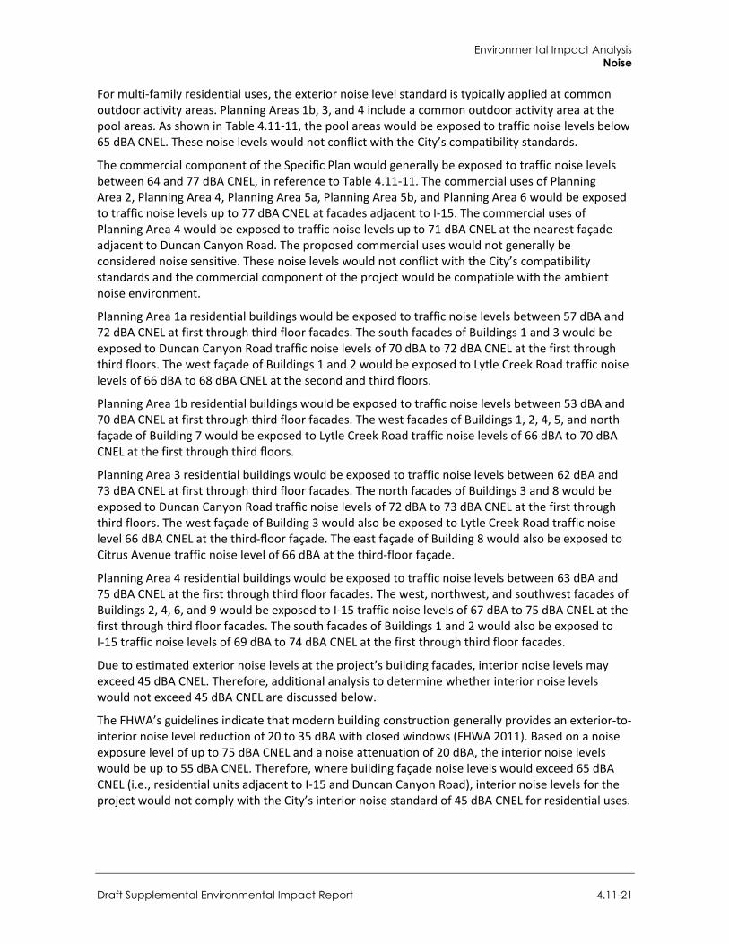
Environmental Impact Analysis Noise
Draft Supplemental Environmental Impact Report 4.11-21
For multi-family residential uses, the exterior noise level standard is typically applied at common outdoor activity areas. Planning Areas 1b, 3, and 4 include a common outdoor activity area at the pool areas. As shown in Table 4.11-11, the pool areas would be exposed to traffic noise levels below 65 dBA CNEL. These noise levels would not conflict with the City’s compatibility standards.
The commercial component of the Specific Plan would generally be exposed to traffic noise levels between 64 and 77 dBA CNEL, in reference to Table 4.11-11. The commercial uses of Planning Area 2, Planning Area 4, Planning Area 5a, Planning Area 5b, and Planning Area 6 would be exposed to traffic noise levels up to 77 dBA CNEL at facades adjacent to I-15. The commercial uses of Planning Area 4 would be exposed to traffic noise levels up to 71 dBA CNEL at the nearest façade adjacent to Duncan Canyon Road. The proposed commercial uses would not generally be considered noise sensitive. These noise levels would not conflict with the City’s compatibility standards and the commercial component of the project would be compatible with the ambient noise environment.
Planning Area 1a residential buildings would be exposed to traffic noise levels between 57 dBA and 72 dBA CNEL at first through third floor facades. The south facades of Buildings 1 and 3 would be exposed to Duncan Canyon Road traffic noise levels of 70 dBA to 72 dBA CNEL at the first through third floors. The west façade of Buildings 1 and 2 would be exposed to Lytle Creek Road traffic noise levels of 66 dBA to 68 dBA CNEL at the second and third floors.
Planning Area 1b residential buildings would be exposed to traffic noise levels between 53 dBA and 70 dBA CNEL at first through third floor facades. The west facades of Buildings 1, 2, 4, 5, and north façade of Building 7 would be exposed to Lytle Creek Road traffic noise levels of 66 dBA to 70 dBA CNEL at the first through third floors.
Planning Area 3 residential buildings would be exposed to traffic noise levels between 62 dBA and 73 dBA CNEL at first through third floor facades. The north facades of Buildings 3 and 8 would be exposed to Duncan Canyon Road traffic noise levels of 72 dBA to 73 dBA CNEL at the first through third floors. The west façade of Building 3 would also be exposed to Lytle Creek Road traffic noise level 66 dBA CNEL at the third-floor façade. The east façade of Building 8 would also be exposed to Citrus Avenue traffic noise level of 66 dBA at the third-floor façade.
Planning Area 4 residential buildings would be exposed to traffic noise levels between 63 dBA and 75 dBA CNEL at the first through third floor facades. The west, northwest, and southwest facades of Buildings 2, 4, 6, and 9 would be exposed to I-15 traffic noise levels of 67 dBA to 75 dBA CNEL at the first through third floor facades. The south facades of Buildings 1 and 2 would also be exposed to I-15 traffic noise levels of 69 dBA to 74 dBA CNEL at the first through third floor facades.
Due to estimated exterior noise levels at the project’s building facades, interior noise levels may exceed 45 dBA CNEL. Therefore, additional analysis to determine whether interior noise levels would not exceed 45 dBA CNEL are discussed below.
The FHWA’s guidelines indicate that modern building construction generally provides an exterior-to-interior noise level reduction of 20 to 35 dBA with closed windows (FHWA 2011). Based on a noise exposure level of up to 75 dBA CNEL and a noise attenuation of 20 dBA, the interior noise levels would be up to 55 dBA CNEL. Therefore, where building façade noise levels would exceed 65 dBA CNEL (i.e., residential units adjacent to I-15 and Duncan Canyon Road), interior noise levels for the project would not comply with the City’s interior noise standard of 45 dBA CNEL for residential uses.
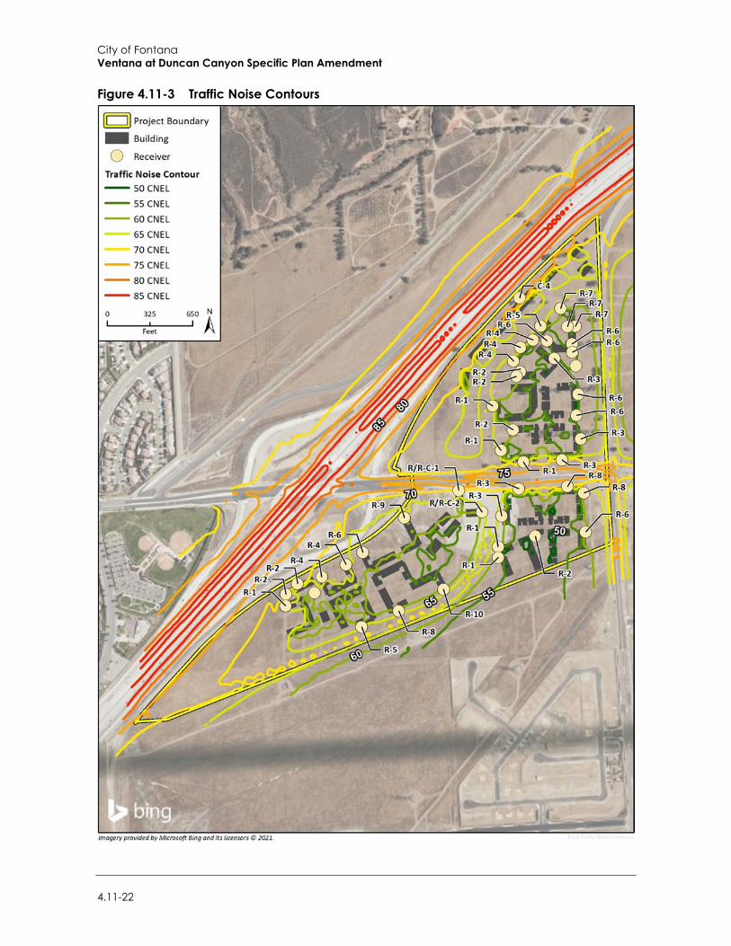
City of Fontana Ventana at Duncan Canyon Specific Plan Amendment
4.11-22
Figure 4.11-3 Traffic Noise Contours
Environmental Impact Analysis Noise
Draft Supplemental Environmental Impact Report 4.11-23
Mitigation Measure
N-3 Exterior-to-Interior Noise Analysis
For residential units where exterior noise levels exceed 65 dBA CNEL, the project applicant shall coordinate with the project architects and other contractors to ensure compliance with the 45 dBA CNEL interior noise level standard. This shall be achieved through additional exterior-to-interior noise analysis and incorporation of noise attenuation features once specific building plan information is available. The information in the analysis shall include wall heights and lengths, room volumes, window and door tables typical for a building plan, as well as information on other openings in the building shell. With this specific building plan information, the analysis shall determine the predicted interior noise levels at the planned on-site buildings. If predicted noise levels are found to be in excess of the applicable limit, the report shall identify architectural materials or techniques that could be included to reduce noise levels to the applicable limit. The project applicant shall comply with mitigation measures included in the interior noise report to reduce interior noise levels where applicable noise limits are exceeded.
Significance After Mitigation Impacts would be less than significant with implementation of mitigation.
Threshold 2: Would the proposed project expose persons to or generate excessive ground-borne vibration or ground-borne noise levels?
Impact N-4 PROJECT CONSTRUCTION WOULD GENERATE GROUND-BORNE VIBRATION ON AND ADJACENT TO THE SITE. HOWEVER, VIBRATION LEVELS AT SENSITIVE RECEIVERS WOULD NOT EXCEED APPLICABLE THRESHOLDS. IMPACTS WOULD BE LESS THAN SIGNIFICANT.
Construction activity can result in varying degrees of ground vibration, depending on the equipment and methods used, distance to the affected structures and soil type. It is expected that ground-borne vibration from project construction activities would cause only intermittent, localized intrusion. The proposed project’s construction activities most likely to cause vibration impacts are:
Heavy Construction Equipment. Although heavy mobile construction equipment has the potential of causing at least some perceptible vibration while operating close to buildings, the vibration is usually short-term and is not of sufficient magnitude to cause building damage.
Trucks. Trucks hauling building materials to construction sites can be sources of vibration intrusion if the haul routes pass through residential neighborhoods on streets with bumps or potholes. Repairing the bumps and potholes generally eliminates the problem.
Construction activities known to generate excessive groundborne vibration, such as pile driving, would not be conducted by the project. The greatest anticipated source of vibration during general project construction activities would be from a dozer, which may be used within 50 feet of the nearest on-site vibration sensitive use. A dozer creates approximately 0.089 in./sec. PPV at a distance of 25 feet (Caltrans 2020). This would equal a vibration level of 0.0315 in./sec. PPV at 50 feet. This vibration level is lower than the human annoyance threshold of 0.24 in./sec. PPV and the structural damage threshold of 0.4 in./sec. PPV. Therefore, temporary impacts associated with construction would be less than significant.
The project does not include any substantial vibration sources associated with operation. Therefore, operational vibration impacts would be less than significant.
City of Fontana Ventana at Duncan Canyon Specific Plan Amendment
4.11-24
Mitigation Measures Mitigation measures are not required.
4.11.4 Cumulative Impacts Cumulative construction impacts would consist of combined noise and vibration impacts from the construction under the proposed project and other off-site development. As determined under Impact N-1 and Impact N-4, construction noise and vibration associated with the project would be less than significant. Furthermore, all development in the city would be required to comply with the construction hours permitted by the Section 18-63(b)(7) of the Fontana Municipal Code. Construction noise and vibration would not disturb receivers during sensitive nighttime hours of sleep. In addition, construction noise attenuates greatly with distance, and is considered a localized impact. Unless construction of cumulative projects occurs near each other (i.e., less than a couple hundred feet) and simultaneously, noise and vibration from individual construction projects have a low chance of combining to create significant cumulative impacts. Therefore, the proposed project would not contribute to temporary cumulative construction noise and vibration impacts.
Cumulative operational noise impacts would consist of combined operational noise of the proposed project in conjunction with planned projects in the vicinity. As discussed under Impact N-2, operation of the proposed project would not generate on-site noise that exceeds ambient noise in the existing urban area. On-site operational noise generated by the project would not exceed the City’s noise standards and impacts would be less than significant. Furthermore, as discussed under Impact N-3, project traffic would not increase the ambient noise environment of noise-sensitive land uses in excess of applicable noise standards. While on-site development (particularly residential units adjacent to I-15 and Duncan Canyon Road) may be subject to interior noise levels in excess of the City’s interior noise standard of 45 dBA for residential uses, such noise impacts would be less than significant with implementation of Mitigation Measure N-1. Therefore, the proposed project would not contribute considerably to cumulative noise increases in the project vicinity above ambient noise levels.
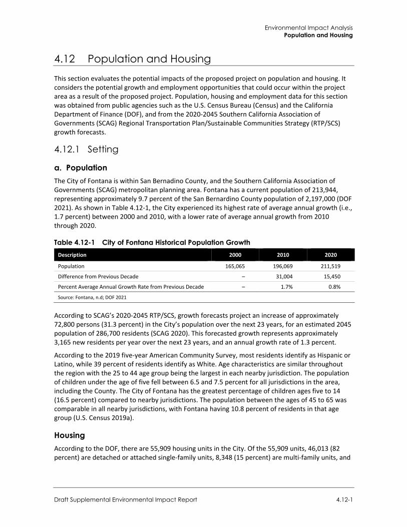
Environmental Impact Analysis Population and Housing
Draft Supplemental Environmental Impact Report 4.12-1
4.12 Population and Housing
This section evaluates the potential impacts of the proposed project on population and housing. It considers the potential growth and employment opportunities that could occur within the project area as a result of the proposed project. Population, housing and employment data for this section was obtained from public agencies such as the U.S. Census Bureau (Census) and the California Department of Finance (DOF), and from the 2020-2045 Southern California Association of Governments (SCAG) Regional Transportation Plan/Sustainable Communities Strategy (RTP/SCS) growth forecasts.
4.12.1 Setting
a. Population The City of Fontana is within San Bernadino County, and the Southern California Association of Governments (SCAG) metropolitan planning area. Fontana has a current population of 213,944, representing approximately 9.7 percent of the San Bernardino County population of 2,197,000 (DOF 2021). As shown in Table 4.12-1, the City experienced its highest rate of average annual growth (i.e., 1.7 percent) between 2000 and 2010, with a lower rate of average annual growth from 2010 through 2020.
Table 4.12-1 City of Fontana Historical Population Growth Description 2000 2010 2020
Population 165,065 196,069 211,519
Difference from Previous Decade – 31,004 15,450
Percent Average Annual Growth Rate from Previous Decade – 1.7% 0.8%
Source: Fontana, n.d; DOF 2021
According to SCAG’s 2020-2045 RTP/SCS, growth forecasts project an increase of approximately 72,800 persons (31.3 percent) in the City’s population over the next 23 years, for an estimated 2045 population of 286,700 residents (SCAG 2020). This forecasted growth represents approximately 3,165 new residents per year over the next 23 years, and an annual growth rate of 1.3 percent.
According to the 2019 five-year American Community Survey, most residents identify as Hispanic or Latino, while 39 percent of residents identify as White. Age characteristics are similar throughout the region with the 25 to 44 age group being the largest in each nearby jurisdiction. The population of children under the age of five fell between 6.5 and 7.5 percent for all jurisdictions in the area, including the County. The City of Fontana has the greatest percentage of children ages five to 14 (16.5 percent) compared to nearby jurisdictions. The population between the ages of 45 to 65 was comparable in all nearby jurisdictions, with Fontana having 10.8 percent of residents in that age group (U.S. Census 2019a).
Housing According to the DOF, there are 55,909 housing units in the City. Of the 55,909 units, 46,013 (82 percent) are detached or attached single-family units, 8,348 (15 percent) are multi-family units, and
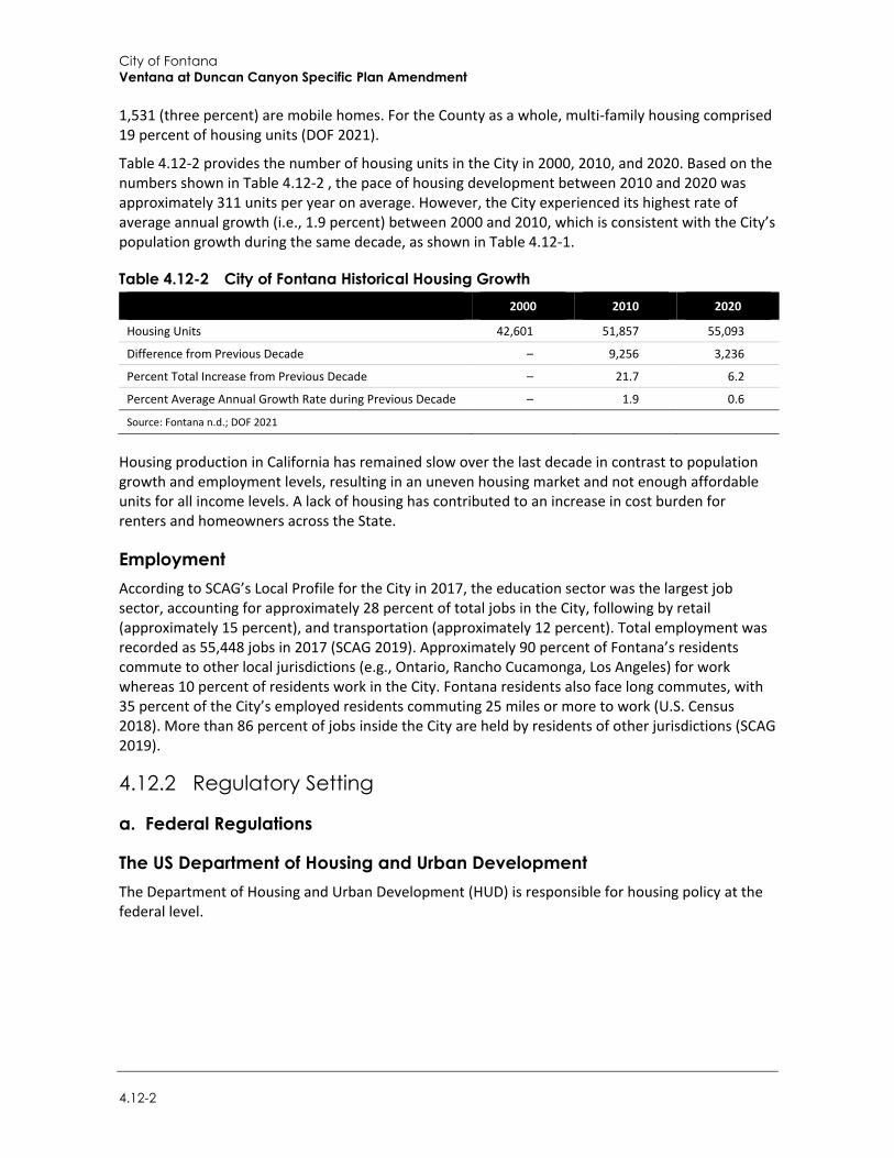
City of Fontana Ventana at Duncan Canyon Specific Plan Amendment
4.12-2
1,531 (three percent) are mobile homes. For the County as a whole, multi-family housing comprised 19 percent of housing units (DOF 2021).
Table 4.12-2 provides the number of housing units in the City in 2000, 2010, and 2020. Based on the numbers shown in Table 4.12-2 , the pace of housing development between 2010 and 2020 was approximately 311 units per year on average. However, the City experienced its highest rate of average annual growth (i.e., 1.9 percent) between 2000 and 2010, which is consistent with the City’s population growth during the same decade, as shown in Table 4.12-1.
Table 4.12-2 City of Fontana Historical Housing Growth 2000 2010 2020
Housing Units 42,601 51,857 55,093
Difference from Previous Decade – 9,256 3,236
Percent Total Increase from Previous Decade – 21.7 6.2
Percent Average Annual Growth Rate during Previous Decade – 1.9 0.6
Source: Fontana n.d.; DOF 2021
Housing production in California has remained slow over the last decade in contrast to population growth and employment levels, resulting in an uneven housing market and not enough affordable units for all income levels. A lack of housing has contributed to an increase in cost burden for renters and homeowners across the State.
Employment According to SCAG’s Local Profile for the City in 2017, the education sector was the largest job sector, accounting for approximately 28 percent of total jobs in the City, following by retail (approximately 15 percent), and transportation (approximately 12 percent). Total employment was recorded as 55,448 jobs in 2017 (SCAG 2019). Approximately 90 percent of Fontana’s residents commute to other local jurisdictions (e.g., Ontario, Rancho Cucamonga, Los Angeles) for work whereas 10 percent of residents work in the City. Fontana residents also face long commutes, with 35 percent of the City’s employed residents commuting 25 miles or more to work (U.S. Census 2018). More than 86 percent of jobs inside the City are held by residents of other jurisdictions (SCAG 2019).
4.12.2 Regulatory Setting
a. Federal Regulations
The US Department of Housing and Urban Development The Department of Housing and Urban Development (HUD) is responsible for housing policy at the federal level.
Environmental Impact Analysis Population and Housing
Draft Supplemental Environmental Impact Report 4.12-3
b. State Regulations
The California Department of Housing and Community Development The California Department of Housing and Community Development (HCD) is responsible for determining the regional housing needs for all jurisdictions in California and ensuring the availability of affordable housing for all income groups.
Housing Element Law: California Government Code Section 65584(a)(1) Pursuant to California Government Code Section 65584(a)(1), the California Department of Housing and Community Development (HCD) is responsible for determining the regional housing needs assessment (segmented by income levels) for each region’s planning body known as a “council of governments” (COG), SCAG being the COG serving the Southern California area. HCD prepares an initial housing needs assessment and then coordinates with each COG to arrive at the final regional housing needs assessment. To date, there have been five previous housing element update “cycles.” California is now in its sixth “housing-element update cycle.”
Housing Crisis Act of 2019 – (SB 330) The Housing Crisis Act of 2019 (SB 330) seeks to accelerate housing production in the next half decade through 2025 by eliminating some of the most common entitlement impediments to the creation of new housing. These may include delays in the local permitting process and cities enacting new requirements after an application is complete and undergoing local review—both of which can exacerbate the cost and uncertainty that sponsors of housing projects face. In addition to speeding up the timeline to obtain building permits, the bill prohibits local governments from reducing the number of homes that can be built through down-planning or down-zoning or the introduction of new discretionary design guidelines. The bill is in effect as of January 1, 2020 and expires on January 1, 2025.
Fair Employment and Housing Act The Fair Employment and Housing Act of 1959 (Government Code Section 12900 et seq.) prohibits housing discrimination based on race, color, religion, sexual orientation, marital status, national origin, ancestry, familial status, disability, or source of income.
The Unruh Civil Rights Act The Unruh Civil Rights Act of 1959 (Civ. Code Section 51) prohibits discrimination in “all business establishments of every kind whatsoever.” The provision has been interpreted to include businesses and persons engaged in the sale or rental of housing accommodations.
c. Local Regulations
City of Fontana General Plan The Fontana General Plan was prepared pursuant to State law to guide future development and to identify the community’s environmental, social, and economic goals and functions as a blueprint that defines how the city will evolve through 2030. The General Plan sets forth goals, objectives, and programs to provide a guideline for day-to-day land use policies and to meet the existing and future
City of Fontana Ventana at Duncan Canyon Specific Plan Amendment
4.12-4
needs and desires of the community, while at the same time integrating a range of State-mandated elements including Land Use, Transportation, Noise, Safety, Housing, and Open Space/Conservation.
The General Plan Housing Element is prepared pursuant to State law and provides planning guidance in meeting the housing needs identified in SCAG’s Regional Housing Needs Allocation (RHNA). The Housing Element identifies the City’s housing conditions and needs and establishes the goals, objectives, and policies that are the foundation of the City’s housing and growth strategy (City of Fontana 2021). The City has released the 6th Cycle Housing Element Update 2021-2029 which was adopted in January 2022 and included a RHNA of 17,518 total housing units at varying income levels.
City of Fontana Municipal Code Zoning regulations provide for the types and densities of residential and other uses permitted in each of the city’s zones. The Zoning Code for the City of Fontana establishes the maximum allowable development in a zone. Zoning also includes height limitations and other development standards which together regulate setbacks, building heights, floor area ratios (FAR), open space and parking for each parcel within the city, as applicable.
4.12.3 Impact Analysis
a. Significance Thresholds The following thresholds of significance were developed based on Appendix G of the CEQA Guidelines. Accordingly, the General Plan Update would have a significant impact with respect to population and housing if it would:
Induce substantial unplanned population growth in an area, either directly (for example, by proposing new homes and businesses) or indirectly (for example, through extension of roads or other infrastructure).
Impacts related to population and housing were analyzed in the Initial Study (Appendix A-2). As determined in the Initial Study, the project would not displace substantial numbers of existing people or housing, necessitating the construction of replacement housing elsewhere. There are currently no residential uses present on the project site and the project area is currently undeveloped. Therefore, implementation of the proposed project would not displace any housing, and the project would not necessitate the construction of replacement housing elsewhere. Therefore, impacts related to displacement are not further evaluated in this section.
Environmental Impact Analysis Population and Housing
Draft Supplemental Environmental Impact Report 4.12-5
b. Project Impacts
Threshold 1: Would the project induce substantial unplanned population growth in an area, either directly (for example, by proposing new homes and businesses) or indirectly (for example, through extension of roads or other infrastructure)?
Impact PH-1 DEVELOPMENT OF THE PROPOSED PROJECT MAY DIRECTLY AND INDIRECTLY INCREASE THE CITY’S POPULATION. HOWEVER, THIS POPULATION GROWTH WOULD BE CONSISTENT WITH AND FALL WITHIN THE CITY’S HOUSING ELEMENT AND SCAG POPULATION FORECASTS. THEREFORE, THE PROPOSED PROJECT WOULD NOT INDUCE POPULATION GROWTH BEYOND THAT ALREADY PLANNED. IMPACTS RELATED TO INDUCEMENT OF SUBSTANTIAL POPULATION GROWTH WOULD BE LESS THAN SIGNIFICANT.
The 2007 EIR found that future development under the existing Specific Plan would lead to the construction of new housing units on the site, an increase in the City’s resident population, and the generation of jobs for the local community. The existing Specific Plan would help meet the City’s future housing needs and provide a different housing type than the single-family units generally found in north Fontana. Development of housing under the existing Specific Plan would not induce substantial development in the area as adjacent areas were already planned for the development. Further, employment generated by the project would serve existing residents, or those in the surrounding area. The 2007 EIR determined the existing Specific Plan would not adversely impact the City’s population and housing stock.
Similar to the existing Specific Plan, the proposed project would include employment generating uses (commercial, light industrial, etc.). The project would result in a small decrease in employment generating square-footage, from 574,500 square feet under the existing Specific Plan to 476,500 square feet under the proposed project, a decrease of 98,000 square feet. Employment associated with commercial development (mainly retail) would likely be filled by residents in the Specific Plan area or neighboring local jurisdictions and would not result in substantial population growth.
The project would increase housing units beyond levels anticipated in the existing Specific Plan. The proposed project would increase the number of dwelling units from 842 units under the existing Specific Plan to 1,671 units. This increases the number of housing units by 829, or nearly a doubling of dwelling units when compared to the existing Specific Plan. The 1,671 units would account for less than 10 percent of the latest RHNA of 17,519 housing units and are, therefore, within anticipated growth planned under the General Plan Housing Element by 2030.
According to the DOF, the City of Fontana has a current population of 213,944 (DOF 2020). As discussed in Section 4.2, Air Quality, the proposed project would accommodate a service population consisting of 6,081 residents and 473 employees, for a total of 7,274 persons. By comparison, the existing Specific Plan would accommodate a service population of 5,383 persons. As such, the project would result in a net increase of 1,891 persons. Nonetheless, the following analysis the service population associated with full buildout of the Specific Plan Amendment (i.e., 7,274 persons) to regional growth forecasts for a conservative analysis of project impacts.
The 2020-2045 RTP/SCS growth forecasts project an increase of approximately 72,800 persons in the City’s population over the next 23 years, for an estimated 2045 population of 286,700 residents (SCAG 2020). Based on this forecast population, the City’s population would be approximately 239,266 in 2030 (the buildout year of the proposed project), which is an increase of 25,322 persons
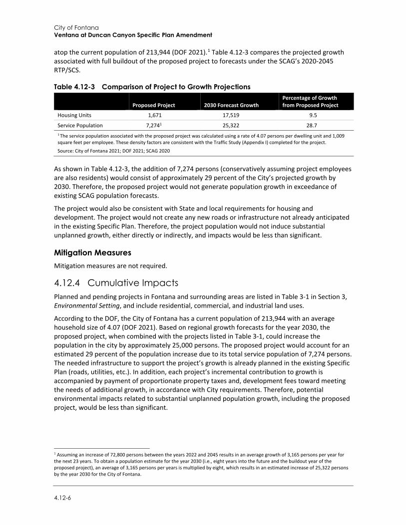
City of Fontana Ventana at Duncan Canyon Specific Plan Amendment
4.12-6
atop the current population of 213,944 (DOF 2021).1 Table 4.12-3 compares the projected growth associated with full buildout of the proposed project to forecasts under the SCAG’s 2020-2045 RTP/SCS.
Table 4.12-3 Comparison of Project to Growth Projections
Proposed Project 2030 Forecast Growth Percentage of Growth from Proposed Project
Housing Units 1,671 17,519 9.5
Service Population 7,2741 25,322 28.7 1 The service population associated with the proposed project was calculated using a rate of 4.07 persons per dwelling unit and 1,009 square feet per employee. These density factors are consistent with the Traffic Study (Appendix I) completed for the project.
Source: City of Fontana 2021; DOF 2021; SCAG 2020
As shown in Table 4.12-3, the addition of 7,274 persons (conservatively assuming project employees are also residents) would consist of approximately 29 percent of the City’s projected growth by 2030. Therefore, the proposed project would not generate population growth in exceedance of existing SCAG population forecasts.
The project would also be consistent with State and local requirements for housing and development. The project would not create any new roads or infrastructure not already anticipated in the existing Specific Plan. Therefore, the project population would not induce substantial unplanned growth, either directly or indirectly, and impacts would be less than significant.
Mitigation Measures Mitigation measures are not required.
4.12.4 Cumulative Impacts Planned and pending projects in Fontana and surrounding areas are listed in Table 3-1 in Section 3, Environmental Setting, and include residential, commercial, and industrial land uses.
According to the DOF, the City of Fontana has a current population of 213,944 with an average household size of 4.07 (DOF 2021). Based on regional growth forecasts for the year 2030, the proposed project, when combined with the projects listed in Table 3-1, could increase the population in the city by approximately 25,000 persons. The proposed project would account for an estimated 29 percent of the population increase due to its total service population of 7,274 persons. The needed infrastructure to support the project’s growth is already planned in the existing Specific Plan (roads, utilities, etc.). In addition, each project’s incremental contribution to growth is accompanied by payment of proportionate property taxes and, development fees toward meeting the needs of additional growth, in accordance with City requirements. Therefore, potential environmental impacts related to substantial unplanned population growth, including the proposed project, would be less than significant.
1 Assuming an increase of 72,800 persons between the years 2022 and 2045 results in an average growth of 3,165 persons per year for the next 23 years. To obtain a population estimate for the year 2030 (i.e., eight years into the future and the buildout year of the proposed project), an average of 3,165 persons per years is multiplied by eight, which results in an estimated increase of 25,322 persons by the year 2030 for the City of Fontana.
Environmental Impact Analysis Public Services and Recreation
Draft Supplemental Environmental Impact Report 4.13-1
4.13 Public Services and Recreation
Public facilities and services are functions which serve residents on a community-wide basis. These functions include fire and police protection, school facilities, public parks and recreational facilities, and libraries. Development proposed under the project would require these services and/or use these facilities. This analysis is supported by readily available information about services providers (i.e., in the Fontana General Plan), and information provided by service providers.
4.13.1 Setting
a. Fire Protection Services The Fontana Fire Protection District (FFPD) provides emergency, preventive, and administrative services across 52.4 square miles within the city limits and the sphere of influence (SOI) through a contract with the San Bernardino County Fire Department (SBCFD). The SBCFD serves the southwestern section of San Bernardino County. There are seven fire stations, an administrative office, and a fire prevention office serving the City (City of Fontana 2018). Total department staffing at the seven fire stations includes 33 full time fire suppression employees consisting of eight fire captains, eight fire engineers, nine firefighter medics, three firefighter paramedics, and five firefighters. The nearest fire station to the project site is Station 79 located approximately 0.1 mile west of the project site, at 4075 Coyote Canyon Road, Fontana. Station 79 operates one medic engine, houses a four-person engine company, and is staffed with one captain, one engineer, and one firefighter medic (City of Fontana 2021, City of Fontana 2018).
The FFPD’s administrative offices and the fire prevention offices are located at City Hall, 8353 Sierra Avenue. The FFPD is staffed with 119 full time personnel, including 108 safety employees, and 11 non-safety personnel. The FFPD performs inspections, plan checks, and issues permits in order to protect the public and emergency responders from safety hazards due to fire. The City also has automatic and mutual aid agreements with nearby agencies including the Rancho Cucamonga Fire Protection District (City of Fontana 2018).
The FFPD’s 2013 Strategic Plan identified nine action items for improving fire operations and for achieving their goals and objectives. These included reorganizing some of their existing resources and construction or remodel of existing facilities. Projects planned through 2022 include construction of a co-located City/County Office of Emergency Services (OES), centrally located training facility, new headquarters, relocating station 77, and constructing a new station in the western SOI (Fire Station 80).
b. Police Protection and Law Enforcement Services According to the Fontana General Plan, the Fontana Police Department (FPD) has 197 sworn officers and operates out of one centrally located police station located at 8353 Sierra Avenue. In total, the FPD has 292 full time equivalent (FTE) positions budgeted, and 18 part-time positions. The Fontana Police Department headquarters is located at 17005 Upland Avenue and also operates Southridge Contact Station at 11500 Live Oak Avenue, and a contact station within the Palm Court Shopping Center, at 17122 Slover Avenue.
The San Bernardino County Sheriff’s Department also operates a station in the City of Fontana located at 17780 Arrow Boulevard. This station is a combination of the West End patrol station and the Fontana stations, and houses 27 deputy positions, five detectives, seven sergeants, one
City of Fontana Ventana at Duncan Canyon Specific Plan Amendment
4.13-2
lieutenant and one captain. It serves a 300-square mile patrol area across Fontana, Bloomington, Rialto, and Lytle Creek, and interfaces with Los Angeles, Orange and Riverside Counties to include unincorporated Upland, Montclair, Ontario and Chino, San Antonio Heights and the Mt. Baldy wilderness (City of Fontana 2018).
c. School Services According to the Fontana General Plan, two public school districts serve most of the City of Fontana: Fontana Unified School District (FUSD) and the Etiwanda School District (pre-K to 8). In addition to these two school districts, small areas of Fontana are covered by the Colton Joint Unified School District (southeast Fontana); the Chaffey Joint Union High School District (northern Fontana), and the Rialto School District (northeast).
The project site is located within the service boundaries of FUSD, which serves most of the city and had an enrollment of 36,160 students in the 2019-20 academic year (Ed Data 2021). Enrollment has been trending consistently downward. Peak enrollment was 42,050 students during the 2004-2005 academic year (City of Fontana 2018).
d. Parks and Recreation Public facilities in Fontana include parks, sports centers, community centers, cultural centers, a nature center, public services facilities (including city hall, the community services department building, and the public works center); one veterans’ resource center; the auditorium and the library. The City’s Community Services Department has responsibility for parks, recreation, and programming.
Park goals in the Fontana General Plan included providing parks accessible to all segments of the population and in newly developed areas; joint use agreements with school districts; and funding of parks and trails through the capital improvement program.
The California Protected Lands Database, which includes all park and recreation sites in the city that have no more than 50 percent impervious area, lists 1,196 acres of land for park and recreation use, 72 percent of which is composed of the Martin Tudor Jurupa Hills Regional Park’s 861 acres. In addition, the City counts 25 percent of the school lands available through joint use agreements with Fontana Unified School District and the Colton Joint Unified School District as usable recreation areas, resulting in an additional 163 acres. Added to the total in the protected lands database, Fontana has an estimated 1,359 acres of park and recreation land, as seen in Table 4.13-1 (City of Fontana 2018).
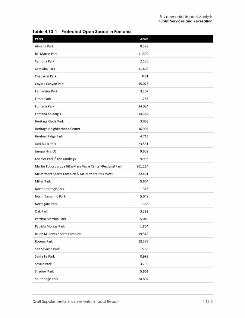
Environmental Impact Analysis Public Services and Recreation
Draft Supplemental Environmental Impact Report 4.13-3
Table 4.13-1 Protected Open Space in Fontana Parks Acres
Almeria Park 8.389
Bill Martin Park 11.399
Cambria Park 2.176
Catawba Park 11.892
Chaparral Park 8.61
Coyote Canyon Park 15.023
Fernandez Park 3.207
Fiesta Park 1.285
Fontana Park 34.034
Fontana holding 1 14.384
Heritage Circle Park 3.008
Heritage Neighborhood Center 16.905
Hunters Ridge Park 4.715
Jack Bulik Park 23.531
Jurupa Hills OS 9.652
Koehler Park / The Landings 9.998
Martin Tudor Jurupa Hills/Mary Vagle Center/Regional Park 861.224
McDermott Sports Complex & McDermott Park West 22.461
Miller Park 5.604
North Heritage Park 1.343
North Tamarind Park 5.049
Northgate Park 1.363
Oak Park 3.382
Patricia Marrujo Park 5.049
Patricia Murray Park 1.804
Ralph M. Lewis Sports Complex 19.548
Rosena Park 13.578
San Sevaine Park 15.66
Santa Fe Park 0.999
Seville Park 3.795
Shadow Park 5.903
Southridge Park 24.807
City of Fontana Ventana at Duncan Canyon Specific Plan Amendment
4.13-4
Parks Acres
Sycamore Hills Park 3.081
Veteran’s Park 23.464
Total 1,196.3
Total without Regional Park 335.1
Source: City of Fontana 2018b
e. Library Services The San Bernardino County Library System provides library services to the City of Fontana through the Fontana Branch Library at 16860 Valencia Avenue (downtown area) and the Kaiser Branch Library at 11155 Almond Avenue (within Kaiser High School). The County Library System serves 18 cities and nine unincorporated areas in the County and is funded by a dedicated share of property taxes.
4.13.2 Regulatory Setting
a. State Regulations
2018 California Strategic Fire Plan The Strategic Fire Plan for California (also known as the California Fire Plan) is a cooperative effort between the California Board of Forestry and Fire Protection and the California Department of Forestry and Fire Protection (CAL FIRE) (CAL FIRE 2018). The California Fire Plan reflects a focus on fire prevention and suppression activities and natural resource management to maintain the State’s forests as a resilient carbon sink to meet California’s climate change goals and to serve as important habitat for adaptation and mitigation. Major components center on the following goals:
Improve the availability and use of consistent, shared information on hazard and risk assessment.
Promote the role of local planning processes, including general plans, new development, and existing developments, and recognize individual landowner/homeowner responsibilities.
Foster a shared vision among communities and the multiple fire protection jurisdictions, including county-based plans and community-based plans such as Community Wildfire Protection Plans.
Increase awareness and actions to improve fire resistance of man-made assets at risk and fire resilience of wildland environments through natural resource management.
Integrate implementation of fire and vegetative fuels management practices consistent with the priorities of landowners or managers.
Determine and seek the needed level of resources for fire prevention, natural resource management, fire suppression, and related services.
Implement needed assessments and actions for post-fire protection and recovery.
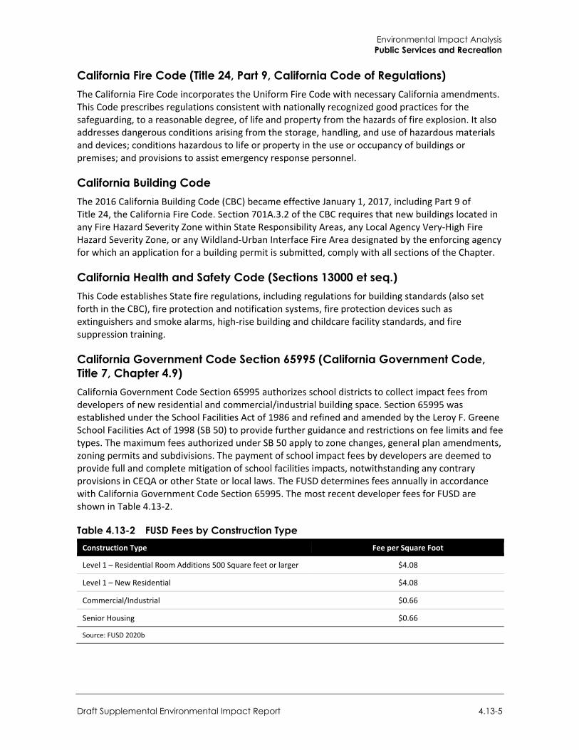
Environmental Impact Analysis Public Services and Recreation
Draft Supplemental Environmental Impact Report 4.13-5
California Fire Code (Title 24, Part 9, California Code of Regulations) The California Fire Code incorporates the Uniform Fire Code with necessary California amendments. This Code prescribes regulations consistent with nationally recognized good practices for the safeguarding, to a reasonable degree, of life and property from the hazards of fire explosion. It also addresses dangerous conditions arising from the storage, handling, and use of hazardous materials and devices; conditions hazardous to life or property in the use or occupancy of buildings or premises; and provisions to assist emergency response personnel.
California Building Code The 2016 California Building Code (CBC) became effective January 1, 2017, including Part 9 of Title 24, the California Fire Code. Section 701A.3.2 of the CBC requires that new buildings located in any Fire Hazard Severity Zone within State Responsibility Areas, any Local Agency Very-High Fire Hazard Severity Zone, or any Wildland-Urban Interface Fire Area designated by the enforcing agency for which an application for a building permit is submitted, comply with all sections of the Chapter.
California Health and Safety Code (Sections 13000 et seq.) This Code establishes State fire regulations, including regulations for building standards (also set forth in the CBC), fire protection and notification systems, fire protection devices such as extinguishers and smoke alarms, high-rise building and childcare facility standards, and fire suppression training.
California Government Code Section 65995 (California Government Code, Title 7, Chapter 4.9) California Government Code Section 65995 authorizes school districts to collect impact fees from developers of new residential and commercial/industrial building space. Section 65995 was established under the School Facilities Act of 1986 and refined and amended by the Leroy F. Greene School Facilities Act of 1998 (SB 50) to provide further guidance and restrictions on fee limits and fee types. The maximum fees authorized under SB 50 apply to zone changes, general plan amendments, zoning permits and subdivisions. The payment of school impact fees by developers are deemed to provide full and complete mitigation of school facilities impacts, notwithstanding any contrary provisions in CEQA or other State or local laws. The FUSD determines fees annually in accordance with California Government Code Section 65995. The most recent developer fees for FUSD are shown in Table 4.13-2.
Table 4.13-2 FUSD Fees by Construction Type Construction Type Fee per Square Foot
Level 1 – Residential Room Additions 500 Square feet or larger $4.08
Level 1 – New Residential $4.08
Commercial/Industrial $0.66
Senior Housing $0.66
Source: FUSD 2020b
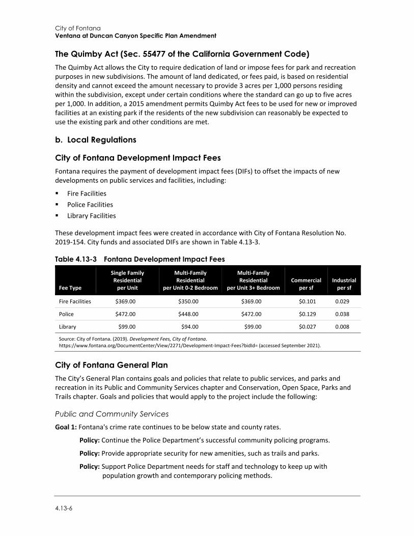
City of Fontana Ventana at Duncan Canyon Specific Plan Amendment
4.13-6
The Quimby Act (Sec. 55477 of the California Government Code) The Quimby Act allows the City to require dedication of land or impose fees for park and recreation purposes in new subdivisions. The amount of land dedicated, or fees paid, is based on residential density and cannot exceed the amount necessary to provide 3 acres per 1,000 persons residing within the subdivision, except under certain conditions where the standard can go up to five acres per 1,000. In addition, a 2015 amendment permits Quimby Act fees to be used for new or improved facilities at an existing park if the residents of the new subdivision can reasonably be expected to use the existing park and other conditions are met.
b. Local Regulations
City of Fontana Development Impact Fees Fontana requires the payment of development impact fees (DIFs) to offset the impacts of new developments on public services and facilities, including:
Fire Facilities Police Facilities Library Facilities
These development impact fees were created in accordance with City of Fontana Resolution No. 2019-154. City funds and associated DIFs are shown in Table 4.13-3.
Table 4.13-3 Fontana Development Impact Fees
Fee Type
Single Family Residential
per Unit
Multi-Family Residential
per Unit 0-2 Bedroom
Multi-Family Residential
per Unit 3+ Bedroom Commercial
per sf Industrial
per sf
Fire Facilities $369.00 $350.00 $369.00 $0.101 0.029
Police $472.00 $448.00 $472.00 $0.129 0.038
Library $99.00 $94.00 $99.00 $0.027 0.008
Source: City of Fontana. (2019). Development Fees, City of Fontana. https://www.fontana.org/DocumentCenter/View/2271/Development-Impact-Fees?bidId= (accessed September 2021).
City of Fontana General Plan The City’s General Plan contains goals and policies that relate to public services, and parks and recreation in its Public and Community Services chapter and Conservation, Open Space, Parks and Trails chapter. Goals and policies that would apply to the project include the following:
Public and Community Services
Goal 1: Fontana's crime rate continues to be below state and county rates.
Policy: Continue the Police Department’s successful community policing programs.
Policy: Provide appropriate security for new amenities, such as trails and parks.
Policy: Support Police Department needs for staff and technology to keep up with population growth and contemporary policing methods.
Environmental Impact Analysis Public Services and Recreation
Draft Supplemental Environmental Impact Report 4.13-7
Policy: Promote and enhance use of anti-crime design strategies and programs.
Goal 2: Fontana's Fire Department meets or exceeds state and national benchmarks for protection and responsiveness.
Policy: Continue the City’s successful partnership with the San Bernardino County Fire Department.
Goal 3: Fontana has modern, well-maintained public facilities that meet the needs of residents of all ages, businesses, and government.
Policy: Support development of a City facilities master plan and use an asset-management system for all City property.
Policy: Support initiatives to reduce energy costs in public facilities.
Policy: Develop an “Aging in Fontana” plan to prepare to serve an increasing number of senior citizens.
Conservation, Open Space, Parks and Trails
Goal 5: All Fontana residents live within walking or biking distance of a public park, and there are sufficient public parks to serve all areas of the city.
Policy: Establish park access by walking and biking as a criterion for locating parks and for design of active transportation networks.
Policy: Continue to use a minimum standard of 5 acres of public parkland per 1,000 persons.
Policy: Pursue park development where parkland is insufficient.
4.13.3 Impact Analysis
a. Significance Thresholds In accordance with Appendix G of the CEQA Guidelines, the proposed project would result in potentially significant impacts related to public services if it would result in substantial adverse physical impacts associated with the provision of new or physically altered governmental facilities, need for new or physically altered governmental facilities, the construction of which could cause significant environmental impacts, in order to maintain acceptable services ratios, response times or other performance objectives for any of the public services:
Fire protection Police protection Schools Parks Other public facilities
b. Standard Conditions The following standard conditions related to public services, and identified in the 2007 EIR, remain applicable to the proposed project:
Standard Condition 4.13.1: Future developments shall implement Building Security Specifications and multi-family developments shall be consistent with the principles of Crime
City of Fontana Ventana at Duncan Canyon Specific Plan Amendment
4.13-8
Prevention through Environmental Design, as required by the Fontana Police Department. To ensure compliance, all developments shall be subject to building and site plan review and approval by the Fontana Police Department.
Standard Condition 4.13.2: Future developments would be required to pay development fees for police services. Payment of developer impact fees would assist in funding the needed public facility expansion and service improvements needed to serve the proposed developments on the site.
Standard Condition 4.13.3: Future developments shall be subject to building and site plan review by the San Bernardino County Fire District, for compliance with fire safety and emergency access standards and to identify additional development features which could reduce demand for fire services, prevent the creation of fire hazards, and facilitate emergency response to the project site.
Standard Condition 4.13.4: Future developments would be required to pay development fees for fire services. Payment of developer impact fees would assist in funding the needed public facility expansion and service improvements needed to serve the proposed developments on the site.
Standard Condition 4.13.5: Future developments would be required to pay school impact fees to the Fontana Unified School District, which would help fund the needed school facility expansion and service improvements to serve the proposed project.
Standard Condition 4.13.6: As required under the City’s Municipal Code (Chapter 21, Article IV), the proposed development shall pay Quimby fees for the development of parks and recreational facilities in North Fontana. The collected fees will be used for the development of neighborhood and community parks in the area, to serve the proposed project.
Standard Condition 4.13.7: Future developments would be required to pay development fees for library services. Payment of developer impact fees would assist in funding the needed public facility expansion and service improvements needed to serve the project.
c. Project Impacts
Threshold 1: Would the project result in substantial adverse physical impacts associated with the provision of new or physically altered fire protection facilities, or the need for new or physically altered fire protection facilities, the construction of which could cause significant environmental impacts, in order to maintain acceptable service ratios, response times or other performance objectives?
Impact PS-1 SBCFD HAS THE CAPACITY AND FACILITIES TO SERVE THE PROJECT, AND IMPLEMENTATION OF THE PROJECT WOULD NOT RESULT IN THE NEED FOR EXPANDED FIRE PROTECTION FACILITIES. ADDITIONALLY, BUILDING AND SITE PLAN REVIEW BY THE SBCFD AND DEVELOPMENT IMPACT FEES WOULD OFFSET PROJECT DEMAND FOR NEW FIRE PROTECTION FACILITIES. THEREFORE, THE PROJECT WOULD HAVE A LESS THAN SIGNIFICANT IMPACT.
The 2007 EIR found that future development under the existing Specific Plan would create a direct demand for fire protection services. While development of the site with residential and commercial uses would have removed brush fire hazards, the increase in the on-site population and the introduction of new structures to the site would be accompanied by an increase in demand for fire protection services. In 2007, the project site was surrounded by relatively vacant land outside of the majority of development in Fontana. Therefore, the project could have created longer response
Environmental Impact Analysis Public Services and Recreation
Draft Supplemental Environmental Impact Report 4.13-9
times throughout the city. To address this, an additional fire station (81) was anticipated to be located with the Specific Plan area, to accommodate new growth.
The 2007 EIR found that with building and site plan review by the San Bernardino County Fire District and payment of development fees for fire services the project would not create an adverse impact on fire protection services.
As discussed in Section 4.2, Air Quality, and Section 4.12, Population and Housing, the project would incrementally increase the service population of the SBCFD by adding an additional 829 dwelling units and 1,891 persons to the 842 dwelling units and 5,383 persons previously anticipated under the existing Specific Plan.
The project would be located within the existing service area SBCFD. Today, fire protection services are provided by the SBCFD which operates seven fire stations within the city. There are approximately 122 firefighters/staff which serve Fontana. The closest fire station to the project site is Station 79 at 4075 Coyote Canyon Road, approximately 0.1 miles west of the project site. Fire Station 79 was constructed in 2007 to accommodate the changing use of the area as it transitions from rural to residential and commercial use (City of Fontana 2018). Station 79 operates one medic engine, houses a four-person engine company, and is staffed with one captain, one engineer and one firefighter medic (City of Fontana 2021, 2018). Fire Station 79 is approximately 3 minutes travel time from the project site (Herbert Spitzer 2021). The average response time to fires within Fontana is four minutes, 51 seconds.1
Appropriate fire protection measures would be included in the new development, consistent with the CBC and California Fire Code. Final project design would be subject to plan check by SBCFD to verify compliance with applicable fire prevention and protection requirements. Compliance with pertinent building standards would reduce the demand for fire protection services from the project. Thus, no significant fire hazards are expected to be created on the site.
The project would be required to pay public applicable safety improvement fees to the City’s public safety improvement fund prior to issuance of a building permit. Fees paid by the project would be used solely for the construction or reimbursement for construction of public safety improvements identified in the City’s five-year capital improvement program. Therefore, the project’s contribution to demand for new fire protection services would be offset by payment of required public safety improvement fees. As seen in Table 4.13-3, the current fee for fire services is $350 per multi-family unit. At the current rate, project buildout of 1,671 dwelling units would contribute $584,850 to fire services.2 Payment of developer impact fees would assist in funding the needed public facility expansion and service improvements needed to serve the proposed developments on the site. The project would have a less than significant impact on physical impacts associated with the provision of new or physically altered fire protection facilities, or the need for new or physically altered fire protection facilities, the construction of which could cause significant environmental impacts, in order to maintain acceptable service ratios, response times or other performance objectives.
Mitigation Measures Mitigation measures are not required.
1 Communication from Lauri Lockwood of the SBCFD (November 2, 2021) 2 Fees would be based on the rates in place at the time of project development.
City of Fontana Ventana at Duncan Canyon Specific Plan Amendment
4.13-10
Threshold 2: Would the project result in substantial adverse physical impacts associated with the provision of new or physically altered police protection facilities, or the need for new or physically altered police protection facilities, the construction of which could cause significant environmental impacts, in order to maintain acceptable service ratios, response times or other performance objectives?
Impact PS-2 THE PROJECT WOULD INCREASE THE SERVICE POPULATION OF POLICE PROTECTION SERVICES. HOWEVER, PROJECT CONTRIBUTIONS TO DEVELOPMENT IMPACT FEES AND ADHERENCE TO CRIME PREVENTION THROUGH ENVIRONMENTAL DESIGN WOULD OFFSET THE INCREMENTAL DEMAND FOR NEW POLICE PROTECTION FACILITIES. THE PROJECT WOULD HAVE A LESS THAN SIGNIFICANT IMPACT.
The 2007 EIR found that existing Specific Plan would increase the on-site population, introduce new structures, and add vehicle trips in the area; and thus, generate a new demand for law enforcement and police protection services. Further, employees of the commercial uses would also create a demand for police services, However, the 2007 EIR found that with the implementation of building security specifications and payment of development fees for police services the project would not have significant adverse impacts on police services.
As previously discussed under Impact PS-1, the proposed project would increase the number of residential units via an increase in density. Law enforcement services for the project area is provided by the Fontana Police Department (FPD). The nearest station is located approximately 4.4 miles south from the project site, at 17005 Upland Avenue, Fontana. The potential increase in population and commercial uses in the project area would result in an increase in the demand for police protection services, including officers, equipment, and facilities. Consequently, the project would contribute incrementally to demand for new or expanded police protection facilities.
The FPD has 197 sworn officers, 292 FTE positions budgeted, and 18 part-time positions. The City standard for police protection prescribes a ratio of 1.4 sworn police officers per 1,000 residents. Based on the City’s current population of 213,944, the current service ratio is 0.92 FTE per 1,000 residents (DOF 2021). Under the existing Specific Plan, the service population would be 5,383 persons, as discussed in Table 4.2-8 in Section 4.2, Air Quality. By comparison, the service population under the proposed project would be 7,274 persons, or an increase of 1,891 persons when compared to the existing Specific Plan. Under the existing Specific Plan, the service ratio of FTE per 1,000 residents would be .90. Assuming the project would add 1,891 persons, the new total of 7,272 persons would result in a service ratio of 0.89 FTE per 1,000 residents. Therefore, the proposed project would represent an approximate change of .01 FTE per 1,000 residents. In order to meet the standard of 1.4 FTE per 1000 residents the City would need 310 sworn officers, or an additional 113 officers atop the existing 197 officers to meet the City’s goal for police services. The Fontana General Plan EIR discusses that, in 2014, the service ratio was 0.94 FTE per 1,000 residences. The General Plan EIR concluded that the officer-to-population ratio is just one criterion used to determine the number of officers necessary to meet City public safety needs. Furthermore, the General Plan EIR states that the updated General Plan addresses the incremental need through adoption of a policy for a long-term strategic planning process for Police services to occur every five years.
The need for police protection at the proposed commercial areas is difficult to quantify and would be dependent on complex variables, such as presence of crime elements, attraction of development to criminals, security measures, perceived public safety, service demands in other areas of the City, and other factors. Commercial development would be required to implement building security
Environmental Impact Analysis Public Services and Recreation
Draft Supplemental Environmental Impact Report 4.13-11
specifications and multi-family developments would be designed consistent with the principles of Crime Prevention through Environmental Design, as required by the FPD. To ensure compliance, all developments would be subject to building and site plan review and approval by the FPD.
Furthermore, the project would be required to pay public safety improvement fees to the City’s public safety improvement fund prior to issuance of a building permits. Fees paid by the project would be used solely for the construction or reimbursement for construction of public safety improvements. Therefore, the project’s contribution to demand for new police protection services would be offset by payment of required public safety improvement fees. As seen in Table 4.13-3 the current fee for police services is $448.00 per multi-family until. With project buildout, 1,671 dwelling units would contribute $748,608 to police services. Payment of developer impact fees would assist in funding the needed public facility expansion and service improvements needed to serve the proposed developments on the site. Furthermore, with adherence to applicable policies, payment of development fees and design review by the FPD, the proposed project would have a less than significant impact on police protection facilities.
Mitigation Measures Mitigation measures are not required.
Threshold 3: Would the project result in substantial adverse physical impacts associated with the provision of new or physically altered schools, or the need for new or physically altered schools, the construction of which could cause significant environmental impacts, in order to maintain acceptable service ratios or other performance objectives?
Impact PS-3 THE PROJECT WOULD INCREASE THE NEED FOR SCHOOL SERVICES. HOWEVER, PROJECT CONTRIBUTIONS TO DEVELOPMENT IMPACT OFFSET THE INCREMENTAL DEMAND FOR NEW SCHOOL FACILITIES. THEREFORE, THE PROJECT WOULD HAVE A LESS THAN SIGNIFICANT IMPACT.
The 2007 EIR found that FUSD’s facilities were operating beyond capacity and the rapid development in North Fontana had further strained school facilities. However, with payment of development fees the Specific Plan would not have an adverse impact on schools.
The project site is in the FUSD area and would be served by Hemlock Elementary School (K-Grade 5), Fontana Middle School (Grades 6-8), and Fontana High School (Grades 9-12) (FUSD n.d.). The project would accommodate 6,801 residents, some of which may be school-age children. School-age children living in the project’s residential units would incrementally increase student enrollment at FUSD schools, which could result in or contribute to the need for new or physically altered schools. Estimates of the future student population on the site are based on the generation rates of the FUSD, as seen in Table 4.13-4.
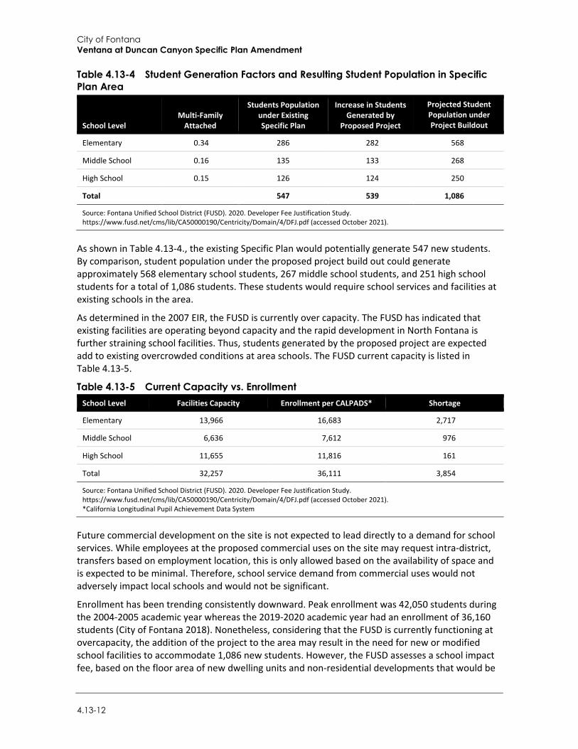
City of Fontana Ventana at Duncan Canyon Specific Plan Amendment
4.13-12
Table 4.13-4 Student Generation Factors and Resulting Student Population in Specific Plan Area
School Level Multi-Family
Attached
Students Population under Existing Specific Plan
Increase in Students Generated by
Proposed Project
Projected Student Population under Project Buildout
Elementary 0.34 286 282 568
Middle School 0.16 135 133 268
High School 0.15 126 124 250
Total 547 539 1,086
Source: Fontana Unified School District (FUSD). 2020. Developer Fee Justification Study. https://www.fusd.net/cms/lib/CA50000190/Centricity/Domain/4/DFJ.pdf (accessed October 2021).
As shown in Table 4.13-4., the existing Specific Plan would potentially generate 547 new students. By comparison, student population under the proposed project build out could generate approximately 568 elementary school students, 267 middle school students, and 251 high school students for a total of 1,086 students. These students would require school services and facilities at existing schools in the area.
As determined in the 2007 EIR, the FUSD is currently over capacity. The FUSD has indicated that existing facilities are operating beyond capacity and the rapid development in North Fontana is further straining school facilities. Thus, students generated by the proposed project are expected add to existing overcrowded conditions at area schools. The FUSD current capacity is listed in Table 4.13-5.
Table 4.13-5 Current Capacity vs. Enrollment School Level Facilities Capacity Enrollment per CALPADS* Shortage
Elementary 13,966 16,683 2,717
Middle School 6,636 7,612 976
High School 11,655 11,816 161
Total 32,257 36,111 3,854
Source: Fontana Unified School District (FUSD). 2020. Developer Fee Justification Study. https://www.fusd.net/cms/lib/CA50000190/Centricity/Domain/4/DFJ.pdf (accessed October 2021). *California Longitudinal Pupil Achievement Data System
Future commercial development on the site is not expected to lead directly to a demand for school services. While employees at the proposed commercial uses on the site may request intra-district, transfers based on employment location, this is only allowed based on the availability of space and is expected to be minimal. Therefore, school service demand from commercial uses would not adversely impact local schools and would not be significant.
Enrollment has been trending consistently downward. Peak enrollment was 42,050 students during the 2004-2005 academic year whereas the 2019-2020 academic year had an enrollment of 36,160 students (City of Fontana 2018). Nonetheless, considering that the FUSD is currently functioning at overcapacity, the addition of the project to the area may result in the need for new or modified school facilities to accommodate 1,086 new students. However, the FUSD assesses a school impact fee, based on the floor area of new dwelling units and non-residential developments that would be
Environmental Impact Analysis Public Services and Recreation
Draft Supplemental Environmental Impact Report 4.13-13
used to fund school services and facilities. As seen in Table 4.13-2, the FUSD fee is currently $4.08 per square feet for new residential development and $0.66 per square feet for commercial development. School impacts fees paid by future commercial developments on the project site would assist in the provision of school services to residents of the site. Pursuant to Section 65995 (3)(h) of the Government Code (Senate Bill 50, circa 1998), the payment of statutory fees “...is deemed to be full and complete mitigation of the impacts of any legislative or adjudicative act, or both, involving, but not limited to, the planning, use, or development of real property, or any change in governmental organization or reorganization.” Due to provisions of State law, the City is strictly limited in the mitigation measures it may impose on developers of residential projects to address potential school overcrowding issues. State law assumes the developer’s payment of school impact fees to the local school district, in an amount established by the school district, would address school capacity impacts.
Therefore, although the project would increase enrollment at FUSD schools, payment of the school impact developer fees would be considered full mitigation for the project's impacts under CEQA and impacts to schools may be less than significant.
Mitigation Measures Mitigation measures are not required.
Threshold 4: Would the project result in substantial adverse physical impacts associated with the provision of new or physically altered parks, or the need for new or physically altered parks, the construction of which could cause significant environmental impacts, in order to maintain acceptable service ratios or other performance objectives?
Threshold 5: Would the project increase the use of existing neighborhood and regional parks or other recreational facilities such that substantial physical deterioration of the facility would occur or be accelerated?
Threshold 6: Does the project include recreational facilities or require the construction or expansion of recreational facilities which might have an adverse physical effect on the environment?
Impact PS-4 THE PROJECT WOULD INCREASE THE USE OF PARKS AND RECREATION FACILITIES. HOWEVER, THE CITY MAINTAINS A HIGH PARKLAND TO POPULATION RATIO, AND THE PROJECT WOULD CONTRIBUTE DEVELOPMENT IMPACT FEES TO OFFSET IMPACTS TO PARKS AND RECREATION FACILITIES. THEREFORE, PROJECT IMPACTS WOULD BE LESS THAN SIGNIFICANT.
The 2007 EIR found that the existing Specific Plan would create a direct demand on parks and recreational facilities in the area. However, the 2007 EIR determined that payment of pay park fees to the City for the development of parks in nearby areas would offset impacts to parks. In 2007, the Fontana General Plan set a parkland standard of two acres of community parkland per thousand residents, and three acres of neighborhood parkland per thousand residents.
The proposed project would result in 829 additional dwellings units atop the 842 units under the existing Specific Plan, resulting in 1,671 dwelling units under project buildout. Similar to the existing Specific Plan, the proposed project would increase the demand for recreation and park facilities. According to the Fontana General Plan EIR, the performance objective or standard for parks and recreation is five acres of parkland for every 1,000 residents (two acres of community parks for every 1,000 residents and three acres of neighborhood parks for every 1,000 residents). As seen in
City of Fontana Ventana at Duncan Canyon Specific Plan Amendment
4.13-14
Table 4.13-1, the City of Fontana has approximately 1,196 acres of parkland, including regional parkland, and approximately 335 acres excluding regional parkland. In addition, the City counts 25 percent of the school lands available through joint use agreements with FUSD and the Colton Joint Unified School District as usable recreation areas, resulting in an additional 163 acres. Added to the total in the protected lands database, Fontana has approximately 1,359 acres of park and recreation land.
As shown in Table 4.2-8 in Section 4.2, Air Quality, the existing Specific Plan would accommodate a service population of 5,383 persons. Assuming that the population would be new to Fontana, the ratio of parks to 1,000 residents would be approximately 6.2 acres of park land. The project would incrementally increase the service population by adding an additional 829 dwelling units and 1,891 persons, in addition to the 842 dwelling units and 5,383 persons anticipated under the existing Specific Plan. Assuming the proposed project would accommodate a service population of 7,274 persons, the ratio of parks to 1,000 residents would be approximately 6.1 acres of park land which is consistent with the City’s performance objectives. In other words, the increases in residential density would change the park land service ratio by approximately .1 acres per 1,000 residents. Furthermore, the project would include the construction of various recreational facilities, including three recreation centers and swimming pools, which would help meet recreation needs of on-site residents and employees.
In accordance with the City’s Municipal Code, the developer has the option to dedicate parkland on site, pay a fee, or a combination of both to satisfy the park and recreation demand that would be generated by the project. As required under the Fontana Municipal Code (Chapter 21, Article IV), development will be required to pay Quimby fees for the development of neighborhood and community parks in North Fontana. Furthermore, the need for recreation facilities will be somewhat offset by the provision of on-site facilities such as pools, play areas and sport courts. Therefore, with payment of Quimby fees for the development of parks and recreational facilities in North Fontana, the project would not have a less than significant impact on parks in Fontana.
Mitigation Measures Mitigation measures are not required.
Threshold 7: Would the project result in substantial adverse physical impacts associated with the provision of new or physically altered public facilities, or the need for new or physically altered public facilities, the construction of which could cause significant environmental impacts, in order to maintain acceptable service ratios, response times or other performance objectives?
Impact PS-5 THE PROJECT WOULD INCREASE THE USE OF LIBRARY FACILITIES, AND THE PROJECT WOULD CONTRIBUTE DEVELOPMENT IMPACT FEES TO OFFSET IMPACTS TO LIBRARY FACILITIES. THEREFORE, PROJECT IMPACTS WOULD BE LESS THAN SIGNIFICANT.
The 2007 EIR found that the existing Specific Plan would create a direct demand on library facilities in the area. However, it was found that payment of development impact fees to help fund library services and facilities in the city would offset impacts.
The Fontana Public Library is located approximately 4.43 miles south of the project site. The project would increase the number of dwelling units by 829, compared to 842 under the existing Specific Plan, resulting in up to 1,671 dwelling units at project buildout. Therefore, the project would
Environmental Impact Analysis Public Services and Recreation
Draft Supplemental Environmental Impact Report 4.13-15
incrementally increase the service population of the Fontana Public Library, above that anticipated in the Specific Plan.
According to Fontana Municipal Code Section 5-9, the project’s contribution to population increase would be offset by payment of proportionate DIFs, which include a public library facilities fee. As seen in Table 4.13-3, the City currently charges $94.00 per multi-family unit and $0.027 per square foot of new commercial development to pay for library services and facilities (fees are subject to change).
With the addition of the proposed 1,671 dwelling units and the development of 476,500 square feet of commercial use, the proposed project would contribute $157,074 for residential development and $12,865.5 for commercial development. These fees are used to fund library services and facilities needed to serve the site and the city. Payment of these fees would mitigate impacts associated with the demand for library services that would be generated by future residents of the project. Therefore, project impacts to public library facilities would be less than significant.
Mitigation Measures Mitigation measures are not required.
4.13.4 Cumulative Impacts Planned and pending projects in Fontana and surrounding areas are listed in Table 3-1 in Section 3, Environmental Setting, and include residential, commercial, and industrial land uses.
As discussed in Section 4.2, Air Quality, and Section 4.12, Population and Housing, the project would accommodate a service population of 7,274. The addition of new residents would generate a proportional increase in demand for additional fire protection and emergency medical services, police protection, school services, use of parks and recreation facilities, and use of libraries and other public services. As discussed above, implementation of the project would not create a cumulatively considerable need for new or expanded public services that could not be offset by the payment of development fees.
New development in Fontana, including the projects listed in Table 3-1 in Section 3, Environmental Setting, may also contribute to an increase in service population and use of public services, and cumulatively, there may be a need for new or improved facilities to maintain acceptable service ratios, response times, or other applicable goals. According to the California DOF, the City of Fontana has a current population of 213,944 with an average household size of 4.07 (DOF 2021). The proposed project, when combined with the projects listed in Table 3-1, could increase the population in the city by approximately 25,000 persons. The proposed project would account for approximately 29 percent of new residents. However, each project’s incremental contribution to demand for new services would be offset by payment of proportionate property taxes, development fees, and/or DIF in accordance with Fontana Municipal Code. Additionally, new development projects would be reviewed by the SBCFD staff prior to development permit approval to ensure adequate fire safety and security measures are provided for each site-specific development.
Therefore, potential environmental impacts related to the construction of new or expanded public facilities would be assessed on a project-specific level when such development of public services and facilities are considered. Therefore, cumulative impacts to public services and facilities would be less than significant.

City of Fontana Ventana at Duncan Canyon Specific Plan Amendment
4.13-16
This page intentionally left blank.

Supplemental Draft Environmental Impact Report Transportation
Draft Supplemental Environmental Impact Report 4.14-1
4.14 Transportation
This section analyzes the project’s potential impacts to transportation. The analysis is based on the Traffic Study prepared for the project by Urban Crossroads and includes a vehicle miles traveled (VMT) assessment (Urban Crossroads 2022; see Appendix I).
The purpose of the Traffic Study is to evaluate the potential deficiencies related to traffic, identify circulation system deficiencies that may result from the development of the proposed project, and to recommend improvements to resolve identified deficiencies in order to achieve acceptable operational conditions at study area intersections and ensure consistency with the City’s General Plan. The Traffic Study has been prepared in accordance with the City of Fontana’s Traffic Impact Analysis (TIA) Guidelines for Vehicle Miles Traveled (VMT) and Level of Service Assessment, and through consultation with City of Fontana staff during the scoping process. The project traffic study scoping agreement is provided in the Traffic Study and has been approved by the City of Fontana.
4.14.1 Setting
a. Existing Roadway System Access to the project site will be provided to Citrus Avenue and Duncan Canyon Road via Lytle Creek Road. Regional access to the project site is available from Interstate 15 (I-15) via Duncan Canyon Road and Beech Avenue interchanges. The following descriptions are provided for each roadway that would serve the project site:
I-15 (Ontario Freeway) I-15 is a major northeast-southwest freeway with four lanes in each direction and provides regional access to the project area. This freeway extends south to the San Diego area and north to Barstow and the Las Vegas area. Located just northwest of the project site, I-15 has interchanges at Baseline Road, Summit Avenue, Sierra Avenue, Glen Helen Parkway, and the State Route 210 (SR-210).
Duncan Canyon Road Duncan Canyon Road is an east-west oriented roadway located on the project’s southern boundary. project to construct Duncan Canyon Road at its ultimate half-width (north side) as a Major Highway (134-foot right-of-way) from the western project boundary to Citrus Avenue consistent with the City’s standards.
Citrus Avenue Citrus Avenue is a north-south oriented roadway located on the project’s eastern boundary. Project to construct Citrus Avenue at its ultimate half-width as a Primary Highway (104-foot right-of-way) from the northern project boundary to Duncan Canyon Road consistent with the City’s standards.
Lytle Creek Road Lytle Creek Road is a north-south oriented roadway that bisects the project between Duncan Canyon Road to Citrus Avenue. Project to construct Lytle Creek Road at its ultimate full-width as a Local Street (68-foot right-of-way) between Duncan Canyon Road to Citrus Avenue consistent with the City’s standards.
City of Fontana Ventana at Duncan Canyon Specific Plan Amendment
4.14-2
b. Existing Alternative Transportation Facilities The City’s bike facilities are shown on Figure 4.14-1. There are existing Class II bike facilities along Duncan Canyon Road, west of Coyote Canyon, Citrus Avenue, Beech Avenue, and Summit Avenue, and Sierra Lakes Parkway east of Citrus Avenue. There are proposed Class II Duncan Canyon Road, east of Coyote Canyon Road, and Sierra Lakes Parkway, west of Citrus Avenue.
The project area is currently served by Omnitrans Transit Agency with bus services along Citrus Avenue, Summit Avenue, Sierra Lakes Avenue, and Sierra Avenue. Routes 312 and 22 serve the City of Fontana, north of SR-210, but there are currently no transit routes that would serve the project site, as shown in Figure 4.14-2. Transit service is reviewed and updated by Omnitrans periodically to address ridership, budget, and community demand needs. Changes in land use can affect these periodic adjustments which may lead to either enhanced or reduced service where appropriate. As the project site is undeveloped, the site does not have pedestrian facilities.
4.14.2 Regulatory Setting
a. State Regulations
California Senate Bill 743 Senate Bill 743 (SB 743) was signed into law on September 27, 2013, and directed the Office of Planning and Research (OPR) to develop revisions to the CEQA Guidelines to establish new criteria for determining the significance of transportation impacts. SB 743 was enacted, in part, as further implementation of California’s Climate Action Plan to meet California Global Warming Solutions Act (Assembly Bill 32) greenhouse gas (GHG) emission reduction targets. SB 743 seeks to reduce criteria air pollutants and GHG emissions in the transportation sector by reducing VMT. SB 743 changed the approach to transportation impact analysis by establishing measures such as VMT, VMT per capita, or automobile trip generation rates as the primary measures of transportation impacts and eliminates the traditionally used measures of auto delay, LOS, and other measures of traffic congestion as a basis for determining significant impacts.
In December 2018, OPR adopted and promulgated its changes to the CEQA Guidelines (14 California Code of Regulations [CCR] Section 15000 et seq.) in response to SB 743. Section 15064.3 of the CEQA Guidelines contains the operative language for implementing the goals of SB 743 when determining the significance of a project’s transportation impacts. There are four key aspects of CEQA Guidelines Section 15064.3 that apply in the case of the proposed project:
“[A] project’s effect on automobile delay shall not constitute a significant environmental impact” (Section 15064.3[a]).
For a land use project like the proposed project, “Vehicle miles traveled exceeding an applicable threshold of significance may indicate a significant impact… projects that decrease vehicle miles traveled in the project area compared to existing conditions should be presumed to have a less than significant transportation impact” (Section 15064.3[b][1]).
“A lead agency has discretion to choose the most appropriate methodology to evaluate a project’s vehicle miles traveled, including whether to express the change in absolute terms, per capita, per household or in any other measure” (Section 15064.3[b][(4]).
The terms and conditions of Section 15064.3 apply prospectively and a lead agency “may elect to be governed by the provisions of [15064.3] immediately. Beginning on July 1, 2020, the provisions of [15064.3] shall apply statewide” (Section 15064.3[c]).
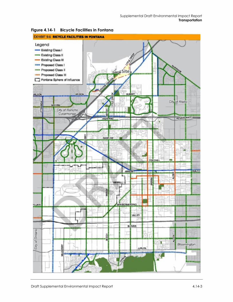
Supplemental Draft Environmental Impact Report Transportation
Draft Supplemental Environmental Impact Report 4.14-3
Figure 4.14-1 Bicycle Facilities in Fontana
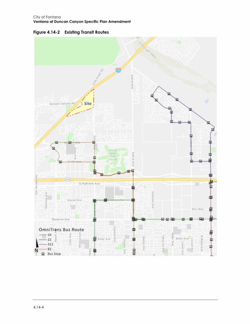
City of Fontana Ventana at Duncan Canyon Specific Plan Amendment
4.14-4
Figure 4.14-2 Existing Transit Routes
Supplemental Draft Environmental Impact Report Transportation
Draft Supplemental Environmental Impact Report 4.14-5
California Assembly Bill 32, Senate Bill 32, and Senate Bill 375 The “California Global Warming Solutions Act of 2006” (AB 32) outlines California’s major legislative initiative for reducing GHG emissions. AB 32 codifies the statewide goal of reducing GHG emissions to 1990 levels by 2020, a reduction of approximately 15 percent below emissions expected under a “business as usual” scenario. On September 8, 2016, the governor signed Senate Bill 32 (SB 32) into law, extending the California Global Warming Solutions Act of 2006 by requiring the state to further reduce GHG emissions to 40 percent below 1990 levels by 2030 (the other provisions of AB 32 remain unchanged).
The Sustainable Communities and Climate Protection Act of 2008 (SB 375), signed in August 2008, enhances the state’s ability to reach AB 32 goals by directing the California Air Resources Board (CARB) to develop regional GHG emission reduction targets to be achieved from passenger vehicles by 2020 and 2035. SB 375 aligns regional transportation planning efforts, regional GHG reduction targets, and affordable housing allocations. Metropolitan Planning Organizations (MPOs) are required to adopt a Sustainable Communities Strategy (SCS) that allocates land uses in the MPO’s Regional Transportation Plan (RTP). Qualified projects consistent with an approved SCS or Alternative Planning Strategy (categorized as “transit priority projects”) can receive incentives to streamline CEQA processing.
On March 22, 2018, CARB adopted updated regional targets for reducing GHG emissions from 2005 levels by 2020 and 2035. The Southern California Association of Governments (SCAG) was assigned targets of an eight percent reduction in per capita GHG emissions from passenger vehicles by 2020 and a 19 percent reduction in per capita GHG emissions from passenger vehicles by 2035. In the SCAG region, SB 375 also provides the option for the coordinated development of subregional plans by the subregional councils of governments and the county transportation commissions to meet SB 375 requirements. On September 3, 2020, the SCAG’s Regional Council formally adopted the 2020-2045 RTP/SCS titled Connect SoCal, which meets the requirements of SB 375.
b. Local Regulations
Measure “I” Funds In 2004, the voters of San Bernardino County approved the 30-year extension of Measure “I”, a one-half of one percent sales tax on retail transactions, through the year 2040, for transportation projects including, but not limited to, infrastructure improvements, commuter rail, public transit, and other identified improvements. The Measure “I” extension requires that a regional traffic impact fee be created to ensure development is paying its fair share. A regional Nexus study was prepared by San Bernardino County Transportation Authority (SBCTA)and concluded that each jurisdiction should include a regional fee component in their local programs in order to meet the Measure “I” requirement. The regional component assigns specific facilities and cost sharing formulas to each jurisdiction and was most recently updated in May 2018. Revenues collected through these programs are used in tandem with Measure “I” funds to deliver projects identified in the Nexus Study. While Measure “I” is a self-executing sales tax administered by SBCTA, it bears discussion here because the funds raised through Measure “I” have funded in the past and will continue to fund new transportation facilities in San Bernardino County, including within the City of Fontana.
City of Fontana Ventana at Duncan Canyon Specific Plan Amendment
4.14-6
City of Fontana General Plan The Community Mobility and Circulation chapter of the General Plan is focused on connecting neighborhoods and city destinations by expanding transportation choice in Fontana. The following policies are relevant to the project:
Goal 1: The City of Fontana has a comprehensive and balanced transportation system with safety and multimodal accessibility the top priority of citywide transportation planning, as well as accommodating freight movement.
Policy: Provide roadways that serve the needs of Fontana residents and commerce, and that facilitate safe and convenient access to transit, bicycle facilities, and walkways.
Policy: Make safety and multimodal accessibility the top priority of citywide transportation planning.
Policy: Apply the six “E’s” of the Safe Routes to School program to transportation planning and implementation—Encouragement, Education, Engineering, Enforcement, Evaluation, and Equity.
Policy: Make land use decisions that support walking, bicycling, and public transit use, in alignment with the 2014-2040 Regional Transportation Plan and Sustainable Communities Strategy.
Goal 2: Fontana’s street network is safe and accessible to all users, especially the most vulnerable such as children, youth, older adults and people with disabilities.
Policy: When constructing or modifying roadways, design the roadway space for use by all users when feasible, including motor vehicles, buses, bicyclists, mobility devices, and pedestrians, as appropriate for the context of the area.
Policy: Support designated truck routes that avoid negative impacts on residential and commercial areas while accommodating the efficient movement of trucks on designated truck routes and arterial streets.
Goal 3: Local transit within the City of Fontana is a viable choice for residents, easily accessible and serving destinations throughout the city.
Policy: Maximize the accessibility, safety, convenience, and appeal of transit service and transit stops.
Policy: Promote concentrated development patterns in coordination with transit planning to maximize service efficiency and ridership.
Goal 4: Fontana’s neighborhood streets maintain a residential character and support a range of transportation options.
Policy: Balance neighborhood traffic circulation needs with the goal of creating walkable and bike friendly neighborhoods.
Policy: Develop and implement Best Practice Street Design standards for new residential street development projects.
Supplemental Draft Environmental Impact Report Transportation
Draft Supplemental Environmental Impact Report 4.14-7
Goal 5: Fontana’s commercial and mixed-use areas include a multifunctional street network that ensures a safe, comfortable, and efficient movement of people, goods, and services to support a high quality of life and economic vitality.
Policy: Provide a transportation network that is compatible with the needs of commerce and those who live, work and shop in mixed-use areas.
Policy: Encourage mixed use and commercial developments that support walking, bicycling, and public transit use while balancing the needs of motorized traffic to serve such developments.
Goal 6: The city has attractive and convenient parking facilities for both motorized and non-motorized vehicles that fit the context.
Policy: Provide the right amount of motor vehicle and bicycle parking in commercial and employment centers to support vibrant economic activity.
Policy: Encourage approaches that reduce the overall number of new parking spaces that must be provided on-site for new development.
Goal 7: The city of Fontana participates in shaping regional transportation policies to reduce traffic congestion and greenhouse gas emissions.
Policy: Lead and participate in initiatives to manage regional traffic.
Policy: Coordinate with regional agencies and Caltrans to participate in regional efforts to maintain transportation infrastructure in Fontana.
Policy: Participate in the efforts of the Southern California Association of Governments (SCAG) to coordinate transportation planning and services that support greenhouse gas reductions.
Policy: Participate in the efforts by Caltrans to reduce congestion and improve traffic flow on area freeways.
City of Fontana Municipal Code City of Fontana Municipal Code Chapter 17, Motor Vehicles and Traffic contains ordinances for traffic administration, City traffic engineer, operation of motor vehicles, stopping, standing and parking, permit parking zones, parking of oversized or non-motorized vehicles, Loading and unloading zones, pedestrians, bicycles, truck routes, funding of air pollution reduction programs, and temporary closure of streets.
City of Fontana Development Impact Fee Program The City of Fontana adopted the latest update to its Development Impact Fee (DIF) program in September 2019. Fees from new residential, commercial and industrial development are collected to fund Measure “I” compliant regional facilities as well as local facilities. Under the City’s DIF program, the City may grant developers a credit against specific components of fees when those developers construct certain facilities and landscaped medians identified in the list of improvements funded by the DIF program.
After the City’s DIF fees are collected, they are placed in a separate restricted use account pursuant to the requirements of Government Code sections 66000 et seq. The timing to use the DIF fees is
City of Fontana Ventana at Duncan Canyon Specific Plan Amendment
4.14-8
established through periodic capital improvement programs, which are overseen by the City’s Engineering Department. Periodic traffic counts, review of traffic accidents, and a review of traffic trends throughout the city are also periodically performed by City staff and consultants. The City uses this data to determine the timing of the improvements listed in its facilities list. The City also uses this data to ensure that the improvements listed on the facilities list are constructed before the LOS falls below the LOS performance standards adopted by the City. In this way, the improvements are constructed before the LOS falls below the City’s LOS performance thresholds. The City’s DIF program establishes a timeline to fund, design, and build the improvements.
4.14.3 Impact Analysis
a. Significance Thresholds Appendix G of CEQA Guidelines states transportation and traffic impacts of the project would be significant if the project would:
Conflict with a program, plan, ordinance, or policy addressing the circulation system, including transit, roadway, bicycle, and pedestrian facilities;
Conflict or be inconsistent with CEQA Guidelines Section 15064.3, subdivision (b);
Impacts to transportation were analyzed in the Initial Study (see Appendix A-2). The Initial Study concluded that the project would comply with City of Fontana roads standards and would not include any design features that would increase circulation hazards. The development would not result in roadway uses that would be incompatible with the existing land uses surrounding the project site, which consist of residential and commercial uses. In addition, project construction and operational activities would not result in any street closures that could impede emergency access or evacuation. Ultimately, the development of the newly aligned Lytle Creek Road would improve connectivity and emergency access for the area. In addition, roadway capacity and operation, including level of service (LOS), is no longer a consideration for determination of significance, and mitigation, under CEQA. Therefore, these impacts are not further evaluated in this section.
b. Methodology As detailed in the Specific Plan Amendment and Section 2, Project Description, of the SEIR, the project would include the following roadway improvements as design features, which would be constructed in conjunction with development of the site:
Construction of Duncan Canyon Road at its ultimate half-width (north side) as a Major Highway (134-foot right-of-way) from the western project boundary to Citrus Avenue consistent with the City’s standards; and at its ultimate half-width (south side) as a Major Highway (134-foot right-of-way) from the western project boundary to Citrus Avenue consistent with the City’s standards.
Construction of Citrus Avenue at its ultimate half-width as a Primary Highway (104-foot right-of-way) from the northern Project boundary to Duncan Canyon Road consistent with the City’s standards; and at its ultimate half-width as a Primary Highway (104-foot right-of-way) from the southern project boundary to Duncan Canyon Road consistent with the City’s standards.
Construction of Lytle Creek Road at its ultimate full-width as a Local Street (68-foot right-of-way) between Duncan Canyon Road to Citrus Avenue consistent with the City’s standards; and
Supplemental Draft Environmental Impact Report Transportation
Draft Supplemental Environmental Impact Report 4.14-9
at its ultimate full-width as a Secondary (92-foot right-of-way) between Duncan Canyon Road to Citrus Avenue consistent with the City’s standards.
Therefore, for the purpose of this analysis, these site and side adjacent improvements are considered as part of the project.
VMT Screening Criteria The City Guidelines describe specific “screening thresholds” that can be used to identify when a proposed land use project is anticipated to result in a less than significant impact without conducting a more detailed project level VMT analysis.
Consistent with City Guidelines, a land use project needs only to satisfy one of four screening thresholds to result in a less than significant impact, absent substantial evidence to the contrary. The project was evaluated against VMT screening criteria with the following results:
Transit Priority Area (TPA) Screening. Projects located within a TPA (i.e., within 0.5 mile of an existing major transit stop or an existing stop along a high-quality transit corridor may be presumed to have a less than significant impact, with specific exceptions. However, the project site is not located within 0.5 mile of an existing major transit stop, or along a high-quality transit corridor.
Low VMT Area Screening. Projects within a low VMT generating area—e.g., 15 percent below baseline County of San Bernardino VMT per service population—may be presumed to have a less than significant impact. The project location based on assessor parcel number is input into the Screening Tool to determine the VMT generated within the respective transportation analysis area and compared to the jurisdictional average. The results indicate the project site in not located within a low VMT area.
Low Project Type Screening. Local serving retail with buildings less than 50,000 square feet or other local serving essential services (e.g., day care centers, public schools, medical/dental office buildings, etc.) are presumed to have a less than significant impact. However, the project is not considered local serving under the guidelines.
Project Net Daily Trips less than 500 ADT. Projects that generate fewer than 500 ADT (stated in actual vehicles) are deemed to not cause a substantial increase in the total citywide or regional VMT and are therefore presumed to have a less than significant impact on VMT. However, the project’s net daily trips would exceed 500 ADT.
Based on this analysis included in the Traffic Study, the project would not meet any of the screening criteria and a project level VMT analysis is required.
c. Standard Conditions The following standard conditions related to transportation, and identified in the 2007 EIR,
remain applicable to the proposed project: Standard Condition 4.4.1: The project shall pay development impact fees as set by the City to fund roadway maintenance and improvement projects in the area.
Standard Condition 4.4.2: Future developments would be subject to plan check review to ensure that the necessary access, parking, and roadway improvements are provided as part of individual developments, in accordance with the City’s traffic safety design criteria.
City of Fontana Ventana at Duncan Canyon Specific Plan Amendment
4.14-10
Standard Condition 4.4.3: Future developments on the site shall be accompanied by the construction of internal and perimeter roadways, in accordance with the City’s Circulation Master Plan and City roadway standards, including the City’s standard intersection configuration for southbound traffic at the Lytle Creek Road/Duncan Canyon Road intersection.
d. Project Impacts
Threshold 1: Would the project conflict with a program, plan, ordinance or policy addressing the circulation system, including transit, roadway, bicycle and pedestrian facilities?
Impact TRA-1 THE PROPOSED PROJECT WOULD NOT CONFLICT WITH A PROGRAM, PLAN, ORDINANCE OR POLICY ADDRESSING THE CIRCULATION SYSTEM, INCLUDING TRANSIT, ROADWAY, BICYCLE AND PEDESTRIAN FACILITIES. IMPACTS WOULD BE LESS THAN SIGNIFICANT.
The project would generate short-term traffic during construction, and long-term traffic during the operational life of the project. The 2007 EIR found that implementation of the Specific Plan required a modification to the Fontana Circulation Master Plan (within the Circulation Element of the Fontana General Plan). The existing Specific Plan required reclassification of the segment of Duncan Canyon Road from Lytle Creek Road to Citrus Avenue as a Major Highway. However, the 2007 EIR found that the proposed amendment to the Circulation Master Plan would not create a significant adverse impact on the City’s circulation system and would be consistent with the goals and policies of the Fontana General Plan. The proposed project would similarly construct Duncan Canyon Road as a Major Highway within project limits.
The proposed pedestrian and roadway facilities improvements could require the temporary closure or detours of travel lanes near the project site. The project may result in temporary traffic impacts to surrounding roads during construction. A traffic control plan will be prepared and submitted for City review and address temporary closures, detours, and notification of key agencies (emergency providers, etc.) if necessary. In addition, the proposed haul route for construction equipment and materials delivery is subject to review and approval by the City. With these requirements and City oversight, impacts related to construction would be less than significant.
The project would include sidewalk and paseos that would serve as the two main categories of pedestrian access serving the project area. The sidewalks would serve as a backbone to the site’s pedestrian traffic while the paseos would establish a network of experiential pedestrian corridors inspired by Tuscan villages. The addition of sidewalk within and around the currently undeveloped project area would promote future walkability and pedestrian activities in the neighborhood.
Although the proposed residential and commercial land uses on the site could generate a demand for bus transit, the project would be developed approximately 0.75 mile from the nearest bus stop on Citrus Avenue, which would allow for access to public transportation for project residents. Therefore, the project would encourage the use of alternative means of transportation consistent with Goal 3 and Goal 5 of the Community Mobility and Circulation chapter of the City’s General Plan.
There are also existing Class II bike facilities along Duncan Canyon Road, west of Coyote Canyon, Citrus Avenue, Beech Avenue, and Summit Avenue, and Sierra Lakes Parkway east of Citrus Avenue that would serve the project site. Furthermore, there are proposed Class II bike facilities along Duncan Canyon Road, east of Coyote Canyon Road, and Sierra Lakes Parkway, west of Citrus that would provide future opportunities for other means of transportation. Although the project would involve site and side adjacent roadway improvements as part of the project, such modifications
Supplemental Draft Environmental Impact Report Transportation
Draft Supplemental Environmental Impact Report 4.14-11
would remain subject to the review and approval by the City’s Planning Department per the Specific Plan Amendment. Therefore, with this requirement and City oversight, the project would not involve off-site changes to the roadway system with the potential to impact existing or planned bicycle facilities.
In addition, on-site traffic signing and roadway striping would be implemented consistent with the provisions of the California Manual on Uniform Traffic Control Devices and in conjunction with detailed construction plans for the project site. Sight distance at each project access point would be reviewed by the City with respect to standard Caltrans and City of Fontana sight distance standards at the time of preparation of final grading, landscape, and street improvement plans.
Given these considerations, the proposed project would have less than significant impacts related to programs, plans, ordinances, or policies governing the City’s public transit, bikeways, and pedestrian facilities.
Mitigation Measures Mitigation measures are not required.
Threshold 2: Would the project conflict or be inconsistent with CEQA Guidelines Section 15064.3, subdivision (b)?
Impact TRA-2 THE PROJECT WOULD NOT EXCEED THE CITY’S ADOPTED IMPACT THRESHOLD OF 15 PERCENT BELOW THE BASELINE COUNTY OF SAN BERNARDINO VMT PER SERVICE POPULATION IN BOTH THE BASELINE PLUS PROJECT AND CUMULATIVE SCENARIOS. AS SUCH, THE PROJECT’S VMT IMPACT IS LESS THAN SIGNIFICANT.
As discussed above, CEQA Guidelines Section 15064.3, subdivision (b) was adopted in December 2018 by the California Natural Resources Agency. These revisions to the CEQA Guidelines criteria for determining the significance of transportation impacts shift the focus from driver delay to reduction of vehicular GHG emissions through creation of multimodal networks, and creation of a mix of land uses that can facilitate fewer and shorter vehicle trips. VMT is a measure of the total number of miles driven for various purposes and is sometimes expressed as an average per trip or per person. Construction traffic would be temporary and would not permanently affect VMT characteristics in this part of Fontana or elsewhere.
CEQA Guidelines Section 15064.3, subdivision (b) was adopted in December 2018 by the California Natural Resources Agency, therefore, the 2007 EIR, was not required to analyze VMT.
VMT Analysis The project-level VMT analysis utilized the most current version of the San Bernardino Transportation Analysis Model (SBTAM) baseline and cumulative models and the City’s adopted VMT calculation methodology of VMT per service population.
Consistent with the City Guidelines, the project would result in a significant project generated VMT impact if either of the following conditions are satisfied:
The baseline project generated VMT per service population exceeds 15 percent below the baseline County of San Bernardino VMT per service population, or;
The cumulative project generated VMT per service population exceeds 15 percent below the baseline County of San Bernardino VMT per service population.
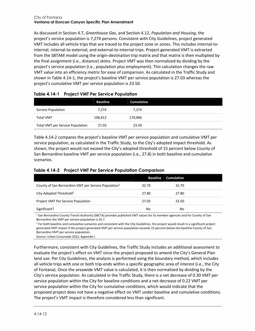
City of Fontana Ventana at Duncan Canyon Specific Plan Amendment
4.14-12
As discussed in Section 4.7, Greenhouse Gas, and Section 4.12, Population and Housing, the project’s service population is 7,274 persons. Consistent with City Guidelines, project generated VMT includes all vehicle trips that are traced to the project zone or zones. This includes internal-to-internal, internal-to-external, and external-to-internal trips. Project-generated VMT is extracted from the SBTAM model using the origin-destination trip matrix and that matrix is then multiplied by the final assignment (i.e., distance) skims. Project VMT was then normalized by dividing by the project’s service population (i.e., population plus employment). This calculation changes the raw VMT value into an efficiency metric for ease of comparison. As calculated in the Traffic Study and shown in Table 4.14-1, the project’s baseline VMT per service population is 27.03 whereas the project’s cumulative VMT per service population is 23.50.
Table 4.14-1 Project VMT Per Service Population Baseline Cumulative
Service Population 7,274 7,274
Total VMT 196,612 170,966
Total VMT per Service Population 27.03 23.50
Table 4.14-2 compares the project’s baseline VMT per service population and cumulative VMT per service population, as calculated in the Traffic Study, to the City’s adopted impact threshold. As shown, the project would not exceed the City’s adopted threshold of 15 percent below County of San Bernardino baseline VMT per service population (i.e., 27.8) in both baseline and cumulative scenarios.
Table 4.14-2 Project VMT Per Service Population Comparison Baseline Cumulative
County of San Bernardino VMT per Service Population1 32.70 32.70
City-Adopted Threshold2 27.80 27.80
Project VMT Per Service Population 27.03 23.50
Significant? No No 1 San Bernardino County Transit Authority (SBCTA) provides published VMT values for its member agencies and for County of San Bernardino the VMT per service population is 32.7. 2 For both baseline and cumulative scenarios and consistent with the City Guidelines, the project would result in a significant project generated VMT impact if the project generated VMT per service population exceeds 15 percent below the baseline County of San Bernardino VMT per service population. Source: Urban Crossroads 2022; Appendix I.
Furthermore, consistent with City Guidelines, the Traffic Study includes an additional assessment to evaluate the project’s effect on VMT since the project proposed to amend the City’s General Plan land use. Per City Guidelines, the analysis is performed using the boundary method, which includes all vehicle trips with one or both trip-ends within a specific geographic area of interest (i.e., the City of Fontana). Once the areawide VMT value is calculated, it is then normalized by dividing by the City’s service population. As calculated in the Traffic Study, there is a net decrease of 0.30 VMT per service population within the City for baseline conditions and a net decrease of 0.22 VMT per service population within the City for cumulative conditions, which would indicate that the proposed project does not have a negative effect on VMT under baseline and cumulative conditions. The project’s VMT impact is therefore considered less than significant.
Supplemental Draft Environmental Impact Report Transportation
Draft Supplemental Environmental Impact Report 4.14-13
Mitigation Measures Mitigation measures are not required.
4.14.4 Cumulative Impacts Planned and pending projects in Fontana and surrounding areas are listed in Table 3-1 in Section 3, Environmental Setting, and include residential, commercial, and industrial land uses.
As discussed under Impact TRA-1, the proposed project would not conflict with any programs or polices governing the City’s circulation system and, therefore, would not cumulatively contribute to a significant impact. All other planned and pending projects in Fontana will be assessed under CEQA and with City oversight for consistency with existing plans and programs. Furthermore, as discussed under Impact TRA-2, the proposed project would not result in a significant VMT impact under baseline and cumulative conditions. Therefore, cumulative impacts would be less than significant.

City of Fontana Ventana at Duncan Canyon Specific Plan Amendment
4.14-14
This page intentionally left blank
Environmental Impact Analysis Utilities and Service Systems
Draft Supplemental Environmental Impact Report 4.15-1
4.15 Utilities and Service Systems
This section analyzes the effects of the proposed project on utilities and service systems. It considers potential impacts with respect to water supply and infrastructure, wastewater conveyance and treatment facilities, stormwater and drainage facilities, solid waste disposal, and electricity, natural gas, and telecommunications facilities. The analysis is based on data and information in the following reports: the Air Quality and Greenhouse Study (Rincon Consultants, Inc. 2021; Appendix B), and the Water Supply Assessment for the Ventana at Duncan Canyon Specific Plan (WSA) (Water Systems Consulting, Inc. 2020; Appendix G).
4.15.1 Setting The following section describes the existing setting with respect to wastewater treatment providers, water suppliers, stormwater drainage facilities, solid waste facilities, electricity and natural gas providers, and telecommunications facilities serving the project site.
a. Water Supply The West Valley Water District (WVWD) provides water service to an approximately 31 square mile service area. WVWD is in the southwest region of San Bernardino County, California, and serves the Cities of Rialto, Fontana, Colton, and Jurupa Valley, and unincorporated areas of San Bernardino County. Figure 4.15-1 shows WVWD’s service area. Potable water is delivered to the project site vicinity via an existing 16-inch water mains within the Duncan Canyon Road and Citrus Avenue right of ways. The project site is located entirely within the WVWD’s northern section. The project area consists of 105 acres in the northern portion of the City of Fontana, California, north of Lytle Creek Road and east of Interstate-15 (I-15). The project site lies within pressure zone 7 of the northern section of WVWD’s water service area, a public water system as defined in the California Water Code Section 10912 (Water Systems Consulting, Inc. 2020). WVWD utilizes three primary sources for drinking water supply: local surface water from the east side of the San Gabriel Mountains, including North Fork Lytle Creek, Middle Fork Lytle Creek, and South Fork Lytle Creek; groundwater; and imported water from the State Water Project (SWP). Groundwater is the primary source of supply.
WVWD extracts groundwater from five regional groundwater basins: Bunker Hill, Lytle Creek, Rialto-Colton, Riverside North, and Chino Basins. All five basins have been adjudicated and are managed. Details on adjudication and management are provided in the WVWD 2015 Regional Urban Water Management Plan (UWMP). WVWD, in a joint venture with the City of Rialto and Valley District, constructed 25,000 feet of 48-inch transmission line known as the Baseline Feeder. Through an agreement with Valley District, WVWD can receive up to 5,000 acre-feet per year (AFY) of supply through this transmission line. WVWD has received water through the Baseline Feeder since 1998. WVWD draws approximately 46 percent of its water supply from its three wells. WVWD’s normal operating practice is to pump its wells 16 hours a day during off peak hours to take advantage of Southern California Edison’s time of use rate. If, for some reason, wells are not in service (maintenance or repair), WVWD has the ability and the right to pump its wells up to 24 hours per day. WVWD has approximately 32 million gallons per day (MGD) production capability from all its wells in operation 24 hours per day (Water Systems Consulting, Inc. 2020). Figure 4.15-2 shows groundwater basins in the vicinity of the project.
WVWD purchases SWP water from the San Bernardino Valley Municipal Water District (Valley District) through the Lytle Turnout off the San Gabriel Pipeline Feeder. SWP water is treated at
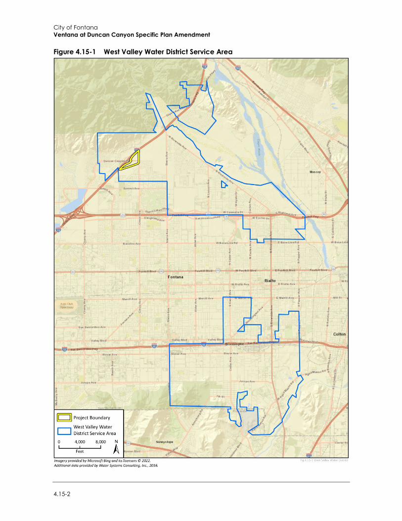
City of Fontana Ventana at Duncan Canyon Specific Plan Amendment
4.15-2
Figure 4.15-1 West Valley Water District Service Area

Environmental Impact Analysis Utilities and Service Systems
Draft Supplemental Environmental Impact Report 4.15-3
Figure 4.15-2 Groundwater Basins
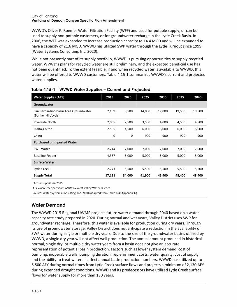
City of Fontana Ventana at Duncan Canyon Specific Plan Amendment
4.15-4
WVWD’s Oliver P. Roemer Water Filtration Facility (WFF) and used for potable supply, or can be used to supply non-potable customers, or for groundwater recharge in the Lytle Creek Basin. In 2006, the WFF was expanded to increase production capacity to 14.4 MGD and will be expanded to have a capacity of 21.6 MGD. WVWD has utilized SWP water through the Lytle Turnout since 1999 (Water Systems Consulting, Inc. 2020).
While not presently part of its supply portfolio, WVWD is pursuing opportunities to supply recycled water. WVWD’s plans for recycled water are still preliminary, and the expected beneficial use has not been quantified. To the extent feasible, if and when recycled water is available to WVWD, this water will be offered to WVWD customers. Table 4.15-1 summarizes WVWD’s current and projected water supplies.
Table 4.15-1 WVWD Water Supplies – Current and Projected
Water Supplies (AFY) 20151 2020 2025 2030 2035 2040
Groundwater
San Bernardino Basin Area Groundwater (Bunker Hill/Lytle)
2,159 9,500 14,000 17,000 19,500 19,500
Riverside North 2,065 2,500 3,500 4,000 4,500 4,500
Rialto-Colton 2,505 4,500 6,000 6,000 6,000 6,000
Chino 0 0 900 900 900 900
Purchased or Imported Water
SWP Water 2,244 7,000 7,000 7,000 7,000 7,000
Baseline Feeder 4,367 5,000 5,000 5,000 5,000 5,000
Surface Water
Lytle Creek 2,271 5,500 5,500 5,500 5,500 5,500
Supply Total 17,131 34,000 41,900 45,400 48,400 48,400
1Actual supplies in 2015.
AFY = acre-feet per year; WVWD = West Valley Water District
Source: Water Systems Consulting, Inc. 2020 (adapted from Table 6-4; Appendix G)
Water Demand The WVWD 2015 Regional UWMP projects future water demand through 2040 based on a water capacity rate study prepared in 2020. During normal and wet years, Valley District uses SWP for groundwater recharge. Therefore, this water is available for production during dry years. Through its use of groundwater storage, Valley District does not anticipate a reduction in the availability of SWP water during single or multiple dry years. Due to the size of the groundwater basins utilized by WVWD, a single dry year will not affect well production. The annual amount produced in historical normal, single dry, or multiple dry water years from a basin does not give an accurate representation of potential basin production. Factors such as lower system demand, cost of pumping, inoperable wells, pumping duration, replenishment costs, water quality, cost of supply and the ability to treat water all affect annual basin production numbers. WVWD has utilized up to 5,500 AFY during normal times from Lytle Creek surface flows and projects a minimum of 2,130 AFY during extended drought conditions. WVWD and its predecessors have utilized Lytle Creek surface flows for water supply for more than 130 years.
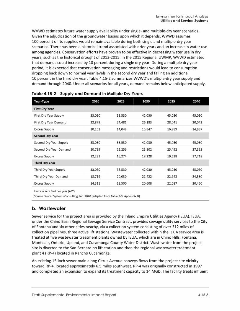
Environmental Impact Analysis Utilities and Service Systems
Draft Supplemental Environmental Impact Report 4.15-5
WVWD estimates future water supply availability under single- and multiple-dry year scenarios. Given the adjudication of the groundwater basins upon which it depends, WVWD assumes 100 percent of its supplies would remain available during both single and multiple-dry year scenarios. There has been a historical trend associated with drier years and an increase in water use among agencies. Conservation efforts have proven to be effective in decreasing water use in dry years, such as the historical drought of 2013-2015. In the 2015 Regional UWMP, WVWD estimated that demands could increase by 10 percent during a single dry year. During a multiple dry year period, it is expected that conservation messaging and restrictions would lead to consumption dropping back down to normal year levels in the second dry year and falling an additional 10 percent in the third dry year. Table 4.15-2 summarizes WVWD’s multiple-dry year supply and demand through 2040. Under all scenarios for all years, demand remains below anticipated supply.
Table 4.15-2 Supply and Demand in Multiple Dry Years
Year-Type 2020 2025 2030 2035 2040
First Dry Year
First Dry Year Supply 33,030 38,530 42,030 45,030 45,030
First Dry Year Demand 22,879 24,481 26,183 28,041 30,043
Excess Supply 10,151 14,049 15,847 16,989 14,987
Second Dry Year
Second Dry Year Supply 33,030 38,530 42,030 45,030 45,030
Second Dry Year Demand 20,799 22,256 23,802 25,492 27,312
Excess Supply 12,231 16,274 18,228 19,538 17,718
Third Dry Year
Third Dry Year Supply 33,030 38,530 42,030 45,030 45,030
Third Dry Year Demand 18,719 20,030 21,422 22,943 24,580
Excess Supply 14,311 18,500 20,608 22,087 20,450
Units in acre feet per year (AFY)
Source: Water Systems Consulting, Inc. 2020 (adapted from Table 8-3; Appendix G)
b. Wastewater Sewer service for the project area is provided by the Inland Empire Utilities Agency (IEUA). IEUA, under the Chino Basin Regional Sewage Service Contract, provides sewage utility services to the City of Fontana and six other cities nearby, via a collection system consisting of over 312 miles of collection pipelines, three active lift stations. Wastewater collected within the IEUA service area is treated at five wastewater treatment plants owned by IEUA, which are in Chino Hills, Fontana, Montclair, Ontario, Upland, and Cucamonga County Water District. Wastewater from the project site is diverted to the San Bernardino lift station and then the regional wastewater treatment plant 4 (RP-4) located in Rancho Cucamonga.
An existing 15-inch sewer main along Citrus Avenue conveys flows from the project site vicinity toward RP-4, located approximately 6.5 miles southwest. RP-4 was originally constructed in 1997 and completed an expansion to expand its treatment capacity to 14 MGD. The facility treats influent
City of Fontana Ventana at Duncan Canyon Specific Plan Amendment
4.15-6
to tertiary standards, meeting all Title 22 requirements for recycled water. Currently, treatment plant effluent is discharged to RP-1 for thickening, anaerobic digestion, and dewatering (IEUA 2021).
c. Stormwater Drainage Facilities Currently, stormwater on the project site flows from higher elevations in the northeast corner of the project site (approximately 1,800 feet above mean sea level [AMSL]) to lower elevations in the southern and western portions of the project site (ranging from approximately 1,689 to 1,741 feet AMSL). New storm drain lines will be installed on Citrus Avenue north of Duncan Canyon and on Duncan Canyon between the Plan Area’s western edge and Citrus Avenue. This will intercept a main line that follows the Lytle Creek Road alignment north of Duncan Canyon Road. The area south of Duncan Canyon will drain to a main line in Lytle Creek Road that connects to an existing storm drain south of the Plan Area. Lateral lines will be extended to each Planning Area as needed. Stormwater conveyance facilities in Fontana are maintained by the Fontana Department of Public Works.
d. Solid Waste Facilities Waste and recycling services to the project site will be provided by Burrtec Waste Industries. No landfills are in Fontana; instead, municipal solid waste is disposed of at the West Valley Materials Recovery Facility Transfer Station in Fontana (approximately six miles southwest of the project site). The nearest landfill is Mid-Valley Sanitary Landfill in Rialto, located approximately two miles southeast of the project site, which is owned and operated by the County of San Bernardino Solid Waste Management Division. Mid-Valley Sanitary Landfill accepts wood, tires, mixed municipal, inert, industrial, green materials, dead animals, contaminated soil, construction and demolition, and agricultural waste (California Department of Resources and Recycling and Recovery [CalRecycle] 2019a). Additional landfills in the southwestern portion of San Bernardino County that may receive waste generated in Fontana include the Pennsylvania Street Inert Landfill in San Bernardino (approximately eight miles southeast of the project site) and the Agua Mansa Landfill in Rialto (approximately ten miles southeast of the project site). Pennsylvania Street Inert Landfill is owned and operated by Robertson Ready Mix and Agua Mansa Landfill is owned and operated by Yeager E. L. Construction Company. Both the Pennsylvania Street Inert and Agua Mansa Landfills accept inert and construction and demolition waste (CalRecycle 2019b, 2019c).
e. Electricity and Natural Gas Providers Natural gas-fired power plants provided approximately 35 percent of the total electricity in California generated in 2020 (California Energy Commission [CEC] 2019). In 2020, California produced 70 percent of the electricity it used and imported the rest from outside the state. In 2019, California used 263,329 gigawatt hours (GWh) of electricity, with 201,784 GWh produced in-state (EIA 2020). San Bernardino County as a whole consumed approximately 527.2 million therms of natural gas in 2020 in both residential and non-residential uses (CEC 2021). San Bernardino County also consumed approximately 15,968.5 GWh of electricity in 2020 from residential and non-residential uses (CEC 2021).
Southern California Edison (SCE) provides electricity to Fontana, including the project site. SCE maintains substations and distribution lines in the region, including the Rancho Vista substation, approximately six miles southwest of the project site in Rancho Cucamonga and the Calectric substation, approximately nine miles southeast of the project site in San Bernardino. Additionally, as discussed in Section 2, Project Description, a SCE transmission line corridor is adjacent to the southeastern project boundary.
Environmental Impact Analysis Utilities and Service Systems
Draft Supplemental Environmental Impact Report 4.15-7
Southern California Gas (SCG) provides natural gas service to approximately six million residential and business customers across 20,000 square miles of southern California, including Fontana (SCG 2021a). The project site is located in SCG’s Northern Zone. An existing natural gas transmission line and high-pressure distribution line owned and operated by SCG is located approximately 430 feet southeast and 600 feet east, respectively of the project site (SCG 2021b).
For additional information on electricity and natural gas service and consumption, refer to Section 4.5, Energy.
f. Telecommunications Numerous private local, wireless, and cellular phone service providers serve the Fontana area. As discussed in Section 2, Project Description, AT&T telecommunications lines are collocated along existing SCE electrical transmission lines within the project site along Duncan Canyon Road.
4.15.2 Regulatory Setting
a. Federal Regulations
Federal Clean Water Act of 1977 The federal Water Pollution Control Act was passed in 1972 and was amended in 1977 as the Clean Water Act (CWA) (33 U.S.C. 1251 1376). The CWA was reauthorized in 1981, 1987, and 2000. It establishes the basic structure for regulating discharges of pollutants into the waters of the United States and has given the United States Environmental Protection Agency the authority to implement pollution control programs. The CWA requires states to set standards to protect, maintain, and restore water quality through the regulation of point source and certain non-point source discharges to surface waters. Many pollutants are regulated under the CWA, including various toxic pollutants, total suspended solids, biological oxygen demand and pH (acidity/alkalinity measure scale). Those discharges are regulated by the National Pollutant Discharge Elimination System permit process, described below. The CWA generally applies to surface Waters of the United States, managed by the United States Army Corps of Engineers.
a. State Regulations
Porter-Cologne Water Quality Control Act The Porter-Cologne Water Quality Control Act is the overarching water quality control law for California. It is implemented by the SWRCB and nine Regional Water Quality Control Boards (RWQCB). The State Water Resources Control Board (SWRCB) establishes statewide policy for water quality control and provides oversight of the regional boards’ operations. The Porter-Cologne Act and the CWA overlap in many ways, as the entities established by the Porter-Cologne Act enforce and implement many federal laws and policies.
Water Conservation Act of 2009 Senate Bill (SB) X7-7, which became effective on February 3, 2010, is the water conservation component to the Delta legislative package (SB 1, Delta Governance/Delta Plan). It seeks to implement water use reduction goals established in 2008 to achieve a 20 percent statewide reduction in urban per capita water use by December 31, 2020. The bill requires each urban retail
City of Fontana Ventana at Duncan Canyon Specific Plan Amendment
4.15-8
water supplier to develop urban water use targets to help meet the 20 percent goal by 2020 and meet an interim 10 percent goal by 2015.
Senate Bill 610 SB 610 was signed into law in 2001. This law requires cities and counties to develop water supply assessments (WSAs) when considering approval of applicable development projects in order to determine whether projected water supplies can meet the project’s anticipated water demand. Triggers requiring the preparation of a WSA include residential developments of more than 500 dwelling units, shopping centers or business establishments employing more than 1,000 persons or having more than 500,000 square feet of floor space, commercial office buildings employing more than 1,000 persons or having more than 250,000 square feet of floor space, and projects that would demand an amount of water equivalent to, or greater than, the amount of water required by a 500 dwelling unit project.
Senate Bill 221 Whereas SB 610 requires a written assessment of water supply availability, SB 221 requires lead agencies to obtain written verification of sufficient water supply prior to approval of certain specified subdivision projects. For this purpose, water suppliers may rely on an UWMP (if a proposed project is accounted for within the UWMP), a WSA or other acceptable information that constitutes “substantial evidence.” “Sufficient water supply” is defined in SB 221 as the total water supplies available during normal, single-dry and multiple-dry water years within the 20-year (or greater) projection period that are available to meet the projected demand associated with a proposed project, in addition to existing and planned future uses. WSAs are required for residential projects of more than 500 units and hotels of more than 500 rooms.
2019 California Green Building Standards Code In January 2010, the California Building Standards Commission adopted the statewide mandatory CalGreen that requires the installation of water-efficient indoor infrastructure for all new projects beginning after January 1, 2011. CalGreen was incorporated as Part 11 into Title 24 of the California Code of Regulations. CalGreen was most recently revised in 2015, with the revisions taking effect for projects approved after December 31, 2015. These revisions include the adoption of former emergency measures for outdoor irrigation and indoor plumbing fixtures applied in 2015 in response to the Governor’s Executive Order B-29-15 in response to extreme drought conditions. CalGreen applies to the planning, design, operation, construction, use and occupancy of every newly constructed building or structure. All new development must satisfy the indoor water use infrastructure standards necessary to meet CalGreen.
CalGreen requires residential and nonresidential water efficiency and conservation measures for new buildings and structures that will reduce the overall potable water use inside the building by 20 percent. The 20 percent water savings can be achieved in one of the following ways: (1) installation of plumbing fixtures and fittings that meet the 20 percent reduced flow rate specified in CalGreen, or (2) by demonstrating a 20 percent reduction in water use from the building “water use baseline.”
Urban Water Management Plan Act The California Urban Water Management Planning Act applies to municipal water suppliers that serve more than 3,000 customers or provide more than 3,000 AFY of water. The Act requires these
Environmental Impact Analysis Utilities and Service Systems
Draft Supplemental Environmental Impact Report 4.15-9
water suppliers to update their UWMP every five years to identify short-term and long-term water demand management measures to meet growing water demands during normal, dry and multiple-dry years. The UWMP should include a description of existing and planned water sources, alternative sources, conservation efforts, reliability and vulnerability assessments, and a water shortage contingency analysis.
Phase II Stormwater Discharge Permit (Order Number 2013-0001-DWQ) On February 5, 2013, the SWRCB adopted the Waste Discharge Requirements for Stormwater Discharges from Small Municipal Separate Storm Sewer System (MS4) General Permit (Order Number 2013-0001-DWQ) (Phase II MS4 Permit). The Phase II MS4 Permit regulates stormwater discharges from small MS4 systems throughout California.
The Phase II MS4 Permit effectively prohibits non-stormwater discharges to the MS4. Furthermore, the permit requires all regulated projects—which are defined as projects creating and/or replacing 5,000 sf or more of impervious area—to incorporate low impact development (LID) measures, including stormwater retention and treatment features. Stormwater retention and treatment features must be designed to capture runoff from the 85th percentile, 24-hour storm event; 80 percent of the annual runoff; or flow from either 0.2 inch per hour rainfall intensity or twice the 85th percentile hourly rainfall intensity as determined by local rainfall records.
Integrated Solid Waste Management Act of 1989 The California Integrated Waste Management Act (CIWMA) of 1989 created the (former) California Integrated Waste Management Board, now CalRecycle. Responsible for oversight of waste management in California, CalRecycle assists cities, counties, businesses, and organizations with meeting state waste reduction, reuse, and recycling goals. Assembly Bill (AB) 939 requires that local jurisdictions meet waste diversion goals and establish a framework for program implementation, solid waste planning, and solid waste facility and landfill compliance. The CIWMA was primarily intended to encourage minimization of the volume of solid waste disposed of through “transformation” (including incineration, pyrolysis, distillation, and bioconversion) and land disposal through the establishment of solid waste diversion goals for all cities and counties.
Assembly Bill 341 (Chesbro, 2011) AB 341 builds from the goals and requirements of AB 939. It declared a State policy goal of 75 percent diversion of solid waste by the year 2020 and directed CalRecycle to develop and adopt regulations for mandatory commercial recycling.
CalGreen Construction Waste Management Requirements CalGreen includes a number of requirements related to solid waste diversion. Importantly, new non-residential construction is required to achieve at least 65 percent construction and demolition waste diversion and provide recycling areas for paper, cardboard, glass, plastics, metal, and organic waste.
b. Local Regulations
2015 San Bernardino Valley Regional Urban Water Management Plan The 2015 Regional UWMP was prepared in accordance with the California Urban Water Management Planning Act and to implement the Water Conservation Act of 2009. The Plan
City of Fontana Ventana at Duncan Canyon Specific Plan Amendment
4.15-10
encourages active planning for future demand and available supplies of water resources, and reports on water conservation strategies to meet the demands.
City of Fontana General Plan The Fontana General Plan, specifically the Sustainability and Resilience chapter and the Infrastructure and Green Systems chapter, recognizes the importance of achieving a reliable water supply and integrated waste management. The General Plan includes the following goals and policies that apply to the project:
Sustainability and Resilience
Goal 7: Conservation of water resources with best practices such as drought-tolerant plant species, recycled water, greywater systems, has become a way of life in Fontana.
Policy: Continue to promote and implement best practices to conserve water.
Infrastructure and Green Systems
Goal 1: Fontana collaborates with public and private agencies for an integrated and sustainable water resource management program.
Policy: Support initiatives to provide a long-term supply of the right water for the right use through working with regional providers and the One Water One Watershed Plan.
Goal 2: Fontana promotes use of non-potable water for uses where drinking water is not needed.
Policy: Encourage use of processed water from the IEUA systems using recycled water for all non-drinking water purposes.
Policy: Promote laundry-to-landscape greywater systems for single-family housing units.
Goal 3: The city continues to have an effective water conservation program.
Policy: Support landscaping in public and private spaces with drought resistant plants.
Policy: Continue successful city water conservation programs and partnerships.
Goal 4: The City of Fontana consistently seeks reasonable rates from the city’s drinking water providers.
Policy: Support City negotiations to keep drinking water rates reasonable for residents and other users.
Goal 6: The City of Fontana consistently seeks reasonable rates from the city’s drinking water providers.
Policy: Continue to implement the Water Quality Management Plan for stormwater management that incorporates low-impact and green infrastructure standards.
Policy: Promote natural drainage approaches (green infrastructure) and other alternative non-structural and structural best practices to manage and treat stormwater.
City of Fontana Municipal Code Chapter 24.11 of the City of Fontana Municipal Code establishes diversion requirements for construction and demolition activities and requires applicants to submit a Waste Reduction and
Environmental Impact Analysis Utilities and Service Systems
Draft Supplemental Environmental Impact Report 4.15-11
Recycling Plan for review and approval in order to reduce the amount of construction waste is disposed of in landfills.
4.15.3 Impact Analysis
a. Significance Thresholds For the purposes of this EIR and in accordance with the environmental checklist contained in Appendix G of the CEQA Guidelines, a utilities and service systems impact is considered significant if the project would:
Require or result in the relocation or construction of new or expanded water, wastewater treatment or stormwater drainage, electric power, natural gas, or telecommunications facilities, the construction of which could cause significant environmental effects;
Not have sufficient water supplies available to serve the project and reasonably foreseeable future development during normal, dry and multiple-dry years;
Result in a determination by the wastewater treatment provider which serves or may serve the project that it does not have adequate capacity to serve the project’s projected demand in addition to the provider’s existing commitments;
Generate solid waste in excess of State or local standards, or in excess of the capacity of local infrastructure, or otherwise impair the attainment of solid waste reduction goals; or
Not comply with federal, State, and local management and reduction statutes and regulations related to solid waste.
b. Methodology Project water demand and wastewater generation were estimated using demand factors contained in the 2015 Regional UWMP and the analysis provided by the WSA prepared by Water Systems Consulting, Inc. These factors are used by WVWD for initial planning purposes to estimate maximum daily demand and, therefore, provide a conservative estimate of annual water demand and wastewater generation. Stormwater infrastructure impacts were analyzed based on the project-specific drainage plans. Solid waste generation associated with the project was estimated based on anticipated demolition debris, soil export, and operational waste generation as reported in the California Emissions Estimator Model (CalEEMod). CalEEMod calculates annual waste generation based on land use-based waste disposal rates reported by CalRecycle (California Air Pollution Control Officers Association [CAPCOA] 2017). Electricity, natural gas, and telecommunications infrastructure impacts were evaluated based on the project’s utilities site plan. Other publicly available resources consulted as part of this analysis include the General Plan and the 2015 San Bernardino Valley Regional UWMP.
c. Standard Conditions The following standard conditions related to utilities and service systems, and identified in the 2007 EIR, remain applicable to the proposed project:
Standard Condition 4.14.1: The developer shall coordinate with the West Valley Water District on water line extensions to serve individual parcels and building pads on the site. All water facilities shall be constructed in accordance with the District’s rules and regulations and Standards for Domestic Water Facilities.
City of Fontana Ventana at Duncan Canyon Specific Plan Amendment
4.15-12
Standard Condition 4.14.2: Future developments shall implement water conservation measures into the project design of the individual developments on the site to reduce water demand, in accordance with the Water Conservation Plan of the West Valley Water District.
d. Project Impacts
Threshold 1: Would the project require or result in the relocation or construction of new or expanded water, wastewater treatment or storm water drainage, electric power, natural gas, or telecommunications facilities, the construction or relocation of which could cause significant environmental effects?
Impact U-1 THE PROJECT WOULD INVOLVE THE RELOCATION OF ELECTRICAL AND TELECOMMUNICATIONS FACILITIES AND CONSTRUCTION OF NEW OR EXPANDED WATER, WASTEWATER TREATMENT, AND STORMWATER DRAINAGE FACILITIES ON THE PROJECT SITE. HOWEVER, SUCH RELOCATION AND CONSTRUCTION WOULD NOT CAUSE SIGNIFICANT ENVIRONMENTAL EFFECTS. IMPACTS WOULD BE LESS THAN SIGNIFICANT.
Water The 2007 EIR determined that development under the project would not result in the relocation or construction of new or expanded water facilities as WVWD would have sufficient supplies to serve the project.
According to Section 2, Project Description, the project site vicinity is served by WVWD. Duncan Canyon Road, and Citrus Avenue south of Duncan Canyon Road, have existing water infrastructure. Planned water infrastructure on Citrus Avenue is anticipated to be completed as part of the nearby Monterado development. A new water main line is expected to follow the alignment of Lytle Creek Road. The main line would create a loop connection with the planned infrastructure on Citrus Avenue to the north and would connect to an existing line along I-15, south of Duncan Canyon Road. Laterals would be provided to each Planning Area as needed.
The proposed water main, laterals, fire water lines, and hydrants would be installed during project construction and within the disturbance area of the project; therefore, the construction of these infrastructure improvements would not substantially increase the project’s disturbance area, associated emissions, or otherwise cause significant environmental effects beyond those identified throughout this document. As described in Impact U-2, below, the project would be served by existing and planned WVWD supplies, which are not anticipated to require major WVWD treatment or distribution facility improvements. Therefore, impacts with respect to new or expanded water facilities would be less than significant.
Wastewater Treatment The 2007 EIR determined that development under the project would not result in the relocation or construction of new or expanded wastewater facilities as IEUA would have sufficient capacity to treat project wastewater.
Sewer service for the project area would continue to be provided by the IIEUA. A sewer main line is expected to follow the Lytle Creek Road alignment and gravity flow to the southwest, connecting to an existing sewer line south of the project area. Points of Connection (POC) would be provided to each Planning Area as needed. The proposed sewer main would serve the future buildings via approximately 11 sanitary sewer lateral connections. As with water facilities, sewer line extensions
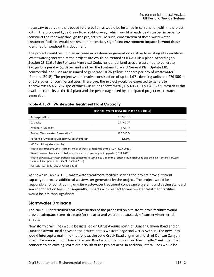
Environmental Impact Analysis Utilities and Service Systems
Draft Supplemental Environmental Impact Report 4.15-13
necessary to serve the proposed future buildings would be installed in conjunction with the project within the proposed Lytle Creek Road right-of-way, which would already be disturbed in order to construct the roadway through the project site. As such, construction of these wastewater treatment facilities would not result in potentially significant environment impacts beyond those identified throughout this document.
The project would result in an increase in wastewater generation relative to existing site conditions. Wastewater generated at the project site would be treated at IEUA’s RP-4 plant. According to Section 23-316 of the Fontana Municipal Code, residential land uses are assumed to generate 270 gallons per day (gpd) per unit and per the Fontana Forward General Plan Update EIR, commercial land uses are assumed to generate 10.76 gallons per acre per day of wastewater (Fontana 2018). The project would involve construction of up to 1,671 dwelling units and 476,500 sf, or 10.9 acres, of commercial uses. Therefore, the project would be expected to generate approximately 451,287 gpd of wastewater, or approximately 0.5 MGD. Table 4.15-3 summarizes the available capacity at the R-4 plant and the percentage used by anticipated project wastewater generation.
Table 4.15-3 Wastewater Treatment Plant Capacity Regional Water Recycling Plant No. 4 (RP-4)
Average Inflow 10 MGD1
Capacity 14 MGD2
Available Capacity 4 MGD
Project Wastewater Generation3 0.5 MGD
Percent of Available Capacity Used by Project 12.5%
MGD = million gallons per day 1Based on current volume treated from all sources, as reported by the IEUA (IEUA 2021). 2Based on new plant capacity following recently completed plant upgrades (IEUA 2021). 3Based on wastewater generation rates contained in Section 23-316 of the Fontana Municipal Code and the Final Fontana Forward General Plan Update EIR (City of Fontana 2018).
Sources: IEUA 2021, City of Fontana 2018
As shown in Table 4.15-3, wastewater treatment facilities serving the project have sufficient capacity to process additional wastewater generated by the project. The project would be responsible for constructing on-site wastewater treatment conveyance systems and paying standard sewer connection fees. Consequently, impacts with respect to wastewater treatment facilities would be less than significant.
Stormwater Drainage The 2007 EIR determined that construction of the proposed on-site storm drain facilities would provide adequate storm drainage for the area and would not cause significant environmental effects.
New storm drain lines would be installed on Citrus Avenue north of Duncan Canyon Road and on Duncan Canyon Road between the project area’s western edge and Citrus Avenue. The new lines would intercept a main line that follows the Lytle Creek Road alignment north of Duncan Canyon Road. The area south of Duncan Canyon Road would drain to a main line in Lytle Creek Road that connects to an existing storm drain south of the project area. In addition, lateral lines would be
City of Fontana Ventana at Duncan Canyon Specific Plan Amendment
4.15-14
extended to each Planning Area as needed. Under the proposed drainage condition, a series of biofiltration/catchment basins would collect drainage from throughout the project site. Water collected in the biofiltration/catchment basins would flow through a network of smaller storm drains to one of the proposed detention basins. The basins would detain flow to the storm drain mainline within the Lytle Creek Road alignment.
As with water and wastewater facilities, proposed storm drain infrastructure would be constructed within the disturbance area of the project and would not result in substantial additional environmental impacts. Given that the project would capture and retain on-site runoff from the 100-year storm event, off-site improvements to the storm drain network would not be necessary. As such, impacts related to new or expanded stormwater facilities would be less than significant.
For additional discussion of the project’s drainage and stormwater impacts, refer to Section 4.9, Hydrology and Water Quality.
Electric Power and Natural Gas The 2007 EIR determined that construction of the proposed on-site storm drain facilities would provide adequate storm drainage for the area and would not cause significant environmental effects. Dry utility services (i.e., electrical, and gas) would be extended north and south along Lytle Creek Road from existing facilities on Duncan Canyon Road. Electrical services would be provided by SCE, and gas service would be provided by SoCal Gas.
As discussed in Section 4.5, Energy, the project would increase electricity and natural gas demand on the project site. However, such increased demand would account for a minimal fraction of SCE’s and SCG’s total demand in the region. The nominal increase in energy demand is not anticipated to require additional electricity substations or natural gas storage/transmission facilities beyond those currently serving the Fontana area. Impacts with respect to new or expanded electric power or natural gas facilities would be less than significant.
For additional discussion of the project’s electricity and natural gas demand, refer to Section 4.5, Energy.
Telecommunications The 2007 EIR determined that the project would not result in the relocation or construction of new or expanded telecommunication facilities as AT&T and Adelphia Communications would both have sufficient existing facilities to serve the project.
AT&T telecommunications lines are collocated with SCE transmission lines and would be extended north and south along Lytle Creek Road from existing facilities on Duncan Canyon Road. Substantial additional ground disturbance, grading, or use of heavy equipment beyond that necessary for the proposed roadway improvements would not be anticipated. No additional telecommunications improvements are proposed as part of the project. Consequently, impacts would be less than significant.
Mitigation Measures Mitigation measures are not required.
Environmental Impact Analysis Utilities and Service Systems
Draft Supplemental Environmental Impact Report 4.15-15
Threshold 2: Would the project have sufficient water supplies available to serve the project and reasonably foreseeable future development during normal, dry and multiple dry years?
Impact U-2 THE PROJECT WOULD DEMAND APPROXIMATELY 358 AFY OF WATER, WHICH WOULD REPRESENT LESS THAN FIVE PERCENT OF WVWD’S PROJECTED EXCESS WATER SUPPLY FOR ALL NORMAL, SINGLE-DRY, AND MULTIPLE-DRY YEAR SCENARIOS THROUGH 2040. BASED ON WVWD’S WATER SUPPLY AND DEMAND PROJECTIONS, PROJECTED WATER SUPPLIES ARE SUFFICIENT TO MEET THE ANTICIPATED WATER DEMAND OF THE PROJECT AND REASONABLY FORESEEABLE FUTURE DEVELOPMENT DURING NORMAL, DRY, AND MULTIPLE DRY YEARS. IMPACTS WOULD BE LESS THAN SIGNIFICANT.
The project would generate both construction-related and operational water demand. Discussions of both sources of water demand follow.
Construction Demand The 2007 EIR determined that the WVWD would have sufficient water supplies to serve the estimated water demand created by the project.
Water would be required for temporary construction activities on the project site, including dust suppression, grading and grubbing, compaction, construction equipment wheel washing, and concrete mixing and casting. Water consumption by construction workers and cleaning of portable toilets on the project site may also account for a small portion of overall construction water demand.
Watering for dust suppression would demand the most water during construction. Pursuant to the requirements of South Coast Air Quality Management District Rule 403 as described in Section 4.2, Air Quality, all disturbed unpaved roads and disturbed areas within the project site would be watered approximately three times per day to reduce fugitive dust generation from construction activities. Water demand for dust suppression is highly dependent on a number of site-specific variables, including soil properties, antecedent moisture conditions, and other climatic factors. In other arid and semi-arid portions of southern California, water demand for construction dust control has been estimated at roughly 3,300 to 4,000 gallons per acre per day (County of San Diego 2013; Murphy 2015). The site preparation and grading phases would last approximately 40 and 95 days, respectively, and would disturb up to five acres per day. Conservatively assuming an application rate of 4,000 gallons per acre per day, dust control during the site preparation and grading phases would require approximately 2.7 million gallons of water, or approximately 10 AF in total. This temporary demand would amount to less than three percent of the project’s annual operational water demand.
Construction water demand would be temporary and, therefore, would not result in a long-term strain on water supplies. Given the temporary and minimal nature of construction water demand as compared to operational water consumption, as well as the fact that WVWD would be able to restrict or require conservation measures for water intensive construction activities, impacts related to construction water consumption would be less than significant.
Operational Demand The 2007 EIR determined that the WVWD would have sufficient water supplies to serve the estimated water demand created by the project.
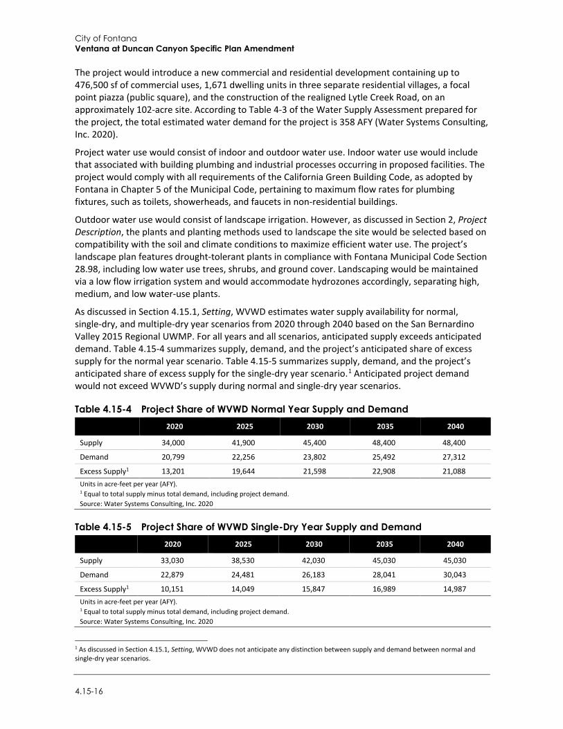
City of Fontana Ventana at Duncan Canyon Specific Plan Amendment
4.15-16
The project would introduce a new commercial and residential development containing up to 476,500 sf of commercial uses, 1,671 dwelling units in three separate residential villages, a focal point piazza (public square), and the construction of the realigned Lytle Creek Road, on an approximately 102-acre site. According to Table 4-3 of the Water Supply Assessment prepared for the project, the total estimated water demand for the project is 358 AFY (Water Systems Consulting, Inc. 2020).
Project water use would consist of indoor and outdoor water use. Indoor water use would include that associated with building plumbing and industrial processes occurring in proposed facilities. The project would comply with all requirements of the California Green Building Code, as adopted by Fontana in Chapter 5 of the Municipal Code, pertaining to maximum flow rates for plumbing fixtures, such as toilets, showerheads, and faucets in non-residential buildings.
Outdoor water use would consist of landscape irrigation. However, as discussed in Section 2, Project Description, the plants and planting methods used to landscape the site would be selected based on compatibility with the soil and climate conditions to maximize efficient water use. The project’s landscape plan features drought-tolerant plants in compliance with Fontana Municipal Code Section 28.98, including low water use trees, shrubs, and ground cover. Landscaping would be maintained via a low flow irrigation system and would accommodate hydrozones accordingly, separating high, medium, and low water-use plants.
As discussed in Section 4.15.1, Setting, WVWD estimates water supply availability for normal, single-dry, and multiple-dry year scenarios from 2020 through 2040 based on the San Bernardino Valley 2015 Regional UWMP. For all years and all scenarios, anticipated supply exceeds anticipated demand. Table 4.15-4 summarizes supply, demand, and the project’s anticipated share of excess supply for the normal year scenario. Table 4.15-5 summarizes supply, demand, and the project’s anticipated share of excess supply for the single-dry year scenario.1 Anticipated project demand would not exceed WVWD’s supply during normal and single-dry year scenarios.
Table 4.15-4 Project Share of WVWD Normal Year Supply and Demand
2020 2025 2030 2035 2040
Supply 34,000 41,900 45,400 48,400 48,400
Demand 20,799 22,256 23,802 25,492 27,312
Excess Supply1 13,201 19,644 21,598 22,908 21,088 Units in acre-feet per year (AFY). 1 Equal to total supply minus total demand, including project demand. Source: Water Systems Consulting, Inc. 2020
Table 4.15-5 Project Share of WVWD Single-Dry Year Supply and Demand
2020 2025 2030 2035 2040
Supply 33,030 38,530 42,030 45,030 45,030
Demand 22,879 24,481 26,183 28,041 30,043
Excess Supply1 10,151 14,049 15,847 16,989 14,987 Units in acre-feet per year (AFY). 1 Equal to total supply minus total demand, including project demand. Source: Water Systems Consulting, Inc. 2020
1 As discussed in Section 4.15.1, Setting, WVWD does not anticipate any distinction between supply and demand between normal and single-dry year scenarios.
Environmental Impact Analysis Utilities and Service Systems
Draft Supplemental Environmental Impact Report 4.15-17
Additionally, the 2015 Regional UWMP estimates future water supply availability for multiple-dry year scenarios. As discussed in Section 4.15.1, Setting, WVWD anticipates no distinction between normal and single-dry year scenarios, and anticipates demand reductions in the second through fourth multiple-dry years as increasingly stringent conservation measures are implemented. Table 4.15-2 summarizes supply, demand, and the project’s percentage of excess supply during the second and third multiple-dry years. Anticipated project demand would account for less than five percent of excess supply during all single- and multiple-dry year scenarios.
The water supply availability analysis incorporates a number of conservative assumptions. Firstly, the analysis above considers all project-generated demand to be new demand and does not account for existing water use on the project. Secondly, the analysis conservatively assumes that project-generated water demand would not be reduced in single- or multiple-dry year scenarios as a result of conservation measures. Finally, the analysis compares the project’s anticipated water demand to excess WVWD supply in future years. The project site was identified as undeveloped non-residential land in the WVWD Development Status map included in the 2015 Regional UWMP, and at least a portion of the project’s anticipated water demand would be captured in the demand projections included in the 2015 Regional UWMP. Nevertheless, despite these conservative assumptions outlined above, the project would not exceed WVWD’s projected supply during all normal, single-dry, and multiple-dry year scenarios through 2040. Therefore, based on the water demand projections, projected local water supplies are sufficient to serve the project during normal, single-dry, and multiple-dry years. Impacts would be less than significant.
Mitigation Measures Mitigation measures are not required.
Threshold 3: Would the project result in a determination by the wastewater treatment provider which serves or may serve the project that it has adequate capacity to serve the project’s projected demand in addition to the provider’s existing commitments?
Impact U-3 PROJECT-GENERATED WASTEWATER WOULD BE TREATED AT IEUA’S REGIONAL WASTEWATER PLANT THAT’S LOCATED IN RANCH CUCAMONGA (RP-4) PLANT. THE PLANT WOULD HAVE ADEQUATE CAPACITY TO SERVE THE PROJECT’S PROJECTED WASTEWATER GENERATION IN ADDITION TO ITS EXISTING WASTEWATER TREATMENT COMMITMENTS. IMPACTS WOULD BE LESS THAN SIGNIFICANT.
The 2007 EIR determined that there is sufficient capacity at the RP-4 plant to accommodate the projected sewage generated by the project.
As discussed under Impact U-1, project-generated wastewater would be adequately served by available capacity at the RP-4 plant. Wastewater generated by the project would account for less than 13 percent of the remaining available capacity at the plant, which was recently expanded to accommodate a maximum capacity of 14 MGD. As such, the project would not result in a determination by the wastewater treatment provider that it does not have adequate capacity to serve the project’s projected demand in addition to the provider’s existing commitments. Impacts would be less than significant.
Mitigation Measures Mitigation measures are not required.
City of Fontana Ventana at Duncan Canyon Specific Plan Amendment
4.15-18
Threshold 4: Would the project generate solid waste in excess of State or local standards, or in excess of the capacity of local infrastructure, or otherwise impair the attainment of solid waste reduction goals?
Threshold 5: Would the project comply with federal, state, and local management and reduction statutes and regulations related to solid waste?
Impact U-4 THE PROJECT WOULD NOT GENERATE SOLID WASTE IN EXCESS OF STATE OR LOCAL STANDARDS, OR IN EXCESS OF THE CAPACITY OF LOCAL INFRASTRUCTURE, INCLUDING THE MID-VALLEY LANDFILL. THE PROJECT WOULD NOT IMPAIR THE ATTAINMENT OF SOLID WASTE REDUCTION GOALS AND WOULD COMPLY WITH FEDERAL, STATE, AND LOCAL STATUTES AND REGULATIONS RELATED TO SOLID WASTE. IMPACTS WOULD BE LESS THAN SIGNIFICANT.
As described in Section 4.15.1, Setting, Waste Management of the Inland Empire and Burrtec provide solid waste collection services for Fontana. Solid waste generated in Fontana may be disposed of at various landfills throughout San Bernardino County based largely on proximity. However, waste is generally disposed of at the Mid-Valley Sanitary Landfill, which accepts wood, tires, mixed municipal, inert, industrial, green materials, dead animals, contaminated soil, construction and demolition, and agricultural waste (CalRecycle 2019a).
Mid-Valley Sanitary Landfill is located approximately two miles southeast of the project site at 2390 Alder Avenue, Rialto. According to the CalRecycle Solid Waste Information System (SWIS), Mid-Valley Sanitary Landfill has a maximum permitted capacity of 101,300,000 cubic yards (cy) and a remaining capacity of approximately 61,219,377 cy as of June 2019. The landfill has an anticipated closure date of April 2045 (CalRecycle 2019a). The landfill has a maximum permitted throughput of 7,500 tons per day and receives an average of 3,100 tons per day (County of San Bernardino 2018). Therefore, the Mid-Valley Sanitary Landfill has a remaining capacity of approximately 4,400 tons per day.
Construction The 2007 EIR determined that there is sufficient capacity at the Mid-Valley Sanitary landfill to accommodate the projected solid waste generated by the project.
The project site currently consists vacant, undeveloped land. Project grading would result in approximately 150,000 cy of fill material. Based on the CalEEMod run prepared for the project, grading would be expected to occur over approximately 130 days, resulting in the average export of approximately 1,154 cy (or 1,616 tons) of soil per day. As such, daily export of soil during the grading period would not exceed the 7,500 tons per day permitted throughput of the Mid-Valley Sanitary Landfill.
As discussed in Section 4.8, Hazards and Hazardous Materials, soils on the project site may be contaminated due to the site’s historic agricultural use. Therefore, soils exported from the project site may require disposal at other area landfills that accept contaminated soil, such as Badlands Sanitary Landfill or Lamb Canyon Sanitary Landfill. The anticipated daily export of soil during the grading phase would account for approximately 33.7 percent of the 4,800-ton daily permitted throughput at Badlands Sanitary Landfill and approximately 32.3 percent of the 5,000-ton daily permitted throughput at Lamb Canyon Sanitary Landfill (CalRecycle 2019d, 2019e). Furthermore, exported soil could be transported to other area landfills that accept soil and construction debris in San Bernardino County to further reduce impacts at any single solid waste disposal facility.
Environmental Impact Analysis Utilities and Service Systems
Draft Supplemental Environmental Impact Report 4.15-19
Therefore, disposal of soils from grading of the project site would not exceed the capacity of local solid waste disposal facilities.
The handling of all debris and waste generated during construction of the project would be subject to 2016 CALGreen requirements and the California Integrated Waste Management Act of 1989 (AB 939) requirements for salvaging, recycling, and reuse of materials from construction activity on the project site. Furthermore, pursuant to Section 24 of the Fontana Municipal Code, the project would be required to keep the construction site and surrounding area clear of construction-related trash and debris and place all construction waste in appropriate containers or an authorized disposal area. Therefore, impacts related to solid waste generated during construction would be less than significant.
Operation The 2007 EIR determined that there is sufficient capacity at the Mid-Valley Sanitary landfill to accommodate the projected solid waste generated by the project.
According to CalEEMod outputs, the project would generate approximately 3,206 tons of solid waste annually, or approximately 8.8 tons per day. Based on this information, the project’s anticipated solid waste generation would account for approximately 0.1 percent of Mid-Valley Sanitary Landfill’s daily permitted throughput of 7,500 tons per day. Given this small proportion of permitted throughput and the existing surplus capacity at Mid-Valley Sanitary Landfill, the solid waste generated by operation of the project would be adequately accommodated by existing landfills.
For operational waste, AB 939 requires all cities and counties to divert a minimum of 50 percent of all solid waste from landfills. Additionally, the project would comply with the Solid Waste Collection and Disposal Ordinance, codified in Chapter 24.11 of the Municipal Code, which regulates waste storage, collection, transfer, and disposal. The project would be required to comply with federal, State, and local statutes and regulations related to solid waste. Therefore, because the project would be served by landfills with sufficient capacity and would comply with applicable regulations related to solid waste, impacts would be less than significant.
Mitigation Measures Mitigation measures are not required.
4.15.4 Cumulative Impacts
Water The geographic scope for cumulative water supply impacts is the WVWD service area, which includes the Cities of Rialto, Fontana, Colton, and Jurupa Valley, and unincorporated areas of San Bernardino County. This geographic scope is appropriate because, as the local water purveyor, WVWD is responsible for supplying potable water to all residential, commercial, industrial, and fire protection uses within its service area, including the project site. As detailed in Section 3, Environmental Setting, development that is considered part of the cumulative analysis includes construction of 23 projects in Fontana and three projects in Rialto that would be served by WVWD. Land uses include single-family detached residences, multi-family apartments, condominiums/townhouses, commercial retail, restaurants, industrial warehouses, carwashes, and a church.
City of Fontana Ventana at Duncan Canyon Specific Plan Amendment
4.15-20
Cumulative development in the WVWD service area would continue to increase demands on water supplies. By 2040, WVWD anticipates a total normal year demand of 48,400 AFY, an increase of 14,400 AFY from the anticipated 2020 demands (Water Systems Consulting, Inc. 2020). This anticipated increase in demand is based on planned and pending future development included in the 2015 Regional UWMP, including development of currently undeveloped properties in Fontana and Rialto. A substantial portion of the cumulative projects included in this analysis, as well as the project site, therefore, at least a portion of the cumulative water demand associated with these projects would be accounted for in WVWD’s demand projections in the 2015 Regional UWMP.
As demonstrated in Impact U-2, above, the project would account for less than five percent of WVWD’s excess water supply during all normal, single-dry, and multiple-dry year scenarios through 2040. This excess supply represents the supply available to WVWD after fulfilling future demand associated with buildout of planned, pending, and reasonably foreseeable future projects in the WVWD service area, including the 26 cumulative projects detailed in Section 3, Environmental Setting. Furthermore, future projects would be required to obtain service commitments from WVWD prior to construction, and those meeting the definition of a project pursuant to SB 610 would be required to prepare project specific WSAs. As such, cumulative impacts related to water would be less than significant.
Wastewater The geographic scope for cumulative wastewater facilities impacts is the service area for the RP-4 plant, which includes portions of Fontana, Rancho Cucamonga, and San Bernardino County (IEUA 2021). This geographic scope is appropriate because the RP-4 plant would receive wastewater flows from the project and, consequently, the project would not contribute to capacity constraints at any other wastewater treatment facilities. Impacts would be cumulatively significant if cumulative development in the service area would exceed the capacity of the RP-4 plant.
As described in Impact U-1, the RP-4 currently treats approximately 10 MGD of wastewater and was recently expanded to treat up to 14 MGD, resulting in an excess capacity of approximately four MGD.
Planned, pending, and reasonably foreseeable development would continue to increase demands on the existing wastewater treatment and conveyance facilities in the RP-4 plant service area. However, the proposed project would account for less than 13 percent of the remaining capacity at the RP-4. This percentage excludes the 26 planned and pending projects listed in Table 3-1 of Section 3, Environmental Setting. Furthermore, future projects would be required to obtain commitments from WVWD to provide wastewater treatment services prior to construction, which would be dependent on remaining treatment capacity at the RP-4 plant. Given that the project would use a relatively small portion of the remaining capacity at the RP-4 plant and the facility’s recent expansion to accommodate up to 14 MGD of wastewater, cumulative impacts associated with wastewater services would be less than significant.
Stormwater Cumulative impacts to stormwater/drainage facilities are discussed in Section 4.7, Hydrology and Water Quality. Individual projects would be subject to the stormwater capture and treatment requirements of the applicable MS4 Permit, reducing potential impacts to stormwater drainage facilities. Therefore, cumulative impacts to stormwater/drainage facilities would be less than significant.
Environmental Impact Analysis Utilities and Service Systems
Draft Supplemental Environmental Impact Report 4.15-21
Solid Waste The geographic scope for cumulative solid waste impacts encompasses all areas in the region that contribute solid waste to the Mid-Valley Sanitary Landfill. This geographic scope is appropriate because, as discussed in Section 4.15.1, Setting, the Mid-Valley Sanitary Landfill would receive project-generated solid waste and, consequently, the project would not substantially contribute to capacity constraints at other solid waste disposal facilities.
Planned, pending, and reasonably foreseeable future development in the Mid-Valley Sanitary Landfill wasteshed would result in increased solid waste generation. As discussed in detail under Impact U-4, the Mid-Valley Sanitary Landfill is anticipated to reach its maximum permitted capacity in April 2045 (CalRecycle 2019a) and has a maximum permitted daily throughput of 7,500 tons per day. This equates to an annual maximum throughput of approximately 2,737,500 tons per year. Once operational, the project would account for less than 0.1 percent of this annual throughput. In addition, compliance with applicable solid waste regulations and, for projects in Fontana, General Plan policies that would maintain or improve upon solid waste diversion rates. Other cities in the region are also subject to solid waste diversion requirements and implementation of waste diversion programs and policies in order to meet State-mandated solid waste diversion rates. For example, AB 939 requires cities to divert 50 percent of solid waste from landfills. Given the nominal fraction of annual throughput accounted for by the project and local, regional, and statewide efforts to improve solid waste diversion rates, cumulative impacts to solid waste facilities would be less than significant.
Electric Power and Natural Gas Facilities Cumulative impacts with respect to electric power and natural gas facilities are discussed in Section 4.5, Energy. Cumulative development projects would be subject to applicable local, regional, State, and federal policies regarding energy efficiency, in turn reducing the need for new or expanded electrical and natural gas facilities. As such, cumulative impacts would be less than significant.
Telecommunication The geographic scope for cumulative telecommunications impacts is the City of Fontana. This geographic scope is appropriate because local providers are responsible for providing adequate telecommunication infrastructure to all land uses within Fontana, including the project site.
As discussed above under Impact U-1, the project would involve undergrounding of telecommunications lines, which are collocated with SCE electricity lines along Duncan Canyon Road. Such infrastructure improvements would occur within the disturbance area of the project and would not result in significant environmental impacts. Cumulative development would increase demand for telecommunications infrastructure in Fontana. Furthermore, consistent with Article III, Utility Undergrounding Requirements, of the Fontana Municipal Code which encourages the undergrounding of all utilities, when possible, telecommunications infrastructure may continue to be relocated underground throughout Fontana in conjunction with other planned, pending, and reasonably foreseeable future development projects. However, cumulative projects would each be required to provide adequate telecommunications infrastructure upgrades on a project-by-project basis and would be subject to the appropriate level of project-specific environmental review. As with the project, such upgrades would typically be expected to occur within the development

City of Fontana Ventana at Duncan Canyon Specific Plan Amendment
4.15-22
footprints of other cumulative projects. Therefore, cumulative impacts related to telecommunications infrastructure would be less than significant.
Environmental Impact Analysis Wildfire
Draft Supplemental Environmental Impact Report 4.16-1
4.16 Wildfire
This section identifies existing wildfire hazard conditions of the project site and surrounding areas; considers applicable federal, State, regional and local goals, and policies; identifies and analyzes environmental impacts that may result from the implementation of the proposed project; and recommends measures to minimize or avoid potential adverse impacts as a result of project implementation.
4.16.1 Setting
a. Wildfire Fundamentals A wildfire is an uncontrolled fire in an area of extensive combustible fuel, including vegetation and structures. Wildfires differ from other fires in that they take place outdoors in areas of grassland, woodlands, brushland, scrubland, peatland, and other wooded areas that act as a source of fuel, or combustible material. Buildings may become involved if a wildfire spreads to adjacent communities. The primary factors that increase an area’s susceptibility to wildfire include slope and topography, vegetation type and condition, and weather and atmospheric conditions.
In California, State and local agencies share responsibility for wildfire prevention and suppression and federal agencies take part as well. Federal agencies are responsible for federal lands in Federal Responsibility Areas (FRA). The State of California has determined that some non-federal lands in unincorporated areas with watershed value are of statewide interest and have classified those lands as State Responsibility Areas (SRA). California Department of Forestry and Fire Protections (CAL FIRE) manages SRAs. All incorporated areas and unincorporated lands not in FRAs or SRAs are classified as Local Responsibility Areas (LRA).
While nearly all of California is subject to some degree of wildfire hazard, there are specific features that make certain areas more hazardous. CAL FIRE is required by law to map areas of significant fire hazards based on fuels, terrain, weather, and other relevant factors (Public Resources Code 4201-4204, California Government Code 51175-89). As described above, the primary factors that increase an area’s susceptibility to fire hazards include slope, vegetation type and condition, and atmospheric conditions. CAL FIRE maps fire hazards based on zones, referred to as Fire Hazard Severity Zones (FHSZ). There are three levels of severity: 1) Moderate FHSZs; 2) High FHSZs; and 3) Very High FHSZs (VHFHSZ). Each of the zones influence how people construct buildings and protect property to reduce risk associated with wildland fires. Under State regulations, areas within VHFHSZs must comply with specific building and vegetation management requirements intended to reduce property damage and loss of life in those areas.
b. On- and Off-Site Fire Hazard and Risk Assessment The project site is located on nearly level terrain that was previously used for farming and currently consists of primarily of vacant/undeveloped land. As discussed in Section 4.3, Biological Resources, the projects site supports two vegetation communities: non-native grassland and eucalyptus row. Early successional/ruderal and non-native weedy plant species compose a majority of the project site as a result of routine weed abatement activities.
There is a history of severe wildfire in the area. The most recent large fire was the 2003 Grand Prix Fire, located in the San Bernardino Mountains, which burned over 59,000 acres including much of the project vicinity. The project site is currently located approximately one mile south from the
City of Fontana Ventana at Duncan Canyon Specific Plan Amendment
4.16-2
nearest area affected by the fire. The area has since re-vegetated and is typical of herbaceous plant communities, with a high percentage of the plants containing an abundance of dead material. This is because of the local Mediterranean climate where warm wet winters promote abundant new growth, and are frequently followed by long, hot, and very dry summer seasons. Occasionally, multi-year droughts cause significant parts of these plants to die back. The major wildland fire threat is from the north and south of the project. This threat comes from the adjacent undeveloped land and its associated fuels, history of significant fires north of the project site, and the potential for severe weather conditions and Santa Ana winds. As shown in Figure 4.16-1, the project area is not within a VHFHSZ within an LRA or SRA. However, the project site is surrounded to the north, east and west by lands that are within a VHFHSZ. Specifically, areas west of, and adjacent to Planning Areas 1, 2, and 3 (as identified under the proposed project) are within a VHFHSZ under an LRA. Areas north of, and adjacent to Planning Areas 2, 4, and 5 (as identified under the proposed project) are within a VHFHSZ or Moderate FHSZ under an SRA (CAL FIRE 2021). Refer to Figure 2-4 in Section 2, Project Description, for a map showing the configuration and location of Planning Areas 1 through 6 within the Specific Plan area.
c. Fire Protection Services The Fontana Fire Protection District (FFPD) provides emergency, preventive, and administrative services across 52.4 square miles within the city limits and the sphere of influence (SOI) through a contract with the San Bernardino County Fire Department (SBCFD). The SBCFD serves the southwestern section of San Bernardino County. There are seven fire stations, an administrative office, and a fire prevention office serving the City (City of Fontana 2018). Total department staffing at the seven fire stations includes 33 full time fire suppression employees consisting of eight fire captains, eight fire engineers, nine firefighter medics, three firefighter paramedics, and five firefighters. The nearest fire station to the project site is Station 79 located approximately 0.1 mile west of the project site, at 4075 Coyote Canyon Road, Fontana. Station 79 operates one medic engine, houses a four-person engine company, and is staffed with one captain, one engineer, and one firefighter medic (City of Fontana 2021, City of Fontana 2018). Fire Station 79 is approximately three minutes travel time from the project site (Herbert Spitzer 2021). The average response time to fires within Fontana is four minutes, 51 seconds.1
The FFPD’s administrative offices and the fire prevention offices are located at City Hall, 8353 Sierra Avenue. The FFPD is staffed with 119 full time personnel, including 108 safety employees, and 11 non-safety personnel. The FFPD performs inspections, plan checks, and issues permits in order to protect the public and emergency responders from safety hazards due to fire. The FFPD The City also has automatic and mutual aid agreements with nearby agencies including the Rancho Cucamonga Fire Protection District (City of Fontana 2018).
The FFPD’s 2013 Strategic Plan identified nine action items for improving fire operations and for achieving their goals and objectives. These included reorganizing some of their existing resources and construction or remodel of existing facilities. Projects planned through 2022 include construction of a co-located City/County Office of Emergency Services (OES), centrally located training facility, new headquarters, relocating station 77, and constructing a new station in the western SOI (Fire Station 80).
1 Communication from Lauri Lockwood of the SBCFD (November 2, 2021)
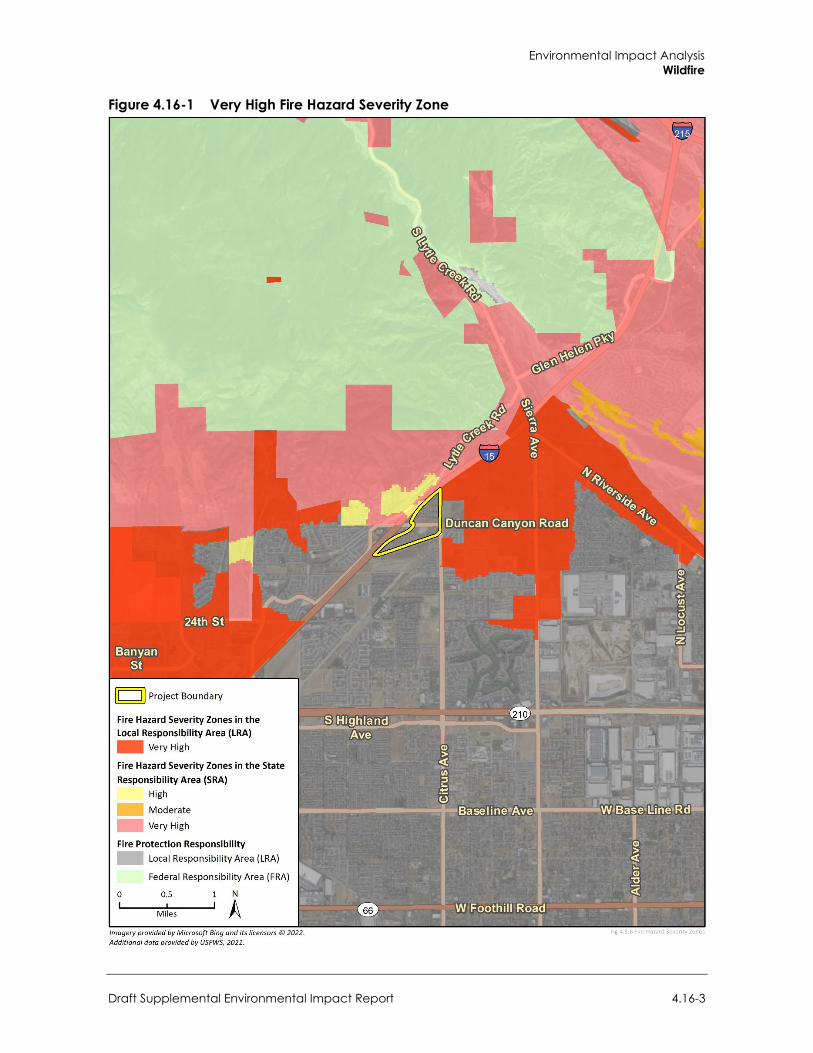
Environmental Impact Analysis Wildfire
Draft Supplemental Environmental Impact Report 4.16-3
Figure 4.16-1 Very High Fire Hazard Severity Zone
City of Fontana Ventana at Duncan Canyon Specific Plan Amendment
4.16-4
4.16.2 Regulatory Setting
a. Federal Regulations
Federal Emergency Management Act Federal Emergency Management Agency’s (FEMA) continuing mission is to lead the effort to prepare the nation for all hazards and effectively manage federal response and recovery efforts following any national incident. FEMA also initiates proactive mitigation activities, trains first responders, and manages the National Flood Insurance Program and the U.S. Fire Administration.
Disaster Mitigation Act of 2000 This Act (42 United States Code [U.S.C.] §5121) was signed into law to amend the Robert T. Stafford Disaster Relief Act of 1988 (42 U.S.C. §5121-5207). This legislation reinforces the importance of pre-disaster infrastructure mitigation planning to reduce disaster losses nationwide and is aimed primarily at the control and streamlining of the administration of federal disaster relief and programs to promote mitigation activities. Some of the major provisions of this Act include funding pre-disaster mitigation activities; developing experimental multi-hazard maps to better understand risk; establishing state and local government infrastructure mitigation planning requirements; defining how states can assume more responsibility in managing the hazard mitigation grant program; and adjusting ways in which management costs for projects are funded. The mitigation planning provisions outlined in Section 322 of this Act establish performance-based standards for mitigation plans and require states to have a public assistance program (Advance Infrastructure Mitigation [AIM]) to develop county government plans. The consequence for counties that fail to develop an infrastructure mitigation plan is the chance of a reduced federal share of damage assistance from 75 percent to 25 percent if the damaged facility has been damaged on more than one occasion in the preceding 10-year period by the same type of event.
Federal Fire Safety Act The 1992 Federal Fire Safety Act (FFSA) is different from other laws affecting fire safety because the law applies to federal operations, and there is no requirement for local action unless a private building owner leases space to the federal government. The FFSA requires federal agencies to provide sprinkler protection in any building, whether owned or leased by the federal government that houses at least 25 federal employees during the course of their employment.
National Fire Plan The National Fire Plan was developed under Executive Order 11246 in August 2000, following a historic wildland fire season. The intent is to establish plans for active response to severe wildland fires and their impacts to communities, while ensuring sufficient firefighting capacity. The plan addresses firefighting, rehabilitation, hazardous fuels reduction, community assistance, and accountability. The program promotes close coordination among local, state, tribal, and federal firefighting resources by conducting training, purchasing equipment, and providing prevention activities on a cost-share basis. To help protect people and their property from potential catastrophic wildfire, the National Fire Plan directs funding to be provided for projects designed to reduce the fire risks to communities (United States Department of Agriculture [USDA], United States Department of the Interior [DOI] 2000). High-risk communities identified within the wildland-urban
Environmental Impact Analysis Wildfire
Draft Supplemental Environmental Impact Report 4.16-5
interface, the area where homes and wildlands intermix, were published in the Federal Register in 2001. At the request of Congress, the Federal Register notice only listed those communities neighboring federal lands (USDA, DOI 2002). The California Department of Forestry and Fire Protection (CAL FIRE) incorporates concepts from this plan into State fire planning efforts.
b. State Regulations
California Fire and Building Codes (2019) The California Fire Code is Chapter 9 of California Code of Regulations (CCR) Title 24. It establishes the minimum requirements consistent with nationally recognized good practices to safeguard public health, safety, and general welfare from the hazards of fire, explosion, or dangerous conditions in new and existing buildings, structure, and premises, and to provide safety and assistance to firefighters and emergency responders during emergency operations. It is the primary means for authorizing and enforcing procedures and mechanisms to ensure the safe handling and storage of any substance that may pose a threat to public health and safety.
The California Fire Code regulates the use, handling, and storage requirements for hazardous materials at fixed facilities. The California Fire Code and the California Building Code use a hazard classification system to determine what protective measures are required to ensure fire safety and protect lives. These measures may include construction standards, separations from property lines and specialized equipment. To ensure that these safety measures are met, the California Fire Code employs a permit system based on hazard classification. The provisions of this Code apply to the construction, alteration, movement, enlargement, replacement, repair, equipment, use and occupancy, location, maintenance, removal, and demolition of every building or structure or any appurtenances connected or attached to such building structures throughout California.
More specifically, the Fire Code is included in Title 24 of the California Code of Regulations. Title 24, Part 9, Chapter 7 addresses fire-resistances- rated construction; California Building Code (Part 2), Chapter 7A addresses materials and construction methods for exterior wildfire exposure; Chapter 8 addresses fire related interior finishes; Chapter 9 addresses fire protection systems; and Chapter 10 addresses fire-related means of egress, including fire apparatus access road width requirements. Fire Code Section 4906 also contains existing regulations for vegetation and fuel management to maintain clearances around structures. These requirements establish minimum standards to protect buildings in Fire Hazard Severity Zones (FHSZ) within State Responsibility Areas (SRA) and wildland-urban interface fire areas. This code includes provisions for ignition-resistant construction standards for new buildings.
2018 California Strategic Fire Plan The Strategic Fire Plan for California (also known as the California Fire Plan) is the State’s road map for reducing the risk of wildfire. The most recent version of the plan was finalized in 2018 and directs each CAL FIRE Unit to prepare a locally specific fire management plan (CAL FIRE 2018). In compliance with the California Fire Plan, individual CAL FIRE units are required to develop fire management plans for their areas of responsibility. These documents assess the fire situation within each of the 21 CAL FIRE units and six contract counties. The plans include stakeholder contributions and priorities and identify strategic areas for pre-fire planning and fuel treatment as defined by the people who live and work with the local fire risk. The plans are required to be updated annually. With California’s extensive wildland-urban interface situation, the list of high-risk communities
City of Fontana Ventana at Duncan Canyon Specific Plan Amendment
4.16-6
extends beyond just those adjacent to federal lands, discussed above. The California State Forester (i.e., CAL FIRE Director) has the responsibility for managing the list of those high-risk communities.
California Disaster Mitigation Act The California Office of Emergency Services prepares the State of California Multi-Hazard Mitigation Plan (SHMP). The SHMP identifies hazard risks and includes a vulnerability analysis and a hazard mitigation strategy. The SHMP is federally required under the Disaster Mitigation Act of 2000 for the State to receive federal funding. The Disaster Mitigation Act of 2000 requires a State mitigation plan as a condition of disaster assistance.
California Emergency Response Plan California has developed an emergency response plan to coordinate emergency services provided by federal, State, and local governments and private agencies. Responding to hazardous-materials incidents is one part of this plan. The plan is administered by the California Governor’s Office of Emergency Services, which coordinates the responses of other agencies. When the City of Fontana experiences an emergency, an Emergency Operations Center (EOC) may be opened. In the event an EOC is opened, emergency response team members coordinate efforts and work with local fire and police agencies, emergency medical providers, the California Highway Patrol, CAL FIRE, California Department of Fish and Wildlife, and California Department of Transportation.
California Building Code
Wildland-Urban Interface Building Standards
On September 20, 2007, the California Building Standards Commission approved the Office of the State Fire Marshal’s emergency regulations amending the California Code of Regulations, Title 24, Part 2, known as the 2007 California Building Code. These codes include provisions for ignition-resistant construction standards in the wildland-urban interface area, which is a geographical area identified by the State as a FHSZ.
California Public Resources Code The California Public Resources Code (PRC) includes fire safety regulations that restrict the use of equipment that may produce a spark, flame, or fire; require the use of spark arrestors on construction equipment that use an internal combustion engine; specify requirements for the safe use of gasoline-powered tools in fire hazard areas; and specify fire suppression equipment that must be provided on-site for various types of work in fire-prone areas.
These regulations include the following:
Earthmoving and portable equipment with internal combustion engines would be equipped with a spark arrestor to reduce the potential for igniting a wildland fire (PRC Section 4442)
Appropriate fire suppression equipment would be maintained during the highest fire danger period—from April 1 to December 1 (PRC Section 4428)
On days when a burning permit is required, flammable materials would be removed to a distance of 10 feet from any equipment that could produce a spark, fire, or flame, and the construction contractor would maintain the appropriate fire suppression equipment (PRC Section 4427)

Environmental Impact Analysis Wildfire
Draft Supplemental Environmental Impact Report 4.16-7
On days when a burning permit is required, portable tools powered by gasoline-fueled internal combustion engines would not be used within 25 feet of any flammable materials (PRC Section 4431)
Senate Bill 1241 (Kehoe) of 2012 Senate Bill 1241 requires cities and counties in SRAs and VHFHSZs to address fire risk in the safety element of their general plans. The bill also resulted in amendments to the CEQA Guidelines’ Initial Study checklist to include questions related to fire hazard impacts for projects located in or near lands classified as SRAs and VHFHSZs. By adopting these amendments, the Governor’s Office of Planning and Research recognized that low-density, leapfrog development may create higher wildfire risks than high-density, infill development.
Government Code Section 51182 In an area or land that is in a VHFHSZ, a person who owns, leases, controls, operates, or maintains an occupied dwelling or occupied structure in, upon, or adjoining a mountainous area, forest-covered land, brush-covered land, grass-covered land, or land that is covered with flammable material, shall at all times do all of the following:
Maintain defensible space of 100 feet from each side and from the front and rear of the structure
Remove that portion of a tree that extends within 10 feet of the outlet of a chimney or stovepipe
Maintain a tree, shrub, or other plant adjacent to or overhanging a building free of dead or dying wood
Maintain the roof of a structure free of leaves, needles, or other vegetative materials Prior to constructing a new dwelling or structure that will be occupied or rebuilding an occupied
dwelling or occupied structure damaged by a fire in that zone, the construction or rebuilding of which requires a building permit, obtain a certification from the local building official that the dwelling or structure, as proposed to be built, complies with all applicable State and local building standards
California Public Utilities Commission General Orders
General Order 95
The California Public Utilities Commission (CPUC) General Order 95 applies to construction and reconstruction of overhead electric lines in California. The replacement of poles, towers, or other structures is considered reconstruction and requires adherence to all strength and clearance requirements of this order. The CPUC has promulgated various rules to implement the fire safety requirements of General Order 95, including:
Rule 18A requires utility companies take appropriate corrective action to remedy safety hazards.
General Order 95 nonconformances requires that each utility company establish an auditable maintenance program.
Rules 31.2 requires that lines be inspected frequently and thoroughly.
City of Fontana Ventana at Duncan Canyon Specific Plan Amendment
4.16-8
Rule 35 requires that vegetation management activities be performed in order to establish necessary and reasonable clearances. These requirements apply to all overhead electrical supply and communication facilities that are covered by General Order 95, including facilities on lands owned and maintained by State and local agencies.
Rule 38 establishes minimum vertical, horizontal, and radial clearances of wires from other wires.
Rule 43.2.A.2 requires that for lines located within Tier 2 or Tier 3 zones, the wind loads required in Rule 43.2.A.1 be multiplied by a wind load factor of 1.1. (CPUC 2018)
General Order 165
General Order 165 establishes requirements for the inspection of electric distribution and transmission facilities that are not contained within a substation. Utilities must perform “Patrol” inspections, defined as a simple visual inspection of utility equipment and structures that is designed to identify obvious structural problems and hazards, at least once per year for each piece of equipment and structure. “Detailed” inspections, where individual pieces of equipment and structures are carefully examined, are required every five years for all overhead conductor and cables, transformers, switching/protective devices, and regulators/capacitors. By July 1st of each year, each utility subject to this General Order must submit an annual report of its inspections for the previous year under penalty of perjury (CPUC 2017a).
General Order 166
General Order 166 Standard 1.E requires that investor-owned utilities develop a fire prevention plan which describes measures that the electric utility will implement to mitigate the threat of power-line fires. Additionally, this standard requires that investor-owned utilities (IOU) outline a plan to mitigate power line fires when wind conditions exceed the structural design standards of the line during a red flag warning in a high fire threat area. Fire prevention plans created by IOUs are required to identify specific parts of the utility’s service territory where the conditions described above may occur simultaneously. Standard 11 requires that utilities report annually to the CPUC regarding compliance with General Order 166 (CPUC 2017b).
Senate Bill 1028 Senate Bill 1028 (2016) requires each electrical corporation to construct, maintain, and operate its electrical lines and equipment in a manner that will minimize the risk of catastrophic wildfire posed by those components, and makes a violation of these provisions by an electrical corporation a crime under State law. The bill also requires each electrical corporation to annually prepare a wildfire mitigation plan and submit to the CPUC for review. The plan must include a statement of objectives, a description of preventive strategies and programs that are focused on minimizing risk associated with electric facilities, and a description of the metrics that the electric corporation uses to evaluate the overall wildfire mitigation plan performance and assumptions that underlie the use of the metrics.
c. Local Regulations
Fontana Local Hazard Mitigation Plan The City’s Local Hazard Mitigation Plan (LHMP) was last updated in June 2017. The intent of the LHMP is to demonstrate the plan for reducing and/or eliminating risk in the City of Fontana. The
Environmental Impact Analysis Wildfire
Draft Supplemental Environmental Impact Report 4.16-9
LHMP process encourages communities to develop goals and objectives that will reduce risk and build a more disaster resilient community by analyzing potential hazards. Section 4.4, Wildfire Hazard Profile, of the LHMP includes a discussion on the existing wildfire regulatory environment, past wildfire occurrences, location/geographic extent of wildfire, wildfire magnitude/severity, frequency/probability of future occurrences of wildfire, and information regarding future development within high fire hazard severity zones.
City of Fontana General Plan The Public and Community Services and Noise and Safety chapters City of the Fontana General Plan contain citywide goals and policies to prevent the loss of life and property, and to minimize injuries and property damage in the event of hazards, including fires. The following goals and policies specifically address community wildfire risk.
Public and Community Services
Goal 2: Fontana's Fire Department meets or exceeds state and national benchmarks for protection and responsiveness.
Policy: Continue the City’s successful partnership with the San Bernardino County Fire Department.
Noise and Safety
Goal 1: Enhanced public safety and the protection of public and private property.
Goal 2: Provide effective emergency response to natural or human-induced disasters that minimizes the loss of life and damage to property, while also reducing disruptions in the delivery of vital public and private services during and following a disaster.
Goal 3: The City of Fontana is a community that implements proactive fire hazard abatement strategies, and as a result, is minimally impacted by wildland and urban fires.
Goal 6: The City shall continue to ensure to the fullest extent possible that, in the event of a major disaster, essential structures and facilities remain safe and functional as required by current law. Essential facilities include hospitals, police stations, fire stations, emergency operation centers, communication centers, generators and substations, and reservoirs.
Goal 7: Threats to public and private property from urban and wildland fire hazards are reduced in Fontana.
Policy: The City shall continue to require residential, commercial, and industrial structures to implement fire hazard-reducing designs and features.
Policy: The City shall continue to ensure to the extent possible that fire services, such as fire equipment, infrastructure, and response times, are adequate for all sections of the city.
Policy: The City shall monitor development or redevelopment in areas where fire zones have been mapped through the city.

City of Fontana Ventana at Duncan Canyon Specific Plan Amendment
4.16-10
4.16.3 Impact Analysis
a. Thresholds of Significance In accordance with Appendix G of the CEQA Guidelines, the project would have significant impacts related to wildfire if it would:
Due to slope, prevailing winds, and other factors, exacerbate wildfire risks, and thereby expose project occupants to, pollutant concentrations from a wildfire or the uncontrolled spread of a wildfire
Require the installation or maintenance of associated infrastructure (such as roads, fuel breaks, emergency water sources, power lines or other utilities) that may exacerbate fire risk or that may result in temporary or ongoing impacts to the environment
Expose people or structures to significant risks, including downslope or downstream flooding or landslides, as a result of runoff, post-fire slope instability, or drainage changes
Impacts to wildfire were analyzed in an Initial Study (Appendix A-2). The Initial Study determined that impacts related to the project substantially impairment of an adopted emergency response plan or emergency evacuation plan, in or near State responsibility areas or lands classified as very high fire hazard severity zones, would be less than significant since project construction and operational activities would not result in street closures that could impede emergency access or evacuation. Therefore, these impacts are not further evaluated in this section.
b. Methodology The discussion of wildfire impacts was limited to Section 4.15, Human Health and Hazards, of the 2007 EIR, as part of the analysis for impacts to human health related to hazards. Evaluation of this subject has since been expanded under CEQA to be its own environmental issue area.
The assessment of impacts related to wildfire hazards and risks were evaluated considering fire hazard severity zone mapping for the City (CAL FIRE 2021) and the Ventana Duncan Canyon Planning Area 6 Fire Protection Plan prepared by Herbert Spitzer, Senior Wildland Fire Associate (2021) (Appendix J).
c. Project Impacts
Threshold 1: If located in or near state responsibility areas or lands classified as very high fire hazard severity zones, would the project due to slope, prevailing winds, and other factors, exacerbate wildfire risks and thereby expose project occupants to pollutant concentrations from a wildfire or the uncontrolled spread of a wildfire?
Impact W-1 THE PROJECT IS LOCATED NEAR AREAS DESIGNATED AS A VHFHSZ. HOWEVER, THE PROJECT SITE’S FLAT TERRAIN AND COMPLIANCE WITH CODES, REGULATIONS, AND PROPOSED POLICES WOULD PREVENT THE EXACERBATION OF WILDFIRE RISKS AND SUBSEQUENT EXPOSURE OF PROJECT OCCUPANTS TO POLLUTANT CONCENTRATIONS. IMPACTS WOULD BE LESS THAN SIGNIFICANT.
As shown in Figure 4.16-1, the project site is surrounded by areas designated as VHFHSZs within an LRA and SRA. The proposed project would facilitate development of nearly double the residential units associated with the existing Specific Plan (i.e., 1,671 units compared to 842 units). The additional units would be accommodated via an increase in density from 15.0 to 25.9 units per acre,
Environmental Impact Analysis Wildfire
Draft Supplemental Environmental Impact Report 4.16-11
as well as a small increase in residential acreage of 8.6 acres (15 percent). In addition, the total commercial area would be reduced by 98,000 square-feet (17 percent), from 574,500 square-feet under the existing Specific Plan, to 476,500 for the proposed project. The increase in density would place buildings closer together, and result in an increase in the overall intensity of development in residential areas of the site.
The Noise and Safety chapter of the City’s General Plan states that single- and multi-family dwellings located within FHSZs have a greater potential of being impacted by wildfires because the structures are the least fire resistant and the population groups that inhabit them are the least prepared to evacuate in a large-scale wildfire event. In addition, residential developments of medium or higher densities are at an increased vulnerability to wildfires because there are minimal property setbacks and construction is lightweight.
The project area is subject to Santa Ana winds, which are strong dry offshore winds that affect southern California in autumn and winter. They can range from hot to cold, depending on the prevailing temperatures in the source regions, the Great Basin, and upper Mojave Desert. The winds are known for the hot dry weather (often the hottest of the year) that often occurs in the fall and are infamous for fanning regional wildfires. Wildfire smoke produced from combustion of natural biomass contains thousands of individual compounds, including particulate matter, carbon dioxide, water vapor, carbon monoxide, hydrocarbons and other organic chemicals, nitrogen oxides, and trace minerals that can be carried in the wind.
In addition to winds, topographical features can either assist or hinder wildfire spread. For example, in the event a fire ignites at the bottom of a steep slope, it will spread much more quickly upwards because it can pre-heat the upcoming fuels with rising hot air, and upward drafts are more likely to create spot fires. Conversely, a rocky slope can function as a natural fire break due to a lack of fuel and wide gap of open space. Generally, wildfires move more quickly uphill than downhill or than on flat terrain (National Park Service 2017). Despite the potential for Santa Ana winds, the project site is relatively flat and its lack of topographical features (i.e., slopes) would help reduce risks related to wildfire spread and subsequent exposure of individuals to pollutant concentrations.
Goal 6 of the General Plan’s Noise and Safety chapter also states that the City of Fontana shall ensure that sufficient resources are available to expand emergency protection and safety services as the community grows. As discussed in Setting, fire protection services are provided by FFPD through a contract with SBCFD, which operates seven fire stations within the City. The closest fire station to the project site is Station 79 located approximately 0.1 mile west of the project site. As discussed in Section 4.13, Public Services, the SBCFD would be able to service the project at existing staffing levels. Fire Station 79 is approximately three minutes travel time from the project site (Herbert Spitzer 2021), whereas the average response time to fires within Fontana is four minutes, 51 seconds.2 Therefore, the project site’s proximity to Fire Station 79 and other stations with availability to quickly respond to potential fires would help reduce impacts associated with wildfire spread and subsequent exposure of individuals to pollutant concentrations. The site is also adjacent to I-15 to the west, which acts as a large fire break from properties on the western portion of the site.
In addition, the proposed project would be required to include the fire protection measures required by the California Building Code and Fire Code. Those measures include ignition-resistant construction with exterior walls of noncombustible or ignition resistant material from the surface of the ground to the roof system sealing any gaps around doors, windows, eaves, and vents to prevent
2 Communication from Lauri Lockwood of the SBCFD (November 2, 2021)

City of Fontana Ventana at Duncan Canyon Specific Plan Amendment
4.16-12
intrusion by flame or embers. Development would also be required to meet California Building Code requirements, including CCR Title 24, Part 2, which includes specific requirements related to exterior wildfire exposure. CCR Title 14 sets forth the minimum development standards for emergency access, fuel modification, setback, signage, and water supply, which help prevent loss of structures or life by reducing wildfire hazards risk. Compliance with existing regulatory requirements for implementation of fire protection measures (e.g., ignition-resistant construction materials and measures) would further reduce impacts associated with wildfire spread and subsequent exposure of individuals to pollutant concentrations.
Final project design would be subject to plan check by the FFPD to verify compliance with applicable fire prevention and protection requirements. Compliance with pertinent building standards would reduce the demand for fire protection services from the project. Thus, no significant fire hazards are expected to be created on the project site. Compliance with codes, regulations, and proposed polices would reduce the risk of exacerbate wildfire risks and thereby expose project occupants to pollutant concentrations from a wildfire or the uncontrolled spread of a wildfire. Impacts would be less that significant.
Mitigation Measures Mitigation measures are not required.
Threshold 2: If located in or near state responsibility areas or lands classified as very high fire hazard severity zones, would the project require the installation or maintenance of associated infrastructure (such as roads, fuel breaks, emergency water sources, power lines or other utilities) that may exacerbate fire risk or that may result in temporary or ongoing impacts to the environment?
Impact W-2 THE PROJECT SITE IS LOCATED NEAR AREAS DESIGNATED AS A VHFHSZ. HOWEVER, THE PROJECT WOULD NOT REQUIRE NEW OR UNIQUE INFRASTRUCTURE TO RESPOND TO A POTENTIAL WILDFIRE HAZARD AND NO IMPACTS WOULD OCCUR FROM FIRE-RELATED INFRASTRUCTURE. FURTHERMORE, COMPLIANCE WITH THE CALIFORNIA BUILDING CODE AND CALIFORNIA FIRE CODE, AS WELL AS THE PROCEDURAL REVIEW BY THE CITY OF FONTANA AND FFPD, WOULD MINIMIZE POTENTIAL IMPACTS IMPLEMENTATION OF UTILITY INFRASTRUCTURE. THE PROJECT WOULD NOT EXACERBATE FIRE RISK AND IMPACTS WOULD BE LESS THAN SIGNIFICANT.
The project site is surrounded by areas designated as an VHFHSZ within an SRA and LRA. However, as part of project implementation, project-related infrastructure would be required to meet minimum California Building Code and California Fire Code standards for fire safety. The project would improve vehicle circulation via the proposed realignment of Lytle Creek Road, which would run diagonally through the project area and offer improved internal connection from the primary roads to each of the individual planning areas.
The project would be served by existing water infrastructure along Duncan Canyon Road and Citrus Avenue south of Duncan Canyon Road. A new water main line would be constructed, following the alignment of Lytle Creek Road north of Duncan Canyon Road, along with planned water infrastructure on Citrus Avenue. Dry utilities would be extended to the north and south along Lytle Creek Road from existing facilities in Duncan Canyon Road. Therefore, the project would include installation of utility infrastructure; however, the project would be required to provide fire safety measures to support fire suppression activities, including compliance with State and local fire codes, a fire hydrant system, paved access, and secondary access routes. These features would be subject to review by the FFPD to ensure that emergency vehicles may respond quickly to potential
Environmental Impact Analysis Wildfire
Draft Supplemental Environmental Impact Report 4.16-13
occurrences of wildfire. In addition, the project would not trigger the need for new or unique infrastructure to respond to a potential wildfire hazard, so no new impacts to the environment would occur from fire-related infrastructure. Compliance with the California Building Code and California Fire Code, as well as the procedural review by the City of Fontana and FFPD would minimize the potential impacts. Therefore, the infrastructure associated with the project would not exacerbate fire risk and impacts would be less than significant.
Mitigation Measures Mitigation measures are not required.
Threshold 3: If located in or near state responsibility areas or lands classified as very high fire hazard severity zones, would the project expose people or structures to significant risks, including downslopes or downstream flooding or landslides, as a result of runoff, post-fire slope instability, or drainage changes?
Impact W-3 WITH ADHERENCE TO BEST MANAGEMENT PRACTICES, BUILDING CODES, AND ALL APPLICABLE FEDERAL, REGIONAL, AND LOCAL REGULATIONS, THE PROJECT WOULD NOT RESULT IN EXPOSURE OF PEOPLE OR STRUCTURES TO SIGNIFICANT RISKS, INCLUDING DOWNSLOPES OR DOWNSTREAM FLOODING OR LANDSLIDES, ASSOCIATED WITH POST-FIRE RUNOFF AND SLOPE INSTABILITY AS WELL AS DRAINAGE CHANGES. IMPACTS WOULD BE LESS THAN SIGNIFICANT.
The project is surrounded by areas designated as a VHFHSZ within an SRA and LRA. The project site is designated as an area of minimal flood hazard in the FEMA National Flood Hazard Map (FEMA 2020), and the area surrounding the intersection at Duncan Canyon Road and Citrus Avenue on the east border of the project site is designated as medium landslide susceptibility in the City of Fontana Local Hazard Mitigation Plan (LHMP) (City of Fontana 2017). However, the project site is relatively flat and, as discussed in the Initial Study (Appendix A-2) and Section 4.6, Geology and Soils, the project site is not located in a landslide hazard area and there are no landslide hazards in the vicinity, as depicted by United States Geological Survey. The site’s lack of topographical features (i.e., slopes) in conjunction with a minimal flood potential of the project area would reduce impacts associated with exposure of people or structures to risks, including flooding or landslides, from post-fire runoff and slope instability. Impacts would be less than significant.
Drainage on site would change with implementation of the proposed project; however, Best Management Practices (BMP) would slow the velocity of water and allow sediment and debris to settle out of the water column, thereby minimizing the potential for downstream flooding, erosion/siltation, or exceedances of stormwater drainage system capacity. Adherence with BPMs, building codes, and all applicable federal, regional, and local regulations the project would not create conditions that would result in exposure of people or structures to significant risks associated with drainage changes. Impacts would be less than significant.
Mitigation Measures Mitigation measures are not required.
4.16.4 Cumulative Impacts Planned and pending projects in the City and surrounding areas are listed in Table 3-1 in Section 3, Environmental Setting, and include residential, commercial, and industrial land uses.

City of Fontana Ventana at Duncan Canyon Specific Plan Amendment
4.16-14
A project’s environmental impacts are “cumulatively considerable” if the “incremental effects of an individual project are significant when viewed in connection with the effects of past projects, the effects of other current projects, and the effects of probable future projects” (CEQA Guidelines Section 15065[a][3]).
Cumulative development occurring within FHSZs would be subject to risk of wildfire hazards. Development of cumulative projects occurring within FHSZs would be subject to compliance with the California Building Code and California Fire Code. All proposed construction would be required to meet minimum standards for fire safety. Development occurring within the City would be subject to review by the City and FFPD to ensure cumulative development is designed to provide a minimum of fire safety and support fire suppression activities, including compliance with State and local fire codes, fire sprinklers, a fire hydrant system, paved access, and secondary access routes. Implementation of these plans and policies, in conjunction with compliance with the Fire Code, and City and FFPD requirements, would minimize potential cumulative impacts with respect to wildfire hazards.
As indicated above, the project would not result in significant wildfire hazard impacts following conformance with the California Building Code, California Fire Code, Fontana Municipal Code, and other City and FFPD requirements. The proposed realignment of Lytle Creek Road would improve area circulation and better allow FFPD emergency access to the project area. Therefore, the proposed project would not contribute to a cumulatively significant impact.
Other CEQA Required Discussions
Draft Supplemental Environmental Impact Report 5-1
5 Other CEQA Required Discussions
This section discusses growth-inducing impacts, irreversible environmental impacts, and energy impacts resulting from the proposed project.
5.1 Effects Found Not to be Significant An Initial Study was prepared for Ventana at Duncan Canyon Specific Plan Amendment. Based on the analysis therein the project would result in less than significant impacts or no impacts for the below subjects. Therefore, these subjects are not further evaluated in this EIR.
Table 5-1 Impacts Found to be Less than Significant Impacts or No Impacts Issue Area Initial Study Findings Less Than Significant Impacts or No Impacts
Aesthetics The project would not damage scenic resources, including but not limited to, trees, rock outcroppings, and historic buildings within a State scenic highway. Impacts would be less than significant.
Agricultural Resources The project would not convert Prime Farmland, Unique Farmland, or Farmland of Statewide Importance. No impact to Farmland would occur.
Neither the site nor nearby lands are enrolled under the Williamson Act. As such, implementation of the project would not conflict with existing zoning for agricultural use or a Williamson Act contract, and no impact would occur.
No forest land or timberland zoning is present on the project site or in the surrounding area. No impact to these resources would occur.
No forest land exists on the project site or in the surrounding area. As such, future development of the project would not result in the loss of forest land or conversion of forest land to non-forest use.
The project site is surrounded by residential developments and undeveloped land zoned as Residential Planned Community (R-PC), Regional Mixed Use (R-MU), Medium Density (R-2), Multiple Family (R-3), Public Facility (P-PF), and Residential Planned Community (R-PC). Neither the project area or surrounding uses include agriculture or forest uses. No impact to these resources would occur.
Air Quality The project would not result in significant emissions that would lead to odors. Potential impact would be less than significant.
Geology and Soil The project would not directly or indirectly cause potential substantial adverse effects involving seismic-related ground failure and liquefaction. Impacts would be less than significant.
The project would not directly or indirectly cause potential substantial adverse effects involving landslides. Impacts would be less than significant.
The project would not result in substantial soil erosion or the loss of topsoil. Impacts would be less than significant.
The project would not be located on a geologic unit or soil that is unstable, or that would become unstable as a result of the project, and potentially result in on- or off-site landslide, lateral spreading, subsidence, liquefaction, or collapse. Impacts would be less than significant.
The project would not have soils incapable of adequately supporting the use of septic tanks or alternative wastewater disposal systems where sewers are not available for the disposal of wastewater. The project would not require nor install a septic system or alternative treatment system. No impact would occur.
City of Fontana Ventana at Duncan Canyon Specific Plan Amendment
5-2
Issue Area Initial Study Findings Less Than Significant Impacts or No Impacts
Hazards and Hazardous Materials
The project would not create a significant hazard to the public or the environment through the routine transport, use, or disposal of hazardous materials. Impacts would be less than significant.
The project would not be located on a site that is included on a list of hazardous material sites compiled pursuant to Government Code Section 65962.5 and, as a result, would not create a significant hazard to the public or the environment. No impact would occur.
The project would not be located within an airport land use plan or within two miles of a public airport or public use airport. Therefore, the project would not result in a safety hazard or excessive noise for people residing or working in the project area. No impact would occur.
Hydrology and Water Quality
The project site is not located in a flood hazard, tsunami, or seiche zone. Therefore, the project would not risk release of pollutants due to project inundation. No impact would occur.
Land Use and Planning The project would not physically divide an established community. No impact would occur.
Mineral Resources The project would not result in the loss of availability of a known mineral resource that would be of value to the region and the residents of the State. No impact would occur.
The project would not result in the loss of availability of a locally important mineral resource recovery site delineated on a local general plan, specific plan, or other land use plan. Impacts would be less than significant.
Noise The project site is not located in the vicinity of a private airstrip or an airport land use plan or within two miles of a public airport or public use airport. Therefore, the project would not expose people residing or working in the project area to excessive noise levels. No impact would occur.
Population and Housing
The project would not displace substantial numbers of existing people or housing, necessitating the construction of replacement housing elsewhere. No impact would occur.
Transportation The project would not substantially increase hazards due to a geometric design feature or incompatible use. Impacts would be less than significant.
The project would not result in inadequate emergency access. Impacts would be less than significant.
Wildfire The project construction and operational activities would not result in street closures that could impede emergency access or evacuation. Therefore, the project would not substantially impair an adopted emergency response plan or emergency evacuation plan in or near State responsibility areas or lands classified as very high fire hazard severity zones. Impacts would be less than significant.
5.2 Growth Inducement Section 15126(d) of the CEQA Guidelines requires a discussion of a proposed project’s potential to foster economic or population growth, including ways in which a project could remove an obstacle to growth. Growth does not necessarily create significant physical changes to the environment. However, depending upon the type, magnitude, and location of growth, it can result in significant adverse environmental effects. Therefore, the proposed project’s growth inducing potential is considered significant if project-induced growth could result in significant physical effects in one or more environmental issue areas.
5.2.1 Population Growth As discussed in Section 4.12, Population and Housing, the proposed project would directly generate population growth because it includes residential uses. In addition, the project involves commercial uses including, but not limited to, restaurants, retail, office space, medical, research and
Other CEQA Required Discussions
Draft Supplemental Environmental Impact Report 5-3
development, and light industrial use, which may indirectly increase the population if new employees relocate to the City. The proposed 1,671 units would account for less than 10 percent of the City’s Regional Housing Needs Allocation (RHNA) of 17,519 housing units and are, therefore, within anticipated growth planned under the General Plan Housing Element by 2030.
As shown in Table 4.2-7 in Section 4.2, Air Quality, the proposed project would accommodate a service population consisting of 6,801 residents and 473 employees. Considering a worst-case scenario, if all projected employees and their families were to relocate to Fontana, there would be a population growth of 7,274 persons. According to the 2020-2045 Southern California Association of Governments (SCAG) Regional Transportation Plan/Sustainable Communities Strategy (RTP/SCS) growth forecasts project an increase of approximately 72,800 persons in the City’s population over the next 23 years, for an estimated 2045 population of 286,700 residents (SCAG 2020). As discussed in Section 4.12, Population and Housing, based on this forecast population, the City’s population would be approximately 239,266 in 2030 (the buildout year of the proposed project), which is an increase of 25,322 persons atop the current population of 213,944 (DOF 2021).1 As such, the addition of 7,274 persons (assuming project employees are also residents) would consist of approximately 29 percent of the City’s projected growth by 2030. Therefore, the proposed project would not generate population growth in exceedance of existing SCAG population forecasts.
The project would facilitate construction on a currently undeveloped area. As discussed in Section 4.3, Biological Resources, the development of the site has the potential to create direct or indirect impacts to burrowing owl and nesting birds and raptors through removal of ground cover and habitat, and from construction during the breeding season. However, with implementation of Mitigation Measures BIO-1A through BIO-1C, which address potential impacts on burrowing owls and nesting birds through preconstruction surveys and other avoidance measures, impacts would be less than significant. In addition, as discussed in Section 4.4, Cultural Resources, due to lack of integrity of known historical resources, the project would not create an adverse change in the significance of a historical resource. However, development of the site has potential to disturb undiscovered cultural resources. However, implementation of Mitigation Measures CUL-2B through CUL-2D would address such impacts during construction through awareness programs, monitoring, and other procedures in the event a tribal or archaeological resource is encountered. Similarly, impacts related to unanticipated discovery of paleontological resources during project construction activities would be less than significant with Mitigation Measure GEO-3 through paleontological monitoring, as discussed in Section 4.6, Geology and Soils. Furthermore, as discussed in Section 4.2, Air Quality, and Section 4.7, Greenhouse Gas Emissions, this EIR, development and operation of the project would not generate air quality or GHG emissions that would result in a significant impact. The project site also lacks significant scenic resources, surface water, or other environmental resources.
Population growth associated with the project would not result in significant long-term physical environmental effects.
5.2.2 Economic Growth The proposed project would generate temporary employment opportunities during construction. However, the proposed project would also add long-term employment opportunities associated
1 Assuming an increase of 72,800 persons between the years 2022 and 2045 results in an average growth of 3,165 persons per year for the next 23 years. To obtain a population estimate for the year 2030 (i.e., eight years into the future and the buildout year of the proposed project), an average of 3,165 persons per years is multiplied by eight, which results in an estimated 2030 population of 25,322 persons for the City of Fontana.
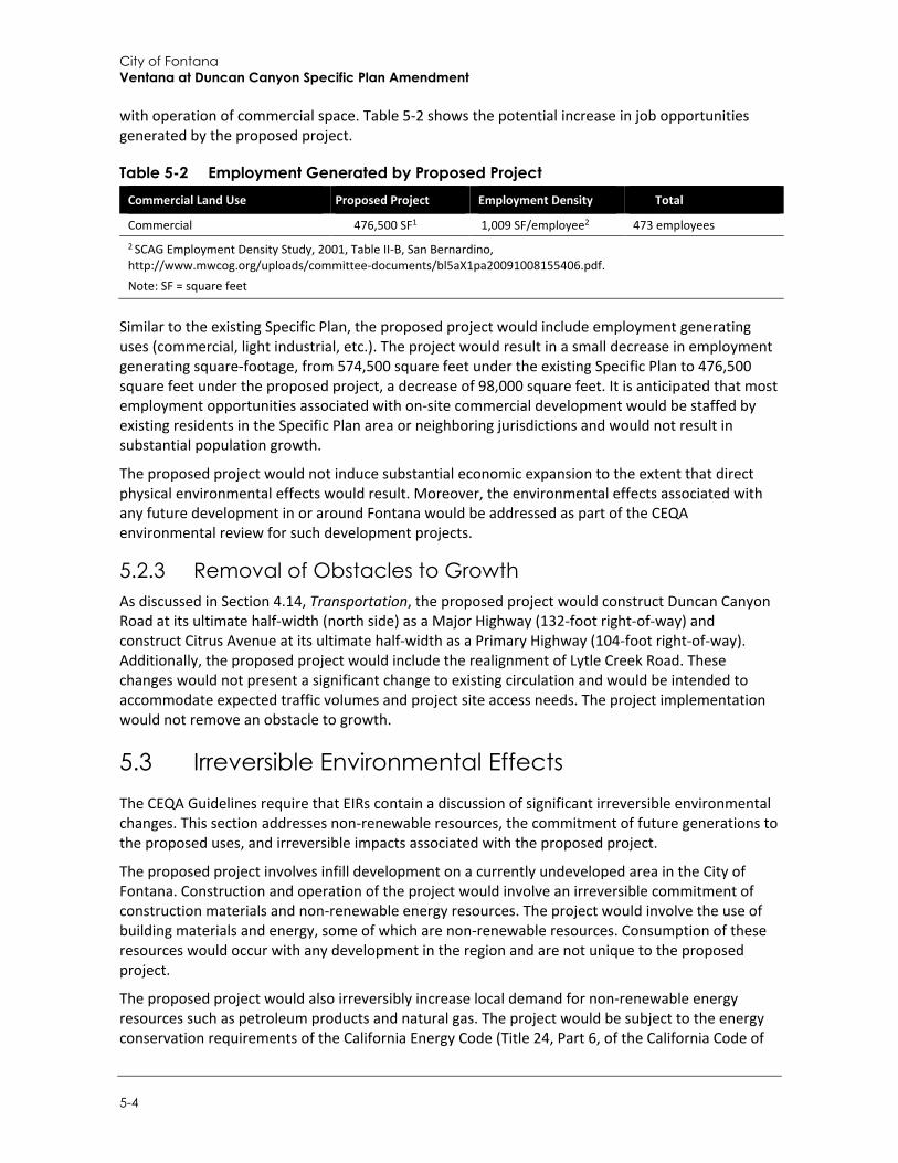
City of Fontana Ventana at Duncan Canyon Specific Plan Amendment
5-4
with operation of commercial space. Table 5-2 shows the potential increase in job opportunities generated by the proposed project.
Table 5-2 Employment Generated by Proposed Project Commercial Land Use Proposed Project Employment Density Total
Commercial 476,500 SF1 1,009 SF/employee2 473 employees 2 SCAG Employment Density Study, 2001, Table II-B, San Bernardino, http://www.mwcog.org/uploads/committee-documents/bl5aX1pa20091008155406.pdf. Note: SF = square feet
Similar to the existing Specific Plan, the proposed project would include employment generating uses (commercial, light industrial, etc.). The project would result in a small decrease in employment generating square-footage, from 574,500 square feet under the existing Specific Plan to 476,500 square feet under the proposed project, a decrease of 98,000 square feet. It is anticipated that most employment opportunities associated with on-site commercial development would be staffed by existing residents in the Specific Plan area or neighboring jurisdictions and would not result in substantial population growth.
The proposed project would not induce substantial economic expansion to the extent that direct physical environmental effects would result. Moreover, the environmental effects associated with any future development in or around Fontana would be addressed as part of the CEQA environmental review for such development projects.
5.2.3 Removal of Obstacles to Growth As discussed in Section 4.14, Transportation, the proposed project would construct Duncan Canyon Road at its ultimate half-width (north side) as a Major Highway (132-foot right-of-way) and construct Citrus Avenue at its ultimate half-width as a Primary Highway (104-foot right-of-way). Additionally, the proposed project would include the realignment of Lytle Creek Road. These changes would not present a significant change to existing circulation and would be intended to accommodate expected traffic volumes and project site access needs. The project implementation would not remove an obstacle to growth.
5.3 Irreversible Environmental Effects The CEQA Guidelines require that EIRs contain a discussion of significant irreversible environmental changes. This section addresses non-renewable resources, the commitment of future generations to the proposed uses, and irreversible impacts associated with the proposed project.
The proposed project involves infill development on a currently undeveloped area in the City of Fontana. Construction and operation of the project would involve an irreversible commitment of construction materials and non-renewable energy resources. The project would involve the use of building materials and energy, some of which are non-renewable resources. Consumption of these resources would occur with any development in the region and are not unique to the proposed project.
The proposed project would also irreversibly increase local demand for non-renewable energy resources such as petroleum products and natural gas. The project would be subject to the energy conservation requirements of the California Energy Code (Title 24, Part 6, of the California Code of
Other CEQA Required Discussions
Draft Supplemental Environmental Impact Report 5-5
Regulations, California’s Energy Efficiency Standards for Residential and Nonresidential Buildings) and the California Green Building Standards Code (Title 24, Part 11 of the California Code of Regulations). The California Energy Code provides energy conservation standards for all new commercial and residential buildings constructed in California, and the Green Building Standards Code requires solar access, natural ventilation, and stormwater capture. Consequently, the project would consume electricity, natural gas, and fuel during construction and operation. However, the project would not place significant additional demand on the energy providers (Southern California Edison or Southern California Gas) and would comply with applicable conservation standards. Neither project construction nor operation would result in wasteful, inefficient, or unnecessary consumption of energy. Impacts would be less than significant.
Additional vehicle trips associated with the proposed project would incrementally increase local traffic and regional air pollutant and GHG emissions. However, as discussed in Section 4.2, Air Quality, and Section 4.7, Greenhouse Gas Emissions, development and operation of the project would not generate air quality or GHG emissions that would result in a significant impact. Furthermore, as determined in Section 4.14, Transportation, long-term impacts associated with the proposed project would be less than significant based on City and regional thresholds. The project would also require a commitment of law enforcement, fire protection, water supply, wastewater treatment, and solid waste disposal services. However, as discussed in Section 4.13, Public Services, and Section 4.15, Utilities and Service Systems, impacts to these service systems would be less than significant.

City of Fontana Ventana at Duncan Canyon Specific Plan Amendment
5-6
This page intentionally left blank.
Alternatives
Draft Supplemental Environmental Impact Report 6-1
6 Alternatives
6.1 Introduction Section 15126.6(a) of the CEQA Guidelines requires that an EIR describe a range of reasonable alternatives to the project, or a range of reasonable alternatives to the location of the project, that could feasibly attain the project’s basic objectives. An EIR does not need to consider every conceivable alternative, but it does have to consider a range of potentially feasible alternatives that will facilitate informed decision making and public participation.
According to CEQA Guidelines Section 15126.6(a), the discussion of alternatives must include several different issues. The discussion of alternatives must focus on alternatives to the project, or to the project location, which would avoid or substantially reduce any significant effects of the project, even if the alternatives would be costlier or hinder to some degree the attainment of the project objectives. The “No Project” alternative must also be evaluated. The “No Project” analysis must discuss the existing conditions and what would reasonably be expected to occur in the foreseeable future if the project was not approved. The range of alternatives required is governed by a “rule of reason.” Therefore, the EIR must only evaluate those alternatives necessary to permit a reasoned choice. The alternatives must be limited to only ones that would avoid or substantially lessen any of the significant effects of the project.
Additionally, an EIR should not consider an alternative whose effects cannot be reasonably ascertained and whose implementation is remote and speculative. The CEQA Guidelines also require an EIR to state why an alternative is being rejected. If the City ultimately rejects any or all alternatives, the rationale for rejection will be presented in the findings that are required prior to the certification of the EIR and action is taken on the project. According to CEQA Guidelines Section 15126.6(f)(1), among the factors that may be considered when addressing the feasibility of alternatives are environmental impacts, site suitability, economic viability, availability of infrastructure, general plan consistency, regulatory limitations, jurisdictional boundaries, and whether the applicant could reasonably acquire, control, or otherwise have access to the alternate site.
The project alternatives are evaluated to determine the extent to which they attain the basic project objectives, while significantly reducing or avoiding any significant effects of the project. As discussed in Section 2, Project Description, the objectives for the proposed project, are as follows:
To support the area demand for housing and contribute residential units to meet the City’s housing goal of 17,519 units.1
To create a master-planned, mixed-use community that creates a unique sense of place. To provide quality housing with various size options to accommodate different housing needs. To actualize the City’s vision for the Regional Mixed-Use designation in north Fontana. To establish a unique window into North Fontana from I-15. To introduce a vibrant, pedestrian-oriented activity center in this area of the city.
1 As discussed in Section 4.12, Population and Housing, the City has released the 6th Cycle Housing Element Update 2021-2029 which was adopted in January 2022 and included a Regional Housing Needs Allocation (RHNA) of 17,518 total housing units allocated to the City by the Southern California Association of Governments (SCAG).
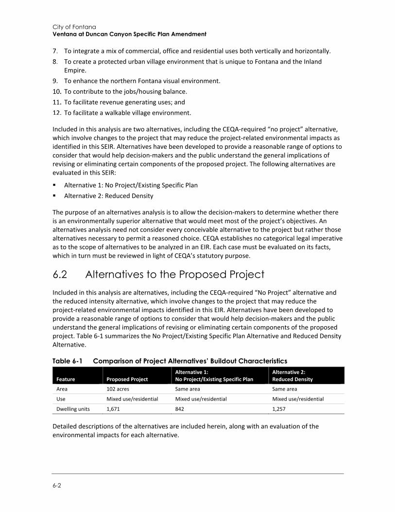
City of Fontana Ventana at Duncan Canyon Specific Plan Amendment
6-2
To integrate a mix of commercial, office and residential uses both vertically and horizontally. To create a protected urban village environment that is unique to Fontana and the Inland
Empire. To enhance the northern Fontana visual environment. To contribute to the jobs/housing balance. To facilitate revenue generating uses; and To facilitate a walkable village environment.
Included in this analysis are two alternatives, including the CEQA-required “no project” alternative, which involve changes to the project that may reduce the project-related environmental impacts as identified in this SEIR. Alternatives have been developed to provide a reasonable range of options to consider that would help decision-makers and the public understand the general implications of revising or eliminating certain components of the proposed project. The following alternatives are evaluated in this SEIR:
Alternative 1: No Project/Existing Specific Plan Alternative 2: Reduced Density
The purpose of an alternatives analysis is to allow the decision-makers to determine whether there is an environmentally superior alternative that would meet most of the project’s objectives. An alternatives analysis need not consider every conceivable alternative to the project but rather those alternatives necessary to permit a reasoned choice. CEQA establishes no categorical legal imperative as to the scope of alternatives to be analyzed in an EIR. Each case must be evaluated on its facts, which in turn must be reviewed in light of CEQA’s statutory purpose.
6.2 Alternatives to the Proposed Project Included in this analysis are alternatives, including the CEQA-required “No Project” alternative and the reduced intensity alternative, which involve changes to the project that may reduce the project-related environmental impacts identified in this EIR. Alternatives have been developed to provide a reasonable range of options to consider that would help decision-makers and the public understand the general implications of revising or eliminating certain components of the proposed project. Table 6-1 summarizes the No Project/Existing Specific Plan Alternative and Reduced Density Alternative.
Table 6-1 Comparison of Project Alternatives’ Buildout Characteristics
Feature Proposed Project Alternative 1: No Project/Existing Specific Plan
Alternative 2: Reduced Density
Area 102 acres Same area Same area
Use Mixed use/residential Mixed use/residential Mixed use/residential
Dwelling units 1,671 842 1,257
Detailed descriptions of the alternatives are included herein, along with an evaluation of the environmental impacts for each alternative.

Alternatives
Draft Supplemental Environmental Impact Report 6-3
6.2.1 Alternative 1: No Project/Existing Specific Plan
a. Description The No Project/Existing Specific Plan Alternative assumes that the proposed project would not be implemented, and the project site would be developed under the existing Specific Plan. Under the existing Specific Plan, on-site development would consist of 842 housing units and 574,500 square feet of total commercial area rather than 1,671 units and 476,500 square feet under the proposed project. The existing Specific Plan would consist of retail commercial, office, hotel, restaurant, and research and development uses on the central section and northwestern boundary and residential uses on the southwestern and eastern sections of the site. Many of the same features from the proposed project would remain under the existing Specific Plan, including residential villages, a focal point piazza, a campanile tower, and the construction of Lytle Creek Road through the project site.
Alternative 1 would meet most project objectives, specifically Objectives 2 through 12. However, alternative 1 would not fulfill Objective 1 to the same extent as the proposed project, which would contribute 1,671 units to the City’s housing goal and RHNA of 17,519 units allocated to the City by SCAG.
b. Impact Analysis
Aesthetics
Visual Resources
Under Alternative 1, the project site would be developed under the existing Specific Plan. The visual character of the site is composed of previously disturbed land, non-native grass, Southern California Edison (SCE) transmission lines, Interstate 15 (I-15), and eucalyptus windrows. The project site occurs in an area that consists of a mosaic of undeveloped/vacant land and new residential developments. Views from areas to the south of the site would change as the proposed residential villages and commercial areas are built on the site. Development under Alternative 1 would lead to structures up to four stories high that would change the foreground views from vacant land to a mix of residential and commercial structures. As such, Alternative 1 also has the potential to change and interrupt views of scenic vistas from local roads, especially Duncan Canyon Road east of I-15. However, on-site development would not adversely affect views of vistas from I-15. Additionally, building setback requirements for individual structures would preserve distant mountain views and prevent total view obstruction on area roads.
Development under Alternative 1 would be visually similar to the proposed project. Impacts to visual resources would be less than significant, and the impacts would be equal when compared to the proposed project.
Light and Glare
Under development of the existing Specific Plan development would be accompanied by new sources of light and glare. Increased lighting levels could impact adjacent residential uses to the west and south but would not lead to a significant adverse effect on these residences since the homes are separated from the site by the SCE right-of-way and I-15. Any light spillover would be within these corridors and not farther south or west. Compliance with the outdoor lighting
City of Fontana Ventana at Duncan Canyon Specific Plan Amendment
6-4
guidelines and the City’s development regulations regarding lighting would prevent the creation of significant adverse light and glare impacts.
Development under Alternative 1 would have similar impacts to that of the proposed project. Impacts to light and glare would be less than significant, and the impacts would be equal when compared to the proposed project.
Air Quality Under Alternative 1, construction impacts would be similar to the proposed project. Because Alternative 1 would decrease overall density, it would produce proportionally less air pollutant emissions associated with project construction and operation. Alternative 1 would require incrementally less construction hauling trips to deliver materials to the site due to construction of 829 less housing units, which is an approximately 50 percent reduction from the 1,671 units under the proposed project. As such, the reduction in units under Alternative 1 would result in a reduction in air pollutant emissions from on-site residential uses when compared to the proposed project. However, the commercial square footage under Alternative 1 would be approximately 21 percent more than the commercial use under the proposed project. Nonetheless, as discussed in Section 4.2, Air Quality, the 2007 EIR determined that the existing Specific Plan would result in a significant and unavoidable impact (even with implementation of mitigation) related to air quality emissions from mobile sources at operation, consistent with the significant and unavoidable impact determination associated the proposed project (i.e., Impact AQ-2).
Impacts under Alternative 1 would be similar to the proposed project. However, due to the decrease in overall density, air quality emissions under Alternative 1 would be less than the proposed project.
Biological Resources Under Alternative 1, potential impacts to biological resources would be similar to those of the proposed project since it would have the same development footprint. The project site consists of vacant, undeveloped land that has been subject to a variety of anthropogenic disturbances from historic agricultural activities, surrounding development and routine weed abatement activities. Development would lead to the additional disturbance of existing vegetation and habitat and the introduction of landscaping plant materials. These include the removal of existing mature trees on the site and non-native grassland areas. Development of the site also has the potential to create direct or indirect impacts to burrowing owl and nesting birds and raptors through removal of ground cover and habitat, and from construction during the breeding season. However, as with the proposed project, impacts to biological resources would be less than significant with implementation of mitigation identified in the 2007 EIR to address potential impacts to migratory and nesting birds, raptors, and burrowing owl. Therefore, impacts to biological resources would be equal when compared to the proposed project.
Cultural Resources and Tribal Cultural Resources Alternative 1 would have the same footprint as the proposed project; therefore, development under the existing Specific Plan would have similar impacts related to cultural resources when compared to the proposed project. Due to lack of integrity of known historical resources, Alternative 1 would not result in an adverse change to a historical resource. However, as with development under the proposed project, construction activities would have the potential to disturb undiscovered cultural resources. Impacts to cultural resources would be less than significant with implementation of

Alternatives
Draft Supplemental Environmental Impact Report 6-5
mitigation identified in the 2007 EIR to address tribal concerns related to archaeological resources. Therefore, impacts cultural and tribal cultural resources would be equal when compared to the proposed project.
Energy Under Alternative 1, energy use during construction and operation would be slightly reduced in conjunction with the reduction in overall density when compared to the proposed project. Impacts under Alternative 1 would be less than significant, similar to the proposed project. However, due to the decrease in density, energy use under Alternative 1 would be less than the proposed project.
Greenhouse Gas Emissions Because Alternative 1 would decrease overall density, it would produce less air GHG emissions associated with project construction since it would require incrementally less construction hauling trips to deliver materials to the site due to constructing 829 less housing units.
Operational impacts under Alternative 1 would also result in less GHG emissions associated with the reduction in overall density, including vehicle trip related GHG emissions. The reduction in units under Alternative 1 would amount to an approximately 50 percent decrease in housing units (i.e., 829 units from the proposed 1,671 units), which would result in a reduction in GHG emissions from on-site residential uses when compared to the proposed project. The commercial square footage under Alternative 1 would be approximately 21 percent more than the commercial use under the proposed project. Both Alternative 1 and the proposed project would have less than significant impacts, however, impacts related to GHG emissions under Alternative 1 would be less than the proposed project.
Geology and Soils Impacts related to geology and soils under Alternative 1 would be similar to the proposed project due to the same development footprint and construction materials and methods that would be used. Development under Alternative 1 would encounter similar geologic phenomena (faults, seismic ground shaking, landslides, etc.), soil conditions, and paleontological resources when compared to the proposed project. As with the proposed project, individual projects would be required to investigate and address the site-specific geologic and soil conditions, along with engineering recommendations incorporated into the final design for consistency with California Building Code (CBC) requirements. Similarly, in the event that paleontological resources are discovered, each individual project would be required to comply with the applicable regulatory requirements and mitigate any potential impacts to resources on the individual project sites. Therefore, development under the existing Specific Plan would have similar impacts related to geology and soils when compared to the proposed project. Impacts to geology and soils would be less than significant after implementation of mitigation for paleontological resources identified in the 2007 EIR, and impacts would be equal when compared to the proposed project.
Hazards and Hazardous Materials Alternative 1 would have the same development footprint and would also develop land that was historically used for agricultural purposes and may present hazards to construction workers, future residents, employees, and visitors. However, as with the proposed project, in the event that hazardous materials are utilized or encountered on-site, development would be required to comply with the applicable regulatory requirements to mitigate any potential impacts on the project site.
City of Fontana Ventana at Duncan Canyon Specific Plan Amendment
6-6
Therefore, as with the proposed project, development under the existing Specific Plan would result in less than significant impacts related to hazards and hazardous materials. Furthermore, due to the similar proposed uses, identical location, and development footprint, impacts would be equal when compared to the proposed project.
Hydrology and Water Quality Under Alternative 1, development under the existing Specific Plan would result in an increased demand for water and implementation of impervious surfaces on the site. In comparison to the proposed project, Alternative 1 would have similar impacts with respect to an increase in impervious surfaces, increases in off-site runoff rates and volumes, and stormwater runoff pollutants during operation. As with the proposed project, Alternative 1 would be required to comply with the requirements of the National Pollution Discharge Elimination System (NPDES) Statewide Construction General Permit, including preparation and implementation of a Storm Water Pollution Prevention Plan (SWPPP) to minimize construction-related erosion, sedimentation, and non-point source pollution. In addition, Alternative 1 would also be subject to the requirements of the applicable Municipal Separate Storm Sewer System (MS4) permit, which would require Best Management Practices (BMP) to capture and treat on-site stormwater runoff for new development and significant redevelopment projects. Similar to the proposed project, impacts related to hydrology and water quality would be less than significant. However, the proposed project would include an increase in residential units and would consequently incrementally increase demand for water when compared to the existing Specific Plan. Therefore, impacts under Alternative 1 would be less than those for the proposed project.
Land Use and Planning Under Alternative 1, there would be no zone change from Medium Density Residential (MDR), Medium-High Density Residential (MHDR), Commercial (C) and Mixed Use (MU). All development under Alternative 1 would comply with development and design standards in the adopted existing Specific Plan, which included a General Plan Amendment. In addition, future development on the project site would comply with the City’s performance standards and the development policies for land use compatibility. Alternative 1 would be consistent with the underlying land use regulations and policies. Impacts would be less than significant. Because the proposed project would include a Specific Plan Amendment and General Plan Amendment, impacts would be less under Alternative 1 when compared to the proposed project.
Noise Under Alternative 1, development under the proposed existing Specific Plan would generate construction and operation noise impacts. Because the project would be built in phases, future on-site residential uses and sensitive receivers would be exposed to construction and operation (on-site traffic) noise levels that could exceed applicable standards. However, development under Alternative 1, similar to the proposed project, would comply with Fontana Municipal Code noise regulations and implement mitigation measures identified in the 2007 EIR to avoid significant impacts related to construction and operational noise as well as land use compatibility. Noise impacts would be less than significant with mitigation under both Alternative 1 and the proposed project. However, noise impacts under Alternative 1 would be less than those of the proposed project due to the decrease in overall density and associated operational noise.
Alternatives
Draft Supplemental Environmental Impact Report 6-7
Population and Housing As with the proposed project, development under Alternative 1 would lead to the construction of new housing units on the site, an increase in the City’s population, and the generation of jobs for the local community. The existing Specific Plan would accommodate a service population of 5,383 persons. By comparison, the proposed project would accommodate a service population consisting of 6,081 residents and 473 employees, for a total of 7,274 persons. Nonetheless, as discussed in Section 4.12, Population and Housing, the proposed project would not generate population growth in exceedance of existing SCAG population forecasts.
Similar to the proposed project, Alternative 1 would include employment generating uses (commercial, light industrial, etc.). Alternative 1 would increase commercial square footage and result in more employment opportunities than the proposed project (i.e., 476,500 square feet under the proposed project to 574,500 square feet under the existing Specific Plan). Regardless, employment associated with on-site commercial development would likely be staffed with residents in the Specific Plan area or neighboring local jurisdictions and would not result in substantial population growth. Impacts related to population growth would be less than significant under Alternative 1, similar to the project. However, because Alternative 1 would contribute 1,891 less persons (i.e., difference between service populations of 7,274 persons and 5,383 persons) to the City’s population, impacts related to growth would be less than the proposed project. Nonetheless, Alternative 1 would not fulfill Objective 1 to the same extent as the proposed project, which would contribute 1,671 units to the City’s housing goal and RHNA of 17,519 units allocated to the City by SCAG.
Public Services and Recreation Alternative 1 would create demands for police and fire protection services, schools, parks, libraries, and medical services, similar to the proposed project. However, payment of required development fees would address impacts from increased demand for public services. In addition, Alternative 1 would result in 829 housing units less than the proposed project and would generate less of a demand for public services due to a decrease in overall density. While impacts would be less than significant under Alternative 1, similar to the proposed project, overall demand for public services would under Alternative 1 would be less than the proposed project.
Transportation Under Alternative 1, development would generate short-term traffic during construction, and long-term traffic during the operational life of the project similar to the proposed project. Because Alternative 1 would decrease overall density, it would produce less construction hauling trips to deliver materials to the site due to the construction of 829 less housing units.
As with the proposed project, development under Alternative 1 would also contribute to transportation improvements through payments to transportation programs, development impact fees, or fair-share contributions. During the operation period, Alternative 1 would decrease vehicle miles traveled (VMT) compared to the proposed project due to the development of less trip-generating residences. As discussed in Section 4.14, Transportation, the proposed project would not exceed the City’s adopted threshold of 15 percent below County of San Bernardino baseline VMT per service population in both baseline and cumulative scenarios and impacts would be less than significant. Therefore, impacts under Alternative 1 would be less than significant, similar to the
City of Fontana Ventana at Duncan Canyon Specific Plan Amendment
6-8
proposed project. However, due to the decrease in density, transportation impacts under Alternative 1 would be less than the proposed project.
Utilities and Service Systems Under Alternative 1, development under the existing Specific Plan would require utility services and the extension of existing infrastructure systems to serve residential and commercial uses on the site, as with the proposed project. Coordination with utility agencies would ensure adequate and timely services, and water and energy conservation and recycling programs would reduce total demands. Alternative 1 would result in 829 housing units less than the proposed project which would generate less of a demand on utilities due to a decrease in overall density (i.e., less water demand, wastewater generation, solid waste generation). Under Alternative 1, impacts would remain less than significant, and due to the decrease in density, demand on utilities under Alternative 1 would be less than that of the proposed project.
Wildfire Alternative 1 would have the same footprint as the proposed project; therefore, development under the existing Specific Plan would have similar impacts related to wildfire to that of the proposed project. The project site is surrounded by areas designated as Very High Fire Hazard Severity Zones (VHFHSZ). Similar to the proposed project, development under Alternative 1 would be required to meet Fire Code standards for fire safety and would be subject to review by the City and Fontana Fire Protection District (FFPD) to verify development is designed to provide a minimum of fire safety and support fire suppression activities, including compliance with State and local fire codes, fire sprinklers, a fire hydrant system, paved access, and secondary access routes. Impacts related to wildfire would also be less than significant and equal when compared to the proposed project.
6.2.2 Alternative 2: Reduced Density Alternative
a. Description Similar to the proposed project, the Reduced Density Alternative would include the development of 476,500 square feet of commercial uses, dwelling units in three separate residential villages with accompanying amenities, a focal point piazza (public square), and the realignment of Lytle Creek Road, on an approximately 102-acre site. Alternative 2 would have the same footprint and location as the proposed project. However, Alternative 2 would include 1,257 residential units (rather than 1,671 residential units under the proposed project).
The purpose of Alternative 2 is to evaluate the effects of the proposed project at a lower residential density to reduce impacts related to traffic, as well as some operational impacts such as energy, GHG emissions, and water usage. Alternative 2 would involve an approximately 25 percent reduction in units when compared to the proposed project. Alternative 2 would be otherwise consistent with the proposed project and would meet most project objectives, particularly Objectives 2 through 12. However, Alternative 2, would not fulfill Objective 1 to the same extent as the proposed project, which would contribute 1,671 units to the City’s housing goal and RHNA of 17,519 units allocated to the City by SCAG.
Alternatives
Draft Supplemental Environmental Impact Report 6-9
b. Impact Analysis
Aesthetics
Visual Resources
Similar to the proposed project, Alternative 2 would convert the undeveloped site into a mixed-use development. The visual character of the site is composed of previously disturbed land, non-native grass, SCE transmission lines, I-15, and eucalyptus windrows. The project site occurs in an area that consist of a mosaic of undeveloped/vacant land and new residential developments. Views from areas to the south of the site would change as the proposed residential villages and commercial areas are built on the site. Development under Alternative 2 would lead to structures that would change the foreground views from vacant land to a mix of residential and commercial structures. As such, Alternative 2 has the potential to change and interrupt views of scenic vistas from local roads, especially Duncan Canyon Road east of I-15. However, on-site development would not adversely affect views of vistas from I-15. Additionally, building setback requirements for individual structures would preserve distant mountain views and prevent total view obstruction on area roads.
Development under Alternative 2 would be visually similar to the proposed project. Impacts to visual resources would be less than significant, and the impacts would be equal when compared to the proposed project.
Light and Glare
Under Alternative 2, development would be accompanied by new sources of light and glare. Increased lighting levels could impact adjacent residential uses to the west and south but would not lead to a significant adverse effect on these residences since the homes are separated from the site by the SCE right-of-way and I-15. Any light spillover would be within these corridors and not farther south or west. Compliance with the outdoor lighting guidelines and the City’s development regulations regarding lighting would prevent the creation of significant adverse light and glare impacts.
Development under Alternative 2 would have similar impacts to that of the proposed project. Impacts to light and glare would be less than significant, and the impacts would be equal when compared to the proposed project.
Air Quality Alternative 2 would result in similar air pollutant impacts when compared to the proposed project. The commercial square footage under Alternative 2 and associated emissions from operation of commercial uses would be the same as the proposed project. However, because Alternative 2 would decrease residential density, it would produce proportionally less air pollutant emissions associated with the construction and operation of 414 less housing units, which is an approximately 25 percent reduction from the 1,671 units under the proposed project. Nonetheless, as discussed in Section 4.2, Air Quality, the 2007 EIR determined that the existing Specific Plan would result in a significant and unavoidable impact (even with implementation of mitigation) related to air quality emissions from mobile sources at operation, consistent with the significant and unavoidable impact determination associated the proposed project (i.e., Impact AQ-2). Because Alternative 2 would involve construction and operation of 1,257 residential units (a quantity of units between those units under the existing Specific Plan and proposed project), it is anticipated that air quality
City of Fontana Ventana at Duncan Canyon Specific Plan Amendment
6-10
emissions from mobile sources would also be significant and unavoidable under Alternative 2 even with mitigation, similar to the proposed project.
Impacts under Alternative 2 would be similar to the proposed project. However, due to the decrease in residential units, air quality impacts under Alternative 2 would be less than the proposed project.
Biological Resources Construction impacts under Alternative 2 would be the be similar to those of the proposed project since it would have the same development footprint. The project site consists of vacant, undeveloped land that has been subject to a variety of anthropogenic disturbances from historic agricultural activities, surrounding development and routine weed abatement activities. Development would lead to the additional disturbance of existing vegetation and habitat and the introduction of landscaping plant materials. These include the removal of existing mature trees on the site and non-native grassland areas. Development of the site also has the potential to create direct or indirect impacts to burrowing owl, nesting birds and raptors through removal of ground cover and habitat, and from construction during the breeding season. However, as with the proposed project, impacts to biological resources would be less than significant with implementation of mitigation measures listed in Section 4.3, Biological Resources. Therefore, impacts would be equal when compared to the proposed project.
Cultural Resources and Tribal Cultural Resources Alternative 2 would have the same footprint as the proposed project; therefore, development under the existing Specific Plan would have similar impacts related to cultural resources when compared to the proposed project. Due to lack of integrity of known historical resources, Alternative 2 would also not create an adverse change in the significance of a historical resource. However, as with development under the proposed project, construction activities have the potential to disturb undiscovered cultural resources. Impacts to cultural and tribal resources would be less than significant with implementation of the mitigation measures listed in Section 4.4, Cultural Resources. Impacts would be equal when compared to the proposed project.
Energy Under Alternative 2, energy use during construction and operation would be slightly reduced due to the reduction in residential density when compared to the proposed project. Impacts under Alternative 2 would less than significant, similar to the proposed project. However, due to the decrease in density, energy use under Alternative 2 would be less than the proposed project.
Greenhouse Gas Emissions Alternative 2 would produce less air GHG emissions associated with project construction since it would require incrementally less construction hauling trips to deliver materials to the site due to the construction of 414 less housing units, which is an approximately 25 percent reduction from the 1,671 units under the proposed project.
Operational impacts under Alternative 2 would also be expected to have a reduction in GHG emissions associated with the reduction in residential density, including vehicle trips related GHG emissions. Both Alternative 2 and the proposed project would have less than significant impacts,

Alternatives
Draft Supplemental Environmental Impact Report 6-11
however, impacts related to GHG emissions under Alternative 2 would be less than those of the proposed project.
Geology and Soils Impacts related to geology and soils under Alternative 2 would be similar to the proposed project due to the same development footprint and construction materials and methods that would be used. Development under Alternative 2 would encounter similar geologic phenomena (faults, seismic ground shaking, landslides, etc.), soil conditions, and paleontological resources when compared to the proposed project. As with the proposed project, individual projects would be required to investigate and address the site specific geologic and soil conditions, along with engineering recommendations incorporated into the final design for consistency with CBC requirements. Similarly, in the event that paleontological resources are discovered, each individual project would be required to comply with the applicable regulatory requirements and mitigate any potential impacts to resources on the individual project sites. Therefore, development Alternative 2 would have similar impacts related to geology and soils when compared to the proposed project. Impacts to geology and soils would be less than significant after implementation of mitigation for paleontological resources identified in Section 4.6, Geology and Soils, and impacts would be equal when compared to the proposed project.
Hazards and Hazardous Materials Impacts under Alternative 2, would have the same development footprint and would also develop land that was historically used for agricultural purposes and may present hazards to construction workers, future residents, employees, and visitors. However, as with the proposed project, in the event that hazardous materials are utilized or encountered on-site, development would be required to comply with the applicable regulatory requirements and mitigate any potential impacts to resources on the project site.
Therefore, as with the proposed project, development under Alternative 2 would result in less than significant impacts related to hazards and hazardous materials. Furthermore, due to the similar proposed uses, identical location, and development footprint, impacts would be equal when compared to the proposed project.
Hydrology and Water Quality As with the proposed project, development under Alternative 2 would result in an increased demand for water and implementation of impervious surfaces on the site. In comparison to the proposed project, Alternative 2 would have similar impacts with respect to an increase in impervious surfaces, increases in off-site runoff rates and volumes, and stormwater runoff pollutants during operation. Alternative 2 would be required to comply with the requirements of the NPDES Statewide Construction General Permit, including preparation and implementation of a SWPPP to minimize construction-related erosion, sedimentation, and non-point source pollution. In addition, Alternative 2 would also be subject to the requirements of the applicable MS4 permit, which would require BMPs to capture and treat on-site stormwater runoff for new development and significant redevelopment projects. Similar to the proposed project, impacts related to hydrology and water quality would be less than significant. However, there would be 414 more residential units under the proposed project which would increase demand for water when compared to Alternative 2. Therefore, impacts under Alternative 2 would be less than those of the proposed project.

City of Fontana Ventana at Duncan Canyon Specific Plan Amendment
6-12
Land Use and Planning As with the proposed project, Alternative 2 would include a Specific Plan Amendment and General Plan Amendment due to the increase in development compared to the existing Specific Plan. Development under Alternative 2 would also comply with the City’s performance standards and the development policies for land use compatibility. With approval of the proposed land use entitlements, Alternative 2 would be consistent with the underlying land use regulations and policies and impacts would be less than significant, similar to the proposed project. Impacts would be equal when compared to the proposed project.
Noise As with the proposed project, development under Alternative 2 would generate construction and operation noise impacts. Because the project would be built in phases, future on-site residential uses and sensitive receivers would be exposed to construction and operation (on-site traffic) noise levels that could exceed applicable standards. However, development under Alternative 2, similar to the proposed project, would comply with Fontana Municipal Code noise regulations and implement mitigation measures to avoid significant impacts related to construction noise and land use compatibility. Noise impacts would be less than significant with mitigation under both Alternative 2 and the proposed project. However, noise impacts under Alternative 2 would be less than those of the proposed project due to the decrease in residential density and associated operational noise.
Population and Housing As with the proposed project, development under Alternative 2 would lead to the construction of new housing units on the site, an increase in the city’s resident population, and the generation of jobs for the local community. Alternative 2 would include the same square-footage of employment generating uses (commercial, light industrial, etc.) as the proposed project (i.e., 476,500 square feet). Employment associated with on-site commercial development would likely be staffed with residents in the Specific Plan area or neighboring local jurisdictions and would not result in substantial population growth similar to the proposed project. The proposed project would accommodate a service population consisting of 7,274 persons. Nonetheless, as discussed in Section 4.12, Population and Housing, the proposed project would not generate population growth in exceedance of existing SCAG population forecasts. Because Alternative 2 would develop 414 fewer residents, its population growth would also be within forecasts and impacts related to population growth would be less than significant, similar to the project. However, because Alternative 2 would generate less population, impacts related to growth would be less than the proposed project. Nonetheless, Alternative 2 would not fulfill Objective 1 to the same extent as the proposed project, which would contribute 1,671 units to the City’s housing goal and RHNA of 17,519 units allocated to the City by SCAG.
Public Services and Recreation Alternative 1 would create demands for police and fire protection services, schools, parks, libraries, and medical services, similar to the proposed project. Payment of required development fees would address potential impacts from increased demand for public services. However, Alternative 2 would result in 414 housing units less than the proposed project and would therefore generate less of a demand for public services. While impacts would be less than significant under Alternative 2, similar to the proposed project, overall demand for public services would under Alternative 2 would be less than the proposed project.
Alternatives
Draft Supplemental Environmental Impact Report 6-13
Transportation
Under Alternative 2, development would generate short-term traffic during construction, and long-term traffic during the operational life of the project similar to the proposed project. Because Alternative 2 would decrease residential density, it would produce less construction hauling trips to deliver materials to the site due to the construction of 414 less housing units.
As with the proposed project, development under Alternative 2 would also contribute to transportation improvements through payments to transportation programs, development impact fees, or fair-share contributions. During the operation period, Alternative 2 would decrease VMT compared to the proposed project due to the development of less trip-generating residences. As discussed in Section 4.14, Transportation, the proposed project would not exceed the City’s adopted threshold of 15 percent below County of San Bernardino baseline VMT per service population in both Baseline and Cumulative scenarios and impacts would be less than significant. Therefore, similar to the proposed project, impacts under Alternative 2 would be less than significant, and due to the decrease in density, transportation impacts under Alternative 2 would be less than the proposed project.
Utilities and Service Systems Under Alternative 2, development would require utility services and the extension of existing infrastructure systems to serve residential and commercial uses on the site, as with the proposed project. Coordination with utility agencies would ensure adequate and timely services, and water and energy conservation and recycling programs would reduce total demands. Alternative 2 would result in 414 housing units less than the proposed project and would generate less of a demand on utilities due to a decrease in overall density (i.e., less water demand, wastewater generation, solid waste generation). Under Alternative 2, impacts would remain less than significant, and due to the decrease in residential density, demand on utilities under Alternative 2 would be less than that of the proposed project.
Wildfire Alternative 2 would have the same footprint as the proposed project; therefore, development under Alternative 2 would have similar impacts related to wildfire to that of the proposed project. The project site is surrounded by areas designated as VHFHSZs. As with the proposed project, development under Alternative 2 would be required to meet Fire Code standards for fire safety and would be subject to review by the City and FFPD to verify development is designed to provide a minimum of fire safety and support fire suppression activities, including compliance with State and local fire codes, fire sprinklers, a fire hydrant system, paved access, and secondary access routes. Impacts related to wildfire would also be less than significant, and impacts would be equal when compared to the proposed project.
6.3 Alternatives Considered but Rejected
6.3.1 No Build A “no build” alternative, in which the site would remain undeveloped; however, due to the previous adoption of the existing Specific Plan, the site has already been identified as an area where commercial/residential development could be built. Because this area is meant to fulfill RHNA
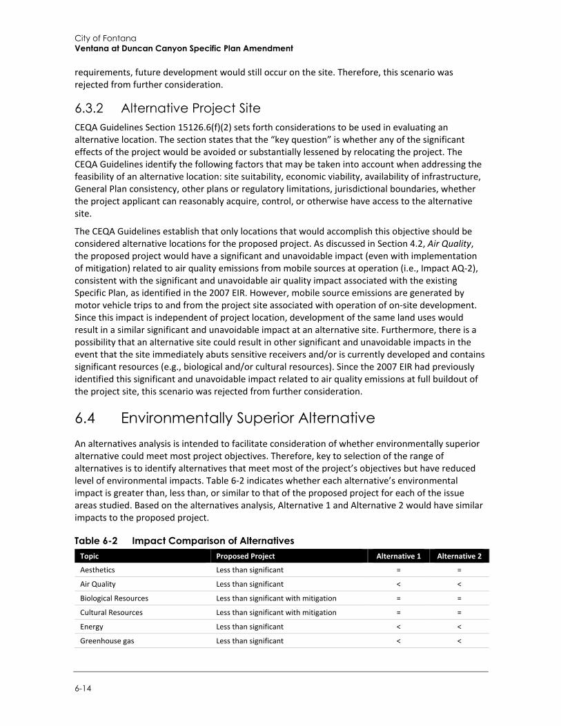
City of Fontana Ventana at Duncan Canyon Specific Plan Amendment
6-14
requirements, future development would still occur on the site. Therefore, this scenario was rejected from further consideration.
6.3.2 Alternative Project Site CEQA Guidelines Section 15126.6(f)(2) sets forth considerations to be used in evaluating an alternative location. The section states that the “key question” is whether any of the significant effects of the project would be avoided or substantially lessened by relocating the project. The CEQA Guidelines identify the following factors that may be taken into account when addressing the feasibility of an alternative location: site suitability, economic viability, availability of infrastructure, General Plan consistency, other plans or regulatory limitations, jurisdictional boundaries, whether the project applicant can reasonably acquire, control, or otherwise have access to the alternative site.
The CEQA Guidelines establish that only locations that would accomplish this objective should be considered alternative locations for the proposed project. As discussed in Section 4.2, Air Quality, the proposed project would have a significant and unavoidable impact (even with implementation of mitigation) related to air quality emissions from mobile sources at operation (i.e., Impact AQ-2), consistent with the significant and unavoidable air quality impact associated with the existing Specific Plan, as identified in the 2007 EIR. However, mobile source emissions are generated by motor vehicle trips to and from the project site associated with operation of on-site development. Since this impact is independent of project location, development of the same land uses would result in a similar significant and unavoidable impact at an alternative site. Furthermore, there is a possibility that an alternative site could result in other significant and unavoidable impacts in the event that the site immediately abuts sensitive receivers and/or is currently developed and contains significant resources (e.g., biological and/or cultural resources). Since the 2007 EIR had previously identified this significant and unavoidable impact related to air quality emissions at full buildout of the project site, this scenario was rejected from further consideration.
6.4 Environmentally Superior Alternative An alternatives analysis is intended to facilitate consideration of whether environmentally superior alternative could meet most project objectives. Therefore, key to selection of the range of alternatives is to identify alternatives that meet most of the project’s objectives but have reduced level of environmental impacts. Table 6-2 indicates whether each alternative’s environmental impact is greater than, less than, or similar to that of the proposed project for each of the issue areas studied. Based on the alternatives analysis, Alternative 1 and Alternative 2 would have similar impacts to the proposed project.
Table 6-2 Impact Comparison of Alternatives Topic Proposed Project Alternative 1 Alternative 2
Aesthetics Less than significant = =
Air Quality Less than significant < <
Biological Resources Less than significant with mitigation = =
Cultural Resources Less than significant with mitigation = =
Energy Less than significant < <
Greenhouse gas Less than significant < <

Alternatives
Draft Supplemental Environmental Impact Report 6-15
Topic Proposed Project Alternative 1 Alternative 2
Geology and Soils Less than significant with mitigation = =
Hazards and Hazardous Materials Less than significant with mitigation = =
Hydrology and Water Quality Less than significant < <
Land use and Planning Less than significant < =
Noise Less than significant with mitigation < <
Population and Housing Less than significant < <
Public Services Less than significant < <
Transportation Less than significant < <
Utilities and Service Systems Less than significant < <
Wildfire Less than significant = =
> Impacts would be greater compared to the proposed project (increased level of impact)
< Impacts would be less compared to the proposed project (reduced level of impact)
= Similar level of impact to the proposed project
Alternative 1 (No Project/No Build Alternative) assumes that the proposed project would not be developed, and the project site would be developed under the existing Specific Plan. Under the existing Specific Plan, on-site development would consist of 842 housing units and 574,500 square feet of total commercial area. The existing Specific Plan would consist of retail commercial, office, hotel, restaurant, and research and development uses on the central section and northwestern boundary and residential uses on the southwestern and eastern sections of the site. Alternative 1 would reduce operational impacts associated with air pollutant emissions, energy, GHG emissions, hydrology and water quality, noise, population and housing, public services, transportation, and utilities and service systems when compared to the proposed project, due to the reduction in overall density. Alternative 1 would meet most project objectives, particularly Objectives 2 through 12. However, Alternative 1 would not fulfill Objective 1 to the same extent as the proposed project, which would contribute 1,671 units instead of 842 units to the City’s housing goal and RHNA of 17,519 units.
Alternative 2 (Reduced Density Alternative), evaluates the effects of the proposed project at a lower residential density to reduce impacts related to traffic, as well as some operational impacts such as energy, GHG emissions, and water usage. Similar to the proposed project, Alternative 2 would include the development of 476,500 square feet of commercial uses, 1,257 dwelling units in three separate residential villages with accompanying amenities, a focal point piazza (public square), and the construction of the realigned Lytle Creek Road, on an approximately 102-acre site. Alternative 2 would have the same footprint, location, and commercial uses as the proposed project; however, Alternative 2 would involve an approximately 25 percent reduction in units when compared to the proposed project (i.e., 414 housing units less). Alternative 2 would also reduce operational impacts associated with air pollutant emissions, energy, GHG emissions, hydrology and water quality, noise, population and housing, public services, transportation, and utilities and service systems when compared to the proposed project. However, due to the same project footprint and similarity in land uses, Alternative 2 would still require mitigation to reduce impacts associated with biological resources, cultural resources, geology and soils (i.e., paleontological resources), hazards and hazardous materials, and noise. Alternative 2 would be otherwise consistent with the proposed project and would meet Objectives 2 through 12. However, Alternative 2, would not fulfill Objective 1 to the same extent as the proposed project, which would contribute 1,671 units instead of 1,257 units to the City’s housing RHNA goal of 17,519 units.
City of Fontana Ventana at Duncan Canyon Specific Plan Amendment
6-16
The proposed project would meet all objectives with similar impacts in terms of environmental significance with compared to Alternative 1 and Alternative 2. However, the 50 percent reduction in housing units under Alternative 1 would result in the least construction and operational impacts when compared to Alternative 2 and the proposed project and is, therefore, determined to be an Environmentally Superior Alternative. Nonetheless, in accordance with the CEQA Guidelines requirement to identify an Environmentally Superior Alternative other than the No Project Alternative (in this case also the existing Specific Plan alternative), a comparative evaluation of the remaining alternative was conducted. Alternative 2 would also reduce project impacts to a greater degree than the proposed project due to the 25 percent reduction in housing units while modernizing development plans for the Specific Plan area. Therefore, Alternative 2 is selected as the Environmentally Superior Alternative. Nonetheless, neither Alternative 1 or Alternative 2 would fulfill Objective 1 to the same extent as the proposed project, which would contribute 1,671 units to the City’s housing goal and RHNA of 17,519 units.
References
Draft Supplemental Environmental Impact Report 7-1
7 References
7.1 Bibliography Aleshire & Wynder LLP. 2019. AB 756; California’s Regulatory Response to PFAS. [online]:
http://www.awattorneys.com/news/ab-756-california%E2%80%99s-regulatory-response-pfas. Accessed October 2021.
Bean, Walton. 1968. California: An Interpretive History. McGraw-Hill Book Company, New York.
Bell ML, McDermott A, Zeger SL, Samet, JM, Dominici, F. 2004. “Ozone and Short-Term Mortality in 95 US Urban Communities, 1987–2000.” JAMA 292:2372-2378.
California Air Pollution Control fficers Association (CAPCOA). 2021. California Emissions Estimator Model User Guide: Version 2020.4.0. Prepared by BREEZE Software, A Division of Trinity Consultants in collaboration with South Coast Air Quality Management District and the California Air Districts. http://www.aqmd.gov/docs/default-source/caleemod/user-guide-2021/01_user-39-s-guide2020-4-0.pdf?sfvrsn=6 (accessed June 2021).
California Air Resources Board (CARB). 2008. Climate Change Scoping Plan. December 2008. https://ww3.arb.ca.gov/cc/scopingplan/document/adopted_scoping_plan.pdf.
______. 2011. Staff Report: Initial Statement of Reasons for Proposed Rulemaking, Public Hearing to Consider the “LEV III” Amendments to the California Greenhouse Gas and Criteria Pollutant Exhaust and Evaporative Emission Standards and Test Procedures and to the On-Board Diagnostic System Requirements for Passenger Cars, Light-Duty Trucks, and Medium-Duty Vehicles, and to the Evaporative Emission Requirements for Heavy-Duty Vehicles. December 7, 2011. Retrieved from: http://www.arb.ca.gov/regact/2012/leviiighg2012/levisor.pdf
______. 2013. The California Almanac of Emissions and Air Quality. Available: https://ww3.arb.ca.gov/aqd/almanac/almanac.htm
______. 2014. AB 32 Scoping Plan Website. Updated June 2014. Accessed October 2021. Available: http://www.arb.ca.gov/cc/scopingplan/scopingplan.htm
______. 2017. California’s 2017 Climate Change Scoping Plan. December 14, 2017. https://www.arb.ca.gov/cc/scopingplan/scoping_plan_2017.pdf
______. 2018a. “California Greenhouse Gas Emissions for 2000-2017.” https://ww3.arb.ca.gov/cc/inventory/pubs/reports/2000_2017/ghg_inventory_trends_00-17.pdf (accessed October 2019).
______. 2018b. “2020 Business-as-Usual (BAU) Emissions Projection – 2014 Edition”. Last modified: June 22, 2018. http://www.arb.ca.gov/cc/inventory/data/bau.htm (accessed October 2019).
______. 2021. California Greenhouse Gas Emissions for 2000 to 2019 Trends of Emissions and Other Indicators. July. https://ww3.arb.ca.gov/cc/inventory/pubs/reports/2000_2019/ghg_inventory_trends_00-19.pdf (accessed October 2021).
City of Fontana Ventana at Duncan Canyon Specific Plan Amendment
7-2
California Air Resources Board. 2016. Ambient Air Quality Standards. May 4, 2016. Available online: https://ww3.arb.ca.gov/research/aaqs/aaqs2.pdf
______. 2017. Area Designations Maps/State. Last updated November 2017.
______. 2018a. Area Designations Maps/National. Last updated October 2018.
______. 2018b. Criteria Pollutants. Top 4 Summary: Select Pollutant, Years, & Area. [dataset] https://www.arb.ca.gov/adam/topfour/topfour1.php. (Accessed September 2021).
______. 2018c. Advanced Clean Cars Overview. https://ww2.arb.ca.gov/our-work/programs/advanced-clean-cars-program. (Accessed October 2019).
______. 2019. Summary: Diesel Particulate Matter Health Impacts. Available online: https://ww2.arb.ca.gov/resources/summary-diesel-particulate-matter-health-impacts (accessed September 2019).
California Climate Change Center (CCCC). 2006. Climate Scenarios for California. https://research.fit.edu/media/site-specific/researchfitedu/coast-climate-adaptation-library/united-states/west-coast-amp-hawaix27i/california---statewide/CCCC.--2006.--Climate-Scenarios-for-California.pdf
California Department of Conservation, Division of Oil, Gas and Geothermal Resources. 2021. Division of Oil, Gas & Geothermal Resources – Well Finder. https://maps.conservation.ca.gov/doggr/wellfinder/#close (accessed January 2022).
California Department of Conservation (DOC). 2018. DOC Maps: Geologic Hazards. Available at: https://maps.conservation.ca.gov/geologichazards/#webmaps. Accessed October 2021.
California Department of Finance (DOF). 2021. E-5 Population and Housing Estimates for Cities, Counties, and the State, 2011-2021 with 2010 Census Benchmark. https://www.dof.ca.gov/Forecasting/Demographics/Estimates/e-5/ (accessed August 2021).
California Department of Finance (DOF). 2021. E-5 Population and Housing Estimates for Cities, Counties, and the State, 2011-2021 with 2010 Census Benchmark. http://www.dof.ca.gov/Forecasting/Demographics/Estimates/e-5/ (accessed November 2021).
California Department of Fish and Wildlife (CDFW). 2012. Staff Report on Burrowing Owl Mitigation. Available at: file:///C:/Users/dtimms/Downloads/BUOW_MIT_StaffReport2012.pdf. Accessed October 2021
______. 2021. QuickView Tool in the Biogeographic Information and Observation System (BIOS). Available at: https://wildlife.ca.gov/Data/BIOS. Accessed October 2021
California Department of Food and Agriculture. 2020. “California Agricultural Production Statistics.” https://www.cdfa.ca.gov/statistics/ (accessed June 2021).
California Department of Forestry and Fire Protection. 2018. Strategic Plan. https://osfm.fire.ca.gov/media/5590/2018-strategic-fire-plan-approved-08_22_18.pdf (accessed September 2021).
California Department of Forestry and Fire Protection (CAL FIRE). 2018. Strategic Plan. https://www.fire.ca.gov/media/5504/strategicplan2019-final.pdf (accessed October 2021).
______. 2021. FHSZ Viewer. Available at: https://egis.fire.ca.gov/FHSZ/. (accessed October 2021).
References
Draft Supplemental Environmental Impact Report 7-3
California Department of Forestry and Fire Protection (CAL FIRE). 2021. FHSZ Viewer. Available at: https://egis.fire.ca.gov/FHSZ/. Accessed February 2021.
California Department of Resources and Recycling and Recovery (CalRecycle). 2019a. SWIS Facility/Site Summary: Mid-Valley Sanitary Landfill (36-AA-0055). https://www2.calrecycle.ca.gov/SolidWaste/Site/Summary/2662 (accessed October 2021).
______. 2019b. SWIS Facility/Site Summary: Pennsylvania Street Inert Landfill (36-AA-0313). https://www2.calrecycle.ca.gov/SolidWaste/Site/Summary/2703 (accessed October 2021).
______. 2019c. SWIS Facility/Site Summary: Agua Mansa Landfill (36-AA-0019). https://www2.calrecycle.ca.gov/SolidWaste/Site/Summary/2639 (accessed October 2021).
______. 2019d. SWIS Facility/Site Summary: Badlands Sanitary Landfill (33-AA-0006). https://www2.calrecycle.ca.gov/SolidWaste/Site/Summary/2367 (accessed October 2021).
______. 2019e. SWIS Facility/Site Summary: Lamb Canyon Sanitary Landfill (33-AA-0007). https://www2.calrecycle.ca.gov/SolidWaste/Site/Summary/2368 (accessed October 2021).
California Department of Resources Recycling and Conservation. 2020. “California’s Statewide Recycling Rate.” Last modified: March 3, 2020. https://www.calrecycle.ca.gov/75percent/recyclerate (accessed August 2020).
California Department of Transportation (Caltrans). 2013. Technical Noise Supplement to the Traffic Noise Analysis Protocol. (CT-HWANP-RT-13-069.25.2) September. Available at: http://www.dot.ca.gov/hq/env/noise/pub/TeNS_Sept_2013B.pdf
______. 2020 Transportation and Construction Vibration Guidance Manual. (CT-HWANP-RT-20-365.01.01) September. Available at: https://dot.ca.gov/-/media/dot-media/programs/environmental-analysis/documents/env/tcvgm-apr2020-a11y.pdf.
California Department of Transportation (Caltrans). 2021. California State Scenic Highways. https://dot.ca.gov/programs/design/lap-landscape-architecture-and-community-livability/lap-liv-i-scenic-highways (accessed September 2021).
California Department of Water Resources. 2018. Indicators of Climate Change in California. May 2018. https://oehha.ca.gov/media/downloads/climate-change/report/2018caindicatorsreportmay2018.pdf (accessed June 2021).
California Department of Water Resources. 2020. Bulletin 118, California’s Groundwater. Update 2019. Available at: https://water.ca.gov/-/media/DWR-Website/Web-Pages/Programs/Groundwater-Management/Bulletin-118/Files/California-GW-FactSheet.pdf. Accessed October 2021.
California Energy Commission (CEC). 2018a. 2019 Building Energy Efficiency Standards. March 2018. https://www.energy.ca.gov/sites/default/files/2020-03/Title_24_2019_Building_Standards_FAQ_ada.pdf (accessed August 2021).
______. 2021a. Gas Consumption by County. http://www.ecdms.energy.ca.gov/gasbycounty.aspx (accessed August 2021).
______. 2021b. Electricity Consumption by County. http://www.ecdms.energy.ca.gov/elecbycounty.aspx (accessed August 2020).
City of Fontana Ventana at Duncan Canyon Specific Plan Amendment
7-4
______. 2021c. California Retail Fuel Outlet Annual Reporting (CEC-A15) Results. https://www.energy.ca.gov/data-reports/energy-almanac/transportation-energy/california-retail-fuel-outlet-annual-reporting (accessed August 2021).
California Energy Commission. 2019. “2019 Building Energy Efficiency Standards.” March 2018. https://www.energy.ca.gov/sites/default/files/2020-03/Title_24_2019_Building_Standards_FAQ_ada.pdf (accessed June 2021).
California Energy Commission (CEC). 2019. Gas Consumption by Entity. http://ecdms.energy.ca.gov/gasbyutil.aspx (accessed October 2021).
______. 2021. 2019 Total System Electric Generation. https://www.energy.ca.gov/data-reports/energy-almanac/california-electricity-data/2020-total-system-electric-generation/2019 (accessed October 2021).
City of Fontana .2018. Fontana Forward: General Plan Update 2015-2035 Draft Environmental Impact Report. https://www.fontana.org/DocumentCenter/View/29524/Draft-Environmental-Impact-Report-for-the-General-Plan-Update (accessed October 2021).
City of Fontana. 2018. Conservation, Open Space, Parks And Trails. https://www.fontana.org/DocumentCenter/View/26746/Chapter-7---Conservation-Open-Space-Parks-and-Trails. (accessed September 2021).
______. 2018b. Fontana Forward: General Plan Update 2015-2035 Draft Environmental Impact Report. https://www.fontana.org/DocumentCenter/View/29524/Draft-Environmental-Impact-Report-for-the-General-Plan-Update (accessed October 2021).
______. 2019. Development Fees, City of Fontana. https://www.fontana.org/DocumentCenter/View/2271/Development-Impact-Fees?bidId= (accessed September 2021).
______. 2021. Stations & Equipment. https://www.fontana.org/639/Stations-Equipment (accessed October 2021).
City of Fontana. (2019). Development Fees, City of Fontana. https://www.fontana.org/DocumentCenter/View/2271/Development-Impact-Fees?bidId= (accessed September 2021).
City of Fontana.2021. City of Fontana General Plan https://www.fontana.org/2632/General-Plan-Update-2015---2035 (accessed November 2021).
City of Fontana. 2021. Stations & Equipment. https://www.fontana.org/639/Stations-Equipment (accessed October 2021).
_______. 2017. Local Hazard Mitigation Plan (LHMP). Available at: https://www.fontana.org/DocumentCenter/View/28274/2017-Local-Hazard-Mitigation-Plan. Accessed February 2021.
______.2018. Fontana Forward: General Plan Update 2015-2035 Draft Environmental Impact Report. https://www.fontana.org/DocumentCenter/View/29524/Draft-Environmental-Impact-Report-for-the-General-Plan-Update (accessed October 2021).
City of Fontana. 2021. Thousand Oaks General Plan. https://www.fontana.org/DocumentCenter/View/26744/Chapter-5---Housing (accessed November 2021).
References
Draft Supplemental Environmental Impact Report 7-5
California Fuel Cell Partnership. 2021. H2 Station List. Updated August 13, 2021. https://cafcp.org/sites/default/files/h2_station_list.pdf (accessed August 2021).
California Geological Survey (CGS). 2016. Earthquake Shaking Potential for California. Available at: https://www.conservation.ca.gov/cgs/Documents/Publications/Map-Sheets/MS_048.pdf. Accessed October 2021
California Native Plants Society (CNPS). 2021. Online Inventory of Rare, Threatened and Endangered Plants of California. Available at: https://www.cnps.org/rare-plants/cnps-inventory-of-rare-plants. Accessed October 2021
California Natural Resources Agency. 2009. 2009 California Climate Adaptation Strategy. March 2009. http://resources.ca.gov/docs/climate/Statewide_Adaptation_Strategy.pdf (accessed June 2021).
California Natural Resources Agency. 2018. Final Statement of Reasons for Regulatory Action. Amendments to the State CEQA Guidelines. OAL Notice File No. Z-2018-0116-12. https://resources.ca.gov/CNRALegacyFiles/ceqa/docs/2018_CEQA_Final_Statement_of%20Reasons_111218.pdf (accessed January 2022).
California Public Utilities Commission (CPUC). 2017a. General Order Number 165. https://docs.cpuc.ca.gov/PublishedDocs/Published/G000/M209/K552/209552704.pdf (accessed October 2021).
______. 2017b. Standards for Operation, Reliability, and Safety During Emergencies and Disasters. Revised December 14, 2017. https://docs.cpuc.ca.gov/PublishedDocs/Published/G000/M209/K451/209451792.pdf (accessed October 2021).
______. 2018. Overhead Electric Line Construction. May 2018. https://docs.cpuc.ca.gov/PublishedDocs/Published/G000/M217/K244/217244586.pdf (accessed October 2021).
Education Data Partnership (Ed Data). 2021. Fontana Unified. http://www.ed-data.org/district/San-Bernardino/Fontana-Unified (accessed September 2021).
ELMT Consulting, Inc. 2021. Habitat Assessment for the Ventana Specific Plan Project Located in the City of Fontana, San Bernardino County, California.
Engelhardt, Zephyrin, O.F.M. 1927a. San Fernando Rey, the Mission of the Valley. Franciscan Herald Press, Chicago.
______. 1927b. San Gabriel Mission and the Beginning of Los Angeles. Mission San Gabriel, San Gabriel, California.
Federal Emergency Management Agency (FEMA). 2020. FEMA’s National Flood Hazard Map. Available at: https://hazards-fema.maps.arcgis.com/apps/webappviewer/index.html?id=8b0adb51996444d4879338b5529aa9cd. Accessed October 2021.
Federal Highway Administration (FHWA). 2006. FHWA Highway Construction Noise Handbook. (FHWAHEP-06-015; DOT-VNTSC-FHWA-06-02). Available at: http://www.fhwa.dot.gov/environment/construction_noise/handbook.
City of Fontana Ventana at Duncan Canyon Specific Plan Amendment
7-6
______. 2011. Highway Traffic Noise: Analysis and Abatement Guidance. (FHWAHEP-10-025). December. Available at: https://www.codot.gov/programs/environmental/noise/assets/fhwa-noise-guidance-dec-2011
Federal Transit Administration (FTA). 2018. Transit Noise and Vibration Impact Assessment. November. Available at: https://www.transit.dot.gov/sites/fta.dot.gov/files/docs/research-innovation/118131/transit-noise-and-vibration-impact-assessment-manual-fta-report-no-0123_0.pdf
Fontana, City of. 2007. Final Environment Impact Report for the proposed “Ventana” at Duncan Canyon Specific Plan. SCH 200511148. Available at: https://ceqanet.opr.ca.gov/2005111048/2. Accessed October 2021
______.2017. Local Hazard Mitigation Plan (LHMP). Available at: https://www.fontana.org/DocumentCenter/View/28274/2017-Local-Hazard-Mitigation-Plan. Accessed February 2021.
______. 2018. General Plan. Available at: https://www.fontana.org/2632/General-Plan-Update-2015---2035. Accessed September 2021.
Fontana, City of. 2015. City of Fontana 2015 - 2035 General Plan Update. Adopted November 13, 2018. https://www.fontana.org/2632/General-Plan-Update-2015---2035 (accessed January 2022).
Fontana, City of. 2015. City of Fontana Climate Action Plan Draft. August. https://igsberkeley.contentdm.oclc.org/digital/collection/p16255coll1/id/169/ (accessed June 2021).
______. 2018. Fontana Forward. Adopted November 13. https://www.fontana.org/DocumentCenter/View/28271/Complete-Document---Approved-General-Plan-Documents-11-13-2018 (accessed June 2021).
Fontana, City of. 2018. Fontana Forward: General Plan Update 2015-2035 Draft Environmental Impact Report. https://www.fontana.org/DocumentCenter/View/29524/Draft-Environmental-Impact-Report-for-the-General-Plan-Update (accessed October 2021).
Fontana Unified School District (FUSD). 2020. Developer Fee Justification Study. https://www.fusd.net/cms/lib/CA50000190/Centricity/Domain/4/DFJ.pdf (accessed October 2021).
______.2020b. Developer Fees. https://www.fusd.net/Page/639. (accessed September 2021).DOF 2021.
Gilliland FD, Berhane K, Rappaport EB, Thomas DC, Avol E, Gauderman WJ, London SJ, Margolis HG, McConnell R, Islam KT, Peters JM. 2004. “The Effects of Ambient Air Pollution on School Absenteeism Due to Respiratory Illnesses.” Epidemiology, 12(1):43-54.
Guinn, J. M. 1977. A History of California and an Extended History of Los Angeles and Environs, Vol.1. Historic Record Company, Los Angeles.
Inland Empire Utilities Agency (IEUA). 2021. Regional Water Recycling Plant No. 4. https://www.ieua.org/facilities/regional-water-recycling-plant-no-4/ (accessed October 2021).
References
Draft Supplemental Environmental Impact Report 7-7
Intergovernmental Panel on Climate Change (IPCC). 2007. Summary for Policymakers. In: Climate Change 2007: The Physical Science Basis. Contribution of Working Group I to the Fourth Assessment Report of the Intergovernmental Panel on Climate Change.
______. 2014. Climate Change 2014: Mitigation of Climate Change. Summary for Policymakers - Contribution of Working Group III to the Fifth Assessment Report of the Intergovernmental Panel on Climate Change. Cambridge University Press, Cambridge, United Kingdom and New York, NY, USA.
______. 2018. Summary for Policymakers. In: Global warming of 1.5°C. An IPCC Special Report on the impacts of global warming of 1.5°C above pre-industrial levels and related global greenhouse gas emission pathways, in the context of strengthening the global response to the threat of climate change, sustainable development, and efforts to eradicate poverty. https://www.ipcc.ch/sr15/ (accessed October 2021).
______. 2021. Climate Change 2021: The Physical Science Basis. Contribution of Working Group I to the Sixth Assessment Report of the Intergovernmental Panel on Climate Change [Masson-Delmotte, V., P. Zhai, A. Pirani, S. L. Connors, C. Péan, S. Berger, N. Caud, Y. Chen, L. Goldfarb, M. I. Gomis, M. Huang, K. Leitzell, E. Lonnoy, J.B.R. Matthews, T. K. Maycock, T. Waterfield, O. Yelekçi, R. Yu and B. Zhou (eds.)] Cambridge University Press. https://www.ipcc.ch/report/ar6/wg1/downloads/report/IPCC_AR6_WGI_Full_Report.pdf (accessed October 2021).
Lawrence E. Kinsler and R. Frey, Austin and B. Coppens, Alan and V. Sanders, James. Fundamentals of Acoustics, 4th Edition. ISBN 0-471-84789-5. Wiley-VCH, December 1999.
Ldn Consulting. 2011. Noise Study, 9th and Palm Commercial Development, Imperial Beach CA.
Malcolm J. Crocker (Editor). 2007. Handbook of Noise and Vibration Control Book, ISBN: 978-0-471-39599-7, Wiley-VCH, October.
McCawley, William. 1996. The First Angelinos: The Gabrielino Indians of Los Angeles. Malki Museum/Ballena Press Cooperative Publication, Banning or Novato, California.
McConnell R, Berhane K, Gilliland F, London SJ, Islam T, Gauderman WJ, Avol E, Margolis HG, Peters JM. 2002. “Asthma in exercising children exposed to ozone: a cohort study.” Lancet, 359:386-91.
Murphy, Rosalie. 2015. Why builders spray water on construction sites. The Desert Sun. September 1, 2015. https://www.desertsun.com/story/money/real-estate/2015/09/01/builders-spray-water-construction-sites/71519806/ (accessed October 2021).
Rincon Consultants, Inc. 2021. Additional Hazardous Materials Review Letter Duncan Canyon Specific Plan, City of Fontana, California
Rolle, Andrew. 2003. California: A History. Revised and expanded sixth edition. Harlan Davidson, Inc., Wheeling, Illinois.
San Bernardino, County of. 2018. Countywide Integrated Waste Management Plan. http://cms.sbcounty.gov/Portals/50/solidwaste/SWAT/Engineering/SB-County-Final-Draft-Siting-Element-SE-07-2018r.pdf?ver=2018-07-10-135822-030 (accessed April 2022).
San Bernardino, County of. 2019. Countywide Plan Draft Program Environmental Impact Report: Section 5.4 Biological Resources. Available at: http://countywideplan.com/wp-content/uploads/2019/06/Ch_05-04-BIO.pdf. Accessed October 2021
City of Fontana Ventana at Duncan Canyon Specific Plan Amendment
7-8
San Bernardino, County of. 2019. Countywide Plan Draft Program Environmental Impact Report: Section 5.6 Geology and Soils. Available at: http://countywideplan.com/wp-content/uploads/2019/06/Ch_05-06-GEO.pdf. Accessed October 2021
San Diego, County of. 2013. Project Description for the Desert Green Solar Farm. Borrego Springs, San Diego County, California. Modification to Major Use Permit 3300-09-012 (P09-012); ER No. 09-05-001A. San Diego, CA. February 22, 2013. https://www.sandiegocounty.gov/pds/PC/130329-Supporting-Documents/P09-012W1/PDS2012-3301-09-012-01-_Project_Description.pdf (accessed October 2021).
San Joaquin Valley Unified Air Pollution Control District (SJVAPCD) 2014. Amicus Brief in Sierra Club v. County of Fresno (Friant Ranch). https://casetext.com/brief/s219783-sierra-club-v-county-of-fresno-friant-ranch-amicus-curiae-brief-of-south-coast-air-quality-management-district (accessed March 2022).
Santa Ana Regional Water Quality Control Board (SARWQCB). 2017. Water Code Section 13383 Order to Submit Method to Comply with Statewide Trash Provisions; Requirements for Phase I Municipal Separate Storm Sewer System (MS4) Co-Permittees within the Jurisdiction of the Santa Ana Regional Water Quality Control Board.
Schremp, Gordon. 2017. Senior Fuels Specialist, California Energy Commission. Personal communication via phone and email regarding fuel consumption in California by County and by source with Lance Park, Associate Planner, Rincon Consultants, Inc. August 22, 2017.
______. 2020. County Policy Plan. Available at: http://www.sbcounty.gov/Uploads/LUS/GeneralPlan/Policy%20Plan%20and%20Policy%20Maps.pdf. Accessed October 2021
Shumway, Gary L., Larry M. Vredenburgh Russell D. Hartill. 1980. Desert Fever An Overview of Mining History of the California Desert Conservation Area. Available at: https://archive.org/details/desertfeveroverv00shum/page/n1. Accessed April 2022
Southern California Air Quality Management District (SCAQMD) 2019. Guidelines for Calculating Emissions from Dairy and Poultry Operations. Available at: https://www.aqmd.gov/docs/default-source/planning/annual-emission-reporting/guidecalcemisdairypoultryoperdec13.pdf?sfvrsn=7
Southern California Association of Governments (SCAG). 2020. Final Growth Forecast Appendix: Regional Transportation Plan 2020-2045 Sustainable Communities Strategy: Towards a Sustainable Future. https://scag.ca.gov/read-plan-adopted-final-plan (Accessed February 2022)
Southern California Association of Governments (SCAG). 2020a. Regional Growth Forecast 2045. https://scag.ca.gov/growth-forecasting (accessed November 2021)
______. 2021. SCAG 6th Cycle Final RHNA Allocation Plan. https://scag.ca.gov/sites/main/files/file-attachments/6th-cycle-rhna-final-allocation-plan.pdf?1625161899 (accessed November 2021).
Southern California Association of Governments (SCAG). 2001. Employee Density Study Report. Prepared by The Natelson Company. Los Angeles, CA. October 31, 2001.
______. 2008. Final 2008 Regional Comprehensive Plan.
References
Draft Supplemental Environmental Impact Report 7-9
______. 2016. Final Growth Forecast Appendix: Regional Transportation Plan 2016-2040 Sustainable Communities Strategy: Towards a Sustainable Future. http://scagrtpscs.net/Documents/2016/final/f2016RTPSCS_DemographicsGrowthForecast.pdf. (Accessed October 2016.)
______. City of Fontana .2018. Fontana Forward: General Plan Update 2015-2035 Draft Environmental Impact Report. https://www.fontana.org/DocumentCenter/View/29524/Draft-Environmental-Impact-Report-for-the-General-Plan-Update (accessed October 2021).
Southern California Association of Governments (SCAG). 2001. Employee Density Study Report. Prepared by The Natelson Company. Los Angeles, CA. October 31, 2001.
Southern California Historical Resources Information System at the South Central Coastal Information Center (SCCIC). 2021. https://anthro.fullerton.edu/sccic/ (accessed February 2022).
Southern California Gas (SCG). 2021a. Natural Gas Transmission. https://www.socalgas.com/stay-safe/pipeline-and-storage-safety/natural-gas-transmission (accessed October 2021).
______. 2021b. Natural Gas Pipeline Map. https://www.socalgas.com/stay-safe/pipeline-and-storage-safety/natural-gas-pipeline-map (accessed October 2021).
South Coast Air Quality Management District (SCAQMD). 2003. Health Risk Assessment for Analyzing Cancer Risks from Mobile Source Diesel Idling Emissions for CEQA Air Quality Analysis. August 2003.
______. 2015a. Application of the South Coast Air Quality Management District for leave to file Brief of Amicus Curiae in support of Neither Party and [Proposed] Brief of Amicus Curiae. In Sierra Club v. County of Fresno (Friant Ranch, L.P.) (2018) 6 Cal.5th 502, Case No. S219783. Available at: https://www.courts.ca.gov/documents/9-s219783-ac-south-coast-air-quality-mgt-dist-041315.pdf
______. 2015. SCAQMD Air Quality Significance Thresholds. San Dimas, CA. March.
______. 2016. Final Air Quality Management Plan, March 2017. Available online: https://www.aqmd.gov/docs/default-source/clean-air-plans/air-quality-management-plans/2016-air-quality-management-plan/final-2016-aqmp/final2016aqmp.pdf?sfvrsn=15
South Coast Air Quality Management District (SCAQMD). 2008b. Attachment E – Draft Guidance Document – Interim CEQA Greenhouse Gas (GHG) Significance Threshold. http://www.aqmd.gov/docs/default-source/ceqa/handbook/greenhouse-gases-(ghg)-ceqa-significance-thresholds/ghgattachmente.pdf (accessed June 2021).
State of California (State of California). 2018. California’s Fourth Climate Change Assessment Statewide Summary Report. August 27, 2018. http://www.climateassessment.ca.gov/state/ (accessed October 2021).
State Lands Commission. 1982. Grants of Land in California Made by Spanish or Mexican Authorities. Electronic document. Available at: https://www.slc.ca.gov/wp-content/uploads/2018/11/1982-GrantsSpanishMexican.pdf. Accessed April 2022
City of Fontana Ventana at Duncan Canyon Specific Plan Amendment
7-10
State Water Resources Control Board (SWRCB). 2019. Final 2014/2016 California Integrated Report (Clean Water Act Section 303(d) List/305(b) Report). [online]: https://www.waterboards.ca.gov/water_issues/programs/tmdl/integrated2014_2016.shtml?wbid=CAL8012700019991013173136. Accessed October 2021.
State Water Resources Control Board (SWRCB). 2021. GeoTracker. Available at: https://geotracker.waterboards.ca.gov/. Accessed October 2021.
______. 2019. Santa Ana Region Basin Plan. San Bernardino, CA. June 2019.
United States Department of Agriculture (USDA). 2019. Web Soil Survey. Available at: https://datagateway.nrcs.usda.gov/. Accessed October 2021
U.S. Department of Energy. 2021. Alternative Fueling Station Locator. https://afdc.energy.gov/stations/#/find/nearest?country=US&fuel=BD (accessed August 2021).
US Census Bureau. 2020. Definitions and Explanations. https://www.census.gov/housing/hvs/definitions.pdf (accessed November 2021).
U.S. Census Bureau (U.S. Census). 2021. QuickFacts. https://www.census.gov/quickfacts/fact/table/Fontanacalifornia,sanbernardinocountycalifornia/PST045221 (accessed November 2021).
U.S. Energy Information Administration (EIA). 2019a. Table C14. Energy Consumption Estimates per Capita by End-Use Sector, Ranked by State, 2019. https://www.eia.gov/state/seds/data.php?incfile=/state/seds/sep_sum/html/rank_use_capita.html&sid=US (accessed August 2021).
______. 2019b. California Energy Consumption Estimates, 2019. https://www.eia.gov/state/?sid=CA#tabs-2 (accessed August 2021).
. 2020. California Electricity Profile 2019. Released November 2020. https://www.eia.gov/electricity/state/california/ (accessed August 2021).
. 2021a. Primary Energy Production Estimates in Trillion Btu, California, 1960-2019. https://www.eia.gov/state/seds/sep_prod/pdf/PT2_CA.pdf (accessed August 2021).
______. 2021b. U.S. energy facts explained. May 2021. https://www.eia.gov/energyexplained/us-energy-facts/ (accessed August 2021).
______. 2021c. Profile Data. Updated August 19, 2021. https://www.eia.gov/state/data.php?sid=CA#ConsumptionExpenditures (accessed August 2021).
United States Department of Agriculture (USDA), United States Department of the Interior (DOI). 2002. FY 2001 Performance Report – National Fire Plan. https://www.forestsandrangelands.gov/documents/resources/reports/2001/6-16-en.pdf (accessed October 2021).
United States Environmental Protection Agency (USEPA). 2014. Policy Assessment for the Review of the Lead National Ambient Air Quality Standards. Research Triangle Park, NC. May.

References
Draft Supplemental Environmental Impact Report 7-11
United States Environmental Protection Agency (U.S. EPA). 2021a. Climate Change Indicators: Atmospheric Concentrations of Greenhouse Gases. Last updated April 2021. https://www.epa.gov/climate-indicators/climate-change-indicators-atmospheric-concentrations-greenhouse-gases (accessed January 2022).
______. 2021b. Climate Change Indicators: Global Greenhouse Gas Emissions. Last updated April 2021. https://www.epa.gov/climate-indicators/climate-change-indicators-global-greenhouse-gas-emissions (accessed January 2022).
______. 2021c. Inventory of U.S. Greenhouse Gas Emissions and Sinks: 1990-2019. April 2021. https://www.epa.gov/ghgemissions/inventory-us-greenhouse-gas-emissions-and-sinks-1990-2019 (accessed January 2022).
United States Fish and Wildlife Service (USFWS). 2021a. Critical Habitat Portal. Available at: https://ecos.fws.gov/ecp/report/table/critical-habitat.html. Accessed October 2021
______. 2021b. National Wetlands Inventory. Available at: https://www.fws.gov/wetlands/. Accessed October 2021
Urban Crossroads. 2021a. The Ventana at Duncan Canyon Air Quality Impact Analysis. October. (Appendix 4.2)
______. 2019c. Ventana at Duncan Canyon Mobile Source Health Risk Assessment. August. (Appendix 4.2)
______. 2019e. The Ventana at Duncan Canyon Traffic Impact Analysis. July. (Appendix 4.11)
Urban Crossroads. 2021b. The Ventana at Duncan Canyon Greenhouse Gas Analysis. December. (Appendix 4.7)
Urban Crossroads 2022. Ventana Specific Plan Amendment Traffic Study City of Fontana. April 6, 2022.
Water Systems Consulting, Inc. 2015. San Bernardino Valley Regional Urban Water Management Plan. Amended June 2017. Available at: https://www.sbvmwd.com/home/showdocument?id=4196
______. 2020. Water Supply Assessment for the Ventana at Duncan Canyon Specific Plan.
Water Systems Consulting, Inc. 2020. Water Supply Assessment for the Ventana at Duncan Canyon Specific Plan.
Water Systems Consulting, Inc. 2020. Water Supply Assessment for the Ventana at Duncan Canyon Specific Plan. October 29, 2020.
West Valley Water District. 2012 Water Master Plan. 2012. Available at: https://wvwd.org/wp-content/uploads/2018/03/2012-Water-Master-Plan.pdf. Accessed October 2021
______. Overview. West Valley Water District. [Online] 2018. Available at: https://agencyeta.com/WVWD/about/overview/. Accessed October 2021
Workman, Boyle. 1936. The City That Grew. Told by Caroline Walker. The Southland Publishing Co., Los Angeles, California.
City of Fontana Ventana at Duncan Canyon Specific Plan Amendment
7-12
World Meteorological Organization (WMO). 2013. A summary of current and climate change findings and figures: a WMO information note. March 2013. https://library.wmo.int/opac/index.php?lvl=notice_display&id=15892#.Wt9-Z8gvzIU (accessed October 2021).
______. 2021. 2020 was one of three warmest years on record. January. https://public.wmo.int/en/media/press-release/2020-was-one-of-three-warmest-years-record (accessed March 2022).
7.2 List of Preparers This SEIR was prepared by the City of Fontana, with the assistance of Rincon Consultants, Inc. Consultant staff involved in the preparation of the EIR are listed below.
RINCON CONSULTANTS, INC. Deanna Hansen, Principal Planner Vanessa Villanueva, Senior Environmental Planner/Project Manager Anna Choudhuri, Supervising Environmental Planner Bill Vosti, Senior Planner Jennifer DiCenzo, Senior Archaeologist Christopher Purtell, Senior Archaeologist Meghan Hearne, Environmental Scientist Ryan Glenn, Archaeologist Courtney Montgomery, Archaeologist Mimi McNamara, Environmental Planner Destiny Timms, Environmental Planner Rachel Irvine, Environmental Planner Shannon McAlpine, Environmental Planner
Related Documents


![Spring Dinner Food Menu-18 - Ventana Canyon, Ventana ... Dinner Food Menu-18 [003].pdfTitle: Spring Dinner Food Menu-18 Created Date: 2/26/2018 9:31:14 PM](https://static.cupdf.com/doc/110x72/5f05b6af7e708231d4145513/spring-dinner-food-menu-18-ventana-canyon-ventana-dinner-food-menu-18-003pdf.jpg)