Vegetation mapping and nature conservation: a case study in Terceira Island (Azores) EDUARDO DIAS, RUI B. ELIAS* and VASCO NUNES Departamento de Cie ˆncias Agra ´rias, Universidade dos Ac ¸ores, Terra Cha ˜, 9701-851 Angra do Heroı ´smo, Azores, Portugal; *Author for correspondence (e-mail: [email protected]; fax: þ351- 295402205) Received 14 October 2002; accepted in revised form 2 June 2003 Key words: Azores Islands, Endemic vegetation, NATURA 2000 network, Nature conservation, Ve- getation classification, Vegetation mapping Abstract. In order to emphasize the importance of vegetation mapping for nature conservation purposes a case study in Terceira island (Azores) is presented, in which the importance of the natural vegetation of the eastern slope of Santa Ba ´rbara volcano (which is part of the Site of Community Importance of Santa Ba ´rbara–Pico Alto) is evaluated through the elaboration of its vegetation map. Fourteen (14) different natural vegetation types were identified: grasslands (1 type), peat bogs (2 types), scrubs (2), forests (5), successional vegetation (3) and vegetation of rocky slopes (1). All communities are protected under the Habitat and Species Directive (EC/92/43) and most of them are endemic to the Azores Islands. This fact, together with the significant number of Azorean endemic taxa (18), Macaronesian endemic taxa (5) and species protected under the Habitat and Species Directive (7), gives this area an important conservation value that justifies future protection actions. Vegetation mapping is an important tool for the char- acterization, evaluation and implementation of managing plans of natural areas of the Azores islands. The use of a floristic-based classification, supported by multivariate analysis and structural data, is an efficient methodology for the construction of these maps. The data collected comprise an important set of information about the distribution and abundance of natural vegetation types and endemic and rare species. This information was not available until now and is indispensable for the elaboration of man- agement plans of Special Zones for Conservation that will be part of the NATURA 2000 network. Nomenclature: Hansen and Sunding (1993), Scha ¨fer (2002). Introduction Less than a century ago vegetation maps were largely unknown; however, this has changed over the years and today much energy is being spent on vegetation mapping. Vegetation is so closely tied to its environment that an appreciation of its character can reveal the qualities of the sites on which it occurs. The information contained in these maps is applied to many fields, such as landscape planning, agriculture, climatology, nature conservation, forestry, geography, plant and animal ecology (Bredenkamp et al. 1998; Cross 1998; Dias 1988; Ku ¨chler and Zonneveld 1988; Zerbe 1998). In the past 5 years we have been studying the natural vegetation of the Azores islands, especially the vegetation of Sites of Community Importance of the NAT- URA 2000 network (Habitat and Species Directive EC/92/43). These studies aim to # 2004 Kluwer Academic Publishers. Printed in the Netherlands. Biodiversity and Conservation 1519–1539, 2004. 13:

Welcome message from author
This document is posted to help you gain knowledge. Please leave a comment to let me know what you think about it! Share it to your friends and learn new things together.
Transcript
Vegetation mapping and nature conservation: acase study in Terceira Island (Azores)
EDUARDO DIAS, RUI B. ELIAS* and VASCO NUNESDepartamento de Ciencias Agrarias, Universidade dos Acores, Terra Cha, 9701-851 Angra do
Heroısmo, Azores, Portugal; *Author for correspondence (e-mail: [email protected]; fax: þ351-
295402205)
Received 14 October 2002; accepted in revised form 2 June 2003
Key words: Azores Islands, Endemic vegetation, NATURA 2000 network, Nature conservation, Ve-
getation classification, Vegetation mapping
Abstract. In order to emphasize the importance of vegetation mapping for nature conservation purposes
a case study in Terceira island (Azores) is presented, in which the importance of the natural vegetation of
the eastern slope of Santa Barbara volcano (which is part of the Site of Community Importance of Santa
Barbara–Pico Alto) is evaluated through the elaboration of its vegetation map. Fourteen (14) different
natural vegetation types were identified: grasslands (1 type), peat bogs (2 types), scrubs (2), forests (5),
successional vegetation (3) and vegetation of rocky slopes (1). All communities are protected under the
Habitat and Species Directive (EC/92/43) and most of them are endemic to the Azores Islands. This fact,
together with the significant number of Azorean endemic taxa (18), Macaronesian endemic taxa (5) and
species protected under the Habitat and Species Directive (7), gives this area an important conservation
value that justifies future protection actions. Vegetation mapping is an important tool for the char-
acterization, evaluation and implementation of managing plans of natural areas of the Azores islands.
The use of a floristic-based classification, supported by multivariate analysis and structural data, is an
efficient methodology for the construction of these maps. The data collected comprise an important set of
information about the distribution and abundance of natural vegetation types and endemic and rare
species. This information was not available until now and is indispensable for the elaboration of man-
agement plans of Special Zones for Conservation that will be part of the NATURA 2000 network.
Nomenclature: Hansen and Sunding (1993), Schafer (2002).
Introduction
Less than a century ago vegetation maps were largely unknown; however, this has
changed over the years and today much energy is being spent on vegetation
mapping. Vegetation is so closely tied to its environment that an appreciation of its
character can reveal the qualities of the sites on which it occurs. The information
contained in these maps is applied to many fields, such as landscape planning,
agriculture, climatology, nature conservation, forestry, geography, plant and animal
ecology (Bredenkamp et al. 1998; Cross 1998; Dias 1988; Kuchler and Zonneveld
1988; Zerbe 1998).
In the past 5 years we have been studying the natural vegetation of the Azores
islands, especially the vegetation of Sites of Community Importance of the NAT-
URA 2000 network (Habitat and Species Directive EC/92/43). These studies aim to
# 2004 Kluwer Academic Publishers. Printed in the Netherlands.
Biodiversity and Conservation 1519–1539, 2004.13:
identify the distribution of natural plant species and vegetation for nature con-
servation purposes. In this paper a case study of vegetation mapping for con-
servation purposes is presented, namely the natural vegetation map of the eastern
slope of Santa Barbara volcano, which is part of the Site of Community Importance
of Santa Barbara–Pico Alto.
Methods
Study area
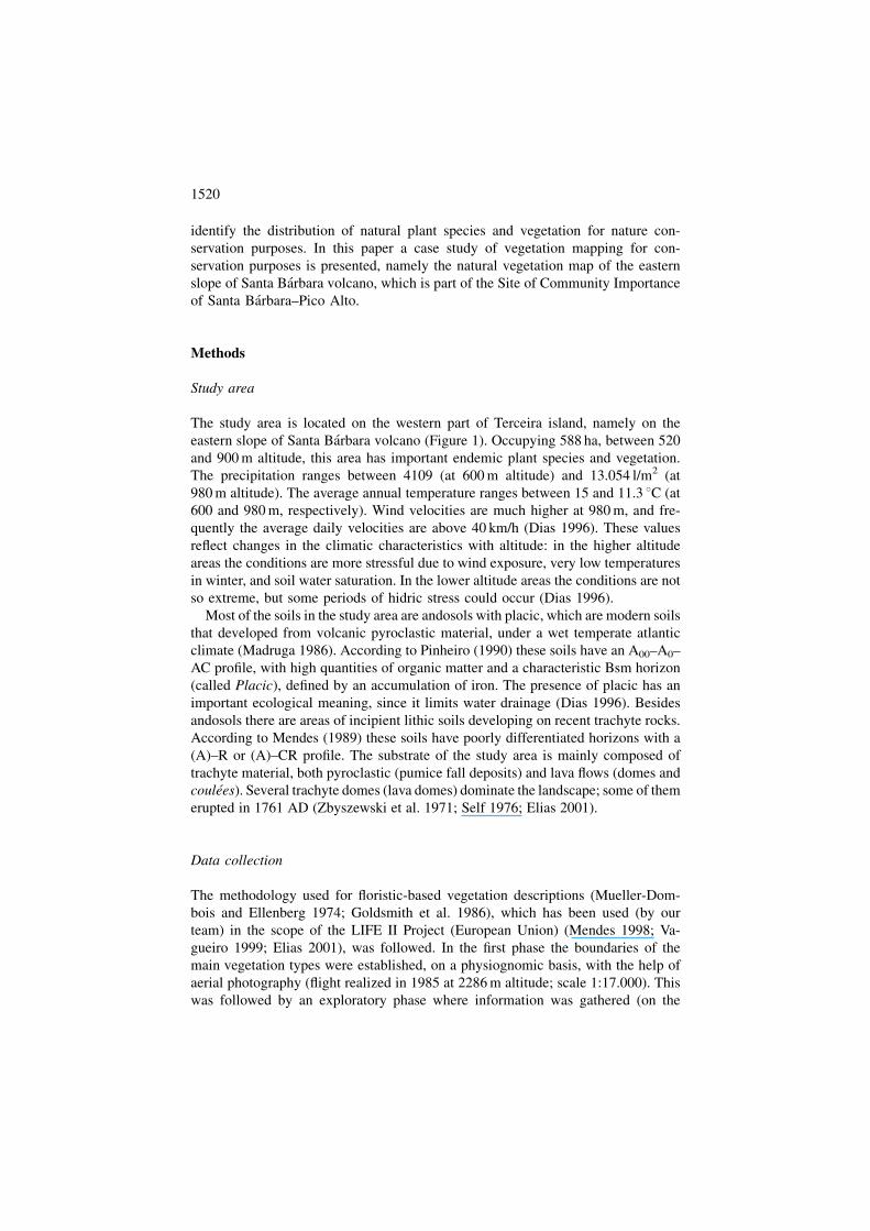
The study area is located on the western part of Terceira island, namely on the
eastern slope of Santa Barbara volcano (Figure 1). Occupying 588 ha, between 520
and 900 m altitude, this area has important endemic plant species and vegetation.
The precipitation ranges between 4109 (at 600 m altitude) and 13.054 l/m2 (at
980 m altitude). The average annual temperature ranges between 15 and 11.3 8C (at
600 and 980 m, respectively). Wind velocities are much higher at 980 m, and fre-
quently the average daily velocities are above 40 km/h (Dias 1996). These values
reflect changes in the climatic characteristics with altitude: in the higher altitude
areas the conditions are more stressful due to wind exposure, very low temperatures
in winter, and soil water saturation. In the lower altitude areas the conditions are not
so extreme, but some periods of hidric stress could occur (Dias 1996).
Most of the soils in the study area are andosols with placic, which are modern soils
that developed from volcanic pyroclastic material, under a wet temperate atlantic
climate (Madruga 1986). According to Pinheiro (1990) these soils have an A00–A0–
AC profile, with high quantities of organic matter and a characteristic Bsm horizon
(called Placic), defined by an accumulation of iron. The presence of placic has an
important ecological meaning, since it limits water drainage (Dias 1996). Besides
andosols there are areas of incipient lithic soils developing on recent trachyte rocks.
According to Mendes (1989) these soils have poorly differentiated horizons with a
(A)–R or (A)–CR profile. The substrate of the study area is mainly composed of
trachyte material, both pyroclastic (pumice fall deposits) and lava flows (domes and
coulees). Several trachyte domes (lava domes) dominate the landscape; some of them
erupted in 1761 AD (Zbyszewski et al. 1971; Self 1976; Elias 2001).
Data collection
The methodology used for floristic-based vegetation descriptions (Mueller-Dom-
bois and Ellenberg 1974; Goldsmith et al. 1986), which has been used (by our
team) in the scope of the LIFE II Project (European Union) (Mendes 1998; Va-
gueiro 1999; Elias 2001), was followed. In the first phase the boundaries of the
main vegetation types were established, on a physiognomic basis, with the help of
aerial photography (flight realized in 1985 at 2286 m altitude; scale 1:17.000). This
was followed by an exploratory phase where information was gathered (on the
1520
field) with the objective of confirming (also on a physiognomic basis) the bound-
aries established earlier and registering other types of vegetation not revealed by
aerial photography analysis.
During the third phase several plots were located, following the methodology of
Braun-Blanquet (Mueller-Dombois and Ellenberg 1974), on the several types of
vegetation previously recognized. The areas of the plots varied between 25 and
Figure 1. Location of the study area: (A) Azores Islands with the location of Terceira; (B) Terceira
Island with the location of the study site.
1521
100 m2, according to Dias (1996). Afterwards the data were normalized for 25 m2
by simple arithmetic calculation. The plots were located at random inside the
boundaries of each vegetation type identified earlier. The number of plots im-
plemented in each vegetation type varied according to the respective area and
accessibility. No plots were located in the Juniperus Forested Peat Bog because it
lies in a mountainous area in rough terrain which is very difficult to access. To
characterize this vegetation the data of Dias (1996), from plots located in a con-
tiguous area that has the same physiognomy, was used. For the characterization of
the Vegetation of Rocky Slopes a qualitative approach was used, since this vege-
tation occurs on vertical slopes of crevasses where it is not viable to implement
plots. In all the plots the absolute percent coverage (0–100%, estimated visually) of
all vascular plant species and the bryophytes Sphagnum spp. and Polytrichum
commune was measured. Several other features related to the site, like soil type,
geology and geomorphology, presence of seedlings and saplings of the vascular
species, soil and vegetation profile, were also noted.
Since the trachyte domes (lava domes) vegetation presented a clear zonation, a
method adapted from the transect method described by Mueller-Dombois and El-
lenberg (1974) was used for its study. This vegetation has been the object of a more
detailed study by Elias (2001) and Elias and Dias (submitted) on the primary
succession on lava domes. In that work data of vegetation bioarea along transects
were collected. This different approach was used because of the zonation presented
by the vegetation of these geologic structures, which is unique in the study area and
could not be correctly accessed by the use of plots. On the other end, all the domes
present in the study area are in a successional stage which justified this different
approach. Since the type of information was different (plots-percent cover and
transects-bioarea), the data from the domes vegetation were not included in the
multivariate analysis. However, the type of vegetation is clearly different and its
structure is characterized according to Elias (2001) (Appendix 1).
Data analysis
Based on the collected data a plots-versus-species matrix (using the cover values of
each species) was created. A multivariate analysis was applied to this matrix in order to
separate different types of vegetation, using the program Syn-Tax 5.0 (Podani 1994). A
hierarchical agglomerative clustering was used, with the Euclidean Distance as the
similarity coefficient and the Complete Linkage as the method for group formation
(Podani 1994; Fernandez-Palacios and Santos 1996). The data were transformed
logarithmically (base 10) in order to accentuate the lognormal distribution properties
of the variables. On the initial matrix, data from six plots (100, 101, 103, 147, 153 and
164) established earlier by Dias (1996) in the study area were included. Individual
cluster analysis was also applied to the main vegetation types individualized in the first
dendrogram but removing the plots implemented in semi-natural areas.
The evaluation of the results was performed by the program Eval (Syn-Tax 5.0,
Podani 1994) through the explanatory variables, to identify the species that
1522
contribute most to the objects’ individualization at a given dissimilarity level.
Principal Component Analysis (PCA) was used to evaluate the ecological ten-
dencies reflected in the dendrogram and to analyze the relationship between species
and plots. A Geographic Information System (GIS) was used to draw a digital map.
Ortophotomaps, on a scale of 1:25 000, were created from the aerial photography
adjusted to digital files of the study site. The digital mapping was performed using
the software Geomedia Professional V3 and printed with CAD quality from the
computer application Intergraph Smartsketch.
Results and discussion
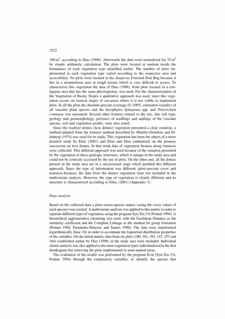
The dendrogram depicted in Figure 2 resulted from the analysis of the species
versus plots matrix. Four major types of vegetation can be distinguished: grass-
lands, peat bogs, scrubs and forests. There is a clear grouping of the formations
dominated by herbaceous plants and by Sphagnum spp. (grasslands and peat bogs)
on the left (A). In the center we have the scrubs divided in two main groups: (B1)
wet formations and (B2) mountain formations, both with a high percentage of
Calluna vulgaris. On the right we have the secondary succession scrubs and forests
(C) (with the exception of plots 36 and 11) and the mature forest formations (D)
dominated by Juniperus brevifolia, Laurus azorica and Ilex perado ssp. azorica.
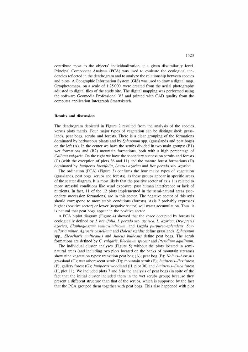
The ordination (PCA) (Figure 3) confirms the four major types of vegetation
(grasslands, peat bogs, scrubs and forests), as these groups appear in specific areas
of the scatter diagram. It is most likely that the positive sector of axis 1 is related to
more stressful conditions like wind exposure, past human interference or lack of
nutrients. In fact, 11 of the 12 plots implemented in the semi-natural areas (sec-
ondary succession formations) are in this sector. The negative sector of this axis
should correspond to more stable conditions (forests). Axis 2 probably expresses
higher (positive sector) or lower (negative sector) soil water accumulation. Thus, it
is natural that peat bogs appear in the positive sector.
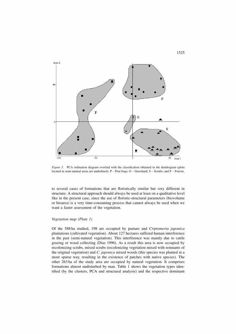
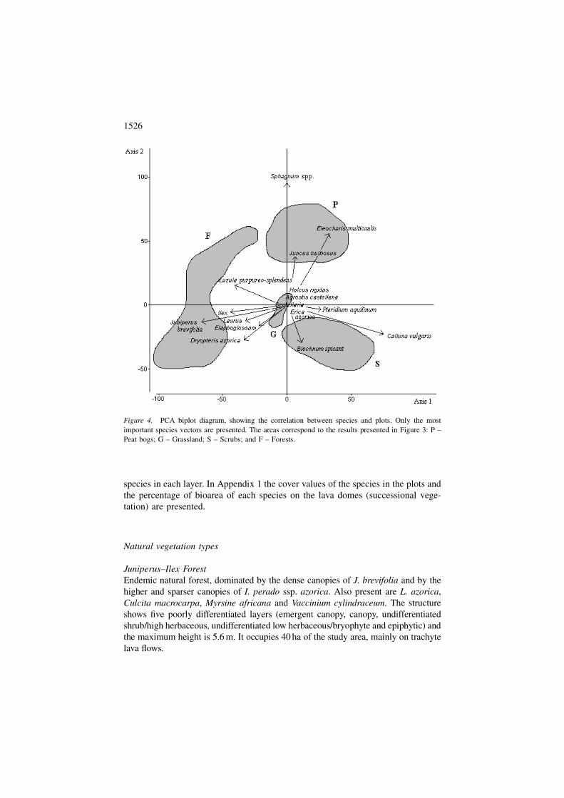
A PCA biplot diagram (Figure 4) showed that the space occupied by forests is
ecologically defined by J. brevifolia, I. perado ssp. azorica, L. azorica, Dryopteris
azorica, Elaphoglossum semicylindricum, and Luzula purpureo-splendens. Scu-
tellaria minor, Agrostis castellana and Holcus rigidus define grasslands. Sphagnum
spp., Eleocharis multicaulis and Juncus bulbosus define peat bogs. The scrub
formations are defined by C. vulgaris, Blechnum spicant and Pteridium aquilinum.
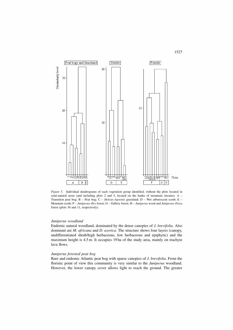
The individual cluster analyses (Figure 5) without the plots located in semi-
natural areas (and including two plots located on the banks of mountain streams)
show nine vegetation types: transition peat bog (A); peat bog (B); Holcus–Agrostis
grassland (C); wet arborescent scrub (D); mountain scrub (E); Juniperus–Ilex forest
(F); gallery forest (G); Juniperus woodland (H, plot 36) and Juniperus–Erica forest
(H, plot 11). We included plots 7 and 8 in the analysis of peat bogs (in spite of the
fact that the initial cluster included them in the wet scrubs group) because they
present a different structure than that of the scrubs, which is supported by the fact
that the PCA grouped them together with peat bogs. This also happened with plot
1523
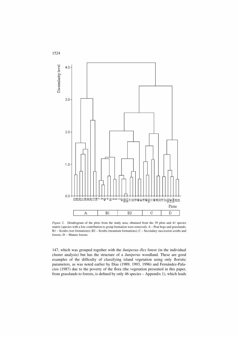
147, which was grouped together with the Juniperus–Ilex forest (in the individual
cluster analysis) but has the structure of a Juniperus woodland. These are good
examples of the difficulty of classifying island vegetation using only floristic
parameters, as was noted earlier by Dias (1989, 1993, 1996) and Fernandez-Pala-
cios (1987) due to the poverty of the flora (the vegetation presented in this paper,
from grasslands to forests, is defined by only 46 species – Appendix 1), which leads
Figure 2. Dendrogram of the plots from the study area, obtained from the 39 plots and 41 species
matrix (species with a low contribution to group formation were removed). A – Peat bogs and grasslands;
B1 – Scrubs (wet formations); B2 – Scrubs (mountain formations); C – Secondary succession scrubs and
forests; D – Mature forests.
1524
to several cases of formations that are floristically similar but very different in
structure. A structural approach should always be used at least on a qualitative level
like in the present case, since the use of floristic-structural parameters (biovolume
or bioarea) is a very time-consuming process that cannot always be used when we
want a faster assessment of the vegetation.
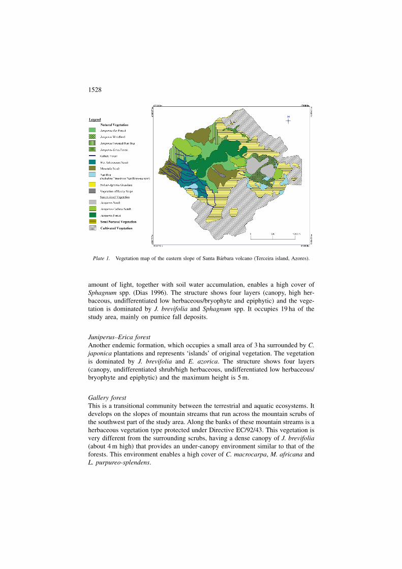
Vegetation map (Plate 1)
Of the 588 ha studied, 198 are occupied by pasture and Criptomeria japonica
plantations (cultivated vegetation). About 127 hectares suffered human interference
in the past (semi-natural vegetation). This interference was mainly due to cattle
grazing or wood collecting (Dias 1996). As a result this area is now occupied by
recolonizing scrubs, mixed scrubs (recolonizing vegetation mixed with remnants of
the original vegetation) and C. japonica mixed woods (this species was planted in a
more sparse way, resulting in the existence of patches with native species). The
other 263 ha of the study area are occupied by natural vegetation. It comprises
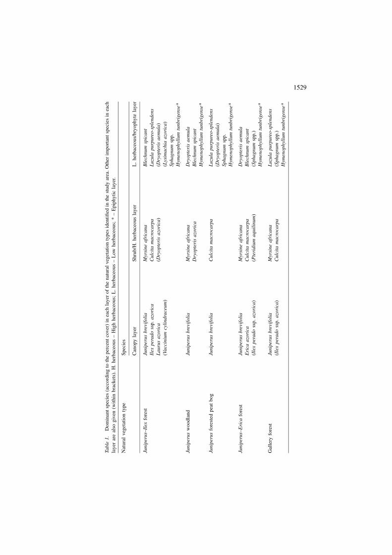
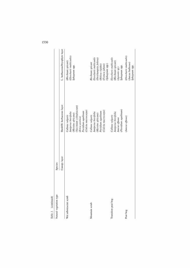
formations almost undisturbed by man. Table 1 shows the vegetation types iden-
tified (by the clusters, PCA and structural analysis) and the respective dominant
Figure 3. PCA ordination diagram overlaid with the classification obtained in the dendrogram (plots
located in semi-natural areas are underlined). P – Peat bogs; G – Grassland; S – Scrubs; and F – Forests.
1525
species in each layer. In Appendix 1 the cover values of the species in the plots and
the percentage of bioarea of each species on the lava domes (successional vege-
tation) are presented.
Natural vegetation types
Juniperus–Ilex Forest
Endemic natural forest, dominated by the dense canopies of J. brevifolia and by the
higher and sparser canopies of I. perado ssp. azorica. Also present are L. azorica,
Culcita macrocarpa, Myrsine africana and Vaccinium cylindraceum. The structure
shows five poorly differentiated layers (emergent canopy, canopy, undifferentiated
shrub/high herbaceous, undifferentiated low herbaceous/bryophyte and epiphytic) and
the maximum height is 5.6 m. It occupies 40 ha of the study area, mainly on trachyte
lava flows.
Figure 4. PCA biplot diagram, showing the correlation between species and plots. Only the most
important species vectors are presented. The areas correspond to the results presented in Figure 3: P –
Peat bogs; G – Grassland; S – Scrubs; and F – Forests.
1526
Juniperus woodland
Endemic natural woodland, dominated by the dense canopies of J. brevifolia. Also
dominant are M. africana and D. azorica. The structure shows four layers (canopy,
undifferentiated shrub/high herbaceous, low herbaceous and epiphytic) and the
maximum height is 4.5 m. It occupies 19 ha of the study area, mainly on trachyte
lava flows.
Juniperus forested peat bog
Rare and endemic Atlantic peat bog with sparse canopies of J. brevifolia. From the
floristic point of view this community is very similar to the Juniperus woodland.
However, the lower canopy cover allows light to reach the ground. The greater
Figure 5. Individual dendrograms of each vegetation group identified, without the plots located in
semi-natural areas (and including plots 2 and 5, located on the banks of mountain streams). A –
Transition peat bog; B – Peat bog; C – Holcus–Agrostis grassland; D – Wet arborescent scrub; E –
Mountain scrub; F – Juniperus–Ilex forest; G – Gallery forest; H – Juniperus wood and Juniperus–Erica
forest (plots 36 and 11, respectively).
1527
amount of light, together with soil water accumulation, enables a high cover of
Sphagnum spp. (Dias 1996). The structure shows four layers (canopy, high her-
baceous, undifferentiated low herbaceous/bryophyte and epiphytic) and the vege-
tation is dominated by J. brevifolia and Sphagnum spp. It occupies 19 ha of the
study area, mainly on pumice fall deposits.
Juniperus–Erica forest
Another endemic formation, which occupies a small area of 3 ha surrounded by C.
japonica plantations and represents ‘islands’ of original vegetation. The vegetation
is dominated by J. brevifolia and E. azorica. The structure shows four layers
(canopy, undifferentiated shrub/high herbaceous, undifferentiated low herbaceous/
bryophyte and epiphytic) and the maximum height is 5 m.
Gallery forest
This is a transitional community between the terrestrial and aquatic ecosystems. It
develops on the slopes of mountain streams that run across the mountain scrubs of
the southwest part of the study area. Along the banks of these mountain streams is a
herbaceous vegetation type protected under Directive EC/92/43. This vegetation is
very different from the surrounding scrubs, having a dense canopy of J. brevifolia
(about 4 m high) that provides an under-canopy environment similar to that of the
forests. This environment enables a high cover of C. macrocarpa, M. africana and
L. purpureo-splendens.
Plate 1. Vegetation map of the eastern slope of Santa Barbara volcano (Terceira island, Azores).
1528
Ta
ble
1.
Dom
inan
tsp
ecie
s(a
ccord
ing
toth
eper
cent
cover
)in
each
layer
of
the
nat
ura
lveg
etat
ion
types
iden
tifi
edin
the
stu
dy
area
.O
ther
imp
ort
ant
spec
ies
inea
ch
lay
erar
eal
sog
iven
(wit
hin
bra
cket
s).
H.
her
bac
eou
s–
Hig
hher
bac
eous;
L.
her
bac
eous
–L
ow
her
bac
eou
s;*
–E
pip
hyti
cla
yer
.
Nat
ura
lveg
etat
ion
typ
eS
pec
ies
Can
op
yla
yer
Sh
rub
/H.
her
bac
eou
sla
yer
L.
her
bac
eou
s/b
ryo
ph
yte
lay
er
Jun
iper
us–
Ilex
fore
stJu
nip
eru
sb
revi
foli
aM
yrsi
ne
afr
ica
na
Ble
chn
um
spic
an
t
Ilex
per
ad
oss
p.
azo
rica
Cu
lcit
am
acr
oca
rpa
Lu
zula
pu
rpu
reo
-sp
len
den
s
La
uru
sa
zori
ca(D
ryo
pte
ris
azo
rica
)(D
ryo
pte
ris
aem
ula
)
(Va
ccin
ium
cyli
nd
race
um
)(L
ysim
ach
iaa
zori
ca)
Sp
hag
nu
msp
p.
Hym
eno
phyl
lum
tun
bri
gen
se*
Jun
iper
us
wo
od
lan
dJu
nip
eru
sb
revi
foli
aM
yrsi
ne
afr
ica
na
Dry
op
teri
sa
emu
la
Dry
op
teri
sa
zori
caB
lech
nu
msp
ica
nt
Hym
eno
phyl
lum
tun
bri
gen
se*
Jun
iper
us
fore
sted
pea
tb
og
Jun
iper
us
bre
vifo
lia
Cu
lcit
am
acr
oca
rpa
Lu
zula
pu
rpu
reo
-sp
len
den
s
(Dry
op
teri
sa
emu
la)
Sp
hag
nu
msp
p.
Hym
eno
phyl
lum
tun
bri
gen
se*
Jun
iper
us–
Eri
cafo
rest
Jun
iper
us
bre
vifo
lia
Myr
sin
ea
fric
ana
Dry
op
teri
sa
emu
la
Eri
caa
zori
caC
ulc
ita
ma
cro
carp
aB
lech
nu
msp
ica
nt
(Ile
xp
era
do
ssp
.a
zori
ca)
(Pte
rid
ium
aq
uil
inum
)(S
ph
ag
num
spp
.)
Hym
eno
phyl
lum
tun
bri
gen
se*
Gal
lery
fore
stJu
nip
eru
sb
revi
foli
aM
yrsi
ne
afr
ica
na
Lu
zula
pu
rpu
reo
-sp
len
den
s
(Ile
xp
era
do
ssp
.a
zori
ca)
Cu
lcit
am
acr
oca
rpa
(Sp
ha
gn
um
spp
.)
Hym
eno
phyl
lum
tun
bri
gen
se*
1529
Ta
ble
1.
(con
tin
ued
)
Nat
ura
lveg
etat
ion
typ
eS
pec
ies
Can
op
yla
yer
Sh
rub
/H.
her
bac
eou
sla
yer
L.
her
bac
eou
s/b
ryo
ph
yte
lay
er
Wet
arb
ore
scen
tsc
rub
Call
un
avu
lga
ris
(Ble
chn
um
spic
an
t)
Jun
iper
us
bre
vifo
lia
(Ele
och
ari
sm
ult
ica
uli
s)
(Myr
sin
ea
fric
ana)
Sp
hag
nu
msp
p.
(Va
ccin
ium
cyli
nd
race
um
)
(Eri
caa
zori
ca)
Pte
rid
ium
aq
uil
inu
m
(Cu
lcit
am
acr
oca
rpa)
Mo
un
tain
scru
bC
all
un
avu
lga
ris
Ble
chn
um
spic
an
t
Jun
iper
us
bre
vifo
lia
Ele
och
ari
sm
ult
icau
lis
(Myr
sin
ea
fric
ana)
(Des
cha
mp
sia
foli
osa
)
Pte
rid
ium
aq
uil
inu
m(H
olc
us
rig
idu
s)
(Cu
lcit
am
acr
oca
rpa)
(Fes
tuca
jub
ata
)
(Sp
ha
gn
um
spp
.)
Tra
nsi
tion
pea
tb
og
Call
un
avu
lga
ris
Ele
och
ari
sm
ult
icau
lis
Jun
iper
us
bre
vifo
lia
(Ble
chn
um
spic
an
t)
Jun
cus
effu
sus
(Ag
rost
issp
.)
(Pte
rid
ium
aq
uil
inu
m)
Sp
hag
nu
msp
p.
Pea
tb
og
(Ju
ncu
sef
fusu
s)(E
leo
cha
ris
mu
ltic
au
lis)
(Ju
ncu
sbu
lbo
sus)
Sp
hag
nu
msp
p.
1530
Ta
ble
1.
(con
tin
ued
)
Nat
ura
lveg
etat
ion
typ
eS
pec
ies
Can
op
yla
yer
Sh
rub
/H.
her
bac
eou
sla
yer
L.
her
bac
eou
s/b
ryo
ph
yte
lay
er
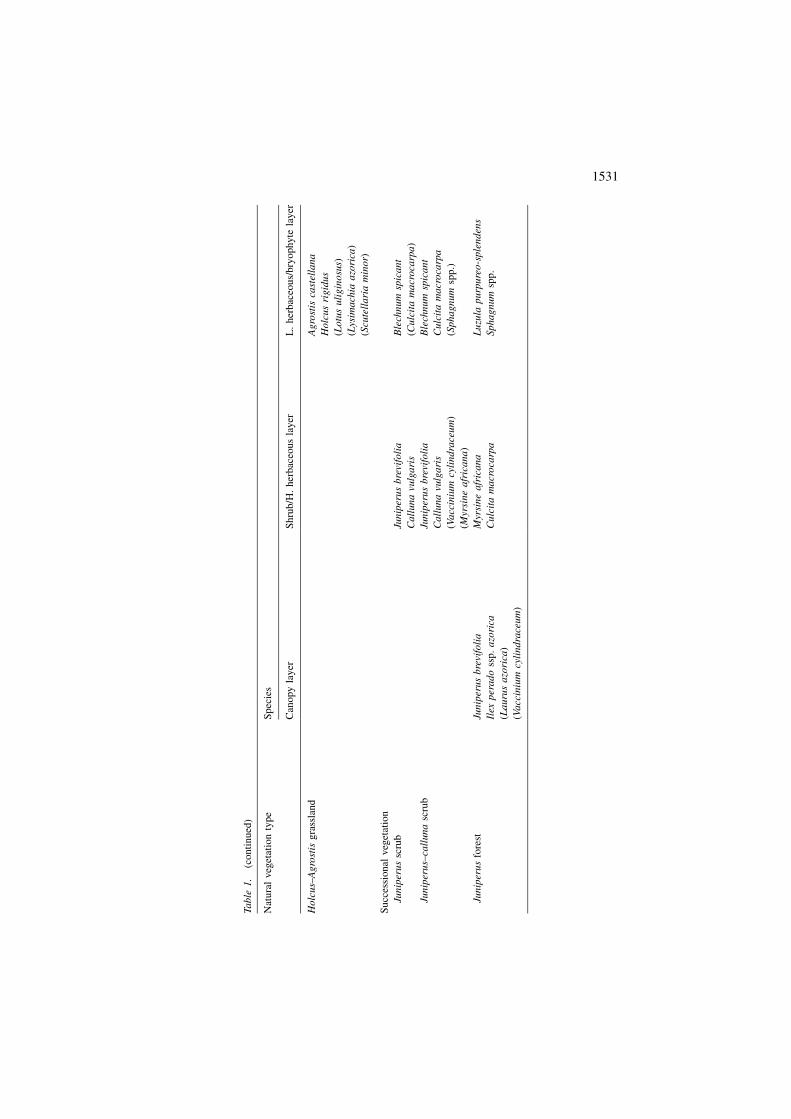
Ho
lcu
s–A
gro
stis
gra
ssla
nd
Ag
rost
isca
stel
lan
a
Ho
lcu
sri
gid
us
(Lo
tus
uli
gin
osu
s)
(Lys
imach
iaa
zori
ca)
(Scu
tell
ari
am
inor)
Succ
essi
onal
veg
etat
ion
Jun
iper
us
scru
bJu
nip
eru
sb
revi
foli
aB
lech
nu
msp
ica
nt
Ca
llu
na
vulg
ari
s(C
ulc
ita
ma
cro
carp
a)
Jun
iper
us–
call
un
asc
rub
Jun
iper
us
bre
vifo
lia
Ble
chn
um
spic
an
t
Ca
llu
na
vulg
ari
sC
ulc
ita
ma
cro
carp
a
(Vacc
iniu
mcy
lindra
ceum
)(S
ph
ag
num
spp
.)
(Myr
sin
ea
fric
an
a)
Jun
iper
us
fore
stJu
nip
eru
sb
revi
foli
aM
yrsi
ne
afr
ica
na
Lu
zula
pu
rpu
reo
-sp
len
den
s
Ilex
per
ad
oss
p.
azo
rica
Cu
lcit
am
acr
oca
rpa
Sp
hag
nu
msp
p.
(La
uru
sa
zori
ca)
(Va
ccin
ium
cyli
nd
race
um
)
1531
Wet arborescent scrub
According to Dias (1996) this endemic scrub is characteristic of wet, low-exposure,
mountainous slopes. In the study area they precede the mountain scrubs, in the
southwest zone, that occur at higher, more exposed, altitudes. Its similarity with
mountain scrubs is evident by the dominance of C. vulgaris and J. brevifolia.
However, the less exposed conditions enable a higher coverage of C. macrocarpa,
V. cylindraceum and L. azorica. It occupies 28 ha of the study area, mainly on
pumice fall deposits.
Mountain scrub
The vegetation is dominated by C. vulgaris and J. brevifolia. It occurs in high
mountainous areas on pumice fall deposits. There are three types of patches: shrub
patches (dominated by C. vulgaris and J. brevifolia); herbaceous patches (domi-
nated by Deschampsia foliosa, Festuca jubata or E. multicaulis) and bryophyte
patches (dominated by Sphagnum spp.). With a maximum height of 1.3 m these
scrubs occupy 54 ha of the study area.
Transition peat bogs
These occupy, together with peat bogs, 14 ha of the study area. They are the
most common Azorean peat bogs. They have a soligenic flux of minerotrophic
water with a higher nutrient availability. Its irregularity is expressed through a
hummock-hollow structure that allows an active mineralization on the hummocks
and the consequent advance of woody species (Dias 1996). Polytrichum com-
mune and Juncus effusus occur on the hummocks as happens with, in a more
stable situation, C. vulgaris and J. brevifolia. The hollows are dominated by
Sphagnum spp.
Peat bog
These are homogeneous, flat, floristically poor, peat bogs. However, the highest
diversity of Sphagnum species occurs here (Mendes 1998). In the vegetation map
(Plate 1) peat bogs and transition peat bogs are represented together under the
designation ‘Peat Bog’.
Holcus–Agrostis grassland
This community, limited to a 0.4 ha area in the south of the study area, is dominated
by H. rigidus and A. castellana.
Successional vegetation
This vegetation type was the object of a more detailed study by Elias (2001)
(Appendix 1). It presents a clear zonation with different communities in the base,
middle and top areas of the domes. This zonation reflects the habitat characteristics
and the colonization and successional histories of these geological formations. In
1532
the study area we have several trachyte domes with ages ranging from 240 years to
about 2000 years.
Juniperus scrub
Develops in young domes that represent 20 ha of the study area. The vegetation
cover values are very low mainly in the middle (with only 20% of the surface
covered) and top (50% cover) areas. A Calluna–Juniperus Pioneer Scrub and a
Juniperus Pioneer Scrub, respectively, develop in these areas. These communities
present a clear patchy horizontal structure with ‘spots’ of vegetation in depressions
and cracks in the rock surface and with the more exposed surfaces almost clear of
vegetation.
Juniperus–Calluna scrub
Develops in more ancient domes [370 years in the case study of Elias (2001)] in a
27 ha area. The vegetation has a greater degree of coverage and higher height but
the zonation and patchy horizontal structure, in the middle and top areas, is still
clear. The vegetation at the base of the domes is already well developed and more
similar to the surroundings. The middle and top areas are characterized by a scrub
vegetation that is very similar in composition to the pioneer vegetation, but with
higher cover values.
Juniperus forest
Develops in 2000 year old domes on a 40 ha area. In these domes both the zonation
and horizontal structure, though present, are less evident. The base of the domes is
characterized by a Juniperus–Ilex forest (similar to the surrounding vegetation).
The lateral area presents a Juniperus wet scrub with a high coverage of Sphagnum
spp. The top is occupied by a Juniperus–Ilex–Laurus forest. In spite of these
differences these domes have a physiognomy dominated by J. brevifolia and I.
perado ssp. azorica.
Vegetation of rocky slopes
Due to extreme difficulties of the terrain no plots were implemented here. This
is a community with an important botanical and scientific value due to the
presence of rare species and floristic diversity. Some of the species observed are
Lactuca watsoniana, Euphorbia stygiana, Smilax canariensis or Diphasium
madeirense.
Conclusions
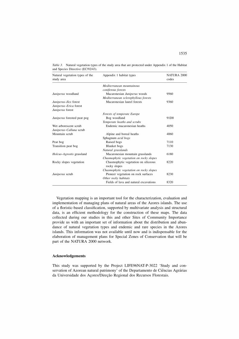
The study area has an important set of plant species and vegetation types. Eighteen
Azorean endemic taxa, 5 Macaronesian endemic taxa, 10 species protected by the
1533
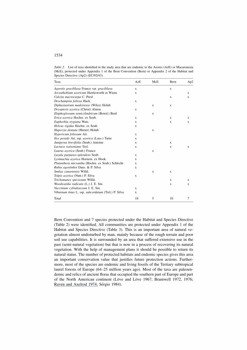
Bern Convention and 7 species protected under the Habitat and Species Directive
(Table 2) were identified. All communities are protected under Appendix 1 of the
Habitat and Species Directive (Table 3). This is an important area of natural ve-
getation almost undisturbed by man, mainly because of the rough terrain and poor
soil use capabilities. It is surrounded by an area that suffered extensive use in the
past (semi-natural vegetation) but that is now in a process of recovering its natural
vegetation. With the help of management plans it should be possible to return its
natural status. The number of protected habitats and endemic species gives this area
an important conservation value that justifies future protection actions. Further-
more, most of the species are endemic and living fossils of the Tertiary subtropical
laurel forests of Europe (64–25 million years ago). Most of the taxa are paleoen-
demic and relics of ancient floras that occupied the southern part of Europe and part
of the North American continent (Love and Love 1967; Bramwell 1972, 1976;
Raven and Axelrod 1974; Sergio 1984).
Table 2. List of taxa identified in the study area that are endemic to the Azores (AzE) or Macaronesia
(McE), protected under Appendix 1 of the Bern Convention (Bern) or Appendix 2 of the Habitat and
Species Directive (Ap2) (EC/92/43).
Taxa AzE McE Bern Ap2
Agrostis gracililaxa Franco var. gracililaxa x x
Arceuthobium azoricum Hawksworth et Wiens x x
Culcita macrocarpa C. Presl x x
Deschampsia foliosa Hack. x
Diphasiastrum madeirense (Wilce) Holub x x
Dryopteris azorica (Christ) Alston x
Elaphoglossum semicylindricum (Bowd.) Benl x
Erica azorica Hochst. ex Seub. x x x
Euphorbia stygiana Wats. x x x
Holcus rigidus Hochst. ex Seub. x
Huperzia dentata (Herter) Holub x
Hypericum foliosum Ait. x
Ilex perado Ait. ssp. azorica (Loes.) Tutin x
Juniperus brevifolia (Seub.) Antoine x x
Lactuca watsoniana Trel. x x x
Laurus azorica (Seub.) Franco x
Luzula purpureo-splendens Seub. x
Lysimachia azorica Hornem. ex Hook. x
Platanthera micrantha (Hochst. ex Seub.) Schlecht x
Rubia agostinhoi Dans. & P. Silva x
Smilax canariensis Willd. x x
Tolpis azorica (Nutt.) P. Silva x
Trichomanes speciosum Willd. x x
Woodwardia radicans (L.) J. E. Sm. x x
Vaccinium cylindraceum J. E. Sm. x
Viburnum tinus L. ssp. subcordatum (Trel.) P. Silva x
Total 18 5 10 7
1534
Vegetation mapping is an important tool for the characterization, evaluation and
implementation of managing plans of natural areas of the Azores islands. The use
of a floristic-based classification, supported by multivariate analysis and structural
data, is an efficient methodology for the construction of these maps. The data
collected during our studies in this and other Sites of Community Importance
provide us with an important set of information about the distribution and abun-
dance of natural vegetation types and endemic and rare species in the Azores
islands. This information was not available until now and is indispensable for the
elaboration of management plans for Special Zones of Conservation that will be
part of the NATURA 2000 network.
Acknowledgements
This study was supported by the Project LIFE96NAT-P-3022 ‘Study and con-
servation of Azorean natural patrimony’ of the Departamento de Ciencias Agrarias
da Universidade dos Acores/Direcao Regional dos Recursos Florestais.
Table 3. Natural vegetation types of the study area that are protected under Appendix 1 of the Habitat
and Species Directive (EC/92/43).
Natural vegetation types of the
study area
Appendix 1 habitat types NATURA 2000
codes
Mediterranean mountainous
coniferous forests
Juniperus woodland Macaronesian Juniperus woods 9560
Mediterranean sclerophyllous forests
Juniperus–Ilex forest Macaronesian laurel forests 9360
Juniperus–Erica forest
Juniperus forest
Forests of temperate Europe
Juniperus forested peat pog Bog woodland 91D0
Temperate heaths and scrubs
Wet arborescent scrub Endemic macaronesian heaths 4050
Juniperus–Calluna scrub
Mountain scrub Alpine and boreal heaths 4060
Sphagnum acid bogs
Peat bog Raised bogs 7110
Transition peat bog Blanket bogs 7130
Natural grasslands
Holcus–Agrostis grassland Macaronesian mountain grasslands 6180
Chasmophytic vegetation on rocky slopes
Rocky slopes vegetation Chasmophytic vegetation on siliceous
rocky slopes
8220
Chasmophytic vegetation on rocky slopes
Juniperus scrub Pioneer vegetation on rock surfaces 8230
Other rocky habitats
Fields of lava and natural excavations 8320
1535

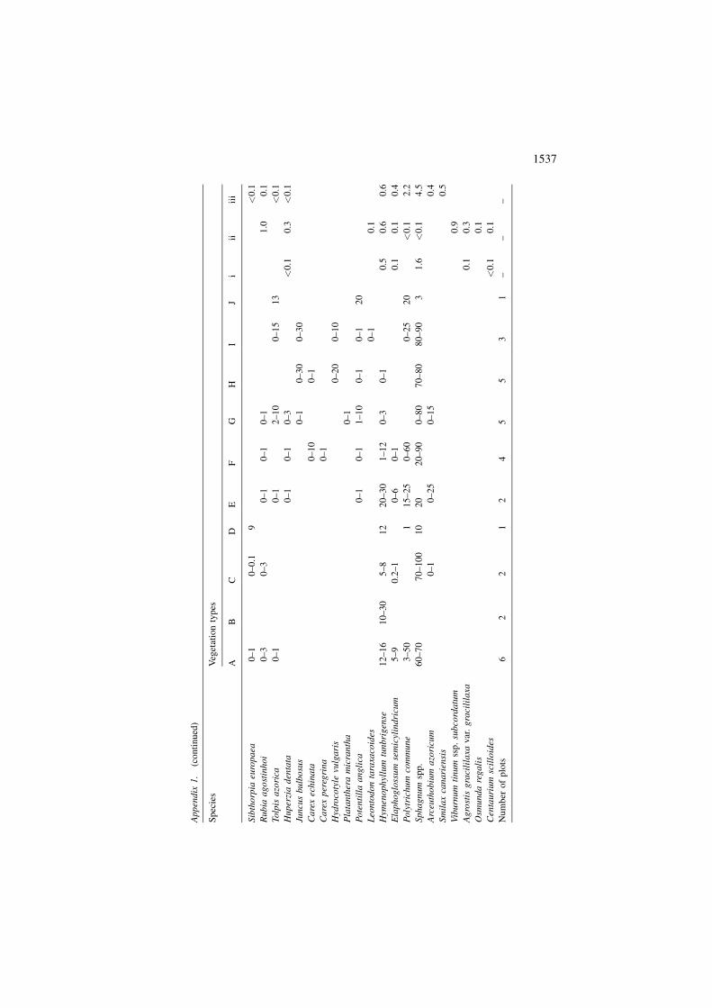
Ap
pen
dix
1.
Cover
val
ues
(A–
J,%
)(l
ow
eran
dh
igh
erli
mit
sar
eg
iven
)o
fth
esp
ecie
sid
enti
fied
inth
eplo
tsim
ple
men
ted
inth
edif
fere
nt
types
of
veg
etat
ion
of
the
stu
dy
area
.A
–Ju
nip
eru
s–Il
exF
ore
st;
B–
Jun
iper
us
wo
od
lan
d;
C–
Jun
iper
us
fore
sted
pea
tb
og
(Dia
s1
99
6);
D–
Jun
iper
us–
Eri
cafo
rest
;E
–G
alle
ryfo
rest
;F
–W
et
arb
ore
scen
tsc
rub
;G
–M
oun
tain
scru
b;
H–
Tra
nsi
tio
np
eat
bo
g;
I–
Pea
tb
og
;J
–H
olc
us–
Agro
stis
gra
ssla
nd
.i–
iii:
Per
cen
tage
(%)
of
bio
area
of
the
spec
ies
iden
tifi
edin
the
succ
essi
onal
veg
etat
ion.
i–
Jun
iper
us
scru
b;
ii–
Jun
iper
us–
Ca
llu
na
scru
b;
iii
–Ju
nip
eru
sfo
rest
(Eli
as2
00
1).
Sp
ecie
sV
eget
atio
nty
pes
AB
CD
EF
GH
IJ
iii
iii
Jun
iper
us
bre
vifo
lia
50
–60
75
–9
08
06
09
02
5–
50
25
–60
18
–50
0–
64
9.0
32
.93
1.3
Ilex
per
ad
oss
p.
azo
rica
20
–60
0.1
–5
25
10–
20
0–
11
–3
0–
12
.01
.71
2.2
La
uru
sa
zori
ca2
5–
70
0.2
–5
50
–6
0–
60
–1
0.1
8.3
Eri
caa
zori
ca0
–9
5–
25
40
3–
12
0–
60–
22
0–
80
.31
.43
.6
Va
ccin
ium
cyli
nd
race
um
20
–40
30
1–
510
–15
4–
15
0–
30–
65
8.3
11
.83
.8
Myr
sin
ea
fric
ana
18
–40
25
–5
02
–1
51
52
0–
50
1–
15
2–
70–
38
.09
.74
.8
Ca
llu
na
vulg
ari
s1
0–
25
0–
60
–1
15
75
–90
25
–70
35
–80
0–
35
19
.63
3.4
0.9
Cu
lcit
am
acr
oca
rpa
30
–80
15
–20
30
30
–80
9–
20
5–
25
0–
55
.61
.81
0.9
Dry
op
teri
sa
zori
ca1
5–
20
2–
40
0.2
–2
02
.60
.2
Pte
rid
ium
aq
uil
inum
5–
21
1–
620
0–
130
–60
14
–25
0–
45
0–
30
.43
.9
Jun
cus
effu
ses
1–
60
–1
32
–1
26
–5
00
–2
0
Wo
od
wa
rdia
rad
ica
ns
3
Dry
op
teri
sa
emu
la3
–1
62
–2
51
–5
20
0–
60
–5
0.3
<0
.1<
0.1
Ble
chn
um
spic
an
t2
1–
54
3–
18
2–
318
15
6–
12
6–
40
1–
25
0–
85
1.7
1.6
0.8
Ele
och
ari
sm
ult
ica
uli
s1
01
2–
27
15–
40
0–
70
Lys
imach
iaa
zori
ca6
–1
00
.5–1
3–
60
–6
0–
135
<0
.10
.22
.4
Lu
zula
pu
rpu
reo
–sp
len
den
s9
–6
01
–3
05
–3
02
00
–3
1–
40
1–
30
.20
.57
.3
Ag
rost
issp
.3
–4
00
–5
Ag
rost
isca
stel
lan
a1
–3
00
–2
04
8
Ho
lcu
sri
gid
us
0–
11
–3
0–
10
8–
15
1–
30–
15
48
0.8
Des
cha
mp
sia
foli
osa
3–
18
0–
1
Fes
tuca
jub
ata
2–
9
Lo
tus
uli
gin
osu
s3
5
Sel
ag
inel
lakr
au
ssia
na
0–
90
–1
01
–1
0<
0.1
Scu
tell
ari
am
inor
0–
10
30
1536
Ap
pen
dix
1.
(co
nti
nued
)
Sp
ecie
sV
eget
atio
nty
pes
AB
CD
EF
GH
IJ
iii
iii
Sib
tho
rpia
euro
pa
ea0
–1
0–
0.1
9<
0.1
Ru
bia
ag
ost
inh
oi
0–
30
–3
0–
10
–1
0–
11
.00
.1
To
lpis
azo
rica
0–
10
–1
2–
10
0–
15
13
<0
.1
Hu
per
zia
den
tata
0–
10
–1
0–
3<
0.1
0.3
<0
.1
Jun
cus
bu
lbo
sus
0–
10
–3
00
–3
0
Ca
rex
ech
ina
ta0
–1
00
–1
Ca
rex
per
egri
na
0–
1
Hyd
roco
tyle
vulg
ari
s0
–2
00
–1
0
Pla
tan
ther
am
icra
nth
a0
–1
Po
ten
till
aa
ng
lica
0–
10
–1
1–
10
0–
10
–1
20
Leo
nto
do
nta
raxa
coid
es0
–1
0.1
Hym
enophyl
lum
tunbri
gen
se1
2–
16
10
–30
5–
81
22
0–
30
1–
12
0–
30
–1
0.5
0.6
0.6
Ela
ph
og
loss
um
sem
icyl
indri
cum
5–
90
.2–1
0–
60
–1
0.1
0.1
0.4
Po
lytr
ichu
mco
mm
un
e3
–5
01
15
–25
0–
60
0–
25
20
<0
.12
.2
Sp
ha
gn
um
spp
.6
0–
70
70
–10
01
02
02
0–
90
0–
80
70
–80
80
–90
31
.6<
0.1
4.5
Arc
euth
ob
ium
azo
ricu
m0
–1
0–
25
0–
15
0.4
Sm
ila
xca
na
rien
sis
0.5
Vib
urn
um
tin
um
ssp
.su
bco
rda
tum
0.9
Ag
rost
isg
raci
lila
xavar
.g
raci
lila
xa0
.10
.3
Osm
un
da
reg
ali
s0
.1
Cen
tauri
um
scil
loid
es<
0.1
0.1
Nu
mb
ero
fp
lots
62
21
24
55
31
––
–
1537
References
Bramwell D. 1972. Flora of Macaronesia Project. Taxon 21: 730–732.
Bramwell D. 1976. The endemic flora of the Canary Islands. In: Kunkel G. (ed) Biogeography and Ecology
of the Canary Islands. Kluwer Academic Publishers, Dordrecht, The Netherlands, pp. 207–240.
Bredenkamp G., Chytry M., Fischer H.S., Neuhauslova Z. and Van Der Maarel E. 1998. Vegetation
mapping: theory, methods and case studies: Introduction. Journal of Vegetation Science 1: 162–164.
Cross J.R. 1998. An outline map of the potential natural vegetation of Ireland. Journal of Vegetation
Science 1: 241–252.
Dias E. 1988. Carta da vegetacao da ilha Terceira. Actas das 1a Jornadas Atlanticas de Proteccao do Meio
Ambiente: 169–185. Angra do Heroısmo, Azores, 25 de Junho a 1 de Julho. Camara Municipal de
Angra do Heroısmo.
Dias E. 1989. Flora e vegetacao endemica na ilha Terceira, Acores. M.Sc. Dissertation. Departamento de
Ciencias Agrarias, Universidade dos Acores, Angra do Heroısmo, Azores.
Dias E. 1993. Methodological problems on syntaxonomy of islands: vegetation biovolume as a richer
abundance-structural parameter. Proceedings of the 36th International Association of Vegetation
Science Symposium, Tenerife, 12–16 April.
Dias E. 1996. Vegetacao natural dos Acores. Ecologia e sintaxonomia das florestas naturais. Ph.D. Dis-
sertation, Departamento de Ciencias Agrarias, Universidade dos Acores, Angra do Heroısmo, Azores.
Elias R.B. 2001. Sucessao primaria em domas traquıticos. M.Sc. Dissertation in Insular Ecology and
Evolution. Departamento de Ciencias Agrarias, Universidade dos Acores, Angra do Heroısmo, Azores.
Fernandez-Palacios J.M. 1987. Analisis de la variacion espacial de la vegetacion de Tenerife e inter-
pretacion en terminos ambientales. Ph.D. Dissertation, Universidade de La Laguna.
Fernandez-Palacios J.M. and Santos A. 1996. Ecologia de las islas Canarias – Muestreo y analisis de
poblaciones y comunidades. Sociedad La Cosmologica, Santa Cruz de La Palma.
Goldsmith F.B., Harrison C.M. and Morton A.J. 1986. Description and analysis of vegetation. In: Moore
P.D. and Chapman S.B. (eds) Methods In Plant Ecology. Blackwell Science, Oxford, UK, pp. 437–524.
Hansen A. and Sunding P. 1993. Flora of Macaronesia. Checklist of Vascular Plants, Vol. 4, Revised ed.
Sommerfeltia 17, pp. 1–295.
Kuchler A.W. and Zonneveld I.S. (eds) 1988. Vegetation Mapping. Kluwer Academic Publishers,
Dordrecht, The Netherlands.
Legislation Council Directive EC/92/43 of 21 May 1992. On the conservation of natural habitats and of
wild fauna and flora, O.J. L206, 22.07.92.
Love A. and Love D. 1967. The origin of the North Atlantic flora. Aquilo, ser. Botanica 6: 52–66.
Madruga J.S. 1986. Andossolos dos Acores – Contributo para o seu estudo. M.Sc. Dissertation, De-
partamento de Ciencias Agrarias, Universidade dos Acores, Angra do Heroısmo, Azores.
Mendes C.M.F. 1998. Contributo para a caracterizacao de turfeiras de Sphagnum spp. na ilha Terceira.
Relatorio de Estagio. Departamento de Ciencias Agrarias, Universidade dos Acores, Angra do Her-
oısmo, Azores.
Mendes J.P. 1989. Caracterizacao dos solos do Perımetro Florestal da ilha Terceira. Relatorio de Estagio.
Departamento de Ciencias Agrarias, Universidade dos Acores, Angra do Heroısmo, Azores.
Mueller-Dombois D. and Ellenberg H. 1974. Aims and Methods of Vegetation Ecology. Wiley, London.
Pinheiro J.V.F. 1990. Estudo dos principais tipos de solos da ilha Terceira (Acores). M.Sc. Dissertation,
Departamento de Ciencias Agrarias, Universidade dos Acores, Angra do Heroısmo, Azores.
Podani J. 1994. Multivariate Data Analysis in Ecology and Systematics – A Methodological Guide to the
SYN-TAX 5.0 Package. SPB Academic Publishing, The Hague, The Netherlands.
Raven P. and Axelrod D. 1974. Angiosperm biogeography and past continental movements. Annals of
the Missouri Botanical Garden 61: 539–673.
Schafer H. 2002. Flora of the Azores. Margraf Verlag, Weikersheim, Germany.
Self S. 1976. The recent volcanology of Terceira, Azores. Journal of the Geological Society London 132:
645–666.
Sergio C. 1984. The distribution and origin of Macaronesian bryophyte flora. Journal of Hattori
Botanical Laboratory 56: 7–13.
1538
Vagueiro P.C.S. 1999. Contributo para a caracterizacao ecologica e ordenamento da Reserva Florestal
Natural do Biscoito da Ferraria. Relatorio de Estagio. Departamento de Ciencias Agrarias, Uni-
versidade dos Acores, Angra do Heroısmo, Azores.
Zerbe S. 1998. Potential natural vegetation: validity and applicability in landscape planning and nature
conservation. Journal of Vegetation Science 1: 165–172.
Zbyszewski G., Medeiros C., Ferreira O. da Veiga and Torre de Assuncao C. 1971. Carta geologica de
Portugal, Notıcia explicativa da folha ilha Terceira. Servicos Geologicos de Portugal, Lisboa, Portugal.
1539
Related Documents