Variations in water level for Lake Turkana in the past 8500 years near Mt. Porr, Kenya and the transition from the African Humid Period to Holocene aridity Steven L. Forman a, * , David K. Wright b , Christopher Bloszies c a Department of Geology, Baylor University, One Bear Place #97354, Waco, TX 76796, USA b Department of Archaeology and Art History, Seoul National University, San 56-1, Sillim-9dong, Gwanak-gu, Seoul 151-745, Republic of Korea c Department of Earth and Environmental Sciences, University of Illinois at Chicago, Chicago, IL 60607, USA article info Article history: Received 15 January 2014 Received in revised form 30 April 2014 Accepted 9 May 2014 Available online Keywords: Lake Turkana Holocene Relict beaches Lake level Monsoon variability abstract A stratigraphic and geomorphic study of relict beaches up to 80 m above current water level of Lake Turkana reveal four major lake level fluctuations of >50 m between ca 8.5 and 4.5 ka during the tran- sition from the African Humid Period to Holocene aridity. We hypothesize that high stands of Lake Turkana reflect complex hydrological processes with variability in Atlantic and Indian Ocean-derived moisture into East Africa, ultimately linked to changes in sea surface temperatures (SSTs). Lake level rise was also amplified regionally by increased precipitation causing overflow from the adjacent Suguta and Chew Bahir basins, particularly during high stands at ca >8.5 ka and at 6.4 ka. The timing of transgressive and regressive events is constrained by 14 C dating of carefully selected lacustrine mollusks, incorporation of previous shell ages with sufficient elevational control, and OSL dating of quartz grains from littoral and sublittoral deposits by a multiple aliquot regeneration (MAR) approach. There was a high water level up to at least 70 m at >8.5 ka that probably reached the spillover limit ~100 m. A brief (<500 yr) high stand up to at least 50 m at ca 7 ka appears to be coincident with warm postglacial SSTs in the western Indian Ocean and thus may reflect a strengthened East African Monsoon, though some precipitation was probably derived from Atlantic sources as well. A pronounced high stand inferred at ca 6.4 ka, possibly up to 100 m, is associated with warming across the Indian Ocean and equatorward compression of the ITCZ, thus reflecting a strengthened East African Monsoon. A high stand occurred at ca 5.5e5.0 ka up to at least 80 m, with a precipitous drop in lake level by 4.6 ka. Evidence from relict Porr strand plain indicate that lake level was probably below 20 m since ca 4.5 ka, though there were two noticeable high stands up to 12e20 m at ca 830 years ago and <100 years, the latter age is consistent with the historic record. © 2014 Elsevier Ltd. All rights reserved. 1. Introduction Understanding the magnitude and the complex mechanisms of Holocene climate variability is critical to gauge the sensitivity of the climate system to intrinsic drivers (e.g. Walker Circulation) and to improve further earth system models (e.g. Wanner et al., 2008; Liu et al., 2009; Zhao and Harrison, 2012). Crucial and challenging variables to quantify include the sources and the amounts of pre- cipitation in tropical latitudes because this region is particularly susceptible to changes in monsoonal circulation with a warming climate (e.g. Olago et al., 2000; Umer et al., 2004; Cherchi et al., 2011; Hsu et al., 2012; Sun et al., 2012). Rift Valley lakes in East Africa (Fig. 1) are important archives of past changes in water bal- ance and changing precipitation sources in the Holocene (e.g. Talbot and Laerdal, 2000; Verschuren et al., 2009; Tierney et al., 2011, 2013; Berke et al., 2012a). Numerous proxy-climatic records from lakes in East and in North Africa document the African Humid Period between ca 15 and 6 ka with peak drying by ca 5.5e4 ka (Perrott and Street-Perrott, 1982; deMenocal et al., 2000a, b; Gasse, 2000; Gasse et al., 2008; Kr€ opelin et al., 2008; Marshall et al., 2009; Hoelzmann et al., 2010; Tierney et al., 2011; Berke et al., 2012b; Garcin et al., 2012; Renssen et al., 2012; Blanchet et al., 2013; Tierney and deMenocal, 2013). However, there are noticeable ex- ceptions, such as Lake Tana in Ethiopia where isotopic data on leaf * Corresponding author. E-mail address: [email protected] (S.L. Forman). Contents lists available at ScienceDirect Quaternary Science Reviews journal homepage: www.elsevier.com/locate/quascirev http://dx.doi.org/10.1016/j.quascirev.2014.05.005 0277-3791/© 2014 Elsevier Ltd. All rights reserved. Quaternary Science Reviews 97 (2014) 84e101

Welcome message from author
This document is posted to help you gain knowledge. Please leave a comment to let me know what you think about it! Share it to your friends and learn new things together.
Transcript
lable at ScienceDirect
Quaternary Science Reviews 97 (2014) 84e101
Contents lists avai
Quaternary Science Reviews
journal homepage: www.elsevier .com/locate/quascirev
Variations in water level for Lake Turkana in the past 8500 years nearMt. Porr, Kenya and the transition from the African Humid Period toHolocene aridity
Steven L. Forman a, *, David K. Wright b, Christopher Bloszies c
a Department of Geology, Baylor University, One Bear Place #97354, Waco, TX 76796, USAb Department of Archaeology and Art History, Seoul National University, San 56-1, Sillim-9dong, Gwanak-gu, Seoul 151-745, Republic of Koreac Department of Earth and Environmental Sciences, University of Illinois at Chicago, Chicago, IL 60607, USA
a r t i c l e i n f o
Article history:Received 15 January 2014Received in revised form30 April 2014Accepted 9 May 2014Available online
Keywords:Lake TurkanaHoloceneRelict beachesLake levelMonsoon variability
* Corresponding author.E-mail address: [email protected] (S.L. F
http://dx.doi.org/10.1016/j.quascirev.2014.05.0050277-3791/© 2014 Elsevier Ltd. All rights reserved.
a b s t r a c t
A stratigraphic and geomorphic study of relict beaches up to 80 m above current water level of LakeTurkana reveal four major lake level fluctuations of >50 m between ca 8.5 and 4.5 ka during the tran-sition from the African Humid Period to Holocene aridity. We hypothesize that high stands of LakeTurkana reflect complex hydrological processes with variability in Atlantic and Indian Ocean-derivedmoisture into East Africa, ultimately linked to changes in sea surface temperatures (SSTs). Lake levelrise was also amplified regionally by increased precipitation causing overflow from the adjacent Sugutaand Chew Bahir basins, particularly during high stands at ca >8.5 ka and at 6.4 ka. The timing oftransgressive and regressive events is constrained by 14C dating of carefully selected lacustrine mollusks,incorporation of previous shell ages with sufficient elevational control, and OSL dating of quartz grainsfrom littoral and sublittoral deposits by a multiple aliquot regeneration (MAR) approach. There was ahigh water level up to at least 70 m at >8.5 ka that probably reached the spillover limit ~100 m. A brief(<500 yr) high stand up to at least 50 m at ca 7 ka appears to be coincident with warm postglacial SSTs inthe western Indian Ocean and thus may reflect a strengthened East African Monsoon, though someprecipitation was probably derived from Atlantic sources as well. A pronounced high stand inferred at ca6.4 ka, possibly up to 100 m, is associated with warming across the Indian Ocean and equatorwardcompression of the ITCZ, thus reflecting a strengthened East African Monsoon. A high stand occurred atca 5.5e5.0 ka up to at least 80 m, with a precipitous drop in lake level by 4.6 ka. Evidence from relict Porrstrand plain indicate that lake level was probably below 20 m since ca 4.5 ka, though there were twonoticeable high stands up to 12e20 m at ca 830 years ago and <100 years, the latter age is consistentwith the historic record.
© 2014 Elsevier Ltd. All rights reserved.
1. Introduction
Understanding the magnitude and the complex mechanisms ofHolocene climate variability is critical to gauge the sensitivity of theclimate system to intrinsic drivers (e.g. Walker Circulation) and toimprove further earth system models (e.g. Wanner et al., 2008; Liuet al., 2009; Zhao and Harrison, 2012). Crucial and challengingvariables to quantify include the sources and the amounts of pre-cipitation in tropical latitudes because this region is particularlysusceptible to changes in monsoonal circulation with a warming
orman).
climate (e.g. Olago et al., 2000; Umer et al., 2004; Cherchi et al.,2011; Hsu et al., 2012; Sun et al., 2012). Rift Valley lakes in EastAfrica (Fig. 1) are important archives of past changes in water bal-ance and changing precipitation sources in the Holocene (e.g.Talbot and Laerdal, 2000; Verschuren et al., 2009; Tierney et al.,2011, 2013; Berke et al., 2012a). Numerous proxy-climatic recordsfrom lakes in East and in North Africa document the African HumidPeriod between ca 15 and 6 ka with peak drying by ca 5.5e4 ka(Perrott and Street-Perrott, 1982; deMenocal et al., 2000a, b; Gasse,2000; Gasse et al., 2008; Kr€opelin et al., 2008; Marshall et al., 2009;Hoelzmann et al., 2010; Tierney et al., 2011; Berke et al., 2012b;Garcin et al., 2012; Renssen et al., 2012; Blanchet et al., 2013;Tierney and deMenocal, 2013). However, there are noticeable ex-ceptions, such as Lake Tana in Ethiopia where isotopic data on leaf
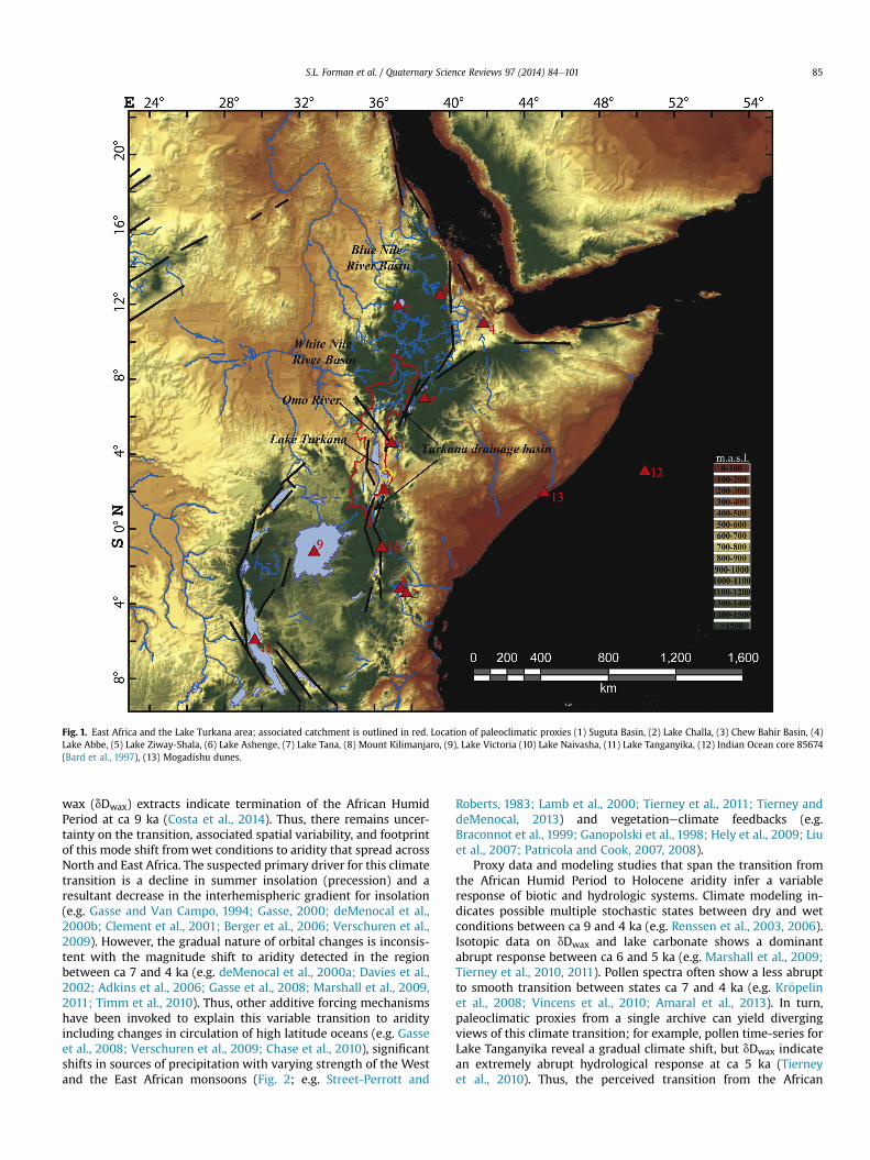
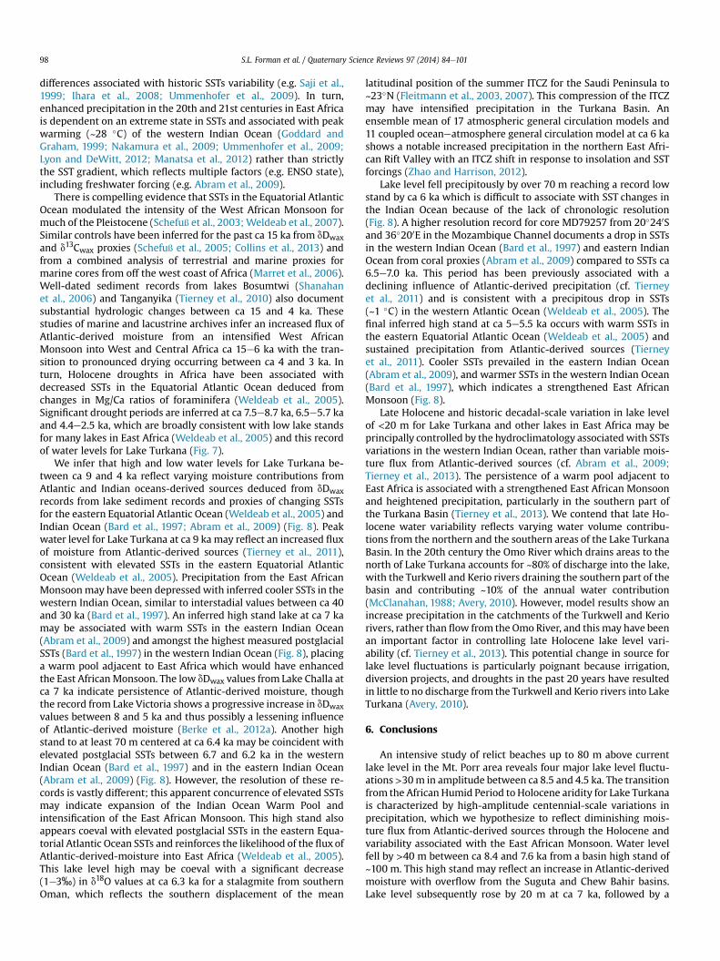
Fig. 1. East Africa and the Lake Turkana area; associated catchment is outlined in red. Location of paleoclimatic proxies (1) Suguta Basin, (2) Lake Challa, (3) Chew Bahir Basin, (4)Lake Abbe, (5) Lake Ziway-Shala, (6) Lake Ashenge, (7) Lake Tana, (8) Mount Kilimanjaro, (9), Lake Victoria (10) Lake Naivasha, (11) Lake Tanganyika, (12) Indian Ocean core 85674(Bard et al., 1997), (13) Mogadishu dunes.
S.L. Forman et al. / Quaternary Science Reviews 97 (2014) 84e101 85
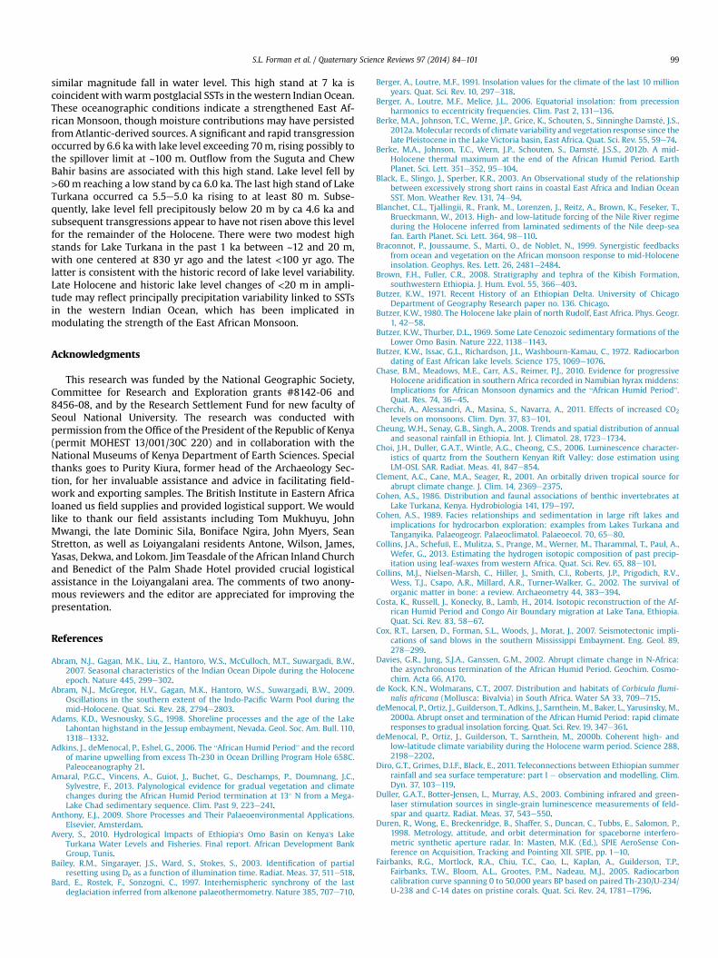
wax (dDwax) extracts indicate termination of the African HumidPeriod at ca 9 ka (Costa et al., 2014). Thus, there remains uncer-tainty on the transition, associated spatial variability, and footprintof this mode shift fromwet conditions to aridity that spread acrossNorth and East Africa. The suspected primary driver for this climatetransition is a decline in summer insolation (precession) and aresultant decrease in the interhemispheric gradient for insolation(e.g. Gasse and Van Campo, 1994; Gasse, 2000; deMenocal et al.,2000b; Clement et al., 2001; Berger et al., 2006; Verschuren et al.,2009). However, the gradual nature of orbital changes is inconsis-tent with the magnitude shift to aridity detected in the regionbetween ca 7 and 4 ka (e.g. deMenocal et al., 2000a; Davies et al.,2002; Adkins et al., 2006; Gasse et al., 2008; Marshall et al., 2009,2011; Timm et al., 2010). Thus, other additive forcing mechanismshave been invoked to explain this variable transition to aridityincluding changes in circulation of high latitude oceans (e.g. Gasseet al., 2008; Verschuren et al., 2009; Chase et al., 2010), significantshifts in sources of precipitation with varying strength of the Westand the East African monsoons (Fig. 2; e.g. Street-Perrott and
Roberts, 1983; Lamb et al., 2000; Tierney et al., 2011; Tierney anddeMenocal, 2013) and vegetationeclimate feedbacks (e.g.Braconnot et al., 1999; Ganopolski et al., 1998; Hely et al., 2009; Liuet al., 2007; Patricola and Cook, 2007, 2008).
Proxy data and modeling studies that span the transition fromthe African Humid Period to Holocene aridity infer a variableresponse of biotic and hydrologic systems. Climate modeling in-dicates possible multiple stochastic states between dry and wetconditions between ca 9 and 4 ka (e.g. Renssen et al., 2003, 2006).Isotopic data on dDwax and lake carbonate shows a dominantabrupt response between ca 6 and 5 ka (e.g. Marshall et al., 2009;Tierney et al., 2010, 2011). Pollen spectra often show a less abruptto smooth transition between states ca 7 and 4 ka (e.g. Kr€opelinet al., 2008; Vincens et al., 2010; Amaral et al., 2013). In turn,paleoclimatic proxies from a single archive can yield divergingviews of this climate transition; for example, pollen time-series forLake Tanganyika reveal a gradual climate shift, but dDwax indicatean extremely abrupt hydrological response at ca 5 ka (Tierneyet al., 2010). Thus, the perceived transition from the African

Fig. 2. Atmospheric circulation for Africa during the “long rains” (July) with the northward expansion of the Intertropical Convergence Zone (ITCZ) with the West African Monsoon and during the “short rains” (December) with thesouthward progression of the ITCZ with the East African Monsoon.From Nicholson, 1996.
S.L.Forman
etal./
Quaternary
ScienceReview
s97
(2014)84
e101
86
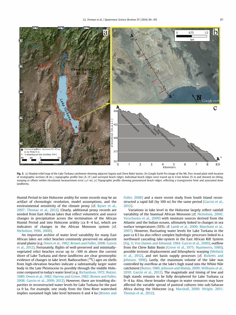
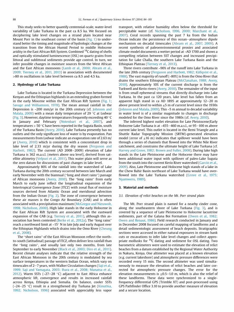
Fig. 3. (a) Shaded-relief map of the Lake Turkana catchment showing adjacent Suguta and Chew Bahir basins. (b) Google Earth Pro image of the Mt. Porr strand plain with locationof stratigraphic sections (B etc.), topographic profile line (AeA0) and surveyed beach ridges. Individual beach ridges were traced up to 4 km below 25 m and showed no tilting,warping or offsets within elevational measurement error (±1 m). (c) Topographic profile showing pronounced beach ridges, reflecting a transgressive limit and associated dunelandforms.
S.L. Forman et al. / Quaternary Science Reviews 97 (2014) 84e101 87
Humid Period to late Holocene aridity for some records may be anartifact of chronologic resolution, model assumptions, and theenvironmental sensitivity of the climate proxy (cf. Ryner et al.,2007; Thomas et al., 2012). Clearly, additional proxy records areneeded from East African lakes that reflect volumetric and sourcechanges in precipitation across the termination of the AfricanHumid Period and into Holocene aridity (ca 8e4 ka), which areindicators of changes in the African Monsoon system (cf.Nicholson, 1996, 2000).
An important archive of water level variability for many EastAfrican lakes are relict beaches commonly preserved on adjacentstrand plains (e.g. Owen et al., 1982; Brown and Fuller, 2008; Garcinet al., 2012). Fortunately, flights of well-preserved and minimally-vegetated relict beaches occur up to ~100 m above the currentshore of Lake Turkana and these landforms are clear geomorphicevidence of changes in lake level. Radiocarbon (14C) ages on shellsfrom high-elevation beaches indicate a substantially larger waterbody in the Late Pleistocene to possibly through the middle Holo-cene compared to today's water level (e.g. Richardson, 1972; Butzer,1980; Owen et al., 1982; Harvey and Grove, 1982; Brown and Fuller,2008; Garcin et al., 2009, 2012). However, there are troubling dis-parities in reconstructed water levels for Lake Turkana for the pastca 9 ka. For example, one study from the Omo River watershedimplies sustained high lake level between 6 and 4 ka (Brown and
Fuller, 2008) and a more recent study from South Island recon-structed a rapid fall (by 100 m) for the same period (Garcin et al.,2012).
Variations in lake level in the Holocene largely reflect rainfallvariability of the biannual African Monsoon (cf. Nicholson, 2000;Verschuren et al., 2009) with moisture sources derived from theAtlantic and the Indian oceans, ultimately linked to changes in seasurface temperatures (SSTs; cf. Lamb et al., 2000; Marchant et al.,2007). However, fluctuating water levels for Lake Turkana in thepast ca 8.5 ka also reflect complex hydrologic processes linked to anorthward cascading lake-system in the East African Rift System(Fig. 3; Von Damm and Edmond, 1984; Garcin et al., 2009), outflowfrom the Chew Bahir Basin (Grove et al., 1975; Nyamweru, 1989),possible tectonic displacement and lithospheric warping (Melnicket al., 2012), and net basin supply processes (cf. Ricketts andJohnson, 1996). Lastly, the maximum volume of the lake wascontrolled by overflow at the lake's high stand into the White Nilecatchment (Butzer, 1980; Johnson andMalala, 2009;Williams et al.,2010; Garcin et al., 2012). The magnitude and timing of low andhigh stands remains to be fully deciphered for Lake Turkana ca9e4 ka. Also, these broader changes in water resources may haveaffected the variable spread of pastoral cultures into sub-SaharanAfrica during the Holocene (e.g. Marshall, 2000; Wright, 2011;Thomas et al., 2012).
S.L. Forman et al. / Quaternary Science Reviews 97 (2014) 84e10188
This study seeks to better quantify centennial-scale, water-levelvariability of Lake Turkana in the past ca 8.5 ka. We focused ondeciphering lake level changes on a strand plain located nearMount Porr in the southeast corner of the basin (Fig. 1) to under-stand better the timing andmagnitude of hydrologic changes at thetransition from the African Humid Period to middle Holocenearidity in the East African Rift System. Combined 14C dating of shellsand optically stimulated luminescence (OSL) on quartz grains fromlittoral and sublittoral sediments provide age control. In turn, weinfer possible changes in moisture sources from the West Africanand the East African monsoons (Lamb et al., 2000; Abram et al.,2009; Tierney et al., 2011, 2013) in association with documented>80 m oscillations in lake level between ca 8.5 and 4.5 ka.
2. Hydrology of Lake Turkana
Lake Turkana is located in the Turkana Depression between theKenyan and the Ethiopian highlands in an extending graben formedin the early Miocene within the East African Rift System (Fig. 1;Savage and Williamson, 1978). The mean annual rainfall in theDepression is ~200 mm/yr in the 20th century (cf. Johnson andMalala, 2009) with a mean daily temperature of 29 �C at Lodwar(Fig. 3). However, daytime temperatures frequently exceeding 40 �Cin January and February (Notenbart et al., 2007), andtemperatures > 50 �C have been reported in the Suguta Basin, southof the Turkana Basin (Avery, 2010). Lake Turkana presently has nooutlets and the only significant loss of water is by evaporation. Panmeasurements from Lodwar indicate an evaporation rate of 2.63 m/yr (Avery, 2010) which is consistent with a concomitant drop inlake level of 2.33 m/yr during the dry season (Ferguson andHarbott, 1982). The current (AD 2008e2009) elevation of LakeTurkana is 362 m.a.s.l. (meters above sea level), derived from sat-ellite altimetry (Velpuri et al., 2011). This water plain will serve asthe zero datum for discussions of past changes in lake level.
Approximately 80% of the rainfall into the watershed of LakeTurkana during the 20th century occurred between late March andearly November with the biannual (“long and short rains”) passageof African monsoons (Avery, 2010). The “long rains” from earlyMarch to early June reflect the longitudinal expansion of theIntertropical Convergence Zone (ITCZ) with zonal flux of moisturesources derived from Atlantic Ocean and meridional advectionfrom the Indian Ocean (Fig. 2). The zone of convergence betweenthese air masses is the Congo Air Boundary (CAB) and is oftenassociatedwith a precipitationmaximum (McGregor and Nieuwolt,1998; Nicholson, 2000). High lake stands in the early Holocene inthe East African Rift System are associated with the eastwardexpansion of the CAB (e.g. Tierney et al., 2011), although this as-sociation has been contested (Berke et al., 2012a). The “long rains”reach a northward limit at ~15� N in late July and early August overthe Ethiopian Highlands which drains into the Omo River (Cheunget al., 2008).
The “short rains” of the East African Monsoon reflect the north-to-south (latitudinal) passage of ITCZ, often deliver less rainfall thanthe “long rains”, and usually last only two months, from lateSeptember to early November (Black et al., 2003; Diro et al., 2011).Recent climate analyses indicate that the relative strength of theEast African Monsoon in the 20th century is modulated by seasurface temperatures in the western Indian Ocean, which vary ontimescales of 2e7 years, withWalker Circulation changes (Saji et al.,1999; Saji and Yamagata, 2003; Ihara et al., 2008; Manatsa et al.,2012). Warm SSTs (~27e28 �C) adjacent to East Africa enhanceatmospheric lift, convergence and results in increased rainfallacross Kenya, Ethiopia and Somalia. On balance, cooler SSTs(~24e25 �C) result in a strengthened dry Turkana Jet (Kinuthia,1992; Nicholson, 1996) associated with appreciably less vapor
transport, with relative humidity often below the threshold forpercipitable water (cf. Nicholson, 1996, 2000; Marchant et al.,2007). Coral records spanning the past 7 ka from the IndianOcean indicate the persistence of this oceaneatmosphere dipolemechanism on decadal timescales (Abram et al., 2007, 2009). Arecent synthesis of paleoenvironmental proxies and associatedclimate model documents a wetter period at ~AD 1700 and shows acompelling relation between SST changes and increased precipi-tation for Lake Challa, the southern Lake Turkana Basin and theEthiopian Plateau (Tierney et al., 2013).
Three rivers contribute ~90% of the runoff into Lake Turkana inthe late 20th century (Ferguson and Harbott, 1982; K€allqvist et al.,1988). The vast majority of runoff (~80%) is from the Omo River thatdrains the southern Ethiopian Plateau (McClanahan, 1988; Avery,2010). Approximately 10% of the current discharge is from theTurkwell and Kerio rivers (Avery, 2010). The remainder of the inputis from small ephemeral streams that directly discharge into LakeTurkana. In the past ca 120 years, lake level has fallen from anapparent high stand in ca AD 1895 at approximately 12e20 mabove present level to within ±5 m of current level since the 1930s(Johnson and Malala, 2009). This ~5 m annual to decadal variabilityin water level is of a similar magnitude to changes in dischargemodeled for the Omo River since the 1980s (cf. Avery, 2010).
The inferred highest outlet elevation for Late Pleistocene/EarlyHolocene Lake Turkana is at ~455e460 m.a.s.l., or 95e100 m abovecurrent lake level. This outlet is located in the Ilemi Triangle and aShuttle Radar Topography Mission (SRTM)-generated elevationmodel (error of ±16 m) indicates that spillover would have beenthrough a series of channels that flowed into the White Nile Rivercatchment, and constrains the ultimate height of Lake Turkana (cf.Harvey and Grove, 1982; Brown and Fuller, 2008). During lake highstands in the Late Pleistocene and the Holocene there may havebeen additional water input with spillover of paleo-Lake Sugutafrom the south into the current Kerio River watershed (Garcin et al.,2009). Also, Late Pleistocene and Holocene high stands of a lake inthe Chew Bahir Basin northeast of Lake Turkana would have over-flowed into the Lake Turkana watershed (Grove et al., 1975;Nyamweru, 1989).
3. Material and methods
3.1. Elevation of relict beaches on the Mt. Porr strand plain
The Mt. Porr strand plain is named for a nearby cinder cone,along the southeastern shore of Lake Turkana (Fig. 3), and iscovered by a sequence of Late Pleistocene to Holocene lacustrinesediments, part of the Galana Boi Formation (Owen et al., 1982;Owen and Renaut, 1986). Field research conducted in January andin December 2008 focused on careful mapping of landforms and adetail sedimentologic assessment of beach deposits. Stratigraphicsections were accessed in either natural exposures in stream bankcuts or excavations to infer lake level changes and collect appro-priate mollusks for 14C dating and sediment for OSL dating. Twobarometric altimeters were used to estimate the elevation of relictbeaches from a datum established by the Regional Water Authorityin Nakuru, Kenya. One altimeter was placed at a known elevation(e.g. current lakeshore) and atmospheric pressure differences wererecorded every 15 min. The second altimeter was used simulta-neously to measure the elevation of relict beaches and later cor-rected for atmospheric pressure changes. The error for theelevation measurements is ±0.5e1.0 m, which is also the relief ofthese landforms. These data were synchronized to a single-frequency differential GPS (Trimble XT) and post-processed usingGPS Pathfinder Office 3.10 to provide another measure of elevationand a secure location.
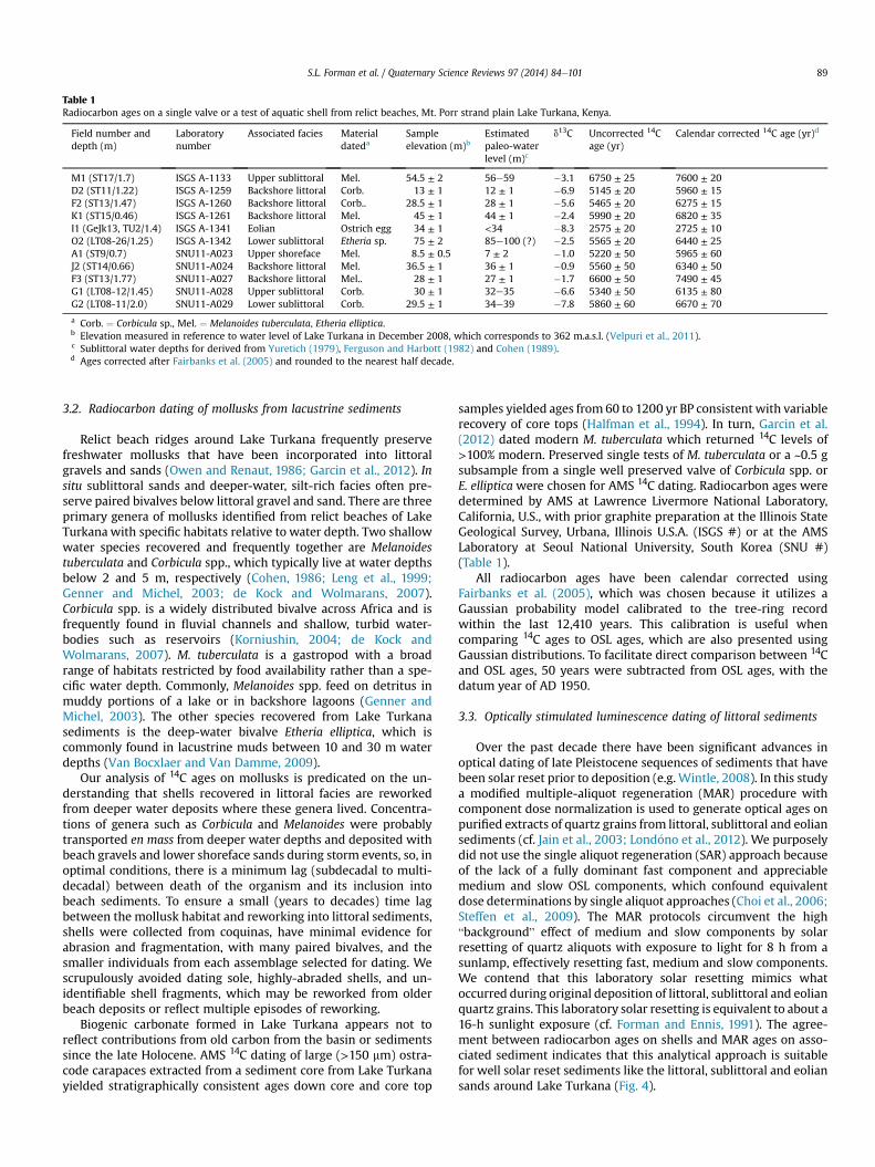
Table 1Radiocarbon ages on a single valve or a test of aquatic shell from relict beaches, Mt. Porr strand plain Lake Turkana, Kenya.
Field number anddepth (m)
Laboratorynumber
Associated facies Materialdateda
Sampleelevation (m)b
Estimatedpaleo-waterlevel (m)c
d13C Uncorrected 14Cage (yr)
Calendar corrected 14C age (yr)d
M1 (ST17/1.7) ISGS A-1133 Upper sublittoral Mel. 54.5 ± 2 56e59 �3.1 6750 ± 25 7600 ± 20D2 (ST11/1.22) ISGS A-1259 Backshore littoral Corb. 13 ± 1 12 ± 1 �6.9 5145 ± 20 5960 ± 15F2 (ST13/1.47) ISGS A-1260 Backshore littoral Corb.. 28.5 ± 1 28 ± 1 �5.6 5465 ± 20 6275 ± 15K1 (ST15/0.46) ISGS A-1261 Backshore littoral Mel. 45 ± 1 44 ± 1 �2.4 5990 ± 20 6820 ± 35I1 (GeJk13, TU2/1.4) ISGS A-1341 Eolian Ostrich egg 34 ± 1 <34 �8.3 2575 ± 20 2725 ± 10O2 (LT08-26/1.25) ISGS A-1342 Lower sublittoral Etheria sp. 75 ± 2 85e100 (?) �2.5 5565 ± 20 6440 ± 25A1 (ST9/0.7) SNU11-A023 Upper shoreface Mel. 8.5 ± 0.5 7 ± 2 �1.0 5220 ± 50 5965 ± 60J2 (ST14/0.66) SNU11-A024 Backshore littoral Mel. 36.5 ± 1 36 ± 1 �0.9 5560 ± 50 6340 ± 50F3 (ST13/1.77) SNU11-A027 Backshore littoral Mel.. 28 ± 1 27 ± 1 �1.7 6600 ± 50 7490 ± 45G1 (LT08-12/1.45) SNU11-A028 Upper sublittoral Corb. 30 ± 1 32e35 �6.6 5340 ± 50 6135 ± 80G2 (LT08-11/2.0) SNU11-A029 Lower sublittoral Corb. 29.5 ± 1 34e39 �7.8 5860 ± 60 6670 ± 70
a Corb. ¼ Corbicula sp., Mel. ¼ Melanoides tuberculata, Etheria elliptica.b Elevation measured in reference to water level of Lake Turkana in December 2008, which corresponds to 362 m.a.s.l. (Velpuri et al., 2011).c Sublittoral water depths for derived from Yuretich (1979), Ferguson and Harbott (1982) and Cohen (1989).d Ages corrected after Fairbanks et al. (2005) and rounded to the nearest half decade.
S.L. Forman et al. / Quaternary Science Reviews 97 (2014) 84e101 89
3.2. Radiocarbon dating of mollusks from lacustrine sediments
Relict beach ridges around Lake Turkana frequently preservefreshwater mollusks that have been incorporated into littoralgravels and sands (Owen and Renaut, 1986; Garcin et al., 2012). Insitu sublittoral sands and deeper-water, silt-rich facies often pre-serve paired bivalves below littoral gravel and sand. There are threeprimary genera of mollusks identified from relict beaches of LakeTurkana with specific habitats relative to water depth. Two shallowwater species recovered and frequently together are Melanoidestuberculata and Corbicula spp., which typically live at water depthsbelow 2 and 5 m, respectively (Cohen, 1986; Leng et al., 1999;Genner and Michel, 2003; de Kock and Wolmarans, 2007).Corbicula spp. is a widely distributed bivalve across Africa and isfrequently found in fluvial channels and shallow, turbid water-bodies such as reservoirs (Korniushin, 2004; de Kock andWolmarans, 2007). M. tuberculata is a gastropod with a broadrange of habitats restricted by food availability rather than a spe-cific water depth. Commonly, Melanoides spp. feed on detritus inmuddy portions of a lake or in backshore lagoons (Genner andMichel, 2003). The other species recovered from Lake Turkanasediments is the deep-water bivalve Etheria elliptica, which iscommonly found in lacustrine muds between 10 and 30 m waterdepths (Van Bocxlaer and Van Damme, 2009).
Our analysis of 14C ages on mollusks is predicated on the un-derstanding that shells recovered in littoral facies are reworkedfrom deeper water deposits where these genera lived. Concentra-tions of genera such as Corbicula and Melanoides were probablytransported en mass from deeper water depths and deposited withbeach gravels and lower shoreface sands during storm events, so, inoptimal conditions, there is a minimum lag (subdecadal to multi-decadal) between death of the organism and its inclusion intobeach sediments. To ensure a small (years to decades) time lagbetween the mollusk habitat and reworking into littoral sediments,shells were collected from coquinas, have minimal evidence forabrasion and fragmentation, with many paired bivalves, and thesmaller individuals from each assemblage selected for dating. Wescrupulously avoided dating sole, highly-abraded shells, and un-identifiable shell fragments, which may be reworked from olderbeach deposits or reflect multiple episodes of reworking.
Biogenic carbonate formed in Lake Turkana appears not toreflect contributions from old carbon from the basin or sedimentssince the late Holocene. AMS 14C dating of large (>150 mm) ostra-code carapaces extracted from a sediment core from Lake Turkanayielded stratigraphically consistent ages down core and core top
samples yielded ages from 60 to 1200 yr BP consistent with variablerecovery of core tops (Halfman et al., 1994). In turn, Garcin et al.(2012) dated modern M. tuberculata which returned 14C levels of>100% modern. Preserved single tests of M. tuberculata or a ~0.5 gsubsample from a single well preserved valve of Corbicula spp. orE. elliptica were chosen for AMS 14C dating. Radiocarbon ages weredetermined by AMS at Lawrence Livermore National Laboratory,California, U.S., with prior graphite preparation at the Illinois StateGeological Survey, Urbana, Illinois U.S.A. (ISGS #) or at the AMSLaboratory at Seoul National University, South Korea (SNU #)(Table 1).
All radiocarbon ages have been calendar corrected usingFairbanks et al. (2005), which was chosen because it utilizes aGaussian probability model calibrated to the tree-ring recordwithin the last 12,410 years. This calibration is useful whencomparing 14C ages to OSL ages, which are also presented usingGaussian distributions. To facilitate direct comparison between 14Cand OSL ages, 50 years were subtracted from OSL ages, with thedatum year of AD 1950.
3.3. Optically stimulated luminescence dating of littoral sediments
Over the past decade there have been significant advances inoptical dating of late Pleistocene sequences of sediments that havebeen solar reset prior to deposition (e.g. Wintle, 2008). In this studya modified multiple-aliquot regeneration (MAR) procedure withcomponent dose normalization is used to generate optical ages onpurified extracts of quartz grains from littoral, sublittoral and eoliansediments (cf. Jain et al., 2003; Lond�ono et al., 2012). We purposelydid not use the single aliquot regeneration (SAR) approach becauseof the lack of a fully dominant fast component and appreciablemedium and slow OSL components, which confound equivalentdose determinations by single aliquot approaches (Choi et al., 2006;Steffen et al., 2009). The MAR protocols circumvent the high“background” effect of medium and slow components by solarresetting of quartz aliquots with exposure to light for 8 h from asunlamp, effectively resetting fast, medium and slow components.We contend that this laboratory solar resetting mimics whatoccurred during original deposition of littoral, sublittoral and eolianquartz grains. This laboratory solar resetting is equivalent to about a16-h sunlight exposure (cf. Forman and Ennis, 1991). The agree-ment between radiocarbon ages on shells and MAR ages on asso-ciated sediment indicates that this analytical approach is suitablefor well solar reset sediments like the littoral, sublittoral and eoliansands around Lake Turkana (Fig. 4).

Fig. 4. Comparison of optically stimulated luminescence ages by multiple aliquotregeneration dating versus AMS radiocarbon ages on associated shell.
S.L. Forman et al. / Quaternary Science Reviews 97 (2014) 84e10190
At least 24 aliquots were used in the MAR analysis, withquadruplicate measurement for the natural and regenerative doses(cf. Cox et al., 2007; Lond�ono et al., 2012). Each aliquot contains~200e2000 quartz grains (dependent on grain size) and wereadhered to an approximately 2-mm diameter area on aluminumdiscs. Littoral and eolian sands from the Lake Turkana strand plainvary in mineralogical maturity with SiO2 content of between 46%and 85%. The quartz fraction was isolated by density separationsusing the heavy liquid Naepolytungstate, and a 40-min immersionin reagent-grade HF was applied to etch the outer ~10 mm of grains,which are affected by alpha radiation (Mejdahl and Christiansen,1994). Finally, quartz grains were rinsed in 10% HCl to removeany insoluble fluorides. The purity of quartz separate was evaluatedby petrographic inspection and point counting of a representativealiquot. Samples that showed >1% of non-quartz minerals wereretreated with HF and rechecked petrographically. The purity ofquartz separates was subsequently tested by exposing aliquots toinfrared excitation (1.08 W from diode at 845 ± 4 nm), whichpreferentially excites feldspar minerals. Samples measured showedweak emissions (<300 counts/s), at or close to background countswith infrared excitation, and a ratio of emissions from blue toinfrared excitation of >20, indicating a spectrally pure quartzextract (cf. Duller et al., 2003).
The MAR protocols employ a test dose (~4 Gy b) to compensatefor laboratory-induced sensitivity changes (Table 2). Two heatingtreatments were employed to eliminate electrons residing in trapsthat are thermally unstable over geologic time (Table 2). The first isstorage at e.g. 150 �C for 1 h immediately following each laboratory
Table 2Multiple aliquot regenerative dose protocols (Jain et al., 2003).
Growth curve Natural
1. Optical bleaching 8 h UV 1. Stimulation with blue lightand data collection
2. Test dose 4 Gy 2. Optical bleaching 8 h UV3. Preheat 170 �C for 1 h 3. Test dose 4 Gy4. Stimulation with blue
light and data collection4. Preheat 170 �C for 1 h
5. Regenerative dose (up to 165 Gy) 5. Stimulation with blue lightand data collection
6. Preheat 170 �C for 1 h7. Stimulation with blue
light and data collection
irradiation and second heating is 125 �C during excitation by bluediodes (Wintle and Murray, 2000). The efficacy of the first preheattreatment (e.g. 150, 160, 170, 180, or 200 �C for 1 h) for thenormalization and regenerative dose was evaluated by comparingcurve shape (trap distribution) between the natural and subse-quent dose (Bailey et al., 2003). A similar dose response is indicatedby zero or low slope (<0.1) between the luminescence for initialand secondary dose. The natural luminescence emission is derivedfrom electrons residing in time-stable traps and thus, this firstpreheat is unnecessary. A sequential regenerative dose of up to~560 Gy was applied to each sample that exceeded the corre-sponding natural luminescence and this dose response is oftenunsaturated. Equivalent dose were calculated for at least the first40 s of excitation, dependent on background counts, as a weightedmean.
To render an optical age the environmental dose rate is needed,which is an estimate of sediment exposure to ionizing radiationfrom the decay of the U and Th series and 40K, and cosmic sourcesduring the burial period (Table 3). The 40K, U and Th content ofsediment, assuming secular equilibrium in the decay series, wasdetermined by inductively coupled plasma-mass spectrometry(ICP-MS) analyzed by Activation Laboratory Ltd, Ontario, Canada. Asignificant cosmic ray component of 0.15e0.19 mGy/yr for theindicated depths was included in the estimated dose rate (Prescottand Hutton, 1994). Moisture content (by weight) of 2 ± 1% wasassumed, which is consistent with the present arid conditions.
We note that OSL ages on quartz grains overlap at standarddeviations with 14C ages on associated shell for specific sites andcorrelated elevations (Table 4; Fig. 4). This concordance betweenthese two dating methods gives us added confidence in theresolved lake level reconstruction and in sole OSL ages to constrainthe timing of eolian and littoral deposition.
4. Results
4.1. Geomorphology of relict beach ridges on the Mt. Porr strandplain
The relict beach ridges in theMt. Porr area are exceptionallywellpreserved and individual strandlines are traced for 2e5 km (Fig. 3).These beach ridges in the Mt. Porr area reflect pre-depositionalslope, topography and the rate of water level change and of sedi-ment supply (cf. Thompson and Baedke, 1995). Most of the beachridges appear to be deposited with initial lake transgression andthen subsequent regression; there were noticeable broad, com-pound relict beaches at ~80e85, 65, 28 and 13 m, reflectingtransgression or a lake still stand (Fig. 3b and c).
The Mt. Porr area is on the flank of the East Africa Rift Systemand is less tectonically and isostatically deformed than South Island(Garcin et al., 2012; Melnick et al., 2012). There aremapped faults inthe Mt. Porr area (Balo and Lakoya faults) that trend across thestrand plain, but the youngest offset deposit is the Pliocene KoobiFora Formation (Gathogo et al., 2008). Careful scrutiny of remotelysensed images and geomorphic and stratigraphic assessments inthe vicinity of these faults document no perceptible offsets of relictbeach ridges. In fact, elevational measurement of the crest of singleridges from the current shore up to 25m and over 2.7 km documentno measurable elevational changes (within errors) and thus theridges appear untilted and locally undeformed.
The highest beach ridges studied are about 80 m, though higherremnant strandlines were traced to ~86 m (Fig. 3b). There is adistinctive upper sequence of relict beaches from about 75 to 35 mcomposed of parallel strandlines trending N120W with broad(100e200m) crests andwith a current gradient of ~10m/km. Thesestrandlines appear to have been deposited with a monotonic fall in
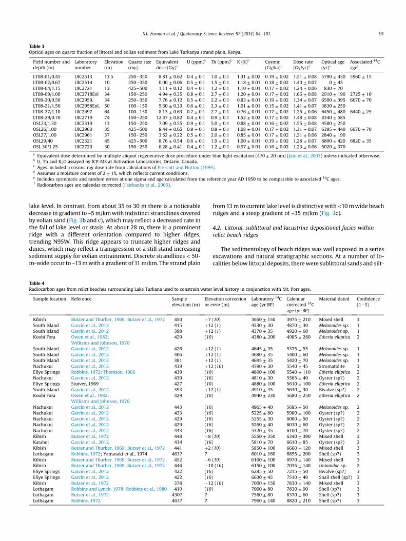
Table 3Optical ages on quartz fraction of littoral and eolian sediment from Lake Turkanya strand plain, Kenya.
Field number anddepth (m)
Laboratorynumber
Elevation(m)
Quartz size(mm)
Equivalentdose (Gy)a
U (ppm)b Th (ppm)b K (%)b Cosmic(Gy/ka)c
Dose rate(Gy/yr)d
Optical age(yr)e
Associated 14Cagef
LT08-01/0.45 UIC2513 13.5 250e350 8.81 ± 0.62 0.4 ± 0.1 1.0 ± 0.1 1.31 ± 0.02 0.19 ± 0.02 1.51 ± 0.08 5790 ± 430 5960 ± 15LT08-02/0.67 UIC2514 10 250e350 0.00 ± 0.06 0.5 ± 0.1 1.5 ± 0.1 1.18 ± 0.01 0.18 ± 0.02 1.40 ± 0.07 0 ± 45LT08-04/1.15 UIC2721 13 425e500 1.11 ± 0.12 0.4 ± 0.1 1.2 ± 0.1 1.10 ± 0.01 0.17 ± 0.02 1.24 ± 0.06 830 ± 70LT08-09/1.00 UIC2718Eol 34 150e250 4.94 ± 0.35 0.8 ± 0.1 2.7 ± 0.1 1.20 ± 0.01 0.17 ± 0.02 1.66 ± 0.08 2910 ± 190 2725 ± 10LT08-20/0.50 UIC2959. 34 250e350 7.76 ± 0.12 0.5 ± 0.1 2.2 ± 0.1 0.83 ± 0.01 0.19 ± 0.02 1.34 ± 0.07 6500 ± 395 6670 ± 70LT08-21/1.50 UIC2958Eol. 50 100e150 5.60 ± 0.33 0.6 ± 0.1 2.3 ± 0.1 1.01 ± 0.01 0.15 ± 0.02 1.41 ± 0.07 3830 ± 250LT08-27/1.10 UIC2497 64 100e150 8.13 ± 0.63 0.7 ± 0.1 2.7 ± 0.1 0.76 ± 0.01 0.17 ± 0.02 1.25 ± 0.06 6450 ± 480 6440 ± 25LT08-29/0.70 UIC2719 74 150e250 12.47 ± 0.82 0.4 ± 0.1 0.9 ± 0.1 1.52 ± 0.02 0.17 ± 0.02 1.48 ± 0.08 8340 ± 585OSL23/1.30 UIC2319 13 150e250 7.09 ± 0.55 0.9 ± 0.1 5.0 ± 0.1 0.88 ± 0.01 0.16 ± 0.02 1.55 ± 0.08 4580 ± 250OSL26/1.00 UIC2960 35 425e500 8.44 ± 0.65 0.9 ± 0.1 0.8 ± 0.1 1.08 ± 0.01 0.17 ± 0.02 1.31 ± 0.07 6395 ± 440 6670 ± 70OSL27/1.00 UIC2961 37 150e250 3.52 ± 0.22 0.5 ± 0.1 2.0 ± 0.1 0.85 ± 0.01 0.17 ± 0.02 1.21 ± 0.06 2840 ± 190OSL29/40 UIC2321 45 425e500 8.76 ± 0.54 0.6 ± 0.1 1.9 ± 0.1 1.00 ± 0.01 0.19 ± 0.02 1.28 ± 0.07 6800 ± 420 6820 ± 35OSL 30/1.25 UIC2720 30 150e250 6.28 ± 0.41 0.4 ± 0.1 1.2 ± 0.1 0.97 ± 0.01 0.16 ± 0.02 1.23 ± 0.06 5020 ± 370
a Equivalent dose determined by multiple aliquot regenerative dose procedure under blue light excitation (470 ± 20 nm) (Jain et al., 2003) unless indicated otherwise.b U, Th and K2O assayed by ICP-MS at Activation Laboratories, Ontario, Canada.c Ages included a cosmic ray dose rate from calculations of Prescott and Hutton (1994).d Assumes a moisture content of 2 ± 1%, which reflects current conditions.e Includes systematic and random errors at one sigma and age calculated from the reference year AD 1950 to be comparable to associated 14C ages.f Radiocarbon ages are calendar corrected (Fairbanks et al., 2005).
S.L. Forman et al. / Quaternary Science Reviews 97 (2014) 84e101 91
lake level. In contrast, from about 35 to 30 m there is a noticeabledecrease in gradient to ~5m/kmwith indistinct strandlines coveredby eolian sand (Fig. 3b and c), which may reflect a decreased rate inthe fall of lake level or stasis. At about 28 m, there is a prominentridge with a different orientation compared to higher ridges,trending N95W. This ridge appears to truncate higher ridges anddunes, which may reflect a transgression or a still stand increasingsediment supply for eolian entrainment. Discrete strandlines < 50-m-wide occur to ~13mwith a gradient of 11m/km. The strand plain
Table 4Radiocarbon ages from relict beaches surrounding Lake Turkana used to constrain water
Sample location Reference Sampleelevation (m)
Elevor e
Kibish Butzer and Thurber, 1969; Butzer et al., 1972 450 �7South Island Garcin et al., 2012 415 þ12South Island Garcin et al., 2012 398 þ12Koobi Fora Owen et al., 1982;
Williams and Johnson, 1976429 (10
South Island Garcin et al., 2012 426 þ12South Island Garcin et al., 2012 406 þ12South Island Garcin et al., 2012 381 þ12Nachukui Garcin et al., 2012 439 þ12Eliye Springs Robbins, 1972; Thomson, 1966 439 (10Nachukui Garcin et al., 2012 439 (16Eliye Springs Stuiver, 1969 427 (10South Island Garcin et al., 2012 393 þ12Koobi Fora Owen et al., 1982;
Williams and Johnson, 1976429 (10
Nachukui Garcin et al., 2012 443 (16Nachukui Garcin et al., 2012 433 (16Nachukui Garcin et al., 2012 429 (16Nachukui Garcin et al., 2012 429 (16Nachukui Garcin et al., 2012 443 (16Kibish Butzer et al., 1972 448 �8Kataboi Garcin et al., 2012 434 (16Kibish Butzer and Thurber, 1969; Butzer et al., 1972 441 þ2Lothagam Robbins, 1972; Yamasaki et al., 1974 463? ?Kibish Butzer and Thurber, 1969; Butzer et al., 1972 452 �6Kibish Butzer and Thurber, 1969; Butzer et al., 1972 444 �10Eliye Springs Garcin et al., 2012 422 (16Eliye Springs Garcin et al., 2012 422 (16Kibish Butzer et al., 1972 378 �12Lothagam Robbins and Lynch, 1978; Robbins et al., 1980 410 (10Lothagam Butzer et al., 1972 430? ?Lothagam Robbins, 1972 463? ?
from 13m to current lake level is distinctivewith<10mwide beachridges and a steep gradient of ~35 m/km (Fig. 3c).
4.2. Littoral, sublittoral and lacustrine depositional facies withinrelict beach ridges
The sedimentology of beach ridges was well exposed in a seriesexcavations and natural stratigraphic sections. At a number of lo-calities below littoral deposits, therewere sublittoral sands and silt-
level history in conjunction with Mt. Porr ages.
ation correctionrror (m)
Laboratory 14Cage (yr BP)
Calendarcorrected 14Cage (yr BP)
Material dated Confidence(1e3)
(10) 3650 ± 150 3975 ± 210 Mixed shell 3(1) 4330 ± 30 4870 ± 30 Melanoides sp. 1(1) 4370 ± 35 4920 ± 60 Melanoides sp. 1
) 4380 ± 200 4985 ± 280 Etheria elliptica 2
(1) 4645 ± 35 5375 ± 55 Melanoides sp. 1(1) 4680 ± 35 5400 ± 60 Melanoides sp. 1(1) 4695 ± 35 5420 ± 70 Melanoides sp. 1(16) 4790 ± 30 5540 ± 45 Stromatolite 3
) 4800 ± 100 5540 ± 110 Etheria elliptica 2) 4810 ± 30 5565 ± 40 Oyster (sp?) 2) 4880 ± 100 5610 ± 100 Etheria elliptica 2(1) 4910 ± 35 5630 ± 30 Bivalve (sp?) 2
) 4940 ± 230 5680 ± 250 Etheria elliptica 2
) 4965 ± 40 5685 ± 50 Melanoides sp. 2) 5225 ± 80 5980 ± 100 Oyster (sp?) 2) 5255 ± 30 6000 ± 50 Oyster (sp?) 2) 5260 ± 40 6010 ± 60 Oyster (sp?) 2) 5320 ± 35 6100 ± 70 Oyster (sp?) 2(10) 5550 ± 350 6340 ± 390 Mixed shell 3) 5810 ± 70 6610 ± 85 Oyster (sp?) 2(10) 5850 ± 100 6660 ± 120 Mixed shell 3
6010 ± 160 6855 ± 200 Shell (sp?) 3(10) 6100 ± 100 6970 ± 140 Mixed shell 3(10) 6150 ± 100 7035 ± 140 Unionidae sp. 2
) 6285 ± 50 7215 ± 50 Bivalve (sp?) 3) 6630 ± 45 7510 ± 40 Snail shell (sp?) 3(10) 7000 ± 150 7830 ± 140 Mixed shell 3
) 7000 ± 80 7830 ± 90 Shell (sp?) 37560 ± 80 8370 ± 60 Shell (sp?) 37960 ± 140 8820 ± 210 Shell (sp?) 3
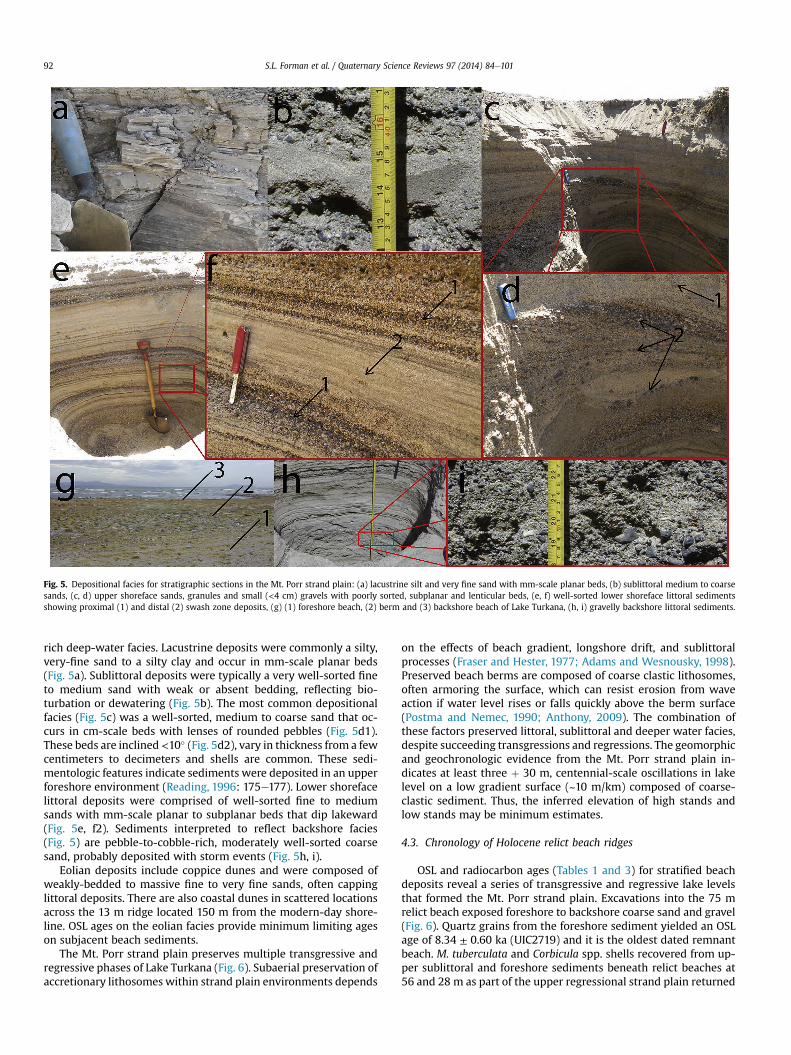
Fig. 5. Depositional facies for stratigraphic sections in the Mt. Porr strand plain: (a) lacustrine silt and very fine sand with mm-scale planar beds, (b) sublittoral medium to coarsesands, (c, d) upper shoreface sands, granules and small (<4 cm) gravels with poorly sorted, subplanar and lenticular beds, (e, f) well-sorted lower shoreface littoral sedimentsshowing proximal (1) and distal (2) swash zone deposits, (g) (1) foreshore beach, (2) berm and (3) backshore beach of Lake Turkana, (h, i) gravelly backshore littoral sediments.
S.L. Forman et al. / Quaternary Science Reviews 97 (2014) 84e10192
rich deep-water facies. Lacustrine deposits were commonly a silty,very-fine sand to a silty clay and occur in mm-scale planar beds(Fig. 5a). Sublittoral deposits were typically a very well-sorted fineto medium sand with weak or absent bedding, reflecting bio-turbation or dewatering (Fig. 5b). The most common depositionalfacies (Fig. 5c) was a well-sorted, medium to coarse sand that oc-curs in cm-scale beds with lenses of rounded pebbles (Fig. 5d1).These beds are inclined<10� (Fig. 5d2), vary in thickness from a fewcentimeters to decimeters and shells are common. These sedi-mentologic features indicate sediments were deposited in an upperforeshore environment (Reading, 1996: 175e177). Lower shorefacelittoral deposits were comprised of well-sorted fine to mediumsands with mm-scale planar to subplanar beds that dip lakeward(Fig. 5e, f2). Sediments interpreted to reflect backshore facies(Fig. 5) are pebble-to-cobble-rich, moderately well-sorted coarsesand, probably deposited with storm events (Fig. 5h, i).
Eolian deposits include coppice dunes and were composed ofweakly-bedded to massive fine to very fine sands, often cappinglittoral deposits. There are also coastal dunes in scattered locationsacross the 13 m ridge located 150 m from the modern-day shore-line. OSL ages on the eolian facies provide minimum limiting ageson subjacent beach sediments.
The Mt. Porr strand plain preserves multiple transgressive andregressive phases of Lake Turkana (Fig. 6). Subaerial preservation ofaccretionary lithosomeswithin strand plain environments depends
on the effects of beach gradient, longshore drift, and sublittoralprocesses (Fraser and Hester, 1977; Adams and Wesnousky, 1998).Preserved beach berms are composed of coarse clastic lithosomes,often armoring the surface, which can resist erosion from waveaction if water level rises or falls quickly above the berm surface(Postma and Nemec, 1990; Anthony, 2009). The combination ofthese factors preserved littoral, sublittoral and deeper water facies,despite succeeding transgressions and regressions. The geomorphicand geochronologic evidence from the Mt. Porr strand plain in-dicates at least three þ 30 m, centennial-scale oscillations in lakelevel on a low gradient surface (~10 m/km) composed of coarse-clastic sediment. Thus, the inferred elevation of high stands andlow stands may be minimum estimates.
4.3. Chronology of Holocene relict beach ridges
OSL and radiocarbon ages (Tables 1 and 3) for stratified beachdeposits reveal a series of transgressive and regressive lake levelsthat formed the Mt. Porr strand plain. Excavations into the 75 mrelict beach exposed foreshore to backshore coarse sand and gravel(Fig. 6). Quartz grains from the foreshore sediment yielded an OSLage of 8.34 ± 0.60 ka (UIC2719) and it is the oldest dated remnantbeach. M. tuberculata and Corbicula spp. shells recovered from up-per sublittoral and foreshore sediments beneath relict beaches at56 and 28 m as part of the upper regressional strand plain returned
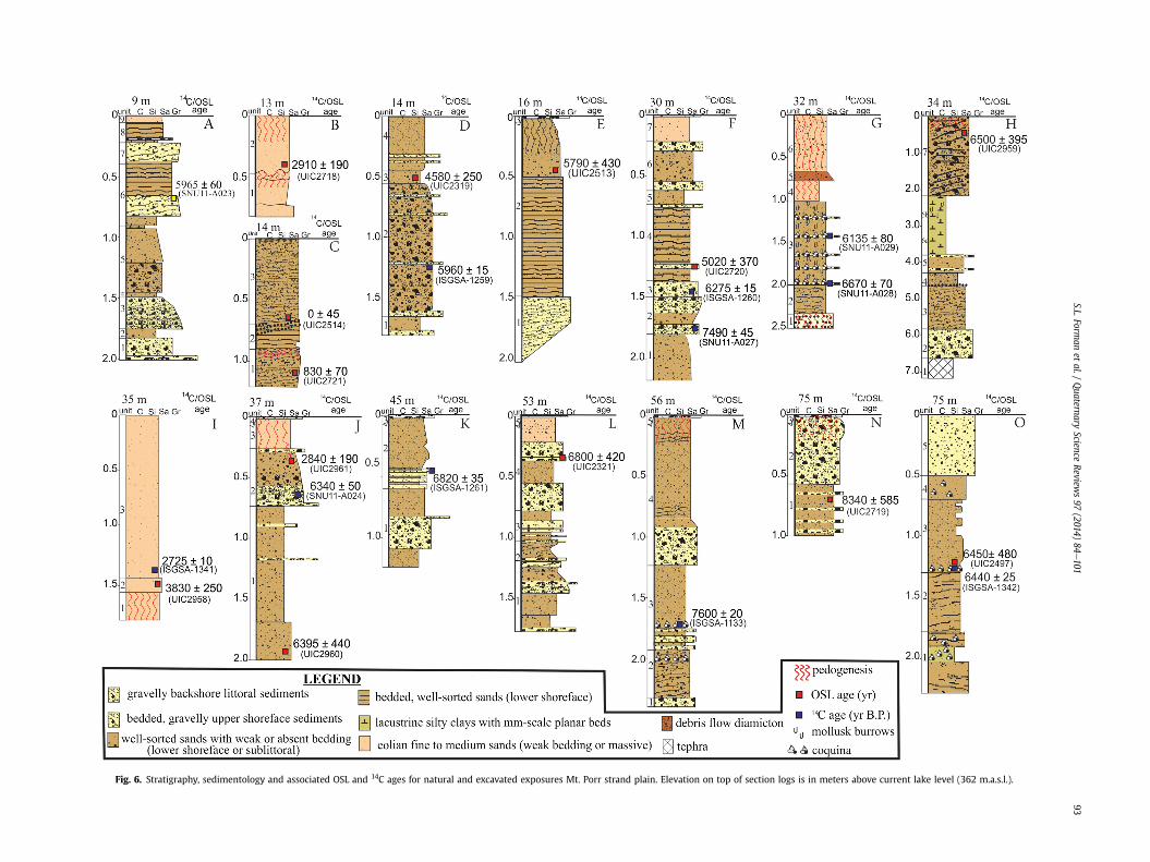
Fig. 6. Stratigraphy, sedimentology and associated OSL and 14C ages for natural and excavated exposures Mt. Porr strand plain. Elevation on top of section logs is in meters above current lake level (362 m.a.s.l.).
S.L.Forman
etal./
Quaternary
ScienceReview
s97
(2014)84
e101
93

S.L. Forman et al. / Quaternary Science Reviews 97 (2014) 84e10194
ages of ca 7.6 and 7.5 ka (Table 1; ISGS A-1133; SNU11 A-027). Thissequence of landforms and associated OSL and 14C ages indicate atleast a 45-m drop in lake level between ca 8.3 and 7.4 ka. A pairedbivalve (E. elliptica) from a lower sublittoral facies at 75 m thatreturned a 14C age of ca 6.4 ka (ISGSA-1342) indicates that lake levelrose to at least 75 m at that time, based on the habitat requirementof this taxon (Van Bocxlaer and Van Damme, 2009). An OSL age of6.45 ± 0.48 ka (UIC2497) on quartz grains from a prominent relictbeach at 75m is consistent with a high stand. Four 14C ages (Table 1,ISGS A-1259, ISGS A-1260, SNU11-A023, SNU11-A029) and one OSLage (Table 3, UIC2513) from associated littoral sediments indicatethat lake level fell rapidly from 35 to 9 m at ca 6.0 ka.
A possible high stand to at least 30 m at ca 5 ka is constrained bylittoral stratigraphy, geomorphology and a sequence of 14C and OSLages (Fig. 6). There is clear geomorphic expression of a prominentrelict berm at ~28 m with associated dunes, reflecting either a riseor stasis in lake level. Three upward-coarsening sequences areexposed associated with the transition from lower foreshore/sub-littoral to upper shoreface/backshore environments indicatingrepeated transgression and regression of Lake Turkana. Quartzgrains from the youngest sequence yielded an OSL age of ca 5 ka,whereas 14C ages on shell from the lower two sequences returnedages of ca 7.5 and 6.4 ka. Archaeological sites with 14C ages of ca3.0e3.5 ka at 36 m (Wright and Forman, 2011) and eolian sandinfiltrated into the upper part of buried littoral deposit at 14 mwithan OSL age of ca 2.9 ka indicate that these surfaces have not beenwave washed since a regression at ca 4.5 ka.
The steep gradient of the lower sequence of relict beaches fromabout 13m to the present shore probably reflects a regression in thepast ca 1000 years. An excavation into the 12 m relict beach revealsa complex archive of lake level oscillations. A littoral sand below aburied soil yielded the OSL age of ca 830 yr, which indicates atransgression and subsequent regression, with ensuing soil devel-opment characterized by a prominent vesicular A horizon (Avb).Quartz grains from an overlying littoral sand returned a modernOSL age of 0 ± 45 yr indicating deposition of this beach in the pastca 100 years.
5. Discussion
5.1. Mt. Porr water level record integrated with previous LakeTurkana records
We combine paleo-lake level altitudes and associated 14C agesfrom the Mt. Porr area with previously reported 14C ages forlacustrine deposits for other areas surrounding Lake Turkana(Table 4). However, the reliability of the ages is ranked from 1 to 3,with 1 considered the most reliable with a 14C age determined on asingle valve or a single gastropod by AMS analysis, associatedwith adirect elevation measurement and a well-documented littoralstratigraphy. A ranking of 2 indicates a conventional 14C age onlarger bivalve species of Etheria sp. or Unionidae sp. Probably themost secure 14C ages prior to the advent of AMS dating are for theselarge bivalves for which there was sufficient mass to date a solevalve or 2e4 valves. However, it is difficult to discern if the shellswere associated with deep-water facies, sublittoral or reworkedinto littoral sediments and thus uncertainty remains on the infer-redwater level. Lastly, a ranking of 3 indicates a conventional 14C onbulk shells with species unidentified and less accurate and preciseassociated elevation (Table 4). The earliest studies of Butzer et al.(1972), Butzer (1980) and Owen et al. (1982) used conventional14C dating, which necessitated the analysis of 10s of grams of shell,and thus a potential mixture of shells of various ages. Similar to thisstudy, recent analysis of relict beaches in Canadian coastal envi-ronments has resolved highly divergent 14C ages onmixed shells by
conventional assays and by AMS 14C analysis on a single molluskvalve (Mytilus edulis) with a known depth habitat (Lavoie et al.,2012). Thus, we suspect that the spread in ages on relict beachesof similar elevation around Lake Turkana may possibly reflectmixing of shells from older deeper water facies or older beachdeposits with penecontemporaneous shells as lake level fell androse multiple times in the past 10 ka. Thus, 14C ages with ranks of 1or 2 are favored, but rank 3 shells are shown as possible lake levelconstraints. In turn, some of the conventional 14C ages in Owenet al. (1982) were derived for organic fraction(s) concentratedfrom bone (Fig. 7), which in the hot environment of Lake Turkanawas preserved poorly and in other contexts yielded highly erro-neous ages (e.g. Stafford et al., 1990; Collins et al., 2002). Subse-quent studies have excluded these bone 14C ages, but have included14C ages on mixed shell assemblages, though with larger errors inelevation and in age, with calendar correction (Brown and Fuller,2008; Garcin et al., 2012).
Lake level post ca 4.5 ka is largely constrained by the elevationaldistribution of 14C dated archaeological sites around Lake Turkana(Butzer et al., 1972; Butzer, 1980; Owen et al., 1982; Garcin et al.,2012). The a priori assumption is that sites were at or close tolake level. This is a credible inference for sites with barbed bonepoints and abundant fish and shell remains, indicating coastalproximity (cf. Robbins, 1984), but for other sites with mixed use ofaquatic and terrestrial resources the proximity to the shore is un-known (cf. Wright and Forman, 2011). Thus, the elevational dis-tribution of sites provides a maximum limiting estimate on the pastheight of lake level and with variable uncertainty depending on thearchaeological context. Also, the associated elevation for new andold 14C ages on shell has been re-assessed through GPS-basedlocation on a 15e30 m resolution digital elevation model (Durenet al., 1998) for strand plains surrounding Lake Turkana whichadds greater uncertainty in the estimated elevation (cf. Brown andFuller, 2008; Garcin et al., 2012). This legacy of conventional 14Cages with larger errors in age (>200 years) and uncertainty inelevation (~±10e30 m), with some ages derived from mixedassemblage of shells may obscure centennial-scale fluctuations inlake level. In turn, assuming that relict beaches of equal elevationare correlative across the Turkana Basin is problematic with dif-ferential uplift, lithospheric warping, isostasy and fault offsets ofmeter to 10s of meter magnitude for the Holocene in thistectonically-active, rifting valley (cf. Melnick et al., 2012).
The Mt. Porr record integrated with previous data shows highand low stands for Lake Turkana, which were mostly unrecognizedby earlier studies (Fig. 7; Butzer, 1980; Owen et al., 1982; Brown andFuller, 2008; Garcin et al., 2012). This difference in lake levelreconstruction may reflect a sample bias with prior studies (Butzer,1980; Owen et al., 1982; Brown and Fuller, 2008) concentrating onthe highest lake deposits, whereas this study and Garcin et al.(2012) also studied lower beaches, particularly >30 m elevationabove current lake level. In turn, the Mt. Porr strand plain is arestricted area (~20 km2) where there was a consistent assessmentof elevation for littoral, sublittoral, and deeper-water facies andassociated inferences of past lake levels. Lastly, we documentedacross theMt. Porr strand plain nowarping or offset of beach ridgeswithin errors of measurement (±1 m), thus elevations of landformsare internally consistent and provide a separate metric of lake levelchange that is integrated with previous 14C ages to resolve poten-tially centennial variability in lake level.
5.2. Lake Turkana water level variability
The lake level record from the Mt. Porr strand plain sequencesshows four substantial (>50 m) oscillations in water level between8.5 and 4.5 ka (Fig. 7a). The earliest oscillation started prior to 8.4 ka
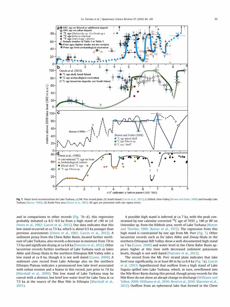
Fig. 7. Water level reconstructions for Lake Turkana, (a) Mt. Porr strand plain, (b) South Island (Garcin et al., 2012), (c) Kibish, Omo Valley (Brown and Fuller, 2008) and broadly LakeTurkana (Butzer, 1980); (d) Koobi Fora area (Owen et al., 1982). All ages are presented with one sigma errors.
S.L. Forman et al. / Quaternary Science Reviews 97 (2014) 84e101 95
and in comparisons to other records (Fig. 7bed), this regressionprobably initiated ca 8.5e9.0 ka from a high stand of >90 m (cf.Owen et al., 1982; Garcin et al., 2012). Our data indicates that thislow stand occurred at ca 7.5 ka, which is about 0.5 ka younger thanprevious assessments (Owen et al., 1982; Garcin et al., 2012). Asediment proxy from the Chew Bahir Basin, located farther north-east of Lake Turkana, also records a decrease in moisture from 7.8 to7.5 ka and significant drying at ca 6.8 ka (Foerster et al., 2012). Otherlacustrine records further northeast of Lake Turkana such as lakesAbhe and Ziway-Shala in the northern Ethiopian Rift Valley infer alow stand at ca 8 ka, though it is not well dated (Gasse, 2000). Asediment core record from Lake Ashenge also on the northernEthiopia Plateau indicates a pronounced low lake level associatedwith eolian erosion and a hiatus in this record, just prior to 7.6 ka(Marshall et al., 2009). This low stand of Lake Turkana may becoeval with a distinct, but brief low water level for Lake Tana at ca7.5 ka at the source of the Blue Nile in Ethiopia (Marshall et al.,2011).
A possible high stand is inferred at ca 7 ka, with the peak con-strained by one calendar corrected 14C age of 7035 ± 140 yr BP onUnionidae sp. from the Kibbish area, north of Lake Turkana (Butzerand Thurber, 1969; Butzer et al., 1972). The regression from thishigh stand is constrained by one age from Mt. Porr (Fig. 7). Otherlacustrine records such as for lakes Abhe and Ziway-Shala in thenorthern Ethiopian Rift Valley show a well-documented high standca 7 ka (Gasse, 2000) and water level in the Chew Bahir Basin ap-pears higher at this time with decreased sediment potassiumlevels, though is not well dated (Foerster et al., 2012).
The record from the Mt. Porr strand plain indicates that lakelevel rose significantly, to at least 80 m by ca 6.4 ka (Fig. 7a). Garcinet al. (2012) hypothesized that outflow from a high stand of LakeSuguta spilled into Lake Turkana, which, in turn, overflowed intothe Nile River Basin during this period, though proxy records for theNile River do not showan abrupt change in discharge (Williams andTalbot, 2009;Williams et al., 2010; Revel et al., 2010; Marriner et al.,2012). Outflow from an ephemeral lake that formed in the Chew
S.L. Forman et al. / Quaternary Science Reviews 97 (2014) 84e10196
Bahir Basin may have contributed to this high stand, which occurswhen water level exceeds 20 m from the basin center (Grove et al.,1975; Nyamweru, 1989). Grove et al. (1975) identified large quan-tities of E. elliptica in a storm beach like association with carbonatedeposits, which are probably beach rock deposits at the elevationallimit (20 m) of the paleo-lake that formed in the Chew Bahir Basin.These shells yielded an uncorrected 14C age of 5660 ± 110 yr BP(GaK-3749; Grove et al., 1975), with a calendar corrected age of6445 ± 120 yr BP, which dates the Chew Bahir playa high stand; thisis coincident with high water level in the Turkana Basin. High lakestands are also inferred between ca 6 and 7 ka ago for lakes Abheand Ziway-Shala (Gasse and Van Campo,1994; Gasse, 2000) and forLake Ashenge between 7.2 and 5.6 ka, all on the Ethiopian Plateauand adjacent Rift Valley (Marshall et al., 2009).
Lake level fell precipitously by over 60m from ca 6.4 to 6.0 ka ontheMt. Porr strand plain. This fall in lake level was also documentedon South Island in Lake Turkana, though of less magnitude (~15 m;Garcin et al., 2012). Earlier studies of relict beaches record stable,high (>60 m) lake levels for this period, though based on 14C datingof shells of mixed species (Butzer et al., 1972; Butzer, 1980; Owenet al., 1982; Brown and Fuller, 2008) and are probably less secureages. Water level for lakes Ashenge, Abhe and Ziway-Shala north ofthe Lake Turkana catchment also fell extremely rapidly, reaching alow by ca 5.6 ka (Gasse, 2000; Marshall et al., 2011). Interestingly,the potassium content for a core from the Chew Bahir Basin, a proxyfor aridity, shows a gradual increase between 6 and 5 ka, indicatingan apparent gradual transition to aridity for the catchmentimmediately northeast of Lake Turkana (Foerster et al., 2012).Farther south, seismic stratigraphic data and the BIT index for asediment record from Lake Challa indicate a drop in lake level at ca6 ka, though the magnitude is unconstrained (Verschuren et al.,2009).
Geomorphic evidence from the Porr strand plain constrains lakelevel below 20m after ca 4.5 ka. An OSL age of ca 3.8 ka on an eoliansand at 33 m and underlying the Adakurake archaeological siteindicates lake level remained below this level for the rest of theHolocene to preserve the artifact-rich surface deposits on the site(Fig. 7; Wright and Forman, 2011). Analyses of diatoms from asediment core from Lake Turkana detect a drop in lake level after3.9 ka, but of unknownmagnitude (Halfman et al., 1994). Maximumdrying in the Chew Bahir Basin is inferred between 3.5 and 3 ka(Foerster et al., 2012). An inferred shift in Lake Turkana watertemperatures of 24e28 �C from the TEX86 proxy between 6 and 4 ka(Berke et al., 2012b) may reflect a shallower and warmer lake. TheMt. Kilimanjaro ice core record shows a prominent dust spike at ca4 ka, though the chronology remains untested, and appreciabledust content thereafter (Thompson et al., 2002) may indicate widespread aridity in East Africa, particularly associated with desicca-tion of lakes.
There is no direct evidence from strand plains around LakeTurkana to constrain water levels between 4 and 1 ka. This lack of arecord may indicate that water level variations during this intervalwerewithin historic variability (<20 m) or below current lake level,though closer study of the Lake Turkana strand plain below 30 m iswarranted to test this hypothesis. At two sites (13 and 35 m) eoliancover sand with OSL and 14C ages of ca 3.9 and 2.9 ka cap beachdeposits (Fig. 6) and indicate broad-scale landscape drying, whichis consistent with pollen assemblages dominated by xeric-adaptedgrasses by the late Holocene (Mohammed et al., 1995). In the ChewBahir Basinwetter conditions prevailed from ca 3.1 to 2.8 ka and 2.0to 1.2 ka, though of considerably less magnitude than in the earlyHolocene. Archaeological sites on the west side of lake on relictbeaches at 10 and 20 m with calibrated 14C ages on charcoal of1730 ± 340 yr BP (UCLA2124K) and 865 ± 85 yr BP (UCLA2114J)respectively (Robbins, 1984), indicate lake level was below 20 m in
past ca 1 ka. An OSL age of 830 ± 70 yr (UIC2721) on a littoral de-posit at 9 m constrains a transgression to that level and possibly upto 20 m based on the occurrence of an archaeological site at thatelevation (Robbins, 1984).
A clear berm at 13 m and regressional beaches to the currentshoreline demark a recent transgression and regression. An exca-vation through a beach at 9 m exposed an older littoral depositdated to ca 830 yr capped by buried soil with a prominent Avbhorizon, indicating surface exposure. This soil is buried by a secondlittoral unit, which yielded an OSL age ca <100 years old. This latestlittoral deposit is consistent with observed lake level variationswith a high stand up to 15e20 m by AD 1895 and lake level fallingto ±5 m by the 1930s (Butzer, 1971; Hopson, 1982; Kallqvist et al.,1988; Johnson and Malala, 2009; Avery, 2010). Lakes Victoria,Naivasha, and Tanganyika showed a similar peak in lake level at theend of the 19th century with lower levels for much of the 20thcentury (cf. Nicholson, 2000; Verschuren, 2001).
5.3. Inferred causes of Holocene lake level variability
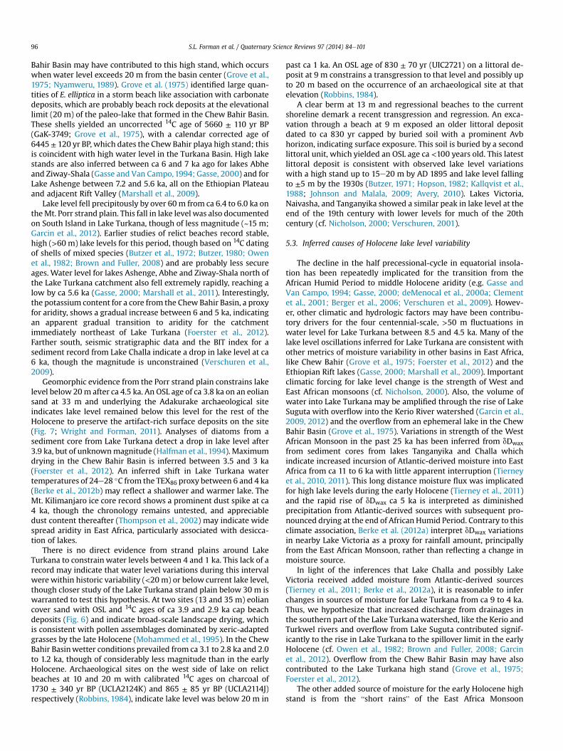
The decline in the half precessional-cycle in equatorial insola-tion has been repeatedly implicated for the transition from theAfrican Humid Period to middle Holocene aridity (e.g. Gasse andVan Campo, 1994; Gasse, 2000; deMenocal et al., 2000a; Clementet al., 2001; Berger et al., 2006; Verschuren et al., 2009). Howev-er, other climatic and hydrologic factors may have been contribu-tory drivers for the four centennial-scale, >50 m fluctuations inwater level for Lake Turkana between 8.5 and 4.5 ka. Many of thelake level oscillations inferred for Lake Turkana are consistent withother metrics of moisture variability in other basins in East Africa,like Chew Bahir (Grove et al., 1975; Foerster et al., 2012) and theEthiopian Rift lakes (Gasse, 2000; Marshall et al., 2009). Importantclimatic forcing for lake level change is the strength of West andEast African monsoons (cf. Nicholson, 2000). Also, the volume ofwater into Lake Turkana may be amplified through the rise of LakeSuguta with overflow into the Kerio River watershed (Garcin et al.,2009, 2012) and the overflow from an ephemeral lake in the ChewBahir Basin (Grove et al., 1975). Variations in strength of the WestAfrican Monsoon in the past 25 ka has been inferred from dDwaxfrom sediment cores from lakes Tanganyika and Challa whichindicate increased incursion of Atlantic-derived moisture into EastAfrica from ca 11 to 6 ka with little apparent interruption (Tierneyet al., 2010, 2011). This long distance moisture flux was implicatedfor high lake levels during the early Holocene (Tierney et al., 2011)and the rapid rise of dDwax ca 5 ka is interpreted as diminishedprecipitation from Atlantic-derived sources with subsequent pro-nounced drying at the end of African Humid Period. Contrary to thisclimate association, Berke et al. (2012a) interpret dDwax variationsin nearby Lake Victoria as a proxy for rainfall amount, principallyfrom the East African Monsoon, rather than reflecting a change inmoisture source.
In light of the inferences that Lake Challa and possibly LakeVictoria received added moisture from Atlantic-derived sources(Tierney et al., 2011; Berke et al., 2012a), it is reasonable to inferchanges in sources of moisture for Lake Turkana from ca 9 to 4 ka.Thus, we hypothesize that increased discharge from drainages inthe southern part of the Lake Turkanawatershed, like the Kerio andTurkwel rivers and overflow from Lake Suguta contributed signif-icantly to the rise in Lake Turkana to the spillover limit in the earlyHolocene (cf. Owen et al., 1982; Brown and Fuller, 2008; Garcinet al., 2012). Overflow from the Chew Bahir Basin may have alsocontributed to the Lake Turkana high stand (Grove et al., 1975;Foerster et al., 2012).
The other added source of moisture for the early Holocene highstand is from the “short rains” of the East Africa Monsoon
Fig. 8. (a) Comparison of Mt. Porr water level record for Lake Turkana, (b) with sea surface temperatures in the eastern and western Indian oceans (Bard et al., 1997; Abram et al.,2009), (c) the western Atlantic Ocean (Weldeab et al., 2005) and Deuterium values for leaf wax from sediment core records from lakes Victoria (Berke et al., 2012a), Challa (Tierneyet al., 2011) and Tanganyika (Tierney et al., 2010). Also shown are March and September insolation values for the Equator (Berger and Loutre, 1991).
S.L. Forman et al. / Quaternary Science Reviews 97 (2014) 84e101 97
modulated by changes in SSTs for the western Indian Ocean, andthe zonal SST gradient associated with Walker Circulation (cf.Marchant et al., 2007; Manatsa et al., 2012; Tierney and deMenocal,2013; Tierney et al., 2013). Berke et al. (2012a) evaluated the changein SST gradient across the Equatorial Indian Ocean for the past ca20 ka by subtracting reconstructed SSTs from the eastern IndianOcean based on Mg/Ca ratios on planktonic foraminifera (Mohtadiet al., 2010) and inferred SSTs for the western Indian Ocean from
alkenones (Bard et al., 1997). In this study, a positive west to eastgradient in SSTs was associated with an enhanced East AfricanMonsoon (Berke et al., 2012a). This analysis showed a peak positivegradient of ~1 �C at ca 15 ka and declining to zero by 5 ka and wasinterpreted to reflect a progressive weakening of the East AfricanMonsoon. This calculated SST gradient change is small, within themargin error for paleothermometry (Bard et al., 1997; Mohtadiet al., 2010), and considerably less than west to east temperature
S.L. Forman et al. / Quaternary Science Reviews 97 (2014) 84e10198
differences associated with historic SSTs variability (e.g. Saji et al.,1999; Ihara et al., 2008; Ummenhofer et al., 2009). In turn,enhanced precipitation in the 20th and 21st centuries in East Africais dependent on an extreme state in SSTs and associated with peakwarming (~28 �C) of the western Indian Ocean (Goddard andGraham, 1999; Nakamura et al., 2009; Ummenhofer et al., 2009;Lyon and DeWitt, 2012; Manatsa et al., 2012) rather than strictlythe SST gradient, which reflects multiple factors (e.g. ENSO state),including freshwater forcing (e.g. Abram et al., 2009).
There is compelling evidence that SSTs in the Equatorial AtlanticOcean modulated the intensity of the West African Monsoon formuch of the Pleistocene (Schefuß et al., 2003;Weldeab et al., 2007).Similar controls have been inferred for the past ca 15 ka from dDwaxand d13Cwax proxies (Schefuß et al., 2005; Collins et al., 2013) andfrom a combined analysis of terrestrial and marine proxies formarine cores from off the west coast of Africa (Marret et al., 2006).Well-dated sediment records from lakes Bosumtwi (Shanahanet al., 2006) and Tanganyika (Tierney et al., 2010) also documentsubstantial hydrologic changes between ca 15 and 4 ka. Thesestudies of marine and lacustrine archives infer an increased flux ofAtlantic-derived moisture from an intensified West AfricanMonsoon into West and Central Africa ca 15e6 ka with the tran-sition to pronounced drying occurring between ca 4 and 3 ka. Inturn, Holocene droughts in Africa have been associated withdecreased SSTs in the Equatorial Atlantic Ocean deduced fromchanges in Mg/Ca ratios of foraminifera (Weldeab et al., 2005).Significant drought periods are inferred at ca 7.5e8.7 ka, 6.5e5.7 kaand 4.4e2.5 ka, which are broadly consistent with low lake standsfor many lakes in East Africa (Weldeab et al., 2005) and this recordof water levels for Lake Turkana (Fig. 7).
We infer that high and low water levels for Lake Turkana be-tween ca 9 and 4 ka reflect varying moisture contributions fromAtlantic and Indian oceans-derived sources deduced from dDwaxrecords from lake sediment records and proxies of changing SSTsfor the eastern Equatorial Atlantic Ocean (Weldeab et al., 2005) andIndian Ocean (Bard et al., 1997; Abram et al., 2009) (Fig. 8). Peakwater level for Lake Turkana at ca 9 ka may reflect an increased fluxof moisture from Atlantic-derived sources (Tierney et al., 2011),consistent with elevated SSTs in the eastern Equatorial AtlanticOcean (Weldeab et al., 2005). Precipitation from the East AfricanMonsoonmay have been depressed with inferred cooler SSTs in thewestern Indian Ocean, similar to interstadial values between ca 40and 30 ka (Bard et al., 1997). An inferred high stand lake at ca 7 kamay be associated with warm SSTs in the eastern Indian Ocean(Abram et al., 2009) and amongst the highest measured postglacialSSTs (Bard et al., 1997) in the western Indian Ocean (Fig. 8), placinga warm pool adjacent to East Africa which would have enhancedthe East AfricanMonsoon. The low dDwax values from Lake Challa atca 7 ka indicate persistence of Atlantic-derived moisture, thoughthe record from Lake Victoria shows a progressive increase in dDwaxvalues between 8 and 5 ka and thus possibly a lessening influenceof Atlantic-derived moisture (Berke et al., 2012a). Another highstand to at least 70 m centered at ca 6.4 ka may be coincident withelevated postglacial SSTs between 6.7 and 6.2 ka in the westernIndian Ocean (Bard et al., 1997) and in the eastern Indian Ocean(Abram et al., 2009) (Fig. 8). However, the resolution of these re-cords is vastly different; this apparent concurrence of elevated SSTsmay indicate expansion of the Indian Ocean Warm Pool andintensification of the East African Monsoon. This high stand alsoappears coeval with elevated postglacial SSTs in the eastern Equa-torial Atlantic Ocean SSTs and reinforces the likelihood of the flux ofAtlantic-derived-moisture into East Africa (Weldeab et al., 2005).This lake level high may be coeval with a significant decrease(1e3‰) in d18O values at ca 6.3 ka for a stalagmite from southernOman, which reflects the southern displacement of the mean
latitudinal position of the summer ITCZ for the Saudi Peninsula to~23�N (Fleitmann et al., 2003, 2007). This compression of the ITCZmay have intensified precipitation in the Turkana Basin. Anensemble mean of 17 atmospheric general circulation models and11 coupled oceaneatmosphere general circulation model at ca 6 kashows a notable increased precipitation in the northern East Afri-can Rift Valley with an ITCZ shift in response to insolation and SSTforcings (Zhao and Harrison, 2012).
Lake level fell precipitously by over 70 m reaching a record lowstand by ca 6 ka which is difficult to associate with SST changes inthe Indian Ocean because of the lack of chronologic resolution(Fig. 8). A higher resolution record for core MD79257 from 20�240Sand 36�200E in the Mozambique Channel documents a drop in SSTsin the western Indian Ocean (Bard et al., 1997) and eastern IndianOcean from coral proxies (Abram et al., 2009) compared to SSTs ca6.5e7.0 ka. This period has been previously associated with adeclining influence of Atlantic-derived precipitation (cf. Tierneyet al., 2011) and is consistent with a precipitous drop in SSTs(~1 �C) in the western Atlantic Ocean (Weldeab et al., 2005). Thefinal inferred high stand at ca 5e5.5 ka occurs with warm SSTs inthe eastern Equatorial Atlantic Ocean (Weldeab et al., 2005) andsustained precipitation from Atlantic-derived sources (Tierneyet al., 2011). Cooler SSTs prevailed in the eastern Indian Ocean(Abram et al., 2009), and warmer SSTs in the western Indian Ocean(Bard et al., 1997), which indicates a strengthened East AfricanMonsoon (Fig. 8).
Late Holocene and historic decadal-scale variation in lake levelof <20 m for Lake Turkana and other lakes in East Africa may beprincipally controlled by the hydroclimatology associated with SSTsvariations in the western Indian Ocean, rather than variable mois-ture flux from Atlantic-derived sources (cf. Abram et al., 2009;Tierney et al., 2013). The persistence of a warm pool adjacent toEast Africa is associated with a strengthened East African Monsoonand heightened precipitation, particularly in the southern part ofthe Turkana Basin (Tierney et al., 2013). We contend that late Ho-locene water variability reflects varying water volume contribu-tions from the northern and the southern areas of the Lake TurkanaBasin. In the 20th century the Omo River which drains areas to thenorth of Lake Turkana accounts for ~80% of discharge into the lake,with the Turkwell and Kerio rivers draining the southern part of thebasin and contributing ~10% of the annual water contribution(McClanahan, 1988; Avery, 2010). However, model results show anincrease precipitation in the catchments of the Turkwell and Keriorivers, rather than flow from the Omo River, and this may have beenan important factor in controlling late Holocene lake level vari-ability (cf. Tierney et al., 2013). This potential change in source forlake level fluctuations is particularly poignant because irrigation,diversion projects, and droughts in the past 20 years have resultedin little to no discharge from the Turkwell and Kerio rivers into LakeTurkana (Avery, 2010).
6. Conclusions
An intensive study of relict beaches up to 80 m above currentlake level in the Mt. Porr area reveals four major lake level fluctu-ations>30m in amplitude between ca 8.5 and 4.5 ka. The transitionfrom the African Humid Period to Holocene aridity for Lake Turkanais characterized by high-amplitude centennial-scale variations inprecipitation, which we hypothesize to reflect diminishing mois-ture flux from Atlantic-derived sources through the Holocene andvariability associated with the East African Monsoon. Water levelfell by >40 m between ca 8.4 and 7.6 ka from a basin high stand of~100 m. This high stand may reflect an increase in Atlantic-derivedmoisture with overflow from the Suguta and Chew Bahir basins.Lake level subsequently rose by 20 m at ca 7 ka, followed by a
S.L. Forman et al. / Quaternary Science Reviews 97 (2014) 84e101 99
similar magnitude fall in water level. This high stand at 7 ka iscoincident with warm postglacial SSTs in thewestern Indian Ocean.These oceanographic conditions indicate a strengthened East Af-rican Monsoon, though moisture contributions may have persistedfromAtlantic-derived sources. A significant and rapid transgressionoccurred by 6.6 kawith lake level exceeding 70m, rising possibly tothe spillover limit at ~100 m. Outflow from the Suguta and ChewBahir basins are associated with this high stand. Lake level fell by>60 m reaching a low stand by ca 6.0 ka. The last high stand of LakeTurkana occurred ca 5.5e5.0 ka rising to at least 80 m. Subse-quently, lake level fell precipitously below 20 m by ca 4.6 ka andsubsequent transgressions appear to have not risen above this levelfor the remainder of the Holocene. There were two modest highstands for Lake Turkana in the past 1 ka between ~12 and 20 m,with one centered at 830 yr ago and the latest <100 yr ago. Thelatter is consistent with the historic record of lake level variability.Late Holocene and historic lake level changes of <20 m in ampli-tude may reflect principally precipitation variability linked to SSTsin the western Indian Ocean, which has been implicated inmodulating the strength of the East African Monsoon.
Acknowledgments
This research was funded by the National Geographic Society,Committee for Research and Exploration grants #8142-06 and8456-08, and by the Research Settlement Fund for new faculty ofSeoul National University. The research was conducted withpermission from the Office of the President of the Republic of Kenya(permit MOHEST 13/001/30C 220) and in collaboration with theNational Museums of Kenya Department of Earth Sciences. Specialthanks goes to Purity Kiura, former head of the Archaeology Sec-tion, for her invaluable assistance and advice in facilitating field-work and exporting samples. The British Institute in Eastern Africaloaned us field supplies and provided logistical support. We wouldlike to thank our field assistants including Tom Mukhuyu, JohnMwangi, the late Dominic Sila, Boniface Ngira, John Myers, SeanStretton, as well as Loiyangalani residents Antone, Wilson, James,Yasas, Dekwa, and Lokom. Jim Teasdale of the African Inland Churchand Benedict of the Palm Shade Hotel provided crucial logisticalassistance in the Loiyangalani area. The comments of two anony-mous reviewers and the editor are appreciated for improving thepresentation.
References
Abram, N.J., Gagan, M.K., Liu, Z., Hantoro, W.S., McCulloch, M.T., Suwargadi, B.W.,2007. Seasonal characteristics of the Indian Ocean Dipole during the Holoceneepoch. Nature 445, 299e302.
Abram, N.J., McGregor, H.V., Gagan, M.K., Hantoro, W.S., Suwargadi, B.W., 2009.Oscillations in the southern extent of the Indo-Pacific Warm Pool during themid-Holocene. Quat. Sci. Rev. 28, 2794e2803.
Adams, K.D., Wesnousky, S.G., 1998. Shoreline processes and the age of the LakeLahontan highstand in the Jessup embayment, Nevada. Geol. Soc. Am. Bull. 110,1318e1332.
Adkins, J., deMenocal, P., Eshel, G., 2006. The “African Humid Period” and the recordof marine upwelling from excess Th-230 in Ocean Drilling Program Hole 658C.Paleoceanography 21.
Amaral, P.G.C., Vincens, A., Guiot, J., Buchet, G., Deschamps, P., Doumnang, J.C.,Sylvestre, F., 2013. Palynological evidence for gradual vegetation and climatechanges during the African Humid Period termination at 13� N from a Mega-Lake Chad sedimentary sequence. Clim. Past 9, 223e241.
Anthony, E.J., 2009. Shore Processes and Their Palaeoenvironmental Applications.Elsevier, Amsterdam.
Avery, S., 2010. Hydrological Impacts of Ethiopia's Omo Basin on Kenya's LakeTurkana Water Levels and Fisheries. Final report. African Development BankGroup, Tunis.
Bailey, R.M., Singarayer, J.S., Ward, S., Stokes, S., 2003. Identification of partialresetting using De as a function of illumination time. Radiat. Meas. 37, 511e518.
Bard, E., Rostek, F., Sonzogni, C., 1997. Interhemispheric synchrony of the lastdeglaciation inferred from alkenone palaeothermometry. Nature 385, 707e710.
Berger, A., Loutre, M.F., 1991. Insolation values for the climate of the last 10 millionyears. Quat. Sci. Rev. 10, 297e318.
Berger, A., Loutre, M.F., Melice, J.L., 2006. Equatorial insolation: from precessionharmonics to eccentricity frequencies. Clim. Past 2, 131e136.
Berke, M.A., Johnson, T.C., Werne, J.P., Grice, K., Schouten, S., Sinninghe Damst�e, J.S.,2012a.Molecular records of climate variability and vegetation response since thelate Pleistocene in the Lake Victoria basin, East Africa. Quat. Sci. Rev. 55, 59e74.
Berke, M.A., Johnson, T.C., Wern, J.P., Schouten, S., Damst�e, J.S.S., 2012b. A mid-Holocene thermal maximum at the end of the African Humid Period. EarthPlanet. Sci. Lett. 351e352, 95e104.
Black, E., Slingo, J., Sperber, K.R., 2003. An Observational study of the relationshipbetween excessively strong short rains in coastal East Africa and Indian OceanSST. Mon. Weather Rev. 131, 74e94.
Blanchet, C.L., Tjallingii, R., Frank, M., Lorenzen, J., Reitz, A., Brown, K., Feseker, T.,Brueckmann, W., 2013. High- and low-latitude forcing of the Nile River regimeduring the Holocene inferred from laminated sediments of the Nile deep-seafan. Earth Planet. Sci. Lett. 364, 98e110.
Braconnot, P., Joussaume, S., Marti, O., de Noblet, N., 1999. Synergistic feedbacksfrom ocean and vegetation on the African monsoon response to mid-Holoceneinsolation. Geophys. Res. Lett. 26, 2481e2484.
Brown, F.H., Fuller, C.R., 2008. Stratigraphy and tephra of the Kibish Formation,southwestern Ethiopia. J. Hum. Evol. 55, 366e403.
Butzer, K.W., 1971. Recent History of an Ethiopian Delta. University of ChicagoDepartment of Geography Research paper no. 136. Chicago.
Butzer, K.W., 1980. The Holocene lake plain of north Rudolf, East Africa. Phys. Geogr.1, 42e58.
Butzer, K.W., Thurber, D.L., 1969. Some Late Cenozoic sedimentary formations of theLower Omo Basin. Nature 222, 1138e1143.
Butzer, K.W., Issac, G.L., Richardson, J.L., Washbourn-Kamau, C., 1972. Radiocarbondating of East African lake levels. Science 175, 1069e1076.
Chase, B.M., Meadows, M.E., Carr, A.S., Reimer, P.J., 2010. Evidence for progressiveHolocene aridification in southern Africa recorded in Namibian hyrax middens:Implications for African Monsoon dynamics and the “African Humid Period”.Quat. Res. 74, 36e45.
Cherchi, A., Alessandri, A., Masina, S., Navarra, A., 2011. Effects of increased CO2levels on monsoons. Clim. Dyn. 37, 83e101.
Cheung, W.H., Senay, G.B., Singh, A., 2008. Trends and spatial distribution of annualand seasonal rainfall in Ethiopia. Int. J. Climatol. 28, 1723e1734.
Choi, J.H., Duller, G.A.T., Wintle, A.G., Cheong, C.S., 2006. Luminescence character-istics of quartz from the Southern Kenyan Rift Valley: dose estimation usingLM-OSL SAR. Radiat. Meas. 41, 847e854.
Clement, A.C., Cane, M.A., Seager, R., 2001. An orbitally driven tropical source forabrupt climate change. J. Clim. 14, 2369e2375.
Cohen, A.S., 1986. Distribution and faunal associations of benthic invertebrates atLake Turkana, Kenya. Hydrobiologia 141, 179e197.
Cohen, A.S., 1989. Facies relationships and sedimentation in large rift lakes andimplications for hydrocarbon exploration: examples from Lakes Turkana andTanganyika. Palaeogeogr. Palaeoclimatol. Palaeoecol. 70, 65e80.
Collins, J.A., Schefuß, E., Mulitza, S., Prange, M., Werner, M., Tharammal, T., Paul, A.,Wefer, G., 2013. Estimating the hydrogen isotopic composition of past precip-itation using leaf-waxes from western Africa. Quat. Sci. Rev. 65, 88e101.
Collins, M.J., Nielsen-Marsh, C., Hiller, J., Smith, C.I., Roberts, J.P., Prigodich, R.V.,Wess, T.J., Csapo, A.R., Millard, A.R., Turner-Walker, G., 2002. The survival oforganic matter in bone: a review. Archaeometry 44, 383e394.
Costa, K., Russell, J., Konecky, B., Lamb, H., 2014. Isotopic reconstruction of the Af-rican Humid Period and Congo Air Boundary migration at Lake Tana, Ethiopia.Quat. Sci. Rev. 83, 58e67.
Cox, R.T., Larsen, D., Forman, S.L., Woods, J., Morat, J., 2007. Seismotectonic impli-cations of sand blows in the southern Mississippi Embayment. Eng. Geol. 89,278e299.
Davies, G.R., Jung, S.J.A., Ganssen, G.M., 2002. Abrupt climate change in N-Africa:the asynchronous termination of the African Humid Period. Geochim. Cosmo-chim. Acta 66, A170.
de Kock, K.N., Wolmarans, C.T., 2007. Distribution and habitats of Corbicula flumi-nalis africana (Mollusca: Bivalvia) in South Africa. Water SA 33, 709e715.
deMenocal, P., Ortiz, J., Guilderson, T., Adkins, J., Sarnthein,M., Baker, L., Yarusinsky, M.,2000a. Abrupt onset and termination of the African Humid Period: rapid climateresponses to gradual insolation forcing. Quat. Sci. Rev. 19, 347e361.
deMenocal, P., Ortiz, J., Guilderson, T., Sarnthein, M., 2000b. Coherent high- andlow-latitude climate variability during the Holocene warm period. Science 288,2198e2202.
Diro, G.T., Grimes, D.I.F., Black, E., 2011. Teleconnections between Ethiopian summerrainfall and sea surface temperature: part I e observation and modelling. Clim.Dyn. 37, 103e119.
Duller, G.A.T., Botter-Jensen, L., Murray, A.S., 2003. Combining infrared and green-laser stimulation sources in single-grain luminescence measurements of feld-spar and quartz. Radiat. Meas. 37, 543e550.
Duren, R., Wong, E., Breckenridge, B., Shaffer, S., Duncan, C., Tubbs, E., Salomon, P.,1998. Metrology, attitude, and orbit determination for spaceborne interfero-metric synthetic aperture radar. In: Masten, M.K. (Ed.), SPIE AeroSense Con-ference on Acquisition, Tracking and Pointing XII. SPIE, pp. 1e10.
Fairbanks, R.G., Mortlock, R.A., Chiu, T.C., Cao, L., Kaplan, A., Guilderson, T.P.,Fairbanks, T.W., Bloom, A.L., Grootes, P.M., Nadeau, M.J., 2005. Radiocarboncalibration curve spanning 0 to 50,000 years BP based on paired Th-230/U-234/U-238 and C-14 dates on pristine corals. Quat. Sci. Rev. 24, 1781e1796.
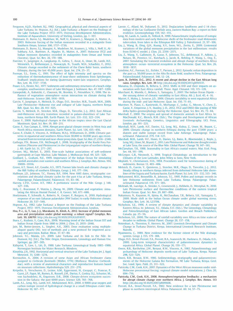
S.L. Forman et al. / Quaternary Science Reviews 97 (2014) 84e101100
Ferguson, A.J.D., Harbott, B.J., 1982. Geographical, physical and chemical aspects ofLake Turkana. In: Hopson, A.J. (Ed.), Lake Turkana: a Report on the Findings ofthe Lake Turkana Project 1972e1975. Overseas Development Administration,Institute of Aquaculture, University of Stirling, London, pp. 1e107.
Fleitmann, D., Burns, S.J., Mudelsee, M., Neff, U., Kramers, J., Mangini, A., Matter, A.,2003. Holocene forcing of the Indian monsoon recorded in a stalagmite fromSouthern Oman. Science 300, 1737e1739.
Fleitmann, D., Burns, S.J., Mangini, A., Mudelsee, M., Kramers, J., Villa, I., Neff, U., Al-Subbary, A.A., Buettner, A., Hippler, D., Matter, A., 2007. Holocene ITCZ andIndian monsoon dynamics recorded in stalagmites from Oman and Yemen(Socotra). Quat. Sci. Rev. 26, 170e188.
Foerster, V., Junginger, A., Langkamp, O., Gebru, T., Asrat, A., Umer, M., Lamb, H.F.,Wennrich, V., Rethemeyer, J., Nowaczyk, N., Trauth, M.H., Schaebitz, F., 2012.Climatic change recorded in the sediments of the Chew Bahir basin, southernEthiopia, during the last 45,000 years. Quat. Int. 274, 25e37.
Forman, S.L., Ennis, G., 1991. The effect of light intensity and spectra on thereduction of thermoluminescence of near-shore sediments from Spitsbergen,Svalbard: implications for dating Quaternary water-lain sequences. Geophys.Res. Lett. 18, 1727e1730.
Fraser, G.S., Hester, N.C., 1977. Sediments and sedimentary structures of a beach-ridgecomplex, southwestern shore of Lake Michigan. J. Sediment. Res. 47, 1187e1200.
Ganopolski, A., Kubatzki, C., Claussen, M., Brovkin, V., Petoukhov, V., 1998. The in-fluence of vegetationeatmosphereeocean interaction on climate during themid-Holocene. Science 280, 1916e1919.
Garcin, Y., Junginger, A., Melnick, D., Olago, D.O., Strecker, M.R., Trauth, M.H., 2009.Late PleistoceneeHolocene rise and collapse of Lake Suguta, northern KenyaRift. Quat. Sci. Rev. 28, 911e925.
Garcin, Y., Melnick, D., Strecker, M.R., Olago, D., Tiercelin, J.-J., 2012. East Africanmid-Holocene wet-dry transition recorded in palaeo-shorelines of Lake Tur-kana, northern Kenya Rift. Earth Planet. Sci. Lett. 331e332, 322e334.
Gasse, F., 2000. Hydrological changes in the African tropics since the Last GlacialMaximum. Quat. Sci. Rev. 19, 189e211.
Gasse, F., Van Campo, E., 1994. Abrupt post-glacial climate events in West Asia andNorth Africa monsoon domains. Earth Planet. Sci. Lett. 126, 435e456.
Gasse, F., Chali�e, F., Vincens, A., Williams, M.A.J., Williamson, D., 2008. Climatic pat-terns in equatorial and southern Africa from 30,000 to 10,000 years ago recon-structed fromterrestrial andnear-shoreproxydata.Quat. Sci. Rev. 27, 2316e2340.
Gathogo, P.N., Brown, F.H., McDougall, I., 2008. Stratigraphy of the Koobi Fora For-mation (Pliocene and Pleistocene) in the Loiyangalani region of northern Kenya.J. Afr. Earth Sci. 51, 277e297.
Genner, M.J., Michel, E., 2003. Fine-scale habitat associations of soft-sedimentgastropods at Cape Maclear, Lake Malawi. J. Molluscan Stud. 69, 325e328.
Goddard, L., Graham, N.E., 1999. Importance of the Indian Ocean for simulatingrainfall anomalies over eastern and southern Africa. J. Geophys. Res. Atmos. 104,19099e19116.
Grove, A.T., Street, A.F., Goudie, A.S., 1975. Former lake levels and climatic change inthe Rift Valley of southern Ethiopia. Geogr. J. 141, 177e194.
Halfman, J.D., Johnson, T.C., Finney, B.P., 1994. New AMS dates, stratigraphic cor-relations and decadal climatic cycles for the past 4 ka at Lake Turkana, Kenya.Palaeogeogr. Palaeoclimatol. Palaeoecol. 111, 83e98.
Harvey, C.P.D., Grove, A.T., 1982. A prehistoric source of the Nile. Geogr. J. 148,327e336.
Hely, C., Braconnot, P., Watrin, J., Zheng, W., 2009. Climate and vegetation: simu-lating the African Humid Period. C. R. Geosci. 341, 671e688.
Hoelzmann, P., Schwalb, A., Roberts, N., Cooper, P., Burgess, A., 2010. Hydrologicalresponse of an east-Saharan palaeolake (NW Sudan) to early-Holocene climate.Holocene 20, 537e549.
Hopson, A.J., 1982. Lake Turkana: a Report on the Findings of the Lake TurkanaProject, 1972e1975. Overseas Development Administration, London.
Hsu, P.-c., Li, T., Luo, J.-J., Murakami, H., Kitoh, A., 2012. Increase of global monsoonarea and precipitation under global warming: a robust signal? Geophys. Res.Lett. 39, L06701 http://dx.doi.org/10.1029/2012GL051037.
Ihara, C., Kushnir, Y., Cane, M.A., 2008. Warming trend of the Indian Ocean SST andIndian Ocean Dipole from 1880 to 2004. J. Clim. 21, 2035e2046.
Jain, M., Botter-Jensen, L., Singhvi, A.K., 2003. Dose evaluation using multiple-aliquot quartz OSL: test of methods and a new protocol for improved accu-racy and precision. Radiat. Meas. 37, 67e80.
Johnson, T.C., Malala, J.O., 2009. Lake Turkana and its link to the Nile. In:Dumont, H.J. (Ed.), The Nile: Origin, Environments, Limnology and Human Use.Springer, pp. 287e305.
K€allqvist, T., Lien, L., Liti, D., 1988. Lake Turkana: Limnological Study 1985e1988.Norwegian Institute for Water Research, Blindern.
Kinuthia, J.H., 1992. Horizontal and vertical structure of the Lake Turkana Jet. J. Appl.Meteorol. 31, 1248e1274.
Korniushin, A., 2004. A revision of some Asian and African freshwater clamsassigned to Corbicula fluminalis (Müller, 1774) (Mollusca: Bivalvia: Corbiculi-dae), with a review of anatomical characters and reproductive features basedon museum collections. Hydrobiologia 529, 251e270.
Kr€opelin, S., Verschuren, D., Lezine, A.M., Eggermont, H., Cocquyt, C., Francus, P.,Cazet, J.P., Fagot, M., Rumes, B., Russell, J.M., Darius, F., Conley, D.J., Schuster, M.,von Suchodoletz, H., Engstrom, D.R., 2008. Climate-driven ecosystem succes-sion in the Sahara: the past 6000 years. Science 320, 765e768.
Lamb, A.L., Leng, M.J., Lamb, H.F., Mohammed, M.U., 2000. A 9000-year oxygen andcarbon isotope record of hydrological change in a small Ethiopian crater lake.Holocene 10, 167e177.
Lavoie, C., Allard, M., Duhamel, D., 2012. Deglaciation landforms and C-14 chro-nology of the Lac Guillaume-Delisle area, eastern Hudson Bay: a report on fieldevidence. Geomorphology 159, 142e155.
Leng, M., Lamb, A., Lamb, H., Telford, R., 1999. Palaeoclimatic implications of isotopicdata from modern and early Holocene shells of the freshwater snail Melanoidestuberculata, from lakes in the Ethiopian Rift Valley. J. Paleolimnol. 21, 97e106.
Liu, J., Wang, B., Ding, Q.H., Kuang, X.Y., Soon, W.L., Zorita, E., 2009. Centennialvariations of the global monsoon precipitation in the last millennium: resultsfrom ECHO-G model. J. Clim. 22, 2356e2371.
Liu, Z., Wang, Y., Gallimore, R., Gasse, F., Johnson, T.C., deMenocal, P., Adkins, J.,Notaro, M., Prentice, I.C., Kutzbach, J., Jacob, R., Behling, P., Wang, L., Ong, E.,2007. Simulating the transient evolution and abrupt change of northern Africaatmosphereeoceaneterrestrial ecosystem in the Holocene. Quat. Sci. Rev. 26,1818e1837.
Lond�ono, A.C., Forman, S.L., Eichler, T., Pierson, J., 2012. Episodic eolian deposition inthe past ca. 50,000 years in the Alto Ilo dune field, southern Peru. Palaeogeogr.Palaeoclimatol. Palaeoecol. 346, 12e24.
Lyon, B., DeWitt, D.G., 2012. A recent and abrupt decline in the East African longrains. Geophys. Res. Lett. 39 http://dx.doi.org/10.1029/2011gl050337.
Manatsa, D., Chipindu, B., Behera, S., 2012. Shifts in IOD and their impacts on as-sociation with East Africa rainfall. Theor. Appl. Climatol. 110, 115e128.
Marchant, R., Mumbi, C., Behera, S., Yamagata, T., 2007. The Indian Ocean Dipole e
the unsung driver of climatic variability in East Africa. Afr. J. Ecol. 45, 4e16.Marret, F., Maley, J., Scourse, J.D., 2006. Climatic instability in west equatorial Africa
during the mid- and late Holocene. Quat. Int. 150, 71e81.Marriner, N., Flaux, C., Kaniewski, D., Morhange, C., Leduc, G., Moron, V., Chen, Z.,
Gasse, F., Empereur, J.-Y., Stanley, J.-D., 2012. ITCZ and ENSO-like pacing of Niledelta hydro-geomorphology during the Holocene. Quat. Sci. Rev. 45, 73e84.
Marshall, F., 2000. The origins and spread of domestic animals in East Africa. In:MacDonald, K.C., Blench, R.M. (Eds.), The Origins and Development of AfricanLivestock: Archaeology, Genetics, Linguistics and Ethnography. UCL Press,London, pp. 191e221.
Marshall, M.H., Lamb, H.F., Davies, S.J., Leng, M.J., Kubsa, Z., Umer, M., Bryant, C.,2009. Climatic change in northern Ethiopia during the past 17,000 years: adiatom and stable isotope record from Lake Ashenge. Palaeogeogr. Palae-oclimatol. Palaeoecol. 279, 114e127.
Marshall, M.H., Lamb, H.F., Huws, D., Davies, S.J., Bates, R., Bloemendal, J., Boyle, J.,Leng,M.J., Umer,M., Bryant, C., 2011. Late Pleistocene andHolocene drought eventsat Lake Tana, the source of the Blue Nile. Global Planet. Change 78, 147e161.
McClanahan, T.R., 1988. Seasonality in East Africa's coastal waters. Mar. Ecol. Prog.Ser. 44, 191e199.
McGregor, G.R., Nieuwolt, S., 1998. Tropical Climatology: an Introduction to theClimates of the Low Latitudes. John Wiley & Sons, New York.
Mejdahl, V., Christiansen, H.H., 1994. Procedures used for luminescence dating ofsediments. Boreas 13, 403e406.
Melnick, D., Garcin, Y., Quinteros, J., Strecker, M.R., Olago, D., Tiercelin, J.-J., 2012.Steady rifting in northern Kenya inferred from deformed Holocene lake shore-lines of the Suguta and Turkana basins. Earth Planet. Sci. Lett. 331e332, 335e346.
Mohammed, M.U., Bonnefille, R., Johnson, T.C., 1995. Pollen and isotopic records inlate Holocene sediments from Lake Turkana, Kenya. Palaeogeogr. Palae-oclimatol. Palaeoecol. 119, 371e383.
Mohtadi, M., Lueckge, A., Steinke, S., Groeneveld, J., Hebbeln, D., Westphal, N., 2010.Late Pleistocene surface and thermocline conditions of the eastern tropicalIndian Ocean. Quat. Sci. Rev. 29, 887e896.
Nakamura, N., Kayanne, H., Iijima, H., McClanahan, T.R., Behera, S.K., Yamagata, T.,2009. Mode shift in the Indian Ocean climate under global warming stress.Geophys. Res. Lett. 36, L23708.
Nicholson, S.E., 1996. A review of climate dynamics and climate variability inEastern Africa. In: Johnson, T.C., Odada, E.O. (Eds.), The Limnology, Climatologyand Paleoclimatology of East African Lakes. Gordon and Breach Publishers,Canada, pp. 25e56.
Nicholson, S.E., 2000. The nature of rainfall variability over Africa on time scales ofdecades to millenia. Global Planet. Change 26, 137e158.
Notenbart, A., Thornton, P., Herrero, M., 2007. Livestock Development and ClimateChange in Turkana District, Kenya. International Livestock Research Institute,Nairobi.
Nyamweru, C., 1989. New evidence for the former extent of the Nile drainagesystem. Geogr. J. 155, 179e188.
Olago, D.O., Street-Perrott, F.A., Perrott, R.A., Ivanovich, M., Harkness, D., Odada, E.O.,2000. Long-term temporal characteristics of palaeomonsoon dynamics inequatorial Africa. Global Planet. Change 26, 159e171.
Owen, R.B., Barthelme, J.W., Renaut, R.W., Vincens, A., 1982. Palaeolimnology andarchaeology of Holocene deposits north-east of Lake Turkana, Kenya. Nature298, 523e529.
Owen, R.B., Renaut, R.W., 1986. Sedimentology, stratigraphy and palaeoenviron-ments of the Holocene Galana Boi Formation, NE Lake Turkana, Kenya. Geol.Soc. Lond. Spec. Publ. 25, 311e322.
Patricola, C.M., Cook, K.H., 2007. Dynamics of the West African monsoon under mid-Holocene precessional forcing: regional climate model simulations. J. Clim. 20,694e716.
Patricola, C.M., Cook, K.H., 2008. Atmosphere/vegetation feedbacks: a mechanismfor abrupt climate change over northern Africa. J. Geophys. Res. Atmos. 113http://dx.doi.org/10.1029/2007jd009608.
Perrott, R.A., Street-Perrott, F.A., 1982. New evidence for a late Pleistocene wetphase in northern intertropical Africa. Palaeoecol. Afr. 14, 57e75.
S.L. Forman et al. / Quaternary Science Reviews 97 (2014) 84e101 101
Postma, G., Nemec, W., 1990. Regressive and transgressive sequences in a raisedHolocene gravelly beach, southwestern Crete. Sedimentology 37, 907e920.
Prescott, J.R., Hutton, J.T., 1994. Cosmic ray contributions to dose rates for lumi-nescence and ESR dating: large depths and long-term time variations. Radiat.Meas. 23, 497e500.
Reading, H.G., 1996. Sedimentary Environments: Processes, Facies and Stratigraphy,third ed. Blackwell Publishing, Malden, Massachusetts.
Renssen, H., Brovkin, V., Fichefet, T., Goosse, H., 2003. Holocene climate instabilityduring the termination of the African Humid Period. Geophys. Res. Lett. 30.
Renssen, H., Brovkin, V., Fichefet, T., Goosse, H., 2006. Simulation of the Holoceneclimate evolution in Northern Africa: the termination of the African HumidPeriod. Quat. Int. 150, 95e102.
Renssen, H., Sepp, H., Crosta, X., Goosse, H., Roche, D.M., 2012. Global character-ization of the Holocene Thermal Maximum. Quat. Sci. Rev. 48, 7e19.
Revel, M., Ducassou, E., Grousset, F.E., Bernasconi, S.M., Migeon, S., Revillon, S.,Mascle, J., Murat, A., Zaragosi, S., Bosch, D., 2010. 100,000 Years of Africanmonsoon variability recorded in the Nile margin. Quat. Sci. Rev. 29,1342e1362.
Richardson, J.L., 1972. Paleolimnological records from Rift lakes in Central Kenya.Palaeoecol. Afr. 6, 131e136.
Ricketts, R.D., Johnson, T.C., 1996. Climate change in the Turkana basin as deducedfrom a 4000 year long delta O-18 record. Earth Planet. Sci. Lett. 142, 7e17.
Robbins, L.H., 1972. Archeology in the Turkana District, Kenya. Science 176,359e366.
Robbins, L.H., 1980. Lopoy and Lothagam, Anthropolgical Series 3, Publication of theMuseum. Michigan State University, p. 137.
Robbins, L.H., Lynch, B.M., 1978. New evidence on the use of Microliths from theLake Turkana Basin. East Africa. Curr. Anthropol. 19, 619e620.
Robbins, L., 1984. Late prehistoric and aquatic adaptations west of Lake Turkana,Kenya. In: Clark, J.D., Brandt, S.A. (Eds.), Hunters to Farmers: Causes and Con-sequences of Food Production in Africa. University of California Press, Berkeley,pp. 206e211.
Ryner, M., Gasse, F., Rumes, B., Verschuren, D., 2007. Climatic and hydrologicalinstability in semi-arid equatorial East Africa during the late Glacial to Holocenetransition: a multi-proxy reconstruction of aquatic ecosystem response innorthern Tanzania. Palaeogeogr. Palaeoclimatol. Palaeoecol. 248, 440e458.
Saji, N.H., Goswami, B.N., Vinayachandran, P.N., Yamagata, T., 1999. A dipole mode inthe tropical Indian Ocean. Nature 401, 360e363.
Saji, N.H., Yamagata, T., 2003. Possible impacts of Indian Ocean Dipole mode eventson global climate. Clim. Res. 25, 151e169.
Savage, R.J.G., Williamson, P.G., 1978. The early history of the Turkana depression.Geol. Soc. Lond. Spec. Publ. 6 (1), 375e394.
Schefuß, E., Schouten, S., Jansen, J.H.F., Damste, J.S.S., 2003. African vegetationcontrolled by tropical sea surface temperatures in the mid-Pleistocene period.Nature 422, 418e421.
Schefuß, E., Schouten, S., Schneider, R.R., 2005. Climatic controls on central Africanhydrology during the past 20,000 years. Nature 437, 1003e1006.
Shanahan, T.M., Overpeck, J.T., Wheeler, C.W., Beek, J.W., Pigati, J.S., Talbot, M.R.,Scholz, C.A., Peck, J., King, J.W., 2006. Paleoclimatic variations in West Africafrom a record of late Pleistocene and Holocene lake level stands of LakeBosumtwi, Ghana. Palaeogeogr. Palaeoclimatol. Palaeoecol. 242, 287e302.
Stafford, T.W.J., Hare, P.E., Currie, L., Jull, A.J.T., Donahue, D., 1990. Accuracy of NorthAmerican human skeleton ages. Quat. Res. 34, 111e120.
Steffen, D., Preusser, F., Schlunegger, F., 2009. OSL quartz age underestimation dueto unstable signal components. Quat. Geochronol. 4, 353e362.
Street-Perrott, F.A., Roberts, N., 1983. Fluctuations in closed basin lakes as indicatorsof past atmospheric circulation patterns. In: Street-Perrott, F.A., Beran, M.,Ratcliff, R.A.S. (Eds.), Variations in the Global Water Budget. D. Reide Dordrecht,Holland, pp. 331e345.
Sun, F., Roderick, M.L., Farquhar, G.D., 2012. Changes in the variability of global landprecipitation. Geophys. Res. Lett. 39. WOS:000309605600005.
Talbot, M.R., Laerdal, T., 2000. The late PleistoceneeHolocene palaeolimnology ofLake Victoria, East Africa, based upon elemental and isotopic analyses of sedi-mentary organic matter. J. Paleolimnol. 23, 141e164.
Timm, O., Koehler, P., Timmermann, A., Menviel, L., 2010. Mechanisms for the onsetof the African Humid Period and Sahara greening 14.5e11 ka BP. J. Clim. 23,2612e2633.
Thomas, D.S.G., Burrough, S.L., Parker, A.G., 2012. Extreme events as drivers of earlyhuman behaviour in Africa? The case for variability, not catastrophic drought.J. Quat. Sci. 27, 7e12.
Thompson, L.G., Mosely-Thompson, E., Davis, M.E., Henderson, K.A., Brecher, H.H.,Zagorodnov, V.S., Mashiotta, T.A., Lin, P.-N., Mikhalenko, V.N., Hardy, D.R.,
Beer, J., 2002. Kilimanjaro ice core records: evidence of Holocene climatechange in tropical Africa. Science 298, 589e593.
Thompson, T.A., Baedke, S.J., 1995. Beach-ridge development in Lake Michigan:shoreline behavior in response to quasi-periodic lake-level events. Mar. Geol.129, 163e174.
Thomson, K.S., 1966. Quaternary fish fossils from west of Lake Rudolf, Kenya. Bre-viora 243, 1e10.
Tierney, J.E., Russell, J.M., Huang, Y.S., 2010. A molecular perspective on Late Qua-ternary climate and vegetation change in the Lake Tanganyika basin, East Africa.Quat. Sci. Rev. 29, 787e800.
Tierney, J.E., Lewis, S.C., Cook, B.I., LeGrande, A.N., Schmidt, G.A., 2011. Model, proxyand isotopic perspectives on the East African Humid Period. Earth Planet. Sci.Lett. 307, 103e112.
Tierney, J.E., Smerdon, J.E., Anchukaitis, K.J., Seager, R., 2013. Multidecadal variabilityin East African hydroclimate controlled by the Indian Ocean. Nature 493,389e392.
Tierney, J.E., deMenocal, P.B., 2013. Abrupt shifts in Horn of Africa hydroclimatesince the Last Glacial Maximum. Science 342, 843e846.
Umer, M., Legesse, D., Gasse, F., Bonnefille, R., Lamb, H.F., Leng, M.J., Lamb, A.L., 2004.Late Quaternary climate changes in the Horn of Africa. In: Battarbee, R.W.,Gasse, F., Stickley, C.E. (Eds.), Past Climate Variability through Europe and Africa.Springer, Dordrecht, The Netherlands, pp. 159e180.
Ummenhofer, C.C., Sen Gupta, A., England, M.H., Reason, C.J.C., 2009. Contributionsof Indian Ocean sea surface temperatures to enhanced East African rainfall.J. Clim. 22, 993e1013.
VanBocxlaer, B.,VanDamme,D., 2009.Palaeobiologyandevolutionof the lateCenozoicfreshwatermolluscsof theTurkanaBasin: IridinidaeSwainson,1840andEtheriidaeDeshayes, 1830 (Bivalvia: Etherioidea). J. Syst. Palaeontol. 7, 129e161.
Velpuri, N.M., Senay, G.B., Asante, K.O., 2011. Using multi-source satellite data forlake level modelling in ungauged basins: a case study for Lake Turkana, EastAfrica. Hydrol. Earth Syst. Sci. Discuss. 8, 4851e4890.
Verschuren, D., 2001. Reconstructing fluctuations of a shallow East African lakeduring the past 1800 yrs from sediment stratigraphy in a submerged craterbasin. J. Paleolimnol. 25, 297e311.
Verschuren, D., Sinninghe Damste, J.S., Moernaut, J., Kristen, I., Blaauw, M., Fagot, M.,Haug, G.H., 2009. Half-precessional dynamics of monsoon rainfall near the EastAfrican Equator. Nature 462, 637e641.
Vincens, A., Buchet, G., Servant, M., Collaborators, E.M., 2010. Vegetation responseto the ‘African Humid Period’ termination in Central Cameroon (7 degrees N) enew pollen insight from Lake Mbalang. Clim. Past 6, 281e294.
Von Damm, K., Edmond, J., 1984. Reverse weathering in the closed-basin lakes ofthe Ethiopian Rift. Am. J. Sci. 284 (7), 835e862.
Wanner, H., Beer, J., Bütikofer, J., Crowley, T.J., Cubasch, U., Flückiger, J., Goosse, H.,Grosjean, M., Joos, F., Kaplan, J.O., Küttel, M., Müller, S.A., Prentice, I.C.,Solomina, O., Stocker, T.F., Tarasov, P., Wagner, M., Widmann, M., 2008. Mid- tolate Holocene climate change: an overview. Quat. Sci. Rev. 27, 1791e1828.
Weldeab, S., Schneider, R.R., Kolling, M., Wefer, G., 2005. Holocene African droughtsrelate to eastern equatorial Atlantic cooling. Geology 33, 981e984.
Weldeab, S., Lea, D.W., Schneider, R.R., Andersen, N., 2007. 155,000 Years of WestAfrican monsoon and ocean thermal evolution. Science 316, 1303e1307.
Williams, R.E.G., Johnson, A.S., 1976. Birmingham University radiocarbon dates X.Radiocarbon 18, 249e267.
Williams, M.A.J., Talbot, M., 2009. Late Quaternary environments in the Nile Basin.In: Dumont, H. (Ed.), The Nile. Springer, Netherlands, pp. 61e72.
Williams, M.A.J., Williams, F.M., Duller, G.A.T., Munro, R.N., El Tom, O.A.M.,Barrows, T.T., Macklin, M., Woodward, J., Talbot, M.R., Haberlah, D., Fluin, J.,2010. Late Quaternary floods and droughts in the Nile valley, Sudan: new evi-dence from optically stimulated luminescence and AMS radiocarbon dating.Quat. Sci. Rev. 29, 1116e1137.
Wintle, A.G., Murray, A.S., 2000. Quartz OSL: effects of thermal treatment and theirrelevance to laboratory dating procedures. Radiat. Meas. 32, 387e400.
Wintle, A.G., 2008. Luminescence dating: where it has been and where it is going.Boreas 37, 471e482.
Wright, D.K., 2011. Frontier animal husbandry in the Northeast and East AfricanNeolithic: a multiproxy paleoenvironmental and paleodemographic study.J. Anthropol. Res. 67, 213e244.
Wright, D.K., Forman, S.L., 2011. Holocene occupation of the Mount Porr strand plainin southern Lake Turkana, Kenya. Nyame Akuma 76, 47e62.
Yuretich, R., 1979. Modern sediments and sedimentary processes in Lake Rudolf(Lake Turkana) eastern Rift Valley, Kenya. Sedimentology 26, 313e331.
Zhao, Y., Harrison, S.P., 2012. Mid-Holocene monsoons: a multi-model analysis ofthe inter-hemispheric differences in the responses to orbital forcing and oceanfeedbacks. Clim. Dyn. 39, 1457e1487.
Related Documents