Ute Mountain Ute Tribal Hazard Mitigation Plan Public Review Draft March 2012

Welcome message from author
This document is posted to help you gain knowledge. Please leave a comment to let me know what you think about it! Share it to your friends and learn new things together.
Transcript

Ute Mountain Ute Tribal Hazard Mitigation Plan
Public Review Draft March 2012

EXECUTIVE SUMMARY
Ute Mountain Ute Tribe Public Review Draft i Tribal Hazard Mitigation Plan
March 2012
The purpose of hazard mitigation is to reduce or eliminate long-term risk to people and property
from hazards. The Ute Mountain Ute Tribe developed this Tribal Hazard Mitigation Plan
(THMP) update to make the Reservation and its residents less vulnerable to future hazard events.
This plan was prepared pursuant to the requirements of the Disaster Mitigation Act of 2000 so
that the Tribe would be eligible for the Federal Emergency Management Agency’s (FEMA) Pre-
Disaster Mitigation and Hazard Mitigation Grant programs.
The Tribe followed a planning process prescribed by FEMA, which began with the formation of
a tribal hazard mitigation planning committee (THMPC) comprised of key tribal representatives,
and other federal and regional stakeholders. The THMPC conducted a risk assessment that
identified and profiled hazards that pose a risk to the Tribe, assessed the Reservation’s
vulnerability to these hazards, and examined the capabilities in place to mitigate them. The
Reservation is vulnerable to several hazards that are identified, profiled, and analyzed in this
plan. Floods, wildfires, and severe weather are among the hazards that can have a significant
impact on the Reservation.
Based upon the risk assessment review and goal setting process, the THMPC developed the
following goals for this plan:
Goal 1: Increase Public Awareness of Vulnerability to Hazards
Goal 2: Minimize the Risk from Hazards to Existing and Proposed Development, Tribal
Assets, and Cultural Sites
Goal 3: Reduce the Loss of Life and Personal Injuries from Hazard Events
Goal 4: Assess needs for Multi-Program Participation
The plan lists specific mitigation projects, or actions, that were developed collaboratively by the
THMPC with the intent to meet the identified goals. These projects will be implemented over
time as a measure of progress towards hazard reduction. The plan also lists plan update and
maintenance procedures, including a five year update schedule.

TABLE OF CONTENTS
Ute Mountain Ute Tribe Public Review Draft ii Tribal Hazard Mitigation Plan
March 2012
Chapter 1 Introduction ...................................................................................... 1.1
1.1 Purpose ..................................................................................................................1.1
1.2 Background and Scope .........................................................................................1.1
1.3 Plan Assurances ....................................................................................................1.2
1.4 Plan Organization..................................................................................................1.3
Chapter 2 Community Profile ........................................................................... 2.1
2.1 History...................................................................................................................2.1
2.2 Geography and Climate ........................................................................................2.3
2.3 Economy ...............................................................................................................2.6
2.4 Population .............................................................................................................2.6
Chapter 3 Planning Process
3.1 Tribal Government Participation ..........................................................................3.1
3.2 The 10-Step Planning Process ..............................................................................3.2
3.2.1 Phase 1: Organize Resources .......................................................................3.3
3.2.2 Phase 2 Assess Hazards and Risk ................................................................3.6
3.2.3 Phase 3: Develop the Mitigation Plan ..........................................................3.7
3.2.4 Phase 4: Implement the Plan and Monitor Progress ....................................3.8
Chapter 4 Risk Assessment ................................................................................ 4.1
4.1 Hazard Identification ............................................................................................4.2
4.1.1 Results and Methodology ............................................................................4.2
4.1.2 Disaster Declaration History ........................................................................4.5
4.1.3 Severe Weather History ...............................................................................4.7
4.2 Hazard Profiles......................................................................................................4.9
4.2.1 Profile Methodology ....................................................................................4.9
4.2.2 Dam Failure ...............................................................................................4.10
4.2.3 Drought ......................................................................................................4.15
4.2.4 Earthquake .................................................................................................4.22
4.2.5 Extreme Temperatures ...............................................................................4.27
4.2.6 Flood ..........................................................................................................4.33
4.2.7 Hazardous Materials ..................................................................................4.37
4.2.8 Landslide/Rockfall .....................................................................................4.39
4.2.9 Severe Weather: Hail/Lightning/Wind ......................................................4.41
4.2.10 Soil Hazards: Expansive Soils ................................................................4.49
4.2.11 Tornado ....................................................................................................4.52
4.2.12 Wildfire ....................................................................................................4.53
4.2.13 Winter Storms ..........................................................................................4.63

Ute Mountain Ute Tribe Public Review Draft iii Tribal Mitigation Plan
March 2012
4.2.14 Natural Hazards Summary .......................................................................4.70
4.3 Vulnerability Assessment ...................................................................................4.71
4.3.1 Dam Failure Vulnerability Assessment .....................................................4.76
4.3.2 Drought Vulnerability Assessment ............................................................4.76
4.3.3 Earthquake Vulnerability Assessment .......................................................4.79
4.3.4 Extreme Temperatures Vulnerability Assessment .....................................4.79
4.3.5 Flood Vulnerability Assessment ................................................................4.80
4.3.6 Hazardous Materials Vulnerability Assessment ........................................4.87
4.3.7 Landslide/Rockfall Vulnerability Assessment ...........................................4.88
4.3.8 Severe Weather: Hail/Lightning/Wind Vulnerability Assessment ............4.90
4.3.9 Soil Hazards: Expansive Soils Vulnerability Assessment ........................4.92
4.3.10 Tornado Vulnerability Assessment ..........................................................4.93
4.3.11 Wildfire Vulnerability Assessment ..........................................................4.93
4.3.12 Winter Storms Vulnerability Assessment ................................................4.99
4.4 Tribal Capability Assessment ...........................................................................4.100
4.4.1 Ute Mountain Ute Tribal Regulatory Mitigation Capabilities .................4.101
4.4.2 Ute Mountain Ute Tribal Administrative/Technical Mitigation
Capabilities ..............................................................................................4.104
4.4.3 Ute Mountain Ute Fiscal Mitigation Capabilities ....................................4.105
4.4.4 Mitigation Outreach and Partnerships .....................................................4.108
4.4.5 Other Mitigation Efforts ..........................................................................4.109
Chapter 5 Mitigation Strategy........................................................................... 5.1
5.1 Tribal Hazard Mitigation Plan Goals ....................................................................5.1
5.2 Identification and Analysis of Tribal Mitigation Actions .....................................5.3
5.3 Implementation of Tribal Mitigation Actions .......................................................5.4
5.3.1 Prioritization Process ...................................................................................5.4
Chapter 6 Plan Adoption ................................................................................... 6.1
Chapter 7 Plan Implementation and Maintenance ......................................... 7.1
7.1 Monitoring, Evaluating, and Updating the Plan ...................................................7.1
7.1.1 Plan Update Process .....................................................................................7.1
7.2 Monitoring Progress of Mitigation Activities .......................................................7.2
7.3 Incorporation into Existing Planning Mechanisms ...............................................7.3
7.4 Continued Public Involvement .............................................................................7.5
Appendix A Adoption Resolutions ..................................................................... A.1
Appendix B Planning Process ............................................................................. B.1

1 INTRODUCTION
Ute Mountain Ute Tribe Public Review Draft 1.1 Tribal Hazard Mitigation Plan
March 2012
1.1 Purpose
The Ute Mountain Ute Tribe (Tribe) has prepared this Tribal Hazard Mitigation Plan (THMP) to
guide hazard mitigation planning to better protect the people, property, cultural assets and tribal
lands from the effects of natural and man-made hazard events. This plan demonstrates the
Tribe’s commitment to reducing risks from hazards and serves as a tool to help decision makers
direct mitigation activities and resources. This plan was also developed to make the Tribe
eligible for certain federal disaster assistance; specifically, the Federal Emergency Management
Agency’s (FEMA) Hazard Mitigation Grant Program (HMGP) as well as Pre-Disaster Mitigation
(PDM) grants, as well as to make the Tribe more disaster resistant.
1.2 Background and Scope
Each year in the United States, disasters take the lives of hundreds of people and injure
thousands more. Nationwide, taxpayers pay billions of dollars annually to help communities,
organizations, businesses, and individuals recover from disasters. These monies only partially
reflect the true cost of disasters, because additional expenses to insurance companies and
nongovernmental organizations are not reimbursed by tax dollars. Many disasters are
predictable, and much of the damage caused by these events can be alleviated or even
eliminated.
Hazard mitigation is defined by FEMA as “any sustained action taken to reduce or eliminate
long-term risk to human life and property from a hazard event.” The results of a three-year,
congressionally mandated independent study to assess future savings from mitigation activities
provides evidence that mitigation activities are highly cost-effective. On average, each dollar
spent on mitigation saves society an average of $4 in avoided future losses in addition to saving
lives and preventing injuries (National Institute of Building Science Multi-Hazard Mitigation
Council 2005).
Hazard mitigation planning is the process through which hazards that threaten communities are
identified, likely impacts of those hazards are determined, mitigation goals are set, and
appropriate strategies to lessen impacts are determined, prioritized, and implemented. This plan
documents the Tribe’s hazard mitigation planning process, identifies relevant hazards and risks,
and identifies the strategy the Tribe will use to decrease vulnerability and increase resiliency and
sustainability.
This plan was prepared pursuant to the requirements of the Disaster Mitigation Act of 2000
(Public Law 106-390) and the implementing regulations set forth by the Interim Final Rule
published in the Federal Register on February 26, 2002 (44 CFR §201.7) and finalized on
October 31, 2007. (Hereafter, these requirements and regulations will be referred to collectively

Ute Mountain Ute Tribe Public Review Draft 1.2 Tribal Hazard Mitigation Plan
March 2012
as the Disaster Mitigation Act or DMA.) While the act emphasized the need for mitigation plans
and more coordinated mitigation planning and implementation efforts, the regulations
established the requirements that local hazard mitigation plans must meet in order for a local
jurisdiction to be eligible for certain federal disaster assistance and hazard mitigation funding
under the Robert T. Stafford Disaster Relief and Emergency Act (Public Law 93-288). Because
the Reservation is subject to many kinds of hazards, access to these programs is vital.
Information in this plan will be used to help guide and coordinate mitigation activities and
decisions for local land use policy in the future. Proactive mitigation planning will help reduce
the cost of disaster response and recovery to the community and its property owners by
protecting critical community facilities, reducing liability exposure, and minimizing overall
community impacts and disruption. The Reservation has been affected by hazards in the past
and is thus committed to reducing future disaster impacts and maintaining eligibility for federal
funding.
1.3 Plan Assurances
Requirement §201.7(c)(6): The plan must include assurances that the Indian Tribal
government will comply with all applicable Federal statutes and regulations in effect with
respect to the periods for which it receives grant funding, in compliance with 44 CFR
13.11(c). The Indian Tribal government will amend its plan whenever necessary to reflect
changes in tribal or Federal laws and statutes as required in 44 CFR 13.11(d).
This plan is prepared to comply with the requirements of the Robert T. Stafford Disaster Relief
and Emergency Assistance Act of 1988 (as amended by the DMA); all pertinent presidential
directives associated with the U.S. Department of Homeland Security and FEMA; all aspects of
44 CFR pertaining to hazard mitigation planning and grants pertaining to the mitigation of
adverse effects of disasters (natural, manmade, and other); interim final rules and final rules
pertaining to hazard mitigation planning and grants, as described above; all planning criteria
issued by FEMA; and all Office of Management and Budget circulars and other federal
government documents, guidelines, and rules.
The Ute Mountain Ute Tribe assures that it will continue to comply with all applicable Federal
statutes and regulations in effect with respect to the periods for which it receives grant funding,
in compliance with 44 CFR 13.11(c). The Tribe will amend its plan whenever necessary to
reflect changes in Tribal or Federal laws and statutes as required in 44 CFR 13.11(d).
Ute Mountain Ute Tribe Public Review Draft 1.3 Tribal Hazard Mitigation Plan
March 2012
1.4 Plan Organization
The Ute Mountain Ute Tribal Hazard Mitigation Plan is organized as follows:
Chapter 2: Community Profile
Chapter 3: Planning Process
Chapter 4: Risk Assessment
Chapter 5: Mitigation Strategy
Chapter 6: Plan Adoption
Chapter 7: Plan Implementation and Maintenance
Appendix A: Adoption Resolution
Appendix B: Planning Process

2 COMMUNITY PROFILE
Ute Mountain Ute Tribe Public Review Draft 2.1 Tribal Hazard Mitigation Plan
March 2012
This Chapter describes the profile of the planning area, including the history, geography,
population and economic aspects of the Ute Mountain Ute Tribe and Reservation.
2.1 History
When the Spanish expeditions traveled through the Southwest in the 1400-1500’s; the people
they called the Yutas, or Utes (the forever ago people), ranged across much of present-day
Colorado, northern New Mexico, and Utah. According to anthropologists, the Utes were
organized into loosely defined bands, but the basic social unit was the extended family, which
could most efficiently utilize the available natural resources. This hunter-gather society made up
of these family units of perhaps ten to forty people followed a seasonal migration pattern,
moving into the higher country in the spring and summer and returning to lower elevations in the
autumn. They fished the streams, they hunted deer, elk, antelope, and occasionally buffalo and
other animals and gathered seeds, fruits, and wild berries in the summer and fall.
Because they were a nomadic people, the Utes had a relatively simple material culture, but that
changed dramatically after the arrival of the Spanish. Because of their proximity to Spanish
settlements in New Mexico, because of being trusted guides for the Spanish expeditions, the Utes
had relatively easy access to horses and quickly amassed large herds, which allowed them to
trade the animals to other tribes. Horses greatly increased the Utes’ mobility and made their life
easier by enhancing their ability to utilize the available food resources. Hunters could now travel
over greater distances, and the tribe could utilize the food resources of a larger area. Thus, the
Utes began to consolidate into larger camps. The band replaced the family as the basic social
unit, and large Ute camps were now able to travel to the Great Plains to hunt buffalo. The
organization of large camps and large hunting expeditions led to the development of more
powerful and influential leaders, and the movement to the Great Plains to hunt brought the Utes
into contact with hostile Plains Indians, spurring the rise of conflict amongst the Plains tribes.
After the Mexican War, the United States and the Utes signed a treaty of peace and friendship in
1849 in which the Utes recognized the jurisdiction of the United States. Soon thereafter settlers
from New Mexico moved north into Ute territory in the San Luis Valley, and a few years later
the 1859 gold rush to Colorado brought hordes of newcomers to the area. These two events
marked the beginning of a new phase in Ute history and established what would become the
major theme in Ute-U.S. relations in the nineteenth century: constant pressure by the United
States on the Ute land base. The first mining camps developed in areas that had not been
purchased from any Indian tribes, and thus mining interests were constantly demanding that
Indians, including Utes, be removed from those areas. The resulting series of treaties and
agreements, negotiated over approximately twenty years, reduced the Ute land base to an area
along the Colorado-New Mexico border in southwestern Colorado.

Ute Mountain Ute Tribe Public Review Draft 2.2 Tribal Hazard Mitigation Plan
March 2012
In 1863, at the behest of Coloradans, the United States negotiated with the Utes for the
acquisition of the San Luis Valley and other areas of Colorado. Demands for Ute land
continued, and in 1868 a Ute delegation was taken to Washington and encouraged to agree to a
second cession. By the Treaty of 1868, the Utes were restricted to a rectangular reservation that
lay mostly west of the Continental Divide. The Utes retained the area west of approximately
Pagosa Springs and south of the present-day Moffat County line. The government promised to
exclude all non-Utes except for government officials and pledged to create two agencies, one of
which would be located on the Rio de Los Pinos. The government wished to encourage the Utes
to become farmers, but it established the Los Pinos Agency on a previously unnamed creek in
the Cochetopa Hills at a high elevation rather than in the more fertile Rio de Los Pinos region in
present-day La Plata County. Moreover, the new agency was not even within the boundaries of
the reservation.
Americans almost immediately violated the terms of the treaty by participating in a mining rush
into the San Juan Mountains. Soon miners were active in the vicinity of the present-day
communities of Lake City, Silverton, Ouray, Rico, Durango, and Hesperus. The Utes protested
the presence of miners; some tribal leaders attempted to persuade the miners to leave the
reservation, whereas others threatened to drive them out. Colorado officials sought to solve the
problem by reducing the size of the reservation, but efforts to do so in 1872 failed; the Utes
insisted that the government enforce previous treaties and prevent trespass on their lands. At one
point federal officials were preparing to use the army to expel non-Ute trespassers, but howls of
outrage by Coloradans caused the government to cease such efforts and to seek instead a new
agreement to reduce the size of the reservation.
In 1873 the United States renewed its efforts to purchase the San Juan mining country and
succeeded in negotiating the Brunot Agreement, which was ratified in 1874. By this agreement,
the United States acquired a block of land with a northern boundary approximately at present-
day Ridgway and a southern boundary just south of present-day Durango. However, the Brunot
Agreement was blatantly fraudulent; the Utes thought they were selling only the mines, but by
the terms of the pact they lost an entire block of territory. The agreement also specifically
reserved for the Utes an area between Ouray and Ridgway known as Uncompahgre Park.
However, soon thereafter non-Indians moved into the area, and the Utes were never able to retain
possession. During the 1870s the government also closed the Ute agencies in New Mexico and
removed the Utes from the vicinity of Cimarron and from the Abiquiu and Tierra Amarilla areas
of the Chama Valley, placing them all in southern Colorado.
Coloradans continued to seek further reductions of the Ute reservation, and the Meeker Massacre
in 1879 gave them an excuse to accomplish that objective. Under the terms of an agreement
concluded the year following the uprising, the Northern Utes, who had participated in the affair,
were moved to Utah. The treaty provided that the friendly Tabeguache or Uncompahgre Utes
should be moved to the junction of the Colorado and Gunnison rivers if sufficient arable land
was available there. However, the government chose to ignore this provision and sent these Utes
to Utah as well.

Ute Mountain Ute Tribe Public Review Draft 2.3 Tribal Hazard Mitigation Plan
March 2012
These events left the Weeminuche, Capote, and Muache as the only remaining Ute bands in
Colorado, and they occupied a narrow strip of land that was 15 miles wide and 110 miles long on
the southern boundary of Colorado. In 1895 legislation passed to provide for the allotment of
land to Utes on the reservation. In keeping with the general thrust of federal Indian policy, the
bill provided that land would be allotted to individual adult Indians and would be held in trust for
them for twenty-five years, at which time a fee simple patent would be issued. Because many
Utes opposed the agreement, the government decided to make the allotments on the eastern part
of the reservation and leave the western half for those who wished to live in traditional
communal camps.
By 1896 land had been allotted to 371 Utes, and soon thereafter the unallotted land on the eastern
part of the reservation was made available to white settlers. As a result, the eastern portion of the
reservation, now known as the Southern Ute Reservation, is a checkerboard of Indian and non-
Indian ownership. The Utes who opposed allotment, largely members of the Weeminuche band
under the leadership of Chief Ignacio, moved to the western portion of the reservation. In time a
subagency was established for them at Navajo Springs, although eventually it moved to the
present location at Towaoc. In time, the western part of the reservation was established as a
separate jurisdiction and became known as the Ute Mountain Ute Reservation.
Life has been more difficult in the twentieth century for the Ute Mountain Utes because of the
lack of resources on their reservation. The lack of water, in particular, inhibited the development
of agriculture and stock raising. The Ute Mountain Utes accepted the Indian Reorganization Act
and adopted a constitution in 1940. Exploration for oil and gas in the 1950s provided needed
revenues, and McPhee Reservoir, completed in 1986 near the town of Dolores, provided
desperately needed agriculture and clean drinking water for the Ute Mountain Ute Reservation.
Since the 1990’s the Utes rely heavily on revenues from oil and gas, and both Southern Utes and
Ute Mountain Utes have established casinos to increase their income. Today Ute leaders seek to
develop economic and educational opportunities while preserving the Ute language and
traditional culture.
2.2 Geography and Climate
The Ute Mountain Indian Reservation is in southwestern Colorado and northwestern New
Mexico (see Figure 2.1). According to the U. S. Department of Commerce, it has a total area of
595,787 acres, consisting of 557,878 acres of tribal lands, 9,549 acres of allotted lands, 28,410
acres of tribal fee lands, and 40 acres of Federally-owned lands. The Reservation is generally a
compact geographic unit with only a few isolated tracts along the northern boundary. The Ute
Mountain Ute Tribe also contains the White Mesa land in Utah. White Mesa, Utah is a small
community located 12 miles south of Blanding, Utah, on Highway 191 on Tribal Reservation
lands as well as allotted lands in southeastern Utah. For the purposes of this plan, the planning
area entails the Reservation land in Colorado and northern New Mexico. A basemap of the area
is shown in Figure 2.1.
Ute Mountain Ute Tribe Public Review Draft 2.4 Tribal Hazard Mitigation Plan
March 2012
The Ute Mountain Ute reservation lies on high desert plateaus; it ranges in altitudes from about
4,600 feet along the San Juan River near Four Corners (the junction of the States of Arizona,
Utah, Colorado, and New Mexico) to 9,977 feet on Ute Peak. Most of the western part of the
reservation is semiarid, eroded grasslands with some “badlands” topography near the Utah
boundary. North of the grasslands is the Sleeping Ute Mountain with a cover of scrub cedar,
oak, and juniper. The eastern and southeastern parts of the reservation also covered by scrub
cedar and juniper consist of the deeply-cut canyons and mesas south of Mesa Verde National
Park. At the toe of Ute Mountain lies the 7600 acres of the thriving Farm & Ranch enterprise.
This enterprise was created in the settlement of Ute water rights from the Dolores project; the
land they cultivate is in the same area the ancient Puebloans farmed 1000’s of years ago.
The principal stream on the reservation is the perennial Mancos River which enters near the
northeast corner, flows southwestward through the area, and meets the San Juan river about 6
miles east of Four Corners. Navajo Wash is a perennial stream flowing southward a few miles
west of Mesa Verde. The San Juan River flows for 5 or more miles across the extreme southwest
corner of the reservation.
The nearest large town is the Montezuma county seat, Cortez, Colorado, about 16 miles
northeast of Towaoc. With a population of over 6,000 it is the principal market center for the
area. South of the reservation in New Mexico are the towns of Shiprock, 30 miles from Towaoc,
and Farmington, 29 miles east of Shiprock, with a population of about 23,800.

Ute Mountain Ute Tribe Public Review Draft 2.5 Tribal Hazard Mitigation Plan
March 2012
Figure 2.1. Ute Mountain Ute Reservation Basemap

Ute Mountain Ute Tribe Public Review Draft 2.6 Tribal Hazard Mitigation Plan
March 2012
2.3 Economy
The most comprehensive economic data available for the reservation comes from the U.S.
Census Bureau by way of the American Community Survey. Select estimates of economic
characteristics for the Reservation are shown in Table 2.1. Much of the Tribe’s economy comes
from revenues from oil and gas and the casino. The archeological resources of the Tribal Park
are also a draw for tourists.
Table 2.1. Ute Mountain Ute Tribe’s Economic Characteristics, 2000
Characteristic Ute Mountain Ute Tribe
Families below Poverty Level 38.5%
Individuals below Poverty Level 40.9%
Median Family Income $19,295
Median Household Income $18,832
Per Capita Income $8,159
Population in Labor Force 717
Population Employed 593
Unemployment 11.3%
Source: U.S. Census Bureau, 2000, www.census.gov/
2.4 Population
Towaoc is the only town on the Reservation and is an unincorporated community. It is the site
of the Ute Mountain Indian Agency and the residence of most of the people on the reservation.
As of 2010, the resident Indian population in and near the reservation was 1,687. Table 2.2 gives
detailed information regarding population and demographics of the Reservation.
Table 2.2. Population and Demographics of the Ute Mountain Reservation
Statistic Number
Total Population 1,588
Under 5 147
Over 65 80
Race
White 105
Black/African-American 0
American Indian 1,440
Average Household Size 3.08
Average Family Size 3.6
Source: US Census Bureau, 2000, www.census.gov/
3 PLANNING PROCESS
Ute Mountain Ute Tribe Public Review Draft 3.1 Tribal Hazard Mitigation Plan
March 2012
44 CFR Requirement 201.7(c)(1) documentation of the planning process used to develop
the plan, including how it was prepared, who was involved in the process, and how the
public was involved. This shall include: (i) An opportunity for the public to comment on
the plan during the drafting stage and prior to plan approval, including a description of
how the Indian tribal government defined “public”, (ii) As appropriate, an opportunity for
neighboring communities, tribal and regional agencies involved in the hazard mitigation
activities, and agencies that have the authority to regulate development, as well as
businesses, academia, and other private and nonprofit interests to be involved in the
planning process; (iii) Review and incorporation, if appropriate, of existing plans, studies,
and reports; and (iv) Be integrated to the extent possible with other ongoing tribal
planning efforts as well as other FEMA programs and initiatives.
The planning process and development of this plan was initiated in the spring of 2011 under the
coordination of Ute Mountain Ute Tribe’s Public Safety Office. Funding was secured through a
FEMA Pre Disaster Mitigation planning grant to enable a consultant to be hired to facilitate the
process and develop the plan. AMEC Earth and Environmental (AMEC) of Boulder, Colorado,
contracted with the Tribe to provide professional planning services. The development of the
plan followed a structured planning process that involved various Tribal departments and other
public and private stakeholders. The planning process is described further in this section and
documented in Appendix B.
3.1 Tribal Government Participation
The Disaster Mitigation Act (DMA) planning regulations and guidance stress that tribal
governments seeking FEMA approval of their mitigation plan must participate in the planning
effort in the following ways:
Participate in the process as part of the Tribal Hazard Mitigation Planning Committee
(THMPC),
Detail areas within the planning area where the risk differs from that facing the entire area,
Identify specific projects to be eligible for funding, and
Have the Tribal Council formally adopt the plan.
For the Ute Mountain Ute Tribe’s Mitigation Plan’s THMPC, “participation” meant:
Attending and participating in the THMPC meetings,
Providing available data requested of the THMPC,
Reviewing and providing comments on the plan drafts,
Advertising, coordinating, and participating in the public input process, and
Coordinating the formal adoption of the plan by the Tribal Council.

Ute Mountain Ute Tribe Public Review Draft 3.2 Tribal Hazard Mitigation Plan
March 2012
Ute Mountain Ute’s Tribal Hazard Mitigation Plan is a tribal plan that geographically covers
developed Reservation lands in Colorado and New Mexico. The focus of this plan is on the area
of the reservation within Colorado, as the New Mexico portion is largely undeveloped and un-
populated.
3.2 The 10-Step Planning Process
AMEC established the planning process for the Reservation’s plan using the DMA planning
requirements and FEMA’s associated guidance. This guidance is structured around a four-phase
process:
1) Organize Resources
2) Assess Risks
3) Develop the Mitigation Plan
4) Implement the Plan and Monitor Progress
Into this four-phase process, AMEC integrated a more detailed 10-step planning process used for
FEMA’s Community Rating System and Flood Mitigation Assistance programs. Thus, the
modified 10-step process used for this plan meets the requirements of six major programs:
FEMA’s Hazard Mitigation Grant Program, Pre-Disaster Mitigation program, Community
Rating System (CRS), Flood Mitigation Assistance Program, Severe Repetitive Loss program,
and a flood control projects program authorized by the U.S. Army Corps of Engineers.
Table 3.1 shows how the modified 10-step process fits into FEMA’s four-phase process.
Table 3.1. FEMA’s Four-Phase Process and the 10-Step CRS Process Used to
Develop the Ute Mountain Ute Tribal Hazard Mitigation Plan
FEMA’s 4-Phase DMA Process Modified 10-Step CRS Process
1) Organize Resources
201.7(c)(1) 1) Organize the Planning Effort
201.7(c)(1)(i) 2) Involve the Public
201.7(c)(1)(ii), (iii) and (iv) 3) Coordinate with Other Departments and Agencies
2) Assess Risks
201.7(c)(2)(i) 4) Identify the Hazards
201.7(c)(2)(ii) 5) Assess the Risks
3) Develop the Mitigation Plan
201.7(c)(3)(i) 6) Set Goals
201.7(c)(3)(ii) 7) Review Possible Activities
201.7(c)(3)(iii) 8) Draft an Action Plan
4) Implement the Plan and Monitor Progress
201.7(c)(5) 9) Adopt the Plan
201.7(c)(4) 10) Implement, Evaluate, and Revise the Plan
Source: FEMA

Ute Mountain Ute Tribe Public Review Draft 3.3 Tribal Hazard Mitigation Plan
March 2012
3.2.1 Phase 1: Organize Resources
Planning Step 1: Organize the Planning Effort
The Ute Mountain Ute Tribal Council designated the Public Safety Office as the lead entity for
this plan. The Public Safety Director sent out the invitations for the kick-off meeting to the
Tribal Council, Tribal Departments, and state and federal partner agencies that could contribute
to the planning process. This list is included in Appendix B.
During the planning process the THMPC communicated with a combination of conference calls,
phone interviews, email correspondence, and an FTP (file transfer protocol) site. Three planning
meetings with the THMPC were held during the plan’s development between February 2011 and
July 2011. The meeting schedule and topics are listed in the following table. All meetings were
held at the East Wing Conference Room in the Tribal Complex and were approximately 2-3
hours long. The sign-in sheets and agendas for each of the meetings are located in Appendix B.
Table 3.2. Schedule of THMPC Meetings
THMPC Meeting Meeting Topic Meeting Date
1 Introduction to DMA Planning/Kickoff Meeting February 1, 2011
2 Risk Assessment Summary/Goals Development July 13, 2011
3 Mitigation Strategy Development July 26, 2011
During the kickoff meeting, the scope and purpose of the plan, participation requirements of
THMPC members, and the proposed project work plan and schedule were discussed. A plan for
public involvement (Step 2) and coordination with other agencies and departments (Step 3) were
discussed. A preliminary hazard identification was initiated for the Tribe, which was
subsequently refined by the THMPC members. Participants were provided worksheets developed
by AMEC to facilitate the collection of information needed to support the plan, such as data on
historic hazard events, values at risk, and current hazard mitigation capabilities. 25 individuals
from various agencies returned these data collection worksheets to AMEC for information to be
incorporated into the plan.
Note any other meetings where this plan was discussed
Planning Step 2: Plan for Public Involvement
For the purposes of this plan the “public” is defined as tribal members or other persons that are
not associated with Tribal government or leadership or other public or private entity. This plan
contains important information regarding potential hazards that could impact the people,
property, and culturally significant assets of the Tribe. The THMPC recognized the value of
sharing this information so that member of the Tribe would be aware of the hazards and their

Ute Mountain Ute Tribe Public Review Draft 3.4 Tribal Hazard Mitigation Plan
March 2012
associated dangers and what steps they could take to minimize the impacts. The public was
given an opportunity to comment on the draft plan during the drafting stage and prior to plan
approval.
A public meeting was held August 24th
, 2011 in conjunction with a Fire Wise meeting to raise
awareness of the plan. The public meeting was advertised through X. The key elements of the
plan were summarized on a fact sheet and shared with participants. The fact sheet announced
where the public could access the draft plan for review and comment. The plan was placed in
hardcopy at <X location> with comment/feedback forms. The plan was also made available on
the Tribe’s website. Comments on the draft plan included X. (Note to THMPC will be finalized
following public meeting)
Planning Step 3: Coordinate with Other Departments and Agencies
Early in the planning process, the THMPC determined that data collection, mitigation strategy
development, and plan approval would be greatly enhanced by inviting state and federal agencies
and organizations to participate in the process. Based on their involvement in hazard mitigation
activities, their role in land stewardship in the Reservation, or their role in public safety,
representatives from the following agencies were invited to participate on the THMPC:
Tribal Chairman
Tribal Administration
Attorney and Justice*
Tribal Casino
Tribal Historic Preservation Office*
UMU Cultural Resources*
UMU Economic Development*
UMU Education*
UMU Energy
UMU Environment*
UMU Farm & Ranch
UMU Housing Authority*
UMU Resources*
UMU Planning and Development*
UMU Public Works*
UMU Public Safety*
UMU Recreation*
UMU Social Services*
UMU Tribal Park*
UMU Transportation*
UMU Farm and Ranch Enterprise
Weeminuche Construction Authority (WCA)*
Ute Mountain Ute Tribe Public Review Draft 3.5 Tribal Hazard Mitigation Plan
March 2012
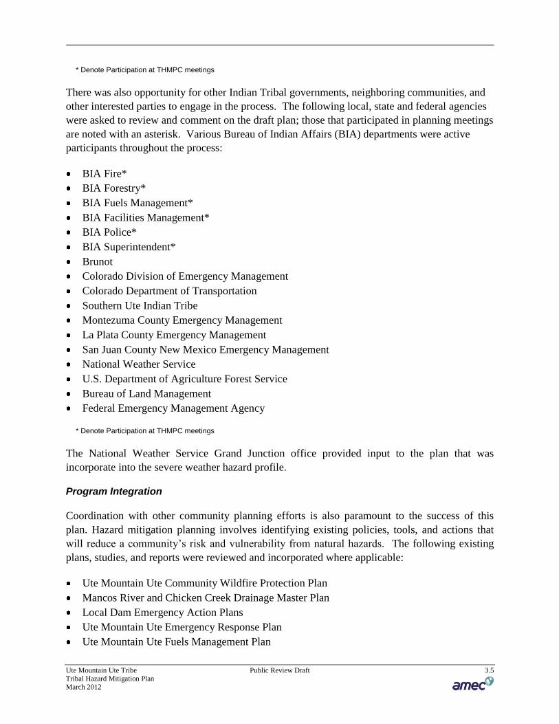
* Denote Participation at THMPC meetings
There was also opportunity for other Indian Tribal governments, neighboring communities, and
other interested parties to engage in the process. The following local, state and federal agencies
were asked to review and comment on the draft plan; those that participated in planning meetings
are noted with an asterisk. Various Bureau of Indian Affairs (BIA) departments were active
participants throughout the process:
BIA Fire*
BIA Forestry*
BIA Fuels Management*
BIA Facilities Management*
BIA Police*
BIA Superintendent*
Brunot
Colorado Division of Emergency Management
Colorado Department of Transportation
Southern Ute Indian Tribe
Montezuma County Emergency Management
La Plata County Emergency Management
San Juan County New Mexico Emergency Management
National Weather Service
U.S. Department of Agriculture Forest Service
Bureau of Land Management
Federal Emergency Management Agency
* Denote Participation at THMPC meetings
The National Weather Service Grand Junction office provided input to the plan that was
incorporate into the severe weather hazard profile.
Program Integration
Coordination with other community planning efforts is also paramount to the success of this
plan. Hazard mitigation planning involves identifying existing policies, tools, and actions that
will reduce a community’s risk and vulnerability from natural hazards. The following existing
plans, studies, and reports were reviewed and incorporated where applicable:
Ute Mountain Ute Community Wildfire Protection Plan
Mancos River and Chicken Creek Drainage Master Plan
Local Dam Emergency Action Plans
Ute Mountain Ute Emergency Response Plan
Ute Mountain Ute Fuels Management Plan

Ute Mountain Ute Tribe Public Review Draft 3.6 Tribal Hazard Mitigation Plan
March 2012
Ute Mountain Ute Integrated Resource Management Plan
Montezuma County Community Wildfire Protection Plan
Colorado State Hazard Mitigation Plan
Colorado Wildfire Mitigation Plan 2007 Update
Colorado Landslide Hazard Mitigation Plan
Colorado Drought Mitigation and Response Plan
In particular this plan is directly integrated with wildfire planning efforts that have preceded the
development of this plan. The Ute Mountain Ute Community Wildfire Protection Plan (CWPP)
and Fuels Management Plan address one of the most significant hazards that could affect the
Reservation. Key findings from those efforts are incorporated into the risk assessment in
Chapter 4 and associated fuels treatments recommendations are referred to in Chapter 5 and
Appendix C Mitigation Strategy. Members of staff that developed these plans participated on
the THMPC.
State and FEMA Program integration
The development of this plan is the first step towards integration with State and FEMA
mitigation programs and initiatives. This plan was completed in accordance with the FEMA
Tribal Mitigation Planning Guidance Document (2010) and when approved will enable the Tribe
to be eligible for pre and post disaster hazard mitigation funding. The plan will also enable
eligibility for State Hazard Mitigation Assistance grants (SHMP).
Currently the Tribe does not participate in the National Flood Insurance Program (NFIP), but one
of the recommendations of this plan is to explore the costs and benefits associated with NFIP
participation.
The Colorado Water Conservation Board (CWCB) is beginning a pilot study in mid-2011 to
evaluate the impacts of drought to recreation and tourism sector in Southwestern Colorado. Due
to the timing the results were not available to inform this plan but may be useful for future
updates to this plan. The CWCB is also promoting the development of local drought
management plans.
3.2.2 Phase 2 Assess Hazards and Risk
Planning Steps 4 and 5: Identify the Hazards and Assess the Risks
AMEC assisted the THMPC in a process to identify the natural and man-made hazards that have
or could impact the Reservation. The hazards identified in the Colorado State Hazard Mitigation
Plan (2010) were utilized as a starting point for identification of hazards that affect the
Reservation. During the kickoff meeting, the THMPC discussed each hazard identified in the
State Hazard Mitigation plan and decided they wanted to address certain hazards. The THMPC
opted to address the man-made hazard of hazardous materials in the plan. More information on

Ute Mountain Ute Tribe Public Review Draft 3.7 Tribal Hazard Mitigation Plan
March 2012
the methodology and resources used to identify and profile the hazards can be found in Section
4.1 and 4.2.
At the kickoff meeting participants were provided worksheets developed by AMEC to facilitate
the collection of information needed to support the plan. This allowed for collection of
information on historic hazard events that have impacted the planning area. AMEC conducted
extensive research using the internet, local news archives, existing reports and plans from
neighboring jurisdictions to research past hazard events and determine the location, extent,
magnitude, and future probability of all hazards identified in Step 4 above. Where data
permitted, geographic information systems (GIS) were used to display, analyze, and quantify
hazards and vulnerabilities. Montezuma County served as the research area in most instances
since the majority of the Reservation is within its boundaries. The individual hazard profiles can
be found in Section 4.2.
The THMPC also conducted a capability assessment to review and document the Reservation’s
current capabilities to mitigate risk and vulnerability from natural hazards. By collecting
information about existing government programs, policies, regulations, ordinances, and
emergency plans, the THMPC can assess those activities and measures already in place that
contribute to mitigating some of the risks and vulnerabilities identified. A more detailed
description of the risk and capability assessment process and the results are included in Chapter 4
Risk Assessment.
3.2.3 Phase 3: Develop the Mitigation Plan
Planning Steps 6 and 7: Set Goals and Review Possible Activities
AMEC facilitated brainstorming and discussion sessions with the THMPC that described the
purpose and the process of developing planning goals and objectives, a comprehensive range of
mitigation alternatives, and a method of selecting and defending recommended mitigation
actions using a series of selection criteria. This process and its results are described in greater
detail in Chapter 5 Mitigation Strategy.
Planning Step 8: Draft an Action Plan
Based on input from the THMPC regarding the draft risk assessment and the goals and activities
identified in Planning Steps 6 and 7, AMEC produced a complete first draft of the plan. This
complete draft was posted for THMPC review and comment on the project ftp site. Other
agencies were invited to comment on this draft as well. THMPC and agency comments were
integrated into the second draft, which was advertised and distributed to collect public input and
comments. AMEC integrated comments and issues from the public, as appropriate, along with
additional internal review comments and produced a final draft for the Colorado Division of
Emergency Management and FEMA Region VIII to review and approve, contingent upon final
adoption by the Tribal Council.

Ute Mountain Ute Tribe Public Review Draft 3.8 Tribal Hazard Mitigation Plan
March 2012
3.2.4 Phase 4: Implement the Plan and Monitor Progress
Planning Step 9: Adopt the Plan
In order to secure buy-in and officially implement the plan, the plan was adopted by the Tribal
Council on the dates included in the adoption resolution in Appendix A Plan Adoption.
Planning Step 10: Implement, Evaluate, and Revise the Plan
The true worth of any mitigation plan is in the effectiveness of its implementation. Up to this
point in the planning process, all of the THMPC’s efforts have been directed at researching data,
coordinating input from participating entities, and developing appropriate mitigation actions.
Each recommended action includes key descriptors, such as a lead manager and possible funding
sources, to help initiate implementation. An overall implementation strategy is described in
Chapter 7 Plan Implementation and Maintenance.
Finally, there are numerous organizations within the Tribe whose goals and interests interface
with hazard mitigation. Coordination with these other planning efforts, as addressed in Planning
Step 3, is paramount to the ongoing success of this plan and mitigation within the Reservation
and is addressed further in Chapter 7. A plan update and maintenance schedule and a strategy
for continued public involvement are also included in Chapter 7.

4 RISK ASSESSMENT
Ute Mountain Ute Tribe Public Review Draft 4.1 Tribal Hazard Mitigation Plan March 2012
44 CFR Requirement 201.7(c)(2): [The plan shall include] a risk assessment that provides the factual basis for activities proposed in the strategy to reduce the losses from identified hazards. Local risk assessments must provide sufficient information to enable the jurisdiction to identify and prioritize appropriate mitigation actions to reduce losses from identified hazards.
As defined by the Federal Emergency Management Agency (FEMA), risk is a combination of hazard, vulnerability, and exposure. “It is the impact that a hazard would have on people, services, facilities, and structures in a community and refers to the likelihood of a hazard event resulting in an adverse condition that causes injury or damage.”
The risk assessment process identifies and profiles relevant hazards and assesses the exposure of lives, property, and infrastructure to these hazards. The process allows for a better understanding of a jurisdiction’s potential risk to natural hazards and provides a framework for developing and prioritizing mitigation actions to reduce risk from future hazard events.
This risk assessment followed the methodology described in the FEMA publication Understanding Your Risks—Identifying Hazards and Estimating Losses (2002), which breaks the assessment down to a four-step process:
1) Identify Hazards 2) Profile Hazard Events 3) Inventory Assets 4) Estimate Losses
Data collected through this process has been incorporated into the following sections of this chapter:
• Section 4.1 Hazard Identification identifies the hazards that threaten the planning area and describes why some hazards have been omitted from further consideration.
• Section 4.2 Hazard Profiles discusses the threat to the planning area and describes previous occurrences of hazard events and the likelihood of future occurrences.
• Section 4.3 Vulnerability Assessment assesses the Tribe’s total exposure to natural hazards, considering assets at risk, critical facilities, and future development trends.
• Section 4.4 Capability Assessment inventories existing mitigation activities and policies, regulations, and plans that pertain to mitigation and can affect net vulnerability.

Ute Mountain Ute Tribe Public Review Draft 4.2 Tribal Hazard Mitigation Plan March 2012
4.1 0BHazard Identification
Requirement §201.7(c)(2)(i): [The risk assessment shall include a] description of the type…of all natural hazards that can affect the jurisdiction.
The Tribal Hazard Mitigation Planning Committee (THMPC) conducted a hazard identification study to determine the hazards that threaten the planning area. The planning area includes the Reservation land that is within Colorado, primarily within Montezuma County. Reservation areas within La Plata County area largely undeveloped. Areas of the Reservation extend into New Mexico, but this area is unpopulated and largely undeveloped except for some roads. Ranch lands in La Plata County, owned by the Tribe but not part of the Reservation, are not included in this analysis. Additionally there are some non-contiguous Ute Mountain Ute reservation lands in southeastern Utah in San Juan County that are not covered in this risk assessment as the focus of this plan is the Reservation area in Colorado.
4.1.1 4BResults and Methodology
Using existing hazards data, relevant plans and studies, and input gained through planning and public meetings, the THMPC agreed upon a list of hazards that could affect the Tribe. Hazards data was obtained from FEMA, the Colorado Division of Emergency Management (including the State of Colorado Natural Hazards Mitigation Plan), the National Oceanic and Atmospheric Administration, the Spatial Hazard Events and Losses Database for the United States (SHELDUS), Tribal Community Wildfire Protection Plan and Fuels Management Plan, the Tribal Emergency Operations Plan and many others. Together, these sources were examined to assess the significance of these hazards to the planning area. The hazards evaluated in this plan include those that have occurred historically or have the potential to cause significant human and/or monetary losses in the future.
The following natural hazards, listed alphabetically, were identified and investigated for the Ute Mountain Ute Tribal Hazard Mitigation Plan:
• Dam Failure • Drought • Earthquake • Extreme Temperatures • Flood • Landslide/Rockfall • Severe Weather: Hail/Lightning/Windstorms • Soil Hazards: Expansive Soils • Tornado • Wildfire • Winter Storm

Ute Mountain Ute Tribe Public Review Draft 4.3 Tribal Hazard Mitigation Plan March 2012
Man-made hazards can also affect the Tribe. Man-made hazards include:
• Hazardous Materials
Other hazards were considered, but due to the lack of past or expected potential impact on the tribe, lack of relevance to the planning area, or extremely long recurrence intervals (i.e. for volcano), they were not profiled in this plan. These hazards were:
• Avalanche • Coastal Erosion • Coastal Storm • Expansive Soils • Hurricane • Land Subsidence (was originally considered a hazard due to oil extraction, but no known
impacts have been recorded) • Tsunami • Volcano
Members of the THMPC used a hazards worksheet to identify and rate the significance of a variety of possible hazards. Significance was measured in general terms, focusing on key criteria such as the likelihood of the event, past occurrences, spatial extent, and damage and casualty potential. Table 4.1 represents the worksheet used to identify and rate the hazards, and is a composite that includes input from all the THMPC participants. Only the more significant hazards (high or medium) have a more detailed hazard profile and are analyzed further in Section 4.3 Vulnerability Assessment. The worksheet rankings have been modified to reflect the results of this risk assessment. Some hazards originally ranked low may have been changed to medium or high, or vice-versa, as a result of the hazard identification and risk assessment process.

Ute Mountain Ute Tribe Public Review Draft 4.4 Tribal Hazard Mitigation Plan March 2012
Table 4.1. Ute Mountain Ute Hazard Identification Worksheet
Hazard Frequency of Occurrence Spatial Extent Magnitude/Severity Significance
Dam Failure Unlikely Limited Negligible Low
Drought Likely Significant Negligible Medium
Earthquake Unlikely Limited Critical Low
Extreme Temperatures Likely Significant Negligible Medium
Flood Likely Limited Limited High
Hazardous Materials Likely Significant Critical High
Landslide/Rockfall Likely Significant Negligible Medium
Severe Weather: Hail/Lightning/Windstorm
Likely Significant Negligible High
Soil Hazards: Expansive Soils
Likely Limited Critical Medium
Tornado Unlikely Limited Critical Low
Wildfires Likely Significant Critical High
Winter Storm Highly Likely Significant Negligible High
Frequency of Occurrence: Highly Likely: Near 100% probability in next year. Likely: Between 10 and 100% probability in next year or at least one chance in ten years. Occasional: Between 1 and 10% probability in next year or at least one chance in next 100 years. Unlikely: Less than 1% probability in next 100 years.
Magnitude/Severity: Catastrophic: Multiple deaths, complete shutdown of facilities for 30 days or more, more than 50% of property is severely damaged Critical: Multiple severe injuries, complete shutdown of facilities for at least 2 weeks, more than 25% of property is severely damaged Limited: Some injuries, complete shutdown of critical facilities for more than one week, more than 10 percent of property is severely damaged Negligible: Minor injuries, minimal quality-of-life impact, shutdown of critical facilities and services for 24 hours or less, less than 10 percent of property is severely damaged.
Spatial Extent: Limited: Less than 10% of planning area Significant: 10-50% of planning area Extensive: 50-100% of planning area
Significance Low: minimal potential impact Medium: moderate potential impact High: widespread potential impact
Source: AMEC Data Collection Guide, THMPC and AMEC input

Ute Mountain Ute Tribe Public Review Draft 4.5 Tribal Hazard Mitigation Plan March 2012
4.1.2 5BDisaster Declaration History
One method the THMPC used to identify hazards was the researching of past events that triggered federal and/or state emergency or disaster declarations in the planning area. Federal and/or state disaster declaration histories help document past occurrences of hazards within the planning area. Disaster declarations are granted when the magnitude and severity impact of the event surpasses the ability of the local government to respond and recover. Disaster assistance is supplemental and sequential. When the local government’s response capacity is surpassed, a state disaster declaration may be issued, allowing for the provision of state assistance. Should the severity of the disaster event surpass both the local and state government response capacity, a federal emergency or disaster declaration may be issued, allowing for the provision of federal disaster assistance. Generally, the federal government issues disaster declarations through FEMA. However, federal assistance may also come from the U.S. Department of Agriculture and the Small Business Association (SBA), and other government agencies such as the Fire Management Assistance Grant Program. FEMA also issues emergency declarations, which are more limited in scope and without the long-term federal recovery programs of major disaster declarations. The quantity and types of damage are the determining factors.
A USDA declaration will result in the implementation of the Emergency Loan Program through the Farm Services Agency. This program enables eligible farmers and ranchers in the affected county as well as contiguous counties to apply for low interest loans. A USDA declaration will automatically follow a major disaster declaration for counties designated major disaster areas and those that are contiguous to declared counties, including those that are across state lines. As part of an agreement with the USDA, the SBA offers low interest loans for eligible businesses that suffer economic losses in declared and contiguous counties that have been declared by the USDA. These loans are referred to as Economic Injury Disaster Loans.
The Fire Management Assistance Grant Program provides funding “for the mitigation, management, and control of fires on publicly or privately owned forests or grasslands, which threaten such destruction as would constitute a major disaster.”0F
1 The quantity and types of damages, as well as the type of event, determine the source of federal aid.
Figure 4.1, from the FEMA website, displays the number of Presidential (FEMA) Disaster Declarations from 1964 to 2010 by FEMA Region.
1 FEMA, Fire Management Assistance Grant Program Webpage, modified December 6, 2006. Available online at http://www.fema.gov/government/grant/fmagp/index.shtm, last accessed April 13, 2009.

Ute Mountain Ute Tribe Public Review Draft 4.6 Tribal Hazard Mitigation Plan March 2012
Figure 4.1. Presidential Disaster Declarations, December 24, 1964 – January 1, 2010
Source: FEMA
Table 4.2 provides information on federal emergencies and disasters for Montezuma County between 1955 and 2010. According to the THMPC none of these declarations included the Tribe.
Table 4.2. Disaster and Emergency Declarations for Montezuma County
Year Event Declaration
2005 Hurricane Katrina Evacuation EM-2224
2002 Wildfires DR-1421
1977 Drought EM-3025
1973 Flooding and Landslides DR-396
1970 Heavy Rains and Flooding DR-293 Source: Colorado State Hazard Mitigation Plan; Colorado Governor’s Office website, Federal Emergency Management Agency, PERI Presidential Disaster Declaration Site.

Ute Mountain Ute Tribe Public Review Draft 4.7 Tribal Hazard Mitigation Plan March 2012
4.1.3 6BSevere Weather History
Severe weather is generally any destructive weather event. The National Oceanic and Atmospheric Administration’s National Climatic Data Center (NCDC) has been tracking severe weather since 1950. Their Storm Events Database contains data on the following: all weather events from 1993 to 2011 (except from 6/1993-7/1993); and additional data from the Storm Prediction Center, which includes tornadoes (1950-1992), thunderstorm winds (1955-1992), and hail (1955-1992). The NCDC tracks severe weather events on a County basis and, as such, not all events occurred on the Reservation. This database contains 92 severe weather events that occurred in Montezuma County between January 1, 1950, and February 28, 2011. Table 4.3 summarizes these events.
Table 4.3. NCDC Severe Weather Reports for Montezuma County. 1950-2011
Type # of Events Property Loss Crop Loss Deaths Injuries
Dust Devil 1 $3,000 $0 0 0
Flash Flood 7 $324,000 $40,000 0 0
Funnel Cloud 3 $0 $0 0 0
Hail 19 $1,039,000 $125,000 0 0
Heavy Rain 12 $130,000 $10,000 0 0
Lightning 9 $237,000 $0 0 3
Thunderstorm Winds 19 $232,000 $0 0 4
Tornado 2 $50,000 $0 0 0
Urban/Small Stream Flood 3 0 $0 0 0
Wild/Forest Fire 17 $420,000 $0 0 0
Total 92 $2,435,000 $175,000 0 7 Source: NCDC
The THMPC supplemented NCDC data with data from SHELDUS (Spatial Hazard Events and Losses Database for the United States). SHELDUS is a county-level data set for the United States that tracks 18 types of natural hazard events along with associated property and crop losses, injuries, and fatalities for the period 1960-2008. Produced by the Hazards Research Lab at the University of South Carolina, this database combines information from several sources (including the NCDC). The database includes every loss causing and/or deadly event between 1960 through 1979 and from 1995 onward. Between 1980 and 1995, SHELDUS™ reflects only events that caused at least one fatality or more than $50,000 in property or crop damages. For events that covered multiple counties, the dollar losses, deaths, and injuries were equally divided among the affected counties (e.g., if four counties were affected, then a quarter of the dollar losses, injuries, and deaths were attributed to each county). From 1995 to 2005, all events that were reported by the NCDC with a specific dollar amount are included in SHELDUS.
SHELDUS contains information on 131 severe weather events that occurred in Montezuma County between 1960 and 2008. Table 4.4 summarizes these events. Based on this data

Ute Mountain Ute Tribe Public Review Draft 4.8 Tribal Hazard Mitigation Plan March 2012
drought, hail, winter weather and flooding have been the most costly hazards in the County, and presumably to the Tribe. The following section examines these and other hazards in more detail.
Table 4.4. SHELDUS Hazard Event Repots for Montezuma County*
Type # of Events Property Loss Crop Loss Deaths Injuries
Avalanche 4 $27,922 $0 1 1
Drought 2 $0 $1,193,396.23 0 0
Flooding 8 $663,080.46 $212,413.79 0 0
Flooding - Severe Storm/Thunder Storm 1 $41,667.67 $0 0 0
Flooding - Severe Storm/Thunder Storm - Winter Weather
1 $793.65 $0 0 0
Hail 4 $1,039,000 $125,000 0 0
Hail - Lightning – Wind 1 $1,562.50 $15,625.00 0 0
Hail - Severe Storm/Thunder Storm – Wind 1 $100,000 $0 0 0
Hail – Wind 1 $25,000 $2,500 0 0
Landslide 1 $714.29 $0 0 0
Lightning 12 $282,661.29 $0 5.1 3
Severe Storm/Thunder Storm 10 $188,435.09 $10,000 0 0
Severe Storm/Thunder Storm - Wind 8 $132,000 $0 0 4
Severe Storm/Thunder Storm - Wind - Winter Weather
1 $79.37 $0 0 0
Severe Storm/Thunder Storm - Winter Weather
1 $1,851.85 $0 0 0
Tornado 1 $5,000 $0 0 0
Wildfire 3 $370,000 $0 0 0
Wind 28 $181,827.73 $7,936.51 0.39 0
Wind - Winter Weather 5 $25,396.83 $793.65 0.03 0.16
Winter Weather 38 $944,248.33 $189,311.27 0.69 0.41
Total 131 $4,031,241.06 $1,756,976.45 7.21 8.57 Source: Hazards & Vulnerability Research Institute (2010). The Spatial Hazard Events and Losses Database for the United States, Version 8.0 [Online Database]. Columbia, SC: University of South Carolina. Available from http://www.sheldus.org *Events may have occurred over multiple cities, so damage may represent only a fraction of the total event damage and may not be specific to Montezuma County and Ute Mountain Ute Tribe.
In addition to the NCDC and SHELDUS, the National Weather Service in Grand Junction presented another archive data set from the NWS Storm Data Program, which has archived data beginning in October 2006. Presently, it only contains archived data through a portion of December 2010. This data is presented in each hazard profile, where appropriate.
Ute Mountain Ute Tribe Public Review Draft 4.9 Tribal Hazard Mitigation Plan March 2012
4.2 1BHazard Profiles
Requirement §201.7(c)(2)(i): [The risk assessment shall include a] description of the…location and extent of all natural hazards that can affect the jurisdiction. The plan shall include information on previous occurrences of hazard events and on the probability of future hazard events.
The hazards identified in Section 4.1 Hazard Identification are profiled individually in this section. In general, information provided by planning team members is integrated into this section with information from other data sources, such as those mentioned in Section 4.1. These profiles set the stage for Section 4.3 Vulnerability Assessment, where the vulnerability is quantified, where possible, for each of the priority hazards.
4.2.1 7BProfile Methodology
Each hazard is profiled in a similar format that is described below:
38BHazard/Problem Description
This section gives a description of the hazard and associated issues followed by details on the hazard specific to the planning area. Where known, this includes information on the hazard location, seasonal patterns, speed of onset/duration, and extent (magnitude or severity) and/or secondary effects.
39BPast Occurrences
This section contains information on historical incidents, including impacts where known. The extent or location of the hazard within or near the planning area is also included here. Historical incident worksheets and other data sources were used to capture information on past occurrences.
40BLikelihood of Future Occurrence
The frequency of past events is used in this section to gauge the likelihood of future occurrences. Where possible, frequency was calculated based on existing data. It was determined by dividing the number of events observed by the number of years on record and multiplying by 100. This gives the percent chance of an event happening in any given year (e.g., three droughts over a 30-year period equates to a 10 percent chance of a drought in any given year). The likelihood of future occurrences is categorized into one of the following classifications:
• Highly Likely—Near 100 percent chance of occurrence in next year or happens every year. • Likely—Between 10 and 100 percent chance of occurrence in next year or has a recurrence
interval of 10 years or less. • Occasional—Between 1 and 10 percent chance of occurrence in the next year or has a
recurrence interval of 11 to 100 years.

Ute Mountain Ute Tribe Public Review Draft 4.10 Tribal Hazard Mitigation Plan March 2012
• Unlikely—Less than 1 percent chance of occurrence in next 100 years or has a recurrence interval of greater than every 100 years.
Section 4.2.14 Natural Hazards Summary provides an initial assessment of the profiles and assigns a level of significance to each hazard. Those hazards determined to be of high significance were characterized as priority hazards that required further evaluation in Section 4.3 Vulnerability Assessment. The Vulnerability Assessment contains more detail on the specific impacts of the hazards to people, property, cultural resources and critical facilities, where known. Those hazards that occur infrequently or have little or no impact on the planning area were determined to be of low significance. Significance was determined based on the hazard profile, focusing on key criteria such as frequency and resulting damage, including deaths/injuries and property, and economic damage. This assessment was used by the THMPC to prioritize those hazards of greatest significance to the planning area; thus enabling the Tribe to focus resources where they are most needed.
The following sections provide profiles of the hazards that the THMPC identified in Section 4.1.
4.2.2 8BDam Failure
41BHazard/Problem Description
A dam is a barrier constructed across a watercourse that stores, controls, or diverts water. Dams are usually constructed of earth, rock, concrete, or mine tailings. The water impounded behind a dam is referred to as the reservoir and is measured in acre-feet, with one acre-foot being the volume of water that covers one acre of land to a depth of one foot. Depending on local topography, even a small dam may have a reservoir containing many acre-feet of water. Dams serve many purposes, including agricultural uses; providing recreation areas; electrical power generation; and erosion, water level, and flood control.
A dam failure is the collapse, breach, or other failure of a dam that causes downstream flooding. Dam failures may result from natural events, human-caused events, or a combination thereof. Due to the lack of advance warning, failures resulting from natural events, such as hurricanes, earthquakes, or landslides, may be particularly severe. Prolonged rainfall that produces flooding is the most common cause of dam failure.
Dam failures usually occur when the spillway capacity is inadequate and water overtops the dam or when internal erosion through the dam foundation occurs (also known as piping). If internal erosion or overtopping cause a full structural breach, a high-velocity, debris-laden wall of water is released and rushes downstream, damaging or destroying whatever is in its path. Overtopping is the primary cause of earthen dam failure in the United States.
Dam failures can also result from any one or a combination of the following causes:
• Prolonged periods of rainfall and flooding, which cause most failures;

Ute Mountain Ute Tribe Public Review Draft 4.11 Tribal Hazard Mitigation Plan March 2012
• Inadequate spillway capacity, resulting in excess overtopping flows; • Internal erosion caused by embankment or foundation leakage or piping; • Improper maintenance, including failure to remove trees, repair internal seepage problems,
replace lost material from the cross-section of the dam and abutments, or maintain gates, valves, and other operational components;
• Improper design, including the use of improper construction materials and construction practices;
• High winds can cause significant wave action and result in substantial erosion around dams and spillways;
• Negligent operation, including the failure to remove or open gates or valves during high flow periods; and
• Failure of upstream dams on the same waterway.
Water released by a failed dam generates tremendous energy and can cause a flood that is catastrophic to life and property. A catastrophic dam failure could challenge local response capabilities and require evacuations to save lives. Impacts to life safety will depend on the warning time and the resources available to notify and evacuate the public. Major loss of life could result as well as potentially catastrophic effects to roads, bridges, and homes. Associated water quality and health concerns could also be issues. Factors that influence the potential severity of a full or partial dam failure are the amount of water impounded; the density, type, and value of development and infrastructure located downstream; and the speed of failure.
In general, there are three types of dams: concrete arch or hydraulic fill, earth-rockfill, and concrete gravity. Each type of dam has different failure characteristics. A concrete arch or hydraulic fill dam can fail almost instantaneously: the flood wave builds up rapidly to a peak then gradually declines. An earth-rockfill dam fails gradually due to erosion of the breach: a flood wave will build gradually to a peak and then decline until the reservoir is empty. And, a concrete gravity dam can fail instantaneously or gradually with a corresponding buildup and decline of the flood wave.
The Colorado Division of Water Resources Dam Safety Branch assigns hazard ratings to dams within the State. Two factors are considered when assigning hazard ratings: existing land use and land use controls (zoning) downstream of the dam. Dams are classified in three categories that identify the potential hazard to life and property:
• High hazard indicates that a failure would most probably result in the loss of life • Significant hazard indicates a failure could result in appreciable property damage • Low hazard exists where failure would result in only minimal property damage and loss of
life is unlikely.
Privately owned high and significant hazard dams are required by Colorado regulations to have Emergency Action Plans (EAPs) in place. High hazard dams are also required to have inundation maps. Federally-owned high hazard dams are also required to have EAPs by federal

Ute Mountain Ute Tribe Public Review Draft 4.12 Tribal Hazard Mitigation Plan March 2012
regulations. According to the 2010 State Hazard Mitigation Plan, all high-hazard dams in Colorado have EAPs in place, which provide for the emergency response procedures in the event of a dam emergency event. According to the National Performance of Dams Program (NPDP) database, housed in the Department of Civil and Environmental Engineering at Stanford University, there are 319 high hazard dams in Colorado. According to HAZUS, and data from the National Inventory of Dams (NID) and NPDP, there are 8 dams in Montezuma County that pose a risk to people or property of the Tribe should the dam fail (see Table 4.5). Figure 4.2 displays the location of high and significant hazard dams that could affect the planning area. None of these dams are located within the reservation.
The risk associated with these dams is best described by evaluating the watersheds they impact, which include the Mancos and McElmo watersheds. The Mancos watershed has 1 high and 2 significant hazard dams. The Mancos watershed is drains a large portion of Ute Mountain Ute Reservation and encompasses the Mancos River which flows through the Reservation east of Mesa Verde National Park to the southwest portion of the reservation. Jackson Gulch is a high hazard dam that is located on the West Mancos River north of the town of Mancos. Jackson Gulch would impact the Mancos River drainage area, State Highway 160 south of Towaoc, and the Indian Ruins areas. The 2 significant hazard dams are Bauer Lake #1 and #2 and are located north of the town of Mancos on Chicken Creek which drains into the Mancos River. These dams pose little risk to Tribal population and development, but could potentially impact Highway 491.
The McElmo watershed has 2 high and 3 significant hazard dams. The majority of McElmo watershed is located north of the Reservation but an area between the Sleeping Ute Mountain and McElmo Creek does contain some Tribal Land. Within this area there is risk from the high hazard dams: Totten which is located on the Simon Draw and is east of the town of Cortez and Narraguinnep which is located in Narraguinnep Canyon that leads into McElmo Creek. The 3 significant hazard dams are: A.M. Puett – located on Stinking Springs Canyon east of the town of Cortez; Cortez #1 – northeast of the town of Cortez on a tributary to McElmo Creek; and McGechie – located west of Cortez on the Hartman Draw Tributary. These dams pose little risk to the Ute Mountain Reservation as McElmo Creek is located on the northern edge of the tribal boundary and there is no population or development in these areas. It is worth noting so that future development is not located within inundation zones.
Table 4.5. Dams with Potential to Cause Damaging Floods in Montezuma County
Dam EAP Owner Stream Watershed Hazard Rating
Dam Height Type
Capacity (Acre-feet)*
Jackson Gulch
Y DOI Br West Mancos River Os
Mancos High 166 Earth 9,980
Narraguinnep Y Montezuma Valley Irrigation
Narraguinnep Canyon
McElmo High 100 Earth 22,700
Totten Y Montezuma Valley Irrigation
Simon Draw-Tributary
McElmo High 30 Earth 4,530

Ute Mountain Ute Tribe Public Review Draft 4.13 Tribal Hazard Mitigation Plan March 2012
Dam EAP Owner Stream Watershed Hazard Rating
Dam Height Type
Capacity (Acre-feet)*
A. M. Puett Y Summit Reservoir &
Irrigation
Stinking Springs Canyon
McElmo Significant 43 Earth 3,209
Bauer Lake #1 N Bauer Lake Water Co.
Chicken Creek
Tributary
Mancos Significant 25 Earth 510
Bauer Lake #2 Y Bauer Lake Reservoir Co.
Chicken Creek
Tributary
Mancos Significant 40 Earth 2,284
Cortez #1 Y City Of Cortez McElmo Creek-
Tributary
McElmo Significant 37 Earth 114
McGechie Y M. F. McGechie Hartman Draw-
Tributary
McElmo Significant 30 Earth 40
Source: National Inventory of Dams

Ute Mountain Ute Tribe Public Review Draft 4.14 Tribal Hazard Mitigation Plan March 2012
Figure 4.2. High and Significant Hazard Dams on Drainages Affecting the Reservation

Ute Mountain Ute Tribe Public Review Draft 4.15 Tribal Hazard Mitigation Plan March 2012
42BPast Occurrences
Colorado has a history of dam failure, with at least 130 known dam failures since 1890 (Source: Flood Hazard Mitigation Plan for Colorado, 2004). The Lawn Lake Disaster of 1982 caused four deaths and over $31 million in property damage when a privately owned dam failed on Forest Service Property above the Town of Estes Park. The San Juan Mountains above Silverton experienced a dam failure flood, of sorts, when a natural lake (Lake Emma) was completely drained on June 4, 1979 by a series of abandoned mine tunnels beneath the lake. There has been no history of dam failure in Montezuma County, but the potential exists.
43BLikelihood of Future Occurrence
Unlikely—There are no official recurrence intervals calculated for dam failures, so estimating the frequency of occurrence of dam failure is extremely difficult. There is very little development along the McElmo Creek. There is some development along the Mancos River, but flood waters would have to be very high for a dam failure to impact that development. In sum, the Reservation has some risk to dam failures from the high and significant hazard dams that affect the planning area, but impacts would likely be limited to roads or bridges in the McElmo and Mancos River floodplains.
4.2.3 9BDrought
44BHazard/Problem Description
Drought is a condition of climatic dryness that is severe enough to reduce soil moisture and water below the minimum necessary for sustaining plant, animal, and human life systems. Influencing factors include temperature patterns, precipitation patterns, agricultural and domestic water supply needs, and growth. Lack of annual precipitation and poor water conservation practices can result in drought conditions.
Drought is a gradual phenomenon. Although droughts are sometimes characterized as emergencies, they differ from typical emergency events. Most natural disasters, such as floods or wildland fires, occur relatively rapidly and afford little time for preparing for disaster response. Droughts occur slowly, over a multi-year period, and can take years before the consequences are realized. It is often not obvious or easy to quantify when a drought begins and ends. Droughts can be a short-term event over several months or a long-term event that lasts for years or even decades.
Drought is a complex issue involving many factors—it occurs when a normal amount of moisture is not available to satisfy an area’s usual water-consuming activities. Drought can often be defined regionally based on its effects (as shown in Figure 4.3):

Ute Mountain Ute Tribe Public Review Draft 4.16 Tribal Hazard Mitigation Plan March 2012
• Meteorological drought is usually defined by a period of below average water supply. • Agricultural drought occurs when there is an inadequate water supply to meet the needs of
the state’s crops and other agricultural operations such as livestock. • Hydrological drought is defined as deficiencies in surface and subsurface water supplies. It
is generally measured as streamflow, snowpack, and as lake, reservoir, and groundwater levels.
• Socioeconomic drought occurs when a drought impacts health, well-being, and quality of life or when a drought starts to have an adverse economic impact on a region.
Figure 4.3. Causes and Impacts of Drought
Source: National Drought Mitigation Center
Drought in the United States is monitored by the National Integrated Drought Information System (NIDIS). A major component of this portal is the U.S. Drought Monitor. The Drought

Ute Mountain Ute Tribe Public Review Draft 4.17 Tribal Hazard Mitigation Plan March 2012
Monitor concept was developed jointly by the NOAA’s Climate Prediction Center, the NDMC, and the USDA’s Joint Agricultural Weather Facility in the late 1990s as a process that synthesizes multiple indices, outlooks and local impacts, into an assessment that best represents current drought conditions. The final outcome of each Drought Monitor is a consensus of federal, state, and academic scientists who are intimately familiar with the conditions in their respective regions. A snapshot of the drought conditions in Colorado and the planning area can be found in Figure 4.4.
Figure 4.4. Current Drought Status in Colorado and the Planning Area
Source: US Drought Monitor
Due to Colorado’s semiarid conditions, drought is a natural but unpredictable occurrence in the state. However, because of natural variations in climate and precipitation sources, it is rare for all of Colorado to be deficient in moisture at the same time. Single season droughts over some portion of the state are quite common.
Drought impacts are wide-reaching and may be economic, environmental, and/or societal. The most significant impacts associated with drought in Colorado are those related to water intensive
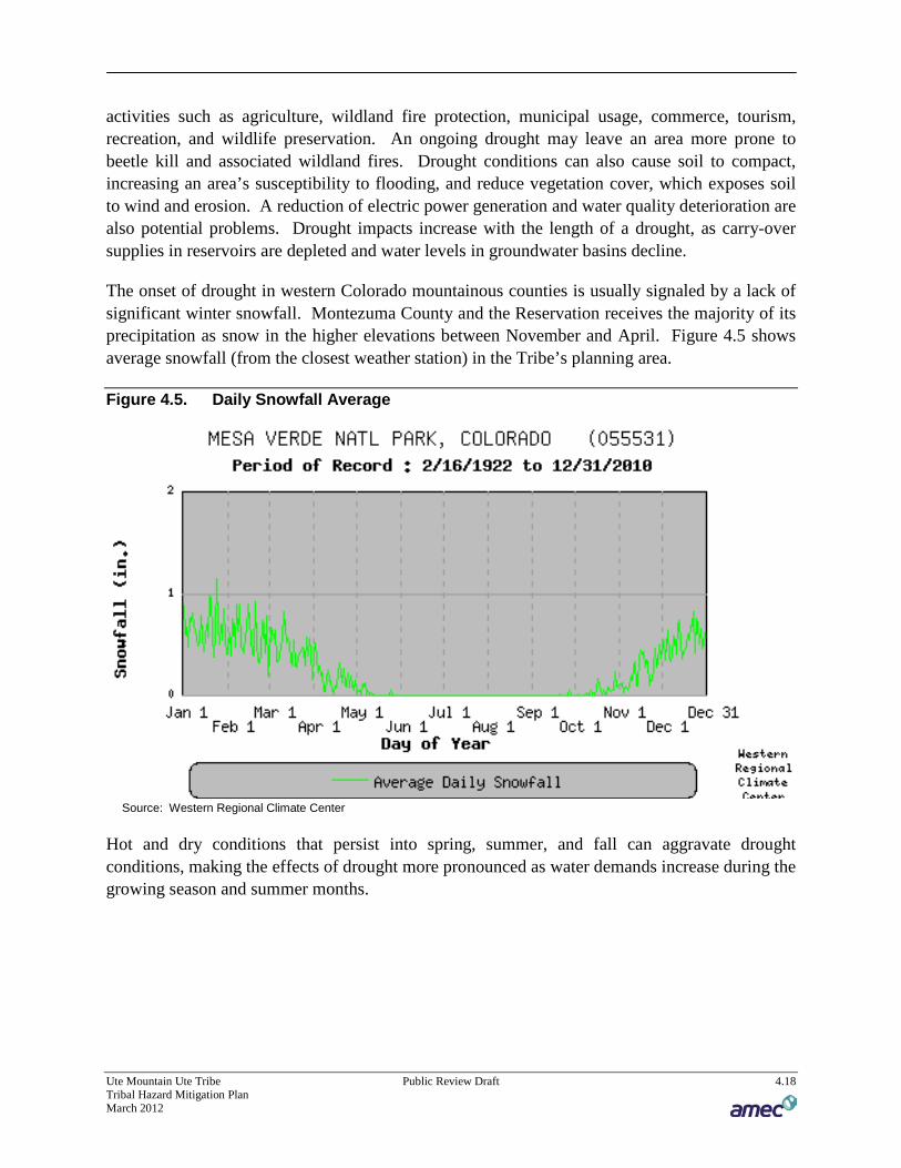
Ute Mountain Ute Tribe Public Review Draft 4.18 Tribal Hazard Mitigation Plan March 2012
activities such as agriculture, wildland fire protection, municipal usage, commerce, tourism, recreation, and wildlife preservation. An ongoing drought may leave an area more prone to beetle kill and associated wildland fires. Drought conditions can also cause soil to compact, increasing an area’s susceptibility to flooding, and reduce vegetation cover, which exposes soil to wind and erosion. A reduction of electric power generation and water quality deterioration are also potential problems. Drought impacts increase with the length of a drought, as carry-over supplies in reservoirs are depleted and water levels in groundwater basins decline.
The onset of drought in western Colorado mountainous counties is usually signaled by a lack of significant winter snowfall. Montezuma County and the Reservation receives the majority of its precipitation as snow in the higher elevations between November and April. Figure 4.5 shows average snowfall (from the closest weather station) in the Tribe’s planning area.
Figure 4.5. Daily Snowfall Average
Source: Western Regional Climate Center
Hot and dry conditions that persist into spring, summer, and fall can aggravate drought conditions, making the effects of drought more pronounced as water demands increase during the growing season and summer months.

Ute Mountain Ute Tribe Public Review Draft 4.19 Tribal Hazard Mitigation Plan March 2012
108BDune Activation
According to a study done by the USGS1F
2, sand dunes and eolian (wind-blown) sheet sands are widely distributed over the southwestern United States, particularly in the southern Great Plains and the southwestern deserts and high plateaus. In the driest parts of the southwest, there are areas of active sand dunes, but most parts have dunes that are stabilized by vegetation and the sand is not moving at present. In the southwestern United States, the largest area of sand dunes is actually not in the deserts, but in the Colorado Plateau region, centered on the four corners area. Sand supplies in the area are abundant from both sandstone bedrock and dry river channels. In this area winds capable of moving sand are dominantly from the southwest (see Figure 4.6). Compared to desert areas around the world where large sand seas are found, the Colorado Plateau has winds capable of moving sand (drift potential) that are very similar.
2 Muhs, Daniel R. and Been, Josh M. Reactivation of Stabilized Sand Dunes on the Colorado Plateau. U.S. Geological Survey. http://geochange.er.usgs.gov/sw/impacts/geology/sand/index.html. Last accessed July 8, 2011.

Ute Mountain Ute Tribe Public Review Draft 4.20 Tribal Hazard Mitigation Plan March 2012
Figure 4.6. Sand Dune Reactivation On or Near the Ute Mountain Ute Reservation
Source: USGS

Ute Mountain Ute Tribe Public Review Draft 4.21 Tribal Hazard Mitigation Plan March 2012
Should a drought persist in the four corners area, the vegetation that stabilizes the sand dunes may die out, and the sand dunes may be reactivated. There is a possibility that the Tribe’s lands could be subject to the activation of sand dunes and could be affected by wind-blown sand and moving dunes, but most of the impacts and dunes are on Navajo and Hopi lands. Reactivation of sand dunes in the area could have impacts on living conditions, grazing, and farming.
45BPast Occurrences
According to the 2004 Drought and Water Supply Assessment, Colorado has experienced multiple severe droughts. Colorado has experienced drought in 2004-2000, 1996, 1994, 1990, 1989, 1979-1975, 1965-1963, 1957-1951, 1941-1931, and 1905-1893 (Source: Colorado Drought Mitigation and Response Plan, 2010). The 1977 drought resulted in a disaster declaration (EM-3025). The most significant of the instrumented period (which began in the late 1800s) are listed in Table 4.6. Although drought conditions can vary across the state, it is likely that the Tribe suffered during these dry periods.
Table 4.6. Historical Dry and Wet Periods in Colorado
Date Dry Wet Duration (years)
1893-1905 X 12
1905-1931 X 26
1931-1941 X 10
1941-1951 X 10
1951-1957 X 6
1957-1959 X 2
1963-1965 X 2
1965-1975 X 10
1975-1978 X 3
1979-1999* X 20
2000-2006* X 6 Source: McKee, et al. *modified for the Colorado State Drought Plan in 2010 based on input from the Colorado Climate Center
Southwestern Colorado, Montezuma County, and the Tribe were impacted by the multi-year drought that began in 1997 and continued into 2004. The summer of 2002 was particularly severe and negatively affected local agriculture and irrigation. The wildland fires that burned that summer had a negative impact on the air quality in the region.
46BLikelihood of Future Occurrence
Likely—Historical drought data for the planning area indicates there have been 8 significant droughts in the last 60 years (1950-2010). This equates to a drought every 7.5 years on average or a 13.3 percent chance of a drought in any given year. Based on this data, droughts will likely affect the planning area.

Ute Mountain Ute Tribe Public Review Draft 4.22 Tribal Hazard Mitigation Plan March 2012
4.2.4 10BEarthquake
47BHazard/Problem Description
An earthquake is caused by a sudden slip on a fault. Stresses in the earth’s outer layer push the sides of the fault together. Stress builds up and the rocks slip suddenly, releasing energy in waves that travel through the earth’s crust and cause the shaking that is felt during an earthquake. The amount of energy released during an earthquake is usually expressed as a Richter magnitude and is measured directly from the earthquake as recorded on seismographs. Richter magnitude is summarized in Table 4.7.
Table 4.7. Richter Scale Magnitudes
Richter magnitudes Description Earthquake effects Frequency of occurrence
Less than 2.0 Micro Micro-earthquakes, not felt. About 8,000 per day
2.0-2.9 Minor
Generally not felt, but recorded About 1,000 per day
3.0-3.9 Often felt, but rarely causes damage. 49,000 per year (est.)
4.0-4.9 Light Noticeable shaking of indoor items, rattling noises. Significant damage unlikely.
6,200 per year (est.)
5.0-5.9 Moderate
Can cause major damage to poorly constructed buildings over small regions. At most slight damage to well-designed buildings.
800 per year
6.0-6.9 Strong Can be destructive in areas up to about 160 kilometres (100 mi) across in populated areas.
120 per year
7.0-7.9 Major Can cause serious damage over larger areas. 18 per year
8.0-8.9 Great
Can cause serious damage in areas several hundred miles across. 1 per year
9.0-9.9 Devastating in areas several thousand miles across. 1 per 20 years
Source: US Geological Survey Earthquake Hazards Program FAQ - http://earthquake.usgs.gov/learn/faq/?categoryID=2
Another measure of earthquake severity is intensity. Intensity is an expression of the amount of shaking at any given location on the ground surface as felt by humans and defined in the Modified Mercalli scale (see Table 4.8).
Table 4.8. Modified Mercalli Intensity (MMI) Scale
MMI Felt Intensity I Not felt except by a very few people under special conditions. Detected mostly by instruments.
II Felt by a few people, especially those on upper floors of buildings. Suspended objects may swing.
III Felt noticeably indoors. Standing automobiles may rock slightly.
IV Felt by many people indoors, by a few outdoors. At night, some people are awakened. Dishes, windows, and doors rattle.
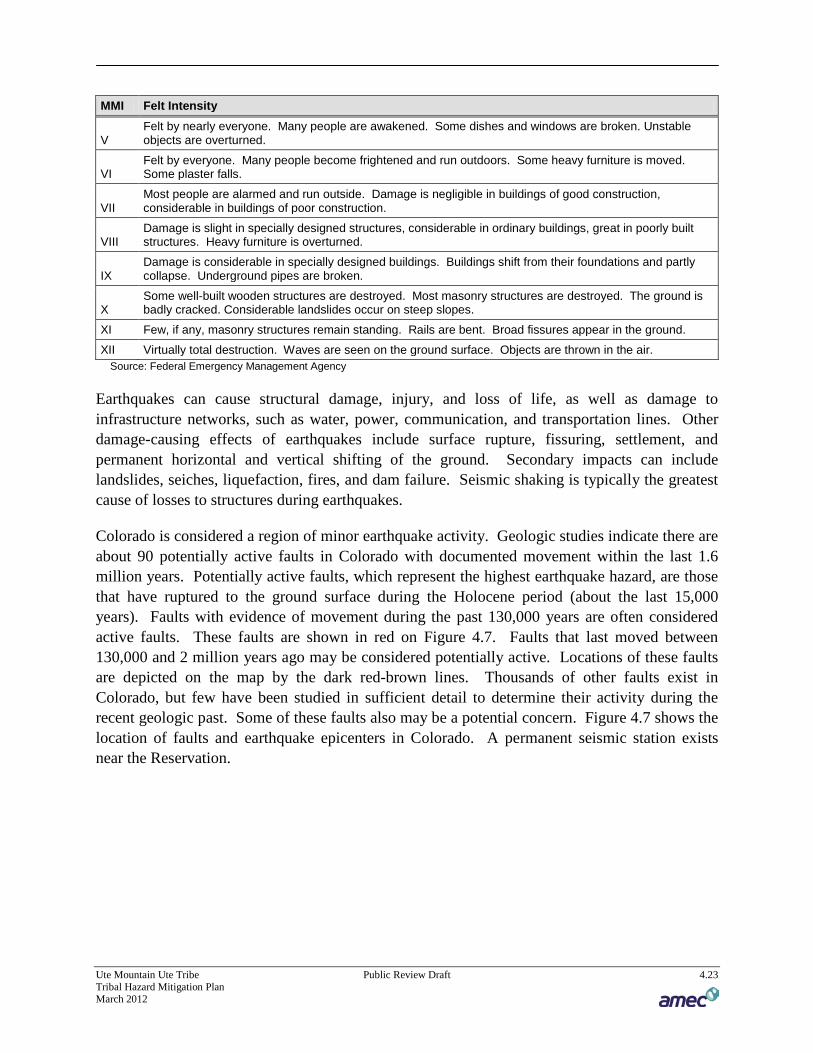
Ute Mountain Ute Tribe Public Review Draft 4.23 Tribal Hazard Mitigation Plan March 2012
MMI Felt Intensity
V Felt by nearly everyone. Many people are awakened. Some dishes and windows are broken. Unstable objects are overturned.
VI Felt by everyone. Many people become frightened and run outdoors. Some heavy furniture is moved. Some plaster falls.
VII Most people are alarmed and run outside. Damage is negligible in buildings of good construction, considerable in buildings of poor construction.
VIII Damage is slight in specially designed structures, considerable in ordinary buildings, great in poorly built structures. Heavy furniture is overturned.
IX Damage is considerable in specially designed buildings. Buildings shift from their foundations and partly collapse. Underground pipes are broken.
X Some well-built wooden structures are destroyed. Most masonry structures are destroyed. The ground is badly cracked. Considerable landslides occur on steep slopes.
XI Few, if any, masonry structures remain standing. Rails are bent. Broad fissures appear in the ground.
XII Virtually total destruction. Waves are seen on the ground surface. Objects are thrown in the air. Source: Federal Emergency Management Agency
Earthquakes can cause structural damage, injury, and loss of life, as well as damage to infrastructure networks, such as water, power, communication, and transportation lines. Other damage-causing effects of earthquakes include surface rupture, fissuring, settlement, and permanent horizontal and vertical shifting of the ground. Secondary impacts can include landslides, seiches, liquefaction, fires, and dam failure. Seismic shaking is typically the greatest cause of losses to structures during earthquakes.
Colorado is considered a region of minor earthquake activity. Geologic studies indicate there are about 90 potentially active faults in Colorado with documented movement within the last 1.6 million years. Potentially active faults, which represent the highest earthquake hazard, are those that have ruptured to the ground surface during the Holocene period (about the last 15,000 years). Faults with evidence of movement during the past 130,000 years are often considered active faults. These faults are shown in red on Figure 4.7. Faults that last moved between 130,000 and 2 million years ago may be considered potentially active. Locations of these faults are depicted on the map by the dark red-brown lines. Thousands of other faults exist in Colorado, but few have been studied in sufficient detail to determine their activity during the recent geologic past. Some of these faults also may be a potential concern. Figure 4.7 shows the location of faults and earthquake epicenters in Colorado. A permanent seismic station exists near the Reservation.
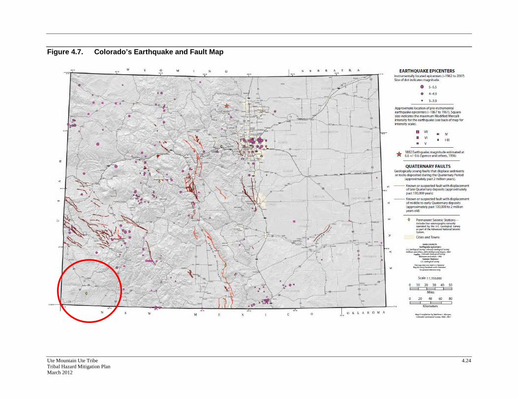
Ute Mountain Ute Tribe 4.24 Tribal Hazard Mitigation Plan March 2012
Figure 4.7. Colorado’s Earthquake and Fault Map

Ute Mountain Ute Tribe 4.25 Tribal Hazard Mitigation Plan March 2012
In the 2008 State Hazard Mitigation Plan, extensive discussion about earthquake hazards indicates that the historical assumption about earthquake vulnerability in the state (namely, that said vulnerability is low) may be false. The “Earthquake Evaluation Report” issued by the Colorado Geological Survey (CGS) is included as an Annex in the 2008 State Plan. This report extensively reviews the history of earthquake analysis in the State, and indicates that significant funding and time investments are required to determine a more realistic evaluation of the earthquake threat to the State. As part of the report, the CGS ran HAZUS (FEMA’s HAZards United States software) to perform several different loss prediction analyses. The CGS determined that there were no active faults near the Tribe. The Four Corners region is considered to be relatively stable by geologists.
The U.S. Geological Survey (USGS) issues National Seismic Hazard Maps as reports every few years. These maps provide various acceleration and probabilities for time periods. Figure 4.8 depicts the peak horizontal acceleration (%g) with 10% probability of exceedance in 50 years for the planning region. The figure demonstrates that almost the entire Tribe falls in the 2%g area.
Figure 4.8. Ute Mountain Ute Seismic Hazard Map – 10% Probability of Exceedance in 50 Years
Source: USGS National Seismic Hazard Maps – 2008 Interactive Tool. Available online at http://gldims.cr.usgs.gov/nshmp2008/viewer.htm

Ute Mountain Ute Tribe Public Review Draft 4.26 Tribal Hazard Mitigation Plan March 2012
Figure 4.9 depicts the peak horizontal acceleration (%g) with 2% probability of exceedance in 50 years for the planning region. The figure demonstrates that almost the entire Tribe falls in the 6-8%g area. Damage is usually not associated with ground motions below 20-30%g.
Figure 4.9. Ute Mountain Ute Seismic Hazard Map – 2% Probability of Exceedance in 50 Years
Source: USGS National Seismic Hazard Maps – 2008 Interactive Tool. Available online at http://gldims.cr.usgs.gov/nshmp2008/viewer.htm
48BPast Occurrences
The Earthquake Evaluation Report reported no earthquakes have affected the Montezuma County and the Ute Mountain Ute Tribe in the past. A further search of the U.S. Geological Survey Earthquake Database showed no earthquake of greater than 5.0 magnitude in a 100 mile radius of Towaoc between 1973 and 2011.
49BLikelihood of Future Occurrence
Unlikely— Based on the lack of active faults, the absence of past occurrences, and USGS probabilistic hazard mapping the likelihood of a future damaging earthquake is unlikely.

Ute Mountain Ute Tribe Public Review Draft 4.27 Tribal Hazard Mitigation Plan March 2012
4.2.5 11BExtreme Temperatures
50BHazard/Problem Description
Temperature extremes - both cold and hot - cause more deaths every year than any other disaster, including hurricanes.2F
3 Both extreme cold and extreme heat are hazards present in the planning area.
109BExtreme Cold
Extreme cold often accompanies a winter storm or is left in its wake. It is most likely to occur in the winter months of December, January, and February. Prolonged exposure to the cold can cause frostbite or hypothermia and can become life-threatening. Infants and the elderly are most susceptible. Pipes may freeze and burst in homes or buildings that are poorly insulated or without heat. Extreme cold can disrupt or impair communications facilities.
In 2001, the NWS implemented an updated Wind Chill Temperature index, which is reproduced in Figure 4.10. This index was developed to describe the relative discomfort/danger resulting from the combination of wind and temperature. Wind chill is based on the rate of heat loss from exposed skin caused by wind and cold. As the wind increases, it draws heat from the body, driving down skin temperature and eventually the internal body temperature.
3 Kevin A. Borden and Susan L. Cutter “Spatial Patterns of Natural Hazards Mortality in the United States.” International Journal of Health Geographics 2008, 7:64. Available online at http://www.ij-healthgeographics.com/content/7/1/64 last accessed July 13, 2009.

Ute Mountain Ute Tribe Public Review Draft 4.28 Tribal Hazard Mitigation Plan March 2012
Figure 4.10. Wind Chill Temperature Chart
Source: National Weather Service
110BExtreme Heat
According to information provided by FEMA, extreme heat is defined as temperatures that hover 10 degrees or more above the average high temperature for the region and last for several weeks. Heat kills by taxing the human body beyond its abilities. In a normal year, about 175 Americans succumb to the demands of summer heat. According to the National Weather Service (NWS), among natural hazards, only the cold of winter—not lightning, hurricanes, tornados, floods, or earthquakes—takes a greater toll. In the 40-year period from 1936 through 1975, nearly 20,000 people were killed in the United States by the effects of heat and solar radiation. In the heat wave of 1980, more than 1,250 people died.
Heat disorders generally have to do with a reduction or collapse of the body’s ability to shed heat by circulatory changes and sweating or a chemical (salt) imbalance caused by too much sweating. When heat gain exceeds the level the body can remove, or when the body cannot compensate for fluids and salt lost through perspiration, the temperature of the body’s inner core begins to rise and heat-related illness may develop. Elderly persons, small children, chronic invalids, those on certain medications or drugs, and persons with weight and alcohol problems are particularly susceptible to heat reactions, especially during heat waves in areas where moderate climate usually prevails. Figure 4.11 illustrates the relationship of temperature and humidity to heat disorders.

Ute Mountain Ute Tribe Public Review Draft 4.29 Tribal Hazard Mitigation Plan March 2012
Figure 4.11. Heat Index
Source: National Weather Service Note: Since HI values were devised for shady, light wind conditions, exposure to full sunshine can increase HI values by up to 15°F. Also, strong winds, particularly with very hot, dry air, can be extremely hazardous.
The NWS has in place a system to initiate alert procedures (advisories or warnings) when the Heat Index is expected to have a significant impact on public safety. The expected severity of the heat determines whether advisories or warnings are issued. A common guideline for the issuance of excessive heat alerts is when the maximum daytime high is expected to equal or exceed 105°F and a nighttime minimum high of 80°F or above is expected for two or more consecutive days.
51BPast Occurrences
111BExtreme Cold
In a region known for extremely cold weather, exacerbated by high winds, temperature extremes and particularly severe cold present a danger to the inhabitants of the planning area. Surprisingly, the NCDC database reflects no extreme cold and extreme wind-chill events in the planning region between 1996 and 2010. The 2010 State Hazard Mitigation Plan does record the following events that affected the planning area that include unseasonable temperatures/freezes.
June 1999—A late freeze destroyed grapes and vegetables in southwestern Colorado. ~$0.004M crop damage were reported.

Ute Mountain Ute Tribe Public Review Draft 4.30 Tribal Hazard Mitigation Plan March 2012
June 2001—A hard freeze struck southwest Colorado. Temperatures between 25 and 30 degrees remained for several hours with widespread damage to pinto bean and tomato crops.
December 2005—Extreme cold and wind chill. Record breaking cold temperatures were reported in western Colorado. Frozen water pipes burst in many areas.
The Colorado Department of Public Health & Environment tracks the number of hospitalizations due to extreme cold on the Colorado Health Information Dataset. Data is available by County, but not broken down to the tribal level. In Montezuma County, 14 people were hospitalized due to extreme cold (at a rate of 3.9 per 100,000 people) from 1995 to 2009. These rates are considered higher than the rate for the state. Statewide statistics indicate that 1,388 people were hospitalized for extreme cold injuries during this time period, with an occurrence rate of 2.1 per 100,000.3F
4
The 2010 State Hazard Mitigation Plan includes information that shows the extreme temperatures in degrees Fahrenheit between 1961 and 1990, which is replicated for the Tribe in Table 4.9.
Table 4.9. Temperature Extremes for Montezuma County, 1961-1990
Counties Extreme Low (ºF)
Montezuma -27° Source: 2010 Colorado State Hazard Mitigation Plan
112BExtreme Heat
In a region known for extreme weather, extreme heat presents a danger to the inhabitants of the planning area. Surprisingly, the NCDC database reflects no extreme heat in the planning region between 1996 and 2010. Elevation of the Reservation reduces the number of extreme heat events each year. The 2008 State Hazard Mitigation Plan does contain two maps, shown here as Figure 4.12 and Figure 4.13, that show average numbers of days per year exceeding 90° and 100°F. According to these maps Montezuma County may have 20 to 30 days of 90°F or greater temperatures a year, and less than 3 days with temperatures exceeding 100°F.
4 Colorado Health Information Dataset, Injury Hospitalization Statistics. Available online at http://www.cdphe.state.co.us/cohid/injury.html accessed July 7, 2011.

Ute Mountain Ute Tribe Public Review Draft 4.31 Tribal Hazard Mitigation Plan March 2012
Figure 4.12. Number of Days with Temperatures Exceeding 100°F
Source: 2010 Colorado State Hazard Mitigation Plan, data adapted from http://hpccsun.unl.edu/coop/atlas/temps100.gif

Ute Mountain Ute Tribe Public Review Draft 4.32 Tribal Hazard Mitigation Plan March 2012
Figure 4.13. Number of Days with Temperatures Exceeding 90°F
Source: 2010 Colorado State Hazard Mitigation Plan, data adapted from http://hpccsun.unl.edu/coop/atlas/temps100.gif
Unfortunately, the health department does not track heat-related injury or mortality statistics in the State of Colorado by county. The NCDC database does not reflect any extreme heat incidents, outside of those captured as drought, for the region either. However, some extrapolation for the severity of extreme heat in the region can be drawn based on the national weather service heat index illustrated above. The Colorado Climate Center notes that the humidity of the eastern plains is very low, but that the highest temperatures in the state occur in this region. This indicates that while many hot days in the planning area fall in the ‘danger’ or ‘extreme danger’ area of the heat index, the low humidity may make the heat feel less uncomfortable on the population. It is possible; therefore, that the population may not notice the effects of extreme heat on themselves until serious injury occurs.
The 2010 State Hazard Mitigation Plan did not indicate any occurrences of extreme heat between 1961 and 1990 in the vicinity of the reservation.
52BLikelihood of Future Occurrence
Likely—Temperature variations are expected in the area. While extremes are usually statistical outliers, they still present a useful picture of potential ranges. These events are expected to occur yearly, in general, and are considered likely, particularly for extreme cold. The Reservation’s

Ute Mountain Ute Tribe Public Review Draft 4.33 Tribal Hazard Mitigation Plan March 2012
typical elevation of 5,000-6000 feet or higher will provide some protection from extreme heat events, but long term climate change may increase the likelihood of these events in the future.
4.2.6 12BFlood
53BHazard/Problem Description
Floods are among the most frequent and costly natural disasters in terms of human hardship and economic loss and are usually caused by weather events. Floods can cause substantial damage to structures, landscapes, and utilities as well as life safety issues. Certain health hazards are also common to flood events. Standing water and wet materials in structures can become breeding grounds for microorganisms such as bacteria, mold, and viruses. This can cause disease, trigger allergic reactions, and damage materials long after the flood. When floodwaters contain sewage or decaying animal carcasses, infectious disease becomes a concern. Direct impacts, such as drowning, can be limited with adequate warning and public education about what to do during floods. Where flooding occurs in populated areas, warning and evacuation will be of critical importance to reduce life and safety impacts.
The planning area is susceptible to various types of flood events as described below.
• Riverine flooding—Riverine flooding, defined as when a watercourse exceeds its “bank-full” capacity, generally occurs as a result of prolonged rainfall, or rainfall that is combined with already saturated soils from previous rain events. This type of flood occurs in river systems whose tributaries may drain large geographic areas and include one or more independent river basins. The onset and duration of riverine floods may vary from a few hours to many days. Factors that directly affect the amount of flood runoff include precipitation amount, intensity and distribution, the amount of soil moisture, seasonal variation in vegetation, snow depth, and water-resistance of the surface due to urbanization. In the planning area, riverine flooding is largely caused by heavy and continued rains, increased outflows from upstream dams, and heavy flow from tributary streams. These intense storms can overwhelm the local waterways as well as the integrity of any flood control structures. The warning time associated with slow rise floods assists in life and property protection.
• Flash Flooding—Flash flooding describes localized floods of great volume and short duration. This type of flood usually results from a heavy rainfall on a relatively small drainage area. Precipitation of this sort usually occurs in the winter and spring. Flash floods often require immediate evacuation.
• Localized flooding—Localized flooding problems are often caused by flash flooding, severe weather, or an unusual amount of rainfall. Flooding from these intense weather events usually occurs in areas experiencing an increase in runoff from impervious surfaces associated with development and urbanization as well as inadequate storm drainage systems.

Ute Mountain Ute Tribe Public Review Draft 4.34 Tribal Hazard Mitigation Plan March 2012
The area adjacent to a channel is the floodplain, as shown in Figure 4.14. In its common usage, the floodplain most often refers to that area that is inundated by the 100-year flood, the flood that has a 1% chance in any given year of being equaled or exceeded. A floodplain is flat or nearly flat land adjacent to a stream or river that experiences occasional or periodic flooding. It includes the floodway, which consists of the stream channel and adjacent areas that carry flood flows, and the flood fringe, which are areas covered by the flood, but which do not experience a strong current. Floodplains are made when floodwaters exceed the capacity of the main channel or escape the channel by eroding its banks. When this occurs, sediments (including rocks and debris) are deposited that gradually build up over time to create the floor of the floodplain. Floodplains generally contain unconsolidated sediments, often extending below the bed of the stream.
Figure 4.14. Floodplain Topography
Source: FEMA
The nature of flooding problems within Montezuma County and The Reservation include: general frontal type rainstorms, convective type cloudbursts, and snowmelt. Frontal type rainstorms present the most serious flood hazard. In May to June the combination of spring snowmelt runoff and thunderstorms perpetuate the potential for severe flooding. Antecedent ground moisture also contributes to flood characteristics.

Ute Mountain Ute Tribe Public Review Draft 4.35 Tribal Hazard Mitigation Plan March 2012
113BWatershed Systems and Major Sources of Flooding in the Tribal Area
The planning area contains 4 separate and distinct watersheds. Each watershed, or drainage basin, contains a river or creek. Watersheds drain and move water through the planning area and are often sources of flooding. These watersheds are shown on Figure 4.2 in Section 4.2.2, and described in Table 4.10. The major watersheds are the McElmo Creek and Mancos River watersheds. There are numerous washes and arroyos across the Reservation that are normally dry that could be sources of flash flooding during cloudbursts or other significant rain events. Cottonwood Wash is one of these drainages that flows through the community of Towaoc and has a watershed that drains a portion of the Sleeping Ute Mountain.
Table 4.10. Watersheds in the Planning Area
BASIN SUBBASIN SQ MILES STATE
Upper Colorado-Dolores Upper Dolores 2,157 CO UT
Upper San Juan Middle San Juan 1,945 AZ CO NM
Upper San Juan Animas 1,370 CO NM
Upper San Juan Mancos 803 CO NM
Lower San Juan Montezuma 1,169 CO UT
Lower San Juan Lower San Juan-Four Corners 1,994 AZ CO NM UT
Lower San Juan McElmo 717 CO UT Source: National Resource Conservation Service Rapid Assessments. http://www.co.nrcs.usda.gov/technical/ WaterRes/WaterResources.html
54BPrevious Occurrences
114BMajor Events
There have been several floods on the Mancos River and McElmo Creek which traverse portions of the reservation. Although a continuous gage record for the Mancos River does not exist (October 1920 to September 1943, February 1951 to current year), and area stream gage records indicate that high water and major flood events have occurred in 1921, 1929, 1934, 1936, 1937, 1940, 1942, 1953, 1957, 1970, 1979, 1986, and 2003. Peak discharges associated with these are summarized in Table 4.11.
Table 4.11. Mancos River Peak Streamflow
Water Year Date Streamflow (cfs)
1921 August 25 1,990
1929 August 5 2,210
1934 August 26 4,900
1936 September 3 2,310
1937 July 28 2,350
1940 September 22 4,600
Ute Mountain Ute Tribe Public Review Draft 4.36 Tribal Hazard Mitigation Plan March 2012
Water Year Date Streamflow (cfs)
1942 October 14 5,300
1953 July 30 4,300
1957 August 6 2,780
1970 September 6 4,530
1979 May 27 2,200
1986 April 3 2,000
2003 September 10 3,530 Source: USGS National Water Information System (USGS Gage 093710004F
5)
Streamflow records for the McElmo Creek are continuous back to 1951. Flood events occurred in 1967, 1970, 1986, 1989, 1997, and 2005. Peak discharges are summarized in Table 4.12.
Table 4.12. McElmo Creek Peak Streamflow
Water Year Date Streamflow (cfs)
1967 August 7 3,040
1970 September 6 2,880
1986 September 24 2,850
1989 July 31 2,170
1997 September 21 2,840
2005 September 30 2,360 Source: USGS National Water Information System (USGS Gage 093720005F
6)
115BFlash Flood Events
In addition to these flood events, the Reservation has been at risk to flash flooding. The NCDC records the following flash flood events dating back to 1993.
September 9, 2003—Two cars became stuck in deep mud flows as flash flooding inundated Highway 491 near mile marker 1.
September 29, 2005—Flash flooding was reported in many areas of Montezuma County where 3 to 5 inches of rain fell within a 12 hour period between midnight and noon. Flood waters were still flowing high in the early evening hours. A house located in a flood plain was inundated with about 4 feet of water and furniture was observed floating in the yard. About 2 feet of water also inundated a nearby restaurant at the intersection of Highways 491 and 184. Many roads
5 Location.--Lat 37°01'39", long 108°44'27", Ute Indian Reservation, Montezuma County, on left bank 700 ft upstream from bridge on U.S. Highway 666, 2.0 mi north of Colorado-New Mexico State line, 6.0 mi upstream from Aztec Creek, and 12 mi south of Towaoc. 6 Location.--Lat 37°19'27", long 109°00'54", in NE sec.2, T.35 N., R.20 W., Montezuma County, on right bank 1.5 mi upstream from Colorado-Utah State line, 2.0 mi upstream from Yellowjacket Creek, and 2.0 mi west of former town of McElmo.
Ute Mountain Ute Tribe Public Review Draft 4.37 Tribal Hazard Mitigation Plan March 2012
were closed, including those in McElmo Canyon area where residents were evacuated. Road washouts occurred in many areas and some bridges were destroyed.
June 8, 2006—Heavy rainfall from a thunderstorm cell that moved north over Sleeping Ute Mountain and then across McElmo Canyon produced flash flooding which heavily damaged a number of bridges, driveways, and irrigation ditches. Damage also was reported to sideroll irrigation systems. Flood waters 10 to 12 feet deep rushed down some large and normally dry arroyos, and extensive erosion occurred throughout the flooded areas. Eight to ten inches of water flooded streets in the town of Towaoc. A combination of flood waters and hail damaged the crops of many vineyards, orchards, hay and alfalfa fields. The water rose so quickly that one farmer had to abandon his truck and move to higher ground, leaving the truck to be engulfed by the flood waters. The bridge over State Route 160 flooded from debris that washed down the river during the flood.
55BLikelihood of Future Occurrences
Occasional–Although there have been flood events in the planning area of various return frequencies, the likelihood of a 100-year flood event (or 1% annual chance event) of occurring that damages property on the Reservation is occasional. The impact of flooding is described further in Section 4.3.
4.2.7 13BHazardous Materials
56BHazard/Problem Description
The Reservation is susceptible to accidents involving hazardous materials on roads, highways, and at fixed facilities that manufacture, use, or store dangerous chemical substances. A hazardous materials incident may occur at any time during routine business operations or as a result of a natural disaster. The release of hazardous materials can threaten people and natural resources in the immediate vicinity of the accident. Air releases can prompt large-scale population evacuations and spills into water or onto the ground can adversely affect public water and sewer systems.
A transportation incident refers to accidental and uncontrolled releases of chemicals or other hazardous materials during transport (i.e., highways, pipelines, and airways). A fixed-facility incident is an uncontrolled release of chemicals or other potentially hazardous materials from a facility. Fixed facilities include companies that store hazardous waste at their facility and also all hazardous waste sites. Begun in 1988, the Toxics Release Inventory (TRI) is a federal program established by the U.S. Environmental Protection Agency that contains information on releases of nearly 650 chemicals and chemical categories from industries including manufacturing, metal and coal mining, electric utilities, and commercial hazardous waste treatment, among others. TRI facilities are required to file reports of their disposal or other environmental releases as well as other waste management quantities of regulated chemicals if they manufacture, process, or otherwise use more than the established threshold quantities of these chemicals. The Tribe has
Ute Mountain Ute Tribe Public Review Draft 4.38 Tribal Hazard Mitigation Plan March 2012
no reported TRI data. The presence of large propane tanks near populated areas in Towaoc is one of the greater concerns for a fixed facility incident.
Note: The TRI does not cover all toxic chemicals that have the potential to adversely affect human health or the environment. The data does not include emissions from mobile sources nor releases of pesticides, volatile organic compounds, or fertilizers from many nonindustrial sources.
Highways 160 and 491 are authorized hazardous materials routes. According to the THMPC, trucks transporting nuclear waste on these highways from New Mexico to Utah are of particular concern to the Tribe. The 2011 Colorado CDOT haz-mat route maps show 160 and 491 as non-nuclear transport routes. However, in 2005, the tribe was notified that nuclear materials were being shipped from a weapons facility in New Mexico to Utah with both land and air support. Since the Reservation is subject to severe weather transportation of hazardous materials is at higher risk to accidents on from winter storms, ice, wildlife, and debris on the roadways.
The Reservation is home to 140 oil wells that supply crude to storage tanks. These fixed facilities are at risk to leaks to the tanks, or to leaks that may occur during transport of stored oil to transport vehicles. Hydrogen sulfide gas occurs naturally underground but is a potentially harmful to human health when it is released during oil and gas drilling operations. Drill workers usually receive training to recognize the gas, but first responders may be vulnerable if they are responding to an incident and have not been properly trained. This gas can also be a fire/explosion hazard if there is a wildfire in the vicinity of the well (see the wildfire hazard profile in Section 4.2.12).
57BPast Occurrences
The EPA's Toxic Release Inventory (TRI) does not indicate any major release of hazardous materials in the Reservation since 1994. There was a sulfuric acid release in 1993, but off-site impacts were not recorded. According to the THMPC, oil spills have occurred at various sites in small amounts. The THMPC also indicated that there has been a hydrogen sulfide release in the past, but it was not a reportable incident.
February 2010 – 5-10 barrels leaked into water way on reservation. The water ran downstream off the reservation. Clean up costs estimates were not available.
1995 thru 99 – There was a pesticide cleanup effort at Mancos farms thru a Brownfield project. Remediation efforts included recapping soil. Clean up costs estimates were not available.
58BLikelihood of Future Occurrence
Likely–The potential for a hazardous materials incident in the planning area is very real. Highway 160 has several sharp curves and narrow passages in places, making it a potential dangerous route for trucks transporting hazardous materials. Although there have been no TRI

Ute Mountain Ute Tribe Public Review Draft 4.39 Tribal Hazard Mitigation Plan March 2012
recorded incidents in the Reservation, the presence of oil wells in the Reservation, coupled with the high amount of hazardous materials transported through the Reservation on Highway 491 and 160, bring risk of hazardous materials spills to the Reservation.
4.2.8 14BLandslide/Rockfall
59BHazard/Problem Description
116BLandslide
A landslide is a general term for a variety of mass-movement processes that generate a downslope movement of soil, rock, and vegetation under gravitational influence. Some of the natural causes of ground instability are stream and lakeshore erosion, heavy rainfall, and poor quality natural materials. In addition, many human activities tend to make the earth materials less stable and, thus, increase the chance of ground failure. Human activities contribute to soil instability through grading of steep slopes or overloading them with artificial fill, by extensive irrigation, construction of impermeable surfaces, excessive groundwater withdrawal, and removal of stabilizing vegetation. Landslides typically have a slower onset and can be predicted to some extent by monitoring soil moisture levels and ground cracking or slumping in areas of previous landslide activity.
In this chapter, the discussion of landslides is more extensive than that of rockfall or debris flow. The primary reason is availability of information. Landslides in the planning area have a more detailed history of record than rockfall or debris flow. Additionally, landslides potentially present a very serious threat to the planning area. Debris flow and rockfall, though still dangerous, are not as significant to the planning area.
117BRockfall
A rockfall is the falling of a detached mass of rock from a cliff or down a very steep slope. Weathering and decomposition of geological materials produce conditions favorable to rockfalls. Rockfalls are caused by the loss of support from underneath through erosion or triggered by ice wedging, root growth, or ground shaking. Changes to an area or slope such as cutting and filling activities can also increase the risk of a rockfall. Rocks in a rockfall can be of any dimension, from the size of baseballs to houses. Rockfall occurs most frequently in mountains or other steep areas during the early spring when there is abundant moisture and repeated freezing and thawing. Rockfalls are a serious geological hazard that can threaten human life, impact transportation corridors and communication systems and result in other property damage.
Spring is typically the landslide/rockfall season in Colorado as snow melts and saturates soils and temperatures enter into freeze/thaw cycles. Rockfall and landslides are influenced by seasonal patterns, precipitation and temperature patterns. Earthquakes could trigger rockfalls and landslides too.

Ute Mountain Ute Tribe Public Review Draft 4.40 Tribal Hazard Mitigation Plan March 2012
Figure 4.15 shows areas of landslide and rockfall in Colorado and the planning area.
Figure 4.15. Landslide, Mudslide, Rockfall, and Debris Flow in the Planning Area
60BPast Occurrences
118BLandslide
According to the THMPC, there have been no recorded occurrences in the past 20-30 years.
119BRockfall
According to the THMPC, there have been no recorded occurrences in the past 20-30 years.

Ute Mountain Ute Tribe Public Review Draft 4.41 Tribal Hazard Mitigation Plan March 2012
61BLikelihood of Future Occurrence
120BLandslide
Likely—While there have been no recorded incidents in recent history, steep slopes in the area make the chance of future landslides likely.
121BRockfall
Likely—While there have been no recorded incidents in recent history, steep slopes in the area make the chance of future rockfall likely.
4.2.9 15BSevere Weather: Hail/Lightning/Wind
62BHazard/Problem Description
122BHail
Hail is associated with thunderstorms that can also bring high winds and tornados. It forms when updrafts carry raindrops into extremely cold areas of the atmosphere where they freeze into ice. Hail falls when it becomes heavy enough to overcome the strength of the updraft and is pulled by gravity towards the earth. Hailstorms occur throughout the spring, summer, and fall in the region, but are more frequent in late spring and early summer. Hailstones are usually less than two inches in diameter and can fall at speeds of 120 mph. Hail causes nearly $1 billion in damage to crops and property each year in the United States. Hail is also one of the requirements which the National Weather Service uses to classify thunderstorms as ‘severe.’ If hail more than ¾ of an inch is produced in a thunderstorm, it qualifies as severe.
The National Weather Service classifies hail by diameter size, and corresponding everyday objects to help relay scope and severity to the population. Table 4.13 indicates the hailstone measurements utilized by the National Weather Service.
Table 4.13. Hailstone Measurements
Average Diameter Corresponding Household Object
.25 inch Pea
.5 inch Marble/Mothball
.75 inch Dime/Penny
.875 inch Nickel
1.0 inch Quarter
1.5 inch Ping-pong ball
1.75 inch Golf-Ball
2.0 inch Hen Egg
2.5 inch Tennis Ball

Ute Mountain Ute Tribe Public Review Draft 4.42 Tribal Hazard Mitigation Plan March 2012
Average Diameter Corresponding Household Object
2.75 inch Baseball
3.00 inch Teacup
4.00 inch Grapefruit
4.5 inch Softball Source: National Weather Service
There is no clear distinction between storms that do and do not produce hailstones. Nearly all severe thunderstorms probably produce hail aloft, though it may melt before reaching the ground. Multi-cell thunderstorms produce many hailstones, but not usually the largest hailstones. In the life cycle of the multi-cell thunderstorm, the mature stage is relatively short so there is not much time for growth of the hailstone. Supercell thunderstorms have sustained updrafts that support large hail formation by repeatedly lifting the hailstones into the very cold air at the top of the thunderstorm cloud. In general, hail 2 inches (5 cm) or larger in diameter is associated with supercells (a little larger than golf ball size which the NWS considers to be 1.75 inch.). Non-supercell storms are capable of producing golf ball size hail.
In all cases, the hail falls when the thunderstorm’s updraft can no longer support the weight of the ice. The stronger the updraft the larger the hailstone can grow. Nebraska, Colorado, and Wyoming usually have the most hail storms in the United States. The area where these three states meet – “hail alley,” averages seven to nine hail days per year. The reason why this area gets so much hail is that the freezing levels (the area of the atmosphere at 32 degrees or less) in the high plains are much closer to the ground than they are at sea level, where hail has plenty of time to melt before reaching the ground.
When viewed from the air, it is evident that hail falls in paths known as hail swaths. They can range in size from a few acres to an area 10 miles wide and 100 miles long. In some instances, piles of hail in hail swaths have been so deep, a snow plow was required to remove them, and occasionally, hail drifts have been reported. Figure 4.16 shows the average number of days of hail per year in the United States, with the planning area outlined in a white oval. Figure 4.17 shows the average number of days of severe hail (over two inches in diameter) per year in the United States, with the planning area outlined in a white oval.
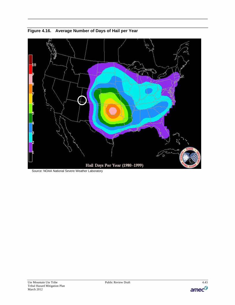
Ute Mountain Ute Tribe Public Review Draft 4.43 Tribal Hazard Mitigation Plan March 2012
Figure 4.16. Average Number of Days of Hail per Year
Source: NOAA National Severe Weather Laboratory
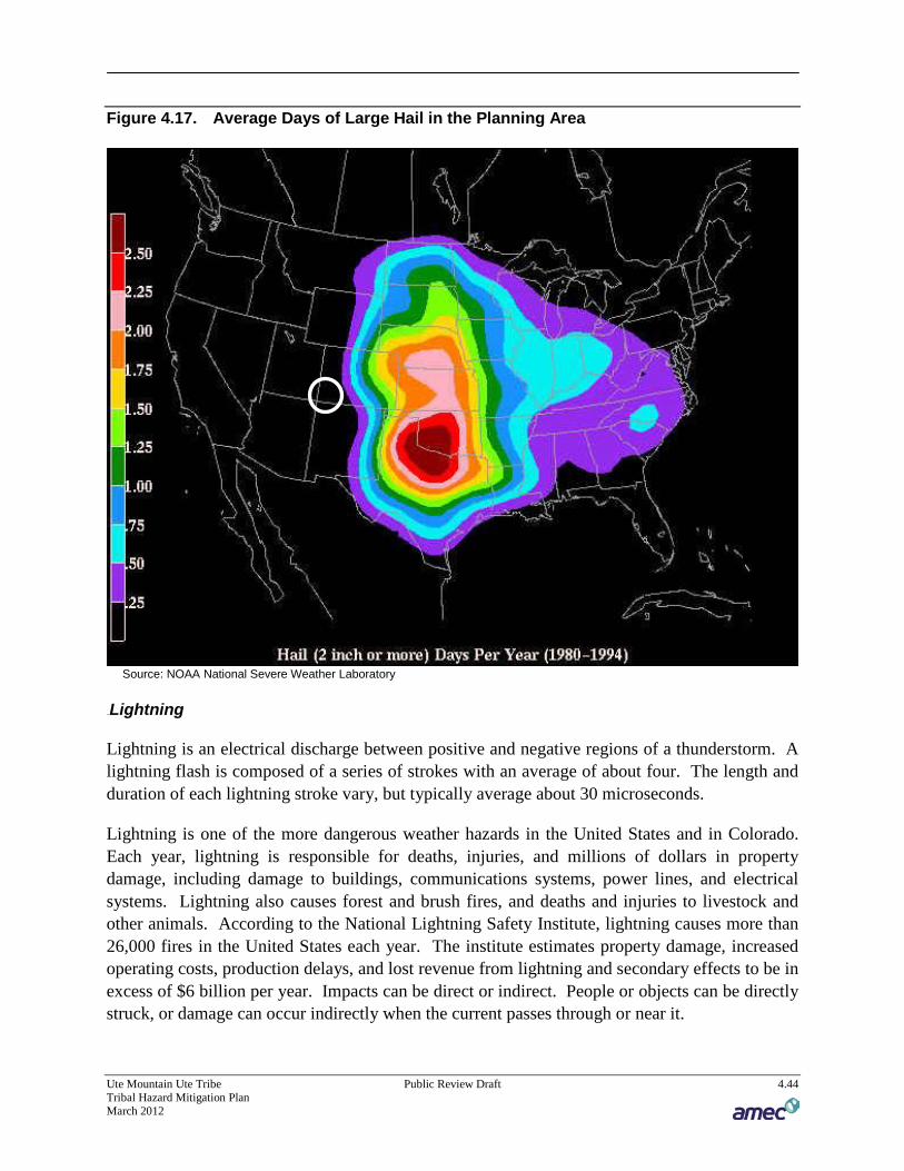
Ute Mountain Ute Tribe Public Review Draft 4.44 Tribal Hazard Mitigation Plan March 2012
Figure 4.17. Average Days of Large Hail in the Planning Area
Source: NOAA National Severe Weather Laboratory
123BLightning
Lightning is an electrical discharge between positive and negative regions of a thunderstorm. A lightning flash is composed of a series of strokes with an average of about four. The length and duration of each lightning stroke vary, but typically average about 30 microseconds.
Lightning is one of the more dangerous weather hazards in the United States and in Colorado. Each year, lightning is responsible for deaths, injuries, and millions of dollars in property damage, including damage to buildings, communications systems, power lines, and electrical systems. Lightning also causes forest and brush fires, and deaths and injuries to livestock and other animals. According to the National Lightning Safety Institute, lightning causes more than 26,000 fires in the United States each year. The institute estimates property damage, increased operating costs, production delays, and lost revenue from lightning and secondary effects to be in excess of $6 billion per year. Impacts can be direct or indirect. People or objects can be directly struck, or damage can occur indirectly when the current passes through or near it.

Ute Mountain Ute Tribe Public Review Draft 4.45 Tribal Hazard Mitigation Plan March 2012
Intra-cloud lightning is the most common type of discharge. This occurs between oppositely charged centers within the same cloud. Usually it takes place inside the cloud and looks from the outside of the cloud like a diffuse brightening that flickers. However, the flash may exit the boundary of the cloud, and a bright channel, similar to a cloud-to-ground flash, can be visible for many miles.
Cloud-to-ground lightning is the most damaging and dangerous type of lightning, though it is also less common. Most flashes originate near the lower-negative charge center and deliver negative charge to earth. However, a large minority of flashes carry positive charge to earth. These positive flashes often occur during the dissipating stage of a thunderstorm’s life. Positive flashes are also more common as a percentage of total ground strikes during the winter months. This type of lightning is particularly dangerous for several reasons. It frequently strikes away from the rain core, either ahead or behind the thunderstorm. It can strike as far as 5 or 10 miles from the storm in areas that most people do not consider to be a threat (see Figure 4.18). Positive lightning also has a longer duration, so fires are more easily ignited. And, when positive lightning strikes, it usually carries a high peak electrical current, potentially resulting in greater damage.
Figure 4.18. Cloud to Ground Lightning
Source: National Weather Service Pueblo Office
The ratio of cloud-to-ground and intra-cloud lightning can vary significantly from storm to storm. Depending upon cloud height above ground and changes in electric field strength between cloud and earth, the discharge stays within the cloud or makes direct contact with the earth. If the field strength is highest in the lower regions of the cloud, a downward flash may

Ute Mountain Ute Tribe Public Review Draft 4.46 Tribal Hazard Mitigation Plan March 2012
occur from cloud to earth. Using a network of lightning detection systems, the United States monitors an average of 25 million strokes of lightning from the cloud-to-ground every year. Figure 4.19 depicts cloud to ground lightning in the United States and the planning area (circled in black). Figure 4.20, from the National Weather Service in Pueblo, depicts a more detailed lightning flash density map for the State of Colorado and the planning area (circled in black).
Figure 4.19. Lightning Flash Density Map 1997-2007
Source: Vaisala’s US National Lightning Detection Network

Ute Mountain Ute Tribe Public Review Draft 4.47 Tribal Hazard Mitigation Plan March 2012
Figure 4.20. Colorado Lightning Flash Map 1989-2005
Source: National Weather Service Pueblo Office. http://www.crh.noaa.gov/pub/?n=/ltg/flash_density_maps_index.php
124BWindstorm
The planning area is subject to significant, non-tornadic (straight-line), winds. High winds, as defined by the NWS glossary, are sustained wind speeds of 40 mph or greater lasting for 1 hour or longer, or winds of 58 mph or greater for any duration.” These winds may occur as part of a seasonal climate pattern or in relation to other severe weather events such as thunderstorms. Straight-line winds may also exacerbate existing weather conditions, as in blizzards, by increasing the affect on temperature and decreasing visibility due to the movement of particulate matters through the air, as in dust and snow storms. The winds may also exacerbate fire conditions by drying out the ground cover, propelling fuel, such as tumbleweeds, around the region, and increasing the ferocity of exiting fires. These winds may damage crops, push automobiles off roads, damage roofs and structures, and cause secondary damage due to flying debris.

Ute Mountain Ute Tribe Public Review Draft 4.48 Tribal Hazard Mitigation Plan March 2012
A corollary hazard of high wind events is blowing dust and sedimentation. A study published in part by Jason Neff at the University of Colorado indicates that the amount of dust in the Western region of the United States, in which the planning area is entirely contained, has increased significantly since the 1800s. Increased levels of dust in the atmosphere have been linked to increased rates of snowmelt, which may cause flooding and exacerbate drought conditions, or prolong the recovery periods from drought. Blowing dust also damages homes, vehicles, property, and livestock, and causes erosion and reduces visibility, which may increase the danger to motorists and travelers.
Figure 4.21 depicts wind zones for the United States. The map denotes that the majority of the planning area falls into Zone I, which is characterized by high winds of up to 130 mph.
Figure 4.21. Wind Zones in the United States
Source: Federal Emergency Management Agency

Ute Mountain Ute Tribe Public Review Draft 4.49 Tribal Hazard Mitigation Plan March 2012
63BPast Occurrences
Table 4.14 depicts the total number of high wind events reported and recorded by the NCDC in the planning region. A discussion of specific events follows the table.
Table 4.14. Severe Weather Events in Montezuma County, 1950-2011
Event Occurrences
Hail 20
Lightning 9
Wind 19
Total 48 Source: National Climatic Data Center using High Winds and Thunderstorm Winds categories
August 12, 1997—Lightning ignited a range fire near Towaoc.
July 31, 1998—Lightning struck a substation, knocking out power to the entire town of Cortez and Towaoc for about one-half hour.
September 29, 2005—Hail accumulations on the roadways caused some cars to slide off the road. At Mesa Verde National Park, hail accumulated up to 7 inches deep and had to be plowed off the roads. The storm did about $12,000 damage in Towaoc according to the THMPC, most of which was covered by insurance.
October 7, 2010—Strong thunderstorms produced large hail in Montezuma County. Hail the size of ping pong balls pelted the area near the Anasazi Heritage Center. There was property damage due to the hail, but damage values were unavailable.
64BLikelihood of Future Occurrence
Likely—There have been 48 severe weather events (hail/lightning/wind) in 51 years. This equates to a 94.1% chance of severe weather striking the Tribe each year.
4.2.10 16BSoil Hazards: Expansive Soils
65BHazard/Problem Description
Swelling soils are soils or soft bedrock that increase in volume as they get wet and shrink as they dry out. They are also commonly known as bentonite, expansive, or montmorillinitic soils. Swelling soils contain a high percentage of certain kinds of clay particles that are capable of absorbing large quantities of water. Soil volume may expand 10 percent or more as the clay becomes wet. The powerful force of expansion is capable of exerting pressures of 20,000 psf or greater on foundations, slabs or other confining structures.

Ute Mountain Ute Tribe Public Review Draft 4.50 Tribal Hazard Mitigation Plan March 2012
Subsurface Colorado swelling soils tend to remain at a constant moisture content in their natural state and are usually relatively dry at the outset of disturbance for construction on them. Exposure to natural or man-caused water sources during or after development results in swelling. In many instances the soils do not regain their original dryness after construction, but remain somewhat moist and expanded due to the changed environment.
Rocks containing swelling clay are generally softer and less resistant to weathering and erosion than other rocks and therefore, more often occur along the sides of mountain valleys and on the plains than in the mountains. However, the potential for shrinking and swelling soils in Colorado is evaluated state-wide. Figure 4.22 shows expansive soils across the state. The darker the red coloring is shown on the map, the greater potential for shrinking and swelling soils.
Figure 4.22. Expansive Soils in Colorado and the Planning Area
Source: 2010 Colorado Natural Hazards Mitigation Plan

Ute Mountain Ute Tribe Public Review Draft 4.51 Tribal Hazard Mitigation Plan March 2012
Design and construction of structures while unaware of the existence and behavior of swelling soils can worsen a readily manageable situation. Where swelling soils are not recognized, improper building or structure design, faulty construction, inappropriate landscaping and long term maintenance practices unsuited to the specific soil conditions can become a continuing, costly problem. Design problems might include improper foundation loading, improper depth or diameter of drilled pier, insufficient reinforcing steel, and insufficient attention to surface and underground water. Miscalculating the severity of the problem for a particular clay soil can result in damage although some mitigating measures were taken.
Construction problems related to swelling soils include lack of reinforcing steel, insufficient or improperly placed reinforcing steel, mushroom-topped drilled piers, and inadequate void space between soils and grade beams. Allowing clays to dry excessively before pouring concrete and permitting the ponding of water near a foundation during and after construction also are contributing factors in swelling-soil related construction problems. Building without allowance for basement or ground floor movement in known swelling soils areas is a very common source of property damage. Improper landscaping problems include inadequate management of surface drainage and planting vegetation next to the foundation so irrigation water enters the soil.
According to the CGS, swelling soils are one of the nation’s most prevalent causes of damage to buildings and construction. Annual losses are estimated in the range of $2 billion. The losses include severe structural damage, cracked driveways, sidewalks and basement floors, heaving of roads and highway structures, condemnation of buildings, and disruption of pipelines and sewer lines. The destructive forces may be upward, horizontal, or both.
66BPast Occurrences
Damage of varying degrees of severity occurs on an ongoing and seasonal basis. The frequency of damage from expansive soils is associated with the cycles of drought and heavy rainfall and also reflects changes in moisture content based on typical seasonal patterns.
The soils West of Hwy 491 to Navajo Wash are of decomposed Mancos Shale, which are very expansive. They are termed as Barx soils which swell and shrink with changes in moisture content and with freeze-thaw cycles. Historically, Woody’s Store sat on the site of the present Travel Center. This building was demolished because the concrete foundation and floors cracked and moved excessively. The original Pottery Factory which sat on the present Casino site had similar problems. With the construction of the Weeminuche buildings the problem was addressed by driving may piers/pilings’ into the ground approximately 40 ft. in depth, into stable soil, which is composed cobble and harder materials
67BLikelihood of Future Occurrence
Likely – Conditions related to natural causes such as precipitation and drought cycles in addition to development and land use prevalent in the past are expected to continue.

Ute Mountain Ute Tribe Public Review Draft 4.52 Tribal Hazard Mitigation Plan March 2012
4.2.11 17BTornado
68BHazard/Problem Description
According to the 2008 Colorado Hazard Mitigation plan, a tornado is a localized, violently destructive windstorm occurring over land, especially in the Midwestern U.S., characterized by a long, funnel-shaped cloud composed of condensation and containing debris that extends to the ground and marks a path of great destruction. The National Weather Service Glossary provides further technical definition, stating that a tornado is “A violently rotating column of air, usually pendant to a cumulonimbus, with circulation reaching the ground. It nearly always starts as a funnel cloud and may be accompanied by a loud roaring noise. On a local scale, it is the most destructive of all atmospheric phenomena.”6F
7
Prior to February 1, 2007, tornado intensity was measured by the Fujita (F) scale. This scale was revised and is now the Enhanced Fujita scale. Both scales are sets of wind estimates (not measurements) based on damage. The new scale provides more damage indicators (28) and associated degrees of damage, allowing for more detailed analysis, better correlation between damage and wind speed. It is also more precise because it takes into account the materials affected and the construction of structures damaged by a tornado. Table 4.15 shows the wind speeds associated with the original Fujita scale ratings and the damage that could result at different levels of intensity. Table 4.16 shows the wind speeds associated with the Enhanced Fujita Scale ratings.7 F
8
Table 4.15. Traditional Fujita (F) Scale
Fujita (F) Scale
Fujita Scale Wind Estimate (mph) Typical Damage
F0 < 73 Light damage. Some damage to chimneys; branches broken off trees; shallow-rooted trees pushed over; sign boards damaged.
F1 73-112 Moderate damage. Peels surface off roofs; mobile homes pushed off foundations or overturned; moving autos blown off roads.
F2 113-157 Considerable damage. Roofs torn off frame houses; mobile homes demolished; boxcars overturned; large trees snapped or uprooted; light-object missiles generated; cars lifted off ground.
F3 158-206 Severe damage. Roofs and some walls torn off well-constructed houses; trains overturned; most trees in forest uprooted; heavy cars lifted off the ground and thrown.
7 National Weather Service, National Weather Service Glossary. Available at http://www.weather.gov/glossary/ last accessed July 13, 2009. 8 The Enhanced Fujita Scale’s damage indicators and degrees of damage can be found online at www.spc.noaa.gov/efscale/ef-scale.html.

Ute Mountain Ute Tribe Public Review Draft 4.53 Tribal Hazard Mitigation Plan March 2012
Fujita (F) Scale
Fujita Scale Wind Estimate (mph) Typical Damage
F4 207-260 Devastating damage. Well-constructed houses leveled; structures with weak foundations blown away some distance; cars thrown and large missiles generated.
F5 261-318
Incredible damage. Strong frame houses leveled off foundations and swept away; automobile-sized missiles fly through the air in excess of 100 meters (109 yards); trees debarked; incredible phenomena will occur.
Source: National Oceanic and Atmospheric Administration Storm Prediction Center
Table 4.16. Enhanced Fujita (EF) Scale
Enhanced Fujita (EF) Scale Enhanced Fujita Scale Wind Estimate (mph)
EF0 65-85
EF1 86-110
EF2 111-135
EF3 136-165
EF4 166-200
EF5 Over 200 Source: National Oceanic and Atmospheric Administration Storm Prediction Center
69BPast Occurrences
There are no recorded tornadoes that have struck the Ute Mountain Ute Reservation. However, in July of 2011 a funnel cloud was sighted immediately to the north of Towaoc. The event triggered warning of residents in Towaoc. There have been two recorded tornadoes in Montezuma County Colorado since 1970. One of these was a magnitude F1 on September 5th, 1970 and was 11 miles northwest of Towoac and traveled approximately 1.5 miles on the ground. The NCDC reports $25,000 in property damage with this event. The other recorded tornado was April 25, 1985 and was an F2 that caused $25,000 in property damage near Cortez.
70BLikelihood of Future Occurrence
Occasional —Due to the fact that the tribe has not been struck by tornadoes in the past, it is unlikely that a tornado will occur. While it is improbable a tornado could strike, it is not impossible.
4.2.12 18BWildfire
71BHazard/Problem Description
The Colorado State Forest Service defines wildfires as “an open fire which spreads unconstrained through the environment. If not quickly controlled, the result can be a firestorm, often termed a ‘conflagration,’ which destroys large amounts of property and threatens lives.” Wildfires occur everywhere in Colorado. Wildfires occur naturally (often through lightning

Ute Mountain Ute Tribe Public Review Draft 4.54 Tribal Hazard Mitigation Plan March 2012
strikes) and also from human causes, both intentional and accidental. Examples of human-driven causes of wildfire include campfires, sparks from railroad cars or engines, discarded cigarette butts, and grills. Droughts may increase the number of wildfire incidents by drying out fuel sources. Insect epidemics and forest parasites may also increase the number and severity of wildfires.
Wildfires are most likely to occur during the fire season, which extends from mid-spring to late fall, and is most prominent during the driest summer months of July and August. However, the fire season’s duration is impacted by local fire conditions. Fire conditions are impacted by hot weather, vegetation growth, and low moisture content in air and fuel. These conditions, especially when combined with high winds and years of drought, increase the potential for wildfire to occur. The wildfire risk is predominantly associated with the wildland-urban interface (WUI). The WUI is made of up of areas where development is interspersed or adjacent to landscapes that support wildland fire. While traditionally associated with forested mountain areas, WUI areas are also present in grasslands, prairies, valleys, or in any area where a sustained wildfire may occur and impact developed areas. Fires in the WUI may result in major losses of property and structures, threaten greater numbers of human lives, and incur larger financial costs. In addition, WUI fires may be more dangerous than wildfires that do not threaten developed areas, as firefighters may continue to work on more dangerous conditions in order to protect structures such as businesses and homes. As the development of WUI areas increases, the likelihood of a severe wildfire also increases.
Generally, there are three major factors that sustain wildfires and predict a given area’s potential to burn. These factors are fuel, topography, and weather.
Fuel – Fuel is the material that feeds a fire and is a key factor in wildfire behavior. Fuel is generally classified by type and by volume. Fuel sources are diverse and include everything from dead tree needles and leaves, twigs, and branches to dead standing trees, live trees, brush, and cured grasses. Manmade structures, such as homes and associated combustibles, are also potential fuel sources. The type of prevalent fuel directly influences the behavior of wildfire. Light fuels such as grasses burn quickly and serve as a catalyst for fire spread. “Ladder fuels” are fuels low to the ground that can spread a surface fire upward through brush and into tree tops. These fires, known as crown fires, burn in the upper canopy of forests and are nearly impossible to control. The volume of available fuel is described in terms of fuel loading. Many areas in the planning area are extremely vulnerable to wildfires as a result of dense vegetation combined with urban interface living.
Topography – An area’s terrain and land slopes affect its susceptibility to wildfire spread. Both the fire intensity and the rate of spread increase as slope increases due to the tendency of heat from a fire to rise via convection. The arrangement and types of vegetation throughout a hillside can also contribute to increased fire activity on slopes. In addition, topography impacts the ability of firefighters to combat the blaze by hampering access for equipment, supplies, materials and personnel.

Ute Mountain Ute Tribe Public Review Draft 4.55 Tribal Hazard Mitigation Plan March 2012
Weather – Weather components such as temperature, relative humidity, wind, and lightning also affect the potential for wildfires. High temperatures and low relative humidity dry out the fuels that feed the wildfire, increasing the odds that fuel will more readily ignite and burn more intensely. Wind is the most treacherous weather factor. The greater the wind, the faster a fire will spread, and the more intense it will be. In addition to wind speed, wind shifts can occur suddenly due to temperature changes or the interaction of wind with topographical features such as slopes or steep hillsides. Lightning also ignites wildfires, which are often in terrain that is difficult for firefighters to reach. Drought conditions contribute to wildfire vulnerability and susceptibility. During periods of drought, the threat of wildfire increases. There are no known effective measures for human mitigation of weather conditions. Careful monitoring of weather conditions that drive the activation and enforcement of fire-safety measures and programs, such as bans on open fires, are ongoing weather-related mitigation activities.
125BFuels Risk Assessment and CWPP
In May of 2011, the Ute Mountain Ute tribe prepared a Community Wildfire Protection Plan (CWPP) to identify risks to the Tribe from wildfire and mitigation measures the Tribe would take to reduce risks. This was a follow up to the Ute Mountain Ute Comprehensive Fuels Management Plan, Ute Mountain Ute Indian Reservation, 2009-2013.
A risk assessment for the Reservation was created during the planning of the Fuels Plan and was used in the CWPP. More discussion on the risk assessment can be found in Section 4.3.9. The Fuels Plan classified Reservation lands according to primary management emphasis areas based on the data in the maps, existing management plans, current management practices, hazardous fuel reduction considerations such as risk to life and property, and FRCC.
The Reservation was classified into eight primary Management Emphasis Areas: 1 - Wildland Urban Interface (4,467 acres), 2 - Riparian (6,051 acres), 3 - Tribal Park (211,771 acres), 4 - Traditional Use (71 acres), 5 - Sleeping Ute Mountain (23,400), 6 – Agriculture (11,447), 7 - Forest, (128,786) and 8 – Range (202,217). These areas are shown on Figure 4.23.

Ute Mountain Ute Tribe Public Review Draft 4.56 Tribal Hazard Mitigation Plan March 2012
Figure 4.23. Management Emphasis Areas on the Reservation
Source: Ute Mountain Ute CWPP
The primary area of concern is the WUI. Areas identified as WUI in the CWPP include concentrated housing, high visitor use areas, and significant commercial or industrial developments considered susceptible to damage from wildfire. The designated WUI areas total 4,467 acres. The following is a description of these areas.
143BTribal Park Visitor Use and Administrative Sites
Includes the Tribal Visitor Center; Tribal Campground; and Navajo Canyon and Porcupine WUI areas, which incorporate a number of visitor use areas consisting of archaeological sites, access roads and trails, and park developments. Most of these areas occur within overmature woodland stands which are subject to intense crown fires, as evidenced by the recent Dwelling and Weaver fires in the Johnson Canyon area, a focal point for park visitors. Access is limited, and wildfires pose a significant risk to park visitors, as well as park administrative facilities, including shade houses and restroom facilities. Fire can also impact archaeological sites through erosion and direct flame contact.
144BTowaoc
This is the largest community on the Reservation. Fuels consist of pinyon-juniper woodland and cheat grass. The community includes the casino and motel development adjacent to Highway

Ute Mountain Ute Tribe Public Review Draft 4.57 Tribal Hazard Mitigation Plan March 2012
491, and nearby homes. This community has experienced numerous arson fires in the last several years, some of which have threatened structures.
145BMcElmo Canyon
The community is in the northwest corner of the Reservation and includes both tribal and non-tribal home sites. Vegetation is comprised of old growth pinyon-juniper subject to extreme fire behavior potential. There have been several recent fires in the area which were difficult to control due to the steep terrain.
146BBarker Dome Repeater Site
This is a new building with solar panels that houses a BIA Fire Management repeater. The north side of the repeater is dominated by dense pinyon-juniper woodland requiring treatment to protect the site from wildfire.
147BWhite Mesa
This is the largest Tribal community in Utah. The community of White Mesa has an abundance of grass fuels with pinyon-juniper in the nearby canyons. Grass fires have been active in the past. Fire protection is provided by the County and Manti-La Sal National Forest; costs are reimbursed under an agreement. The Tribal Public Works Department has maintained firebreaks throughout the community to effectively reduce grass fire potential. Woodland stands surrounding the town are fairly sparse and rocky, with little potential for large fire growth.
148BNorth Thomas, Barker Dome, and Barker Arroyo Gas and Oil Field
Consists of dispersed oil wells and associated developments. WUI buffers have been designated an average of 300 feet from the wells. Fuels consist primarily of old growth pinyon-juniper. Because hydrogen sulfide gas (H2S) is prevalent in this area, wells are required to be shut down until fires are controlled and rehabilitation work is completed; this results in lost revenue. Wells are the responsibility of the permittee.
149BMancos River
This community is south of Towaoc and has not experienced any recent fire starts. Grasses and shrubs are light and do not pose any significant threat to homes. Salt cedar occurs in the Mancos River drainage, however, homes are sufficiently spaced from these fuels.
150BHermano Communications Site
This is a revenue producing site for the Tribe. Alltel, BIA fire management, Tribal Public Safety, BIA law enforcement, and others maintain telecommunication equipment at this site. The site is surrounded by rock outcrops and is well protected from fire except on the north slope where there are dense spruce and fir stands.

Ute Mountain Ute Tribe Public Review Draft 4.58 Tribal Hazard Mitigation Plan March 2012
151BFarm and Ranch
This consists of commercial buildings and associated infrastructure located to the south of Sleeping Ute Mountain. These facilities are operated and maintained by Tribal Agricultural Enterprises. Fire starts have been low since grazing has limited the amount of fuels in this area and buildings are protected by graveled and cleared areas.
72BPast Occurrences
The map in Figure 4.24 shows reported federal wildfire history for the planning area from 1980 to 2009 for fires 10 acres or more in size. The fire occurrence data for this map is a collection of fire records from the following five federal agencies within the United States Department of Interior (DOI) and the United States Department of Agriculture (USDA):
• Bureau of Land Management (BLM) • Bureau of Indian Affairs (BIA) • U.S. Fish and Wildlife Service (FWS) • National Park Service (NPS) • U.S. Forest Service (USFS)
These fires occurred on federal public lands. Specific occurrences are described in Table 4.17. The data that follows only includes those incidents reported to databases. Other fires may have occurred in the planning area that may have not been included in this database.
Table 4.17. Fire Occurrences in the Planning Area From 1980 to 2009*
Fire Name Cause Year Total Acres Burned
Not Named Human 1980 120
Kroeger Natural 1980 15
Hay Human 1980 17
Clarence Natural 1980 30
Grace Human 1980 12
Mancos Human 1981 12
Knight Human 1981 20
Mancos #3 Human 1984 60
Aneth Human 1985 120
Toe Natural 1985 19
Ron Human 1985 34
Navajo Human 1985 30
Trail Mesa Natural 1985 25
Mancos #2 Human 1986 600
Coyote Human 1986 3,000
Hwy41 (A) Human 1986 3,000

Ute Mountain Ute Tribe Public Review Draft 4.59 Tribal Hazard Mitigation Plan March 2012
Fire Name Cause Year Total Acres Burned
Hwy 41 B Human 1986 300
San Juan Human 1986 75
Hwy 41 C Human 1986 60
Westtoe Human 1986 5,500
666 #2 Human 1986 300
666 #3 Human 1986 85
East Toe Natural 1986 100
Hogan Human 1986 5,500
Triple Six Human 1986 150
Watertank Human 1986 60
West Ute Human 1986 20.
Mcelmo Human 1986 15
Mc Elmo Human 1986 20
Salt Natural 1987 40
Bridge Human 1987 30
Salt Natural 1987 45
Hwy 160 Human 1987 20
Aztecthree Human 1987 2,880
Aztec #3 Human 1987 2,880
Aztec Human 1987 500
Aztec Human 1987 400
Thriftway Human 1987 50
Knight Human 1987 50
Navajowash Human 1987 200
Watertank Human 1987 800
Watertank Human 1987 700
Aztec East Human 1987 20
Aztec West Human 1987 30
Sagebrush Natural 1988 85
Sagebrush Natural 1988 200
Mancos Natural 1988 100
Toe Human 1988 150
Head Draw Human 1988 60
Towaoc Human 1988 100
Hwy.666 N.1 Human 1988 200
Pj Sage Human 1988 80
Wright Natural 1988 20
Knight Human 1988 100
Red Horse Human 1992 20

Ute Mountain Ute Tribe Public Review Draft 4.60 Tribal Hazard Mitigation Plan March 2012
Fire Name Cause Year Total Acres Burned
Moccasin#2 Natural 1993 32
Not Named Human 1993 30
Not Named Human 1993 65
Rockyridge Natural 1993 12
Navajowash Human 1994 150
Laplata Human 1995 45.3
Aneth Hwy Natural 1995 41.7
Chimneyroc Human 1995 33
Evonhouse Human 1995 56
Indianck3 Human 1996 15
Mancoscrk Human 1996 15
Prarie Human 1996 57
Aztec Human 1996 16.8
Lagoon3 Human 1996 30
Lagoon Human 1996 15
Utetrl Human 1996 135
Wilson Human 1997 20
N Towaoc Human 1997 225.8
Barker Natural 1998 107
Lafayette Human 1998 12
Pony Natural 2000 3,888
Pony Natural 2000 5,284
Marblewash Natural 2000 40
Lilwaterck Natural 2000 20
Sundance F Human 2001 15
Long Mesa Natural 2002 2,601
Eastmarble Natural 2002 300
Balcony Natural 2003 1,200
Morefield Natural 2003 300
Well Fire Natural 2004 1,116
Wheat Natural 2004 20
Well 2 Natural 2005 377
Rodeo 2 Human 2005 10.2
UteTrail 4 Human 2005 75
Roadside Human 2005 10.1
Weaver Natural 2006 800
North Ute Fire Natural 2006 14
Mancos 2 Natural 2006 15
South Pulpit Natural 2007 37.3

Ute Mountain Ute Tribe Public Review Draft 4.61 Tribal Hazard Mitigation Plan March 2012
Fire Name Cause Year Total Acres Burned
Maverick Natural 2008 227
Paradox Natural 2008 55
Cow Camp Natural 2009 31 Source: USGS, BIA, DOI * 10 acres or more in size

Ute Mountain Ute Tribe Public Review Draft 4.62 Tribal Hazard Mitigation Plan March 2012
Figure 4.24. Fire Occurrences in the Planning Area from 1980 to 2009

Ute Mountain Ute Tribe Public Review Draft 4.63 Tribal Hazard Mitigation Plan March 2012
There have been many large fires near the reservation in the past decade. The NCDC database tracks wildfire as well. Significant wildfires are listed below.
August 17, 1996— Known as the Chapin 5 Fire, this blaze was the most destructive fire in the 90-year history of Mesa Verde National Park. The fire was evidently started by a lightning strike. It is believed that the fire smoldered for nearly 24 hours before erupting into a major blaze. The fire spread across nearly 5,000 acres of pinyon pine and juniper forests, damaging park roads and destroying guard rails, telephone poles, and telephone lines. 724 firefighters from 10 states fought the blaze. The fire was contained on August 22, 1996.
July 19, 2000—Lightning ignited the Bircher fire in Mesa Verde National Park and spread into a portion of the Ute Mountain Indian Reservation which borders the southeast part of the Park. The fire consumed over 23,000 acres of trees and brush. Over 1,000 firefighters fought the blaze.
July 15, 2003 – The Balcony House Complex consisted of five fires, burning 450 acres in the park and approximately 2,500 acres on the Ute Mountain Ute Tribal Park. On July 15, 2003 at approximately 5:30 p.m., a dry thunderstorm cell passed over Mesa Verde National Park with multiple lightning strikes. Due to the extreme drought conditions, fuel moisture, and record breaking high temperatures, a series of small fires erupted along the southern ridgetops in the park and on the Ute Mountain Ute Indian Reservation. Park visitors and employees were evacuated by 7:30 p.m. that evening. By the next morning, the fire was estimated to be 400 acres in size. Since the Balcony House Complex Fire burned in steep terrain, the initial attack was by air with limited ground support. Additional aerial support and ground crews arrived early on the evening of July 16th. Multiple federal agencies and local fire departments assisted in the effort. There were no threats to the alcove archeological sites (cliff dwellings) or structures within the park (source: http://www.nps.gov/meve/parkmgmt/upload/fire_history_09.pdf).
73BLikelihood of Future Occurrence
Highly Likely–There have been 98 wildfires on the Reservation since 1980 (see Table 4.17). This equates to a wildfire multiple times each year, or a 100% chance of occurrence each year.
4.2.13 19BWinter Storms
74BHazard/Problem Description
Heavy snow, ice, severe winter storms, and blizzards are common occurrences in Colorado. The size of such events varies and may range in size from isolated (impacting only a portion of a county) to statewide. Generally, severe winter storm events are considered to be a regional occurrence, impacting multiple counties simultaneously and for extended time periods.

Ute Mountain Ute Tribe Public Review Draft 4.64 Tribal Hazard Mitigation Plan March 2012
The National Weather Service Glossary defines common winter storm characteristics as follows:
• Blizzard: A blizzard means that the following conditions are expected to prevail for a period of 3 hours or longer: − Sustained wind or frequent gusts to 35 miles an hour or greater; and − Considerable falling and/or blowing snow (i.e., reducing visibility frequently to less than
¼ mile). • Heavy Snow: This generally means:
− snowfall accumulating to 4" or more in depth in 12 hours or less; or − snowfall accumulating to 6" or more in depth in 24 hours or less. − In forecasts, snowfall amounts are expressed as a range of values, e.g., “8 to 12 inches.”
However, in heavy snow situations where there is considerable uncertainty concerning the range of values, more appropriate phrases are used, such as “up to 12 inches” or alternatively “8 inches or more”
• Ice Storm: An ice storm is used to describe occasions when damaging accumulations of ice are expected during freezing rain situations. Significant accumulations of ice pull down trees and utility lines resulting in loss of power and communication. These accumulations of ice make walking and driving extremely dangerous. Significant ice accumulations are usually accumulations of ¼" or greater.
Heavy snow can immobilize a region, stranding commuters, stopping the flow of supplies, and disrupting emergency and medical services. Accumulations of snow can collapse roofs and knock down trees and power lines. In rural areas, homes and farms may be isolated for days, and unprotected livestock may be lost. The cost of snow removal, damage repair, and business losses can have a tremendous impact on cities and towns. Heavy accumulations of ice can bring down trees, electrical wires, telephone poles and lines, and communication towers. Communications and power can be disrupted for days until damages are repaired. Even small accumulations of ice may cause extreme hazards to motorists.
Some winter storms are accompanied by strong winds, creating blizzard conditions with blinding wind-driven snow, severe drifting, and dangerous wind chills. Strong winds with these intense storms and cold fronts can knock down trees, utility poles, and power lines. Blowing snow can reduce visibilities to only a few feet in areas where there are no trees or buildings. Serious vehicle accidents can result with injuries and deaths. Heavy snowfall during winter can also lead to flooding or landslides during the spring if the area snowpack melts too quickly.
75BPast Occurrences
The NCDC reports no severe winter storm past occurrences. SHELDUS does report past incidences for Montezuma County, which are summarized on Table 4.18.

Ute Mountain Ute Tribe Public Review Draft 4.65 Tribal Hazard Mitigation Plan March 2012
Table 4.18. Winter Storm Occurrences in the Planning Area
Hazard Begin Date
Hazard End Date Hazard Type Injuries Fatalities
Property Damage
Crop Damage Remarks
1/14/1960 1/17/1960 Winter Weather 0 0 $12.20 $0 Snow
4/30/1960 4/30/1960 Winter Weather 0 0 $0 $793.65 Freeze
9/2/1961 9/5/1961 Winter Weather 0 0 $1,315.79 $1,315.79 Snow
1/8/1962 1/8/1962 Wind - Winter Weather
0 0 $7,936.51 $0 Cold, Snow, And Wind
1/8/1962 1/24/1962 Wind - Winter Weather
0 0.16 $7,936.51 $0
1/10/1963 1/16/1963 Winter Weather 0 0 $79.37 $0 Cold
9/15/1965 9/18/1965 Winter Weather 0 0 $294.12 $0 Heavy Snow
10/15/1965 10/18/1965 Winter Weather 0 0 $333.33 $0 Heavy Snow
4/18/1966 4/21/1966 Winter Weather 0 0 $79.37 $7,936.51 Snow And Cold
4/20/1967 4/30/1967 Winter Weather 0 0 $0 $793.65 Freezing Temperatures
12/13/1967 12/21/1967 Winter Weather 0.12 0 $294.12 $0 Snow
1/25/1969 1/29/1969 Winter Weather 0.06 0 $27.78 $0 Snow
10/11/1969 10/12/1969 Wind - Winter Weather
0.03 0 $793.65 $793.65 Snow, Cold, Wind
10/13/1969 10/14/1969 Winter Weather 0 0 $0 $793.65 Cold
3/1/1970 3/3/1970 Winter Weather 0 0 $312.50 $0 Heavy Snow
9/16/1971 9/20/1971 Winter Weather 0 0 $793.65 $0 Snow, Cold
2/19/1976 2/21/1976 Winter Weather 0 0.02 $0 $0 Winter Storm
4/18/1978 4/18/1978 Winter Weather 0 0 $0 $3,125.00 Freeze
12/5/1978 12/6/1978 Winter Weather 0 0.02 $0 $0 Heavy Snow, Cold
12/17/1978 12/19/1978 Winter Weather 0 0.14 $0 $ Ice, Heavy Snow
11/19/1979 11/21/1979 Winter Weather 0.02 0 $793.65 $0 Blizzard
3/4/1981 3/4/1981 Winter Weather 0 0 $13.89 $0 Heavy Snow
2/1/1982 2/5/1982 Winter Weather 0 0 $79.37 $0 Snow, Cold
12/23/1982 12/23/1982 Winter Weather 0 0.1 $793,651.00 $7,936.51 Blizzard
3/14/1983 3/14/1983 Winter Weather 0 0 $793.65 $0 Heavy Snow
11/26/1983 11/26/1983 Wind - Winter Weather
0 0 $7,936.51 $0 Snow, Wind
12/20/1983 12/20/1983 Severe Storm/Thunder Storm - Winter
Weather
0 0 $1,851.85 $0 Severe Storm-Snow
4/19/1984 4/21/1984 Wind - Winter Weather
0 0 $793.65 $0 Snow/Wind
1/30/1985 2/5/1985 Winter Weather 0 0.08 $793.65 $0 Extreme Cold
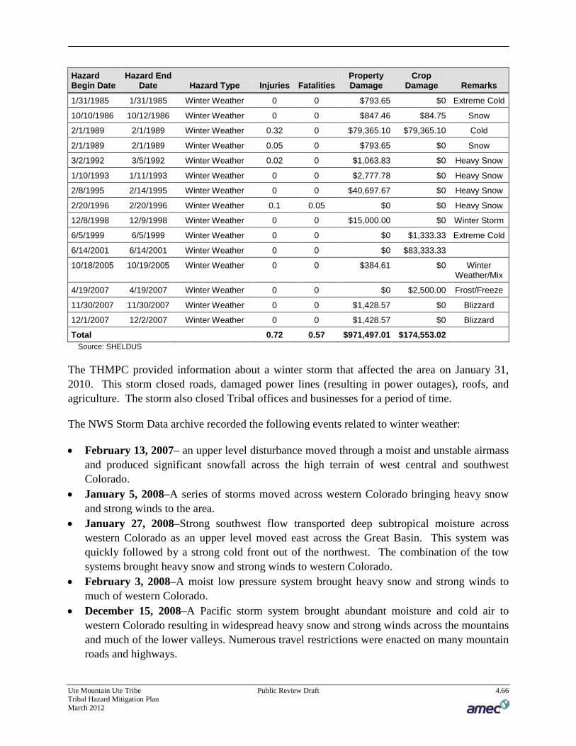
Ute Mountain Ute Tribe Public Review Draft 4.66 Tribal Hazard Mitigation Plan March 2012
Hazard Begin Date
Hazard End Date Hazard Type Injuries Fatalities
Property Damage
Crop Damage Remarks
1/31/1985 1/31/1985 Winter Weather 0 0 $793.65 $0 Extreme Cold
10/10/1986 10/12/1986 Winter Weather 0 0 $847.46 $84.75 Snow
2/1/1989 2/1/1989 Winter Weather 0.32 0 $79,365.10 $79,365.10 Cold
2/1/1989 2/1/1989 Winter Weather 0.05 0 $793.65 $0 Snow
3/2/1992 3/5/1992 Winter Weather 0.02 0 $1,063.83 $0 Heavy Snow
1/10/1993 1/11/1993 Winter Weather 0 0 $2,777.78 $0 Heavy Snow
2/8/1995 2/14/1995 Winter Weather 0 0 $40,697.67 $0 Heavy Snow
2/20/1996 2/20/1996 Winter Weather 0.1 0.05 $0 $0 Heavy Snow
12/8/1998 12/9/1998 Winter Weather 0 0 $15,000.00 $0 Winter Storm
6/5/1999 6/5/1999 Winter Weather 0 0 $0 $1,333.33 Extreme Cold
6/14/2001 6/14/2001 Winter Weather 0 0 $0 $83,333.33
10/18/2005 10/19/2005 Winter Weather 0 0 $384.61 $0 Winter Weather/Mix
4/19/2007 4/19/2007 Winter Weather 0 0 $0 $2,500.00 Frost/Freeze
11/30/2007 11/30/2007 Winter Weather 0 0 $1,428.57 $0 Blizzard
12/1/2007 12/2/2007 Winter Weather 0 0 $1,428.57 $0 Blizzard
Total 0.72 0.57 $971,497.01 $174,553.02 Source: SHELDUS
The THMPC provided information about a winter storm that affected the area on January 31, 2010. This storm closed roads, damaged power lines (resulting in power outages), roofs, and agriculture. The storm also closed Tribal offices and businesses for a period of time.
The NWS Storm Data archive recorded the following events related to winter weather:
• February 13, 2007– an upper level disturbance moved through a moist and unstable airmass and produced significant snowfall across the high terrain of west central and southwest Colorado.
• January 5, 2008–A series of storms moved across western Colorado bringing heavy snow and strong winds to the area.
• January 27, 2008–Strong southwest flow transported deep subtropical moisture across western Colorado as an upper level moved east across the Great Basin. This system was quickly followed by a strong cold front out of the northwest. The combination of the tow systems brought heavy snow and strong winds to western Colorado.
• February 3, 2008–A moist low pressure system brought heavy snow and strong winds to much of western Colorado.
• December 15, 2008–A Pacific storm system brought abundant moisture and cold air to western Colorado resulting in widespread heavy snow and strong winds across the mountains and much of the lower valleys. Numerous travel restrictions were enacted on many mountain roads and highways.

Ute Mountain Ute Tribe Public Review Draft 4.67 Tribal Hazard Mitigation Plan March 2012
• December 24, 2008–A series of strong Pacific disturbances brought a prolonged period of heavy snow and strong winds to western Colorado over the Christmas holiday. This storm Impacted all of western Colorado, resulting In widespread travel difficulties and many temporary road closures. Blizzard conditions occurred across much of the central and southern mountain areas.
• February 8, 2009–A Pacific stonn system moved east across Arizona and near the Four Comers and brought a surge of moisture to western Colorado. Behind this system, another storm quickly moved over the region from the northwest and brought colder air and more snow to the area.
• December 7, 2009–A very strong, moist, and unseasonably cold winter storm struck the central Intermountain region. Heavy snowfall occurred in most areas across eastern Utah and western Colorado. Additionally, strong winds in the southern portions of eastern Utah and western Colorado produced blizzard conditions. Some of the coldest temperatures so far this season followed closely behind this storm system. A few days later, several problems with freezing water pipelines resulted region-wide.
• December 22, 2009–A moist Pacific storm system moved Inland over the Pacific coast and then tracked through the Great Basin region, spreading snowfall across much of eastern Utah and Western Colorado. The best upper level support associated with this storm was positioned over southern Colorado and southeast Utah, which received the heaviest snowfall.
• December 28, 2009–Cold and moist air across western Colorado and eastern Utah combined with an upper level Pacific shortwave trough to produce widespread snowfall. The heaviest snow favored the mountains of southwest Colorado and southeast Utah.
• January 18, 2010–The first in a series of moist Pacific storms spread rain and snow across western Colorado and eastern Utah. Heavy snowfall favored southeast Utah and southwest Colorado. This was the beginning of a very active and wet weather pattern across the southern portion of the region.
• January 21, 2010– The third and strongest in a series of winter storms brought widespread snowfall across the mountains of eastern Utah and western Colorado, as well as rain and snow to the lower valleys. Strong south to southwest winds generated blizzard conditions over the southwest Colorado mountains.
• February 7, 2010–A Pacific storm system moved Into the Great Basin and spread snowfall across the mountains and southern valleys of western Colorado.
• February 19, 2010–An upper level low pressure system pushed a warm front from north to south across the region, and was followed by a Pacific stream of moisture that brought prolonged snowfall to portions of eastern Utah and western Colorado. The southern and central mountains were favored, as well as the southern Colorado and southeast Utah valleys.
The Western Regional Climate Center reports data from one weather station adjacent to the tribal area: Mesa Verde National Park. Table 4.19 contains snowfall and snowdepth summaries for the station. Figure 4.25 and Figure 4.26 show daily snowfall and snowdepth averages and extremes.

Ute Mountain Ute Tribe Public Review Draft 4.68 Tribal Hazard Mitigation Plan March 2012
Table 4.19. Montezuma County Snowfall and Snowdepth Summaries 1922 to 2010
Average Annual Snowfall Snowiest Month/Average
Snowfall Highest Monthly
Snowfall Highest Seasonal
Snowfall
80.57" December 19.69
52" December 1940
152" 1936-1937
Source: Western Regional Climate Center, www.wrcc.dri.edu/
Figure 4.25. Daily Snowfall Average and Extreme
Source: Western Regional Climate Center

Ute Mountain Ute Tribe Public Review Draft 4.69 Tribal Hazard Mitigation Plan March 2012
Figure 4.26. Daily Snowdepth Average and Extreme
Source: Western Regional Climate Center
76BLikelihood of Future Occurrence
Highly Likely—The THMPC estimates that severe winter storms or blizzards are highly likely to occur in any given year. More damaging severe storms may have a slightly lower frequency of occurrence. Based on the data presented above, it is likely that a damaging winter storm will occur. According to the SHELDUS data in Table 4.18, damaging severe winter storms occur about every two years (48 year period of record divided by 44 events). Recent National Weather Service data shows an average of three severe events per year since 2006.

Ute Mountain Ute Tribe Public Review Draft 4.70 Tribal Hazard Mitigation Plan March 2012
4.2.14 20BNatural Hazards Summary
Table 4.20 summarizes the results of the hazard identification and hazard profile for the planning area based on the hazard identification data and input from the HMPC. For each hazard profiled in Section 4.2, this table includes the likelihood of future occurrence and whether the hazard is initially considered a priority hazard for the planning area.
Table 4.20. Determination of Priority Hazard
Hazard Likelihood of Future Occurrence Significance
Dam/Levee Failure Unlikely Low
Drought Likely High
Earthquake Unlikely Low
Extreme Temperatures Likely Medium
Flood Unlikely High
Hazardous Materials Likely High
Landslide/Rockfall Occasional Medium
Severe Weather: Hail/Lightning/Wind Likely Medium
Tornadoes Unlikely Low
Wildfire Likely High
Winter Storms Highly Likely High Source: THMPC, 2011
Based on this data, the THMPC determined drought, wildfire, winter storms, hazardous materials and flooding have been determined to be the most costly hazards to the Tribe and are the most significant hazards in the planning area. The assets at risk and estimated potential losses associated with these hazards are discussed in Section 4.3 Vulnerability Assessment.

Ute Mountain Ute Tribe Public Review Draft 4.71 Tribal Hazard Mitigation Plan March 2012
4.3 2BVulnerability Assessment
Requirement §201.7(c)(2)(ii): [The risk assessment shall include a] description of the Indian tribal government’s vulnerability to the hazards described in paragraph (c)(2)(i) of this section. This description shall include an overall summary of each hazard and its impact on the tribe. The plan should describe vulnerability in terms of: Requirement §201.7(c)(2)(ii)(A): The types and numbers of existing and future buildings, infrastructure, and critical facilities located in the identified hazard areas. Requirement §201.7(c)(2)(ii)(B): An estimate of the potential dollar losses to vulnerable structures identified in paragraph (c)(2)(i)(A) of this section and a description of the methodology used to prepare the estimate. Requirement §201.7(c)(2)(ii)(C): A general description of land uses and development trends within the community so that mitigation options can be considered in future land use decisions; and Requirement §201.7(c)(2)(ii)(D): Cultural and sacred sites that significant, even if they cannot be valued in monetary terms.
With the Tribe’s hazards identified and profiled, the THMPC conducted a vulnerability assessment to describe the impact that the more significant hazards would have on the Tribe. The vulnerability assessment quantifies assets at risk to hazards and estimates potential losses, to the extent possible.
This vulnerability assessment followed the methodology described in the FEMA publication Understanding Your Risks—Identifying Hazards and Estimating Losses. The vulnerability assessment first describes the Tribe’s assets exposed and then discusses vulnerability by hazard.
77BMethodology
This vulnerability assessment is an attempt to quantify assets at risk to further define populations, buildings, and critical facilities at risk to hazards identified in this plan. The hazards included in this assessment are those that were considered medium or high in planning significance (see Table 4.20), based on THMPC input and the hazard profiles, and for which suitable information was available for analysis. The methods of analysis vary by hazard type and data available.
Data to support the vulnerability assessment was collected and compiled from the following sources:
• Tribal and BIA GIS data • FEMA’s HAZUS-MH MR2 GIS-based inventory data • Written descriptions of inventory and risks provided by the Tribe • Existing plans and studies • Personal interviews with planning team members, hazard experts, and tribal staff

Ute Mountain Ute Tribe Public Review Draft 4.72 Tribal Hazard Mitigation Plan March 2012
The scope of the vulnerability assessment was to describe the risks to the Tribe as a whole, but limited to the portion of the reservation in Colorado which includes the majority of The Reservation. The vulnerability assessment first describes the Tribe’s assets, including the total exposure of people and property; critical facilities, infrastructure and other community assets; natural, historic, and cultural resources; and economic assets. Development trends, including population growth and land status, are analyzed in relation to hazard-prone areas. Next, where data was available, hazards of high and medium significance are evaluated in more detail and potential losses are estimated.
78BAssets at Risk
126BTotal Exposure of Population and Structures
The 2010 Census data was unavailable during the creation of this plan. The 2000 Census data profile for the Ute Mountain Ute Reservation and Off-Reservation Trust Lands (CO, NM, UT) was 1,687. Approximately 1,097 live in the community of Towaoc. The population includes elderly, disabled, and low income (see the population discussion in Table 2.1 in Section 2.3). The total assets potentially exposed to hazards are listed in Table 4.21. This inventory is based on HAZUS-MH MR2 data and indicates that the primary building type is residential. The majority of the population and buildings are within the community of Towaoc. While the probability is low, a hazard event that impacts the Towaoc community could have significant impacts to the Tribe as a whole due to the relatively small and concentrated population and infrastructure. Total building exposure is shown on Table 4.21. The Tribe noted that the HAZUS inventory underestimated the value of buildings on the reservation. According to the Tribe total building and land assets are approximately $1.1 billion. Land value estimates of $600,000,000 and buildings/housing value estimates of $500,000,000 are at risk to natural hazards.
Table 4.21. Building Exposure by Type
Building Type Building Count Building Exposure Content Exposure Total Exposure
Residential 547 $33,037,000 $16,556,000 $49,593,000
Commercial 6 $2,989,000 $3,562,000 $6,551,000
Industrial 2 $1,496,000 $1,591,000 $3,087,000
Agriculture 1 $660,000 $660,000 $1,320,000
Religion 1 $334,000 $334,000 $668,000
Government 3 $1,393,000 $1,393,000 $2,786,000
Education 2 $545,000 $545,000 $1,090,000
Total 562 $40,454,000 $24,641,000 $65,095,000 Source: HAZUS-MH MR2
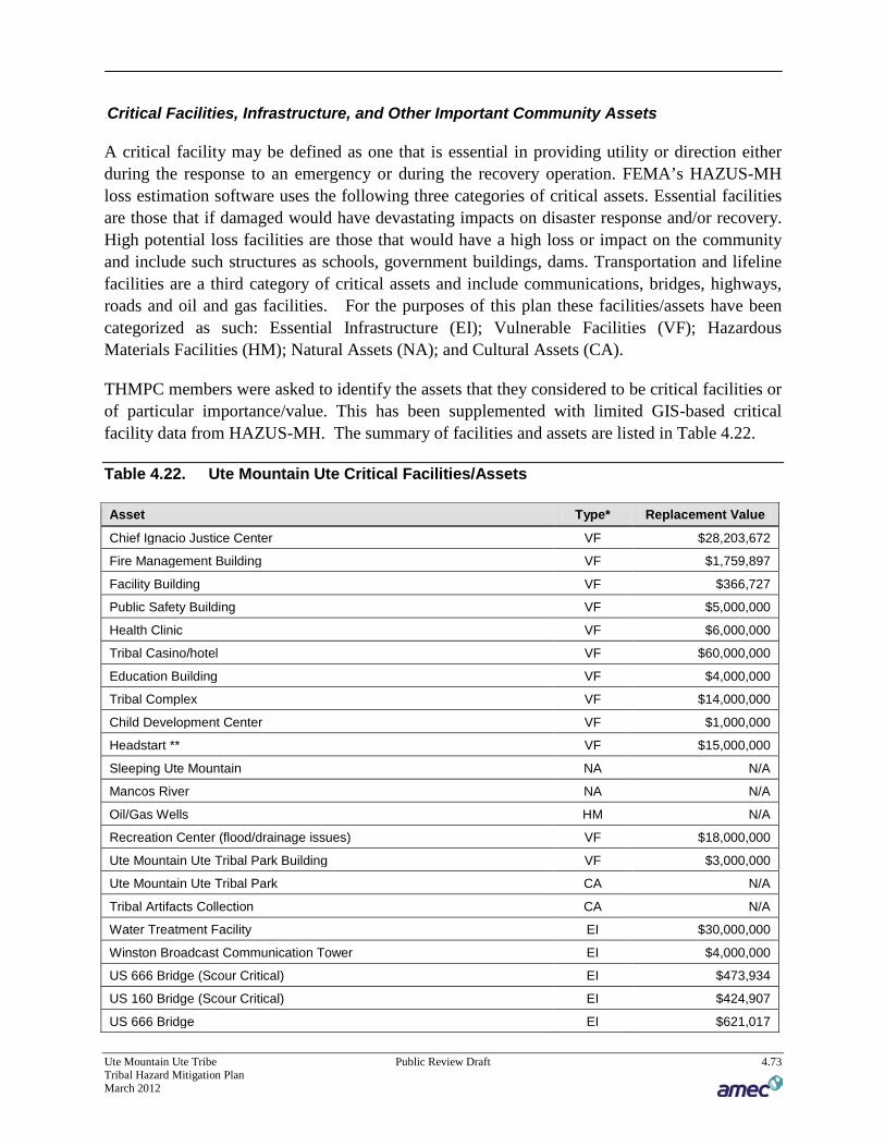
Ute Mountain Ute Tribe Public Review Draft 4.73 Tribal Hazard Mitigation Plan March 2012
127BCritical Facilities, Infrastructure, and Other Important Community Assets
A critical facility may be defined as one that is essential in providing utility or direction either during the response to an emergency or during the recovery operation. FEMA’s HAZUS-MH loss estimation software uses the following three categories of critical assets. Essential facilities are those that if damaged would have devastating impacts on disaster response and/or recovery. High potential loss facilities are those that would have a high loss or impact on the community and include such structures as schools, government buildings, dams. Transportation and lifeline facilities are a third category of critical assets and include communications, bridges, highways, roads and oil and gas facilities. For the purposes of this plan these facilities/assets have been categorized as such: Essential Infrastructure (EI); Vulnerable Facilities (VF); Hazardous Materials Facilities (HM); Natural Assets (NA); and Cultural Assets (CA).
THMPC members were asked to identify the assets that they considered to be critical facilities or of particular importance/value. This has been supplemented with limited GIS-based critical facility data from HAZUS-MH. The summary of facilities and assets are listed in Table 4.22.
Table 4.22. Ute Mountain Ute Critical Facilities/Assets
Asset Type* Replacement Value
Chief Ignacio Justice Center VF $28,203,672
Fire Management Building VF $1,759,897
Facility Building VF $366,727
Public Safety Building VF $5,000,000
Health Clinic VF $6,000,000
Tribal Casino/hotel VF $60,000,000
Education Building VF $4,000,000
Tribal Complex VF $14,000,000
Child Development Center VF $1,000,000
Headstart ** VF $15,000,000
Sleeping Ute Mountain NA N/A
Mancos River NA N/A
Oil/Gas Wells HM N/A
Recreation Center (flood/drainage issues) VF $18,000,000
Ute Mountain Ute Tribal Park Building VF $3,000,000
Ute Mountain Ute Tribal Park CA N/A
Tribal Artifacts Collection CA N/A
Water Treatment Facility EI $30,000,000
Winston Broadcast Communication Tower EI $4,000,000
US 666 Bridge (Scour Critical) EI $473,934
US 160 Bridge (Scour Critical) EI $424,907
US 666 Bridge EI $621,017
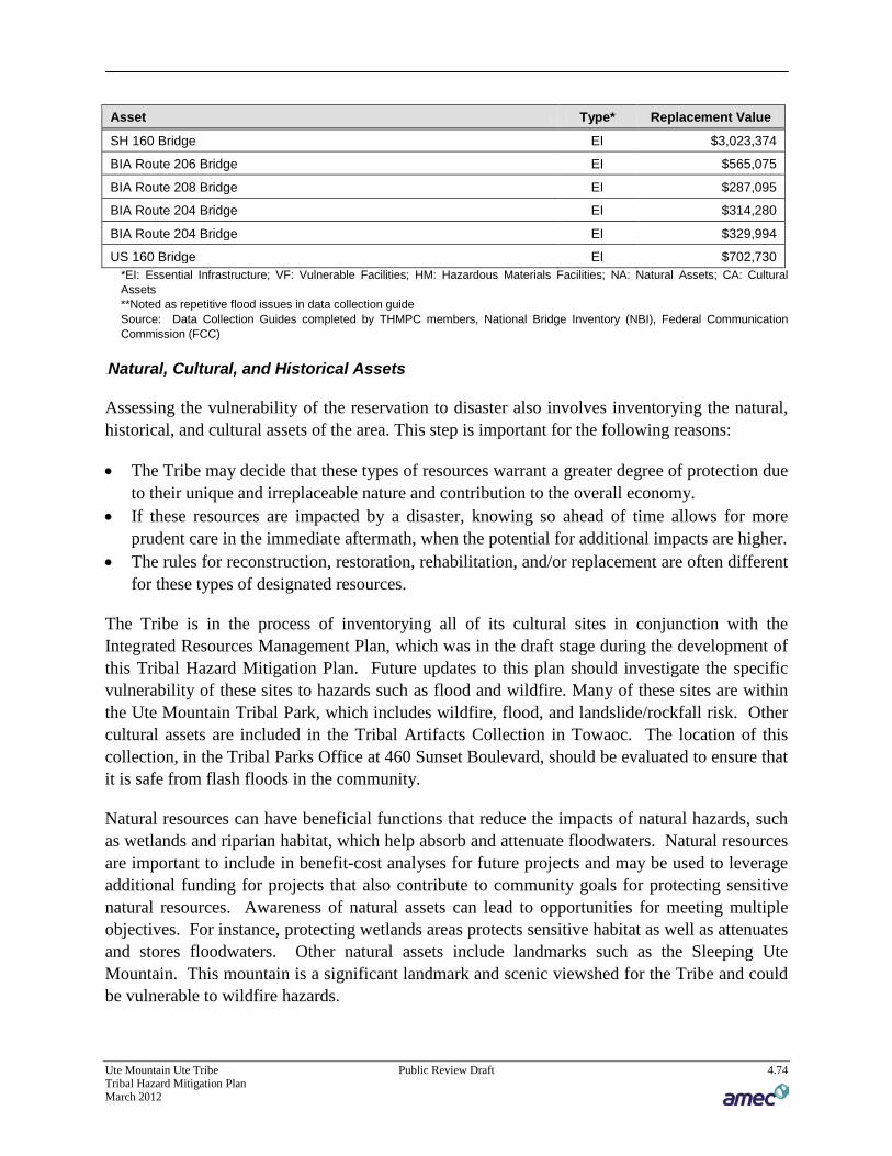
Ute Mountain Ute Tribe Public Review Draft 4.74 Tribal Hazard Mitigation Plan March 2012
Asset Type* Replacement Value
SH 160 Bridge EI $3,023,374
BIA Route 206 Bridge EI $565,075
BIA Route 208 Bridge EI $287,095
BIA Route 204 Bridge EI $314,280
BIA Route 204 Bridge EI $329,994
US 160 Bridge EI $702,730 *EI: Essential Infrastructure; VF: Vulnerable Facilities; HM: Hazardous Materials Facilities; NA: Natural Assets; CA: Cultural Assets **Noted as repetitive flood issues in data collection guide Source: Data Collection Guides completed by THMPC members, National Bridge Inventory (NBI), Federal Communication Commission (FCC)
128BNatural, Cultural, and Historical Assets
Assessing the vulnerability of the reservation to disaster also involves inventorying the natural, historical, and cultural assets of the area. This step is important for the following reasons:
• The Tribe may decide that these types of resources warrant a greater degree of protection due to their unique and irreplaceable nature and contribution to the overall economy.
• If these resources are impacted by a disaster, knowing so ahead of time allows for more prudent care in the immediate aftermath, when the potential for additional impacts are higher.
• The rules for reconstruction, restoration, rehabilitation, and/or replacement are often different for these types of designated resources.
The Tribe is in the process of inventorying all of its cultural sites in conjunction with the Integrated Resources Management Plan, which was in the draft stage during the development of this Tribal Hazard Mitigation Plan. Future updates to this plan should investigate the specific vulnerability of these sites to hazards such as flood and wildfire. Many of these sites are within the Ute Mountain Tribal Park, which includes wildfire, flood, and landslide/rockfall risk. Other cultural assets are included in the Tribal Artifacts Collection in Towaoc. The location of this collection, in the Tribal Parks Office at 460 Sunset Boulevard, should be evaluated to ensure that it is safe from flash floods in the community.
Natural resources can have beneficial functions that reduce the impacts of natural hazards, such as wetlands and riparian habitat, which help absorb and attenuate floodwaters. Natural resources are important to include in benefit-cost analyses for future projects and may be used to leverage additional funding for projects that also contribute to community goals for protecting sensitive natural resources. Awareness of natural assets can lead to opportunities for meeting multiple objectives. For instance, protecting wetlands areas protects sensitive habitat as well as attenuates and stores floodwaters. Other natural assets include landmarks such as the Sleeping Ute Mountain. This mountain is a significant landmark and scenic viewshed for the Tribe and could be vulnerable to wildfire hazards.

Ute Mountain Ute Tribe Public Review Draft 4.75 Tribal Hazard Mitigation Plan March 2012
152BEndangered Species
To further understand natural resources that may be particularly vulnerable to a hazard event, as well as those that need consideration when implementing mitigation activities, it is important to identify at-risk species (i.e., endangered species) in the planning area. An endangered species is any species of fish, plant life, or wildlife that is in danger of extinction throughout all or most of its range. A threatened species is a species that is likely to become an endangered species within the foreseeable future throughout all or a significant portion of its range. Both endangered and threatened species are protected by law and any future hazard mitigation projects are subject to these laws. Candidate species are plants and animals that have been proposed as endangered or threatened but are not currently listed. Sensitive species are capture in Table 4.23.
Table 4.23. Sensitive Species Occurring in the Planning Area
Group Name Status
Birds Yellow-billed Cuckoo (Coccyzus americanus) Candidate
Birds Mexican spotted owl (Strix occidentalis lucida) Threatened
Birds Southwestern willow flycatcher (Empidonax traillii extimus)
Endangered
Fishes Colorado pikeminnow (=squawfish) (Ptychocheilus lucius)
Endangered
Fishes Greenback Cutthroat trout (Oncorhynchus clarki stomias)
Threatened
Fishes Razorback sucker (Xyrauchen texanus) Endangered
Flowering Plants Schmoll milk-vetch (Astragalus schmolliae) Candidate
Flowering Plants Mancos milk-vetch (Astragalus humillimus) Endangered
Flowering Plants Mesa Verde cactus (Sclerocactus mesae-verdae) Threatened
Flowering Plants Sleeping Ute milk-vetch (Astragalus tortipes) Candidate
Mammals Black-footed ferret (Mustela nigripes) Experimental Population, Non-Essential
Mammals Canada Lynx (Lynx canadensis) Threatened
Mammals New Mexico meadow jumping mouse (Zapus hudsonius luteus)
Candidate
Mammals North American wolverine (Gulo gulo luscus) Candidate Source: US Fish and Wildlife Service Species by County Report
129BEconomic Assets
Economic assets at risk may include major employers or primary economic sectors, such as tourism, whose losses or inoperability would have severe impacts on the community and its ability to recover from disaster.
The Tribal Casino and Gaming Commission is a major employer and economic asset. The casino is potentially vulnerable to significant weather events that could close the casino or inhibit

Ute Mountain Ute Tribe Public Review Draft 4.76 Tribal Hazard Mitigation Plan March 2012
the ability of patrons to reach the casino. Hazardous materials events could also be an issue as it is located along a hazardous materials route.
79BGrowth and Development Trends
Population in the Tribe continues to grow. There is currently a planning process occurring for the building of an addition 150 homes on the Reservation. Commercial expansion is occurring which is adding additional chemicals and fuels for fires/hazardous materials.
There is proposed government housing (7 buildings) that could be vulnerable to a hazardous materials incident. According to THMPC input this housing would be adjacent to 6,000 gallon and 30,000 gallon propane tanks.
80BEstimating Potential Losses by Hazard
Each of the following hazards was discussed in Section 4.2. Here, the hazards are described in terms of their potential for future losses in the planning area to both existing development, and potential future development, in quantitative terms where possible. For those hazards with a high or medium significance, this section provides the following information for each hazard: vulnerability overview, potential losses to existing development, and potential losses to future development. A summary vulnerability overview is provided for those hazards with low planning significance.
4.3.1 21BDam Failure Vulnerability Assessment
81BExisting Development
Dam failure can cause downstream flooding, risking both human life and developed property. Given the low risk of dam failure, and the lack of high and significant hazard dams in the vicinity of the Reservation, it is unlikely the Tribe would face any damages.
82BFuture Development
Future development on the Reservation should occur outside the floodplain, and outside possible dam failure inundation zones.
4.3.2 22BDrought Vulnerability Assessment
83BExisting Development
Drought impacts are wide-reaching and may be economic, environmental, and/or societal. Tracking drought impacts can be difficult. The Drought Impact Reporter from the NDMC is a useful reference tool that compiles reported drought impacts nationwide. Figure 4.27 and Table 4.24 show drought impacts for all Colorado counties, including the planning area, from 1850 to 2011. Based on reports to the NDMC, the planning area recorded major amounts of impacts.

Ute Mountain Ute Tribe Public Review Draft 4.77 Tribal Hazard Mitigation Plan March 2012
The data represented is skewed, with the majority of these impacts come from records within the past ten years.
Figure 4.27. Drought Impact Reporter for Montezuma County
Source: National Drought Mitigation Center
Table 4.24. Drought Impacts in Montezuma County
Impacts Ag Fire Water/Energy Environmental Social Other Total
Montezuma County 33 15 3 7 16 40 114 Source: National Drought Mitigation Center
The most significant impacts associated with drought in the planning area are those related to water intensive activities such as agriculture, wildfire protection, municipal usage, commerce, tourism, recreation, and wildlife preservation. Drought conditions can also cause soil to compact and not absorb water well, potentially making an area more susceptible to flooding.
Based on Montezuma County’s past multi-year droughts and Colorado’s drought history, it is evident that all of the Tribe is vulnerable to drought. However, the impacts of future droughts
Ute Mountain Ute Tribe Public Review Draft 4.78 Tribal Hazard Mitigation Plan March 2012
will vary. The 2010 Colorado Drought Plan identifies Montezuma County as having moderate vulnerability to drought in the agriculture, environmental, recreation, and socioeconomic sector. There is some ranching that occurs on the SW side of the Sleeping Ute Mountain, but not much agriculture is practiced on the Reservation.
Drought can also exacerbate the potential occurrence and intensity of wildfire. The wildland areas of the Tribe will see an increase in dry fuels, beetle kill, and associated wildfires and some loss of tourism revenue. The agricultural areas of the Tribe will experience hardships, including agricultural losses, associated with a reduction in water supply. The Ute Mountain farm is a 7,700-acre market-oriented agricultural enterprise located on the Ute Mountain Ute reservation. Though a number of crops are produced at the farm, including wheat, corn and sunflowers, the primary cash crop is hay. The annual hay crop has proved to be most valuable economically to the tribe, but it also is the most water-poor of the crops grown on the farm.
Water supply issues for domestic needs will be a concern for the entire Tribe during droughts. Water supply for the Tribe primarily comes from the north and is piped from McPhee Reservoir. McPhee Reservoir is fed by snowmelt from the San Juan Mountains. The tribe has the capability of utilizing other sources of water should a drought occur. The THMPC noted that there is a spring on Sleeping Ute Mountain above Towaoc that could provide water, but it has gone dry in the past. The Tribe has been evaluating water needs and possibly purchasing additional water rights in 2011 with the Dolores Water Conservancy District as part of a joint Reconnaissance Study.
A drought related decline in tourism and agricultural revenues could impact the Tribe’s economy. According to the 2010 State of Colorado Drought Mitigation and Response Plan, “the multiplier effect of decreased business revenue can impact the entire economy. When an individual loses or decreases their income all of the goods and service providers they usually support will also be impacted.” Tourism visits to the Ute Tribal Park could potentially be impacted by wildfires linked with drought. The Colorado Water Conservation Board is beginning a pilot study in mid-2011 to evaluate the impacts of drought to recreation and tourism sector in Southwestern Colorado. Due to the timing the results were not available to inform this plan but may be useful for future updates to this plan.
While widespread, the losses associated with drought are often the most difficult to track or quantify. While FEMA requires the potential losses to structures to be analyzed, drought does not normally have a structural impact. The drought that ended in 2005 was estimated to cost the Tribe $6 million, according to the National Resource Conservation Service.
Montezuma County has been named in the following USDA and Federal Drought Disaster Declarations, but specific impacts or dollar losses to the Reservation were not available:
• S1843 Drought, Insects • S2327 Drought, Fire, High Winds, Heat

Ute Mountain Ute Tribe Public Review Draft 4.79 Tribal Hazard Mitigation Plan March 2012
• S2970 Drought • 8/3/1951 Drought emergency
84BFuture Development
Losses associated with drought and future development are not anticipated to be substantial unless there is more agricultural and housing development, which is not anticipated in the near future.
4.3.3 23BEarthquake Vulnerability Assessment
85BExisting Development
Earthquakes represent a low probability, but potentially high consequence hazard for the Tribe. Colorado has a relatively short historic record of earthquakes, which makes for a limited data set when making assumptions based on past events. Specific details about the earthquake potential in the Reservation and Colorado in general remain largely unknown. The Colorado Geologic Survey recently ran a series of deterministic scenarios for selected faults around the state using HAZUS MH. The earthquake magnitudes used for each fault were the “Maximum Credible Earthquake” taken from the USGS Quaternary Fault and Fold Database or from the USGS National Earthquake Hazard Map. Montezuma County, which houses much of the Reservation land, was found to have no faults within the County, no historical earthquakes, and no risk of earthquake.
86BFuture Development
Given the limited development trends in the region there is not expected to be an increased vulnerability to the hazard.
4.3.4 24BExtreme Temperatures Vulnerability Assessment
87BExisting Development
Limited data on temperature extreme impacts was available during the development of this hazard’s profile. Extreme cold can cause burst pipes in structures, but the bigger concern is the life safety issue. Areas prone to excessively cold and excessive heat are identified normally on a nation-wide assessment scale, which doesn’t allow detailed results on specific structures. Secondary impacts of extreme cold can affect the supporting mechanisms or systems of a community’s infrastructure. For example, when extreme cold is coupled with high winds or ice storms, power lines may be downed, resulting in an interruption in the transmission of that power shutting down electric furnaces, which may lead to frozen pipes in homes and businesses. Secondary impacts of extreme heat can affect the supporting mechanisms or systems of a community’s infrastructure. For example, when high amounts of utilization is imposed on the

Ute Mountain Ute Tribe Public Review Draft 4.80 Tribal Hazard Mitigation Plan March 2012
power system it can cause an interruption in the transmission of that power shutting down air conditioning capabilities or refrigeration that can lead to spoiled foods, etc.
The elderly population in the planning area is most vulnerable to temperature extremes. Table 2.2 in Chapter 2.4 shows that the percentage of elderly people (age 65 or over) in the planning area is well above the national average, which is 6%. However many residents of the tribe are self sufficient and accustomed to rural living and the climate extremes that are part of the territory. It is encouraged that community shelters have emergency plans or backup power to address power failure during times of extreme cold and extreme heat. Natural gas shortages could also be problematic during periods of extreme temperature. Some solar panels are used for hot water and emergency generators for critical facilities, including the recreation center, community center, and the Casino which could also function as shelters.
88BFuture Development
Vulnerability to extreme temperatures is not anticipated to change substantially, as development trends are minimal. Vulnerability to extreme temperatures could increase if the average age of the population shifts. As identified in the existing development discussion above, many of the residents of the tribe are self sufficient and accustomed to rural living.
4.3.5 25BFlood Vulnerability Assessment
89BExisting Development
130BMethodology
The Tribe has not been mapped by the National Flood Insurance Program and does not have any Flood Insurance Rate Maps. In lieu of those maps an existing HAZUS-MH MR2 flood analysis was used to assess vulnerability to flooding. FEMA used HAZUS-MH MR2 to model the 1% annual chance floodplain and perform associated building and population risk assessments as part of a nationwide flood vulnerability assessment. HAZUS-MH is FEMA’s GIS-based natural hazard loss estimation software. The HAZUS-MH flood model results include analysis for Census Blocks in Montezuma County which is where the majority of the Ute Mountain Ute Tribe’s population and development is located. The Census Blocks associated with the Reservation were extracted so that the loss estimate results would be more specific to the Tribe. The HAZUS process models streams draining a 10 square mile minimum drainage area, using 30 meter (1 arc second) Digital Elevation Models (DEM). Hydrology and hydraulic processes utilize the DEMs, along with flows from USGS regional regression equations and stream gauge data, to determine reach discharges and to model the floodplain. Losses are then calculated using HAZUS-MH national baseline inventories (buildings and population) at the census block level.
HAZUS-MH produces a flood polygon and flood-depth grid that represents the 100-year floodplain. The 100-year floodplain represents a flood that has a 1% chance of being equaled or

Ute Mountain Ute Tribe Public Review Draft 4.81 Tribal Hazard Mitigation Plan March 2012
exceeded in any single year. While not as accurate as official flood maps, these floodplain boundaries are available for use in GIS and could be valuable to communities that have not been mapped by the National Flood Insurance Program. HAZUS-MH generated damage estimates are directly related to depth of flooding and are based on FEMA’s depth-damage functions. For example, a two-foot flood generally results in about 20% damage to the structure (which translates to 20% of the structure’s replacement value). The HAZUS-MH flood analysis results provide number of buildings impacted, estimates of the building repair costs, and the associated loss of building contents and business inventory. Building damage can cause additional losses to a community as a whole by restricting the building’s ability to function properly. Income loss data accounts for losses such as business interruption and rental income losses as well as the resources associated with damage repair and job and housing losses.
Potential losses derived from HAZUS-MH used default national databases and may contain inaccuracies; loss estimates should be used for planning level applications only. The damaged building counts generated are susceptible to rounding errors and are likely the weakest output of the model due to the use of census blocks for analysis. In rural southwestern Colorado, Census Bblocks are large and often sparsely populated or developed; this may contribute to inaccurate loss estimates. It was noted by the THMPC that the HAZUS-MH inventory underestimated the value of buildings and in some areas represented development where there is none. HAZUS-MH assumes population and building inventory to be evenly distributed over a census block; flooding may occur in a small section of the census block where there are not actually any buildings or people, but the model assumes that there is damage to that block. There could also be errors and inadequacies associated with the hydrologic and hydraulic modeling of the HAZUS-MH model. In addition, excessive flood depths may occur due to problems with a DEM or with modeling lake flooding. Errors in the extent and depth of the floodplain may also be present from the use of 30 meter digital elevation models. HAZUS Level II analyses based on local building inventory, higher resolution terrain models, and DFIRMs could be used in the future to refine and improve the accuracy of the results.
153BReports, Maps and Results
A series of maps and analysis results were compiled for the Ute Mountain Ute Tribe. Table 4.25 and Table 4.26 contain the results of the HAZUS loss estimation. Building and contents value loss estimates, income-related loss estimates, and displaced population and shelter needs estimates are included in Table 4.25. In Table 4.26, per capita loss was calculated using total building loss and Census 2009 estimates to the Reservation–level population. Percent building loss and percent contents loss were calculated using building and contents loss estimates, and HAZUS building and contents exposure data.
Table 4.25. HAZUS Loss Estimation
Building Loss
Contents Loss
Inventory Loss
Relocation Loss
Capital Related
Loss Wages Loss
Rental Income
Loss Total Loss
# of Displaced
People
# of People
Needing

Ute Mountain Ute Tribe Public Review Draft 4.82 Tribal Hazard Mitigation Plan March 2012
Short Term
Shelter
$62,000 $104,000 $1,000 - - 9 - $176,000 5 - Source: HAZUS
Table 4.26. HAZUS Loss Estimation Additional Analysis
2009 Population*
Total Exposure
Building Loss
Building Exposure
% Building
Loss Content
Loss Content
Exposure
% Contents
Loss Total Loss
Per Capita Loss
1,410 $65,095,000 $62,000 $40,454,000 0.2% $104,000 $24,641,000 0.4% $176,000 $125 * U.S. Census Bureau
The following maps are provided at the Ute Mountain Ute Tribal Land scale: the map in Figure 4.28 shows the effective DFRIM and HAZUS floodplain boundaries along with critical facilities in and around the Ute Mountain Ute Tribal Land, and the Figure 4.29 shows population affected by flooding by census block.

Ute Mountain Ute Tribe Public Review Draft 4.83 Tribal Hazard Mitigation Plan March 2012
Figure 4.28. Ute Mountain Ute HAZUS and FEMA Flood Zones with Critical Facilities

Ute Mountain Ute Tribe Public Review Draft 4.84 Tribal Hazard Mitigation Plan March 2012
Figure 4.29. Ute Mountain Ute HAZUS Displaced Population

Ute Mountain Ute Tribe Public Review Draft 4.85 Tribal Hazard Mitigation Plan March 2012
131BPopulations and Buildings at Risk
According to the HAZUS model output, Ute Mountain Ute Tribe would suffer a total of $176,000 in total direct economic loss to buildings and 5 people would be displaced in the event of a Reservation wide 1% annual chance flood. Based on Census Block exposure to flooding there are 71 buildings at risk to flood and 89% of these buildings are Residential. The potential flooding for these areas at risk come from the Mancos River which flows from the north east portion of the Ute Mountain Ute Reservation down to the south west corner of the reservation where it meets up with the San Juan River. Additional flooding that HAZUS modeled comes from the Navajo Wash which is located just east of Towaoc and travels south, adjacent to US Highway 160, where it drains into Mancos River.
The community of Towaoc’s flood risk is not addressed by the FEMA HAZUS modeling. HAZUS did not model the flooding on Cottonwood Wash (due to a less than 10 sq mile drainage area), which is a drainage/wash that flows off Sleeping Ute Mountain straight through the middle of Towaoc. However, based on an interpretation of satellite imagery and THMPC input it was determined that there is significant flood risk to Towaoc. The Cottonwood Wash channel is distinct until about N Ute St, and then it becomes less discernable through the community until below Mike Wash Rd (see Figure 4.30). Flash flooding has come down the wash and spread out in the community. A diversion channel and berm has been created just upstream of the community to divert flows to another natural channel that flows east of the community. This provides some level of protection but it was not adequate to accommodate flood flows that affected Towaoc in 2005. Given that the majority of the population and infrastructure are in Towaoc a large flood event could have significant impacts. Thus the HAZUS results.showing a Percent Building Loss of (0.2%), Percent Contents Loss (0.4%), and Per Capita Loss ($125) do not reflect the true risk. A Level II HAZUS analysis would be required to further define the risk.

Ute Mountain Ute Tribe Public Review Draft 4.86 Tribal Hazard Mitigation Plan March 2012
Figure 4.30. Towoac Area Streets and Drainages
Imagery source: Bing maps 2011.
Montezuma County has DFIRM however Ute Mountain Ute Reservation seems to have a flood zone of No Special Flood Hazard Area (NSFHA) according to the FIRM Index. However DFIRM has the area mapped as Zone X. It is not clear if the Reservation is designated as NSFHA, Zone X, or Zone D. A logical conclusion would be Zone D, where flood hazards are possible but undetermined, since mapped flood zones in Montezuma County stop at the Ute
Cottonwood Wash
Diversion structure
Ute Mountain Ute Tribe Public Review Draft 4.87 Tribal Hazard Mitigation Plan March 2012
Mountain tribal land boundaries and that the tribe is not participating in the National Flood Insurance Program (NFIP).
90BFuture Development
Since the Tribe does not have NFIP maps or participate in the NFIP there is the potential that future development could occur, unknowingly, in areas subject to flooding. Given the current slow development trends this risk is not anticipated to be substantial, but care should be taken in siting future buildings near drainages, arroyos, and streams.
4.3.6 26BHazardous Materials Vulnerability Assessment
91BExisting Development
Hazardous materials events could potentially threaten public safety. It is important to note that schools and the majority of the Reservation’s population are located within a one mile corridor of Highway 160 and are therefore potentially exposed to the dangers of hazardous materials incidents. The potential impact to the environment is often related to public safety issues such as air and water quality. Impacts would be dependent on where and when the incident occurred, thus it is difficult to estimate the potential losses from an event. Hazardous materials incidents can also interrupt transportation and delivery services, potentially resulting in economic losses.
Nuclear waste materials are being transported through the Reservation from New Mexico to storage facilities in Utah. According to the THMPC, another concern is the number of above ground propane storage tanks in Towaoc. There are tanks within 200 yds of a day care, prison, and government buildings. The Tribe’s lands are home to 140 oil wells that supply crude to 100 storage batteries. The batteries are typically made up of 6-10,000 gallon tanks that are diked to encase a full release of contents from one tank only. Spills can occur during transferring of oil from batteries to transport vehicles. Consistent movement of trucks from the “oil patch” to refineries can produce of risk of accidental release. Education and training is also needed for first responders regarding hydrogen sulfide hazards at oil and gas wells.
Otherwise, it is presumed that trucks moving through the Reservation area would eventually haul some type hazardous materials. Given the two major highways that serve as hazardous materials routes through the Ute Mountain tribal lands, State Highways 491 and 160, it is conceivable that some spill off of hazmat traffic from these areas could end up on the Tribe’s roadway system and possibly be a human health concern depending on where the accident occurred.
92BFuture Development
There is proposed government housing (7 buildings) that could be vulnerable to a hazardous materials incident. According to THMPC input this housing would be adjacent to 6,000 gallon and 30,000 gallon propane tanks.

Ute Mountain Ute Tribe Public Review Draft 4.88 Tribal Hazard Mitigation Plan March 2012
4.3.7 27BLandslide/Rockfall Vulnerability Assessment
93BExisting Development
Research in the hazard profile for landslide and rockfall events revealed sporadic impacts, particularly in the canyons that dissect the region, most of which have local roads or State highways running through them. Rockfall impacts on foothill highways and County roads have the potential to cause significant indirect economic loss, in addition to the potential for serious injury or death. Economic losses from this road closure and resulting detours could be estimated with traffic counts and detour mileage. The Colton/USGS map of landslide deposits shows areas within the Reservation that have experienced landslides in the past, and thus could be susceptible in the future. Most of these areas are currently undeveloped in the vicinity of Sleeping Ute Mountain and the Tribal Park. It will be important to evaluate the risk in these areas more closely should development or camps be made in these areas. Tribal Park workers and visitors should be made aware of potential rockfall hazards. Highway 160 traverses an area mapped as landslide deposits in the extreme southwest of the reservation and could potentially be at risk. This can be seen on Figure 4.31.
94BFuture Development
Future development may be at risk to landslide or rockfall. Residential development and new critical facilities should be placed in areas outside of known rockfall and landslide areas. Future property losses to existing developments would likely be minor, based on patterns of previous events, and impact mostly infrastructure. Given that many of the hazard areas are in remote locations not well suited for development it is anticipated that future impacts will be minimal. The rockfall hazard areas shown in Figure 4.31 should be taken into consideration when siting future development and infrastructure.

Ute Mountain Ute Tribe Public Review Draft 4.89 Tribal Hazard Mitigation Plan March 2012
Figure 4.31. Landslide and Rockfall Areas in the Reservation

Ute Mountain Ute Tribe Public Review Draft 4.90 Tribal Hazard Mitigation Plan March 2012
4.3.8 28BSevere Weather: Hail/Lightning/Wind Vulnerability Assessment
The ability to predict the potential severity of an impending thunderstorm, wind, lightning, flood or tornado event is made difficult by the lack of weather radar coverage in the Reservation. Southwest Colorado is in an area described as being in a radar “black hole;” the elevation of the San Juan Mountains blocks radar beams, making it difficult for weather stations in Grand Junction to accurately detect the presence and severity of storm events in southwestern Colorado and the Four Corners region as a whole. This lack of accurate information about weather events has widespread effects on the planning area. Residents in the planning area have little time to prepare for and mitigate against severe weather events. This can threaten lives, property, and the economy in the Reservation. In lieu of radar, weather spotters are relied upon by the NWS to get more accurate information.
Between 2009 and 2010, mobile radar stations were deployed as part of a research project in La Plata County. The results of this project are detailed in a 2010 Southwest Colorado Radar Project final report prepared by NOAA for the CWCB, CDEM, and Southwestern Water Conservation District. In the short time the radar has been in operation, La Plata County OEM has used the radar to: monitor storms and flash flooding events; assist La Plata County Road and Bridge with timing of operations; help Search and Rescue find windows of opportunity between rain and hail to perform several rescues; and assist the National Weather Service in issuing Severe Storm and Flood Warnings. This project has been extended into 2011.
95BHail
132BExisting Development
Thunderstorms producing hail are common occurrences throughout the planning area between early spring and late fall. Hailstones are frequently thrown out miles in front of the storm producing them. Due to the frequency and widespread distribution of hail-producing thunderstorms, the planning team considers the risk of hail to be the same across the entire planning area. Hail primarily causes property and vehicle damage in the planning area including impacts to roofs, automobiles, trees and windows. Critical facilities and infrastructure will have the greatest consequences if significantly damaged by severe hail.
133BFuture Development
Future development will be exposed to hail hazards. New critical facilities such as communications towers and outdoor warning systems should be built to withstand hail damages. With limited development occurring in the region future losses to new development should be minimal.

Ute Mountain Ute Tribe Public Review Draft 4.91 Tribal Hazard Mitigation Plan March 2012
96BLightning
134BExisting Development
Lightning can cause deaths, injuries, and property damage, including damage to buildings, communications systems, power lines, and electrical systems. It also causes forest, brush and structural fires. Damage from lightning occurs in four ways:
• Electrocution, severe electrical shock, and burns of humans and animals • Vaporization of materials in the path of the strike • Fire caused by the high temperatures associated with lightning • Power surges that can damage electrical and electronic equipment
When people are struck by lightning, the result is deep burns at the point of contact (usually on the head, neck and shoulders). Approximately 70 percent of lightning survivors experience residual effects such as vision and hearing loss or neuropsychiatric issues. These effects may develop slowly and only become apparent much later. Death occurs in 20 percent of lightning strike victims.
Lightning strikes cause intense but localized damage. In contrast to other hazards, lightning does not cause widespread disruptions with the community. Structural fires, localized damage to buildings, damage to electronics and electrical appliances, and electrical power and communications outages are typical consequences of a lightning strike. Additionally, indirect fatalities may result from electrocution via contact with live power-lines that are knocked loose by a lightning strike.
The indirect social and economic impacts of lightning damage are typically associated with the loss of electrical power. Since society relies heavily on electric power; any disruption in the supply, even for a short time period, can have significant consequences.
One of the most serious risks associated with lightning is its potential to cause wildfires. This in particular could result in substantial losses for the Tribe. For specific details on loss and vulnerability associated with wildfire, please see the vulnerability discussion in Section 4.3.9.
135BFuture Development
New critical facilities such as communications towers and outdoor warning systems should be built to withstand lightning. While no deaths have occurred in the planning area in the past due to lightning, it is difficult to quantify possible future deaths and injuries due to lightning. With limited development occurring in the region future losses to new development should be minimal.

Ute Mountain Ute Tribe Public Review Draft 4.92 Tribal Hazard Mitigation Plan March 2012
97BWind
136BExisting Development
Beyond tornadoes, the planning area is subject to potentially destructive straight-line winds. High winds are common throughout the planning area, throughout the entire year. Straight line winds are primarily a public safety and economic concern. Windstorm can cause damage to structures and power lines which in turn can create hazardous conditions for people. Debris flying from high wind events can shatter windows in structures and vehicles and can harm people that are not adequately sheltered.
Future losses from straight line winds include:
• Erosion (soil loss) • Dry land farming seed loss, • Power line impacts and economic losses from power outages • Occasional building damage, primarily to roofs and fences
Campers, mobile homes, barns, and sheds and their occupants are particularly vulnerable as windstorm events in the region can be sufficient in magnitude to overturn these lighter structures. Livestock that may be contained in these structures may be injured or killed, causing economic harm to the rancher who owns both the structure and the livestock. Overhead power lines are vulnerable and account for the majority of historical damages. State highways can be vulnerable to high winds and dust storms, where high profile vehicles may be overturned by winds and lowered visibility can lead to multi-car accidents.
137BFuture Development
Future development projects should consider windstorm hazards at the planning, engineering and architectural design stage with the goal of reducing vulnerability. Given the limited development trends in the region there is not expected to be an increased vulnerability to the hazard.
4.3.9 29BSoil Hazards: Expansive Soils Vulnerability Assessment
98BExisting Development
Extensive areas of the Reservation are characterized to some extent by swelling soils. Older construction may not be resistant to the swelling soil conditions and, therefore, may experience expensive and potentially extensive damages. This includes heaving sidewalks, structural damage to walls and basements, the need to replace windows and doors, or dangers and damages caused by ruptured pipelines. Newer construction may have included mitigation techniques to avoid most damage from the hazard, but the dangers continue if mitigation actions are not supported by homeowners. For example, the maintenance of grading away from foundations and the use of appropriate landscaping near structures must be continued to prevent an

Ute Mountain Ute Tribe Public Review Draft 4.93 Tribal Hazard Mitigation Plan March 2012
overabundance of water in vulnerable soils near structures. While continued public education efforts may help increase compliance for landscaping and interior finishing mitigation actions, physical reconstruction of foundations is probably not feasible in all but the most heavily impacted of existing development. Therefore, damages may be expected into the future for existing structures.
An area of concern noted by members of the THMPC include the Travel Center and the underground fuel tanks and line areas that could be damaged by excessive ground movement and concrete cracking.
99BFuture Development
Land use planning regulations could temper the risk of swelling soil impacts on future development. Efforts to regulate building in areas of high or moderate swelling potential could increase the number of structures and infrastructure built with swelling-adaptive methods, which in turn reduces the amount of damage incurred each year on the property. As existing development deteriorates and requires either renovation or reconstruction, mitigation methods should be implemented to bring the developments up to contemporary mitigation standards.
4.3.10 30BTornado Vulnerability Assessment
100BExisting Development
The National Climatic Data Center‘s 2005 Annual Summaries indicates that based on national state-level tornado data from 1953 to 2005, Colorado ranks 8th for frequency and 35th for number of deaths. When the tornado frequency per 10,000 square miles is compared with other states, Colorado ranks 35th for frequency and ties for 35th with 16 other states that average 0 deaths per 10,000 square miles. There have been no tornados that have struck the Reservation. Lack of building codes does make Tribal members more at risk to tornado damage should a tornado occur. Proper education on building techniques and the use of sturdy building materials, basements, attached foundations, and other structural techniques may minimize the property vulnerabilities.
101BFuture Development
Given the limited development trends in the region there is not expected to be an increased vulnerability to the hazard. Proper education on building techniques and the use of sturdy building materials, basements, attached foundations, and other structural techniques may minimize the property vulnerabilities. Public shelters at parks and open spaces may help reduce the impacts of tornadoes on the recreational populations exposed to storms.

Ute Mountain Ute Tribe Public Review Draft 4.94 Tribal Hazard Mitigation Plan March 2012
4.3.11 31BWildfire Vulnerability Assessment
102BExisting Development
Wildfires are a major threat to this Reservation. Historic data presented in the wildfire hazard profile section indicate that wildfires are continuous danger and, in 2002, resulted in 2,600 acres consumed in the adjacent Mesa Verde National Park. It should be noted that FEMA Fire Management Assistance Declarations were issued throughout the State of Colorado each year between 2000 and 2006, several of these to wildfires in Montezuma County on or near Reservation lands.
The Ute Mountain Ute Comprehensive Fuels Management Plan 2009-2013 contained an assessment of risk and vulnerability of the Reservation to wildfire based on a combination of factors including fuel types, fire regime, and condition class. Table 4.27 indicates the major vegetation types found on the Reservation and their associated acres.
Table 4.27. Reservation Vegetation Types and Associated Acreage
Vegetation Type Acres
Aspen Forest 2,024
Mixed Conifer Forest 3,590
Ponderosa Pine Forest 6,271
Pinion-Juniper Woodland 286,494
Gambel Oak Shrub 4,666
Shrub 479
Riparian Woodland 13,017
Big Sagebrush Shrub 52,595
Low Sagebrush Shrub 1,837
Desert Shrub 147,224
Grassland 3,670
Sparsely Vegetated 54,977 Source: Ute Mountain Ute Comprehensive Fuels Management Plan 2009-2013
138BFuel Models
Table 4.28 below lists the fuel models found on the Reservation and the associated acreage. Spatial fuel model data was derived from LANDFIRE, and is based on Anderson, 1982. More information on fuel model descriptions may be found in Appendix C of the Ute Mountain Ute Comprehensive Fuels Management Plan 2009-2013.

Ute Mountain Ute Tribe Public Review Draft 4.95 Tribal Hazard Mitigation Plan March 2012
Table 4.28. Reservation Fuel Models and Associated Acreage
Fuel Model Acres
1 - Short Grass 103,892
2 – Open Forest/Grass 76,423
4 - Chaparral 2,825
5 –Shrub 257,945
6 – Woodland/Shrub 122,023
8 – Compact Forest Litter 2,830
9 – Loose Forest Litter 2,619 Source: Ute Mountain Ute Comprehensive Fuels Management Plan 2009-2013
Most pinyon-juniper woodlands occurring on the Reservation have been classified by LANDFIRE as fuel models 5 or 6. However, many of these stands are unusually old and decadent, with a correspondingly high loading of dead fuel. Because of this many of these areas are better represented by fuel model 4, particularly during periods of drought. Fire behavior projections have been validated by the numerous large fires that have occurred in this type on the Reservation and adjacent National Forest and Park Service lands. Along with the WUI, this condition poses the most serious fire management concern on the Reservation. Unfortunately, due to a lack of spatial data, this condition is not accurately represented in the LANDFIRE data set.
139BFire Regime and Condition Class
The Fire Regime (FR) data layer classifies land by fire severity and mean fire return interval. The methodology used for this classification may be found in the Interagency Fire Regime Condition Class Guidebook (Hann et al. 2004). The classes are defined as follows:
• FR 1: Low to mixed fire severity, 0 - 35 year fire return interval. • FR 2: Stand replacement fire severity, 0 - 35 year fire return interval. • FR 3: Low to mixed fire severity, 35 - 200 year fire return interval. • FR 4: Stand replacement fire severity, 35 - 200 year fire return interval. • FR 5: Any fire severity, greater than 200 year fire return interval.
Condition class (CC) is a relative measure of the degree of departure from baseline or “natural” ecosystem conditions. It is determined through a comparison of baseline and current vegetation composition and structure for a given landscape, taking into account current scientific principles of ecosystem processes and function. CC 1 is applied to those areas considered within the natural (or historic) range of variability. CC II is defined as moderately departed from this natural range of variability, and CC III is highly departed. In most cases CC III areas are considered at risk of experiencing a dramatic ecosystem correction; generally this is manifested in the form of catastrophic fire or insect or disease outbreak.

Ute Mountain Ute Tribe Public Review Draft 4.96 Tribal Hazard Mitigation Plan March 2012
Table 4.29 lists acreage by fire regime and condition class on the Reservation. The Fire Regime Condition Class Treatment Priority Map in Figure 4.32 displays the corresponding distribution of these areas.
Table 4.29. Reservation Acres by Fire Regime and Condition Class*
Fire Regime Condition Class Total
I II III
1 247 2,302 8 2557
2 8 182 5 195
3 45,182 90,325 238,078 373,585
4 5,484 14,023 12,814 32,321
5 13,999 31,973 75,126 121,098
Total 64,920 138,805 326,031 529,756 * - The remaining 60,505 Reservation acres consist of agricultural, urban, and barren areas and do not fit within the FRCC classification system.

Ute Mountain Ute Tribe Public Review Draft 4.97 Tribal Hazard Mitigation Plan March 2012
Figure 4.32. Ute Mountain Ute Fire Regime Map

Ute Mountain Ute Tribe Public Review Draft 4.98 Tribal Hazard Mitigation Plan March 2012
The Fuels Program Business Management Handbook identifies the highest priority for fuels mitigation with FR 1 – 3 CC II and III (except for WUI areas, which are considered high priority regardless of FRCC classification). Accordingly, approximately 56 percent of Reservation lands are considered high priority for treatment.
140BMan-made Fire
On several occasion arson activities have occurred within the wildland urban interface (WUI) areas of Towaoc, which have required the assistance of multiple arson taskforces, investigators, and additional fire resources. Other fire hazards include abandoned structures.
141BPopulation and Buildings at Risk
The WUI boundary consists of 2 main areas of concern, the Towaoc area and a section of the Reservation in the McElmo Canyon north of the Sleeping Ute Mountain. The greatest potential for property damage is in the Towaoc area. Based on the 2000 US Census, there is a population of 2 people and 2 residential buildings with an exposure of $102,000 within the WUI area for the McElmo Canyon area. There is a population of 1,230 with 469 buildings within the Towaoc WUI area with a value of $46,312,000 (according to HAZUS estimates, which are considered to be low), which represents 71% of the total building value on the Reservation. These values could be assumed as worst case losses. Thus a considerable amount of the Reservation’s buildings and population are at risk to wildfire.
Populations that gather in areas such as the Sundance Crown for ceremonial activities could also be a risk if a wildfire were to occur in the area at the same time. The BIA has been conducting fuels treatment in this area to help mitigate the danger.
142BCritical Facilities and Cultural Resources at Risk
The Winston Broadcast Communication Tower located on Sleeping Ute Mountain is a critical facility that may be at risk to wildfire.
Wildfire has the potential to impact cultural resources within the Reservation. The option of using prescribed fire as a treatment method is limited within areas that contain archeological sites, so other options need to be considered.
103BFuture Development
Given the limited development trends in the region there is not expected to be an increased vulnerability to the hazard. The Tribe has engaged in a variety of planning efforts related to wildfire. Fuels treatments and density management programs have occurred in the past, and are scheduled for future occurrences.

Ute Mountain Ute Tribe Public Review Draft 4.99 Tribal Hazard Mitigation Plan March 2012
4.3.12 32BWinter Storms Vulnerability Assessment
104BExisting Development
The threat to public safety is typically the greatest concern when it comes to impacts of winter storms. But these storms can also impact the local economy by disrupting transportation and commercial activities. Winter storms are occasionally severe enough to overwhelm snow removal efforts, transportation, livestock management, and business and commercial activities. The region can experience high winds and drifting snow during winter storms that can occasionally isolate individuals and entire communities and lead to serious damage to livestock populations and crops. Winter storms contribute directly to other hazards in this plan: extreme temperatures (cold) profiled in Section 4.2.5.
Travelers on highways in the planning area, particularly along remote stretches of road, can become stranded, requiring search and rescue assistance and shelter provisions.
Research presented in Section 4.2.13 Winter Storms yielded significant impacts from this hazard in the past. Structural losses to buildings are possible and structural damage from winter storms in Colorado have resulted from severe snow loads on rooftops. Older buildings are more at risk, as are buildings with large flat rooftops (often found in public buildings such as schools). The THMPC indicated that one of the Tribe’s schools experienced roof damage in past winter storm events, but were unable to provide greater detail. The planning area’s elderly population is a potentially vulnerable demographic during severe winter storms. Persons that choose to live in these areas are generally self-sufficient, or should be, as government and emergency services may be limited during a severe winter storm.
Another common impact of blizzards and severe winter storms on the planning area is power loss. The weight of heavy continued snowfall and/or ice accumulating on power lines often brings them to the ground causing service disruptions for thousands of customers. This can cause a loss of community water and sewer services, as well as the supply of gasoline, as these services almost always require electrical pumps. In addition, prolonged power outages can mean loss of food to grocery stores and other facilities that provide feeding services (i.e restaurants, casino).
Estimating future dollar losses is difficult though because of a lack of impact data from past events. It is also difficult to pinpoint which areas within the Reservation will be impacted by any particular storm. What can be stated is that future severe winter storms will continue to occur, and most losses will be related to snow removal, roadway closures, and loss of electrical power.
105BFuture Development
Future buildings that conform to federal building standards should be able to withstand snow loads from severe winter storms. Given building and population trends in the planning area, it is not anticipated that more persons will be exposed to the winter storm hazardin the future.

Ute Mountain Ute Tribe Public Review Draft 4.100 Tribal Hazard Mitigation Plan March 2012
Due to the history and severity of past storms within this region, critical infrastructure should be prepared in case power and transportation is disrupted during a storm. Emergency power generation should be available and if not, must be prioritized for future installation of critical facilities such those operated by the Fire Department. Alternative transportation routes should also be evaluated as well.
4.4 3BTribal Capability Assessment
Requirement 201.7(c)(3)(iv): [The mitigation strategy shall include] a discussion of the Indian Tribal government’s pre- and post-disaster hazard management policies, programs, and capabilities to mitigate the hazards in the area, including:
• An evaluation of tribal laws, regulations, policies, and programs related to hazard mitigation as well as to development in hazard prone areas; and
• A discussion of tribal funding capabilities for hazard mitigation projects.
Thus far, the planning process has identified the hazards posing a threat to the Tribe and described, in general, the vulnerability of the Tribe to these risks. The next step is to assess what loss prevention mechanisms are already in place. This part of the planning process is the mitigation capability assessment. Combining the risk assessment with the mitigation capability assessment results in the Tribe’s “net vulnerability” to disasters and more accurately focuses the goals, objectives, and proposed actions of this plan.
The THMPC used a two-step approach to conduct this assessment for the Tribe. First, an inventory of common mitigation activities was made through the use of a matrix. The purpose of this effort was to identify policies and programs that were either in place, needed improvement, or could be undertaken, if deemed appropriate. Second, the THMPC reviewed existing policies, regulations, plans, and programs to determine if they contributed to reducing hazard-related losses or if they inadvertently contributed to increasing such losses.
This section presents the Tribe’s mitigation capabilities: programs and policies currently in use to reduce hazard impacts or that could be used to implement hazard mitigation activities. It also identifies select state and federal departments/agencies that can supplement the Tribe’s mitigation capabilities. This assessment is divided into four sections: regulatory mitigation capabilities, administrative and technical mitigation capabilities, fiscal mitigation capabilities and funding sources, and mitigation outreach and partnerships.
4.4.1 33BUte Mountain Ute Tribal Regulatory Mitigation Capabilities
Table 4.30 lists regulatory mitigation capabilities, including planning and land management tools, typically used by local jurisdictions to implement hazard mitigation activities and indicates those that are in place in the Tribe. Excerpts from applicable policies, regulations, and plans and program descriptions follow to provide more detail on existing mitigation capabilities.

Ute Mountain Ute Tribe Public Review Draft 4.101 Tribal Hazard Mitigation Plan March 2012
Table 4.30. Ute Mountain Ute Regulatory Capabilities
Regulatory Tool (ordinances, codes, plans) Yes/No Comments
General or Comprehensive plan Y In process (IRMP)
Zoning ordinance N
Subdivision ordinance N
Growth management ordinance N
Floodplain ordinance N
Other special purpose ordinance (stormwater, steep slope, wildfire)
Y Burned Area Emergency Response Plan in place for wildfire burned areas
Building code N All federal buildings are built to National Code
Fire department ISO rating Y Rating: 9/7
Erosion or sediment control program Y Burned Area Emergency Response Plan in place for wildfire burned areas
Stormwater management program Y
Site plan review requirements
Capital improvements plan
Economic development plan
Local emergency operations plan Y
Other special plans Y CWPP, Fuels Management Plan, BIA COOP and Fire plans
Flood insurance study or other engineering study for streams N
Elevation certificates (for floodplain development) N
Other Source: AMEC Data Collection Guide
Several of the THMPC members indicated in the data collection guides that the Tribe could use zoning, subdivision and growth management ordinances. These programs could help limit future vulnerability of population and buildings in areas prone to hazards such as wildfire, flood, and landslide/rockfall.
106BEmergency Response Plan
The Ute Mountain Emergency Response Plan outlines an emergency response process for previously identified potential hazards and or disaster situations. It assigns responsibilities and functions, which will provide for the safety and welfare of its citizens against the threat of natural, technological, and national security emergencies and disasters.
The Plan sets forth standard operating procedures using the “Incident Command System” (ICS) adopted by Tribe for handling emergencies resulting from wildfires, floods, storms, hazardous material incidents and other potential natural and man-made disasters.
Hazards addressed in the Emergency Response Plan are:

Ute Mountain Ute Tribe Public Review Draft 4.102 Tribal Hazard Mitigation Plan March 2012
• Environmental/Hazardous Transportation • Drought • Flash Flood • Hail • Heat Wave • Land Subsidence • Thunderstorm and Lightning • Tornado • Severe Storm and Wind • Winter Storm & Freezing • Wildfire • Terrorism
107BUte Mountain Ute Community Wildfire Protection Plan
The term “Community Wildfire Protection Plan” (CWPP) means a plan for an at-risk community that: (A) is developed within the context of the collaborative agreements and the guidance established by the Wildland Fire Leadership Council and agreed to by the applicable local government, local fire department, and State agency responsible for forest management, in consultation with interested parties and the Federal land management agencies managing land in the vicinity of the at-risk community; (B) identifies and prioritizes areas for hazardous fuel reduction treatments and recommends the types and methods of treatment on Federal and non-Federal land that will protect one or more at-risk communities and essential infrastructure; and (C) recommends measures to reduce structural ignitability throughout the at-risk community. The CWPP for the Tribe indicates where the tribe is at risk, and gives a plan of mitigation through 2013. Table 4.31 shows the schedule of mitigation measures and fuels treatments the tribe has taken, is taking, and will undertake. These areas are shown in Figure 4.33. According to the BIA noted fuels treatments are being regularly implemented in areas such as the Sundance Crown and Sleeping Ute Mountain areas, which were identified as high wildfire risk areas in the fuels management plan.
Table 4.31. Fuels Plan – Proposed Treatment Schedule (updated 02/11)
Year Project Acres Description Community/Value at Risk
2009
McElmo Canyon 200 Mastication McElmo Canyon
Sundance 12 Hand Treatment Sundance
Sundance 40 Mastication Sundance
Total 252
2010 Barker Dome 3 Hand Treatment Barker Dome Repeater
Site
Total 3

Ute Mountain Ute Tribe Public Review Draft 4.103 Tribal Hazard Mitigation Plan March 2012
Year Project Acres Description Community/Value at Risk
2011
Baker Dome Pile Burning Barker Dome Repeater Site
Chapin Mesa Pile Burning Tribal Park
Lower Whiskey 209 Mastication Towaco
Lower Whiskey 21 Hand Treatment Towaoc
Lion Canyon I and II 200 Mastication Tribal Park
West Green Cedar 27 Mastication Towaoc
Maverick 302 CR survey Barker Dome
Cow Camp 242 Sagebrush Burn Tribal Park
Total 1,001
2012
Maverick Burn Prep 34 Mastication Tribal Park
Maverick Burn 248 PJ Burn Tribal Park
Mancos River * 110 Mastication Mancos River
Porcupine 50 Mastication Tribal Park
North Peterson Reservoir 818 Sagebrush Burn Tribal Park
Peterson Reservoir 1063 Sagebrush Burn Tribal Park
Greasewood 1005 Sagebrush Burn Tribal Park
Pilot Burns * 20 Burning Towaoc, Sundance, Tribal Park
Total 3,348
2013
Southwest Towaoc 50 Mastication Towaoc
Southwest Towaoc 24 Hand Treatments Towaoc
Towaoc Maintenance 30 Broadcast Burn Towaoc
Soda Point Maintenance 23 Broadcast Burn Tribal Park
Johnson Cyn. Maintenance 84 Broadcast Burn Tribal Park
Chapin Mesa Maintenance 211 Broadcast Burn Tribal Park
Pool Cyn Maintenance 79 Broadcast Burn Tribal Park
McElmo Cyn Maintenance 207 Broadcast Burn McElmo
Total 708 Source: Ute Mountain Ute CWPP *The projects are listed in order of priority

Ute Mountain Ute Tribe Public Review Draft 4.104 Tribal Hazard Mitigation Plan March 2012
Figure 4.33. Fuels Treatment Plan Map
4.4.2 34BUte Mountain Ute Tribal Administrative/Technical Mitigation Capabilities
Table 4.32 identifies the tribal personnel responsible for activities related to mitigation and loss prevention for the Ute Mountain Ute Tribe.
Table 4.32. Ute Mountain Ute Administrative/Technical Capabilities
Personnel Resources Yes/No Department/Position Comments
Planner/engineer with knowledge of land development/land management practices
Y Natural Resource Forester BIA agency personnel
Engineer/professional trained in construction practices related to buildings and/or infrastructure
Y Facility Management Property Officer
BIA agency personnel
Planner/engineer/scientist with an understanding of natural hazards
Y Natural Resource Forester BIA agency personnel
Personnel skilled in GIS Y Environmental
Full time building official Facility Management Specialist
BIA agency personnel
Floodplain manager N

Ute Mountain Ute Tribe Public Review Draft 4.105 Tribal Hazard Mitigation Plan March 2012
Personnel Resources Yes/No Department/Position Comments
Emergency manager Y Public Safety BIA superintendent for wildfires
Grant writer Y Public Safety
Other personnel Agency Superintendent Incident commander
BIA agency personnel
GIS Data Resources (Hazard areas, critical facilities, land use, building footprints, etc.)
Y Agency Facility Mgr Property Officer
BIA agency personnel
Warning Systems/Services (Reverse 9-11, cable override, outdoor warning signals)
Y Public Safety Tornado sirens
Other Y Youth Shelter Tribal Bushwackers
(Superintendent, Fire Management Officer, Facility Management
Specialist, Fire Management Officer- BIA)
Wildfire
Source: THMPC/AMEC Data Collection Guides
One THMPC member indicated that staff with knowledge of the Ute culture and language is needed to further educate Tribe members in regards to land development/management practices.
The Tribe has partners that can assist with mitigation projects. The CWPP identified the following groups that could assist in wildfire mitigation.
• Tribal Sunrise Youth Shelter. Youth from this program could be used to perform defensible space projects for the elderly and handicapped. This is a very under-used resource that could reduce the risk of structural ignitability.
• Tribal Bushwhackers program is located within the Recreation Department. This is a youth summer day camp program that could be used to perform defensible space projects for the elderly and handicapped. This is another under-used resource that could reduce the risk of structural ignitability.
4.4.3 35BUte Mountain Ute Fiscal Mitigation Capabilities
Requirement 201.7(c)(3)(v): [The mitigation strategy shall include an] identification of current and potential sources of Federal, tribal, or private funding to implement mitigation activities.
Financial tools or resources that the Ute Mountain Ute Tribe could potentially use to help fund mitigation activities and loss prevention are discussed in this section. During the development of this plan the Tribe conducted an assessment of the funding capabilities for hazard mitigation projects. A list was developed of existing and potential funding sources was developed and analyzed. Those that are currently being used to fund mitigation projects are indicated by an asterisk. Past and current projects are described further in Section 4.4.5. The other funding sources could potentially be used in the future to fund mitigation efforts.
Ute Mountain Ute Tribe Public Review Draft 4.106 Tribal Hazard Mitigation Plan March 2012
• Bureau of Indian Affairs* • U.S. Army Corp of Engineers • Colorado Division of Emergency Management • FEMA Pre Disaster Mitigation Grants* • Indian Health Service • U.S. Department of Interior Healthy Forests Restoration Act (HFRA)* • U.S. Department of Agriculture Natural Resources Conservation Service (NRCS)* • U.S. Department of Agriculture Farm Service Agency • Community Development Block Grants • Capital improvements project funding • Tribal funds • Gaming funds • Private funds • Fees for water services, stormwater, or other utility services
The Tribe obtained a FEMA Pre Disaster Mitigation planning grant to assist with the development of this plan. Funds were used to hire a consultant to provide professional planning assistance. A consultant was also hired to develop the Tribe’s Emergency Operations Plan. BIA funding and technical resources have been used to accomplish various wildfire mitigation efforts.
In addition, FEMA’s website provides a page for grant and assistance programs for governments. (http://www.fema.gov/government/grant/government.shtm) Catalog of Federal Disaster Assistance (CFDA) numbers are provided to help find additional information on the CFDA website.
154BDisaster‐Specific Assistance Programs
• Community Disaster Loan Program (CDFA Number: 97.03) − Provides funds to any eligible jurisdiction in a designated disaster area that has suffered a
substantial loss of tax and other revenue.
• Fire Management Assistance Grant Program (CDFA Number: 97.046) − Assistance for the mitigation, management, and control of fires on publicly or privately
owned forests or grasslands, which threaten such destruction as would constitute a major disaster.
• Hazard Mitigation Grant Program (CDFA Number: 97.039) − Provides grants to States and local governments to implement long‐term hazard
mitigation measures after a major disaster declaration. (States, localities and tribal governments; certain private‐nonprofit organizations or institutions; authorized tribal organizations; and Alaska native villages or organizations via states)
• Public Assistance Grant Program (CDFA Number: 97.036)

Ute Mountain Ute Tribe Public Review Draft 4.107 Tribal Hazard Mitigation Plan March 2012
− Provides assistance to alleviate suffering and hardship resulting from major disasters or emergencies declared by the President.
• Reimbursement for Firefighting on Federal Property (CDFA Number: 97.016) − Provides reimbursement only for direct costs and losses over and above normal operating
costs.
155BHazard‐Related Grants and Assistance Programs
• Community Assistance Program, State Support Services Element (CAP‐SSSE) (CDFA Number: 97.023) − Provides funding to States to provide technical assistance to communities in the National
Flood Insurance Program (NFIP) and to evaluate community performance in implementing NFIP floodplain management activities.
• Flood Mitigation Assistance Program (CDFA Number: 97.029) − Provides funding to assist States and communities in implementing measures to reduce or
eliminate the long‐term risk of flood damage to buildings, manufactured homes, and other structures insurable under the NFIP. The Tribe would need to become a member of the NFIP to be eligible for this assistance.
• National Dam Safety Program (CDFA Number: 97.041) − Provides financial assistance to the states for strengthening their dam safety programs.
• National Earthquake Hazards Reduction Program (NEHRP) (CDFA Number: 97.082) − Provides financial assistance to the states for strengthening their earthquake safety
programs.
• National Flood Insurance Program (CDFA Number: 97.022) − Enables property owners in participating communities to purchase insurance as a
protection against flood losses in exchange for State and community floodplain management regulations that reduce future flood damages.
• Pre‐Disaster Mitigation Program (CDFA Numbers: 97.017) − Provides funds for hazard mitigation planning and the implementation of mitigation
projects prior to a disaster event.
• Repetitive Flood Claims Program (CDFA Number: 97.092) − Provides funding to States and communities to reduce or eliminate the long-term risk of
flood damage to structures insured under the NFIP. The Tribe would need to become a member of the NFIP and have repetitive flood damages to insured structures to be elibilbe for this assistance. Non‐Disaster Programs

Ute Mountain Ute Tribe Public Review Draft 4.108 Tribal Hazard Mitigation Plan March 2012
• Comprehensive Environmental Response, Compensation, and Liability Act (CERCLA) (CDFA Numbers: 97.02, 97.021) − Supports programs designed to improve capabilities associated with oil and hazardous
materials emergency planning and exercising.
• Cooperating Technical Partners (CDFA Number: 97.045) − Provides technical assistance, training, and/or data to support flood hazard data
development activities.
• Emergency Food and Shelter Program (CDFA Number: 97.024) − Supplements the work of local social service organizations within the United States, both
private and governmental, to help people in need of emergency assistance.
• Map Modernization Management Support (CDFA Number: 97.070) − Provides funding to supplement, not supplant, ongoing flood hazard mapping
management efforts by the local, regional, or State agencies.
• Superfund Amendments and Reauthorization Act − Provides funding for training in emergency planning, preparedness, mitigation, response,
and recovery capabilities associated with hazardous chemicals.
4.4.4 36BMitigation Outreach and Partnerships
The tribe, as part of the implementation of their CWPP, conducts periodic public outreach regarding wildfire. The following events were scheduled in 2011:
• April 20th: Cortez Junior High Career Day. Ute Mountain BIA Fire Management personnel will discuss Federal Wildland Fire jobs, structural ignitability, protecting your home from wildfire, wildfire prevention, and pass out structural ignitability/prevention materials.
• 1st weekend of May: Montezuma County Firewise. Ute Mountain BIA Fire Management personnel, along with Montezuma County Firewise personnel will present firewise, structural ignitability, prevention, and fire potential information to the public.
• June 3rd-6th: Bear Dance Ceremonies. Ute Mountain BIA Fire Management personnel will have a booth set up at the ceremonial grounds to talk to attendees about structural ignitability and pass out pamphlets explaining how to protect homes from wildfire.
• June 24th-27th: Sundance Ceremonies. Ute Mountain BIA Fire Management personnel will have a booth set up at the event to talk to attendees about structural ignitability and pass out pamphlets explaining how to protect homes from wildfire.
• July 3rd: Fourth of July Events. Ute Mountain BIA Fire Management personnel will have a booth set up at the ceremonial grounds to talk to attendees about structural ignitability and pass out pamphlets explaining how to protect homes from wildfire.
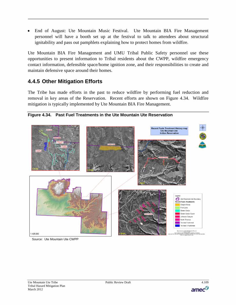
Ute Mountain Ute Tribe Public Review Draft 4.109 Tribal Hazard Mitigation Plan March 2012
• End of August: Ute Mountain Music Festival. Ute Mountain BIA Fire Management personnel will have a booth set up at the festival to talk to attendees about structural ignitability and pass out pamphlets explaining how to protect homes from wildfire.
Ute Mountain BIA Fire Management and UMU Tribal Public Safety personnel use these opportunities to present information to Tribal residents about the CWPP, wildfire emergency contact information, defensible space/home ignition zone, and their responsibilities to create and maintain defensive space around their homes.
4.4.5 37BOther Mitigation Efforts
The Tribe has made efforts in the past to reduce wildfire by performing fuel reduction and removal in key areas of the Reservation. Recent efforts are shown on Figure 4.34. Wildfire mitigation is typically implemented by Ute Mountain BIA Fire Management.
Figure 4.34. Past Fuel Treatments in the Ute Mountain Ute Reservation
Source: Ute Mountain Ute CWPP

5 MITIGATION STRATEGY
Ute Mountain Ute Tribe Public Review Draft 5.1 Tribal Hazard Mitigation Plan
March 2012
44 CFR Requirement 201.7(c)(3): The plan shall include a mitigation strategy that provides
the Indian tribal government’s blueprint for reducing the potential losses identified in the
risk assessment, based on existing authorities, policies, programs and resources, and its
ability to expand on and improve these existing tools.
This section describes the mitigation strategy process and mitigation action plan for the Ute
Mountain Ute Tribal Hazard Mitigation Plan. It explains how the Tribe accomplished Phase 3 of
FEMA’s 4-phase guidance—Develop the Mitigation Plan—and includes the following from the
10-step planning process:
Planning Step 6: Set Goals
Planning Step 7: Review Possible Activities
Planning Step 8: Draft an Action Plan
5.1 Tribal Hazard Mitigation Plan Goals
Requirement §201.6(c)(3)(i): [The hazard mitigation strategy shall include a] description of
mitigation goals to reduce or avoid long-term vulnerabilities to the identified hazards.
Up to this point in the planning process, the Tribal Hazard Mitigation Planning Committee
(THMPC) has organized resources, assessed natural hazards and risks, and documented
mitigation capabilities. A profile of the Tribe’s vulnerability to natural hazards resulted from
this effort, which is documented in the preceding chapter. The resulting goals, objectives, and
mitigation actions were developed based on this profile. The THMPC developed this aspect of
the plan based on a series of meetings and worksheets designed to achieve a collaborative
mitigation planning effort as described further in this section.
The goals for this plan were developed by the THMPC through a process facilitated by the
consultant project manager during the meeting on the plan’s risk assessment. This analysis of
the risk assessment identified areas where improvements could be made and provided the
framework for the THMPC to formulate planning goals and objectives and the mitigation
strategy for the Tribe.
Goals were defined for the purpose of this mitigation plan as broad-based public policy
statements that:
Represent basic desires of the community;
Encompass all aspects of community, public and private;
Are nonspecific, in that they refer to the quality (not the quantity) of the outcome;
Are future-oriented, in that they are achievable in the future; and
Are time-independent, in that they are not scheduled events.

Ute Mountain Ute Tribe Public Review Draft 5.2 Tribal Hazard Mitigation Plan
March 2012
Goals are stated without regard for implementation, that is, implementation cost, schedule, and
means are not considered. Goals are defined before considering how to accomplish them so that
the goals are not dependent on the means of achievement. Goal statements form the basis for
objectives and actions that will be used as means to achieve the goals. Objectives define
strategies to attain the goals and are more specific and measurable.
At the end of the risk assessment meeting team members were given a worksheet that included a
list of sample goals to consider, including the goals of the Colorado Hazard Mitigation Plan. The
THMPC was instructed that they could use, combine, or revise the statements they were
provided or develop new ones on their own, keeping the risk assessment in mind. Team
members were asked to write 2 or 3 goals and related objectives to meet each goal on the
worksheet. These goal worksheets were collected by the consultant project manager and
grouped into similar themes. Draft goals were developed from this process and provided in a
handout for discussion at the beginning of the mitigation strategy meeting. Some of the
statements were determined to be better suited as objectives or actual mitigation projects, and
were designated as such. The finalized goals that resulted represented the THMPC’s input and
consensus.
Based upon the risk assessment review and goal setting process, the THMPC developed the
following goals and associated objectives:
Goal 1: Increase Public Awareness of Vulnerability to Hazards
Inform people about natural and man-made events such as weather, fire, and hazardous
materials.
Educate citizens regularly through public meetings and outreach on television channels and
other media.
Educate citizens about wildfire defensible space
Goal 2: Minimize the Risk from Hazards to Existing and Proposed Development, Tribal
Assets, and Cultural Sites
Identify sacred places and secure them as best as possible against the elements
Reduce hazard risk naturally such as using native species to control erosion, flooding, and
increase drought and wildfire tolerance
Maintain the flood mitigation efforts including diversions around Towaoc
Reduce the impact of natural hazards to protection of people and property through public
awareness training
Continue fire mitigation efforts including defensible space and fuels treatments
Goal 3: Reduce the Loss of Life and Personal Injuries from Hazard Events
Provide periodic education of changing circumstances to Emergency Response Plan
Objectives for multi-hazards.

Ute Mountain Ute Tribe Public Review Draft 5.3 Tribal Hazard Mitigation Plan
March 2012
Periodically test plans with drills and exercises to identify weaknesses in plans
Goal 4: Assess needs for Multi-Program Participation
Provide cross communication to all local, tribal, states, and federal government participation
in this Hazard Mitigation Plan’s implementation and update.
5.2 Identification and Analysis of Tribal Mitigation Actions
44 CFR Requirement §201.7(c)(3)(ii): The mitigation strategy shall include a section that
identifies and analyzes a comprehensive range of specific mitigation actions and projects
being considered to reduce the effects of each hazard, with particular emphasis on new and
existing buildings and infrastructure.
In order to identify and select mitigation measures to support the mitigation goals, each hazard
identified in Section 4.1: Identifying Hazards was evaluated. The THMPC analyzed a
comprehensive set of viable mitigation alternatives that would support identified goals and
objectives. Each THMPC member was provided with the following list of categories of
mitigation measures, which originate from the NFIP Community Rating System:
Prevention
Property Protection
Structural Projects
Natural Resource Protection
Emergency Services
Public Information
The THMPC members were also provided with several lists of alternative multi-hazard
mitigation actions for each of the above categories as well as a list of typical mitigation actions
by hazard type. These lists are captured in Appendix B Planning Process. THMPC members
were encouraged to develop mitigation alternatives that would protect future, as well as existing,
development from hazards per the DMA 2000 regulations. A facilitated discussion then took
place to examine and analyze the alternatives. THMPC members wrote project ideas on a
mitigation action worksheet. These ideas were discussed amongst the group and collected at the
meeting for inclusion in the plan. The action worksheets allowed key details regarding the
mitigation project to be captured for integration into the plan, and also helped prioritization of
actions as described in the next section.
Ute Mountain Ute Tribe Public Review Draft 5.4 Tribal Hazard Mitigation Plan
March 2012
5.3 Implementation of Tribal Mitigation Actions
44 CFR Requirement §201.7(c)(3)(iii): The mitigation strategy shall include an action plan
describing how the actions identified in paragraph (c)(2)(ii) of this section will be
prioritized, implemented, and administered by the Indian tribal government.
This section outlines the development of the final mitigation action plan. The action plan
consists of the specific projects, or actions, designed to meet the plan’s goals. Over time the
implementation of these projects will be tracked as a measure of demonstrated progress on
meeting the plan’s goals.
5.3.1 Prioritization Process
Once the mitigation actions were identified, the THMPC members were provided with several
sets of decision-making tools, including FEMA’s recommended criteria, STAPLE/E (which
considers social, technical, administrative, political, legal, economic, and environmental
constraints and benefits).
Social: Does the measure treat people fairly?
Technical: Will it work? (Does it solve the problem? Is it feasible?)
Administrative: Is there capacity to implement and manage the project?
Political: Who are the stakeholders? Did they get to participate? Is there public support? Is
political leadership willing to support it?
Legal: Does your organization have the authority to implement the measure? Is it legal? Are
there liability implications?
Economic: Is it cost-beneficial? Is there funding? Does it contribute to the local economy or
economic development? Does it reduce direct property losses or indirect economic losses?
Environmental: Does it comply with environmental regulations or have adverse
environmental impacts?
In accordance with the DMA requirements, an emphasis was placed on the importance of a
benefit-cost analysis in determining project priority (the ‘economic’ factor of STAPLE/E).
Other criteria used to recommend what actions might be more important, more effective, or more
likely to be implemented than others included:
Does the action protect lives?
Does the action address hazards or areas with the highest risk?
Does the action protect critical facilities, infrastructure, community assets, natural or cultural
assets?
Does the action meet multiple objectives (Multiple Objective Management)?
Team members discussed potential projects at the mitigation strategy meeting and discussed the
relative priority of these projects with the above criteria in mind, essentially voting on the

Ute Mountain Ute Tribe Public Review Draft 5.5 Tribal Hazard Mitigation Plan
March 2012
projects. The projects with were assigned a ‘high,’ medium or low priority. This process
provided both consensus and priority for the recommendations.
The results of the project identification and prioritization exercise are summarized in Table 5.1
and detailed in the text that follows the table. These projects detail specific actions for reducing
future hazard-related losses within the Reservation. The projects are organized by the hazards
that the projects are intended to mitigate. Included are notes about the department and partners
necessary to implement the project. Also included are the goal(s) that the projects primarily
align with, with an understanding that some projects may help to achieve more than one goal.
The mitigation projects are marked with their relative level of priority: H=high, M=medium, and
L=low.
Specific actions, comments, and the parties responsible for each objective are captured in Table
5.1. For each identified project a worksheet designed to capture additional details was filled out
by the THMPC member or organization taking the lead on project implementation. These details
include: project intent, hazard(s) mitigated, other alternatives considered, cost, benefits (losses
avoided), responsible entity, priority, and potential funding. These project details are captured in
the action descriptions following Table 5.1. Many of these mitigation actions are intended to
reduce impacts to existing development. Those that protect future development from hazards, as
required per the DMA 2000 regulations, are indicated by an asterisk ‘*’ in the action title.

Ute Mountain Ute Tribe Public Review Draft 5.6 Tribal Hazard Mitigation Plan
March 2012
Table 5.1. Ute Mountain Ute Tribal Mitigation Action Summary Table
Action Title Responsible
Agency Hazard
Addressed Related Goal(s) Priority
Multi-Hazard
Develop and Conduct a Multi-Hazard Seasonal Public Awareness Program
Public Safety BIA – Fuels
Management Tribal – Natural
Resources Environmental
Department
All All H
Improve GIS Databases for future vulnerability studies* Planning BIA
Environmental Public Safety
All All H
Develop and Conduct a Multi-Hazard Seasonal Public Awareness Program
Public Safety BIA – Fuels
Management Tribal – Natural
Resources Environmental
Department
Drought Extreme
Temperatures Severe
Weather Winter Storm
All H
Flood
HAZUS Level II Flood Assessment* EPD Planning
Flood 2 H
Flood Hazard Reduction on Ute Mountain Ute Reservation
Weeminuche Construction
Flood 2 M
Cottonwood Wash Diversion Rebuild Environmental Programs
Public Safety Planning
Flood 2 H
Hazardous Materials
Work with Surrounding Communities/Counties to Create Haz-Mat Team.
LEPC Hazardous Materials
3 M
Landslide/Rockfall
Moisture and Soil Erosion damages in Mancos Canyon near Sandal House.
WCA Flood Landslide
2 M
Wildfire
WUI Fuels Treatment Implementation BIA – Fuels Management
Tribal – Natural Resources
Environmental Department
Wildfire 2, 3 H
* Intended to reduce losses to future development

Ute Mountain Ute Tribe Public Review Draft 5.7 Tribal Hazard Mitigation Plan
March 2012
Action Item #1 Develop and Conduct a Multi-Hazard Seasonal Public Awareness
Program
Hazards Addressed: All, including Drought, Extreme Temperatures, Severe Weather,
Winter Storm
Issue/Background: The Reservation is subject to several natural hazards. Each poses a
different degree of risk and associated vulnerability. Some hazards have a combination of
attributes, including a high likelihood of occurrence, a specific location that would likely be
impacted, and proven approaches that could reduce the impact. For other hazards, where either
the likelihood of occurrence is very low, the area of likely impact is not specifically known, or
there is very little that can be done to reduce the impacts, the HMPC has determined that the best
approach is public awareness. Tribal members should have information describing historical
events and losses, the likelihood of future occurrences, the range of possible impacts, appropriate
actions to save lives and minimize property damage, and where additional information can be
found. Any information provided through this effort should be accurate, specific, timely, and
consistent with current and accepted local emergency management procedures as promoted by
the Bureau of Indian Affairs, Colorado Department of Emergency Management (CDEM) and the
American Red Cross. Following a disaster event, there should be extra efforts to provide the
public with information about disaster preparedness and mitigation measures. This public
outreach effort should be conducted annually and should include:
Using a variety of information outlets, including local news media;
Creating and printing (where applicable) brochures, leaflets, water bill inserts, and public
service announcements;
Displaying current brochures and flyers in tribal office buildings, libraries, and other public
places; and
Developing public-private partnerships and incentives to support public education activities.
This project will be undertaken as part of the continuing Firewise workshops
Other Alternatives: Continue public information activities currently in place
Responsible Office and partners:
Public Safety
BIA – Fuels Management
Tribal – Natural Resources
Environmental Department
Priority (High, Medium, Low): High
Cost Estimate: Staff time, printing costs for literature.

Ute Mountain Ute Tribe Public Review Draft 5.8 Tribal Hazard Mitigation Plan
March 2012
Benefits (Avoided Losses): Life safety, reduction in property losses, relatively low cost
Potential Funding: State Hazard Mitigation Program grants, tribal funds, other available grants
Schedule: Part of seasonal multi-hazard public awareness campaign, and in conjunction with
Firewise workshops.
Action Item #2 Improve GIS Databases for future vulnerability studies
Hazards Addressed: Multi-hazard
Issue/Background: During the development of this plan the best available GIS data resources
were utilized. Some of these resources, such as the building inventory data from HAZUS, were
considered to be inaccurate or inadequate. A well defined and more robust database is needed at
a central location that can be accessed by several departments, especially departments that can
review data and make determinations on where the tribe is more vulnerable to hazards.
Other Alternatives: No action.
Responsible Office and partners: Planning, BIA, Environmental, Public Safety; National
Geospatial Resource Center in Albuquerque can provide free GIS software and training to the
tribe
Priority (High, Medium, Low): High
Cost Estimate: Unknown
Benefits (Avoided Losses): Overall data can be combined from several departments. Can help
identify possible hazard areas before they occur. Could also be used to support improved
emergency response.
Potential Funding: Planning grant to improve GIS data resources to do a more thorough risk
assessment for the tribe. BIA provides free GIS software resources to tribes.
Schedule: Within 5 years. Update every 5 years.
Action Item #3 Develop and Conduct a Multi-Hazard Seasonal Public Awareness
Program
Hazards Addressed: All, including Drought, Extreme Temperatures, Severe Weather,
Winter Storm
Issue/Background: The Reservation is subject to several natural hazards. Each poses a
different degree of risk and associated vulnerability. Some hazards have a combination of

Ute Mountain Ute Tribe Public Review Draft 5.9 Tribal Hazard Mitigation Plan
March 2012
attributes, including a high likelihood of occurrence, a specific location that would likely be
impacted, and proven approaches that could reduce the impact. For other hazards, where either
the likelihood of occurrence is very low, the area of likely impact is not specifically known, or
there is very little that can be done to reduce the impacts, the HMPC has determined that the best
approach is public awareness. Tribal members should have information describing historical
events and losses, the likelihood of future occurrences, the range of possible impacts, appropriate
actions to save lives and minimize property damage, and where additional information can be
found. Any information provided through this effort should be accurate, specific, timely, and
consistent with current and accepted local emergency management procedures as promoted by
the Bureau of Indian Affairs, Colorado Department of Emergency Management (CDEM) and the
American Red Cross. Following a disaster event, there should be extra efforts to provide the
public with information about disaster preparedness and mitigation measures. This public
outreach effort should be conducted annually and should include:
Using a variety of information outlets, including local news media;
Creating and printing (where applicable) brochures, leaflets, water bill inserts, and public
service announcements;
Displaying current brochures and flyers in tribal office buildings, libraries, and other public
places; and
Developing public-private partnerships and incentives to support public education activities.
This project will be undertaken as part of the continuing Firewise workshops
Other Alternatives: Continue public information activities currently in place
Responsible Office and partners:
Public Safety
BIA – Fuels Management
Tribal – Natural Resources
Environmental Department
Priority (High, Medium, Low): High
Cost Estimate: Staff time, printing costs for literature.
Benefits (Avoided Losses): Life safety, reduction in property losses, relatively low cost
Potential Funding: State Hazard Mitigation Program grants, tribal funds, other available grants
Schedule: Part of seasonal multi-hazard public awareness campaign, and in conjunction with
Firewise workshops.

Ute Mountain Ute Tribe Public Review Draft 5.10 Tribal Hazard Mitigation Plan
March 2012
Action Item #4 HAZUS Level II Flood Assessment
Hazards Addressed: Flood
Issue/Background: There is currently no accurate GIS mapped floodplain for the Reservation.
The existing HAZUS level 1 analysis was not refined enough to capture risk to Towaoc from
Cottonwood Wash. HAZUS level 1 default inventory databases are inadequate or inaccurate. A
Level II flood assessment would provide a higher resolution assessment by utilizing a smaller
drainage basin (suggested 1 sq mile vs 10 sq mile area limitation in Level 1 analysis) and utilize
user-defined building inventory for more accurate results.
Other Alternatives: No action
Responsible Office and partners: EPD, Planning
Priority (High, Medium, Low): High
Cost Estimate: GIS exercise and data transfer. Roughly $15,000 to hire a consultant to help
develop building specific data, import data into HAZUS and run analysis.
Benefits (Avoided Losses): Demonstrate need for flood hazard mapping from FEMA, better
understanding of hazard impacts. New projects (pumps/storage) may result from findings of this
analysis.
Potential Funding: Limited funding is available for Tribe. FEMA funding or Colorado CDEM
funding.
Schedule: 1-2 years
Action Item #5 Flood Hazard Reduction on Ute Mountain Ute Reservation
Hazards Addressed: Flood
Issue/Background: Throughout the Ute Mountain Ute Reservation, flooding has been occurring
in both populated and remote areas. Rainfall on areas burned by fires to the north of the
Reservation have caused road wash outs in remote areas of the Reservation. A flood on Cowboy
Wash in 2009 had the potential to plug culverts on Highway 160 near the Four Corners area.
Other Alternatives: No action.
Responsible Office and partners: Weeminuche Construction Authority has begun to put in
culverts and improve drainage. CDOT could be a partner where highways are affected.
Priority (High, Medium, Low): Medium

Ute Mountain Ute Tribe Public Review Draft 5.11 Tribal Hazard Mitigation Plan
March 2012
Cost Estimate: Will vary depending on culvert/drainage project
Benefits (Avoided Losses): Damage to roads. Longer evacuation times for visitors to remote
areas (Mancos Canyon).
Potential Funding: Weeminuche Construction Authority; If cost effective FEMA PDM or
HMGP; FEMA Public Assistance funds if a declared disaster.
Schedule: Within 5 years
Action Item #6 Cottonwood Wash Diversion Rebuild
Hazard Addressed: Flood
Issue/Background: The diversion structure on the north side of Towaoc needs maintenance or
replacement to protect the community from flooding. A flood in 2004 was thought to be a 50
year event. It blew out the diversion berm and flooded Mike Wash Rd and the gravel pit. A BIA
engineering study exists that includes a drawing for the diversion structure. The area has also
been looked at by the Army Corp of Engineers who suggested an armored arroyo. This would
cost $1-2 million but the 50% local match requirement would make this infeasible. Partnering
with the Weeminuche Construction Authority may make the diversion enhancement option more
feasible.
Other Alternatives:
No action. (poor alternative as flooding will continue)
Continued maintenance (expensive and re-occurring)
Responsible Office and partners:
Environmental Programs
Public Safety
Planning
Priority (High, Medium, Low): High
Cost Estimate:
$100,000 w/Weeminuche Construction Authority
$1,000,000 w/o Weeminuche Construction Authority
Benefits (Avoided Losses): Reduced risk to life and property damage; reduced road and bridge
damage.
Potential Funding:
Ute Mountain Ute Tribe Public Review Draft 5.12 Tribal Hazard Mitigation Plan
March 2012
Weeminuche Construction Authority (WCA) internal – for gravel
Army Corp of Engineers – 50% up to $2 million
FEMA – PDM or HMGP grants
USDA
Schedule: To be determined
Action Item #7 Moisture and Soil Erosion Damages in Mancos Canyon near Sandal
House.
Hazard Addressed: Flood, Landslide
Issue/Background: A fire on Moccasin Mesa Tribal Land and Mesa Verde National Park
caused road problems. The road was damaged by rains that fell on lands burned by wildfire that
led to erosion. There is a need to repair a dirt road on Moccasin Mesa on National Park Service
Land and Tribal Land and improve drainage so that future repairs are minimized.
Other Alternatives: No action.
Responsible Office and partners: WCA; NPS; BIA
Priority (High, Medium, Low): Medium
Cost Estimate: To be determined.
Benefits (Avoided Losses): Continuous vehicle access to Moccasin Mesa and reduced future
damages to the road.
Potential Funding: WCA, NPS
Schedule: Within 5 years
Action Item #8 Work With Surrounding Communities/Counties To Create Haz-Mat
Team.
Hazard Addressed: Hazardous Materials
Issue/Background: The Reservation is traversed by two Colorado hazardous material routes –
Highway 491 and Highway 160. The Reservation also contains 140 oil wells that supply crude
to storage tanks. These fixed facilities are at risk to leaks to the tanks, or to leaks that may occur
during transport of stored oil to transport vehicles. Hydrogen sulfide gas occurs naturally
underground but is a potentially harmful to human health when it is released during oil and gas
drilling operations.

Ute Mountain Ute Tribe Public Review Draft 5.13 Tribal Hazard Mitigation Plan
March 2012
Other Alternatives: No action
Responsible Office and partners: LEPC, Colorado State Patrol, Montezuma County, Dolores
County
Priority (High, Medium, Low): Medium
Cost Estimate: $500,000 for training and equipment
Benefits (Avoided Losses): Increased life safety for tribal members, workers on oil and gas
rigs, and for tourists and others who pass through the Reservation.
Potential Funding: To be determined.
Schedule: Dependent on funding.
Action Item #9 WUI Fuels Treatment Implementation
Hazard Addressed: Wildfire
Issue/Background: The Tribe desires to reduce hazardous fuels within the WUI areas of the
reservation to reduce risk to structures and life. In order to accomplish this, the following actions
(identified within the CWPP according to the priorities outlined in that document as well as the
management objectives established in the Fuels Plan) will be undertaken.
1) Treat an average of 100 to 300 acres of identified WUI areas annually over the next 10 years.
Treatments deemed successful will be those, determined by fire behavior modeling, to
preclude either crown fire or ground fire with constant flame lengths exceeding 4 feet under
conditions of high fire danger.
2) Treat an average of 20 to 40 acres a year to control or eliminate fire-prone salt cedar and
Russian olive and promote establishment and growth of native willow and cottonwood plant
communities, as well as other culturally significant plants for shade houses and other uses.
3) Promote reestablishment of aspen on the Sleeping Ute Mountain area by promoting aspen
resprouting on 200 to 300 acres over the next 10 years through the application of prescribed
fire, wildland fire use or hand felling.
4) Reestablish vigorous native shrublands within the Forest and the Sleeping Ute Mountain
areas, targeting overmature and decadent shrub stands. Prescribed fire or wildland fire use
will be applied to top-kill at least 75 percent of shrubs and consume a minimum of 50 percent
of down wood. Treat an average of between 200 and 500 acres a year.
5) Treat an average of 500 to 1,000 acres a year of sagebrush with the objective of consuming
75 to 100 percent of residual coarse woody debris and killing from 50 to 100 percent of the
sagebrush component.
6) Treat, on a trial basis, a total of 500 to 1,000 acres of decadent condition class 3 pinyon-
juniper stands over the next several years to convert to condition class 1 or 2. Purpose of

Ute Mountain Ute Tribe Public Review Draft 5.14 Tribal Hazard Mitigation Plan
March 2012
trial will be to evaluate the cost effectiveness of various treatments, and environmental
compliance approaches, in order to explore the efficacy of continuing treatments throughout
the landscape.
7) Develop a Fire Use Plan for the Sleeping Ute Mountain area. Adopt the plan for
implementation targeted for 2010.
8) Over the next 2 years treat approximately 50 acres within the Sundance Ceremonial site to
provide for public safety during traditional ceremonies.
9) Conduct monitoring to determine treatment effectiveness.
Other Alternatives: No action. Lack of action increases risk of larger wildfires on Reservation
lands.
Responsible Office and partners:
BIA – Fuels Management
Tribal – Natural Resources
Environmental Department
Priority (High, Medium, Low): High
Cost Estimate: $800,000-$1,000,000
Benefits (Avoided Losses): Life/Property – less damage to structures, reduced losses to the
local economy.
Potential Funding: Federal HFR funds; FEMA Pre Disaster Mitigation funds or Hazard
Mitigation Grant Program funds (post disaster) if cost effective and NEPA compliant.
Schedule: Over next several years; see also the schedule and specific areas identified in Section
4.4 Tribal Capability Assessment as excerpted from the CWPP.

6 PLAN ADOPTION
Ute Mountain Ute Tribe Public Review Draft 6.1 Tribal Hazard Mitigation Plan
March 2012
Requirement §201.7(c)(5): The plan must be formally adopted by the governing body of
the Indian Tribal government prior to submittal to FEMA for final review and approval.
The purpose of formally adopting this plan is to secure buy-in from the Tribe, raise awareness of
the plan, and formalize the plan’s implementation. The adoption of this plan completes Planning
Step 9 of the 10-step planning process: Adopt the Plan, in accordance with the requirements of
DMA 2000. The Tribal Council for the Ute Mountain Ute Tribe has adopted this local hazard
mitigation plan by passing a resolution. A copy of the generic resolution is included in
Appendix A: Adoption Resolution.

7 PLAN IMPLEMENTATION
AND MAINTENANCE
Ute Mountain Ute Tribe Public Review Draft 7.1 Tribal Hazard Mitigation Plan
March 2012
7.1 Monitoring, Evaluating, and Updating the Plan
44 CFR Requirement 201.7(c)(4): A plan maintenance process that includes (i) a section
describing the method and schedule of monitoring, evaluating, and updating the mitigation
plan.
Implementation and maintenance of the plan is critical to the overall success of hazard mitigation
planning. This is Planning Step 10 of the 10-step planning process, and phase 4 of FEMA’s 4
phase process. This section outlines how this plan will be implemented and updated. The
chapter also discusses incorporating the plan into existing planning mechanisms and how to
address continued public involvement.
Upon adoption, the plan faces the truest test of its worth: implementation. While this plan puts
forth many worthwhile and ―High‖ priority recommendations, the decision of which action to
undertake first will be the first issue that the Tribe faces. Fortunately, there are two factors that
will help make that decision. First, there are high priority items for the Tribe. Second, funding
is always an issue. Thus, pursuing low or no-cost high-priority recommendations will have the
greatest likelihood for success.
7.1.1 Plan Update Process
The updating of the plan will be by written changes and submissions, as the THMPC deems
appropriate and necessary.
Updates to this plan will:
Be done in accordance to the latest FEMA Tribal Multi-Hazard Mitigation Planning
Guidance and plan review crosswalk;
Consider changes in vulnerability due to project implementation;
Document success stories where mitigation efforts have proven effective;
Document areas where mitigation actions were not effective;
Document any new hazards that may arise or were previously overlooked;
Document hazard events and impacts that occurred within the five-year period;
Incorporate new data or studies on hazards and risks;
Incorporate new capabilities or changes in capabilities;
Incorporate documentation of continued public involvement;
Incorporate documentation to update the planning process that may include new or additional
stakeholder involvement;

Ute Mountain Ute Tribe Public Review Draft 7.2 Tribal Hazard Mitigation Plan
March 2012
Incorporate growth and development-related changes to building inventories;
Incorporate new project recommendations or changes in project prioritization;
Include a public involvement process to receive public comment on the updated plan prior to
submitting the updated plan to CDEM/FEMA; and
Include re-adoption by the Tribe following CDEM/FEMA approval.
The Tribe will amend its plan whenever necessary to reflect changes in Tribal or Federal
laws and statutes as required in 44 CFR 13.11(d), per the Section 1.3 Plan Assurances;
Plan Maintenance Schedule
This monitoring and updating will take place through an annual review by the THMPC. The
annual review and five year update will be initiated by the Public Safety Director. It is
recommended that the annual review meeting occur in March and could coincide with annual
reviews of the CWPP. This plan will be updated, approved, and adopted within a five-year cycle
as per Requirement §201.7(c)(4)(i) of the Disaster Mitigation Act of 2000 unless disaster or
other circumstances (e.g., changing regulations) lead to a different time frame.
When the THMPC reconvenes for the review, they will coordinate with each agency that
participated in the planning process – or that has joined the THMPC since the inception of the
planning process – to update and revise the plan. Public notice will be given and public
participation will be invited, at a minimum, through available web-postings and press releases to
local media outlets.
7.2 Monitoring Progress of Mitigation Activities
§201.7(c)(4)(ii): [The plan maintenance process must include a] system for monitoring
implementation of mitigation measures and project closeouts.
With adoption of this plan, the THMPC will take the lead on plan implementation and
maintenance. The THMPC will act as an advisory body. Its primary duty is to see the plan
successfully carried out and to report to the Tribal Council and the public on the status of plan
implementation and mitigation opportunities. Other duties include reviewing and promoting
mitigation proposals, considering stakeholder concerns about hazard mitigation, passing
concerns on to appropriate entities, and posting relevant information on the Tribal website and in
local newspapers. The THMPC agrees to:
Act as a forum for hazard mitigation issues;
Disseminate hazard mitigation ideas and activities to all participants;
Pursue the implementation of high-priority, low/no-cost recommended actions;
Keep the concept of mitigation in the forefront of Tribe decision making by identifying plan
recommendations when other Tribal goals, plans, and activities overlap, influence, or directly
affect increased Tribal vulnerability to disasters;

Ute Mountain Ute Tribe Public Review Draft 7.3 Tribal Hazard Mitigation Plan
March 2012
Maintain a vigilant monitoring of multi-objective cost-sharing opportunities to help the Tribe
implement the plan’s recommended actions for which no current funding exists;
Monitor and assist in implementation and updates to this plan;
Report on plan progress and recommended changes to the Tribal Council; and
Inform and solicit input from the public.
The evaluation of the progress can be achieved by monitoring changes in the vulnerability
identified in the plan and progress towards meeting the plan’s goals. Changes in vulnerability
can be identified by noting:
Lessened vulnerability as a result of implementing recommended actions/projects;
Increased vulnerability as a result of failed or ineffective mitigation actions, and/or;
Increased vulnerability as a result of new development.
Progress towards the plan’s goals can be monitored through implementation of projects. Each
department responsible for completing a mitigation action will prepare a Mitigation Action
Report for the annual meeting in March of each year. If grant funds are involved the lead entity
on the project will ensure that grant timelines and documentation requirements are met so that
project closeouts are completed accordingly. Lead entities will work with FEMA and CDEM
staff, where applicable, on the latest quarterly reporting and closeout procedures.
7.3 Incorporation into Existing Planning Mechanisms
44 CFR Requirement §201.7(c)(4)(iii):[A plan maintenance process that includes] a process
by which the Indian tribal government incorporates the requirements of the mitigation
plan into other planning mechanisms such as reservation master plans or capital
improvement plans, when appropriate.
Mitigation is most successful when it is incorporated into the day-to-day functions and priorities
of government and development. An important implementation mechanism that is highly
effective and low-cost is incorporation of the hazard mitigation plan recommendations and their
underlying principles into other plans and mechanisms, such as the Tribal Emergency Response
Plan. The Tribe already implements policies and programs to reduce losses to life and property
from hazards. This plan builds upon the momentum developed through previous and related
planning efforts and mitigation programs and recommends implementing actions, where
possible, through these other program mechanisms.
Implementation will be accomplished by adhering to the schedules identified for each action and
through constant, pervasive, and energetic efforts to network and highlight the multi-objective,
win-win benefits to each program and the planning area. This effort is achieved through the
routine actions of monitoring agendas, attending meetings, and promoting a safe, sustainable
community. Additional mitigation strategies could include consistent and ongoing enforcement

Ute Mountain Ute Tribe Public Review Draft 7.4 Tribal Hazard Mitigation Plan
March 2012
of existing policies and vigilant review of programs for coordination and multi-objective
opportunities.
Simultaneous to these efforts, it is important to maintain a constant monitoring of funding
opportunities that can be leveraged to implement some of the more costly recommended actions.
This will include creating and maintaining a bank of ideas on how to meet local match or
participation requirements. When funding does become available, the Tribe will be in a position
to capitalize on the opportunity. Funding opportunities to be monitored include special pre- and
post-disaster funds, special district budgeted funds, state and federal earmarked funds, and other
grant programs, including those that can serve or support multi-objective applications.
Where possible, plan participants will use existing plans and/or programs to implement hazard
mitigation actions. Based on the capability assessment in Section 4.4 of this plan, the Tribe will
continue to plan and implement programs to reduce loss of life and property from hazards. This
plan builds upon the momentum developed through previous related planning efforts and
mitigation programs, and recommends implementing actions, where possible, through the
following means:
Emergency Operations Plan
Community Wildfire Protection Plan
―Firewise‖ and other Fire Mitigation Programs
Integrated Resource Management Plan
Stormwater Management Plan
Tribal ordinances
Capital improvement plans and budgets
The risk assessment in this plan will provide information for the hazard analysis in the next
update of the Tribal Emergency Response Plan. Risks identified in this plan should also be
considered in the Integrated Resource Management Plan (IRMP) in the context of cultural and
natural resource management/protection. This IRMP was in development during the time of the
initial development of this plan, and efforts were made to coordinate the efforts, including
involving staff associated with the development of the IRMP on the THMPC. THMPC members
involved in updating the existing planning mechanisms will be responsible for integrating the
findings and actions of the mitigation plan, as appropriate. The THMPC is also responsible for
monitoring this integration and incorporating the appropriate information into the five-year
update of the multi-hazard mitigation plan.

Ute Mountain Ute Tribe Public Review Draft 7.5 Tribal Hazard Mitigation Plan
March 2012
7.4 Continued Public Involvement
44 CFR Requirement §201.7(c)(4)(iv): [A plan maintenance process that includes]
discussion on how the Indian tribal government will continue public participation in the
plan maintenance process.
Continued public involvement is imperative to the overall success of the plan’s implementation.
The update process provides an opportunity to solicit participation from new and existing
stakeholders and to publicize success stores from the plan implementation and seek additional
public comment. The plan maintenance and update process will include continued public and
stakeholder involvement and input through attendance at designated committee meetings, flyers,
web postings, press releases to local media, ―Fire Wise‖ meetings, and through public hearings.
When the THMPC reconvenes for the update, they will coordinate with all stakeholders
participating in the planning process—including those that joined the committee since the
planning process began—to update and revise the plan. In reconvening, the THMPC plans to
identify a public outreach subcommittee, which will be responsible for coordinating the activities
necessary to involve the public. The subcommittee will develop a plan for public involvement
and will be responsible for disseminating information through a variety of media channels
detailing the plan update process. As part of this effort, a series of public meetings will be held
and public comments will be solicited on the plan update draft.

Appendix A INTRODUCTION
Ute Mountain Ute Tribe Public Review Draft Appendix A.1 Tribal Hazard Mitigation Plan
March 2012
Note to Reviewers: When this plan has been reviewed and approved pending adoption by
FEMA Region VIII, the adoption resolutions will be signed by the participating jurisdictions and
added to this appendix. A model resolution is provided below:
Resolution # ______
Adopting the Ute Mountain Ute Tribal Hazard Mitigation Plan
WHEREAS the Ute Mountain Ute Tribe has historically experienced severe damage from
natural and human-caused hazards such as flooding, wildfire, earthquake, drought,
thunderstorms/high winds, and hazardous materials incidents on many occasions in the past
century, resulting in loss of property and life, economic hardship, and threats to public health and
safety;
WHEREAS the Ute Mountain Ute Tribe has developed and received conditional approval from
the Federal Emergency Management Agency (FEMA) for its All Hazard Mitigation Plan under
the requirements of 44 CFR 201.7;
WHEREAS the Plan specifically addresses hazard mitigation strategies and plan maintenance
procedures for the Ute Mountain Ute Tribe;
WHEREAS the Plan recommends several hazard mitigation actions/projects that will provide
mitigation for specific natural and human caused hazards that impact Ute Mountain Ute Tribe,
with the effect of protecting people and property from loss associated with those hazards;
WHEREAS, adoption of this plan will make the Ute Mountain Ute Tribe eligible for funding to
alleviate the impacts of future hazards on the Reservation,
NOW THEREFORE BE IT RESOLVED by the [insert appropriate official titles] of the Ute
Mountain Ute Tribe that:
1) The Plan is hereby adopted as an official plan of Ute Mountain Ute Tribe.
2) The respective officials identified in the mitigation strategy of the Plan are hereby directed to
pursue implementation of the recommended actions assigned to them.
3) Future revisions and Plan maintenance required by 44 CFR 201.7 and FEMA, are hereby
adopted as a part of this resolution for a period of five (5) years from the date of this
resolution.
4) An annual report on the progress of the implementation elements of the Plan shall be
presented to the [insert appropriate official titles such as Mayor, Town Council, Board of
Supervisors, Tribal Council, etc.] by [insert date] of each calendar year.
5) The Ute Mountain Ute Tribe will comply with all applicable Federal statutes and regulations
in effect with respect to the periods for which it receives grant funding, in compliance with

Ute Mountain Ute Tribe Public Review Draft Appendix A.2 Tribal Hazard Mitigation Plan
March 2012
44 CFR 13.11 (c); and will amend our Plan whenever necessary to reflect applicable changes
in Tribe, State or Federal laws and statutes as required in 44 CFR 13.11. (d).
PASSED by the Ute Mountain Ute Tribe, this ___ day of ____ (month), _____(year).
Certifying Official

Appendix B PLANNING PROCESS
Ute Mountain Ute Tribe Publice Review Draft Appendix B.1 Tribal Hazard Mitigation Plan
March 2012

Ute Mountain Ute Tribe Public Review Draft Appendix B.2 Tribal Hazard Mitigation Plan
March 2012
UTE MOUNTAIN UTE HAZARD MITIGATION PLAN
KICKOFF MEETING
February 1, 2011
1400 (2 P.M.)
East Wing Conference Room
1) Opening Remarks and Introductions
2) Mitigation, Tribal Mitigation Planning, & the Disaster Mitigation Act Requirements Intro to Mitigation Planning: DMA 2000/DRU
Hazard Mitigation & Emergency Management Services
AMEC Earth & Environmental
University of Colorado, Boulder 16
A 10-Step Process Within the 4-Phase GuidancePhase I: Organize Resources
Get organized
Plan for public involvement
Coordinate with other
departments and agencies
Phase II: Hazard Identification and Risk
Assessment
Identify the hazard(s)
Assess the risks
Phase III: Develop A Mitigation Plan
Set planning goals
Review possible activities
Draft an action plan
Phase IV: Adoption and Implementation
Adopt the plan
Implement the plan, evaluate its worth, and revise as needed
3) The Role of the Hazard Mitigation Planning Committee
4) Coordinating with Other Agencies/Related Planning Efforts
5) Planning for Public Involvement
6) Hazard Identification
7) Data Collection Needs
8) Project Schedule and Next Steps
9) Questions and Answers/Adjourn

Ute Mountain Ute Tribe Public Review Draft Appendix B.3 Tribal Hazard Mitigation Plan
March 2012

Ute Mountain Ute Tribe Public Review Draft Appendix B.4 Tribal Hazard Mitigation Plan
March 2012

Ute Mountain Ute Tribe Public Review Draft Appendix B.5 Tribal Hazard Mitigation Plan
March 2012
Agenda
UTE MOUNTAIN UTE HAZARD MITIGATION PLAN
RISK ASSESSMENT MEETING
Tuesday, July 13th, 2011
1:15 to 3:15 pm
1) Opening Remarks and Introductions
2) Review of the Planning Process Intro to Mitigation Planning: DMA 2000/DRU
Hazard Mitigation & Emergency Management Services
AMEC Earth & Environmental
University of Colorado, Boulder 16
A 10-Step Process Within the 4-Phase GuidancePhase I: Organize Resources
Get organized
Plan for public involvement
Coordinate with other
departments and agencies
Phase II: Hazard Identification and Risk
Assessment
Identify the hazard(s)
Assess the risks
Phase III: Develop A Mitigation Plan
Set planning goals
Review possible activities
Draft an action plan
Phase IV: Adoption and Implementation
Adopt the plan
Implement the plan, evaluate its worth, and revise as needed
3) Risk Assessment Presentation and Discussion
a. Hazard Identification review
b. Vulnerability Assessment results
c. Capability Assessment review
4) Developing Plan Goals and Objectives
5) Next Steps/next meeting: Identify and Prioritize Mitigation Projects

Ute Mountain Ute Tribe Public Review Draft Appendix B.6 Tribal Hazard Mitigation Plan
March 2012
Risk Assessment Meeting Minutes
On July 13, 2011, a meeting was held to discuss the draft risk assessment developed for the Ute
Mountain Ute Multi-Hazard Mitigation Plan. A conference call was held with AMEC, the
consultant helping to prepare the plan, and the Ute Mountain Ute Tribe. In attendance for
AMEC were Jeff Brislawn, Mack Chambers, and Chris Morrison. In attendance for the Tribe
were John Trochek (Public Safety), Jacob Dance, Jr. (Tribal Park), Tom Rennick (BIA Forestry),
Keith Yessith (BIA Facilities Mgmt), Madison Delby (Cultural Resources), and Peter Cohn
(Cultural Resources). The meeting began at 1:20 pm. The meeting agenda was presented by Jeff
Brislawn.
Jeff talked to a Power Point presentation and began with an overview of the benefits of hazard
mitigation planning. The 10 step planning process was reviewed and the progress made thus far
in the process was discussed. Planning requirements for the risk assessment were discussed,
followed by a detailed discussion of each hazard, the risk the Tribe faces to each hazard, and the
Tribe’s vulnerability to the hazard. Hazards discussed were:
Dam Failure
Drought
Earthquake
Extreme Temperatures
Flood
Landslide/Rockfall
Severe Weather: Hail/Lightning/Windstorms
Tornado
Wildfire
Winter Storm
Hazardous Materials
Feedback was given by THMPC members on the various hazards. Wildfire, winter storms,
hazardous materials, drought and floods have the potential to cause the greatest impacts. Some of
the points of discussion are noted below:
Flood
There was a flash flood about 5 years ago down the main part of Towaoc. It left a lot of
debris cleanup and culverts to be cleaned around the tribal center but not much damage.
Mancos river had some flooding a couple of months ago that went over the bridge in the
vicinity of the Tribal Park.
It was pointed out that the HAZUS inventory appeared to under-estimate the value of
structures, by about ½, and inventory shown east of HWY 160 does not exist.
HAZUS did not represent the risk of flooding on Cottonwood Wash in Towaoc.

Ute Mountain Ute Tribe Public Review Draft Appendix B.7 Tribal Hazard Mitigation Plan
March 2012
There is a diversion and some mitigation in Cottonwood Wash that may not be adequate.
CDOT has been replacing culverts and widening the road at MM 5 on Hwy 160.
Drought
Most of the Tribe’s water sources comes from Mchpee Reservoir and is piped in from the
north. A spring on the Mountain has gone dry in the past.
Some ranching occurs on the SW side of the Mountain, but there is not much agriculture on
the reservation.
Extreme Temperatures
Natural gas shortages could be problematic. Some solar panels are used for hot water and
emergency generators for critical facilities, including the recreation center, community
center, and Casino which could also function as shelters.
Hail
A 2005 hailstorm did about $12K in building damage that was covered by insurance.
The tribe is in a weather radar shadow caused by the Rocky Mountains which makes precise
forecasting difficult.
Wildfire
The fuels management plan written 3-4 years ago has identified wildland urban interface
areas
Hazardous Materials
A commodity flow study has been completed in the region.
Nuclear materials are being transported from New Mexico to storage facilities in Utah.
The LEPC is putting in a grant to develop a HazMat response team.
Education and training is needed for first responders regarding hydrogen sulfide hazards at
oil and gas wells.
Above ground propane storage is within 200 yds of a day care, prison, and government
buildings
Once hazard risks and vulnerabilities were discussed, Jeff led a discussion on critical facilities
and assets in the Reservation. Cultural and natural resources were discussed as well. Jeff lead
the THMPC on a discussion of existing Tribal capabilities related to mitigating hazards impact,
including the existing wildfire plans, and emergency management program. There are no local
building codes but buildings comply with federal facilities standards.

Ute Mountain Ute Tribe Public Review Draft Appendix B.8 Tribal Hazard Mitigation Plan
March 2012
To kick start the next THMPC meeting, a brief discussion of plan goals and objectives was
introduced. THMPC members were allowed to brainstorm goals for this plan with the guidance
of the goals from the State of Colorado Hazard Mitigation Plan and a goals development
worksheet. A more summary of the draft goals and objectives developed from the exercise will
take place at the beginning of the next meeting scheduled for July 26th.
Feedback on the draft risk assessment was requested by the THMPC to be provided by July
22nd.
The meeting closed at 3:15 pm.
This meeting summary was prepared by AMEC.

Ute Mountain Ute Tribe Public Review Draft Appendix B.9 Tribal Hazard Mitigation Plan
March 2012

Ute Mountain Ute Tribe Public Review Draft Appendix B.10 Tribal Hazard Mitigation Plan
March 2012
Agenda
UTE MOUNTAIN UTE HAZARD MITIGATION PLAN
MITIGATION STRATEGY MEETING
Tuesday, July 26th, 2011
1:15 to 3:15 pm
1) Opening remarks and introductions
2) Review the planning process and key issues from the risk assessment and capability
assessment
3) Finalize goals and objectives
4) Review types of mitigation actions
5) Discuss criteria for mitigation action selection and prioritization
6) Brainstorming Session/Development of mitigation actions (group process)
7) Prioritize mitigation actions (group process)
8) Discuss plan implementation and maintenance
9) Discuss next steps

Ute Mountain Ute Tribe Public Review Draft Appendix B.11 Tribal Hazard Mitigation Plan
March 2012
Related Documents


![upreme aurt af nitet tatee · 2017-09-20 · No. 11-729 Supreme Court, U.S. | FILED JAN 1 I ~t~ ur-Piu~ uP ][HE CLERK upreme aurt af nitet tatee UTE MOUNTAIN UTE TRIBE, Petitioner,](https://static.cupdf.com/doc/110x72/5e9b2bd5f8b14a23c81e28a3/upreme-aurt-af-nitet-tatee-2017-09-20-no-11-729-supreme-court-us-filed-jan.jpg)