Using Geographical Information System for Implementing Resettlement Strategies in Mining Areas in Kosovo MURAT MEHA BLERIM REXHA ISMET SHALA BEDRI DRAGUSHA Faculty of Mines and Metallurgy Faculty of Electrical and Computer Engineering Faculty of Mines and Metallurgy Faculty of Mechanical Engineering University of Prishtina Kodra e Diellit pn., 10000 Prishtina KOSOVO [email protected] , [email protected] , [email protected] , [email protected] www.uni-pr.edu Abstract: - In this paper is presented a modern approach for developing and implementing resettlement strategy in mining areas in Kosovo using Geographic Information System. The main aim of such Geographic Information System is to digitally represent various geographical collected data linked to location. The geological map of Kosovo was analogous until year 2000. The lack of a modern information system about miming and settlement areas was deemed as one of the obstacles or difficulties faced by investment decision- makers. The property issues are considered to be directly related with expropriation. Properties registered in the register of rights over immovable property may not be deregistered for any purpose except for public needs. The developed information system will support the calculation of social impacts on the settlements in mining areas and will provide data visualization that will help when creating perceptions regarding mineral source utilization. The full local development benefits of mining can only effectively be realized if local settlement members support and understand mining activities. The most affected area is Kosovo coal basin, which has a surface about 270 km 2 and about 44.021 inhabitants with many public, cult, business and industrial buildings. The final graphical and textual data is prepared in shape file stored in data base, which offers the possibility of usage by many geographic information systems. This software application is developed using latest ASP.NET platform, C# as programming language and Microsoft SQL as database server. It shall server as unique tool for governmental decision makers and to contribute inputs to future policy and management decision-making in the mining and spatial sector. Key-Words: - Database, Expropriations, Property, Geographic Information Systems, Minerals 1 Introduction Development of Geographic Information System (GIS) of settlements in mining areas will provide an overview of the realistic situation in the field on the economic analysis of mining sources. The GIS will provide for definition of various relations and factors, approximate cost of expropriation for mineral use, time necessary for eventual displacement of the settlement. Expropriations and social effects have a special impact on time and cost factors. The developed database is a combination of field research and research undertaken by the Kosovo Cadastral Land Information System (KCLIS). Data on settlements is also gathered in Microsoft Excel, which may be used in the future to calculate data according to various models in conformity with user needs. Upon presentation of an economic analysis on the feasibility of utilization of a mining source, the detailed project to define legal-property relations and initiate further expropriation procedures shall be compiled. 2 Geological Data and Expropriation Process in Kosovo 2.1 Geo Description of Kosovo The global geographical position of Kosovo lays approximately between parallels 420 and 440 of the northern hemisphere of the globe and between WSEAS TRANSACTIONS on INFORMATION SCIENCE and APPLICATIONS Murat Meha, Blerim Rexha, Ismet Shala, Bedri Dragusha ISSN: 1790-0832 18 Issue 1, Volume 8, January 2011

Welcome message from author
This document is posted to help you gain knowledge. Please leave a comment to let me know what you think about it! Share it to your friends and learn new things together.
Transcript

Using Geographical Information System for Implementing
Resettlement Strategies in Mining Areas in Kosovo
MURAT MEHA
BLERIM REXHA
ISMET SHALA
BEDRI DRAGUSHA
Faculty of Mines and Metallurgy
Faculty of Electrical and Computer Engineering
Faculty of Mines and Metallurgy
Faculty of Mechanical Engineering University of Prishtina
Kodra e Diellit pn., 10000 Prishtina
KOSOVO
[email protected], [email protected], [email protected], [email protected]
www.uni-pr.edu
Abstract: - In this paper is presented a modern approach for developing and implementing resettlement strategy
in mining areas in Kosovo using Geographic Information System. The main aim of such Geographic
Information System is to digitally represent various geographical collected data linked to location. The
geological map of Kosovo was analogous until year 2000. The lack of a modern information system about
miming and settlement areas was deemed as one of the obstacles or difficulties faced by investment decision-
makers. The property issues are considered to be directly related with expropriation. Properties registered in the
register of rights over immovable property may not be deregistered for any purpose except for public needs.
The developed information system will support the calculation of social impacts on the settlements in mining
areas and will provide data visualization that will help when creating perceptions regarding mineral source
utilization. The full local development benefits of mining can only effectively be realized if local settlement
members support and understand mining activities. The most affected area is Kosovo coal basin, which has a
surface about 270 km2 and about 44.021 inhabitants with many public, cult, business and industrial buildings.
The final graphical and textual data is prepared in shape file stored in data base, which offers the possibility of
usage by many geographic information systems. This software application is developed using latest ASP.NET
platform, C# as programming language and Microsoft SQL as database server. It shall server as unique tool for
governmental decision makers and to contribute inputs to future policy and management decision-making in the
mining and spatial sector.
Key-Words: - Database, Expropriations, Property, Geographic Information Systems, Minerals
1 Introduction
Development of Geographic Information System
(GIS) of settlements in mining areas will provide an
overview of the realistic situation in the field on the
economic analysis of mining sources. The GIS will
provide for definition of various relations and
factors, approximate cost of expropriation for
mineral use, time necessary for eventual
displacement of the settlement. Expropriations and
social effects have a special impact on time and cost
factors. The developed database is a combination of
field research and research undertaken by the
Kosovo Cadastral Land Information System
(KCLIS). Data on settlements is also gathered in
Microsoft Excel, which may be used in the future to
calculate data according to various models in
conformity with user needs.
Upon presentation of an economic analysis on the
feasibility of utilization of a mining source, the
detailed project to define legal-property relations
and initiate further expropriation procedures shall be
compiled.
2 Geological Data and Expropriation Process in
Kosovo
2.1 Geo Description of Kosovo
The global geographical position of Kosovo lays
approximately between parallels 420 and 440 of the
northern hemisphere of the globe and between
WSEAS TRANSACTIONS on INFORMATION SCIENCE and APPLICATIONS Murat Meha, Blerim Rexha, Ismet Shala, Bedri Dragusha
ISSN: 1790-0832 18 Issue 1, Volume 8, January 2011

meridians 200 and 220 of the eastern geographic
longitude. Kosovo lays in the central part of the
Balkans Peninsula – in Southeast Europe. The
surface of Kosovo is 10 908 km2, and a population
of over 2 million inhabitants. Over 40% of its
inhabitants are in age between 0-15 years. The
population is multiethnic and consists of: 92%
Albanians and 8% other communities (Serbian,
Turkish, Bosnian, Roma, Ashkali). Merely the
Albanian population has three religious confessions
(muslim, catholic and orthodox) [1].
Kosovo has a various geological content as well
with various mineral qualities and quantities. Only a
number of minerals are researched and few of them
were utilized, others are being utilized, whereas
some will only be used in a longer perspective.
Because of such indications and content of minerals
in Kosovo, and because of their occurrence in
Kosovo, the Independent Commission on Mines and
Minerals (ICMM) has conducted a geo-physical
relief in 2006 to assess the occurrence and sorts of
minerals available [2]. Ministry of Energy and
Mines (MEM) has prepared a plan that delineates
perspective mineral areas in Kosovo. The
delineation was performed to provide for clearer
vision for mineral utilization in the future and will
serve various studies that may be carried out to
conduct certain economic and strategic assessments.
The extent and delineation of perspective mineral
zones is presented in the Figure 1.
Fig. 1: Perspective zones in Kosovo
Fig. 2: Geological map of Kosovo [3]
The most significant minerals in these perspective
zones are: coal minerals, lead minerals, zinc
minerals, copper minerals, nickel minerals, chrome
minerals, aluminum minerals, iron minerals, silver
minerals [4], as presented in Figure 2. Furthermore
these minerals are regulated by Law on Mines and
Minerals, recently approved by the Parliament of
Kosovo [5].
2.2 Property expropriation and legal foundation
Mining and mineral processing played a significant
role in Kosovo’s economic development, business
activities, education, infrastructure and growth of
income per capita. Expropriations are necessary for
further development of mineral utilization.
“Expropriation” means all actions of an
expropriating body which include:
Withdrawal of a legitimate right or interest
over a property that belongs to one person
and transforming that property into a public
immovable property, or
WSEAS TRANSACTIONS on INFORMATION SCIENCE and APPLICATIONS Murat Meha, Blerim Rexha, Ismet Shala, Bedri Dragusha
ISSN: 1790-0832 19 Issue 1, Volume 8, January 2011

Compulsory transformation of servitude or
another right of use into public immovable
property.
Expropriation is a necessary tool used by all
democratic authorities in obtaining access to
properties and using the property for common
interest. The expropriation procedure is an essential
state instrument and provides for legal deprivation
of individuals from property possession when the
property represents a common economic interest. In
Kosovo expropriation is regulated by the Law on
Expropriations [6]. This law determines the
procedures, including legal remedies, for the
protection of individuals from non-proportional
interventions on the right to property. These
procedures consist of preparatory activities,
determination of a common interest, expropriation
decision and compensation decision. The Law on
Expropriation determines: rules and conditions, in
accordance with which the Government or
Municipality may expropriate property rights and
other rights over the immovable property of a
person which is further transferred to public
property; it also determines authorizations on
limitation and temporary use of immovable
property; it defines rules and procedures to be
followed in determining the amount and payment
method for expropriation or limitation of property
rights, as well as other provisions that regulate
various issues pertaining to expropriation or
limitation of property rights. When expropriation is
performed by the Government in achieving wider
economic interests of the society, in line with this
law, they supersede all current plans of municipal
authorities or other public and individual plans.
2.2.1 Expropriation process methodology and
management Expropriation process management is carried out
according to the Law on Expropriations [6], and
includes the following:
Mapping of the certain surface zones, to the
general and strategic general interest, as
vision to the decision-making authority,
Preparation of the required documentation,
for the area proposed as a common public
interest,
Publication of the area outlined as a
common interest, in line with the Law on
Expropriation,
Decision on preventing new construction
investments in this area,
Development of the technical property-legal
documentation for expropriation,
Determination of the criteria for assessing
real estate property,
Price proposal for the property and the
assets in the delineated area,
Study and collection of the requests of the
residents for the mining area,
Deadlines and responsibilities for the
implementation of expropriation in certain
phases,
Development of the budgetary plan for
expropriation of the area announced as a
common interest,
The strategy drafted for emergency and
permanent expropriation,
Development of the budgetary plan for
partial or full expropriation of the area
declared as a common interest.
2.2.2 Expropriation through KCLIS The role of land in the country’s economy is very
significant. Cadastral information for the lands are
multidimensional and are used for many purposes,
both for the public and the private sector. KCLIS
has been developed as unified system, including
cadastral data of the lands, the rights to immovable
property; land use, addresses; and it will eventually
include other data, such as: environmental
conditions, buildings and facilities, land value, etc,
for many purposes. Expropriation always depends
on the KCLIS documentation. This documentation
can be divided into two groups: textual and
graphical documentation.
2.2.3 Spatial Data Infrastructure
Spatial Data Infrastructure (SDI) as an
organizational approach to increase spatial
information availability as well as to increase
number of applications using spatial data will offer
easy approach to perspective zones of minerals. In
this case, if we have mineral spatial data available
widely for many, we will have more profit on local
and national level. This is based on definition of
NSDI. National Spatial Data Infrastructure
encompasses the policies, standards and institutional
arrangements involved in delivering spatially-
related information from many different sources to
the widest possible group of potential users [7]. SDI
is a mixture of information technologies, databases,
services, organizational approaches, legislation,
projects etc. Kosovo governmental sector already
starts and is expecting to play leading role
establishing NSDI, including also minerals data,
WSEAS TRANSACTIONS on INFORMATION SCIENCE and APPLICATIONS Murat Meha, Blerim Rexha, Ismet Shala, Bedri Dragusha
ISSN: 1790-0832 20 Issue 1, Volume 8, January 2011

which is going to deal with policy giving answer on
following questions:
What is the price of spatial data sets from
public sector for other users?
Should public sector data be payable or not,
if it is payable?
Which information should be available for
free?
Which rules are dominating: rules of
personal data protection or rules of free
public data access?
Public administration is the largest spatial
information producer as well as the largest data
user. The information from public administration is
essential for every spatial related decision.
Therefore public information must be easy
accessible within public administration as well as
for other users.
2.2.4 Database from the cadastral information
system Based on the projecting task of expropriation and on
the project’s technical description, a database with
the following content shall be created [8]:
Coordinate register ( Y, X, H,) from: (i) the
referent/trigonometric network, (ii)
polygonal network, (iii) separate cadastral
plot limits which undergo expropriation,
and (iv) expropriation lines
Register of submissions,
Recapitulation of surfaces,
Possession lists (certificates of rights over
immovable property),
Orto-photos with cadastral maps in vector
shapes above,
Cadastral maps with the old cadastral
situation, at scales 1: 2 500; 1:1000, 1: 500
pending availability,
Cadastral maps with the new existing
situation from the field, at scales 1: 2 500;
1:1000; 1: 500, pending availability.
These data on expropriation areas comprise the
general foundation, while additional data may also
be added. Cadastral documentation assessment
clearly delineates which parts of the perspective are
belonging to rural, urban or urban areas. In certain
occasions, there are urban areas or entire towns
included in a perspective area. Inclusion of a town
or lake in perspective areas is unjustifiable;
therefore those areas of specific character are
removed from perspective areas.
Cadastral data listed in the upper section may
include:
a) The updated cadastral data in the territory of
expropriated area, and if they are in
correlation with exploitation of minerals,
will be an advantage for the project. In this
case the expropriation process is shorter and
we have reducing costs, each owner directly
will be informed about the process, get
information criteria provided by the future
user and achieve the agreement.
b) The cadastral data in Kosovo are not
homogeneous and this varies from
municipality to municipality. Lack of
cadastral data creates challenges for
implementing the project of expropriation in
correlation with using of minerals. Such
case in Kosovo was deployment of village
Hade which was located in the coal mining
of KEC. Discrepancy of cadastral data with
real situation is presented in fig. 2. At parcel
100/2 now is a building but in the
documentation presented on by cadastre
there is no building. Updating of the
cadastral documentation is necessary for fair
and transparent for compensation of the
owners whose land expropriation was made.
This process requires special commitment
to the commission of expropriation, new
cadastral surveys, certificate of property
rights in RDPP, time and financial
resources. Another challenge is the process
of heritage and eventually mortgages early
parcels that are now in the process of
expropriation. Collection of missing data in
the cadastral documents must be processed,
edited and archived to the cadastral base
before getting compensation for the
expropriated property owners. In solving
these challenges have to be involved
cadastre experts, owners, users the new
beneficiary and local courts.
WSEAS TRANSACTIONS on INFORMATION SCIENCE and APPLICATIONS Murat Meha, Blerim Rexha, Ismet Shala, Bedri Dragusha
ISSN: 1790-0832 21 Issue 1, Volume 8, January 2011

Land Information System (LIS) in Kosovo is
achieved in the register of the immovable property
(IPRR) [9] and in the graphical (GIS) that can it be
called as Kosovo cadastral land information system
(KCLIS). This system provides advantages for the
expropriation process offering the possibility of
controlling the information about real estate, adding
information and increasing reliability on the quality
of service. This support gives opportunity to the
expropriation process, starting from the recipient of
request for services. Quickness of delivery services
for data and transparency to the client for
information that is important to achieve processing
where demand for the service requested by fulfilling
his legal responsibilities. Expropriations bear in
them the long term timeframe, which increases the
cost by creating opportunities for intervention with
or without end, which may change the data on real
estate. Through this graphical data can be achieved
better control and gives opportunity to make a right
decision in terms of their improvement. Creation of
new responsibilities and use of integrated Kosovo
WebGIS's as presented in [9] or through the NSDI,
and setting the information online which will be
available for other interested Agencies.
Therefore the preliminary tests for certain
expropriation should namely started by the updating
the cadastral documentation of the perspective
mineral areas, various types of objects, cultural
objects, industrial facilities, cemeteries in order to
avoid mismatching with field information, as
presented in Figure 3.
Fig. 3: The difference of data in the cadastral
documentation and field
In Table 1 is presented a part of the area number 25
with mineral prospective of Cupper (Cu).
Table 1: Perspective zones of Minerals
Perspective zone: 25 Mineral's type: Cu
Zone Surface Land
Coordinates of the
origin of the area
Municipality Cadastral (ha)
Agricultural
(ha)
Mountain
(ha)
Wasteland
(ha)
Dwelling
(ha) Y / X
Prizren Gornjesellë 955.2 0 472.6 482.5 0
7497539.49
4669117.91
Shtërpce Sevc 71.2 0 71.2 0 0
7497503.39
4671608.73
Shtërpce Jazhincë 810.8 0 810.8 0 0
7500896.67
4668215.45
Shtërpce Vërbeshticë 38.4 0 38.4 0 0
7500896.67
4668215.45
3. Real estate market
To give a professional opinion about the situation
and possibilities for the land market and taxes at
Kosovo’s system is difficult. Kosovo started to
create a new system of land market but it is in
principle probably difficult to choose between the
American systems and European system. The
country with the short tradition the longest market
economy and the most developed real estate market
in the world is not easy to compare to economies in
early development.
Based on the acquired information it may be
ascertained that the area of real estate market value
assessment in the Republic of Kosovo is defined by
law, i.e. the communities are required to assess real
estate tax based on market value. The law defines
very categorically that in order to assess market
WSEAS TRANSACTIONS on INFORMATION SCIENCE and APPLICATIONS Murat Meha, Blerim Rexha, Ismet Shala, Bedri Dragusha
ISSN: 1790-0832 22 Issue 1, Volume 8, January 2011

value of real estate’s as well as to define the taxable
base, the three established valuation principles shall
be used, i.e. the principle of comparable sales, the
purchase-value principle and the principle of real
estate profitability. The criteria and measures as well
as qualities and standards of real estate valuation are
not regulated in detail, i.e. this area is left to
statutory instruments.
The Real estate tax act in the Republic of Kosovo
defines that communities are responsible for
defining taxable base, from the aspect of providing
data as well as from the methodological-
organisational aspect of performing the real estate
market value assessment. The Ministry of Finance
and Economic Relations of the Republic of Kosovo
has no part in the contents or procedures, their
responsibility and duty is merely to provide IT
support to all communities, based on central
information systems.
4 The description of minerals in perspective zone
Kosovo’s coal basin
Mining sector in Kosovo has played an important
role in economic development throughout the
second half of last century. However, after the 1999
war, the mining sector has declined and is reduced
only in the coal mines and to a lesser extent the
exploitation of lead, zinc and minerals Ferronickel.
Coal as a useful energetic mineral in Kosova has
started to be used in 1922 by underground exertions
in Hade’s Mining and later also in Babush –
Lipjan[4].
Now days in the Republic of Kosova, still exist a
considerable amount of coal’s deposits, lignite type.
Lignite is the most important resource in the
Republic of Kosova which supplies about 97 % of
the total production of electric energy. Kosova’s
coal is lignite type; it has a dark color and a high
partaking of wetness. It submits very easy to self-
starting processes under the influence of conditions
and nature’s erosive processes. According to some
thoughts, the main cause of the self-starting of coals
is the participation of pyrite as an inorganic
component. The attributive characteristics of coal
are gained from number of analyses done in
different periods of time of the research. Coals will
remain for a very long period of time one of the
most important source for producing electric energy
in Kosova. The most important coal basins in
Kosova’s territory are: Kosova’s Coal Basin,
Dukagjini’s Coal Basin and Drenica’s Coal Basin.
Kosova’s Coal Basin is situated in Kosova’s basin
and it is one of the biggest coal basins that were
discovered until today in the region and in Europe.
The longitude of the basin is about 30 km, and the
latitude is about 9 km. Kosovo coal basin has a
surface about 270 km2. Kosova’s basin presents a
long basin and relatively narrowed with extension
on the North-West – South-East. It extends from
Mitrovica on the North, to Kaçanik on the South.
The basin is restricted by a high configuration of
relief, with Kopaonik’s Massif on the North-East
side, on the East side with Llapi’s Valley, on the
South side with Kacaniku’s Defile and Shari’s
Mountains, on the West side with Çyçavica’s
Mountains [4].
The morphologic border and the round mountains of
the basin are very hard to cross from fields to high
mountains. Different Geologic researches are almost
finished in Kosova’s coal basin but with a different
intensity and quantity. Kosova’s Basin is built of
Paleozoic’s, Mesozoic’s and Cainozoic’s
formations, also involving the peripheral areas.
In geologic term Kosova’s coal basin consist rough
series of Pliocene’s deposits which is known with a
big petrography and litofacial variety. This series
fatness moves to a wide diapason and it’s a result of
paleo-relief’s morphology and sediment’s
conditions.
Pliocene’s productive series, in lithostratigraphic
aspect is separated in three lithologic parts [10]:
Coal’s floor sheet (Pl1
1)
Coal’s sheet (Pl1
2)
Coal’s ceiling sheet (Pl1
2)
Coal’s floor sheet (Pl1
1) - is represented by different
colors of argils like: green, blue, copper, grey etc;
sometimes it consists carbonated sand and gravel.
These deposit’s maximal fatness is about 300m.
Coal’s sheet (Pl1
2) has a heterogeneous coal sheet,
followed with a sterile under sheet consisted of argil
and carbonates. Coal’s sheet contact over floor
deposits is unclear and with gradual crosses. Coal’s
sheet fatness moves on wide diapason from 5-100m
and at the whole basin it has a medium fatness of
50m. Coal’s sheet deepness moves from the outer
sides about 310m from the North-West parts of the
basin, going to the South-West parts of Henc’s
basin.
Coal’s ceiling sheet (Pl1
2) is concordant over coal’s
sheet and has a split contact with it.
Mostly it’s composed of argil but in special
positions they displace from alluvial deposits and
from baked argil which presents a product of baked
argil from coal’s self-starter processes. In
morphotectonic aspect, Kosova’s coal basin presents
WSEAS TRANSACTIONS on INFORMATION SCIENCE and APPLICATIONS Murat Meha, Blerim Rexha, Ismet Shala, Bedri Dragusha
ISSN: 1790-0832 23 Issue 1, Volume 8, January 2011
a dynamic hollow situated in the geotectonic area of
Vardar. Basin’s formation was done from hard
Pliocene tectonic radials, and as a result there are
number of tectonic separations with different rate
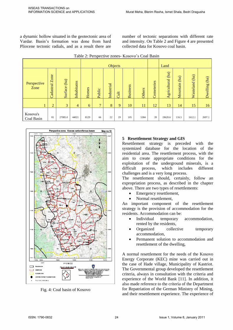
and intensity. On Table 2 and Figure 4 are presented
collected data for Kosovo coal basin.
Table 2: Perspective zones- Kosovo’s Coal Basin
Objects Land
Perspective
Zone
Cad
astr
al Z
on
e
Su
rfac
e (h
a)
Inh
abit
atn
s
Ho
mes
Pu
bli
c
Ind
ust
rial
Cu
lt
Bu
sin
ess
Oth
ers
Cem
eter
ies
Ag
ricu
ltu
ral
(ha)
Mo
un
tain
(h
a)
Was
tela
nd
(h
a)
Dw
elli
ng
(h
a)
1 2 3 4 6 7 8 9 10 11 12 13 14 15 16
Kosova's
Coal Basin 81 27085.0 44021 8129 66 22 19 105 5384 39 19620.6 116.5 1612.1 2697.1
Fig. 4: Coal basin of Kosovo
5 Resettlement Strategy and GIS
Resettlement strategy is preceded with the
systemized database for the location of the
residential area. The resettlement process, with the
aim to create appropriate conditions for the
exploitation of the underground minerals, is a
difficult process, which includes different
challenges and is a very long process.
The resettlement should, certainly, follow an
expropriation process, as described in the chapter
above. There are two types of resettlements:
Emergency resettlement,
Normal resettlement,
An important component of the resettlement
strategy is the provision of accommodation for the
residents. Accommodation can be:
Individual temporary accommodation,
rented by the residents,
Organized collective temporary
accommodation,
Permanent solution to accommodation and
resettlement of the dwelling,
A normal resettlement for the needs of the Kosovo
Energy Corporate (KEC) mine was carried out in
the case of Hade village, Municipality of Kastriot.
The Governmental group developed the resettlement
criteria, always in consultation with the criteria and
experience of the World Bank [11]. In addition, it
also made reference to the criteria of the Department
for Repatriation of the German Ministry of Mining,
and their resettlement experience. The experience of
WSEAS TRANSACTIONS on INFORMATION SCIENCE and APPLICATIONS Murat Meha, Blerim Rexha, Ismet Shala, Bedri Dragusha
ISSN: 1790-0832 24 Issue 1, Volume 8, January 2011

other countries has indicated that resettlement
duration can be from 4-10 years.
5.1 Social impact assessment in the mining area
settlements
Expropriation and resettlement of residences has a
direct or indirect impact to the community living in
that area. For this purpose, the project addressed the
perspective area for the community, social impacts
to the residents, and different age groups. This
project presents the social impact for the
expropriation of Hade village, Municipality of
Kastriot.
5.2 Demography in the perspective mining zones
The number of Kosovo population is still
unconfirmed. The last general census in Kosovo was
done in 1981. When also taking into consideration
other facts such as, internal migrations, and
emigrations, the uncertainties are larger, and the
probability to find an exact number of the
population is lower. Field data gathering for the
project “Creation of the database of settlements in
mining areas” was carried out through the
assessment method and communication with the
residents of the settlements in mining areas.
Demography and other related elements are divided
into two groups:
Perspective areas with a possibility of
opencast mining,
Perspective areas with a possibility for
underground mining,
Depending on the mining possibilities, a
questionnaire was developed for the residents of the
respective settlements. The following questions
were often addressed by the landlords:
When will the project start?
How many of us can be employed?
Do we resettle soon from our homes?
Can I choose another settlement?
Who is responsible and who funds the
project, etc?
Based on the offers for the landlords, the model for
the data collection and their accuracy is developed.
The increased interest for the resettlement has a
direct effect to the increase of the community needs.
An important position, which the residents see in
cases of resettlements, is the creation of new
households, and allocation of lands for construction,
by registering new land plots for the new
households. This is also done with the aim to define
the legal ownership relation, so that the benefits
from the land are realized by every household.
Presentation of the database to the community
clarifies their orientation. The newest such example
in Kosovo is the resettlement of the Hade village,
Municipality of Kastriot, a process that started in
2004. In 2004, the database for the cadastral area of
Hade showed 225 registered owners. However, by
the end of the process in 2006, there were 653
owners (households) with a total 1448 residents.
After receiving the residents’ requests, and the
process development, the number of households,
respectively owners had increased to 653. It results
that the number of family members in the beginning
of the process was 6.4, and at the end of the process,
2.2. This example indicates the rapid increase of the
number of households, with the aim to acquire more
benefits from the expropriation and new
resettlements
5.3 GIS
The GIS application was developed using Microsoft
Developer Studio 2008 and recently ported to 2010
version and C# and Active Server Pages (ASP) as
programming language. Furthermore AJAX
(Asynchronous JavaScript and XML) is used as
ASP.NET extension to make the GIS user interface
more interactive and dynamic. In the Fig. 5 is
presented the general architecture of the GIS
software solution.
CENTRAL DATABASE SERVER
Application Server Web Server
GIS Serveri
Data Server
administratoret
Distributed geodatabase
Oracle 10G Standard / SQL 2005 Standard
WebGIS Shfrytezuesit(3, 4, ...)
WebGIS per qytetaret
E-governmentInternet/Intranet
Fig. 5: Architecture for GIS system
Application architecture used is the same as
presented in [12]. Presentation of the database was
done in two separate groupings: a) general overview
of all perspective areas b) detailed presentation of
the data for every area. The data include the
registration of living standards of the population,
their age-groups according to respective territory.
Various industrial buildings, commercial facilities,
religious sites, and graveyards in perspective areas
WSEAS TRANSACTIONS on INFORMATION SCIENCE and APPLICATIONS Murat Meha, Blerim Rexha, Ismet Shala, Bedri Dragusha
ISSN: 1790-0832 25 Issue 1, Volume 8, January 2011

are accounted for, and listed in a unique
coordination system.
General living standard assessment for the residents
of the perspective mining areas is rather complex
due to different types of settlements, distinguished
according to their:
geographical position,
economic facilities in their surroundings,
development of the current various
businesses,
development of a new infrastructure for the
provision of products, etc.
Difficulties in data collection appear due to the
absence of residents in mountainous areas and
because migrations to the Western Europe. The
following tables provide an overview of the
population according to age-groups for each coal
basin in the Republic of Kosovo.
The database was developed from all required
elements for the settlements in mining areas,
including number of residents, age-groups,
employees, social situation of employees,
schoolchildren, economy of territories in perspective
areas. Table 3 shows only the division of age-groups
and number of residents based on [13].
Table 3: Residents age groups Kosovo
coal basin
Age-
group
Nr. of
residents
%
Kosovo 07-15 12.406 28.2
15-18 6.651 15.1
Other 24.964 56.7
Total 44.021 100
Drenas 07-15 647 23.2
15-18 290 10.4
Other 1.853 66.4
Total 2.790 100
Skenderaj 07-15 548 11.1
15-18 262 5.3
Other 4.132 83.6
Total 4.942 100
Dukagjin 07-15 1.897 36.5
15-18 871 16.7
Other 2.432 46.8
Total 5.200 100
The Table 3 indicates that the age-groups 7-18
comprise around 30% of the residents. These data
facilitates the assessment, population’s education in
the region, and provide a possibility to analyze the
project development for the required expropriation
and resettlement. In Figure 6 and Figure 7 are
presented the view of GIS application and the view
of developed perspective zones. Information data of
the perspective zones and other data on the type of
property, types of plants of the property and those
generally used for the cadastral information system
are archived in the MEM.
Fig. 6: View of GIS application
Fig. 7: View of perspective zones
6 Conclusion
Collection, systemization and processing of the
existing documentation, as well as the data
collection from the ground for each perspective
area, made possible for the development of a new
database in the model described above. The
database was developed with the features and the
required detailed attributes of the dwellings in the
mining area. According to the Kosovo integrated
WebGIS [9], the graphical database was prepared in
shape file. The created model facilitates the future
steps in updating the mining data. With the use of
these data, and the investors’ interests for the
perspective mining zones, national institutions
increase the probability of the results for decision-
making, as it facilitates:
WSEAS TRANSACTIONS on INFORMATION SCIENCE and APPLICATIONS Murat Meha, Blerim Rexha, Ismet Shala, Bedri Dragusha
ISSN: 1790-0832 26 Issue 1, Volume 8, January 2011

Economic analysis of the mining source,
Determination of types of lands,
communities, residents’ age-groups, etc.
Calculation of costs for the expropriation
for mining purposes,
Calculation of costs for the required
expropriation and eventual resettlement of
the dwellings,
Indeed, several other analysis and studies have to be
developed based on this GIS model, taking into
consideration the timing and economic
requirements.
References:
[1] The World Factbook,
https://www.cia.gov/library/publications/the-
world-factbook/geos/kv.html, link visited at
June 2010.
[2] British and Finland geological Survey “Air
borne Geophysical survey of Kosovo. 2006-
2007.
[3] Beak Consultants GmbH, Kosovo, December
2003.
[4] Instituti Inkos “Studimi për vlerësimin e
hulumtimeve dhe rezervave gjeologjike të
qymyrit në Kosovë, Prishtinë, Shator 2007.
[5] Assembly of Kosovo, Law on Mines and
Minerals (Law No. 03/L-163-September 2010)
[6] Assembly of Kosovo, Law on Expropriations
of Immovable Property (Law No. 03/L-139-
March 2009).
[7] NSDI, , http://www.procig.org/ing/nsdi.htm,
retrieved September 2010
[8] “Consulting MM” “The creation of dwelling’s
data base in mineral zones” Prishtina, July,
2009.
[9] Meha M, Rexha B, Idrizi I, and Shala I.,
“Integrated WebGIS in the Republic of
Kosovo” – International Conference on
Information Technology in Skopje, March 2009.
[10] Meha M, Analysis of Cadastral Data in the
Perspective of Land Administration in Kosova.
Integrating Generations TS 5H - Land
Administration Case Studies I. www.FIG.net,
Stockholm, Sweden June 2008. [11] Institute for Development Research –
RIINVEST ESTAP III “Implementation
Manual for Community Development
Framework and Community Consultations
Guidelines for mining in Kosova” Prishtina,
November 2007.
[12] Blerim Rexha, Haxhi Lajqi and Myzafere
Limani, “Implementing Data Security in
Student Lifecycle Management System at the
University of Prishtina”, WSEAS
TRANSACTIONS on INFORMATION
SCIENCE and APPLICATIONS, ISSN: 1790-
0832 pp. 965-974, Issue 7, Volume 7, July
2010
[13] Murat Meha, Resettlement of Hade Village for
the needs of the KEK mine. Development of
the cadastral data for expropriation, Ministry of
Energy and Mining, 2005.
WSEAS TRANSACTIONS on INFORMATION SCIENCE and APPLICATIONS Murat Meha, Blerim Rexha, Ismet Shala, Bedri Dragusha
ISSN: 1790-0832 27 Issue 1, Volume 8, January 2011
Related Documents