Using Collaborative Tools for Energy Corridor Planning Jim Kuiper, Brian Cantwell, Ihor Hlohowskyj, John Krummel, Robert Moore, Robert Sullivan 2008 ESRI Federal User Conference Land and Environment Track Decision Support for Managing Protected Lands Session Thursday, February 21, 4:00pm - 5:30pm

Welcome message from author
This document is posted to help you gain knowledge. Please leave a comment to let me know what you think about it! Share it to your friends and learn new things together.
Transcript

Using Collaborative Tools for Energy Corridor Planning
Jim Kuiper, Brian Cantwell, Ihor Hlohowskyj, John Krummel, Robert Moore, Robert Sullivan
2008 ESRI Federal User Conference Land and Environment Track
Decision Support for Managing Protected Lands Session
Thursday, February 21, 4:00pm - 5:30pm

2
Abstract
In November 2007, a Draft Programmatic Environmental Impact Statement (PEIS) on Designation of Energy Corridors on Federal Land in the Western 11 States was released for public comment. The draft PEIS proposes a network of 6055 miles of energy corridors on lands managed by seven different federal agencies. Determining the proposed locations of the corridors was a large collaborative effort among the agencies and included local, state, and federal land managers. To connect this geographically dispersed group of people, the project team employed a variety of approaches to evaluate corridor siting issues, including sharing GIS layers and electronic maps, a downloadable GIS database and ArcReader project, workshops, and Internet webcast teleconferences. This collaborative approach allowed complex siting issues to be understood and discussed from many perspectives, and greatly assisted in effective decision making. As a result of this collaborative effort, the draft PEIS proposes a corridor system that avoids many sensitive resources and protected lands while accommodating expected energy development.

3
Why Plan for Energy Corridors Now?
Energy demand has been steadilyincreasing throughout the United States,and has challenged the ability of energyproducers and suppliers to meet thegrowing demand of cities such asLos Angeles, Las Vegas, and Phoenix.
Congress passed the Energy Policy Actof 2005 which, in part, targeted problemsassociated with energy delivery.
The transport of energy from production to demand areas invariably requires passage across federal lands managed by one or more federal agencies.
The designation of federal energy corridors would aid developers of energy transmission projects by identifying suitable routes across federal lands.

4
What Does Section 368 of the Energy Policy Act Require?
Section 368 of the Act calls for theSecretaries of Energy, Agriculture,Interior, Commerce and Defense to:– Designate energy corridors on
federal lands in the elevenwestern states where futureelectric transmission lines as wellas oil, natural gas, and hydrogenpipelines could be developed tosupport increased energy delivery.
– Perform any environmental reviews required to complete the corridor designations.
– Incorporate the designated corridors into the relevant agency land use and resource management plans.
– Complete the same activities for the remaining 39 states by 2009.

5
What Progress Has Been Made So Far?
Perform environmental reviews:– Draft Programmatic Environmental
Impact Statement (PEIS) wasreleased November 2007
Designate corridors:– 6055 miles of corridors have
been proposed on federal lands in the 11 western statesIncorporate the designated corridors into the relevant agency land use and resource management plans.– PEIS is expected to support records of decision for amending over 100
land use plans to designate the energy corridorsComplete the same activities for the remaining 39 states by 2009– Process is starting for the remaining states– Considerably less federal land exists in these states except for Alaska

6
What Were the Key Challenges of Designating Energy Corridors on Federal Lands in the Western 11 States?
These states cover a vast region of about 1,185,000 square miles.Nearly half (48.4%) of the land is federally owned.There are many federal agencies, each with different missions and procedures.There are numerous siting constraints, including:
– Physical barriers such as mountainranges, canyons and rivers, and
– Many land use restrictions andprotected natural resources, such as
• National Parks and Monuments,• National Wildlife Refuges,• Wildernesses and Wilderness
Study Areas, and• Cultural resources.
A GIS approach was the only practical meansto accomplish the task.Efficient planning and communication amongthe many stakeholders was essential.

7
What Were the Major GIS Activities?
Methodology and data needsGIS database assembly– Nearly 100 unique themes
Corridor planning/revision– Workshops– Data calls
Corridor analysis– Support of PEIS and
management team– Calculations/analysis
Map and data products– Figures and map atlas
for PEIS document– Data files for public release
Each stage involved a variety of audiences and stakeholders, and required different strategies for effective communication
Public
Active participants
Full project team
Internal interdisciplinary team
GIS Staff
Audiences/Stakeholders

8
What Strategies Were Used to Manage the GIS Work?
Main database carefully maintained– Tri-Service Spatial Data Standard
for organization and naming– Metadata from sources included
Master ArcMap project file helpedstandardize productsOrganized storage of raw data receivedand sourcesSystem for maps and figures– Tracking of requests and status– Project files must point to main database,
not working directories– Specifications for map design and symbolization
Difficult balance between flexibility and consistency– Flexibility needed to support requested changes/new data– Consistency needed for production of maps and analysis

9
How Was the Internal Interdisciplinary Team Supported?
GIS database mirrored daily to shared project driveGeneral-purpose and focused ArcReader projects– Training session provided to explain
database content and ArcReader– Team members were able to answer
questions themselves and plan mapsGIS staff “at the table” throughout projectOrganized process for analysis– Changes “frozen” during analysis period– GIS staff partnered with scientific staff
Organized process for document figures– Specifications for maps improved consistency and quality– Organized review process reduced revision cycles

10
How Was the Full Project Team Supported?
GIS workshops for major planning and review sessions– Live editing and
display by GIS staff
Extranet and file-sharingweb sites– Secure communication
with registered users– Single managed and
accessible source ofcurrent information

11
How Was the Full Project Team Supported?
Data calls for corridorplanning and review– Map series organized
by jurisdictional areas– ArcReader projects
with supporting GISdatabase
– Hundreds of corridorrefinements received
Internet webcasts forplanning amongdistributed participants– Over 50 organized webcasts were held– Many more webcasts were used for editing sessions– Status maps circulated to illustrate planning issues and decisions
Example webcast view of GIS editing session

12
How Were the Corridors Developed?
Examples of communications supported by webcasts:– Arizona: A proposed corridor between Phoenix and Flagstaff was finally
dropped across the Tonto and Coconino National Forests after several webcasts, information exchange, and considerable dialogue. The main issues were related to protected areas and insufficient width of existing pathways to establish a viable corridor.
– Colorado: Multiple webcasts and other communication with several BLM and FS offices and NPS were needed to resolve the location of corridor 87-277 along US-50 across the Continental Divide at a ski area as well as skirting areas of critical environmental concern and a National Conservation Area.
– Nevada: Negotiating routes for several critical energy corridors around all the sensitive and protected areas near Las Vegas was probably the most demanding challenge on the entire project. It involved many webcasts and coordination with BLM, FS, FWS, NPS, DOD, DOE, and others toreach agreement on these corridor locations.

13
How Were the Corridors Developed?

14
How Were the Corridors Developed?

15
How Were the Corridors Developed?
Example of corridor development in three phases (SW Colorado)– “Three steps” maps were produced for each state and used in
public meetings to illustrate the planning process
Conceptual network Preliminary refinement Draft corridor

16
How Were Active Participants and the Public Included?
Public web site(CorridorEIS.anl.gov)available throughoutprojectE-mail subscriptionfor updates andannouncementsMaps of preliminary corridors released before draft PEISMap, data, anddocument downloadPublic comment formsduring scoping andDraft PEIS comment periods

17
How Were Active Participants and the Public Included?
Draft PEIS released November 2007– Hardcopy includes 131-page map atlas– DVD version includes PDF maps and ArcReader project

18
What Resources Were Provided to View the Proposed Corridors?
GIS and map products for different capability levels/interests– Map atlas for PEIS document in PDF form
• Two 1:1,000,000 scale map series• Three state map series
– Interactive ArcReader map with GIS database (187 Mb)• Includes ArcReader and ArcGIS project files• GIS database has layers used for maps in map atlas
– Energy corridor GIS files for GIS professionals (2.3 Mb)• Geodatabase and Shapefile formats with metadata
– Keyhole Markup Language (KML) file of corridors (11.4 Mb)• Viewable in Google Earth, ArcGIS Explorer

19
What Resources Were Provided to View the Proposed Corridors?
Example pages from 131-page map atlas

20
What Resources Were Provided to View the Proposed Corridors?
Publicly released ArcReader project with GIS database
21
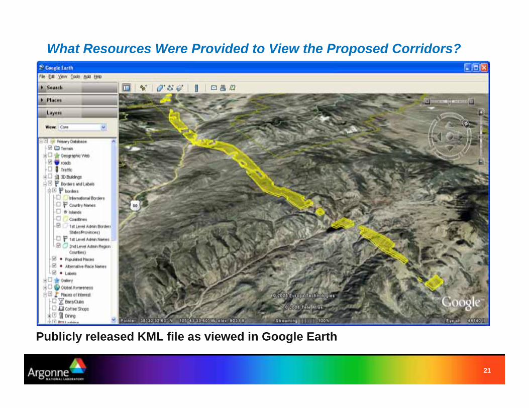
What Resources Were Provided to View the Proposed Corridors?
Publicly released KML file as viewed in Google Earth

22
More Information
Project Web Site: http://CorridorEIS.anl.govLead Federal Agencies
– U.S. Department of Energy– U.S. Department of the Interior,
Bureau of Land ManagementCooperating Federal Agencies
– U.S. Department of Agriculture,Forest Service
– U.S. Department of Defense– U.S. Department of the Interior,
Fish and Wildlife ServiceAuthors:
– Jim Kuiper, [email protected], GIS Project Developer/Analyst– Brian Cantwell, [email protected], GIS Programmer/Analyst– Ihor Hlohowskyj, [email protected], Environmental Scientist– John Krummel, PhD., [email protected],
Environmental Scientist/Strategic Area Manager– Robert Moore, [email protected], Environmental Scientist– Robert Sullivan, [email protected],
Program Coordinator/Manager of Environmental Data Communication
Related Documents