USGIF MEMBERSHIP DIRECTORY 2016

Welcome message from author
This document is posted to help you gain knowledge. Please leave a comment to let me know what you think about it! Share it to your friends and learn new things together.
Transcript
USGIFMEMBERSHIPDIRECTORY
2016

2 | 2016 MEMBERSHIP DIRECTORY ll USGIF.ORG
377 Omega Inc.9701 Overlea Dr.Rockville, MD 20850www.377omega.com377 Omega, Inc.’s mission is to provide experienced technical professionals dedicated to our national security and intelligence programs.POC: John Stopher, President 301-537-0001, [email protected] Level: Sustaining Partner
Abacus Technology Corporation5404 Wisconsin Ave., Suite 1100Chevy Chase, MD 20815www.abacustech.comAbacus Technology Corporation is a premier provider of IT Services for secure enterprise and cloud solutions at superb price points. Key capabilities include: Enterprise IT, Data Centers, Unified Communications, Application Services, Information Assurance/IT Security, and Networks. We have 30+ year track record of success across Federal Government Market (Defense, Intel Community, Civilian) and ~1000 employees.POC: Pamela Moraga, Vice President Business Development and Marketing 202-302-6149, [email protected] Level: Sustaining Partner
Accenture Federal Services800 North Glebe Rd., Suite 300Arlington, VA 22203www.accenture.com/federalAccenture Federal Services is a U.S. com-pany, with offices in Arlington, Va., and is a wholly owned subsidiary of Accenture LLP. Accenture’s federal business serves every cabinet-level department and 30 of the largest federal organizations with cli-ents at defense, intelligence, public safety, civilian and military health organizations.POC: Matt Fahle, Managing Director 571-414-5728 [email protected] Level: Strategic Partner
Adobe Systems7930 Jones Branch Dr., 5th FloorMcLean, VA 22102www.adobe.com/governmentAdobe delivers the solutions government agencies use to make, manage, mobilize and measure the knowledge, informa-tion and experiences needed to achieve their objectives. From content creation and management, to secure business workflows, easy to develop forms, robust analytics, intuitive collaboration and e-learning, today’s agencies rely on Adobe Digital Government solutions.POC: Ron King, Sr. Program Executive 571-358-4267, [email protected] Level: Strategic Partner
AECOMBusiness Unit: Management Services Group4800 Westfields Blvd., Suite 400Chantilly, VA 20151www.aecom.comAECOM is a premier, fully integrated professional and technical services firm positioned to design, build, finance and operate infrastructure assets around the world for public- and private-sector clients. The company is a leader in all of the key markets that it serves, including transpor-tation, facilities, environmental, energy, oil and gas, water, high-rise buildings and government. They provide a blend of global reach, local knowledge, innovation and technical excellence in delivering cus-tomized and creative solutions that meet the needs of our clients’ projects.POC: Mike Eiden, Director of Business Development, 703-579-0452 [email protected] Level: Strategic Partner
The Aerospace Corporation2310 E. El Segundo Blvd., M1/447El Segundo, CA 90245www.aerospace.orgThe Aerospace Corporation is the scien-tific and engineering arm for the nation’s national security space programs. For more than 50 years, Aerospace has provid-ed technical analysis and engineering support to virtually every national security space project, applying our expertise in systems engineering and mission assur-ance to ensure customer mission success.POC: Sabrina Steele, Executive Director, Corporate Communications 310-336-1192, [email protected] Level: Associate Partner
Airbus Defense & SpaceBusiness Unit: Intelligence14595 Avion Pkwy., Suite 500Chantilly, VA 20151www.intelligence-airbusds.comThrough its Intelligence Portfolio, Airbus Defense and Space is recognized as a World leader in geo-information, pooling an unmatched access to Earth observation satellite imagery with unique expertise and decades of experience in one organization. Based on an exclusive access to Pléiades, SPOT, TerraSAR-X and TanDEM-X (radar and optical satellites), its extensive portfolio spans the entire geo-information value chain.POC: Peter Barren, Technical Sales Engineeer, 703-715-3124 [email protected] Level: Sustaining Partner
Alaska Satellite FacilityBusiness Unit: University of Alaska Fairbanks903 Koyuyuk Dr., WRRB 105Fairbanks, AK 99775-7329www.asf.alaska.eduThe mission of the Alaska Satellite Facil-ity (ASF) is to make remote-sensing data accessible. ASF downlinks, processes, archives, and distributes remote-sensing data to scientific users around the world. ASF’s three major components are a Satellite Tracking Ground Station, a Synthetic Aperture Radar Distributed Active Archive Center, and ASF Enter-prise, which focuses on applications of remote-sensing data.POC: Scott Arko, Deputy Director 907-474-5570, [email protected] Level: Sustaining Partner
ALQIMI National Security Inc.Business Unit: National Security Group9210 Corporate Blvd., Suite 150Rockville, MD 20850www.alqimi.comALQIMI National Security, Inc. helps fulfill security and intelligence objectives by providing tailored systems integration, IT, and security services focused on the customer mission/requirements; state-of-the-art technology for applications software, cybersecurity, data analytics, and data exploitation solutions; and expert technical skills supported by professionals who under-stand the mission domain and have broad experience supporting the community.POC: Ricky Garris, President 240-404-7503, [email protected] Level: Small Business Partner
Altamira Technologies Corp.8201 Greensboro Dr., Suite 800McLean, VA 22102www.altamiracorp.comAltamira brings a commercial mindset to solving the most complex national security problems by delivering mission application development, multi-intelli-gence analysis, cyber operations, and data science technologies and solutions to the national defense and intelligence com-munities. Altamira’s culture of innovation excellence make us the next generation leader bringing technology to mission.POC: Dan Whalen, Vice President Business Development, 703-813-2100, [email protected] Level: Sustaining Partner
Amazon Web Services12900 Worldgate Dr.Herndon, VA 20170www.aws.amazon.com/government-educationAmazon Web Services’ Worldwide Public Sector Team offers enterprise class cloud computing services to Government, Education, Healthcare and Nonprofit organizations globally. With the cloud, public sector IT professionals no longer need to plan for IT infrastructure months in advance, but rather can be operational in minutes.POC: Chris Bailey, AWS Sales Manager, 703-472-3267, [email protected] Level: Sustaining Partner
American Public University SystemBusiness Unit: American Military University10110 Battleview Pkwy., Suite 114Manassas, VA 20109www.apus.eduAmerican Military University (AMU) provides quality higher education to the nation’s national security and intelligence communities. With more than 190 degree and certificate programs—including Intelligence Studies, Homeland Security, and International Relations—we prepare students for service and leadership in a diverse and global society. Learn more: www.PublicSafetyatAMU.comPOC: Erik Kleinsmith, AVP, Strategic Partnerships, 571-358-3023 [email protected] Level: Academic Partner
2016 MEMBERSHIP DIRECTORY ll USGIF.ORG | 3
Analytical Graphics Inc.220 Valley Creek BlvdExton, PA 19341www.agi.comAnalytical Graphics, Inc. (AGI) delivers COTS software to model and analyze mis-sions and visualize ISR systems. This suite of off-the-shelf desktop, server and software development kits can be implemented by the space, defense and intelligence communities to support ISR missions in a timely and cost-effective manner. AGI’s rich APIs and data model are interopera-ble with open or industry-standard mission partner software and supportive of virtually any modern architecture.POC: Stephanie Eftimiades, Public Relations Manager, 610-981-8531 [email protected] Level: Strategic Partner
Ankura Consulting GroupBusiness Unit: Risk, Resiliency, and Geopolitical Advisory Practice1220 19th St NW, Suite 700Washington, DC 20036www.ankuraconsultinggroup.comAnkura merges geospatial information and advanced data mining techniques to iden-tify and analyze risks and opportunities to/for investments and related operations. We monitor fluid geopolitical landscapes to forecast opportunities and provide early warning of events that might affect busi-ness or provide a competitive advantage to clients investing in new markets or mitigating existing operation risks.POC: Michelle DiGruttolo, Senior Managing Director, 571-225-9312 [email protected] Level: Small Business Partner
Annapolis Micro Systems Inc.190 Admiral Cochrane Dr., Suite 130Annapolis, MD 21401www.annapmicro.comAnnapolis, The FPGA Performance Company, providing COTS hardware and FPGA IP in multiple form factors including VPX, PCIe, AMC and Blade. Call us to discuss how we can help you get 20x performance increase for your Geospatial Lidar data acquisition and storage requirements. Our network communications systems now support 40 Gigabit and 100 Gigabit Ethernet.POC: Patrick Stover, Director Mid Atlantic Programs, 410-841-2514 [email protected] Level: Sustaining Partner
APG Technologies LLC116 Chimney Ridge PlacePotomac Falls, VA 20165www.apgtech.comAPG provides advanced software, systems, and security services for high-perfor-mance Data Management, Information Assurance, and Private Cloud Engi-neering. We specialize in transforming vast amounts of data into actionable infor-mation within constrained schedules and budgets. APG mission critical solutions overcome complex challenges in the midst of ever-increasing velocity, variety, and volumes of IC data.POC: Eric J. Amberge, Managing Director, 585-615-2137 [email protected] Level: Small Business Partner
Applied Imagery5425 Wisconsin Ave., Suite 600Chevy Chase, MD 20815www.appliedimagery.comApplied Imagery’s Quick Terrain Model-er LiDAR exploitation software enables powerful, intuitive, interactive analysis of enormous 3D terrain models and point clouds. It is simple to use, can fuse 3D data and 2D imagery from different sources, and is widely used in the DoD community.POC: Chris Parker, 301-589-4004 [email protected] Level: Sustaining Partner
Applied Research Associates Inc.Business Unit: Software, Systems, and Modeling Sector8537 Six Forks Rd., Suite 600Raleigh, NC 27615www.ara.comARA is an employee-owned scientific research and engineering company founded in 1979 and dedicated to pro-ducing innovative solutions that tackle critical national problems in National Security, Infrastructure, Energy and Environment, and Health Solutions. We are committed to solving our customers’ toughest problems with innovative yet practical and technically sound solutions.POC: Michael Seebold, Principal Business Development Director 919-582-3300 x3389, [email protected] Level: Small Business Partner
ARCHIBUS Inc.18 Tremont Street, Floor 12Boston, MA 02108www.archibus.comARCHIBUS is the #1 global provider of real estate, infrastructure and facilities management solutions. Our Web-based, industry-leading enterprise software provides governments a comprehensive, integrated COTS product that manages the use, condition, and cost of physical assets. ARCHIBUS supports informed strategic decision-making that optimizes return-on-investment, lowers asset lifecy-cle costs, and increases productivity.POC: Brad Peterson, Vice President Government Programs, 757-431-0367 [email protected] Level: Sustaining Partner
Aruba, a Hewlett Packard Enterprise Company1344 Crossman Ave.Sunnyvale, CA 94089www.arubanetworks.comAruba, a Hewlett Packard Enterprise company, is a leading provider of next-generation network access solutions to the U.S. government. Using NSA-ap-proved Suite B encryption, Aruba’s wired, wireless and VPN technologies provide US government agencies with secure network access at the unclassified, secret, TS/SCI and other caveated levels.POC: Mike Rayfield, Territory Manager 703-989-5551 [email protected] Level: Sustaining Partner
Aspera, an IBM Company5900 Hollis St., Suite EEmeryville, CA 94608www.asperasoft.comAspera technology enables secure, predictable, location-independent, and automated movement of files and datasets of any size and format, and has been thoroughly vetted by the intelligence community for high-speed, large data transfers over the most difficult military networks. Terabytes of data are transferred every day by the many DoD/IC agencies deploying Aspera software.POC: Brian Robinson, Director-Federal Sales, 571-252-7893 [email protected] Level: Sustaining Partner
Aspiration Software LLCPO Box 903Middleburg, VA 20118www.aspirationsoftware.comAspiration Software LLC is small, minority, woman-owned firm specializing in experts with experience in Analyst Centric Engi-neering, Acquisition,Architecture, Systems Engineering for NGA. Over 90% of profes-sionals have advanced degrees/certifications including ITILv3, INCOSE, DODAF, SAFe PMP. Our multi-disciplined, consul-tants provide solutions and expert services to NGA, most recently at the DNI’s Advanced Campaign Cell (ACC).POC: Jon M. Stout, Chief Executive Officer, 540-687-3870 [email protected] Level: Small Business Partner
AT&T Global Business - Public Sector Solutions3033 Chain Bridge Rd.Oakton, VA 22124www.corp.att.com/govAT&T Global Business Public Sector Solutions helps address the needs of the Intelligence Community with IT services spanning network, cybersecurity, unified communications, cloud services, connect-ed devices and more, enabling Agencies to focus on their mission goals and create a better citizen experience.POC: Craig Allen, Business Manager 703-885-0028, [email protected] Level: Sustaining Partner
BAE Systems10920 Technology Pl., Suite 1200San Diego, CA 92127www.baesystems.comBAE Systems delivers a full range of products and services for air, land and naval forces, as well as advanced electronics, secu-rity, and IT solutions and support services. The company enables the transformation of data into intelligence and provides engineer-ing, integration and sustainment support for critical military platforms and systems. It also serves commercial and defense electronics markets offering a broad portfolio of vehicle and mission critical electronic systems from electronic warfare to night vision systems, surveillance and reconnaissance sensors, flight and engine controls, mobile networked-communications equipment, systems integration, and hybrid propulsion, power and energy management systems.POC: Jon Dorn, VP of Business Development for ISR Solutions 858-675-2944, [email protected] Level: Strategic Partner
4 | 2016 MEMBERSHIP DIRECTORY ll USGIF.ORG
Ball Aerospace10 Longs Peak Dr.Broomfield, CO 80021www.ballaerospace.comBall Aerospace pioneers discoveries that enable our customers to perform beyond expectation and protect what matters most. We create innovative and affordable space solutions, enable more accurate weather forecasts, drive insightful observations of our planet, and deliver actionable data and intelligence that protects national security.POC: Fred Doyle, Vice President, Defense and Intelligence Community, 303-533-5294, [email protected] Level: Strategic Partner
Basis Technology2553 Dulles View Dr., Suite 450Herndon, VA 20171www.basistech.comBasis Technology provides software solu-tions for extracting meaningful intelligence from unstructured text. We help govern-ment organizations improve the accuracy of search, text mining, link analysis, and other applications through advanced linguistics. Our digital forensics team pioneers faster and cheaper techniques to extract forensic evidence, leveraging the Autopsy open source platform.POC: Chris Biow, SVP - US Public Sector, 1-617-386-7104 [email protected] Level: Sustaining Partner
Blue Canopy GroupBusiness Unit: National Security Solutions11091 Sunset Hills Rd., Suite 777Reston, VA 20190www.bluecanopy.comSince 2001, Blue Canopy has provided the expertise to convert information and knowledge into timely actionable intelligence while reducing the cost of delivery to our customers. We offer highly agile and flexible teams that honor its commitments, provides innovate solutions, and demonstrates the ability to rapidly deploy mission capabilities across the DoD, intelligence, federal civilian and commercial communities. Blue Canopy’s technology and cloud computing experts leverage new technologies and processes as analytical force multipliers.POC: Michael G. Lee, Partner 703-447-0937, [email protected] Level: Associate Partner
Blue Coat SystemsBusiness Unit: Federal1945 Old Gallows Rd., Suite 320Vienna, VA 22182www.bluecoat.com/solutions/governmentBlue Coat is a leader in enterprise security, providing on-premise, hybrid and cloud-based solutions for protecting web connectivity, combating advanced threats, and responding to security breaches. Blue Coat has a long history of protecting feder-al agencies, their data and their employees.POC: Kevin Griffith, Director, DoD Sales 703-727-9848,[email protected] Level: Sustaining Partner
The Boeing Co.Business Unit: Electronic & Information Solutions12701 Fair Lakes CircleFairfax, VA 22033www.boeing.comElectronic & Information Solutions has specific expertise in collection, information management, dissemination and analysis. The business is focused on technology development that enables robust situational awareness, advanced analytic processing and secure information sharing. Geospatial production services complement the technology development offerings through insights offered by subject matter experts. Enabling technologies that support customers’ missions include Kestrel TAC’s knowledge management software solutions; eXMeritus’ cross-domain security solutions; information and data management software; and product suites from SMSi that include the Twister software that allows large quantities of data to be ingested, nor-malized and extracted, and then delivered in virtually any format to the user.POC: James Batt, Director, Business Development, 571-236-8130 [email protected] Level: Strategic Partner
Booz Allen HamiltonBusiness Unit: National Agencies8283 Greensboro DriveMclean, VA 22101www.boozallen.comBooz Allen Hamilton has been at the fore-front of strategy, delivering/management, and technology solutions for nearly a centu-ry. The firm provides services primarily to the US government, and also to major corpora-tions and international clients. Booz Allen offers clients deep functional knowledge spanning strategy, organization, engineering, operations, technology, and analytics.POC: Lee Ramseur, Vice President 703-984-0546, [email protected] Level: Strategic Partner
Boundless Spatial Inc.222 Broadway, 19th FloorNew York, NY 10038www.boundlessgeo.comBoundless develops powerful open-source for geospatial applications. Our team of expert developers reduce the total cost and time of deploying and managing geospatial software with Packaging, Support, Mainte-nance, Training, and Professional Services.POC: Andy Dearing, CEO, 636-487-1388 [email protected] Level: Sustaining Partner
Braxton Science & Technology Group6 North Tejon Street, Suite 220Colorado Springs, CO 80903www.bstgllc.comBraxton Science & Technology Group companies provide capabilities and expertise in Command & Control Systems, Satellite Ground Systems, Environmen-tal Intelligence, Cross Domain Data Dissemination, Information Assurance, Cyber Security and Technical Staffing. Our Software and Systems Engineers develop solutions with our own COTS product suite, and provide open source and third party solutions when applicable.POC: Rob Patterson, Chief Revenue Officer, 719-219-7415 [email protected] Level: Sustaining Partner
BrocadeBusiness Unit: Federal13241 Woodland Park RdHerndon, VA 20171www.brocade.com/federalBrocade networking solutions empower federal agencies to achieve their critical initiatives in a world where applications and information reside anywhere. By delivering open, software-driven, and hard-ware-optimized solutions, Brocade helps agencies modernize their IT networks while accelerating their journey to the New IP. Learn more about best-in-class networking solutions at www.brocade.com.POC: Donald Riordan, Director, Regional Sales, 571-203-7800, [email protected] Level: Sustaining Partner
C2S Consulting GoupBusiness Unit: IT Cloud Consulting21514 Wild Timber Ct.Ashburn, VA 20148www.c2sconsultinggroup.com
C2S Consulting Group specializes in Cloud Migration and Next Generation Innovations. We provide clients with cleared and commercial Cloud Experts in the areas of Strategy, Consulting, and Migration with AWS and Cloud exper-tise. We provide the best and brightest consultants, who have the specialized knowledge to execute for your business and deliver “CLOUD READY” solutions.POC: Brandee Daly, CEO & Founder 571-420-2333 [email protected] Level: Small Business Partner
CA TechnologiesBusiness Unit: Technology2291 Wood Oaks Dr.Herndon, VA 20171www.ca.com/publicsectorCA Technologies helps customers succeed in a future where every busi-ness—from apparel to energy—is being rewritten by software. From planning to development to management to security, at CA we create software that fuels transformation for companies in the application economy.POC: Chris Vatidis, Sr. Director of Sales 703-708-3994, [email protected] Level: Sustaining Partner
CACIBusiness Unit: National Services Group1430 Spring Hill Rd., Suite 525McLean, VA 22102www.caci.comCACI supports the nation’s geospatial ac-tivities through the creation of foundation data, delivery of actionable intelligence, and IT managed services and network operations. CACI’s information and geospatial solutions support all members of the Intelligence Community, bolster-ing national security through improved collaboration, data collection and analysis, 3D modeling and simulation, mobile solutions, test and evaluation of sensors, cloud implementation, agile development, and a highly trained, mission-focused staff. With over 50 years of proven success, CACI understands GEOINT and facilitates its integration with other intelligence disciplines to enable timely, accurately informed de-cision making. Contact CACI to realize the benefits of a company focused on keeping its customers, and itself, Ever Vigilant.POC: Don Bergeson, Account Executive, 703-667-9103, [email protected] Level: Strategic Partner
2016 MEMBERSHIP DIRECTORY ll USGIF.ORG | 5
POC: Erika Kaufhold, Communications and Outreach Coordinator 703-648-7884, [email protected] Level: Sustaining Partner
ClearTerra7030 Dorsey Rd., Suite 102Hanover, MD 21076www.clearterra.comClearTerra specializes in geospatial software products, custom software devel-opment, technical services, consulting, and training. ClearTerra LocateXT software discovers & extracts geocoor-dinates, place names, and other critical information within unstructured text and places it instantly into Desktop, Server, and Cloud-based geospatial platforms.POC: Jeff Wilson, Vice President, Sales 703-403-5636, [email protected] Level: Sustaining Partner
ClouderaBusiness Unit: Cloudera Government Solutions1420 Spring Hill Rd., Suite 600McLean, VA 22102www.cloudera.comCloudera delivers the modern platform for multi-int data and analytics. Agencies trust Cloudera to help them apply data to the center of their missions with Cloudera Enterprise, the fastest, easiest, and most secure data platform built on Apache Hadoop and the latest open source technologies. POC: Marc Kriz, Cloudera National Security Programs, 703-407-9993 [email protected] Level: Sustaining Partner
CMX Technologies, an Xator Corp.1835 Alexander Bell, Suite 210Reston, VA 20190www.xatorcorp.comCMX Technologies, an Xator Company, provides innovative technology-based geospatial-intelligence consulting and solutions, with a proven record reflecting extremely high customer satisfaction. CMX selectively recruits and places leaders into challenging positions where their experience ensures Mission Success for our customers in the National Geospatial-Intelligence Agency and the Intelligence Community.POC: Ted Wrublesky, VP of Business Development, 215-990-5749 [email protected] Level: Sustaining Partner
businesses, clients have access to numer-ous companies of varying size; combined with the backing of its parent company–Cherokee Nation Businesses–CNTS has the size, sophistication, scalability and character to meet any need.POC: John Sun, Vice President & Direc-tor of Business Development 210-501-9596, [email protected] Level: Sustaining Partner
Churchill Navigation5660 Airport Blvd.Boulder, CO 80301www.churchillnavigation.comChurchill Navigation, a leading devel-oper of advanced geospatial mapping solutions, digital video encoding and re-cording solutions and video management applications, offers ARS, the Augmented Reality System; ION, a digital video/metadata recorder; and Earthscape, the latest in cloud based video management and reporting application.POC: Erin Murphy, Director, Sales 850-748-7471 [email protected] Level: Small Business Partner
Cisco Systems Inc.Business Unit: Federal13635 Dulles Technology Dr.Herndon, VA 20171www.cisco.comCisco Systems, Inc., a worldwide leader in Information Technology, combines advanced solutions in networking, computing, security, communications, video, and mobility to provide a respon-sive and unified environment–allowing government to securely utilize informa-tion anywhere, anytime–for improved situational awareness, decision making and delivery of the mission.POC: Brian Zook, Account Manager 240-477-2351, [email protected] Level: Sustaining Partner
Civil Applications Committee12201 Sunrise Valley Dr., MS #562Reston, VA 20192The Civil Applications Committee oversees Federal civil use of national and commercial imagery systems data. The CAC provides the United States Geological Survey and other Federal civil organizations with a connection to the intelligence community as a way to further their individual missions.
reconnaissance and high-volume geospatial production. Our web-based and desktop solution enables on-demand exploitation of large datasets.POC: David Kuo, President 650-622-9078, [email protected] Level: Small Business Partner
Center for Geospatial IntelligenceBusiness Unit: University of MissouriW1025 Lafferre HallColumbia, MO 65211geography.missouri.eduWe are an interdisciplinary university center with ongoing research in advanced processing and exploitation (feature extraction, change detection, spatial rea-soning, database retrieval) of geospatial information from satellite and airborne systems. We seek opportunities to partner with government and industry in edu-cation and R&D activities in pursuit of advanced GEOINT capabilities.POC: Dr. Curt Davis, Director 573-884-3789, [email protected] Level: Academic Partner
Center for Southeastern Tropical Advanced Remote Sensing (CSTARS), University of Miami11811 S.W. 168th St.Miami, FL 33177-2137www.cstars.miami.eduCSTARS is a state-of-the-art high capability receiving and analysis facility and testbed for commercial EO and SAR satellite data. A leading provider of value-added products and operational ser-vices. Innovative research and expertise in interferometry, time-sensitive oceanic and terrestrial applications to ensure U.S. superiority in science, safety, and security.POC: Dr. Hans Graber, Executive Director, 305-421-4954 [email protected] Level: Sustaining Partner
Cherokee Nation Technology Solutions85 NE Loop 410, Suite 304San Antonio, TX 78216www.cherokee-cnts.comCherokee Nation Technology Solutions (CNTS) is a tribally-owned business that excels in assisting clients with achieving their goals. With CNTS and its sister
CAEBusiness Unit: CAE Defence and Security4908 Tampa West Blvd.Tampa, FL 33634www.cae.comCAE is a global leader in modeling, simulation and training. The company offers defense and security customers a complete range of highly innovative product, service and training center solu-tions designed to help them meet their mission critical needs for safety, efficiency and readiness. CAE provides critical technology, standards and expertise to the GIS community.POC: Matthew Jamison, Director Business Development, 813-887-1296 [email protected] Level: Sustaining Partner
Carahsoft Technology Corp.1860 Michael Faraday Dr., Suite 100Reston, VA 20190www.carahsoft.comCarahsoft Technology Corp. is the trusted Government IT solutions provider, sup-porting an ecosystem of manufacturers, value-added resellers, system integrators, and consulting partners committed to helping government agencies select and implement the best solution at the best value. The company’s dedicated Solu-tions Divisions proactively market, sell and deliver VMware, Symantec, EMC, Adobe, F5 Networks, Open Source, HPE Software, SAP, and Innovative and Intelligence products and services, among others. Carahsoft is consistent-ly recognized by its partners as a top revenue producer, and is listed annually among the industry’s fastest growing firms by CRN, Inc., Washington Technology, The Washington Post, and Washington Business Journal. POC: Mary Warmkessel, Intelligence Community Focal Point, 844-423-8687 [email protected] Level: Strategic Partner
Cardio Logic Inc.1200 Industrial Rd, #7San Carlos, CA 94070www.cardiofx.comCardio supplies hardware-accelerated software that processes drone video, aerial or satellite imagery with accuracy, automation and speed to assemble the big picture instantly for actionable informa-tion in real-time surveillance, wide-area
6 | 2016 MEMBERSHIP DIRECTORY ll USGIF.ORG
Commonwealth Computer Research Inc. (CCRi)1440 Sachem PlaceCharlottesville, VA 22901www.ccri.comCCRi takes on technically challenging projects that give our clients the informa-tional leverage they need to attain new levels of speed, accuracy, and productivity.POC: James Conklin, Director of Strate-gy & Business Development 434-214-4415, [email protected] Level: Small Business Partner
Compass Inc.465A Carlisle Dr.Herndon, VA 20170www.cmpsinc.comCompass, Inc. is a Woman Owned Small Business (WOSB) providing trusted expertise focused on the Defense and Intelligence Community. We are a completely non-conflicted company employing senior program managers, acquisition professionals, architects, engineers, functional leaders, and subject matter experts who understand the mis-sions and needs of the Warfighters.POC: Kevin Maull, Vice President Business Development, 703-707-9870, [email protected] Level: Sustaining Partner
CompassData Inc.12353 E. Easter Ave., Suite 200Centennial, CO 80112www.compassdatainc.comCompassData is the world’s foremost supplier of GPS-based ground control survey data, maintaining the largest commercially available archive of Ground Control Points (GCP). Continuously adding to its more than 30,000 GCP, CompassData provides accurate geospatial data and collection services for clients in a partnership model.POC: Hayden Howard, Vice President 303-627-4058 [email protected] Level: Sustaining Partner
Compusult Limited40 Bannister St.Mount Pearl, NL, Canada A1N 1W1www.compusult.netCOMPUSULT is leading supplier of
open-architecture, standards-based, data management solutions providing geospa-tial data search, retrieval, organization, visualization and collaboration, across the enterprise and through mobile devices. For over 30 years COMPUSULT has delivered products and services to our customers through innovation, teamwork and by placing the highest priority on our clients’ requirements.POC: Robert Thomas, Marketing Manager, 1-888-745-7914 [email protected] Level: Sustaining Partner
Compusult Systems Inc.12110 Sunset Hills Rd., Suite 410Reston, VA 20190www.compusultsystems.comCompusult Systems Inc. (CSI) provides professional information technology services including project management, business process and system design, systems engineering, systems integration, needs analysis, customized software development, infrastructure planning and systems imple-mentation, deployment and training.POC: Michael A. Rampino, CEO & President, 703-464-5649 [email protected] Level: Small Business Partner
Concurrent Technologies Corp.100 CTC Dr.Johnstown, PA 15904www.ctc.comConcurrent Technologies Corporation (CTC) is an independent, nonprofit, applied scientific research and development professional services organization providing innovative solutions that solve data discovery, correlation, and analysis challenges. CTC supports intelligence and national security missions; develops secure and cross-domain, collaborative, cloud-based, multi-INT information environments; and makes significant advances in human-computer symbiosis and user and data personalization.POC: Randy A. Weaver, Executive Director, Advanced Intelligence Solutions Market, 814-269-6223 [email protected] Level: Sustaining Partner
Consolidated Resource Imaging (CRI)2943 S Wilson Ct NWGrand Rapids, MI 49534www.cri.us.com
CRI is focused on providing ISR system research and technology development, system integration and certification, test and operations, and operational expertise for Wide Area Motion Imagery (WAMI) and Multi-Spectral 2D/3D Modeling systems to include EO, IR, LIDAR, SAR, Hyper-Spectral and Multi-Spectral sensors with over 150,000 flight hours of experience (US and overseas) during the last eleven years. POC: Rodney Norris, Business Development Manager, 616-735-2080 [email protected] Level: Sustaining Partner
Continental Mapping Consultants Inc.121 S Bristol StSuite 201Sun Prairie, WI 53590www.continentalmapping.comContinental Mapping is a leading small business provider of geospatial services to private and public clients. Project experience includes high accuracy photogrammetry, satellite imagery expertise for civil and defense applications, lidar and other remote sensing data processing, mobile and other terrestrial lidar types, land and hydrographic survey, unmanned aerial systems, and software development.POC: Ben Redding, Business Development Manager, 888-815-3327 [email protected] Level: Sustaining Partner
COPT Data Center Solutions6711 Columbia Gateway Dr., Suite 300Columbia, MD 21046www.coptdata.comCorporate Office Properties Trust (COPT) (NYSE:OFC) develops, owns & operates data centers & Class A office for U.S. Gov-ernment, Defense IT and enterprise data center customers. COPT’s Data Center Solutions division provides industry lead-ing, green and highly efficient data center solutions for build to suit, wholesale and customized managed collocation.POC: Frank Ziegler, Senior Vice President, New Business and Development, Government Services, 443-285-5680, [email protected] Level: Sustaining Partner
Courage Services Inc.4121 Wilson Blvd., Suite 301Arlington, VA 22203www.courageservices.comCourage Services, Inc. is an industry-lead-ing provider of open source advanced analytics, geospatial data, and technology solutions. Our innovative products ensure that our clients have a clear understand-ing of complex and changing global dynamics and empower them to make confident decisions and navigate risk.POC: Jason Patti, Vice President Operations, 571-356-9384 [email protected] Level: Associate Partner
Cray Inc.901 Fifth Ave., Suite 1000Seattle, WA 98164www.cray.comCray builds innovative systems and solutions enabling customers to meet their hardest simulation, analytics and cy-bersecurity challenges. Leveraging years of experience developing the world’s most advanced supercomputers, Cray brings you a comprehensive portfolio of high performance computing, storage, and data analytics solutions delivering unrivaled performance, efficiency, and scalability.POC: Louis B. Hackerman, Account Manager, 301-910-6416 [email protected] Level: Sustaining Partner
Crunchy Data146 Fairchild St., Suite 134Daniel Island, SC 29492www.crunchydata.comCrunchy Data is a provider of trusted, open source PostgreSQL and PostGIS. A leading enterprise PostgreSQL vendor, Crunchy Data provides Crunchy Cer-tified PostgreSQL, the most advanced pure open source RDBMS on the market featuring container support for cloud native architectures, fine-grained security with SELinux for high security environments, and the leading open source GeoSpatial extension.POC: Bob Laurence, 703-819-1300 [email protected] Level: Small Business Partner

2016 MEMBERSHIP DIRECTORY ll USGIF.ORG | 7
CSG Solutions214 Burgess St.Fayatteville, NC 28301www.csg-isr.comCSG is an emerging leader in the deliv-ery of specialized remote sensing, ISR, and GEOINT services to government and commercial customers worldwide. Drawing on extensive SOF and IC experience, we can deliver collection operations, sensor exploitation, and GEOINT analytics with an unparalleled combination of technical acumen and operational experience.POC: Mike Bosco, Director of Business Development, 703-447-2103 [email protected] Level: Sustaining Partner
CSRABusiness Unit: Defense and Intelligence Group3170 Fairview Park Dr.Falls Church, VA 22042www.csra.comCSRA was formed through the combination of the North American Public Sector business of CSC and SRA International. With over 50 years of experience supporting U.S. government agencies and programs, we deliver innovative, next-generation IT solutions and professional services to help our customers modernize their legacy systems, protect their networks and assets, and improve the effectiveness and efficiency of mission-critical functions for our warfighters and our citizens.POC: Kelley Artz, Director, NGA/DIA 571-999-3533, [email protected] Level: Sustaining Partner
Cubic Global Defense205 Van Buren, Suite 310Herndon, VA 20170www.cubic.comCubic provides comprehensive Intelli-gence, Surveillance and Reconnaissance (ISR) capabilities for defense, intelligence and security operations and training. Our C4ISR integrated systems provide capture, assessment, exploitation and cross-domain dissemination within a net-work-centric environment. Backed by six decades of experience, Cubic continues to deliver innovative, secure and scalable solutions for mission success.POC: Tom Richards, Vice President Special Projects, 727-460-0168 [email protected] Level: Sustaining Partner
D-Wave Systems2650 E. Bay Shore Rd.Palo Alto, CA 94303www.dwavesys.comD-Wave is the world’s first quantum computing company, whose mission is to integrate new discoveries in physics and computer science into breakthrough approaches to computation. The com-pany’s new 1000-qubit superconducting processor uses quantum mechanics to accelerate computation. D-Wave customers include NASA, Google, Lock-heed Martin and Los Alamos National Laboratory.POC: René Copeland, Director, Government Sales, 410-340-6310 [email protected] Level: Sustaining Partner
DataDirect Networks Federal8320 Guilford Rd., Suite LColumbia, MD 21046www.ddn.comDDN, the performance storage leader, delivers the world’s fastest, most scalable solutions for capturing and converting data into actionable intelligence by handling thousands of FMV surveillance streams, capturing data uninterrupted event during system correction, support-ing peak IO of extremely large clusters, and delivering Self-Healing, autonomous cloud storage at massive scale.POC: Bob Merkert, VP, Federal Sales 410-352-7192, [email protected] Level: Associate Partner
DataFission Inc.2526 Qume Dr Bldg 22San Jose, CA 95131www.datafission.comDataFission is a Silicon Valley-based technology company leading the way by innovating Content Indexing, Search and Analytics systems and solutions based on its core product offering the DataHunter Search platform. DataFission allows you to find anything. POC: Allan Torres, 952-412-2381 [email protected] Level: Small Business Partner
Dell Inc.Business Unit: Federal GovernmentOne Dell WayRound Rock, TX 78682www.dell.com/fedDell has a decades-long history of providing solutions and services to U.S. Department of Defense agencies that have come to rely on Dell for everything from rugged tablets and notebooks to our data center and back office and forward deployed solutions. Today, Dell is a rec-ognized leader in providing solutions that support Department of Defense missions from data analytics, cybersecurity and mobile computing solutions to data cen-ter, cloud and a wide range of services.POC: Andy Kemp, Regional Sales Director, 571-465-0745 [email protected] Level: Associate Partner
Deloitte LLPBusiness Unit: Federal Consulting1919 N. Lynn St.Arlington, VA 22209www.deloitte.comWith decades of industry-leading analytic and advisory experience, the Deloitte Geospatial Analytics practice helps government and commercial clients use the power of location to gain critical insights for improving their mission outcomes. Our analysts, software developers, data scientists, and strategists couple innovative data-driven approaches with geospatial solutions to deliver results—where it matters.POC: Lisa Barrow, Senior Strategic Relationship Manager, 703-929-8483 [email protected] Level: Sustaining Partner
Delta State University Center for Interdisciplinary Geospatial Information Technologies1008 W Sunflower Rd.Cleveland, MS 38733gis.deltastate.eduThe Delta State University GIS program now offers a Bachelor’s of Applied Science in Geospatial Analysis
and Intelligence. The program of study features 21 courses with focus on analytics, GIS, remote sensing, surveying, and programming/data management.DSU is an NGA Center for Academic Excellence. Out-of-state tuition is waived, start anytime.POC: Chris Smith, 662-846-4521 [email protected] Level: Academic Partner
DewberryBusiness Unit: Geospatial & Technology Services8401 Arlington Blvd.Fairfax, VA 22031www.dewberry.comDewberry’s Geospatial and Technologies Services is one of the largest and most advanced geospatial services providers in the world. For more than thirty years, our staff of 300+ geospatial professionals (many with clearances) have been offering progressive multi-technological solutions to clients such as USGS, FEMA, NOAA, US Army, and the NGA.POC: Phillip Thiel, Senior Vice President 703-849-0271, [email protected] Level: Associate Partner
Digital Reasoning1765 Greensboro Station Pl., Suite 1200McLean, VA 22102www.digitalreasoning.comDigital Reasoning’s cognitive computing platform, Synthesys transforms unstructured human communications into structured insights to reveal concealed risks and relationships. Combining large scale machine learning, natural language processing, and deep learning algorithms, Synthesys delivers entity, geospatial, document, and behavioral analytics to support time-sensitive, critical missions. Successfully deployed on C2S with proven results in Activity Based Intelligence (ABI) and Object Based Production (OBP), Synthesys empowers analysts to quickly build profiles of objects of interest, and identify, prioritize, and assess threats.POC: Joe Dvornicky, Director, National Security Programs, 410-984-1900 [email protected] Level: Associate Partner

8 | 2016 MEMBERSHIP DIRECTORY ll USGIF.ORG
DigitalGlobe1300 West 120th AvenueWestminister, CO 80234www.digitalglobe.comDigitalGlobe is the world’s leading provider of high-resolution Earth imagery, data, and analytics. Operating the most agile and sophisticated commercial satellite constellation in orbit, we put the world’s smartest images into everyone’s hands, giving them confidence to make decisions that matter. Our unmatched imagery, along with comprehensive data and actionable analytics, make us a trusted partner across dozens of industries—from defense to mining, from mapping to public safety. Customers worldwide rely on our best-in-class technology, global coverage, and 16-year time-lapse image library to provide the most exacting, mission-critical information available about our changing planet.POC: Marcy Steinke, Senior Vice President, Government Relations 703-292-5833 [email protected] Level: Strategic Partner
DLT Solutions2411 Dulles Corner Park, Suite 800Herndon, VA 20171www.dlt.comDLT Solutions is a leading technology partner to the Federal intelligence commu-nity. Over the past 25 years, the company’s dedication to helping government agencies make smart technology choices ensures its customers have the best options for cybersecurity, cloud, business applications and IT management solutions.POC: Greg Blackburn, Account Manager, Field Sales, 703-773-9225 [email protected] Level: Sustaining Partner
Dynamic Graphics Inc.1015 Atlantic Ave.Alameda, CA 94501www.dgi.comDynamic Graphics, Inc. partners with our clients to solve spatial analysis problems. Over the past four decades, we have been a premier provider of geospatial solutions with our innovative, easy-to-use software and outstanding support services. DGI’s CoViz 4D software is an industry leader in quantitative visualization, integration,
and analysis of time-dependent data.POC: Jeff Feige, Business Development 202-546-4089, [email protected] Level: Sustaining Partner
e-GEOSVia Tiburtina, 965Rome, Italy 00156www.e-geos.ite-GEOS, an ASI/Telespazio Company, is a leading international player in the Earth Observation and Geo-Spatial Information business and commercial-izes the COSMO-SkyMed Programme on the world-wide market. e-GEOS offers unique portfolio of application services and also direct access to satellite downlinks through ground stations and value-added and application products to a wide range of market segments.POC: Luciana Di Domenico, Head of Sales, +39 064 0694224 [email protected] Level: Sustaining Partner
Eagle Ray Inc.14425 Penrose Place, Suite 110Chantilly, VA 20151www.eaglerayinc.comAn ISO 9000 registered, woman-owned mid-tier company, Eagle Ray delivers expertise in acquisition, program and fi-nancial management, alongside technical know-how in infrastructure modern-ization (including IC ITE adoption), predictive analytics and agile engineering to address our clients’ most complex mission challenges. Membership Level: Sustaining Partner
East View Geospatial10601 Wayzata Blvd.Minneapolis, MN 55305www.geospatial.comEast View Geospatial has served the US Government, defense contractors, foreign governments and think-tanks for over twenty years. East View offers products and solutions in support of GEOINT and OSINT including topographic and geo-logical maps, DEMs, satellite imagery, vector data, and nautical/aeronautical charts. East View is your partner for sourcing uncommon information from extraordinary places.POC: Rodney Buhrsmith, Business Development, 952-252-4523 [email protected] Level: Sustaining Partner
EMC Corp.Business Unit: Federal8444 Westpark Dr., Suite 300McLean, VA 22102www.emc.comEMC offers key cloud infrastructure capabilities that enable our customers to drive up mission value while driving down TCO. Whether for the analyst stateside or the warfighter abroad, our solutions deliver any data, any time, any place, accessible by any authorized user. EMC: Powering the GEOINT Cloud.POC: Mike Veneri, Director, ISR and Cyber Programs, 571-217-0531 [email protected] Level: Sustaining Partner
EnvitiaBusiness Unit: US Office11710 Plaza America Dr., Suite 2000Reston, VA 20190www.envitia.comEnvitia is a SMB with 25 years of experi-ence helping customers make better, faster decisions through software specializing in the Discovery, Visualization, Situational Awareness, and Exploitation of Actionable Geospatial Intelligence. Envitia provides best-of-breed capability, complemented by open standards for cross-community interoperability, supplying comprehensive GEOINT solutions to domestic and international defense programs.POC: Robin Parrish, Business Development Manager, North America, 703-871-5255, [email protected] Level: Sustaining Partner
Esri380 New York St.Redlands, CA 92373www.esri.comThe market leader in geospatial technol-ogy, Esri software is used by more than 350,000 organizations worldwide includ-ing local, state, & national agencies. The ArcGIS platform provides high-perfor-mance 2D and 3D mapping and analysis in desktop, server, and hosted environ-ments. It’s a complete and open solution for managing, analyzing, and sharing data and products. Esri is transforming how organizations solve problems and make informed decisions. Implementing the ArcGIS platform leverages big data, web technologies, and integrated apps to make GIS easy to use, more accessible, and collaborative.POC: Kyra Williams, Sales Associate 703-506-9515 x8014, [email protected] Level: Strategic Partner
Euroconsult USA4601 N. Fairfax Dr., Suite 1200Arlington, VA 22203www.euroconsult-ec.comEuroconsult is the leading global consult-ing firm specializing in space markets. As a privately-owned, fully independent firm, we provide first-class strategic con-sulting, develop comprehensive research and organize executive-level annual summits and training programs for the satellite industry. With more than 30 years of experience, Euroconsult is trust-ed by 600 clients in over 50 countries.POC: Sima Fishman, Managing Director, Euroconsult USA, 703-520-6415 [email protected] Level: Sustaining Partner
exactEarth Ltd.60 Struck Ct.Cambridge, Ontario, Canada N1R 8L2www.exactearth.comexactEarth is a data services company leading the way in delivering advanced location-based maritime vessel informa-tion critical for government authorities and commercial organizations around the world. Such high quality geo-based information delivers real value for a wide range of maritime operational applications including Vessel Monitoring, Security and Surveillance, Environmen-tal Protection and Search and Rescue.POC: David Martin, Vice President Global Sales & Marketing, 519-620-5872 [email protected] Level: Sustaining Partner
F5 NetworksTwo Discovery Square12012 Sunset Hills Rd., Suite 900Reston, VA 20190www.f5.comF5 makes the connected world run better, helping organizations meet the demands and embrace the opportunities that come with the growth of voice, data, and video traffic, mobile workers, and applications—in the data center and the cloud. With F5, federal agencies can deliver and protect their applications and services while ensuring people stay connected.Membership Level: Sustaining Partner
2016 MEMBERSHIP DIRECTORY ll USGIF.ORG | 9
Freedom Consulting Group Inc.9881 Broken Land Pkwy., Suite 300Columbia, MD 21046www.freedomconsultinggroup.comFreedom Consulting Group provides en-terprise solutions for geospatial capabilities including geodatabase architecture and implementation, application develop-ment, and analyst support operations. We specialize in developing solutions for large-scale operations for the intelligence community; incorporating cutting-edge technology including cloud based comput-ing, high availability designs and business intelligence into our system designs.POC: Rich Walker, VP-Advanced Technology Solutions, 410-290-9035 [email protected] Level: Sustaining Partner
Fulcrum5870 Trinity Pkwy., Suite 400Centreville, VA 20120www.fulcrumco.comFulcrum has been a recognized leader in total information technology solutions for the Federal Government for over 25 years. From health care enterprise architecture and advanced technologies, to cybersecurity and human capital man-agement, we solve our customer’s most complex operational challenges in time- and resource-constrained environments.POC: Ken Diller, Vice President of Business Development, 703-543-2788 [email protected] Level: Sustaining Partner
General Atomics Aeronautical Systems Inc.14200 Kirkham WayPoway, CA 92064www.ga-asi.comGeneral Atomics Aeronautical Systems, Inc. (GA-ASI) is a leading manufacturer of Remotely Piloted Aircraft (RPA) sys-tems, radars, and electro-optic and related mission system solutions, including the Predator/Gray Eagle aircraft series and the Lynx Multi-mode Radar. GA-ASI provides long-endurance, mission-capa-ble aircraft with the integrated sensor/data link systems required for persistent situational awareness/rapid strike.POC: Chris Pehrson, Sr. Director Strategic Development, 202-496-8229 [email protected] Level: Sustaining Partner
General DynamicsBusiness Unit: Mission Systems; Information Technology2941 Fairview Park Dr.Falls Church, VA 22042www.gd.com/business-groups/information-systems-and-technology/index.cfmGeneral Dynamics supports the Intelli-gence Community vision of Intelligence Integration by providing advanced Information Technology services and solutions that improve data management while enhancing security and reducing costs. With deep knowledge and expe-rience in the Intelligence Community and the Geospatial Intelligence mission, we integrate the very best commercial technology and tradecraft to enhance capability and capacity. Today our geospa-tial intelligence command and control tools enable real-time visualization, communications, information sharing, in-teroperability and collaboration. The end result: consequence-driven intelligence that helps our military, intelligence and first-responder communities protect our country. General Dynamics is a market leader in business aviation; land and ex-peditionary combat systems; armaments and munitions; shipbuilding and marine systems; and information systems and technologies.POC: Mike Manzo, Mission Systems; Joanna Davenport, IT, Director of GEOINT Processing and Exploitation Systems; Business Development for NGA, 703-628-3049; 703-268-7309 [email protected]; [email protected] Level: Strategic Partner
Geo Owl LLC721 Brentwinds Ln., Suite 308Spring Lake, NC 28390www.geoowl.comGeo Owl is an innovative professional services organization specializing in Geospatial Intelligence Services, En-terprise level IT Networks and Satellite Communications.POC: Nicholas Smith, President 727-771-5716, [email protected] Level: Small Business Partner
Geographic Services Inc.7901 Jones Branch Dr., Suite 210McLean, VA 22102www.geographicservices.comGeographic Services, Inc. (GSI) is the premier provider of fully integrated geospatial, linguistic and sociocultural
solutions, and an authority on Human Geography. GSI’s innovative technologies, and authoritative content accessible via mobile apps or cloud-based architecture, enhance knowledge and understanding of critical areas of the world, and support anticipatory analysis while enabling more informed, timely decisions.POC: Nancy McGee, Chief Operating Officer, 703-287-9702 [email protected] Level: Sustaining Partner
GeoNorth LLC561 E 36th Ave.Anchorage, AK 99503www.geonorth.comEstablished in 1994, GeoNorth is an SBA-certified 8(a) firm providing tailored geospatial solutions to government and commercial clients. Our expertise devel-oping enterprise geospatial applications is complemented by our US-based, multi-mission Direct Receiving Station (DRS), capable of delivering timely and relevant GEOINT from all the commercial, Airbus Defense and Space satellites, including Pleiades, SPOT and TerraSAR-X.POC: Jon Heinsius, Director of Sales 202-361-7447, [email protected] Level: Small Business Partner
George Mason UniversityCenter for Geospatial Intelligence, College of Science4400 University Dr., MS 6C3Fairfax, VA 22030cgeoint.gmu.eduWith strong expertise in geoinformat-ics, ranging from remote sensing and photogrammetry to GIS and social media analysis, GMU is offering world-leading educational programs in geospatial intelligence (including USGIF-accred-ited Certificate and MS programs), and pursues a wide array of research activities in this field through its Center for Geo-spatial Intelligence.POC: Anthony Stefanidis, Director 703-993-1212, [email protected] Level: Academic Partner
Geoweb3d45 Lewis St.Binghamton, NY 13901www.geoweb3d.comGeoweb3d produces the next generation
3D engine for GEOINT visualization, analysis, and mapping. Open, standard geospatial data including GIS, NGA, CAD, 3D Models, M&S, Web Services, LIDAR, FMV, and others are fused together in real-time with game quality graphics and pixel accurate analysis. The 3D engine is accessible as SDK or plug-in ready Desktop app.POC: Robert Holicky, President 607-372-6749, [email protected] Level: Sustaining Partner
Global Marketing Insights Inc.Business Unit: Global Geospatial Market Research; Strategic Tactical Plans8803 Brecksville Rd., Suite 306Cleveland, OH 44141www.globalinsights.comGlobal Marketing Insights, Inc. (GMI) provides Geospatial Business Intelligence Expertise focused on strategic sales/market planning and customized market research for commercial and government sectors. As authors of the USGS and NOAA international remote sensing studies that include ten-year trends data GMI possesses the largest database of global geospatial users.POC: Shawana Johnson, GISP, President 216-525-0600, [email protected] Level: Sustaining Partner
Grover Consulting Services (GCS)P.O. Box 117029501 Burke RdBurke, VA 22009www.grovercsllc.comGrover Consulting Services (GCS) is a veteran-owned small business dedicated to providing the Department of Defense (DoD) and Intelligence Community (IC) with high-value, agile consulting services and project management. GCS specializes and thrives in remote sensing applications and geospatial disciplines with the guiding principles of sound science and engineering, consistently meeting customer mission. POC: Stephen Grover, Principal 703-283-9427, [email protected] Level: Small Business Partner
10 | 2016 MEMBERSHIP DIRECTORY ll USGIF.ORG
GuidePoint Security11951 Freedom Dr., Suite 1331Reston, VA 20190www.guidepointsecurity.comGuidePoint Security provides custom-ized, innovative and valuable information security solutions that enable commercial and federal organizations to more success-fully achieve their security and business goals. By embracing new technologies, GuidePoint Security helps our clients recognize the threats, understand the solutions, and mitigate the risks present in their evolving IT environments. Membership Level: Sustaining Partner
H2M Group LLC11220 Assett Loop, Suite 201Manassas, VA 20109www.theh2mgroup.comH2M Group is a Woman-Owned and Veteran-Owned Small Business providing geospatial analysis services to the federal government and commercial clients. We specialize in data science, geospatial intelligence, imagery analysis, geospatial analysis, and human geography. H2M Group also provides professional services including geospatial training, policy analy-sis, career services, information assurance and Cyber network defense, and program management.POC: John T. Hartman, Executive Vice President, 703-509-4317 [email protected] Level: Associate Partner
Harris Corporation1025 W NASA Blvd.Melbourne, FL 32919www.harris.comHarris Corporation is a leading technology innovator, solving our customers’ toughest mission-critical challenges by providing solutions that connect, inform and protect. From sensors and software to actionable intelligence on-demand, Harris provides our customers the geospatial information they need to analyze the environment for smarter operational and business decisions – when and where they need it. We are a proven enterprise transformation partner to the intelligence community and offer a full spectrum of capabilities such as IT services, security frameworks and network managed services. Harris supports customers in more than 125 countries, has approximately $8 billion in annual reve-nue and 22,000 employees worldwide.POC: Stuart Blundell, Director, Strategy and Business Development 571-203-1575, [email protected] Level: Strategic Partner
Helm Point Solutions Inc.6760 Alexander Bell Dr., Suite 105Columbia, MD 21046www.helmpoint.comHelm Point Solutions, Inc. combines ex-pertise in cyber solutions like vulnerability research, network monitoring, information assurance, and critical infrastructure pro-tection with physical security monitoring, access control, and workforce manage-ment. Providing engineering expertise to open-source and government-led cloud research projects has led to advance-ments in mission-based analytics, cloud performance at scale, and monitoring and security auditing solutions. POC: Geoff Martino, Technical Director 410-290-1111, [email protected] Level: Small Business Partner
Hera Systems Inc.6389 San Ignacio Ave.San Jose, CA 95119www.herasys.comHera Systems is a satellite information and analytics company collecting images of the Earth, monitoring change and empowering decisions about our planet’s constantly changing features and emerging situations across the globe, in near-real time. Starting in December 2016, our 1HOPSat microsat constella-tion will produce multispectral imagery and video at submeter resolution.POC: Joe Thurgood, PhD, VP Corporate Development and Marketing 415-412-1730, [email protected] Level: Small Business Partner
HERE425 W. Randolph St.Chicago, IL 60606company.here.comHERE, the location cloud company, enables rich, real-time location applications and experiences for consumers, vehicles, enterprises and cities. HERE is backed by a consortium of leading automotive compa-nies. To learn more about us, including our work in the areas of connected and auto-mated driving, visit http://360.here.com.POC: Cliff Allison, Senior Account Executive, 703-217-9267 [email protected] Level: Sustaining Partner
Hewlett Packard Enterprise13600 EDS Dr.Herndon, VA 20171www.hpe.comHewlett Packard Enterprise (HPE) is an industry leading technology company that enables customers to go further, fast-er. As one of the world’s largest providers of IT infrastructure and over 50 years supporting intelligence community requirements, HPE brings the industry’s most comprehensive portfolio, spanning the cloud to the data center to workplace applications. Our technology and services help customers around the world make IT more efficient, more productive and more secure.POC: Brenda Brown, IC Account Relations, 703-736-3336 [email protected] Level: Strategic Partner
HHB Systems1818 Library St., Suite 500Reston, VA 20190www.hhbsystems.comHHB Systems is a GEOINT information systems technology company specializing in professional management advisory services, government GEOINT systems architecture and operations, program acquisition services, systems engineering, systems and applications integration, and systems administration. Whether im-plementing specialized GEOINT tools, or integrating and administering entire systems, we are GEOINT experts.POC: Brent Hermansen, CEO 703-956-3006 [email protected] Level: Sustaining Partner
HP Inc.1501 Page Mill Rd.Palo Alto, CA 94304www.hp.comHP creates new possibilities for tech-nology to have a meaningful impact on people, businesses, governments and society. With the broadest technology portfolio spanning printing, personal systems, software, services and IT infrastructure, HP delivers solutions for customers’ most complex challenges in every region of the world. POC: David Aumiller, Enterprise Account Manager, 410-991-2783 [email protected] Level: Associate Partner
The HumanGeo Group LLC4350 N. Fairfax Dr., Suite 950Arlington, VA 22203www.thehumangeo.comThe HumanGeo Group, LLC is headquartered in Arlington, Virginia. Hu-manGeo’s unique capabilities include the development of big data applications and tools to synthesize, manage and exploit large data sets, big data analytics, geospa-tial visualization, anticipatory analysis, and real-time social media events.POC: Al DiLeonardo, CEO 202-250-1592, [email protected] Level: Sustaining Partner
i3 ICS6564 Loisdale Ct., Suite 1010BSpringfield, VA 22150www.i3ics.comUnique in the industry, i3 ICS is a Service Disabled Veteran-Owned Small Business (SDVOSB) specializing in Analytical Integration (AI) – the process of synchronizing new or emerging technologies into the analytical process to maximize impact and streamline opera-tions. i3 ICS’ experience and knowledge assists with both technical and practical solutions to customers’ challenges.POC: Phil Oakley, President 703-313-7040, [email protected] Level: Sustaining Partner
IBM6710 Rockledge Dr.Bethesda, MD 20817www.ibm.com/federalIBM forges integrated intelligence. INNOVATION. IBM provides real-time analytics, cognitive solutions, cloud service expertise, and the infrastructure to support GEOINT On-Demand. With R&D investments over $6B annually, IBM leads the world in patents - making the kind of discoveries that shape the future of government, business, academia and society. These breakthroughs are leveraged in IBM solutions to handle challenging NSG mission imperatives. IBM’s industry leadership is recognized in numerous areas - Consulting and Managed Services, Ana-lytics, where IBM has received more than 500 analytics patents, Cost-savings Meth-odologies, IT Workload Optimization, Application Integration, Cloud and Cloud Storage, DevOps, and Cybersecurity.POC: Gabe Chang, Federal CTO Archi-tect, 301-803-3655, [email protected] Level: Strategic Partner
2016 MEMBERSHIP DIRECTORY ll USGIF.ORG | 11
ICES2214 Rock Hill Rd., Suite 100Herndon, VA 20170www.ices-inc.netICES provides life-cycle systems engineering and integration services and geospatial intelligence analysis. We specialize in architecture (systems, data, security), information assurance, IT asset management and accredited asset man-agement training. We leverage expertise in agile engineering while ensuring the transformation of systems to service-ori-ented and cloud based capabilities are sound, secure and cost effective.POC: Steven Zameito, Vice President for Business Development, 610-306-7020 [email protected] Level: Associate Partner
Image Matters LLC201 Loudoun St. SWLeesburg, VA 20175www.imagemattersllc.comImage Matters specializes in innovative solutions for Object-Based Production and next generation Structured Analytics. As exemplified in our FactWeave prod-uct, we offer cloud-based solutions for knowledge-assisted analytic models and services, robust treatment of provenance and tradecraft in analytic processes, advanced search, discovery and explo-ration of object based intelligence, and autonomous workflow, collaboration and distribution capabilities. POC: Harry Niedzwiadek, CEO 703-669-5510 [email protected] Level: Small Business Partner
Immersive Media1700 Main St., Suite 222Washougal, WA 98671www.immersivemedia.comAs the technology behind Google Street View, our Immersive 360˚ platform can assist you in developing virtual tours of almost any location; cities, factories, pipe-lines, construction locations, oil rigs or developments sites. All accompanied by full video, tagged assets and the capability to link information from or integrate with other databases.Membership Level: Small Business Partner
In-Q-TelP. O. Box 749Arlington, VA 22216www.iqt.orgIn-Q-Tel is the not-for-profit, strategic in-vestment organization that works to identify, adapt, and deliver innovative technology solutions to support the mission of the U.S. Intelligence Community (IC). Launched in 1999, IQT identifies and partners with companies developing cutting-edge technologies that serve the national security interests of the United States.POC: Nick Miller, Director, Intelligence Community Support, 703-248-3000 [email protected] Level: Sustaining Partner
Innovative Analytics & Training LLC1455 Pennsylvania Avenue, Suite 710Washington, DC 20004www.innovative-analytics.comInnovative Analytics & Training, LLC (IAT), is a small business focusing on improving decisionmaking for govern-ment & commercial clients. We excel in strategy and policy development, analytic tradecraft, cyber analysis, and human capital and HR analytics.POC: Rick Raftery, Executive Vice President, 202-280-2045 ext. 702 [email protected] Level: Small Business Partner
InQuisient46290 Summerhill PlacePotomac Falls, VA 20165www.inquisient.comInQuisient’s enterprise data manage-ment platform creates order from chaos, enabling agile, user-driven data manage-ment and business transformation at the speed of your mission. This browser-based platform provides a clear chain of custody and is especially well suited for DoD and Intelligence organizations, enabling the ability to look at ‘today’s truth’ across all operational levels.POC: Sandy Levine, Chief Marketing Offi-cer, 888-230-2181, [email protected] Level: Small Business Partner
Insitu Inc.118 East Columbia River WayBingen, WA 98605www.insitu.com
Insitu creates customized unmanned aerial systems and information processing software solutions that provide informa-tion for superior decision making. Our platforms - ScanEagle, Integrator, and Blackjack – deliver high-quality, com-bat-proven ISR for both land and maritime missions. Insitu is a wholly owned subsidi-ary of The Boeing Company. POC: Danny Proko, Director, National Security Operation, East Coast 949-540-0740, [email protected] Level: Sustaining Partner
InTec LLC10306 Eaton Pl., Suite 520Fairfax, VA 22030www.intecllc.netInTec, LLC provides expertise in systems engineering and integration, information technology/assurance, training develop-ment, intelligence analysis, collection management, and program management support to the Federal Government. InTec is a leader in integrating big data and cloud technology. Since 2005, InTec has provided high quality multi-disci-plined experts to support intelligence systems, training and operations.POC: Bruce J. Donaldson, President, 703-255-1524 [email protected] Level: Associate Partner
Integrity Applications IncorporatedBusiness Unit: Analytical Services15020 Conference Center Dr.Chantilly, VA 20151www.integrity-apps.comIntegrity Applications Incorporated (IAI) is an engineering, software services and solutions company supporting intelligence, civil, defense and other customers focusing on ISR activities. Headquartered in Virginia, IAI has offices in 13 States, providing specialized support for all aspects of engineering and acquisition. IAI SMEs guide development and validate performance for our customers, and produce innovative software applications. Our domain expertise in GEOINT ISR includes radar, EO/IR and MASINT, ground systems, geo-positioning, photogrammetry, image quality analyses, and special capabilities.POC: Barry Tilton, P.E., PMP, Chief Architect, Analytical Services 703-378-8672 x3325 [email protected] Level: Associate Partner
Intelligent Decisions Inc.21445 Beaumeade Cir.Ashburn, VA 20147www.intelligent.netIntelligent Decisions partners with clients, enabling them to reach and surpass their IT goals. ID’s diversified IT solutions combine technology expertise with our employees’ innovative approach to solutions. We develop, deploy and maintain the most sophisticated technology solutions on the market by combining high-end professional services and cutting-edge technology to provide an all-encompassing, end-to-end solution.POC: Michael Walsh, Senior Director for Intelligence Programs, 703-840-6038 [email protected] Level: Sustaining Partner
Intergraph Government SolutionsBusiness Unit: Defense and Intelligence1881 Campus Commons Dr., Suite 410Reston, VA 20191www.intergraphgovsolutions.comIntergraph has served the United States government for more than four decades. As a wholly owned subsidiary of Intergraph, Intergraph Government Solutions (IGS) provides geospatially-powered solutions to the U.S. government’s defense, intelligence, security and civilian agencies. IGS is the exclusive provider of ERDAS Imagine, GeoMedia and other Hexagon Geospatial technologies to the US Federal govern-ment. Our wide-ranging solutions include remote sensing, photogrammetry, geospatial intelligence production, and cloud-based exploitation. IGS solutions help our cus-tomers collect, fuse and analyze geospatial intelligence, mitigate security threats, and make fast, effective decisions.POC: Rob Mott, VP for Geospatial Solutions, 703-264-5713 [email protected] Level: Strategic Partner
Intergraph Services Co. (ISC)Business Unit: Intergraph Government Solutions301 Cochran Rd.Huntsville, AL 35824www.intergraphgovsolutions.comISC is one of the largest providers of Geo-spatial data based solely in the U.S. The data we produce supports the government marketplace in their day-to-day planning ac-tivities - whether that is a county tax official, a federal GIS manager, or the Warfighter.POC: George Jones, Business Develop-ment Manager, 256-799-6430 [email protected] Level: Sustaining Partner
12 | 2016 MEMBERSHIP DIRECTORY ll USGIF.ORG
International Spy Museum800 F St NWWashington, DC 20004www.spymuseum.orgThe International Spy Museum chronicles the history of spying throughout the ages and across the globe. Without political bias, the Museum presents the facts behind the missions, tradecraft, and the spies themselves and features the largest collection of international espionage-related artifacts open to the public.POC: Rebecca Diamond, Director of Development and Membership 202-654-0954, [email protected] Level: Small Business Partner
Iron Bow Technologies4800 Westfields Blvd., Suite 300Chantilly, VA 20151www.ironbow.comIron Bow Technologies is an IT solutions provider that successfully transforms technology investments into business capabilities for government and industry. Our depth of technical expertise, global reach and strategic partnerships with lead-ing OEMs positions Iron Bow to target the right solution for successful business outcome. Regardless of how your organi-zation consumes technology, we can help you innovate.POC: Gary Coppeler, Account Manager 240-487-1502, [email protected] Level: Sustaining Partner
ISPA Technology6138 Redwood Square Centre, Suite 203Centreville, VA 20121www.ispatechnology.comISPA Technology is a Command, Control, Communications, Computers, Intelligence Surveillance and Recon-naissance (C4ISR) company. ISPA has a decade of experience providing support to the Department of Defense and Intel-ligence Community. ISPA is comprised of technology applicators that specialize in supporting government organizations as they build custom applications and upgrade their infrastructures for the emerging battlefield.POC: Michael C. Grochol, Principal 850-524-7077 [email protected] Level: Small Business Partner
IvySys Technologies LLC4501 North Fairfax Dr., Suite 920Arlington, VA 22203www.ivysys.comIvySys develops big data integration software solutions that enable existing intelligence analytics tools and large-scale databases to securely share data, while providing capabilities to automatically synchronize, disambiguate, and align entities/objects across disparate data stores. IvySys data integration solutions provide seamless intelligence software system interoperability and information sharing to facilitate object-based production in a cloud-computing environment.POC: Dr. James A. DeBardelaben President & CEO, 703-414-5665 x111 [email protected] Level: Sustaining Partner
Jacobs11710 Plaza America Dr., Suite 600Reston, VA 20190www.jacobs.comJacobs is one of the world’s largest, most diverse providers of technical and profes-sional services to the intelligence, space and special operations communities. We focus on the crucial linkages between technology solutions and operational mission support. Jacobs provides mission critical telecommunications, enterprise IT management, end-to-end GEOINT analysis and production, cybersecurity and insider threat program management and advisory services. POC: Vincent Mihalik, 202-460-8090 [email protected] Level: Sustaining Partner
Johns Hopkins UniversityAdvanced Academic Programs1717 Massachusetts Ave. NWWashington, DC 20036www.advanced.jhu.edu/academics/graduate-degree-programs/ geographic-information-systemsGeographic Information Systems (GIS) represent a technological breakthrough in organizing and displaying spatial inform-taion to promote better decision-making by scientists, public officials, and communities facing increasingly complex demands upon their available resources. The Master of Science in GIS is designed for students looking to enter this lucrative and exciting field.POC: Geri Miller, GIS Program Coordi-nator, 215-817-6241, [email protected] Level: Academic Partner
Juniper Networks2251 Corporate Park Dr.Herndon, VA 20171www.juniper.net/federalJuniper Networks offers the U.S. federal government a high-performance networking and security solutions port-folio, enabling a responsive and trusted environment to support mission-critical, geospatial programs. Delivered in part-nership with leading systems integrators, Juniper solutions enable high-perfor-mance, secure networking for the entire federal enterprise, from the data center to the desktop.POC: Allan Assel, National Security Group, Special Programs, 571-203-1700 [email protected] Level: Sustaining Partner
KaDSci LLC7225 Whitson Dr.Springfield, VA 22153www.kadsci.comKaDSci, LLC is a small decision science research and data analytics company with the goal of doing applied intelligence related research with an eye toward transitioning successful research to analysts and operators. Toward that end we, often in partnership with academia, have delivered research results in many areas including simulation, artificial intelligence, and forecasting.POC: Daniel T. Maxwell, Ph.D. President, 703-409-7828 [email protected] Level: Sustaining Partner
Keeper Technology21740 Beaumeade Circle, Suite 150 Ashburn, VA 20147www.keepertech.comKeeper Technology has a 10-year history of architecting, deploying, and supporting enterprise class data storage and data management solutions. Keeper’s revolu-tionary keeperSAFE storage appliance solves the hard problems of managing billions of files and petabytes of data through a unique combination of open source technology, Keeper intellectual property, and tightly integrated hardware.Membership Level: Sustaining Partner
KEYW Corporation7740 Milestone Pkwy., Suite 400Hanover, MD 21076www.keywcorp.comKEYW provides mission-critical solutions for geospatial intelligence and cybersecu-rity to defense, intelligence and national security agencies. Our services and prod-ucts support the collection, processing, analysis, and use of intelligence data and information in the domains of geospace and cyberspace. Our solutions are designed to respond to meet the critical needs for our customers who include the National Geospatial-Intelligence Agency (NGA), other intelligence agencies, the Department of Defense and other federal defense and law enforcement agencies.POC: Michele Cook, Executive Vice President, Business Development 571-421-8500, [email protected] Level: Strategic Partner
Knowledge Link Inc.2551 Dulles View Dr., Suite 305Herndon, VA 20171www.knowledge-link.comKnowledge Link was incorporated in 2003. At its core Knowledge Link was established to solve the most daunting and challenging technology and service requirements. We endeavor to build strong customer relationships through an uncompromising commitment to quality and client satisfaction. Our consultants deliver innovative solutions that span the full infrastructure lifecycle.POC: Blair Carter, Executive Director 703-827-8500, [email protected] Level: Small Business Partner
Kongsberg Geospatial411 Legget Drive, Suite 400Ottawa, Ontario, Canada K2K 3C9www.kongsberggeospatial.comKongsberg Geospatial develops leading situational awareness and Command and Control software solutions that allow users of geospatial information to architect high performance, real-time, mission critical applications. The company provides a complete range of customized solutions for customers worldwide, leveraging over 25 years of experience and world class in-house software components. Kongsberg Geospatial is a subsidiary of Kongsberg Defence Systems.POC: Christopher Ivey, Marketing Manager, 1-613-271-5500 [email protected] Level: Sustaining Partner

2016 MEMBERSHIP DIRECTORY ll USGIF.ORG | 13
KPMG LLP1676 International Dr.McLean, VA 22102www.kpmg.comKPMG is a leading professional services firm, with more than 23,000 profession-als in 87 offices nationwide. KPMG’s Federal Advisory practice supports the Department of Defense and Intelligence Community (IC) in addressing business and technology challenges, including fi-nancial and business transformation, cost management, shared services optimiza-tion, organizational change management, program management, and mission services enablement.Membership Level: Sustaining Partner
LAND INFO Worldwide Mapping LLC9609 S University Blvd. #631961Littleton, CO 80130www.landinfo.comLAND INFO is a leading provider of satellite imagery and value-added remote sensing solutions such as feature extraction (buildings, roads, hydrology etc.), spectral classification/Object-Based Image Analysis (land-use/land-cover, vegetation & change detection mapping) and Digital Elevation Models. The company also offers custom mapping of economic indicators and an extensive archive of global digital map data. POC: Nick Hubing, President 303-790-9730, [email protected] Level: Small Business Partner
Learning Tree International13650 Dulles Technology Dr.Herndon, VA 20171www.learningtree.comLearning Tree International is a leading vendor-independent provider of training to IT professionals and managers of business and government organizations worldwide since 1974. We provide skills enhancement services that help organi-zations assess the skill levels of their staff, determine skill gaps and define learning paths to enhance the competencies of their IT workforce.POC: Brian Green, SVP, Sales & Solu-tion Development, 703-925-7611 [email protected] Level: Sustaining Partner
LeidosBusiness Unit: National Security Sector11951 Freedom Dr.Reston, VA 20190www.leidos.comLeidos is a FORTUNE 500 science and technology solutions leader working to address some of the world’s toughest challenges in national security, health and engineering. The Company’s 19,000 employees support vital missions for our government and the commercial sector, develop innovative solutions to drive better outcomes and defend our Nation’s digital and physical infrastructure from ‘new world’ threats. Headquartered in Reston, Virginia, Leidos reported annual revenues of approximately $5.06 billion for its fiscal year ended January 30, 2015.POC: Karen Pifer, Strategic Events Manager, 703-589-5149 [email protected] Level: Strategic Partner
LexisNexisBusiness Unit: LexisNexis OSINT1150 18th Street NW, 6th FloorWashington, DC 20036www.lexisnexis.comLexisNexis is the leader in open source intelligence (OSINT) research with over 89,000 news and social media sources and adaptable search technology from one discreet provider. LexisNexis takes intelli-gence professionals straight to information that matters, without leaving a footprint. Our intelligence is available via our own proprietary platform, or via a direct feed.POC: Adam Dietz, Senior Government Consultant, 202-256-6794 [email protected] Level: Sustaining Partner
LGS Innovations13665 Dulles Technology Dr., Suite 301Herndon, VA 20171www.lgsinnovations.comLGS Innovations delivers mission-critical communications products, R&D, and supporting services to government and commercial customers worldwide. We create advanced solutions in wireless communications, signals processing and analysis, optical networking, photonics, routing and switching, and spectrum management, driving mission success in C4ISR, cyberspace operations, and network assurance.POC: Dustin Lowry, Business Opera-tions Analyst, 703-394-1518 [email protected] Level: Sustaining Partner
LizardTech1008 Western Ave., Suite 200Seattle, WA 98104www.lizardtech.comLizardTech creates state-of-the-art soft-ware products and solutions that enable governments and businesses to manage and distribute massive, high-resolution geospatial data such as aerial and satellite imagery and LiDAR data. LizardTech pioneered MrSID, a powerful image encoder, viewer, and file format.Membership Level: Sustaining Partner
Lockheed MartinBusiness Unit: Space Systems CompanyPO Box 179Denver, CO 80201www.lockheedmartin.comHeadquartered in Bethesda, Maryland, Lockheed Martin is a global security and aerospace company that employs approximately 125,000 people worldwide and is principally engaged in the research, design, development, manufacture, integration and sustainment of advanced technology systems, products and services. Lockheed Martin is a global leader in technology for the full range of geospatial intelligence, geospatial processing and related geospatial intelligence products. Lockheed Martin’s advanced systems provide the technology backbone for col-lecting and disseminating imagery, fusing multi-source data into a common picture, and delivering situational awareness through easy-to-use web-based services for analysts and warfighters world-wide.POC: David Messina, Business Development, 703-466-2791 [email protected] Level: Strategic Partner
Luciad Inc.2200 Pennsylvania Ave. NW4th Floor, East TowerWashington, DC 20037www.luciad.comAt Luciad, we are passionate about geospa-tial software. Our innovative, principled approach and dedication to customer satisfaction have earned us a reputation for cutting-edge excellence worldwide. Luciad’s real-time situational awareness geospatial software components are known for their flexibility, high performance and accuracy. Luciad software plays an invaluable role in safety-critical industries including aviation, defense, maritime, public-safety & homeland-security, and utilities & logistics.POC: Demetreus Lancsweert, Country Manager North America, 202-507-5895 [email protected] Level: Sustaining Partner
Mapbox1714 14th St NWWashington, DC 20009www.mapbox.comMapbox is a platform for building custom maps and processing geo data, relying heavily on open source tools. We power maps for organizations like Foursquare, the Financial Times, and the National Parks Services. Our team is based in Washington, DC and San Francisco.Membership Level: Sustaining Partner
MapLarge1201 Peachtree St NE, Ste 200400 Colony SquareAtlanta, GA 30361www.maplarge.comMapLarge maximizes the time-to-value of GEOINT by enabling analysts to visualize and analyze geospatial Big Data in real time with High Definition resolution. The platform leverages its powerful in-mem-ory technology and an open API-driven architecture that provides a new view of geospatial data. MapLarge improves deci-sion-making, planning, and collaboration resulting in lasting mission outcomes.POC: Lynwood Bishop, CEO, 1-855-MAP-LARGE [email protected] Level: Sustaining Partner
MapR Technologies350 Holger Way, Suite 109San Jose, CA 95134www.mapr.comMapR enables organizations to create disruptive advantage and long-term value from their data with the industry’s only Converged Data Platform, which delivers distributed processing, real-time analytics, and enterprise-grade requirements across cloud and on-premise environments–while leveraging the significant ongoing development in open source technologies including Spark and Hadoop.POC: Doug Natal, 703-674-7695 [email protected] Level: Sustaining Partner
MarkLogic CorporationBusiness Unit: Public Sector7950 Jones Branch Dr., Suite 200McLean, VA 22107www.marklogic.com
14 | 2016 MEMBERSHIP DIRECTORY ll USGIF.ORG
For over a decade, organizations around the world have come to rely on MarkLog-ic to power their innovative information applications. As the world’s experts at integrating data from silos, MarkLogic’s operational and transactional enterprise NoSQL database platform empowers our customers to build next generation applications on a unified, 360-degree view of their data. POC: Kim Kok, National Security Programs, 571-389-0406 [email protected] Level: Sustaining Partner
MDA13800 Commerce Pkwy.Richmond, BC, Canada V6V 2J3www.mdacorporation.comMDA is a is a unique global commu-nications and information company, a member of USGIF, and a leading source of actionable geospatial intelligence solutions for commercial and government organizations worldwide. Actively sup-porting the U.S. DoD and Intelligence Community for three decades, MDA delivers advanced geospatial systems, ser-vices, and products for government and commercial programs, employing data products from leading high-resolution satellite missions. MDA also has extensive experience in priming turnkey satellite missions, and is a leader in multi-sensor ground segments.POC: Wendy Keyzer, Director, Market-ing Communications, 604-231-2743 [email protected] Level: Strategic Partner
Meadowgate TechnologiesBusiness Unit: Small Business171 Jersey St., Bldg 3, Suite 101Trenton, NJ 08611www.meadowgate.usCertified HUBZone, Women Owned Small Business. Value-added reseller providing IT Solution Architecture and Agile Secure Supply Chain Manage-ment with a DD254 & Integration Facility in MD. Multiple Prime contracts supporting the U.S. Federal Government. Specializing in Enterprise Servers & Storage, Networking, High Performance Computing, Peripherals, Services and Software (Cloud, Analytics, Virtualization and Cyber Security).POC: Phil Loperfido, Director, Business Development, 267-626-9126 [email protected] Level: Sustaining Partner
Mellanox Federal Systems350 Oakmead Pkwy., Suite 100Sunnyvale, CA 94085www.mellanoxfederal.comMellanox Technologies is a leading supplier of end-to-end Ethernet and InfiniBand intelligent interconnect solu-tions and services for servers, storage, and hyper-converged infrastructure. Mellanox intelligent interconnect solutions increase data center efficiency by providing the highest throughput and lowest latency, delivering data faster to applications and unlocking system performance.POC: Dale D’Alessio, CEO 703-969-5735, [email protected] Level: Sustaining Partner
MemSQL USG534 4th St.San Francisco, CA 94107www.memsql.comMemSQL is the real-time database for transactions and analytics. Our in-memory database provides for rapid ingest and simultaneous querying of data in flight. We enable our customers to have access to their data in the moment while performing ana-lytics on constantly changing data sources.POC: Mike Kilrain, President 703-201-4480, [email protected] Level: Small Business Partner
Mercom Corporation313 Commerce Dr.Pawleys Island, SC 29585www.mercomcorp.comMercom Corporation, your trusted technology advisor, combines the latest technology with highly trained profes-sionals to deliver best in cutting edge solutions with first class customer service.POC: Betsy Chewning, Marketing and Vendor Relations Coordinator 843-979-9957 [email protected] Level: Sustaining Partner
Micron Technology Inc.8000 S. Federal WayBoise, ID 83716www.micron.comMicron is a global leader in advanced semiconductor systems and the only U.S.-based memory provider capable of supplying the high-performance DRAM, Flash, SSDs, and multichip packages that enable innovative solutions for the most
demanding federal computing, storage, networking, mobile and embedded applications.POC: Jim Board, Director of Federal Sales, 202-412-9806, [email protected] Level: Sustaining Partner
The MITRE Corp.7515 Colshire Dr., MS T630McLean, VA 22102www.mitre.orgThe MITRE Corporation is a private, independent not-for-profit organization, chartered to work solely in the public interest. It provides systems engineer-ing, research and development, and information technology support to the government. MITRE operates federally funded research and development centers for the DoD, FAA, IRS, DHS, NIST, CMS and the U.S. Courts.POC: Catherine Pennington, Portfolio Director, National Geospatial Programs 703-983-7104, [email protected] Level: Sustaining Partner
Monitor 360444 Spear St., Suite 210San Francisco, CA 94105www.monitor-360.comNarratives are unseen forces that drive behavior, and work for or against you. People now express themselves across numerous media platforms, allowing a discoverable set of narratives that govern people’s attitudes and behavior. Monitor 360 helps clients harness the power of narratives—rather than being disrupt-ed by them—impacting marketing, communications, strategy, and customer experiences.POC: Mary Jo Lampe, Director of Busi-ness Development, 202-412-2650 [email protected] Level: Small Business Partner
MotionDSP Inc.700 Airport Blvd., Suite 270Burlingame, CA 94010www.motiondsp.comMotionDSP, winner of two Air Force RIF contracts, makes commercial GPU- accelerated FMV and WAMI processing software for real-time video improve-ment and video analytics. MotionDSP’s advanced image processing algorithms comprehensively address video quality issues, provide real-time Visual Moving Target Indicator (VMTI) and tracking, and vastly improve the productivity of the FMV analyst.POC: Sean Varah, CEO, 650-288-1164 [email protected] Level: Sustaining Partner
National Geospatial-Intelligence Agency (NGA)7500 GEOINT Dr.Springfield, VA 22150www.nga.milNGA delivers world-class geospatial intelligence, or GEOINT that provides a decisive advantage to warfighters, policy-makers, intelligence professionals and first responders. Both an intelligence agency and combat support agency, NGA fulfills the president’s national security priorities in partnership with the U.S. Intelligence Community and the Department of De-fense. NGA also is the lead federal agency for GEOINT and manages a global consortium of more than 400 commercial and government relationships.POC: Office of Corporate Communica-tions, 571-557-5200, [email protected] Level: Strategic Partner
Nelson Intelligence Solutions LLC800 Corporate Dr., Suite 301Stafford, VA 22554www.nelsonintelligencesolutions.comNelson Intelligence Solutions (NIS), LLC was formed as a Service Disabled Veteran and Minority Owned Business with offices located in Stafford, Virginia and Little Rock, Arkansas. NIS’s main service sector will be intelligence analysis, geospatial production, providing on-site personnel services and in the intelligence systems integration and Information Technology (IT) support.POC: Eric W. Nelson, 703-629-8839 [email protected] Level: Small Business Partner
Neptune415 8th Street SEWashington, DC 20003www.neptuneasc.comNeptune supports leaders in both the private and public sectors with an integrated offering that includes consulting services, proprietary research, and policy and programmatic analysis. By leveraging our enterprise model, we identify risk and opportunity upstream of the competition, setting the conditions to change problems into solutions and value creation opportunities.POC: David Schopler, Partner 202-827-0277, [email protected] Level: Small Business Partner

2016 MEMBERSHIP DIRECTORY ll USGIF.ORG | 15
NetAppBusiness Unit: U.S. Public Sector1921 Gallows Rd., Suite 600Vienna, VA 22182www.netapp.comLeading organizations worldwide count on NetApp for software, systems and services to manage and store their data. Customers value our teamwork, expertise and passion for helping them succeed now and into the future.POC: Gary Hale, Sr. Director, Intelli-gence Programs, 703-918-7200 [email protected] Level: Associate Partner
New Light Technologies Inc. (NLT)1100 H Street, NW, Suite 700Washington, DC 20005www.newlighttechnologies.comNLT provides enterprise IT and GIS solutions through complete GIS system implementation services, from GIS needs assessment through system implementa-tion, maintenance, and ongoing quality assurance/quality control. NLT has helped numerous commercial, federal, state, and local clients achieve the highest levels of return on their investments in IT and GIS technology.POC: Ghermay Araya, 202-568-6300 [email protected] Level: Small Business Partner
New World Solutions, a SOSi Company1881 Campus Commons Dr., Suite 500Reston, VA 20191www.new-world-solutions.comNew World Solutions LLC—an SOS International (SOSi) company based in Reston, Virginia provides support to a wide spectrum of ground-, airborne-, and space-based ISR programs operating across a range of disciplines in the defense and intelligence communities. NWS is an award-winning company offer-ing our customers high value technical services to meet mission needs.POC: Harry G. Looney, Jr., President 703-350-7906, [email protected] Level: Sustaining Partner
Next Century Corp.7075 Samuel Morse Dr., Suite 250Columbia, MD 21046www.nextcentury.comNext Century is a professional services firm that provides Critical Insight Systems which utilize innovative technologies and interface mechanisms to provide users with at-a-glance insight and decision sup-port (i.e., bringing key information to those who need it, when they need it, where they need it, and in a form that facilitates rapid and effective decision-making).POC: Mark A. Allen, VP, Business Development, 443-545-3135 [email protected] Level: Sustaining Partner
Next Tier Concepts Inc. (NT Concepts)1945 Old Gallows Rd., Suite 400Vienna, VA 22182www.ntconcepts.comNT Concepts serves customers across Government with leading edge information technology solutions and comprehensive professional services. Our technical capabilities span software, system, and network engineering, and include deep expertise in big data analytics, enterprise portal, cybersecurity, and geospatial domains. Founded in 1998, we employ over 1000 professionals delivering customer-centric offerings to the Department of Defense, Intelligence Community, and Civilian agencies, supporting a multitude of efforts with direct impact to our nation’s security.POC: Chris Powell, CTO, 703-752-8634 [email protected] Level: Associate Partner
NextFED Inc.1765 Greensboro Station Pl., Suite 900McLean, VA 22102www.nextfederal.comNextFED is a consulting firm with a deep understanding of the National Security Mission and decades of experience and expertise. NextFED is a privately-held woman owned small business with TS/SCI access. Focus areas: Mergers and Acquisition Support; Strategic Planning and Advisory; Business Development and Capture Support; Commercialization of Dual-Use Technology.POC: Lorraine Castro, Executive Vice President, 703-229-3748 [email protected] Level: Small Business Partner
NJVC LLC14295 Park Meadow Dr.Chantilly, VA 20151www.njvc.comNJVC helps Intelligence agencies maximize mission capability through advanced cloud computing without compromising security, availability or usability. NJVC engineers better paths to the cloud and improves IT performance through cloud migration and hybrid IT transformation & optimization. We align and manage more responsive, agile IT through enterprise management & monitoring, software solutions and an absolute commitment to cyber security. As a trusted IC partner since 2000, NJVC unleashes the power of advanced technology within the unique require-ments of the Intelligence enterprise. Our 1,200 highly cleared IT profession-als are deployed globally, driven by your mission.POC: Jeff Bongianino, SVP, Chief Revenue Officer, 703-429-9389 [email protected] Level: Strategic Partner
Noblis3150 Fairview Park Dr. SouthFalls Church, VA 22042www.noblis.orgNoblis, a nonprofit S&T organization, brings the best of science, management, and engineering together objectively. To-gether with our subsidiaries, Noblis ESI and Noblis NSP, we tackle the nation’s toughest problems and support critical national security, intelligence, transporta-tion, healthcare, resilient infrastructure, and enterprise engineering missions for government and industry clients.POC: Jeff Anderson, Director of Business Development and Strategy 703-610-1637, [email protected] Level: Sustaining Partner
Northeastern UniversityBusiness Unit: College of Professional Studies360 Huntington Ave.Boston, MA 02115www.northeastern.edu/cpsNortheastern University is a top-tier, nonprofit, research university ranked in the Top 50 by U.S. News & World Report connecting students to leading faculty, and our dynamic network of partners and alumni in more than 145 countries. Our signature cooperative education program
provides integrated learning that enhanc-es our student’s academic experience and career development.POC: Cordula Robinson, Associate Teaching Professor, 857-319-6650 [email protected] Level: Academic Partner
Northrop Grumman Corp.Business Unit: Cyber & Intelligence Mission Solutions Division2691 Technology Dr.Annapolis Junction, MD 20701www.northropgrumman.comNorthrop Grumman is a leading global security company providing innovative systems, products and solutions in autonomous systems, cyber, C4ISR, strike, and logistics and modernization to government and commercial custom-ers worldwide. We hold ourselves to a higher standard, both in the products we deliver and in the way we con-duct ourselves throughout the entire customer experience. Because, after all, we are in the business of securing a great deal more than just our place in the market. Our mission is to be at the forefront of technology and innovation, delivering superior capability in tandem with maximized cost efficiencies. The security solutions we provide help secure freedoms for our nation and its partners around the world.POC: Tim Pasierb, Geospatial Account Manager, 314-704-0434 [email protected] Level: Strategic Partner
NovettaBusiness Unit: Corporate Business Development12021 Sunset Hills Rd., Suite 400Reston, VA 20190www.novetta.comNovetta delivers agile big data solutions and services that deliver actionable insights. Our Identity, Cyber and Social Analytics enable government and commercial customers worldwide to quickly make data-driven decisions. We apply mission critical technology in cloud computing, geospatial analysis and visualization, entity resolution, biometrics and software and systems engineering to drive mission success.POC: Andrea Keilholtz, Senior Director, Federal Business Development 703-885-1024, [email protected] Level: Associate Partner

16 | 2016 MEMBERSHIP DIRECTORY ll USGIF.ORG
NVIDIA2701 San Tomas Expy.Santa Clara, CA 95050www.nvidia.com/defenseNVIDIA (NASDAQ: NVDA) is a computer technology company that has pioneered GPU-accelerated computing. It targets the world’s the most demanding users — gamers, designers and scientists — with products, services and software that power amazing experiences in virtual reality, artificial intelligence, professional visualization and autonomous cars.POC: Kevin Berce, Director, Industry Business Development, 408-566-6467 [email protected] Level: Sustaining Partner
Oasys International Corp.1750 Tysons Blvd., Suite 1500McLean, VA 22102www.oasysic.comOasys International Corporation (Oasys) is a management IT services company serving Government and industry with agility, while delivering objective, flexible and efficient solutions for our customers’ toughest challenges. We do so with one simple goal in mind: deliver responsive, efficient solutions and services—one cus-tomer, one person, and one deliverable at a time.POC: Paige Openshaw, Director Corporate Administration, 703-269-8825 [email protected] Level: Sustaining Partner
Observera Inc.3856 Dulles South Ct., Suite IChantilly, VA 20151www.observera.comObservera is a high technology, wom-an-owned small business that specializes in sophisticated geospatial science, pro-cessing and analysis. Our staff’s expertise covers the range of geospatial disciplines, including imagery science, imagery analysis, GIS and imagery software development. Our specialties include: providing on-site image science and analysis expertise, providing imagery sys-tems engineering services and geospatial workflow development, optimization and customization.POC: Todd Jamison, CEO 703-378-3153, [email protected] Level: Sustaining Partner
Octo Consulting Group Inc.1600 International Dr., Suite 500McLean, VA 22102www.octoconsulting.comOcto Consulting Group, Inc., (Octo) is an agile, mid-sized business delivering mission enabling management consulting and technology services. Our experience in program management, agile software development, testing and evaluation, and sustainment services has enabled us to grow extensively across the federal civilian, health, defense, and intelligence markets.POC: James Vant, Senior Vice President, 703-447-1133 [email protected] Level: Sustaining Partner
OGSystems14291 Park Meadow Dr., Suite 100Chantilly, VA 20151www.ogsystems.comOGSystems is a disruptive GEOINT Solutions provider- we are technology enablers. We don’t just create proprietary solutions for our customers, we seek the best ones. Immersing in our clients’ mission needs, we work tougher to com-bine our vast experience with the best technologies and partnerships available to get you from problem to solution- faster.POC: Aarish Gokaldas, Executive Part-ner, 202-549-6256 [email protected] Level: Strategic Partner
OmniEarth Inc.251 18th St South, Suite 650Arlington, VA 22202www.omniearth.netOmniEarth improves our subscribers’ ability to visualize the world around them by enhancing their ability to see, analyze, and react to change in real time. Through a constant stream of geoinfor-matics, OmniEarth subscribers always have access to imagery and derived information products from any location on Earth – on demand and over time.POC: Alistair Miller, Sales and Partner-ships, 888-838-6318 x702 [email protected] Level: Small Business Partner
Open Geospatial Consortium (OGC)35 Main Street, Suite 5Wayland, MA 01778www.opengeospatial.orgThe OGC is an international consortium of more than 500 companies, government agencies, research organizations, and universities participating in a consensus process to develop open geospatial stan-dards. OGC standards play a critical role in geospatial intelligence, empowering technology developers to make geospatial/ location information and services useful across the net-centric environment.POC: Mark Reichardt, President & CEO 301-840-1361 [email protected] Level: Sustaining Partner
OpenWhere Inc.2201 Cooperative Way, Suite 350Herndon, VA 20171www.openwhere.comOpenWhere is harnessing the power of the world’s sensors delivering insights for a smarter and safer planet. We apply cloud computing, location based services, open source technologies, and big data analytics to deliver next generation information services to government and commercial customers. Our experienced team turns sensed data into advanced analytics to support decision makers.POC: Chris Glanzmann, COO 703-935-1934 [email protected] Level: Small Business Partner
Optensity Inc.860 Michael Faraday Drive, Suite 100Reston, VA 20190www.optensity.comOptensity offers AppSymphony, a platform that enables developers, data scientists and analysts to rapidly build advanced analytic applications as com-posite “apps” from dynamic workflows. AppSymphony then orchestrates these apps to execute across hybrid clouds and multiple infrastructures wherever the data resides. AppSymphony is currently available on AWS and enterprise clouds.POC: Pamela Arya, CEO, 703-868-5248 [email protected] Level: Small Business Partner
Oracle America Inc.Business Unit: National Security Group1910 Oracle WayReston, VA 20190www.oracle.comFrom data center operations to cloud applications, Oracle not only eliminates the complexity that stifles business innovation, but also engineers in speed, reliability, security, and manageability. Oracle’s industry-leading cloud-based and on-premises solutions give custom-ers complete deployment flexibility and unmatched benefits including applica-tion integration, advanced security, high availability, scalability, energy efficiency, powerful performance, and low total cost of ownership. Oracle’s open architecture and multiple operating system options (Oracle Linux, Oracle Solaris, and more) provide unrivaled choice and flexibility for all deployment scenarios, including hybrid clouds. Oracle’s National Security Group is proud to provide the IC with innovative technology that enables the world’s best intelligence.POC: Mark Tatum, Vice President, Mission Solutions, 703-364-2311 [email protected] Level: Strategic Partner
Orbit Logic7852 Walker Dr., Suite 400Greenbelt, MD 20770www.orbitlogic.comOrbit Logic specializes in mission plan-ning, scheduling, and space situational awareness. Orbit Logic’s operationally proven software products create better plans faster with fewer resources, more insight, and less risk. Our highly configu-rable desktop, web, mobile, and onboard software supports analysis and operations for domains including aerial/satellite imaging and space/ground networking.POC: Ella Herz, Chief Operating Officer 301-982-6234, [email protected] Level: Sustaining Partner
Orbital ATK Inc.Business Unit: Aerospace45101 Warp Dr.Dulles, VA 20166www.orbitalatk.comOrbital ATK’s Space Systems Group is one of the world’s preeminent satellite builders and advanced space systems pro-viders, for commercial, military, scientific and international customers. We are a market-leading supplier of space compo-nents that power and enable satellites of

2016 MEMBERSHIP DIRECTORY ll USGIF.ORG | 17
all classes, and is pioneering innovative in-orbit satellite servicing technologies.POC: Daniel Brophy, Senior Director, Business Development, 703-406-5436 [email protected] Level: Sustaining Partner
PAR Government Systems Corp. (PAR Government)Business Unit: Intelligence, Surveil-lance, and Reconnaissance Division421 Ridge St.Rome, NY 13440www.pargovernment.comPAR Government delivers innovative systems and service solutions for the geospatial intelligence community with a focus on Situational Awareness, FMV, raster imagery, LiDAR, and geospatial information assurance. For 30+ years, PAR has provided cutting edge support to the DoD, Federal, State and local agen-cies, as well as private industry and global commercial/government markets.POC: Wes Cordova, Director, Business Development, 315-356-2104 [email protected] Level: Sustaining Partner
Penn State UniversityPenn State Geospatial Intelligence Program2217 EES BuildingUniversity Park, PA 16802www.psu.eduPenn State has offered instructor-led online education to over 5600 geospatial professionals since 1999. We have over 35 courses covering Geospatial Intelligence competencies and cutting-edge applica-tions. Penn State specializes in designing and implementing educational programs that emphasizes preparation of the individual to confront disaster response, emergency management, and military operations.POC: Dr. Todd S. Bacastow, Professor of Practice, 814-863-0049, [email protected] Level: Academic Partner
Pentaho, A Hitachi Group CompanyBusiness Unit: Federal Government Sales5950 Hazeltine National DriveOrlando, FL 32822www.pentaho.comPentaho, a Hitachi Group company, is a leading data integration and business
analytics company with a unified compre-hensive platform. Pentaho’s open source heritage, helps organizations eliminate coding while harnessing value from all their data, including big data, Internet of Things, predictive analytics, with easy to embed analytics for custom dashboards, data visualizations in the Cloud, or on-premise.POC: Trisha Orndoff, Director, Federal Sales, 301-509-5161 [email protected] Level: Small Business Partner
Pherson Associates1892 Preston White Dr., Suite 300Reston, VA 20191www.pherson.orgPherson Associates provides training, mentoring, and coaching services. For serve federal agencies, providing experts to teach and guide the effective applica-tion of strategies, tools, and techniques to make sense of the present and anticipate the future. We develop clear-thinking analysts and leaders who will help our nation foresee and prepare to meet new threats and challenges.POC: Diana Pittman, PMP, Program Manager, 703-391-6071 [email protected] Level: Sustaining Partner
Pictometry International Corp.25 Methodist Hill Rd.Rochester, NY 14623www.pictometry.comPictometry International Corp., an EagleView Technologies company, is the unparalleled provider of aerial imagery, data analytics and GIS solutions serving the government, commercial and public utility sectors. Patented image capture processes and property-centric analytic tools empower end-user workflows with highly accurate answer sets supporting property claims, risk management, construction, emergency response, assess-ment, corridor mapping and more.POC: Ira Marcus, VP, Federal Sales 571-335-8356, [email protected] Level: Sustaining Partner
Pitney Bowes3001 Summer St.Stamford, CT 06926www.pitneybowes.com/usPitney Bowes is a global technology company offering innovative products and solutions that enable commerce in the areas of customer information
management, location intelligence, customer engagement, shipping and mailing, and global ecommerce. More than 1.5 million clients in approximately 100 countries around the world rely on products, solutions and services from Pitney Bowes.POC: Joe Francica, Managing Director, Location Intelligence Solutions 256-640-9507, [email protected] Level: Sustaining Partner
PIXIA Corp.Business Unit: Corporate Headquarters11951 Freedom Dr.Reston, VA 20190www.pixia.comSince 1999, PIXIA provides blazing fast data management, access and dissemi-nation of massive volumes of large visual and geospatial datasets. PIXIA creates fast and easy access to large data so customers pull exactly the data they need, precisely when they need it anywhere around the world without changing user workflows, architectures or existing tools.POC: Pat Ernst, COO, 571-203-9665 [email protected] Level: Sustaining Partner
Planet346 9th StreetSan Francisco, CA 94103www.planet.comPlanet’s mission is to image the entire Earth, every day, and to make informa-tion about change on the Earth visible, accessible, and actionable. We design, build, and operate commercial remote sensing satellites, and maintain a web platform for searching, viewing, and downloading our imagery.POC: Scott Brunton, Director US Government Sales, 703-475-1398 [email protected] Level: Associate Partner
PlanetRisk (formerly iMapData)8280 Greensboro Dr., Suite 800McLean, VA 22102www.planetrisk.comPlanetRisk is a global big data analytics company providing advanced technolo-gy solutions merging big data, visionary analytics and subject matter expertise. Capabilities are in data sourcing, integration and engineering; advanced analytics; geospatial and social network
analysis; and enterprise risk modeling. PlanetRisk develops models enabling analysts to recognize hidden patterns, detect anomalies, and forecast future conditions.POC: Eileen Ratzer, Director, Analytics 703-663-2010, [email protected] Level: Small Business Partner
The Potomac Advocates (PRASAM LLC)12884 Harbor Dr., Suite DWoodbridge, VA 22192www.potadv.comThe Potomac Advocates is a leading Washington-based consulting and lob-bying firm. We provide comprehensive and cost effective services to some of the world’s largest corporations, small and medium sized businesses, and individu-als. Our principals have served in DoD and on Congressional staffs. We identify opportunities and help you win business.POC: John Nichols, Partner/Owner 703-493-8036, [email protected] Level: Sustaining Partner
Polyverse Corporation550 Kirkland Way, Suite 210Kirkland, WA 98033www.polyverse.ioPolyverse provides the only com-mercially deployed Moving Target Defense (MTD) cybersecurity platform. Polyverse dynamically partitions server applications into vast numbers of secure containers which constantly reset to a known good state, automatically eliminating any undetected malware. Polyverse constantly scrambles an application’s binaries, fundamentally inoculating systems against cyberattacks. The platform is highly adaptable to exist-ing on-premise and cloud environments.POC: Steve Potter, Vice President, Sales 619-261-3421, [email protected] Level: Small Business Partner
ProCleared LLC10432 Balls Ford Rd., Suite 300Manassas, VA 20109www.procleared.comBridging Skills to Requirements: We pro-vide highly qualified cleared personnel to satisfy National Security requirements, but not just any person in any require-ment. We look for the right person in the right requirement, with the right skills, with the right clearance, at the right time, to accomplish the mission.POC: Gary L. Martin, CEO 540-422-1202, [email protected] Level: Sustaining Partner
18 | 2016 MEMBERSHIP DIRECTORY ll USGIF.ORG
PTFS (Progressive Technology Federal Systems) Inc.11501 Huff Ct.Bethesda, MD 20895www.ptfs.comPTFS provides a content management system (CMS) for more than 500 orga-nizations worldwide. Our core products providing geospatial CMS functionality include Knowvation, Bibliovation and Droneware. To help organizations focus on their core mission, we also offer highly technical teams that streamline the process to stand up and maintain custom solutions that best meet client needs.POC: Dan Quinn, Vice President 301-654-8088 x154, [email protected] Level: Sustaining Partner
PwC1800 Tysons Blvd.McLean, VA 22102www.pwc.com/publicsectorPwC’s Public Sector Practice helps feder-al agencies solve complex business issues, manage risk and add value through our comprehensive service offerings in finan-cial management; program management; human capital; enterprise effectiveness; governance, risk and compliance; and technology, all of which are delivered seamlessly throughout the world.POC: John Guedel, Director 703-624-4722, [email protected] Level: Sustaining Partner
Quadrint Inc.10411 Motor City Dr., Suite 375Bethesda, MD 20817www.quadrint.comQuadrint is a small business that provides end-to-end support for corporate business systems throughout the Intelligence Community. We provide systems engi-neering, development, architecture, and business process support for the system that manage the IC, including human resources, workforce security, financials, and records management systems. POC: David Conetsco, Director of Busi-ness Development, 703-349-0139 x706 [email protected] Level: Small Business Partner
Quantum Corp.224 Airport Pkwy., Suite 300San Jose, CA 95110www.quantum.com/governmentQuantum StorNext scale-out storage powers today’s most demanding ISR workflows—enabling analysts to capture, process, share, and preserve the growing influx of geospatial data. Designed to meet advances in remote sensors, full motion video, and satellite technologies, Quantum addresses skyrocketing ISR needs with a high-performance, scalable storage solution.POC: Don Maruca, 800-881-2296 [email protected] Level: Sustaining Partner
Radiance Technologies Inc.Business Unit: Technical Intelligence Group5100 Springfield St., Suite 210Dayton, OH 45431www.radiancetech.comRadiance Technologies, Inc. is an em-ployee owned small business geospatial solutions integrator for the Department of Defense and the Intelligence Commu-nity. Radiance provides multi-discipline time- and content- dominant geospatial intelligence support to a diverse customer base including the Air Force National Air and Space Intelligence Center, the Army Intelligence and Security Command, the Naval Oceanographic Office.POC: Bill Bailey III, Strategic Initiatives Analyst, 256-489-8526 [email protected] Level: Sustaining Partner
RadiantBlue Technologies Inc.1975 Research Pkwy., Suite 315Colorado Springs, CO 80920www.radiantblue.comRanked as one of the world’s fastest growing technology companies, Radiant-Blue provides software development, IT, consulting and program support services for the U.S. Defense and Intelligence Communities. With 95% of our staff cleared, RadiantBlue is making a differ-ence in delivery of solutions quicker and with lower total costs of ownership.POC: Todd Ham, Vice President Pro-grams & Development, 571-521-8018 [email protected] Level: Sustaining Partner
Raytheon Co.Business Unit: Raytheon Intelligence, Information and Services 22270 Pacific Blvd., Mail Drop: AADulles, VA 20166www.raytheon.comRaytheon Company, with 2014 sales of $24 billion, is a technology and innovation leader specializing in defense, homeland security and other government markets throughout the world. With a history of innovation spanning 90 years, Raytheon provides state-of-the-art electronics, mission systems integration and capabilities in sensing; effects; command, control, communications and intelligence systems (C3I); and cyber, as well as a broad range of mission support and training services. With headquarters in Waltham, Mass., Raytheon employs 63,000 people worldwide.POC: Luis Martinez, Director, GEOINT Business Development 972-664-7723 [email protected] Level: Strategic Partner
Red Hen Systems LLC145B W. Swallow Rd.Ft. Collins, CO 80525www.redhensystems.comRHS, the handheld guys, offer mobile mapping solutions. From MediaMapper Mobile App for Android available at the IGAPP Store, to THISR tactical handheld ISR and UAS kits, RHS fuses metadata from cameras, GPS and telemetry instruments. Converts to MISB compliant FMV. For defense, mobile missions, patrols, Zika, natural/manmade disasters, gas leak detection, natural resources, etc.POC: Neil Havermale, Managing Member, [email protected] Level: Sustaining Partner
Reinventing Geospatial Inc. (RGi)Business Unit: Government Solutions4035 Ridge Top Rd., Suite 520Fairfax, VA 22030www.rgi-corp.comRGi is a consulting and technology-driven business that enables our Intelligence, Defense and Federal clients to achieve mission success. Our consultative ap-proach is based on customer collaboration and thoughtful consideration of the right technology, workflows, policies and training necessary to achieve operational success. We specialize in architecture, engineering, research, development, inte-
gration, testing, training and deployment.POC: Mike Lee, Director, Technical Solutions, 703-272-3204 x2052 [email protected] Level: Small Business Partner
Riegl USA7035 Grand National Dr., Suite 100Orlando, FL 32819www.rieglusa.comRIEGL USA delivers cutting edge technology in airborne, mobile, terrestrial, and the newest unmanned laser scanning solutions. From purchase, to system integration, as well as training and support, RIEGL USA stands out as a leader in the industry. RIEGL USA: Building Systems, Delivering Performance.POC: James Van Rens, Chief Operating Officer, 407-248-9927 [email protected] Level: Sustaining Partner
Riverside ResearchBusiness Unit: Washington Business Office2900 Crystal Dr., 8th FloorArlington, VA 22202www.riversideresearch.orgRiverside Research is a leading innovator/integrator of advanced GEOINT con-cepts, algorithms, and capabilities for the NGA, IC, and DoD. We are experienced in designing enterprise-wide strategies and mission-focused solutions addressing emerging ISR and Cyber needs. As a not-for-profit, we employ an open innovation R&D model encouraging internal and ex-ternal collaboration to advance technology in defense of our Nation.POC: John Boylan, Vice President Government Relations, 703-908-2104 [email protected] Level: Sustaining Partner
S2 Analytical Solutions625 Elden Street, Suite 202Herndon, VA 20170www.s2analyticalsolutions.comS2 Analytical Solutions, LLC is a small business providing full life cycle, mission-focused system engineering, agile technology insertion, cloud migration, and business analytic services to the U.S. intelligence community, Department of Defense and other agencies.POC: Steven Bailey, CEO and Manag-ing Partner, 703-597-9647 [email protected] Level: Sustaining Partner

2016 MEMBERSHIP DIRECTORY ll USGIF.ORG | 19
Safe Software Inc.7445 132nd St., Suite 2017 Surrey, BC, Canada V3W 1J8www.safe.comConnect, Transform & Automate with intuitive workflow authoring and enter-prise automation. Easily move spatial and non-spatial data between applications with FME’s unlimited flexibility to restructure, reformat and integrate 325+ different data formats. Connect systems with workflow automation, job sched-uling, notification services, real-time capabilities and more.POC: Frank Zander, Account Executive Federal Government, 604-501-9985 x354 [email protected] Level: Sustaining Partner
SAIC1710 SAIC Dr.McLean, VA 22102www.saic.comSAIC is a premier technology integrator providing full life cycle services and solutions in the technical, engineering, intelligence, and enterprise information technology markets. SAIC provides sys-tems engineering and integration offerings for large, complex projects. Headquartered in McLean, Virginia, SAIC has approx-imately 15,000 employees and annual revenues of about $4.3 billion.POC: Colleen Oresky, VP, Intelligence Community Solutions, 703-676-6573 [email protected] Level: Sustaining Partner
The Sanborn Map Company1935 Jamboree Dr., Suite 100Colorado Springs, CO 80920www.sanborn.com/industries/Sanborn delivers total geospatial solutions. Leveraging a 140-year history, Sanborn provides high value solutions for mapping and geographic data, aerial surveys, photogrammetry and image analysis, as well as advanced structured analytics and 3D modeling and visualiza-tion systems for customers worldwide.POC: Jason Caldwell, Vice President Business Development, 719-264-5547 [email protected] Level: Sustaining Partner
Sandia National LaboratoriesP.O. Box 5800, MS 0980Albuquerque, NM 87185www.sandia.govSandia National Laboratories is a govern-ment-owned/contractor operated facility managed by Sandia Corporation for the U.S. Department of Energy’s Nation-al Nuclear Security Administration. Sandia is recognized as a national leader in preventing technological surprise, anticipating threats, and providing inno-vative, science-based system engineering solutions to our nation’s most challenging national security problems.Membership Level: Sustaining Partner
SanDisk, a Western Digital brand13873 Park Center Road, Suite 230Herndon, VA 20171www.sandisk.comSanDisk, a Western Digital brand, is expanding the possibilities of data storage. Our products are used in the world’s leading-edge data centers, embedded in advanced smartphones, tablets, and lap-tops, and entrusted by consumers around the globe. From mobile devices to hyperscale data centers, SanDisk storage solutions make the incredible possible.POC: Shaylin O’Connell, 703-890-5307 shaylin.o’[email protected] Level: Sustaining Partner
SAP National Security Services (SAP NS2)1101 Wootton Pkwy., Suite 800Rockville, MD 20852www.sapns2.comSAP National Security Services (SAP NS2) combines the power of enterprise, database, business analytics and mobile software solutions from SAP, Sybase and BusinessObjects with the highest levels of security and support to meet the unique mission requirements of US national secu-rity and critical infrastructure customers.POC: Kristen Sanchez, Vice President of Marketing, 301-896-1120 [email protected] Level: Associate Partner
SASBusiness Unit: Federal1530 Wilson Blvd., Suites 800 & 900Arlington, VA 22209sas.com/nationalsecuritySAS is the leader in predictive analytics software and services. Through innovative solutions, SAS helps government and mil-itary intelligence fully utilize all available data to solve complex problems and reveal national security threats. Since 1976, SAS has been giving customers around the world THE POWER TO KNOW. POC: Josh Mahoney, Senior Account Executive, 410-418-9902 [email protected] Level: Sustaining Partner
SDL Government2325 Dulles Corner Blvd., Suite 1100Herndon, VA 20171www.sdlgov.comSDL Government translation technology solutions have been chosen by govern-ment and commercial customers for their easy adaptability to specific domains and custom applications, providing a universal COTS architecture that rapidly delivers linguistic technology tailored to specific deployment scenarios. Our translation technology products support applications including broadcast and media monitor-ing, cross language internet and enterprise searching, instant message chat, speech to text translation, social media analytics, and document and media exploitation by incorporating machine translation into the application functionality.POC: Denise Rhea-McKenzie, VP Sales Marketing & BD, 703-665-6739 [email protected] Level: Associate Partner
Seagate Government Solutions13800 Coppermine Rd.Herndon, VA 20171www.seagategov.comSeagate Government Solutions is a US business entity dedicated to helping address the growing data management needs of government agencies. Seagate’s SL200 can simplify management of 100’s of petabytes of data while protecting mis-sion-critical data sets from cyber-threats in an efficient, cost effective manner, enabling Multi-Level Security for the Geospatial Community.POC: Mike Moritzkat, Sales Manager - Federal, 703-400-2228 [email protected] Level: Sustaining Partner
SGIBusiness Unit: Federal420 National Business Pkwy., Suite 180Annapolis Junction, MD 20701www.sgi.comSGI is a global leader in high perfor-mance solutions for compute, data analytics and data management that enable customers to accelerate time to discovery, innovation, and profitability.POC: Robert Paddison, Federal Relations Manager, 301-874-5994, [email protected] Level: Associate Partner
Sierra Nevada Corp.Business Unit: Intelligence, Surveil-lance, and Reconnaissance 444 Salomon Cir.Sparks, NV 89434www.sncorp.comSNC is a world-class prime systems integrator and electronic systems provider known for its rapid, innovative, and agile technology solutions. Fast-growing and widely diversified, SNC is a high-tech electronics, engineering, and manufactur-ing corporation that continues to expand its impressive portfolio of capabilities, products and services. POC: Taco Gilbert, VP of Business Development, 303-795-0604 [email protected] Level: Sustaining Partner
Sigma Space4600 Forbes Blvd.Lanham, MD 20706www.sigmaspace.comEstablished in 1998, Sigma Space Corpo-ration produces next-generation LiDAR, laser ranging, attitude determination, spectroscopy, and radiometry instrumen-tation for remote sensing. Sigma Space offers advanced science and engineering services to private and government clients, including NASA and DoD. Sup-porting these efforts is our world-class staff of engineers, technicians, and scientists.POC: Katie Fitzsimmons, Director of Operations, 301-552-6001 [email protected] Level: Sustaining Partner
20 | 2016 MEMBERSHIP DIRECTORY ll USGIF.ORG
Simulyze Inc.12020 Sunrise Valley Dr., Suite 300Reston, VA 20191www.simulyze.comSimulyze offers a high-end four-dimen-sional operational intelligence platform tailored to meet the needs of the military (operations and intelligence), commer-cial defense, tracking, and aerospace communities. Simulyze’s technology can analyze complex events in real-time with data from multiple disparate data sources. Customized & user-friendly, Mission In-sight provides comprehensive battlespace analysis and visualization.POC: Christy Gallagher, Senior Systems Engineer, 703-391-7001 x272 [email protected] Level: Sustaining Partner
Skyline Software Systems Inc.Business Unit: Defense 13873 Park Center Rd., Suite 201Herndon, VA 20171www.skylinesoft.comSkyline Software is a leader in 3D earth visualization, geospatial data fusion and dissemination capabilities. Skyline’s TerraExplorer and SkylineGlobe applications set the standards for 3D desktop and web-based applications; allowing users to generate custom 3D globes utilizing their own data, integrated with their applications and delivered across almost any network.POC: Steve Marks, Director, Business Development, 703-378-3780 x112 [email protected] Level: Sustaining Partner
Software AG Government Solutions12950 Worldgate Dr., Suite 300Herndon, VA 20170www.softwareaggov.comOur integrated digital business platform removes barriers to connect data from any source. Trusted for rapid application development, process automation, IT transformation, real-time in-memory data management and analytics, our products enable GEOINT professionals to exploit new and legacy technologies to quickly solve mission critical IT challenges at massive scale.POC: Ray Falcione, Regional Vice President, 703-949-9549 [email protected] Level: Sustaining Partner
Solers Inc.950 North Glebe Rd., Suite 1100Arlington, VA 22203www.solers.comSolers, Inc. is an innovative software development and systems integration company. CMMI Maturity Level 3 certified and Agile processes, Solers delivers high quality solutions of Enterprise Services, Net-Centric & Service Oriented Architecture, Cloud Computing, Satellite Ground Systems, Cybersecurity, Information Assurance, IdAM & Cross Domain Solutions, Data Visualization and Geospatial Applications.POC: Trey Rhiddlehoover, Vice President 703-526-0001 [email protected] Level: Associate Partner
Solvarus6200 Maple Run Ct.Clifton, VA 20124www.solvarus.comSolvarus specializes in domain-specific sub-ject matter expertise (SIGINT, GEOINT, MULTIINT), cloud services adoption, migration of legacy systems & data, management of Agile development efforts, creating & institutionalizing enterprise ar-chitectures, promoting IT interoperability & reuse, and managing large IT portfolios. We bring full development lifecycle exper-tise to solve mission problems.POC: Russ Wallace, President 321-961-5360, [email protected] Level: Sustaining Partner
SOS International LLC1881 Campus Commons Dr., Suite 500Reston, VA 20190www.sosi.comSOS International LLC (SOSi) is a pri-vate, family-owned government services integrator. Founded in 1989, we have experience in more than 30 countries worldwide. SOSi provides intelligence, technology and project management solutions to large government and private-sector organizations.POC: James Edwards, Vice President Business Development, 703-674-5018 [email protected] Level: Sustaining Partner
Space Dynamics Laboratory1965 N Research Park WayN Logan, UT 84341www.sdl.usu.eduSDL provides space, air and ground-based sensors, small satellite technologies, prototype hardware and software de-velopment, concept validation studies and demonstrations, and solutions for ISR operations from data acquisition to end-user data exploitation. C4ISR solutions include data compression and transmission solutions, ground processing and display stations, screening/exploita-tion software, and tactical sensors for real-time data acquisition.POC: Amy Secrist, Business Develop-ment Manager, 435-713-3088 [email protected] Level: Academic Partner
Spaceknow Inc.620 Folsom St., Unit 100San Francisco, CA 94107www.spaceknow.comSpaceknow is a provider of online plat-forms for automatic analysis of satellite imagery. By partnering with leading satellite imagery companies, Spaceknow brings the imagery and analytics into an integrated interface for on-demand situational awareness.POC: Pavel Machalek, CEO 415-349-1576, [email protected] Level: Small Business Partner
Spatial Networks Inc.360 Central Ave., Suite 200St. Petersburg, FL 33701www.spatialnetworks.comSpatial Networks is a geospatial tech-nology solution provider specializing in data acquisition, analysis, visualization, human-geography & management with emphasis on emerging & post-conflict regions. Our products and services amplify GEOINT for CONUS & OCONUS requirements. We operate a strategic global footprint & respond with an on-demand tempo.POC: Anthony Quartararo, CEO 727-216-2893, [email protected] Level: Sustaining Partner
Spectra Logic6285 Lookout Rd.Boulder, CO 80301www.spectralogic.comSpectra Logic develops deep storage
solutions that solve the problem of long term storage for business and technology professionals dealing with exponential data growth. Spectra enables affordable, multi-decade data storage and access by creating new methods of managing information in all forms of deep storage—including archive, backup, cold storage, private cloud and public cloud.POC: Glenn Saxman, Director, Federal Sales, 703-407-8800 [email protected] Level: Sustaining Partner
SRC Inc.7502 Round Pond Rd.North Syracuse, NY 13212www.srcinc.comSRC, Inc. formerly Syracuse Research Corporation, is a not-for-profit research and development company with almost 60 years of experience in defense, environment and intelligence. As a not-for-profit, our value and integrity isn’t measured by investors, but by the satisfac-tion level of the customers we serve and success of the missions we support.POC: John (Jack) Lo Secco, Assistant Vice President, 315-452-8998 [email protected] Level: Sustaining Partner
SRI International201 Washington Rd.Princeton, NJ 08540www.sri.comSilicon Valley-based SRI International, a nonprofit research and development organization, performs sponsored R&D for governments, businesses, and founda-tions. SRI is known for world-changing innovations in computing, health and pharmaceuticals, materials, sensing, ener-gy, education, national defense, and more.POC: Ron Krakower, Director 609-734-2493, [email protected] Level: Sustaining Partner
Stellar Solutions Inc.14425 Penrose Pl., Suite 400Chantilly, VA 20151www.stellarsolutions.comStellar Solutions is an engineering services business providing top-tiered technical expertise and problem-solving skills to significant national and interna-tional aerospace programs. The company has distinguished itself by satisfying cus-tomers’ critical needs on diverse projects, including defense-related intelligence projects, international telecommuni-
2016 MEMBERSHIP DIRECTORY ll USGIF.ORG | 21
cations satellites, commercial imagery satellites and NASA’s earth science and planetary missions.POC: Pat Logsdon, Vice President Intelligence Programs, 703-657-2738 [email protected] Level: Sustaining Partner
Surrey Satellite Technology US LLC345 Inverness Dr South, Suite 100Englewood, CO 80112www.surreysatellite.comSurrey Satellite is the world’s leading small satellite innovator with over 30 years of experience and 47 successful missions to date. For decades, Surrey has been changing the economics of space by providing cost-effective, full mission solutions through continual advance-ments in small satellite technology, applications, and services.POC: Carol Thorpe, Marketing Com-munications Manager, 720-256-2594 [email protected] Level: Sustaining Partner
TASC, an Engility Company4801 Stonecroft Blvd.Chantilly, VA 20151www.tasc.comTASC, an Engility Company provides ad-vanced systems engineering, integration and decision-support services to Space agencies and the Intelligence Community. TASC combines strategic thinking with precise analytics to solve complex problems of national importance. TASC’s far-reach-ing perspective on space systems, geospatial intelligence, intelligence operations and other specialized domains allows us to de-velop national security solutions that extend beyond organizational boundaries. For more information and career opportunities, visit our website at www.tasc.com.POC: Andrew Boyd, VP, Client Account 703-449-3054 [email protected] Level: Strategic Partner
teKnoluxion641 S Street NWWashington, DC 20001www.teknoluxion.comteKnoluxion is a service-disabled veteran owned small business (SDVOSB) that specializes in providing innovative
solutions to our customers. Our team of senior engineers and program managers are specialists in operations, enterprise management, web development, virtu-alization, cloud computing, large-scale transitions, SAFe, software and hardware integration support, and innovative data visualizations with Tableau.Membership Level: Small Business Partner
Teledyne OptechBusiness Unit: Defense & Security Solutions150 Lucius Gordon Dr.West Henrietta, NY 14586www.teledyneoptech.comTeledyne Optech is a world leader in the development, manufacture and support of advanced lidar and imaging instruments. Teledyne Optech’s success is a direct result of many partnerships with Defense & Security customers; and now with the diverse businesses of Teledyne Technolo-gies, remains committed to meeting the evolving needs for ISR capabilities.POC: Barry A. Cross, Sales Manager, Defense & Security Solutions 585-427-8422 x4204 [email protected] Level: Sustaining Partner
Tenax Aerospace600 Crescent Blvd., Suite BRidgeland, MS 39157www.tenaxaerospace.comTenax Aerospace provides special mission leased aircraft to the US Government and commercial partners. Our key areas of focus are LiDAR aerial mapping; ISR enabled aircraft; aerial firefighters, C2 and specialized executive lift. Our capital position, former senior executive members of the US Government as Board Members set us apart from the competition.POC: Jason Dean, Vice President of Business Development, 601-664-8858 [email protected] Level: Sustaining Partner
Terra Bella1600 Amphitheatre ParkwayMountain View, CA 94043www.google.com/terrabellaTerra Bella empowers global businesses to make better decisions with timely, high fidelity imagery and infinite analytics. By combining the power of web technolo-gies and a constellation of high-resolution imaging satellites, Terra Bella is generat-ing a unique data source describing daily
global activity with timely, accessible, sub-meter imagery and HD video.POC: Andy Hock, Product Manager, AnalyticsMembership Level: Associate Partner
TerraGo Technologies45610 Woodland Rd., Suite 350Sterling, VA 20166www.terragotech.comFounded in 2005, TerraGo invented the industry’s most widely adopted geospatial collaboration technology with its innovative GeoPDF products and is revolutionizing field data collection with its TerraGo Edge mobile platform. TerraGo’s customers include the world’s leading defense and intelligence de-partments, along with over 1,500 global customers based in over 70 countries and all 50 US states.Membership Level: Sustaining Partner
Terran Orbital15265 Alton Pkwy., Suite 200Irvine, CA 92618www.terranorbital.comTerran Orbital is the leading provider of nanosatellite defense solutions, offering turnkey, concept-to-operations services for government customers. Nanosatellite solutions – including design and build, testing, launch integration and flight – make space-based research and utilization more accessible and cost efficient than ever by leveraging unparalleled industry knowledge with state-of-the-art technology.POC: Emily Krasch, Office Manager 949-753-1020, [email protected] Level: Small Business Partner
Tesla Government Inc.8614 Westwood Center Dr., Suite 310Vienna, VA 22182www.teslagovernment.comTesla Government develops and manages collaboration platforms for government and industry that include curation staff who organize the information topically, temporally, and geospatially. Our products are built using open source components and are designed to integrate open-source and proprietary data streams, providing users with visualizations that provide easy navigation.POC: Fred Hassani, Founder 301-219-2901, [email protected] Level: Small Business Partner
Textron SystemsBusiness Unit: Geospatial Solutions21660 Ridgetop Circle, Suite 110Sterling, VA 20166www.textronsystems.comTextron Systems Geospatial Solutions delivers scalable and innovative software solutions that enable GEOINT analysts to produce timely and relevant geospatial information to support mission critical operations. Its analytic, visualization and data management technologies provide us-er-focused interfaces, optimized workflows and precise positioning to deliver action-able intelligence from imagery sources and sensors. Textron Systems time-tested and mission-proven tools for imagery exploitation (RemoteView), 3D analysis (3D Pro), full motion video exploitation (V-TRAC), feature extraction (Feature Analyst), LIDAR exploitation (LIDAR Analyst), Geospatial Data Management (GeoCatalog), Web-based Geospatial Image Exploitation Capability (RVcloud), and other GEOINT applications provide a core set of capabilities in support of NGA and the Intelligence Community.POC: Kevin Opitz, Sales Operations Manager, 406-829-5274 [email protected] Level: Strategic Partner
Thinklogical100 Washington St.Milford, CT 06460www.thinklogical.comThinklogical manufactures secure video distribution systems (VDS) and KVM, video, audio, and computer peripheral ex-tension and switching products for C4ISR, command and control, visualization, simu-lation and training. Thinklogical products enable multi-domain isolation in secure visual computing environments and are IA-accredited to the Common Criteria EAL4, DISA JITC UCR APL, NATO NIAPC Evaluation Scheme: GREEN and TEMPEST Level B.POC: Keith Johnson, Vice President U.S. Federal, 203-647-8700 [email protected] Level: Sustaining Partner
TomTom North America Inc.Business Unit: Geospatial11 Lafayette St.Lebanon, NH 03766www.tomtom.com/geospatialTomTom North America Inc. is a leading provider of global map and traffic con-tent. TomTom offers global map coverage with navigable maps for 135 countries.POC: John Auble, Director of Govern-ment Programs, 603-643-0330 [email protected] Level: Sustaining Partner
22 | 2016 MEMBERSHIP DIRECTORY ll USGIF.ORG
TransVoyant5845 Richmond Hwy., Suite 600Alexandria, VA 22303www.transvoyant.comTransVoyant puts the power of global live data and advanced analytics into the hands of decision makers for the first time in order to deliver better future outcomes. TransVoyant provides timely and action-able information on globally occurring real-time and predicted events through the use of continuous risk mitigation and opportunity assessment technologies and professional services.POC: Jim Clautice, Vice President 703-778-3500 [email protected] Level: Sustaining Partner
Trident Systems Inc.Business Unit: Assured Collaboration Systems10201 Fairfax Blvd., Suite 300Fairfax, VA 22030www.tridsys.comTrident Systems delivers innovative af-fordable technology solutions for critical government and commercial needs. Founded in 1985, Trident continues to harness technology and provide leading-edge solutions to the DoD, Intelligence Community, and a broad spectrum of government and industry partners. Trident develops products in three primary areas: Integrated C4I systems, Radar Systems, and Assured Collaboration Systems.POC: Dave Britton, Vice President, Business Director, 703-963-7942 [email protected] Level: Small Business Partner
Trinity Global Consulting LLC5285 Shawnee Rd., Suite 315Alexandria, VA 22312www.triglocon.comTrinity Global Consulting, LLC (TGC) is a Virginia Certified DMBE, Verified Service-Disabled Veteran-Owned Small Business (SDVOSB) professional services firm. TGC’s principals bring decades of combined experience successfully providing and managing a broad range of professional support services and solutions for the US Government (DoD & Federal) and Intelligence Community (IC) customers.POC: Marilyn Rivera, Executive Vice President, Strategic Communications & Marketing, 703-868-7810 [email protected] Level: Sustaining Partner
Trusted Knowledge Options Inc.2795 Luna Ct., Suite 100Punta Gorda, FL 33950www.tkoptions.comTrusted Knowledge Options, Inc. is a veteran-owned small business with personnel in Virginia, New Mexico, Colorado, Florida, Washington DC, Tennessee and Washington State. For 11 years, TKO has provided cleared, experienced engineers and program managers to critical IC and DoD acquisition, program management, systems engineering, integration, and research efforts.POC: Tammy Jones, President 703-508-3126, [email protected] Level: Small Business Partner
TVAR Solutions1320 Old Chain Bridge Rd., Suite 445McLean, VA 22101www.tvarsolutions.comTVAR Solutions is a value-added reseller that can design, deploy, and manage effective infrastructure, from data centers to cloud. Our senior technical advisors, experienced engineers, and proven performance ensure a fully functional, dynamic, and secure enterprise. For over 10 years we’ve been streamlining the acquisition of IT products and services to our Federal Government.POC: Stacey Meyer, Sr. Account Executive, 571-235-6157 [email protected] Level: Sustaining Partner
United States Army Geospatial Center7701 Telegraph Rd.Alexandria, VA 22315www.agc.army.milTo coordinate, integrate and synchronize geospatial information requirements and standards across the Army and within the Army Geospatial Enterprise framework; develop and field geospatial-enterprise enabled systems and capabilities to the Army and the Department of Defense; and to provide geospatial engineering support to operating and generating forces - ultimately enabling geospatial information dominance.POC: Joseph F. Fontanella, Director 703-428-6600 [email protected] Level: Sustaining Partner
University of Southern California Spatial Sciences InstituteDana and David Dornsife College of Letters, Arts, and Sciences3616 Trousdale Pkwy., AHF B55Los Angeles, CA 90089-0374spatial.usc.eduThe USC Spatial Sciences Institute is dedicated to the science of “where” and to the power and importance of spatial thinking. Our faculty, staff, students, and alumni collaborate with researchers, businesses, non-profits, NGOs, and other entities to analyze, model, and visualize location-based data to inform deci-sion-making for human well-being.POC: Susan H. Kamei, Associate Direc-tor, 213-740-1375 [email protected] Level: Academic Partner
Ursa Space Systems Inc.314 E State St., Suite 200Ithaca, NY 14850www.ursaspace.comUrsa is a US-based company founded by veterans of the satellite, radar, and software/data security industries. Ursa is releasing an application in 2016 which provides geospatial information derived from satellite based synthetic aperture radar (SAR) imagery. This will be followed by launch of Ursa designed and owned SAR satellites which will provide hourly revisit times.POC: Alec Mitchell, 856-630-2804 [email protected] Level: Small Business Partner
UrtheCast33-1055 Canada PlaceVancouver, BC, Canada V6C 0C3www.urthecast.comWith a diverse sensor suite—Deimos-2, Iris, Theia, and Deimos-1—and a powerful, open-API Platform, UrtheCast provides space-based imagery and video at multiple resolutions to address diverse and complex requirements. UrtheCast’s 16-sat-ellite OptiSAT and 8-satellite UrtheDaily Constellations, both under development, will provide high-resolution, high-revisit imagery and worldwide coverage.POC: Lyne Rainville, Director of Mar-keting, 604-669-1788 [email protected] Level: Sustaining Partner
Vencore15052 Conference Center Dr.Chantilly, VA 20151www.vencore.comVencore is a proven information solutions, engineering and analytics company that helps our customers across Government solve their most complex challenges. For more than 40 years, we have designed, developed and delivered mission-critical solutions as our custom-ers’ trusted partner. Our innovations in cyber security, data analysis and technology, and our focus on research, ensure Vencore remains ahead of the ever-changing demands in the market. Vencore has 4,800 employees and is based in Chantilly, VA.POC: Kent Matlick, Intelligence Group 703-460-3623, [email protected] Level: Strategic Partner
ViaSat6155 El Camino RealCarlsbad, CA 92009www.viasat.comThrough innovative satellite, wireless, and cybersecurity systems and services, ViaSat enables fast, secure, and efficient communications to any location. Worldwide mobile broadband service for ISR/C2; UHF to Ka high-capacity satcom; Man-portable broadband satcom terminals; Link 16 and tactical data links; Hard drive encryption, secure networks, secure wireless/smartphone, real-time cybersecurity visualization. POC: Bill Menter, Director of Intelli-gence Solutions, 760-476-2523 [email protected] Level: Sustaining Partner
Video InformBusiness Unit: Visual Profiler100 Jabotinsky St., P.O. 3331Petach Tikva, Israel 49130www.video-inform.comVIDEO INFORM Visual Profiler, a cognitive computer vision search engine for automatic target acquisition on aerial & satellite imagery. This software solution is designed for operational geospatial intelligence and airborne ISR missions. Visual Profiler makes your imagery more valuable & copes with the growing of information overload and is field-proven.POC: Yoram Sagher, CEO [email protected] Level: Small Business Partner

2016 MEMBERSHIP DIRECTORY ll USGIF.ORG | 23
ViON Corporation196 Van Buren St., Suite 300Herndon, VA 20170www.vion.comViON Corporation is committed to innovation – and to the success of your organization. Founded in 1980, ViON has grown from a small product reseller into a leading systems integrator delivering customized solutions and best of breed offerings from the world’s premier OEMs to large public and private organizations.POC: Evan Laufer, Vice President, Federal Sales, 571-353-6087 [email protected] Level: Sustaining Partner
Voyager Search111 E State St., Suite 204Redlands, CA 92373www.voyagersearch.comVoyager Search enables enterprises and government agencies to catalog any data and find it within a single search interface. The company can index 1,800+ different formats – map data, imagery, PDFs, databases, Excel files, Word documents, videos – and seamlessly access those files from the cloud, databases, content management systems, or a server.POC: Brian Goldin, CEO 909-730-6698, [email protected] Level: Small Business Partner
Vricon8280 Greensboro Dr., Suite 850McLean, VA 22102www.vricon.comVricon has a mission: To build The Globe in 3D. We are revolutionizing GEOINT tradecraft with 3D analytics and 3D data models that depict the world the way it really is. Our products are sensor agnostic, commercially available, and accurate at any point on Earth. That’s right – anywhere.POC: Craig Brower, Vice President 703-283-4588, [email protected] Level: Associate Partner
Westway Development Services LLC23950 Craftsman RoadCalabasas, CA 91302www.westwaydevelopmentservices.comWestway Development Services (WDS) promotes acquisition competition within the security market by providing rapid access to turn-key accredited secure facilities and communication infrastruc-tures with all-inclusive security, IT, and facilities support services and building amenities to support start government programs, small businesses and estab-lished firms.POC: Daniel Kressley, Director of Operations, 703-624-6923 [email protected] Level: Sustaining Partner
WISER1427 Kensington Square CourtMurfreesboro, TN 37130www.wiserco.comWiser is a technology services firm offering geospatial and intelligence solutions, information solutions, and civil solution services. Technology is essential to everything we do, and we serve our clients by combining technology and expertise to develop innovative solutions that deliver quality results and aid in critical decision-making.Membership Level: Sustaining Partner
Woolpert4454 Idea Center Blvd.Dayton, OH 45430www.woolpert.comWoolpert is a leader in the collection, processing, exploitation, dissemination, and storage of geospatial data to advance situational awareness. Our capabilities include airborne/terrestrial collection of LiDAR/EO/IR data, creation of GEOINT products, data analysis, research & development, system integra-tion/engineering and UAS data collection and processing. We offer comprehensive end-to-end GEOINT solutions.POC: Tim Hale, Project Manager 937-531-1668, [email protected] Level: Associate Partner
World Wide Technology Inc.701 Fee Fee Rd.Maryland Heights, MO 63043www.wwt.comWorld Wide Technology, Inc. (WWT) is an award-winning Systems Integrator that provides innovative technology products, services and supply chain solutions to cus-tomers and suppliers around the globe. WWT brings an innovative and proven approach to how organizations evaluate, architect and implement technology.Membership Level: Sustaining Partner
Zodiac Data Systems - Zodiac AerospaceBusiness Unit: Space & Communications11800 Amber Park Dr., Suite 140Alpharetta, GA 30009www.zodiacaerospace.com/en/products-services/aircraft-systems/data-systemsZodiac Data Systems a high technology company that designs, manufactures and supplies a broad range of products and solutions for airborne & ground telemetry, mission video and flight test recorders, satellite command control, data collection from observation satellites and, products and solutions for satellite communications QoS monitoring.POC: Michele Switalski, Business Devel-opment Manager, 1-470-365-8466 [email protected] Level: Sustaining Partner
Do you want to become more involved in your professional association? Does your organization want
to be seen as a leader in the growing GEOINT Community? If so, USGIF Membership is the right choice.
USGIF offers different levels of engagement through both Individual and Organizational memberships.
JOIN TODAY usgif.org/membership
USGIF
CAPABILITIES INDEX
MEMBERSHIPDIRECTORY
2016
25 | 2016 MEMBERSHIP DIRECTORY ll USGIF.ORG
3D MODELINGThe Aerospace CorporationAirbus Defense & SpaceAnalytical Graphics Inc.Applied ImageryBAE SystemsBall AerospaceBooz Allen HamiltonBoundless Spatial Inc.CACICAECarahsoft Technology Corp.Cardio Logic Inc.Cherokee Nation Technology Solutions
Concurrent Technologies Corp.
Consolidated Resource Imaging (CRI)
Continental Mapping Consultants Inc.
Cubic Global DefenseDeloitte LLPDewberryDigitalGlobeDynamic Graphics Inc.e-GEOSEast View GeospatialEnvitiaGeo Owl LLCGeoweb3dHarris CorporationHera Systems Inc.HEREInsitu Inc.Integrity Applications Incorporated
Intelligent Decisions Inc.JacobsKEYW CorporationLAND INFO Worldwide Mapping LLC
LeidosLuciad Inc.MDANational Geospatial-Intelligence Agency (NGA)
Nelson Intelligence Solutions LLC
Next Century Corp.OGSystemsOpen Geospatial Consortium (OGC)
Penn State UniversityPictometry International Corp.
RadiantBlue Technologies Inc.
Raytheon Co.Red Hen Systems LLCRiegl USARiverside ResearchSafe Software Inc.SAICThe Sanborn Map CompanySimulyze Inc.Skyline Software Systems Inc.
SRC Inc.SRI InternationalSurrey Satellite Technology
US LLCTeledyne OptechTerraGo TechnologiesTextron SystemsThinklogicalTrusted Knowledge Options Inc.
United States Army Geospatial Center
University of Southern California Spatial Sciences Institute
VencoreVriconWoolpert
ACTIVITY BASED INTELLIGENCEAdobe SystemsAECOMALQIMI National Security Inc.
Analytical Graphics Inc.APG Technologies LLCAspiration Software LLCBAE SystemsBall AerospaceBlue Canopy GroupCACICarahsoft Technology Corp.Cherokee Nation Technology Solutions
ClearTerraClouderaCommonwealth Computer Research Inc. (CCRi)
Compass Inc.Concurrent Technologies Corp.
Consolidated Resource Imaging (CRI)
Continental Mapping Consultants Inc.
Courage Services Inc.CSG SolutionsCubic Global DefenseDeloitte LLPDewberryDigital Reasoninge-GEOSEsriFreedom Consulting Group Inc.
FulcrumGeneral Atomics Aeronautical Systems Inc.
Geo Owl LLCGeographic Services Inc.George Mason UniversityGlobal Marketing Insights Inc.
H2M Group LLCHarris CorporationHera Systems Inc.HEREThe HumanGeo Group LLCi3 ICSIBMImage Matters LLCImmersive MediaInsitu Inc.Integrity Applications
IncorporatedIntergraph Government Solutions
ISPA TechnologyIvySys Technologies LLCJacobsKaDSci LLCKEYW CorporationLearning Tree InternationalLeidosLockheed MartinLuciad Inc.MapLargeMDAThe MITRE Corp.National Geospatial-Intelligence Agency (NGA)
New World Solutions, a SOSi Company
NoblisNorthrop Grumman Corp.NovettaObservera Inc.Octo Consulting Group Inc.OGSystemsOpen Geospatial Consortium (OGC)
OpenWhere Inc.Optensity Inc.Oracle America Inc.Penn State UniversityPitney BowesPIXIA Corp.PlanetRisk (formerly iMapData)
Polyverse CorporationThe Potomac Advocates (PRASAM, LLC)
Radiance Technologies Inc.RadiantBlue Technologies Inc.
Raytheon Co.Riverside ResearchS2 Analytical SolutionsSAICSAP National Security Services (SAP NS2)
SASSDL GovernmentSimulyze Inc.Solers Inc.SolvarusSpatial Networks Inc.SRC Inc.SRI InternationalTASC, an Engility CompanyTeledyne OptechTenax AerospaceTerra BellaTerraGo TechnologiesTextron SystemsTransVoyantTrusted Knowledge Options Inc.
Ursa Space Systems Inc.Vencore
AERIAL IMAGINGAlaska Satellite FacilityAnalytical Graphics Inc.Applied ImageryBAE Systems
Ball AerospaceCarahsoft Technology Corp.Cardio Logic Inc.Churchill NavigationCommonwealth Computer Research Inc. (CCRi)
Compass Inc.CompassData Inc.Consolidated Resource Imaging (CRI)
Continental Mapping Consultants Inc.
CSG SolutionsDewberrye-GEOSEast View GeospatialGeneral Atomics Aeronautical Systems Inc.
Global Marketing Insights Inc.
Immersive MediaInsitu Inc.Integrity Applications Incorporated
Intergraph Government Solutions
Intergraph Services Co. (ISC)ISPA TechnologyKEYW CorporationLAND INFO Worldwide Mapping LLC
LizardTechLuciad Inc.MDAMotionDSP Inc.Next Century Corp.Northeastern UniversityOGSystemsOpen Geospatial Consortium (OGC)
Penn State UniversityPictometry International Corp.
PIXIA Corp.The Potomac Advocates (PRASAM, LLC)
Radiance Technologies Inc.Raytheon Co.Red Hen Systems LLCRiegl USARiverside ResearchThe Sanborn Map Company Sierra Nevada Corp.Sigma SpaceSRI InternationalStellar Solutions Inc.Teledyne OptechTenax AerospaceTextron SystemsUnited States Army Geospatial Center
University of Southern California Spatial Sciences Institute
Ursa Space Systems Inc.VriconWISERWoolpert
ANALYTIC DATA VISUALIZATIONAdobe Systems
Alaska Satellite FacilityALQIMI National Security Inc.
Altamira Technologies Corp.Analytical Graphics Inc.BAE SystemsBall AerospaceBasis TechnologyBlue Canopy GroupThe Boeing Co.Boundless Spatial Inc.C2S Consulting GoupCACICAECarahsoft Technology Corp.Center for Southeastern Tropical Advanced Remote Sensing (CSTARS), University of Miami
Cherokee Nation Technology Solutions
ClearTerraClouderaCMX Technologies, an Xator Corp.
Commonwealth Computer Research Inc. (CCRi)
Compass Inc.Concurrent Technologies Corp.
Continental Mapping Consultants Inc.
Courage Services Inc.CSG SolutionsCubic Global DefenseDataFission Inc.Deloitte LLPDewberryDigital ReasoningDynamic Graphics Inc.e-GEOSEnvitiaEsriFreedom Consulting Group Inc.
FulcrumGeographic Services Inc.Geoweb3dGlobal Marketing Insights Inc.
H2M Group LLCHarris CorporationHera Systems Inc.HEREHHB SystemsThe HumanGeo Group LLCIBMImage Matters LLCIn-Q-TelInnovative Analytics & Training LLC
Insitu Inc.Integrity Applications Incorporated
Intelligent Decisions Inc.Intergraph Government Solutions
Intergraph Services Co. (ISC)ISPA TechnologyIvySys Technologies LLCJacobsKaDSci LLC
CAPAB I L I T I ES I N D E X

2016 MEMBERSHIP DIRECTORY ll USGIF.ORG | 26
KEYW CorporationKnowledge Link Inc.Learning Tree InternationalLeidosLexisNexisLockheed MartinLuciad Inc.MapboxMapLargeMarkLogic CorporationMDAThe MITRE Corp.MotionDSP Inc.National Geospatial-Intelligence Agency (NGA)
Nelson Intelligence Solutions LLC
Next Century Corp.Next Tier Concepts Inc. (NT Concepts)
NJVC LLCNoblisNortheastern UniversityNorthrop Grumman Corp.NovettaNVIDIAOcto Consulting Group Inc.OGSystemsOmniEarth Inc.Open Geospatial Consortium (OGC)
OpenWhere Inc.Optensity Inc.Oracle America Inc.Penn State UniversityPentaho, A Hitachi Group Company
Pherson AssociatesPictometry International Corp.
Pitney BowesPIXIA Corp.PlanetRisk (formerly iMapData)
PTFS (Progressive Technology Federal Systems) Inc.
PwCRadiance Technologies Inc.RadiantBlue Technologies Inc.
Raytheon Co.Riverside ResearchSAICThe Sanborn Map CompanySAP National Security Services (SAP NS2)
SASSimulyze Inc.Solers Inc.Space Dynamics LaboratorySpatial Networks Inc.SRC Inc.SRI InternationalTASC, an Engility CompanyteKnoluxionTeledyne OptechTenax AerospaceTerra BellaTesla Government Inc.Textron SystemsThinklogicalTransVoyantUnited States Army Geospatial Center
University of Southern California Spatial Sciences Institute
VencoreViaSatViON CorporationVricon
ANALYTIC SERVICES (HUMAN)AECOMALQIMI National Security Inc.
Altamira Technologies Corp.Analytical Graphics Inc.Aspiration Software LLCBall AerospaceThe Boeing Co.C2S Consulting GoupCACICenter for Geospatial Intelligence
Cherokee Nation Technology Solutions
CMX Technologies, an Xator Corp.
Commonwealth Computer Research Inc. (CCRi)
Compass Inc.Concurrent Technologies Corp.
Consolidated Resource Imaging (CRI)
Courage Services Inc.CSG SolutionsCubic Global DefenseDeloitte LLPDigital ReasoningDigitalGlobeEagle Ray Inc.Freedom Consulting Group Inc.
FulcrumGeo Owl LLCGeographic Services Inc.Global Marketing Insights Inc.
H2M Group LLCHelm Point Solutions Inc.Hera Systems Inc.The HumanGeo Group LLCi3 ICSIBMImage Matters LLCInnovative Analytics & Training LLC
Insitu Inc.Intergraph Government Solutions
ISPA TechnologyJacobsKaDSci LLCKEYW CorporationKnowledge Link Inc.Learning Tree InternationalLeidosLockheed MartinMDAMonitor 360National Geospatial-Intelligence Agency (NGA)
Nelson Intelligence Solutions LLC
NoblisNorthrop Grumman Corp.NovettaOGSystemsOpen Geospatial Consortium (OGC)
OpenWhere Inc.Penn State University
Pentaho, A Hitachi Group Company
Pherson AssociatesPictometry International Corp.
Pitney BowesPIXIA Corp.PlanetRisk (formerly iMapData)
PTFS (Progressive Technology Federal Systems) Inc.
PwCRadiance Technologies Inc.Raytheon Co.Riverside ResearchSASSpatial Networks Inc.SRC Inc.Textron SystemsVencoreWISER
ANALYTIC SOFTWAREThe Aerospace CorporationAirbus Defense & SpaceAlaska Satellite FacilityALQIMI National Security Inc.
Altamira Technologies Corp.Analytical Graphics Inc.APG Technologies LLCApplied ImageryARCHIBUS Inc.Aspera, an IBM CompanyBAE SystemsBall AerospaceThe Boeing Co.Booz Allen HamiltonBoundless Spatial Inc.Braxton Science & Technology Group
BrocadeC2S Consulting GoupCACICarahsoft Technology Corp.Cherokee Nation Technology Solutions
Cisco Systems Inc.ClearTerraClouderaCommonwealth Computer Research Inc. (CCRi)
Compass Inc.Compusult LimitedConcurrent Technologies Corp.
Consolidated Resource Imaging (CRI)
Continental Mapping Consultants Inc.
Courage Services Inc.Crunchy DataCSG SolutionsCubic Global DefenseDataFission Inc.Deloitte LLPDigital ReasoningDigitalGlobeDLT SolutionsDynamic Graphics Inc.Eagle Ray Inc.EMC Corp.EsriFulcrumGeographic Services Inc.Global Marketing Insights Inc.
Harris CorporationHelm Point Solutions Inc.Hera Systems Inc.Hewlett Packard EnterpriseThe HumanGeo Group LLCIBMImage Matters LLCIn-Q-TelInsitu Inc.Integrity Applications Incorporated
Intelligent Decisions Inc.Intergraph Government Solutions
Intergraph Services Co. (ISC)ISPA TechnologyIvySys Technologies LLCJacobsKaDSci LLCKEYW CorporationKnowledge Link Inc.Learning Tree InternationalLeidosLockheed MartinLuciad Inc.MapLargeMapR TechnologiesMarkLogic CorporationMDAMemSQL USGMotionDSP Inc.National Geospatial-Intelligence Agency (NGA)
Next Century Corp.NJVC LLCNoblisNorthrop Grumman Corp.NovettaOcto Consulting Group Inc.OGSystemsOmniEarth Inc.Open Geospatial Consortium (OGC)
OpenWhere Inc.Optensity Inc.Oracle America Inc.Orbit LogicPenn State UniversityPentaho, A Hitachi Group Company
Pherson AssociatesPictometry International Corp.
Pitney BowesPIXIA Corp.PlanetRisk (formerly iMapData)
PTFS (Progressive Technology Federal Systems) Inc.
Radiance Technologies Inc.RadiantBlue Technologies Inc.
Raytheon Co.Red Hen Systems LLCReinventing Geospatial Inc. (RGi)
Riverside ResearchSafe Software Inc.SAICThe Sanborn Map CompanySAP National Security Services (SAP NS2)
SASSimulyze Inc.
Software AG Government Solutions
Solers Inc.SOS International LLCSpaceknow Inc.SRC Inc.SRI InternationalTASC, an Engility CompanyteKnoluxionTeledyne OptechTerra BellaTextron SystemsTransVoyantTrusted Knowledge Options Inc.
TVAR SolutionsUnited States Army Geospatial Center
University of Southern California Spatial Sciences Institute
Ursa Space Systems Inc.VencoreViaSatVideo InformViON CorporationVricon
APPLICATION DELIVERYAbacus Technology Corporation
ALQIMI National Security Inc.
Analytical Graphics Inc.Annapolis Micro Systems Inc.
APG Technologies LLCBAE SystemsBall AerospaceBlue Canopy GroupBooz Allen HamiltonBoundless Spatial Inc.CACICarahsoft Technology Corp.Cherokee Nation Technology Solutions
Cisco Systems Inc.ClearTerraCompass Inc.Compusult LimitedConcurrent Technologies Corp.
Continental Mapping Consultants Inc.
Cubic Global DefenseDeloitte LLPDewberryF5 NetworksFulcrumGeographic Services Inc.GuidePoint SecurityHarris CorporationHelm Point Solutions Inc.Hera Systems Inc.Hewlett Packard EnterpriseHHB SystemsThe HumanGeo Group LLCIBMIn-Q-TelInsitu Inc.Integrity Applications Incorporated
Intelligent Decisions Inc.Intergraph Services Co. (ISC)ISPA TechnologyKaDSci LLCKEYW CorporationKnowledge Link Inc.
27 | 2016 MEMBERSHIP DIRECTORY ll USGIF.ORG
Learning Tree InternationalMDANext Century Corp.Next Tier Concepts Inc. (NT Concepts)
NJVC LLCNoblisNovettaOasys International Corp.Octo Consulting Group Inc.OGSystemsOmniEarth Inc.Open Geospatial Consortium (OGC)
Optensity Inc.Orbit LogicPAR Government Systems Corp. (PAR Government)
Penn State UniversityPictometry International Corp.
PIXIA Corp.PlanetRisk (formerly iMapData)
Polyverse CorporationRaytheon Co.Reinventing Geospatial Inc. (RGi)
Riverside ResearchSAICSierra Nevada Corp.Solers Inc.SolvarusSRC Inc.TASC, an Engility CompanyteKnoluxionTerraGo TechnologiesTesla Government Inc.Textron SystemsUnited States Army Geospatial Center
University of Southern California Spatial Sciences Institute
Ursa Space Systems Inc.ViaSatViON CorporationWoolpert
APPLIED RESEARCHThe Aerospace CorporationAlaska Satellite FacilityALQIMI National Security Inc.
Analytical Graphics Inc.BAE SystemsBall AerospaceCenter for Geospatial Intelligence
Center for Southeastern Tropical Advanced Remote Sensing (CSTARS), University of Miami
Cherokee Nation Technology Solutions
Compass Inc.Compusult LimitedConcurrent Technologies Corp.
Continental Mapping Consultants Inc.
Courage Services Inc.Cubic Global DefenseDeloitte LLPDewberryFreedom Consulting Group Inc.
Fulcrum
Global Marketing Insights Inc.
Hera Systems Inc.HEREHewlett Packard EnterpriseIBMImmersive MediaInnovative Analytics & Training LLC
Insitu Inc.Integrity Applications Incorporated
Intelligent Decisions Inc.ISPA TechnologyIvySys Technologies LLCKaDSci LLCKEYW CorporationLexisNexisLGS InnovationsMDAThe MITRE Corp.National Geospatial-Intelligence Agency (NGA)
NeptuneNext Century Corp.NoblisNorthrop Grumman Corp.NovettaOGSystemsOmniEarth Inc.Open Geospatial Consortium (OGC)
Orbit LogicPenn State UniversityRadiance Technologies Inc.Raytheon Co.Reinventing Geospatial Inc. (RGi)
Riverside ResearchS2 Analytical SolutionsSAICSASSpace Dynamics LaboratorySRC Inc.SRI InternationalTextron SystemsTrusted Knowledge Options Inc.
United States Army Geospatial Center
University of Southern California Spatial Sciences Institute
VencoreWoolpert
CAMERASAnalytical Graphics Inc.BAE SystemsBall AerospaceCMX Technologies, an Xator Corp.
CompassData Inc.Consolidated Resource Imaging (CRI)
General Atomics Aeronautical Systems Inc.
General DynamicsHera Systems Inc.Immersive MediaIntegrity Applications Incorporated
Intergraph Government Solutions
KEYW CorporationMDAPenn State University
Pictometry International Corp.
Raytheon Co.Red Hen Systems LLCThe Sanborn Map CompanySpace Dynamics LaboratorySurrey Satellite Technology US LLC
Teledyne OptechUnited States Army Geospatial Center
CHANGE DETECTIONAirbus Defense & SpaceAnalytical Graphics Inc.Applied ImageryBall AerospaceCACICarahsoft Technology Corp.Cardio Logic Inc.Center for Geospatial Intelligence
Center for Southeastern Tropical Advanced Remote Sensing (CSTARS), University of Miami
Cherokee Nation Technology Solutions
ClouderaCompass Inc.Consolidated Resource Imaging (CRI)
Continental Mapping Consultants Inc.
DewberryDigitalGlobeDynamic Graphics Inc.e-GEOSEsriFreedom Consulting Group Inc.
General Atomics Aeronautical Systems Inc.
GeoNorth LLCGlobal Marketing Insights Inc.
H2M Group LLCHarris CorporationHera Systems Inc.IBMIntegrity Applications Incorporated
Intergraph Government Solutions
Intergraph Services Co. (ISC)KEYW CorporationLAND INFO Worldwide Mapping LLC
LeidosMapLargeMDAMemSQL USGThe MITRE Corp.MotionDSP Inc.Nelson Intelligence Solutions LLC
Next Century Corp.Northeastern UniversityNorthrop Grumman Corp.NovettaOasys International Corp.Observera Inc.OmniEarth Inc.Open Geospatial Consortium (OGC)
Penn State UniversityPictometry International Corp.
RadiantBlue Technologies Inc.
Raytheon Co.Riegl USARiverside ResearchSAICThe Sanborn Map CompanySASSolers Inc.Space Dynamics LaboratorySpaceknow Inc.SRI InternationalTeledyne OptechTesla Government Inc.Textron SystemsTransVoyantUnited States Army Geospatial Center
University of Southern California Spatial Sciences Institute
Ursa Space Systems Inc.Vricon
CLIENT SERVER TECHNOLOGYAbacus Technology Corporation
ALQIMI National Security Inc.
APG Technologies LLCAspera, an IBM CompanyBall AerospaceBasis TechnologyBooz Allen HamiltonBoundless Spatial Inc.Braxton Science & Technology Group
CAECarahsoft Technology Corp.Cherokee Nation Technology Solutions
Cisco Systems Inc.ClouderaCMX Technologies, an Xator Corp.
Compass Inc.Compusult LimitedConcurrent Technologies Corp.
FulcrumHelm Point Solutions Inc.Hera Systems Inc.Hewlett Packard EnterpriseHHB SystemsIBMImmersive MediaInsitu Inc.Integrity Applications Incorporated
Intelligent Decisions Inc.Intergraph Government Solutions
ISPA TechnologyJacobsKEYW CorporationKnowledge Link Inc.Learning Tree InternationalLGS InnovationsLuciad Inc.Meadowgate TechnologiesMellanox Federal SystemsNoblisOasys International Corp.Octo Consulting Group Inc.Open Geospatial Consortium (OGC)
Oracle America Inc.
PAR Government Systems Corp. (PAR Government)
Penn State UniversityPitney BowesPwCRadiance Technologies Inc.Raytheon Co.Reinventing Geospatial Inc. (RGi)
SAICSanDisk, a Western Digital brand
Solers Inc.SolvarusteKnoluxionTextron SystemsTrusted Knowledge Options Inc.
TVAR SolutionsUnited States Army Geospatial Center
CLOUD COMPUTING SERVICES & SUPPORTAbacus Technology Corporation
AECOMAirbus Defense & SpaceALQIMI National Security Inc.
Altamira Technologies Corp.Amazon Web ServicesAPG Technologies LLCAspera, an IBM CompanyAspiration Software LLCAT&T Global Business - Public Sector Solutions
BAE SystemsBall AerospaceBlue Canopy GroupBlue Coat SystemsBooz Allen HamiltonBoundless Spatial Inc.Braxton Science & Technology Group
C2S Consulting GoupCACICAECarahsoft Technology Corp.Churchill NavigationCisco Systems Inc.CMX Technologies, an Xator Corp.
Commonwealth Computer Research Inc. (CCRi)
Compass Inc.Compusult LimitedConcurrent Technologies Corp.
CSRADeloitte LLPDLT SolutionsEagle Ray Inc.EMC Corp.F5 NetworksFulcrumGeneral Atomics Aeronautical Systems Inc.
Geographic Services Inc.Harris CorporationHelm Point Solutions Inc.Hera Systems Inc.HEREHewlett Packard EnterpriseHHB SystemsThe HumanGeo Group LLCIBMICES
2016 MEMBERSHIP DIRECTORY ll USGIF.ORG | 28
Image Matters LLCImmersive MediaIn-Q-TelInnovative Analytics & Training LLC
Insitu Inc.InTec LLCIntegrity Applications Incorporated
Intelligent Decisions Inc.Intergraph Government Solutions
Iron Bow TechnologiesISPA TechnologyIvySys Technologies LLCJacobsKeeper TechnologyKEYW CorporationKnowledge Link Inc.Learning Tree InternationalLeidosLGS InnovationsMapboxMeadowgate TechnologiesMellanox Federal SystemsMemSQL USGMercom CorporationThe MITRE Corp.Nelson Intelligence Solutions LLC
Next Century Corp.Next Tier Concepts Inc. (NT Concepts)
NJVC LLCNoblisNorthrop Grumman Corp.NovettaOasys International Corp.Octo Consulting Group Inc.OGSystemsOpen Geospatial Consortium (OGC)
OpenWhere Inc.Optensity Inc.Oracle America Inc.Pentaho, A Hitachi Group Company
Pitney BowesPolyverse CorporationQuadrint Inc.Quantum Corp.Radiance Technologies Inc.Raytheon Co.Reinventing Geospatial Inc. (RGi)
S2 Analytical SolutionsSafe Software Inc.SAICThe Sanborn Map CompanySASSeagate Government Solutions
Sierra Nevada Corp.Software AG Government Solutions
Solers Inc.SolvarusSpatial Networks Inc.teKnoluxionTesla Government Inc.Textron SystemsTrusted Knowledge Options Inc.
TVAR SolutionsUnited States Army Geospatial Center
University of Southern California Spatial Sciences Institute
VencoreViON CorporationWorld Wide Technology Inc.
COLLABORATIVE TOOLSAbacus Technology Corporation
Adobe SystemsAECOMAirbus Defense & SpaceALQIMI National Security Inc.
Analytical Graphics Inc.APG Technologies LLCAruba, a Hewlett Packard Enterprise Company
AT&T Global Business - Public Sector Solutions
BAE SystemsBall AerospaceThe Boeing Co.Booz Allen HamiltonBoundless Spatial Inc.CACICarahsoft Technology Corp.Cherokee Nation Technology Solutions
Cisco Systems Inc.CMX Technologies, an Xator Corp.
Compass Inc.Compusult LimitedConcurrent Technologies Corp.
Consolidated Resource Imaging (CRI)
Continental Mapping Consultants Inc.
CSG SolutionsCubic Global DefenseDeloitte LLPDewberryDigitalGlobeDynamic Graphics Inc.EMC Corp.General Atomics Aeronautical Systems Inc.
General DynamicsGeographic Services Inc.Helm Point Solutions Inc.Hera Systems Inc.Hewlett Packard EnterpriseHHB SystemsThe HumanGeo Group LLCi3 ICSIBMImage Matters LLCImmersive MediaIn-Q-TelInsitu Inc.Integrity Applications Incorporated
Intelligent Decisions Inc.Iron Bow TechnologiesISPA TechnologyIvySys Technologies LLCJacobsKEYW CorporationKnowledge Link Inc.Learning Tree InternationalLGS InnovationsLuciad Inc.MapboxMapLarge
MDAMercom CorporationThe MITRE Corp.National Geospatial-Intelligence Agency (NGA)
Next Century Corp.NJVC LLCNoblisNorthrop Grumman Corp.NovettaOasys International Corp.Octo Consulting Group Inc.OGSystemsOmniEarth Inc.Open Geospatial Consortium (OGC)
OpenWhere Inc.Oracle America Inc.Orbit LogicPAR Government Systems Corp. (PAR Government)
Penn State UniversityPherson AssociatesPitney BowesRadiance Technologies Inc.RadiantBlue Technologies Inc.
Raytheon Co.SAICSanDisk, a Western Digital brand
SASSDL GovernmentSpace Dynamics LaboratoryStellar Solutions Inc.TASC, an Engility CompanyTerraGo TechnologiesTesla Government Inc.Textron SystemsTrident Systems Inc.Trusted Knowledge Options Inc.
TVAR SolutionsUnited States Army Geospatial Center
University of Southern California Spatial Sciences Institute
VencoreViON Corporation
COMPUTERS/ HARDWAREAECOMALQIMI National Security Inc.
Annapolis Micro Systems Inc.
Aruba, a Hewlett Packard Enterprise Company
BAE SystemsBlue Coat SystemsBrocadeCarahsoft Technology Corp.Cardio Logic Inc.Cherokee Nation Technology Solutions
Churchill NavigationCisco Systems Inc.Compass Inc.Concurrent Technologies Corp.
Consolidated Resource Imaging (CRI)
Continental Mapping Consultants Inc.
Cray Inc.D-Wave Systems
DataFission Inc.Dell Inc.EMC Corp.F5 NetworksGeneral DynamicsGuidePoint SecurityHelm Point Solutions Inc.Hera Systems Inc.Hewlett Packard EnterpriseHHB SystemsHP Inc.i3 ICSIBMImmersive MediaIntegrity Applications Incorporated
Intelligent Decisions Inc.Iron Bow TechnologiesISPA TechnologyJacobsLearning Tree InternationalLGS InnovationsMeadowgate TechnologiesMellanox Federal SystemsMercom CorporationMicron Technology Inc.Nelson Intelligence Solutions LLC
NetAppNJVC LLCNVIDIAOasys International Corp.Octo Consulting Group Inc.OGSystemsOracle America Inc.PAR Government Systems Corp. (PAR Government)
Raytheon Co.Reinventing Geospatial Inc. (RGi)
SAICSanDisk, a Western Digital brand
Seagate Government Solutions
SGISolers Inc.teKnoluxionTeledyne OptechThinklogicalTrinity Global Consulting LLCTrusted Knowledge Options Inc.
TVAR SolutionsUnited States Army Geospatial Center
University of Southern California Spatial Sciences Institute
ViON CorporationWorld Wide Technology Inc.Zodiac Data Systems - Zodiac Aerospace
COMPUTERS/ SOFTWAREAECOMALQIMI National Security Inc.
Analytical Graphics Inc.Annapolis Micro Systems Inc.
APG Technologies LLCApplied ImageryARCHIBUS Inc.Aruba, a Hewlett Packard Enterprise Company
Aspera, an IBM Company
BAE SystemsBasis TechnologyBlue Coat SystemsBooz Allen HamiltonBoundless Spatial Inc.Braxton Science & Technology Group
BrocadeC2S Consulting GoupCA TechnologiesCarahsoft Technology Corp.Cardio Logic Inc.Cherokee Nation Technology Solutions
Churchill NavigationCisco Systems Inc.ClearTerraClouderaCMX Technologies, an Xator Corp.
Commonwealth Computer Research Inc. (CCRi)
Compass Inc.Compusult LimitedCompusult Systems Inc.Concurrent Technologies Corp.
Consolidated Resource Imaging (CRI)
Continental Mapping Consultants Inc.
Cray Inc.Crunchy DataD-Wave SystemsDataFission Inc.Dell Inc.Digital ReasoningDLT SolutionsEMC Corp.EnvitiaEsriF5 NetworksGeneral Atomics Aeronautical Systems Inc.
General DynamicsGeoNorth LLCGeoweb3dGuidePoint SecurityHarris CorporationHelm Point Solutions Inc.Hera Systems Inc.Hewlett Packard EnterpriseHHB SystemsHP Inc.i3 ICSIBMImmersive MediaInQuisientInsitu Inc.Integrity Applications Incorporated
Intelligent Decisions Inc.Intergraph Government Solutions
Intergraph Services Co. (ISC)Iron Bow TechnologiesISPA TechnologyIvySys Technologies LLCJacobsKEYW CorporationKnowledge Link Inc.Kongsberg GeospatialLearning Tree InternationalLGS InnovationsLizardTechLockheed MartinLuciad Inc.Mapbox
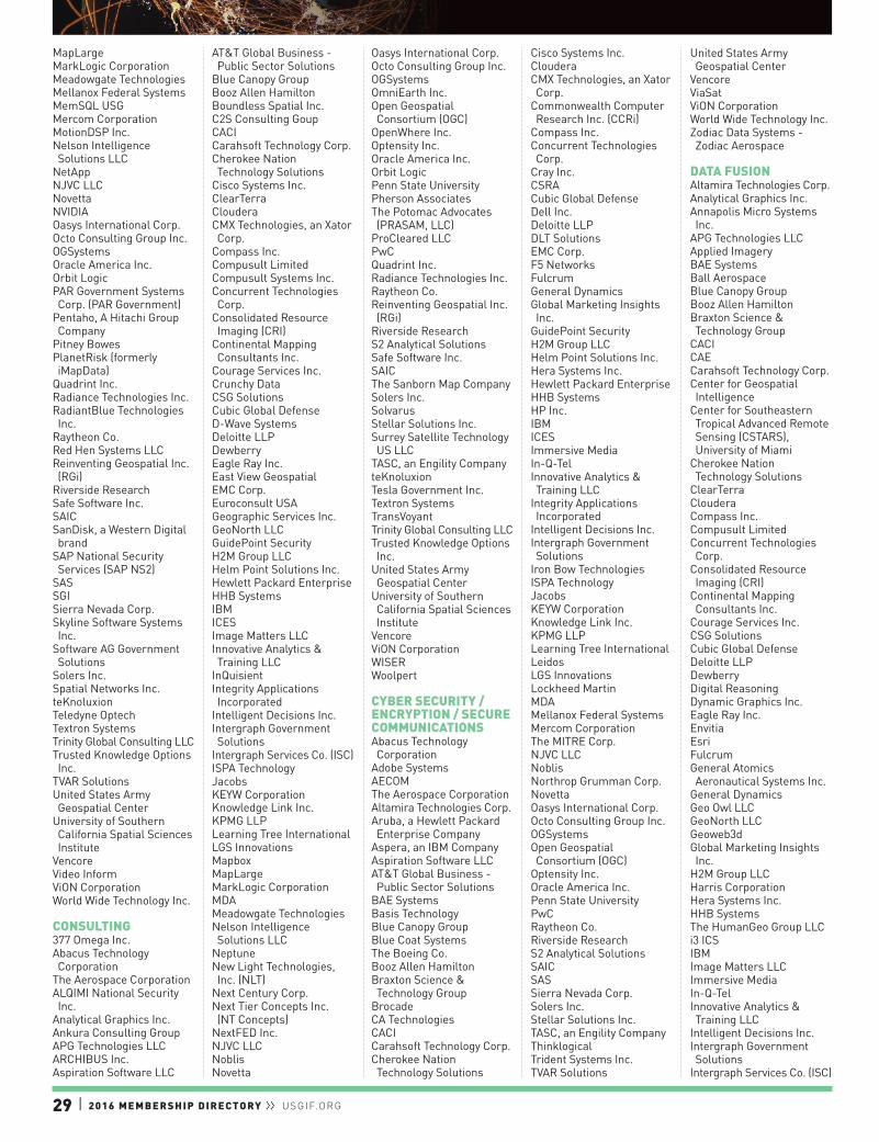
29 | 2016 MEMBERSHIP DIRECTORY ll USGIF.ORG
MapLargeMarkLogic CorporationMeadowgate TechnologiesMellanox Federal SystemsMemSQL USGMercom CorporationMotionDSP Inc.Nelson Intelligence Solutions LLC
NetAppNJVC LLCNovettaNVIDIAOasys International Corp.Octo Consulting Group Inc.OGSystemsOracle America Inc.Orbit LogicPAR Government Systems Corp. (PAR Government)
Pentaho, A Hitachi Group Company
Pitney BowesPlanetRisk (formerly iMapData)
Quadrint Inc.Radiance Technologies Inc.RadiantBlue Technologies Inc.
Raytheon Co.Red Hen Systems LLCReinventing Geospatial Inc. (RGi)
Riverside ResearchSafe Software Inc.SAICSanDisk, a Western Digital brand
SAP National Security Services (SAP NS2)
SASSGISierra Nevada Corp.Skyline Software Systems Inc.
Software AG Government Solutions
Solers Inc.Spatial Networks Inc.teKnoluxionTeledyne OptechTextron SystemsTrinity Global Consulting LLCTrusted Knowledge Options Inc.
TVAR SolutionsUnited States Army Geospatial Center
University of Southern California Spatial Sciences Institute
VencoreVideo InformViON CorporationWorld Wide Technology Inc.
CONSULTING377 Omega Inc.Abacus Technology Corporation
The Aerospace CorporationALQIMI National Security Inc.
Analytical Graphics Inc.Ankura Consulting GroupAPG Technologies LLCARCHIBUS Inc.Aspiration Software LLC
AT&T Global Business - Public Sector Solutions
Blue Canopy GroupBooz Allen HamiltonBoundless Spatial Inc.C2S Consulting GoupCACICarahsoft Technology Corp.Cherokee Nation Technology Solutions
Cisco Systems Inc.ClearTerraClouderaCMX Technologies, an Xator Corp.
Compass Inc.Compusult LimitedCompusult Systems Inc.Concurrent Technologies Corp.
Consolidated Resource Imaging (CRI)
Continental Mapping Consultants Inc.
Courage Services Inc.Crunchy DataCSG SolutionsCubic Global DefenseD-Wave SystemsDeloitte LLPDewberryEagle Ray Inc.East View GeospatialEMC Corp.Euroconsult USAGeographic Services Inc.GeoNorth LLCGuidePoint SecurityH2M Group LLCHelm Point Solutions Inc.Hewlett Packard EnterpriseHHB SystemsIBMICESImage Matters LLCInnovative Analytics & Training LLC
InQuisientIntegrity Applications Incorporated
Intelligent Decisions Inc.Intergraph Government Solutions
Intergraph Services Co. (ISC)ISPA TechnologyJacobsKEYW CorporationKnowledge Link Inc.KPMG LLPLearning Tree InternationalLGS InnovationsMapboxMapLargeMarkLogic CorporationMDAMeadowgate TechnologiesNelson Intelligence Solutions LLC
NeptuneNew Light Technologies, Inc. (NLT)
Next Century Corp.Next Tier Concepts Inc. (NT Concepts)
NextFED Inc.NJVC LLCNoblisNovetta
Oasys International Corp.Octo Consulting Group Inc.OGSystemsOmniEarth Inc.Open Geospatial Consortium (OGC)
OpenWhere Inc.Optensity Inc.Oracle America Inc.Orbit LogicPenn State UniversityPherson AssociatesThe Potomac Advocates (PRASAM, LLC)
ProCleared LLCPwCQuadrint Inc.Radiance Technologies Inc.Raytheon Co.Reinventing Geospatial Inc. (RGi)
Riverside ResearchS2 Analytical SolutionsSafe Software Inc.SAICThe Sanborn Map CompanySolers Inc.SolvarusStellar Solutions Inc.Surrey Satellite Technology US LLC
TASC, an Engility CompanyteKnoluxionTesla Government Inc.Textron SystemsTransVoyantTrinity Global Consulting LLCTrusted Knowledge Options Inc.
United States Army Geospatial Center
University of Southern California Spatial Sciences Institute
VencoreViON CorporationWISERWoolpert
CYBER SECURITY / ENCRYPTION / SECURE COMMUNICATIONSAbacus Technology Corporation
Adobe SystemsAECOMThe Aerospace CorporationAltamira Technologies Corp.Aruba, a Hewlett Packard Enterprise Company
Aspera, an IBM CompanyAspiration Software LLCAT&T Global Business - Public Sector Solutions
BAE SystemsBasis TechnologyBlue Canopy GroupBlue Coat SystemsThe Boeing Co.Booz Allen HamiltonBraxton Science & Technology Group
BrocadeCA TechnologiesCACICarahsoft Technology Corp.Cherokee Nation Technology Solutions
Cisco Systems Inc.ClouderaCMX Technologies, an Xator Corp.
Commonwealth Computer Research Inc. (CCRi)
Compass Inc.Concurrent Technologies Corp.
Cray Inc.CSRACubic Global DefenseDell Inc.Deloitte LLPDLT SolutionsEMC Corp.F5 NetworksFulcrumGeneral DynamicsGlobal Marketing Insights Inc.
GuidePoint SecurityH2M Group LLCHelm Point Solutions Inc.Hera Systems Inc.Hewlett Packard EnterpriseHHB SystemsHP Inc.IBMICESImmersive MediaIn-Q-TelInnovative Analytics & Training LLC
Integrity Applications Incorporated
Intelligent Decisions Inc.Intergraph Government Solutions
Iron Bow TechnologiesISPA TechnologyJacobsKEYW CorporationKnowledge Link Inc.KPMG LLPLearning Tree InternationalLeidosLGS InnovationsLockheed MartinMDAMellanox Federal SystemsMercom CorporationThe MITRE Corp.NJVC LLCNoblisNorthrop Grumman Corp.NovettaOasys International Corp.Octo Consulting Group Inc.OGSystemsOpen Geospatial Consortium (OGC)
Optensity Inc.Oracle America Inc.Penn State UniversityPwCRaytheon Co.Riverside ResearchS2 Analytical SolutionsSAICSASSierra Nevada Corp.Solers Inc.Stellar Solutions Inc.TASC, an Engility CompanyThinklogicalTrident Systems Inc.TVAR Solutions
United States Army Geospatial Center
VencoreViaSatViON CorporationWorld Wide Technology Inc.Zodiac Data Systems - Zodiac Aerospace
DATA FUSIONAltamira Technologies Corp.Analytical Graphics Inc.Annapolis Micro Systems Inc.
APG Technologies LLCApplied ImageryBAE SystemsBall AerospaceBlue Canopy GroupBooz Allen HamiltonBraxton Science & Technology Group
CACICAECarahsoft Technology Corp.Center for Geospatial Intelligence
Center for Southeastern Tropical Advanced Remote Sensing (CSTARS), University of Miami
Cherokee Nation Technology Solutions
ClearTerraClouderaCompass Inc.Compusult LimitedConcurrent Technologies Corp.
Consolidated Resource Imaging (CRI)
Continental Mapping Consultants Inc.
Courage Services Inc.CSG SolutionsCubic Global DefenseDeloitte LLPDewberryDigital ReasoningDynamic Graphics Inc.Eagle Ray Inc.EnvitiaEsriFulcrumGeneral Atomics Aeronautical Systems Inc.
General DynamicsGeo Owl LLCGeoNorth LLCGeoweb3dGlobal Marketing Insights Inc.
H2M Group LLCHarris CorporationHera Systems Inc.HHB SystemsThe HumanGeo Group LLCi3 ICSIBMImage Matters LLCImmersive MediaIn-Q-TelInnovative Analytics & Training LLC
Intelligent Decisions Inc.Intergraph Government Solutions
Intergraph Services Co. (ISC)
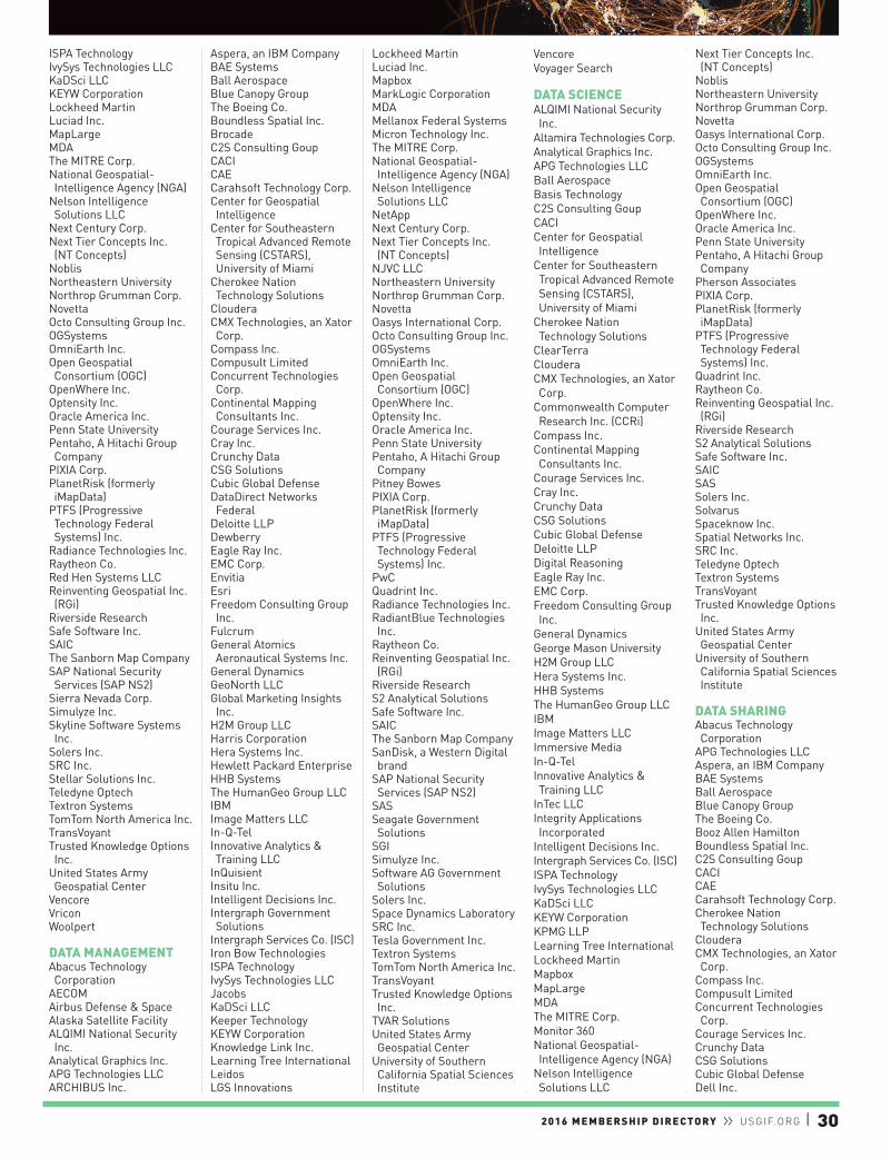
2016 MEMBERSHIP DIRECTORY ll USGIF.ORG | 30
ISPA TechnologyIvySys Technologies LLCKaDSci LLCKEYW CorporationLockheed MartinLuciad Inc.MapLargeMDAThe MITRE Corp.National Geospatial-Intelligence Agency (NGA)
Nelson Intelligence Solutions LLC
Next Century Corp.Next Tier Concepts Inc. (NT Concepts)
NoblisNortheastern UniversityNorthrop Grumman Corp.NovettaOcto Consulting Group Inc.OGSystemsOmniEarth Inc.Open Geospatial Consortium (OGC)
OpenWhere Inc.Optensity Inc.Oracle America Inc.Penn State UniversityPentaho, A Hitachi Group Company
PIXIA Corp.PlanetRisk (formerly iMapData)
PTFS (Progressive Technology Federal Systems) Inc.
Radiance Technologies Inc.Raytheon Co.Red Hen Systems LLCReinventing Geospatial Inc. (RGi)
Riverside ResearchSafe Software Inc.SAICThe Sanborn Map CompanySAP National Security Services (SAP NS2)
Sierra Nevada Corp.Simulyze Inc.Skyline Software Systems Inc.
Solers Inc.SRC Inc.Stellar Solutions Inc.Teledyne OptechTextron SystemsTomTom North America Inc.TransVoyantTrusted Knowledge Options Inc.
United States Army Geospatial Center
VencoreVriconWoolpert
DATA MANAGEMENTAbacus Technology Corporation
AECOMAirbus Defense & SpaceAlaska Satellite FacilityALQIMI National Security Inc.
Analytical Graphics Inc.APG Technologies LLCARCHIBUS Inc.
Aspera, an IBM CompanyBAE SystemsBall AerospaceBlue Canopy GroupThe Boeing Co.Boundless Spatial Inc.BrocadeC2S Consulting GoupCACICAECarahsoft Technology Corp.Center for Geospatial Intelligence
Center for Southeastern Tropical Advanced Remote Sensing (CSTARS), University of Miami
Cherokee Nation Technology Solutions
ClouderaCMX Technologies, an Xator Corp.
Compass Inc.Compusult LimitedConcurrent Technologies Corp.
Continental Mapping Consultants Inc.
Courage Services Inc.Cray Inc.Crunchy DataCSG SolutionsCubic Global DefenseDataDirect Networks Federal
Deloitte LLPDewberryEagle Ray Inc.EMC Corp.EnvitiaEsriFreedom Consulting Group Inc.
FulcrumGeneral Atomics Aeronautical Systems Inc.
General DynamicsGeoNorth LLCGlobal Marketing Insights Inc.
H2M Group LLCHarris CorporationHera Systems Inc.Hewlett Packard EnterpriseHHB SystemsThe HumanGeo Group LLCIBMImage Matters LLCIn-Q-TelInnovative Analytics & Training LLC
InQuisientInsitu Inc.Intelligent Decisions Inc.Intergraph Government Solutions
Intergraph Services Co. (ISC)Iron Bow TechnologiesISPA TechnologyIvySys Technologies LLCJacobsKaDSci LLCKeeper TechnologyKEYW CorporationKnowledge Link Inc.Learning Tree InternationalLeidosLGS Innovations
Lockheed MartinLuciad Inc.MapboxMarkLogic CorporationMDAMellanox Federal SystemsMicron Technology Inc.The MITRE Corp.National Geospatial-Intelligence Agency (NGA)
Nelson Intelligence Solutions LLC
NetAppNext Century Corp.Next Tier Concepts Inc. (NT Concepts)
NJVC LLCNortheastern UniversityNorthrop Grumman Corp.NovettaOasys International Corp.Octo Consulting Group Inc.OGSystemsOmniEarth Inc.Open Geospatial Consortium (OGC)
OpenWhere Inc.Optensity Inc.Oracle America Inc.Penn State UniversityPentaho, A Hitachi Group Company
Pitney BowesPIXIA Corp.PlanetRisk (formerly iMapData)
PTFS (Progressive Technology Federal Systems) Inc.
PwCQuadrint Inc.Radiance Technologies Inc.RadiantBlue Technologies Inc.
Raytheon Co.Reinventing Geospatial Inc. (RGi)
Riverside ResearchS2 Analytical SolutionsSafe Software Inc.SAICThe Sanborn Map CompanySanDisk, a Western Digital brand
SAP National Security Services (SAP NS2)
SASSeagate Government Solutions
SGISimulyze Inc.Software AG Government Solutions
Solers Inc.Space Dynamics LaboratorySRC Inc.Tesla Government Inc.Textron SystemsTomTom North America Inc.TransVoyantTrusted Knowledge Options Inc.
TVAR SolutionsUnited States Army Geospatial Center
University of Southern California Spatial Sciences Institute
VencoreVoyager Search
DATA SCIENCEALQIMI National Security Inc.
Altamira Technologies Corp.Analytical Graphics Inc.APG Technologies LLCBall AerospaceBasis TechnologyC2S Consulting GoupCACICenter for Geospatial Intelligence
Center for Southeastern Tropical Advanced Remote Sensing (CSTARS), University of Miami
Cherokee Nation Technology Solutions
ClearTerraClouderaCMX Technologies, an Xator Corp.
Commonwealth Computer Research Inc. (CCRi)
Compass Inc.Continental Mapping Consultants Inc.
Courage Services Inc.Cray Inc.Crunchy DataCSG SolutionsCubic Global DefenseDeloitte LLPDigital ReasoningEagle Ray Inc.EMC Corp.Freedom Consulting Group Inc.
General DynamicsGeorge Mason UniversityH2M Group LLCHera Systems Inc.HHB SystemsThe HumanGeo Group LLCIBMImage Matters LLCImmersive MediaIn-Q-TelInnovative Analytics & Training LLC
InTec LLCIntegrity Applications Incorporated
Intelligent Decisions Inc.Intergraph Services Co. (ISC)ISPA TechnologyIvySys Technologies LLCKaDSci LLCKEYW CorporationKPMG LLPLearning Tree InternationalLockheed MartinMapboxMapLargeMDAThe MITRE Corp.Monitor 360National Geospatial-Intelligence Agency (NGA)
Nelson Intelligence Solutions LLC
Next Tier Concepts Inc. (NT Concepts)
NoblisNortheastern UniversityNorthrop Grumman Corp.NovettaOasys International Corp.Octo Consulting Group Inc.OGSystemsOmniEarth Inc.Open Geospatial Consortium (OGC)
OpenWhere Inc.Oracle America Inc.Penn State UniversityPentaho, A Hitachi Group Company
Pherson AssociatesPIXIA Corp.PlanetRisk (formerly iMapData)
PTFS (Progressive Technology Federal Systems) Inc.
Quadrint Inc.Raytheon Co.Reinventing Geospatial Inc. (RGi)
Riverside ResearchS2 Analytical SolutionsSafe Software Inc.SAICSASSolers Inc.SolvarusSpaceknow Inc.Spatial Networks Inc.SRC Inc.Teledyne OptechTextron SystemsTransVoyantTrusted Knowledge Options Inc.
United States Army Geospatial Center
University of Southern California Spatial Sciences Institute
DATA SHARINGAbacus Technology Corporation
APG Technologies LLCAspera, an IBM CompanyBAE SystemsBall AerospaceBlue Canopy GroupThe Boeing Co.Booz Allen HamiltonBoundless Spatial Inc.C2S Consulting GoupCACICAECarahsoft Technology Corp.Cherokee Nation Technology Solutions
ClouderaCMX Technologies, an Xator Corp.
Compass Inc.Compusult LimitedConcurrent Technologies Corp.
Courage Services Inc.Crunchy DataCSG SolutionsCubic Global DefenseDell Inc.
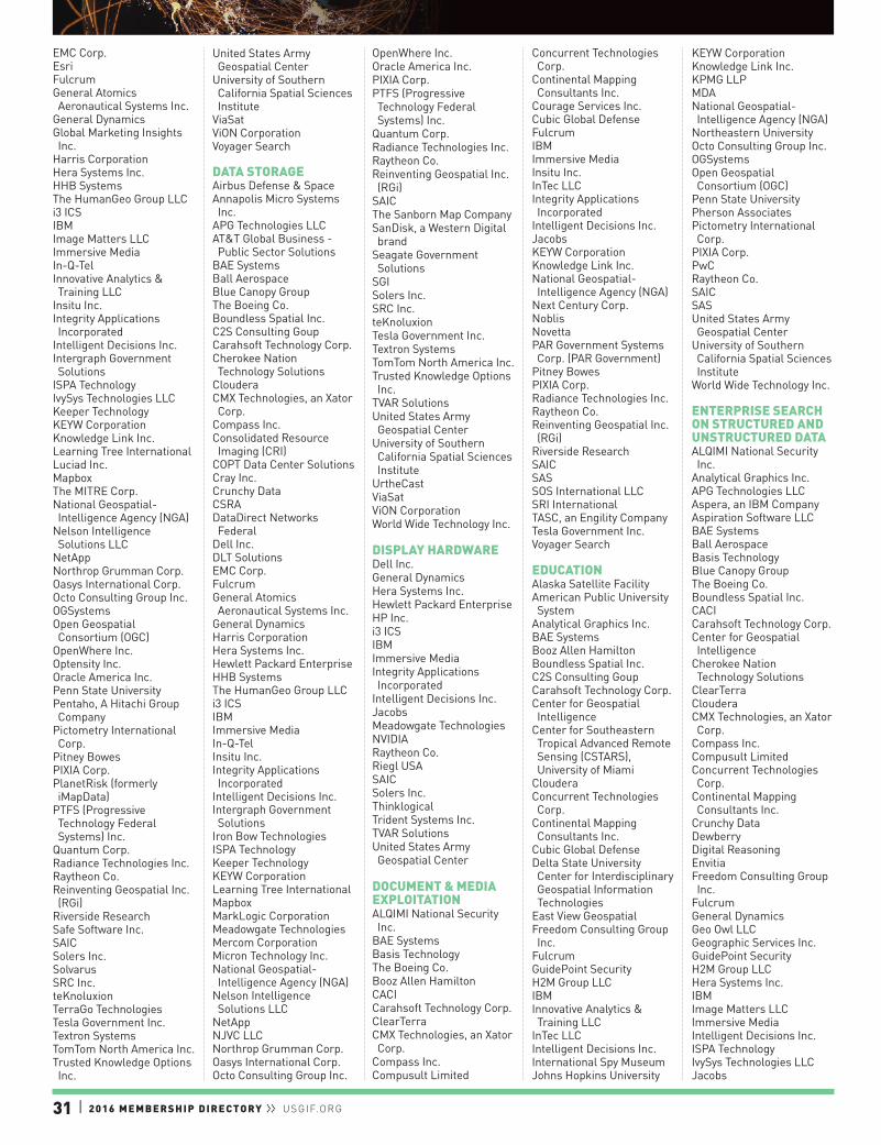
31 | 2016 MEMBERSHIP DIRECTORY ll USGIF.ORG
EMC Corp.EsriFulcrumGeneral Atomics Aeronautical Systems Inc.
General DynamicsGlobal Marketing Insights Inc.
Harris CorporationHera Systems Inc.HHB SystemsThe HumanGeo Group LLCi3 ICSIBMImage Matters LLCImmersive MediaIn-Q-TelInnovative Analytics & Training LLC
Insitu Inc.Integrity Applications Incorporated
Intelligent Decisions Inc.Intergraph Government Solutions
ISPA TechnologyIvySys Technologies LLCKeeper TechnologyKEYW CorporationKnowledge Link Inc.Learning Tree InternationalLuciad Inc.MapboxThe MITRE Corp.National Geospatial-Intelligence Agency (NGA)
Nelson Intelligence Solutions LLC
NetAppNorthrop Grumman Corp.Oasys International Corp.Octo Consulting Group Inc.OGSystemsOpen Geospatial Consortium (OGC)
OpenWhere Inc.Optensity Inc.Oracle America Inc.Penn State UniversityPentaho, A Hitachi Group Company
Pictometry International Corp.
Pitney BowesPIXIA Corp.PlanetRisk (formerly iMapData)
PTFS (Progressive Technology Federal Systems) Inc.
Quantum Corp.Radiance Technologies Inc.Raytheon Co.Reinventing Geospatial Inc. (RGi)
Riverside ResearchSafe Software Inc.SAICSolers Inc.SolvarusSRC Inc.teKnoluxionTerraGo TechnologiesTesla Government Inc.Textron SystemsTomTom North America Inc.Trusted Knowledge Options Inc.
United States Army Geospatial Center
University of Southern California Spatial Sciences Institute
ViaSatViON CorporationVoyager Search
DATA STORAGEAirbus Defense & SpaceAnnapolis Micro Systems Inc.
APG Technologies LLCAT&T Global Business - Public Sector Solutions
BAE SystemsBall AerospaceBlue Canopy GroupThe Boeing Co.Boundless Spatial Inc.C2S Consulting GoupCarahsoft Technology Corp.Cherokee Nation Technology Solutions
ClouderaCMX Technologies, an Xator Corp.
Compass Inc.Consolidated Resource Imaging (CRI)
COPT Data Center SolutionsCray Inc.Crunchy DataCSRADataDirect Networks Federal
Dell Inc.DLT SolutionsEMC Corp.FulcrumGeneral Atomics Aeronautical Systems Inc.
General DynamicsHarris CorporationHera Systems Inc.Hewlett Packard EnterpriseHHB SystemsThe HumanGeo Group LLCi3 ICSIBMImmersive MediaIn-Q-TelInsitu Inc.Integrity Applications Incorporated
Intelligent Decisions Inc.Intergraph Government Solutions
Iron Bow TechnologiesISPA TechnologyKeeper TechnologyKEYW CorporationLearning Tree InternationalMapboxMarkLogic CorporationMeadowgate TechnologiesMercom CorporationMicron Technology Inc.National Geospatial-Intelligence Agency (NGA)
Nelson Intelligence Solutions LLC
NetAppNJVC LLCNorthrop Grumman Corp.Oasys International Corp.Octo Consulting Group Inc.
OpenWhere Inc.Oracle America Inc.PIXIA Corp.PTFS (Progressive Technology Federal Systems) Inc.
Quantum Corp.Radiance Technologies Inc.Raytheon Co.Reinventing Geospatial Inc. (RGi)
SAICThe Sanborn Map CompanySanDisk, a Western Digital brand
Seagate Government Solutions
SGISolers Inc.SRC Inc.teKnoluxionTesla Government Inc.Textron SystemsTomTom North America Inc.Trusted Knowledge Options Inc.
TVAR SolutionsUnited States Army Geospatial Center
University of Southern California Spatial Sciences Institute
UrtheCastViaSatViON CorporationWorld Wide Technology Inc.
DISPLAY HARDWAREDell Inc.General DynamicsHera Systems Inc.Hewlett Packard EnterpriseHP Inc.i3 ICSIBMImmersive MediaIntegrity Applications Incorporated
Intelligent Decisions Inc.JacobsMeadowgate TechnologiesNVIDIARaytheon Co.Riegl USASAICSolers Inc.ThinklogicalTrident Systems Inc.TVAR SolutionsUnited States Army Geospatial Center
DOCUMENT & MEDIA EXPLOITATIONALQIMI National Security Inc.
BAE SystemsBasis TechnologyThe Boeing Co.Booz Allen HamiltonCACICarahsoft Technology Corp.ClearTerraCMX Technologies, an Xator Corp.
Compass Inc.Compusult Limited
Concurrent Technologies Corp.
Continental Mapping Consultants Inc.
Courage Services Inc.Cubic Global DefenseFulcrumIBMImmersive MediaInsitu Inc.InTec LLCIntegrity Applications Incorporated
Intelligent Decisions Inc.JacobsKEYW CorporationKnowledge Link Inc.National Geospatial-Intelligence Agency (NGA)
Next Century Corp.NoblisNovettaPAR Government Systems Corp. (PAR Government)
Pitney BowesPIXIA Corp.Radiance Technologies Inc.Raytheon Co.Reinventing Geospatial Inc. (RGi)
Riverside ResearchSAICSASSOS International LLCSRI InternationalTASC, an Engility CompanyTesla Government Inc.Voyager Search
EDUCATIONAlaska Satellite FacilityAmerican Public University System
Analytical Graphics Inc.BAE SystemsBooz Allen HamiltonBoundless Spatial Inc.C2S Consulting GoupCarahsoft Technology Corp.Center for Geospatial Intelligence
Center for Southeastern Tropical Advanced Remote Sensing (CSTARS), University of Miami
ClouderaConcurrent Technologies Corp.
Continental Mapping Consultants Inc.
Cubic Global DefenseDelta State University Center for Interdisciplinary Geospatial Information Technologies
East View GeospatialFreedom Consulting Group Inc.
FulcrumGuidePoint SecurityH2M Group LLCIBMInnovative Analytics & Training LLC
InTec LLCIntelligent Decisions Inc.International Spy MuseumJohns Hopkins University
KEYW CorporationKnowledge Link Inc.KPMG LLPMDANational Geospatial-Intelligence Agency (NGA)
Northeastern UniversityOcto Consulting Group Inc.OGSystemsOpen Geospatial Consortium (OGC)
Penn State UniversityPherson AssociatesPictometry International Corp.
PIXIA Corp.PwCRaytheon Co.SAICSASUnited States Army Geospatial Center
University of Southern California Spatial Sciences Institute
World Wide Technology Inc.
ENTERPRISE SEARCH ON STRUCTURED AND UNSTRUCTURED DATAALQIMI National Security Inc.
Analytical Graphics Inc.APG Technologies LLCAspera, an IBM CompanyAspiration Software LLCBAE SystemsBall AerospaceBasis TechnologyBlue Canopy GroupThe Boeing Co.Boundless Spatial Inc.CACICarahsoft Technology Corp.Center for Geospatial Intelligence
Cherokee Nation Technology Solutions
ClearTerraClouderaCMX Technologies, an Xator Corp.
Compass Inc.Compusult LimitedConcurrent Technologies Corp.
Continental Mapping Consultants Inc.
Crunchy DataDewberryDigital ReasoningEnvitiaFreedom Consulting Group Inc.
FulcrumGeneral DynamicsGeo Owl LLCGeographic Services Inc.GuidePoint SecurityH2M Group LLCHera Systems Inc.IBMImage Matters LLCImmersive MediaIntelligent Decisions Inc.ISPA TechnologyIvySys Technologies LLCJacobs

2016 MEMBERSHIP DIRECTORY ll USGIF.ORG | 32
KEYW CorporationKnowledge Link Inc.Learning Tree InternationalMDAThe MITRE Corp.National Geospatial-Intelligence Agency (NGA)
NoblisNorthrop Grumman Corp.NovettaOcto Consulting Group Inc.OGSystemsOpen Geospatial Consortium (OGC)
Oracle America Inc.Penn State UniversityPentaho, A Hitachi Group Company
Pitney BowesPIXIA Corp.PlanetRisk (formerly iMapData)
PTFS (Progressive Technology Federal Systems) Inc.
PwCRaytheon Co.Reinventing Geospatial Inc. (RGi)
Riverside ResearchSafe Software Inc.SAICSASSolers Inc.teKnoluxionTerraGo TechnologiesTesla Government Inc.Textron SystemsTransVoyantTVAR SolutionsUnited States Army Geospatial Center
University of Southern California Spatial Sciences Institute
Voyager SearchWorld Wide Technology Inc.
FACILITIES MANAGEMENT / OPERATIONS & MAINTENANCEAECOMAnalytical Graphics Inc.ARCHIBUS Inc.BAE SystemsCarahsoft Technology Corp.Cherokee Nation Technology Solutions
COPT Data Center SolutionsDewberryFreedom Consulting Group Inc.
General DynamicsHera Systems Inc.IBMImmersive MediaIntegrity Applications Incorporated
Intelligent Decisions Inc.JacobsMDANational Geospatial-Intelligence Agency (NGA)
NoblisPIXIA Corp.PwCRaytheon Co.
TerraGo TechnologiesTrident Systems Inc.United States Army Geospatial Center
Westway Development Services LLC
FULL MOTION VIDEOAdobe SystemsAnalytical Graphics Inc.BAE SystemsBooz Allen HamiltonCACICarahsoft Technology Corp.Cardio Logic Inc.Churchill NavigationCisco Systems Inc.Compass Inc.Concurrent Technologies Corp.
Consolidated Resource Imaging (CRI)
Courage Services Inc.CSG SolutionsCubic Global DefenseEsriGeneral Atomics Aeronautical Systems Inc.
Geo Owl LLCH2M Group LLCHarris CorporationHera Systems Inc.HHB SystemsIBMImmersive MediaInsitu Inc.Integrity Applications Incorporated
Intergraph Services Co. (ISC)ISPA TechnologyIvySys Technologies LLCJacobsKEYW CorporationLeidosLockheed MartinLuciad Inc.MDAThe MITRE Corp.MotionDSP Inc.National Geospatial-Intelligence Agency (NGA)
Nelson Intelligence Solutions LLC
Northrop Grumman Corp.NovettaOGSystemsOpen Geospatial Consortium (OGC)
Oracle America Inc.PAR Government Systems Corp. (PAR Government)
Penn State UniversityPIXIA Corp.ProCleared LLCRadiance Technologies Inc.Raytheon Co.Red Hen Systems LLCSierra Nevada Corp.Solers Inc.Space Dynamics LaboratorySRC Inc.SRI InternationalTeledyne OptechThinklogicalTrident Systems Inc.Trinity Global Consulting LLCUrtheCastVencore
ViON CorporationWISER
GEOGRAPHIC INFORMATION SYSTEMSAnalytical Graphics Inc.APG Technologies LLCApplied ImageryApplied Research Associates Inc.
ARCHIBUS Inc.Blue Canopy GroupBoundless Spatial Inc.CACICarahsoft Technology Corp.Center for Southeastern Tropical Advanced Remote Sensing (CSTARS), University of Miami
Cherokee Nation Technology Solutions
Churchill NavigationClearTerraCMX Technologies, an Xator Corp.
Compass Inc.CompassData Inc.Compusult LimitedConcurrent Technologies Corp.
Consolidated Resource Imaging (CRI)
Continental Mapping Consultants Inc.
Courage Services Inc.Crunchy DataCSG SolutionsDeloitte LLPDewberryDynamic Graphics Inc.e-GEOSEnvitiaEsriFulcrumGeneral DynamicsGeo Owl LLCGeographic Services Inc.GeoNorth LLCGeorge Mason UniversityGeoweb3dH2M Group LLCHera Systems Inc.HEREHHB SystemsThe HumanGeo Group LLCIBMICESImage Matters LLCImmersive MediaInsitu Inc.Integrity Applications Incorporated
Intergraph Services Co. (ISC)ISPA TechnologyJacobsKEYW CorporationKnowledge Link Inc.LAND INFO Worldwide Mapping LLC
Lockheed MartinLuciad Inc.MapboxMapLargeMarkLogic CorporationMDAThe MITRE Corp.MotionDSP Inc.
National Geospatial-Intelligence Agency (NGA)
Nelson Intelligence Solutions LLC
New Light Technologies, Inc. (NLT)
Next Century Corp.Next Tier Concepts Inc. (NT Concepts)
NoblisNortheastern UniversityNorthrop Grumman Corp.NovettaNVIDIAObservera Inc.Octo Consulting Group Inc.OGSystemsOmniEarth Inc.Open Geospatial Consortium (OGC)
PAR Government Systems Corp. (PAR Government)
Penn State UniversityPictometry International Corp.
Pitney BowesPIXIA Corp.PlanetRisk (formerly iMapData)
PTFS (Progressive Technology Federal Systems) Inc.
Raytheon Co.Red Hen Systems LLCReinventing Geospatial Inc. (RGi)
Riverside ResearchS2 Analytical SolutionsSafe Software Inc.SAICThe Sanborn Map CompanySigma SpaceSimulyze Inc.Solers Inc.Spatial Networks Inc.SRC Inc.teKnoluxionTeledyne OptechTerraGo TechnologiesTesla Government Inc.Textron SystemsThinklogicalTomTom North America Inc.TransVoyantTrinity Global Consulting LLCUnited States Army Geospatial Center
University of Southern California Spatial Sciences Institute
VencoreVriconWISERWoolpert
GEOSPATIAL DATA PRODUCTIONAirbus Defense & SpaceAlaska Satellite FacilityAnalytical Graphics Inc.APG Technologies LLCApplied ImageryApplied Research Associates Inc.
Aspiration Software LLCBAE SystemsThe Boeing Co.Boundless Spatial Inc.
CACICAECarahsoft Technology Corp.Center for Geospatial Intelligence
Center for Southeastern Tropical Advanced Remote Sensing (CSTARS), University of Miami
Cherokee Nation Technology Solutions
Churchill NavigationClearTerraCMX Technologies, an Xator Corp.
Commonwealth Computer Research Inc. (CCRi)
Compass Inc.CompassData Inc.Consolidated Resource Imaging (CRI)
Continental Mapping Consultants Inc.
Courage Services Inc.Crunchy DataCSG SolutionsCubic Global DefenseDeloitte LLPDewberryDigitalGlobee-GEOSEsriFreedom Consulting Group Inc.
General Atomics Aeronautical Systems Inc.
Geographic Services Inc.GeoNorth LLCGlobal Marketing Insights Inc.
H2M Group LLCHarris CorporationHera Systems Inc.HEREHHB SystemsThe HumanGeo Group LLCIBMImmersive MediaInsitu Inc.Integrity Applications Incorporated
Intergraph Services Co. (ISC)ISPA TechnologyJacobsKnowledge Link Inc.LAND INFO Worldwide Mapping LLC
LeidosLuciad Inc.MapboxMapLargeMDAMotionDSP Inc.National Geospatial-Intelligence Agency (NGA)
Nelson Intelligence Solutions LLC
New Light Technologies, Inc. (NLT)
NoblisNortheastern UniversityNorthrop Grumman Corp.Octo Consulting Group Inc.OGSystemsOmniEarth Inc.
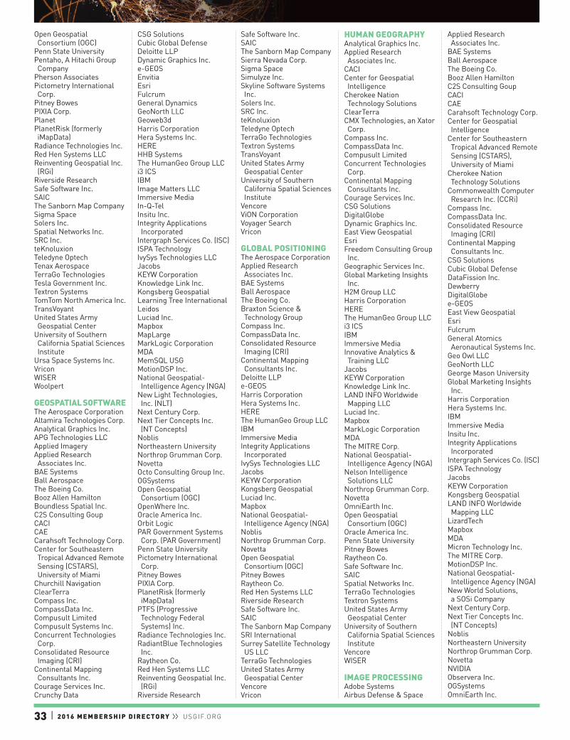
33 | 2016 MEMBERSHIP DIRECTORY ll USGIF.ORG
Open Geospatial Consortium (OGC)
Penn State UniversityPentaho, A Hitachi Group Company
Pherson AssociatesPictometry International Corp.
Pitney BowesPIXIA Corp.PlanetPlanetRisk (formerly iMapData)
Radiance Technologies Inc.Red Hen Systems LLCReinventing Geospatial Inc. (RGi)
Riverside ResearchSafe Software Inc.SAICThe Sanborn Map CompanySigma SpaceSolers Inc.Spatial Networks Inc.SRC Inc.teKnoluxionTeledyne OptechTenax AerospaceTerraGo TechnologiesTesla Government Inc.Textron SystemsTomTom North America Inc.TransVoyantUnited States Army Geospatial Center
University of Southern California Spatial Sciences Institute
Ursa Space Systems Inc.VriconWISERWoolpert
GEOSPATIAL SOFTWAREThe Aerospace CorporationAltamira Technologies Corp.Analytical Graphics Inc.APG Technologies LLCApplied ImageryApplied Research Associates Inc.
BAE SystemsBall AerospaceThe Boeing Co.Booz Allen HamiltonBoundless Spatial Inc.C2S Consulting GoupCACICAECarahsoft Technology Corp.Center for Southeastern Tropical Advanced Remote Sensing (CSTARS), University of Miami
Churchill NavigationClearTerraCompass Inc.CompassData Inc.Compusult LimitedCompusult Systems Inc.Concurrent Technologies Corp.
Consolidated Resource Imaging (CRI)
Continental Mapping Consultants Inc.
Courage Services Inc.Crunchy Data
CSG SolutionsCubic Global DefenseDeloitte LLPDynamic Graphics Inc.e-GEOSEnvitiaEsriFulcrumGeneral DynamicsGeoNorth LLCGeoweb3dHarris CorporationHera Systems Inc.HEREHHB SystemsThe HumanGeo Group LLCi3 ICSIBMImage Matters LLCImmersive MediaIn-Q-TelInsitu Inc.Integrity Applications Incorporated
Intergraph Services Co. (ISC)ISPA TechnologyIvySys Technologies LLCJacobsKEYW CorporationKnowledge Link Inc.Kongsberg GeospatialLearning Tree InternationalLeidosLuciad Inc.MapboxMapLargeMarkLogic CorporationMDAMemSQL USGMotionDSP Inc.National Geospatial-Intelligence Agency (NGA)
New Light Technologies, Inc. (NLT)
Next Century Corp.Next Tier Concepts Inc. (NT Concepts)
NoblisNortheastern UniversityNorthrop Grumman Corp.NovettaOcto Consulting Group Inc.OGSystemsOpen Geospatial Consortium (OGC)
OpenWhere Inc.Oracle America Inc.Orbit LogicPAR Government Systems Corp. (PAR Government)
Penn State UniversityPictometry International Corp.
Pitney BowesPIXIA Corp.PlanetRisk (formerly iMapData)
PTFS (Progressive Technology Federal Systems) Inc.
Radiance Technologies Inc.RadiantBlue Technologies Inc.
Raytheon Co.Red Hen Systems LLCReinventing Geospatial Inc. (RGi)
Riverside Research
Safe Software Inc.SAICThe Sanborn Map CompanySierra Nevada Corp.Sigma SpaceSimulyze Inc.Skyline Software Systems Inc.
Solers Inc.SRC Inc.teKnoluxionTeledyne OptechTerraGo TechnologiesTextron SystemsTransVoyantUnited States Army Geospatial Center
University of Southern California Spatial Sciences Institute
VencoreViON CorporationVoyager SearchVricon
GLOBAL POSITIONINGThe Aerospace CorporationApplied Research Associates Inc.
BAE SystemsBall AerospaceThe Boeing Co.Braxton Science & Technology Group
Compass Inc.CompassData Inc.Consolidated Resource Imaging (CRI)
Continental Mapping Consultants Inc.
Deloitte LLPe-GEOSHarris CorporationHera Systems Inc.HEREThe HumanGeo Group LLCIBMImmersive MediaIntegrity Applications Incorporated
IvySys Technologies LLCJacobsKEYW CorporationKongsberg GeospatialLuciad Inc.MapboxNational Geospatial-Intelligence Agency (NGA)
NoblisNorthrop Grumman Corp.NovettaOpen Geospatial Consortium (OGC)
Pitney BowesRaytheon Co.Red Hen Systems LLCRiverside ResearchSafe Software Inc.SAICThe Sanborn Map CompanySRI InternationalSurrey Satellite Technology US LLC
TerraGo TechnologiesUnited States Army Geospatial Center
VencoreVricon
HUMAN GEOGRAPHYAnalytical Graphics Inc.Applied Research Associates Inc.
CACICenter for Geospatial Intelligence
Cherokee Nation Technology Solutions
ClearTerraCMX Technologies, an Xator Corp.
Compass Inc.CompassData Inc.Compusult LimitedConcurrent Technologies Corp.
Continental Mapping Consultants Inc.
Courage Services Inc.CSG SolutionsDigitalGlobeDynamic Graphics Inc.East View GeospatialEsriFreedom Consulting Group Inc.
Geographic Services Inc.Global Marketing Insights Inc.
H2M Group LLCHarris CorporationHEREThe HumanGeo Group LLCi3 ICSIBMImmersive MediaInnovative Analytics & Training LLC
JacobsKEYW CorporationKnowledge Link Inc.LAND INFO Worldwide Mapping LLC
Luciad Inc.MapboxMarkLogic CorporationMDAThe MITRE Corp.National Geospatial-Intelligence Agency (NGA)
Nelson Intelligence Solutions LLC
Northrop Grumman Corp.NovettaOmniEarth Inc.Open Geospatial Consortium (OGC)
Oracle America Inc.Penn State UniversityPitney BowesRaytheon Co.Safe Software Inc.SAICSpatial Networks Inc.TerraGo TechnologiesTextron SystemsUnited States Army Geospatial Center
University of Southern California Spatial Sciences Institute
VencoreWISER
IMAGE PROCESSINGAdobe SystemsAirbus Defense & Space
Applied Research Associates Inc.
BAE SystemsBall AerospaceThe Boeing Co.Booz Allen HamiltonC2S Consulting GoupCACICAECarahsoft Technology Corp.Center for Geospatial Intelligence
Center for Southeastern Tropical Advanced Remote Sensing (CSTARS), University of Miami
Cherokee Nation Technology Solutions
Commonwealth Computer Research Inc. (CCRi)
Compass Inc.CompassData Inc.Consolidated Resource Imaging (CRI)
Continental Mapping Consultants Inc.
CSG SolutionsCubic Global DefenseDataFission Inc.DewberryDigitalGlobee-GEOSEast View GeospatialEsriFulcrumGeneral Atomics Aeronautical Systems Inc.
Geo Owl LLCGeoNorth LLCGeorge Mason UniversityGlobal Marketing Insights Inc.
Harris CorporationHera Systems Inc.IBMImmersive MediaInsitu Inc.Integrity Applications Incorporated
Intergraph Services Co. (ISC)ISPA TechnologyJacobsKEYW CorporationKongsberg GeospatialLAND INFO Worldwide Mapping LLC
LizardTechMapboxMDAMicron Technology Inc.The MITRE Corp.MotionDSP Inc.National Geospatial-Intelligence Agency (NGA)
New World Solutions, a SOSi Company
Next Century Corp.Next Tier Concepts Inc. (NT Concepts)
NoblisNortheastern UniversityNorthrop Grumman Corp.NovettaNVIDIAObservera Inc.OGSystemsOmniEarth Inc.

2016 MEMBERSHIP DIRECTORY ll USGIF.ORG | 34
Open Geospatial Consortium (OGC)
PAR Government Systems Corp. (PAR Government)
Penn State UniversityPictometry International Corp.
Pitney BowesPIXIA Corp.PlanetRadiance Technologies Inc.Raytheon Co.Red Hen Systems LLCReinventing Geospatial Inc. (RGi)
Riverside ResearchSafe Software Inc.SAICThe Sanborn Map CompanySierra Nevada Corp.Skyline Software Systems Inc.
Solers Inc.SolvarusSpace Dynamics LaboratorySpaceknow Inc.SRC Inc.SRI InternationalStellar Solutions Inc.TASC, an Engility CompanyteKnoluxionTeledyne OptechTextron SystemsThinklogicalUnited States Army Geospatial Center
University of Southern California Spatial Sciences Institute
Ursa Space Systems Inc.VencoreVriconWISERWoolpert
IMAGERY PROVIDERAirbus Defense & SpaceApplied Research Associates Inc.
Ball AerospaceCarahsoft Technology Corp.Cardio Logic Inc.Center for Southeastern Tropical Advanced Remote Sensing (CSTARS), University of Miami
CompassData Inc.Consolidated Resource Imaging (CRI)
Continental Mapping Consultants Inc.
DigitalGlobee-GEOSEast View GeospatialGeneral Atomics Aeronautical Systems Inc.
GeoNorth LLCHarris CorporationHera Systems Inc.Immersive MediaInsitu Inc.Intergraph Services Co. (ISC)JacobsKEYW CorporationLAND INFO Worldwide Mapping LLC
MapboxMDA
Observera Inc.Orbit LogicPictometry International Corp.
PlanetRaytheon Co.Riegl USAThe Sanborn Map CompanyUnited States Army Geospatial Center
Ursa Space Systems Inc.UrtheCastWISERWoolpert
INFORMATION MANAGEMENTAbacus Technology Corporation
AECOMALQIMI National Security Inc.
Analytical Graphics Inc.APG Technologies LLCApplied Research Associates Inc.
AT&T Global Business - Public Sector Solutions
BAE SystemsBall AerospaceBlue Canopy GroupThe Boeing Co.Booz Allen HamiltonC2S Consulting GoupCACICarahsoft Technology Corp.Cherokee Nation Technology Solutions
Cisco Systems Inc.ClouderaCompass Inc.Compusult LimitedConcurrent Technologies Corp.
Continental Mapping Consultants Inc.
CSG SolutionsCSRADataDirect Networks Federal
DataFission Inc.Deloitte LLPDewberryDLT SolutionsEagle Ray Inc.EMC Corp.EsriF5 NetworksFulcrumGeneral Atomics Aeronautical Systems Inc.
General DynamicsGeo Owl LLCH2M Group LLCHera Systems Inc.Hewlett Packard EnterpriseThe HumanGeo Group LLCIBMImage Matters LLCImmersive MediaInQuisientInsitu Inc.InTec LLCIntelligent Decisions Inc.Intergraph Services Co. (ISC)JacobsKaDSci LLCKEYW Corporation
Knowledge Link Inc.KPMG LLPLearning Tree InternationalLeidosLockheed MartinMDAMellanox Federal SystemsNext Century Corp.Next Tier Concepts Inc. (NT Concepts)
NJVC LLCNorthrop Grumman Corp.NovettaOasys International Corp.Octo Consulting Group Inc.OGSystemsOmniEarth Inc.Open Geospatial Consortium (OGC)
Oracle America Inc.PAR Government Systems Corp. (PAR Government)
Penn State UniversityPitney BowesThe Potomac Advocates (PRASAM, LLC)
ProCleared LLCPTFS (Progressive Technology Federal Systems) Inc.
PwCQuadrint Inc.Radiance Technologies Inc.Raytheon Co.Reinventing Geospatial Inc. (RGi)
S2 Analytical SolutionsSAICSASSimulyze Inc.Software AG Government Solutions
Solers Inc.TASC, an Engility CompanyteKnoluxionTesla Government Inc.Textron SystemsTransVoyantTrinity Global Consulting LLCTVAR SolutionsUnited States Army Geospatial Center
University of Southern California Spatial Sciences Institute
VencoreViON Corporation
INTELLIGENCE SUPPORT SYSTEMSAECOMAltamira Technologies Corp.Analytical Graphics Inc.Annapolis Micro Systems Inc.
APG Technologies LLCApplied Research Associates Inc.
BAE SystemsBall AerospaceBasis TechnologyBooz Allen HamiltonBraxton Science & Technology Group
C2S Consulting GoupCACICAECarahsoft Technology Corp.
Churchill NavigationCisco Systems Inc.Commonwealth Computer Research Inc. (CCRi)
Compass Inc.Concurrent Technologies Corp.
Consolidated Resource Imaging (CRI)
Cray Inc.CSG SolutionsCSRACubic Global DefenseDeloitte LLPDigital ReasoningEnvitiaFulcrumGeo Owl LLCHelm Point Solutions Inc.HEREHewlett Packard EnterpriseHHB SystemsThe HumanGeo Group LLCIBMImage Matters LLCInnovative Analytics & Training LLC
Insitu Inc.InTec LLCIntelligent Decisions Inc.ISPA TechnologyIvySys Technologies LLCJacobsKaDSci LLCKEYW CorporationKnowledge Link Inc.Learning Tree InternationalLeidosLuciad Inc.MDAMellanox Federal SystemsNelson Intelligence Solutions LLC
Next Century Corp.Next Tier Concepts Inc. (NT Concepts)
NoblisNorthrop Grumman Corp.NovettaOasys International Corp.Octo Consulting Group Inc.OGSystemsOpen Geospatial Consortium (OGC)
PAR Government Systems Corp. (PAR Government)
Penn State UniversityPlanetRisk (formerly iMapData)
The Potomac Advocates (PRASAM, LLC)
PTFS (Progressive Technology Federal Systems) Inc.
PwCRadiance Technologies Inc.RadiantBlue Technologies Inc.
Raytheon Co.Riverside ResearchSAICSAP National Security Services (SAP NS2)
SASSDL GovernmentSierra Nevada Corp.Simulyze Inc.Solers Inc.
SOS International LLCSRC Inc.Stellar Solutions Inc.TASC, an Engility CompanyteKnoluxionTerraGo TechnologiesTextron SystemsThinklogicalTransVoyantTrident Systems Inc.Trinity Global Consulting LLCUnited States Army Geospatial Center
Ursa Space Systems Inc.VencoreViaSatVideo InformViON CorporationVriconWISER
LAUNCH OPERATIONSAnalytical Graphics Inc.The Boeing Co.Braxton Science & Technology Group
Freedom Consulting Group Inc.
Insitu Inc.MDANorthrop Grumman Corp.Open Geospatial Consortium (OGC)
Orbital ATK Inc.SAICStellar Solutions Inc.Surrey Satellite Technology US LLC
TASC, an Engility CompanyTerran OrbitalUnited States Army Geospatial Center
Vencore
LIDARAnalytical Graphics Inc.Annapolis Micro Systems Inc.
Applied ImageryApplied Research Associates Inc.
BAE SystemsBall AerospaceThe Boeing Co.Booz Allen HamiltonCarahsoft Technology Corp.Compass Inc.CompassData Inc.Concurrent Technologies Corp.
Consolidated Resource Imaging (CRI)
Continental Mapping Consultants Inc.
CSG SolutionsDewberryDynamic Graphics Inc.East View GeospatialEsriGeneral Atomics Aeronautical Systems Inc.
Geoweb3dGlobal Marketing Insights Inc.
Harris CorporationHEREImmersive MediaInsitu Inc.

35 | 2016 MEMBERSHIP DIRECTORY ll USGIF.ORG
Intergraph Services Co. (ISC)ISPA TechnologyKEYW CorporationKnowledge Link Inc.LeidosLGS InnovationsLizardTechLuciad Inc.MDANational Geospatial-Intelligence Agency (NGA)
Nelson Intelligence Solutions LLC
Next Century Corp.Northeastern UniversityNorthrop Grumman Corp.NovettaOGSystemsOmniEarth Inc.Open Geospatial Consortium (OGC)
Oracle America Inc.PAR Government Systems Corp. (PAR Government)
Penn State UniversityPictometry International Corp.
PIXIA Corp.Radiance Technologies Inc.RadiantBlue Technologies Inc.
Raytheon Co.Red Hen Systems LLCRiegl USASafe Software Inc.SAICThe Sanborn Map CompanySierra Nevada Corp.Sigma SpaceSkyline Software Systems Inc.
Space Dynamics LaboratorySRI InternationalTeledyne OptechTenax AerospaceTerraGo TechnologiesTextron SystemsUnited States Army Geospatial Center
VencoreVriconWISERWoolpert
LOCATION BASED SERVICESApplied Research Associates Inc.
Aruba, a Hewlett Packard Enterprise Company
AT&T Global Business - Public Sector Solutions
BAE SystemsBooz Allen HamiltonCarahsoft Technology Corp.Cisco Systems Inc.CMX Technologies, an Xator Corp.
Compass Inc.CompassData Inc.Compusult LimitedConcurrent Technologies Corp.
Continental Mapping Consultants Inc.
CSG SolutionsDewberryDigitalGlobe
EnvitiaEsriGlobal Marketing Insights Inc.
Hera Systems Inc.HEREThe HumanGeo Group LLCIBMImage Matters LLCKEYW CorporationLuciad Inc.MapboxMapLargeNext Tier Concepts Inc. (NT Concepts)
Northrop Grumman Corp.NovettaOmniEarth Inc.Open Geospatial Consortium (OGC)
OpenWhere Inc.Oracle America Inc.Pitney BowesRadiance Technologies Inc.Raytheon Co.Riverside ResearchSafe Software Inc.SAICThe Sanborn Map CompanyTerraGo TechnologiesTransVoyantUnited States Army Geospatial Center
Vencore
MACHINE LEARNINGAECOMAnalytical Graphics Inc.BAE SystemsBasis TechnologyCenter for Geospatial Intelligence
ClouderaCommonwealth Computer Research Inc. (CCRi)
Cray Inc.CSG SolutionsD-Wave SystemsDeloitte LLPDigital ReasoningDigitalGlobeEagle Ray Inc.Freedom Consulting Group Inc.
FulcrumGlobal Marketing Insights Inc.
Hera Systems Inc.The HumanGeo Group LLCIBMImmersive MediaIntelligent Decisions Inc.ISPA TechnologyIvySys Technologies LLCLAND INFO Worldwide Mapping LLC
MapR TechnologiesMDAThe MITRE Corp.Next Century Corp.Northeastern UniversityNorthrop Grumman Corp.NVIDIAObservera Inc.OGSystemsOmniEarth Inc.Oracle America Inc.Penn State University
Pentaho, A Hitachi Group Company
Raytheon Co.Riverside ResearchSAICSASSDL GovernmentSolers Inc.Spatial Networks Inc.SRI InternationalTextron SystemsTransVoyantUnited States Army Geospatial Center
University of Southern California Spatial Sciences Institute
Ursa Space Systems Inc.VencoreVideo Inform
MAPPING / GEOSPATIAL DATAAdobe SystemsThe Aerospace CorporationAirbus Defense & SpaceAnalytical Graphics Inc.APG Technologies LLCApplied ImageryApplied Research Associates Inc.
ARCHIBUS Inc.BAE SystemsBall AerospaceBooz Allen HamiltonCACICAECarahsoft Technology Corp.Center for Southeastern Tropical Advanced Remote Sensing (CSTARS), University of Miami
Cherokee Nation Technology Solutions
Churchill NavigationClearTerraCommonwealth Computer Research Inc. (CCRi)
Compass Inc.CompassData Inc.Compusult LimitedConcurrent Technologies Corp.
Consolidated Resource Imaging (CRI)
Continental Mapping Consultants Inc.
Courage Services Inc.Crunchy DataCSG SolutionsCubic Global DefenseDataFission Inc.Deloitte LLPDewberryDigitalGlobeDLT SolutionsDynamic Graphics Inc.East View GeospatialEnvitiaEsriFreedom Consulting Group Inc.
FulcrumGeneral DynamicsGeo Owl LLCGeographic Services Inc.GeoNorth LLCGeorge Mason University
Geoweb3dGlobal Marketing Insights Inc.
H2M Group LLCHarris CorporationHera Systems Inc.HEREThe HumanGeo Group LLCIBMImage Matters LLCImmersive MediaIn-Q-TelIntergraph Services Co. (ISC)ISPA TechnologyIvySys Technologies LLCJacobsKEYW CorporationKnowledge Link Inc.Kongsberg GeospatialLAND INFO Worldwide Mapping LLC
Learning Tree InternationalLeidosLizardTechLuciad Inc.MapboxMapLargeMDAMotionDSP Inc.National Geospatial-Intelligence Agency (NGA)
Nelson Intelligence Solutions LLC
New Light Technologies, Inc. (NLT)
Next Century Corp.Next Tier Concepts Inc. (NT Concepts)
NoblisNortheastern UniversityNorthrop Grumman Corp.NovettaOGSystemsOmniEarth Inc.Open Geospatial Consortium (OGC)
OpenWhere Inc.Optensity Inc.Oracle America Inc.PAR Government Systems Corp. (PAR Government)
Penn State UniversityPentaho, A Hitachi Group Company
Pictometry International Corp.
Pitney BowesPIXIA Corp.PlanetRisk (formerly iMapData)
PTFS (Progressive Technology Federal Systems) Inc.
RadiantBlue Technologies Inc.
Raytheon Co.Red Hen Systems LLCReinventing Geospatial Inc. (RGi)
Riverside ResearchSafe Software Inc.SAICThe Sanborn Map CompanySAP National Security Services (SAP NS2)
SASSierra Nevada Corp.Sigma Space
Skyline Software Systems Inc.
Solers Inc.SOS International LLCSpatial Networks Inc.SRI InternationalTeledyne OptechTenax AerospaceTerraGo TechnologiesTesla Government Inc.Textron SystemsTomTom North America Inc.TransVoyantTrusted Knowledge Options Inc.
United States Army Geospatial Center
University of Southern California Spatial Sciences Institute
Ursa Space Systems Inc.VencoreVoyager SearchVriconWISERWoolpert
MEDIAAbacus Technology Corporation
AECOMBooz Allen HamiltonCarahsoft Technology Corp.Compass Inc.George Mason UniversityH2M Group LLCIBMInsitu Inc.Intelligent Decisions Inc.JacobsRaytheon Co.Red Hen Systems LLCSAICSASSDL GovernmentUnited States Army Geospatial Center
MISSION GROUND SYSTEMSThe Aerospace CorporationAnalytical Graphics Inc.APG Technologies LLCBAE SystemsBall AerospaceBooz Allen HamiltonBraxton Science & Technology Group
CACICarahsoft Technology Corp.Center for Southeastern Tropical Advanced Remote Sensing (CSTARS), University of Miami
Churchill NavigationCompass Inc.Consolidated Resource Imaging (CRI)
CSRACubic Global DefenseFulcrumGeneral DynamicsHarris CorporationHera Systems Inc.IBMImmersive MediaInsitu Inc.Kongsberg Geospatial

2016 MEMBERSHIP DIRECTORY ll USGIF.ORG | 36
Learning Tree InternationalLeidosLuciad Inc.MDAThe MITRE Corp.MotionDSP Inc.New World Solutions, a SOSi Company
NoblisNorthrop Grumman Corp.Open Geospatial Consortium (OGC)
OpenWhere Inc.Optensity Inc.Orbit LogicRaytheon Co.Reinventing Geospatial Inc. (RGi)
SAICSierra Nevada Corp.Simulyze Inc.Solers Inc.SolvarusSpace Dynamics LaboratoryStellar Solutions Inc.Surrey Satellite Technology US LLC
TASC, an Engility CompanyTerran OrbitalTextron SystemsUnited States Army Geospatial Center
ViaSatZodiac Data Systems - Zodiac Aerospace
MOBILE WIRELESS NETWORKINGAbacus Technology Corporation
Alaska Satellite FacilityALQIMI National Security Inc.
ARCHIBUS Inc.Aruba, a Hewlett Packard Enterprise Company
AT&T Global Business - Public Sector Solutions
BAE SystemsBooz Allen HamiltonCisco Systems Inc.CMX Technologies, an Xator Corp.
Compass Inc.Concurrent Technologies Corp.
Cubic Global DefenseFulcrumGeneral Dynamicsi3 ICSIBMIn-Q-TelIntelligent Decisions Inc.Iron Bow TechnologiesISPA TechnologyKEYW CorporationLGS InnovationsThe MITRE Corp.New Light Technologies, Inc. (NLT)
Northrop Grumman Corp.NovettaOasys International Corp.PAR Government Systems Corp. (PAR Government)
Raytheon Co.Red Hen Systems LLCSAIC
Sierra Nevada Corp.TASC, an Engility CompanyTrident Systems Inc.United States Army Geospatial Center
VencoreViaSat
MODELINGThe Aerospace CorporationAnalytical Graphics Inc.Applied Research Associates Inc.
BAE SystemsBooz Allen HamiltonBoundless Spatial Inc.Braxton Science & Technology Group
CACICAECarahsoft Technology Corp.Cherokee Nation Technology Solutions
Commonwealth Computer Research Inc. (CCRi)
CompassData Inc.Concurrent Technologies Corp.
Consolidated Resource Imaging (CRI)
Continental Mapping Consultants Inc.
Courage Services Inc.Deloitte LLPDewberryFulcrumGeneral DynamicsGeo Owl LLCGeoweb3dGlobal Marketing Insights Inc.
Harris CorporationHera Systems Inc.IBMImmersive MediaIntelligent Decisions Inc.ISPA TechnologyIvySys Technologies LLCJacobsKaDSci LLCKEYW CorporationKnowledge Link Inc.KPMG LLPLAND INFO Worldwide Mapping LLC
Learning Tree InternationalLeidosLuciad Inc.MarkLogic CorporationMDAThe MITRE Corp.National Geospatial-Intelligence Agency (NGA)
NoblisNorthrop Grumman Corp.NovettaOGSystemsOmniEarth Inc.Open Geospatial Consortium (OGC)
Orbit LogicPenn State UniversityPictometry International Corp.
Radiance Technologies Inc.
RadiantBlue Technologies Inc.
Raytheon Co.Riverside ResearchS2 Analytical SolutionsSafe Software Inc.SAICThe Sanborn Map CompanySimulyze Inc.Space Dynamics LaboratorySRC Inc.TASC, an Engility CompanyTextron SystemsUnited States Army Geospatial Center
University of Southern California Spatial Sciences Institute
VencoreViaSatWoolpert
MULTI-SENSOR DATA COLLECTIONAECOMAltamira Technologies Corp.Analytical Graphics Inc.Annapolis Micro Systems Inc.
APG Technologies LLCApplied ImageryApplied Research Associates Inc.
Aruba, a Hewlett Packard Enterprise Company
AT&T Global Business - Public Sector Solutions
BAE SystemsBall AerospaceThe Boeing Co.Booz Allen HamiltonBraxton Science & Technology Group
CACICarahsoft Technology Corp.Center for Southeastern Tropical Advanced Remote Sensing (CSTARS), University of Miami
Churchill NavigationClouderaCMX Technologies, an Xator Corp.
Commonwealth Computer Research Inc. (CCRi)
Compass Inc.CompassData Inc.Compusult LimitedConsolidated Resource Imaging (CRI)
Continental Mapping Consultants Inc.
CSG SolutionsCubic Global DefenseDeloitte LLPDewberryDigitalGlobeEast View GeospatialEsriFulcrumGeneral Atomics Aeronautical Systems Inc.
General DynamicsGeoNorth LLCGlobal Marketing Insights Inc.
Harris CorporationHera Systems Inc.
HEREIBMImmersive MediaIn-Q-TelInsitu Inc.ISPA TechnologyIvySys Technologies LLCJacobsKEYW CorporationKongsberg GeospatialLearning Tree InternationalLeidosLuciad Inc.MDANew World Solutions, a SOSi Company
Next Century Corp.Next Tier Concepts Inc. (NT Concepts)
Northeastern UniversityNorthrop Grumman Corp.NovettaObservera Inc.OGSystemsOmniEarth Inc.Open Geospatial Consortium (OGC)
OpenWhere Inc.Orbit LogicPAR Government Systems Corp. (PAR Government)
Penn State UniversityPentaho, A Hitachi Group Company
PIXIA Corp.PlanetRisk (formerly iMapData)
The Potomac Advocates (PRASAM, LLC)
Radiance Technologies Inc.RadiantBlue Technologies Inc.
Raytheon Co.Red Hen Systems LLCRiegl USARiverside ResearchSafe Software Inc.SAICThe Sanborn Map CompanySierra Nevada Corp.SOS International LLCSpace Dynamics LaboratorySRC Inc.Surrey Satellite Technology US LLC
Teledyne OptechTextron SystemsTrident Systems Inc.United States Army Geospatial Center
University of Southern California Spatial Sciences Institute
UrtheCastVencoreWoolpertZodiac Data Systems - Zodiac Aerospace
NETWORK IMPLEMENTATION & INFRASTRUCTUREAbacus Technology Corporation
AECOMAltamira Technologies Corp.AT&T Global Business - Public Sector Solutions
BAE SystemsBooz Allen HamiltonBraxton Science & Technology Group
BrocadeC2S Consulting GoupCACICarahsoft Technology Corp.Cisco Systems Inc.CMX Technologies, an Xator Corp.
Compass Inc.Concurrent Technologies Corp.
Consolidated Resource Imaging (CRI)
CSRACubic Global DefenseDeloitte LLPDLT SolutionsF5 NetworksFulcrumGeneral DynamicsGeo Owl LLCGuidePoint SecurityHarris CorporationHelm Point Solutions Inc.HEREHewlett Packard EnterpriseHHB SystemsIBMImmersive MediaIn-Q-TelInTec LLCIntelligent Decisions Inc.Iron Bow TechnologiesISPA TechnologyJacobsJuniper NetworksKEYW CorporationKnowledge Link Inc.Learning Tree InternationalLGS InnovationsMDAMeadowgate TechnologiesMellanox Federal SystemsNJVC LLCNorthrop Grumman Corp.Oasys International Corp.Open Geospatial Consortium (OGC)
Oracle America Inc.PAR Government Systems Corp. (PAR Government)
The Potomac Advocates (PRASAM, LLC)
Radiance Technologies Inc.Raytheon Co.Riverside ResearchSAICSierra Nevada Corp.Solers Inc.TASC, an Engility CompanyThinklogicalTrinity Global Consulting LLCTVAR SolutionsUnited States Army Geospatial Center
University of Southern California Spatial Sciences Institute
VencoreViaSatViON Corporation
OPEN SOURCE INTELLIGENCEAECOM
37 | 2016 MEMBERSHIP DIRECTORY ll USGIF.ORG
ALQIMI National Security Inc.
Ankura Consulting GroupAspiration Software LLCBAE SystemsBall AerospaceBasis TechnologyBlue Canopy GroupBooz Allen HamiltonC2S Consulting GoupCACICarahsoft Technology Corp.ClearTerraClouderaCompass Inc.Concurrent Technologies Corp.
Continental Mapping Consultants Inc.
Courage Services Inc.CSG SolutionsCubic Global DefenseDeloitte LLPDigital ReasoningDigitalGlobeDLT SolutionsEast View GeospatialEnvitiaEsriFulcrumGeographic Services Inc.George Mason UniversityGlobal Marketing Insights Inc.
Harris CorporationHelm Point Solutions Inc.Hera Systems Inc.The HumanGeo Group LLCi3 ICSIBMImage Matters LLCImmersive MediaIn-Q-TelInnovative Analytics & Training LLC
InTec LLCISPA TechnologyJacobsKEYW CorporationKnowledge Link Inc.LAND INFO Worldwide Mapping LLC
Learning Tree InternationalLeidosLexisNexisLockheed MartinMapboxMapLargeMDAThe MITRE Corp.Monitor 360National Geospatial-Intelligence Agency (NGA)
Nelson Intelligence Solutions LLC
New World Solutions, a SOSi Company
Next Century Corp.Next Tier Concepts Inc. (NT Concepts)
NoblisNortheastern UniversityNorthrop Grumman Corp.NovettaOasys International Corp.OGSystemsOmniEarth Inc.
Open Geospatial Consortium (OGC)
OpenWhere Inc.Oracle America Inc.PAR Government Systems Corp. (PAR Government)
Penn State UniversityPentaho, A Hitachi Group Company
Pherson AssociatesPlanetRisk (formerly iMapData)
The Potomac Advocates (PRASAM, LLC)
PTFS (Progressive Technology Federal Systems) Inc.
PwCRadiance Technologies Inc.RadiantBlue Technologies Inc.
Raytheon Co.Riverside ResearchSAICSAP National Security Services (SAP NS2)
SDL GovernmentSoftware AG Government Solutions
SolvarusSOS International LLCSpatial Networks Inc.Stellar Solutions Inc.TerraGo TechnologiesTesla Government Inc.Textron SystemsTomTom North America Inc.Trusted Knowledge Options Inc.
VencoreViON CorporationVoyager SearchVriconWISER
OPTICSBall AerospaceConsolidated Resource Imaging (CRI)
Harris CorporationHera Systems Inc.Immersive MediaKEYW CorporationLGS InnovationsNorthrop Grumman Corp.Penn State UniversityPictometry International Corp.
Radiance Technologies Inc.Raytheon Co.Red Hen Systems LLCRiverside ResearchSurrey Satellite Technology US LLC
Teledyne OptechUnited States Army Geospatial Center
PHYSICAL SECURITY & ACCESS CONTROLAbacus Technology Corporation
AECOMALQIMI National Security Inc.
Analytical Graphics Inc.Aruba, a Hewlett Packard Enterprise Company
BAE SystemsCherokee Nation Technology Solutions
Cisco Systems Inc.Compass Inc.Deloitte LLPDewberryFreedom Consulting Group Inc.
Helm Point Solutions Inc.Hewlett Packard EnterpriseIBMImmersive MediaIntelligent Decisions Inc.Learning Tree InternationalLeidosMDANorthrop Grumman Corp.Open Geospatial Consortium (OGC)
Raytheon Co.SAICTASC, an Engility CompanyThinklogicalUnited States Army Geospatial Center
REMOTE SENSINGThe Aerospace Corporation Airbus Defense & SpaceAlaska Satellite FacilityAnalytical Graphics Inc.Applied ImageryBAE SystemsBall AerospaceBooz Allen HamiltonCarahsoft Technology Corp.Center for Geospatial Intelligence
Center for Southeastern Tropical Advanced Remote Sensing (CSTARS), University of Miami
Compass Inc.CompassData Inc.Compusult LimitedConsolidated Resource Imaging (CRI)
Continental Mapping Consultants Inc.
CSG SolutionsCubic Global DefenseDewberryDigitalGlobee-GEOSEast View GeospatialEsriFreedom Consulting Group Inc.
FulcrumGeneral DynamicsGeoNorth LLCGeorge Mason UniversityH2M Group LLCHarris CorporationHera Systems Inc.HEREInnovative Analytics & Training LLC
Insitu Inc.InTec LLCISPA TechnologyKEYW CorporationKnowledge Link Inc.LAND INFO Worldwide Mapping LLC
LeidosLGS Innovations
Luciad Inc.MDAThe MITRE Corp.National Geospatial-Intelligence Agency (NGA)
New World Solutions, a SOSi Company
Next Tier Concepts Inc. (NT Concepts)
Northeastern UniversityNorthrop Grumman Corp.NovettaObservera Inc.OGSystemsOmniEarth Inc.Open Geospatial Consortium (OGC)
OpenWhere Inc.Orbit LogicOrbital ATK Inc.PAR Government Systems Corp. (PAR Government)
Penn State UniversityThe Potomac Advocates (PRASAM, LLC)
Radiance Technologies Inc.Raytheon Co.Red Hen Systems LLCRiegl USARiverside ResearchThe Sanborn Map CompanySierra Nevada Corp.SOS International LLCSpace Dynamics LaboratorySRC Inc.Stellar Solutions Inc.Surrey Satellite Technology US LLC
Teledyne OptechTextron SystemsTrident Systems Inc.United States Army Geospatial Center
University of Southern California Spatial Sciences Institute
UrtheCastVencoreViaSatWISERWoolpert
SENSOR PHENOMENOLOGYAltamira Technologies Corp.Analytical Graphics Inc.BAE SystemsBall AerospaceCACICenter for Geospatial Intelligence
Center for Southeastern Tropical Advanced Remote Sensing (CSTARS), University of Miami
Compass Inc.e-GEOSFreedom Consulting Group Inc.
H2M Group LLCHarris CorporationHera Systems Inc.Immersive MediaInsitu Inc.ISPA TechnologyKEYW CorporationKnowledge Link Inc.Leidos
MDAThe MITRE Corp.National Geospatial-Intelligence Agency (NGA)
New World Solutions, a SOSi Company
Northrop Grumman Corp.Observera Inc.OGSystemsOmniEarth Inc.Open Geospatial Consortium (OGC)
Penn State UniversityPictometry International Corp.
ProCleared LLCRadiance Technologies Inc.Raytheon Co.Riverside ResearchSAICThe Sanborn Map CompanySpace Dynamics LaboratorySRC Inc.TASC, an Engility CompanyTeledyne OptechTextron SystemsUnited States Army Geospatial Center
Vencore
SIMULATIONAnalytical Graphics Inc.Applied Research Associates Inc.
BAE SystemsBall AerospaceThe Boeing Co.Booz Allen HamiltonBraxton Science & Technology Group
CACICAECarahsoft Technology Corp.Commonwealth Computer Research Inc. (CCRi)
Compusult LimitedConcurrent Technologies Corp.
Cray Inc.Cubic Global DefenseDeloitte LLPEast View GeospatialEnvitiaFulcrumGeneral DynamicsGeoweb3dHera Systems Inc.HHB SystemsIBMInsitu Inc.Intelligent Decisions Inc.ISPA TechnologyIvySys Technologies LLCJacobsKaDSci LLCKEYW CorporationKnowledge Link Inc.LAND INFO Worldwide Mapping LLC
Learning Tree InternationalLeidosLuciad Inc.MDAThe MITRE Corp.National Geospatial-Intelligence Agency (NGA)
NoblisNorthrop Grumman Corp.
2016 MEMBERSHIP DIRECTORY ll USGIF.ORG | 38
NVIDIAOcto Consulting Group Inc.OGSystemsOpen Geospatial Consortium (OGC)
Orbit LogicPenn State UniversityPictometry International Corp.
The Potomac Advocates (PRASAM, LLC)
Radiance Technologies Inc.RadiantBlue Technologies Inc.
Raytheon Co.Riverside ResearchSAICThe Sanborn Map CompanySierra Nevada Corp.Simulyze Inc.Space Dynamics LaboratoryTASC, an Engility CompanyTextron SystemsThinklogicalUnited States Army Geospatial Center
VencoreViaSatVricon
SMALL SATELLITESThe Aerospace CorporationAnalytical Graphics Inc.Ball AerospaceThe Boeing Co.Center for Southeastern Tropical Advanced Remote Sensing (CSTARS), University of Miami
Compass Inc.CompassData Inc.DigitalGlobeFreedom Consulting Group Inc.
Global Marketing Insights Inc.
Hera Systems Inc.Innovative Analytics & Training LLC
JacobsLAND INFO Worldwide Mapping LLC
MDAThe MITRE Corp.NoblisNortheastern UniversityOmniEarth Inc.Open Geospatial Consortium (OGC)
OpenWhere Inc.Orbit LogicOrbital ATK Inc.PlanetThe Potomac Advocates (PRASAM, LLC)
Radiance Technologies Inc.Sierra Nevada Corp.Space Dynamics LaboratorySpaceknow Inc.Stellar Solutions Inc.Surrey Satellite Technology US LLC
Teledyne OptechTerran OrbitalTrident Systems Inc.United States Army Geospatial Center
Ursa Space Systems Inc.
Zodiac Data Systems - Zodiac Aerospace
SOCIAL MEDIA ANALYSISAdobe SystemsAECOMAnalytical Graphics Inc.BAE SystemsBasis TechnologyBlue Canopy GroupCACICarahsoft Technology Corp.ClearTerraClouderaCommonwealth Computer Research Inc. (CCRi)
Compass Inc.Compusult LimitedConcurrent Technologies Corp.
Courage Services Inc.CSG SolutionsDataFission Inc.Deloitte LLPDigital ReasoningFreedom Consulting Group Inc.
Geographic Services Inc.George Mason UniversityGlobal Marketing Insights Inc.
Hera Systems Inc.The HumanGeo Group LLCi3 ICSIBMImage Matters LLCInnovative Analytics & Training LLC
ISPA TechnologyIvySys Technologies LLCJacobsKEYW CorporationLeidosLexisNexisLockheed MartinMapLargeMDAThe MITRE Corp.National Geospatial-Intelligence Agency (NGA)
Nelson Intelligence Solutions LLC
NoblisNorthrop Grumman Corp.NovettaOcto Consulting Group Inc.OGSystemsOmniEarth Inc.Open Geospatial Consortium (OGC)
OpenWhere Inc.Optensity Inc.Penn State UniversityPentaho, A Hitachi Group Company
Pitney BowesPlanetRisk (formerly iMapData)
PTFS (Progressive Technology Federal Systems) Inc.
PwCRadiance Technologies Inc.Raytheon Co.SAICSAP National Security Services (SAP NS2)
SASSDL GovernmentSoftware AG Government Solutions
SOS International LLCTASC, an Engility CompanyTerraGo TechnologiesTesla Government Inc.TransVoyantUnited States Army Geospatial Center
Ursa Space Systems Inc.VencoreViON Corporation
SPACE LAUNCH VEHICLESThe Aerospace Corporation Analytical Graphics Inc.
Compass Inc.Freedom Consulting Group Inc.
MDANorthrop Grumman Corp.Orbital ATK Inc.The Potomac Advocates (PRASAM, LLC)
SAICSierra Nevada Corp.Stellar Solutions Inc.TASC, an Engility CompanyUnited States Army Geospatial Center
SPACE VEHICLE MANUFACTURINGAnalytical Graphics Inc.The Boeing Co.Carahsoft Technology Corp.Compass Inc.Freedom Consulting Group Inc.
Hera Systems Inc.MDANorthrop Grumman Corp.Orbital ATK Inc.The Potomac Advocates (PRASAM, LLC)
SAICSierra Nevada Corp.Surrey Satellite Technology US LLC
United States Army Geospatial Center
STORAGE OPTIMIZATIONAPG Technologies LLCBAE SystemsBlue Canopy GroupBooz Allen HamiltonC2S Consulting GoupCarahsoft Technology Corp.Cisco Systems Inc.CMX Technologies, an Xator Corp.
Compass Inc.Compusult LimitedConcurrent Technologies Corp.
Cray Inc.DataDirect Networks Federal
Deloitte LLPEMC Corp.FulcrumGeneral Atomics Aeronautical Systems Inc.
Helm Point Solutions Inc.Hewlett Packard EnterpriseHHB Systemsi3 ICSIBMIn-Q-TelIntelligent Decisions Inc.Iron Bow TechnologiesISPA TechnologyKeeper TechnologyKEYW CorporationKPMG LLPLearning Tree InternationalMeadowgate TechnologiesMellanox Federal SystemsMercom CorporationMicron Technology Inc.NetAppNJVC LLCNorthrop Grumman Corp.Oracle America Inc.PIXIA Corp.Raytheon Co.Riverside ResearchSAICSanDisk, a Western Digital brand
Seagate Government Solutions
TASC, an Engility CompanyteKnoluxionTVAR SolutionsUnited States Army Geospatial Center
ViON CorporationWorld Wide Technology Inc.
SYNTHETIC APERTURE RADARAirbus Defense & SpaceAlaska Satellite FacilityAltamira Technologies Corp.Analytical Graphics Inc.Annapolis Micro Systems Inc.
Applied ImageryBAE SystemsCenter for Southeastern Tropical Advanced Remote Sensing (CSTARS), University of Miami
Consolidated Resource Imaging (CRI)
Continental Mapping Consultants Inc.
Dewberrye-GEOSEast View GeospatialEsriFulcrumGeneral Atomics Aeronautical Systems Inc.
GeoNorth LLCH2M Group LLCHarris CorporationImmersive MediaISPA TechnologyKEYW CorporationMarkLogic CorporationMDAThe MITRE Corp.National Geospatial-Intelligence Agency (NGA)
Northeastern UniversityNorthrop Grumman Corp.Observera Inc.OmniEarth Inc.Orbit Logic
Orbital ATK Inc.PAR Government Systems Corp. (PAR Government)
Penn State UniversityThe Potomac Advocates (PRASAM, LLC)
Radiance Technologies Inc.Raytheon Co.Riverside ResearchSAICSierra Nevada Corp.Space Dynamics LaboratorySRC Inc.SRI InternationalSurrey Satellite Technology US LLC
TASC, an Engility CompanyTeledyne OptechTextron SystemsTrident Systems Inc.United States Army Geospatial Center
Ursa Space Systems Inc.UrtheCastVencore
SYSTEMS INTEGRATORSAbacus Technology Corporation
The Aerospace CorporationAltamira Technologies Corp.Analytical Graphics Inc.Aspiration Software LLCBAE SystemsBlue Canopy GroupThe Boeing Co.Booz Allen HamiltonC2S Consulting GoupCACICAECarahsoft Technology Corp.Center for Southeastern Tropical Advanced Remote Sensing (CSTARS), University of Miami
Compass Inc.Compusult LimitedCompusult Systems Inc.Concurrent Technologies Corp.
Consolidated Resource Imaging (CRI)
Cubic Global DefenseDeloitte LLPDewberryDLT SolutionsEnvitiaFulcrumGeneral Atomics Aeronautical Systems Inc.
General DynamicsGeoNorth LLCGuidePoint SecurityHHB SystemsThe HumanGeo Group LLCi3 ICSIBMICESImage Matters LLCImmersive MediaInnovative Analytics & Training LLC
Insitu Inc.InTec LLCIntelligent Decisions Inc.Iron Bow TechnologiesISPA Technology

39 | 2016 MEMBERSHIP DIRECTORY ll USGIF.ORG
IvySys Technologies LLCKEYW CorporationKnowledge Link Inc.KPMG LLPLeidosLGS InnovationsMDAMellanox Federal SystemsNelson Intelligence Solutions LLC
New World Solutions, a SOSi Company
Next Century Corp.Next Tier Concepts Inc. (NT Concepts)
NJVC LLCNoblisNorthrop Grumman Corp.NovettaOasys International Corp.Observera Inc.Octo Consulting Group Inc.OGSystemsOpenWhere Inc.PAR Government Systems Corp. (PAR Government)
ProCleared LLCPTFS (Progressive Technology Federal Systems) Inc.
The Potomac Advocates (PRASAM, LLC)
Radiance Technologies Inc.RadiantBlue Technologies Inc.
Raytheon Co.Red Hen Systems LLCReinventing Geospatial Inc. (RGi)
Riverside ResearchS2 Analytical SolutionsSafe Software Inc.SAICSierra Nevada Corp.Solers Inc.SolvarusSpace Dynamics LaboratorySRC Inc.Surrey Satellite Technology US LLC
TASC, an Engility CompanyteKnoluxionTeledyne OptechTextron SystemsTrinity Global Consulting LLCTrusted Knowledge Options Inc.
United States Army Geospatial Center
VencoreViaSatViON CorporationZodiac Data Systems - Zodiac Aerospace
TRAININGAbacus Technology Corporation
AECOMAlaska Satellite FacilityAmerican Public University System
Analytical Graphics Inc.Ankura Consulting GroupApplied Research Associates Inc.
ARCHIBUS Inc.BAE Systems
Blue Canopy GroupThe Boeing Co.Booz Allen HamiltonBoundless Spatial Inc.C2S Consulting GoupCACICAECarahsoft Technology Corp.ClouderaCompass Inc.Compusult Systems Inc.Concurrent Technologies Corp.
Consolidated Resource Imaging (CRI)
Continental Mapping Consultants Inc.
Courage Services Inc.CSG SolutionsCubic Global DefenseD-Wave SystemsDeloitte LLPDelta State University Center for Interdisciplinary Geospatial Information Technologies
EnvitiaFreedom Consulting Group Inc.
FulcrumGeneral Atomics Aeronautical Systems Inc.
General DynamicsGeoNorth LLCGeorge Mason UniversityGuidePoint SecurityH2M Group LLCHHB SystemsIBMICESImmersive MediaInnovative Analytics & Training LLC
Insitu Inc.InTec LLCIntelligent Decisions Inc.Intergraph Services Co. (ISC)ISPA TechnologyKEYW CorporationKnowledge Link Inc.KPMG LLPLearning Tree InternationalLeidosMDANational Geospatial-Intelligence Agency (NGA)
Nelson Intelligence Solutions LLC
Next Century Corp.Next Tier Concepts Inc. (NT Concepts)
Northrop Grumman Corp.Observera Inc.Octo Consulting Group Inc.OGSystemsOpen Geospatial Consortium (OGC)
Oracle America Inc.Penn State UniversityPentaho, A Hitachi Group Company
Pherson AssociatesPictometry International Corp.
Pitney BowesPTFS (Progressive Technology Federal Systems) Inc.
The Potomac Advocates (PRASAM, LLC)
PwCRadiance Technologies Inc.RadiantBlue Technologies Inc.
Raytheon Co.Red Hen Systems LLCReinventing Geospatial Inc. (RGi)
S2 Analytical SolutionsSAICSierra Nevada Corp.Simulyze Inc.SOS International LLCSurrey Satellite Technology US LLC
TASC, an Engility CompanyTesla Government Inc.Textron SystemsUnited States Army Geospatial Center
VencoreWorld Wide Technology Inc.
TRANSPORTATION / MOBILITY INTELLIGENCEAECOMThe Aerospace CorporationAnalytical Graphics Inc.BAE SystemsBlue Canopy GroupCarahsoft Technology Corp.CMX Technologies, an Xator Corp.
Commonwealth Computer Research Inc. (CCRi)
Compass Inc.Consolidated Resource Imaging (CRI)
Continental Mapping Consultants Inc.
Deloitte LLPFreedom Consulting Group Inc.
HEREIBMKEYW CorporationMDANational Geospatial-Intelligence Agency (NGA)
Nelson Intelligence Solutions LLC
NoblisNorthrop Grumman Corp.Open Geospatial Consortium (OGC)
Penn State UniversityRaytheon Co.Red Hen Systems LLCSAICTextron SystemsUrsa Space Systems Inc.Woolpert
UASAECOMThe Aerospace CorporationAnalytical Graphics Inc.The Boeing Co.CompassData Inc.Consolidated Resource Imaging (CRI)
Continental Mapping Consultants Inc.
CSG Solutions
Freedom Consulting Group Inc.
General Atomics Aeronautical Systems Inc.
Global Marketing Insights Inc.
Harris CorporationHera Systems Inc.Insitu Inc.JacobsLizardTechLockheed MartinLuciad Inc.MDAMotionDSP Inc.Northeastern UniversityNorthrop Grumman Corp.OGSystemsOpen Geospatial Consortium (OGC)
Orbit LogicPenn State UniversityPictometry International Corp.
The Potomac Advocates (PRASAM, LLC)
Radiance Technologies Inc.Raytheon Co.Red Hen Systems LLCRiegl USARiverside ResearchSAICThe Sanborn Map CompanySierra Nevada Corp.Simulyze Inc.Teledyne OptechTenax AerospaceTextron SystemsThinklogicalUnited States Army Geospatial Center
ViaSatWISERWoolpert
UNMANNED VEHICLESAECOMThe Aerospace CorporationAnalytical Graphics Inc.The Boeing Co.Churchill NavigationConcurrent Technologies Corp.
Continental Mapping Consultants Inc.
CSRADeloitte LLPFulcrumGeneral Atomics Aeronautical Systems Inc.
General DynamicsGlobal Marketing Insights Inc.
Hera Systems Inc.Immersive MediaInsitu Inc.ISPA TechnologyJacobsLeidosLockheed MartinMDANoblisNortheastern UniversityNorthrop Grumman Corp.OGSystemsOpen Geospatial Consortium (OGC)
Orbit Logic
PAR Government Systems Corp. (PAR Government)
Penn State UniversityPictometry International Corp.
The Potomac Advocates (PRASAM, LLC)
Radiance Technologies Inc.Raytheon Co.Red Hen Systems LLCRiverside ResearchSAICThe Sanborn Map CompanySierra Nevada Corp.Sigma SpaceSimulyze Inc.TASC, an Engility CompanyTeledyne OptechTenax AerospaceTextron SystemsThinklogicalTrident Systems Inc.ViaSatWISER
VIDEO ANALYSISAECOMApplied Research Associates Inc.
BAE SystemsBooz Allen HamiltonCACICarahsoft Technology Corp.Center for Geospatial Intelligence
Churchill NavigationConcurrent Technologies Corp.
Courage Services Inc.CSG SolutionsCubic Global DefenseDataFission Inc.Deloitte LLPGeneral Atomics Aeronautical Systems Inc.
Geo Owl LLCGeorge Mason UniversityGlobal Marketing Insights Inc.
Harris CorporationHera Systems Inc.IBMImmersive MediaIn-Q-TelInsitu Inc.Intelligent Decisions Inc.ISPA TechnologyJacobsLockheed MartinMDAThe MITRE Corp.MotionDSP Inc.National Geospatial-Intelligence Agency (NGA)
Next Century Corp.Northrop Grumman Corp.NovettaOptensity Inc.Oracle America Inc.PAR Government Systems Corp. (PAR Government)
Penn State UniversityPIXIA Corp.ProCleared LLCRadiance Technologies Inc.Raytheon Co.Red Hen Systems LLCSAIC

2016 MEMBERSHIP DIRECTORY ll USGIF.ORG | 40
SASSRC Inc.SRI InternationalTeledyne OptechTextron SystemsThinklogicalUnited States Army Geospatial Center
VencoreVideo InformViON CorporationVriconWISER
VISUALIZATION SOFTWAREAdobe SystemsALQIMI National Security Inc.
Altamira Technologies Corp.Analytical Graphics Inc.Applied ImageryApplied Research Associates Inc.
AT&T Global Business - Public Sector Solutions
BAE SystemsBall AerospaceThe Boeing Co.Boundless Spatial Inc.CACICarahsoft Technology Corp.Center for Southeastern Tropical Advanced Remote Sensing (CSTARS), University of Miami
Churchill NavigationClearTerraClouderaCommonwealth Computer Research Inc. (CCRi)
Compass Inc.Compusult LimitedConcurrent Technologies Corp.
Consolidated Resource Imaging (CRI)
Continental Mapping Consultants Inc.
Courage Services Inc.CSG SolutionsCubic Global DefenseDeloitte LLPDigital ReasoningDynamic Graphics Inc.EnvitiaEsriFulcrumGeneral Atomics Aeronautical Systems Inc.
General DynamicsGeoweb3dH2M Group LLCHarris CorporationHEREHewlett Packard EnterpriseThe HumanGeo Group LLCi3 ICSIBMIn-Q-TelInsitu Inc.Intelligent Decisions Inc.ISPA TechnologyIvySys Technologies LLCJacobsKongsberg GeospatialLearning Tree InternationalLeidos
Lockheed MartinLuciad Inc.MapLargeMarkLogic CorporationMDAThe MITRE Corp.National Geospatial-Intelligence Agency (NGA)
Nelson Intelligence Solutions LLC
Next Century Corp.Next Tier Concepts Inc. (NT Concepts)
NJVC LLCNortheastern UniversityNorthrop Grumman Corp.NovettaNVIDIAOGSystemsOmniEarth Inc.OpenWhere Inc.Optensity Inc.Oracle America Inc.PAR Government Systems Corp. (PAR Government)
Penn State UniversityPentaho, A Hitachi Group Company
Pitney BowesPIXIA Corp.PlanetRisk (formerly iMapData)
Radiance Technologies Inc.RadiantBlue Technologies Inc.
Raytheon Co.Reinventing Geospatial Inc. (RGi)
Riverside ResearchSAICSAP National Security Services (SAP NS2)
SASSierra Nevada Corp.Simulyze Inc.Skyline Software Systems Inc.
Solers Inc.Space Dynamics LaboratorySpaceknow Inc.Spatial Networks Inc.SRC Inc.teKnoluxionTeledyne OptechTerra BellaTerraGo TechnologiesTextron SystemsThe Sanborn Map CompanyTVAR SolutionsUnited States Army Geospatial Center
University of Southern California Spatial Sciences Institute
Ursa Space Systems Inc.VencoreViaSatViON CorporationVriconWISERWorld Wide Technology Inc.
WEATHER SENSING & ANALYTICS The Aerospace CorporationAnalytical Graphics Inc.Ball AerospaceThe Boeing Co.
Carahsoft Technology Corp.Center for Southeastern Tropical Advanced Remote Sensing (CSTARS), University of Miami
Cherokee Nation Technology Solutions
Compass Inc.CSRADewberryFreedom Consulting Group Inc.
Global Marketing Insights Inc.
Harris CorporationIBMIn-Q-TelLuciad Inc.MapLargeMDANorthrop Grumman Corp.OmniEarth Inc.Open Geospatial Consortium (OGC)
Optensity Inc.Penn State UniversityPentaho, A Hitachi Group Company
The Potomac Advocates (PRASAM, LLC)
Radiance Technologies Inc.Raytheon Co.Riverside ResearchSAICSASStellar Solutions Inc.United States Army Geospatial Center
Vencore
Related Documents