USDA-NASS Cropland Data Layer (Chesapeake Bay Watershed) United States Department of Agriculture, National Agricultural Statistics Service & Towson University Patrick Willis & Rick Mueller TUGIS 2005 Conference

Welcome message from author
This document is posted to help you gain knowledge. Please leave a comment to let me know what you think about it! Share it to your friends and learn new things together.
Transcript

USDA-NASS Cropland Data Layer (Chesapeake Bay Watershed)
United States Department of Agriculture,
National Agricultural Statistics Service
& Towson University
Patrick Willis & Rick Mueller
TUGIS 2005 Conference

Who is NASS?
o Each year, the USDA's National Agricultural Statistics
Service (NASS) conduct hundreds of surveys and
prepares reports covering virtually every facet of U.S.
agriculture.
o Traditional NASS crop acreage estimates are based
primarily on mailing, telephone, and face-to-face surveys
of producers and agribusiness who voluntarily provide
information on a confidential basis.


o Combine remote sensing imagery and NASS survey
data to produce supplemental acreage estimates for
the state's major commodities
o Production of a crop-specific digital land cover data
layer for distribution in industry standard "GIS" format
Purpose of the USDA-NASS Cropland Data Layer (CDL)

Cropland Data Layer States
Cooperative partnerships &
year implemented

NASS Methodology
1. Hundreds of farms throughout each state are visited annually by
enumerators as part of the USDA/NASS June Agricultural Survey (JAS).
NASSMethodology

o National Agricultural Statistics Service
June Agricultural Survey (JAS) – National in Scope
• 41,000 farms visited
• 11,000 one-square mile sample area segments visited
• Most states contain between 150 – 400 segments
• Planted acreage estimate
Cropland Data Layer depends on the JAS data
• Unbiased statistical estimator of crop area
– State and county level estimates
Cropland Data Layer Background

Area Sampling Frame
Stratify based on percent cultivated land
Subdivide strata into primary sampling units or PSU's
– Selected PSU's divided into secondary sampling units or segments

1 sq. mi. JAS
segment annotated
by enumerator on a
1:8,000-scale
NAPP photo
NASSMethodology

JAS Questionnaire
Enumerators account for all land usage in segment
– Draw off field location by direct observation
– Directly link questionnaire to segment photo

NASS Methodology
1. Several hundred farms throughout the state are visited annually by
enumerators as part of the USDA/NASS June Agricultural Survey (JAS).
2. The land use and acreage information is entered into a database and
the field boundaries are digitized.
NASSMethodology

• Each field is digitized by the
NASS field office staff through
direct interpretation of the
enumerator’s annotated NAPP
photo of the JAS segment onto
an enlarged Landsat TM image.
NASSMethodology

Satellite SpecsLandsat 5 (TM) and Landsat 7 (ETM+)
Spatial Resolution:
One picture element (pixel) represents an area of 30 meters by 30 meters, 185 kilometer swath width
43 Scenes used for the 2002 Mid-Atlantic Cropland Data Layer
Temporal Resolution:
16 day repeat coverage (two satellites in 2002 = once every 8 days)
NASS uses 2 dates for our classification process (Spring & Summer)
Spectral Resolution:
3 Visible Bands@ 30m
1 Near Infrared (IR) Band @ 30m
2 Shortwave IR Bands @ 30m
1 Thermal IR Band (TM @ 120m, ETM @ 60m)
1 Panchromatic Band @ 15m res. (ETM only)
NASSMethodology

NASS Methodology
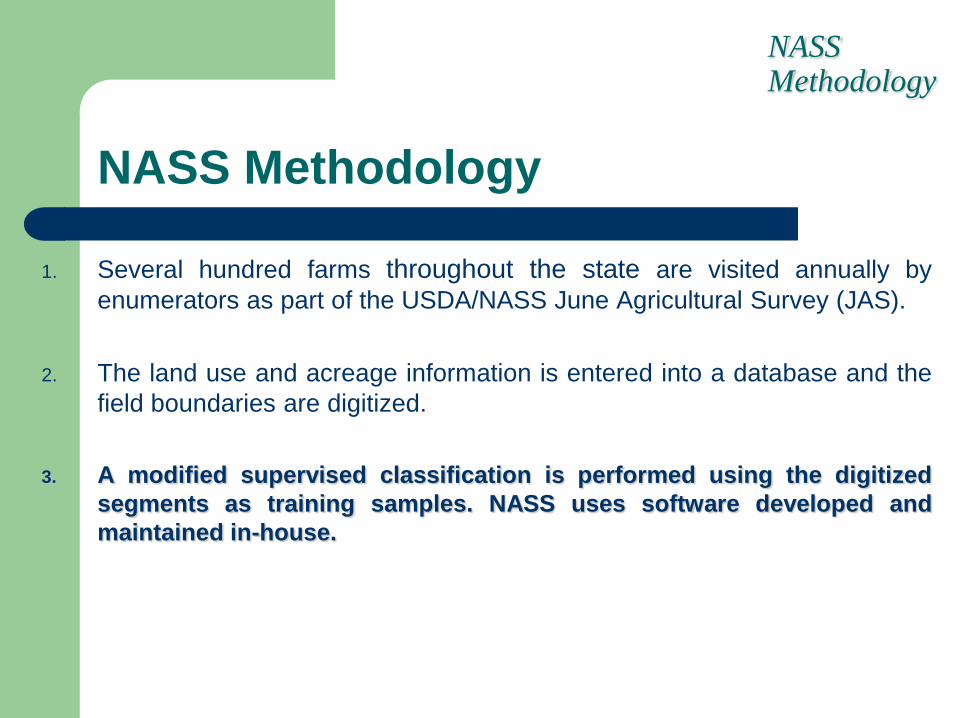
1. Several hundred farms throughout the state are visited annually by
enumerators as part of the USDA/NASS June Agricultural Survey (JAS).
2. The land use and acreage information is entered into a database and the
field boundaries are digitized.
3. A modified supervised classification is performed using the digitized
segments as training samples. NASS uses software developed and
maintained in-house.
NASSMethodology

Program Resources
Hardware
Computational intensive jobs (i.e.
cluster/classify)
Windows XP
Digitizing/editing
Windows XP
Software
Image processing PEDITOR
Developed internally
Digitizing/editing
Remote Sensing Project
Developed internally
Batch job processing
XLNT – Commercial software
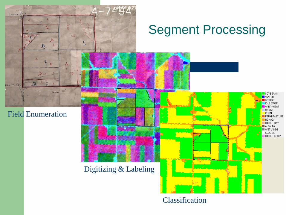
Segment Processing
Field Enumeration
Digitizing & Labeling
Classification

NASS Methodology
1. Several hundred farms throughout the state are visited annually by
enumerators as part of the USDA/NASS June Agricultural Survey (JAS).
2. The land use and acreage information is entered into a database and the field
boundaries are digitized.
3. A modified supervised classification is performed using the digitized segments
as training samples. NASS uses software developed and maintained in-house.
4. All the categorized scenes comprising a state are stitched together to
produce a statewide land cover classification map (GIS layer).
NASSMethodology

2001 Maryland Cropland Data Layer (Pilot Project) Queen Anne's County

DRAFT

DRAFT

NASS Methodology
1. Several hundred farms throughout the state are visited annually byenumerators as part of the USDA/NASS June Agricultural Survey (JAS).
2. The land use and acreage information is entered into a database and the fieldboundaries are digitized.
3. A modified supervised classification is performed using the digitized segmentsas training samples. NASS uses software developed and maintained in-house.
4. All the categorized scenes comprising a state are stitched together to producea statewide land cover classification map (GIS layer).
5. This land cover data layer is then used to produce state and county-levelcrop estimates using a regression estimator and/or raw pixel counts.
NASSMethodology

Program Summary
Raw Satellite Image Area Sampling Frame Segment Boundaries JAS Questionnaire
Mosaicked CDLCategorized Images Estimates

Importance of Land Cover Data
Agricultural Business Planning
Land Use Summary by Unit Area
Farmland Conversion
Resource Management
Soil Erosion Rates
Acres of Crops in Prime Farmland
Woodland Management
Hydrologic Modeling Input
CDL CustomersFarmers, farm org, seed companies, fertilizer & pesticide companies, farm equipment dealers, grain transit/storage companies, farm real estate, global change, water quality, soils, & environmental assessment, crop insurance, universities, federal, state, & county gov, value added RS/GIS resellers, agribusinesses

Champaign, Illinois - Willard Airport
1999 CDL 2000 CDL 2001 CDL Interagency

Limitations of NASS Land
Cover Data
o 30 m x 30 m ground resolution
o Emphasis on agricultural land cover
o Classification limitations
o Potential cloud cover
o Dependent upon continued health of the Landsat 5 satellite
oUSDA stopped purchasing Landsat 7 ETM in 2004

Benefits of NASS Land
Cover Data
o Low Cost for CD-Rom
o Spatially Referenced
o Attributed
o Updated Annually
o Statewide Coverage
o Quality Control for Other Data
o Generate Summary Analysis Quickly

http://www.nass.usda.gov/research/Cropland/cdorderform.htm

Questions?
Related Documents