Arctic National Wildlife Refuge Revised Comprehensive Conservation Plan Final Environmental Impact Statement Arctic National Wildlife Refuge Revised Comprehensive Conservation Plan Final Environmental Impact Statement Executive Summary U.S. Fish & Wildlife Service U.S. Fish & Wildlife Service - Arctic National Wildlife Refuge Final EIS Summary - January 2015 U.S. Department of the Interior U.S. Fish and Wildlife Service in cooperation with National Aeronautics and Space Administration Arctic National Wildlife Refuge 101 12th Ave., Room 236 Fairbanks, AK 99701 907-456-0250 • 1-800-362-4546 [email protected] http://arctic.fws.gov www.facebook.com/arcticnationalwildliferefuge Photos by USFWS unless indicated otherwise January 2015

Welcome message from author
This document is posted to help you gain knowledge. Please leave a comment to let me know what you think about it! Share it to your friends and learn new things together.
Transcript

ArcticNationalWildlifeRefuge
Revised Comprehensive Conservation Plan
Final Environmental Impact Statement
ArcticNationalWildlifeRefuge
Revised Comprehensive Conservation Plan
Final Environmental Impact Statement
Executive Summary
U.S. Fish & Wildlife Service
U.S. Fish &
Wildlife Service - A
rctic National W
ildlife Refuge Final EIS Summ
ary - January 2015
U.S. Department of the InteriorU.S. Fish and Wildlife Servicein cooperation with National Aeronautics and Space Administration
Arctic National Wildlife Refuge101 12th Ave., Room 236 Fairbanks, AK 99701907-456-0250 • [email protected]
http://arctic.fws.govwww.facebook.com/arcticnationalwildliferefuge
Photos by USFWS unless indicated otherwise
January 2015

U.S. Fish and Wildlife Service Mission
The mission of the U.S. Fish and Wildlife Service is working with others to conserve, protect, and enhance fish, wildlife, plants, and their habitats, for the continuing benefit of the American people.
National Wildlife Refuge System Mission
The mission of the National Wildlife Refuge System is to administer a national network of lands and waters for the conservation, management, and, where appropriate, restoration of the fish, wildlife, and plant resources and their habitats within the United States for the benefit of present and future generations of Americans.
This Comprehensive Conservation Plan describes programs that may exceed future budget allocations and therefore does not constitute specific commitments for future staff increases, project details, or funding.
U.S. Fish & Wildlife Service
Prepared by Arctic Refuge and the Alaska Region of the U.S. Fish and Wildlife Service in cooperation with the National Aeronautics and Space Administration
Arctic National Wildlife Refuge101 12th Ave, Rm 236Fairbanks AK 99701
Alaska Regional OfficeDivision of Conservation Planning and Policy1011 East Tudor Rd MS 231Anchorage AK 99503
ArcticNationalWildlifeRefuge
Revised Comprehensive Conservation Plan
Final Environmental Impact Statement
Executive SummaryJanuary 2015

This page intentionally left blank

Final EIS Summary
Arctic National Wildlife Refuge Revised Comprehensive Conservation Plan S-iii
Table of Contents Title Page ............................................................................................................................................... i
Table of Contents ................................................................................................................................ iii
List of Tables ........................................................................................................................................ v
List of Maps .......................................................................................................................................... v
Acronyms ............................................................................................................................................ vii
1. Introduction ................................................................................................................................... 9
1.1 Purpose and Need for the Plan ........................................................................................... 9
1.2 The Planning Process ........................................................................................................ 13
1.3 Public Involvement ............................................................................................................ 14
1.4 Consultation and Coordination with Others .................................................................... 15
1.5 Arctic Refuge Establishment and Purposes ................................................................... 15
1.5.1 The Arctic National Wildlife Range and ANILCA .................................................... 15
1.5.2 Relationship between Range Purposes and Refuge Purposes .................................. 16
1.5.3 Designated Wilderness .................................................................................................. 16
1.5.4 Designated Wild Rivers ................................................................................................. 16
1.5.5 1002 Area ......................................................................................................................... 17
1.6 Special Values ..................................................................................................................... 17
1.7 Vision ................................................................................................................................... 19
2. Goals, Objectives, Management Policies, and Guidelines....................................................... 20
2.1 Goals and Objectives .......................................................................................................... 20
2.2 Management Policies and Guidelines............................................................................... 23
3. Issues and Alternatives .............................................................................................................. 27
3.1 Issues ................................................................................................................................... 27
3.1.1 Issues Addressed in the Alternatives .......................................................................... 27
3.1.2 Issues Considered but Not Addressed in the Alternatives ....................................... 28
3.2 Summary of Alternatives .................................................................................................. 29
3.2.1 Management Common to All Alternatives .................................................................. 29
3.2.2 Preferred Alternative .................................................................................................... 30
4. Refuge Environment .................................................................................................................... 37
4.1 Physical and Biological Environment .............................................................................. 37
4.2 Cultural and Social Environment ..................................................................................... 38
5. Environmental Consequences .................................................................................................... 43
Final EIS Summary
S-iv Arctic National Wildlife Refuge Revised Comprehensive Conservation Plan
6. Implement the Plan ...................................................................................................................... 45
6.1 Step-down Plans ................................................................................................................. 45
6.2 Implement and Monitor ..................................................................................................... 45
6.3 Amend and Revise .............................................................................................................. 46
6.4 Partnership Opportunities ................................................................................................. 46
7. Wilderness Review ...................................................................................................................... 47
8. Wild and Scenic River Review .................................................................................................... 51
9. Compatibility Determinations ...................................................................................................... 55
10. Changes between the Draft and Final EIS ................................................................................. 56

Final EIS Summary
Arctic National Wildlife Refuge Revised Comprehensive Conservation Plan S-v
List of Tables Table 1. Summary of the management policies and guidelines for Arctic Refuge. .................... 25
Table 2. Comparison of alternatives by major planning issue ...................................................... 35
Table 3. Timeline for start and completion dates of future step-down plans of Arctic Refuge. 45
List of Maps Map 1. Arctic National Wildlife Refuge ........................................................................................... 11
Map 2. Management alternatives ..................................................................................................... 33
Map 3. Surface estate land status ..................................................................................................... 39
Map 4. Special designated areas ....................................................................................................... 41
Map 5. Wilderness study areas ......................................................................................................... 49
Map 6. Wild and scenic river review ................................................................................................ 53

Final EIS Summary
S-vi Arctic National Wildlife Refuge Revised Comprehensive Conservation Plan
This page intentionally left blank

Final EIS Summary
Arctic National Wildlife Refuge Revised Comprehensive Conservation Plan S-vii
Acronyms
ANILCA Alaska National Interest Lands Conservation Act
dbh diameter at breast height
EIS Environmental Impact Statement
MRA Minimum Requirement Analysis
NASA National Aeronautics and Space Administration
NEPA National Environmental Policy Act
NWPS National Wilderness Preservation System
NWSRS National Wild and Scenic Rivers System
PLO Public Land Order
ROD Record of Decision
WSA Wilderness Study Area


Final EIS Summary
Arctic National Wildlife Refuge Revised Comprehensive Conservation Plan S-9
1. Introduction Arctic National Wildlife Refuge (Arctic Refuge, Refuge) encompasses approximately 19.64 million1 acres of land and water in northeastern Alaska (Map 1) and is administered by the U.S. Fish and Wildlife Service (Service) as a unit of the National Wildlife Refuge System (Refuge System). The Revised Comprehensive Conservation Plan (Plan, Revised Plan) and Final Environmental Impact Statement (EIS) for Arctic Refuge will guide management of the Refuge for the next 15 to20 years. It revises the Service’s original Comprehensive Conservation Plan for Arctic Refuge, which was approved in 1988.
This document is a summary of the Revised Plan and final EIS, which was published in four volumes. You may view the Revised Plan and final EIS and associated planning documents, including this summary, online at http://arctic.fws.gov/ccp.htm. You may also request a hard copy of this summary or a compact disc containing complete texts of all four volumes of the Plan. Requests for compact discs and summaries should be directed to: U.S. Fish and Wildlife Service, Arctic NWR – Arctic CCP, 101 12th Ave, Rm 236, Fairbanks AK 99701.
1.1 Purpose and Need for the Plan The purpose of this planning process is to develop a Revised Plan for Arctic Refuge to provide management direction for the next 15-20 years. The Plan is needed because comprehensive conservation plans require periodic review and updating, and much has changed since the initial Plan was completed in 1988. This revision follows guidance found in the Alaska National Interest Lands Conservation Act of 1980 (ANILCA), the National Wildlife Refuge System Administration Act of 1966, as amended, and the National Environmental Policy Act of 1969 (NEPA), as amended. Revising the Plan allows the Service to:
Ensure the purposes of the Refuge and the mission of the Refuge System are being fulfilled
Establish a long-term vision for the Refuge
Establish management goals and objectives
Define compatible use
Evaluate current Refuge management direction based on changing public use of the Refuge and its resources
Update management direction related to national and regional policies and guidelines used to implement Federal laws governing Refuge management
Establish broad management direction for Refuge programs and activities
Ensure that opportunities are available for interested parties to participate in the development of management direction
Describe and maintain the resources and special values of Arctic Refuge
Incorporate new scientific information on resources of the Refuge and surrounding areas
1 Acreages in the Revised Plan are derived from many sources and may not agree with previously published values, including the draft Revised Plan. For more information, please refer to the final EIS.

Final EIS Summary
S-10 Arctic National Wildlife Refuge Revised Comprehensive Conservation Plan
Provide a systematic process for making and documenting resource management decisions
Provide continuity in Refuge management
Provide guidance for budget requests
Provide guidance for work planning and evaluation

!(
!(
!(
!(
!(
B e a u f o r t S e aCamden Bay
Brooks Range
Philip Smith Mts
Sadlerochit Mts
Shublik Mts
Romanzof Mts
Franklin Mts
British Mts
Davidson Mts
Ogilvie Mts
Kaktovik
ArcticVillage
!(
!(
Konga
kut R
iver
Ivishak R ive r
Saga v anirk tok R iver
Can
ning
Rive
r
Jago
River
Hul
ahul
a Ri
ver
Lake Peters
Porcu
pine River
Cole
en Ri
ver
Chandalar River
East
Fork
Chan
dala
r Riv
er
Coleen River
Shee
njek Rive
r
Wind River
Porcu
pine River
Old Crow River
Dalto
n Hi
ghwa
y
Old Crow
Canada
PrudhoeBay
Venetie
Wiseman
Coldfoot
140° W
140° W
142° W
142° W
144° W
144° W
146° W
146° W
148° W
148° W
150° W
150° W
152° W
152° W
154° W
154° W70
° N
70°
N
69°
N
69°
N
68°
N
68°
N
67°
N
67°
N
!
!
Arctic Ocean
Gulf of AlaskaBering
Sea
Anchorage
FairbanksAlaska
Russia
Canada
Alaska Albers Equal Area Conic Projection, 1983 North American Datum.
Map 1-1
Arctic Refuge Boundary
Wilderness Boundary
Roads
U.S.- Canada Border
0 10 20 30 40 50 60 70 80Miles
0 10 20 30 40 50 60 70 80Kilometers
Arctic National Wildlife RefugeMap 1
Final EIS Summary
Arctic National Wildlife Refuge Revised Comprehensive Conservation Plan S-13
1.2 The Planning Process The Service used an eight-step planning process to revise the Plan for Arctic Refuge:
Design the Planning Process – During the fall of 2009, the Service began reviewing the 1988 Arctic Refuge Plan to determine how it should be revised. The Service identified all relevant laws, regulations, policies, and other direction that would be considered during revision of the Plan. A planning team was formed to review the available data on resources and human uses in the Refuge and to identify areas that would require additional work. Tribal consultation was also initiated during this phase of the process.
Initiate Public Involvement and Scoping -- This step informed the public that the Plan revision process was beginning and that the Service was soliciting ideas on what issues should be addressed in the Revised Plan. A Notice of Intent to revise the Arctic Refuge Plan and prepare an EIS was published in the Federal Register on April 7, 2010. The public scoping period ended on June 7, 2010.
Identify Significant Issues – The planning team reviewed the issues raised by the public, Refuge staff, other Service divisions and Federal agencies, tribal governments, and the State to identify the significant planning issues to be addressed in the Revised Plan. Significant issues are those that may be handled differently in each of the alternatives.
Develop and Analyze Alternatives – In August 2010, the planning team developed a set of six draft alternatives that incorporated different approaches to resolving three significant planning issues. Each of the alternatives would meet Refuge purposes, would fulfill the Service and Refuge System missions, and would comply with current law and policy.
Prepare Draft Plan and EIS – On August 15, 2011, the Service presented the public with a draft Revised Plan and draft EIS for a 90-day public review and comment period. The draft Plan described six alternatives (including current management) for managing Arctic Refuge during the next 15 years, or until the next Plan revision. The draft EIS included an analysis of the potential impacts of implementing each alternative and provided a description of management actions common to all alternatives.
Prepare and Adopt a Final Plan – The planning team reviewed and analyzed all public comments received on the draft Revised Plan and EIS. The Plan was modified as needed to develop the Revised Plan and final EIS, which identified the Service’s preferred alternative. Following a 30-day review period, the Service’s regional director will issue a record of decision (ROD) that will describe the alternative to be implemented and the rationale used to make the decision. The Service will publish and distribute the ROD, and later a stand-alone Revised Plan (no alternatives and no EIS documentation), after the decision is made.
Implement, Monitor, and Evaluate the Plan – Implementation of the Plan will begin once the ROD is signed. Plan implementation includes monitoring, which is a critical component of management. Monitoring helps determine if management actions are effectively meeting management objectives. The Refuge will use an adaptive management approach in which information gained from monitoring will be used to evaluate and, as needed, modify Refuge management actions.

Final EIS Summary
S-14 Arctic National Wildlife Refuge Revised Comprehensive Conservation Plan
Review and Revise the Final Plan as Necessary – Service policy directs Arctic Refuge staff to review the Revised Plan every year to assess any need for change in management direction. Additionally, every three to five years, Refuge staff will review public comments, local and State government recommendations, research studies, and other sources to determine if revisions to the Plan are necessary. If major changes are proposed, public meetings may be held, and a new environmental analysis may be needed. Full review and revision of the Plan is scheduled to occur every 15-20 years, or more often, if deemed necessary.
1.3 Public Involvement Public involvement is an integral part of developing a comprehensive conservation plan. Throughout the planning process the Refuge provided various opportunities for public involvement. Outreach materials included a series of planning updates, posters, and other information posted and available for download on the Arctic Refuge planning website. During both scoping and the draft review period, we held public meetings in Anchorage, Arctic Village, Fairbanks, Fort Yukon, Kaktovik and Venetie, Alaska. During scoping, meetings were also held in Barrow, Alaska and Washington, D.C.
Both comment periods (scoping and review of the draft Plan) elicited a considerable response from the public. During scoping, a total of 94,061 individuals and organizations provided written and oral comments. These comments were analyzed by a third party contractor, and analysts produced a comprehensive database containing all the comments. Similar topics were then organized into a logical structure for the final report. The report (Appendix J in the Revised Plan and final EIS), database, and original responses were used by Refuge staff and planners to identify issues.
During the public review period of the draft, we received approximately 612,285 individual communications (a piece of mail, website submission, form letter, statement at a public hearing, etc.). Every communication was read by Refuge staff or project planners and by a third party contractor hired to analyze public comments. The content of all communications was reviewed for the presence of substantive comments. Substantive comments are those sections, paragraphs, and sentences in a communication that warrant a response from the Service. In accordance with NEPA regulations, we defined substantive comments as those that:
Question, with reasonable basis, the accuracy of the information in the EIS;
Question, with reasonable basis, the adequacy of, methodology for, or assumptions used for the environmental analysis;
Present new information relevant to the analysis;
Present reasonable alternatives other than those analyzed in the EIS, or new ideas for the alternatives, and/or
Cause changes or revisions in one or more of the alternatives.
We identified a total of 1,305 comments that required a response from the Service. Volume 3 of the final EIS presents the substantive comments and the Service’s responses. In many instances, the draft Plan was modified to address comments. Volume 4 of the final EIS includes full text samples of the communications received.

Final EIS Summary
Arctic National Wildlife Refuge Revised Comprehensive Conservation Plan S-15
1.4 Consultation and Coordination with Others We began the planning process with formal notification to nine federally-recognized tribes, two Native village councils, the State of Alaska, four Federal agencies, two Regional Native corporations, one village corporation, and the North Slope Borough. We prepared the Plan/EIS in coordination with the Alaska Department of Natural Resources, the Alaska Department of Fish and Game, the Arctic Slope Regional Corporation, and the Native Village of Kaktovik, all of which had one or more representatives on the planning team. The National Aeronautics and Space Administration (NASA) joined the Service as a cooperating agency in January 2012, offering special expertise for the final stages of the EIS process.
On several occasions throughout the planning process, we informally consulted with the Gwichyaa Zhee Gwich’in Tribal Government, the Native Village of Kaktovik, the Native Village of Venetie Tribal Government, the Arctic Village Council, and the Venetie Village Council. We encouraged their participation in the Revised Plan, inviting them to comment on the Plan and/or formally consult with the Service. We formally consulted with the Gwichyaa Zhee Gwich’in Tribal Government, the Native Village of Kaktovik, and the Native Village of Venetie Tribal Government in June 2012, and we formally consulted with Doyon Limited in September 2012.
1.5 Arctic Refuge Establishment and Purposes 1.5.1 The Arctic National Wildlife Range and ANILCA
On December 6, 1960, Public Land Order (PLO) 2214 established the 8.83 million-acre Arctic National Wildlife Range. PLO 2214 proclaimed that the Range was established “to preserve unique wildlife, wilderness, and recreational values.”
On December 2, 1980, President Carter signed ANILCA into law, establishing new Federal conservation units across the State, enlarging several existing units, and designating Wilderness2 areas and wild and scenic rivers. ANILCA established the Arctic National Wildlife Refuge. The boundaries of the Refuge encompassed approximately 19.64 million acres and incorporated the Arctic Range into Arctic Refuge. ANILCA designated a portion of the Refuge as Wilderness, designated three wild rivers, and established the following four purposes for Refuge management:
(i) to conserve fish and wildlife populations and habitats in their natural diversity including, but not limited to, the Porcupine caribou herd (including participation in coordinating the Western Arctic caribou herd), polar bears, grizzly bears, muskox, Dall sheep, wolves, wolverines, snow geese, peregrine falcons and other migratory birds, and Arctic char and grayling
(ii) to fulfill the international treaty obligations of the United States with respect to fish and wildlife and their habitats
(iii) to provide, in a manner consistent with the purposes set forth in subparagraphs (i) and (ii), the opportunity for continued subsistence uses by local residents
2 “Wilderness” (with a capital “W”) refers to the designated Wilderness areas, and “wilderness” (not capitalized) is used as an adjective to describe wilderness-related qualities.

Final EIS Summary
S-16 Arctic National Wildlife Refuge Revised Comprehensive Conservation Plan
(iv) to ensure, to the maximum extent practicable and in a manner consistent with the purposes set forth in paragraph (i), water quality and necessary water quantity within the refuge
The ANILCA designation offered more protection to the area than was afforded by the original Arctic Range. Under ANILCA, Arctic Refuge was closed to all forms of appropriation under the public land laws, including the mineral leasing and mining laws.
1.5.2 Relationship between Range Purposes and Refuge Purposes
According to ANILCA Section 305, the 1960 establishing purposes of the Range continue to guide management of lands and waters in the original Range “except to the extent that they are inconsistent with this Act [ANILCA] or the Alaska Native Claims Settlement Act and, in any such case, the provisions of such Acts shall prevail.” In light of ANILCA Section 101(b) and 305, we believe the Range purposes are consistent with the Alaska Native Claims Settlement Act, ANILCA, and the Refuge purposes set forth in ANILCA. Therefore, the Range purposes still apply to the lands and waters that were part of the original Range.
1.5.3 Designated Wilderness
Approximately 7.16 million acres3, most of the original Range, was designated as Wilderness when ANILCA became law. This Wilderness area is the largest designated Wilderness area in the Refuge System, and it contains the four primary qualities of Wilderness as described in the Wilderness Act: undeveloped, untrammeled, natural, and provides opportunities for solitude or primitive and unconfined recreation.
The purposes of the Wilderness Act are within and supplemental, i.e. additional, to Refuge purposes in the designated Wilderness portion of the Refuge. The purposes of the Wilderness Act are to:
“Secure an enduring resource of wilderness; protect and preserve the wilderness character of areas within the National Wilderness Preservation System (NWPS); administer the NWPS for the use and enjoyment of the American people in a way that will leave these areas unimpaired for future use and enjoyment as wilderness; and gather and disseminate information regarding the use and enjoyment of wilderness areas.”
In 1996, the “Arctic National Wildlife Refuge Wilderness” was officially renamed the “Mollie Beattie Wilderness.”
1.5.4 Designated Wild Rivers
ANILCA designated portions of the Ivishak, Sheenjek, and Wind rivers within the boundaries of the Refuge as wild rivers pursuant to the Wild and Scenic Rivers Act, as amended by ANILCA. The purposes of the Wild and Scenic Rivers Act (1968) are to ensure:
3 ANILCA stated eight million acres of Wilderness were designated in the Refuge. However, Geographic Information Systems estimate the size of the Wilderness area as 7.16 million acres. The boundaries did not change, just the estimated measurement of the area within the boundary.

Final EIS Summary
Arctic National Wildlife Refuge Revised Comprehensive Conservation Plan S-17
“certain selected rivers of the Nation which, with their immediate environments, possess outstandingly remarkable scenic, recreational, geologic, fish and wildlife, historic, cultural or other similar values, shall be preserved in free-flowing condition, and that they and their immediate environments shall be protected for the benefit and enjoyment of present and future generations.”
1.5.5 1002 Area
ANILCA excluded approximately 1.57 million acres of the Arctic Refuge coastal plain from Wilderness designation. This area of the coastal plain, also known as the “1002 Area,” was opened to limited oil and gas exploration pursuant to ANILCA Section 1002. Section 1002 also directed the Secretary of the Interior to prepare a report to Congress on biological resources, the oil and gas potential of the coastal plain, and the impacts of development, and to provide recommendations as to whether further oil and gas exploration and development should be permitted. In 1987, the Department of the Interior published the Arctic National Wildlife Refuge, Alaska, Coastal Plain Resource Assessment report. This report found the coastal plain met the criteria of the Wilderness Act for designation, and the Secretary of the Interior recommended to Congress that the entire 1002 Area should be open to oil and gas leasing programs at such a pace and in such circumstances so as to avoid unnecessary adverse effects on the environment. With the submission of the report, the statutory authority to permit exploratory activity on the Refuge’s coastal plain expired, and Congress made no provisions for any further reports or for any additional exploratory activities. To date, Congress has not acted on the recommendation in the report.
1.6 Special Values According to ANILCA Section 304(g)(2)(B), the Service is required to identify and describe “special values” of the Refuge. The following eleven special values were identified for Arctic Refuge.
Wilderness Characteristics –Arctic Refuge exemplifies the idea of wilderness—to leave some remnants of this nation’s natural heritage intact, wild, and free of the human intent to control, alter, or manipulate the natural order. Embodying tangible and intangible values, the Refuge’s wilderness characteristics include natural conditions, natural quiet, wild character, and exceptional opportunities for solitude, adventure, and immersion in the natural world.
Ecological Values – The distinguishing ecological aspect of the Refuge—and a major reason for its establishment—is that this single protected area encompasses a wide range of arctic and subarctic ecosystems, their unaltered landforms, and native flora and fauna. The Refuge is a place of free-functioning ecological and evolutionary processes, exhibiting a high degree of biological integrity, natural diversity, and environmental health.
Wildlife Values – The Refuge’s diverse fauna includes at least 47 species of terrestrial mammals, including several high-profile and special-status species: polar and grizzly bears, wolf, wolverine, Dall’s sheep, moose, muskox, and two free-roaming caribou herds. At least 42 species of fish inhabit waters in the Refuge and more than 201 species of birds depend upon the Refuge for at least some portion of their lifecycles.
Rivers – About 160 named rivers and streams, and several hundred unnamed waterways, flow through the Refuge. The large number of unmodified, free-flowing rivers is noteworthy.

Final EIS Summary
S-18 Arctic National Wildlife Refuge Revised Comprehensive Conservation Plan
The Sheenjek, Wind, and Ivishak rivers are designated as part of the National Wild and Scenic River System.
Landscape Scale and Features – From its southern forests across the precipitous mountain divide to its coastal lagoons and islands along the Beaufort Sea, this unfragmented 19.64-million-acre Refuge—the size of South Carolina—spans six major physiographic zones and encompasses numerous different features, such as wetlands, lakes, the highest peaks and glaciers in the Brooks Range, broad valleys, steep river canyons, and many others.
Scientific Values – The Refuge has become a natural laboratory of international importance. The ecological processes, natural diversity, and free function of natural communities in the Refuge provide unsurpassed opportunities for scientific understanding of arctic and subarctic wildlife, ecology, geophysics, and the changing climate.
Native Culture and Subsistence – Arctic Refuge encompasses the traditional homeland of Iñupiat and Gwich’in peoples and perpetuates opportunities for their continuing traditional subsistence uses, skills, and relationships with the land.
Historic and Heritage Values – The Refuge represents deep-rooted American cultural values about frontiers, open spaces, and wilderness. It is one of the finest representations of the wilderness that helped shape our national character and identity.
Recreational Values – The Refuge is renowned for the opportunities it provides for adventure, exploration, independence, and solitude.
Hunting Values – The Refuge’s setting rewards those seeking to challenge themselves under primitive conditions. It perpetuates opportunities for a kind of adventurous hunting experience that is becoming increasingly rare.
A Symbolic Value – The Refuge represents the hope of a past generation that one of the finest remnants of our natural inheritance will be passed on, undiminished, to future generations. Millions who will never set foot in the Refuge find satisfaction, inspiration, and even hope in just knowing it exists.

Final EIS Summary
Arctic National Wildlife Refuge Revised Comprehensive Conservation Plan S-19
1.7 Vision Comprehensive conservation plans incorporate a vision statement – an inspiring expression of the Refuge’s special character. Rooted in the Refuge’s purposes, the vision statement describes those qualities that should endure to be passed on to future generations. The Arctic Refuge’s vision statement is:
This untamed arctic landscape continues to sustain the ecological diversity and special values that inspired the Refuge’s establishment. Natural processes continue and traditional cultures thrive with the seasons and changing times; physical and mental challenges test our bodies, minds and spirit; and we honor the land, the wildlife and the native people with respect and restraint. Through responsible stewardship this vast wilderness is passed on, undiminished, to future generations.

Final EIS Summary
S-20 Arctic National Wildlife Refuge Revised Comprehensive Conservation Plan
2. Goals, Objectives, Management Policies, and Guidelines 2.1 Goals and Objectives Arctic Refuge purposes, vision statement, and special values provide the framework for developing goals and objectives for managing the Refuge. Goals are broad statements of desired future conditions. Objectives are concise statements of what the Refuge wants to accomplish. The range of objectives presented here provides an overview of the management priorities currently being addressed by the Refuge, or that shall be addressed during the life of the Plan.
Goal 1: Ecological processes continue to shape the Refuge, and to the greatest degree possible, these processes remain free of the intent to alter the natural order, including the dynamics of fish and wildlife populations and their relationships with natural habitats.
Objectives include:
Manage the Refuge to support biological integrity, environmental health, and wildness
Revise the Ecological Inventory and Monitoring Plan
Prepare a research plan
Conduct an Ecological Review of the Refuge’s biological program
Maintain a fire management program
Participate in State of Alaska Boards of Fisheries and Game and the Federal Subsistence Board processes
Prepare a land protection plan
Identify and determine the status of rare species
Conduct long-term ecological monitoring
Goal 2: The Refuge preserves its wilderness values and characteristics, maintains its natural state in unaltered condition, and designated Wilderness is managed consistent with the intent of the Wilderness Act and ANILCA.
Objectives include:
Integrate Wilderness management provisions into all Refuge activities in designated Wilderness
Complete a Minimum Requirement Analysis for Refuge management activities in designated Wilderness
Provide Wilderness training for staff
Develop a Wilderness Stewardship Plan
Analyze whether to remove one or more buildings at Lake Peters
Monitor characteristics commonly associated with designated Wilderness and other wild lands
Restore wilderness characteristics to sites that have been impaired or degraded

Final EIS Summary
Arctic National Wildlife Refuge Revised Comprehensive Conservation Plan S-21
Goal 3: The ecological functions and natural flow regimes of the Refuge’s aquatic ecosystems, including headwater streams, rivers, springs, wetlands, lakes, and lagoons, are documented and protected, and designated Wild Rivers and Marine Protected Area are managed in a manner consistent with their special designations.
Objectives include:
Study and manage the Refuge’s Marine Protected Area and enhance public awareness of it
Establish legal protection for water quality and quantity
Complete a water resource inventory and assessment
Monitor water quality and quantity
Assess baseline resources and complete Comprehensive River Management Plans for designated wild rivers.
Goal 4: The Refuge, in consultation with appropriate parties, addresses concerns about proposed actions that may substantially or directly affect subsistence or cultural resources, rural subsistence or cultural uses, or the rights of tribes.
Objectives include:
Consult with Alaska Native tribes and Native corporations
Provide opportunities for continued subsistence uses
Continue and expand the Refuge Information Technician program
Develop harvest monitoring programs in partnership with local communities
Establish a network of compiled historical and contemporary subsistence use data
Cooperatively conduct a historical access study
Goal 5: The Refuge provides a range of opportunities for wildlife-dependent and wilderness-associated recreational activities that emphasize adventure, independence, self-reliance, exploration, and solitude or primitive and unconfined recreation while protecting the Refuge’s natural conditions and special values.
Objectives include:
Continue to provide access for compatible recreational activities
Staff will minimize on-site contacts with visitors
Minimize placement of recreational facilities on Refuge lands
Develop a Visitor Use Management Plan
Continue to authorize commercial visitor services
Coordinate visitor management with neighboring land owners
Strengthen and unify law enforcement efforts through coordination

Final EIS Summary
S-22 Arctic National Wildlife Refuge Revised Comprehensive Conservation Plan
Maintain a long-term dataset about visitor experience
Implement strategies to address aircraft landing impacts to vegetation
Goal 6: The effects of climate change on Refuge resources are evaluated through research, monitoring, and local traditional knowledge, and these effects are considered in Refuge management decisions.
Objectives include:
Evaluate potential effects of climate change on Refuge resources
Consider climate change and non-climate stressors when making management decisions
Collaborate with others on studying the effects of climate change
Avoid actions that resist the effects of climate change
Monitor biological components vulnerable to climate change
Goal 7: Refuge staff and partners conduct research and monitoring in support of the Refuge’s role as an internationally recognized benchmark for naturally functioning arctic and subarctic ecosystems.
Objectives include:
Participate in collaborative research
Work with international partners
Develop research protocols and encourage scientific research by cooperators
Goal 8: In consultation with appropriate parties, the Refuge documents, conserves, and protects cultural resources, both historic and prehistoric, to allow visitors and community members to appreciate the interconnectedness of the people of the region and their environment.
Objectives include:
In partnership, collect traditional knowledge about past and present conditions
Protect cultural resources and monitor at risk sites
Prepare an Integrated Cultural Resource Management Plan
Improve management of cultural resources by conducting surveys and compiling a comprehensive cultural resources atlas and archive
Create a comprehensive cultural inventory of the Refuge
Goal 9: Refuge staff provides outreach information to distant audiences, individuals who enter the Refuge, and people in gateway communities, to enhance their understanding, appreciation, and stewardship of Refuge lands and resources.
Objectives include:
Use modern media technologies to provide information to the public

Final EIS Summary
Arctic National Wildlife Refuge Revised Comprehensive Conservation Plan S-23
Provide information to the public about traveling to and in the Refuge
Collaboratively provide outreach information in communities near the Refuge
Perform a National Interest Study every 15 years
2.2 Management Policies and Guidelines Management policies and guidelines provide the framework and direction for Refuge management for the next 15-20 years. They are derived from the laws governing the Refuge System and from national and regional regulations, policies, and guidance developed to implement these laws. The policies and guidelines presented here update those in the 1988 Plan to reflect current laws, regulations, and policies. Additionally, we changed a number of the guidelines from the 1988 Plan to better reflect the Refuge’s vision, special values, and purposes, and to maintain the ecological function and wilderness characteristics of the Refuge’s lands and waters.
ANILCA requires the Service to designate areas according to their resources and values and to specify programs and uses within these areas. To meet this requirement, three management categories were established for Arctic Refuge in the 1988 Plan: Minimal Management, Wilderness Management, and Wild River Management. The Revised Plan retains the same three management categories, but the descriptions of these categories were modified somewhat from those in the 1988 Plan. The management policies and guidelines describe the appropriate activities, uses, and types of facilities for each of the three management categories. Key sections of the revised guidelines include:
How the Refuge will meet Service policy for managing lands, appropriate uses, and compatibility
How we will cooperate and coordinate with others
Our approach to ecosystem and landscape management, including climate change
Our approach to fish and wildlife habitat and population management
How we will provide for continued subsistence opportunities
How we will provide for public access and transportation, as well as for recreation, public uses, and public use facilities
Our approach to outreach and education
Commercial use management guidelines
Environmental contaminant policies
Administrative facilities management
Mineral resource policies and guidelines for Arctic Refuge
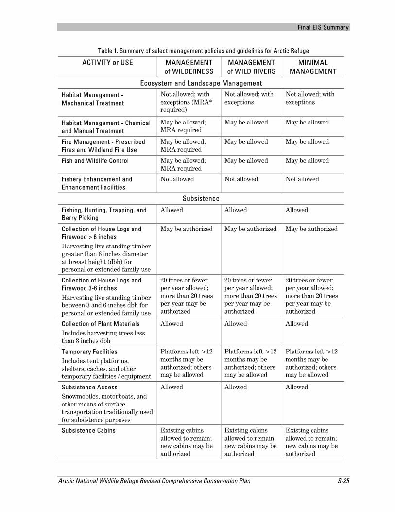
The following paragraphs, and Table 1, summarize some of the proposed changes to the management policies and guidelines. For more information, please refer to Chapter 2 of the Revised Plan and final EIS, Sections 2.2 through 2.5.
Fish and Wildlife Habitat Management – Fish and wildlife habitat would not be actively managed, or altered. Rather, management would seek to sustain the highest degree of natural diversity and biological integrity. Activities such as crushing, chemical, or mechanical

Final EIS Summary
S-24 Arctic National Wildlife Refuge Revised Comprehensive Conservation Plan
treatments or the construction of structures would not be allowed unless necessary to address invasive species or management emergencies.
Fish and Wildlife Control – All native species are an integral part of the Refuge, and management would allow native fish and wildlife populations to continue without control or manipulation, subject to management emergencies. Management emergencies include situations where threatened or endangered species, natural diversity, water quality and/or quantity, or subsistence resources are jeopardized, or the introduction of an invasive species potentially necessitates actions not normally permissible.
Fishery Restoration and Enhancement – The Refuge would maintain undisturbed habitat conditions. Fishery restoration could be authorized in a management emergency, but fishery enhancement structures would not be allowed.
Public Use Facilities – Public use facilities would be maintained at communities near the Refuge that provide gateways for visitors and at developed sites along the Dalton Highway. Facilities such as boat launches, signs, and kiosks would not be developed on Refuge lands. Trails, temporary signs, hardened campsites, and sanitation facilities could be developed if they are necessary to address resource damage.
Recreation and Other Public Uses – The Refuge would remain a place where people experience self-reliance, solitude, and adventure. The Refuge would manage existing public uses to ensure they remain compatible with the purposes for which the Refuge was established.
Climate Change –Refuge staff would monitor and study climate change, and would generally follow a process of non-intervention with the exception of invasive species or management emergencies such as public safety, threatened or endangered species, or subsistence resources.
Disease Prevention and Control – Domestic animal restrictions would apply to sheep, goats, llamas, and alpacas to prevent the transmission of disease to wildlife, especially Dall’s sheep. Regulations would be promulgated for non-commercial uses.
Final EIS Summary
Arctic National Wildlife Refuge Revised Comprehensive Conservation Plan S-25
Table 1. Summary of select management policies and guidelines for Arctic Refuge
ACTIVITY or USE MANAGEMENT of WILDERNESS
MANAGEMENT of WILD RIVERS
MINIMAL MANAGEMENT
Ecosystem and Landscape Management
Habitat Management - Mechanical Treatment
Not allowed; with exceptions (MRA* required)
Not allowed; with exceptions
Not allowed; with exceptions
Habitat Management - Chemical and Manual Treatment
May be allowed; MRA required
May be allowed May be allowed
Fire Management - Prescribed Fires and Wildland Fire Use
May be allowed; MRA required
May be allowed May be allowed
Fish and Wildlife Control May be allowed; MRA required
May be allowed May be allowed
Fishery Enhancement and Enhancement Facilities
Not allowed Not allowed Not allowed
Subsistence
Fishing, Hunting, Trapping, and Berry Picking
Allowed Allowed Allowed
Collection of House Logs and Firewood > 6 inches Harvesting live standing timber greater than 6 inches diameter at breast height (dbh) for personal or extended family use
May be authorized May be authorized May be authorized
Collection of House Logs and Firewood 3-6 inches Harvesting live standing timber between 3 and 6 inches dbh for personal or extended family use
20 trees or fewer per year allowed; more than 20 trees per year may be authorized
20 trees or fewer per year allowed; more than 20 trees per year may be authorized
20 trees or fewer per year allowed; more than 20 trees per year may be authorized
Collection of Plant Materials Includes harvesting trees less than 3 inches dbh
Allowed Allowed Allowed
Temporary Facilities Includes tent platforms, shelters, caches, and other temporary facilities / equipment
Platforms left >12 months may be authorized; others may be allowed
Platforms left >12 months may be authorized; others may be allowed
Platforms left >12 months may be authorized; others may be allowed
Subsistence Access Snowmobiles, motorboats, and other means of surface transportation traditionally used for subsistence purposes
Allowed Allowed Allowed
Subsistence Cabins Existing cabins allowed to remain; new cabins may be authorized
Existing cabins allowed to remain; new cabins may be authorized
Existing cabins allowed to remain; new cabins may be authorized
Final EIS Summary
S-26 Arctic National Wildlife Refuge Revised Comprehensive Conservation Plan
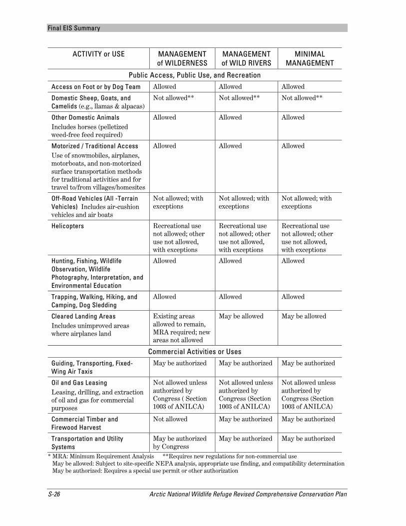
ACTIVITY or USE MANAGEMENT of WILDERNESS
MANAGEMENT of WILD RIVERS
MINIMAL MANAGEMENT
Public Access, Public Use, and Recreation
Access on Foot or by Dog Team Allowed Allowed Allowed
Domestic Sheep, Goats, and Camelids (e.g., llamas & alpacas)
Not allowed** Not allowed** Not allowed**
Other Domestic Animals Includes horses (pelletized weed-free feed required)
Allowed Allowed Allowed
Motorized / Traditional Access Use of snowmobiles, airplanes, motorboats, and non-motorized surface transportation methods for traditional activities and for travel to/from villages/homesites
Allowed Allowed Allowed
Off-Road Vehicles (All -Terrain Vehicles) Includes air-cushion vehicles and air boats
Not allowed; with exceptions
Not allowed; with exceptions
Not allowed; with exceptions
Helicopters Recreational use not allowed; other use not allowed, with exceptions
Recreational use not allowed; other use not allowed, with exceptions
Recreational use not allowed; other use not allowed, with exceptions
Hunting, Fishing, Wildlife Observation, Wildlife Photography, Interpretation, and Environmental Education
Allowed Allowed Allowed
Trapping, Walking, Hiking, and Camping, Dog Sledding
Allowed Allowed Allowed
Cleared Landing Areas Includes unimproved areas where airplanes land
Existing areas allowed to remain, MRA required; new areas not allowed
May be allowed May be allowed
Commercial Activities or Uses
Guiding, Transporting, Fixed-Wing Air Taxis
May be authorized May be authorized May be authorized
Oil and Gas Leasing Leasing, drilling, and extraction of oil and gas for commercial purposes
Not allowed unless authorized by Congress ( Section 1003 of ANILCA)
Not allowed unless authorized by Congress (Section 1003 of ANILCA)
Not allowed unless authorized by Congress (Section 1003 of ANILCA)
Commercial Timber and Firewood Harvest
Not allowed May be authorized May be authorized
Transportation and Utility Systems
May be authorized by Congress
May be authorized May be authorized
* MRA: Minimum Requirement Analysis **Requires new regulations for non-commercial use May be allowed: Subject to site-specific NEPA analysis, appropriate use finding, and compatibility determination May be authorized: Requires a special use permit or other authorization

Final EIS Summary
Arctic National Wildlife Refuge Revised Comprehensive Conservation Plan S-27
3. Issues and Alternatives 3.1 Issues The Service defines an issue as any unsettled matter that requires a management decision. A total of 37 issues for the Revised Plan were identified internally by Refuge staff and from public scoping comments. Staff carefully considered each issue and determined if the issue would best be addressed through management alternatives in the Revised Plan, goals and objectives, or further step-down planning.
3.1.1 Issues Addressed in the Alternatives
The following three issues were carried forward into the Plan’s six alternatives:
Wilderness – Should one or more areas of the Refuge be recommended for Wilderness designation?
All lands not currently designated as Wilderness were included in a wilderness review (see Section 7, below). Three Wilderness Study Areas (WSAs) were established, and all three were determined to meet the minimum criteria for Wilderness with the exception of lands in the immediate vicinity of Arctic Village and Kaktovik. The alternatives present a range of management options: from no new wilderness recommended to all three WSAs recommended for inclusion in the National Wilderness Preservation System (NWPS).
During scoping and during the review of the draft Plan, nearly all those who commented mentioned this issue. Most of the comments focused on the Coastal Plain WSA and the effect Wilderness designation might have on potential oil and gas development there. There were relatively few comments specific to either the Brooks Range or the Porcupine Plateau WSAs. Those who commented typically offered their opinion as to whether some, none, or all of the Refuge’s non-Wilderness areas should be recommended for designation. The legality of conducting a wilderness review was also questioned.
Wild and Scenic Rivers – Should additional wild and scenic rivers be recommended for inclusion in the National Wild and Scenic Rivers System?
Twenty rivers were included in the Refuge’s wild and scenic river review (see Section 8, below). Of these, ten were determined to be eligible for inclusion in the National Wild and Scenic Rivers System (NWSRS) because they were free-flowing and possessed at least one outstandingly remarkable value. Four of the ten eligible rivers were determined to be suitable for wild and scenic river designation. The alternatives present a range of management options: from no new rivers recommended to all four suitable rivers recommended for inclusion in the NWSRS.
Scoping comments addressing wild and scenic rivers were generally in favor of the Service conducting a review, although some comments expressed opposition. Those who commented provided additional information on river values for those rivers evaluated and information on non-evaluated rivers. Comments received on the draft Revised Plan questioned the legality of conducting a wild and scenic river review and/or agreed or disagreed with the review’s methods and conclusions. In response to public comments, the eligibility and suitability

Final EIS Summary
S-28 Arctic National Wildlife Refuge Revised Comprehensive Conservation Plan
reports were combined into a single wild and scenic river review document, and new sections, data, and descriptions were added.
Kongakut River Visitor Management – How will the Refuge manage Kongakut River visitor use to protect resources and visitor experience?
The Kongakut River, on the north side of the Brooks Range, offers spectacular views from the mountains to the coastal plain; contains a variety of unique geologic features; receives nearly one-quarter (24%) of the documented visitors to the Refuge; and its entire extent is in designated Wilderness. Visitation patterns, such as numerous groups launching on the same day during peak use periods and larger groups staying for longer periods, have impacted biological resources and Wilderness character in the Kongakut River drainage. Poor camping practices and weather-related transportation backlogs negatively impact visitors’ experiences. Refuge staff has received visitor reports of group crowding; user conflicts; excessive over-flights; fire rings, tent rings, and human waste accumulations at concentrated access points and popular camp areas; hardening or impairment of fragile riparian and tundra habitats; and increased footprint at aircraft landing areas.
The vast majority of public scoping comments specific to the Kongakut River suggested a need for greater management efforts along the river corridor. Some of those who commented requested the Refuge focus on retaining or restoring visitor experience quality by addressing crowding, group size, spreading out launch days, and addressing impacts to river access landing areas. Public comments on the draft Plan called again for immediate actions to improve visitor experience and suggested a cap be placed on commercial recreational guides.
3.1.2 Issues Considered but Not Addressed in the Alternatives
The following discussion briefly describes issues and actions the staff considered but subsequently eliminated from detailed study and analysis in the EIS. Issues raised by the public and the agency included development, policy, ecological, management, visitor use, and administrative concerns. Many of these issues are important to the management of the Refuge and could have been considered in the alternatives. However, we determined that some of the issues were best addressed through compatibility determinations, step-down plans, or other existing management tools. A more detailed discussion of the issues considered but eliminated is included in Appendix D of the final EIS.
Development Issues – We did not address issues such as oil and gas development or updating seismic data on the coastal plain (the “1002 Area”) despite the numerous public comments we received that expressed support for and opposition to Wilderness designation and oil and gas development in Arctic Refuge. Section 1003 of ANILCA specifically prohibits oil and gas leasing, development, and production anywhere on Arctic Refuge until Congress takes action to change the provision.
Ecological Issues – Climate change is expected to continue to affect Refuge resources and the associated human environment for the foreseeable future. There are few actions the Refuge can take to manage the effects of climate change. Rather than incorporating climate change into the alternatives, the Refuge established objectives to evaluate climate change through scientific research and monitoring, and the sharing of traditional knowledge in local communities (see Chapter 2, Section 2.1.6 of the Revised Plan).

Final EIS Summary
Arctic National Wildlife Refuge Revised Comprehensive Conservation Plan S-29
Concerns about the effects of hunting on population structure and genetics for certain wildlife species, such as Dall’s sheep, were deferred to the Refuge’s Ecological Inventory and Monitoring Plan. Public concerns about changes in fire behavior, the Service’s response to fires, and smoke impacts were deferred to the Refuge’s Fire Management Plan.
Management Issues – The Revised Plan does not provide a range of management alternatives for the Refuge’s Public Use Natural Area and two Research Natural Areas. We decided existing management, in combination with Refuge purposes, afford a high degree of protection for the features and values of these special designations and that no additional management guidance is needed. Similarly, the Plan does not provide a range of management options for the Refuge’s three wild rivers. Their management would instead be addressed through Comprehensive River Management Plans (see Chapter 2, Section 2.1.3 in the Revised Plan).
The Revised Plan provides an opportunity for us to collaboratively study the ecology and natural heritage of the Refuge’s marine protected area (which was established in 2009) and enhance public recognition of this area through environmental education and outreach. This opportunity was incorporated into an objective (see Chapter 2, Section 2.1.3 of the Revised Plan).
Visitor Use Issues – The public raised numerous issues concerning visitor use in Arctic Refuge such as impacts to resources in the Refuge and visitor experiences. Included were concerns about user conflicts, human waste, group size, and levels, timing, and distribution of visitor use, among other things. Refuge staff decided that these complex and often interrelated concerns would be best addressed through a focused step-down planning effort that would include additional public involvement. Public use issues would be addressed in a Visitor Use Management Plan and a Wilderness Stewardship Plan that would begin immediately upon approval of the Revised Plan.
Administrative Issues – Some of those who commented expressed concern over the administrative facility at Lake Peters and asked the Refuge to remove it. The Refuge will conduct a separate environmental analysis to explore this proposal (see Chapter 2, Section 2.1.2, Objective 2.5 of the Revised Plan). Other people wanted the Refuge to establish one or more commercial-free zones and/or an area free from mechanization where solitude and natural quiet are protected. The Refuge decided they do not have the necessary data to adequately describe the effects such an action would have on access, private aircraft use, big-game hunting, and scientific research. Further, there were unresolved questions about specific requirements for establishment of such an area. The Refuge staff decided to defer this issue for potential consideration in a Wilderness Stewardship step-down plan.
3.2 Summary of Alternatives 3.2.1 Management Common to All Alternatives
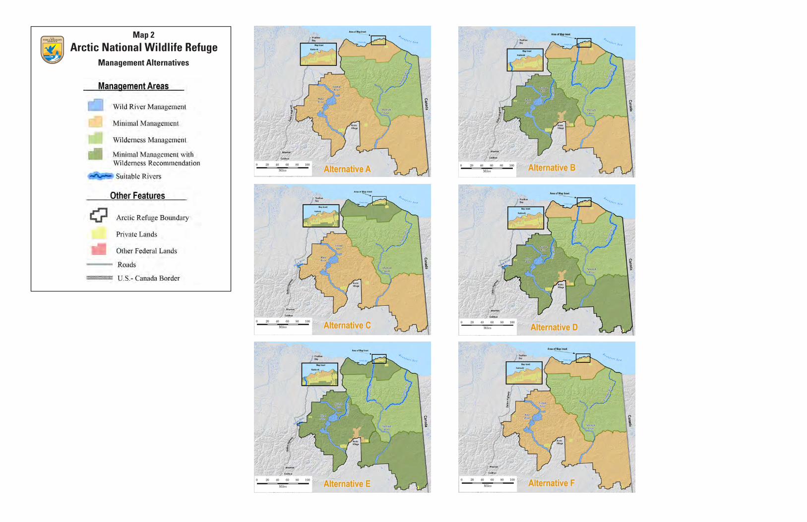
We combined multiple elements to create the alternatives in the Plan: goals and objectives; management categories; management policies and guidelines; and different strategies to respond to issues, public concerns, and opportunities identified during the planning process. A range of six alternatives was developed to address the Plan’s three significant planning issues: wilderness, wild and scenic rivers, and visitor use management in the Kongakut River valley (Map 2; Table 2).

Final EIS Summary
S-30 Arctic National Wildlife Refuge Revised Comprehensive Conservation Plan
Alternative A represents the current management situation at Arctic Refuge; it is also called the “no action” alternative. Alternative A would not adopt any of the goals or objectives, and it would maintain the management direction identified in the 1988 CCP except where it conflicts with more recent legislation, regulations, or national policies. Alternative F is similar to Alternative A, but it would adopt all the goals and objectives and the updated management policies and guidelines. Alternatives B through E would also adopt the goals, objectives, management policies, and guidelines, but they would differ in how they would address the three significant planning issues. All six alternatives would maintain three management categories for Refuge lands: Minimal, Wilderness, and Wild River.
Several management actions would continue regardless of the alternative selected. These management actions are either already occurring and would continue, or are currently in the process of being implemented and would be carried forward. The Refuge would continue to:
Meet international treaty obligations concerning migratory birds, the Porcupine caribou herd, and Yukon River salmon Monitor, protect, and maintain fish and wildlife populations, habitat values, ecological
processes, and biological diversity Maintain water quality and quantity throughout the Refuge and protect the values of the
Wind, Ivishak, and Sheenjek wild river corridors Provide opportunities to pursue research on wildlife and habitats and conduct inventory
and monitoring projects Allow appropriate and compatible private and commercial uses Allow methods of public access, including for rural residents engaged in subsistence
uses, currently allowed by law and regulation Provide opportunities to pursue social, cultural, and economic research Protect and monitor cultural and historical sites Provide the opportunity for continued subsistence uses by federally qualified subsistence
users
3.2.2 Preferred Alternative
The Service selected Alternative E as the Preferred Alternative for the Revised Plan. Alternative E addresses the key issues and concerns identified during the planning process and will best achieve the purposes of the Refuge as well as the missions of the Service and the National Wildlife Refuge System.
The Revised Plan and final EIS addresses a variety of needs, including protection of fish and wildlife populations and their habitats and providing opportunities for fish and wildlife-dependent recreation, subsistence, and other public uses. Alternative E contributes significantly to achieving Refuge purposes and the mission of the Refuge System, and Alternative E also strengthens the monitoring of fish, wildlife, habitat, and public uses on the Refuge. Service implementation of Alternative E will occur over the next 15 to 20 years.
The decision was based on a thorough analysis of the environmental, social, and economic considerations presented in the Revised Plan and final EIS. The Service reviewed and considered the impacts identified in Chapter 5 of the draft Plan/EIS; relevant issues, concerns, and opportunities; input received throughout the planning process, including advice from

Final EIS Summary
Arctic National Wildlife Refuge Revised Comprehensive Conservation Plan S-31
technical experts and public comments on the draft Plan/EIS; and other factors, including Refuge purposes and relevant laws, regulations, and policies.
This decision adopts the management goals and objectives and revised management policies and guidelines (Chapter 2 of the Revised Plan). Additionally, it addresses the three planning issues as follows:
Wilderness – Alternative E recommends the qualified and suitable lands and waters in three Wilderness Study Areas (nearly 12.28 million acres) for inclusion in the National Wilderness Preservation System. Until Congress makes a decision, recommended lands will continue to be managed under the Minimal Management category. Only Congress can designate Wilderness.
Wild and Scenic Rivers – Four rivers are recommended for inclusion in the National Wild and Scenic Rivers System: the Atigun, Marsh Fork Canning, Hulahula, and Kongakut rivers. Until Congress makes a decision, suitable and recommended rivers will be managed according to the interim management guidelines listed in Appendix I of the final EIS. Only Congress can designate rivers for inclusion in the National Wild and Scenic River System.
Kongakut River Visitor Use Management – Alternative E implements a series of management actions that can be taken right away, without promulgating regulations, to improve visitor experience and resource conditions in the Kongakut River valley. These interim measures include: working with guides to reduce visitor volume and to disperse flights; publishing a launch schedule; developing new outreach materials with targeted messages; increasing enforcement of permit conditions and Refuge regulations; and identifying and repairing degraded sites. Interim measures will remain in effect until a Refuge-wide Visitor Use Management Plan is completed.

Final EIS Summary
S-32 Arctic National Wildlife Refuge Revised Comprehensive Conservation Plan
This page intentionally left blank
0 20 40 60 80 100
Miles
0 20 40 60 80 100
Miles
0 20 40 60 80 100
Miles
0 20 40 60 80 100
Miles
0 20 40 60 80 100
Miles
0 20 40 60 80 100
Miles
Arctic National Wildlife RefugeMap 2
Management Alternatives
Final EIS Summary
Arctic National Wildlife Refuge Revised Comprehensive Conservation Plan S-35
Table 2. Comparison of alternatives by major planning issue
Issue Alternative A (No Action)
Alternative B Alternative C Alternative D Alternative E
Alternative F
Issue 1: Wilderness
Should additional Wilderness Study Areas be recommended for inclusion in the National Wilderness Preservation System, and if so, which areas?
No new wilderness recommended.
Recommend the Brooks Range Wilderness Study Area.
Recommend the Coastal Plain Wilderness Study Area.
Recommend the Brooks Range and Porcupine Plateau Wilderness Study Areas.
Recommend the Brooks Range, Porcupine Plateau, and Coastal Plain Wilderness Study Areas.
Same as Alternative A
Issue 2: Wild and Scenic Rivers
Should additional rivers be recommended for inclusion in the National Wild and Scenic Rivers System (NWSRS), and if so, which rivers?
No rivers recommended. Use existing management tools to maintain values on the Atigun, Hulahula, Kongakut, and Marsh Fork Canning rivers.
Recommend the Hulahula, Kongakut, and Marsh Fork Canning rivers. Use existing management tools to maintain values on the Atigun River.
Recommend the Atigun River. Use existing management tools to maintain values on the Hulahula, Kongakut, and Marsh Fork Canning rivers.
Recommend the Atigun, Kongakut, and Marsh Fork Canning rivers, and those portions of the Hulahula River managed by the Refuge.
Recommend the Atigun, Hulahula, Kongakut, and Marsh Fork Canning rivers.
Same as Alternative A
Issue 3: Kongakut River Visitor Use
How will the Refuge manage Kongakut River visitor use to protect natural resources and visitor experience?
Group size limits exist for guided groups (7 hikers, 10 floaters) No group size limits for non-
guided visitors Information on minimum
impact camping etc. available on Refuge web site Commercial service providers
have Special Use Permits (SUPs) with occasional compliance checks Monitoring of physical and
social conditions occurs occasionally Visitor impacts monitored
periodically On-site permit compliance
checks done infrequently In the Kongakut valley, air
operator permit holders required to land on non-vegetated surfaces and asked to follow all FAA advisories during flight operations Prepare a Public Use
Management Plan (as required by the 1988 Plan)
Same as Alternative A, and: Step-down plans
(VUMP/WSP*) initiated immediately
Issues addressed in step-down plans: o crowding and resource
impacts o site rehabilitation o early communication to
visitors Interim measures: o Expand monitoring of
degradation o Work with guides to reduce
visitor volume o Work to disperse flights o Develop new educational
materials o Publish a launch schedule o Enforce permit conditions
and Refuge regulations o Identify and repair
degraded sites Set an interim cap on
commercial recreational guides from 2013 thru 2016, pending VUMP/WSP
Specifics of the cap: each year of the interim period, recreational guides restricted to the average number of client use days they reported for 2007-2011 operating years
Same as Alternative B
* VUMP = Visitor Use
Management Plan WSP = Wilderness
Stewardship Plan
Same as Alternative B, except: No interim cap on commercial
recreational guides
Same as Alternative D
Same as Alternative D

Final EIS Summary
Arctic National Wildlife Refuge Revised Comprehensive Conservation Plan S-37
4. Refuge Environment Arctic Refuge lies across the spine of the Brooks Range Mountains in the northeast corner of Alaska. It spans roughly 200 miles north to south with the Beaufort Sea coast of the Arctic Ocean at its north. From east to west, the Refuge is 180 miles across at its maximum width between the U.S.-Canada border and the Sagavanirktok River drainage near the Dalton Highway. With no road connections to or within the Refuge, people access the Refuge by boat, airplane, snow machine, or dog team. The nearest road is the Dalton Highway, which is west of the Refuge.
The exterior boundary of Arctic Refuge encompasses nearly 19.86 million acres, of which about 19.64 acres (99 percent) are administered by the Refuge. Within the Refuge boundary, private lands (including both surface and subsurface estates) are owned by the Arctic Slope Regional Corporation, Doyon Limited, Kaktovik Inupiat Corporation, and various Native allotees (Map 3). In addition to the Mollie Beattie Wilderness Area and three designated wild rivers, the Refuge contains a marine protected area, the Shublik Springs and Firth-Mancha Research Natural Areas and the Neruokpuk Lakes Public Use Natural Area (Map 4).
4.1 Physical and Biological Environment Arctic Refuge is situated entirely north of the Arctic Circle, and is an intact continuum of different ecosystems. The northern part of the Refuge starts with the coastal waters along the Beaufort Sea coast. From there, the coastal plain, which incorporates the 1002 Area, rises gradually to the foothills of the Brooks Range Mountains. The foothills ascend to mountains that arc east to west across the Refuge and represent the northernmost extension of the Rocky Mountains. Some summits reach higher than 9,000 feet. All waters on the north side of the Continental Divide flow to the Beaufort Sea of the Arctic Ocean; waters on the south side of the divide flow into tributaries of the Yukon River drainage and eventually to the Bering Sea. South of the Brooks Range are the Davidson and Ogilvie mountains and a gently sloping basin along the Porcupine River. The climatic conditions of the Refuge mirror its diverse geographic features and latitudes. The mean annual temperature is below freezing in all parts of the Refuge.
The variety of unaltered habitats supports a great diversity of arctic and subarctic wildlife including a variety of birds and fish, polar, brown and black bears, wolves, wolverines, muskoxen, moose, Dall's sheep, and caribou. Observers have recorded 201 species of birds in the Refuge, of which 109 breed on the Refuge. Caribou are the most abundant large mammal in the Refuge and are an important subsistence species for Iñupiat and Athabascan (Gwich'in) hunters. Caribou from the Porcupine caribou herd use the Refuge's coastal plain as part of their traditional calving grounds.
Resources on Refuge-managed land and the Alaska Native communities in and near the Refuge are vulnerable to accelerating climate change. The arctic climate has warmed rapidly during the past 50 years, with annual average temperatures increasing nearly twice as fast as the rest of the world. These temperatures are already affecting the Refuge through coastal erosion and an extended growing season. In addition to other changes, continued warming may increase precipitation and change plant distributions.

Final EIS Summary
S-38 Arctic National Wildlife Refuge Revised Comprehensive Conservation Plan
4.2 Cultural and Social Environment Many archeological, historic, and paleontological sites are within the Refuge, and more than 10,000 years of human use of the land have been recorded. The Iñupiat and Athabascan peoples of the region have used the Refuge's lands and resources for centuries and continue using the Refuge for subsistence today. There are several communities near the Refuge, but only the Iñupiat community of Kaktovik, located on Barter Island along the shore of the Beaufort Sea, is within the boundaries of the Refuge. The Gwich'in Athabascan villages located on the south side of the Brooks Range near the Refuge include Arctic Village, Chalkyitsik, Fort Yukon, and Venetie. The communities of Wiseman and Coldfoot are to the west of the Refuge along the Dalton Highway corridor.
Arctic Refuge provides visitors with a variety of recreational experiences and opportunities to float rivers, hike, backpack, camp, mountaineer, hunt, fish, and observe and photograph wildlife. Arctic Refuge is vast, geographically remote, and primarily managed to provide visitors with a wilderness experience. There are no maintained facilities on the Refuge, and visitors may come and go without campsite assignments or registration requirements. An unknown number of visitors enter the Refuge each year by private planes and boats or by hiking. Commercial air operators, recreation guides, and big-game hunt guides must obtain a permit from the Refuge to operate on its lands and waters. Since 1980, the Refuge has issued an increasing number of annual permits to commercial service providers and air operators for the purpose of bringing visitors to the Refuge.
At Arctic Refuge, outreach and education programs are tailored toward three distinct audience types: people who come to visit the Refuge; people who live in communities in interior and northeast Alaska; and people who live far from the Refuge in Alaska, the U.S., and internationally. Outreach information is designed to meet the interests of each of these groups. Information is conveyed via the Refuge website, the Arctic Interagency Visitor Center, and informational kiosks in communities near the Refuge.
Since the late 1960s, NASA, in partnership with other agencies and the University of Alaska, has carried out scientific research using suborbital rockets launched from the Poker Flat Research Range located just north of Fairbanks, Alaska. The rockets help scientists better understand the aurora borealis, weather, climate change, and the interaction between the sun and earth’s upper atmosphere. Sub-orbital rockets shed various components along their flight paths. It is estimated that between 20 and 38 NASA-launched rocket motors have landed in Arctic Refuge since the inception of the Poker Flat Research Range. Arctic Refuge issues annual Special Use Permits for the Sounding Rockets Program; the permits contain conditions to minimize impacts.

!(
!(
!(
!(
!(
Brooks Range
Philip Smith Mts
Sadlerochit Mts
Shublik Mts
Romanzof MtsFranklin Mts
British Mts
Davidson Mts
Ogilvie Mts
B e a u f o r t S e aCamden Bay
Kaktovik
ArcticVillage
!(
!(
Konga
kut R
iver
Ivishak River
Sagav ani rktok River
Can
ning
Rive
r
Jago
River
Hul
ahul
a Ri
ver
Lake Peters
Porcu
pine River
Cole
en Ri
ver
Chandalar River
East
Fork
Chan
dala
r Riv
er
Coleen River
Shee
njek Rive
r
Wind River
Porcu
pine River
Old Crow River
Dalto
n Hi
ghwa
y
Old Crow
Canada
PrudhoeBay
Venetie
Wiseman
Coldfoot
140°W
140°W
142°W
142°W
144°W
144°W
146°W
146°W
148°W
148°W
150°W
150°W
152°W
152°W
154°W
154°W70
°N 70°N
69°N 69
°N
68°N 68
°N
67°N 67°N
!
!
Arctic Ocean
Gulf of AlaskaBering
Sea
Anchorage
FairbanksAlaska
Russia
Canada
Alaska Albers Equal Area Conic Projection, 1983 North American Datum.
Map 4-1
Surface Estate Land Status
03-0104
Arctic National Wildlife Refuge
Native Allotment
Regional Corporation
Village Corporation
Selected Conveyed
Roads
U.S. - Canada Border
U.S. Air Force Withdrawal
Arctic Refuge Boundary
Wilderness Boundary
Other FeaturesVillage Townsite
0 10 20 30 40 50 60 70 80Miles
0 10 20 30 40 50 60 70 80Kilometers
Map 3

!(
!(
!(
!(
!(
Brooks Range
Philip Smith Mts
Sadlerochit Mts
Shublik Mts
Romanzof MtsFranklin Mts
British Mts
Davidson Mts
Ogilvie Mts
B e a u f o r t S e aCamden Bay
Kaktovik
ArcticVillage
!(
!(
Konga
kut R
iver
Ivishak River
Sagav ani rktok River
Can
ning
Rive
r
Jago
River
Hul
ahul
a Ri
ver
Lake Peters
Porcu
pine River
Cole
en Ri
ver
Chandalar River
East
Fork
Chan
dala
r Riv
er
Coleen River
Shee
njek Rive
r
Wind River
Porcu
pine River
Old Crow River
Dalto
n Hi
ghwa
y
Old Crow
Canada
PrudhoeBay
Venetie
Wiseman
Coldfoot
140°W
140°W
142°W
142°W
144°W
144°W
146°W
146°W
148°W
148°W
150°W
150°W
152°W
152°W
154°W
154°W70
°N 70°N
69°N 69
°N
68°N 68
°N
67°N 67°N
!
!
Arctic Ocean
Gulf of AlaskaBering
Sea
Anchorage
FairbanksAlaska
Russia
Canada
Alaska Albers Equal Area Conic Projection, 1983 North American Datum.
Map 4-2
Special Designated Areas
03-0105
Arctic National Wildlife Refuge
Firth-Mancha
Shublik SpringsNeruokpuk Lakes
SheenjekRiver
WindRiver
IvishakRiver
National Marine Protected Area
Public Use Natural Area
Research Natural Area
Wild and Scenic River
Roads
U.S. - Canada Border
Arctic Refuge Boundary
Wilderness Boundary
Other Features
0 10 20 30 40 50 60 70 80Miles
0 10 20 30 40 50 60 70 80Kilometers
Map 4

Final EIS Summary
Arctic National Wildlife Refuge Revised Comprehensive Conservation Plan S-43
5. Environmental Consequences The potential effects of the six alternatives are identified, described, and compared in Chapter 5 of the Revised Plan. Chapter 5 includes an analysis of the “no action” alternative (A), five action alternatives (B-F), the cumulative effects of each alternative, an ANILCA Section 810 analysis of the effects on subsistence, and the effects of the proposed alternatives on low income and minority populations (environmental justice). The analysis was conducted for the EIS in compliance with NEPA and ANILCA. Effects on the physical and biological (biophysical), and the socioeconomic (human) environments of the Refuge, and effects on the Poker Flat Sounding Rockets Program, were considered.
For the biophysical environment, we considered the following resource categories:
Permafrost and soils
Water Quality and Aquatic Habitats
Vegetation and Terrestrial Habitats
Fish Populations and Natural Diversity
Bird Populations and Natural Diversity
Mammal Populations and Natural Diversity
We analyzed the human environment separately and according to the following resource categories:
Local Economy and Commercial Uses
Cultural Resources
Subsistence
Visitor Services and Recreational Opportunities
Wilderness Characteristics
Special Designation
Refuge Operations
Care was taken to ensure that the major issues (wilderness, wild and scenic rivers, and visitor use management of the Kongakut River) were addressed within the context of each resource category. The analysis also considered the effects of the other components of each alternative, including the goals and objectives and the management policies and guidelines. We also identified effects common to all the alternatives and those common to the five action alternatives.
Effects of the Goals and Objectives – All five action alternatives (B-F) would adopt the goals and objectives, which were found to have a positive effect on the biophysical and human environments of the Refuge. Since no goals and objectives were identified in the original Plan, they were not analyzed in relation to Alternative A. NASA is identified as a collaborative partner in Objective 2.7 (Chapter 2, Section 2.1.2 of the Revised Plan), which focuses on the restoration of wilderness characteristics at impaired sites. Such work is expected to have a negative economic effect to NASA, and a negligible effect on scientific return.

Final EIS Summary
S-44 Arctic National Wildlife Refuge Revised Comprehensive Conservation Plan
Effects of New Management Policies and Guidelines – All five action alternatives (B-F) would adopt the new management policies and guidelines, which are summarized in Section 2.2 and Table 1, above. The effects of the management policies and guidelines for both the human and biophysical environments were found to be generally positive. The management policies and guidelines do not pertain to the Poker Flat Sounding Rockets Program and would have no direct or indirect effects on NASA.
Effects of Alternative A (No Action Alternative) – An analysis of the “no action” alternative is required by NEPA and serves as the basis for comparing alternatives B through F and analyzing their effects. The effects of current management were analyzed for each resource category. Current management would result in generally negligible to minor effects to most resource categories; however, degradation of impaired sites and visitor experiences, such as in the Kongakut River valley, would continue.
Effects of Alternatives B-F (Action Alternatives) – The effects of the five action alternatives were analyzed by resource category for each of the three significant planning issues. All the effects on biophysical resource categories were found to be positive. The analysis of the human environment was generally positive with negative effects identified for Refuge operations. The potential designation of the Brooks Range Wilderness Study Area as Wilderness would significantly affect the scientific return of NASA’s Sounding Rockets Program under Alternatives B, D, and E; mitigation opportunities were also identified.
Cumulative Effects – Each alternative was analyzed to identify its cumulative effects on resources within the Refuge and across the region. Cumulatively, each alternative would have minor effects on the biophysical and human environments in the region. We also determined that none of the alternatives would affect other actions or planning efforts near Arctic Refuge (i.e., reasonably foreseeable future actions).
810 Evaluation of Subsistence – In accordance with Title XIII of ANILCA, the Refuge analyzed the effect of the proposed management actions on subsistence. None of the alternatives or their cumulative effects would significantly restrict subsistence use or availability of resources in Arctic Refuge, nor would they increase competition for resources or restrict access to harvestable resources. Opportunities for continued subsistence would be maintained.
Environmental Justice – The Refuge analyzed whether any of the alternatives would have disproportionately high or adverse human health or environmental effects on the programs, policies, and activities of minority populations and low income populations (in compliance with Executive Orders 12898 and 12948). Neither current management, nor any of the actions proposed under Alternatives B-F, would impose any disproportionately high or adverse human health or environmental effects on minority or low income populations, including effects on subsistence which is an integral and necessary activity for residents in the communities near Arctic Refuge. The analysis did not include a health risk assessment for people who rely principally on subsistence resources.
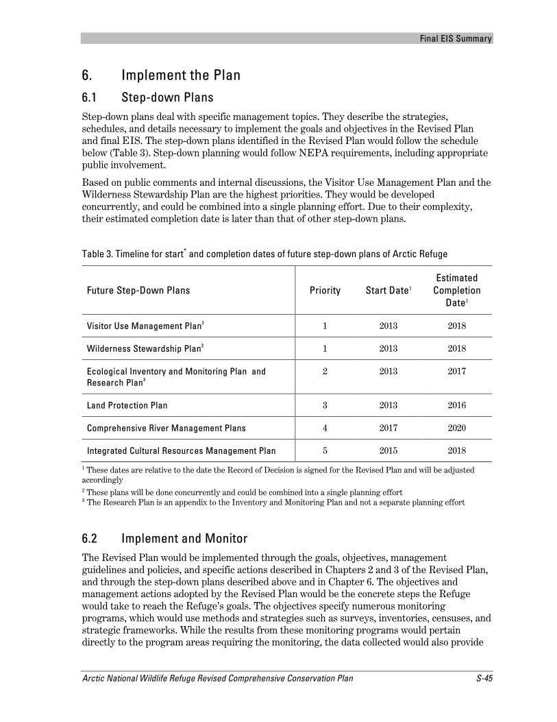
Final EIS Summary
Arctic National Wildlife Refuge Revised Comprehensive Conservation Plan S-45
6. Implement the Plan 6.1 Step-down Plans Step-down plans deal with specific management topics. They describe the strategies, schedules, and details necessary to implement the goals and objectives in the Revised Plan and final EIS. The step-down plans identified in the Revised Plan would follow the schedule below (Table 3). Step-down planning would follow NEPA requirements, including appropriate public involvement.
Based on public comments and internal discussions, the Visitor Use Management Plan and the Wilderness Stewardship Plan are the highest priorities. They would be developed concurrently, and could be combined into a single planning effort. Due to their complexity, their estimated completion date is later than that of other step-down plans.
Table 3. Timeline for start* and completion dates of future step-down plans of Arctic Refuge
Future Step-Down Plans Priority Start Date1 Estimated
Completion Date1
Visitor Use Management Plan2 1 2013 2018
Wilderness Stewardship Plan2 1 2013 2018
Ecological Inventory and Monitoring Plan and Research Plan3
2 2013 2017
Land Protection Plan 3 2013 2016
Comprehensive River Management Plans 4 2017 2020
Integrated Cultural Resources Management Plan 5 2015 2018
1 These dates are relative to the date the Record of Decision is signed for the Revised Plan and will be adjusted accordingly 2 These plans will be done concurrently and could be combined into a single planning effort 3 The Research Plan is an appendix to the Inventory and Monitoring Plan and not a separate planning effort
6.2 Implement and Monitor The Revised Plan would be implemented through the goals, objectives, management guidelines and policies, and specific actions described in Chapters 2 and 3 of the Revised Plan, and through the step-down plans described above and in Chapter 6. The objectives and management actions adopted by the Revised Plan would be the concrete steps the Refuge would take to reach the Refuge’s goals. The objectives specify numerous monitoring programs, which would use methods and strategies such as surveys, inventories, censuses, and strategic frameworks. While the results from these monitoring programs would pertain directly to the program areas requiring the monitoring, the data collected would also provide

Final EIS Summary
S-46 Arctic National Wildlife Refuge Revised Comprehensive Conservation Plan
feedback on the Revised Plan. Thus, monitoring programs identified in the objectives would be used to track the progress of Plan implementation. Plan implementation will depend on future Service budgets and regional funding allocations.
6.3 Amend and Revise The Service will maintain flexibility in implementing the Revised Plan to account for changing environmental conditions, policies, budgets, technologies, and opportunities for partnerships that might occur during the life of the Revised Plan. Revisions are a necessary part of the adaptive management approach used by the Service. The Service will evaluate monitoring results and amend or revise the Revised Plan accordingly to improve wildlife conservation and Refuge management. Service policy directs Arctic Refuge staff to review the Revised Plan every year to assess any need for change in management direction. Additionally, every three to five years, Refuge staff will review public comments, local and State government recommendations, research studies, and other sources to determine if revisions to the Revised Plan are necessary. If major changes are proposed, public meetings may be held, and a new environmental analysis may be needed. Full review and revision of the Plan is scheduled to occur every 15-20 years, or more often, if deemed necessary.
6.4 Partnership Opportunities Arctic Refuge is a dynamic ecosystem. Many of the resources in the Refuge are of regional, State, national, and international importance. The Service recognizes that the public, organizations, and other governmental agencies have interests in the Refuge and the work of the Service. Successful implementation of many Refuge programs requires involvement from these interested parties. Partnerships are among the best ways for the Refuge to accomplish its work and fulfill its mission.

Final EIS Summary
Arctic National Wildlife Refuge Revised Comprehensive Conservation Plan S-47
7. Wilderness Review Arctic Refuge completed a wilderness review as part of the Revised Plan. The purpose of a wilderness review is to identify, and recommend to Congress, lands and waters of the Refuge System that merit inclusion in the National Wilderness Preservation System (NWPS). In addition, a wilderness review is a means Arctic Refuge can use to assess whether we are effectively managing the Refuge according to its purposes. The current review was initiated in accordance with the refuge planning process outlined in the Service Manual and is conducted in compliance with the Service’s Wilderness Stewardship Policy. The review includes all areas of the Refuge not designated as Wilderness (about 60 percent of the Refuge) and incorporates recent information on the Refuge's resources, uses, and management concerns. The wilderness review process has three phases:
Inventory – Identify lands and waters that meet the minimum criteria for Wilderness. These are called Wilderness Study Areas (WSAs).
Study – Evaluate WSAs to determine if they are suitable for Wilderness designation. In this phase, values, resources, public uses, and Refuge management activities are considered, to compare the benefits and impacts of managing an entire WSA, a portion of a WSA, or none of a WSA as designated Wilderness. The study also evaluates how designation would achieve Refuge purposes and the purposes of the NWPS.
Recommendation – Findings of each WSA study are used to determine if the Service will make a wilderness recommendation. Any recommendation(s) would be forwarded by the Director of the Service to the Secretary of the Interior. The Secretary may forward the recommendation(s) to the President, who may transmit them to Congress. Only Congress can designate Wilderness.
The Arctic Refuge wilderness review divides the Refuge’s non-Wilderness lands into three WSAs: the Brooks Range, the Porcupine Plateau, and the Coastal Plain (Map 5). All three WSAs were found to be preliminarily suitable for Wilderness designation with the exception of two areas in the vicinity of Arctic Village and Kaktovik. The Preferred Alternative recommends the qualified and suitable lands and waters in all three of the WSAs (nearly 12.28 million acres) for inclusion in the NWPS.
Until Congress makes a decision regarding their designation, lands recommended for Wilderness status are managed under the Minimal Management category. If Congress were to designate recommended lands, only then would their management convert to Wilderness Management as defined in the Revised Plan.

Final EIS Summary
S-48 Arctic National Wildlife Refuge Revised Comprehensive Conservation Plan
Page intentionally left blank

!(
!(
!(
!(
!(
Brooks Range
Philip Smith Mts
Sadlerochit Mts
Shublik Mts
Romanzof MtsFranklin Mts
British Mts
Davidson Mts
Ogilvie Mts
B e a u f o r t S e aCamden Bay
Kaktovik
ArcticVillage
!(
!(
Konga
kut R
iver
Ivishak River
Sagav ani rktok River
Can
ning
Rive
r
Jago
River
Hul
ahul
a Ri
ver
Lake Peters
Porcu
pine River
Cole
en Ri
ver
Chandalar River
East
Fork
Chan
dala
r Riv
er
Coleen River
Shee
njek Rive
r
Wind River
Porcu
pine River
Old Crow River
Dalto
n Hi
ghwa
y
Old Crow
Canada
PrudhoeBay
Venetie
Wiseman
Coldfoot
140°W
140°W
142°W
142°W
144°W
144°W
146°W
146°W
148°W
148°W
150°W
150°W
152°W
152°W
154°W
154°W70
°N 70°N
69°N 69
°N
68°N 68
°N
67°N 67°N
!
!
Arctic Ocean
Gulf of AlaskaBering
Sea
Anchorage
FairbanksAlaska
Russia
Canada
Alaska Albers Equal Area Conic Projection, 1983 North American Datum.
Map H-1
Wilderness Study Areas
03-0106
Arctic National Wildlife Refuge
Roads
U.S. - Canada Border
Arctic Refuge Boundary
Designated Wilderness Boundary
Other Features
Native Corporation Land
0 10 20 30 40 50 60 70 80Miles
0 10 20 30 40 50 60 70 80Kilometers
Coastal Plain WSA
Western Brooks Range WSA
Porcupine Plateau WSA
Map 5

Final EIS Summary
Arctic National Wildlife Refuge Revised Comprehensive Conservation Plan S-51
8. Wild and Scenic River Review The National Wild and Scenic Rivers System (NWSRS) provides Federal protection for certain free flowing rivers, preserving them and their immediate environments for the use and enjoyment of present and future generations. Both the Wild and Scenic Rivers Act and Service policy require us to consider the wild and scenic potential of rivers within refuges when conducting comprehensive conservation planning. A wild and scenic river review has three phases:
Inventory Rivers – Within the inventory phase, there are three steps:
a) Decide what rivers to evaluate. There are approximately 160 named rivers, and hundreds of unnamed rivers, on the Refuge. We decided to evaluate 20 waters with documented, commercially-supported visitor use.
b) Determine what rivers are eligible. To be eligible for wild and scenic river designation, a river is required to be both free flowing, and possess at least one of six criteria called “outstanding remarkable values.” Outstandingly remarkable values are:
Scenic: landform, vegetation, color, and related factors result in notable or exemplary visual features Recreational: recreational opportunities are unique, rare, or attract visitors from beyond the region Geologic: the corridor contains a geologic feature, process, or phenomenon that is unique or rare Historic/Cultural: the river corridor contains national or regional importance for interpreting history or prehistory Fish: the river is an important producer of resident or anadromous fish, or provides exceptionally high quality habitat Wildlife: the river is an important producer of native wildlife species or provides exceptionally high quality habitat
c) Preliminarily classify each river as one of the following:
Wild: essentially primitive; not impounded; inaccessible except by trail; waters unpolluted Scenic: largely primitive and undeveloped; not impounded; accessible in places by roads Recreational: some development; may have some impoundment or diversion; readily accessible by road
Study Rivers – Each eligible river, including lands within ½ mile of each bank, is studied to determine if it is suitable for inclusion in the NWSRS. The suitability study determines whether eligible segments would be appropriate additions to the NWSRS by considering tradeoffs between development and protection. Suitability factors include: physical, social, and political environments; economic consequences; and manageability of rivers if they are designated.

Final EIS Summary
S-52 Arctic National Wildlife Refuge Revised Comprehensive Conservation Plan
Recommendation – Based on the suitability study, the Service decides whether to recommend all, some, or none of the Refuge’s rivers for inclusion in the NWSRS. The recommendation is included in the record of decision (ROD) for the Revised Plan. If the Service recommends designation, the river study report is given to the Department of the Interior, then to the President, and finally to Congress. Only Congress can decide whether to designate rivers as wild, scenic, or recreational.
The wild and scenic river review conducted as part of the Revised Plan determined that 10 of the 20 evaluated rivers had at least one outstandingly remarkable value (i.e., were eligible for wild and scenic river status), and four rivers were preliminarily determined suitable: Atigun, Marsh Fork Canning, Hulahula, and Kongakut (Map 6). The Preferred Alternative recommends all four suitable rivers for inclusion in the NWSRS.
Until Congress makes a decision whether to include the recommended rivers in the NWSRS, the rivers will be managed using the interim management prescriptions included in Appendix I of the Revised Plan to maintain their free-flowing condition, water quality, recommended classification (i.e., wild), and their outstandingly remarkable and other values. If Congress were to designate any of these rivers, the rivers would be managed under the Wild River Management category as defined in the Revised Plan. The Refuge would also prepare river-specific Comprehensive River Management Plans that would: describe the existing resource conditions in the river corridor; define the goals and desired conditions for protecting river values; address the types and amounts of public use the river area can sustain (i.e., user capacities); address water quality issues and instream flow requirements; and include a monitoring strategy to maintain desired conditions. If Congress decides not to designate a recommended river, the interim management prescriptions would no longer apply, and management would revert back to the appropriate management category and associated guidelines contained in the Revised Plan.
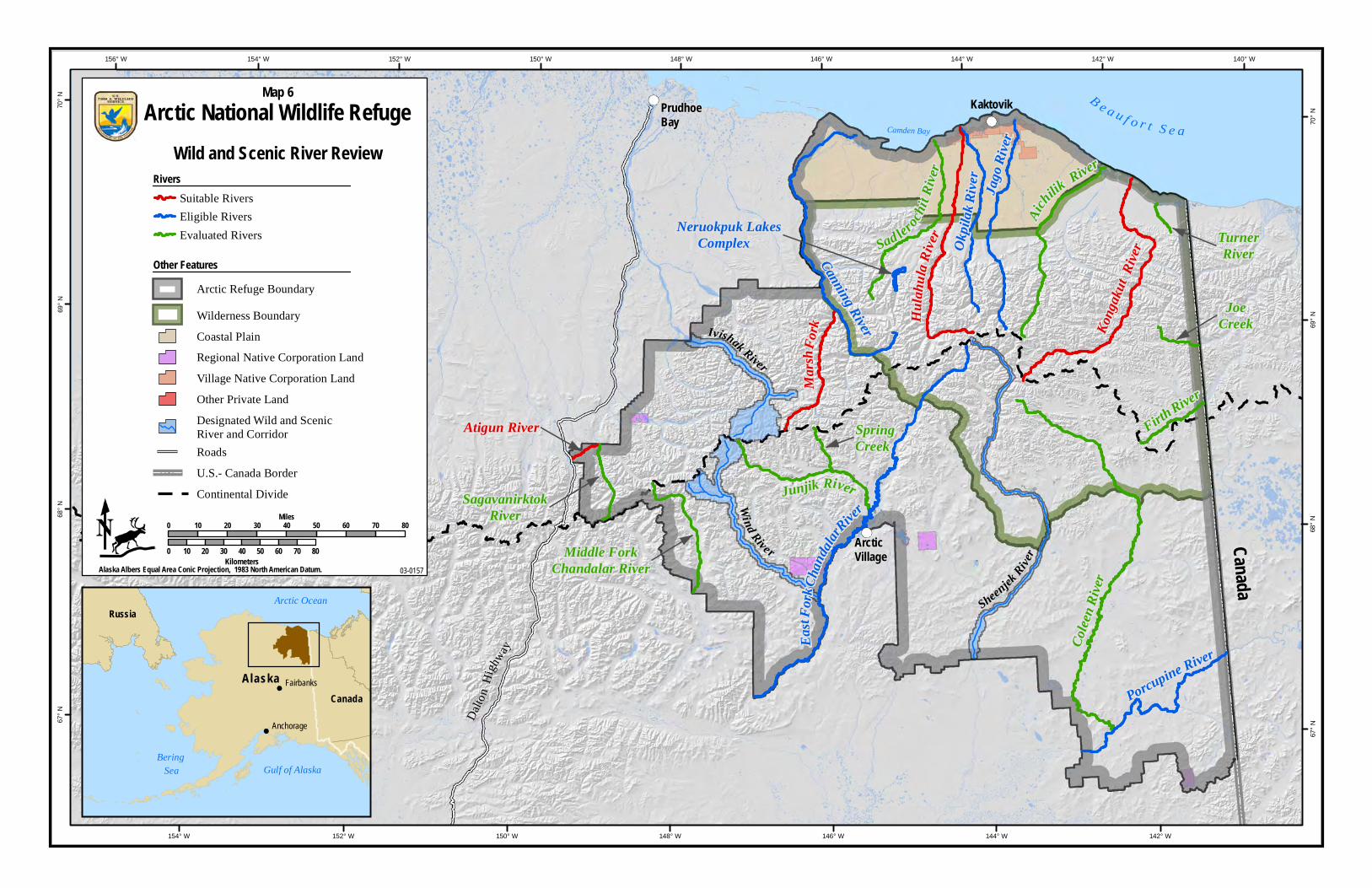
Porcupine RiverColee
n Rive
r
EastF
orkCh
andal
arRiver
SpringCreek
Junjik River
Neruokpuk Lakes Complex
Middle ForkChandalar River
TurnerRiver
Marsh
Fork Ko
ngak
utRiv
erOkpil
akRi
ver
Sad lerochit
River
JoeCreek
Aichilik
River
FirthRiver
Canning River
Jago
River
H ulah
ulaRi
ver
SagavanirktokRiver
Atigun River
B eau f or t S e aCamden Bay
PrudhoeBay
Kaktovik
ArcticVillage
Canada
152° W
152° W 140° W
142° W
142° W
146° W
146° W
148° W
148° W
150° W
150° W
154° W
154° W156° W
144° W
144° W70
° N
70°
N
69°
N
69°
N
68°
N
68°
N
67°
N
67°
N
Arctic Ocean
Gulf of AlaskaBering
Sea
Anchorage
FairbanksAlaska
Russia
Canada
Sheenjek
River
Wind River
Ivishak River
Dalt
onH
ighw
ay
Alaska Albers Equal Area Conic Projection, 1983 North American Datum.
Map 6
Wild and Scenic River Review
03-0157
Arctic National Wildlife Refuge
0 10 20 30 40 50 60 70 80Miles
0 10 20 30 40 50 60 70 80Kilometers
Other FeaturesArctic Refuge Boundary
Wilderness Boundary
U.S.- Canada Border
Continental Divide
Roads
Coastal Plain
Regional Native Corporation Land
Village Native Corporation Land
Designated Wild and ScenicRiver and Corridor
Other Private Land
Suitable RiversEligible RiversEvaluated Rivers
Rivers
Final EIS Summary
Arctic National Wildlife Refuge Revised Comprehensive Conservation Plan S-55
9. Compatibility Determinations The Refuge Administration Act states, “the Secretary [of the Interior] is authorized, under such regulations as he [or she] may prescribe, to…permit the use of any area within the [Refuge] System for any purpose, including but not limited to hunting, fishing, public recreation and accommodations, and access whenever he [or she] determines that such uses are compatible…”
A compatible use is a proposed or existing wildlife-dependent recreation use or any other use of a national wildlife refuge that, based on sound professional judgment, would not materially interfere with nor detract from the fulfillment of the Refuge System mission or the purposes for which a national wildlife refuge was established. A refuge compatibility determination is the document that results from the analysis and public review conducted by the Service to find an activity or use compatible or not compatible with the purposes of a refuge.
Seventeen compatibility determinations were prepared concurrently with the Revised Plan and were made available for public review and comment with the draft Plan/EIS. Appendix G of the Revised Plan and final EIS contains the signed compatibility determinations for activities or uses on Arctic Refuge, and each includes a summary of the public comments received on the draft compatibility determinations.

Final EIS Summary
S-56 Arctic National Wildlife Refuge Revised Comprehensive Conservation Plan
10. Changes between the Draft and Final EIS In response to public comments and internal agency communications, we made the following changes to the Revised Plan and final EIS from the draft Plan/EIS:
Wilderness Terminology – We added a “Note about Wilderness Terminology” to the front pages of Volumes 1, 2, and 3 to explain how we use wilderness-related terms throughout the Revised Plan. “Wilderness” (with a capital “W”) refers to the Refuge’s designated Wilderness area, and “wilderness” (not capitalized) is used as an adjective to describe wilderness-related qualities across the Refuge, including in Minimal Management areas.
Acreages – Many of the acreages listed in the Revised Plan and final EIS differ from those published elsewhere, including the draft Plan. The revised acreages reflect our ability to more accurately measure land areas using such technologies as Geographic Information Systems. We added a “Note about Acreages” to the front pages of Volumes 1, 2, and 3 to explain our approach.
ANILCA – ANILCA Section 1004 does not apply to Arctic Refuge, and all references to it were removed from the Revised Plan and final EIS.
Cooperating Agencies – Since the draft Plan was released, we welcomed the National Aeronautics and Space Administration (NASA) as a cooperating agency.
Refuge Purposes – Since publishing the draft Plan, we received clarification on how Refuge purposes guide management. Established in 1960, the Arctic National Wildlife Range (Range) was created “for the purpose of preserving unique wildlife, wilderness, and recreational values.” In 1980, ANILCA re-designated the Range as part of the Arctic National Wildlife Refuge and provided four purposes that guide management of the entire Refuge. Under the provisions of Section 305 of ANILCA, the Range purposes from 1960 remain in force and effect on the lands and waters in the original Range only to the extent they are consistent with ANILCA and the Alaska Native Claims Settlement Act. ANILCA purposes apply to the entire Refuge. The Revised Plan was edited to fully reflect this interpretation of Refuge purposes.
Goals and Objectives – The goals and objectives included in the draft Plan were revised based on public comment and Service review. Changes range from minor clarifications to major rewrites of goals and objectives. In some cases, multiple objectives in the draft Plan were combined into one. Additionally, several new objectives were added to the Revised Plan. These objectives discuss:
Restoration and rehabilitation of degraded and/or impaired sites
Management of the Refuge’s marine protected area
Modifications to the Refuge’s management approach to climate change
Providing more flexibility in the range of available responses to climate change
Assessment and inventory of water resources
Formal consultation with tribes, Native corporations, Native organizations, and local residents on a wide range of environmental, biological, cultural, and subsistence issues and concerns
Management Policies and Guidelines – To enable managers to more effectively manage the Refuge to meet its purposes, maintain its special values, and continue its role in the larger

Final EIS Summary
Arctic National Wildlife Refuge Revised Comprehensive Conservation Plan S-57
National Wildlife Refuge System, we made several changes to the Refuge’s management policies and guidelines. Changes included: rewriting the introduction to better explain how the guidelines were developed to meet the needs of Arctic Refuge; clarifying the authorities of the State of Alaska and the Service; expanding the discussion on U.S. government relations with tribal governments; and clarifying our intent to generally adopt a non-intervention approach towards climate change and avoid activities aimed at resisting the effects of climate change. Additionally, we expanded the section on human safety and management emergencies to include threats to resources in the Refuge; restriction of domestic animals such as sheep, goats, llamas, and alpacas to prevent the spread of disease to wildlife; prohibition of the use of straw and hay for bedding for dogs; and prohibition of all except pelletized weed-free feed for pack animals, to reduce the potential introduction and spread of invasive plants. Finally, we removed the proposed permit and fees for temporary facilities related to the taking of fish and wildlife left in designated Wilderness from one season to the next.
Alternatives – The projected budget to implement each of the alternatives was revised and is now lower than what was published in the draft Plan. This was accomplished through the strategic use of personnel, critically assessing the upcoming requirements outlined in the Revised Plan, and reducing costs where possible.
The options considered for management of visitor use on the Kongakut River were also revised. A Public Use or Visitor Use Management Plan would be completed under all the alternatives, including Alternative A (“no action”), and two of the alternatives now include an interim cap on commercial recreation guides from 2013 to 2016, or until step-down plans are completed. Step-down planning would begin immediately upon approval of the Revised Plan and final EIS, rather than two years after approval, and all management prescriptions put in place pending the step-down plans would be considered interim.
Other Chapters and Appendices – Various chapters and appendices were revised and reworked since the draft Plan and draft EIS:
Chapter 1, Introduction – was updated with details about the public comment period on the draft Plan and contains a new section entitled “Concerns Regarding Fish, Wildlife, and Habitats,” as required by ANILCA.
Chapter 4, Affected Environment – has a new section on soundscape and a new section on cabins; in addition, subsections on climate change were added to the descriptions of water resources, vegetation, fish, birds, and mammals. Socioeconomic data were updated with 2010 Census data, where available, and a new section on the Poker Flat Research Range and NASA’s Sounding Rockets Program was added.
Chapter 5, Environmental Consequences – was reworked to provide more consistency, and to identify reasonably foreseeable future actions. Additionally, the chapter considers the effects of each proposed action on the Poker Flat Research Range.
Chapter 6, Implementation and Monitoring – step-down plans were reprioritized.
Appendix G – compatibility determinations were finalized and signed.
Appendix I -- the eligibility and suitability studies for the wild and scenic river review were combined into a single report, and we added information about the Wild and Scenic Rivers Act and its management implications.

Related Documents