U.S. DEPARTMENT OF THE INTERIOR TO ACCOMPANY MAP I-1963 U.S. GEOLOGICAL SURVEY GEOLOGIC MAP OF THE SKYKOMISH RIVER 30- BY 60 MINUTE QUADRANGLE, WASHINGTON By R.W. Tabor, V.A. Frizzell, Jr., D.B. Booth, R.B. Waitt, J.T. Whetten, and R.E. Zartman INTRODUCTION From the eastern-most edges of suburban Seattle, the Skykomish River quadrangle stretches east across the low rolling hills and broad river valleys of the Puget Lowland, across the forested foothills of the North Cascades, and across high meadowlands to the bare rock peaks of the Cascade crest. The quadrangle straddles parts of two major river systems, the Skykomish and the Snoqualmie Rivers, which drain westward from the mountains to the lowlands (figs. 1 and 2). In the late 19th Century mineral deposits were discovered in the Monte Cristo, Silver Creek and the Index mining districts within the Skykomish River quadrangle. Soon after came the geologists: Spurr (1901) studied base- and precious- metal deposits in the Monte Cristo district and Weaver (1912a) and Smith (1915, 1916, 1917) in the Index district. General geologic mapping was begun by Oles (1956), Galster (1956), and Yeats (1958a) who mapped many of the essential features recognized today. Areas in which additional studies have been undertaken are shown on figure 3. Our work in the Skykomish River quadrangle, the northwest quadrant of the Wenatchee 1° by 2° quadrangle, began in 1975 and is part of a larger mapping project covering the Wenatchee quadrangle (fig. 1). Tabor, Frizzell, Whetten, and Booth have primary responsibility for bedrock mapping and compilation. Zartman carried out the zircon uranium-thorium-lead (U-Th-Pb) isotopic analyses and advised in the interpretation of isotope ages. Booth mapped most of the unconsolidated deposits of the western half of the quadrangle. Waitt mapped most of the unconsolidated deposits of the eastern half; in the eastern two-thirds of the map area, mostly along the crest of the mountains, talus and other morphologically distinct surficial units were mapped primarily from aerial photographs. Details of the unconsolidated deposits in the western half of the map are shown on a separate map (Booth, 1990). ACKNOWLEDGMENTS Our field work was helped considerably by Eduardo Rodriguez (1975), Bill Gaum and Kim Marcus (1977), Sam Johnson, Brett Cox, Elizabeth Lincoln Mathieson and Nora Shew (1978), P. Thompson Davis (1979), M. Jean Hetherington and Joe Marquez (1979-80), Jim Talpey, Paul Carroll, and Kathy Lombardo (1979), Steve Connelly, Stephen A. Sandberg, Susan Cook, Fredrika Moser, and Fred Beall (1981). Jean Hetherington, Steve Connelly, Kathleen Ort, and Fred Zankowsky helped in the office and laboratory. Dennis H. Sorg supplied clean mineral concentrates for radiometric dating. We thank Robert Kenlee, of Converse Ward Davis and Dixon, and Arthur Arnold, of Bechtel and Associates, for supplying drill-hole data and reports related to the City of Everett's Spada Lake projects. Curtis Scott, of Bechtel, showed us many interesting features in the Blue Mountain water diversion tunnel.

Welcome message from author
This document is posted to help you gain knowledge. Please leave a comment to let me know what you think about it! Share it to your friends and learn new things together.
Transcript

U.S. DEPARTMENT OF THE INTERIOR TO ACCOMPANY MAP I-1963
U.S. GEOLOGICAL SURVEY
GEOLOGIC MAP OF THE SKYKOMISH RIVER 30- BY 60 MINUTE
QUADRANGLE, WASHINGTON
By R.W. Tabor, V.A. Frizzell, Jr., D.B. Booth, R.B. Waitt, J.T. Whetten,
and R.E. Zartman
INTRODUCTION
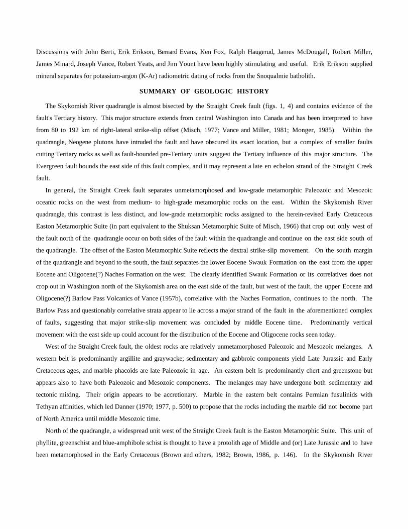
From the eastern-most edges of suburban Seattle, the Skykomish River quadrangle stretches east across the low rolling
hills and broad river valleys of the Puget Lowland, across the forested foothills of the North Cascades, and across high
meadowlands to the bare rock peaks of the Cascade crest. The quadrangle straddles parts of two major river systems, the
Skykomish and the Snoqualmie Rivers, which drain westward from the mountains to the lowlands (figs. 1 and 2).
In the late 19th Century mineral deposits were discovered in the Monte Cristo, Silver Creek and the Index mining
districts within the Skykomish River quadrangle. Soon after came the geologists: Spurr (1901) studied base- and precious-
metal deposits in the Monte Cristo district and Weaver (1912a) and Smith (1915, 1916, 1917) in the Index district. General
geologic mapping was begun by Oles (1956), Galster (1956), and Yeats (1958a) who mapped many of the essential features
recognized today. Areas in which additional studies have been undertaken are shown on figure 3. Our work in the
Skykomish River quadrangle, the northwest quadrant of the Wenatchee 1° by 2° quadrangle, began in 1975 and is part of a
larger mapping project covering the Wenatchee quadrangle (fig. 1).
Tabor, Frizzell, Whetten, and Booth have primary responsibility for bedrock mapping and compilation. Zartman carried
out the zircon uranium-thorium-lead (U-Th-Pb) isotopic analyses and advised in the interpretation of isotope ages. Booth
mapped most of the unconsolidated deposits of the western half of the quadrangle. Waitt mapped most of the unconsolidated
deposits of the eastern half; in the eastern two-thirds of the map area, mostly along the crest of the mountains, talus and other
morphologically distinct surficial units were mapped primarily from aerial photographs. Details of the unconsolidated
deposits in the western half of the map are shown on a separate map (Booth, 1990).
ACKNOWLEDGMENTS
Our field work was helped considerably by Eduardo Rodriguez (1975), Bill Gaum and Kim Marcus (1977), Sam Johnson,
Brett Cox, Elizabeth Lincoln Mathieson and Nora Shew (1978), P. Thompson Davis (1979), M. Jean Hetherington and Joe
Marquez (1979-80), Jim Talpey, Paul Carroll, and Kathy Lombardo (1979), Steve Connelly, Stephen A. Sandberg, Susan
Cook, Fredrika Moser, and Fred Beall (1981). Jean Hetherington, Steve Connelly, Kathleen Ort, and Fred Zankowsky helped
in the office and laboratory. Dennis H. Sorg supplied clean mineral concentrates for radiometric dating.
We thank Robert Kenlee, of Converse Ward Davis and Dixon, and Arthur Arnold, of Bechtel and Associates, for
supplying drill-hole data and reports related to the City of Everett's Spada Lake projects. Curtis Scott, of Bechtel, showed us
many interesting features in the Blue Mountain water diversion tunnel.

Doug Bucklew (1978), John Nelson (1978), Tim Bonin (1979), and the late Jack Johnson (1979-81) piloted helicopters;
we are indebted to their skill.

Lake Chelan
PUGET
SOUND
SKYKOMISHRIVER QUADRANGLE
CHELAN
WENATCHEEQUADRANGLE
Mt. Shuksan
Mt. Baker
Gee Point
TRAFTONOlo
Mountain
Mt. Pilchuck
Glacier Peak
CANADAUNITED
BRITISH WASHINGTON
QUADRANGLE
SNOQUALMIEPASS
QUADRANGLE
NORTH BEND
Harding Mountain
Mt. Stuart
EASTON
LookoutHuckleberryMountain
Mt. Rainier
BarlowPass
CloudyPass
SnoqualmiePass
SEATTLE
Mountain
IslandsSan
Stilla gu amish River
LOW
LAN
D
ST
RA
IGH
T
River
Fork
FAU
LT
123 122 121 120
49
48
47
KILOMETERS0 50
Nooksack
River
River
CR
EE
K
Skagit
Sauk
South
River
Little
River
Col
umbi
a
Little
River
Naches
PUG
ET
Wenatchee
Creek
Sw
auk
Cre
st
NO
RTH
CA
SC
AD
ES
WASHINGTON
Ca
sca
de
AREA OF THIS MAP
Figure 1. Index map of northwestern Washington showing the Skykomish River and three adjoining 30- by 60 minute quadrangles that compose the Wenatchee 1° by 2° quadrangle (original in black and white only).
Discussions with John Berti, Erik Erikson, Bernard Evans, Ken Fox, Ralph Haugerud, James McDougall, Robert Miller,
James Minard, Joseph Vance, Robert Yeats, and Jim Yount have been highly stimulating and useful. Erik Erikson supplied
mineral separates for potassium-argon (K-Ar) radiometric dating of rocks from the Snoqualmie batholith.
SUMMARY OF GEOLOGIC HISTORY
The Skykomish River quadrangle is almost bisected by the Straight Creek fault (figs. 1, 4) and contains evidence of the
fault's Tertiary history. This major structure extends from central Washington into Canada and has been interpreted to have
from 80 to 192 km of right-lateral strike-slip offset (Misch, 1977; Vance and Miller, 1981; Monger, 1985). Within the
quadrangle, Neogene plutons have intruded the fault and have obscured its exact location, but a complex of smaller faults
cutting Tertiary rocks as well as fault-bounded pre-Tertiary units suggest the Tertiary influence of this major structure. The
Evergreen fault bounds the east side of this fault complex, and it may represent a late en echelon strand of the Straight Creek
fault.
In general, the Straight Creek fault separates unmetamorphosed and low-grade metamorphic Paleozoic and Mesozoic
oceanic rocks on the west from medium- to high-grade metamorphic rocks on the east. Within the Skykomish River
quadrangle, this contrast is less distinct, and low-grade metamorphic rocks assigned to the herein-revised Early Cretaceous
Easton Metamorphic Suite (in part equivalent to the Shuksan Metamorphic Suite of Misch, 1966) that crop out only west of
the fault north of the quadrangle occur on both sides of the fault within the quadrangle and continue on the east side south of
the quadrangle. The offset of the Easton Metamorphic Suite reflects the dextral strike-slip movement. On the south margin
of the quadrangle and beyond to the south, the fault separates the lower Eocene Swauk Formation on the east from the upper
Eocene and Oligocene(?) Naches Formation on the west. The clearly identified Swauk Formation or its correlatives does not
crop out in Washington north of the Skykomish area on the east side of the fault, but west of the fault, the upper Eocene and
Oligocene(?) Barlow Pass Volcanics of Vance (1957b), correlative with the Naches Formation, continues to the north. The
Barlow Pass and questionably correlative strata appear to lie across a major strand of the fault in the aforementioned complex
of faults, suggesting that major strike-slip movement was concluded by middle Eocene time. Predominantly vertical
movement with the east side up could account for the distribution of the Eocene and Oligocene rocks seen today.
West of the Straight Creek fault, the oldest rocks are relatively unmetamorphosed Paleozoic and Mesozoic melanges. A
western belt is predominantly argillite and graywacke; sedimentary and gabbroic components yield Late Jurassic and Early
Cretaceous ages, and marble phacoids are late Paleozoic in age. An eastern belt is predominantly chert and greenstone but
appears also to have both Paleozoic and Mesozoic components. The melanges may have undergone both sedimentary and
tectonic mixing. Their origin appears to be accretionary. Marble in the eastern belt contains Permian fusulinids with
Tethyan affinities, which led Danner (1970; 1977, p. 500) to propose that the rocks including the marble did not become part
of North America until middle Mesozoic time.
North of the quadrangle, a widespread unit west of the Straight Creek fault is the Easton Metamorphic Suite. This unit of
phyllite, greenschist and blue-amphibole schist is thought to have a protolith age of Middle and (or) Late Jurassic and to have
been metamorphosed in the Early Cretaceous (Brown and others, 1982; Brown, 1986, p. 146). In the Skykomish River

0
Spada Lake
Creek
River
North
Fork
Silv
er
Riv
er
Beckl
er
South
Fork
Skykomish River Tye River
Nason Creek
Icicle C
reek
CleElum
River
Deceptio n
Creek
FossR
iver
M
iddle
Fork Snoqualmie
River
Tolt
River
South Fork
North Fork
SkykomishRiver
Tolt Seattle Water Supply Reservoir
Calligan Lake
Lake Hancock
Youngs Creek
Nor
thFo
rkSn
oqua
lmie River
KyesPeak
Maloney
Ridge
Tonga
Ridge
Woods
DUVALL
INDEX
MONTECRISTO
FALL
CARNATION
SNOQUALMIE
SKYKOMISH
StevensPass
Little
SULTANBASIN
1
2
3
4
5
6
7
8
9
10
11
12
13 1415
16
17
18
1920
21
22
23
24
26
27
28
29
30
31
32
33
34C
r
Mill
Cre
ek
Skykomish Rive r
Money Cr
Mt
SpireMountain
EvergreenMountain
BaringMountainMount
Index
Summit Chief
SNOHOMISH KING
KIN
G
KITTITAS
9047°30'
48° 122° 121°
SN
OH
OM
ISH
CO
CH
ELA
NC
O
CO
CO
CA
SCA
DE
CR
EST
Fren
chC
reek
Sn
oqualmie
River
2
2
Miller
River
W
enatchee River
TroublesomeMountain
MONROE
Sulta
n
Riv
er
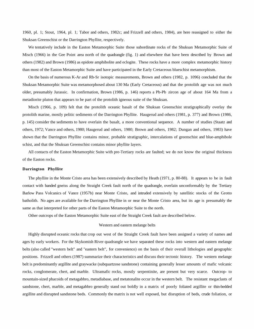
Figure 2. Generalized geographic map of Skykomish River quadrangle, Washington. Numbers indicate localities of obscure place names referred to in text.
5 KILOMETERS

quadrangle, the Easton is sparsely represented by the Darrington Phyllite and the Shuksan Greenschist that are exposed near
and within the Straight Creek fault zone.
Between probable en echelon faults within the fault zone are the low- to medium-grade metamorphosed pelites and scarce
metaigneous rocks of the Tonga Formation of Yeats (1958b). The Tonga has a late kinematic to static metamorphic
overprint that locally has increased its grade from greenschist on the south to amphibolite facies on the north. The Tonga
appears to grade into the amphibolite-grade Chiwaukum Schist of the Nason terrane although the exact gradation is
interrupted by faults and intrusive rocks.
The Nason terrane is composed mostly of metapelite assigned to the Chiwaukum Schist and banded gneiss derived from
the schist. The protolith age of the Chiwaukum Schist is uncertain, but the Chiwaukum may contain sedimentary inclusions
of the Late Jurassic or Early Cretaceous Ingalls Tectonic Complex, indicating that its age could lie between the Late Jurassic
and the Late Cretaceous. However, some workers (Evans and Berti, 1986, p. 698; Magloughlin, 1986, p. 263-264) assign a
Triassic and (or) Jurassic protolithic age to the Chiwaukum on the basis of Rb-Sr isochrons established for the Chiwaukum
and its probable correlative in Canada.
The Late Jurassic or Early Cretaceous Ingalls Tectonic Complex is mostly an unmetamorphosed melange that crops out
east of the Straight Creek fault, although in the Skykomish River quadrangle the complex is thermally metamorphosed by
the Late Cretaceous Mount Stuart batholith. The Ingalls appears to be an ophiolite complex (Southwick, 1974; Hopson and
Mattinson, 1973; Miller, 1977; Miller and Frost, 1977, p. 287) thrust over the Chiwaukum Schist (Miller, 1980a, b, 1985).
During the Late Cretaceous, the Ingalls Tectonic Complex, the Chiwaukum Schist, and the Tonga Formation of Yeats
(1958b) were intruded by the Mount Stuart batholith and Beckler River stocks. The intrusions produced hornfels in the
Ingalls and late- to post-kinematic mineral growth in the Tonga Formation, but the timing of metamorphic events and
intrusion of the Mount Stuart into the Chiwaukum Schist is still under debate. The deeper seated, Late Cretaceous Sloan
Creek and Tenpeak Mountain plutons also invaded the Chiwaukum Schist, and these plutons, although retaining igneous
textures and structures, are predominantly metamorphic in fabric and structure (see Tabor and others, 1980, 1982a).
By early Tertiary time the Cretaceous and older rocks had been uplifted and partially eroded. Lithofeldspathic subquartzose
sandstone and conglomerate of the lower Eocene Swauk Formation and its intercalated Silver Pass Volcanic Member were
deposited unconformably on the pre-Tertiary rocks. Following deformation, uplift, and erosion of the lower Eocene rocks,
various volcanic rocks and subquartzose sand of the upper Eocene and Oligocene(?) Naches Formation, and the correlative
Barlow Pass Volcanics of Vance (1957b) were deposited. Similar sedimentation and volcanism is expressed farther west in
the quadrangle in the volcanic rocks of Mount Persis and in the Puget Group.
Strong deformation continued in the mountainous region of the North Cascades. The folded Barlow Pass and Naches are
overlain unconformably by less deformed upper Oligocene and Miocene calc-alkalic volcanic rocks laterally equivalent to the
Ohanapecosh and Stevens Ridge Formations near Mt. Rainier (fig. 1) (see Frizzell and others, 1984). In a preliminary report
(Tabor and others, 1982a), we stated that the Oligocene and Miocene rocks on the west flank of the Cascades conformably
overlay the lower Tertiary Puget Group. Further mapping and reevaluation of the structural differences lead us to think that
the Oligocene and Miocene rocks unconformably overlie the Puget Group, although with less angular discordance than that of
the corresponding unconformity in the mountains to the east (Frizzell and others, 1984).

Roughly contemporaneous with the volcanism, tonalite and granodiorite batholiths invaded the crust of the area. The
Index batholith cooled about 34 Ma during the Oligocene and the Snoqualmie and Grotto batholiths about 25 Ma in the
Oligocene and (or) Miocene.
Alpine river valleys in the quadrangle record multiple advances and retreats of alpine glaciers. Multiple advances of the
Cordilleran ice sheet, originating in the mountains of British Columbia, Canada, have left an even more complex sequence of
outwash and till along the western mountain front, up these same alpine river valleys, and over the Puget Lowland.
PRE-QUATERNARY BEDROCK UNITS
By R.W. Tabor, V.A. Frizzell, Jr.,
and R.E. Zartman
PRE-TERTIARY ROCKS
ROCKS WEST OF THE STRAIGHT CREEK FAULT
Easton terrane
Easton Metamorphic Suite
A relatively distinctive belt of greenschist, blue-amphibole schist, and phyllite stretches northward from central
Washington, about 35 km south of the quadrangle, to beyond the Canadian border. Rocks of a part of the belt were originally
named the Easton Schist by Smith (1904, p. 3). Phyllite in the belt near Darrington (fig. 1) was called the Gold Hill unit
by Vance (1957a, p. 44). These rocks were later named the Darrington Phyllite by Misch (1966, p. 109) and included within
his Shuksan Metamorphic Suite along with greenschist and blue-amphibole schist that he named the Shuksan Greenschist
(Misch, 1966, p. 109). An earlier use of the name Shukson (original spelling) Formation for fossiliferous Upper Jurassic
marine sandstone and shale (rocks probably now included in the Nooksack Formation) by Weaver (1945, p. 1392) and Imlay
(1952, p. 977) has been appropriately unused and, because of vague descriptions, logically abandoned.
Yeats (1977, p. 267) and Vance and others (1980, p. 362) combined the Darrington Phyllite and Shuksan Greenschist of
Misch (1966, p. 109) into the Easton Schist as restricted by Stout (1964, p. 323). Silberling and others (1987, p. 12)
included the Easton Schist in their Shuksan terrane. We here revise the Easton Schist as the Easton Metamorphic Suite,
which consists of the here-adopted Darrington Phyllite and the here-adopted Shuksan Greenschist as defined by Misch (1966,
p. 109) and further described by Brown (1986).
The type locality of the Shuksan Greenschist is on Mount Shuksan in the vicinity of 121°36', 48°50', north of the
quadrangle (fig. 1), and has been described by Misch (1966, p. 109). The type locality of the Darrington Phyllite is on Gold
Mountain near Darrington mostly in secs. 16-21, 28-33, T. 32 N., R. 10 E., (Misch, 1966, p. 109).
In the central part of the Skykomish River quadrangle, we include the Shuksan Greenschist rocks that Yeats (1958a, p.
64-67; 1958b) called the Eagle Greenschist, but we exclude those rocks that Yeats (1958a, p. 40-63; 1958b) called the Tonga
Formation for reasons described in the section on the Tonga. Along the south edge of the quadrangle, we also include the
Shuksan rocks mapped originally as the Easton Schist by Ellis (1959). Farther south, rocks mapped as greenschist or
phyllite, shown by earlier workers as the Easton Schist (Smith, 1904; Smith and Calkins, 1906; Ellis, 1959, fig. 44; Foster,


1960, pl. 1; Stout, 1964, pl. 1; Tabor and others, 1982c; and Frizzell and others, 1984), are here reassigned to either the
Shuksan Greenschist or the Darrington Phyllite, respectively.
We tentatively include in the Easton Metamorphic Suite those subordinate rocks of the Shuksan Metamorphic Suite of
Misch (1966) in the Gee Point area north of the quadrangle (fig. 1) and elsewhere that have been described by Brown and
others (1982) and Brown (1986) as epidote amphibolite and eclogite. These rocks have a more complex metamorphic history
than most of the Easton Metamorphic Suite and have participated in the Early Cretaceous blueschist metamorphism.
On the basis of numerous K-Ar and Rb-Sr isotopic measurements, Brown and others (1982, p. 1096) concluded that the
Shuksan Metamorphic Suite was metamorphosed about 130 Ma (Early Cretaceous) and that the protolith age was not much
older, presumably Jurassic. In confirmation, Brown (1986, p. 146) reports a Pb-Pb zircon age of about 164 Ma from a
metadiorite pluton that appears to be part of the protolith igneous suite of the Shuksan.
Misch (1966, p. 109) felt that the protolith oceanic basalt of the Shuksan Greenschist stratigraphically overlay the
protolith marine, mostly pelitic sediments of the Darrington Phyllite. Haugerud and others (1981, p. 377) and Brown (1986,
p. 145) consider the sediments to have overlain the basalt, a more conventional sequence. A number of studies (Staatz and
others, 1972; Vance and others, 1980; Haugerud and others, 1980; Brown and others, 1982; Dungan and others, 1983) have
shown that the Darrington Phyllite contains minor, probable stratigraphic, intercalations of greenschist and blue-amphibole
schist, and that the Shuksan Greenschist contains minor phyllite layers.
All contacts of the Easton Metamorphic Suite with pre-Tertiary rocks are faulted; we do not know the original thickness
of the Easton rocks.
Darrington Phyllite
The phyllite in the Monte Cristo area has been extensively described by Heath (1971, p. 80-88). It appears to be in fault
contact with banded gneiss along the Straight Creek fault north of the quadrangle, overlain unconformably by the Tertiary
Barlow Pass Volcanics of Vance (1957b) near Monte Cristo, and intruded extensively by satellitic stocks of the Grotto
batholith. No ages are available for the Darrington Phyllite in or near the Monte Cristo area, but its age is presumably the
same as that interpreted for other parts of the Easton Metamorphic Suite to the north.
Other outcrops of the Easton Metamorphic Suite east of the Straight Creek fault are described below.
Western and eastern melange belts
Highly disrupted oceanic rocks that crop out west of the Straight Creek fault have been assigned a variety of names and
ages by early workers. For the Skykomish River quadrangle we have separated these rocks into western and eastern melange
belts (also called "western belt" and "eastern belt", for convenience) on the basis of their overall lithologies and geographic
positions. Frizzell and others (1987) summarize their characteristics and discuss their tectonic history. The western melange
belt is predominantly argillite and graywacke (subquartzose sandstone) containing generally lesser amounts of mafic volcanic
rocks, conglomerate, chert, and marble. Ultramafic rocks, mostly serpentinite, are present but very scarce. Outcrop- to
mountain-sized phacoids of metagabbro, metadiabase, and metatonalite occur in the western belt. The resistant megaclasts of
sandstone, chert, marble, and metagabbro generally stand out boldly in a matrix of poorly foliated argillite or thin-bedded
argillite and disrupted sandstone beds. Commonly the matrix is not well exposed, but disruption of beds, crude foliation, or


pervasive cataclasis is apparent in most outcrops. The eastern part of the western belt is more thoroughly metamorphosed
than the rest of the belt; in the general area of the lower Sultan Basin, the disrupted rocks grade to slate, phyllite, and
semischist and contain minor greenschist and chert.
The eastern melange belt, on the other hand, consists predominantly of mafic volcanic rocks and chert with minor argillite
and graywacke. Marble is conspicuous locally, and large and small pods of ultramafic rocks are present throughout the belt.
Metadiabase and a mafic migmatitic gneiss complex also crop out in the eastern belt. In the Skykomish River quadrangle,
much of the eastern melange belt is exposed as screens or pendants surrounded by Tertiary batholiths. In the upper Sultan
Basin area, we delineated the eastern belt from phyllitic rocks of the western belt on the basis of gradually increasing amounts
of volcanic and ultramafic rocks. The amount of penetrative deformation in the eastern belt is difficult to estimate because of
thermal metamorphism by the nearby Tertiary batholiths, but north of the quadrangle the clastic rocks in the eastern belt have
well-developed penetrative foliation. Heath (1971, pl. 1) mapped a fault between the eastern and western belts. The
disruption in Heath's wide fault zone seems to us to be no more severe than disruption elsewhere within the melange belts,
and we prefer to base the contact on the lithologic change that occurs farther west.
Although some of the disruption of beds in the melange belts may be of olistostromal origin, the mixing in both belts is
probably tectonic, judged by (a) overall penetrative deformation, (b) the local synkinematic metamorphism in the western
belt, and (c) strong cataclasis in crystalline megaclasts. Silberling and others (1987, p. 9, 12) have correlated our western and
eastern melange belts with regional tectonostratigraphic terranes that they call the Olney Pass and San Juan terranes,
respectively. The appropriate grouping of units in regional terranes and their naming are still under study, but an oceanic
origin for these disrupted Paleozoic and Mesozoic rocks, now cropping out west of the Straight Creek fault, and their
subsequent accretion to the North American continent are accepted by many students of Northwest tectonics (Danner, 1970;
1977; Davis and others, 1978; Vance and others, 1980; Whetten and others, 1980; Brandon and others, 1983).
Rocks of the western melange belt
The graywacke, argillite, chert, metavolcanic rocks, marble, and metagabbro of the western melange belt south of the
quadrangle were first mapped and described by Fuller (1925, p. 29-53). Other workers (Culver, 1936; Carithers and Guard,
1945, p. 14-15, 18-22; Bethel, 1951, p. 22-25; Kremer, 1959, p. 40-68; Heath, 1971, p. 97-102; Dungan, 1974, p. 8-21)
have further described rocks in the belt and applied local and correlative names, but the most definitive descriptions are by
Danner (1957, p. 333-371), who included most of the sedimentary and volcanic rocks in his Sultan unit.
On the basis of the lithology and the widespread internal deformation, Jett (1986, p. 16) and Jett and Heller (1988)
concluded that the western melange belt formed in an accretionary wedge.
Argillite and graywacke
Argillite may well be the most abundant rock type in the western melange belt, but because it was easily eroded and is
now covered by unconsolidated deposits, the predominant exposures are sandstone. Most outcrops of interbedded argillite and
sandstone reveal the penetrative cleavage that disrupts bedding, but in some areas bedding is preserved, and original structures
such as graded bedding, small-scale crossbedding, scour marks, and load casts are abundant. Slate-chip breccias are common.

The most common exposures are of massive-looking sandstone that has little preserved bedding and is cut by anastomosing
brittle shears.
Good outcrops of the melange matrix in the western belt are scarce, but some reveal the weak to strong scaly cleavage.
Melange of the western belt, well exposed on the South Fork of the Stillaguamish River east of Granite Falls (fig. 1), lacks
consistent penetrative cleavage and is composed of lenticular and locally necked blocks of sandstone, greenstone, limestone,
and rare metatonalite in a massive argillite matrix. The melange resembles Cowan's (1985, p. 454-456) type-II melange,
evolved from submarine landslides of a once-coherent but varied stratigraphic sequence.
Potassium feldspar-bearing sandstone
Parts of the western belt appear to be richer in potassium feldspar than other parts, although rocks with or without
potassium feldspar may be found in adjacent outcrops. Jett and Heller (1986, 1988) and Jett (1986, p. 52-63) included the
potassium feldspar-bearing sandstones in their arkosic petrofacies and noted that a pre-Jurassic potassium feldspar source has
not been recognized in the adjoining terranes. They also noted similarity of the bimodal sandstone of the western melange
belt to bimodal sandstones of the Californian Franciscan Complex. The distribution of potassium feldspar-rich rocks shown
on the geologic map was determined by estimating values from stained thin sections and slabs and from modal data in Jett
(1986, p. 13). In contrast, sandstones from the eastern belt have almost no potassium feldspar.
Slate, phyllite, and semischist
Sandstone and argillite in the western melange belt grade eastward into slatey argillite, slate, phyllite, and semischist in
the upper Sultan Basin area. The change from nonfoliate to foliate rocks typically takes place over a few hundred meters.
Greenstone and tuffaceous rocks grade into phyllitic greenstone or fine-grained greenschist.
This slatey argillite and phyllite unit appears to be continuous with rocks that Danner (1957, p. 423-455) included in his
phyllitic Olo Mountain unit, north of the quadrangle boundary. Danner felt that the Olo Mountain unit was also
lithologically similar to the Nooksack Formation exposed on the upper Nooksack River (fig. 1), except that the former
contained more chert. Similarly, our phyllitic unit contains more chert than the less foliated rocks to the west. On the north
side of the Sultan River, however, we also include in our phyllitic unit the lowermost Cretaceous fossiliferous rocks, which
Danner included in his Sultan unit (table 1).
Metagabbro, metadiabase, and metatonalite
Metagabbro in the western melange belt ranges from slightly uralitized ophitic gabbro through protomylonite to well-
recrystallized gneissic amphibolite.
The mode of formation and emplacement of the gabbroic masses is important to the interpretation of theorigin of the
melange unit. Danner (1957, p. 535-541) considered the metagabbro bodies (his Woods Creek intrusive bodies) to be
intrusive into the sedimentary rocks. Relatively wide-spread and strongly uralitized diabase dikes, though sparse, are clearly
intrusive into the sedimentary rocks. Similar rocks, presumably dikes, are present in the overlying Tertiary volcanic rocks as
well. However, most contacts between the larger gabbro bodies and adjoining rocks are strongly deformed and faulted; small
knockers of metagabbro are clearly tectonically emplaced in the sedimentary rocks, which have no hornfelsic textures adjacent

to the metagabbro. Metagabbro and metatonalite masses yield U-Th-Pb zircon ages of 170 to 150 Ma (table 2, nos. 55-58),
which indicate that the plutonic rocks are minimally about the same age as or older than the enclosing Jurassic and Lower
Cretaceous sedimentary rocks. A Buchia from matrix argillite and graywacke beds (table 1, nos. 1F-3F) appears to be
restricted to the Tithonian (Danner, 1957, p. 410), and more definitive radiolarian samples indicate ages from Kimmeridgian
to Valanginian (Frizzell and others, 1987) that, in numerical age, range from 156 to 131 Ma based on the time scale of
Harland and others (1982).
Whetten and others (1980, p.365-366) considered the Woods Creek plutonic rocks and the massif of Mount Si [8]1 to be
in-folded or in-faulted klippen of their Haystack thrust, a regional thrust plate emplaced in earliest Late Cretaceous time. In
an alternative hypothesis, they also suggested that these rocks could be a large-scale melange with imbricated exotic blocks of
Mesozoic ophiolite. We now view the western melange belt as an imbricated mixture of marine sedimentary rocks, volcanic
rocks, and probable underlying gabbroic basement rocks.
We placed the concealed contact of metagabbro in the northwestern part of the quadrangle by inspection of aeromagnetic
anomalies (U.S. Geological Survey, 1977).
Metavolcanic rocks and phyllitic greenstone
Nonschistose and schistose metavolcanic rocks in the western melange belt crop out mostly in the Blue Mountain [2] area
south of the Sultan River and just west of Mount Si. The original rocks were mostly mafic, probably basaltic; some were
formed underwater as shown by pillow structures. Probable quartz porphyry dikes, now boudins along penetrative shearing in
the Mount Si area, are the only silicic metavolcanic rocks that we have found in the western melange belt.
Ultramafic rocks
Ultramafic rocks are very scarce in the western melange belt, a characteristic that helps distinguish it from the eastern belt.
A discontinuous layer of ultramafic rocks is present along the gneissic contact of the Bald Mountain pluton. McPhee and
Baumann (1911) report an ultramafic body near Hogarty Creek [3]. North of the quadrangle, several bodies of ultramafic
rocks crop out near Granite Falls in the western melange belt, and south of the quadrangle a small pod of serpentized
peridotite is associated with sheared and isolated outcrops of protomylonitic metagabbro.
-----------------------------------
1 Numbers in brackets refer to obscure place names on fig. 2.
----------------------------------------
Chert
The largest masses of banded chert crop out in the northern part of the quadrangle within the slate, phyllite, and semischist
part of the western melange belt. Most chert occurs as discontinuous pods or isolated blocks in highly disrupted sandstone
and argillite. A few cherts yield identifiable radiolarians (table 1).
Marble

Most marble in the western melange belt is coarsely crystalline. Only one outcrop of marble, near Proctor Creek [4], has
yielded identifiable fossils (table 1, no. 7F), but several marble outcrops from the western melange belt north of the
quadrangle are fossiliferous (see below).
Age, correlation, and emplacement
of the western melange belt
The ages of most components of the western melange belt appear to be Jurassic and Early Cretaceous, based on fossils
from several locations throughout the belt (table 1) and U-Th-Pb zircon ages in the range of 170-150 Ma (table 2, nos. 55-58)
from four metatonalite-metagabbro masses. Cherts from several localities north of the quadrangle in the western melange belt
(Tabor and Booth, 1985) contain Early Jurassic radiolarians (Charles Blome, written commun., 1985). Conventional K-Ar
ages of hornblende from the uralitic metagabbro are around 100 Ma (table 2, nos. 53-54) and probably have been degraded by
superimposed metamorphism. The marble near Proctor Creek contains considerable ichthtyolith fragments and vertebrae of a
possible tetrapod indicating it is probably Mississippian to early Permian in age (table 1, no. 7F). Confirming this pre-
Jurassic age of marble in the melange are mid- and Late Permian fusulinids recovered from marble outcrops in the western
melange belt to the north (Wiebe, 1963, p. 6; Danner, 1966, p. 319-322, 325).
Danner considered the oceanic sedimentary rocks of the western melange belt (his Sultan unit) to be correlative
lithologically and in age with the relatively undeformed Late Jurassic Nooksack Formation (Misch, 1966, p. 118; see also
Sondergaard, 1979). Jett (1986, p. 52-57) questioned this correlation because, in particular, the Nooksack lacks the arkosic
petrofacies found in the western melange belt.
Less disrupted rocks of similar general age and lithologies on the San Juan Islands (fig. 1) are the Constitution and
Lummi Formations (Vance, 1975, p. 13; 1977, p. 182, 186; Brandon and others, 1983, p. 16-23) and even farther west on
Vancouver Island, the Pacific Rim Complex (Brandon, 1985).
The age of emplacement of the western melange belt is not well constrained. Tectonic mixing of the melange
components, the emplacement of the melange along the margin of North America, and possible major displacement along
strike-slip faults such as the Straight Creek fault are discussed in more detail in Frizzell and others (1987).
The western melange belt is intruded within the quadrangle by the Fuller Mountain plug and north of the quadrangle by
the Granite Falls and Mount Pilchuck stocks, all of which yield early Eocene K-Ar ages of 47 Ma (table 2, no. 34), 44 Ma,
and 49 Ma respectively (Yeats and Engels, 1971, p. D36). We do not know whether the stocks intruded before or after
melange accretion or fault emplacement, but preliminary paleomagnetic work in the Granite Falls stock (Beck and others,
1982, p. 516) suggests that emplacement, tectonic mixing, and significant translation along faults were completed by
sometime in the early Tertiary.
If the phyllitic rocks represent the highest metamorphic grade attained during imbrication of the Paleozoic and Mesozoic
rocks, then the K-Ar cooling age of about 48 Ma (table 2, no. 37) on newly formed sericite, in a well-recrystallized phyllite
from the unit, is a minimum age of melange formation.
The western melange belt is overlain unconformably by the gently deformed, 38-Ma (late Eocene) volcanic rocks of
Mount Persis [5]. Lack of deformation and the apparent correlation of the Mount Persis volcanic rocks with at least part of
the Puget Group (see below), appear to qualify the former as a post-accretion, overlap unit. However the Mount Persis

volcanic rocks overlie only the western melange belt, and their lack of deformation contrasts with the strong deformation in
the contemporaneous strata of the adjoining Puget Group (see Vine, 1969; Turner and others, 1983), suggesting that the
entire block of the western melange belt overlain by the volcanic rocks of Mount Persis is in fault contact with the Puget
Group.
In summary, emplacement, melange formation, and significant strike-slip translation, if any, must have taken place
between the Early Cretaceous and the early Eocene. As will be indicated, the eastern melange belt was definitely emplaced by
late Eocene time and perhaps as early as the mid-Cretaceous. Tabor and Booth (1985) have suggested that the western melange
belt may be in fault contact with the eastern melange belt, but the two belts may have been accreted to North America about
the same time.
Rocks of the eastern melange belt
The eastern melange belt is an assemblage of diverse rocks, including metavolcanic rocks (basalt), chert, argillite,
graywacke, and marble, as well as migmatitic gneiss, metagabbro, metadiabase, metatonalite, and ultramafic rocks. These
rocks are considerably deformed, slightly metamorphosed to greenschist facies, and statically recrystallized by Tertiary
plutons. Evidence for extreme disruption of the belt is locally abundant: penetrative foliation, small-scale folds, and zones of
tectonic breccia (Yeats, 1964, p. 556-557). The belt is highly fragmented, mostly by intrusion of the Tertiary Snoqualmie,
Grotto, and Index batholiths.
In the eastern belt, we include rocks in the Weden Creek area [12], mapped by Heath (1971, p. 90-94) as the
Chilliwack(?) Group of Misch (1966), and thermally metamorphosed volcanic rocks and chert associated with ultramafic rocks
on the north side of Silver Creek. We also include metabasalt and ribbon chert exposed on Garfield Mountain. A roof
pendant of mostly graywacke on Bare Mountain [11] could belong to either the eastern or western melange belts, but
Gualtieri and others (1975, p. 71) report metavolcanic and ultramafic rocks in the nearby Illinois Creek area that indicate the
pendant belongs with the eastern melange belt. Metamorphosed oceanic rocks, including metabasalt, metachert, marble, and
metagabbro, exposed near Snoqualmie Pass (fig. 1) are also isolated remnants of the eastern melange belt (see Danner 1957,
p. 249-255; Frizzell and others, 1982, 1984).
Chert and metachert, marble, mafic metavolcanic rocks, argillite and graywacke
Rocks cropping out northwest of Skykomish have been named the Gunn Peak and Barclay Creek Formations by Yeats
(1964, p. 556). The Gunn Peak Formation, composed predominantly of ribbon chert and quartzite (metachert) and containing
marble pods, grades upward into the Barclay Creek Formation. The formations are lithologically similar, but locally the
Barclay Creek contains more banded siliceous and calcareous argillite, graywacke, and greenstone. Yeats (1958a, p. 102-114;
1964, p. 556) restricted the Gunn Peak Formation as originally defined by Weaver (1912a, p. 36-38), which had also included
the migmatitic gneiss and parts of the Swauk Formation.
Although in a previous report (Tabor and others, 1982b) we indicated that the formations described by Yeats could not be
mapped away from the Skykomish area, a chert-rich unit has been mapped north of the quadrangle in rocks that are
continuous with the eastern melange belt (Vance, 1957a; Baum, 1968) and appears to terminate along the North Fork of the

Sultan River. We here include the rocks mapped by Yeats as his Gunn Peak Formation in our chert and metachert unit,
although an age correlation has not been shown.
Migmatitic gneiss
The summit areas of Gunn Peak, Merchant Peak [22], and Baring Mountain are composed mostly of migmatitic
hornblende gneiss that ranges in composition from amphibolite to trondhjemite. Detailed petrographic studies by Yeats
(1958a, p. 83-98; 1964, p. 551-555) indicate that the gneiss underwent regional dynamic metamorphism and granitization,
cataclastic deformation, and static recrystallization (by Tertiary batholiths). The cataclastic deformation is pervasive and
especially prominent at its contacts with the sedimentary and volcanic rocks. On the basis of a regional correlation with
similar sheared metamorphic complexes that apparently overlie unmetamorphosed rocks as described by Misch (1960, 1963,
1966, p. 106), Yeats (1964, p. 559) considered the migmatitic gneiss to be klippen of pre-Middle Devonian basement rocks
that were thrust over younger rocks. Uranium-thorium-lead ages of about 190 Ma from a tonalite phase of the migmatitic
gneiss led Whetten and others (1980, p. 365) to suggest that the gneiss was part of a regionally overthrust sheet (their
Haystack terrane) of Mesozoic ophiolite.
Evidence that these gneisses are in tectonic contact with the sedimentary and volcanic rocks is, indeed, convincing.
However, argillite is imbricated with the gneiss in many places (Yeats, 1964, p. 556) and even lies atop the gneiss on Baring
Mountain. Furthermore, some contacts presumed to be horizontal are, in fact, steep, such as on the south side of Gunn Peak.
All of the faults bounding the crystalline rocks, including the high-angle faults mapped by Yeats (1958a, pl. II, and 1964, pl.
1) and thought by him to be younger than the thrust, may be the same age. An alternative interpretation to the overthrust
hypothesis is that the gneiss masses are mostly steep-sided exotic blocks in a melange, an interpretation alluded to by Yeats
(1964, p. 558) when he referred to the klippen as megabreccia.
Metadiabase and metatonalite
Danner (1957, p. 513-517) and Plummer (1964, p. 52-56) considered a large mass of metadiabase on Crosby Mountain
[10] to be intrusive into the pre-Tertiary sedimentary and volcanic rocks. Erikson (1969, pl. 1) included the diabase in his
early phase of the Miocene Snoqualmie batholith.
The uralitized diabase is similar to diabase in the western melange belt and locally displays steeply dipping crude foliation.
It has a sharp contact against sheared pods of metatonalite associated with highly deformed argillite and graywacke on the west
side of Crosby Mountain, but we do not know the relative ages of the two igneous rocks. Zircons with 207Pb/206Pb ages
of around 70-60 Ma from the metatonalite in this area (table 2, no. 60) may be partially reset. We think that the discordancy
exhibited by these zircons reflects new zircon growth during intrusion of the nearby Tertiary batholiths. Zircons recovered
from metatonalite surrounded by the Tertiary batholith on Garfield Mountain show a similar pattern in their isotopic
systematics (table 2, no. 57).
On the steep walls of Money Creek, intrusion of the Snoqualmie batholith has produced extensive contact breccia, where
dark diabase clasts are set in a white quartzofeldspathic matrix (see Plummer, 1964, p. 52-53) and permeation of diabase by
quartz is conspicuous in thin section where the pyroxene and calcic plagioclase float in a quartz mesostasis.
Ultramafic rocks

Pods of ultramafic rocks are scattered throughout the eastern melange belt but are also concentrated along the sheared and
imbricated margin of the migmatitic gneiss. A conspicuous belt of hornfelsic peridotite cuts across the upper Sultan River.
In the Skykomish area, most of the ultramafic rocks are partially or completely altered to tremolite and serpentine minerals,
but relict pyrogenic minerals indicate that the pods were originally pyroxenite, peridotite, and dunite (Yeats, 1958a, p. 116-
118). On the east side of Weden Creek [12], a large sliver of dunite appears to be faulted against the Barlow Pass Volcanics
of Vance (1957b). Dungan (1974, p. 98-100) argued from detailed petrologic and petrochemical data that correlative
ultramafic pods on strike to the north, the Stillaguamish ophiolite (Vance and others, 1980), were once part of a coherent
ophiolite complex.
Age and correlation of the eastern melange belt
On Palmer Mountain [9], Danner (in Thompson and others, 1950, p. 49; see also Danner, 1966, p. 362-363) found
Permian fusulinids in a float block of limestone in an area where most of the limey rocks in outcrop are well-recrystallized
marble, barren of diagnostic fossils. Nevertheless, on the basis of overall lithologic similarity, Danner (1966, p. 363)
referred these rocks to his Trafton sequence exposed in a belt farther north. The fusulinids in the Trafton are Tethyan in
affinity, indicating to Danner (1977, p. 500) that the rocks including them did not become a part of North America until at
least the middle Mesozoic. The Trafton sequence contains fossils ranging from Devonian to Middle Jurassic in age (Danner,
1977, p. 492-493; Whetten and Jones, 1981). A wide range of ages in the eastern melange belt indicates considerable tectonic
mixing: the limestone components of probable Permian age, the tonalite component of the migmatitic gneiss of Early
Jurassic protolith age, and metagabbro of Late Jurassic age in the eastern melange belt near Snoqualmie Pass (Frizzell and
others, 1982). West of Darrington (fig. 1), chert and marble of the chert and metachert unit, equivalent to the Barclay Creek
Formation of Yeats (1958b), are Late Triassic based on radiolarian and conodonts, respectively (C.D. Blome, written
commun., 1985, and K.S. Schindler and A.G. Harris, written commun., 1984). The age range of ages in the eastern melange
belt corresponds well to the age range of components in the Trafton sequence reported by Whetten and Jones (1981).
Mafic and ultramafic rocks of the belt are likely correlative with the dismembered Stillaguamish ophiolite (Vance and
others, 1980, p. 362-363, fig. 3) mostly exposed on strike to the north of the quadrangle. On the basis of regional
correlations, Vance and others (1980, p. 378) suggest a Middle and Late Jurassic age for original igneous crystallization.
They inferred a Middle Jurassic to mid-Cretaceous age for the associated volcanic rocks.
On the basis of petrologic, chemical, and isotopic evidence, Dungan (1974, p. 216-217), Vance and Dungan (1977), and
Johnson and others (1977) considered the northern parts of the Stillaguamish ophiolite to have been metamorphosed at least
to the middle amphibolite facies of regional metamorphism prior to fault emplacement adjacent to the unmetamorphosed
rocks where they are now found. This regional metamorphism occurred in the Middle or Late Jurassic (Vance and others,
1980, p. 378, 384), and imbrication of the ophiolite and its sedimentary and volcanic cover took place in the mid-Cretaceous,
an age in agreement with the proposed time of emplacement of the Haystack terrane of Whetten and others (1980). Direct
evidence for the time of tectonic mixing and (or) emplacement of the eastern melange belt in the Skykomish River quadrangle
is lacking, but we know that the melange was emplaced by the late Eocene because it is overlain by the Barlow Pass
Volcanics of Vance (1957b).
Bald Mountain pluton

Biotite granodiorite exposed along the north margin of the quadrangle on Bald Mountain [1] is medium to coarse grained,
bears trace amounts of cordierite and garnet, and is distinct from most other Tertiary intrusions in grain size, composition,
gneissic margins, and prominent cataclasis. Some local deformation on the south side is due to local shearing along a major
high-angle fault in the Pilchuck River valley. The north margin of the Bald Mountain pluton is cataclastically sheared and
bordered by a thin discontinuous layer of ultramafic rock. Most of this margin is better exposed north of the quadrangle and
was described as a fault by Dungan (1974, p. 32-33).
Dungan (1974, p. 31-34) correlated the Bald Mountain pluton with the nearby 49-Ma Mount Pilchuck stock (Yeats and
Engels, 1971, p. D36, D37), north of the quadrangle, which is similar compositionally, although slightly more potassic, and
also contains cordierite (Wiebe, 1963, p. 20). However, the stock is circular in shape, strongly discordant, and nonfoliate.
U-Th-Pb ages obtained from zircons from the Bald Mountain pluton suggest that it also crystallized or recrystallized about
55-50 Ma, but the much older 207Pb/206Pb ages (table 2, no. 50) either indicate a Pb component that could reflect
xenocrystic zircons picked up in the magma, presumably from the surrounding Mesozoic rocks, or indicate that the pluton
originally was much older and has been recrystallized by the intrusion of the Mount Pilchuck stock. Although the similarity
in peraluminous composition argues for the Mount Pilchuck stock and Bald Mountain pluton to be the same age and
probably comagmatic, the contrast in texture, contacts, and shape may mean that the pluton is considerably older than the
stock. Some sheared granodiorite of the pluton is thermally metamorphosed by the Mount Pilchuck stock, showing that it is
at least somewhat older than the stock.
Miscellaneous gabbros
Several bodies of mafic rocks, mostly variably metamorphosed gabbro, have been mapped previously as early phases of
the Miocene Snoqualmie batholith by Erikson (1969, pl. 1). Their ages are uncertain, but most are near or at the margin of
the Snoqualmie batholith, are thermally metamorphosed by it, and are associated with sedimentary rocks of the melange.
They are commonly cut by dark tonalite to quartz diorite dikes, which are difficult to distinguish from the gabbro. As a map
unit, the miscellaneous gabbros may be a mixture of Snoqualmie batholith, its dikes, and older rocks, in particular, remnants
of metagabbro from the western melange belt.
Hypersthene-clinopyroxene gabbro, locally with cumulate layering, that crops out along the north wall of Money Creek
was first described by Plummer in his thesis (1964, p. 48-52) as the "Money Creek gabbro"; he noted its affinity with the
Snoqualmie batholith. We observed no contacts of the gabbro with either the Snoqualmie or the Index batholith, but
evidence of strong thermal metamorphism in the main body of rock is lacking. However, the gabbro is faulted against
sandstone and conglomerate, here tentatively included with the Barlow Pass Volcanics of Vance (1957b). Thoroughly
recrystallized ultramylonites in the sheared contacts indicate that the gabbro is considerably older than the Snoqualmie
batholith. Locally within the western melange belt–and far from the batholith–relatively undeformed two-pyroxene gabbro
that is very similar to the gabbro on Money Creek crops out. The Money Creek gabbro unit may therefore be an
anomalously undeformed large phacoid in the melange.
We include thermally metamorphosed heterogeneous rocks, ranging from uralitized pyroxene gabbro to tonalite, which
crop out in the Middle Fork of the Snoqualmie River, in this unit, but are less certain of their affinity to the metagabbro.
Some outcrops of these rocks are a mixture of black hornfels and gabbro. We also include in this unit the uralitized gabbro

exposed on Palmer Mountain [9], rocks which we once thought might be an early phase of the Index batholith (Tabor and
others, 1982a).
Erikson (1968; 1969, p. 2219) reported chemical data for samples of the miscellaneous gabbros that are associated with
the Snoqualmie batholith. The fact that many of these data do not fit well with the variation curves plotted for the batholith
as a whole (Erikson, 1969, p. 2228) further suggests that the gabbro bodies may be part of the melange units.
ROCKS EAST OF THE STRAIGHT CREEK FAULT
Within the Skykomish River quadrangle, we include much of the pre-Tertiary bedrock east of the Straight Creek fault in
two tectonostratigraphic terranes: the Nason terrane and the terrane composed of the Ingalls Tectonic Complex. The Easton
Metamorphic Suite crops out east of the fault as well; it is especially well exposed south of the quadrangle. Within the
quadrangle, rocks that we correlate with the Easton and with the Tonga Formation of Yeats (1958b) are more accurately
described as occurring within the fault zone, but for convenience they are described here. Extensive pre-Tertiary
synmetamorphic plutons that represent terrane overlap units intrude all of the terranes east of the fault and the Tonga
Formation within the fault zone.
On the basis of anomalous Late Cretaceous magnetic pole directions in one of the synmetamorphic plutons, namely the
Mount Stuart batholith, Beck and Noson (1971) and Beck (1981) have suggested pre-Eocene clockwise rotation and (or)
considerable northward translation of all or part of the Nason terrane and the Ingalls Tectonic Complex and by analogy the
Tonga Formation of Yeats (1958b). Beck (1980, p. 7125) argued on theoretical grounds that deep-seated tilt cannot have had
significant effect on the observed rotations. Thus, in situ post-intrusion tilt of the batholith could not have produced much,
if any, of the pole discordance, unless the batholith were rotated in small separate blocks on faults as yet undiscovered. We
do know that the Swauk Formation has been tilted strongly westward on the west side of the batholith, indicating that some
post-Eocene tilting has taken place.
Ingalls Terrane
Ingalls Tectonic Complex
The Ingalls Tectonic Complex crops out most extensively southeast of the Skykomish River quadrangle (Tabor and
others, 1982c), where tectonically mixed sandstone and argillite, radiolarian chert, pillow basalt, and ultramafic rocks indicate
that the unit is derived from an ophiolite complex (Hopson and Mattinson, 1973; Southwick, 1974, p. 399; Miller, 1977;
Miller and Frost, 1977, p. 287; and Miller, 1980a, b). A definitive study and detailed explanation of the origin of the Ingalls
Tectonic Complex is in Miller (1985). Silberling and others (1987, p. 8) include the complex in their Mount Ingalls terrane,
but Ingalls terrane (Tabor and others, 1987a) is more appropriate.
The Ingalls Tectonic Complex southeast of the quadrangle was metamorphosed in the prehnite-pumpellyite and
greenschist facies (Miller, 1975, p. 23) prior to Late Cretaceous recrystallization that accompanied the intrusion of the
Mount Stuart batholith.
Frost (1973, 1975) studied the thermal metamorphism and recognized the tectonic mixing of oceanic rocks in the Ingalls
Tectonic Complex at Paddy Go Easy Pass [34], where components of the complex are thoroughly recrystallized by the Mount
Stuart batholith. Some components retain their protolith structures and textures, however, revealing their origin as
peridotite, basalt, pillow basalt, fine-grained volcaniclastic rocks, argillite, chert, and gabbro. Totally recrystallized rocks are
most common east of the uppermost Cle Elum River. Miller (1985, p. 30-36) includes most of the rocks in the Paddy Go
Easy Pass area in his Cle Elum Ridge fault zone, which he believes represents an oceanic fracture zone (see also Cowan and
Miller, 1980).
Gabbro from the type locality of the Ingalls Tectonic Complex along Ingalls Creek (fig. 1) is Late Jurassic according to a
156-Ma U-Pb age of zircon from it (J.M. Mattinson, quoted in Miller, 1985, p. 29). Chert from the complex in the
Wenatchee quadrangle contains radiolarians restricted to the Late Jurassic (Tabor and others, 1982c). Although the complex
could contain additional tectonic components of different ages, we accept these ages for the protolith. Presumably the
complex was assembled during the Late Jurassic or Early Cretaceous. Miller (1980a, 1980b, p. 390-404) proposed that the
Ingalls was thrust onto the Chiwaukum Schist prior to intrusion of the Late Cretaceous Mount Stuart batholith. Evidence
for this thrust relation is fairly persuasive in the Chelan quadrangle to the east (Miller, 1980a, 1980b, p. 405-410; 1985;
Tabor and others, 1987a), and some intermixing of ultramafic rocks and the Chiwaukum (discussed below) suggest more
widespread imbrication.
Easton Metamorphic Suite
East of the Straight Creek fault, the Easton Metamorphic Suite (see also discussion under "Rocks West of the Straight
Creek Fault") crops out predominantly in two areas separated by an eastern lobe of the Tertiary Snoqualmie batholith.
Darrington Phyllite
Fault-bounded phyllite that crops out along the Cascade crest in the southern part of the quadrangle is highly deformed,
locally mylonitized, and subsequently statically recrystallized. This phyllite, along with greenschist and blue-amphibole
schist of the Shuksan Greenschist, extends almost continuously to Easton, south of the quadrangle (fig. 1) (Frizzell and
others, 1984).
Ellis (1959, p. 101-104) described the western bounding fault in detail, and our observations confirm his conclusion that
there has been no post-intrusion faulting in this area. North of the batholith in the West Fork of the Foss River, we include
hornfelsic outcrops of strongly deformed phyllite in the Darrington Phyllite, although these rocks could be part of the Tonga
Formation of Yeats (1958b).
Shuksan Greenschist
Small isolated outcrops of greenschist and blue-amphibole schist that crop out west of the Foss and Beckler Rivers were
called the Eagle Greenschist by Yeats (1958a, p. 41; 1958b; 1977, p. 267), and he correlated them with the Easton Schist and
the Shuksan Greenschist. The unique blueschist lithology makes this correlation seem appropriate. We presume that these
rocks share the same Middle and Late Jurassic protolith age and Early Cretaceous metamorphic age as the Shuksan elsewhere.
U-Th-Pb ages of zircon recovered from a banded greenschist (metatuff) in Eagle Creek [25] are strongly discordant (table 2,
no. 52). The U-Pb and Th-Pb ages probably mainly record crystallization during the Early Cretaceous metamorphism as well
as during the thermal metamorphism engendered by the nearby 25-Ma Grotto batholith. The Pb-Pb age, however, also
indicates an initial Precambrian zircon component, probably in the form of detrital grains. This hint of a Precambrian
provenance for some Easton protolith sediments may help constrain reconstruction of their paleogeographic setting.

Blastomylonite and recrystallized tectonic breccia that are found in isolated exposures on Eagle Creek adjacent to the
Grotto batholith may be derived from the Darrington Phyllite, although these rocks could also be strongly deformed rocks of
the eastern melange belt. They might have been deformed along the Straight Creek fault, now mostly engulfed by the Grotto
batholith (fig. 4).
Tonga Formation of Yeats (1958b)
Yeats (1958a, p. 42; 1958b) named a belt of predominantly pre-Tertiary metasedimentary rocks exposed on Tonga Ridge
the Tonga Formation. The unit is bounded on the west by faults and Tertiary plutons and on the east by the prominent
Evergreen fault. The Tonga appears to be a fault block in a zone of en echelon rupture along the Straight Creek fault.The
belt of fine-grained metapelite and metasandstone grades from black phyllite and semischist in the Tonga Ridge area south of
the South Fork of the Skykomish River to graphitic-staurolite-garnet-biotite schist and fine-grained hornblende-biotite gneiss
on the North Fork. Intercalations of mafic rocks, presumably metamorphosed basalt flows and dikes, grade from greenschist
in the south to fine-grained amphibolite in the north and east.
Yeats (1958a, p. 42-70), who described the Tonga Formation in detail, identified irregular metamorphic zones, which he
separated by isograds that define an overprint of a northward increase of higher grade metamorphism in the phyllite: graphitic
chlorite-sericite phyllite (south of the South Fork of the Skykomish River), graphitic garnet-biotite phyllite, and graphitic
garnet-staurolite-biotite schist. Although contacts of the Beckler Peak stocks with the Tonga are commonly sheared, the
phyllite and schist are also commonly sharply upgraded metamorphically near the contacts, particularly noticeable south of
the biotite isograd, where phyllite rapidly grades to garnet-biotite schist a few meters from the stocks. Yeats did not include
the local upgrading in his regional isograds, but he recognized (1977, p. 267) that the phyllite was overprinted by moderately
kinematic to static, higher grade metamorphism at the same time it was intruded by the Beckler Peak stocks, which are
satellites of the Late Cretaceous Mount Stuart batholith. In a like manner, schist adjacent to the Mount Stuart batholith in
the Nason terrane to the east is also upgraded although at an overall higher metamorphic grade. The isograds shown in the
Tonga on the map are adapted from Yeats (1958a, pl. V), and we have added a staurolite isograd in the vicinity of the main
mass of the Beckler Peak stock.
The correlation of the Tonga is somewhat uncertain. The character of the phyllite, which appears to be associated with
the rare outcrops of blue-amphibole-bearing greenschist in the Eagle Creek [25] area and to the north, led Yeats (1958a, p. 41;
1977, p. 267; Misch 1966, p. 111) to correlate the Tonga with the Easton Schist (equivalent to part of the herein-revised
Easton Metamorphic Suite) to the south and the Darrington Phyllite of Misch (1966, p. 103) to the north. The blueschist is
the most characteristic element of the Easton Metamorphic Suite, but it is exposed only along the west side of the Tonga
Formation; contacts between the Tonga and the blueschist are not exposed. Greenschist and low-rank amphibolite that are
intercalated with the phyllite and schist of the Tonga are found mostly along the east side of the outcrop belt. The contact
between the Tonga and the blueschists on the west may well be a fault. Yeats (1977, fig. 3; written commun., 1986)
suggested that the discordance in structure between the blueschist (Shuksan Greenschist) and the Tonga Formation is
compelling evidence of a fault between the units.
The Tonga displays a fine-crenulation lineation on the principal foliation surfaces, much like that of the Darrington
Phyllite (Yeats, 1958a, p. 48; Haugerud and others, 1981, p. 378; Brown, 1986, p. 147). This feature was used by workers

in the field to distinguish the Darrington Phyllite from phyllites in other units, but several other features in the Tonga are
unlike those of the Darrington. The Tonga Formation differs from most of the Darrington by having more metasandstone
and better preserved original sedimentary features in the metasandstone and, ironically, by having an overprint of higher grade
minerals (Misch, 1971) and by grading into amphibolite-grade schist.
Because the contact between the Tonga and the blueschist outcrops may be a fault and because of the lithologic
differences, the correlation of the Tonga with the Easton Metamorphic Suite is suspect. The Tonga Formation appears to
grade into the Chiwaukum Schist, a relation alluded to by McDougall (1980, p. 25), but discontinuous outcrops, shearing,
and granitoid plutons obscure the transition or contact between the Tonga and the Chiwaukum. The Evergreen fault
apparently separates rocks of slightly to moderately different metamorphic grade. Although we follow the lead of earlier
studies (Yeats 1958a; Tabor and others, 1982b, d) and include rocks east of the fault and south of Johnson Creek [24] in the
Chiwaukum, these rocks could just as easily be assigned to the Tonga Formation. From a regional view, the increase in
grade in the Tonga from south to north continues in the Chiwaukum Schist in the Cadet Creek area [16] where staurolite-
grade schist gives way to kyanite-grade and then sillimanite-grade schists near the contact with the banded gneiss north of the
quadrangle (see also Heath, 1971, pl. 1).
As we suggested in earlier reports (Tabor and others, 1982a, d), the Tonga may be the lower-grade stratigraphic equivalent
of the Chiwaukum Schist. In a subsequent paper, Tabor and others (1987b) argue that the Tonga is a correlative of the
Darrington Phyllite and, as a correlative of the Easton Metamorphic Suite that had undergone a high-pressure, low-
temperature blueschist metamorphism, was less likely to be a correlative of the Chiwaukum Schist because the latter lacked
evidence of the blueschist metamorphism. As we have noted here, the correlation of the Tonga with the Easton Metamorphic
Suite is uncertain; at present we believe the preponderance of evidence upholds its correlation with the Chiwaukum Schist.
As will be described below, the protolith age of the Chiwaukum is uncertain.
Stout (1964, p. 321) suggested that his Lookout Mountain Formation, exposed about 60 km to the south, also between
strands of the Straight Creek fault, might be a correlative of the Tonga. The two units are so similar lithologically that their
correlation is attractive, although Goetsch (1978, p. 26) felt that they did not have a similar metamorphic history. The
Lookout Mountain unit is faulted against a zone of highly tectonized rocks, some of which are blue-amphibole schist (Stout,
1964; Goetsch, 1978; Frizzell and others, 1984), but no blue-amphibole schist has been found intercalated directly with the
schist of the Lookout Mountain Formation. The Lookout Mountain is intruded by metatonalite that yields U-Pb ages of
zircon of about 155 Ma (Hopson and Mattinson, 1973). Goetsch's objections notwithstanding, we tentatively correlate the
Lookout Mountain and the Tonga Formations. The Jurassic pluton intruding the Lookout Mountain unit might represent the
same intrusive episode that produced the gneissic tonalite of Excelsior Mountain (see below). If the correlation of the Tonga
with the Lookout Mountain is correct, then the protolithic age of the Tonga is pre-155 Ma or pre-Late Jurassic.
Gneissic tonalite of Excelsior Mountain
An elongate gneissic tonalite mass crops out on Excelsior Mountain [18] and extends northward across the North Fork of
the Skykomish River. It appears to intrude both the Tonga Formation of Yeats (1958b) and the Chiwaukum Schist, but we

observed no definitive contacts; the contacts could be faults. The pluton is highly mylonitic and cataclastic; much cataclasis
may be caused by the nearby Evergreen fault.
U-Th-Pb analyses of zircon (table 2, no. 49) indicate considerable Late Cretaceous recrystallization, but 207Pb/206Pb
ages as old as 120 Ma in the finer grained fraction probably reflect pre-Cretaceous crystallization of the original pluton.
Except for the older zircon component, the gneissic tonalite bears considerable resemblance to the Sloan Creek plutons
(discussed below). However, we think that it more likely is an older pluton intruded into the Tonga, similar perhaps to the
Jurassic plutons that intruded the Lookout Mountain Formation of Stout (1964), a tentative correlative of the Tonga.
Nason terrane
The major bedrock unit in the Nason terrane is the Chiwaukum Schist, made up predominantly of aluminous mica schist
and subordinate amphibole-bearing schist and amphibolite. Intimately associated with the Chiwaukum is banded gneiss
derived from the schist by metasomatic and igneous processes. The Nason terrane is one of several distinct
tectonostratigraphic terranes in the crystalline core of the North Cascades (see Tabor and others, 1982d, 1987b).
East of the quadrangle, the Nason terrane is bounded on the northeast by a probable fault separating it from the Mad River
terrane (Tabor and others, 1987a,b) and on the east by the Chiwaukum graben. The west boundary is along the Evergreen
fault and, north of the quadrangle, the major west strand of the Straight Creek fault. On the south, the terrane has been thrust
over by, and imbricated with, the Ingalls Tectonic Complex (Miller, 1980a; 1980b, p. 405-410; 1985).
Chiwaukum Schist
Two major units comprise the Chiwaukum Schist: (1) a structurally and probably stratigraphically lower unit of mica
schist with subordinate amphibolite, amphibole-mica schist, calc-silicate schist, marble and relatively rare ultramafic rock and
(2) an upper predominantly mica schist unit. The upper mica schist unit is widespread to the east (see Tabor and others,
1980; 1987a), especially in the Chiwaukum Creek area where it was first described by Page (1939, p. 15-16; 1940).
Previous workers in the Skykomish River quadrangle (Oles, 1956, p. 41-86; Yeats, 1958a, p. 17-40; Rosenberg, 1961, p. 1-
34; Van Diver, 1964a, p. 15-38; and Heath, 1971, p. 12-26) have described rocks that we now correlate with the Chiwaukum
Schist and the associated banded-gneiss unit. Most workers have considered the Chiwaukum to be a metamorphosed sandy to
argillaceous sedimentary sequence with local carbonate and mafic igneous rocks. Magloughlin (1986, p. 101-104) discusses
the probable ocean-floor depositional setting of the Chiwaukum protolith.
The metamorphic history of the Chiwaukum Schist has been interpreted in contrasting ways, although most recent
workers (Heath, 1971; Getsinger, 1978; Plummer, 1980; Kaneda, 1980; Berti, 1983; Miller, 1985; Evans and Berti, 1986;
Magloughlin, 1986) recognize several stages of deformation. These stages were highlighted by growth of porphyroblasts of
andalusite, staurolite, kyanite, and sillimanite and were promoted in part by the intrusion of the Late Cretaceous Mount
Stuart batholith. Estimates of when the peak metamorphic pressures were reached and the timing of the intrusion differ, but
the most recent work suggests that andalusite, formed in an early episode of metamorphism associated with the intrusion of
the Mount Stuart batholith, has been replaced by kyanite. This relation led Evans and Berti (1986) to propose tectonic burial
by overthrusting of the Nason terrane in post-Late Cretaceous (Mount Stuart) time. On the contrary, age data from the

Mount Stuart batholith and the Sloan Creek plutons, as described below, demand rapid uplift and erosion following
emplacement of the plutons. Magloughlin (1986, p. 226) summarizes several deformation and intrusion scenarios.
The isograds shown on the map in the Chiwaukum Schist and associated banded-gneiss unit are projected from outside the
quadrangle—from the east (Plummer, 1980, p. 387) and from the north (Crowder and others, 1966)—and are also derived from
Heath (1971), scattered data in Rosenberg (1961), Van Diver (1964a), and Oles (1956), and from our own reconnaissance
work. The isograds express mineral growth in at least two recognized episodes of metamorphism. Data are sparse in the
upper North Fork of the Skykomish River area and the overall distribution of regional sillimanite is uncertain; most workers
found sillimanite only in rocks near the Mount Stuart batholith and the Sloan Creek plutons, whereas we found it some
distance from these plutons in the upper North Fork of the Skykomish River area.
The isograd pattern suggests that the greatest intensity of metamorphism was in the banded gneiss unit in the upper North
Fork of the Skykomish River area, in the vicinity of the Sloan Creek plutons. This pattern may well indicate a greater
degree of uplift in this area. The close spacing in the isograds and the decrease in metamorphic grade across the Evergreen
fault zone confirm such an interpretation. The parallelism of isograds in the Chiwaukum Schist and the Tonga Formation of
Yeats (1958b), west of the Evergreen fault, strongly suggests that the latest episode of metamorphism in the Tonga was the
same as that in the Chiwaukum but at a lower grade.
In the Chelan quadrangle to the east, Tabor and others (1980; 1987a) describe broad west-northwest-trending folds in the
Chiwaukum Schist and banded-gneiss unit. This structure is not well shown by planar foliation in the Skykomish River
quadrangle, presumably because the intrusion of the Mount Stuart batholith and Sloan Creek plutons has dilated and distorted
the earlier structural pattern. The banded-gneiss unit (kyanite and sillimanite zone) represents the core of a major antiform
flanked by the lower grade Chiwaukum Schist (staurolite zone) on the northeast and southwest. West of the Evergreen fault,
the change in grade in the Tonga Formation from greenschist-facies rocks on the south to staurolite-grade rocks on the north
probably reflects the same structural uplift toward the crest of the antiform, although at the overall lower grade.
We do not know the age of the original sediments and volcanic rocks that were metamorphosed to become the
Chiwaukum Schist. In earlier reports (Tabor and others, 1987a), we suggest that the protolith age of the unit might be
sometime during the Late Jurassic to Late Cretaceous, on the basis of relations with the Ingalls Tectonic Complex. Well
within the Chiwaukum Schist, mostly exposed in the Chelan quadrangle to the east (Tabor and others, 1987a) but also above
Whitepine Creek [33], a narrow zone of scattered ultramafic bodies contains a remarkably thin and continuous slab of
metaperidotite, which parallels compositional layering in the Chiwaukum and is associated with fine-grained sugary
amphibolite similar to Ingalls amphibolite. Imbrication of the Ingalls and the Chiwaukum could explain the distribution of
the ultramafic rocks, but alternatively this slab and, by analogy, other small metamorphosed ultramafic bodies might be
metamorphosed serpentine slides that descended onto Chiwaukum protolith mud from an adjacent uplifted Ingalls ophiolite
prior to metamorphism of the two units.
In contrast, considerable new Rb-Sr data has been interpreted to suggest a protolithic age of 210 Ma, latest Triassic and
(or) earliest Jurassic. From 15 samples of the Chiwaukum Schist, Magloughlin (1986, p. 263-264) obtained a somewhat
scattered whole-rock isochron showing an age of 210±22 Ma and a 87Sr/86Sr initial intercept of 0.7043. An almost identical
whole-rock isochron is derived from Rb-Sr data from the Settler Schist in British Columbia, Canada (Gabites, 1985, p. 68).

On the basis of a comparison of lithology and metamorphic history, Lowes (1972, p. 167), Misch (1977), and Evans and
Berti (1986, p. 697) have suggested that the Settler Schist is an offset correlative of the Chiwaukum Schist, 190 km to the
northwest and across the Straight Creek fault. The Settler is also intruded by Late Cretaceous calkalkaline plutons similar to
the Mount Stuart batholith. The whole-rock Rb-Sr isochrons for both the Settler and the Chiwaukum are interpreted to be
sedimentary ages (Bartholomew, 1976, p. 100; Gabites, 1985, p. 70; R.L. Armstrong in Magloughlin, 1986, p. 264). The
Rb-Sr data seem to confirm the correlation of the Chiwaukum with the Settler Schist, but the Rb-Sr ages are suspect because
of the poorly defined isochrons. In addition, the initial 87Sr/86Sr ratios from the whole-rock isochrons are low (0.7043),
which is surprising because U-Pb ages from zircons from the Settler suggest a modified Precambrian component in the
protolith sediments (Gabites, 1985, p. 70). If there is a Precambrian detrital component, the initial ratio should be higher.
One other clue supportive of a Triassic protolithic age of the Chiwaukum Schist may be found in the probable correlations
with the Tonga Formation of Yeats (1958b) and the Chiwaukum Schist. Because the Tonga may be a correlative of the
Lookout Mountain Formation of Stout (1964) and is intruded by a Late Jurassic pluton, the Chiwaukum like the Tonga and
Lookout Mountain must have a pre-Late Jurassic protolith. We tentatively consider the Chiwaukum protolith age to be pre-
Late Jurassic.
Potassium-argon ages of biotite, muscovite, and hornblende from schist, gneiss, pegmatite, and amphibolite of the Nason
terrane cluster tightly around 85-81 Ma (table 2, no. 39; Tabor and others, 1987a). Concordant biotite and muscovite ages
from gneissic biotite granodiorite described below are also about 82 Ma (table 2, no. 38). This near concordancy of different
minerals from a variety of rocks suggests that the ages represent rapid cooling, such as by uplift, following the last episode
of regional metamorphism and (or) the intrusion of the youngest synkinematic pluton of the Mount Stuart batholith dated at
about 87 to 85 Ma (see also the discussion of the Sloan Creek plutons below). These ages are in keeping with the 90- to 60-
Ma range for regional metamorphism reported by Mattinson (1972, p. 3778) in the Chelan area 55 km east of the quadrangle
and our work in the Chelan quadrangle (Tabor and others, 1987a). In contrast, Magloughlin (1986, p. 278-282), on the basis
of pressure and temperature paths, prefers a regional metamorphic culmination between 102 and 92 Ma.
Banded gneiss
Gneiss, schist, and amphibolite
The Chiwaukum Schist grades into banded gneiss characterized by conspicuous, thin to very thick layers and irregular
masses of light-colored tonalite gneiss and light-colored, fine-grained to pegmatitic dikes and sills. Much of the unit is
alternating mica schist, hornblende schist, amphibolite, and light-colored tonalite gneiss. The amount of gneiss and light-
colored dike rock in the unit ranges from 10 to 99 percent. Contacts between the gneiss and schist are sharp in some places
and gradational in others. The rocks are locally migmatitic, especially where light-colored gneiss predominates. Foliation is
generally conspicuous everywhere; massive rocks are rare.
The banded gneiss corresponds to Rosenberg's (1961, p. 35-54) Poe Mountain subdivision of the Green Mountain-White
Chuck unit of Ford (1959) and is continuous with rocks mapped as biotite gneiss by Crowder and others (1966) in the Glacier
Peak quadrangle to the north.
Early workers (Oles, 1956, p. 86-111; Rosenberg, 1961, p. 35-54; Van Diver, 1964a, p. 51-66; 1964b, p. 146-147)
considered much of the gneiss to be of replacement origin, although Rosenberg (1961, p. 21-30) considered some of the fine-

grained gneiss to have a sedimentary protolith that was metamorphosed without appreciable metasomatism. Gradational
contacts, relicts of schist and mafic schlieren, and textural evidence of replacement all suggest that the banded gneiss formed
from the Chiwaukum Schist; the schist was at least partially replaced by quartzofeldspathic (leuco-trondhjemitic) material
during regional synkinematic metamorphism. Considerable material has been added to the banded gneiss by intrusion, as
shown by crosscutting internal contacts, dilation, and relict igneous textures in some gneiss. Layers of porphyroblastic,
mylonitic gneiss throughout the unit suggest considerable local, deep-seated shearing.
Gneissic biotite granodiorite
Gneissic biotite granodiorite similar to some thin layers of light-colored gneiss in the banded gneiss also crops out in
larger, relatively uniform masses. Contacts are generally conformable and interlayered with schist but are locally
crosscutting. Textural features such as euhedrally zoned plagioclase cores and intergranular quartz suggest an early igneous
history, although the bodies are now predominantly crystalloblastic and in the same metamorphic facies as the surrounding
schist. Biotite and muscovite from the gneissic biotite granodiorite on Rainey Creek [32] yield concordant K-Ar ages of 81
and 83 Ma respectively (table 2, no. 38), which fall within the range of 90-60 Ma for the last episode of regional
metamorphism for the North Cascades espoused by Mattinson (1972, p. 3779).
Gneissic pyroxene-biotite tonalite
A relatively uniform body of tonalite crops out at Pear Lake [31]. Relict igneous texture and zoning in plagioclase
indicate its igneous origin, but we observed no intrusive contacts.
Terrane-overlap units
Late Cretaceous late-kinematic to synkinematic plutons cut metamorphic terranes throughout the North Cascades (Tabor
and others, 1987b). The Mount Stuart batholith intrudes both the Nason terrane and the Ingalls Tectonic Complex. The
Tenpeak Mountain pluton intrudes along the presumed tectonic contact between the Nason terrane and the Mad River terrane
exposed east of the Skykomish River quadrangle (Tabor and others, 1987a).
Sloan Creek plutons
Large sill-like bodies of uniform biotite-hornblende tonalite gneiss crop out in the northeastern part of the quadrangle and
extend to the north where they have been called the Sloan Creek plutons by Crowder and others (1966) and Tabor and others
(1982b).
The well-foliated, light-colored gneiss has predominantly metamorphic texture and minerals, but relict euhedral oscillatory
zoning and synneusis twins (Heath, 1971, p. 62) in subhedral plagioclase crystals, uniform composition, and healed cataclasis
indicate that the original rock was a phaneritic igneous rock. Layers of biotite-hornblende tonalite flaser gneiss are common
in schist and banded gneiss near the plutons.
Hornblende and biotite from tonalite gneiss from the southeast face of Sloan Peak, north of the quadrangle, yield K-Ar
ages of about 90 and 75 Ma respectively. U-Th-Pb ages of zircons from the same sample are concordant at about 90 Ma
(table 2, no. 48). The younger biotite age may be due to slow cooling or possibly to thermal effects of the nearby Tertiary
Monte Cristo stock, but the concordancy of the hornblende and the zircon isotope ages is convincing evidence of Late
Cretaceous crystallization, followed by rapid uplift.

Tenpeak Mountain pluton
A small part of the extensive Tenpeak Mountain pluton extends into the northeast corner of the Skykomish River
quadrangle. In texture and structure, the Tenpeak Mountain pluton is similar to the Sloan Creek plutons. It also appears to
be a synkinematic pluton, intruded at mesozonal to catazonal depths (Buddington, 1959, p. 708) during the Late Cretaceous
metamorphic episode. Zen and Hammarstrom (1984) suggest that it crystallized at more than 25 km deep. Cater (1982, p.
31-35), who described the Tenpeak Mountain in detail and recorded chemical and modal analyses, felt that the pluton was a
deep-seated igneous body, but unaffected by regional metamorphism and displaying predominantly protoclastic textures.
Several new U-Th-Pb zircon ages confirm its Late Cretaceous age (R.A. Haugerud and Thomas Stern, written commun.,
1986). See Tabor and others (1980, p. 17-18; 1987a) for a brief history of ideas regarding the origin of the pluton, citations
of other work, and further description.
Rocks of the Mount Stuart batholith
The Mount Stuart batholith, composed of two elongate tonalite to granodiorite plutons and several satellitic bodies,
intrudes the Nason terrane and the Ingalls Tectonic Complex. The eastern and western plutons are separated by a thin screen
composed of the Chiwaukum Schist and the Ingalls Tectonic Complex. Of all the Late Cretaceous plutons in the Nason
terrane, the Mount Stuart looks the most igneous in texture and structure. In spite of its emplacement prior to or during the
latest episode of regional metamorphism, only the earliest phases show significant metamorphic features.
Russell (1900, p. 105-107) first described the rocks of the batholith, and Smith (1904, p. 4, 5) named the Mount Stuart
Granodiorite for exposures to the southeast of the quadrangle. Subsequently much study (Page, 1939, p. 44-54; Pratt, 1958,
p. 46-49; Plummer, 1969, p. 10-34; Engels and Crowder, 1971) has been focused on the batholith, especially its
petrochemical evolution (Pongsapich, 1974; Erikson, 1977b).
A rather complex array of discordant isotopic ages (table 2, nos. 40-47 and Tabor and others, 1987a) indicates that the age
of the eastern pluton is about 93±3 Ma and the western pluton about 85 Ma. The Harding Mountain pluton, a southern
extension of the western pluton and having a slightly different jointing habit, has concordant hornblende and biotite ages of
about 88 Ma (table 2, no. 42).
Although the western pluton appears to be a separate magmatic pulse about 8 m.y. younger than the eastern pluton, the
two plutons differ little chemically (Erikson, 1977b); on the basis of modal determinations, the eastern pluton is slightly
more mafic (see "Description of Map Units" on the map).
Intruding the Tonga Formation of Yeats (1958b) are the satellitic Beckler Peak stocks (Yeats, 1958a, 1977) that are about
92 m.y. old (Yeats and McLaughlin, 1968; Yeats and Engels, 1971). The stocks, essentially the same age as the eastern
pluton of the Mount Stuart batholith, seem anomalously positioned to the west of the younger, western pluton. The Beckler
Peak stocks are exposed in a probable downdropped block, and the eastern Mount Stuart pluton is a concordant sill-like body
dipping to the east, a geometry that suggests the eastern pluton and Beckler Peak stocks may have been connected as a large
east-dipping intrusive layer prior to later intrusion of the western pluton, concomitant rotation of the foliation, faulting, and
erosion.

Plummer (1969, p. 31-36) and Erikson (1977b, p. 184) identified early phases of metadiorite and metagabbro associated
with the eastern pluton of the Mount Stuart batholith. These more mafic rocks are more deformed and metamorphosed than
the main phases of the batholith. A metagabbro in the Chelan quadrangle is about 96 m.y. old, based on concordant U-Th-Pb
isotope ages of zircon (Tabor and others, 1987a). This age is similar to or slightly older than the main eastern pluton.
TERTIARY ROCKS
Swauk Formation and Silver Pass Volcanic Member
The Swauk Formation is predominantly thin- to thick-bedded feldspathic sandstone of fluviatile origin. Interbeds of
siltstone and argillite, pebbly layers, and conglomerate are also common. Yeats (1958a, p. 127) and McDougall (1980,
Appendix A) indicate that conglomerate is particularly prominent east of Tonga Ridge where the Swauk is in contact with the
Mount Stuart batholith. We show McDougall's irregular depositional contact on the map, although he (1980, p. 47)
discusses this contact as though it were a syndepositional fault and shows it as a normal fault on a cross-section (B-B',
Appendix B).
Sandstone east of the Evergreen fault is continuous with the Eocene Swauk Formation at its type locality to the southeast
(Tabor and others, 1982c; 1984), except where it is interrupted by a reentrant of the Snoqualmie batholith and overlying
middle Tertiary volcanic rocks.
Andesitic to dacitic volcanic rocks interbedded with feldspathic sandstone on Summit Chief Mountain and at Spada Lake
appear to be the Silver Pass Volcanic Member of the Swauk.
Feldspathic sandstone west of the Evergreen fault, in an isolated patch north of Fourth of July Creek [23] and forming a
screen between Neogene batholiths from Trout Creek to Silver Creek, has been either included in the Swauk or questionably
correlated with the Swauk in earlier studies (Yeats, 1958a, p. 128-150; Pytlak, 1970, p. 9-12; Heath, 1971, p. 105-109;
Ream, 1972, p. 8-12; Tabor and others, 1982a, d). Because of new data reported north of the quadrangle and regional
structural considerations described below, we now correlate these rocks with the late Eocene Barlow Pass Volcanics of Vance
(1957b). For similar reasons the overlying and locally interbedded volcanic rocks south of Skykomish that we once referred
to the Silver Pass Volcanic Member of the Swauk Formation (Tabor and others, 1982a) are also now correlated with the
Barlow Pass Volcanics.
The Swauk Formation southeast of the Snoqualmie batholith is folded and cut by many northwest-trending faults. The
unit appears to be steeply faulted against the Darrington Phyllite in the Straight Creek fault zone. Because of its steep dip,
we interpret this fault to be a normal fault and thus a branch of the Straight Creek fault. Gualtieri and Simmons (1973) and
Gualtieri and others (1973) consider this fault to be one of several east-dipping thrusts in the upper Waptus River area [28].
Fuller Mountain plug
Northeast of the town of Snoqualmie a small plug of hornblende-biotite-pyroxene granodiorite intrudes graywacke of the
western melange belt, forming the erosionally resistant backbone of Fuller Mountain. Hornblende yields a K-Ar age of about
47 Ma (table 2, no. 34), suggesting that this plug is related to early Eocene plutons in the Granite Falls and Mount Pilchuck
area north of the quadrangle (Yeats and Engels, 1971, p. D36-D37).
Raging River Formation

Conformably underlying nonmarine rocks of the Tiger Mountain and Tukwila Formations of the Puget Group (Vine,
1969, p. 16) are Eocene marine sandstone, siltstone, and shale with minor conglomerate. These marine rocks are exposed in
a northwesterly plunging anticline in the southwest corner of the quadrangle. Sandstone of the Raging River Formation is
rich in volcanic clasts, making strong contrast with the conspicuously feldspathic fluviatile sandstones of Eocene age
elsewhere in western Washington. Foraminifers from the unit are considered to be middle Eocene in age (Vine, 1969, p. 16;
Rau, 1981, fig. 11).
Puget Group
The Tiger Mountain and Tukwila Formations of the Puget Group, which crop out in very limited exposures in the
southwest corner of the quadrangle, have been described in detail by Vine (1969). We have included outcrops of
predominantly volcanic rocks with minor interbeds of sedimentary rocks in the Tukwila, although Vine (1969), mapping at a
larger scale, generally separated the two interfingering units. Breccia near the top of the Tukwila west of the map area yields
a zircon fission-track age of 41 Ma and a hornblende K-Ar age of about 42 Ma (Turner and others, 1983). Ash beds in coal
from interfingering sedimentary rocks south of the quadrangle yield plagioclase K-Ar and apatite fission-track ages ranging
from about 45 to 41 Ma (Turner and others, 1983; Frizzell and others, 1984).
The pronounced folding and abundant interbeds of feldspathic sandstone, locally with coal, in the Tukwila and Tiger
Mountain Formations differentiate them from the low-dipping volcanic rocks of Mount Persis, which crop out on
Rattlesnake Mountain and to the north, and from a totally volcanic sequence, mostly Oligocene and younger in age, which
crops out southeast of the map area.
We also include in the Tukwila the volcanic rocks that display questionable, steeply dipping and sheared bedding in the
vicinity of Grand Ridge [7] and east of it. Alternatively, some or all of the volcanic rocks in this area could be the volcanic
rocks of Mount Persis.
Barlow Pass Volcanics of Vance (1957b)
The "earlier andesites" of Spurr (1901, p. 791-796) in the Monte Cristo area form a thick pile of altered basalt, andesite,
and rhyolite that crops out continuously from the North Fork of the Skykomish River to beyond Barlow Pass (north of the
quadrangle, fig. 1) where they were named the Barlow Pass Volcanics by Vance (1957a, p. 275-287; 1957b). Pytlak (1970,
p. 12-19), Heath (1971, p. 116-122), and Ream (1972, p. 13-15) have also described the Barlow Pass Volcanics. Although
much of the Barlow Pass Volcanics is characterized by feldspathic sandstone interbeds, northwest of the type locality at
Barlow Pass the dominant lithology becomes sandstone.
The Barlow Pass Volcanics forms characteristically dark, massive outcrops that contrast highly with the unconformably
overlying, light-colored, very thick bedded breccia of Kyes Peak. The exact location of the unconformity, however, is hard to
find in many places. Bedding is also very difficult to find in the Barlow Pass unit except in interbedded feldspathic sandstone
and shale. Vance (1957a, p. 275) estimated a thickness of at least 1,220 m of Barlow Pass volcanic rocks and sandstone
interbeds in the type locality.
The Barlow Pass Volcanics rests unconformably on schist and phyllite of pre-Tertiary age. Vance and Naeser (1977)
reported a zircon fission-track age of 35 Ma, but this age has probably been reduced by later intrusions (J.A. Vance, written
commun., 1981). Several zircon fission-track ages from rhyolite tuff interbeds in feldspathic sandstone in the Barlow Pass
Volcanics of the Deer Creek area (fig. 1) are 46 to 42 Ma (Tabor and others, 1984, p. 36; J.A. Vance, written commun.,
1986). On the basis of a sparse fossil-leaf collection, Spurr (1901, p. 795-796) correlated the Barlow Pass with the Eocene
Puget Group.
Vance (1957a, p. 287) proposed that the Barlow Pass is correlative with the upper Eocene and Oligocene(?) Naches
Formation as defined by Foster (1960; 1967) and redescribed by Tabor and others (1984, p. 35-36). On the basis of the unit's
lithology, especially the thick basalt flows, rhyolite, and interbedded feldspathic sandstone, we think that this correlation is
correct.
With some uncertainty we include three areas of mostly fluviatile feldspathic sandstone and conglomerate, locally with
interbedded volcanic rocks, in the Barlow Pass Volcanics.
One area lies immediately west of the main outcrop area of the Barlow Pass and forms a screen of folded strata between the
Index and Grotto batholiths, along Trout and Silver Creeks. These rocks were first described by Spurr (1901, p. 789-791) and
subsequently studied by Weaver (1912a), Smith (1915; 1916, p. 565-566), Galster (1956), Yeats (1958a, p. 128-150), Pytlak
(1970, p. 9-12), Heath (1971, p. 105-109), and Ream (1972, p. 8-12). The sandstone appears to have been deposited
unconformably on the eastern melange belt. Most of the sandstone is strongly thermally metamorphosed and bears sulfides
adjacent to tonalite dikes (Spurr, 1901, p. 829; Ream, 1972, p. 9). In earlier reports, we (Tabor and others, 1982a,b)
tentatively correlated these rocks with the Swauk Formation. Although volcanic interbeds are very rare in this outcrop belt
within the Skykomish River quadrangle, the sandstone belt extends 40 km north to the Deer Creek area where the upper
Eocene rhyolite tuff interbeds mentioned above are prominent. This thick belt of feldspathic sandstone is mostly faulted
against volcanic rocks of the Barlow Pass unit, but in the Silver Creek area, the bedding attitudes suggest that Barlow Pass
volcanic rocks overlie the sandstone with a strong angular unconformity. An unconformity would present a strong argument
for correlating the sandstone of Silver Creek and Trout Creek with the lower Eocene Swauk Formation, but in the area in
question the rocks are cut by many small faults, and most rocks are highly hornfelsic due to the nearby Grotto batholith and
younger stocks; exact relations are unclear.
The second area of sandstone crops out near and southeast of Skykomish and includes a thick sequence of overlying and
interbedded volcanic rocks. These rocks were originally described by Galster (1956, p. 43), Yeats (1958a, p. 133), and
McDougall (1980, appendix A). The sandstone is in fault contact on the east with the Tonga Formation of Yeats (1958b).
Small pods of serpentinized peridotite along the fault and partially imbricated with sheared sandstone are similar to imbricated
ultramafic rocks in sandstone of the Barlow Pass(?) Volcanics north of the quadrangle (Vance, 1957a; Vance and Dungan,
1977). In previous reports, we (Tabor and others, 1982a, b) included these sandstones in the Swauk Formation. The
sandstone in this area appears to be separated from the Swauk Formation to the east by the Evergreen fault. McDougall
(1980, p. 66), although attesting to the reality of the fault, felt that the bedding in the sandstone was uninterrupted across it.
Petrologically the sandstone of the lower Eocene Swauk Formation is similar to the sandstone in the upper and middle
Eocene Barlow Pass Volcanics and its partial correlative, the Naches Formation to the south. Detailed sandstone petrology
indicates some differences between Naches and Swauk, but data on the Barlow Pass(?) sandstones are limited (Frizzell, 1979).

South of Skykomish, sandstone and conglomerate of the Barlow Pass(?) Volcanics are overlain and interbedded with
volcanic rocks, a relation recognized by Galster (1956, p. 44). Other workers (Smith, 1915, p. 154; and Yeats, 1958a, p.
154; 1977, p. 273) have considered the eruptive rocks to overlie the sandstone unconformably. The volcanic rocks are a
heterogeneous mixture of andesite to rhyolite; they include dark-green to black porphyritic andesite, dark dacite tuff and
breccia, rhyolite tuff, flow-banded rhyolite, and, less commonly, breccia with sandstone and schist clasts. Although these
rocks are not as strongly bimodal as the Barlow Pass, we think that they are correlative with that unit.
The volcanic rocks south of the Skykomish area were first described by Smith (1915, p. 162-165), who assigned them to
the (Miocene) Keechelus Andesitic Series of Smith and Calkins (1906, p. 8). The volcanic rocks were further described by
Galster (1956, p. 43, 54-69) in a thesis. He divided and named them the Temple Mountain andesite and Lookout breccias
(Galster, 1956, p. 55).
Although we are uncertain about their affinity, we also include in the Barlow Pass Volcanics a variety of volcanic rocks,
mostly porphyritic andesite, that cap ridges north of Money Creek and crop out as isolated roof pendants in the Grotto
batholith west of the Beckler River. Yeats (1958a, p. 160-162) has described the latter occurrences. Most of the pendants and
a great deal of the main volcanic pile exposed in the quadrangle are thermally metamorphosed by underlying plutons. Many
of the rocks are hornfels and have only a few relict textures or structures left to indicate their volcanic origin.
A zircon fission-track age of 28 Ma (Vance and Naeser, 1977; table 2, no. 36) from the Barlow Pass(?) Volcanics south of
Skykomish is undoubtedly a minimum age because of the close proximity of the Snoqualmie and Grotto batholiths. A
sample of dacite ash-flow tuff from the Barlow Pass(?) Volcanics east of the Miller River apparently is so thoroughly
recrystallized by the nearby batholith that its U-Th-Pb zircon ages (table 2, no. 35) now show a strong Miocene overprinting.
The 207Pb/206Pb ages of the coarse- and fine-mesh fractions (about 111 and 103 Ma, respectively) give some evidence for
the partial survival of detrital zircon from the metamorphic and plutonic terrane to the east.
An isolated, down-faulted block of sandstone and conglomerate north of Money Creek was first described by Plummer
(1964, p. 25-30), who implied that these thermally metamorphosed rocks were pre-Tertiary in age. Because they resemble
Tertiary fluviatile sandstones in their coarse crossbedding and graded bedding we include them in the Barlow Pass(?)
Volcanics.
Volcanic rocks of Mount Persis
Composed of predominantly porphyritic andesite flows, the volcanic rocks of Mount Persis form a west-descending upland
surface south of the Skykomish River and mostly west of the Index and Snoqualmie batholiths. The once-continuous
outcrop area of the volcanic rocks is now interrupted by an eroded north-trending horst composed of the western melange belt
(see map cross section A-A'). Volcanic rocks of the eastern part of this unit were first briefly described by Weaver (1912a, p.
44-46) as the West Index Andesitic Series. The peak that was called West Index in Weaver's day is now Mount Index, and,
inexplicably, very little of Weaver's West Index unit is exposed on it. As Weaver mentioned, however, the unit is well
exposed on Mount Persis [5], especially on the precipitous northeast face. In the North Fork Snoqualmie River area and
along the forks of the Tolt River, Bethel (1951, p. 60-75) and Plummer (1964, p. 8-13), respectively, in their theses included
the volcanic rocks of Mount Persis in Bethel's Mount Phelps volcanics. In his thesis, Danner (1957, p. 460-479) designated

rocks in the western outcrop area of the Mount Persis rocks as his Snohomish Formation, originally mapped in an earlier
thesis as the Snohomish andesite unit to the west by McKnight and Ward (1925).
The composition of the volcanic rocks of Mount Persis is mostly andesitic. Porphyritic two-pyroxene andesite flows are
most common, but breccia and tuff as well as volcanic conglomerate, sandstone, and shale occur sporadically, especially near
the top of the section to the west. Aphyric basalt is a rare constituent. Altered, variegated andesitic breccia and tuff on
Mount Persis in the eastern outcrop area is capped by thick flows of massive hornblende dacite breccia, a splendid, well-
indurated rock type that is coarsely jointed and forms bold cliffs.
The age of the volcanic rocks is somewhat uncertain. They rest unconformably on Mesozoic melange and, west of
Monroe, apparently are overlain by unnamed micaceous sandstone of Oligocene age (Minard, 1981). The volcanic unit is
intruded and thermally metamorphosed by the 34-Ma (early Oligocene) Index batholith.
Hornblende from the dacite breccia on Mount Persis yields a K-Ar age of 38.1±3.3 Ma (table 2, no. 32), and an apatite
fission-track age from a massive andesite flow in the western outcrop area is 47±4 Ma (table 2, no. 33). Because of possible
heating by the underlying Index batholith, the hornblende age is probably a minimum. If the structural argument that we
offer below is correct, the fission-track age would appear to be too old.
The volcanic rocks of Mount Persis appear to be about the same age as the Tukwila Formation (about 42 Ma) of the
Puget Group and are almost continuous with the Tukwila that is mapped in the southwestern part of the quadrangle. They
differ from the Tukwila in their lack of pronounced deformation and lack of micaceous and (or) feldspathic sandstone interbeds.
The gentle dips in the volcanic rocks of Mount Persis suggest that the Mount Persis unit is younger than the Tukwila, but it
is probably no younger than 38 Ma and cannot be younger than 34 Ma because it is intruded by the Index batholith.
Although exposures are scarce where the units adjoin in the crucial area near North Bend (fig. 1), we suspect that the Puget
Group is separated from the Mount Persis unit by major faults. In the crucial area, a probable zone of faulting buried by
unconsolidated deposits is shown on the west edge of the map, extrapolated from a steep east-west gravity gradient (Danes and
Phillips, 1983) and faults suggested by Gower and others (1985).
Two-pyroxene andesite flows that form Rattlesnake Mountain south of North Bend are here included in the volcanic rocks
of Mount Persis, although in a preliminary report we (Tabor and others, 1982a) suggested the correlation of the Rattlesnake
Mountain rocks with younger volcanic rocks to the south. There is little to differentiate the two-pyroxene andesite on
Rattlesnake Mountain from fresh-flow rocks in any of the middle and upper Tertiary units. The Rattlesnake Mountain rocks
are faulted against the Puget Group on the southwest, and in their overall thickness and uniformity they seem more like the
volcanic rocks of Mount Persis than volcanic rocks in any of the other more varied units.
Naches Formation
The Naches Formation, which is faulted against the Easton Metamorphic Suite in a small area along the Straight Creek
fault in the southern part of the Skykomish River quadrangle, is almost continuously exposed southward to more extensive
outcrops in the type locality along the Little Naches River, about 40 km south of the quadrangle (Ellis, 1959; Foster, 1960;
Stout, 1964; Frizzell and others, 1984). The unit is characterized on the whole by mostly basaltic and rhyolitic volcanic
rocks with minor andesitic rocks and interbedded feldspathic sedimentary rocks (Tabor and others, 1984, p. 35-37).

In the Skykomish River quadrangle, the Naches consists mostly of steeply dipping to overturned dark basaltic rocks,
minor interbeds of white feldspathic sandstone, and a mapped flow of white- to orange-weathering rhyolite. Most of the rocks
have been recrystallized by the intrusion of the nearby Snoqualmie batholith.
Tabor and others (1984, p. 39-41) have shown that the Naches is middle and late Eocene and Oligocene(?) in age on the
basis of K-Ar and fission-track ages of about 44-40 Ma. The Naches appears to at least partly correlate in time with the
Puget Group, the volcanic rocks of Mount Persis to the west, and the Barlow Pass Volcanics of Vance (1957b) to the north.
Unnamed sandstone
Deeply weathered sandstone and conglomerate crop out north of Monroe and appear to be continuous with shallow-marine
rocks of Oligocene age to the west (Minard, 1981). Minard considers them to be correlative with the Blakely Formation and
reports that a few kilometers west of the quadrangle they unconformably overlie volcanic rocks that are probably continuous
with the volcanic rocks of Mount Persis. Similar rocks 18 km northwest of the quadrangle are described in a thesis as the
Oligocene Riverside formation by Danner (1957, p. 492-499) and as the upper Eocene to lower Oligocene Bulson Creek unit
of Lovseth (1975) by Whetten and others (1988).
Index batholith
The Index batholith ranges from quartz diorite to rare granite, but it is predominantly tonalite and granodiorite. Originally
described by Weaver (1912a, p. 39-42), the Index batholith is continuously exposed over a total area of about 285 km2. The
batholith sharply intrudes older rocks and has an irregular, thermal metamorphic aureole as wide as several kilometers. Yeats
(1958a, p. 192-216) described the rocks of the Index batholith, but did not always separate them from those of the Grotto
batholith in his descriptions. Griffis (1977, p. 80-95) also described the northern part of the Index batholith. Until the
advent of isotopic dating of the batholiths (Yeats and Engels, 1971), most workers (see for instance Plummer, 1964, p. 30-
43) considered the Snoqualmie, Grotto, and Index batholiths to be the same intrusive mass. The rocks of the Index batholith
tend to differ from those of the younger Grotto in the general lack of pyroxene and lack of mesostasic quartz. Sulfide
mineralization associated with the batholith is described by Weaver (1912a), Griffis (1977), and Church and others (1983a, b).
Roughly concordant hornblende and biotite K-Ar ages from the Index batholith are about 34 Ma. Zircon also yields U-Pb
ages of about 34 Ma and a fission-track age of 33 Ma (table 2, nos. 24-26).
In the Index batholith, we include tonalite exposed along the North Fork of the Tolt River, a stock and associated plug in
Youngs Creek, and an elongate stock on Goblin Creek [17], although the plug and stock contain considerable pyroxene. The
Sunday Creek stock, originally described by Bethel (1951, p. 145-152), is more potassic than the Index batholith, but a
hornblende K-Ar age of about 33 Ma (table 2, no. 28) suggests that the Sunday Creek is of the Index intrusive episode. The
age is poorly reproducible and could be minimum due to thermal effects caused by the nearby Miocene Snoqualmie batholith.
Armstrong and others (1976, p. 241-242) report an age of 9.9 Ma from a biotite concentrate recovered from a hydrothermal
zone in the volcanic rocks of Mount Persis(?) adjacent to a "dacite porphyry pluton" that, from the reported location, must be
the Sunday Creek stock or porphyritic granophyre dike associated with it (Bethel, 1951, p. 146). This is probably a
minimum age of mineralization.
Metaporphyry of Troublesome Mountain

Metaporphyry on Troublesome Mountain (fig. 2) bears abundant subhedral plagioclase and clinopyroxene phenocrysts, the
latter partly to completely replaced by green hornblende. The metaporphyry unit is intruded by the Grotto batholith and,
judging from iron-stained gullies along the contact, appears to be faulted against the Barlow Pass Volcanics. The genetic
relation of the metaporphyry to other units is unclear, but relict zoning of the plagioclase phenocrysts suggests it might be a
hypabyssal phase of the Index batholith that has been recrystallized by the intrusion of the younger Grotto batholith.
Volcanic rocks
Thermally metamorphosed breccia, tuff, ash-flow tuff, and porphyritic flow rocks on Garfield Mountain and vicinity could
be correlative with the nearby volcanic rocks of Mount Persis or the younger volcanic rocks of Huckleberry Mountain (fig. 1)
exposed continuously to the south and correlative in part with the Ohanapecosh Formation (Frizzell and others, 1984).
Smith (1915, p. 163-165) first described the volcanic rocks on Garfield Mountain; Bethel (1951, p. 56-60) and Ellis (1959, p.
82-83) expanded the record and correlated the volcanic rocks with the volcanic accumulations just south of the quadrangle,
which at that time were referred to as the Keechelus Andesitic Series, a name now abandoned (see Tabor and others, 1984).
We favor a correlation with these southern volcanic rocks because the Garfield Mountain rocks are heterogeneous, with thick,
massive, coarse breccia beds, features typical of the volcanic rocks of Huckleberry Mountain.
Volcanic rocks of Mount Daniel
Bedded volcanic breccia, tuff, and flow rocks overlie the lower Eocene Swauk Formation with strong angular
unconformity in the southeast corner of the quadrangle near Mount Daniel and extend 5 to 6 km south of the quadrangle
(Frizzell and others, 1984). The rocks are mostly dacite and andesite with lesser amounts of rhyolite. Simonson (1981, p.
41-42), who has made the most recent study, considered the main mass of volcanic rocks in the Mount Daniel area to be
silicic ash-flow tuffs and breccias. The rocks are intruded on the west by the 25-Ma phase of the Snoqualmie batholith, and
some lines of evidence suggest that they may be related to it. Coarse sandstone breccias containing clasts as much as 10 m
across are present at the base of the unit, and volcanic breccia dikes intrude the unit and the underlying Swauk, mostly near
the volcanic contact. Many of the breccias are monolithologic, but Ellis (1959, p. 66) and Simonson (1981, p. 40) described
sandstone breccia with a volcanic matrix, indicating deposition during volcanic activity. The basal breccias may well be
catastrophic debris-flow deposits, possibly related to faulting accompanying eruption, a scenario suggested by Hammond
(1965). Fissures in the older rock, shattered along the faults, may have been filled with breccia to form the dikes.
Smith and Calkins (1906) mapped volcanic rocks on Goat Mountain just to the south of the quadrangle and included them
in their Keechelus Andesitic Series. Ellis (1959, p. 64-82), Pratt (1954, p. 37-42), and McDougall (1980, p. 53-58) found
that the volcanic rocks extended north to Mount Daniel.
The age of the volcanic deposits appears to be latest Oligocene or Miocene, but the evidence is somewhat contradictory.
The volcanic rocks are older than the 25-Ma Snoqualmie batholith that intrudes them. On ridge tops and peaks, erosional
remnants of what may have been a pile of continuous flat-lying andesitic breccia and tuff form a tell-tale track to the main
mass of volcanic rocks south of Snoqualmie Pass, where strongly deformed early Tertiary rocks are overlain by the 30- to 32-
Ma gently folded andesitic to dacitic volcanic rocks of Huckleberry Mountain that are probably in part correlative with the
Ohanapecosh Formation (Tabor and others, 1984, p. 28-29; Frizzell and others, 1984). Thus the similarity of structural

position and lithology suggests that the rocks of Mount Daniel may also be correlative with the Ohanapecosh. An apatite
fission-track age of 33.5±3.8 Ma from a dacite tuff in the volcanic rocks of Mount Daniel just south of the quadrangle
(Frizzell and others, 1984) supports this correlation. However, fission-track ages of zircons from the Mount Daniel area
suggest ages of about 25 Ma for these volcanic rocks (table 2, nos. 21-23). These younger ages led Simonson (1981, p. 41)
and Vance (1982) to correlate the volcanic rocks of Mount Daniel with the Stevens Ridge Formation exposed near Mount
Rainier. The Stevens Ridge yields a number of zircon fission-track ages that indicate a late Oligocene and (or) early Miocene
age (Vance, 1982; Frizzell and Vance, 1983; Frizzell and others, 1984). Because the age of the volcanic rocks is so close to
the cooling age of the Snoqualmie batholith, Simonson (1981, p. 75-76) proposed that the volcanic rocks were an eruptive
phase of the batholith.
To counter the notion that the fission-track ages might be reset by the intrusion of the batholith, Simonson (1981, p. 66-
68) argued that several grains of zircon from a lithic tuff gave ages of about 47 Ma and that these zircons were probably from
rhyolite fragments derived from the lower Eocene Silver Pass Member of the Swauk Formation exposed to the north.
Because the older grains appeared not to have been annealed by the batholith, he thought the main zircon population yielding
ages of 26 Ma also would not have not been reset. We think the argument is unconvincing because the undated rocks he
presumed to be Silver Pass are more likely to be the younger Barlow Pass Volcanics of Vance (1957b), and the older zircons
might be from even older rocks and be partly annealed.
Simonson (1981, p. 70-73) suggested that the volcanic rocks of Mount Daniel erupted from a caldera to the west that has
since been engulfed by the Snoqualmie batholith. Hammond (1965) proposed that volcanic rocks on Goat Mountain to the
south, which are continuous with the Mount Daniel accumulation, fill a small collapsed caldera.
The Mount Daniel-Goat Mountain volcanic pile may indeed be part of an extensive volcanic-tectonic depression and
similar in that respect to the Eagle Tuff of Yeats (1977) and the breccia of Kyes Peak. These floundering blocks of volcanic
rocks more or less cluster along the east side of the Straight Creek fault (fig. 4) and along the margin of the Snoqualmie and
Grotto batholiths. From this view of structural affinity with other deposits presumed to be related to the batholiths, the
volcanic rocks of Mount Daniel may also be related to the batholiths, although somewhat older than 25 Ma.
Snoqualmie and Grotto batholiths
The rocks of the Snoqualmie batholith were first described by Smith and Calkins (1906, p. 9-11) as the Snoqualmie
Granodiorite. The batholith crops out over an area of about 580 km2 in the Skykomish River quadrangle and to the south of
the quadrangle. Although 80 percent of the batholith is medium-grained granodiorite, it ranges in composition from gabbro
to alaskite (Erikson, 1969, p. 2213). Many workers have helped to delineate the outcrop area of the batholith (see fig. 3).
Erikson (1965, 1969) has made the most comprehensive study of the petrology and chemistry of the batholith and its several
phases. Our work has drawn heavily on Erikson's mapping but with some important modifications. We think that some of
the more mafic rocks, gabbro to mafic tonalite, that Erikson mapped as early phases of the batholith may be large phacoids of
the invaded melanges (see previous section on "Miscellaneous Gabbros") that have been partially engulfed by the batholith.
We were unable to map Erikson's pyroxene granodiorite and late granodiorite phases of the batholith.
Since the early days, the Snoqualmie batholith has been considered to be Miocene, a determination substantiated by early
K-Ar ages from outcrops near Snoqualmie Pass, south of the quadrangle. A considerable number of new K-Ar ages (table 2,

nos. 4-11), most from mineral separates provided by E.H. Erikson, indicate that the age of the northern, mostly tonalite, part
of the batholith is about 25 Ma (near the Oligocene-Miocene boundary), that the age of the central granodiorite to granite part
is a minimum of about 20 Ma (Miocene), and that the age of the southern, mostly granodiorite to tonalite part exposed south
of the quadrangle is about 18 Ma. Most of the biotite and some of the hornblende ages are interpreted to reflect degassing by
intrusion of the younger phases of the batholith. Field evidence for different ages for these major phases of the batholith is
not compelling.
Erikson (1969, p. 2220) considered the granite of the Mount Hinman stock to be younger than the main phase of the
Snoqualmie batholith and described an intrusive contact on the east side. We found the western contact to be gradational, and
discordant hornblende and biotite K-Ar ages (table 2, no. 11) indicate that the stock is probably about the same age as the
northern part of the batholith. Erikson (1969, p. 2221) reports both gradational and intrusive contacts of the central
granodiorite and granite (his Preacher Mountain quartz monzonite stock) with more mafic phases of the batholith. South of
the quadrangle, we found evidence of mutual intrusion of the southern tonalite phase and the central granodiorite-granite
phase.
Rocks of the Grotto batholith are similar to those of the Snoqualmie in composition and age. The two batholiths no
doubt are continuous under a thin roof of Tertiary rocks south of Skykomish. Yeats (1958a, p. 189) first recognized and
named the Grotto batholith as a pluton separate from the Snoqualmie batholith. Continuous outcrops of the Grotto cover
approximately 130 km2, and the associated Monte Cristo and smaller stocks, exposed to the north, cover an additional 20
km2.
The Grotto batholith is also compositionally variable, ranging from granite poor in mafic minerals to tonalite. A
mappable area of biotite granite and graphic granite crops out mostly east of San Juan Creek [20]. We found no contacts
between the granite and the more mafic granodiorite of the Grotto, and neither rock appears to be thermally metamorphosed.
Granophyric intergranular textures in granodiorite adjacent to the granite suggest a gradational contact. The granite is highly
sheared and faulted along the contact with the Tonga Formation of Yeats (1958b).
The age of the Grotto also is about 25 Ma (table 2, nos. 14-17). Hornblende and biotite from the Monte Cristo stock in
Elliot Creek, north of the quadrangle, yield concordant K-Ar ages of about 25 Ma (Yeats and Engels, 1971, p. D36).
Hornblende from the small stock in the Columbia Glacier area and a biotite from Foggy Peak, both at the north edge of the
quadrangle, yield ages of about 23 and 24 Ma, respectively.
Mafic phases of the Grotto are gabbro and quartz gabbro that crop out as dark caps on the batholith at Spire and Townsend
Mountains. The gabbro grades over a distance of a few meters into underlying granodiorite.
Both batholiths have thermal aureoles, as wide as 0.8 km according to Erikson (1969, p. 2215), and have produced
pyroxene-hornfels facies rocks near the contacts. Erikson (1969, p. 2225) concluded that the Snoqualmie was intruded at a
depth of 2 to 5 km. Sulfide mineralization is scattered throughout the Grotto and Snoqualmie batholiths. Zones of shearing,
brecciation, and veining are characterized by copper porphyry-type deposits and have been described by Grant (1969, p. 78-88),
Gualtieri and others (1973, 1975), and Church and others (1983a, b).
Breccia of Kyes Peak

Unconformably overlying the folded Barlow Pass Volcanics of Vance (1957b) are andesitic to rhyolitic breccia, tuff, and
flows that Spurr (1901, p. 799-801) called the "later andesites". These rocks have been called the Monte Cristo Volcanic
Breccias (Pytlak, 1970, p. 19; Heath, 1971, p. 122-127; 1972), but the name Monte Cristo is preempted, so Tabor and others
(1982b) called them the breccia of Kyes Peak. The breccia of Kyes Peak is only gently folded, but individual outcrops are
difficult to distinguish from the underlying Barlow Pass Volcanics. We include in the Kyes Peak unit all breccia containing
numerous metamorphic and granitic clasts, rocks that are uncommon or absent in the Barlow Pass.
Because the unit contains monolithologic breccia of pre-Tertiary country rock and clasts greater than 200 m long by 50 m
thick, we suspect that it may have been deposited during active faulting, perhaps in a grabenlike structure controlled by
northwest-trending faults (see Tabor and others, 1982b). The Eagle Tuff of Yeats (1977), cropping out to the south, may
have erupted into a similar depression about the same time.
Definitive evidence for the age of the breccia of Kyes Peak is elusive. On the divide at the head of Seventysix Gulch [14]
are very large blocks (as much as 15 m in diameter) of monolithologic granodiorite breccia, presumedly shed from basal
layers of the Kyes Peak unit that overlie granodiorite of the Grotto batholith. The granodiorite clasts in the breccia are
sheared and altered to epidote, much like the granodiorite in the fault zone below the divide on the south. According to Heath
(1971, p. 126; see also Spurr, 1901, p. 800), the granodiorite breccia rests on the batholith in an eroded depression along the
major fault that crosses the ridge between Twin Lakes and Seventysix Gulch. Heath considered the breccia to be younger than
that of the Kyes Peak unit, made up of materials eroded from it and granodiorite debris that filled the eroded trough along the
fault. His interpretation is consistent with his observation that the breccia of Kyes Peak was intruded by the Monte Cristo
stock (Heath, 1971, p. 122-123). Tabor and others (1982b) found that the stock intrudes the Barlow Pass Volcanics but not
the breccia of Kyes Peak, although above the Glacier Creek basin [15] the breccia of Kyes Peak is thermally metamorphosed.
We suggest that unrecognized plugs of the 20-Ma porphyritic tonalite of Silver Creek (see below) may have thermally
metamorphosed the breccia of Kyes Peak in the Glacier Creek basin area and that the granodiorite breccia above Seventysix
Gulch is indeed part of the Kyes Peak unit. Furthermore, shearing in clasts of the breccia is evidence that movement on the
fault that presently offsets the Kyes Peak unit preceded deposition of the basal breccia, supporting the idea that the breccia of
Kyes Peak was deposited during active faulting.
A 24-Ma zircon fission-track age reported by Vance and Naeser (1977; table 2, no. 20) may be a little old because it
implies extremely rapid cooling, uplift, and erosion of the 25-Ma Grotto batholith. On the other hand if the 20-Ma intrusive
event did thermally metamorphose the breccia of Kyes Peak, its age is neatly bracketed. The breccia erupted between two
pulses of intrusive magmatic activity, and it represents a surface eruption from the same Miocene magmas that produced the
batholiths.
Eagle Tuff of Yeats (1977)
A thick pile of silicic tuff and breccia unconformably overlies the Swauk Formation and pre-Tertiary rocks in the vicinity
of Eagle Creek [25] and on Eagle Rock (Yeats, 1958a, p. 172-182). The breccia and tuff probably erupted in a highly
explosive volcanic event, during which time many fragments of the country rock were incorporated (Yeats, 1958a, p. 181).
The breccia and tuff appear to be faulted against the Grotto batholith and older rocks to the west. Lack of thermal
metamorphism in the Eagle Tuff near the Grotto batholith suggests that it is younger than the intrusion, an interpretation

supported by zircon fission-track ages of 22-24 Ma (Vance and Naeser, 1977). However, the tuff and breccia could also have
been faulted from beyond the thermal aureole. Its near contemporaneity with the batholith suggests that the Eagle Tuff may
be related to the intrusion (Yeats, 1977, p. 273). The Eagle Tuff could have been emplaced in a small subsidiary graben, part
of a major subsidence feature, which also was filled with the breccia of Kyes Peak exposed farther north.
Tonalite of Silver Creek and associated intrusive breccia
Small stocks and a plethora of dikes of somewhat porphyritic tonalite in the Silver Creek drainage area are similar to
some phases of the Grotto batholith, but one stock yields a concordant K-Ar age of 20 Ma from hornblende and biotite (table
2, no. 2). A 17.3-Ma age on very fine grained hydrothermal biotite from a mineralized zone adjacent to a similar tonalite
plug to the east, as reported by Armstrong and others (1976, p. 241-242), may be a minimum. In and just above Red Gulch
[13], the main tonalite stock in Silver Creek is a sericitized and silicified breccia of hornfels fragments in a matrix of calcite
and sulfides. This rock, described in detail by Ream (1972, p. 10), appears to be an intrusive explosion breccia, as indicated
by the hydrothermal alteration and the shattered country rock. The Miocene stocks in Silver Creek anchor a dribble of
tonalite stocks that form a northeast-trending lineament that ends 40 km to the northeast at the Miocene Cloudy Pass
batholith, a pluton with several associated intrusive explosion breccias and considerable mineralization (Tabor and Crowder,
1969, p. 15-17; Cater, 1960; 1969). The Miocene tonalite lineament roughly corresponds to the Glacier Peak transverse
structural belt described by Grant (1969, p. 40).
Intrusive volcanic breccia
Heterogeneous volcanic breccia that crops out in upper Silver Creek is enigmatic. The breccia contains angular clasts as
much as 0.5 m across. Many clasts resemble the Miocene porphyritic tonalite of Silver Creek, and other clasts are sulfides
that could have been derived from the explosion breccia. The overall appearance of the intrusive volcanic breccia is similar to
that of some of the breccia at Kyes Peak, and in an earlier report we interpreted the intrusive breccia to have been a feeder for
the breccia of Kyes Peak (Tabor and others, 1982b). However, we now recognize that the intrusive breccia may be younger
than the Kyes Peak unit because the former contains clasts of the tonalite of Silver Creek, which, on rather speculative
evidence, appears to be younger than the Kyes Peak unit. At a steep contact of the intrusive breccia with a porphyritic
tonalite stock, shattered tonalite of the stock grades into monolithologic breccia of tonalite, which in turn grades into
volcanic breccia with fewer and fewer tonalite clasts. This contact, and the apparent circular outcrop pattern of the breccia,
indicates that the body is intrusive, albeit the breccia is locally compositionally layered.
Similar unmapped breccia with tonalite clasts crops out on the steep hillside north of Silver Creek but is difficult to
differentiate from breccia in the Barlow Pass Volcanics.
Another intrusive volcanic breccia, on Conglomerate Point and described by Yeats (1958a, p. 182-185), seems to be
similar to the Silver Creek intrusive volcanic breccia. It too has a steep contact with the enclosing tonalite of the Grotto
batholith, is rich in clasts of tonalite at the contact, and is faintly bedded. The matrix of the breccia changes from fine-grained
dacite at the base of the exposure to devitrified glass at the top, a feature leading Yeats to consider the breccia to be a volcanic
feeder for the breccia of Kyes Peak. We have no data to constrain the age of the breccia at Conglomerate Point.
Volcanic rocks of Cady Ridge

Dacite dikes in two swarms crop out at the pass between the North Fork of the Skykomish and the Sauk Rivers and on
Cady Ridge [30]. Bedded dacite breccia in a rock spine at the pass indicates an eruptive or near-surface phase. The other large
masses of the dacite appear to be intrusive, as do small dacite plugs reported along the Sauk a few kilometers to the north
(Crowder and others, 1966). Ubiquitous pyrite in the rocks in the swarm areas has spurred some economic exploration
(Grant, 1982, p. 35). Tabor and Crowder (1969, p. 50) suggested that the spine at the head of the Sauk River was a volcanic
neck. On the basis of the columnar joint pattern, Rosenberg (1961, p. 89-92) argued that a dacite mass north of Wards Pass
was a feeder for dacite eruptive rocks. The general area seems to have been a volcanic center.
Hornblende from a probable cogenetic dacite dike that intrudes the breccia spine yields a minimum K-Ar age of about 5
Ma; its biotite age of 0.6 Ma appears highly degraded (table 2, no. 1).
QUATERNARY MATERIALS AND LANDFORMS
By R.B. Waitt and D.B. Booth
INTRODUCTION
Quaternary materials in the Skykomish River quadrangle are products of four environments: (1) the late Pleistocene Puget
lobe of the Cordilleran ice sheet and its marginal drainage in the lowlands along and west of the west front of the Cascade
Range, (2) scores of late Pleistocene local cirque and valley glaciers and their outwash streams in the mountainous eastern
two-thirds of the area, (3) Holocene streams and mass-wasting hillslopes throughout the area, and (4) scattered small
volcanoes. Along the Cascade front the east margin of the Cordilleran ice sheet sloped from altitude 1,080 m at the north
boundary of the quadrangle to about 800 m at the south boundary; most alpine valleys harbored smaller glaciers. Below these
levels many areas mapped as bedrock are extensively but discontinuously veneered by glacial and water-laid deposits.
Most of our map units, while based to some degree on lithology, either are of inferred genesis or are local coeval
stratigraphic units distinguished by geographic relations to neighboring units and to topography. In alpine terrain, for
instance, landslide material (Ql), talus (Qt), and alpine-glacial debris (Qgp) may be lithologically identical but are
distinguished by genesis on the basis of depositional surface topography. The surficial deposits are correlated by lateral
continuity, by geographic position, by relation to gradients of present streams and former glaciers and lakes, by stratigraphic
relation to each other and to regional tephra layers, and by amount of weathering and soil development. Deposits from the
last major glaciation are between 17,000 and 13,000 yr old as determined by numerous radiocarbon ages from outside the
quadrangle (Porter and others, 1983; Waitt and Thorson, 1983, fig. 3-2). Many map-unit contacts are based on topographic
relations revealed on aerial photographs. In alpine areas of the eastern half of the quadrangle, most mapping was done in the
field, but many of the smaller, isolated, trailless valley heads and unvegetated high-altitude slopes were mapped from
characteristics seen on aerial photographs.
LANDSCAPE EVOLUTION AND RELATION TO MAP UNITS
The overall landscape of the quadrangle is dominated by the Cascade Range and the east edge of the Puget Lowland. The
Cascade Range probably rose in late Miocene and Pliocene time; the area to the west has been a relative lowland even longer
(Mullineaux, 1970, p. 9-26). Many valleys in the Cascades are excavated within belts of erosionally weak rocks, which trend

generally but not everywhere northwest. During and after uplift of the Cascade Range, many streams in the quadrangle
exploited these belts of weak rock and developed as classic subsequent streams at the expense of neighboring drainages in
granitic and other resistant rocks. Beckler River, for instance, flows south in a broad valley excavated in erosionally weak
phyllite that is sandwiched between resistant gneissic and granitic rock bodies on the east and west.
Between lat 47°40' and 47°50', many upland ridgecrests are broad and crudely accordant in altitude, apparently remnants of
a former mature erosion surface. From the Cascade crest westward almost to the Cascade front, the undulating surface
generally descends at an average gradient of 16 m/km. Areas of sharp-crested, higher relief, nonaccordant ridgecrests lie to the
north and south. The depth of present trunk streams, which are incised hundreds of meters below the older erosion surface,
suggests that the surface predates and was uparched by the late Miocene and Pliocene growth of the Cascade Range.
The Quaternary units mapped in the quadrangle exist within the context of the topography. Late Tertiary uparching
produced a range that intercepted moisture that was driven eastward from the Pacific Ocean. Deep valleys were eroded during
the Pliocene and early Pleistocene; during the climatic coolings of the Pleistocene, valleys in the east were episodically
occupied and eroded by valley glaciers, and valleys in the west were covered and eroded by the Cordilleran ice sheet as well.
With rare exceptions, the surficial deposits in the quadrangle lie on topography beveled by these glaciers.
Tephra
Quaternary tephra, though not thick or continuous enough to distinguish as a map unit, is indispensible for dating and
correlating the mapped surficial deposits in the eastern two-thirds of the quadrangle. Four informally designated tephra layers
are especially useful as marker beds: Glacier Peak tephra of Porter (1978) (about 11,250 yr B.P.) and Mazama ash bed (6,900
yr B.P.) and ash layers Yn (3,400 yr B.P.) and Wn (450 yr B.P.) from Mount St. Helens in southern Washington
(Mullineaux, 1974; Porter, 1978; Mehringer and others, 1984). The tephra layers are distinguished by field characteristics,
such as grain size and color, that are the same as those in petrographically verified occurrences to the east. Thus in the
northeast it is impossible to mistake Glacier Peak tephra (lapilli) for the Mount St. Helens tephras (fine ash).
QUATERNARY MAP UNITS
Basalt flows and cones
Basaltic deposits and flows (unit Qbf) that lie scattered in the northeastern part of the quadrangle are similar to isolated
basaltic materials farther north (Ford, 1959, p. 306-308; Tabor and Crowder, 1969, p. 47). A scoriaceous cinder cone at the
head of Indian Creek at the north map boundary is on a steep slope; its modest erosion suggests that it is Pleistocene in age.
Scoriaceous basaltic lava flows, bombs, and lapilli, previously described by Rosenberg (1961, p. 94-95), lie north of Wards
Pass [29] on the Cascade crest.
In the nearby North Fork Skykomish River valley, porphyritic olivine basalt and weakly lithified interbedded scoriaceous
breccia having steep, downvalley-dipping foreset bedding are apparently part of an eroded cinder-cone complex. This deposit
thins upvalley, downvalley, and against the valley sides; it deranged the drainage into two streams that have incised each
margin of the deposit. The valley had been eroded to its full depth before the flow and breccia unit was emplaced; since then,
the streams have incompletely incised the valley-floor deposit. The maximum age of the deposit is therefore late(?)
Pleistocene. The volcanic materials are overlain by till that is capped by Mazama ash (6,900 yr B.P.). The basalt therefore

probably erupted before the last major alpine glaciation (before 19,000? yr. B.P.) and certainly before the Rat Creek advance
(about 13,000? yr B.P.). These materials may be approximately the same age as cinder cones that predate the Glacier Peak
tephra (11,250 yr B.P.) 5 km north of the quadrangle (Beget, 1981). A separate porphyritic olivine-basalt flow 7 km farther
down the Skykomish River valley also was emplaced after the valley had been eroded to its present depth; the flow has since
been incised about 40 m by the North Fork Skykomish River. Its valley-floor position and its only modest dissection
suggest that the flow is late Pleistocene in age.
PRE-FRASER GLACIAL AND NONGLACIAL DEPOSITS
The Puget Lowland contains a discontinuous stratigraphic record of several Pleistocene advances of the Cordilleran ice
sheet that alternate with nonglacial episodes (Armstrong and others, 1965; Easterbrook and others, 1981). Oxidation rinds on
clasts and other weathered features in drift in and near the quadrangle give evidence of at least two alpine glaciations and at
least one ice-sheet glaciation predating the Fraser glaciation (Crandell and Miller, 1974; Porter, 1976; Booth, 1990). Pre-
Fraser fluvial deposits and drift of the Cordilleran ice sheet (unit Qpf) are identified in the quadrangle by their advanced
weathering and by their stratigraphic position beneath deposits of Fraser age. Oxidation rinds on fine-grained volcanic clasts
in the older deposits are at least 1.5 mm thick; some stones are weathered to clay or to grus. Typical soil on these deposits
has an argillic B horizon 15 cm or more thick and a Cox horizon that extends 2.5 m or more below the surface; some
deposits are cemented. Wood in fluvial sediments sandwiched between the till of the Vashon stade of the Fraser glaciation
(hereafter informally referred to as Vashon till) and an underlying till 8 km downstream from the Tolt Reservoir yields a 14C
age of 25,600±320 yr B.P. (USGS-1625).
DEPOSITS OF FRASER-AGE CORDILLERAN ICE SHEET
During the Fraser glaciation, between 19,000 and 13,000 yr B.P., alpine glaciers expanded from numerous high-altitude
areas in the central and eastern parts of the quadrangle, and the western side of the quadrangle was invaded by the Puget lobe of
the Cordilleran ice sheet (Porter and others, 1983; Waitt and Thorson, 1983). During the maximum stand of the ice sheet,
the east margin of the Puget lobe lay along the west front of the Cascade Range. Tongues of ice flowed eastward up
mountain valleys freshly vacated by alpine glaciers. Mountain-valley lakes dammed by these ice tongues drained generally
southward both subaerially and subglacially (Booth, 1986). After its maximum stand about 14,000 yr B.P., the Puget lobe
of the Cordilleran ice sheet receded northwestward from the quadrangle; ice-dammed lakes in the western part of the quadrangle
enlarged and coalesced with each other and with lakes in the Puget Lowland (Thorson, 1980; Booth, 1990).
Most Pleistocene deposits in the western third of the quadrangle were derived from the Puget lobe of the Cordilleran ice
sheet; these deposits were laid down in laterally adjacent areas, and some of them are also in stratigraphic succession. West of
the Cascade front, fluvial sand and gravel (Qva) derived from ice advancing from the north was later eroded by the ice or was
covered by till (Qvt). The till in turn was dissected by streams or was partly covered by outwash and associated lacustrine
deposits (Qvr). In mountain valleys, ice-sheet tongues deposited embankments of till and coarse fluvial debris, which
typically grade upvalley into silt and clay (Qvgl) that was deposited in the lakes impounded in the western Cascade valleys.
During ice recession a series of lakes formed and migrated generally westward as lower valleys successively became
deglaciated.

Anomalous valleys, cut across present drainage lines and not part of the major postglacial drainage lines, are occupied by
underfit streams or have only lakes and swamps. One such nearly continuous valley crosses successive divides from the
Skykomish River valley near Index to the North Fork Tolt, the South Fork Tolt, and the North Fork Snoqualmie valleys.
Smaller channels cut across the broad spurs that jut west from the Cascade front between the Skykomish, Tolt, and North
Fork Snoqualmie River valleys. Some such valleys formerly classed as ice-marginal channels (Mackin, 1941) are now
thought to have carried and have been partly formed by subglacial water, as indicated by quantitative simulation of ice-water
relations (Booth, 1984; 1986). Such valleys are variously floored by bedrock, till (Qvt), and recessional outwash and
glaciolacustrine sediment (Qvr).
Advance outwash
Beneath Vashon till west of the Cascade front, bedded materials record aqueous environments that lay in front of the south-
advancing ice-sheet terminus. Sparsely exposed near the base of sandy fluvial debris, discontinuous beds of laminated,
unoxidized gray clay to silty clay record an interval of ponding. The fact that this fine-grained unit is common across the
southern Puget Lowland suggests an interval of widespread ponding ahead of the advancing ice sheet. Most of this lacustrine
sediment in the quadrangle correlates with the upper part of the transitional beds unit of Booth (1990) and Minard (1985a, b),
with parts of the Pilchuck Clay Member of the Vashon Drift (Newcomb, 1952), and with the Lawton Clay Member of the
Vashon Drift (Mullineaux and others, 1965). Somewhat older preglacial fine-grained sediments, however, would be
indistinguishable from early glaciolacustrine sediments.
Between these fine-grained sediments and the overlying till is a sand and gravel unit that corresponds to the Esperance
Sand Member of the Vashon Drift (Mullineaux and others, 1965). This unit is the deposit of meltwater streams that issued
south from the south-advancing glacier. The sand is commonly crossbedded, and in thick exposures it grades upward into
compact gravelly layers. Along the Snoqualmie River west of Carnation, more than 100 m of deltaic sand and gravel is
exposed between river level and the till that caps the bluff, but along the Skykomish River east of Monroe the unit is a
discontinuous bed less than 1 m thick. The contact with overlying lodgment till is typically abrupt.
Till
The till is a compact, matrix-supported diamicton. Most clasts are dark, fine-grained rocks locally derived from Tertiary
volcanic rock units and components of the pre-Tertiary melange belts; granitic and other exotic rocks commonly make up
several percent of the clasts. Exposed thickness of the till is generally less than a few meters, but it can range from almost
nothing to tens of meters. Commonly the upper meter is looser and more oxidized than the compact till below, probably as
a result of Holocene weathering. Weathered rinds on fine-grained rocks are thinner than 1 mm, and only a few percent of the
granitic clasts are rotted to grus. Oxidation extends 1 m or less into the deposit, and, although there may be a color-defined B
horizon, the soil is little enriched in clay.
Much of the rolling uplands west of the Cascade front is mantled by this till. These uplands are commonly marked by
subparallel linear flutes and ridges hundreds of meters long that delineate rather consistent southeastward ice-flow directions.
These ridges may consist wholly of till or mostly of bedrock or be a blanket of till over barely exposed bedrock. Moraines of
more bouldery till are exposed in some areas that have been recently cleared by logging. About 8 km south of the town of

Startup, subparallel lateral moraines that lie 15 to 30 m below the 945-m-altitude drift limit change discontinuously into end
moraines farther east.
Glaciolacustrine deposits
Upvalley of ice-deposited embankments (see below), thick beds of stratified mud (Qvgl) show that the glacier and its
morainal embankments dammed sizable lakes in Cascade valleys. The lacustrine sediment generally is silty clay to fine sand,
but in downvalley areas it includes wedges of coarser sand. These deposits are plane bedded and laminated, and they typically
contain sparse dropstones. Such deposits are thicker than 30 m and extensively underlie parts of the floors and lower slopes
of the Sultan, Skykomish, North Fork Snoqualmie, and Middle Fork Snoqualmie River valleys. They form and underlie
conspicuous terraces in some valleys that are crudely graded to the embankment tops. In the Skykomish-Tye-Beckler River
valley above Skykomish, thick glaciolacustrine deposits extend as high as altitude 460 m and sporadically as high as 475 m;
in the upper and lower North Fork Skykomish River valley they lie as high as 490 m. These deposits indicate that for much
of its existence glacial Lake Skykomish drained subaerially through the 490-m spillway along Dry Creek [6] into the North
Fork Tolt River drainage (Booth, 1986).
Recessional outwash and associated lake deposits
All principal valleys along the Cascade front, from the Sultan Basin on the north to the Middle Fork Snoqualmie on the
south, are obstructed by great wedges of till and water-laid gravel and sand (Qvt, Qvr, and Qva). The exotic lithology of some
clasts and the rarely exposed upvalley dip of foreset bedding indicate that these sediments originated from ice and outwash that
flowed upvalley from the west, as Mackin (1941) inferred of similar bodies just south of the map boundary. Some
embankments consist largely of water-laid till of the Puget lobe; nearly all of them are mantled with recessional outwash.
The crestal altitudes of the blockading embankments vary unsystematically between 720 and 520 m, and in all valleys the
maximum drift limit is 100 to 600 m above the top of the embankments. Therefore the embankments must record local
depositional conditions in each valley and not the ice-maximum position or a widespread stillstand during ice recession. The
internal structure of the embankments and the reconstructed ice-surface profiles suggests that these deposits formed by
sedimentation into ice-dammed lakes (Booth, 1986).
Gravel, sand, and mud, deposited by meltwater and lakes during glacial retreat, discontinuously mantle the bedrock terrain
and lodgment till in the lower ends of mountain valleys west of the embankments and along and west of the Cascade front.
This deposit (unit Qvr) ranges from a veneer only centimeters thick to deltas thicker than 100 m along the east side of the
Snoqualmie River valley. Water-laid ice-contact deposits that are mapped as part of this unit include the west sides of
embankments and scattered deposits that are pocked by kettles or are internally deformed west of the mountain front because
of collapse when the buried ice melted. Water currents were regulated mainly by the north-south trends of valleys and by the
generally east or northeast trend of the retreating ice margin, and foreset beds in gravel and sand generally dip to the southeast,
south, or southwest. Foreset beds thinner than 1 m may be crossbedded outwash, but those thicker than 2.5 m probably are
deltaic. Lacustrine bodies of clay and silt are interspersed laterally and stratigraphically between alluvial bodies of gravel and
sand.

Some conspicuous, flat depositional surfaces are formed across several lithologic facies. For instance, a nearly level
surface along the valley wall and 60 m above the confluence of the Skykomish and Snoqualmie Rivers is underlain by till
that grades southward into boulder outwash, pebble-and-sand outwash, foreset deltaic sand, and lacustrine mud. The flat
depositional surface thus links contemporaneous deposits of ice, outwash river, and glacial lake. Booth (1990) maps several
such surfaces in detail.
During part of its existence, glacial Lake Skykomish probably drained subglacially, but at times during glacial recession
it drained subaerially through four channels that cut across the divide south of the Skykomish River valley. The eastern
channel, now occupied by underfit Dry Creek [6], leads southward to the North Fork Tolt drainage. The lake that used this
spillway at altitude 490 m persisted long enough for the thick, extensive lacustrine sediment upvalley to accumulate up to
this altitude in the Skykomish River valley. During ice recession this spillway was abandoned in favor of spillways farther
west and now at altitudes 180, 130, and 70 m that cross the divide into the Snoqualmie River drainage.
Successively lower lakes during occupation of these later channels produced a complex of flat-topped gravel and sand
bodies that cover almost 40 km2 along the north side of the Skykomish River valley. These bodies have tall, delta-foreset
beds that dip southeast, south, southwest, and west. The level surfaces and the contacts between topset and foreset beds lie
between altitudes 155 and 50 m, about 40 to 130 m above the present valley floor. The principal sources of sediment for the
higher deposits were outwash and inwash streams that flowed southward along and east of the margin of the dwindling Puget
lobe; consequently the sediments accumulated mainly on the north side of glacial Lake Skykomish.
During deglaciation, a glacial lake also occupied the Snoqualmie River drainage basin and first spilled southward at
altitudes between 480 and 280 m (Mackin, 1941; Williams, 1971). Continued recession by the ice uncovered other potential
west-draining spillways that are presently at altitudes between 160 and 45 m, near the southwest corner of the quadrangle.
Deltas were built into the lake at the mouths of the North Fork Snoqualmie River, Tokul Creek, and Harris Creek. Delta
tops or contacts between topset and foreset beds register various altitudes of the lake surface between about 275 and 32 m,
which, when corrected for isostatic rebound, correspond to the levels of the potential spillways (Booth, 1990). The lowest
local spillway was abandoned when ice receded far enough north that the lake became an arm of a more extensive late-deglacial
lake occupying the central Puget Lowland (Thorson, 1980).
DEPOSITS RELATED TO ALPINE GLACIERS
Alpine glacial drift
Most valleys in the Skykomish River quadrangle contained valley glaciers during part of the Fraser glaciation, glaciers
governed by a west-sloping regional snowline some 900 m below the present snowline (Porter, 1977). Glaciers also must
have formed during many earlier glaciations; as we found weathered drift in only a few areas, we do not distinguish it at this
map scale. The higher reaches of many valleys in the eastern two-thirds of the Skykomish River quadrangle are U-shaped
troughs with steeply truncated spurs and hanging tributary valleys that start in cirques along the divides. Valleys like those
of the Foss River tributaries that are U-shaped and floored with drift (Qag) for their entire length contributed confluent ice to a
trunk glacier in the valley below. Hundreds of other tributaries, however, have a driftless canyon above their confluence with
a glaciated trunk valley and must have contained only small headward glaciers that did not contribute to a trunk glacier.

Most of the U-shaped valley segments are partly floored by scarcely weathered, cobbly till (Qag) that extends hundreds of
meters up the valley walls in many places. The angular to rounded drift stones are locally derived and vary from valley to
valley. The floors of most mountain valleys contain narrow trains or terraces of gravel and sand deposited as outwash during
recession of the valley glaciers. Postglacial alluvial fans and mass-wastage deposits discontinuously mantle this drift.
Compared with areas in the eastern Cascades, the Skykomish River quadrangle has fewer recognized alpine moraines
(included in unit Qag). The sparseness of observed moraines is due to steeper slopes and narrower valleys, to the denser
forests, and to burial of some valley-glacier deposits by ice-sheet drift. But recessional moraines do lie in many valleys. For
instance, just below the glacier-scoured rock basin of Evans Lake [26] in the western headwaters of the Foss River,
conspicuous lateral moraines of compact till as thick as 8 m neatly outline the termini of former cirque glaciers.
The inferred age of alpine drift is limited by relations to ice-sheet deposits in a few areas. Deposits of the maximal extent
of the alpine glaciers are inferred to underlie deposits of the maximum extent of the Puget lobe. Surface sediment in the
Skykomish River and its tributary valleys near Skykomish is the silt and clay (Qvgl) that accumulated in the near-maximal
glacial Lake Skykomish, and it buries any valley-floor effects of alpine glaciers. In the Middle Fork Snoqualmie River
valley, Williams (1971) mapped alpine glacier recessional outwash that merges with deposits of a lake dammed by a near-
maximal Puget lobe. Yet exposures in the sparse roadcuts in this material suggest instead that it is mainly a postglacial
sidestream deposit. Upvalley of the Vashon embankment that obstructs Olney Creek near the north map boundary, however,
poor outcrops of downvalley-dipping gravel beds (included within unit Qvgl) suggest that outwash from a nearby icecap may
have built a delta into a lake that was contemporaneously dammed by the ice sheet.
Scattered tephra deposits also provide limits to the inferred age of alpine glaciers. Many alpine-glacial deposits are capped
by the 6,900-yr-B.P. Mazama ash bed, and some in the northeast are capped by the 11,250-yr-B.P. Glacier Peak tephra.
Conspicuous moraines that lie high in many glaciated valleys and in lower altitude cirques probably are contemporaneous
with the late-glacial Rat Creek moraines (Porter, 1976, 1978; Waitt and others, 1982). Porter inferred that such moraines at
Snoqualmie Pass (south of quadrangle) and at Stevens Pass postdate the Glacier Peak tephra and date from about 11,000 yr
old. But many cirque floors northeast of Stevens Pass are floored by the Glacier Peak tephra. Furthermore, near the head of
Smith Brook valley 7 km north of Stevens Pass, moraines at the same altitude as Rat Creek moraines at Stevens Pass are
capped by the Glacier Peak tephra; similar moraines in headwaters of the Little Wenatchee valley are also capped by the
Glacier Peak tephra. Therefore, the Rat Creek drift deposits farther down valley also predate the Glacier Peak tephra, probably
from at least 12,000 yr old. Many probably contemporaneous moraines accumulated at the termini of glaciers high in other
valleys.
Glacial, protalus, and talus deposits
Dozens of small glaciers occupy niches and cirques in the highest parts of the quadrangle. Fronting these glaciers and
outlining vanished glaciers are moraines of coarse angular rock debris (Qgp) that mark formerly more advanced positions of
the glacier termini. These moraines commonly merge laterally, upslope, or downslope with other moraines or with similar
debris that has the form of talus aprons or protalus ramparts or is a discontinuous blanket (Qgp, Qt, Qra). This unvegetated,
coarse rock waste was largely derived by mass wastage and only locally was redistributed into moraines. Some of the high-
altitude talus and moraines merge downslope into coarse fans of debris that are scantly to moderately vegetated with grass and

shrubs. Talus, glacial, and mountain-stream deposits typically grade into one another, and the map symbol shows the
dominant deposit type in a unit that is commonly polygenetic.
Some of the high-altitude moraines and protalus ramparts in the quadrangle are nested in older ones, and outer ones are
overlain by the 6,900-yr-B.P. Mazama ash bed. The controlling snowline for such moraines is only 100 m or less below
present-day snowlines and represents a glacial advance that is indicated by radiocarbon ages to the north (Beget, 1984) and by
weathering data to the east (Waitt and others, 1982) and to have been early Holocene rather than late Fraser in age. A
prominent series of such pre-Mazama moraines lies in the Necklace Valley [27]; scores of other such moraines front other
existing or vanished cirque glaciers.
Nested inside the Mazama-capped moraines are moraines not capped by the Mazama ash bed. Some of the post-Mazama
moraines, protalus ramparts, and talus deposits are overlain by either or both of the Mount St. Helens Yn (3,400 yr B.P.) or
Wn ash layers (450 yr B.P.); others lack the Wn ash and some even lack lichens. Clearly there were several episodes of
expansion and contraction of alpine glaciers during the late Holocene, and the most recent ones were within the past century
or so.
OTHER DEPOSITS
Alluvium
Alluvial deposits (Qa) range from angular boulder gravel moved by high-gradient headwater creeks and mountain rivers to
mud deposited overbank by rivers in the lowlands. Fan alluvium ranges from slope-deposited talus to stream-deposited
alluvium; in different places it has characteristics of each. It is generally poorly sorted boulder-to-pebble gravel of angular to
subangular clasts. In alpine troughs some of the material was deposited by spring-snow avalanches. Fans at the mouths of
small tributaries are partly Holocene in age, as shown in places where these materials overlie glaciated deposits or where the
Mazama ash bed or the Mount St. Helens Yn ash layer is intercalated. In the northeast many fans are capped by the Glacier
Peak tephra and thus mostly accumulated shortly after Fraser-age glaciers receded. Alluvium along present or abandoned river
channels is boulder-to-pebble gravel; overbank deposits that floor the lower Snoqualmie River are mud, peat, and buried logs.
Mass-wastage and landslide deposits
Dozens of individual landslide deposits (Ql, Qra, Qmw) are mapped in the quadrangle. Most of them have a characteristic
hummocky, bulbous depositional topography downslope from an arcuate source-area scar, but some are distinguished by
textural and lithologic characteristics of the deposits. Generally the slide deposit is a nonsorted, nonstratified diamicton
containing angular pebbles to boulders of only one or a few local rock types that are commonly set in a gravelly mud matrix.
Landslides that have descended into deglaciated mountain valleys, in places ponding lakes or swamps, must be younger than
about 16,000 yr B.P.; many such slides are overlain by the Mount St. Helens Yn ash layer (3,400 yr B.P.), and some by the
Mazama ash bed (6,900 yr B.P.), and therefore are probably pre-late Holocene in age. Some extensively crevassed bedrock
areas on steep slopes denote incipient landslides (Qli), which could be hazardous during a major earthquake.
A diamicton that contains angular boulders of quartz diorite as large as 5 m in intermediate diameter and smaller phyllite
clasts forms the surface deposit over about 2.5 km2 of the Skykomish River valley floor just above the town of Skykomish.
The deposit irregularly thickens northeastward toward a thick, broken blockslide at the base of the steep valley wall from

which the slide apparently originated. The wide extent of the deposit over a gentle slope suggests that the slide was
catastrophic rather than creeping. The deposit is overlain by the Mount St. Helens Wn ash layer but not by the Mount St.
Helens Yn ash layer or Mazama ash bed, which lie beyond the margins of the slide material, and therefore the slide occurred
between 3,400 and 450 yr B.P.
REFERENCES CITED
Anderson, C.A., 1965, Surficial geology of the Fall City area, Washington: Seattle, University of Washington, M.S. thesis,
70 p.
Armstrong, J.E., Crandell, D.R., Easterbrook, D.J., and Noble, J.B., 1965, Late Pleistocene stratigraphy and chronology in
southwestern British Columbia and northwestern Washington: Geological Society of America Bulletin, v. 76, p. 321-
330.
Armstrong, R.L., Harakal, J.E., and Hollister, V.F., 1976, Age determination of late Caenozoic porphyry copper deposits of
the North American Cordillera: Institution of Mining and Metallurgy Transactions, Sec. B, v. 85, p. 239-244.
Bartholomew, P.R., 1976, Geology and metamorphism of the Yale Creek area, B.C.: Vancouver, University of British
Columbia, M.S. thesis, 105 p.
Baum, L.F., 1968, Geology and mineral deposits, Vesper Peak stock area, Snohomish County, Washington: Seattle,
University of Washington, M.S. thesis, 75 p.
Beck, M.E., Jr., 1980, The paleomagnetic record of plate margin tectonic processes along the western edge of North America:
Journal of Geophysical Research, v. 85, no. B12, p. 7115-7131.
———1981, New paleomagnetic results from the Mt. Stuart batholith of west-central Washington and the question of
tectonic transport of batholiths [abs.]: Geological Society of America Abstracts with Programs, v. 13, no. 2, p. 44.
Beck, M.E., Jr., and Noson, Linda, 1971, Anomalous paleolatitudes in Cretaceous granitic rocks: Nature, Physical Science,
v. 235, no. 53, p. 11-13.
Beck, M.E., Jr., Burmester, R.F., and Schooner, Ruth, 1982, Tertiary paleomagnetism of the North Cascade Range,
Washington: Geophysical Research Letters, v. 9, no. 5, p. 515-518.
Beget, J.E., 1981, Early Holocene glacier advance in the North Cascade Range, Washington: Geology, v. 9, p. 409-413.
———1984, Tephrochronology of late Wisconsin deglaciation and Holocene glacier fluctuations near Glacier Peak, North
Cascade Range, Washington: Quaternary Research, v. 21, p. 304-316.
Berti, J.W., 1983, Barrovian-type metamorphism superimposed on low-pressure metamorphism in the Chiwaukan Schist,
Stevens Pass, Washington [abs.]: Geological Society of America Abstracts with Programs, v. 15, no. 5, p. 437.
Bethel, H.L., 1951, Geology of the southeast part of the Sultan quadrangle, King County, Washington: Seattle, University
of Washington, Ph.D. dissertation, 244 p.
Booth, D.B., 1984, Glacial dynamics and the development of glacial landforms along a marginal portion the Puget Lowland,
Washington: Seattle, University of Washington, Ph.D. dissertation, 217 p.
———1986, The formation of ice-marginal embankments into ice-dammed lakes in the eastern Puget Lowland, Washington,
U.S.A., during the late Pleistocene: Boreas, v. 15, p. 247-263.

———1990, Surficial geology of the Skykomish and Snoqualmie Rivers area, Snohomish and King Counties, Washington:
U.S. Geological Survey Miscellaneous Investigations Series Map I-1745, scale 1:50,000.
Brandon, M.T., 1985, Mesozoic melange of the Pacific Rim Complex, western Vancouver Island, trip 7 in Tempelman-
Kluit, Dirk, ed., Field guides to geology and mineral deposits in the southern Canadian Cordillera: Geological Society
of America, Cordilleran Section, Vancouver, B.C., 1985, p. 7.1-7.28.
Brandon, M.T., Cowan, D.S., Muller, J.E., and Vance, J.A., 1983, Pre-Tertiary geology of San Juan Islands, Washington,
and southeast Vancouver Island, British Columbia: Geological Association of Canada Annual Meeting, Victoria, B.C.,
1983, Field Trip Guidebook, v.1, Field Trip 5, 65 p.
Brown, E.H., 1986, Geology of the Shuksan Suite, North Cascades, Washington, U.S.A., in Evans, B.W., and Brown, E.H.,
eds., Blueschists and eclogites: Geological Society of America Memoir 164, p. 143-154.
Brown, E.H., Wilson, D.L., Armstrong, R.L., and Harakal, J.E., 1982, Petrologic, structural, and age relations of
serpentinite, amphibolite, and blueschist in the Shuksan Suite of the Iron Mountain-Gee Point area, North Cascades,
Washington: Geological Society of America Bulletin, v. 93, p. 1087-1098.
Buddington, A.F., 1959, Granite emplacement with special reference to North America: Geological Society of America
Bulletin, v. 70, p. 671-748.
Carithers, L.W., and Guard, A.K., 1945, Geology and ore deposits of the Sultan Basin, Snohomish County, Washington:
Washington Division of Mines and Geology Bulletin 36, 90 p.
Cater, F.W., 1960, Chilled contacts and volcanic phenomena associated with the Cloudy Pass batholith, Washington, in
Short papers in the geological sciences: U.S. Geological Survey Professional Paper 400-B, p. B471-B473.
———1969, The Cloudy Pass epizonal batholith and associated subvolcanic rocks: Geological Society of America Special
Paper 116, 52 p.
———1982, The intrusive rocks of the Holden and Lucerne quadrangles, Washington; the relation of depth zones,
composition, textures, and emplacement of plutons: U.S. Geological Survey Professional Paper 1220, 108 p.
Church, S.E., Tabor, R.W., and Johnson, F.L, 1983a, Mineral resource potential map of the Glacier Peak Roadless Area,
Snohomish County, Washington: U.S. Geological Survey Miscellaneous Field Studies Map MF-1380-C, 15 p., scale
1:50,000.
———1983b, Mineral resource potential map of the Eagle Rock Roadless Area, Snohomish and King Counties,
Washington: U.S. Geological Survey Miscellaneous Field Studies Map MF-1380-B, 15 p., scale 1:50,000.
Converse Ward Davis Dixon Inc., 1979, Final geotechnical investigation: raising of Culmback dam: Sultan River Project,
stage II, Vol. 1: Seattle, Washington, Converse Ward Davis Dixon Inc., 105 p.
Cowan, D.S., 1985, Structural styles in Mesozoic and Cenozoic melanges in the western Cordillera of North America:
Geological Society of America Bulletin, v. 96, p. 451-462.
Cowan, D.S., and Miller, R.B., 1980, Deformational styles in two Mesozoic fault zones, western Washington, U.S.A.:
Geological Society of London, Special Publication, no. 9, 8 p.
Crandell, D.R., and Miller, R.D., 1974, Quaternary stratigraphy and extent of glaciation in the Mount Rainier region,
Washington: U.S. Geological Survey Professional Paper 847, 59 p.

Crowder, D.F., Tabor, R.W., and Ford, A.B., 1966, Geologic map of the Glacier Peak quadrangle, Snohomish and Chelan
Counties, Washington: U.S. Geological Survey Geologic Quadrangle Map GQ-473, scale 1:62,500.
Culver, H.E., 1936, The geology of Washington, pt. I, General features of Washington geology (to accompany the
preliminary geologic map, 1936): Washington Division of Geology Bulletin 32, 70 p.
Dalrymple, G.B., 1979, Critical tables for the conversion of K-Ar ages from old to new constants: Geology, v. 7, p. 558-
560.
Danes, Z.F., and Phillips, W.M., 1983, Complete Bouguer gravity anomaly map, Cascade Mountains, Washington:
Washington Division of Geology and Earth Resources Geophysical Map GM-27, scale 1:500,000.
Danner, W.R., 1957, A stratigraphic reconnaissance in the northwestern Cascade Mountains and San Juan Islands: Seattle,
University of Washington, Ph.D. dissertation, 561 p.
———1966, Limestone resources of western Washington: Washington Division of Mines and Geology Bulletin 52, 474 p.
———1970, Paleontologic and stratigraphic evidence for and against sea floor spreading and opening and closing oceans in
the Pacific Northwest [abs.]: Geological Society of America Abstracts with Programs, v. 2, no. 2, p. 84-85.
———1977, Paleozoic rocks of northwest Washington and adjacent parts of British Columbia, in Stewart, J.H., Stevens,
C.H., and Fritsche, A.E., eds., Paleozoic paleogeography of the Western United States: Society of Economic
Paleontologists and Mineralogists, Pacific Section, Pacific Coast Paleogeography Symposium 1, Bakersfield, Calif.,
1977, p. 481-502.
Davis, G.A., Monger, J.W.H., and Burchfiel, B.C., 1978, Mesozoic construction of the Cordilleran "collage", central British
Columbia to central California, in Howell, D.G., and McDougall, K.A., eds., Mesozoic paleogeography of the Western
United States: Society of Economic Paleontologists and Mineralogists, Pacific Section, Pacific Coast Paleogeography
Symposium 2, Sacramento, Calif., 1978, p. 1-32.
Dungan, M.A., 1974, The origin, emplacement, and metamorphism of the Sultan mafic-ultramafic complex, North Cascades,
Snohomish County, Washington: Seattle, University of Washington, Ph.D. dissertation, 227 p.
Dungan, M.A., Vance, J.A., and Blanchard, D.P., 1983, Geochemistry of the Shuksan greenschists and blueschists, North
Cascades, Washington: variably fractionated and altered metabasalts of oceanic affinity: Contributions to Mineralogy
and Petrology, v. 82, p. 131-146.
Easterbrook, D.J., Biggs, N.D., Westgate, J.A., and Gorton, M.P., 1981, Age of the Salmon Springs glaciation in
Washington: Geology, v. 9, p. 87-93.
Ellis, R.C., 1959, The geology of the Dutch Miller Gap area, Washington: Seattle, University of Washington, Ph.D.
dissertation, 113 p.
Engels, J.C., and Crowder, D.F., 1971, Late Cretaceous fission-track and potassium-argon ages of the Mount Stuart
granodiorite and Beckler Peak stock, North Cascades, Washington, in Geological Survey research 1971: U.S. Geological
Survey Professional Paper 750-D, p. D39-D43.
Engels, J.C., Tabor, R.W., Miller, F.K., and Obradovich, J.D., 1976, Summary of K-Ar, Rb-Sr, U-Pb, Pbµ, and fission-
track ages of rocks from Washington State prior to 1975 (exclusive of Columbia Plateau basalts): U.S. Geological
Survey Miscellaneous Field Studies Map MF-710, 2 sheets, scale 1:1,000,000.

Erikson, E.H., Jr., 1965, Petrology of an eastern portion of the Snoqualmie batholith, central Cascades, Washington:
Seattle, University of Washington, M.S. thesis, 52 p.
———1968, Petrology of the Snoqualmie batholith, central Cascade Mountains, Washington: Dallas, Texas, Southern
Methodist University, Ph.D. dissertation, 112 p.
———1969, Petrology of the composite Snoqualmie batholith, central Cascade Mountains, Washington: Geological
Society of America Bulletin, v. 80, p. 2213-2236.
———1977a, Structure, stratigraphy, plutonism and volcanism of the central Cascades, Washington; part II, General
geologic setting of the Stevens Pass-Leavenworth-Swauk Pass area, in Brown, E.H., and Ellis, R.C., eds., Geological
excursions in the Pacific Northwest: Geological Society of America Annual Meeting, Seattle, Wash., 1977, [Field
Guide], p. 276-282.
———1977b, Petrology and petrogenesis of the Mount Stuart batholith—plutonic equivalent of the high-alumina basalt
association?: Contributions to Mineralogy and Petrology, v. 60, p. 183-207.
Evans, B.W., and Berti, J.W., 1986, Revised metamorphic history for the Chiwaukum Schist, North Cascades, Washington:
Geology, v. 14, p. 695-698.
Ford, A.B., 1959, Geology and petrology of the Glacier Peak quadrangle, northern Cascades, Washington: Seattle, University
of Washington, Ph.D. dissertation, 336 p.
Ford, A.B., Drinkwater, J.L., and Garwin, S.L., 1988, Petrographic data from plutonic rocks and gneisses of the Glacier Peak
Wilderness and vicinity, northern Cascades, Washington: U.S. Geological Survey Open-File Report 85-432, 121 p.
Foster, R.J., 1960, Tertiary geology of a portion of the central Cascade Mountains, Washington: Geological Society of
America Bulletin, v. 71, p. 99-126.
———1967, Geology of the Rampart-Keechelus Ridge area, central Cascade Mountains, Washington: Northwest Science, v.
41, no. 1, p. 32-41.
Frizzell, V.A., Jr., 1979, Petrology and stratigraphy of Paleogene nonmarine sandstones, Cascade Range, Washington: U.S.
Geological Survey Open-File Report 79-1149, 151 p.
Frizzell, V.A., Jr., and Vance, J.A., 1983, Cenozoic volcanism of the Cascades of Washington: Eos Transactions, American
Geophysical Union, v. 64, no. 45, p. 886.
Frizzell, V.A., Jr., Tabor, R.W., Zartman, R.E., and Jones, D.L., 1982, Mesozoic melanges in the western Cascades of
Washington [abs.]: Geological Society of America Abstracts with Programs, v. 14, no. 4, p. 164.
Frizzell, V.A., Jr., Tabor, R.W., Booth, D.B., Ort, Kathleen, and Waitt, R.B., Jr., 1984, Preliminary geologic map of the
Snoqualmie Pass 1:100,000 quadrangle: U.S. Geological Survey Open-File Report 84-693.
Frizzell, V.A., Jr., Tabor, R.W., Zartman, R.E., and Blome, C.D., 1987, Late Mesozoic or early Tertiary melanges in the
western Cascades of Washington, in Schuster, J.E., ed., Selected papers on the geology of Washington: Washington
State Division of Geology and Earth Resources Bulletin 77, p. 129-148.
Frost, B.R., 1973, Contact metamorphism of the Ingalls ultramafic complex at Paddy-Go-Easy Pass, central Cascades,
Washington: Seattle, University of Washington, Ph.D. dissertation, 166 p.

———1975, Contact metamorphism of serpentinite, chloritic blackwall and rodingite at Paddy-Go-Easy Pass, Central
Cascades, Washington: Journal of Petrology, v. 16, p. 272-313.
Fuller, R.E., 1925, The geology of the northeastern part of the Cedar Lake quadrangle, with special reference to the deroofed
Snoqualmie batholith: Seattle, University of Washington, M.S. thesis, 96 p.
Gabites, J.E., 1985, Geology and geochronology of the Cogburn Creek-Settler Creek area, northeast of Harrison Lake, B.C.:
Vancouver, B.C., University of British Columbia, M.S. thesis, 153 p.
Galster, R.W., 1956, Geology of the Miller-Foss River area, King County, Washington: Seattle, University of Washington,
M.S. thesis, 96 p.
Getsinger, J.S., 1978, A structural and petrographic study of the Chiwaukum Schist on Nason Ridge, northeast of Stevens
Pass, north Cascades, Washington: Seattle, University of Washington, M.S. thesis, 151 p.
Goetsch, S.A., 1978, The metamorphic and structural history of the Quartz Mountain–Lookout Mountain area, Kittitas
County, central Cascades, Washington: Seattle, University of Washington, M.S. thesis, 86 p.
Gower, H.D., Yount, J.C., and Crosson, R.S., 1985, Seismotectonic map of the Puget Sound region, Washington: U.S.
Geological Survey Miscellaneous Investigations Series Map I-1613, scale 1:250,000.
Grant, A.R., 1969, Chemical and physical controls for base metal deposition in the Cascade Range of Washington:
Washington Division of Mines and Geology Bulletin 58, 107 p.
———1982, Summary of economic geology data for the Glacier Peak Wilderness, Chelan, Snohomish, and Skagit Counties,
Washington: U.S. Geological Survey Open-File Report 82-408, 36 p., scale 1:100,000.
Griffin, B.F., 1948, The geology of the Monte Cristo district with special reference to ore deposits: Seattle, University of
Washington, M.S. thesis, 60 p.
Griffis, R.J. 1977, Igneous petrology, structure, and mineralization in the eastern Sultan Basin, Snohomish County,
Washington: Pullman, Washington State University, Ph.D. dissertation, 270 p.
Gualtieri, J.L., and Simmons, G.C., 1973, Lower Tertiary thrust zone in the central Cascades of Washington, in Geological
Survey research 1973: U.S. Geological Survey Professional Paper 850, p. 61.
Gualtieri, J.L., Simmons, G.C., Thurber, H.K., Miller, M.S., and Davis, W.E., 1973, Mineral resources of the Alpine
Lakes study area, Chelan, King, and Kittitas Counties, Washington: U.S. Geological Survey open-file report, 132 p.
Gualtieri, J.L., Thurber, H.K., Miller, M.S., McMahan, M.C., and Federspiel, M.S., 1975, Mineral resources of additions to
the Alpine Lakes Study Area, Chelan, King, and Kittitas Counties, Washington: U.S. Geological Survey Open-File
Report 75-3, 162 p.
Hammond, P.E., 1965, Goat Mountain cauldron—a volcanic-tectonic subsidence structure of early Tertiary age, east-central
Cascade Range, Washington: preliminary study [abs.]: Geological Society of America Special Paper 87, p. 207-208.
Harland, W.B., Cox, A.V., Llewellyn, P.G., Pickton, C.A.G., Smith, A.G., and Walters, R., 1982, A geologic time scale:
Cambridge, England, Cambridge University Press, 131 p.
Haugerud, R.A., Morrison, M.L., and Brown, E.H., 1981, Structural and metamorphic history of the Shuksan Metamorphic
Suite in the Mount Watson and Gee Point areas, North Cascades, Washington: Geological Society of America Bulletin,
v. 92, pt. 1, p. 374-383.

Heath, M.T., 1971, Bedrock geology of the Monte Cristo area, north Cascades, Washington: Seattle, University of
Washington, Ph.D. dissertation, 164 p.
———1972, Bedrock geology of the Monte Cristo area, northern Cascades, Washington [abs.]: Dissertation Abstracts
International, Section B, v. 32, no. 8, p. 4670-B, 4671-B.
Hopson, C.A., and Mattinson, J.M., 1973, Ordovician and late Jurassic ophiolitic assemblages in the Pacific Northwest
[abs.]: Geological Society of America Abstracts with Programs, v. 5, no. 1, p. 57.
Imlay, R.W., 1952, Correlation of the Jurassic formation of North America exclusive of Canada: Geological Society of
America Bulletin, v. 63, p. 953-992.
Jett, G. A., 1986, Sedimentary petrology of the western melange belt, North Cascade Range, Washington: Laramie,
University of Wyoming, M.S. thesis, 85 p.
Jett, G.A., and Heller, P.L., 1986, Significance of bimodal composition of sandstone in the western melange belt, North
Cascade Range, Washington [abs.]: Geological Society of America Abstracts with Programs, v. 18, no. 2, p. 122.
———1988, Tectonic significance of polymodal compositions in melange sandstones, western melange belt, North Cascade
Range, Washington: Journal of Sedimentary Petrology, v. 58, p. 52-61.
Johnson, Michael, Dungan, M.A., and Vance, J.A., 1977, Stable isotope compositions of olivine and dolomite in peridotites
formed by deserpentinization, Darrington area, North Cascades, Washington: Geochimica et Cosmochimica Acta, v. 41,
p. 431-435.
Jones, R.W., 1959, Geology and petrology of the Higgins Mountain area, northern Cascades, Washington: Seattle,
University of Washington, Ph.D. dissertation, 205 p.
Kaneda, B.K., 1980, Contact metamorphism of the Chiwaukum Schist near Lake Edna, Chiwaukum Mountains,
Washington: Seattle, University of Washington, M.S. thesis, 149 p.
Knoll, E.M., 1967, Surficial geology of the Tolt River area, Washington: Seattle, University of Washington, M.S. thesis,
91 p.
Koteff, Carl, and Pessl, Fredrick, Jr., 1981, Systematic ice retreat in New England: U.S. Geological Survey Professional
Paper 1179, 20 p.
Kremer, D.E., 1959, The geology of the Preston-Mt. Si area, Washington: Seattle, University of Washington, M.S. thesis,
103 p., scale 1:42,240.
Liesch, B.A., Prince, C.E., and Walters, K.L., 1963, Geology and ground-water resources of northwestern King County,
Washington: Washington State Water Supply Bulletin 20, 241 p.
Lovseth, T.P., 1975, The Devils Mountain fault zone, northwestern Washington: Seattle, University of Washington, M.S.
thesis, 29 p.
Lowes, B.E., 1972, Metamorphic petrology and structural geology of the area east of Harrison Lake, British Columbia,
Canada: Seattle, University of Washington, Ph.D. dissertation, 162 p.
Mackin, J.H., 1941, Glacial geology of the Snoqualmie-Cedar area, Washington: Journal of Geology, v. 49, p. 449-491.

Magloughlin, J.F., 1986, Metamorphic petrology, structural history, geochronology, tectonics and
geothermometry/geobarometry in the Wenatchee Ridge area, North Cascades, Washington: Seattle, University of
Washington, M.S. thesis, 344 p.
Mattinson, J.M., 1972, Ages of zircons from the northern Cascade Mountains, Washington: Geological Society of America
Bulletin, v. 83, p. 3769-3784.
McDougall, J.W., 1980, Geology and structural evolution of the Foss River-Deception Creek area, Cascade Mountains,
Washington: Corvallis, Oregon State University, M.S. thesis, 86 p.
McKnight, E.T., and Ward, A., 1925, Geology of the Snohomish quadrangle, Washington: Seattle, University of
Washington, B.S. thesis, 28 p.
McPhee, J.A., and Baumann, H.N., Jr., 1911, The geology and mining of the western part of the Index Mining District:
Seattle, University of Washington, B.S. thesis, 33 p.
Mehringer, P.J., Jr., Sheppard, J.C., and Foit, F.F., Jr., 1984, The age of Glacier Peak tephra in west-central Montana:
Quaternary Research, v. 21, p. 36-41.
Miller, R.B., 1975, Structure and petrology of the Ingalls Peridotite and associated pre-Tertiary rocks southwest of Mount
Stuart, Washington: Seattle, University of Washington, M.S. thesis, 90 p.
———1977, Structure and petrology of the Ingalls mafic-ultramafic complex and associated pre-Tertiary rocks, central
Washington Cascades [abs.]: Geological Society of America Abstracts with Programs, v. 9, no. 4, p. 468.
———1980a, The Windy Pass thrust and the emplacement of the Ingalls Ophiolite Complex, central Washington Cascades
[abs.]: Geological Society of America Abstracts with Programs, v. 12, no. 3, p. 141.
———1980b, Structure, petrology, and emplacement of the ophiolitic Ingalls Complex, north-central Cascades, Washington:
Seattle, University of Washington, Ph.D. dissertation, 422 p.
———1985, The ophiolitic Ingalls Complex, north-central Cascade Mountains, Washington: Geological Society of
America Bulletin, v. 96, p. 27-42.
Miller, R.B., and Frost, B.R., 1977, Structure, stratigraphy, plutonism and volcanism of the central Cascades, Washington;
part III, Geology of the Ingalls Complex and related pre-late Cretaceous rocks of the Mount Stuart uplift, central
Cascades, Washington, in Brown, E.H., and Ellis, R.C., eds., Geological excursions in the Pacific Northwest:
Geological Society of America Annual Meeting, Seattle, Wash., 1977, [Field Guide], p. 283-291.
Minard, J.P., 1981, Distribution and description of the geologic units in the Maltby quadrangle, Washington: U.S.
Geological Survey Open-File Report 81-100, 4 p., scale 1:24,000.
———1985, Geologic map of the Snohomish quadrangle, Snohomish County, Washington: U.S. Geological Survey
Miscellaneous Field Studies Map MF-1745, scale 1:24,000.
———1985, Geology map of the Maltby quadrangle, Snohomish and King Counties, Washington: U.S. Geological Survey
Miscellaneous Field Studies Map MF-1746, scale 1:24,000.
Misch, Peter, 1960, Large overthrusts in the northwestern Cascades near the 49th parallel [abs.]: Geological Society of
America Bulletin, v. 71, p. 2069.

———1963, Crystalline basement complex in northern Cascades of Washington [abs.]: Geological Society of America
Special Paper 76, p. 213-214.
———1966, Tectonic evolution of the northern Cascades of Washington State—a west-Cordilleran case history, in A
symposium on the tectonic history and mineral deposits of the western Cordillera in British Columbia and neighbouring
parts of the United States: Canadian Institute of Mining and Metallurgy, Special Volume 8, p. 101-148.
———1971, Metamorphic facies types in northern Cascades [abs.]: Geological Association of Canada, Cordilleran Section,
Vancouver, British Columbia, 1971, Programme and Abstracts, p. 22-23.
———1977, Dextral displacements at some major strike faults in the North Cascades [abs.]: Geological Association of
Canada, Cordilleran Section, Vancouver, British Columbia, 1977; Programme and Abstracts, p. 37.
Monger, J.W.H., 1985, Terranes in the southeastern coast plutonic complex and Cascade fold belt [abs.]: Geological Society
of America Abstracts with Programs, v. 17, no. 6, p. 371.
Mullineaux, D.R., 1970, Geology of the Renton, Auburn, and Black Diamond quadrangles, King County, Washington: U.S.
Geological Survey Professional Paper 672, 92 p.
———1974, Pumice and other pyroclastic deposits in Mount Rainier National Park, Washington: U.S. Geological Survey
Bulletin 1326, 83 p.
Mullineaux, D.R., Waldron, H.H., and Rubin, Meyer, 1965, Stratigraphy and chronology of the late interglacial and early
Vashon glacial time in the Seattle area, Washington: U.S. Geological Survey Bulletin 1194-O, 10 p.
Newcomb, R.C., 1952, Groundwater resources of Snohomish County, Washington: U.S. Geological Survey Water-Supply
Paper 1135, 133 p.
Oles, K.F., 1956, The geology and petrology of the crystalline rocks of the Beckler River-Nason Ridge area, Washington:
Seattle, University of Washington, Ph.D. dissertation, 192 p.
Page, B.M., 1939, Geology of part of the Chiwaukum quadrangle, Washington: Stanford, Calif., Stanford University, Ph.D.
dissertation, 203 p.
———1940, Geology of a part of the Chiwaukum quadrangle, Washington [abs.]: Stanford, Calif., Stanford University
Abstracts of Dissertations, v. 15, p. 118.
Plummer, C.C., 1964, The geology of the Mount Index area of Washington State: Seattle, University of Washington, M.S.
thesis, 62 p.
———1969, Geology of the crystalline rocks, Chiwaukum Mountains and vicinity, Washington Cascades: Seattle,
University of Washington, Ph.D. dissertation, 137 p.
———1980, Dynamothermal contact metamorphism superposed on regional metamorphism in the pelitic rocks of the
Chiwaukum Mountains area, Washington Cascades: Geological Society of America Bulletin, v. 91, pt. 1, p. 386-388;
pt. 2 (microfiche), p. 1627-1668.
Pongsapich, Wasant, 1974, The geology of the eastern part of the Mount Stuart batholith, central Cascades, Washington:
Seattle, University of Washington, Ph.D. dissertation, 170 p.
Porter, S.C., 1976, Pleistocene glaciation on the southern part of the North Cascade Range, Washington: Geological Society
of America Bulletin, v. 87, p. 61-75.

———1977, Present and past glaciation threshold in the Cascade Range, Washington, topographic and climatic controls, and
paleoclimatic implications: Journal of Glaciology, v. 18, p. 101-116.
———1978, Glacier Peak tephra in the North Cascade Range, Washington: stratigraphy, distribution, and relationship to
late-glacial events: Quaternary Research, v. 10, p. 30-41.
Porter, S.C., Pierce, K.L., and Hamilton, T.D., 1983, Late Wisconsin mountain glaciation in the western United States, in
Porter, S.C., ed., Late-Quaternary environments of the United States, vol. 1, The Late Pleistocene: Minneapolis,
Minn., University of Minnesota Press, p. 71-111.
Pratt, R.M., 1954, Geology of the Deception Pass area, Chelan, King, and Kittitas Counties, Washington: Seattle,
University of Washington, M.S. thesis, 58 p.
———1958, The geology of the Mount Stuart area, Washington: Seattle, University of Washington, Ph.D. dissertation,
229 p.
Pytlak, S.R., 1970, Geology of the Blanca Lake area, Snohomish County, Washington: Seattle, University of Washington,
M.S. thesis, 46 p.
Rau, W.W., 1981, Pacific Northwest Tertiary benthonic foraminiferal biostratigraphic framework—an overview, in
Armentrout, J.M., ed., Pacific Northwest Cenozoic biostratigraphy: Geological Society of America Special Paper 184,
p. 67-84.
Ream, L.R., 1972, Economic Geology of the Silver Creek mining district, Snohomish County, Washington: Pullman,
Wash., Washington State University, M.S. thesis, 59 p.
Richardson, Donald, Bingham, J.W., Madison, R.J., and Williams, R.C., 1968, Water resources of King County,
Washington: U.S. Geological Survey Water-Supply Paper 1852, 74 p.
Rosenberg, E.A., 1961, Geology and petrology of the northern Wenatchee Ridge area, northern Cascades, Washington:
Seattle, University of Washington, M.S. thesis, 109 p.
Russell, I.C., 1900, A preliminary paper on the geology of the Cascade Mountains in northern Washington: U.S.
Geological Survey Annual Report 20, pt. 2, p. 83-210.
Silberling, N.J., Jones, D.L., Blake, M.C., Jr., and Howell, D.G., 1987, Lithotectonic terranes of the western conterminous
United States: U.S. Geological Survey Miscellaneous Field Studies Map MF-1874-C, 20 p., scale 1:2,500,000.
Simonson, E.R., 1981, The Tertiary volcanic rocks of the Mt. Daniel area, central Washington Cascades: Seattle, University
of Washington, M.S. thesis, 81 p.
Smith, G.O., 1904, Description of the Mount Stuart quadrangle [Washington], folio 106 of Geologic atlas of the United
States: U.S. Geological Survey, scale 1:125,000, 10 p.
Smith, G.O., and Calkins, F.C., 1906, Description of the Snoqualmie quadrangle [Washington], folio 139 of Geologic atlas
of the United States: U.S. Geological Survey, scale 1:125,000, 14 p.
Smith, W.S., 1915, Petrology and economic geology of the Skykomish Basin, Washington: New York, Columbia
University School of Mines Quarterly, v. 36, no. 2, April, p. 154-185.
———1916, Stratigraphy of the Skykomish Basin, Washington: Journal of Geology, v. 24, p. 559-582.

———1917, Physiography of the Skykomish Basin, Washington: Annals of the New York Academy of Sciences, v. 27, p.
205-214.
Snyder, R.V., and Wade, J.M., 1972, Soil resource inventory, Snoqualmie National Forest, Skykomish, North Bend, and
White River ranger districts: U.S. Forest Service, Enumicla, Wash., unpublished map, scale 1:62,500.
Sondergaard, J.N., 1979, Stratigraphy and petrology of the Nooksack Group in the Glacier Creek-Skyline Divide area, North
Cascades, Washington: Bellingham, Wash., Western Washington University, M.S. thesis, 103 p.
Southwick, D.L., 1974, Geology of the alpine-type ultramafic complex near Mount Stuart, Washington: Geological Society
of America Bulletin, v. 85, p. 391-402.
Spurr, J.E., 1901, The ore deposits of Monte Cristo, Washington: U.S. Geological Survey Annual Report 22, pt. 2, p. 777-
865.
Staatz, M.H., Tabor, R.W., Weis, P.L, Robertson, J.E., Von Noy, R.M., and Pottee, E.C., 1972, Geology and national
resources of the northern part of the North Cascades National Park, Washington: U.S. Geological Survey Bulletin 1359,
132 p.
Steiger, R.H., and Jager, E., 1977, Subcommission on geochronology: Convention on the use of decay constants in geo-
and cosmochronology: Earth and Planetary Science Letters, v. 36, p. 359-362.
Stout, M.L., 1964, Geology of a part of the south-central Cascade Mountains, Washington: Geological Society of America
Bulletin, v. 75, p. 317-334.
Tabor, R.W., and Booth, D.B., 1985, Folded thrust between major melange units of the western North Cascades,
Washington, and its relationship to the Shuksan thrust [abs.]: Geological Society of America Abstracts with Programs,
v. 17, no. 6, p. 412.
Tabor, R.W., and Crowder, D.F., 1969, On batholiths and volcanoes–intrusion and eruption of Late Cenozoic magmas in the
Glacier Peak area, North Cascades, Washington: U.S. Geological Survey Professional Paper 604, 67 p.
Tabor, R.W., Frizzell, V.A., Jr., Whetten, J.T., Swanson, D.A., Byerly, G.R., Booth, D.B., Hetherington, M.J., and Waitt,
R.B., Jr., 1980, Preliminary geologic map of the Chelan 1:100,000 quadrangle, Washington: U.S. Geological Survey
Open-File Report 80-841, 43 p.
Tabor, R.W., Frizzell, V.A., Jr., Booth, D.B., Whetten, J.T., and Waitt, R.B., Jr., 1982a, Preliminary geologic map of the
Skykomish River 1:100,000 quadrangle, Washington: U.S. Geologic Survey Open-File Report 82-747, 31 p.
Tabor, R.W., Frizzell, V.A., Jr., Yeats, R.S., and Whetten, J.T., 1982b, Geologic map of the Eagle Rock-Glacier Peak
Roadless Areas, Snohomish and King Counties, Washington: U.S. Geological Survey Miscellaneous Field Studies Map
MF-1380-A, scale 1:100,000.
Tabor, R.W., Waitt, R.B., Jr., Frizzell, V.A., Jr., Swanson, D.A., and Byerly, G.R., 1982c, Geologic map of the Wenatchee
1:100,000 quadrangle, Washington: U.S. Geological Survey Miscellaneous Investigations Series Map I-1311.
Tabor, R.W., Zartman, R.B., and Frizzell, V.A., Jr., 1982d, Possible accreted terranes in the North Cascades crystalline core,
Washington [abs.]: Geological Society of America Abstracts with Programs, v. 14, no. 4, p. 239.

Tabor, R.W., Frizzell, V.A., Jr., Vance, J.A., and Naeser, C.W., 1984, Ages and stratigraphy of lower and middle Tertiary
sedimentary and volcanic rocks of the central Cascades, Washington: application to the tectonic history of the Straight
Creek fault: Geological Society of America Bulletin, v. 95, no. 1, p. 26-44.
Tabor, R.W., Mark, R.K., and Wilson, R.H., 1985, Reproducibility of the K-Ar ages of rocks and minerals: an empirical
approach: U.S. Geological Survey Bulletin 1654, 5 p.
Tabor, R.W., Frizzell, V.A., Jr., Whetten, J.T., Waitt, R.B., Swanson, D.A., Byerly, G.R., Booth, D.B., Hetherington,
M.J., and Zartman, R.E., 1987a, Geologic map of the Chelan 30-minute by 60-minute quadrangle, Washington: U.S.
Geological Survey Miscellaneous Investigations Series Map I-1661, scale 1:100,000.
Tabor, R.W., Zartman, R.B., and Frizzell, V.A., Jr., 1987b, Possible tectonostratigraphic terranes in the North Cascade
crystalline core, Washington, in Schuster, J.E., ed., Selected papers on the geology of Washington: Washington State
Division of Geology and Earth Resources Bulletin 77, p. 107-127.
Thompson, M.L., Wheeler, H.E., and Danner, W.R., 1950, Middle and upper Permian fusulinids of Washington and British
Columbia: Cushman Foundation for Foraminiferal Research Contributions, v. 1, pts. 3-4, p. 46-63.
Thorson, R.M., 1980, Ice-sheet glaciation of the Puget lowland, Washington, during the Vashon stade (late Pleistocene):
Quaternary Research, v. 13, p. 303-321.
Turner, D.L., Frizzell, V.A., Jr., Triplehorn, D.M., and Naeser, C.W., 1983, Radiometric dating of ash partings in coals of
the Eocene Puget Group, Washington: implications for paleobotanical stages: Geology, v. 11, p. 527-531.
U.S. Geological Survey, 1977, Aeromagnetic map of northern and eastern parts of the Puget Sound area, Washington: U.S.
Geological Survey Open-File Report 77-34, scale 1:125,000.
Vance, J.A., 1957a, The geology of the Sauk River area in the northern Cascades of Washington: Seattle, University of
Washington, Ph.D. dissertation, 312 p.
———1957b, The geology of the Sauk River area in the northern Cascades of Washington [abs.]: Dissertation Abstracts, v.
17, no. 9, p. 1984.
———1975, Bedrock geology of San Juan County, in Russell, R.H., ed., Geology and water resources of the San Juan
Islands, San Juan County, Washington: Washington Department of Ecology Water Supply Bulletin 46, p. 3-19.
———1977, The stratigraphy and structure of Orcas Island, San Juan Islands, in Brown, E.H., and Ellis, R.C., eds.,
Geological excursions in the Pacific Northwest: Geological Society of America Annual Meeting, Seattle, Wash., 1977,
[Field Guide], p. 170-203.
———1982, Cenozoic stratigraphy and tectonics of the Washington Cascades [abs.]: Geological Society of America
Abstracts with Programs, v. 14, no. 4, p. 241.
Vance, J.A., and Dungan, M.A., 1977, Formation of peridotites by deserpentinization in the Darrington and Sultan areas,
Cascade Mountains, Washington: Geological Society of America Bulletin, v. 88, p. 1497-1508.
Vance, J.A., and Miller, R.B., 1981, The movement history of the Straight Creek fault in Washington State: the last 100
million years (mid Cretaceous to Holocene) of geology and mineral deposits in the Canadian Cordillera [abs.]:
Geological Association of Canada, Cordilleran Section, Vancouver, British Columbia, 1981, Programme and Abstracts,
p. 39-41.

Vance, J.A., and Naeser, C.W., 1977, Fission track geochronology of the Tertiary volcanic rocks of the Central Cascade
Mountains, Washington [abs.]: Geological Society of America Abstracts with Programs, v. 9, no. 4, p. 520.
Vance, J.A., Dungan, M.A., Blanchard, D.P., and Rhodes, J.M., 1980, Tectonic setting and trace element geochemistry of
Mesozoic ophiolitic rocks in western Washington: American Journal of Science, v. 280-A, p. 359-388.
Van Diver, B.B., 1964a, Petrology of the metamorphic rocks, Wenatchee Ridge area, central northern Cascades, Washington:
Seattle, University of Washington, Ph.D. dissertation, 140 p.
———1964b, Contemporaneous faulting-metamorphism in Wenatchee Ridge area, northern Cascades, Washington:
American Journal of Science, v. 265, p. 132-150.
Vine, J.D., 1969, Geology and coal resources of the Cumberland, Hobart, and Maple Valley quadrangles, King County,
Washington: U.S. Geological Survey Professional Paper 624, 63 p.
Waitt, R.B., Jr., and Thorson, R.M., 1983, The Cordilleran ice sheet in Washington, Idaho, and Montana, in Porter, S.C.,
ed., Late-Quaternary environments of the United States, v. 1, The Late Pleistocene: Minneapolis, University of
Minnesota Press, p. 53-70.
Waitt, R.B., Jr., Yount, J.C., and Davis, P.T., 1982, Regional significance of an early Holocene moraine in Enchantment
Lakes basin, North Cascade Range, Washington: Quaternary Research, v. 17, p. 191-210.
Warren, W.C., Norbisrath, H., Grivetti, R.M., and Brown, S.P., 1945, Preliminary geologic map and brief description of the
coal fields of King County, Washington: U.S. Geological Survey open-file report, scale 1:31,680.
Weaver, C.E., 1912a, Geology and ore deposits of the Index Mining District: Washington Geological Survey Bulletin 7, 93
p.
———1912b, A preliminary report on the Tertiary paleontology of western Washington: Washington Geological Survey
Bulletin 15, 80 p.
———1945, Geology of Oregon and Washington and its relation to occurrence of oil and gas: American Association of
Petroleum Geologists, v. 29, p. 1377-1415.
Whetten, J.T., and Jones, D.L., 1981, Age, character, and time of accretion of the Trafton unit, northwest Washington [abs.]:
Geological Society of America Abstracts with Programs, v. 13, no. 2, p. 114.
Whetten, J.T., Carroll, P.I., Gower, H.D., Brown, E.H., and Pessl, Fred, Jr., 1988, Bedrock geologic map of the Port
Townsend 30- by 60-minute quadrangle, Puget Sound region, Washington: U.S. Geological Survey Miscellaneous
Investigations Series Map I-1198-G, scale 1:100,000.
Whetten, J.T., Zartman, R.E., Blakely, R.J., and Jones, D.L., 1980, Allochthonous Jurassic ophiolite in northwest
Washington: Geological Society of America Bulletin, v. 91, pt. 1, p. 359-368.
Wiebe, R.A., 1963, The geology of Mount Pilchuk: Seattle, University of Washington, M.S. thesis, 52 p.
Williams, V.S., 1971, Glacial geology of the drainage basin of the Middle Fork of the Snoqualmie River: Seattle,
University of Washington, M.S. thesis, 46 p.
Yeats, R.S., 1958a, Geology of the Skykomish area in the Cascade Mountains of Washington: Seattle, University of
Washington, Ph.D. dissertation, 249 p.

———1958b, Geology of the Skykomish area in the Cascade Mountains of Washington [abs.]: Dissertation Abstracts, v.
19, no. 4, p. 775.
———1964, Crystalline klippen in the Index district, Cascade Range, Washington: Geological Society of America Bulletin,
v. 75, p. 549-562.
———1977, Structure, stratigraphy, plutonism and volcanism of the central Cascades, Washington; pt. I, General geologic
setting of the Skykomish Valley, in Brown, E.H., and Ellis, R.C., eds., Geological excursions in the Pacific Northwest:
Geological Society of America Annual Meeting, Seattle, Wash., 1977 [Field Guide], p. 265-275.
Yeats, R.S., and Engels, J.C., 1971, Potassium-argon ages of plutons in the Skykomish-Stillaguamish areas, North
Cascades, Washington, in Geological Survey research 1971: U.S. Geological Survey Professional Paper 750-D, p. D34-
D38.
Yeats, R.S., and McLaughlin, W.A., 1969, Radiometric age of three Cascade plutons, Skykomish area, Washington [abs.]:
Geological Society of America Special Paper 121, p. 331-332.
Zen, E-an, and Hammarstrom, J.M., 1984, Magmatic epidote and its petrologic significance: Geology, v. 12, p. 515-518.

Table 1. Fossils and fossil localities in the western and eastern melange belts
Location
Map Sample Latitude Longitude Description Age ReferenceNumber Number
1F WA 132 47°58.5' 121°44.4' "Strongly sheared and deformed" Contemporary with Danner (1957, p. 410-411) Aucella sp. (Buchia sp.). WA 133.
2F WA 133 47°59.1' 121°45.7' do. Earliest Early Do. Cretaceous.
3F 76-192 47°59.1' 121°45.7' Buchia concentrica Late Jurassic D.L. Jones and J.W. Miller (written commun., 1977).
4F VF 79-521 47°50.3' 121°47.3' Radiolarians in chert do. D.L. Jones and Benita Murchey (written commun., 1980).
5F JTW 80-109 47°56.0' 121°41.0' do. Probably Mesozoic Do.
6F JTW 80-107 47°54.3' 121°37.6' do. do. Do.
7F KO 82-88 47°49.6' 121°39.6' Fragmental ichthyoliths in marble; Mississippian A.G. Harris and Nicholas Hotten III possible tetrapod vertibrae. through Triassic. (written commun., 1983).
8F RWT 145-81 47°36.3' 121°45.7' Radiolarians in chert Late Jurassic C.D. Bloom (written commun., 1983)
9F VF 81-513 47°32.2' 121°40.9' Radiolarians in chert pebbles in Late Triassic C.D. Bloom (written commun., 1982) chert conglomerate.
10F VF 81-497 47°32.2' 120°41.4' Radiolarians in chert Jurassic C.D. Bloom (written commun., 1983)
11F VF 81-496 47°42.2' 121°42.2' Radiolarians in chert Early Cretaceous Do.
12F RWT 251-78 47°26.7' 121°41.4' Radiolarians in chert; just south Mesozoic Do. of quadrangle.
13F WA 126 47°44.9' 121°28.0' Crinoid stems in limestone Indeterminate Danner (1957, p. 271)
14F UW 3488 47°44.8' 121°27.7' Fusulinids in limestone float Permian Thompson and others (1950, p. 49) and Danner (1957, p. 270-271).

Table 2 Fission-track and isotope analyses of rocks in Skykomish River quadrangle and vicinity
[Map number refers to location on map, except for samples noted in comment. All fission-track ages (FT) calculated with F=7.03x10⁻¹⁷yr-1. All USGS K-Ar ages calculated on basis of 1976 IUGS decay and abundance constants. K-Ar ages from Engels and others (1976) and earlier reports are corrected by use of table in Dalrymple (1979). Errors on single new K-Ar ages of this report are based on empirically derived curve relating coefficient of variation in age to percent radiogenic argon (Tabor and others, 1985).U-Th-Pb ages reported in following order 206Pb/238U; 207Pb/235U; 207Pb/206Pb; 208Pb/232Th. Where two data sets are reported, each is preceded by mesh size in parentheses]______________________________________________________________________________________________________________________________________________ Map Sample Location Age Map unit andnumber number Method Materials Lat Long Unit (m.y.) (or) commment References______________________________________________________________________________________________________________________________________________
1 RWT 408-80 K-Ar Hornblende 47°59.0' 121°0.9' Volcanic rocks of 5.1±0.4 Tcb Table 3
K-Ar Biotite Cady Ridge. 0.6±0.2
______________________________________________________________________________________________________________________________________________ 2 RWT 133-81 K-Ar Hornblende 47°57.6' 121°26.6' Silver Creek stock 20.0±1.3 Tts Table 3
K-Ar Biotite 20.3±0.4
3 Unavailable K-Ar Biotite 47°57' 121°24' do. 17.3±0.6 Location Armstrong and uncertain; others (1976). hydrothermal potassic zone at contact of Tts.
______________________________________________________________________________________________________________________________________________
4 EE 382 B K-Ar Biotite 47°33.9' 121°14.3' Snoqualmie batholith 22.4±0.5 Tst Table 3 5 EE 404 K-Ar Hornblende 47°37.7' 121°22.8' do. 23.0±1.2 do. Do.
K-Ar Biotite 22.7±0.4 6 EE 395 K-Ar Hornblende 47°33.6' 121°17.4' do. 23.0±0.9 do. Do.
K-Ar Biotite 20.5±0.7 7 EE 239 K-Ar Hornblende 47°34.1' 121°32.7' do. 24.1±0.5 Tsm Do.
K-Ar Biotite 20.4±0.4 8 EE 255 K-Ar Hornblende 47°36.9' 121°32.8' do. 25.2±2.3 Tst Do. 9 VF 80-234 K-Ar Hornblende 47°42.0' 121°31.2' do. 25.6±1.0 do. Do.
K-Ar Biotite 21.5±0.410 EE 500 K-Ar Hornblende 47°34.2' 121°32.9' do. 25.6±1.0 do. Do.
K-Ar Biotite 20.5±0.511 RWT 642-79 K-Ar Hornblende 47°34.6' 121°13.7' do. 26.7±1.7 Tsh Do.
K-Ar Biotite 22.8±0.612 9 FT Zircon 47°35' 121°10.5' do. 21.4±1.4 Tst Simonson (1981)13 52 FT Zircon 47°33.5' 121°14' do. 22.8 Location Do.
uncertain.______________________________________________________________________________________________________________________________________________

14 JTW 79-218 K-Ar Hornblende 47°57.2' 121°20.7' Grotto batholith 23.0±3.9 Tg Table 315 JTW 79-219 K-Ar Biotite 48°00' 121°22' do. 24.1±0.4 Tg; Monte Do.
Cristo stock.16 RWT 13-68 K-Ar Hornblende 48°02.4' 121°22.7' do. 24.5±1.0 Tg; north Yeats and
K-Ar Biotite 24.8±1.1 of quadrangle. Engels (1971)17 RWT 16-68 K-Ar Hornblende 47°53.9' 121°25.3' do. 25.7±1.5 Tg Do.
K-Ar Biotite 27.0±8.018 R-17 FT Zircon 47°45.6' 121°21.5' Eagle Tuff 22.6 Tte J.A. Vance and 19 R-18 FT Zircon 47°46.4' 121°19.4' do. 24.8 do. C.W. Naeser (written20 R-91 FT Zircon 47°57.7' 121°20.1' Breccia of Kyes Peak 23.7 Tbk commun.,1983).
___________________________________________________________________________________________________________________________________________________
21 R 157 (46) FT Zircon 47°33' 121°09.5' Volcanic rocks of 24.6±1.2 Tdd Simonson Mount Daniel. (1981).
22 R158 (11) FT Zircon 47°32.5' 121°09.5' do. 25.1±1.1 do. Tabor and others23 R222 (12) FT Zircon 47°32' 121°10' do. 26.7±1.5 do. (1984).
______________________________________________________________________________________________________________________________________________________
24 JE 10-67 K-Ar Hornblende 47°46.7' 121°29.5' Index batholith 33.3±2.5 Tig Yeats and EngelsK-Ar Biotite 33.3±1.2 (1971).
25 JV-246 K-Ar Hornblende 47°49.2' 121°34.3' do. 35.9±1.4 do. Table 3Biotite 33.6±0.9
FT Zircon 33 J.A. Vance andU-Pb Zircon 34 N.B. Walker
(written commun.,1985).
26 3 K-Ar Biotite 47°49.2' 121°34.3' do. 34±5 do. Yeats andRb-Sr Biotite 35±5 McLaughlin
(1968).27 4 Rb-Sr Biotite 47°47.7' 121°30.5' do. 40±2 do. Do.28 VF 81-470 K-Ar Hornblende 47°39.0' 121°36.6' do. 32.6±1.5 Tigs Table 329 NF K-Ar Biotite 47°38' 121°37' do. 9.9±0.4 Location un- Armstrong and
certain but others (1976). probably Tigs.
30 RWT 445-78 K-Ar Hornblende 47°46.9' 121°38.8' Dike 33.1±2.3 Intrudes Tpa Table 3_____________________________________________________________________________________________________________________________________________________
31 JH 80-66A K-Ar Hornblende 48°02.5' 121°25.8' Dike complex; 36.8±9.2 North of Table 3JH 80-66B K-Ar Hornblende intrudes Barlow 23.3±7.0 quad.
Pass Volcanics.32 RWT 509-80 K-Ar Hornblende 47°46.6' 121°37.4' Volcanic rocks 38.1±3.3 Tphb Table 3
of Mount Persis.
33 VF 79-531 FT Apatite 47°48.4' 121°45.2' do. 47.0±4.0 Tpa See footnote 1
____________________________________________________________________________________________________________________________________________________34 DB 81-568 K-Ar Hornblende 47°35.1' 121°44.9' Fuller Mountain plug 46.6±2.0 Tfm Table 3

35 RWT 389-80 U-Th-Pb Zircon 47°41.0' 121°22.5' Barlow Pass(?) (-200+250)29.8; 30.8; 111.2; 27.0 Tbv(?); reset Table 4Volcanics. (-250+325)27.0; 27.8; 102.5; 24.5 age; see text.
36 R-16 FT Zircon 47°41.5' 121°20.0' do. 28 Tbv(?); reset J.A. Vance and age; see text. C.W. Naeser
(written commun., 1983).
37 RWT 372-80 K-Ar Sericite 47°55.8' 121°37.9' Western melange 47.8±0.8 TKws; Table 3 belt. cooling age.
______________________________________________________________________________________________________________________________________________________
38 RWT 25-82 K-Ar Biotite 47°49.2' 121°01.7' Gneissic biotite 81.2±1.4 Kbgg Do.K-Ar Muscovite granodiorite. 82.7±1.5
39 RWT 198-80 K-Ar Hornblende 47°58.6' 121°05.7' Chiwaukum Schist 81.4±1.8 Kca Do.40 VF 80-214 K-Ar Hornblende 47°45.5' 121°10.3' Mount Stuart 82.4±2.0 Ksw Do.
K-Ar Biotite batholith. 82.4±1.341 JE 13-67 K-Ar Hornblende 47°42.6' 121°09.9' do. 85.5±2.7 do. Engels and
Biotite 84.6±2.5 Crowder (1971) 28±3
42 RWT 475-80 K-Ar Hornblende 47°34.2' 121°01.8' do. 87.5±3.0 Kswh Table 3K-Ar Biotite 87.7±0.2
43 JE 14-67 K-Ar Hornblende 47°46.5' 121°04.5' do. 95.0±3.3 Kse Yeats and EngelsK-Ar Biotite 82.3±2.4 (1971).FT Apatite 62±4
44 RWT 18-68 K-Ar Hornblende 47°43.3' 121°16.7' do. 92.1±2.7 Ksb Do.K-Ar Biotite 92.1±2.7FT Apatite 42±5FT Allanite 84±12FT Allanite 98±14FT Epidote 83±20
45 1 Rb-Sr Biotite 47°42.9' 121°16.3' do. 94.2±16 Ksb Yeats and McLaughlin
(1968).

46 2 Rb-Sr Biotite 47°42.9' 121°17.2' do. 86±14 do. Do.K-Ar Biotite 82.3±5K-Ar Biotite 78±5
47 JE 12A-67 K-Ar Biotite 47°42.9' 121°16.3' do. 93.2±2.8 do. Engels andCrowder (1971).
48 79-200 K-Ar Hornblende 48°02.4' 121°20.4' Sloan Creek 89.9±2.2 Ksc; north Table 3K-Ar Biotite plutons. 75.3±1.2 of quad.U-Th-Pb Zircon (-100+150)89.7; 89.8; 91.2; 89.8 Table 4
(-200+250)89.4; 89.5; 93.1; 88.2_________________________________________________________________________________________________________________________________________________________
49 RWT 390-80 U-Th-Pb Zircon 47°55.4' 121°17.2' Gneissic (-250+325)88.5; 89.5; 115.3; 91.0 Kgt Table 4 tonalite. (-325+400)91.4; 92.5; 119.7; 100.6
50 RWT 297-83 U-Th-Pb Zircon 47°59.9' 121°39.1' Bald Mountain (-150+200)53.6; 55.1; 119.4 ; 60.3 bm Table 4 pluton. (-250+325)49.2; 50.8; 126.0; 51.7
51 RWT 55-81 K-Ar Biotite 47°59.4' 121°39.4' do. 44.3±1.3 Table 352 RWT 49-81 U-Th-Pb Zircon 47°44.8' 121°19.6' Easton Metamor- (-100+200)61.3; 74.3; 516.3; 64.9 Kes Table 4
phic Suite.53 RWT 70-81 K-Ar Hornblende 47°49.5' 121°40.2' Western melange 96.3±4.0 TKwg Table 3
belt.54 JTW 76-199 K-Ar Hornblende 47°56.9' 121°48.4' do. 118.0±7.7 do. Do.55 JTW 76-191 U-Th-Pb Zircon 47°59.0' 121°46.9' do. (-100+150)164; 164; 168; 165 TKwt Whetten and
(-270+325)172; 173; 184; 167 others (1980).56 RWT 278-80 U-Th-Pb Zircon 47°42.4' 121°34.5' do. (-150+200)148.1; 149.0; 163.3; 146.7 do. Table 4
(-250+325)149.8; 150.5; 161.1; 149.857 RWT 316-80 U-Th-Pb Zircon 47°46.8' 121°40.7' do. (-150+200)148.2; 149.1; 162.3; 143.0 TKwg Do.
(-250+325)148.1; 149.5; 172.0; 145.958 JTW 77-215 U-Th-Pb Zircon 47°30.9' 121°45.5' do. (-100+150)152; 152; 159; 146 do. Whetten and
do. (-200+270)148; 149; 169; 144 others (1980).59 JTW 79-214 U-Th-Pb Zircon 47°48.7' 121°27.2' Eastern melange (-100+150)186; 187; 199; 195 TKeg Do.
belt. (-200+270)191; 193; 211; 19660 RWT 513-80 U-Th-Pb Zircon 47°43.6' 121°29.5' do (-150+200)39.4; 39.8; 62.6; 37.9 TKet; see Table 4
(-250+325)47.0; 47.5; 72.0; 46.6 text.61 JTW 79-215 U-Th-Pb Zircon 47°33.5' 121°29.2' do. (-200+250)28.1; 28.7; 77.2; 29.1 TKet; see Do.
(-250+325)34.4; 34.9; 73.3; 33.0 text.____________________________________________________________________________________________
1 Analytical data for VF 79-531: rsx 106/cm2 = 810; rix106/cm2 = 10.5; fx1015 neutrons/cm2 = 1.02; U = 3 ppm. Constants from Steiger and Jager (1977).

Table 3. New K-Ar ages from Skykomish River quadrangle and vicinity, Wash.[All USGS K-Ar ages calculated on the basis of 1976 IUGS decay and abundance constants; errors on single K-Ar ages are based onan empirically derived curve relating coefficient of variation in the age to percent radiogenic argon (Tabor and others, 1985). K2O wasdetermined by flame photometry by analysts Paul Klock, Sarah Neil, Dave Vivit, M. Taylor, and J.H. Christie]
Map Sample K2O Ar40Rad ArRad Agenumber number Mineral percent moles/gmx1010 (percent) (m.y.)
1 RWT 408-80 Hornblende 0.265, 0.279, 0.266, 0.255 0.021, 0.018 4.83, 4.01 5.1±0.4Biotite 7.98, 7.98 0.091, 0.049 3.23, 5.45 0.6±0.2
2 RWT 133-81 Hornblende 0.449, 0.455, 0.484, 0.451 0.133 20.4 20.0±1.3Biotite 8.82, 8.82 2.59 74.2 20.3±0.4
4 EE 382 B Biotite 8.94, 8.93 2.90 66.1 22.4±0.5
5 EE 404 Hornblende 0.513, 0.514, 0.517, 0.512 0.171 25.4 23.0±1.2Biotite 8.69, 8.70 2.86 73.6 22.7±0.4
6 EE 395 Hornblende 0.490, 0.488, 0.489, 0.489 0.163 34.1 23.0±0.9Biotite 8.76, 8.78 2.61 48.9 20.5±0.7
7 EE 239 Hornblende 0.580, 0.579, 0.572, 0.574 0.198, 0.205 25.7, 31.4 24.1+0.5Biotite 8.45, 8.45 2.50 68.2 20.4±0.4
8 EE 255 Hornblende 0.566, 0.569, 0.559, 0.563 0.185, 0.221 19.4, 33.3 25.2±2.3
9 VF 80-234 Hornblende 0.540, 0.531, 0.527, 0.532, 0.196 34.8 25.6±1.0 0.529
Biotite 8.96, 8.98 2.80 76.8 21.5±0.4
10 EE 500 Hornblende 0.526, 0.527, 0.532, 0.529 0.196 34.8 25.6±1.0Biotite 7.94, 7.94 2.36 60.1 20.5±0.5
11 RWT 642-79 Hornblende 0.349, 0.349, 0.338, 0.340 0.133 21.1 26.7±1.7Biotite 9.16, 9.17 3.03 58.7 22.8±0.6
14 JTW 79-218 Hornblende 0.391, 0.384, 0.383, 0.383 0.128 6.26 23.0±3.9
15 JTW 79-219 Biotite 8.94, 8.96 3.13 84.0 24.1±0.4
25 JV 246 Hornblende 0.369, 0.368, 0.370, 0.363 0.192 36.7 35.9±1.4Biotite 8.55, 8.55 4.170 57.2 33.6±0.9
28 VF 81-470 Hornblende 0.266, 0.262, 0.264, 0.263 0.119, 0.131 15.2, 14.2 32.6±1.5
30 RWT 445-78 Hornblende 0.265, 0.258, 0.263, 0.261 0.126 18.7 33.1±2.3
31 JH 80-66A Hornblende 0.224, 0.216, 0.207, 0.214 0.086, 0.144 2.16, 3.25 36.8±9.2JH 80-66B Hornblende 0.222, 0.221, 0.218, 0.220 0.074 2.89 23.3±7.0
32 RWT 509-80 Hornblende 0.224, 0.217, 0.226, 0.234 0.114, 0.137 12.3, 22.2 38.1±3.3
34 DB 81-568 Hornblende 0.535, 0.537, 0.529, 0.543 0.364 31.2 46.6±2.0
37 RWT 372-80 Sericite 8.9, 8.9 6.21 79.5 47.8±0.8
38 RWT 25-82 Biotite 9.13, 9.14 10.93 79.7 81.2±1.4Muscovite 10.23, 10.21 12.45 77.7 82.7±1.5
39 RWT 198-80 Hornblende 0.522, 0.521, 0.526 0.628 62.7 81.4±1.8
40 VF 80-214 Hornblende 0.283, 0.288, 0.283, 0.281 0.344 58.1 82.4±2.0Biotite 8.34, 8.32 10.1 82.4 82.4±1.3
42 RWT 475-80 Hornblende 0.292, 0.286, 0.295, 0.292 0.376 40.7 87.5±3.0Biotite 9.48, 9.39 12.2, 12.2 79.6, 88.4 87.7±0.2
48 79-200 Hornblende 0.484, 0.484, 0.478, 0.472 0.636 59.1 89.9±2.2Biotite 8.85, 8.89 9.81 84.8 75.3±1.2
51 RWT 55-81 Biotite 7.91, 7.92 5.11 52.1 44.3±1.3
53 RWT 70-81 Hornblende 0.153, 0.132, 0.136, 0.132 0.200 33.8 96.3±4.0
54 JTW 76-199 Hornblende 0.193, 0.191, 0.195, 0.189 0.337 20.5 118.0±7.7

Table 4. Uranium-thorium-lead isotopic ages of zircon from rocks of Skykomish River quadrangle, Wash.
[Constants: 238U=1.55125x10⁻¹⁰yr-1, 235U=9.8485x10⁻¹⁰yr-1, 232Th=4.9475x10⁻¹¹yr-1, 238U/235U=137.88. Isotopic composition ofcommon lead assumed to be 204Pb:206Pb:207Pb:208Pb = 1:18.60:15.60:38.60]
Isotopic composition of lead Mesh size Concentration (ppm) (atom percent) 206Pb 207Pb 207Pb 208Pb
(fraction) U Th Pb 204Pb 206Pb 207Pb 208Pb 238U 235U 206Pb 232Th
35 RWT 389-80 Dacite tuff of the Barlow Pass(?) Volcanics, (Tbv?)
-200+250 167.4 68.3 1.497 0.6472 56.68 12.25 30.42 29.8 30.8 111.2 27.0-250+325 166.1 73.1 0.905 0.2965 71.75 7.809 20.14 27.0 27.8 102.5 24.5
48 79-200 Sloan Creek plutons (Ksc)
-100+150 167.9 30.7 2.393 0.0862 86.14 5.389 8.384 89.7 89.8 91.2 89.8-200+250 191.2 37.3 2.728 0.0883 85.80 5.407 8.704 89.4 89.5 93.1 88.2
49 RWT 390-80 Gneissic tonalite of Excelsior Mountain (Kgt)
-250+325 967.8 109.1 12.768 0.0288 90.64 4.804 4.530 88.5 89.5 115.3 91.0-325+400 939.2 100.2 12.876 0.0363 90.22 4.902 4.843 91.4 92.5 119.7 100.6
50 RWT 297-83 Bald Mountain pluton (bm)
-150+200 988.2 132.4 9.326 0.2231 80.26 7.170 12.35 53.6 55.1 119.4 60.3-250+325 1165.2 171.8 8.666 0.0352 89.25 4.851 5.861 49.2 50.8 126.0 51.7
52 RWT 49-81 Easton Metamorphic Suite (Kes)
-100+200 427.1 159.5 5.043 0.2338 74.04 7.670 18.05 61.3 74.3 516.3 64.9
56 RWT 278-80 Metatonalite block in the western melange belt (TKwt)
-150+200 685.1 375.9 17.257 0.0354 80.04 4.468 15.46 148.1 149.0 163.3 146.7-250+325 629.9 324.4 15.714 0.0173 81.41 4.266 14.31 149.8 150.5 161.1 149.8
57 RWT 316-80 Metatonalite block in the western melange belt (TKwg)
-150+200 310.2 139.7 7.444 0.0090 83.56 4.252 12.18 148.2 149.1 162.3 143.0-250+325 337.5 144.6 8.098 0.0143 83.60 4.349 12.04 148.1 149.5 172.0 145.9
60 RWT 513-80 Metatonalite block in the eastern melange belt (TKet)
-150+200 283.2 104.1 2.003 0.1786 77.94 6.313 15.57 39.4 39.8 62.6 37.9-250+325 290.9 104.2 2.477 0.1874 77.51 6.436 15.87 47.0 47.5 72.0 46.6
61 JTW 79-215 Metatonalite block in the eastern melange belt (TKet)
-200+250 877.5 254.2 4.441 0.1995 78.14 6.657 15.00 28.1 28.7 77.2 29.1-250+325 684.2 205.7 4.276 0.2163 77.60 6.873 15.31 34.4 34.9 73.3 33.0
Related Documents