U.S. Department of the Interior Bureau of Reclamation Lower Colorado Region Southern California Area Office Temecula, California National Environmental Policy Act DRAFT FINDING OF NO SIGNIFICANT IMPACT NO. 05-SCAO-005-CX Irvine Basin Groundwater and Surface Water Improvement Projects (Irvine Desalter Project and South Irvine Brine Line) Orange County, California Reclamation Wastewater and Groundwater Study and Facilities Act of 1992 (Title XVI of Public Law 102-575) Based on our review and evaluation of the certified Environmental Impact Report (SCH No. 89010086) and other supporting documents, we have determined that the proposed action to install groundwater wells, 7.7 miles of potable water pipelines, a 4.7 mile brine line, a pump station, and a 8.2 million gallon per day potable treatment plant to clean up brackish groundwater within the Irvine Subbasin of the Orange County Groundwater Basin in Orange County, California, is not a major Federal action which would significantly affect the quality of the human environment within the meaning of Section 102(2)(C) of the National Environmental Policy Act of 1969. Accordingly, preparation of an environmental impact statement on the proposed action is not required. Recommended: Date: Doug McPherson, Environmental Protection Specialist Reviewed By: Date: Dennis Wolfe, Area Engineer Approved: Date: William J. Steele, Area Manager

Welcome message from author
This document is posted to help you gain knowledge. Please leave a comment to let me know what you think about it! Share it to your friends and learn new things together.
Transcript
U.S. Department of the Interior Bureau of Reclamation Lower Colorado Region Southern California Area Office Temecula, California
National Environmental Policy Act DRAFT FINDING OF NO SIGNIFICANT IMPACT
NO. 05-SCAO-005-CX
Irvine Basin Groundwater and Surface Water Improvement Projects
(Irvine Desalter Project and South Irvine Brine Line) Orange County, California
Reclamation Wastewater and Groundwater Study and Facilities Act of 1992
(Title XVI of Public Law 102-575)
Based on our review and evaluation of the certified Environmental Impact Report (SCH No. 89010086) and other supporting documents, we have determined that the proposed action to install groundwater wells, 7.7 miles of potable water pipelines, a 4.7 mile brine line, a pump station, and a 8.2 million gallon per day potable treatment plant to clean up brackish groundwater within the Irvine Subbasin of the Orange County Groundwater Basin in Orange County, California, is not a major Federal action which would significantly affect the quality of the human environment within the meaning of Section 102(2)(C) of the National Environmental Policy Act of 1969. Accordingly, preparation of an environmental impact statement on the proposed action is not required. Recommended: Date: Doug McPherson, Environmental Protection Specialist Reviewed By: Date: Dennis Wolfe, Area Engineer Approved: Date: William J. Steele, Area Manager
CDWYER
Draft
CDWYER
Draft
BACKGROUND The Irvine Ranch Water District (District) is seeking Federal funds through the Bureau of Reclamation (Reclamation) for the potable treatment facilities of the Irvine Desalter Project (IDP) and for the South Irvine Brine Line (SIBL) in Orange County, California. The proposed action represents two components of the Irvine Groundwater and Surface Water Improvement Program, authorized under section 1636 of the Reclamation Wastewater and Groundwater Study and Facilities Act of 1992 (Title XVI of Public Law [P.L.] 102-575), as amended. The IDP is a joint groundwater restoration project by the Orange County Water District (OCWD) and the District to clean up the groundwater in the vicinity of the former El Toro Marine Corps Air Station (MCAS). The IDP consists of three separate treatment facilities, the Potable Treatment Plant (PTP) and two non-potable treatment plants: the shallow groundwater unit (SGU) and principal aquifer treatment plant (CTP). Each system operates independently with separate wells, pipelines and treatment facilities. Natural geology and past agricultural drainage have caused high levels of total dissolved solids (TDS) and nitrates in the groundwater of the Irvine Subbasin. Separately, past chemical disposal and waste handling practices at the former MCAS have caused seepage of volatile organic compounds (VOCs) into both the shallow and principal aquifers. The VOC contamination is primarily limited to the base property; however, a plume has been identified in the principal aquifer which threatens the main Orange County groundwater basin. Clean up of the VOC contamination utilizing the non-potable treatment facilities (SGU and CTP) is being undertaken by the District and funded by the Department of the Navy under a settlement agreement. On May 28, 2004, the Irvine Basin Surface and Groundwater Improvement Act (P.L. 108-233) was signed into law, amending Title XVI to authorize Federal funding for up to 25 percent of the potable IDP components and the SIBL. The non-potable IDP components (SGU and CTP) are not part of the proposed action by Reclamation. PURPOSE AND NEED The Irvine Groundwater and Surface Water Improvement Program is designed to improve the impaired quality of groundwater and surface water in the Irvine Subbasin. The IDP and SIBL components will provide regional benefits by cleaning up brackish groundwater, producing a new local potable supply, and removing salt brine. The project is intended to improve area groundwater quality, reduce dependency on imported water, and provide a reliable local water supply. PROJECT DESCRIPTION The initial IDP potable treatment facilities and SIBL would rehabilitate one existing well and install three new wells, a 4.6 million gallon per day (mgd) reverse osmosis treatment plant, 5.6 miles of potable system pipelines, a 4.7-mile brine line, and one new pump station at the Los Alisos Water Reclamation Plant for brine disposal to the existing Aliso Creek Ocean Outfall. The potable treatment plant will produce 3,982 acre-feet per year (AFY) of potable drinking water. Two existing wells, one additional new well, 2.1 miles of piping and 3.6 mgd additional treatment may be added to the system in the future. The PTP will treat groundwater from outside the VOC plume to remove TDS and nitrates. The PTP will be located on a vacant parcel in a developed area on the southeast corner of Waterworks Way and Odyssey. The treatment plant, which consists of pretreatment, reverse osmosis, decarbonation, chemical conditioning and disinfection, is designed to meet California Title 22 requirements for drinking water. See the attached Addendum No. 3 for more project details. ADOPTION OF EXISTING ENVIRONMENTAL DOCUMENT The National Environmental Policy Act (NEPA) requires review of a proposed Federal action to determine its impact on the human environment. Council on Environmental Quality (CEQ) regulations direct Federal agencies to cooperate with State and local agencies to the fullest extent possible to reduce duplication between NEPA and State and local requirements (40 CFR 1506.2).
CDWYER
Draft
CDWYER
Draft

Department of Interior procedures for implementing NEPA encourage tiering of environmental documents and provide for adoption of existing environmental documents if, upon evaluation by a responsible official, it is found to comply with relevant provisions of the CEQ regulations. When appropriate and efficient, a responsible official may augment an environmental document to comply with Reclamation policy for the protection of Indian Trust Assets, executive orders for Indian Sacred Sites (EO 13007), Cultural Resources, Hazardous Materials, Federally listed species, and Environmental Justice. In accordance with CEQ regulations for implementing the procedural requirements of NEPA, Reclamation has reviewed the supplied documents and considers the EIR and subsequent addenda, augmented by compliance with Section 106 of the National Historic Preservation Act, to adequately disclose the environmental effects of the proposed action. Reclamation will adopt the EIR with augmentation in accordance with CEQ regulations (40 CFR 1506.3) and Department of the Interior policies for implementing NEPA (516 DM 3.6). CALIFORNIA ENVIRONMENTAL ANALYSIS PROCESS As the Lead Agency under the California Environmental Quality Act (CEQA), the OCWD certified an Environmental Impact Report (EIR), State Clearinghouse No. 89010086, on May 16, 1990, following a public review period. Three addenda were subsequently certified to address minor project modifications. Addendum No. 1 was certified by OCWD on May 19, 1993, to address relocating the treatment plant to a new site not included among the five alternatives considered in the EIR. The new alternative is adjacent to IRWD’s headquarters and in proximity to Site 3. On June 6, 2001, the OCWD certified Addendum No. 2, to reconfigure the project into two separate production and treatment systems: nonpotable and potable. The reconfigured systems were designed to be separate treatment systems housed at one site. Several alternative well sites were also identified. On September 15, 2004, the OCWD certified Addendum No. 3 which evaluated design modifications to the potable treatment system consisting of a relocated site for the potable treatment plant, additional potable wells, new locations of potable well sites, construction of new and reuse of existing pipelines, new brine line, and appurtenant changes as they related to these modifications. OCWD filed a Notice of Determination on September 22, 2004, finding that the project would not have a significant impact on the environment. A summary of the 1990 EIR and Addendum No. 3 are attached. Summary of the FEIR and Subsequent Addenda: The EIR concluded that most project effects could either be mitigated to less-than-significant or were beneficial. However, locating the treatment plant at Site 3 would result in the loss of approximately 1 acre of prime farmland. This impact was considered significant, and no mitigation was available. This impact is avoided under Addendum 3 by relocating the PTP to non-agricultural land. The pipelines, including the SIBL, would be located mostly in existing street rights-of-way and adjacent to other underground utilities with exception of short connecting segments associated with each well. Alternatives The District considered a no action alternative and alternative locations within the area for the PTP, well sites and brine line. The alternatives identified and examined included alternative locations, alternative technologies and brine disposal alternatives. Project alternatives included evaporative basins, direct discharge to the Orange County Sanitation District (OCSD), discharge to the San Diego Creek, and Ocean Outfall. All alternatives were extensively examined and shown to have greater negative impacts that could not be mitigated and permits could not be obtained. Alternative pipeline alignments were considered and the selected alignment was found to minimize potential effects to biological resources and was the better alternative. The No-Project Alternative would result in the continuing degradation of the groundwater by nitrates and TDS which would further reduce pumping for potable water supplies, causing more surface water to be
CDWYER
Draft
CDWYER
Draft
imported to meet demands. In addition, it is estimated that the poor quality groundwater in the Irvine Subbasin would migrate into the main Orange County basin, thereby degrading the groundwater supplies further. Decreased groundwater pumping in the Irvine area in response to spreading contaminants would accelerate this process. Endangered Species No federal listed species or species proposed as rare, threatened, or endangered are known to occur in the immediate project area. Due to the history of disturbance and lack of habitat value in the project area, implementing the project would not affect Federally-listed species. Cultural Resources A cultural resource record search indicated that nearly the entire proposed project area has been previously surveyed. The record search identified no cultural resource sites within the project area with the exception of one recorded site, preserved site ORA-373. AUGMENTATION Wetlands and Floodplain The proposed action has no effect on any jurisdictional wetlands. The PTP is not within Zone A (100 year floodplain) on Flood Insurance Rate Map No. 06059C0295H. Clean Water Act On December 8, 2004, the San Diego Regional Water Quality Control Board approved a modification to the existing National Pollutant Discharge Elimination System (NPDES) permit for the Aliso Creek Ocean Outfall to accommodate the brine discharge (NPDES Permit No. CA0107611). Environmental Justice The proposed site is not located in a neighborhood that suffers from known exposure to adverse human health or other environmental conditions. The project has no potential to adversely impact any low income or ethnic communities in the long term. Indian Trust Assets No known Indian Trust Assets will be affected. Wild and Scenic Rivers San Diego Creek and Aliso Creek are not designated Wild and Scenic Rivers. Coastal Zone The action is not within the California coastal zone. AGENCY CONSULTATION AND COORDINATION Fish and Wildlife Service Reclamation staff concluded the proposed action will not affect any Federally-listed species. Consultation with the Fish and Wildlife Service is not required under either the Endangered Species Act or the Fish and Wildlife Coordination Act. California State Historic Preservation Officer The District contracted with LSA & Associates to augment the CEQA document with an additional cultural resources survey. No historic properties were identified. Reclamation made a finding of no properties/no effect for the proposed project and communicated this finding in a letter to the California State Historic Preservation Office on December 30, 2004. Monitoring was recommended in one area of potential archaeological sensitivity (site ORA-373). ENVIRONMENTAL COMMITMENTS A qualified archaeologist will monitor all ground disturbing activities in the vicinity of site ORA-373. Mitigation measures identified in the 1990 EIR are included in the attached EIR Summary.
CDWYER
Draft
CDWYER
Draft

Attachments: 1) Addendum No. 3 2) 1990 EIR Summary (Chapter 2) 3) December 30, 2004 letter to California State Historic Preservation Officer
CDWYER
Draft
CDWYER
Draft

A D D E N D U M N U M B E R 3 T O T H E
F I N A L E N V I R O N M E N T A L I M P A C T R E P O R T F O R T H E I R V I N E D E S A L T E R P R O J E C T
Submitted to:
Orange County Water District 10500 Ellis Avenue
P.O. Box 8300 Fountain Valley, California 92708
Contact: Roy Herndon (714) 378-3200
Prepared by:
LSA Associates, Inc. 20 Executive Park, Suite 200 Irvine, California 92614-4731
(949) 553-0666
LSA Project No. IRW333
PR 10376/30376
September 2004
L S A A S S O C I A T E S , I N C . A D D E N D U M # 3 T O T H E F I N A L E N V I R O N M E N T A L I M P A C T R E P O R T A P R I L 2 0 0 5 I R V I N E D E S A L T E R P R O J E C T
P:\IRW333\Revised IDP Project\Final Addendum.doc «09/08/04» i
TABLE OF CONTENTS
1.0 INTRODUCTION............................................................................................................................ 1 1.1 BACKGROUND ................................................................................................................... 1 1.2 PROJECT OVERVIEW ........................................................................................................ 1 1.3 PREVIOUS ENVIRONMENTAL DOCUMENTATION .................................................. 11 1.4 PURPOSE OF ADDENDUM 3........................................................................................... 12 1.5 CONCLUSIONS.................................................................................................................. 13
2.0 DESCRIPTION OF MINOR MODIFICATIONS TO THE IRVINE DESALTER
PROJECT ................................................................................................................................ 14 2.1 MODIFIED FACILITIES AND NEW RELATED ACTIVITIES ...................................... 14
3.0 ENVIRONMENTAL EFFECTS OF MINOR MODIFICATIONS TO THE IRVINE
DESALTER PROJECT........................................................................................................... 21 3.1 INTRODUCTION ............................................................................................................... 21 3.2 EFFECTS OF MODIFIED FACILITIES ............................................................................ 21
4.0 REFERENCES............................................................................................................................... 31 5.0 LIST OF PREPARERS .................................................................................................................. 32
LSA ASSOCIATES, INC. ......................................................................................................... 32 IRVINE RANCH WATER DISTRICT..................................................................................... 32

L S A A S S O C I A T E S , I N C . A D D E N D U M # 3 T O T H E F I N A L E N V I R O N M E N T A L I M P A C T R E P O R T A P R I L 2 0 0 5 I R V I N E D E S A L T E R P R O J E C T
P:\IRW333\Revised IDP Project\Final Addendum.doc «09/08/04» ii
FIGURES AND TABLES
FIGURES Figure 1: Project Location and Site Overview ...................................................................................... 2 Figure 2A: Site Photographs .................................................................................................................. 3 Figure 2B: Site Photographs................................................................................................................... 4 Figure 2C: Site Photographs................................................................................................................... 5 Figure 2D: Site Photographs .................................................................................................................. 6 Figure 2E: Site Photographs................................................................................................................... 7 Figure 2F: Site Photographs ................................................................................................................... 8 Figure 2G: Site Photographs .................................................................................................................. 9 Figure 2H: Site Photographs ............................................................................................................... 10 TABLES Table A: Irvine Desalter Well Flows/Water Quality............................................................................ 15 Table B: Water Quality Objectives—Irvine Desalter Project Product Waters..................................... 16

L S A A S S O C I A T E S , I N C . A D D E N D U M # 3 T O T H E F I N A L E N V I R O N M E N T A L I M P A C T R E P O R T A P R I L 2 0 0 5 I R V I N E D E S A L T E R P R O J E C T
P:\IRW333\Revised IDP Project\Final Addendum.doc «09/08/04» 1
1.0 INTRODUCTION
1.1 BACKGROUND The Orange County Water District (OCWD) and Irvine Ranch Water District (IRWD) have prepared this Addendum to the Environmental Impact Report (EIR) for the proposed Irvine Desalter Project (IDP; hereafter also referred to as the project), pursuant to the California Environmental Quality Act (CEQA) and the CEQA Guidelines. This Addendum addresses modifications to the IDP since 2001. 1.2 PROJECT OVERVIEW The IDP is a joint groundwater quality restoration project by the OCWD and IRWD, with financial participation by the U.S. Department of the Navy (DON), to clean up the groundwater in the vicinity of the former Marine Corps Air Station (MCAS) El Toro base (Figure 1). The natural geology and past agricultural drainage have resulted in undesirable levels of total dissolved solids (TDS)—or salts—and nitrates in the local groundwaters. Separately, past chemical disposal and waste handling practices at the former MCAS have caused seepage of volatile organic compounds (VOCs) such as trichloroethylene (TCE) into both the shallow and principal aquifers on and adjacent to the former MCAS. The shallow groundwater VOC contamination, referred to as the shallow groundwater unit (SGU) Site 24, is primarily limited to the base property itself, which currently remains under DON ownership. However, a VOC plume in the principal aquifer, also referred to as Site 18, extends northwest to a distance of approximately three miles from the base. By pumping and treating groundwater containing elevated salts and nitrates, the IDP will largely prevent the migration of salts and nitrates from the Irvine Subbasin into the main Orange County groundwater basin, which is located just west of Irvine. The project will also prevent VOC-contaminated groundwater from spreading into the main Orange County aquifer. By providing reliable new sources of local potable and nonpotable waters, the IDP will reduce dependency on nonlocal water sources. The project consists of three separate systems of wells and pipelines and three separate water treatment plant facilities: Potable Treatment Plant (PTP), SGU treatment facility (nonpotable), and Central Treatment Plant (CTP; nonpotable). Each system operates independently, with separate wells, pipelines, and treatment facilities. The potable water system will treat groundwater from outside of the VOC plume to remove salts and nitrates. The PTP is located on the southeast corner of Waterworks Way and Odyssey, and will treat water from Wells 107, 77, 76, 110, 75 (future), 106 (future), and 115 (future). The treatment plant, which consists of pretreatment, reverse osmosis (RO),decarbonation, chemical conditioning, and disinfection (using sodium hypochlorite and aqueous ammonia),is being designed to meet the State of California Title 22 treatment requirements for drinking water. The product water will be discharged to IRWD’s Zone 3 potable system. The RO brine is discharged from the PTP into the existing Aliso Creek Ocean Outfall via a new brine line.

55
22
405
5
55
73
57
133
241
1
Ca
li
fo
rn
i
a
SITELOCATION
55
22
405
5
55
73
57
133
241
1
Ca
li
fo
rn
i
a
SITELOCATION
FEET
400020000
SOURCE: TETRA TECH, JUNE 2004
I:\IRW333\G\Loc_overview_rev2.cdr.cdr (9/8/04)
Project Location and Site Overview
Irvine Desalter Project
N
FIGURE 1

I:\IRW333\G\Photosheet_1.cdr (9/7/04)
Irvine Desalter Project
FIGURE 2A
Site Photos
Well 115
Well 107

I:\IRW333\G\Photosheet_2.cdr (9/7/04)
Irvine Desalter Project
FIGURE 2B
Site Photos
Proposed location of Well 75.
Well 76 (Subsurface)

I:\IRW333\G\Photosheet_3.cdr (9/7/04)
Irvine Desalter Project
FIGURE 2C
Site Photos
Well 77
Well 106

I:\IRW333\G\Photosheet_4.cdr (9/7/04)
Irvine Desalter Project
FIGURE 2D
Site Photos
Well 110
Proposed location of Potable Treatment Plant

I:\IRW333\G\Photosheet_5.cdr (9/7/04)
Irvine Desalter Project
FIGURE 2E
Site Photos
Well ET-2 (Well 113)
Well 78 (subsurface)
I:\IRW333\G\Photosheet_6.cdr (9/7/04)
Irvine Desalter Project
FIGURE 2F
Site Photos
Well ET-1
Proposed location of Central Treatment Plant
I:\IRW333\G\Photosheet_7.cdr (9/7/04)
Irvine Desalter Project
FIGURE 2G
Site Photos
Well IDP-1
Well IDP-3

I:\IRW333\G\Photosheet_8.cdr (9/7/04)
Irvine Desalter Project
FIGURE 2H
Site Photos
Proposed location of SGU Treatment Facility

L S A A S S O C I A T E S , I N C . A D D E N D U M # 3 T O T H E F I N A L E N V I R O N M E N T A L I M P A C T R E P O R T A P R I L 2 0 0 5 I R V I N E D E S A L T E R P R O J E C T
P:\IRW333\Revised IDP Project\Final Addendum.doc «09/08/04» 11
The SGU nonpotable system will treat contaminated shallow groundwater from Site 24 to remove VOCs. The SGU treatment facility is located adjacent to the former MCAS, east of Sand Canyon Avenue and south of Marine Way, and will treat shallow groundwater from DON’s extraction well system. It consists of treating the water using air stripping, and treating the off gas from the air stripper using granular activated carbon (GAC). The product water will be injected into injection well IDP-1. In the future, well IDP-3 may be added as an injection well. Wells IDP-1 and IDP-3 are existing wells that would be modified as a part of this project to become injection wells. Should the injection well(s) not be operational, the treated SGU water could be discharged into the new brine line. The ET nonpotable system will treat contaminated principal aquifer groundwater to remove VOCs. The CTP is located on the northeast corner of Irvine Center Drive and Jeffrey Road and will initially treat water from Well ET-1, with future treatment for Wells ET-2 (formerly known as TIC 113) and 78. It consists of treating the water using air stripping, and treating the off gas from the air stripper using granular activated carbon (GAC). The product water will be discharged into IRWD’s Zone A nonpotable system for approximately 10 months per year. When nonpotable water demands are low, the nonpotable product water can be discharged to IRWD’s seasonal storage reservoir, the San Joaquin Reservoir via existing pipelines. 1.3 PREVIOUS ENVIRONMENTAL DOCUMENTATION The following environmental documents have been prepared in support of the IDP and subsequent modifications. Final Environmental Impact Report (1990) The 1990 Final EIR (FEIR) examined the impacts of the project, which included the extraction of groundwater containing high concentrations of salts, nitrates, selenium, and VOCs; treatment of the groundwater at a central treatment plant; conveyance of the treated water to the local potable water system; and disposal of the facility’s brine waste product in the regional sanitary sewer system. The EIR was certified by the OCWD Board of Directors on May 16, 1990 (Resolution No. 90-5-120). As required by CEQA, the Board adopted a statement of overriding considerations and a mitigation monitoring plan and filed the Notice of Determination with the Governor’s Office of Planning and Research (OPR) and County Clerk. Addendum 1 to the EIR (1993) On May 19, 1993, the OCWD Board approved an Addendum to the FEIR (Resolution No. 93-5-85). The Addendum considered relocating the CTP to a site that was not included in the original set of five alternatives considered in the FEIR. The new site was located adjacent to the IRWD headquarters on Waterworks Way.

L S A A S S O C I A T E S , I N C . A D D E N D U M # 3 T O T H E F I N A L E N V I R O N M E N T A L I M P A C T R E P O R T A P R I L 2 0 0 5 I R V I N E D E S A L T E R P R O J E C T
P:\IRW333\Revised IDP Project\Final Addendum.doc «09/08/04» 12
Addendum 2 to the EIR (2001) Subsequent to the First Addendum, IRWD organized several focus groups, consisting of the general public, informed IRWD customers, and local community leaders to address public and local concerns. After numerous workshop meetings, it was found that customers supported the project but were concerned with treated water previously contaminated from the VOC plume entering the potable water system. In response to these concerns, the OCWD and IRWD proposed minor alterations to reconfigure the project into two separate production and treatment systems: nonpotable and potable. Water pumped from the wells in the area of the VOC plume would be treated separately and used for nonpotable purposes, such as irrigation and industrial uses, and/or reinjected. Groundwater from areas outside of the VOC plume would be separately treated and delivered to the potable system. The reconfigured systems were designed to be separate treatment systems housed at one site. In addition, the need for several alternative well sites was identified. On June 6, 2001, the OCWD Board approved an Addendum to the FEIR to cover these project modifications (Resolution No. 01-6-83). 1.4 PURPOSE OF ADDENDUM 3 The OCWD and IRWD are proposing design modifications to the IDP, which requires the preparation of Addendum 3 to the 1990 FEIR. The Lead Agency for Addendum 3 will be the OCWD, and the IRWD will be the Responsible Agency, as defined by CEQA. Modifications to the potable system consist of a relocated site for the PTP, additional potable wells, new locations of potable well sites, construction of new and reuse of existing pipelines, new brine line, and appurtenant changes as they relate to these modifications. Modifications to the nonpotable system consist of construction of two treatment facilities (the SGU treatment facility adjacent to the former MCAS and the CTP on the Well ET-1 site), an additional injection well, relocation of one well site location, construction of pipelines and appurtenant changes as they relate to these modifications. When a proposed project is changed or there are changes in the environmental setting, a determination must be made by the Lead Agency as to whether an Addendum or Subsequent FEIR is prepared. Criteria, as set forth in CEQA Guidelines Section 15162, are used to assess which environmental document is appropriate. The criteria for determining whether an Addendum or Subsequent FEIR is prepared are outlined below. If the criteria below are true, then an Addendum is the appropriate document: • No new significant impacts will result from the project or from new mitigation measures.
• No substantial changes have occurred with respect to the circumstances under which the project was originally proposed and the FEIR was certified; therefore it will not require major revisions to the FEIR since no new significant environmental effects and no substantial increase in the severity of previously identified impacts will occur.
• No substantial increase in the severity of environmental impact will occur.
• No new feasible alternatives or mitigation measures that would reduce impacts previously found not to be feasible have, in fact, been found to be feasible.

L S A A S S O C I A T E S , I N C . A D D E N D U M # 3 T O T H E F I N A L E N V I R O N M E N T A L I M P A C T R E P O R T A P R I L 2 0 0 5 I R V I N E D E S A L T E R P R O J E C T
P:\IRW333\Revised IDP Project\Final Addendum.doc «09/08/04» 13
The OCWD reviewed information regarding the facility changes under consideration and determined that none of the conditions requiring preparation of a subsequent or supplemental EIR applied. Based upon the information provided in Sections 2.0 and 3.0 of this document, the proposed modifications will not result in new significant impacts or substantially increase the severity of impacts previously identified in the FEIR, and there are no previously infeasible alternatives that are now feasible. Therefore, an Addendum is appropriate, and Addendum No. 3 has been prepared to address the environmental effects of the refinements to the project. 1.5 CONCLUSIONS Addendum No. 3 addresses the environmental effects associated only with refinements to project design that have occurred since certification of the FEIR and the two previous Addenda. The conclusions of the analysis in this Addendum are not substantially different from those made in the FEIR. The same unavoidable significant impacts identified in the FEIR remain. No new significant impacts will result and no substantial increase in severity of impacts will result from those previously identified in the FEIR.
L S A A S S O C I A T E S , I N C . A D D E N D U M # 3 T O T H E F I N A L E N V I R O N M E N T A L I M P A C T R E P O R T A P R I L 2 0 0 5 I R V I N E D E S A L T E R P R O J E C T
P:\IRW333\Revised IDP Project\Final Addendum.doc «09/08/04» 14
2.0 DESCRIPTION OF MODIFICATIONS TO THE IRVINE DESALTER PROJECT
2.1 MODIFIED FACILITIES AND NEW RELATED ACTIVITIES The following discussion describes the IDP modifications in greater detail. The facilities are depicted in Figure 1, Project Location and Site Overview, and in Figures 2A-2H, Site Photographs. 2.1.1 Treatment Plants The former project had the three separate treatment plants all located at a facility adjacent to the IRWD headquarters. Each of these plants are further described in their appropriate sections below. The proposed location of the Potable Treatment Plant (PTP), previously adjacent to the IRWD Headquarters along Waterworks Way, has been moved to the southeast parcel near the intersection of Waterworks Way and Odyssey, adjacent to the U.S. Postal Service branch. The new proposed location is approximately 500 feet from the previous location. Two treatment plants, consisting of the Central Treatment Plant (CTP) and Shallow Groundwater Unit (SGU) treatment facility, will treat nonpotable waters at different locations from the PTP. The CTP will be located on the existing Well ET-1 site near the northeast corner of the Jeffrey Road/Irvine Center Drive intersection. The SGU treatment facility will be located adjacent to the former MCAS, east of Sand Canyon Avenue and south of Marine Way. 2.1.2 Extraction Well Capacity/Quality The reconfiguration of the system will require only minor design alterations. Tables A and B provide the proposed extraction rates and water quality objectives, respectively. The PTP brine would be conveyed in a new pipeline from the PTP to the SOCWA outfall pumping station located at the IRWD Los Alisos Water Reclamation Plant in Lake Forest. The capacity of the potable system is similar to the estimated 5,220 gpm capacity from Addendum 2. Table A has been revised in Addendum 3 to reflect the most recent design and testing data. Approximately 5,700 gallons per minute (gpm) will be generated by the seven potable wells. Raw water extracted by the potable wells is estimated to contain approximately 728 milligrams per liter (mg/l) of TDS. The capacity of the nonpotable system is similar to the estimated 3,050 gpm capacity from Addendum 2. Table A has been revised in Addendum 3 to reflect the most recent design and testing data. Approximately 2,900 gpm from Wells ET-1, ET-2, and 78 and approximately 400 gpm from the DON’s shallow groundwater unit (SGU) wells will be generated. Raw water extracted by the nonpotable Wells ET-1, ET-2, and 78 is estimated to contain an average of approximately 750 mg/l of

L S A A S S O C I A T E S , I N C . A D D E N D U M # 3 T O T H E F I N A L E N V I R O N M E N T A L I M P A C T R E P O R T A P R I L 2 0 0 5 I R V I N E D E S A L T E R P R O J E C T
P:\IRW333\Revised IDP Project\Final Addendum.doc «09/08/04» 15
TDS and 9 micrograms per liter (µg/l) of TCE. For the DON SGU wells, the expected raw water quality is estimated to contain an average of approximately 1,100 mg/l of TDS and 240 µg/l of TCE. Table A: Irvine Desalter Well Flows/Water Quality Potable Wells
Well Flow (GPM) Quality Est. TDS (mg/l) Nitrates (mg/l) TCE (µg/l)
Initial 76 500 800 1.1 0 77 800 852 0.4 0 107 700 789 0.7 0 110 1,200 902 2.1 0 Future 75 500 800 1.1 0 106 1,200 394 0.4 0 115 800 702 1.5 0 Totals/Ave. 5,700 728 1.1 0 Nonpotable Wells (ET)
Well Flow (GPM) Quality Est. TDS (mg/l) Nitrates (mg/l) TCE (µg/l)
Initial ET-1 1,000 950 11 11 Future ET-2 (113) 1,300 680 10 11 78 600 570 3 2 Totals/Ave. 2,900 750 9 9 Nonpotable Wells (SGU)
Well Flow (GPM) Quality Est. TDS (mg/l) Nitrates (mg/l) TCE (µg/l)
SGU 400 1,100 12 240 Notes: 1. Based on existing databases and recent pilot testing and well drilling. 2. Nitrates as N. Source: Tetratech, May 2004.
L S A A S S O C I A T E S , I N C . A D D E N D U M # 3 T O T H E F I N A L E N V I R O N M E N T A L I M P A C T R E P O R T A P R I L 2 0 0 5 I R V I N E D E S A L T E R P R O J E C T
P:\IRW333\Revised IDP Project\Final Addendum.doc «09/08/04» 16
Table B: Water Quality Objectives—Irvine Desalter Project Product Waters
IDP Product Water Quality Item Goals/MCLs Potable Nonpotable
Total Dissolved Solids (Goal)
500 mg/l 420 mg/l n.a.
Nitrates (N) 10 mg/l Less than 7 mg/l n.a. Selenium 50 µg/l Less than 50 µg/l n.a. Trichloroethylene (TCE)
5 µg/l MCL or less than 0.5 µg/l, whichever is less
MCL
Other Trace VOCs/SVOCs
Varies MCL or less than 0.5 µg/l, whichever is less
MCL
Notes: MCLs = Maximum Contaminant Levels. 1 milligram = 1,000 micrograms. mg/l = milligrams/liter µg/l = micrograms/liter n.a. = not available 2.1.3 Potable System 1. Existing Well No. 115 is a potential future IDP well. The existing well is located within a
garbage disposal structure at a business complex, north of I-5 and west of Culver Drive and is accessed via Commerce/Exchange Streets. It currently functions as an agricultural well owned and operated by The Irvine Company (TIC). Ownership, water rights, and right-of-way for this well, associated pipelines, and access will be conveyed by TIC to IRWD. Future construction will include well rehabilitation, replacement of wellhead facilities, chemical addition, and piping modifications (directly into IRWD distribution system).
2. Existing Well No. 107 is located on Lot # 24 of proposed Tract No. 16644,north of I-5 and west of Culver Drive. This tract is being developed by William Lyon Homes as multi-family residential units. The well currently functions as an agricultural well owned and operated by TIC. Ownership, water rights, and right-of-way for this well, associated pipelines, and access will be conveyed by TIC to IRWD. Construction will include well rehabilitation, replacement of wellhead facilities, and piping modifications. A new connection to the southbound Culver Drive irrigation pipeline (currently owned by TIC for agricultural water) would be used. The well is designed to include aboveground electrical equipment and aboveground piping with a submersible well pump and motor. The architecture of the well housing will complement the existing structures in the future neighborhood.
3. Well No. 75 is a potential future well. It will be located in a separate well building in the City of Irvine’s Presley Park, adjacent to a proposed public restroom. An easement or equivalent right-of-way document would be conveyed by the City of Irvine to IRWD. Future construction will include well drilling, wellhead facilities, well/restroom buildings, and piping. It is anticipated that the restroom would be built first, and the well-related facilities would be built in the future. A pipeline will be constructed across a grassy area of Presley Park connecting Well No. 75 to the existing pipeline in Yale Avenue at the same time as the wellhead construction of Well No. 75.
L S A A S S O C I A T E S , I N C . A D D E N D U M # 3 T O T H E F I N A L E N V I R O N M E N T A L I M P A C T R E P O R T A P R I L 2 0 0 5 I R V I N E D E S A L T E R P R O J E C T
P:\IRW333\Revised IDP Project\Final Addendum.doc «09/08/04» 17
4. Well No. 76’s final location is similar to the Well 76 site identified in Addendum 2. It is located within a lawn area adjacent to the parking lot for Heritage Park (City-owned park) just south of I-5 and west of Yale Avenue. The well will be owned by IRWD with a Grant of Easement from the City of Irvine. Construction will include well drilling, wellhead facilities, and piping. The well is designed to include aboveground electrical equipment and aboveground piping with a submersible well pump and motor.
5. Well No. 77’s final location is similar to the Well 77A site identified in Addendum 2. The site is located on a grassy area behind the Irvine High School parking lot. The well will be owned by IRWD with a lease agreement from the Irvine Unified School District. Construction will include well drilling, wellhead facilities, and piping. The well is designed to include aboveground electrical equipment and aboveground piping with a submersible well pump and motor.
6. Well Nos. 77 and 76 were previously proposed to connect to the PTP via a pipeline that would have been constructed in Walnut Avenue. Well Nos. 76 and 77 are now proposed to connect to the PTP via a new raw water pipeline that parallels I-5 between Yale Avenue and Escolar (within Heritage Park and Irvine Public Facilities Association land), a new raw water pipeline in Escolar road (adjacent to Irvine High School), and a new pipeline within the street right-of-way of Walnut Avenue between Culver Avenue and Escolar. The new pipe in Walnut Avenue will connect to the existing Culver Drive irrigation pipeline (currently owned by TIC for agricultural water).
7. Existing Well No. 106 is a potential future IDP well. The well is located on a lettered lot adjacent to an apartment complex near the southeast corner of Harvard Avenue and Barranca Parkway. The well is housed in a small wellhead building (stuccoed building with Spanish tile roofing) that was designed to match the surrounding architecture. It functions as an agricultural well owned and operated by TIC. Ownership, water rights, and right-of-way for this well, associated pipelines, and access will be conveyed by TIC to IRWD. Future construction will include well rehabilitation, improvement of wellhead facilities, chemical addition, and piping modifications (directly into IRWD distribution system and/or into the IDP raw water main).
8. Flows from Wells No. 76, 77, and 107 and future flows from Wells 75, 106, and 115 will be conveyed to the PTP. Flows from Well Nos. 76, 77, 107, and eventually Well Nos. 75 and 115 will be conveyed in the existing Culver Drive irrigation pipeline located within Culver Drive between Trabuco Road and Irvine Center Drive (rather than along Walnut Avenue, as previously proposed). At Culver and Irvine Center Drive, the existing Culver Drive irrigation pipeline would be connected to IRWD’s existing 18-inch potable line (commonly referred to as IRWD’s Navy line). When Well 106 is connected, modifications to the existing Barranca Avenue and Culver Drive irrigation pipelines would be made, with the alignment being easterly along San Diego Creek or Barranca Avenue to Culver Drive and northerly in Culver Drive to Irvine Center Drive. The existing Barranca and Culver irrigation pipelines are currently owned by TIC and used for agricultural water. Ownership and right-of-way for the Barranca Avenue and Culver Drive pipelines and access will be conveyed by TIC to IRWD. Converting the existing irrigation lines into a raw water pipeline will require sliplining, connection modifications, and appurtenance upgrades.
9. IRWD Well No. 110 is a new well adjacent to the former TIC Well No. 110 that was previously identified in the FEIR. Addendum 2 identifies TIC Well No. 110, an agricultural well owned by TIC, as serving as IRWD Well No. 110 for the IDP project. However, the preliminary design studies determined that a new well with modified perforations and depths was preferred. The

L S A A S S O C I A T E S , I N C . A D D E N D U M # 3 T O T H E F I N A L E N V I R O N M E N T A L I M P A C T R E P O R T A P R I L 2 0 0 5 I R V I N E D E S A L T E R P R O J E C T
P:\IRW333\Revised IDP Project\Final Addendum.doc «09/08/04» 18
existing TIC Well No. 110 was properly destroyed by filling with cement slurry. The new well is located about 50 feet south of destroyed TIC Well No. 110, just south of I-5 at the Jeffrey Road on- and off-ramp. The new well site is located adjacent to the proposed easterly extension of Walnut Avenue within City of Irvine Planning Area (PA) 12. The well will be owned by IRWD, with right-of-way provided by TIC. Construction will include well drilling, wellhead facilities, and piping. The well is designed to include aboveground electrical equipment and aboveground piping with a submersible well pump and motor.
10. As identified in Addendum 2, flows from Well No. 110 will be conveyed along a new raw water pipeline to the PTP that essentially follows the alignment of proposed Oak Canyon Road/Valley Oak Drive, between Walnut Avenue and Irvine Center Drive.
11. The Culver Drive and Valley Oak Drive raw water pipelines will connect to IRWD’s existing 18-inch Navy line located in Irvine Center Drive. This line is owned by IRWD, and the original IDP concept was to use this line to convey brine from the CTP. It is proposed that the existing 18-inch Navy line in Irvine Center Drive be used to convey raw water from Culver Drive to Sand Canyon Avenue. At Sand Canyon and Irvine Center Drive, a new 24-inch raw water pipeline would be constructed along Irvine Center Drive to Odyssey Drive and across Waterworks Drive to the PTP.
12. Brines from the PTP will be discharged to the new brine line. Treated SGU water that cannot be reinjected will also be discharged to the new brine line (discussed further in section 2.1.5). The new brine line will connect the PTP to the new South Orange County Wastewater Authority (SOCWA) outfall pumping station located at the Los Alisos Water Reclamation Plant (LAWRP) operated by IRWD. The brine effluent extracted during the IDP reverse osmosis treatment process will be discharged into a new 4.7-mile brine line that will connect the PTP to the LAWRP site. The brine line alignment will follow from the PTP in Waterworks Way to Odyssey and to Irvine Center Drive, where it will be connected to IRWD’s existing 18-inch Navy line. Between Irvine Center Drive and the MCAS boundary, the existing Navy line would be sliplined. The pipe would then connect to the treated SGU line and to the new brine line to the east. The new line would be constructed within Technology Drive and Barranca Parkway to the LAWRP. At LAWRP, the brine line would discharge into the wetwell of the new SOCWA outfall pumping station. The LAWRP effluent and IDP brine/treated SGU waters would co-mingle in the wetwell and be pumped via this new SOCWA outfall pumping station into the existing SOCWA Effluent Transmission Main (land outfall). The Effluent Transmission Main connects to the SOCWA Aliso Creek Ocean Outfall. The new SOCWA outfall pumping station and wetwell is being designed and constructed as a part of a separate LAWRP plant expansion.
13. The potable treatment plant will be located across from the Irvine Branch Post Office. IRWD is acquiring this site from The Irvine Company (TIC). The plant will treat the groundwater using pretreatment, reverse osmosis (RO),decarbonation, chemical conditioning, and disinfection (using sodium hypochlorite and aqueous ammonia)prior to discharge to IRWD’s potable system.
2.1.4 Nonpotable System (CTP) 14. As identified in the FEIR, Well ET-1 is an existing well located near the intersection of Jeffery
Road and Irvine Center Drive and functions as a non-potable well owned and operated by IRWD. Well rehabilitation, wellhead modifications, and piping changes will be made to connect the well discharge to the Central Treatment Plant (CTP).

L S A A S S O C I A T E S , I N C . A D D E N D U M # 3 T O T H E F I N A L E N V I R O N M E N T A L I M P A C T R E P O R T A P R I L 2 0 0 5 I R V I N E D E S A L T E R P R O J E C T
P:\IRW333\Revised IDP Project\Final Addendum.doc «09/08/04» 19
15. The location of Well ET-2 has been modified from Addendum No. 2 to existing Well No. 113. Well No. 113 is located at the northwest corner of the Irvine Center Drive/Culver Drive intersection and functions as an agricultural well owned and operated by The Irvine Company (TIC). The existing at-grade well vault is located in the greenbelt area adjacent to a shopping plaza and parking lot. The site is within a lettered landscape lot owned by TIC. Ownership, water rights, and right-of-way for this well, associated pipelines, and access will be conveyed by TIC to IRWD. Future construction will include well rehabilitation, wellhead facilities, and piping modifications. The well is designed to include aboveground electrical equipment and below ground piping with a submersible well pump and motor (located in a well vault). The use of this well will be phased, with the initial construction consisting of well rehabilitation and piping modifications to discharge directly into the IRWD non-potable system in Culver Drive. In the future, the well may be connected to Well ET-1 by constructing a new pipeline from Well ET-2 to the Culver Drive/Irvine Center Drive intersection, and then along Irvine Center Drive to Well ET-1 (see Item # 17).
16. As identified in the FEIR, Well No 78 is located at the intersection of Warner Avenue/Culver Drive and functions as a non-potable well owned and operated by IRWD. IRWD has an easement for this wellsite. Initially, it will be rehabilitated and continue to discharge to the non-potable system in Culver Drive. Future construction will include well rehabilitation, wellhead facilities, and piping modifications. The well would then be connected to Well ET-1 by constructing a new pipeline in Culver Drive to the Irvine Center Drive intersection, and then along Irvine Center Drive to Well ET-1 (see Item # 17).
17. In the future, if and when Wells ET-2 and 78 will be connected to the CTP, a new pipeline paralleling IRWD’s existing Navy line along Irvine Center Drive between Culver Drive and Well ET-1 will be constructed.
18. The CTP will treat TCE-contaminated groundwater from the principal aquifer. The CTP is located within the existing ET-1 well site near the northeast corner of the Jeffrey Road/Irvine Center Drive intersection. The site is owned by IRWD, and if additional property is needed, IRWD will acquire it from TIC. The CTP will treat the water using air stripping and will treat the off gas from the air stripper using granular activated carbon (GAC). The treated water will be discharged to IRWD’s existing non-potable system either in Irvine Center Drive or Jeffrey Road.
2.1.5 Nonpotable System (SGU) 19. The Shallow Groundwater Unit (SGU) Treatment Facility will treat TCE-contaminated
groundwater from DON’s Site 24. The SGU Treatment Facility is located on TIC agricultural lands adjacent to the former MCAS property, east of Sand Canyon Avenue, south of Marine Way, and north of the railroad tracks. IRWD is acquiring the SGU site from TIC. The SGU Treatment Facility will receive water via the DON pipeline, treat the water using air stripping, and treat the off gas from the air stripper using granular activated carbon (GAC). The treated water will be injected into the principal aquifer at injection wells IDP-1 and IDP-3 (future) or discharged into the new brine line.
20. As identified in the FEIR, Well IDP-1 is a proposed injection well that would inject treated SGU waters into the principal aquifer. Well IDP-1 is an existing OCWD well located on the former MCAS near the Marine Way entry gate. The DON has committed to providing right-of-way for this well, associated pipelines, and access to OCWD/IRWD. Construction will include well

L S A A S S O C I A T E S , I N C . A D D E N D U M # 3 T O T H E F I N A L E N V I R O N M E N T A L I M P A C T R E P O R T A P R I L 2 0 0 5 I R V I N E D E S A L T E R P R O J E C T
P:\IRW333\Revised IDP Project\Final Addendum.doc «09/08/04» 20
rehabilitation, wellhead facilities, and piping. A new pipeline will convey treated SGU water from the SGU Treatment Facility to this well.
21. Well IDP-3, previously identified as a monitoring well in Addendum 2, is a potential future injection well. Well IDP-3 is an existing OCWD well located on the former MCAS property north of the railroad tracks, near the Marine Way entry gate. The DON has committed to providing right-of-way for this well and access to OCWD/IRWD. Well IDP-3 would be converted into an injection well only if pipeline right-of-way can be obtained from the future property owner(s). Future construction will include well rehabilitation, wellhead facilities and piping. A new pipeline will convey treated SGU water from the SGU Treatment Facility to this well.

L S A A S S O C I A T E S , I N C . A D D E N D U M # 3 T O T H E F I N A L E N V I R O N M E N T A L I M P A C T R E P O R T A P R I L 2 0 0 5 I R V I N E D E S A L T E R P R O J E C T
P:\IRW333\Revised IDP Project\Final Addendum.doc «09/08/04» 21
3.0 ENVIRONMENTAL EFFECTS OF MODIFICATIONS TO THE IRVINE DESALTER PROJECT
3.1 INTRODUCTION This chapter evaluates the potential environmental impacts of the proposed project modifications, identified in Chapter 2.0. This section also identifies any environmental impacts and changes to the environmental setting that may differ from the impacts and setting originally identified in the FEIR. There have been no substantial changes to the regulations and the circumstances under which the proposed project is being undertaken. Development of agricultural land to residential, commercial, and industrial uses has occurred within the project vicinity since certification of the FEIR in 1990. These developments reflect the type and intensity of uses identified in the City’s General Plan and do not represent a substantial change to the environmental baseline condition. Additionally, there has been no substantial change in the regulatory environment identified in the FEIR since its certification. Any mitigation measures referenced are the same measures identified in the FEIR. As discussed below, the modifications to the project will not result in substantial new impacts or new mitigation measures. 3.2 EFFECTS OF MODIFIED FACILITIES 3.2.1 Aesthetics Treatment Plants. The location of the PTP has been moved to a parcel along Waterworks Way, west of the previously proposed CTP location. The new PTP location is in an area being developed for research and industrial uses. The architecture of the building structure will be industrial, consistent with the surrounding industrial and commercial development in the surrounding vicinity. No new aesthetic impacts would occur as a result of relocation of the PTP. The location of the CTP treatment facility has been moved to the existing ET-1 site, from the previously proposed CTP location. The site currently contains Well ET-1, a well pump, an air stripper, electrical equipment, and appurtenances. This site is adjacent to an agricultural field and a golf course. No new aesthetic impacts would occur as a result of the implementation of the CTP. The SGU treatment facility will be adjacent to the former MCAS El Toro base, east of Sand Canyon Avenue and south of Marine Way. This site is currently an agricultural lease from TIC used for fire wood sales that is directly adjacent to the State Route (SR) 133 Freeway overpass, but the City has designated this site as business/industrial. Since the CTP and SGU facilities will be visually consistent with the surrounding area, no new aesthetic impacts would occur as a result of the CTP and SGU treatment facilities.

L S A A S S O C I A T E S , I N C . A D D E N D U M # 3 T O T H E F I N A L E N V I R O N M E N T A L I M P A C T R E P O R T A P R I L 2 0 0 5 I R V I N E D E S A L T E R P R O J E C T
P:\IRW333\Revised IDP Project\Final Addendum.doc «09/08/04» 22
Well and Pipeline Facilities. The location of the modified well facilities would remain in the same vicinity as the wells addressed in the FEIR and Addendum 2. These sites would remain visible to local residents in the vicinity of the well sites, as well as motorists and pedestrians traveling in the well areas. Well 115 is located within a garbage disposal structure at a business complex and is not visible from the surrounding area. Well 106 is housed in an existing small wellhead building (stuccoed building with Spanish tile roofing) that was designed to match the surrounding architecture. Well ET-2 is in an existing at-grade well vault located in the greenbelt area adjacent to a shopping plaza and parking lot. Utilization of these wells will not change the current visual appearances of the surrounding area, except during the construction activities. Well 107 is located adjacent to a graded vacant parcel that will be developed in the near future into a multi-family residential community. Well 107 is being designed as a below-ground submersible pump facility on an at-grade concrete pad, with above-ground piping and electrical panels. The aesthetic design is being coordinated with the developer to minimize the visual impacts. Potential future Well 75 will be located in Presley Park and housed aboveground in a structure that will be architecturally consistent with the proposed restroom facilities that will be sited near the well building. The Well 75 structure will blend into the existing setting of Presley Park, incorporating architectural design features complementary to the adjacent residences and school. Although the final design of the housing structure for Well 75 has not been determined, the well housing structure for Well 75 will be designed according to the building design, siting, landscaping, and screen measures identified in the Aesthetic Mitigation Measures, described on page 5-28 of the FEIR, and will be consistent with the surrounding land uses. The addition of Wells 106, 107, and 115 and the location modifications of Wells 75 and ET-2 will not create new aesthetic impacts. All pipeline facilities will be constructed below the ground. Although air release valves and blowoffs associated with the pipelines will be above ground, the presence of the air release valves and blowoffs will not be visually intrusive to the surrounding area. No additional aesthetic impacts beyond these identified in the FEIR would occur as a result of project modifications to the well and pipeline facilities. 3.2.2 Agricultural Resources The FEIR identified significant farmland impacts stemming from the proposed project wells and pipelines. However, according to the most recent City General Plan, many of the agricultural areas identified in the previous FEIR have been entitled for or constructed with urban uses such as residential, commercial, and industrial. Well 107 is located adjacent to land previously utilized for agriculture, which will now be developed with residential uses. Well 115 is located in a commercial business park and Well 75 will be located in a recreational park. Although the SGU Treatment Facility site is currently an agricultural area, the City has designated this site for future residential or business/industrial purposes and is currently in preliminary design of this site. The new brine line that will connect the PTP to the SOCWA outfall pumping station will be located within the existing street rights-of-way of Waterworks Way, Odyssey, Irvine Center Drive, Technology Drive, Barranca Parkway and Muirlands. The remaining section of the brine line would use the existing 18-inch Navy line between Irvine Center Drive and the former MCAS. Currently, agricultural uses are located directly adjacent to the existing street rights-of-way. However, according to the City’s General Plan, the proposed future land uses for the existing agricultural lands in the

L S A A S S O C I A T E S , I N C . A D D E N D U M # 3 T O T H E F I N A L E N V I R O N M E N T A L I M P A C T R E P O R T A P R I L 2 0 0 5 I R V I N E D E S A L T E R P R O J E C T
P:\IRW333\Revised IDP Project\Final Addendum.doc «09/08/04» 23
project area are nonagricultural and include commercial, business/industrial, and institutional uses. The modified locations of the PTP, CTP, SGU treatment facility, wells, and pipeline facilities will not result in additional agricultural resource impacts beyond those identified in the FEIR. 3.2.3 Air Quality As discussed in the FEIR, the primary air quality impacts that would be associated with the proposed project are construction-related airborne dust and equipment-related emissions. The FEIR concluded that potential construction air quality impacts are less than significant with implementation of the dust palliative procedures outlined in Mitigation Measures on page 5-8 of the FEIR. No new air quality impacts would occur as a result of project modifications. 3.2.4 Biological Resources Treatment Plants. Implementation of the relocated PTP would result in similar impacts on biological resources as identified in the FEIR. The new PTP location is a vacant parcel disturbed by prior grading associated with the creation of pads for future development in City of Irvine Planning Area (PA)31. Impacts to biological resources within the new PTP location were previously addressed in FEIR for PA 31. No new biological resource impacts would occur as a result of the project modifications to the PTP. The proposed surrounding area of the CTP site is a heavily disturbed, urbanized area. The SGU treatment facility will be located on an existing field disturbed by agricultural uses, grading, and the adjacent uses that include an area for wood storage and an unpaved service road. No new biological resource impacts would occur as a result of the CTP, SGU, and treatment facilities. Well and Pipeline Facilities. The modified well and pipeline facilities are located in areas with similar biological conditions as identified in the FEIR. The project areas exhibit a history of intensive disturbance through agricultural and urban activities and therefore do not contain significant wildlife or vegetation species. Wells ET-2, 106, and 115 are located in urban, commercial areas, and Well 107 is located on a vacant parcel disturbed by prior grading and that is currently being developed by William Lyon Homes. Well 75 will be located in Presley Park and will affect ornamental landscaping. The regional brine line that will connect the potable treatment plant to the LAWRP will cross a portion of San Diego Creek culvert, close to the intersection of Barranca Parkway and Alton Parkway. However, the brine line will be built within existing street rights-of-way along Technology Drive and Barranca Parkway and will not impact the existing storm drain culverts. No new biological resource impacts would occur as a result of the project modifications to the well and pipeline facilities. 3.2.5 Cultural Resources Treatment Plants. Implementation of the modified PTP would result in no new impacts on cultural resources than those previously identified in the FEIR. As mentioned, the new PTP location is a vacant, graded parcel. The location was previously assessed as part of the PA31 FEIR and no known

L S A A S S O C I A T E S , I N C . A D D E N D U M # 3 T O T H E F I N A L E N V I R O N M E N T A L I M P A C T R E P O R T A P R I L 2 0 0 5 I R V I N E D E S A L T E R P R O J E C T
P:\IRW333\Revised IDP Project\Final Addendum.doc «09/08/04» 24
resources were identified. Grading of the site was conducted pursuant to the Cultural Resources Mitigation Measures identified in the PA 31 FEIR. Potential impacts to unknown cultural resources at the PTP, CTP, and SGU treatment facilities will be addressed through implementation of the Cultural Resources Mitigation Measures outlined on page 5-29 of the IDP FEIR. Based on a records search for the project, there are no previously recorded sites within the footprints of the PTP, CTP, and SGU. No new cultural resources impacts would occur as a result of the project modifications to the PTP or the implementation of the CTP and SGU treatment facilities. Well and Pipeline Facilities. The modified well and pipeline facilities are located in areas with similar conditions as identified in the FEIR. Most of the pipeline facilities will be located beneath existing roads and adjacent to other underground utilities. The wells added to the project, Wells ET-2, 75, 78, 106, 107, and 115, are located within developed or graded areas, and there will be no new impacts to known cultural resources. Compliance with Cultural Resources Mitigation Measures identified in the IDP FEIR will ensure that impacts to unknown resources are adequately addressed. Based on a records search for the project, there are no previously recorded sites within the footprints of the well locations and pipeline alignments. No new cultural resources impacts would occur as a result of the project modifications to the well and pipeline facilities. 3.2.6 Geology and Soils According to the FEIR, conversion of soils classified as prime farmlands would be a significant and unavoidable impact. However, since certification of the FEIR, all of the previously designated prime farmlands have been developed into non-agricultural uses. Areas that are still undeveloped have been zoned for non-agricultural uses. Treatment Plants. The potential geological and soil conditions are similar to those identified in the FEIR and potential impacts associated with the relocated treatment facilities would be similar to the impacts identified in the FEIR. As discussed in the FEIR, seismic activity could potentially affect the proposed treatment facilities. Construction of the modified PTP, CTP, and SGU treatment facility would be implemented according to the requirements of the Uniform Building Code for Seismic Zone 4, and the project will incorporate all required local, State, and federal seismic safety standards. Construction of the PTP, CTP, and SGU treatment facilities will also comply with the standard construction practices identified in the Soil Mitigation Measures and described on page 5-8 of the FEIR. No new geological or soils impacts would occur as a result of the project modifications to the PTP or the implementation of the CTP and SGU treatment facility. Well and Pipeline Facilities. The geologic and seismic conditions for the proposed well and pipeline modifications are similar to those identified in the FEIR. In addition, the potential impacts associated with the project modifications to the well and pipeline locations would be similar to those addressed in the FEIR. Construction of the modified well and pipeline facilities would be implemented according to the requirements of the Uniform Building Code for Seismic Zone 4, and the project will
L S A A S S O C I A T E S , I N C . A D D E N D U M # 3 T O T H E F I N A L E N V I R O N M E N T A L I M P A C T R E P O R T A P R I L 2 0 0 5 I R V I N E D E S A L T E R P R O J E C T
P:\IRW333\Revised IDP Project\Final Addendum.doc «09/08/04» 25
incorporate all required local, State, and federal seismic safety standards. No new geological or soils impacts would occur as a result of the project modifications to the well and pipeline facilities. 3.2.7 Hydrology and Water Quality According to the FEIR, there is a possibility of ground surface subsidence from groundwater extraction. However, as described in the FEIR, surface subsidence associated with Irvine area aquifers is remote and independent of the proposed project. Treatment Plants. The hydrology and water quality conditions for the proposed PTP, CTP, and SGU treatment facility locations are similar to the conditions described in the FEIR. The modifications will have a beneficial effect on water quality by treating existing degradation of water quality in the local groundwater aquifers that was caused by natural geology, past agricultural drainage, and past VOC contamination. High concentrations of salts, nitrates, and VOCs from historical agricultural, urban, industrial, and military activities occur in the principal and shallow aquifers in the vicinity of the PTP, CTP, and SGU treatment facility. The quantity of water to be pumped and treated would be approximately the same as the amounts estimated in the FEIR. No new hydrology or water quality impacts would occur as a result of the project modifications to the PTP or the implementation of the CTP and SGU treatment facility. Well and Pipeline Facilities. The amount of water that will be pumped and treated from the aquifer will be similar to the amounts described in the FEIR. The proposed brine line will discharge RO brine and treated SGU water into the Aliso Creek Ocean Outfall. Potential acute and chronic toxic effects were evaluated using bioassay analyses (AMEC 2004) to determine whether there would be any toxic effects of introducing brine/treated SGU waters into the outfall. The results of the analysis indicated that the brine discharges from the IDP do not increase the acute or chronic toxicity of the Aliso Creek outfall discharges and would not result in violations of permitted limits for the outfall. As identified in the Hydrology and Water Quality Mitigation Measure, described on page 5-17 of the FEIR, well pumping shall be adjusted to reduce or eliminate excessive drawdown effects resulting from the proposed project. No new hydrology or water quality impacts would occur as a result of the project modifications to the well and pipeline facilities. 3.2.8 Land Use Planning Treatment Plants. Since the FEIR was certified, the PTP location has been moved from the original location and the CTP and SGU treatment facilities have been added. Pursuant to Section 53091 of the California Government Code, facilities for production and transmission of water are not subject to County or City building or zoning ordinances. Although the sites are not subject to City zoning, the proposed uses are consistent with the City of Irvine’s current zoning. The PTP site is currently a vacant, graded parcel with a land use designation as Research and Industrial in the City’s General Plan and a Medical and Science Zone designation on the City’s Zoning Map. Current land uses immediately adjacent to the site include the U.S. Post Office and

L S A A S S O C I A T E S , I N C . A D D E N D U M # 3 T O T H E F I N A L E N V I R O N M E N T A L I M P A C T R E P O R T A P R I L 2 0 0 5 I R V I N E D E S A L T E R P R O J E C T
P:\IRW333\Revised IDP Project\Final Addendum.doc «09/08/04» 26
Southern California Edison (immediately west of the site). Surrounding land uses include research/industrial structures and office buildings. The CTP treatment facility will be located adjacent to SCE land that is used as an agricultural field and a cell tower on a power pole. The CTP site will be located within IRWD property which contains existing Well ET-1. The parcel is currently designated as Preservation in the City’s General Plan and a Preservation Zone designation on the City’s Zoning Map. The SGU treatment facility will be located on the property adjacent to the former MCAS El Toro with a land use designation as Research and Industrial and a zoning designation of Medical and Science. No new land use impacts would occur as a result of the project modifications to the PTP or the implementation of the CTP and SGU treatment facilities. Well and Pipeline Facilities. Pursuant to Section 53091 of the California Government Code, facilities for production and transmission of water are not subject to County or City building or zoning ordinances. The well sites and related pipelines are proposed in the same general land use vicinities as those identified in the FEIR. However, some of the land uses in the project area have changed since the certification of the FEIR, and the land uses on the well sites may be different than what was previously identified. Potable Wells.
• IRWD Well No. 115: The existing well is located in the parking lot of an business complex
just north of I-5 between Culver Drive and Jamboree Road and is currently functioning as an agricultural well owned and operated by TIC. The current land use designation of the surrounding area is Research and Industrial, and the current zoning designation is Business Park.
• IRWD Well No. 107: The existing well is located on a soon-to-be developed parcel north of I-5 and east of Culver Drive and currently functions as an agricultural well owned and operated by TIC. Although previously agricultural land, the land use designation of the surrounding area is Medium Density Residential, and the current zoning designation is Medium–High Density Residential.
• IRWD Well No. 77 and 76/77 Escolar Pipeline: The well site is located on a grassy area behind the parking lot for the Irvine High School. The well will be owned by the IRWD with a lease agreement from the Irvine Unified School District. The land use designation of the surrounding area is Educational Facilities, and the current zoning is Institutional. For the pipelines located in Escolar, IRWD will get right-of-way from the Irvine Unified School District. The land use designations of the area surrounding the Escolar pipeline are Medium–High Density Residential, Recreation, and Educational Facilities, and the current zoning designations surrounding the pipeline are Medium–High Density Residential, Recreation, and Institutional.
• IRWD Well No. 76 and 76/77 Pipeline: The well is designed to include aboveground piping with an underground pump within a lawn area of Heritage Park (City-owned park) just south of I-5 and west of Yale Avenue. The pipeline would be in the back area of Heritage Park and
L S A A S S O C I A T E S , I N C . A D D E N D U M # 3 T O T H E F I N A L E N V I R O N M E N T A L I M P A C T R E P O R T A P R I L 2 0 0 5 I R V I N E D E S A L T E R P R O J E C T
P:\IRW333\Revised IDP Project\Final Addendum.doc «09/08/04» 27
land owned by the Irvine Public Facilities Association. The well will be owned by the IRWD with a Grant of Easement from the City of Irvine. The pipeline will be owned by the IRWD with right-of-ways from the City Parks and Irvine Public Facilities Association. The land use designation of the area surrounding the well is Recreation, and the current zoning designation surrounding the well is Recreation. The land use designations of the area surrounding the pipeline are Recreation and Educational Facilities, and the current zoning designations surrounding the pipeline are Institutional and Recreation.
• IRWD Well No. 75: Well No. 75 is within a lawn area of Presley Park (City-owned park), located along Yale Avenue between Lindstrom Avenue and Karen Ann Lane. At this site, the new well will be housed aboveground in a structure that will be adjacent to future restroom facilities for use by park visitors. The well will be owned by the IRWD with an easement or right-of-way license from the City of Irvine. The land use designations of the surrounding area are Medium Density Residential and Educational Facilities, and the current zoning designation of the surrounding area is Institutional.
• TIC Well No. 110: TIC Well No. 110 was an agricultural well owned by TIC that was planned to be converted to serve as IRWD Well No. 110 in Addendum 2. TIC Well No. 110 was properly destroyed pursuant to California Department of Water Resources Well Standards. The new well is located about 50 feet south of destroyed TIC Well No. 110, just south of I-5 at the Jeffrey Road on- and off-ramp. The well will be owned by the IRWD, with right-of way from TIC. The land use designation of the surrounding area is Preservation, and the current zoning designation is Institutional.
• TIC Well No. 106: TIC Well No. 106 is currently an agricultural well owned by TIC and is located on a lettered lot adjacent to an apartment complex near the southeast corner of Harvard Avenue and Barranca Parkway. The land use designation of the surrounding area is Medium-High Density Residential, and the current zoning designation is Medium–High Density Residential.
• IDP-1: IDP-1 is a proposed injection well that will be located on the former MCAS near the Marine Way entry gate. The land use designation is Great Park, and the zoning designation is Recreation.
• IDP-3: IDP-3 is a proposed injection well that will be located on the former MCAS near the Marine Way entry gate. The land use designation is Great Park, and the zoning designation is Institutional.
Nonpotable Wells.
• Well ET-1: Well ET-1 is located an IRWD-owned parcel adjacent to SCE land used as an agricultural field and a cell tower on a telephone pole. The land use designation of the surrounding area is Preservation, and the current zoning is Preservation.
• IRWD Well No. 78: IRWD Well No. 78 is located on an easement for the parkway/landscaped lot. The land use designation of the surrounding area is Medium Density Residential, and the current zoning is Medium Density Residential.
• Well ET-2 (TIC Well 113): Well ET-2 is located within a lettered landscape lot owned by TIC. The existing at-grade well vault is located in the greenbelt area adjacent to a shopping

L S A A S S O C I A T E S , I N C . A D D E N D U M # 3 T O T H E F I N A L E N V I R O N M E N T A L I M P A C T R E P O R T A P R I L 2 0 0 5 I R V I N E D E S A L T E R P R O J E C T
P:\IRW333\Revised IDP Project\Final Addendum.doc «09/08/04» 28
plaza and parking lot. The land use designation of the surrounding area is Community Commercial, and the current zoning is Community Commercial.
Pipelines. The pipeline facilities, including the brine line, would be located mostly in existing street rights-of-way with the exception of short connecting segments associated with each well. The construction of pipeline facilities associated with the IDP will not alter existing land uses or require a modification to existing land use designations. Impacts associated with construction and operation of the well and pipeline facilities would be similar to impacts addressed in the FEIR. The construction of well or pipeline facilities may temporarily affect access to nearby residential, commercial, and public facilities uses. As discussed in the FEIR, due to the short-term duration of construction impacts, no new impacts are anticipated. Once operational, the well and pipeline facilities would operate without displacing existing land uses. No new land use impacts would occur as a result of the project modifications to the well and pipeline facilities. 3.2.9 Noise Treatment Plants. As discussed in the FEIR, construction activities related to the project would temporarily increase noise levels in the immediate vicinity of the project. Noise would be generated by heavy equipment and other machinery typical of construction projects. These noise impacts would be temporary, and construction activities will comply with the City’s standards for noise. Operational noise will be generated by the treatment plants. However, the housing structures will be designed to meet the City’s Noise Ordinance, consistent with the Noise Mitigation Measure described on page 5-27 of the FEIR. No new noise impacts would occur as a result of the project modifications to the PTP or the implementation of the CTP and SGU treatment facilities. Well and Pipeline Facilities. The primary noise sources result from vehicular traffic on adjacent roadways, including I-5 and major thoroughfares. Construction activities associated with heavy equipment, and other machinery for well drilling and pipeline installation, would result in temporary increases in noise levels that may adversely affect nearby receptors. These impacts would be similar to those identified in the FEIR, which were determined to be less than significant due to the temporary nature of construction activities. As identified in the Noise Mitigation Measures on page 5-27 of the FEIR, operational noise associated with pumping facilities will be addressed consistent with City of Irvine Noise Ordinance requirements. The modified location of Well 75 within a separate building adjacent to a future restroom facility will comply with existing City of Irvine noise standards. These mitigation measures will be implemented during the project modifications. No new noise impacts would occur as a result of the project modifications to the well and pipeline facilities.

L S A A S S O C I A T E S , I N C . A D D E N D U M # 3 T O T H E F I N A L E N V I R O N M E N T A L I M P A C T R E P O R T A P R I L 2 0 0 5 I R V I N E D E S A L T E R P R O J E C T
P:\IRW333\Revised IDP Project\Final Addendum.doc «09/08/04» 29
3.2.10 Transportation/Traffic Treatment Plants. As discussed in the FEIR, the project would result in temporary disruption of existing traffic patterns during construction activities for the potable treatment plant. Addition of the CTP and SGU treatment facilities will not result in different or greater impacts than identified for the potable treatment plant. However, these impacts were determined to be less than significant, and the new location of the PTP and the presence of the CTP and SGU treatment facilities will not result in new impacts. Once operational, the treatment facilities are designed to be operated remotely, with daily site inspections and monthly preventative maintenance visits. This would result in approximately 30–35 vehicle trips per month per treatment plant. Due to the limited nature of these trips (3 trips per day), potential traffic impacts are negligible. Therefore, maintenance of the treatment facilities is not expected to result in new traffic-related impacts apart from those impacts discussed in the FEIR. The Traffic Mitigation Measures identified on page 5-26 of the FEIR will further reduce any potential impacts resulting from the proposed project. Well and Pipeline Facilities. The project modifications would result in similar impacts as identified in the FEIR. Temporary traffic disruptions may occur during pipeline construction activities. Minor and temporary increases in traffic volume may occur due to construction equipment involvement. The FEIR identified mitigation measures to further reduce impacts on traffic during construction will be addressed in the design of the project modifications. These mitigation measures will be implemented for the project modifications. These impacts were determined to be less than significant in the FEIR and would not substantially change as a result of project modifications. Once operational, maintenance of the pipelines would involve daily review of flow rates and pressures and regular field inspections. If traffic lanes are closed during maintenance, the IRWD will obtain a City encroachment permit and install City-approved traffic control devices/procedures. The Traffic Mitigation Measures identified on page 5-26 of the FEIR will further reduce any potential impacts resulting from the proposed project. Maintenance of the revised pipeline locations is not expected to result in new traffic-related impacts apart from those impacts discussed in the FEIR. 3.2.11 Utilities Treatment Plants. As discussed in the FEIR, the major utilities for the PTP, CTP, and SGU treatment plants would be electrical and sewage services. Other utility needs, such as solid waste disposal and gas services, would be minor. Once operational, the PTP, CTP, and SGU treatment facilities would provide potable and nonpotable water sources for the surrounding community. New injection and brine line connections will be constructed for the treated SGU waters. No new utility impacts beyond those identified in the FEIR would occur as a result of the project modifications to the potable treatment plant or the implementation of the CTP and SGU treatment facilities. Well and Pipeline Facilities. Operation of the well and pipeline facilities would neither require a substantial demand for, nor require relocation of, existing utility services beyond the impacts identified in the FEIR due to the similar quantity of well locations as the FEIR. A minimal amount of electrical services may be necessary for well operations. For the brine line, the brine flows will be accommodated within the permitted outflow rate for the SOCWA Aliso Creek Outfall (South Orange

L S A A S S O C I A T E S , I N C . A D D E N D U M # 3 T O T H E F I N A L E N V I R O N M E N T A L I M P A C T R E P O R T A P R I L 2 0 0 5 I R V I N E D E S A L T E R P R O J E C T
P:\IRW333\Revised IDP Project\Final Addendum.doc «09/08/04» 30
County Wastewater Authority 2004). IRWD owns 7.5 mgd of flow capacity in the outflow transmission system. Currently, the LAWRP's highest monthly average flow is 3.96 mgd. Combined with the projected 1.0–1.5 mgd of brine, the average monthly flow rate will be within the flow capacity allotted to IRWD. No new utility impacts beyond those identified with the FEIR would occur as a result of the project modifications to the well and pipeline facilities.
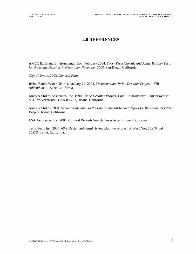
L S A A S S O C I A T E S , I N C . A D D E N D U M # 3 T O T H E F I N A L E N V I R O N M E N T A L I M P A C T R E P O R T A P R I L 2 0 0 5 I R V I N E D E S A L T E R P R O J E C T
P:\IRW333\Revised IDP Project\Final Addendum.doc «09/08/04» 31
4.0 REFERENCES
AMEC Earth and Environmental, Inc., February 2004. Short-Term Chronic and Acute Toxicity Tests for the Irvine Desalter Project: July–November 2003. San Diego, California. City of Irvine. 2003. General Plan. Irvine Ranch Water District. January 22, 2004. Memorandum: Irvine Desalter Project—EIR Addendum 3. Irvine, California. Jones & Stokes Associates, Inc. 1990. Irvine Desalter Project, Final Environmental Impact Report, SCH No. 89010086. (JSA 89-227). Irvine, California. Jones & Stokes. 2001. Second Addendum to the Environmental Impact Report for the Irvine Desalter Project. Irvine, California. LSA Associates, Inc. 2004. Cultural Records Search Cover letter. Irvine, California. Tetra Tech, Inc. 2004. 60% Design Submittal: Irvine Desalter Project, Project Nos. 10376 and 30376. Irvine, California.

L S A A S S O C I A T E S , I N C . A D D E N D U M # 3 T O T H E F I N A L E N V I R O N M E N T A L I M P A C T R E P O R T A P R I L 2 0 0 5 I R V I N E D E S A L T E R P R O J E C T
P:\IRW333\Revised IDP Project\Final Addendum.doc «09/08/04» 32
5.0 LIST OF PREPARERS
LSA ASSOCIATES, INC. Deborah Pracilio, Principal, Project Manager Peter Hersh, Project Manager, Coordinator Noel Legaspi, Environmental Planner ORANGE COUNTY WATER DISTRICT Roy Herndon, Chief Hydrogeologist IRVINE RANCH WATER DISTRICT Steven Malloy, Principal Engineer Patty Lee-Uematsu, Project Engineer

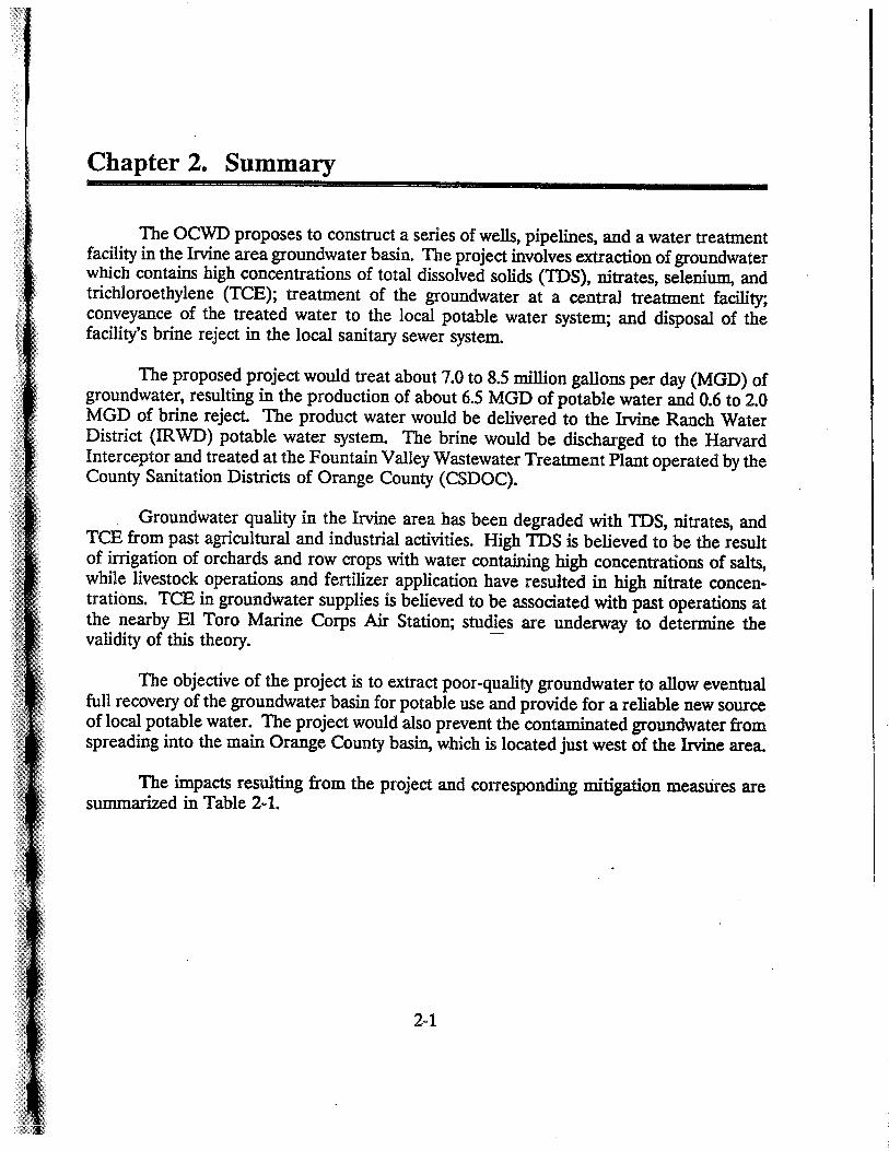

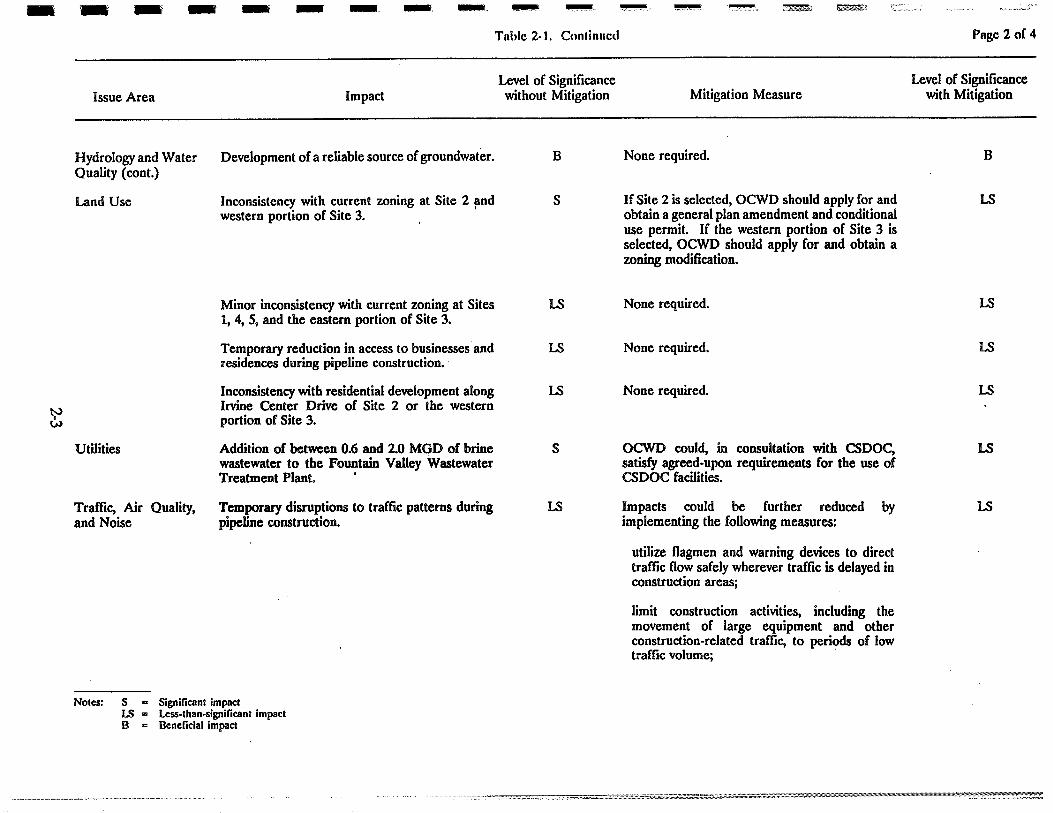
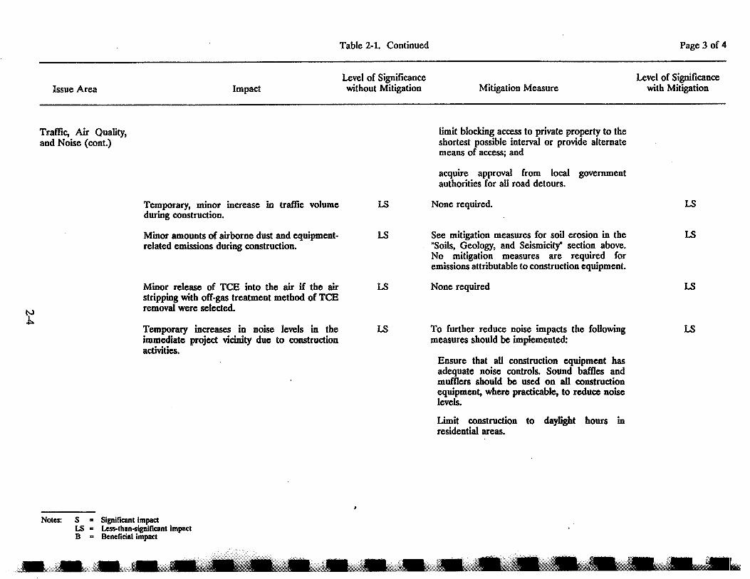


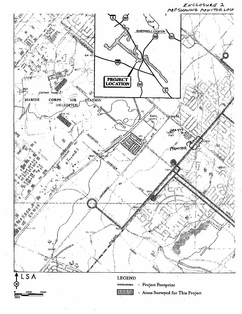
Related Documents