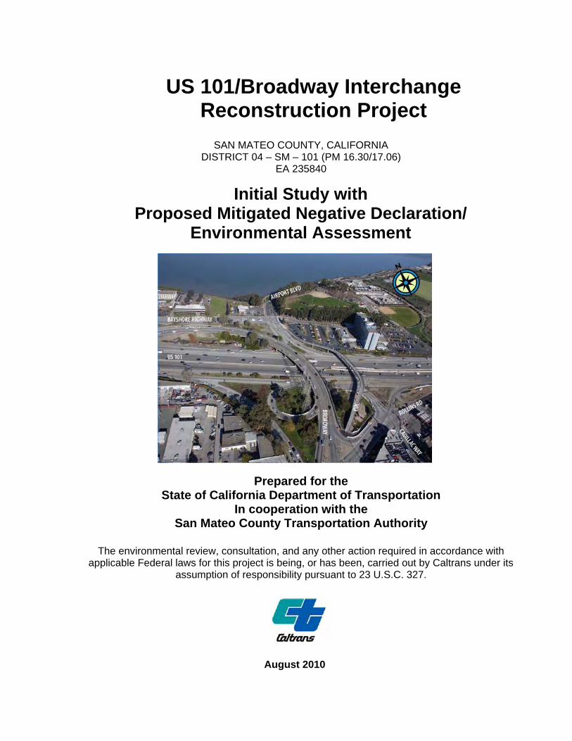
US 101/Broadway Interchange Reconstruction Project SAN MATEO COUNTY, CALIFORNIA DISTRICT 04 – SM – 101 (PM 16.30/17.06) EA 235840 Initial Study with Proposed Mitigated Negative Declaration/ Environmental Assessment Prepared for the State of California Department of Transportation In cooperation with the San Mateo County Transportation Authority The environmental review, consultation, and any other action required in accordance with applicable Federal laws for this project is being, or has been, carried out by Caltrans under its assumption of responsibility pursuant to 23 U.S.C. 327. August 2010

Welcome message from author
This document is posted to help you gain knowledge. Please leave a comment to let me know what you think about it! Share it to your friends and learn new things together.
Transcript
US 101/Broadway Interchange Reconstruction Project
SAN MATEO COUNTY, CALIFORNIA
DISTRICT 04 – SM – 101 (PM 16.30/17.06) EA 235840
Initial Study with Proposed Mitigated Negative Declaration/
Environmental Assessment
Prepared for the State of California Department of Transportation
In cooperation with the San Mateo County Transportation Authority
The environmental review, consultation, and any other action required in accordance with
applicable Federal laws for this project is being, or has been, carried out by Caltrans under its assumption of responsibility pursuant to 23 U.S.C. 327.
August 2010

GENERAL INFORMATION ABOUT THIS DOCUMENT
What’s in this document: This Initial Study/Environmental Assessment (IS/EA), which examines the potential environmental impacts of the proposed project located in the City of Burlingame, San Mateo County, California, has been prepared for the California Department of Transportation (Department), as assigned by the Federal Highway Administration (FHWA). The Department is the lead agency under the National Environmental Policy Act (NEPA) and the California Environmental Quality Act (CEQA). The document tells you why the project is being proposed, what alternatives we have considered for the project, how the existing environment could be affected by the project, the potential impacts of each of the alternatives, and the proposed avoidance, minimization, and/or mitigation measures.
What you should do: • Please read this IS/EA. • Additional copies of this IS/EA, as well as of the technical studies we relied on in
preparing it, are available for review at the Department of Transportation District 4 Office, 111 Grand Avenue, Oakland, CA, and the Burlingame Public Library, 480 Primrose Road, Burlingame, CA 94010.
• Attend the public meeting. The meeting will be held on September 15, 2010, from 6 PM to 8 PM, at the Burlingame Public Library, Lane Room, 480 Primrose Road, Burlingame, CA 94010.
• We’d like to hear what you think. If you have any comments regarding the proposed project, please attend the public meeting and/or send your written comments to the Department by the deadline. – Submit comments via postal mail to:
Department of Transportation, District 4, Ed Pang, Attn: Thomas Rosevear, P.O. Box 23660, Oakland, CA 94623-0660.
– Submit comments via e-mail to: [email protected]. • Be sure to submit comments by the deadline: September 29, 2010, by 5 PM.
What happens next: After comments are received from the public and reviewing agencies, the Department, as assigned by the FHWA, may (1) give environmental approval to the proposed project, (2) do additional environmental studies, or (3) abandon the project. If the project is given environmental approval and funding is appropriated, the Department could design and construct all or part of the project.
For individuals with sensory disabilities, this document is available in Braille, in large print, on audiocassette, or on computer disk. To obtain a copy in one of these alternate formats, please call or write to Department of Transportation, Attn: Gidget Navarro, Office of Public Information, P.O. Box 23660, Oakland, CA, 94623-0660, phone 510-286-5574, email: [email protected], or use the California Relay Service TTY number (800-735-2929).


US 101/Broadway Interchange Reconstruction Project IS/EA iii
Proposed Mitigated Negative Declaration (MND) Pursuant to: Division 13, Public Resources Code
Project Description The California Department of Transportation (Department), in cooperation with the San Mateo County Transportation Authority (SMCTA), proposes to reconfigure the United States Highway 101 (US 101)/Broadway interchange in the City of Burlingame, County of San Mateo, California. The purpose of the project is to improve traffic movements and access around the interchange, accommodate future traffic increases at adjacent intersections, improve operations at the southbound US 101 ramps, and increase bicyclist and pedestrian access. The length of the project is 0.76 mile.
Determination This proposed Mitigated Negative Declaration (MND) is included to give notice to interested agencies and the public that it is the Department’s intent to adopt an MND for this project. This does not mean that the Department’s decision regarding the project is final. This MND is subject to modification based on comments received by interested agencies and the public.
The Department has prepared an Initial Study for this project, and pending public review, expects to determine from this study that the proposed project would not have a significant effect on the environment for the following reasons:
The proposed project would have no effect on growth, farmlands/timberlands, community character and cohesion, environmental justice, and paleontology. In addition, the proposed project would have no significant effect on land use; community impacts (relocations); utilities/emergency services; transportation/pedestrian and bicycle facilities; visual/aesthetics; cultural resources; hydrology and floodplain; water quality and storm water runoff; geology/soils/seismicity/topography; hazardous waste/materials; air quality; noise; natural communities; plant species; animal species; and invasive species. The proposed project would have no significantly adverse effect on wetlands and other waters, because the following mitigation measure would reduce potential effects to insignificance:
• Compensatory mitigation efforts for permanent effects to wetlands and other waters will be determined in consultation with the U.S. Army Corps of Engineers. These may include, but are not limited to, reduction in the amount of impact, options to participate in regional habitat enhancement projects, or purchase of mitigation bank credits.
_____________________________ ________________ BIJAN SARTIPI Date District Director District 4 California Department of Transportation

Summary
US 101/Broadway Interchange Reconstruction Project IS/EA v
Summary
The California Department of Transportation (Department) proposes to reconfigure the United States Highway 101 (US 101)/Broadway interchange in the City of Burlingame, California.
The Department is the lead California Environmental Quality Act (CEQA) agency for the project, and effective July 1, 2007, has been assigned environmental review and consultation responsibilities under the National Environmental Policy Act (NEPA) pursuant to 23 United States Code (USC) 327. The project is proposed in cooperation with the San Mateo County Transportation Authority (SMCTA).
The purpose of the project is to improve traffic movements and access around the interchange, accommodate future traffic increases at adjacent intersections, improve operations at the southbound US 101 ramps, and increase bicyclist and pedestrian access. The Build Alternative would construct a new seven-lane Broadway overcrossing approximately 170 feet to the north of the existing four-lane structure. Broadway would be realigned to extend straight across US 101 from the Broadway/Rollins Road intersection on the west to Bayshore Highway on the east, and the northern terminus of Airport Boulevard would be moved approximately 100 feet to the north to meet the new overcrossing. The existing on- and off-ramps would be replaced, and ramp metering equipment would be installed. The project would retain the existing pedestrian overcrossing just south of Broadway and provide additional pedestrian and bicycle improvements at the interchange. The total length of the project is 0.76 mile (from Post Mile 16.30 to 17.06).
This Initial Study/Environmental Assessment (IS/EA) addresses the proposed project’s potential to have adverse impacts on the environment. Potential impacts and avoidance, minimization, and mitigation measures are summarized in Table S-1.

Summary
vi US 101/Broadway Interchange Reconstruction Project IS/EA
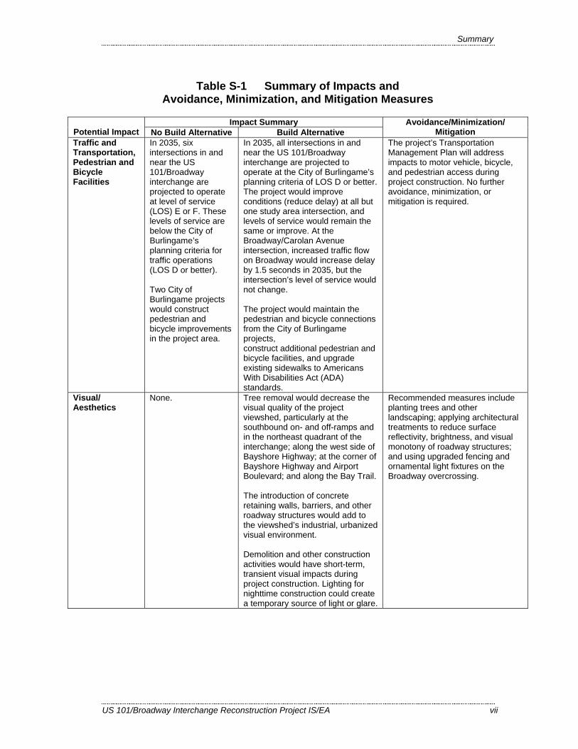
Table S-1 Summary of Impacts and Avoidance, Minimization, and Mitigation Measures
Impact Summary Potential Impact No Build Alternative Build Alternative
Avoidance/Minimization/ Mitigation
Land Use The No Build Alternative would not support City of Burlingame plans that call for improving the US 101/Broadway interchange.
The project would support existing and planned land uses and is consistent with local and regional plans. Temporary closures of the Bay Trail and Bay Trail extension would be required during construction. The realignment of Airport Boulevard would shift the Bay Trail and acquire approximately 800 square feet of the Bay Trail extension. The project would not affect the long-term use of these facilities. Effects to Section 4(f) facilities would be de minimis.
During final design, the Department and SMCTA will develop a detailed trail closure plan to minimize disruption to trail users. The project’s Transportation Management Plan will address impacts to bicycle and pedestrian access during project construction.
Community Impacts: Community Character and Cohesion
None. The project would not displace or relocate any residents, change any existing community boundaries, physically divide an established community, or create a new barrier to movement within the project area.
None required.
Community Impacts: Relocations
None. The project would require acquisition of full and partial parcels or temporary construction easements from commercial and industrial establishments adjacent to the right-of-way. Relocation assistance payments and counseling will be provided to businesses in accordance with the Department’s Relocation Assistance Program.
None required.
Utilities and Emergency Services
None. The project would require relocating sewer, water, electrical, and communications lines.
Measures would be implemented to protect three existing Pacific Gas and Electric Company (PG&E) transmission towers and their foundations during construction. Access will be maintained for emergency response vehicles. No disruption to existing emergency service access is expected.
Summary
US 101/Broadway Interchange Reconstruction Project IS/EA vii
Table S-1 Summary of Impacts and Avoidance, Minimization, and Mitigation Measures
Impact Summary Potential Impact No Build Alternative Build Alternative
Avoidance/Minimization/ Mitigation
Traffic and Transportation, Pedestrian and Bicycle Facilities
In 2035, six intersections in and near the US 101/Broadway interchange are projected to operate at level of service (LOS) E or F. These levels of service are below the City of Burlingame’s planning criteria for traffic operations (LOS D or better). Two City of Burlingame projects would construct pedestrian and bicycle improvements in the project area.
In 2035, all intersections in and near the US 101/Broadway interchange are projected to operate at the City of Burlingame’s planning criteria of LOS D or better. The project would improve conditions (reduce delay) at all but one study area intersection, and levels of service would remain the same or improve. At the Broadway/Carolan Avenue intersection, increased traffic flow on Broadway would increase delay by 1.5 seconds in 2035, but the intersection’s level of service would not change. The project would maintain the pedestrian and bicycle connections from the City of Burlingame projects, construct additional pedestrian and bicycle facilities, and upgrade existing sidewalks to Americans With Disabilities Act (ADA) standards.
The project’s Transportation Management Plan will address impacts to motor vehicle, bicycle, and pedestrian access during project construction. No further avoidance, minimization, or mitigation is required.
Visual/ Aesthetics
None. Tree removal would decrease the visual quality of the project viewshed, particularly at the southbound on- and off-ramps and in the northeast quadrant of the interchange; along the west side of Bayshore Highway; at the corner of Bayshore Highway and Airport Boulevard; and along the Bay Trail. The introduction of concrete retaining walls, barriers, and other roadway structures would add to the viewshed’s industrial, urbanized visual environment. Demolition and other construction activities would have short-term, transient visual impacts during project construction. Lighting for nighttime construction could create a temporary source of light or glare.
Recommended measures include planting trees and other landscaping; applying architectural treatments to reduce surface reflectivity, brightness, and visual monotony of roadway structures; and using upgraded fencing and ornamental light fixtures on the Broadway overcrossing.

Summary
viii US 101/Broadway Interchange Reconstruction Project IS/EA
Table S-1 Summary of Impacts and Avoidance, Minimization, and Mitigation Measures
Impact Summary Potential Impact No Build Alternative Build Alternative
Avoidance/Minimization/ Mitigation
Cultural Resources
None. One archaeological site was reported within the archaeological resources area of potential effects (APE). No subsurface construction activities would take place in the vicinity of the site. Subsurface excavation and pile driving is proposed in previously filled and disturbed areas, and therefore the project is not expected to affect subsurface archaeological resources. No properties in the architectural APE are eligible for the National Register of Historic Places or California Register of Historic Resources, or appear to be historical resources for the purposes of CEQA. The project would not affect a Section 4(f) historic resource.
The archaeological site would be designated an environmentally sensitive area (ESA). The specific method of establishing the ESA would be determined during final design. If cultural materials are discovered during construction, earth-moving activities will be diverted until an archaeologist can assess the find. If human remains are discovered, the procedures described in State law will be implemented.
Hydrology and Floodplains
A drainage channel that passes beneath Bayshore Highway is currently blocked. Flooding occurs around the eastern landing of the Broadway overcrossing.
Parts of the project area are in the 100-year floodplain. The project would require minor fill in Easton Creek and between the existing southbound US 101 off-ramp and the Crowne Plaza Hotel parking lot but is not expected to affect the extent or elevation of flooding. The project will implement one or more drainage modifications to eliminate the flooding around the eastern landing of the Broadway overcrossing.
Measures proposed to avoid and minimize impacts to water quality, storm water runoff, and wetlands and other waters of the U.S. will also avoid and minimize hydrology and floodplain impacts.
Water Quality and Storm Water Runoff
None. Project construction could result in temporary impacts to water quality and storm water runoff from increased erosion and subsequent transport of sediment to surface waters. Spills and fluid leaks from construction vehicles, equipment, or materials may also occur during construction. Groundwater would likely be encountered during construction. The project would increase impervious surface areas by 0.5 acre.
Permanent erosion control best management practices (BMPs) will be included in the project to prevent an adverse change in downstream water quality. Measures will include feasible temporary (short-term) and permanent (long-term) BMPs. Potentially feasible treatment BMPs that will be considered during final design include vegetated swales and buffer strips, and tree well filters. The required Storm Water Pollution Prevention Plan will include storm water BMPs for temporary soil stabilization and sediment control.
Summary
US 101/Broadway Interchange Reconstruction Project IS/EA ix
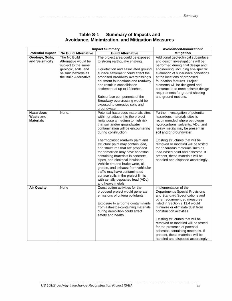
Table S-1 Summary of Impacts and Avoidance, Minimization, and Mitigation Measures
Impact Summary Potential Impact No Build Alternative Build Alternative
Avoidance/Minimization/ Mitigation
Geology, Soils, and Seismicity
The No Build Alternative would be subject to the same geologic, soils, and seismic hazards as the Build Alternative.
The project area could be exposed to strong earthquake shaking. Liquefaction and associated ground surface settlement could affect the proposed Broadway overcrossing’s abutment foundations and roadway and result in consolidation settlement of up to 13 inches. Subsurface components of the Broadway overcrossing would be exposed to corrosive soils and groundwater.
Additional geotechnical subsurface and design investigations will be performed during final design and engineering, including site-specific evaluation of subsurface conditions at the locations of proposed foundation features. Project elements will be designed and constructed to meet seismic design requirements for ground shaking and ground motions.
Hazardous Waste and Materials
None. Potential hazardous materials sites within or adjacent to the project limits pose a medium to high risk that soil and/or groundwater contamination will be encountering during construction. Thermoplastic roadway paint and structure paint may contain lead, and structures that are proposed for demolition may have asbestos-containing materials in concrete, pipes, and electrical insulation. Vehicle tire and brake wear, oil, grease, and exhaust from vehicular traffic may have contaminated surface soils in the project limits with aerially deposited lead (ADL) and heavy metals.
Further investigation of potential hazardous materials sites is recommended where petroleum hydrocarbons, solvents, ADL, and heavy metals may be present in soil and/or groundwater. Existing structures that will be removed or modified will be tested for hazardous materials such as lead-based paint and asbestos. If present, these materials will be handled and disposed accordingly.
Air Quality None Construction activities for the proposed project would generate emissions of criteria pollutants. Exposure to airborne contaminants from asbestos-containing materials during demolition could affect safety and health.
Implementation of the Department’s Special Provisions and Standard Specifications and other recommended measures listed in Section 2.11.4 would minimize or eliminate dust from construction activities. Existing structures that will be removed or modified will be tested for the presence of potential asbestos-containing materials. If present, these materials will be handled and disposed accordingly.

Summary
x US 101/Broadway Interchange Reconstruction Project IS/EA
Table S-1 Summary of Impacts and Avoidance, Minimization, and Mitigation Measures
Impact Summary Potential Impact No Build Alternative Build Alternative
Avoidance/Minimization/ Mitigation
Noise One location studied, the tennis court at the Northpark Apartments, has existing and future noise levels that approach or exceed Federal noise abatement criteria (NAC).
Future noise levels would approach or exceed the NAC at the tennis court at the Northpark Apartments. Noise abatement at the tennis court was studied, a soundwall was determined feasible, and a range of soundwall heights were evaluated. However, no barrier design could reduce traffic sound levels by more than 2 A-weighted decibels (dBA), and therefore soundwall abatement was not considered reasonable (a 5 dBA reduction should be achieved to be reasonable). The Build Alternative would not increase future noise levels at any of the modeled locations. Construction activities would at times generate higher noise levels than existing traffic noise.
The Construction Contractor will be required to implement measures to abate construction noise, including locating stationary noise-generating construction equipment away from noise-sensitive residences, requiring all construction equipment to conform to Section 14-8.02 of the latest Standard Specifications, and instituting a construction noise monitoring program for nighttime construction during demolition.
Natural Communities
None The project has no natural communities of concern and is dominated by urban development. The project would extend the Easton Creek culvert but would not introduce permanent barriers to fish passage. Installation of new freeway ramps, the proposed Broadway overcrossing, and realigned roadways would require removing approximately 71 trees.
A project landscaping plan will be developed during final design and will include tree planting ratios of 1:1 or greater and the use of native species where possible. Tree removal would take place before the start of the nesting season for raptors and migratory birds (February 1) to avoid impacts to birds that are protected under the Migratory Bird Treaty Act. Vegetation would be preserved in areas of the project limits where no construction is planned.
Wetlands and Other Waters of the United States
None Permanent impacts to 0.85 acre of waters of the U.S. would result from constructing new paved roadways, regrading slopes around the footings of the new overcrossing, extending the Easton Creek culvert, and potentially restoring the conveyance capacity of the unnamed drainage channel. Temporary impacts to 0.72 acre of waters of the U.S. would occur in construction access and staging areas as a result of sediment discharge, vegetation removal, and soil compaction.
Temporarily affected areas will be restored to approximately the original site conditions. Compensatory mitigation efforts for permanent effects to wetlands and other waters will be determined in consultation with the U.S. Army Corps of Engineers. These may include, but are not limited to, reduction in the amount of impact, options to participate in regional habitat enhancement projects, or purchase of mitigation bank credits.
Plant Species None No impacts would occur to special-status plant species.
None required.

Summary
US 101/Broadway Interchange Reconstruction Project IS/EA xi
Table S-1 Summary of Impacts and Avoidance, Minimization, and Mitigation Measures
Impact Summary Potential Impact No Build Alternative Build Alternative
Avoidance/Minimization/ Mitigation
Animal Species None Vegetation removal along the project limits would result in minimal habitat loss for nesting raptors and migratory birds, if present. Temporary pile-driving noise is expected to have a negligible effect on individual birds. Temporary impacts to Essential Fish Habitat (EFH) would result from extension of the Easton Creek culvert.
Vegetation will be removed during the nonbreeding season (September 1 to February 1). If construction activities take place during the nesting season, surveys will be conducted, and if nesting birds are found, buffers will be applied until the nesting activity is completed. The project design will incorporate Department BMPs for storm water pollution prevention (Section 2.8.4) and general construction measures (Section 2.16.4.2) to minimize project-related effects to EFH.
Threatened and Endangered Species
None Impacts to California seablite are not expected because the rare plant surveys did not detect the species within the biological study area (BSA). Extension of the Easton Creek culvert could affect marginal foraging habitat for southern Distinct Population Segment (DPS) green sturgeon. The culvert extension would also have a permanent impact on 0.02 acre of designated critical habitat for southern DPS green sturgeon. Project construction would result in permanent (1.83 acre) and temporary (0.49 acre) effects to marginal potential habitat for California red-legged frog (CRLF) and San Francisco garter snake (SFGS). If work in the unnamed drainage channel is required, the project would temporarily affect 0.12 acre of poor to marginal habitat for California black rail, California clapper rail, and salt marsh harvest mouse, but no impacts would occur because the species are considered absent from the BSA.
In addition to the general construction measures listed in Section 2.16.4.2, the following measures would avoid or minimize impacts to specific species. A qualified botanist will conduct a focused preconstruction survey for California seablite during the blooming period (July to October) in 2013 and contact the U.S. Fish and Wildlife Service for guidance if the species is identified. To avoid and minimize potential effects to southern DPS green sturgeon and its designated critical habitat, in-stream work in Easton Creek and the unnamed drainage will take place during the dry season (April 15 through October 15). Cofferdams in Easton Creek will be installed during low tide and use only clean gravel or sand fill. A qualified biological monitor will be present during cofferdam installation and removal. If work in the unnamed drainage channel is required, sediment and berm removal will take place during low tide. Exclusion fencing, use of appropriate erosion control materials, a focused preconstruction survey, and biological monitoring during removal of potential habitat would avoid or minimize effects to CRLF and SFGS.
Summary
xii US 101/Broadway Interchange Reconstruction Project IS/EA
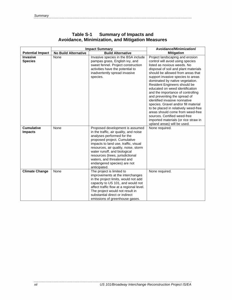
Table S-1 Summary of Impacts and Avoidance, Minimization, and Mitigation Measures
Impact Summary Potential Impact No Build Alternative Build Alternative
Avoidance/Minimization/ Mitigation
Invasive Species
None Invasive species in the BSA include pampas grass, English ivy, and sweet fennel. Project construction activities have the potential to inadvertently spread invasive species.
Project landscaping and erosion control will avoid using species listed as noxious weeds. No disposal of soil and plant materials should be allowed from areas that support invasive species to areas dominated by native vegetation. Resident Engineers should be educated on weed identification and the importance of controlling and preventing the spread of identified invasive nonnative species. Gravel and/or fill material to be placed in relatively weed-free areas should come from weed-free sources. Certified weed-free imported materials (or rice straw in upland areas) will be used.
Cumulative Impacts
None Proposed development is assumed in the traffic, air quality, and noise analyses performed for the proposed project. Cumulative impacts to land use, traffic, visual resources, air quality, noise, storm water runoff, and biological resources (trees, jurisdictional waters, and threatened and endangered species) are not anticipated.
None required.
Climate Change None The project is limited to improvements at the interchanges in the project limits, would not add capacity to US 101, and would not affect traffic flow at a regional level. The project would not result in substantial direct or indirect emissions of greenhouse gases.
None required.
US 101/Broadway Interchange Reconstruction Project IS/EA xiii
Table of Contents
Cover Sheet ...................................................................................................................... i Proposed Mitigated Negative Declaration (MND) .................................................................. iii Summary ......................................................................................................................v Table of Contents .................................................................................................................. xiii List of Figures .................................................................................................................. xvi List of Tables ................................................................................................................. xvii Chapter 1. Proposed Project....................................................................................... 1-1 1.1. Introduction............................................................................................................... 1-1
1.1.1. Location and Route Description .................................................................. 1-1 1.1.2. Background.................................................................................................. 1-2
1.2. Purpose and Need ..................................................................................................... 1-5 1.2.1. Project Purpose ............................................................................................ 1-5 1.2.2. Project Need................................................................................................. 1-6
1.3. Project Description ................................................................................................. 1-12 1.3.1. Build Alternative ....................................................................................... 1-12 1.3.2. No Build Alternative.................................................................................. 1-18 1.3.3. Final Decision Making Process ................................................................. 1-18
1.4. Alternatives Considered But Eliminated From Further Discussion........................ 1-18 1.5. Permits and Approvals Needed............................................................................... 1-21 Chapter 2. Affected Environment, Environmental Consequences, and Avoidance,
Minimization, and/or Mitigation Measures .............................................. 2-1 Human Environment .............................................................................................................. 2-3 2.1. Land Use................................................................................................................... 2-3
2.1.1. Existing and Future Land Use ..................................................................... 2-3 2.1.2. Consistency with State, Regional, and Local Plans and Programs.............. 2-9 2.1.3. Coastal Zone .............................................................................................. 2-12 2.1.4. Parks and Recreation ................................................................................. 2-13
2.2. Community Impacts................................................................................................ 2-19 2.2.1. Community Character and Cohesion......................................................... 2-19 2.2.2. Relocations and Real Property Acquisition ............................................... 2-24
2.3. Utilities and Emergency Services ........................................................................... 2-30 2.3.1. Affected Environment ............................................................................... 2-30 2.3.2. Environmental Consequences.................................................................... 2-31 2.3.3. Avoidance, Minimization, or Mitigation Measures................................... 2-32
2.4. Traffic and Transportation/Pedestrian and Bicycle Facilities................................. 2-32 2.4.1. Regulatory Setting ..................................................................................... 2-32 2.4.2. Affected Environment ............................................................................... 2-33 2.4.3. Environmental Consequences.................................................................... 2-40 2.4.4. Avoidance, Minimization, and/or Mitigation Measures ............................ 2-44
2.5. Visual/Aesthetics .................................................................................................... 2-45 2.5.1. Regulatory Setting ..................................................................................... 2-45 2.5.2. Affected Environment ............................................................................... 2-45 2.5.3. Environmental Consequences.................................................................... 2-49 2.5.4. Avoidance, Minimization, and/or Mitigation Measures ............................ 2-69
2.6. Cultural Resources.................................................................................................. 2-70 2.6.1. Regulatory Setting ..................................................................................... 2-71 2.6.2. Affected Environment ............................................................................... 2-71 2.6.3. Environmental Consequences.................................................................... 2-73

Table of Contents
xiv US 101/Broadway Interchange Reconstruction Project IS/EA
2.6.4. Avoidance, Minimization, and/or Mitigation Measures.............................2-74 Physical Environment...........................................................................................................2-75 2.7. Hydrology and Floodplain ......................................................................................2-75
2.7.1. Regulatory Setting......................................................................................2-75 2.7.2. Affected Environment ................................................................................2-75 2.7.3. Environmental Consequences ....................................................................2-77 2.7.4. Avoidance, Minimization, and/or Mitigation Measures.............................2-78
2.8. Water Quality and Storm Water Runoff..................................................................2-79 2.8.1. Regulatory Setting......................................................................................2-79 2.8.2. Affected Environment ................................................................................2-83 2.8.3. Environmental Consequences ....................................................................2-84 2.8.4. Avoidance, Minimization, and/or Mitigation Measures.............................2-85
2.9. Geology, Soils, and Seismicity................................................................................2-88 2.9.1. Regulatory Setting......................................................................................2-88 2.9.2. Affected Environment ................................................................................2-88 2.9.3. Environmental Consequences ....................................................................2-91 2.9.4. Avoidance, Minimization, and/or Mitigation Measures.............................2-91
2.10. Hazardous Waste and Materials ..............................................................................2-91 2.10.1. Regulatory Setting......................................................................................2-91 2.10.2. Affected Environment ................................................................................2-92 2.10.3. Environmental Consequences ....................................................................2-93 2.10.4. Avoidance, Minimization, and/or Mitigation Measures.............................2-97
2.11. Air Quality...............................................................................................................2-98 2.11.1. Regulatory Setting......................................................................................2-98 2.11.2. Affected Environment ................................................................................2-99 2.11.3. Environmental Consequences ..................................................................2-101 2.11.4. Avoidance, Minimization, and/or Mitigation Measures...........................2-108
2.12. Noise .....................................................................................................................2-110 2.12.1. Regulatory Setting....................................................................................2-110 2.12.2. Affected Environment ..............................................................................2-113 2.12.3. Environmental Consequences ..................................................................2-114 2.12.4. Avoidance, Minimization, and/or Abatement Measures..........................2-117
Biological Environment......................................................................................................2-118 2.13. Natural Communities ............................................................................................2-118
2.13.1. Affected Environment ..............................................................................2-118 2.13.2. Environmental Consequences ..................................................................2-120 2.13.3. Avoidance, Minimization, and/or Mitigation Measures...........................2-120
2.14. Wetlands and Other Waters of the United States ..................................................2-121 2.14.1. Regulatory Setting....................................................................................2-121 2.14.2. Affected Environment ..............................................................................2-122 2.14.3. Environmental Consequences ..................................................................2-123 2.14.4. Avoidance, Minimization, and/or Mitigation Measures...........................2-129
2.15. Plant Species .........................................................................................................2-131 2.15.1. Regulatory Setting....................................................................................2-131 2.15.2. Affected Environment ..............................................................................2-131 2.15.3. Environmental Consequences ..................................................................2-132 2.15.4. Avoidance, Minimization, and/or Mitigation Measures...........................2-132
2.16. Animal Species......................................................................................................2-132 2.16.1. Regulatory Setting....................................................................................2-132 2.16.2. Affected Environment ..............................................................................2-133 2.16.3. Environmental Consequences ..................................................................2-135

Table of Contents
US 101/Broadway Interchange Reconstruction Project IS/EA xv
2.16.4. Avoidance, Minimization, and/or Mitigation Measures .......................... 2-136 2.17. Threatened and Endangered Species .................................................................... 2-139
2.17.1. Regulatory Setting ................................................................................... 2-139 2.17.2. Affected Environment ............................................................................. 2-140 2.17.3. Environmental Consequences.................................................................. 2-151 2.17.4. Avoidance, Minimization, and/or Mitigation Measures .......................... 2-156
2.18. Invasive Species.................................................................................................... 2-158 2.18.1. Regulatory Setting ................................................................................... 2-158 2.18.2. Affected Environment ............................................................................. 2-159 2.18.3. Environmental Consequences.................................................................. 2-159 2.18.4. Avoidance, Minimization, and/or Mitigation Measures .......................... 2-159
Cumulative Impacts ........................................................................................................... 2-161 2.19. Cumulative Impacts .............................................................................................. 2-161
2.19.1. Regulatory Setting ................................................................................... 2-161 2.19.2. Projects Considered for Cumulative Impacts .......................................... 2-161 2.19.3. Environmental Consequences.................................................................. 2-166
2.20. Climate Change (CEQA) ...................................................................................... 2-172 2.20.1. Regulatory Setting ................................................................................... 2-172 2.20.2. Project Analysis ....................................................................................... 2-175 2.20.3. Construction Emissions ........................................................................... 2-177 2.20.4. AB 32 Compliance .................................................................................. 2-177 2.20.5. Adaptation Strategies............................................................................... 2-181
Chapter 3. Comments and Coordination.................................................................... 3-1 3.1. Initial Project Development and Public Participation............................................... 3-1 3.2. Consultation and Coordination with Public Agencies .............................................. 3-2 3.3. Circulation, Review, and Comment on the Draft Environmental Document ........... 3-3 Chapter 4. List of Preparers ....................................................................................... 4-1 Chapter 5. Distribution List ....................................................................................... 5-1 Chapter 6. References ................................................................................................ 6-1 Appendix A Project Plans ............................................................................................ A-1 Appendix B CEQA Checklist .......................................................................................B-1 Appendix C Title VI Policy Statement .........................................................................C-1 Appendix D Summary of Relocation Benefits............................................................. D-1 Appendix E Glossary of Technical Terms....................................................................E-1 Appendix F Minimization and/or Mitigation Summary............................................... F-1 Appendix G List of Acronyms..................................................................................... G-1 Appendix H List of Technical Studies ......................................................................... H-1 Appendix I U.S. Fish and Wildlife Service Species List.............................................. I-1

xvi US 101/Broadway Interchange Reconstruction Project IS/EA
List of Figures
Figure 1-1 Project Location, Vicinity, and Proposed Project .....................................1-3 Figure 1-2 Levels of Service for Signalized and Unsignalized Intersections .............1-8 Figure 2.1-1 Land Use ...................................................................................................2-5 Figure 2.1-2 Section 4(f) Resources Near the Project Limits ......................................2-15 Figure 2.2-1 Community Impact Assessment Study Area...........................................2-21 Figure 2.2-2 Properties Potentially Affected By The Project ......................................2-25 Figure 2.4-1 Existing and 2035 No Build Alternative Lane Geometries.....................2-39 Figure 2.4-2 Build Alternative Lane Geometries ........................................................2-42 Figure 2.5-1 Project Viewshed, Landscape Units, and Key Viewpoints .....................2-47 Figure 2.5-2 View from US 101, Looking Southeast ..................................................2-51 Figure 2.5-3 View from Rollins Road at Cadillac Way, Looking Northeast...............2-53 Figure 2.5-4 Views Toward Bay from Existing Broadway Overcrossing and
Pedestrian Overcrossing..........................................................................2-55 Figure 2.5-5 Simulated View Toward Bay from Proposed Broadway Overcrossing..2-57 Figure 2.5-6 View Westward from Bay Trail, Along Airport Boulevard....................2-59 Figure 2.5-7 Views from Bayshore Highway, Northpark Apartments, and Auto
Row .........................................................................................................2-61 Figure 2.7-1 FEMA Flood Insurance Rate Map for Proposed Project Limits .............2-76 Figure 2.12-1 Noise Levels of Common Activities .....................................................2-112 Figure 2.14-1 Impacts to Potentially Jurisdictional Features.......................................2-125 Figure 2.14-2 Impacts to Potentially Jurisdictional Features.......................................2-127 Figure 2.17-1 Potential Special-Species Habitat in the Biological Study Area...........2-147 Figure 2.20-1 California Greenhouse Gas Inventory...................................................2-175 Figure 2.20-2 Fleet CO2 Emissions vs. Speed (Highway)...........................................2-176 Figure 2.20-3 Outcome of Strategic Growth Plan .......................................................2-178

xvii US 101/Broadway Interchange Reconstruction Project IS/EA
List of Tables
Table S-1 Summary of Impacts and Avoidance, Minimization, and Mitigation Measures..................................................................................................... vi
Table 1-1 Traffic Accident Data ............................................................................. 1-10 Table 1-2 Regulatory Permits and Approvals......................................................... 1-21 Table 2.1-1 Recent and Proposed Development Projects in City of Burlingame ........ 2-7 Table 2.2-1 Properties Potentially Affected by the Project........................................ 2-27 Table 2.3-1 Proposed Utility Relocations .................................................................. 2-31 Table 2.4-1 Intersection Levels of Service, Existing Conditions............................... 2-36 Table 2.4-2 Future (2035) Intersection Levels of Service, No Build Alternative...... 2-37 Table 2.4-3 Future (2035) Intersection Levels of Service, No Build and Build
Alternatives............................................................................................. 2-40 Table 2.5-1 Visual Mitigation Measures.................................................................... 2-70 Table 2.8-1 Minimum Requirements for Temporary BMPs...................................... 2-86 Table 2.10-1 Potential Hazardous Materials Sites ....................................................... 2-94 Table 2.11-1 State and National Ambient Air Quality Standards.............................. 2-100 Table 2.11-2 CALINE4 CO Modeling Results.......................................................... 2-103 Table 2.12-1 Federal Noise Abatement Criteria ........................................................ 2-111 Table 2.12-2 Loudest Hour Noise Levels and Impacts, Leq(hr) dBA........................... 2-114 Table 2.14-1 Summary of Potentially Jurisdictional Waters of the U.S. in the BSA 2-123 Table 2.14-2 Summary of Impacts to Waters of the U.S. by Feature ........................ 2-124 Table 2.17-1 Threatened and Endangered Species Considered in the Biological Study
Area ...................................................................................................... 2-140 Table 2.20-1 Climate Change Strategies.................................................................... 2-180


US 101/Broadway Interchange Reconstruction Project IS/EA 1-1
1
Chapter 1. Proposed Project
1.1. Introduction
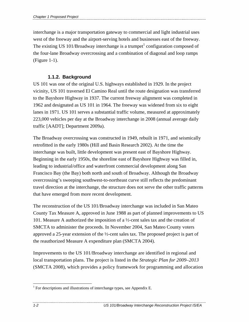
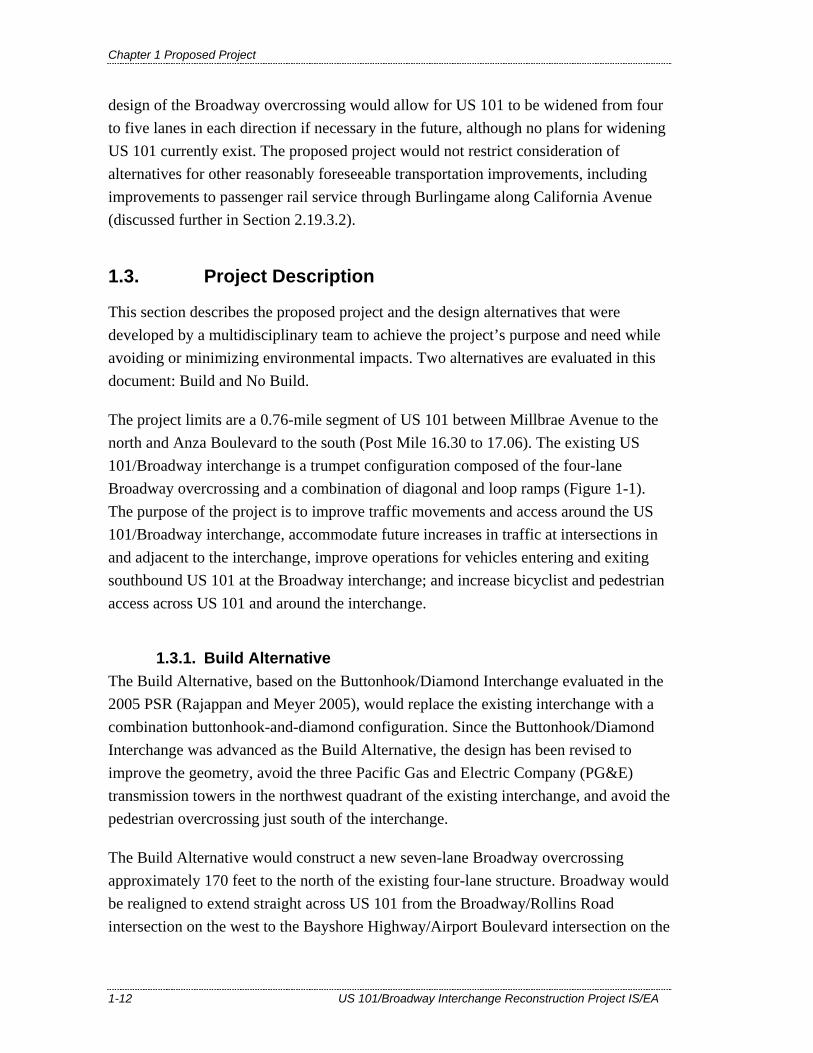
The California Department of Transportation (Department), in cooperation with the San Mateo County Transportation Authority (SMCTA), proposes to reconfigure the United States Highway 101 (US 101)/Broadway interchange in the City of Burlingame, County of San Mateo, California. The existing interchange has circuitous traffic movements, substandard weaving distances, and inadequate capacity to accommodate projected traffic growth. The total length of the project is 0.76 mile (from Post Mile 16.30 to 17.06). Figure 1-1 shows the project location and vicinity.
This project is included in the Metropolitan Transportation Commission’s (MTC) current Regional Transportation Plan (RTP), the Transportation 2035 Plan for the San Francisco Bay Area (MTC 2009a, RTP ID No. 21602). The project is also included in the 2009 Transportation Improvement Program (TIP), which was adopted by MTC on May 28, 2008 (TIP ID No. SM-050028). The Federal Highway Administration (FHWA) and Federal Transit Administration (FTA) approved the 2009 TIP on November 17, 2008.
The Department is the lead California Environmental Quality Act (CEQA) agency for the project and, effective July 1, 2007, has been assigned environmental review and consultation responsibilities under the National Environmental Policy Act (NEPA) pursuant to 23 United States Code (USC) 327. Therefore, the Department is also the NEPA lead agency for the project.
1.1.1. Location and Route Description US 101 is a major north-south corridor that extends from the Oregon border to Los Angeles. The route serves local and interregional traffic along the San Francisco Peninsula and the greater Bay Area, connecting downtown San Francisco and San Francisco International Airport (SFO) with San Jose and Silicon Valley to the south. The segment of US 101 in the project limits, also known as the Bayshore Freeway, has eight through lanes with auxiliary lanes in both directions and ramp metering lights at the Broadway on-ramps and off-ramps.
The US 101/Broadway interchange provides access to US 101 from Broadway, Rollins Road, Bayshore Highway, and Airport Boulevard in the City of Burlingame. The
Chapter 1 Proposed Project
1-2 US 101/Broadway Interchange Reconstruction Project IS/EA
interchange is a major transportation gateway to commercial and light industrial uses west of the freeway and the airport-serving hotels and businesses east of the freeway. The existing US 101/Broadway interchange is a trumpet1 configuration composed of the four-lane Broadway overcrossing and a combination of diagonal and loop ramps (Figure 1-1).
1.1.2. Background US 101 was one of the original U.S. highways established in 1929. In the project vicinity, US 101 traversed El Camino Real until the route designation was transferred to the Bayshore Highway in 1937. The current freeway alignment was completed in 1962 and designated as US 101 in 1964. The freeway was widened from six to eight lanes in 1971. US 101 serves a substantial traffic volume, measured at approximately 223,000 vehicles per day at the Broadway interchange in 2008 (annual average daily traffic [AADT]; Department 2009a).
The Broadway overcrossing was constructed in 1949, rebuilt in 1971, and seismically retrofitted in the early 1980s (Hill and Basin Research 2002). At the time the interchange was built, little development was present east of Bayshore Highway. Beginning in the early 1950s, the shoreline east of Bayshore Highway was filled in, leading to industrial/office and waterfront commercial development along San Francisco Bay (the Bay) both north and south of Broadway. Although the Broadway overcrossing’s sweeping southwest-to-northeast curve still reflects the predominant travel direction at the interchange, the structure does not serve the other traffic patterns that have emerged from more recent development.
The reconstruction of the US 101/Broadway interchange was included in San Mateo County Tax Measure A, approved in June 1988 as part of planned improvements to US 101. Measure A authorized the imposition of a ½-cent sales tax and the creation of SMCTA to administer the proceeds. In November 2004, San Mateo County voters approved a 25-year extension of the ½-cent sales tax. The proposed project is part of the reauthorized Measure A expenditure plan (SMCTA 2004).
Improvements to the US 101/Broadway interchange are identified in regional and local transportation plans. The project is listed in the Strategic Plan for 2009–2013 (SMCTA 2008), which provides a policy framework for programming and allocation
1 For descriptions and illustrations of interchange types, see Appendix E.
San
FranciscoBay
Rollins Rd
MillsCreek
Sanchez
Creek
BaysidePark
City of BurlingameWater Treatment
Facility
BroadwayCaltrain
SOUTHERN PROJECTLIMIT: PM 16.30
NORTHERN PROJECTLIMIT: PM 17.06
Crowne PlazaHotel Driveway
Existing PedestrianOvercrossing
Marsten Rd
Burlingame
Lagoon
Rollins Rd
California Dr
Airport Blvd
Broadway
BayshoreHwy
EastonCreek
GroveAve
LincolnAve
AdrianRd
JuanitaAve
CadillacWay
RhinetteAve
BurlwayRd
Caltrain Tracks
EdwardsRd
Carolan Ave
£¤101
US 101/BROADWAY INTERCHANGERECONSTRUCTION PROJECT
BURLINGAME, CAEA 235840
\\S021emc2\gisdata\Projects\US101_Broadway_SMTA_28645059\Maps\Community_Impact_Assessment\Fig_1-1_Project_location.mxd-5/12/2010@1:53:35PM
URSCorp-OaklandCA-J.Owen
FIGURE 1-1
PROJECT LOCATION AND PROPOSED PROJECT
Project location
§̈¦
£¤101
UV82
UV35
San FranciscoInternational Airport
San Mateo
Burlingame
Hillsborough
Millbrae
Map area
Fresno
Redding
San Diego
Bakersfield
Los Angeles
San Francisco
Sacramento
Proposed Project Footprint
Edge of Paved Roadway
Existing Pedestrian Overcrossing
Sidewalk
Creek
Imagery source: DigitalGlobe ImageConnect Service, 5/1/2009
0 200 400100
FEET$

Chapter 1 Proposed Project
US 101/Broadway Interchange Reconstruction Project IS/EA 1-5
decisions within the structure established by the Measure A expenditure plan. The Countywide Transportation Plan 2010 (C/CAG 2001) identifies the SMCTA Strategic Plan projects as significant highway improvements to help relieve congestion on US 101.
In 1990, the Department prepared a Project Study Report (PSR)2 (EA 04-217-23584G) for the reconstruction of the US 101/Broadway interchange, which was approved on July 16, 1990. However, the PSR did not proceed to the next phase of project development as the City of Burlingame had concerns about the proposed alternatives.
Beginning in 2000, a new PSR was prepared based on the latest requirements and standards (Rajappan and Meyer 2005). In preparing the new PSR, the consultant re-evaluated the previous alternatives and developed a new alternative called the Buttonhook/Diamond Interchange,3 which was approved on November 22, 2005. The Buttonhook/Diamond Interchange alternative was the basis for the Build Alternative evaluated in this document (Figure 1-1; see Section 1.3.1).
In spring 2007, construction began on 4.5 miles of auxiliary lanes in both directions of US 101 between Millbrae Avenue in Millbrae and Third Avenue in San Mateo, excluding the US 101/Broadway interchange. The US 101 Auxiliary Lanes Project reconstructed the US 101/Peninsula Avenue interchange and the Monte Diablo pedestrian/bicycle overcrossing, installed ramp metering equipment, and built soundwalls (Department and SMCTA 2003). The project also constructed a pedestrian/bicycle overcrossing (now completed; hereafter referred to as the pedestrian overcrossing) just south of the Broadway overcrossing.
1.2. Purpose and Need
1.2.1. Project Purpose The purpose of the project is to:
• Improve traffic movements and access around the US 101/Broadway interchange; • Accommodate future increases in traffic at intersections in and adjacent to the
interchange; 2 The PSR defines the scope, schedule and estimated cost of a project for consideration for future transportation funding. The approval of the PSR is one of the necessary steps to define alternatives and begin a detailed consideration of their merits and feasibility in the Project Report and Environmental Document. 3 For descriptions and illustrations of interchange types, see Appendix E.
Chapter 1 Proposed Project
1-6 US 101/Broadway Interchange Reconstruction Project IS/EA
• Improve operations for vehicles entering and exiting southbound US 101 at the Broadway interchange; and
• Increase bicyclist and pedestrian access across US 101 and around the interchange.
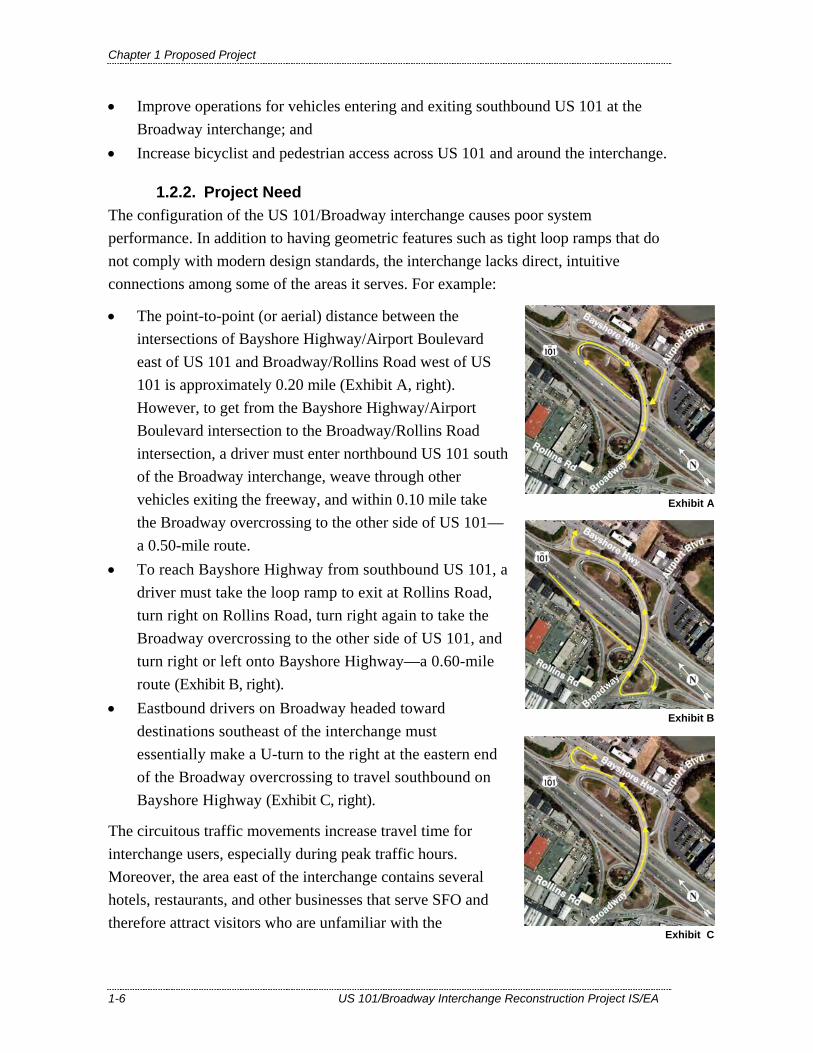
1.2.2. Project Need The configuration of the US 101/Broadway interchange causes poor system performance. In addition to having geometric features such as tight loop ramps that do not comply with modern design standards, the interchange lacks direct, intuitive connections among some of the areas it serves. For example:
Exhibit A
Exhibit B
• The point-to-point (or aerial) distance between the intersections of Bayshore Highway/Airport Boulevard east of US 101 and Broadway/Rollins Road west of US 101 is approximately 0.20 mile (Exhibit A, right). However, to get from the Bayshore Highway/Airport Boulevard intersection to the Broadway/Rollins Road intersection, a driver must enter northbound US 101 south of the Broadway interchange, weave through other vehicles exiting the freeway, and within 0.10 mile take the Broadway overcrossing to the other side of US 101—a 0.50-mile route.
• To reach Bayshore Highway from southbound US 101, a driver must take the loop ramp to exit at Rollins Road, turn right on Rollins Road, turn right again to take the Broadway overcrossing to the other side of US 101, and turn right or left onto Bayshore Highway—a 0.60-mile route (Exhibit B, right).
• Eastbound drivers on Broadway headed toward destinations southeast of the interchange must essentially make a U-turn to the right at the eastern end of the Broadway overcrossing to travel southbound on Bayshore Highway (Exhibit C, right).
The circuitous traffic movements increase travel time for interchange users, especially during peak traffic hours. Moreover, the area east of the interchange contains several hotels, restaurants, and other businesses that serve SFO and therefore attract visitors who are unfamiliar with the
Exhibit C

Chapter 1 Proposed Project
US 101/Broadway Interchange Reconstruction Project IS/EA 1-7
interchange and local roadway system. Area business owners have reported to the City of Burlingame that clients get lost and have difficulty reaching their destinations while trying to navigate through the interchange.
The US 101/Broadway interchange also lacks capacity to accommodate projected future traffic volumes, as described further in the following sections.
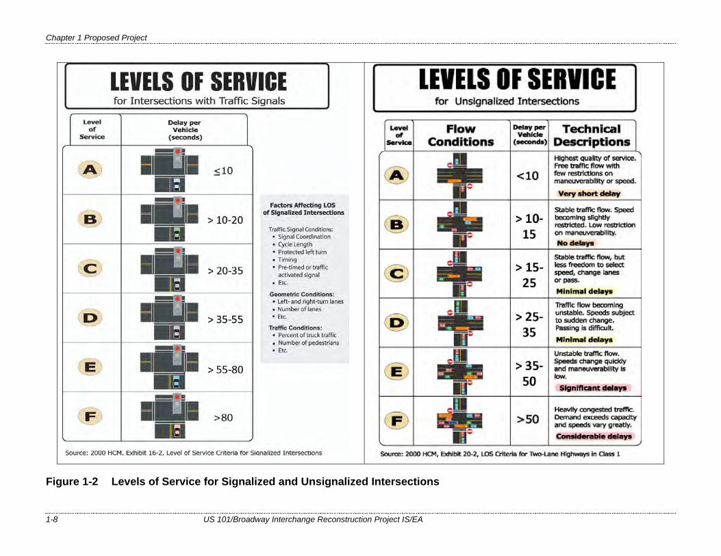
1.2.2.1. Capacity, Transportation Demand, and Safety Level of service (LOS) is an indicator of operational conditions on a roadway or at an intersection and is defined in categories ranging from A to F. These categories can be viewed much like school grades, with A representing the best roadway conditions and F indicating substantial congestion with stop-and-go traffic. At intersections, LOS is evaluated in terms of delay caused by vehicles slowing or stopping due to a signal, a stop sign, or queue caused by congestion (Figure 1-2). At signalized intersections, LOS A indicates that vehicles are delayed by 10 seconds or less, and LOS F represents delays of more than 80 seconds. At unsignalized intersections, LOS A indicates that vehicles are delayed by less than 10 seconds, and LOS F indicates delays of more than 50 seconds. In accordance with City of Burlingame planning criteria, LOS E and F are considered unacceptable.
All intersections in and adjacent to the US 101/Broadway interchange currently operate at acceptable levels of service (URS 2010a). However, the traffic forecast and operational analysis completed for the US 101/Broadway interchange and adjacent intersections shows that three intersections are currently at the threshold of acceptable conditions (LOS D, with delays that are less than 10 seconds from the threshold for LOS E). By 2035, six intersections surrounding the US 101/Broadway interchange will operate at unacceptable levels of service:
• Broadway/US 101 northbound on-ramp/Bayshore Highway (LOS E during the morning (AM) peak hour4);
• Broadway/US 101 southbound off-ramp/Rollins Road (LOS F during the AM and afternoon/evening [PM] peak hours);
• Cadillac Way/US 101 southbound ramps/Rollins Road (LOS F during the AM and PM peak hours);
• Broadway/Carolan Avenue (LOS F during the AM peak hour);
4 The AM peak hour in both directions of US 101 at the Broadway interchange is 7:00 to 8:00 AM. The PM peak hour is 5:00 PM to 6:00 PM in the northbound direction and 4:00 PM and 5:00 PM in the southbound direction (URS 2010a).
Chapter 1 Proposed Project
1-8 US 101/Broadway Interchange Reconstruction Project IS/EA
Figure 1-2 Levels of Service for Signalized and Unsignalized Intersections
Chapter 1 Proposed Project
US 101/Broadway Interchange Reconstruction Project IS/EA 1-9
• Broadway/California Drive (LOS E during the AM and PM peak hours); and • Cadillac Way/Carolan Avenue (LOS E during the AM peak hour and LOS F
during the PM peak hour).
The multiple traffic movements at the Broadway/US 101 southbound off-ramp/Rollins Road intersection and the Cadillac Way/US 101 southbound ramps/Rollins Road intersection constrain the number of vehicles that are able to pass through each signal cycle.
Poor operating conditions and long delays at the Broadway/US 101 southbound off-ramp/Rollins Road intersection would increasingly induce drivers to use Cadillac Way to travel between southbound US 101 and destinations west of the freeway. In the PM peak hour, this would result in LOS F conditions and delays of more than two minutes at the intersection of Cadillac Way and Carolan Avenue. Additional information about future traffic conditions is presented in Section 2.4.
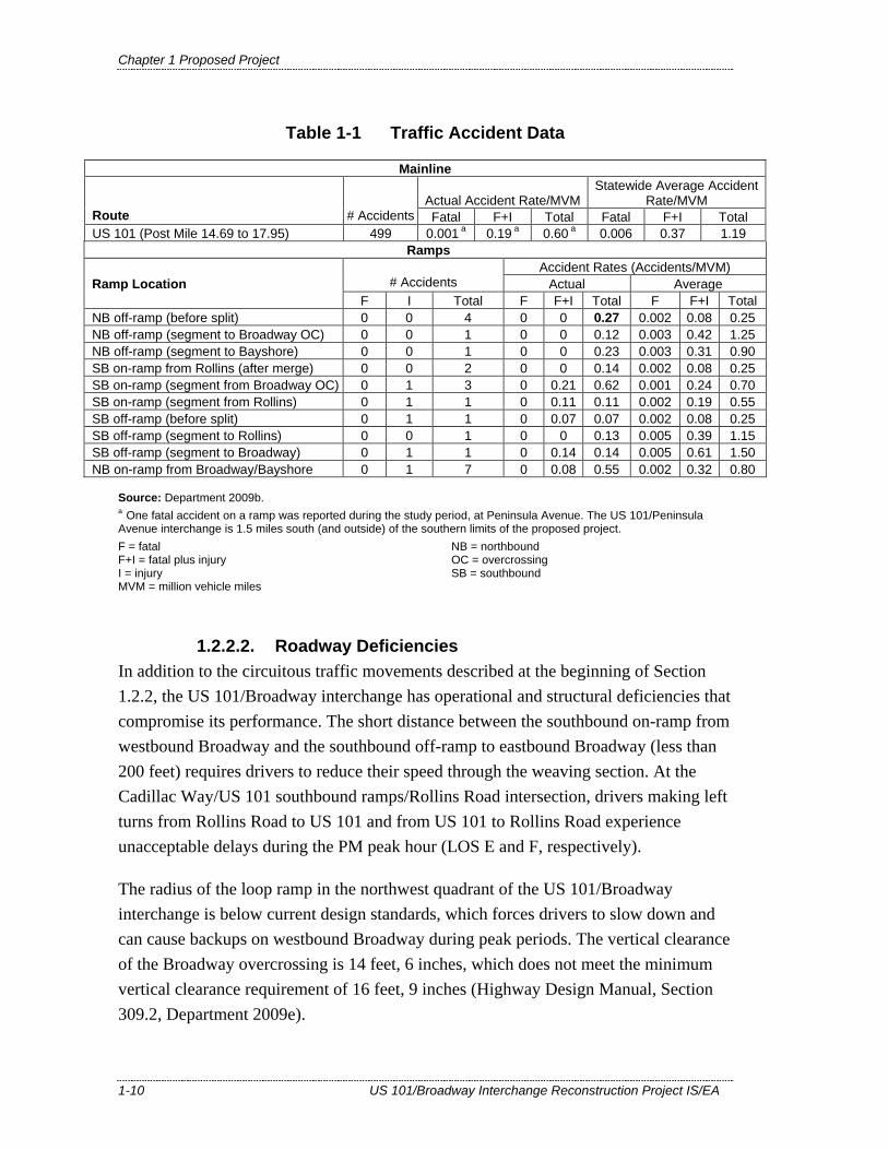
Traffic Accident Surveillance and Analysis System (TASAS) data are summarized in Table 1-1 for US 101 in the project area for the period of April 1, 2005, through March 31, 2008 (Department 2009b). The data are expressed as accidents per million vehicle miles (MVM) traveled and accidents per million vehicles for ramps. The data show that 48.50 percent of accidents in the project area occur on northbound US 101 and 51.50 percent occur on southbound US 101. The total accident rate on this segment of US 101 (0.60 accidents/MVM) is less than the Statewide average for similar freeways (1.19 accidents/MVM).
The accident rates for the mainline and ramp movements listed in Table 1-1 are below the statewide average, with the exception of the northbound off-ramp to Broadway. The rate for this ramp (0.27 accidents/MVM) is slightly above the State average (0.25 accidents/MVM). According to the TASAS data, “hit object” collisions account for half of the accidents in this location, and the remaining accidents are evenly divided between sideswipe and rear-end collisions.
Chapter 1 Proposed Project
1-10 US 101/Broadway Interchange Reconstruction Project IS/EA
Table 1-1 Traffic Accident Data
Mainline
Actual Accident Rate/MVMStatewide Average Accident
Rate/MVM Route # Accidents Fatal F+I Total Fatal F+I Total US 101 (Post Mile 14.69 to 17.95) 499 0.001 a 0.19 a 0.60 a 0.006 0.37 1.19
Ramps Accident Rates (Accidents/MVM)
# Accidents Actual Average Ramp Location F I Total F F+I Total F F+I Total NB off-ramp (before split) 0 0 4 0 0 0.27 0.002 0.08 0.25 NB off-ramp (segment to Broadway OC) 0 0 1 0 0 0.12 0.003 0.42 1.25 NB off-ramp (segment to Bayshore) 0 0 1 0 0 0.23 0.003 0.31 0.90 SB on-ramp from Rollins (after merge) 0 0 2 0 0 0.14 0.002 0.08 0.25 SB on-ramp (segment from Broadway OC) 0 1 3 0 0.21 0.62 0.001 0.24 0.70 SB on-ramp (segment from Rollins) 0 1 1 0 0.11 0.11 0.002 0.19 0.55 SB off-ramp (before split) 0 1 1 0 0.07 0.07 0.002 0.08 0.25 SB off-ramp (segment to Rollins) 0 0 1 0 0 0.13 0.005 0.39 1.15 SB off-ramp (segment to Broadway) 0 1 1 0 0.14 0.14 0.005 0.61 1.50 NB on-ramp from Broadway/Bayshore 0 1 7 0 0.08 0.55 0.002 0.32 0.80
Source: Department 2009b. a One fatal accident on a ramp was reported during the study period, at Peninsula Avenue. The US 101/Peninsula Avenue interchange is 1.5 miles south (and outside) of the southern limits of the proposed project. F = fatal F+I = fatal plus injury I = injury MVM = million vehicle miles
NB = northbound OC = overcrossing SB = southbound
1.2.2.2. Roadway Deficiencies In addition to the circuitous traffic movements described at the beginning of Section 1.2.2, the US 101/Broadway interchange has operational and structural deficiencies that compromise its performance. The short distance between the southbound on-ramp from westbound Broadway and the southbound off-ramp to eastbound Broadway (less than 200 feet) requires drivers to reduce their speed through the weaving section. At the Cadillac Way/US 101 southbound ramps/Rollins Road intersection, drivers making left turns from Rollins Road to US 101 and from US 101 to Rollins Road experience unacceptable delays during the PM peak hour (LOS E and F, respectively).
The radius of the loop ramp in the northwest quadrant of the US 101/Broadway interchange is below current design standards, which forces drivers to slow down and can cause backups on westbound Broadway during peak periods. The vertical clearance of the Broadway overcrossing is 14 feet, 6 inches, which does not meet the minimum vertical clearance requirement of 16 feet, 9 inches (Highway Design Manual, Section 309.2, Department 2009e).
Chapter 1 Proposed Project
US 101/Broadway Interchange Reconstruction Project IS/EA 1-11
A pedestrian overcrossing of US 101 was completed in November 2008 just south of Broadway. Some pedestrians and bicyclists continue to use the sidewalks of the Broadway overcrossing when it is their most direct route (Chou 2009). The Broadway overcrossing has 3-to-4-foot sidewalks on both sides (Department 2009c) and two 11-to-12-foot travel lanes (Chou 2009) in each direction. It has no striped bicycle lanes or additional shoulder width to accommodate bicyclists. The Caltrans Highway Design Manual (Section 1003.3; Department 2009d) does not specify minimum shoulder or lane widths for unstriped bikeways on streets, but requires interchanges to have either an outside lane width of 16 feet or a 12-foot lane and a 4-foot shoulder. The Broadway overcrossing, which is part of an interchange, does not conform to these widths.
1.2.2.3. Modal Interrelationships and System Linkages The US 101/Broadway interchange is a connecting link in the local and regional transportation system. Although Broadway is not the closest US 101 interchange to SFO, drivers exiting at Broadway can use southbound Bayshore Highway to reach South McDonnell Road, which parallels US 101 to the west and provides access to SFO as well as airport-related long-term parking and rental car businesses. The interchange provides access to Bayshore Highway and Airport Boulevard and the hotels, restaurants, and other businesses that serve nearby SFO, as well as to Bayside Park and the Bay Trail east of US 101 from the residential and commercial areas to the west. The interchange also serves the Caltrain station at Broadway and California Drive, one of 30 Caltrain stations between San Francisco and Gilroy.
1.2.2.4. Independent Utility and Logical Termini FHWA regulations (23 Code of Federal Regulations [CFR] 771.111[f]) require that the action evaluated:
• Connect logical termini and be of sufficient length to address environmental matters on a broad scope
• Have independent utility or independent significance (be usable and be a reasonable expenditure even if no additional transportation improvements in the area are made)
• Not restrict consideration of alternatives for other reasonably foreseeable transportation improvements.
The limits of the proposed project were established to fully address the geometric and safety conditions of the US 101/Broadway interchange. No subsequent transportation improvements in the area would be needed to optimize interchange operations. The
Chapter 1 Proposed Project
1-12 US 101/Broadway Interchange Reconstruction Project IS/EA
design of the Broadway overcrossing would allow for US 101 to be widened from four to five lanes in each direction if necessary in the future, although no plans for widening US 101 currently exist. The proposed project would not restrict consideration of alternatives for other reasonably foreseeable transportation improvements, including improvements to passenger rail service through Burlingame along California Avenue (discussed further in Section 2.19.3.2).
1.3. Project Description
This section describes the proposed project and the design alternatives that were developed by a multidisciplinary team to achieve the project’s purpose and need while avoiding or minimizing environmental impacts. Two alternatives are evaluated in this document: Build and No Build.
The project limits are a 0.76-mile segment of US 101 between Millbrae Avenue to the north and Anza Boulevard to the south (Post Mile 16.30 to 17.06). The existing US 101/Broadway interchange is a trumpet configuration composed of the four-lane Broadway overcrossing and a combination of diagonal and loop ramps (Figure 1-1). The purpose of the project is to improve traffic movements and access around the US 101/Broadway interchange, accommodate future increases in traffic at intersections in and adjacent to the interchange, improve operations for vehicles entering and exiting southbound US 101 at the Broadway interchange; and increase bicyclist and pedestrian access across US 101 and around the interchange.
1.3.1. Build Alternative The Build Alternative, based on the Buttonhook/Diamond Interchange evaluated in the 2005 PSR (Rajappan and Meyer 2005), would replace the existing interchange with a combination buttonhook-and-diamond configuration. Since the Buttonhook/Diamond Interchange was advanced as the Build Alternative, the design has been revised to improve the geometry, avoid the three Pacific Gas and Electric Company (PG&E) transmission towers in the northwest quadrant of the existing interchange, and avoid the pedestrian overcrossing just south of the interchange.
The Build Alternative would construct a new seven-lane Broadway overcrossing approximately 170 feet to the north of the existing four-lane structure. Broadway would be realigned to extend straight across US 101 from the Broadway/Rollins Road intersection on the west to the Bayshore Highway/Airport Boulevard intersection on the
Chapter 1 Proposed Project
US 101/Broadway Interchange Reconstruction Project IS/EA 1-13
east, eliminating the existing curvilinear alignment. The northern terminus of Airport Boulevard would be moved approximately 100 feet to the north to meet the new eastern landing of the overcrossing and maintain a four-leg intersection with Broadway, Bayshore Highway, and the access road for the Crowne Plaza Hotel. New traffic signals and streetlights would be installed as part of the project. The Build Alternative, as designed, is anticipated to take 2 to 2.5 years to construct.
1.3.1.1. Overcrossing Construction Construction of the Broadway overcrossing would require the installation of abutments on both ends of the structure and a support column in the US 101 median. Approximately 250 piles would be driven to support the abutments and the column. The piles would be Class 140, 14 or 15 inches in diameter depending on the type used, and driven by impact hammer. Approximately 12 to 15 piles would be driven per day. Pile driving for the overcrossing is expected to last between two and four weeks. As groundwater has been encountered at a depth of approximately 4 feet in the project vicinity, dewatering at the abutment footings is anticipated. Tanker trucks would collect all extracted liquid and dispose of it at an appropriate off-site facility.
The new overcrossing’s profile grade would be more than 2 feet higher than the existing structure to meet the current Department standard for vertical clearance over the freeway. Broadway, Rollins Road, the southbound US 101 off- and on-ramps, Airport Boulevard, Bayshore Highway, and the Crowne Plaza Hotel access road would also be raised to conform with the new overcrossing grade. Imported fill would be used for all project-related grade changes. Cross-sections of project roadways are shown in Sheets X-1 through X-10 in Appendix A.
1.3.1.2. Freeway On-Ramp and Off-Ramp Changes On the west side of US 101, the existing partial cloverleaf interchange5 with collector-distributor roads would be removed and replaced with a partial diamond interchange (Figure 1-1). The intersection of the southbound off- and on-ramps with Broadway would be elevated by up to 25 feet above the existing grade. Approximately 60 to 120 piles would be driven to permanently support the southbound off- and on-ramps. The piles would be Class 140, 14 or 15 inches in diameter depending on the type used, and driven by impact hammer. Approximately 12 to 15 piles would be driven per day. Pile driving for the southbound off- and on-ramps is expected to last approximately two weeks.
5 For descriptions and illustrations of interchange types, see Appendix E.

Chapter 1 Proposed Project
1-14 US 101/Broadway Interchange Reconstruction Project IS/EA
On the east side of the interchange, the existing trumpet-configuration ramps would be replaced by a partial buttonhook interchange (Figure 1-1). The two-lane northbound US 101 off-ramp would pass under the new overcrossing and curve west to form a T-intersection at Bayshore Highway. Bayshore Highway would be widened from four to eight lanes between the new overcrossing and the northbound US 101 ramps.
1.3.1.3. Pedestrian and Bicycle Facilities Both ends of the pedestrian overcrossing located approximately 100 feet south of the existing Broadway overcrossing would be reconfigured to meet the increased profile grades of Rollins Road to the west and Bayshore Highway and the Crowne Plaza Hotel access road to the east. The new Broadway overcrossing would have a 10-foot sidewalk on the north side and Class II (striped) bike lanes on both sides. The project would also provide new Class II bike lanes on Airport Boulevard and Bayshore Highway and Class III (unstriped) bikeways on Broadway west of the overcrossing and Rollins Road.
1.3.1.4. Ramp Metering Systems Ramp metering signals and equipment would be installed at both the northbound and southbound US 101 on-ramps.
1.3.1.5. Right-of-Way Requirements East of US 101, the realignment of Airport Boulevard at its intersection with Broadway and Bayshore Highway would require the acquisition of a gas station. West of US 101, an industrial property would be acquired to accommodate the northward realignment of Broadway just east of Rollins Road. Partial property acquisitions and temporary easements for construction access and staging could be necessary from commercial and industrial properties. No residential properties would be acquired for the proposed project.
The increased profile height of the new Broadway overcrossing would require adjacent approach roadways and parking lot driveways to be raised in elevation by 2 to 10 feet, depending on the distance from the overcrossing. Asphalt-concrete overlay would be added to increase roadway elevations, and in some locations retaining walls would be constructed to minimize encroachment onto existing properties.
1.3.1.6. Utilities and Drainage To meet the Department’s freeway design standards, utilities that generally parallel the roadway within the proposed State right-of-way would be relocated. A number of utilities are anticipated to be affected, including PG&E electric cables and gas lines; Comcast and Sprint communication lines; and a City of Burlingame sanitary sewer,
Chapter 1 Proposed Project
US 101/Broadway Interchange Reconstruction Project IS/EA 1-15
storm sewer, and water line. Overhead utility lines along Airport Boulevard are proposed to be placed underground. The project will avoid the three PG&E transmission towers in the northwest quadrant of the existing US 101/Broadway interchange. All potentially relocated utilities are within the project footprint shown in Figure 1-1.
The existing drainage systems within the project limits consist of roadside ditches, cross culverts, longitudinal culverts, asphalt-concrete dikes, and concrete curbs with inlets to collect storm water at shoulders. The City of Burlingame also operates a pump station on the west side of US 101, which the project will not affect. The project would replace undersized culverts and install additional inlets and new longitudinal systems to meet current drainage design requirements.
An unnamed channel lies just east of the project footprint between Bayshore Highway and San Francisco Bay near Airport Boulevard (Figure 1-1). The channel occupies a drainage easement between a vacant lot and a gas station. Roadway and roadside runoff from around the eastern landing of the Broadway overcrossing and Bayshore Highway flows into the drainage channel by way of 18- and 24-inch culvert pipes under Bayshore Highway. The culvert outfall is flush with the bottom of the channel and routinely becomes clogged with sediment, restricting flows from draining into the channel. A low berm across the channel approximately 200 feet to the east of the outfall restricts the channel from draining into San Francisco Bay. Together, the clogged culvert and the berm result in localized flooding around the eastern landing of the overcrossing.
The project will implement one or more drainage modifications to eliminate the flooding around the eastern landing. One option is to restore the conveyance capacity of the unnamed drainage channel by cleaning the 24-inch culvert pipe that drains to the channel and determining if it has sufficient capacity to convey runoff. This option could also involve removing sediments from the channel to increase its capacity and removing the berm across the channel to allow flows to drain to the Bay. Another option is to install a new storm drainage system to collect runoff from the eastern landing area of the Broadway overcrossing and Bayshore Highway and to convey the runoff by gravity flow to an existing outfall at Easton Creek. The drainage modifications required to address the flooding will be developed during final design.

Chapter 1 Proposed Project
1-16 US 101/Broadway Interchange Reconstruction Project IS/EA
1.3.1.7. Creek Crossings US 101 crosses Easton and Sanchez creeks within the project limits (Figure 1-1). Easton Creek is north of the proposed interchange. The existing 6-foot-by-6-foot double box culvert at Easton Creek on the east side of northbound US 101 would be extended by approximately 42 feet to accommodate the construction of the new northbound US 101 on-ramp. No changes would be made to Easton Creek or the culvert on the west side of US 101.
Sanchez Creek crosses US 101 in a triple box culvert south of the proposed interchange and flows into the Burlingame Lagoon. No work would take place in or near Sanchez Creek or the lagoon. Project activities near Sanchez Creek and the Burlingame Lagoon would be limited to pavement restriping within the existing paved roadway. A third waterway, Mills Creek, crosses US 101 in a culvert to the north and outside of the project limits and would not be affected by project construction (Figure 1-1). The Burlingame Lagoon and Mills Creek will be designated as environmentally sensitive areas (ESAs), and contractor access will be prohibited.
1.3.1.8. Retaining Walls and Concrete Barriers Retaining walls would be constructed in several locations within the project footprint to minimize right-of-way impacts to existing business properties and to support the ramp approaches and roadway embankments. Approximately 375 piles would be driven to permanently support the retaining walls adjacent to the Broadway overcrossing and southbound off- and on-ramps. The piles would be Class 90, 14 or 15 inches in diameter depending on the type used, and driven by impact hammer. Approximately 12 to 15 piles would be driven per day. Pile driving for the retaining walls is expected to last between four and five weeks. Dewatering at retaining wall footings is anticipated, and tanker trucks would collect all extracted liquid and dispose of it at an appropriate off-site facility.
Retaining walls would also be constructed along the Crowne Plaza Hotel access road, Bayshore Highway, and Rollins Road. These retaining walls would be supported on spread footings and would not require pile driving.
Concrete safety barriers on spread footings would be constructed on the east side of US 101 along the proposed northbound off-ramp and on the east side of the proposed northbound on-ramp.
Soundwalls are present in the southern project limits (south of approximately Toyon Drive) along the west side of US 101 and would not be affected by the project.
Chapter 1 Proposed Project
US 101/Broadway Interchange Reconstruction Project IS/EA 1-17
1.3.1.9. Transportation Systems Management (TSM) and Transportation Demand Management (TDM) Alternatives
Transportation systems management (TSM) strategies increase the efficiency of existing facilities by accommodating a greater number of vehicle trips on a facility without increasing the number of through lanes. Transportation demand management (TDM) focuses on regional means of reducing the number of vehicle trips and vehicle miles traveled (VMT) as well as increasing vehicle occupancy. Although TSM and TDM measures alone could not satisfy the purpose and need of the project, the following TSM and TDM measures have been incorporated into the Build Alternative for this project:
• Ramp metering signals and equipment would be installed at both the northbound and southbound US 101 on-ramps to increase the efficiency of the ramp system during peak periods.
• A high-occupancy vehicle (HOV) lane would be installed on the northbound US 101 on-ramp to help encourage carpooling. An HOV lane was considered for the southbound on-ramp but eliminated from the project because constructing an additional lane would require property from residences along Rollins Road.
• The new Broadway overcrossing would have Class II (striped and designated) bike lanes along both sides. The project would also provide new Class II bike lanes on Airport Boulevard and Bayshore Highway and Class III (unstriped) bikeways on Broadway west of the overcrossing and Rollins Road. These improvements are included to facilitate nonmotorized travel.
1.3.1.10. Project Cost and Schedule This project is included in the current RTP, the Transportation 2035 Plan for the San Francisco Bay Area (MTC 2009a, RTP ID No. 21602). The project is also included in the 2009 TIP (MTC 2008). Project approval is anticipated in 2011. Design plans, specifications, and right-of-way acquisitions are expected to be completed in 2013. Project construction is anticipated to begin in 2014. The project will be funded from Measure A tax proceeds, local funds from the City of Burlingame, and future State Transportation Improvement Program (STIP) funds and future federal allocations.
The preliminary estimated project costs are as follows:
Construction total: $60,149,000 Support total: $14,348,000 PROJECT TOTAL: $74,497,000

Chapter 1 Proposed Project
1-18 US 101/Broadway Interchange Reconstruction Project IS/EA
1.3.2. No Build Alternative The No Build Alternative would make no improvements to the US 101/Broadway interchange. The existing constraints caused by the overcrossing and ramp configurations would continue to impair system performance. The City of Burlingame proposes improvements to bicycle and pedestrian access in the project area that would be constructed independent of the US 101/Broadway project (see Section 2.4.2.3). As a result, the No Build Alternative would meet the purpose and need of increasing bicycle and pedestrian access in the project area, although to a lesser degree than the Build Alternative (see Section 2.4.3.3). Otherwise, the No Build Alternative does not meet the purpose and need of the project because it would not improve traffic movements and access around the US 101/Broadway interchange, accommodate future increases in traffic at intersections in and adjacent to the interchange, or improve operations for vehicles entering and exiting southbound US 101.
1.3.3. Final Decision Making Process After the public circulation period for this IS/EA, all comments will be considered, and the Department will select a preferred alternative and make the final determination of the project’s effect on the environment. In accordance with CEQA, if no unmitigable significant adverse impacts are identified, the Department will prepare a Mitigated Negative Declaration (MND). Similarly, if the Department determines the action does not significantly affect the environment, the Department, as assigned by FHWA, will issue a Finding of No Significant Impact (FONSI) in accordance with NEPA.
1.4. Alternatives Considered But Eliminated From Further Discussion
Development of the proposed project included consideration of other interchange designs as well as options to address specific elements of the project design. The following summary describes these designs and options and why they were not advanced for further evaluation.
The 1990 PSR for the proposed project (Department 1990) identified nine build alternatives to reconstruct the US 101/Broadway interchange, address the circuitous traffic movements, accommodate future traffic increases at intersections in and adjacent to the interchange, and reduce weaving conflicts. Beginning in 2000, the PSR was updated based on the latest engineering requirements and standards (Rajappan and Meyer 2005). The following design variations were considered and eliminated.

Chapter 1 Proposed Project
US 101/Broadway Interchange Reconstruction Project IS/EA 1-19
• PSR Alternative 1, Direct Ramp with Southbound Loops, would have a similar configuration to the existing interchange except that the east landing of the Broadway overcrossing would be moved to the intersection of Airport Boulevard and Bayshore Highway. However, it would create unacceptable weaving problems from Rollins Road/Cadillac Way to US 101 and provide insufficient space for ramp metering.
• PSR Alternative 2, Narrow Diamond Interchange, would have short, straight on- and off-ramps to and from Broadway and an overcrossing that would meet the Airport Boulevard/Bayshore Highway intersection. PSR Alternative 3, Partial Cloverleaf Type “A” Interchange, and PSR Alternative 4, Partial Cloverleaf South Ramps, would have the same overcrossing configuration as PSR Alternative 2 with full or partial loops in the southeast and northwest interchange quadrants. PSR Alternatives 2, 3, and 4 were not advanced for further consideration because traffic analyses showed that ramp intersections would have unacceptable levels of service in 2025.
• PSR Alternative 5, Single Point Interchange, would have short, straight on- and off-ramps to a Broadway crossing underneath US 101. Site conditions and traffic staging for this design were unacceptable, and it would conflict with the foundations of the three existing PG&E towers in the northwest quadrant of the interchange.
Following the approval of the 2005 PSR, the Department re-evaluated PSR Alternative 6 (the Buttonhook/Diamond Interchange) as well as the following additional designs to investigate whether impacts to existing structures and facilities could be minimized:
• Build the Broadway overcrossing as separate structures (east and westbound) to avoid the PG&E towers and simplify construction staging;
• Build the overcrossing on separate structures but on a curve, which would maintain the existing overcrossing alignment and avoid the need for a temporary crossing of US 101; and
• Two variations of a single-point urban overcrossing and a single-point urban undercrossing.
All of the preliminary designs were eliminated based on constructability and design issues including encroachment on the PG&E towers, inadequate superelevation rates (the degree of banking on a roadway curve to improve driver comfort and reduce potential for skidding), potential turning radius problems for large trucks, potential for flooding, and lack of pedestrian and bicycle connectivity.

Chapter 1 Proposed Project
1-20 US 101/Broadway Interchange Reconstruction Project IS/EA
In August 2009, a value analysis (VA) study6 was performed for the project (Value Management Strategies 2009). The VA study analyzed conceptual plans to improve the proposed design, reduce costs, eliminate design exceptions, and improve the construction schedule. The VA team developed the following six alternatives:
• VA Alternative 1 proposed to construct a northbound loop on-ramp in the southeast quadrant of the interchange to accommodate the high-volume left-turn movement at the intersection of Bayshore Highway and Airport Boulevard. It was determined that a northbound US 101 loop on-ramp would require additional right-of-way from the Crowne Plaza Hotel and have such a tight radius that it would require drivers to slow down to about 12 miles per hour (mph), which would impair traffic operations.
• VA Alternative 2 proposed to reduce the northbound off-ramp from two lanes to one lane but was determined to provide no operational improvement and little cost savings.
• VA Alternative 3 proposed the use of nonstandard alternative construction materials and methods to reduce costs.
• VA Alternative 4 proposed four variations to revise the existing parking lot entrance for the Holiday Inn and Max’s Restaurant on Bayshore Highway. The entrance is directly across Bayshore Highway from the northbound US 101 on- and off-ramps. The proposed project would require a mandatory design exception for access control if the parking lot entrance remained in its existing configuration. The variations were: - Option 4.1, relocate the access for Holiday Inn and Max’s Restaurant to
Airport Boulevard. - Option 4.2, eliminate the existing access for Holiday Inn and Max’s
Restaurant and relocate it to the adjacent office building property. - Option 4.3, eliminate the existing access for Holiday Inn and Max’s
Restaurant and relocate it to Airport Boulevard and the adjacent office building property, along San Francisco Bay.
- Option 4.4, improve the existing driveway channelization and signage for Holiday Inn and Max’s Restaurant to help prevent vehicles exiting the parking lots from inadvertently entering US 101.
6 A VA study is used to evaluate whether other solutions might exist to meet project objectives. The study is conducted by a multidisciplinary team as a comprehensive, independent peer review of the proposed project alternatives. Recommendations from the VA study may be considered for inclusion in the project.
Chapter 1 Proposed Project
US 101/Broadway Interchange Reconstruction Project IS/EA 1-21
• VA Alternative 5 proposed to revise the profile of Broadway southbound on-ramp to accommodate the vertical clearance required to preserve the pedestrian overcrossing.
VA Alternatives 1, 2, and 3 were eliminated from further consideration because they would impact traffic operations, require additional right-of-way, and/or require nonstandard design that would be unlikely to be approved. In November 2009, the VA stakeholders determined that VA Alternative 4, Option 4.4 and VA Alternative 5 should be advanced for inclusion in the proposed project, and the Build Alternative was modified accordingly.
1.5. Permits and Approvals Needed
Table 1-2 summarizes the regulatory permits and approvals needed for the project.
Table 1-2 Regulatory Permits and Approvals
Agency Permit or Approval Status or Planned Action U.S. Fish and Wildlife Service (USFWS)
Formal consultation for threatened and endangered species under Section 7 of the Federal Endangered Species Act (FESA).
● Biological Assessment submitted to the USFWS in August 2010 to address species protected under Section 7 of the FESA. ● Biological Opinion will be sought prior to approval of the MND/FONSI.
NOAA’s National Marine Fisheries Service (NOAA Fisheries)
Informal consultation for threatened and endangered species under Section 7 of the FESA.
● Consultation will be initiated with submittal of a request for concurrence to NOAA Fisheries.
U.S. Army Corps of Engineers (USACE), San Francisco District
One or more Section 404 permits, such as USACE Nationwide Permits 3 and 14, for placement of fill within waters of the U.S.
● Draft wetland delineation performed. ● USACE approval of wetland delineation requested in August 2010. ● USACE permit application will be submitted during final project design.
Federal Highway Administration (FHWA)
Concurrence with project’s conformity to Clean Air Act and other requirements.
● Air quality studies will be submitted for FHWA concurrence in January 2011.
State Historic Preservation Officer (SHPO)
Concurrence on finding that the project does not affect historic resources and Section 106 requirements are satisfied.
● Cultural resources studies submitted for SHPO concurrence in December 2009. ● SHPO did not respond during the specified 30-day time period. ● The Department has assumed SHPO concurrence in accordance with the Section 106 Programmatic Agreement.
California Department of Fish and Game (CDFG)
1602 Agreement for Lake and Streambed Alteration Permit.
● Permit application will be submitted during final design.
Chapter 1 Proposed Project
1-22 US 101/Broadway Interchange Reconstruction Project IS/EA
Table 1-2 Regulatory Permits and Approvals
Agency Permit or Approval Status or Planned Action San Francisco Bay Regional Water Quality Control Board (RWQCB)
Section 401 Water Quality Certification, National Pollutant Discharge Elimination System (NPDES) approval for work greater than one acre.
● Application for RWQCB Water Quality Certification or waiver will be submitted during final design. ● A Notice of Construction and Storm Water Pollution Prevention Plan will be prepared/submitted by construction contractor.
Bay Conservation and Development Commission (BCDC)
BCDC permit. ● Consultation will be requested for project activities within BCDC jurisdiction. ● Permit application will be submitted during final design.
City of Burlingame Coordination with the city.
● Various phases of project development and during final design phase.

US 101/Broadway Interchange Reconstruction Project IS/EA 2-1
2
Chapter 2. Affected Environment, Environmental Consequences, and Avoidance, Minimization, and/or Mitigation Measures
This chapter addresses the environmental impacts of the proposed project as well as the identified avoidance, minimization, and mitigation measures that will be carried out as part of the project.
The environmental resource discussions presented in this chapter are based on the technical studies cited at the beginning of each discussion and listed in Appendix H. An evaluation of the proposed project consistent with CEQA checklist criteria is provided in Appendix B. Avoidance, minimization, and/or mitigation measures for each of the environmental resource areas are discussed in the following sections and summarized in Appendix F.
As part of the scoping and environmental analysis for the project, the following environmental issues were considered but no adverse impacts were identified. Consequently, there is no further discussion regarding these issues in this document.
• Growth – The project would accommodate but not induce growth. The proposed project improvements are limited to the new overcrossing and ramp locations and profiles. No new lanes are proposed on US 101. The freeway capacity would remain the same. The interchange would not provide access to any area that it does not already serve. The proposed project would respond to existing and foreseeable demands of the community, rather than trigger further development beyond the project itself (URS 2009a).
• Environmental Justice – The proposed project would not cause disproportionately high and adverse effects on any minority or low-income populations. The study area population is predominantly white. The median household incomes in the City of Burlingame and in both of the Census Block Groups in the project area are above the Department of Health and Human Service poverty guideline (in 2009, $22,050 for a family of four; URS 2009a). Therefore, this project is not subject to the provisions of Executive Order (EO) 12898.

Chapter 2 Affected Environment, Environmental Consequences, and Mitigation Measures
2-2 US 101/Broadway Interchange Reconstruction Project IS/EA
• Farmlands and Timberlands – No farmlands or timberlands exist in or near the project limits.
• Paleontology – A document review conducted for the area of the proposed project found no indication that paleontological resources are present. No evidence of paleontological resources was observed during field studies along the project alignment.

Chapter 2 Affected Environment, Environmental Consequences, and Avoidance, Minimization, and/or Mitigation Measures
US 101/Broadway Interchange Reconstruction Project IS/EA 2-3
Human Environment
2.1. Land Use
The following discussion is based on the Community Impact Assessment (URS 2009a) for the proposed project, which was completed in November 2009.
2.1.1. Existing and Future Land Use 2.1.1.1. Affected Environment
Existing Land Use The City of Burlingame occupies approximately 5 square miles. Two square miles are in San Francisco Bay and protected from development (City of Burlingame 2006). Otherwise, the city is primarily developed with residential, commercial, and industrial land uses.
Figure 2.1-1 shows land uses in and adjacent to the project area as designated in the City of Burlingame General Plan (City General Plan; City of Burlingame 1969, elements amended various years) and the Burlingame Bayfront Specific Plan (Bayfront Plan; City of Burlingame 2006). The City General Plan Land Use Map (last updated 2000) identifies the land use designations in the study area as commercial, industrial, parks, and residential. The waterfront east of US 101, known as the Bayfront area, is in the jurisdiction of the Bayfront Plan. The project area is within the plan’s Inner Bayshore and Shoreline subareas, which are designated primarily for industrial/office and waterfront commercial uses, respectively. In general, office and industrial uses are concentrated in the northwestern quadrant of the US 101/Broadway interchange (Rollins Road, Nerli Lane, and Marsten Road); service, retail, and commercial uses are primarily in the southwestern interchange quadrant (Broadway and Rollins Road); and waterfront commercial uses such as hotels and restaurants are east of the interchange. Commercial uses on Bayshore Highway near the San Francisco Bay shoreline are oriented toward serving visitors traveling to and from nearby SFO.
The only residential land use near the project area is the Northpark Apartments at 1080 Carolan Avenue. This multibuilding complex occupies an 11-acre parcel generally bordered by Rollins Road, Cadillac Way, Carolan Avenue, and auto dealerships and residential properties to the south (all outside of the project area).

Chapter 2 Affected Environment, Environmental Consequences, and Avoidance, Minimization, and/or Mitigation Measures
2-4 US 101/Broadway Interchange Reconstruction Project IS/EA
Commute Patterns Land use patterns greatly influence the movement of people. The distance people must travel to work and shop, and the type of transport they use, affects the transportation networks of cities and larger metropolitan areas. Lengthening commute time and increasing congestion throughout much of California has brought about the concept of a “jobs/housing balance” (Department 1997). The essence of this concept is to encourage people to live as close to where they work as possible.
A basic measure of jobs-housing balance is the ratio of jobs to housing units in the area. A total of 1.00 generally indicates a jobs-housing balance. A total of more than 1.00 indicates there are more jobs than housing units and may indicate that many employees are commuting in from outside the area. A total below 1.00 indicates a greater number of housing units than jobs and may suggest that many residents are commuting to jobs outside the area.
The Association of Bay Area Governments (ABAG) projects that the City of Burlingame will have a jobs-housing balance of 1.86 in 2010 and 2.54 in 2035 (ABAG Projections 2007). The city’s change in jobs-housing ratio coincides with the projected addition of 11,960 jobs between 2010 and 2035, an increase of about 50 percent (ABAG Projections 2007). The jobs-housing ratio is higher than that for San Mateo County (1.40 in 2010 and 1.70 in 2035). Burlingame’s high ratio of jobs to housing suggests that many employees are commuting in from outside of the area, a trend that will continue through 2035.
Housing The study area has an average vacancy rate of 5 percent, which is somewhat higher than the city and county averages. The 2000 U.S. Census reports that housing in the City of Burlingame is split nearly evenly between owner-occupied and rental units. The median home age in Burlingame is 50 years (Yahoo Real Estate 2009). Because Burlingame is an older developed city, most of the new housing stock in the future will come from redevelopment of land currently in use.
Development Trends The City General Plan contains goals and policies to maintain sufficient housing stock. Policies include targeting underdeveloped parcels for redevelopment and encouraging construction of mixed commercial/residential development. Sites identified for residential reuse generally follow the transit village pattern, focusing on
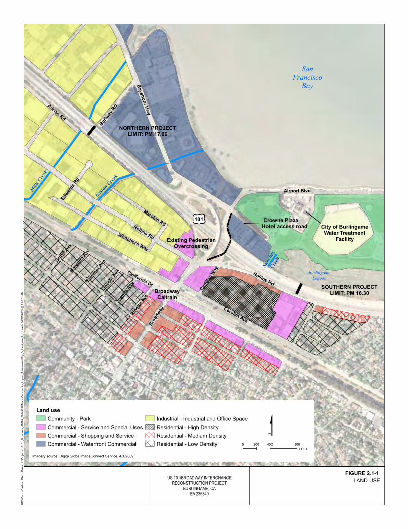
San
FranciscoBay
Rollins Rd
MillsCreek
Sanchez
Creek
Burlingame
Lagoon
City of BurlingameWater Treatment
Facility
BroadwayCaltrain
SOUTHERN PROJECTLIMIT: PM 16.30
NORTHERN PROJECTLIMIT: PM 17.06
Crowne PlazaHotel access road
MarstenRd
Existing PedestrianOvercrossing
Whitehorn Way
California Dr
Bro
adw
ay
Rin
ette
Ave
EastonCreek
Rollins Rd
Airport Blvd
Baysh
ore
Hw
y
Gro
veAve
Linco
lnAve
Adrian
Rd
Juan
ita
Ave
Cad
illac
Way
Bur
lway
Rd
Sum
mer
Ave
Mar
quita
Ave
Edw
ards
Rd
Carolan Ave
82
101
US 101/BROADWAY INTERCHANGERECONSTRUCTION PROJECT
BURLINGAME, CAEA 235840
October 2009
L:\Projects\US101_Broadway_SMTA_28645059\Maps\Community_Impact_Assessment\Fig_3_Land_use_8_11.mxd-10/30/2009@9:09:01AM
URSCorp-OaklandCA-J.Owen
FIGURE 3
LAND USE
Land use
Community - Park
Commercial - Service and Special Uses
Commercial - Shopping and Service
Commercial - Waterfront Commercial
Industrial - Industrial and Office Space
Residential - High Density
Residential - Medium Density
Residential - Low Density
Imagery source: DigitalGlobe ImageConnect Service, 4/1/2009
0 400 800200
FEET
FIGURE 2.1-1


Chapter 2 Affected Environment, Environmental Consequences, and Avoidance, Minimization, and/or Mitigation Measures
US 101/Broadway Interchange Reconstruction Project IS/EA 2-7
the north end of Burlingame near the Bay Area Rapid Transit (BART) Millbrae station and near the Broadway and Burlingame Caltrain stations. None of the currently proposed residential development plans are in the project area, and the closest is approximately 0.25 mile away. Table 2.1-1 summarizes recent and proposed residential and commercial/institutional development projects identified by the City of Burlingame Planning Division.
Table 2.1-1 Recent and Proposed Development Projects in City of Burlingame
Project Location
Distance from Project Area1 (Miles) Description Status
Multifamily Residential
18-unit condominium, including 2 affordable2 units
556 El Camino Real
0.67 New 4-story structure to replace structure with 14 apartment units
Application submitted in August 2006; in review.
9-unit condominium, including 1 affordable unit
1512-1516 Floribunda Ave.
0.62 New 4-story structure to replace 1 single-family home and a 4-unit residential structure
Approved 9/12/05; constructed.
45-unit condominium, including 7 affordable units
1840 Ogden Drive
1.03 New 4-story structure to replace 1-story office building
Approved 7/24/06; construction in progress.
20-unit condominium, including 2 affordable units
1441-1445 Bellevue Ave.
0.71 New 4-story structure to replace 5 multifamily residential buildings with a total of 18 units
Approved 1/8/07; building permit not issued as of 8/24/10.
25-unit condominium, including 3 affordable units
1800 Trousdale Drive
0.96 New 7-story structure to replace 1-story office building
Approved 4/16/07; building permit not issued as of 8/24/10.
9-unit condominium, including 1 affordable unit
1226 El Camino Real
0.25 New 4-story structure to replace 4 apartment buildings with a total of 12 units
Approved 5/27/08; constructed.
Commercial/Institutional
Office/life science campus
350 Beach Road
1.07 Multiple buildings with 730,000 square feet of floor space, parking in a 5-story structure and various lots
Application submitted in April 2010; in initial review stage.
Addition to existing commercial building
1801 Adrian Road
0.64 New 60,929-square-foot second floor addition to existing building
Application submitted in September 2009; in initial review stage.

Chapter 2 Affected Environment, Environmental Consequences, and Avoidance, Minimization, and/or Mitigation Measures
2-8 US 101/Broadway Interchange Reconstruction Project IS/EA
Table 2.1-1 Recent and Proposed Development Projects in City of Burlingame
Project Location
Distance from Project Area1 (Miles) Description Status
Safeway store and 2-story retail/office building with
1450 Howard Avenue
0.95 Replacement of existing Safeway and Walgreens stores, construction of 44,982-square-foot store with 6,865-square-foot mezzanine and 2-story building with 18,739 square feet total
Application approved February 2010; building permit application in progress.
Remodel and addition to existing building for proposed office use
1427 Chapin Ave.
0.78 Demolition of several accessory structures and interior remodel of existing 2-story building, plus 2-story addition
Approved 4/24/06; constructed.
79-unit assisted living facility
1818 Trousdale Drive
1.00 New 4-story structure with below-grade parking to replace 1-story office building
Approved 7/10/06; construction in progress.
Remodel of existing building and construction of new building
1450 Rollins Road/20 Edwards Ct.
0.06 Veterinary/rehabilitation, adoption, education, and retail facility for Peninsula Humane Society and Society for the Prevention of Cruelty to Animals (SPCA)
Environmental document certified 6/18/07; construction in progress.
New retail building
260 El Camino Real
0.86 New 13,755-square-foot, 1-story structure with mezzanine level to replace gas station
Approved 1/20/09; constructed.
Source: City of Burlingame 2010. 1 As measured from the boundaries of the project area (shown in red in Figure 2.2-1). 2 In San Mateo County, “affordable” housing is defined as that with a contract rent or price affordable to low and moderate income households, based upon: rent not exceeding 30 percent of monthly income and monthly mortgage payment not exceeding 33 percent of gross monthly income (City General Plan p. H-39).
Land use planning on a countywide basis also emphasizes increasing the supply and density of housing in transit corridors. In 1999, the City/County Association of Governments of San Mateo County launched a Transit-Oriented Development Incentive Program to give the county and 20 participating cities incentives to build more housing near rail stations. The program allocates up to 10 percent of State TIP funds to encourage construction of transit-oriented development. The MTC adopted a Housing Incentive Program based on the San Mateo County model (C/CAG 2002; MTC 2009b).
Chapter 2 Affected Environment, Environmental Consequences, and Avoidance, Minimization, and/or Mitigation Measures
US 101/Broadway Interchange Reconstruction Project IS/EA 2-9
2.1.1.2. Environmental Consequences The proposed project would serve an existing developed urban area and would not involve unused rural land. The project would convert approximately four partial parcels and three full parcels designated for commercial and industrial land uses to transportation facilities, as described further in Section 2.2.2. Otherwise, the current land use designations in the study area would remain the same.
By reducing congestion and improving connectivity along Broadway in the vicinity of the Caltrain station, the project would support City of Burlingame and San Mateo County land use planning for transit village development.
2.1.1.3. Avoidance, Minimization, and/or Mitigation Measures No avoidance, minimization, or mitigation is necessary.
2.1.2. Consistency with State, Regional, and Local Plans and Programs
2.1.2.1. Affected Environment Transportation Plans/Programs As described at the beginning of Chapter 1, the proposed project is included in the Transportation 2035 Plan for the San Francisco Bay Area (MTC 2009a, RTP ID No. 21602) and the 2009 TIP (MTC 2008, TIP ID No. SM-050028). Funding is described in Section 1.3.1.10.
City of Burlingame Plans Both the City General Plan and the Bayfront Plan assume reconstruction of the US 101/Broadway interchange. The City General Plan calls for improving the interchange to provide for full directional movement and accommodate increasing traffic volume, particularly from the industrial areas of the city (Action CI[2]). The plan also calls for reducing congestion at the intersection of Rollins Road and Broadway and increasing capacity throughout the Broadway-Bayshore Area by reducing conflicts through traffic control measures, providing added lanes at critical points, and grade separating turning movements wherever feasible.
The Bayfront Plan emphasizes the need for access points to the Bayfront area to operate at acceptable levels of service. The plan identified the Broadway interchange as a major gateway into the Shoreline planning subarea, a 31-acre waterfront commercial zone that extends south from the Millbrae border to the Broadway interchange on the east side of Bayshore Highway along San Francisco Bay. The plan also lists reconstruction of the

Chapter 2 Affected Environment, Environmental Consequences, and Avoidance, Minimization, and/or Mitigation Measures
2-10 US 101/Broadway Interchange Reconstruction Project IS/EA
Broadway interchange as one of the roadway improvements necessary to maintain an acceptable level of service in the Bayfront area.
The proposed project is consistent with the City General Plan and the Bayfront Plan. The configuration of the new US 101/Broadway interchange would eliminate the existing directional movement issues described in Section 1.2.2. The traffic forecast and operational analysis for the project shows that all intersections adjacent to the interchange will operate at acceptable levels of service in future year 2035 (URS 2010a; see Section 2.4.3.1). The project is expected to reduce delay at the Rollins Road/Broadway intersection by an average of 60 seconds or more compared to No Build conditions. At a major gateway into Shoreline planning subarea (the Broadway/Airport Boulevard/Crowne Plaza Hotel access road/Bayshore Highway intersection), level of service is projected to improve from LOS D under future No Build conditions to LOS C with the project (Section 2.4.3.1).
The project also would increase the number of lanes on the Broadway overcrossing, the freeway on- and off-ramps, and adjoining intersections at Airport Boulevard/Bayshore Highway/Crowne Plaza Hotel access road and at Rollins Road. The additional lanes are designed to reduce traffic backups on Broadway and other local streets that provide access to and from the interchange. This would improve congestion and delay times and support the existing waterfront commercial land uses in the Bayfront area and the commercial and industrial uses on the west side of the interchange.
San Francisco International Airport Influence Area The area between the northern project limits and roughly 500 feet south of Easton Creek in the project area is within the Airport Influence Area for SFO (City of Burlingame 2007). Part 77 of the Federal Aviation Regulations defines several height and airspace protection parameters that apply to land use and development within Airport Influence Areas. No project structures would meet the height criteria that would require notification of or consultation with the Federal Aviation Administration.
San Francisco Bay Plan The BCDC has legislative authority to issue permits and regulate public or private projects that affect the San Francisco Bay and adjacent wetlands and shorelands. The BCDC maintains jurisdiction over the San Francisco Bay, a shoreline band between the shoreline of San Francisco Bay and a line 100 feet landward of and parallel to the shoreline, salt ponds, some managed wetlands, and certain other waterways that are subject to tidal action. The BCDC performs its functions through the enforcement of

Chapter 2 Affected Environment, Environmental Consequences, and Avoidance, Minimization, and/or Mitigation Measures
US 101/Broadway Interchange Reconstruction Project IS/EA 2-11
the San Francisco Bay Plan (Bay Plan; BCDC 2008). The BCDC’s major policy goals include curbing Bay fill, promoting public access along the Bay, and supporting recreational uses along the Bay.
Two parts of the proposed project are within BCDC jurisdiction: northbound US 101 along the Burlingame Lagoon, and an area along San Francisco Bay northeast of the intersection of Airport Boulevard and Bayshore Highway. The project will require a BCDC permit. Project activities along northbound US 101 adjacent to the Burlingame Lagoon would be limited to pavement restriping. On the San Francisco Bay side, the project would shift the intersection of Airport Boulevard and Bayshore Highway to the north, realign sections of the Bay Trail (Section 2.1.4.3) and City of Burlingame sidewalk, and potentially restore the conveyance capacity of a clogged drainage channel (Section 1.3.1.6). No fill would be placed in the Bay.
The project would promote public access and support recreational uses along the Bay by restoring the affected Bay Trail segment to preconstruction condition or better, adding a 10-foot sidewalk on the north side and Class II (striped) bike lanes on both sides of the new Broadway overcrossing, and providing new Class II bike lanes on Airport Boulevard and Bayshore Highway and Class III (unstriped) bikeways on Broadway west of the overcrossing and Rollins Road. The project is consistent with the Bay Plan.
2.1.2.2. Environmental Consequences The No Build Alternative would not support City General Plan and Bayfront Plan goals to provide for full directional movements and accommodate increasing traffic volumes at the US 101/Broadway interchange.
The proposed project is consistent with regional and local planning goals. The project would help meet the City of Burlingame’s stated objectives for reducing congestion and improving connectivity in the interchange area to support surrounding land uses. The project design includes pedestrian and bicycle features that support City of Burlingame and Bay Plan objectives to increase public access to the Bay. No habitat conservation plans apply to the study area; therefore, the project would not conflict with any such plans.
2.1.2.3. Avoidance, Minimization, and/or Mitigation Measures No avoidance, minimization, or mitigation is necessary.
Chapter 2 Affected Environment, Environmental Consequences, and Avoidance, Minimization, and/or Mitigation Measures
2-12 US 101/Broadway Interchange Reconstruction Project IS/EA
2.1.3. Coastal Zone 2.1.3.1. Regulatory Setting
This project is in the coastal zone. The Coastal Zone Management Act of 1972 (CZMA) is the primary federal law enacted to preserve and protect coastal resources. The CZMA sets up a program under which coastal states are encouraged to develop coastal management programs. States with an approved coastal management plan are able to review federal permits and activities to determine if they are consistent with the state’s management plan.
California has developed a coastal zone management plan and has enacted its own law, the California Coastal Act of 1976, to protect the coastline. The policies established by the California Coastal Act are similar to those for the CZMA; they include the protection and expansion of public access and recreation, the protection, enhancement and restoration of environmentally sensitive areas, protection of agricultural lands, the protection of scenic beauty, and the protection of property and life from coastal hazards. The California Coastal Commission is responsible for implementation and oversight under the California Coastal Act.
The Bay Conservation and Development Commission (BCDC), created prior to the California Coastal Act, retains oversight and planning responsibilities for development and conservation of coastal resources in the Bay Area. The regulatory authority for BCDC is the McAteer-Petris Act and the Suisun Marsh Protection Act.
2.1.3.2. Affected Environment Two parts of the proposed project are within 100 feet of open water, marshes and mudflats of San Francisco Bay: northbound US 101 along the Burlingame Lagoon, and an area northeast of the intersection of Airport Boulevard and Bayshore Highway (Figure 1-1). Northbound US 101 is directly west of the Burlingame Lagoon, a marsh and lagoon complex that is connected to the Bay by a channel approximately 1.3 mile south of the Broadway overcrossing. Near the intersection of Airport Boulevard and Bayshore Highway, Airport Boulevard is bordered on the east by San Francisco Bay, and the parcels along the east side of Bayshore Highway back onto the Bay shoreline. As stated in Section 2.1.2.1, these areas are within BCDC jurisdiction.
2.1.3.3. Environmental Consequences Project activities along northbound US 101 adjacent to the Burlingame Lagoon would be limited to pavement restriping. No work would take place in the lagoon, and the project would not affect Sanchez Creek or its triple box culvert under US 101.

Chapter 2 Affected Environment, Environmental Consequences, and Avoidance, Minimization, and/or Mitigation Measures
US 101/Broadway Interchange Reconstruction Project IS/EA 2-13
On the San Francisco Bay side, the project would shift the intersection of Airport Boulevard and Bayshore Highway to the north. Sections of the Bay Trail and City of Burlingame sidewalk would be realigned to accommodate the new intersection. These activities are described in detail in Section 2.1.4.3. The project would also potentially restore the conveyance capacity of a clogged drainage channel between Bayshore Highway and the Bay (Section 1.3.1.6). None of the proposed project activities would place fill in the Bay.
As described in Section 2.1.2.1 (under San Francisco Bay Plan), the project is consistent with BCDC goals to curb Bay fill, promote public access along the Bay, and support recreational uses along the Bay.
The project will require a BCDC permit. The project team initiated contact with BCDC regarding the proposed project in July 2009 and provided preliminary boundary mapping and other project information in May 2010. A permit application will be submitted during the project design phase.
2.1.3.4. Avoidance, Minimization, and/or Mitigation Measures Measures to avoid or minimize disruption to recreation users are listed in Section 2.1.4.4. No additional measures are proposed.
2.1.4. Parks and Recreation 2.1.4.1. Regulatory Setting
Section 6009(a) of the Safe, Accountable, Flexible, Efficient Transportation Equity Act: A Legacy for Users (SAFETEA-LU) amended Section 4(f) legislation at 23 USC 138 and 49 USC 303 to simplify the processing and approval of projects that have only de minimis impacts on lands protected by Section 4(f).
The FHWA’s final rule on Section 4(f) de minimis findings is codified in 23 CFR 774.3 and 23 CFR 774.17.
In the first substantive revision to Section 4(f) since its enactment, SAFETEA-LU amended the law to simplify the processing and approval of projects that have only de minimis impacts on lands protected by Section 4(f). This revision provides that once the U.S. Department of Transportation determines that a transportation use of Section 4(f) property, after consideration of any impact avoidance, minimization, and mitigation or enhancement measures, results in a de minimis impact on that property, an analysis of avoidance alternatives is not required and the Section 4(f) evaluation

Chapter 2 Affected Environment, Environmental Consequences, and Avoidance, Minimization, and/or Mitigation Measures
2-14 US 101/Broadway Interchange Reconstruction Project IS/EA
process is complete. Responsibility for compliance with Section 4(f) has been assigned to the Department pursuant to the memoranda of understanding (MOUs) under SAFETEA-LU Sections 6004 and 6005, including determinations and approval of Section 4(f) evaluations as well as coordination with those agencies that have jurisdiction over a Section 4(f) resource that may be affected by a project action.
2.1.4.2. Affected Environment Senate Bill 100 of 1987 directed the ABAG to develop a plan for a trail around the Bay. The Bay Trail Plan, adopted by ABAG in July 1989, includes a proposed alignment; a set of policies to guide the future selection, design and implementation of routes; and strategies for implementation and financing. Segments of the Bay Trail are built, owned, managed, and maintained by cities, counties, park districts and other agencies with land management responsibilities, often in partnership with local nonprofit organizations, citizens groups, or businesses. When complete, the Bay Trail will be a continuous 500-mile network of trails connecting the Bay shoreline of all nine Bay Area counties. Approximately 290 miles of the alignment have been completed (ABAG 2009).
A portion of the Bay Trail lies within the project limits along the San Francisco Bay on the eastern side of Airport Boulevard (see Figure 2.1-2). This segment of the trail has been developed and maintained by the City of Burlingame and has signage as the “Bay Front Trail.” For purposes of this report, the Bay Front Trail is referred to as the Bay Trail.
Within the project limits, the Bay Trail extends from a bulb-shaped cul-de-sac/turnaround near the corner of Airport Boulevard and Bayshore Highway (referred to as the Bay Trail turnaround; see Figure 2.1-2) southeastward along Airport Boulevard. The Bay Trail turnaround, which has no recreational fixtures other than a bench, is between a gas station and San Francisco Bay. The Bay Trail in the project limits is 8 feet wide and separated from Airport Boulevard by a grass-covered median.
Adjacent to the Bay Trail and just southeast of the Bay Trail turnaround, a trailside seating area in a grove of trees with lighting, streetside landscaping, and a Bay Trail sign is also within the project limits. (This area is hereafter referred to as the Bay Trail extension; see Figure 2.1-2.) The seating area provides views of San Francisco Bay. The Bay Trail extension was developed by the City of Burlingame as part of a grant from SMCTA and the California Coastal Conservancy for improvements to the Bay Trail.

Chapter 2 Affected Environment, Environmental Consequences, and Avoidance, Minimization, and/or Mitigation Measures
US 101/Broadway Interchange Reconstruction Project IS/EA 2-15
Figure 2.1-2 Section 4(f) Resources Near the Project Limits Source: Base photo from Google Earth
Other Bay Trail segments and facilities are outside of the project limits but within the project study area. Between the Bay Trail and Airport Boulevard, approximately 200 yards east of the project limits, is a small parking lot, another seating area, and trail signage. Across Airport Boulevard is another Bay Trail segment that connects the following City of Burlingame recreational facilities, which lie just east and south of the project area:
• Bayside Park (Figures 1-1 and 2.1-2) has 22 acres divided between a lower deck, accessed from Airport Boulevard, and an upper deck, accessed from Anza Boulevard. The City of Burlingame Water Treatment Facility lies between the two decks. The lower deck of Bayside Park, which is adjacent to the proposed project area, has two full baseball diamonds, a soccer field that can be used for baseball, and a parking lot. The upper deck has a golf driving range, a group of putting greens, a soccer field, a “tot lot,” an open field for informal group activities, and a large parking lot.
Chapter 2 Affected Environment, Environmental Consequences, and Avoidance, Minimization, and/or Mitigation Measures
2-16 US 101/Broadway Interchange Reconstruction Project IS/EA
• The Burlingame Lagoon (Figure 1-1) serves as a wildlife and waterfowl refuge and is bordered to the west by US 101 and to the east by Bayside Park, the City of Burlingame Water Treatment Facility, and commercial and industrial development. Another Bay Trail segment follows the east side of the lagoon and has wetland observation points and interpretive signage (City of Burlingame 2006). The lagoon area and surrounding pathways are approximately 110 acres.
The Bay Trail within the study area is also included in the San Mateo County 2001 Trails Plan (San Mateo County Parks and Recreation Commission 2001), which provides design and management guidelines for trail construction and operation in the county. No new county trails are proposed in the immediate project area.
All of the facilities described in this section are considered publicly owned parkland under the terms of Section 4(f) of the Department of Transportation Act.
2.1.4.3. Environmental Consequences Temporary Impacts Project construction would result in temporary impacts to recreational facilities within the project limits and study area. Temporary closures or detours of a segment of the Bay Trail would be required to preserve public safety while construction takes place along Airport Boulevard (east of Bayshore Highway). Once the realignment of Airport Boulevard is completed, the trail can likely be reopened. The length of the trail closure(s) would therefore be shorter in duration than the overall project schedule. Any detour routes onto Airport Boulevard would be separated from traffic by a temporary barrier (such as a K-rail) to ensure the safety of trail users. The Bay Trail turnaround and extension would also need to be temporarily closed during construction along Airport Boulevard.
Demolition of the gas station at the corner of Airport Boulevard and Bayshore Highway, demolition of the Broadway overcrossing and ramps, pile installation for the new overcrossing and retaining walls, realignment of Airport Boulevard, and pavement removal and installation would cause periodic noise and visual disturbance to recreationists. These effects would be most pronounced when the activities are in progress near the Bay Trail, Bay Trail turnaround, and Bay Trail extension. As stated above, temporary closures of these facilities would be required during the realignment of Airport Boulevard, which would prevent recreationists from being exposed to noise and visual disturbance during some construction periods.

Chapter 2 Affected Environment, Environmental Consequences, and Avoidance, Minimization, and/or Mitigation Measures
US 101/Broadway Interchange Reconstruction Project IS/EA 2-17
Outside of the project limits, visitors to Bayside Park could also experience periodic construction noise and visual disturbance. Tall trees around the northern and western perimeter of Bayside Park would provide some visual shielding. The Crowne Plaza Hotel building and a berm to the south of the building would shield recreationists on the Bay Trail segment at the Burlingame Lagoon from most noise and visual disturbance. In addition, many project construction activities would take place at night, when the park is closed.
Permanent Impacts The realignment of Airport Boulevard would require an approximately 150-foot section of the Bay Trail to be shifted to the north. An existing grass median between the Bay Trail and roadway of Airport Boulevard, some shrubs and ornamental landscaping, and pavement would have to be removed to accommodate the realignment of Airport Boulevard and the Bay Trail. Approximately 2,400 square feet of the Bay Trail would be affected.
The realigned trail section would be 10 feet wide. The realigned trail would conform with the existing trail alignment at the Bay Trail turnaround, which would not be permanently affected. The elevation of Airport Boulevard and the Bay Trail would be gradually increased by approximately 8 feet as they approach Bayshore Highway, and an earth embankment would be installed along the northern side of the road. No Bay fill would be required to support the realigned road or trail section. The realignment of the Bay Trail would not affect its long-term use.
The realignment of Airport Boulevard and the Bay Trail to the north would require permanent acquisition of an approximately 800-square-foot section at the southwestern edge of the Bay Trail extension. The section that would be acquired contains pavement and landscaping and is not critical to the recreational use of the Bay Trail extension. The existing seating area would remain in place and would continue to provide views of the Bay.
The project would add a paved path from the southeastern corner of Broadway, Bayshore Highway, Airport Boulevard, and the Crowne Plaza Hotel access road within the existing right-of-way to an existing path into the northwestern corner of Bayside Park (Figure 1-1). The paved path would improve bicycle and pedestrian access to Bayside Park. The project would have no permanent adverse impacts to Bayside Park or the Burlingame Lagoon.

Chapter 2 Affected Environment, Environmental Consequences, and Avoidance, Minimization, and/or Mitigation Measures
2-18 US 101/Broadway Interchange Reconstruction Project IS/EA
Although the project would provide additional access to the shoreline, Bay Trail, and Bayside Park, it is not anticipated to increase the use of these facilities such that substantial physical deterioration would occur or accelerate.
Section 4(f) De Minimis Findings The City of Burlingame owns and maintains the Bay Trail segment and Bay Trail extension in the project limits as well as Bayside Park and the Burlingame Lagoon outside of the project limits. All four facilities are publicly owned parkland and qualify for protection under Section 4(f) of the Department of Transportation Act. Impacts to these facilities constitute “use” of Section 4(f) resources. The use of these facilities is considered minimal because the transportation use of the properties, with avoidance, minimization, or enhancement measures incorporated, would not adversely affect the activities, features, and attributes that qualify the properties for protection under Section 4(f).
The Department, as assigned by FHWA, is responsible for making the final determination on the de minimis finding. The determination also requires the following steps:
• The City of Burlingame must agree, in writing, that the use will not adversely affect the features and attributes of the property, and that the city has been informed of the Department’s intent to make a de minimis finding based on that agreement. The Department and SMCTA will request such written agreement from the City of Burlingame.
• In addition, the public must have an opportunity to review and comment on the effects of the project on the protected activities, features, and attributes of the Section 4(f) property. The public will have the opportunity to review and comment on the effects to the Bay Trail and Bay Trail extension during the public review period for this document.
The avoidance, minimization, and enhancement measures needed to make the de minimis finding are listed in Section 2.1.4.4.
2.1.4.4. Avoidance, Minimization, and/or Enhancement Measures
Parts of the Bay Trail and Bay Trail extension will need to be temporarily closed or detoured during project construction. The Department and SMCTA will develop a trail closure plan during the final design phase and before submitting the BCDC permit application for the proposed project. The trail closure plan will:

Chapter 2 Affected Environment, Environmental Consequences, and Avoidance, Minimization, and/or Mitigation Measures
US 101/Broadway Interchange Reconstruction Project IS/EA 2-19
• Minimize the number of days that the Bay Trail and Bay Trail extension will be closed to the public;
• Include a mandatory signage plan notifying Bay Trail users of closed segments or full closures. Notices will be posted at Bay Trail access points as appropriate; and
• Provide a detour or alternate route for trail users during construction. If safety concerns prevent use of another route, the trail closure will be kept to the minimum period possible.
A Transportation Management Plan (TMP) will be developed as part of the project to address impacts to motor vehicle, bicycle, and pedestrian access during project construction. The plan will maintain bicycle and pedestrian access to the maximum extent feasible as part of construction staging. The plan will include briefing local public officials and developing a public information program to notify the public of project progress and upcoming closures and detours. The public information program will include outreach to ride sharing agencies, transit operators, and neighborhood and special interest groups.
2.2. Community Impacts
This section is based on the Community Impact Assessment (URS 2009a) for the proposed project, which was completed in November 2009.
2.2.1. Community Character and Cohesion 2.2.1.1. Regulatory Setting
NEPA established that the Federal government use all practicable means to ensure that all Americans have safe, healthful, productive, and aesthetically and culturally pleasing surroundings (42 USC 4331[b][2]). The FHWA in its implementation of NEPA (23 USC 109[h]) directs that final decisions regarding projects are to be made in the best overall public interest. This requires taking into account adverse environmental impacts, such as destruction or disruption of human-made resources, community cohesion, and the availability of public facilities and services.
Under CEQA, an economic or social change by itself is not to be considered a significant effect on the environment. However, if a social or economic change is related to a physical change, then social or economic change may be considered in determining whether the physical change is significant. Since this project would

Chapter 2 Affected Environment, Environmental Consequences, and Avoidance, Minimization, and/or Mitigation Measures
2-20 US 101/Broadway Interchange Reconstruction Project IS/EA
result in physical change to the environment, it is appropriate to consider changes to community character and cohesion in assessing the significance of the project’s effects.
2.2.1.2. Affected Environment Demographic Profile The entire study area for community impacts lies within the City of Burlingame. Census Block Groups that most closely correspond to the project area were examined, and population and community characteristics of the groups were compared with the totals for the City of Burlingame. The community impacts study area and the Block Groups evaluated are shown in Figure 2.2-1.
The City of Burlingame had a population of 28,158 in 2000, with the study area representing about 14 percent of the total population. The predominant age group (19 percent) in the city is between 35 and 44 years old, and just over 50 percent of the population falls between the ages of 25 and 54. By contrast, in both block groups in the study area, the predominant age group is 25 to 34, and just under 50 percent of the population (almost 62 percent) falls between the ages of 25 and 44. In general, the age composition of the study area population is somewhat younger than the composition of Burlingame as a whole.
Whites represent the majority of the population in the study area and the city—from 77 percent in the city as a whole to 60 percent in Census Tract 6054, Block Group 5 (CT6054 BG5). Census Tract 6051, Block Group 2 (CT6051 BG2) has an almost identical ethnic composition to the City of Burlingame. CT6054 BG5 has nearly twice as many Asian, other race, two or more races, and Hispanic/Latino residents than either the city or CT6051 BG2, but a lower percentage than San Mateo County.
Incomes in the City of Burlingame are well above the State average but similar to the San Mateo County average. The median household incomes within CT6051 BG2 ($59,483) and CT6054 BG5 ($60,958) are lower than for the city ($68,526) and county ($70,819) but higher than for the State ($47,493). Per capita income is also less than the Burlingame average in both Block Groups but higher than the State average.
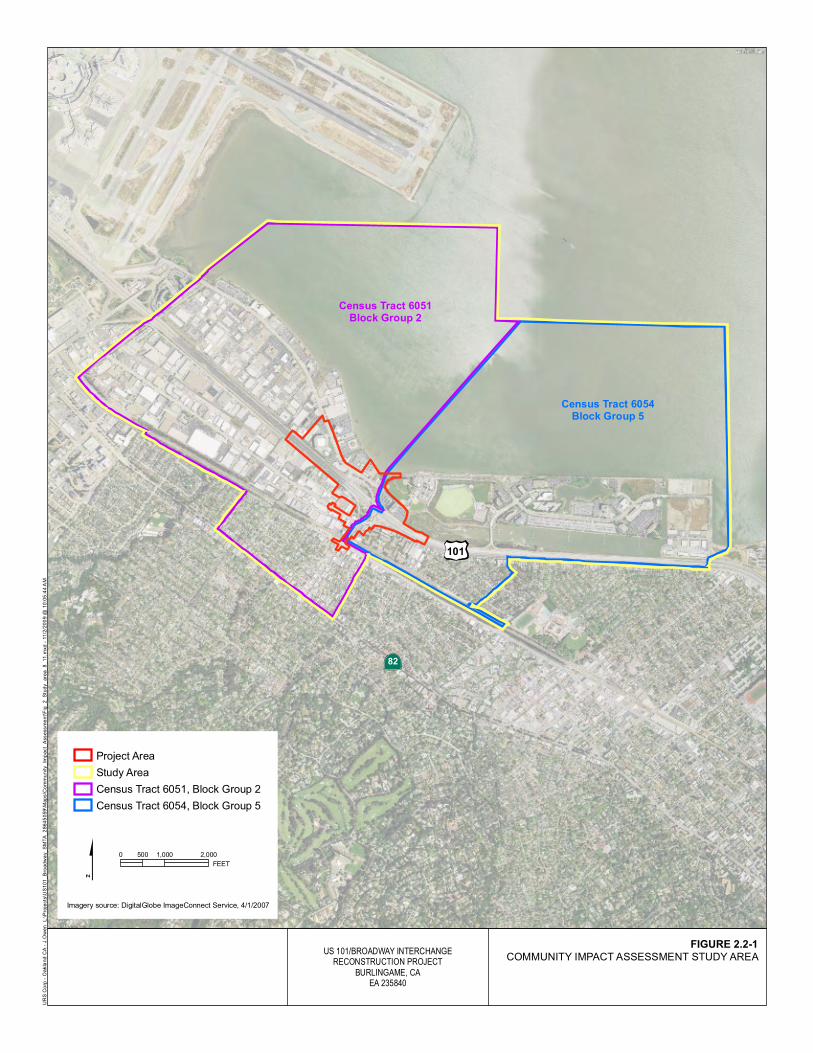
Census Tract 6051Block Group 2
Census Tract 6054Block Group 5
82
101
US 101/BROADWAY INTERCHANGERECONSTRUCTION PROJECT
BURLINGAME, CAEA 235840
October 2009
URSCorp-OaklandCA-J.Owen
FIGURE 2
COMMUNITY IMPACT ASSESSMENT STUDY AREA
L:\Projects\US101_Broadway_SMTA_28645059\Maps\Community_Impact_Assessment\Fig_2_Study_area_8_11.mxd-11/2/2009@10:05:44AM
Project Area
Study Area
Census Tract 6051, Block Group 2
Census Tract 6054, Block Group 5
Imagery source: DigitalGlobe ImageConnect Service, 4/1/2007
0 1,000 2,000500
FEET
FIGURE 2.2-1

Chapter 2 Affected Environment, Environmental Consequences, and Avoidance, Minimization, and/or Mitigation Measures
US 101/Broadway Interchange Reconstruction Project IS/EA 2-23
Approximately 5.7 percent of Burlingame residents were below the poverty level in 1999, whereas the State average was 14.2 percent and the San Mateo County average was 5.8 percent. Poverty rates in both Block Groups were lower than the State rate of 14.2 but higher than the city and county rate. The poverty rate in CT6054 BG5 (14.1 percent) was more than twice as high as in CT6051 BG2.
Community Profile No residences exist in the project limits. The only residential land use near the project limits is the Northpark Apartments (see Section 2.1.1.1).
The US 101/Broadway interchange connects two economic centers in the City of Burlingame: an “auto row” and downtown area on the west, and the Bayfront area on the east.
West of the project limits is the Broadway center, which is on Broadway between California Drive and El Camino Real. The five-block district has restaurants, a large drug/variety store, and other consumer services for area residents. At California Drive, a historical arched “BROADWAY BURLINGAME” sign marks the entry to the Broadway center, and predominantly one-story buildings, established businesses (such as a candy and ice cream shop that opened in 1946), and streetside benches give the area a feeling of small-town intimacy.
Bayshore Highway and Airport Boulevard within the project limits have commercial uses including a restaurant, hotels, and a gas station.
The study area is in the Burlingame School District and the San Mateo Union High School District. No schools are within the project limits or study area. Burlingame High School, located at 1 Mangini Way, is one block southwest of CT6054 BG5 and approximately 1 mile from the project area.
2.2.1.3. Environmental Consequences The proposed project would not displace or relocate any residents, change any existing community boundaries, physically divide an established community, or create a new barrier to movement within the project area. The proposed Broadway overcrossing will remain in the same general location and continue to connect the business and residential areas west of the US 101 with the recreation and commercial uses to the east. The pedestrian overcrossing will remain in place, and a sidewalk and bike lanes on the Broadway overcrossing will provide additional pedestrian and bicycle access across US 101 (Section 1.3.1.3). A TMP will be developed as part of the
Chapter 2 Affected Environment, Environmental Consequences, and Avoidance, Minimization, and/or Mitigation Measures
2-24 US 101/Broadway Interchange Reconstruction Project IS/EA
project to address impacts to motor vehicle, bicycle, and pedestrian access during project construction, as described in Section 2.1.4.4.
2.2.1.4. Avoidance, Minimization, or Mitigation Measures No further avoidance, minimization, or mitigation is necessary.
2.2.2. Relocations and Real Property Acquisition 2.2.2.1. Regulatory Setting
The Department’s Relocation Assistance Program (RAP) is based on the Federal Uniform Relocation Assistance and Real Property Acquisition Policies Act of 1970 (as amended) and Title 49 CFR Part 24. The purpose of the RAP is to ensure that persons displaced as a result of a transportation project are treated fairly, consistently, and equitably so that such persons will not suffer disproportionate injuries as a result of projects designed for the benefit of the public as a whole. Please see Appendix D for a summary of the RAP.
All relocation services and benefits are administered without regard to race, color, national origin, or sex in compliance with Title VI of the Civil Rights Act (42 USC 2000d, et seq.). Please see Appendix C for a copy of the Department’s Title VI Policy Statement.
2.2.2.2. Affected Environment In addition to the right-of-way needed at the Bay Trail extension (see Section 2.1.4.3), the proposed project could require full or partial acquisitions or temporary construction easements (TCEs) at commercial or industrial properties, City of Burlingame property, and a vacant lot. West of US 101, the affected properties are located on or adjacent to Broadway, Rollins Road, and the southbound US 101 off-ramp. East of US 101, the affected properties are on or adjacent to Bayshore Highway and Airport Boulevard. No residential properties would be affected.
2.2.2.3. Environmental Consequences The potentially affected parcels, based on the preliminary design, are listed in Table 2.2-1 and shown in Figure 2.2-2. The following summarizes the potential property effects of the proposed project.
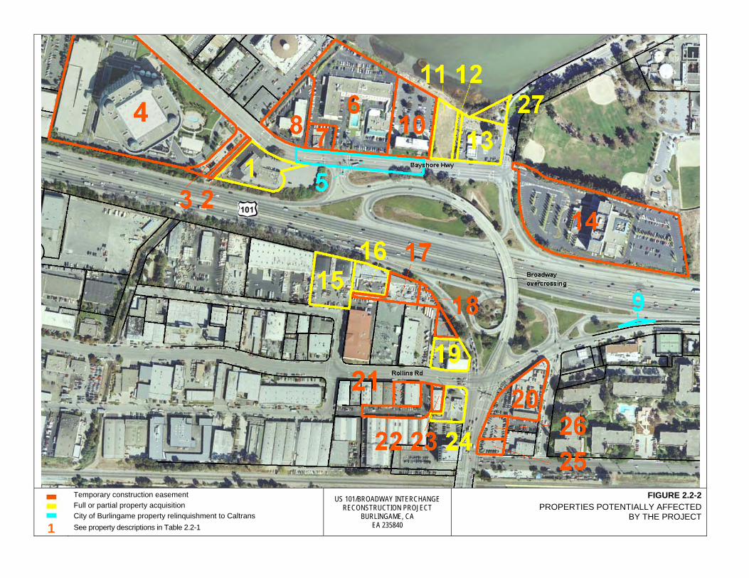
1
Temporary construction easement Full or partial property acquisition City of Burlingame property relinquishment to Caltrans See property descriptions in Table 2.2-1
US 101/BROADWAY INTERCHANGE RECONSTRUCTION PROJECT
BURLINGAME, CA EA 235840
FIGURE 2.2-2 PROPERTIES POTENTIALLY AFFECTED
BY THE PROJECT

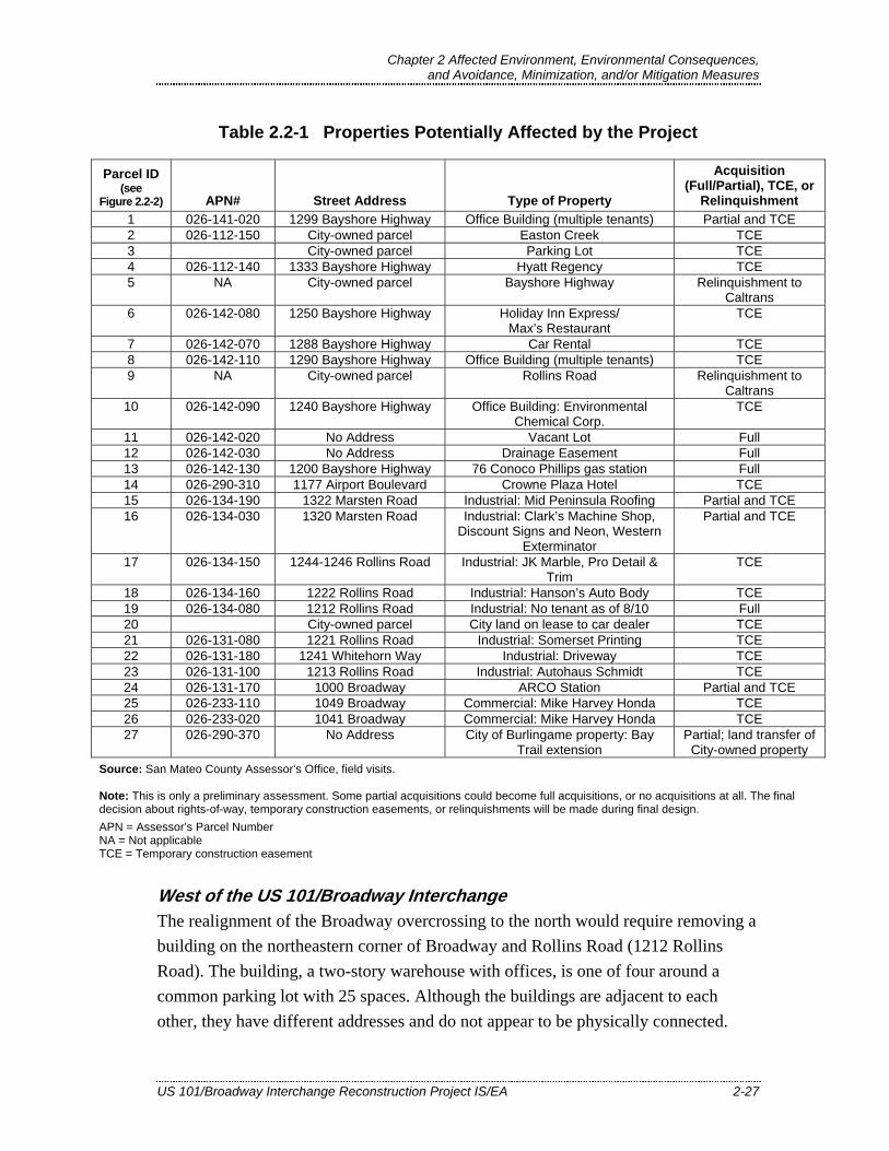
Chapter 2 Affected Environment, Environmental Consequences, and Avoidance, Minimization, and/or Mitigation Measures
US 101/Broadway Interchange Reconstruction Project IS/EA 2-27
Table 2.2-1 Properties Potentially Affected by the Project
Parcel ID (see
Figure 2.2-2) APN# Street Address Type of Property
Acquisition (Full/Partial), TCE, or
Relinquishment 1 026-141-020 1299 Bayshore Highway Office Building (multiple tenants) Partial and TCE 2 026-112-150 City-owned parcel Easton Creek TCE 3 City-owned parcel Parking Lot TCE 4 026-112-140 1333 Bayshore Highway Hyatt Regency TCE 5 NA City-owned parcel Bayshore Highway Relinquishment to
Caltrans 6 026-142-080 1250 Bayshore Highway Holiday Inn Express/
Max’s Restaurant TCE
7 026-142-070 1288 Bayshore Highway Car Rental TCE 8 026-142-110 1290 Bayshore Highway Office Building (multiple tenants) TCE 9 NA City-owned parcel Rollins Road Relinquishment to
Caltrans 10 026-142-090 1240 Bayshore Highway Office Building: Environmental
Chemical Corp. TCE
11 026-142-020 No Address Vacant Lot Full 12 026-142-030 No Address Drainage Easement Full 13 026-142-130 1200 Bayshore Highway 76 Conoco Phillips gas station Full 14 026-290-310 1177 Airport Boulevard Crowne Plaza Hotel TCE 15 026-134-190 1322 Marsten Road Industrial: Mid Peninsula Roofing Partial and TCE 16 026-134-030 1320 Marsten Road Industrial: Clark’s Machine Shop,
Discount Signs and Neon, Western Exterminator
Partial and TCE
17 026-134-150 1244-1246 Rollins Road Industrial: JK Marble, Pro Detail & Trim
TCE
18 026-134-160 1222 Rollins Road Industrial: Hanson’s Auto Body TCE 19 026-134-080 1212 Rollins Road Industrial: No tenant as of 8/10 Full 20 City-owned parcel City land on lease to car dealer TCE 21 026-131-080 1221 Rollins Road Industrial: Somerset Printing TCE 22 026-131-180 1241 Whitehorn Way Industrial: Driveway TCE 23 026-131-100 1213 Rollins Road Industrial: Autohaus Schmidt TCE 24 026-131-170 1000 Broadway ARCO Station Partial and TCE 25 026-233-110 1049 Broadway Commercial: Mike Harvey Honda TCE 26 026-233-020 1041 Broadway Commercial: Mike Harvey Honda TCE 27 026-290-370 No Address City of Burlingame property: Bay
Trail extension Partial; land transfer of
City-owned property Source: San Mateo County Assessor’s Office, field visits. Note: This is only a preliminary assessment. Some partial acquisitions could become full acquisitions, or no acquisitions at all. The final decision about rights-of-way, temporary construction easements, or relinquishments will be made during final design. APN = Assessor’s Parcel Number NA = Not applicable TCE = Temporary construction easement
West of the US 101/Broadway Interchange The realignment of the Broadway overcrossing to the north would require removing a building on the northeastern corner of Broadway and Rollins Road (1212 Rollins Road). The building, a two-story warehouse with offices, is one of four around a common parking lot with 25 spaces. Although the buildings are adjacent to each other, they have different addresses and do not appear to be physically connected.
Chapter 2 Affected Environment, Environmental Consequences, and Avoidance, Minimization, and/or Mitigation Measures
2-28 US 101/Broadway Interchange Reconstruction Project IS/EA
The building that would be removed is currently vacant and for lease. If the building is leased, coordinating with the property owner to end the new lease term during the project right-of-way process would reduce the severity of a potential relocation impact. No relocation impact would occur if the building remains unleased.
A number of other property impacts would occur west of the interchange. The southbound US 101 off-ramp would be shifted westward and increased in elevation approaching the interchange, and a retaining wall would be constructed along the ramp behind buildings on Nerli Lane and Marsten Road. This could require partial acquisitions at two industrial parcels that house four businesses. The area bordered by US 101, Broadway, California Drive, and Millbrae Avenue is dedicated to industrial and commercial land uses, and it is expected that replacement property would be available there.
The realignment of Broadway to the north and the higher overcrossing profile would require increasing the elevation of both Broadway and Rollins Road. Driveway modifications to conform to the higher roadway may be needed at six commercial and industrial parcels, requiring either partial property acquisitions or TCEs.
At the ARCO station on the corner of Broadway and Rollins Road, the increased elevation of the roadway could require more extensive driveway modifications, which could temporarily impair customer access but would not affect the viability of the business.
East of the US 101/Broadway Interchange East of the interchange, the realignment of Airport Boulevard would require full acquisition of the 76 Conoco Phillips gas station at 1200 Bayshore Highway.
The higher profile of the new Broadway overcrossing would require increasing the elevation of Bayshore Highway as it approaches the intersection with Broadway, Airport Boulevard, and the Crowne Plaza Hotel access road. As a result, Bayshore Highway could be up to 8 to 10 feet higher than the surface of the vacant lot next to the 76 Conoco Phillips gas station. The entire lot would be acquired for the project, but as it is vacant, no relocation impacts would occur.
The increased height of the Broadway overcrossing would also require raising the elevation of the Crowne Plaza Hotel access road to meet the profile of the adjacent intersection. A TCE would be needed to adjust the driveway grade over a distance of approximately 200 feet and to construct a retaining wall along the west side of the
Chapter 2 Affected Environment, Environmental Consequences, and Avoidance, Minimization, and/or Mitigation Measures
US 101/Broadway Interchange Reconstruction Project IS/EA 2-29
driveway. The driveway is the single access route for the hotel; therefore, no disruption to access can occur. The project would be staged to maintain access to the hotel property at all times. Implementation of the project TMP will minimize temporary construction impacts at the Crowne Plaza Hotel property.
Along Bayshore Highway, TCEs are proposed for the four properties to the north of the vacant parcel to make grade adjustments to driveway connections.
The new northbound US 101 on-ramp lanes would require partial acquisition of a parcel containing a multi-tenant office building (1299 Bayshore Highway). The west and south sides of the parcel abut existing Department right-of-way, and approximately half of the building’s parking lot is on Department property. The proposed project would reclaim part of the parking lot within existing Department right-of-way and require a sliver of additional land outside of the right-of-way. In all, approximately 46 of the lot’s 77 parking spaces could be eliminated.
The proposed northbound on-ramp to US 101 from Bayshore Highway would be realigned slightly to the east, requiring a TCE in a paved area in the southwestern edge of the Hyatt Regency property. The area that would be affected is a perimeter road around the main hotel structure. The TCE is not expected to affect the use of the road.
Economic Impacts Up to four privately owned commercial or industrial properties could be acquired for the project right-of-way. If the affected businesses cease operations or relocate outside of the City of Burlingame, a reduction in tax revenue could occur. Sales tax from the gas stations would likely be generated at one of the other three gas stations in the project area.
Adequate replacement property appears to be available in Burlingame for the businesses that could be displaced. The vacant lot provides minimal tax revenue to the city. Therefore, the project is expected to have a negligible impact on local tax revenue.
Relocation Assistance The need for relocation assistance will be limited to businesses. Relocation assistance payments and counseling will be provided to persons and businesses in accordance with the Federal Uniform Relocation Assistance and Real Properties Acquisition Policies Act, as amended, to ensure adequate relocation. All benefits and services

Chapter 2 Affected Environment, Environmental Consequences, and Avoidance, Minimization, and/or Mitigation Measures
2-30 US 101/Broadway Interchange Reconstruction Project IS/EA
would be provided equitably without regard to race, color, national origin, or sex in compliance with Title VI of the Civil Rights Act (42 USC 2000d, et seq.). The Relocation Assistance Program was developed to help displaced individuals move with as little inconvenience as possible. All rights and services provided under Public Law 91-646, Uniform Relocation Assistance and Real Property Acquisition Act of 1970 would be strictly followed to meet the need of the handicapped, elderly, and other special groups (e.g., non-English speaking people) to ensure that their relocation needs are met. Programs implemented to meet these needs include bilingual brochures on relocation services, interpreters, determination of people’s needs and preferences through individual interviews, transportation services for those who do not own personal transportation or who cannot drive, information on other State and Federal assistance programs, and counseling to minimize hardships.
Caltrans Relocation Assistance Program information is included in Appendix D.
2.2.2.4. Avoidance, Minimization, or Mitigation Measures No additional avoidance, minimization, or mitigation measures are proposed.
2.3. Utilities and Emergency Services
This section is based on the Community Impact Assessment (completed in November 2009; URS 2009a) and the Draft Project Report (completed in August 2010; URS 2010b) for the proposed project.
2.3.1. Affected Environment 2.3.1.1. Utilities
The proposed project would require relocating sewer, water, electrical, and communications lines. Utilities in the project were identified through site visits and reviews of utility plans obtained from the Department, SMCTA, City of Burlingame, City of San Mateo, Comcast, Sprint, Verizon, AT&T, Level III Communications, Qwest, Astound Broadband, and PG&E. Project area utilities include three PG&E transmission towers in the northwest quadrant of the existing US 101/Broadway interchange.
The City of Burlingame serves as its own water utility using water from the San Francisco Water Department’s Crystal Springs and Sunset aqueducts. Allied Waste of San Mateo County provides waste collection, recycling, transportation, disposal, and related services within the city. PG&E provides gas and electrical service.

Chapter 2 Affected Environment, Environmental Consequences, and Avoidance, Minimization, and/or Mitigation Measures
US 101/Broadway Interchange Reconstruction Project IS/EA 2-31
2.3.1.2. Emergency Services Central County Fire provides fire protection and emergency services for the City of Burlingame and the Town of Hillsborough. The department has a staff of approximately 80 in a total of five fire stations, three of which are in Burlingame. Station 36 at 1399 Rollins Road is in the study area, about 0.3 mile north of Broadway.
The Burlingame Police Department provides public safety services within the city limits. The department employs 42 full-time sworn police officers and 20 full-time civilian personnel (Burlingame Police Department 2009). The police station is at 1111 Trousdale Drive, approximately 1.2 miles from the project area.
Burlingame has one hospital, the Peninsula Medical Center at 1501 Trousdale Drive (about 1.2 miles northwest of the study area). Construction of a new six-story, 241-bed general acute care facility is in progress at the same address. The new Mills-Peninsula Medical Center is scheduled to open in November 2010.
2.3.2. Environmental Consequences The project would relocate several utilities within the project limits. Table 2.3-1 lists these utilities by type, owner, and approximate length.
Table 2.3-1 Proposed Utility Relocations
Utility Owner Relocation
Quantity (feet) Sanitary Sewer City of Burlingame 1,160 Electric PG&E 2,295 Natural Gas PG&E 200 Water City of Burlingame 2,205 Telephone/Communications Cable AT&T 650 TV Cable Comcast 460 Communication Sprint 1,060
Further utility investigation would be performed to verify all utility relocation requirements and data during the final project design phase.
The project would have no adverse effects on emergency services. By providing additional lanes and a more direct route across US 101, the proposed interchange design has the potential to reduce response times for emergency service providers.
Chapter 2 Affected Environment, Environmental Consequences, and Avoidance, Minimization, and/or Mitigation Measures
2-32 US 101/Broadway Interchange Reconstruction Project IS/EA
2.3.3. Avoidance, Minimization, or Mitigation Measures Avoidance measures would be implemented to protect the three existing PG&E transmission towers and their foundations during construction. A longitudinal encroachment policy variance may be necessary for the high-voltage transmission lines suspended from these towers.
A TMP will be developed as part of the project to address traffic impacts from staged construction, detours, and specific traffic handling concerns such as emergency access during project construction. Access will be maintained for emergency response vehicles, and no disruption to existing emergency service access is expected.
2.4. Traffic and Transportation/Pedestrian and Bicycle Facilities
The information for this section is summarized from the Traffic Operations Analysis Report (completed in June 2010; URS 2010a) and Community Impact Assessment (completed in November 2009; URS 2009a) prepared for the project.
2.4.1. Regulatory Setting The Department, as assigned by FHWA, directs that full consideration should be given to the safe accommodation of pedestrians and bicyclists during the development of federal-aid highway projects (see 23 CFR 652). It further directs that the special needs of the elderly and the disabled must be considered in all federal-aid projects that include pedestrian facilities. When current or anticipated pedestrian and/or bicycle traffic presents a potential conflict with motor vehicle traffic, every effort must be made to minimize the detrimental effects on all highway users who share the facility.
The Department is committed to carrying out the 1990 Americans with Disabilities Act (ADA) by building transportation facilities that provide equal access for all persons. The same degree of convenience, accessibility, and safety available to the general public will be provided to persons with disabilities.
Chapter 2 Affected Environment, Environmental Consequences, and Avoidance, Minimization, and/or Mitigation Measures
US 101/Broadway Interchange Reconstruction Project IS/EA 2-33
2.4.2. Affected Environment 2.4.2.1. Roadway Network
US 101 in the project area is an eight-lane divided freeway. As described in Section 1.1.2, auxiliary lanes were recently completed in both directions of US 101 between Millbrae Avenue in Millbrae and Third Avenue in San Mateo.
Broadway is a four-lane east-west arterial in the City of Burlingame. In the project vicinity, Broadway intersects Carolan Avenue and Rollins Road to the west, crosses US 101 on a four-lane structure, and intersects Bayshore Highway and the northbound US 101 on- and off-ramps to the east (Figure 1-1). Just past the Bayshore Highway intersection, Broadway becomes Airport Boulevard.
Other streets in the project area include the following (Figure 1-1):
West of US 101 • Rollins Road, a two-lane north-south collector road that intersects Broadway,
Cadillac Way, and the southbound US 101/Broadway on-ramp and off-ramp. South of Cadillac Way, Rollins Road parallels southbound US 101. North of Broadway, Rollins Road is four lanes.
• Cadillac Way, a one-block-long, two-lane street that extends between Rollins Road to the east and Carolan Avenue to the west, parallel to Broadway.
• Carolan Avenue, a two-lane street that extends between Broadway to the north and Burlingame Avenue to the south, parallel to and east of the Caltrain tracks.
• California Drive, a four-lane road that extends from Millbrae Avenue in the City of Millbrae to Peninsula Avenue in San Mateo to the south, after which it becomes North San Mateo Drive. California Drive is parallel to and west of the Caltrain tracks.
East of US 101 • Bayshore Highway, a four-lane road that extends from just north of Millbrae
Avenue in the City of Millbrae to its intersection with Broadway, Airport Boulevard, and the Crowne Plaza Hotel access road to the south.
• Airport Boulevard, a two- to four-lane road that extends from its intersection with Broadway, Bayshore Highway, and the Crowne Plaza Hotel access road to the north to Coyote Point Drive in San Mateo to the south.
A pedestrian overcrossing was constructed just south of the Broadway overcrossing as part of the US 101 Auxiliary Lanes Project (Department and SMCTA 2003).

Chapter 2 Affected Environment, Environmental Consequences, and Avoidance, Minimization, and/or Mitigation Measures
2-34 US 101/Broadway Interchange Reconstruction Project IS/EA
Opened for public use in November 2008, the pedestrian overcrossing extends from the intersection of Rollins Road and Broadway west of US 101 to the intersection of the Broadway off-ramp and Bayshore Highway east of US 101. The pedestrian overcrossing also serves as a Class I Bikeway—a paved multiuse trail separated from the road—and has a traveled way of 12 feet.
Other pedestrian and bicycle facilities in the project area include the following:
• The Broadway overcrossing has narrow (3-to-4-foot) sidewalks on both sides. The eastern end of the sidewalk on the north side of the overcrossing is partially blocked by a barrier rail. Both sidewalks have signs stating: “Narrow Sidewalk Area/Not ADA Accessible/Proceed with Caution.” The overcrossing has no striped bike lanes.
• East of the interchange, Airport Boulevard has a shared sidewalk and bike path (the Bay Trail) on the east side only. Bayshore Highway has a sidewalk on the east side only and bike lanes on both sides between Airport Boulevard and the intersection with the eastern touchdown of the Broadway overcrossing/US 101 northbound on-ramp. To the north of the on-ramp, Bayshore Highway has sidewalks on both sides but no striped bike lanes.
• West of interchange, Broadway, Rollins Road, and Cadillac Way have sidewalks on both sides. No roadways in the project area west of the interchange have striped bike lanes.
The Burlingame Bicycle Route Map (City of Burlingame 2008) identifies Bayshore Highway, Airport Boulevard, Broadway east of California Drive, Rollins Road north of Broadway, Carolan Avenue, and California Drive as official bike routes.
2.4.2.2. Traffic Operations Analysis Study Area and Methods The traffic forecast and operational analysis was completed for the US 101/Broadway interchange and adjacent intersections for the future year 2035 (URS 2010a). The traffic analysis evaluated the mainline of US 101, the freeway off-ramps and on-ramps, and the local street intersections that had the greatest potential to be affected by the project. Traffic on the mainline of US 101 in the project vicinity was analyzed between the Peninsula Avenue on-ramp and the East Millbrae Avenue off-ramp in the northbound direction and the East Millbrae Avenue off-ramp and the Third Avenue off-ramp in the southbound direction. Eight intersections were evaluated:7
7 The intersection numbering shown in this list is used throughout the tables and figures in this section.

Chapter 2 Affected Environment, Environmental Consequences, and Avoidance, Minimization, and/or Mitigation Measures
US 101/Broadway Interchange Reconstruction Project IS/EA 2-35
1. Broadway/US 101 northbound on-ramp/Bayshore Highway 2. US 101 northbound off-ramp/Airport Boulevard/Bayshore Highway 3. Broadway/US 101 southbound off-ramp/Rollins Road 4. Cadillac Way/US 101 southbound ramps/Rollins Road 5. Broadway/Carolan Avenue 6. Broadway/California Drive 7. Cadillac Way/Carolan Avenue 8. Broadway/US 101 southbound ramps (a new intersection that would be added
with the project)
The future traffic forecasts for the study area were developed using the San Mateo Countywide Travel Demand Forecasting Model implemented in EMME/2 (version 9.2) software. The model includes future land use and growth projections from ABAG’s Projections 2005 and the latest MTC travel demand model (BAYCAST; MTC 2008), which are less than 5 years old. Mainline operations along US 101 were analyzed using the FREQ macroscopic traffic model. Operations at the study intersections were analyzed using the Synchro and SimTraffic operational models. The operational analysis evaluated existing and future conditions.
Existing conditions represent the year 2007, based on the availability of data when the traffic study was conducted. Future conditions were projected for the year 2035. The AM and PM peak hour operational models were calibrated and validated to replicate existing conditions for freeway, ramp, and intersection volumes; bottleneck locations; and observed queues. A ratio of 2 percent heavy vehicles to 98 percent passenger cars was used at the study intersections, and a ratio of 10 percent heavy vehicles to 90 percent passenger cars was used for roadway segments.
2.4.2.3. Existing and Future (No Build Alternative) Conditions This section describes existing and projected future (year 2035) traffic conditions in the project limits without the proposed project. Section 2.4.3 discusses projected future conditions with the project.
Level of service, an indicator of the operating performance of a roadway or intersection, is explained in Section 1.2.2.1. In accordance with City of Burlingame planning criteria, the traffic analysis used LOS D or better as a threshold for an acceptable level of performance, while LOS E or F indicated unacceptable levels at the study intersections and roadway segments.
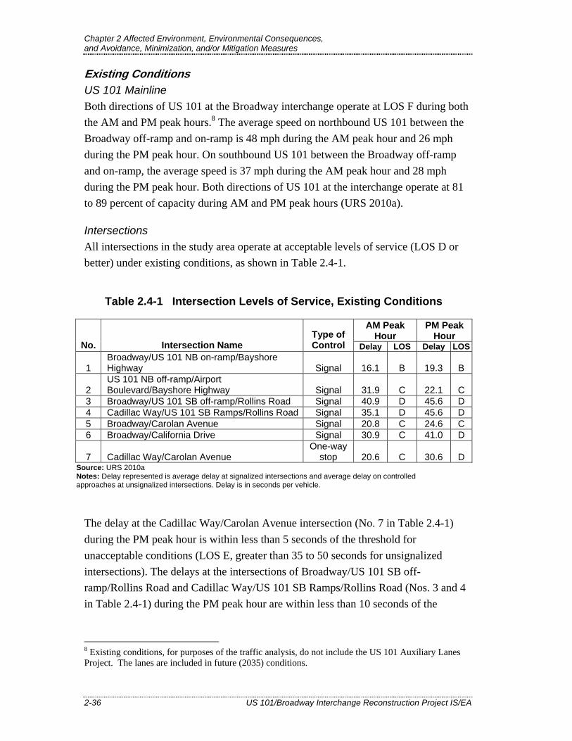
Chapter 2 Affected Environment, Environmental Consequences, and Avoidance, Minimization, and/or Mitigation Measures
2-36 US 101/Broadway Interchange Reconstruction Project IS/EA
Existing Conditions US 101 Mainline Both directions of US 101 at the Broadway interchange operate at LOS F during both the AM and PM peak hours.8 The average speed on northbound US 101 between the Broadway off-ramp and on-ramp is 48 mph during the AM peak hour and 26 mph during the PM peak hour. On southbound US 101 between the Broadway off-ramp and on-ramp, the average speed is 37 mph during the AM peak hour and 28 mph during the PM peak hour. Both directions of US 101 at the interchange operate at 81 to 89 percent of capacity during AM and PM peak hours (URS 2010a).
Intersections All intersections in the study area operate at acceptable levels of service (LOS D or better) under existing conditions, as shown in Table 2.4-1.
Table 2.4-1 Intersection Levels of Service, Existing Conditions
AM Peak Hour
PM Peak Hour
No. Intersection Name Type of Control Delay LOS Delay LOS
1 Broadway/US 101 NB on-ramp/Bayshore Highway Signal 16.1 B 19.3 B
2 US 101 NB off-ramp/Airport Boulevard/Bayshore Highway Signal 31.9 C 22.1 C
3 Broadway/US 101 SB off-ramp/Rollins Road Signal 40.9 D 45.6 D 4 Cadillac Way/US 101 SB Ramps/Rollins Road Signal 35.1 D 45.6 D 5 Broadway/Carolan Avenue Signal 20.8 C 24.6 C 6 Broadway/California Drive Signal 30.9 C 41.0 D
7 Cadillac Way/Carolan Avenue One-way
stop 20.6 C 30.6 D Source: URS 2010a Notes: Delay represented is average delay at signalized intersections and average delay on controlled approaches at unsignalized intersections. Delay is in seconds per vehicle.
The delay at the Cadillac Way/Carolan Avenue intersection (No. 7 in Table 2.4-1) during the PM peak hour is within less than 5 seconds of the threshold for unacceptable conditions (LOS E, greater than 35 to 50 seconds for unsignalized intersections). The delays at the intersections of Broadway/US 101 SB off-ramp/Rollins Road and Cadillac Way/US 101 SB Ramps/Rollins Road (Nos. 3 and 4 in Table 2.4-1) during the PM peak hour are within less than 10 seconds of the
8 Existing conditions, for purposes of the traffic analysis, do not include the US 101 Auxiliary Lanes Project. The lanes are included in future (2035) conditions.

Chapter 2 Affected Environment, Environmental Consequences, and Avoidance, Minimization, and/or Mitigation Measures
US 101/Broadway Interchange Reconstruction Project IS/EA 2-37
threshold for unacceptable conditions (LOS E, greater than 55 to 80 seconds for signalized intersections).
Future (No Build Alternative) Conditions US 101 Mainline In 2035, US 101 at the Broadway interchange will continue to operate at LOS F but average freeway speed will decline because of increased congestion. For example, between the Broadway on-ramps and off-ramps during the AM peak hour, the traffic model predicts the average existing freeway speed of 48 mph in the northbound direction and 37 mph in the southbound direction will decrease to 27 mph in the northbound direction and 26 mph in the southbound direction. Both directions of US 101 at the interchange will operate at 87 to 94 percent of capacity during AM and PM peak hours.
Intersections In 2035, six of the seven study intersections are expected to operate at unacceptable levels of service. Table 2.4-2 shows the 2035 levels of service.
Table 2.4-2 Future (2035) Intersection Levels of Service, No Build Alternative
AM Peak Hour PM Peak
Hour No. Intersection Name
Type of Control Delay LOS Delay LOS
1 Broadway/US 101 NB on-ramp/Bayshore Highway Signal 71.3 E 46.0 D
2 US 101 NB off-ramp/Airport Boulevard/Bayshore Highway Signal 49.2 D 45.9 D
3 Broadway/US 101 SB off-ramp/Rollins Road Signal 89.3 F 91.4 F
4 Cadillac Way/US 101 SB Ramps/Rollins Road Signal 81.2 F 152.0 F
5 Broadway/Carolan Avenue Signal 101.8 F 27.5 C 6 Broadway/California Drive Signal 55.4 E 73.1 E
7 Cadillac Way/Carolan Avenue One-way
stop 43.4 E 176.6 F Source: URS 2010a Notes: Delay represented is average delay at signalized intersections and average delay on controlled approaches at unsignalized intersections. Delay is in seconds per vehicle. Shading indicates unacceptable levels of service (LOS E or F).
The unacceptable future levels of service for the No Build Alternative shown for the intersections of Broadway/US 101 southbound off-ramp/Rollins Road and Cadillac Way/US 101 southbound ramps/Rollins Road (Nos. 3 and 4 in Table 2.4-2) are projected to result from increased traffic volumes (estimated to grow by 1 percent per

Chapter 2 Affected Environment, Environmental Consequences, and Avoidance, Minimization, and/or Mitigation Measures
2-38 US 101/Broadway Interchange Reconstruction Project IS/EA
year between existing conditions and 2035) combined with the capacity constraints posed by the five-legged intersection (see Figure 2.4-1, No. 3). The multiple traffic movements at each intersection constrain the number of vehicles that are able to pass through each signal cycle. The backup of vehicles on the US 101 southbound off-ramp to the Broadway/US 101 SB off-ramp/Rollins Road intersection (No. 3 in Figure 2.4-1 and Table 2.4-2) is predicted to extend into the mainline of US 101. At the Cadillac Way/US 101 southbound ramps/Rollins Road intersection, the backup of vehicles on Rollins Road would be nearly double the length of the existing queue (the buildup of traffic waiting to pass through intersections), particularly between Broadway and Cadillac Way.
Poor operating conditions and long delays at the Broadway/US 101 southbound off-ramp/Rollins Road intersection would increasingly induce drivers to use Cadillac Way to travel between southbound US 101 and destinations west of the freeway. As shown in Figure 2.4-1, Cadillac Way is parallel to and one block south of Broadway, and directly across from a pair of US 101 southbound ramps. By using Cadillac Way, drivers would travel through one congested intersection (No. 4 in Figure 2.4-1) instead of two (Nos. 3 and 4). In the PM peak hours, however, this would result in LOS F conditions and delays of more than two minutes at the intersection of Cadillac Way and Carolan Avenue (No. 7 in Figure 2.4-1 and Table 2.4-2).
Pedestrian and Bicycle Facilities Two City of Burlingame projects propose improvements to pedestrian and bicycle facilities in the US 101/Broadway project area. Both projects have been approved and are anticipated to be completed by 2013. The Carolan Avenue Bike Route Project would provide a dedicated Class III bike route with signs along approximately 1 mile of Carolan Avenue between Broadway and North Lane (to the south of the project area). The Broadway Pedestrian/Bicycle Bridge Connections Project would construct standard sidewalks, curb ramps, crosswalks, and signs at both ends of the pedestrian overcrossing. In addition, the project would construct a 600-foot sidewalk to connect the eastern landing of the pedestrian overcrossing to an existing Samtrans bus stop along Bayshore Highway via a crosswalk at the northbound US 101 on- and off-ramps.

US 101/BROADWAY INTERCHANGE RECONSTRUCTION PROJECT
BURLINGAME, CA EA 235840
FIGURE 2.4-1 EXISTING AND 2035 NO BUILD ALTERNATIVE LANE GEOMETRIES

Chapter 2 Affected Environment, Environmental Consequences, and Avoidance, Minimization, and/or Mitigation Measures
2-40 US 101/Broadway Interchange Reconstruction Project IS/EA
2.4.3. Environmental Consequences Section 2.4.2.3 describes future conditions under the No Build Alternative for both the US 101 mainline and study intersections. This section discusses the projected conditions with the Build Alternative.
2.4.3.1. Motorized Vehicle Traffic Conditions US 101 Mainline The project would add a second lane to the northbound US 101 off-ramp and an HOV lane on the northbound US 101 on-ramp. No adverse impacts to the freeway conditions are anticipated and no improvements to the mainline of US 101 are proposed. US 101 mainline traffic conditions were assumed to be the same as under the No Build Alternative.
Intersections In 2035 under No Build conditions, six of the seven study intersections are projected to operate at unacceptable levels of service. With the Build Alternative, all intersections are projected to operate at acceptable average levels of service. Table 2.4-3 shows projected delay times and levels of service for each alternative.
Table 2.4-3 Future (2035) Intersection Levels of Service, No Build and Build Alternatives
2035 No Build Conditions 2035 Build ConditionsAM Peak
Hour PM Peak
Hour AM Peak
Hour PM Peak
Hour No.
Intersection Name (under Build Conditions)
Type of Control Delay LOS Delay LOS Delay LOS Delay LOS
1 US 101 NB ramps/Bayshore Highway Signal 71.3 E 46.0 D 27.6 C 36.3 D
2
Broadway/Airport Boulevard/Crowne Plaza Hotel access road/Bayshore Highway Signal 49.2 D 45.9 D 27.7 C 25.9 C
3 Broadway/Rollins Road Signal 89.3 F 91.4 F 22.4 C 30.3 C 4 Cadillac Way/Rollins Road Signal 81.2 F 152.0 F 12.1 B 10.3 B 5 Broadway/Carolan Avenue Signal 101.8 F 27.5 C 32.9 C 29.0 C 6 Broadway/California Drive Signal 55.4 E 73.1 E 28.5 C 37.5 D
7 Cadillac Way/Carolan Avenue
One-way stop 43.4 E 176.6 F 17.9 C 21.3 C
8 Broadway/US 101 SB Ramps Signal Only exists with project
15.5 B 21.9 C
Source: URS 2010a Notes: Delay represented is average delay at signalized intersections and average delay on controlled approaches at unsignalized intersections. Delay is in seconds per vehicle. Shading indicates unacceptable levels of service (LOS E or F).
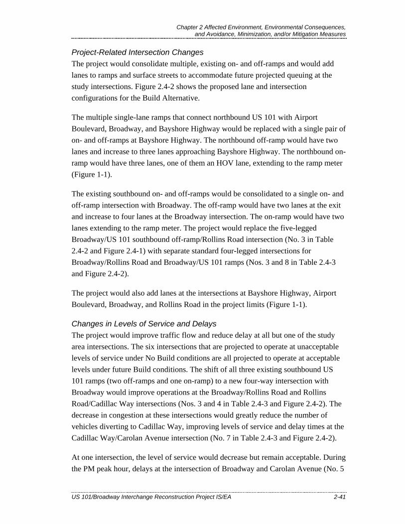
Chapter 2 Affected Environment, Environmental Consequences, and Avoidance, Minimization, and/or Mitigation Measures
US 101/Broadway Interchange Reconstruction Project IS/EA 2-41
Project-Related Intersection Changes The project would consolidate multiple, existing on- and off-ramps and would add lanes to ramps and surface streets to accommodate future projected queuing at the study intersections. Figure 2.4-2 shows the proposed lane and intersection configurations for the Build Alternative.
The multiple single-lane ramps that connect northbound US 101 with Airport Boulevard, Broadway, and Bayshore Highway would be replaced with a single pair of on- and off-ramps at Bayshore Highway. The northbound off-ramp would have two lanes and increase to three lanes approaching Bayshore Highway. The northbound on-ramp would have three lanes, one of them an HOV lane, extending to the ramp meter (Figure 1-1).
The existing southbound on- and off-ramps would be consolidated to a single on- and off-ramp intersection with Broadway. The off-ramp would have two lanes at the exit and increase to four lanes at the Broadway intersection. The on-ramp would have two lanes extending to the ramp meter. The project would replace the five-legged Broadway/US 101 southbound off-ramp/Rollins Road intersection (No. 3 in Table 2.4-2 and Figure 2.4-1) with separate standard four-legged intersections for Broadway/Rollins Road and Broadway/US 101 ramps (Nos. 3 and 8 in Table 2.4-3 and Figure 2.4-2).
The project would also add lanes at the intersections at Bayshore Highway, Airport Boulevard, Broadway, and Rollins Road in the project limits (Figure 1-1).
Changes in Levels of Service and Delays The project would improve traffic flow and reduce delay at all but one of the study area intersections. The six intersections that are projected to operate at unacceptable levels of service under No Build conditions are all projected to operate at acceptable levels under future Build conditions. The shift of all three existing southbound US 101 ramps (two off-ramps and one on-ramp) to a new four-way intersection with Broadway would improve operations at the Broadway/Rollins Road and Rollins Road/Cadillac Way intersections (Nos. 3 and 4 in Table 2.4-3 and Figure 2.4-2). The decrease in congestion at these intersections would greatly reduce the number of vehicles diverting to Cadillac Way, improving levels of service and delay times at the Cadillac Way/Carolan Avenue intersection (No. 7 in Table 2.4-3 and Figure 2.4-2).
At one intersection, the level of service would decrease but remain acceptable. During the PM peak hour, delays at the intersection of Broadway and Carolan Avenue (No. 5
US 101/BROADWAY INTERCHANGE
RECONSTRUCTION PROJECT BURLINGAME, CA
EA 235840
FIGURE 2.4-2 BUILD ALTERNATIVE LANE GEOMETRIES
Chapter 2 Affected Environment, Environmental Consequences, and Avoidance, Minimization, and/or Mitigation Measures
US 101/Broadway Interchange Reconstruction Project IS/EA 2-43
in Table 2.4-3 and Figure 2.4-2) would increase by 1.5 seconds over the No Build condition, but this minor increase in delay would not change the intersection’s LOS C rating. This effect would result from a shift of vehicles that would otherwise use Cadillac Way (to avoid Broadway congestion under the No Build Alternative) to using Carolan Avenue and westbound Broadway.
2.4.3.2. Construction Impacts Project construction would be staged to maintain through traffic on US 101 and the project area surface roads, although detours and limited short-term, temporary closures could be necessary on freeway ramps and other roadways in the project limits.
2.4.3.3. Pedestrian and Bicycle Facilities Access to and from the project’s transportation facilities including the Broadway overcrossing, existing pedestrian overcrossing, and other project area roadways would be designed with consideration of low-mobility groups and in conformance with ADA. Design features would include ramped curbs at intersections and accessible locations for public transit stops.
The project would upgrade existing sidewalks in the project limits to meet ADA standards and California Code of Regulations Title 24 requirements. The project would also add ADA-accessible sidewalks to the north side of the Broadway overcrossing and the east side of Rollins Road. Bicycle lanes would be added within the project limits as described in Section 1.3.1.3. If applicable, additional nonmotorized and pedestrian features may be considered during the final design phase.
Temporary closures of the pedestrian overcrossing will be required to reconfigure the structure’s approach landings at Rollins Road to the west and Bayshore Highway and the Crowne Plaza Hotel access road to the east. The TMP described in Section 2.4.3.2 would address impacts to the pedestrian overcrossing and bicycle and pedestrian access during project construction. The plan will maintain bicycle and pedestrian access across US 101, either on the pedestrian overcrossing or on the new Broadway overcrossing, to the maximum extent feasible as part of construction staging.
The proposed project is not expected to affect the bicycle lane striping or signage that will be installed for the City of Burlingame’s Carolan Avenue Bike Route Project. Several components of the City of Burlingame’s Broadway Pedestrian/Bicycle Bridge Connections Project would be reconstructed to accommodate the alignment of the
Chapter 2 Affected Environment, Environmental Consequences, and Avoidance, Minimization, and/or Mitigation Measures
2-44 US 101/Broadway Interchange Reconstruction Project IS/EA
new Broadway overcrossing and the higher grade of adjacent roadways and sidewalks, including at the landings of the existing pedestrian overcrossing. The US 101/Broadway project design maintains the pedestrian and bicycle connections from the City of Burlingame project, including a sidewalk and crosswalk linking the eastern landing of the pedestrian overcrossing with the Samtrans bus stop on the west side of Bayshore Highway. The US 101/Broadway project also includes additional features, such as a sidewalk and Class II bike lanes on the new Broadway overcrossing, that will increase pedestrian and bicycle access in the project vicinity consistent with the City of Burlingame’s project.
2.4.4. Avoidance, Minimization, and/or Mitigation Measures The proposed project would improve overall traffic operations within the project limits. Levels of service would improve or remain the same. Replacement of the existing overcrossing and ramps would slightly increase delay at one intersection (Broadway and Carolan Avenue) as a result of the improved flow and volume of traffic along Broadway. The change would not affect level of service and is not considered a substantial adverse impact, as it represents only 1.5 seconds of additional delay in 2035. Delay at all other study intersections would decrease, in some cases to the extent that the level of service would improve.
Impacts to traffic circulation and pedestrian and bicycle access during project construction would be minimized by implementation of the TMP. A detailed TMP will be prepared during the final design phase to minimize delay and inconvenience to the traveling public, in accordance with Department requirements and guidelines. The TMP will address traffic impacts from stage construction, detours, and specific traffic handling concerns such as emergency access during project construction. The TMP would include briefing local public officials and developing a public information program to notify the public of project progress and upcoming closures and detours. The public information program would include outreach to ride sharing agencies, transit operators, and neighborhood and special interest groups. Impacts to pedestrians and bicyclists, as well as access to local developments, would all be carefully considered in the staging plans.
No additional avoidance, minimization, and/or mitigation measures are required.

Chapter 2 Affected Environment, Environmental Consequences, and Avoidance, Minimization, and/or Mitigation Measures
US 101/Broadway Interchange Reconstruction Project IS/EA 2-45
2.5. Visual/Aesthetics
This section describes the visual setting of the project area as presented in the Visual Impact Assessment (William Kanemoto and Associates 2009), which was completed in December 2009.
2.5.1. Regulatory Setting NEPA establishes that the Federal government use all practicable means to ensure all Americans safe, healthful, productive, and aesthetically (emphasis added) and culturally pleasing surroundings (42 USC 4331[b][2]). To further emphasize this point, the FHWA in its implementation of NEPA (23 USC 109[h]) directs that final decisions regarding projects are to be made in the best overall public interest taking into account adverse environmental impacts, including among others, the destruction or disruption of aesthetic values.
Likewise, CEQA establishes that it is the policy of the State to take all action necessary to provide the people of the State “with…enjoyment of aesthetic, natural, scenic and historic environmental qualities” (California Public Resources Code [PRC] Section 21001[b]).
2.5.2. Affected Environment High-density urban development, including light and heavy industry, commercial establishments, utility corridors, and SFO dominate most immediate views from the US 101 corridor in the project vicinity. Mature trees and hedges along US 101 provide intermittent screening. Scenic views to the east include fleeting glimpses of San Francisco Bay between intensive bayside development. To the west are scenic distant views of the east-facing slope of the Coast Range, characterized by a mosaic of wooded hillside, open grassland, and residential development. Elevations in the project area range from near sea level along US 101 and the Bay shoreline to approximately 1,000 feet along the coastal hills to the west. US 101 in the project limits is not designated as a California Scenic Highway.
The project viewshed is generally defined as a 1/8-mile zone around the proposed US 101/Broadway interchange, where the proposed project features could be visually dominant and project-related visual impacts could occur. The project viewshed is situated within seven distinct landscape units, generally corresponding to different land uses with different levels of visual quality (measured by vividness, intactness

Chapter 2 Affected Environment, Environmental Consequences, and Avoidance, Minimization, and/or Mitigation Measures
2-46 US 101/Broadway Interchange Reconstruction Project IS/EA
and unity) and viewer sensitivity. These landscape units are depicted in Figure 2.5-1 and described below.
• Landscape Unit 1 – US 101 Corridor. US 101 is the primary visual feature within this landscape unit, with views of asphalt, vehicles, and concrete barriers. Existing trees within the interchange and at the highway shoulders contribute some vividness and visual screening, resulting in moderate visual quality. Sensitive viewers in this unit consist of motorists on US 101.
• Landscape Unit 2 – Broadway Interchange. This unit consists of the curved overcrossing, ramps, and the landscape elements in and around them. East of US 101, trees adjoin the existing overcrossing, and five large eucalyptus trees line Bayshore Highway to the northeast. West of the highway, eucalyptus and acacia trees screen industrial land uses along the southbound off-ramp and the tall PG&E transmission towers that loom over the interchange. The tree canopy gives this unit moderate visual quality. Pedestrians and bicyclists traveling between the Broadway shopping area and the Bay on the existing Broadway overcrossing and pedestrian overcrossing are considered the most visually sensitive viewers in this unit.
• Landscape Unit 3 – Bayshore Open Space. This unit has high-quality views of San Francisco Bay, mature trees along the south side of Airport Boulevard, and open grass areas within Bayside Park. Views to the proposed project would be largely limited to the immediate area along Airport Boulevard and Bayshore Highway. Sensitive viewers in this unit consist of recreational and scenery-oriented viewers using the Bay Trail and Bayside Park.
• Landscape Unit 4 – Bayshore Highway Airport Commercial. Hotel towers are interspersed with older single-story commercial development, occasional mature trees and landscaping, transmission towers, signs, and parking lots. Trees along the west side of Bayshore provide screening and an attractive streetscape element, resulting in an overall moderate visual quality. Despite the hotel-visitor orientation of the area, the focus of visual attention is directed strongly away from US 101 and interchange and toward the Bay, the Bay Trail, and Bayside Park to the east.
• Landscape Unit 5 – Northpark Apartments. The Northpark Apartment complex, one block south of Broadway and approximately 200 feet west of the existing Rollins Road southbound on-ramp, is the nearest residential housing to the proposed project. Views of the interchange and ramps are limited to east-facing views from second- and third-story units, and most views are partially or

San
FranciscoBay
Rollins Rd
Sanchez
Creek
BroadwayCaltrain
SOUTHERN PROJECTLIMIT: PM 16.30
NORTHERN PROJECTLIMIT: PM 17.06
Crowne PlazaHotel Driveway
MarstenRd
Whitehorn Way
California Dr
Broadway
RinetteAve
EastonCreek
Existing PedestrianOvercrossing
Rollins Rd
Airport Blvd
BayshoreHwy
LincolnAve
JuanitaAve
CadillacWay
BurlwayRd
SummerAve
Carolan Ave
KeyViewpoint 7
KeyViewpoint 6
KeyViewpoint 5
Key Viewpoint 4(Simulation)
Key Viewpoint 3(Simulation)
Key Viewpoint 2(Simulation)
Key Viewpoint 1(Simulation)
7. Rollins Light Industrial
3. Bayshore Open Space
4. Bayshore HighwayAirport Commercial
6. Auto Row
1. 101 Corridor
5. North ParkApartments
1. 101 Corridor
2. BroadwayInterchange
·|}82
£¤101
US 101/BROADWAY INTERCHANGERECONSTRUCTION PROJECT
BURLINGAME, CAEA 235840
December 2009
\\S021emc2\gisdata\Projects\US101_Broadway_SMTA_28645059\Maps\Fig_2_6-1_Project_Viewshed.mxd-12/4/2009@2:34:59PM
URSCorp-OaklandCA-J.Owen
FIGURE 2.6-1
PROJECT VIEWSHED, LANDSCAPE UNITS,
AND KEY VIEWPOINTS
Proposed Project Footprint
Edge of Paved Roadway
Landscape Unit Boundary
Imagery source: DigitalGlobe ImageConnect Service, 4/1/2009
0 200 400
FEET$FIGURE 2.5-1


Chapter 2 Affected Environment, Environmental Consequences, and Avoidance, Minimization, and/or Mitigation Measures
US 101/Broadway Interchange Reconstruction Project IS/EA 2-49
fully screened by mature trees within the complex or by buildings along Rollins Road and Broadway. The on-site tree canopy provides this unit with moderate visual quality. Residents of the complex are considered sensitive viewers, but only a small number of residents would have limited, screened views of the project.
• Landscape Unit 6 – Auto Row. From west of the overcrossing to the Caltrain railroad tracks, this unit is dominated by car dealerships, vehicles, concrete and asphalt, and mostly lacks street trees or other visual amenities. Trees within the interchange to the east and more distant views of the Broadway shopping district to the west provide some visual relief, although views within the unit are of low quality. The area supports high numbers of motorists entering and exiting downtown Burlingame, as well as pedestrians and bicyclists accessing the Bay via the Broadway overcrossing and pedestrian overcrossing.
• Landscape Unit 7 – Rollins Light Industrial. This landscape unit lies to the north of Broadway and is characterized by light industrial development. The area lacks landscaping and other visual amenities, resulting in a low overall visual quality. Views of the proposed project would be negligible.
2.5.3. Environmental Consequences Visual impacts were defined based on FHWA visual impact assessment methodology (FHWA 1988). Changes in visual quality of the setting, as identified by the attributes of vividness, intactness and unity in combination with viewer sensitivity and exposure, were used to rate change or impact:
• Low – Minor adverse change to the existing visual resource, with low viewer response to change in the visual environment. May or may not require mitigation.
• Moderate – Moderate adverse change to the visual resource with moderate viewer response. Impact can be mitigated within 5 years using conventional practices.
• Moderately High – Moderate adverse visual resource change with high viewer response or high adverse visual resource change with moderate viewer response. Extraordinary mitigation practices may be required. Landscape treatment required will generally take longer than 5 years to mitigate.
• High – A high level of adverse change to the resource or a high level of viewer response to visual change such that architectural design and landscape treatment cannot mitigate the impacts. Viewer response level is high. An alternative project design may be required to avoid highly adverse impacts.
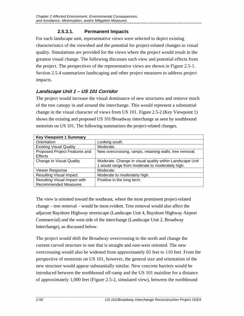
Chapter 2 Affected Environment, Environmental Consequences, and Avoidance, Minimization, and/or Mitigation Measures
2-50 US 101/Broadway Interchange Reconstruction Project IS/EA
2.5.3.1. Permanent Impacts For each landscape unit, representative views were selected to depict existing characteristics of the viewshed and the potential for project-related changes to visual quality. Simulations are provided for the views where the project would result in the greatest visual change. The following discusses each view and potential effects from the project. The perspectives of the representative views are shown in Figure 2.5-1. Section 2.5.4 summarizes landscaping and other project measures to address project impacts.
Landscape Unit 1 – US 101 Corridor The project would increase the visual dominance of new structures and remove much of the tree canopy in and around the interchange. This would represent a substantial change in the visual character of views from US 101. Figure 2.5-2 (Key Viewpoint 1) shows the existing and proposed US 101/Broadway interchange as seen by southbound motorists on US 101. The following summarizes the project-related changes.
Key Viewpoint 1 Summary Orientation Looking south. Existing Visual Quality Moderate. Proposed Project Features and Effects
New overcrossing, ramps, retaining walls; tree removal.
Change to Visual Quality Moderate. Change in visual quality within Landscape Unit 1 would range from moderate to moderately high.
Viewer Response Moderate. Resulting Visual Impact Moderate to moderately high. Resulting Visual Impact with Recommended Measures
Positive in the long term.
The view is oriented toward the southeast, where the most prominent project-related change – tree removal – would be most evident. Tree removal would also affect the adjacent Bayshore Highway streetscape (Landscape Unit 4, Bayshore Highway Airport Commercial) and the west side of the interchange (Landscape Unit 2, Broadway Interchange), as discussed below.
The project would shift the Broadway overcrossing to the north and change the current curved structure to one that is straight and east-west oriented. The new overcrossing would also be widened from approximately 65 feet to 110 feet. From the perspective of motorists on US 101, however, the general size and orientation of the new structure would appear substantially similar. New concrete barriers would be introduced between the northbound off-ramp and the US 101 mainline for a distance of approximately 1,000 feet (Figure 2.5-2, simulated view), between the northbound
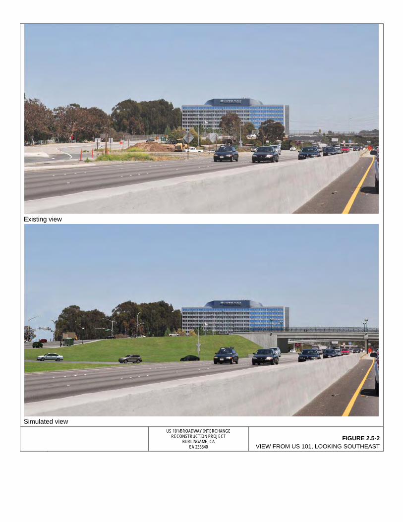
Existing view
Simulated view
US 101/BROADWAY INTERCHANGE
RECONSTRUCTION PROJECT BURLINGAME, CA
EA 235840 FIGURE 2.5-2
VIEW FROM US 101, LOOKING SOUTHEAST
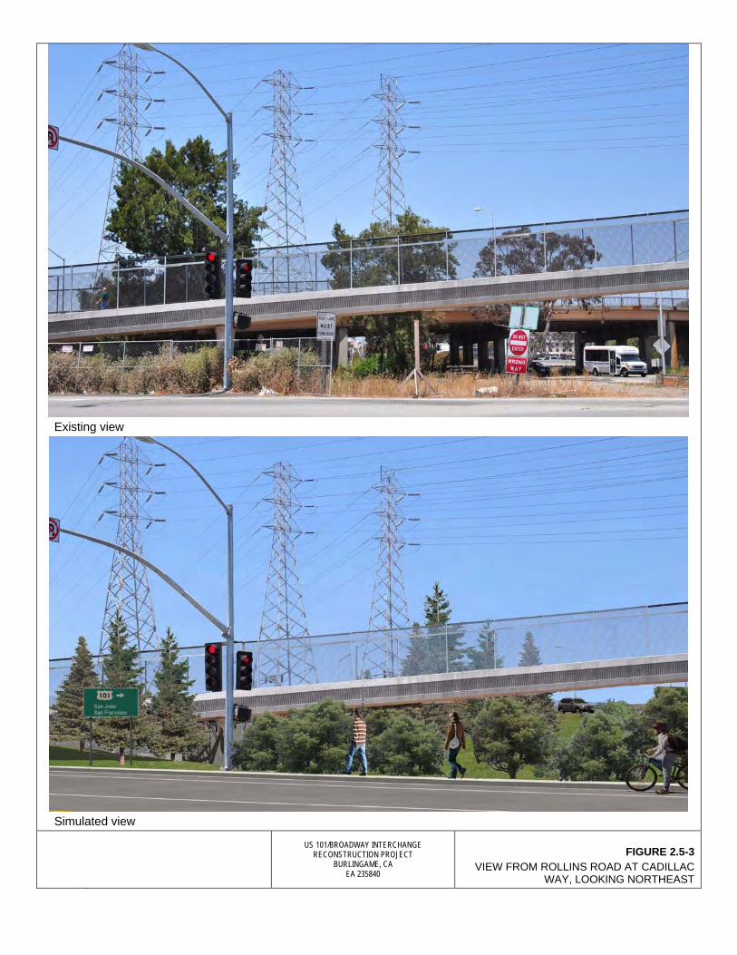
Existing view
Simulated view
US 101/BROADWAY INTERCHANGE
RECONSTRUCTION PROJECT BURLINGAME, CA
EA 235840
FIGURE 2.5-3 VIEW FROM ROLLINS ROAD AT CADILLAC
WAY, LOOKING NORTHEAST
View eastward toward San Francisco Bay from existing Broadway overcrossing
View northeast toward Bay from existing pedestrian overcrossing
US 101/BROADWAY INTERCHANGE RECONSTRUCTION PROJECT
BURLINGAME, CA EA 235840
FIGURE 2.5-4 VIEWS TOWARD BAY FROM EXISTING
BROADWAY OVERCROSSING AND PEDESTRIAN OVERCROSSING

US 101/BROADWAY INTERCHANGE
RECONSTRUCTION PROJECT BURLINGAME, CA
EA 235840
FIGURE 2.5-5 SIMULATED VIEW TOWARD BAY FROM PROPOSED
BROADWAY OVERCROSSING
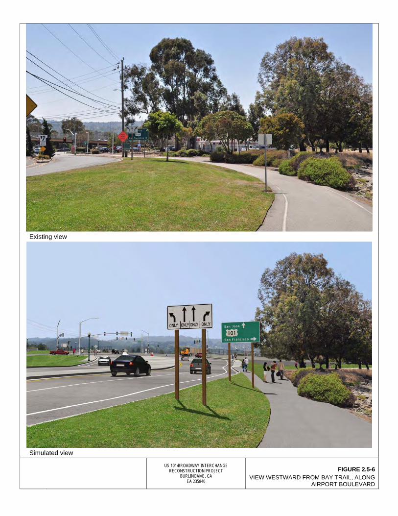
Existing view
Simulated view
US 101/BROADWAY INTERCHANGE
RECONSTRUCTION PROJECT BURLINGAME, CA
EA 235840
FIGURE 2.5-6 VIEW WESTWARD FROM BAY TRAIL, ALONG
AIRPORT BOULEVARD

Key Viewpoint 5: Bayshore Highway, looking south
Key Viewpoint 6: View toward proposed project area from Northpark Apartments, looking northeast
Key Viewpoint 7: View toward proposed project area from Auto Row, looking east from Carolan Avenue
US 101/BROADWAY INTERCHANGE
RECONSTRUCTION PROJECT BURLINGAME, CA
EA 235840
FIGURE 2.5-7 VIEWS FROM BAYSHORE HIGHWAY,
NORTHPARK APARTMENTS, AND AUTO ROW
Chapter 2 Affected Environment, Environmental Consequences, and Avoidance, Minimization, and/or Mitigation Measures
US 101/Broadway Interchange Reconstruction Project IS/EA 2-63
on-ramp and US 101 travel lanes for a distance of approximately 600 feet, and along the east side of the northbound on-ramp for a distance of approximately 800 feet. The barriers would contribute incrementally to the increased visual dominance of pavement and hardscape structures in the project vicinity.
The principal visual change from project structures would result from new retaining walls along the new southbound off- and on-ramps, which are west of, and outside of, the view shown in Figure 2.5-2. The ramps would rise to a height of approximately 25 feet above existing grade to meet Broadway. To support the ramps, retaining walls would be constructed from the beginning of the southbound off-ramp, meet the abutment beneath the new overcrossing, and continue to the end of the southbound on-ramp, for an overall distance of approximately 1,200 feet. This wall would primarily affect views for southbound highway motorists near the interchange.
The project’s greatest impact in the highway viewshed would result from removal of existing vegetation, including approximately 71 trees (eucalyptus, Casuarina [horsetail], Myoporum, willow, and acacia) throughout the project limits. Existing trees in the interchange provide visual screening. The simulated view in Figure 2.5-2 shows areas of tree removal along the northbound on- and off-ramps and Bayshore Highway. Other areas of tree removal not visible in Figure 2.5-2 are within the loop ramps west of US 101, along the southbound off-ramp shoulder, and behind the gas station at the corner of Airport Boulevard and Bayshore Highway. Although some of the trees that would be removed appear to be in compromised health and lack visual unity, several are tall and visually prominent. Along with shrubs and open grass areas, these trees dominate the visual image of the interchange.
Landscape Unit 2 – Broadway Interchange The project would not have a substantially adverse change with respect to views from the Broadway overcrossing or pedestrian overcrossing structures. As depicted in Figure 2.5-3, views are dominated by urban features including chain-link fencing, compromised landscaping, nearby concrete barriers, and traffic on Rollins Road and Broadway. The loss of tree canopy would change the overall visual quality rating at this location from moderate to moderately high.
West of the Interchange. Figure 2.5-3 (Key Viewpoint 2) depicts a view of motorists, bicyclists, and pedestrians on Rollins Road at Cadillac Way as they approach the interchange and pedestrian overcrossing to access the Bay east of US 101. It also represents a pedestrian’s view traveling from the southwest interchange
Chapter 2 Affected Environment, Environmental Consequences, and Avoidance, Minimization, and/or Mitigation Measures
2-64 US 101/Broadway Interchange Reconstruction Project IS/EA
quadrant (e.g., the Northpark Apartments area) toward the Bay using the Broadway overcrossing or pedestrian overcrossing (Landscape Unit 5, Northpark Apartments). Because views from the apartment complex area are heavily screened, this location was considered the worst-case project change for viewers in the southwest interchange quadrant.
Key Viewpoint 2 Summary Orientation Looking northeast. Existing Visual Quality Visual quality from Viewpoint 2 is moderately low;
however, overall visual quality of Landscape Unit 2, which this viewpoint represents in part, is moderate.
Proposed Project Features and Effects
New overcrossing, ramps, retaining walls, earth embankments; tree removal; reconfiguration of pedestrian overcrossing connector to meet new sidewalk along Rollins Road.
Change to Visual Quality Change to visual quality from this viewpoint would be moderate; however, change to visual quality within Landscape Unit 2 in general would range from moderate to moderately high.
Viewer Response Moderate. Resulting Visual Impact Moderate from this viewpoint. Change to visual quality
within Landscape Unit 2 in general would range from moderate to moderately high.
Resulting Visual Impact with Recommended Measures
Positive in the long term.
The project would change views in the southwest interchange quadrant by removing tall trees and introducing a retaining wall and earth embankment west of the new elevated southbound on-ramp. The existing PG&E transmission towers, now located north of the existing interchange, would become somewhat more visible in the foreground of a new 25-foot-tall retaining wall on the south side of Broadway. Views of the retaining walls, embankment, and towers would be screened by the pedestrian overcrossing and its abutments. The access to the pedestrian overcrossing would be moved south on Rollins Road from its existing location near Broadway closer to Cadillac Way. Pedestrians and bicyclists would access the pedestrian overcrossing from a new sidewalk along the east side of Rollins Road.
East of the Interchange. Key Viewpoint 3 was selected to represent existing and proposed views to the Bay from the project area. Pedestrians and bicyclists accessing the Bay via both the existing Broadway overcrossing and the pedestrian overcrossing are an important user and viewer group. Figure 2.5-4 shows the tall chain-link safety fencing along the curved Broadway overcrossing and pedestrian overcrossing that screens views of the Bay. A gas station at Bayshore Highway and Airport Boulevard and three large eucalyptus trees to the east also partially obstruct Bay views.
Chapter 2 Affected Environment, Environmental Consequences, and Avoidance, Minimization, and/or Mitigation Measures
US 101/Broadway Interchange Reconstruction Project IS/EA 2-65
Key Viewpoint 3 Summary Orientation Looking east. Existing Visual Quality Visual quality from the existing viewpoints is
moderate; existing scenic views of the Bay are very limited and highly filtered by chain-link fencing.
Proposed Project Features and Effects
New overcrossing, ramps, retaining walls, earth embankments; tree removal; realignment of overcrossing to a straight east-west orientation.
Change to Visual Quality The project would improve the visual quality for motorists and bicyclists on the new Broadway overcrossing.
Viewer Response Moderate. Resulting Visual Impact Improved. Resulting Visual Impact with Recommended Mitigation
Visual quality of views would be enhanced in the long term by recommended replacement landscaping on new earth embankments. No additional mitigation needed to enhance scenic vistas.
As shown in Figure 2.5-5, the straight east-west orientation of the proposed Broadway overcrossing would provide unobstructed views of the Bay. Removal of the gas station and the trees behind it to accommodate the realignment of Airport Boulevard would also increase views toward the east. The realignment of Airport Boulevard would create a new area of open space at the entrance to Bayside Park that could be available for landscaping. These changes would improve visual quality for motorists and for the bicyclists who use the Class II bike lane on the south side of the Broadway overcrossing. Views of the Bay would also improve for pedestrians who use the sidewalk on the north side of the Broadway overcrossing, to the north and outside of the view shown in Figure 2.5-5.
Figure 2.5-5 also depicts earth embankments that would support a new access road to the Crowne Plaza Hotel and new sidewalks on both sides of the access road. Farther south, out of the view shown in Figure 2.5-5, the pedestrian overcrossing would connect with the sidewalk on the west side of the access road; beyond that, a retaining wall would support the west side of the access road as it enters the Crowne Plaza Hotel parking lot. This wall would be up to 10 feet high and 100 feet in length. The new earth embankments, elevated intersection, access road, and retaining wall would visually alter the approach and entrance to the hotel.
Landscape Unit 3 – Bayshore Open Space Figure 2.5-6 (Key Viewpoint 4) depicts the project’s effect on views for Bay Trail users, the principal affected user group in this unit. Loss of landscaping, including the large eucalyptus trees at the gas station, and introduction of a concrete retaining wall
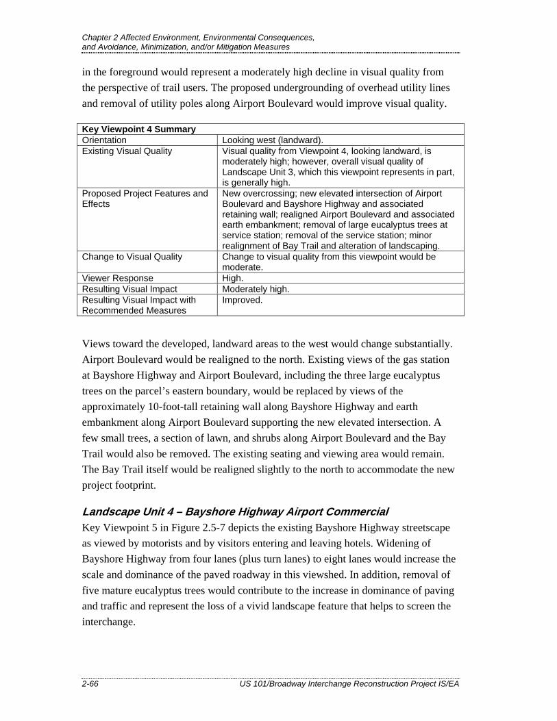
Chapter 2 Affected Environment, Environmental Consequences, and Avoidance, Minimization, and/or Mitigation Measures
2-66 US 101/Broadway Interchange Reconstruction Project IS/EA
in the foreground would represent a moderately high decline in visual quality from the perspective of trail users. The proposed undergrounding of overhead utility lines and removal of utility poles along Airport Boulevard would improve visual quality.
Key Viewpoint 4 Summary Orientation Looking west (landward). Existing Visual Quality Visual quality from Viewpoint 4, looking landward, is
moderately high; however, overall visual quality of Landscape Unit 3, which this viewpoint represents in part, is generally high.
Proposed Project Features and Effects
New overcrossing; new elevated intersection of Airport Boulevard and Bayshore Highway and associated retaining wall; realigned Airport Boulevard and associated earth embankment; removal of large eucalyptus trees at service station; removal of the service station; minor realignment of Bay Trail and alteration of landscaping.
Change to Visual Quality Change to visual quality from this viewpoint would be moderate.
Viewer Response High. Resulting Visual Impact Moderately high. Resulting Visual Impact with Recommended Measures
Improved.
Views toward the developed, landward areas to the west would change substantially. Airport Boulevard would be realigned to the north. Existing views of the gas station at Bayshore Highway and Airport Boulevard, including the three large eucalyptus trees on the parcel’s eastern boundary, would be replaced by views of the approximately 10-foot-tall retaining wall along Bayshore Highway and earth embankment along Airport Boulevard supporting the new elevated intersection. A few small trees, a section of lawn, and shrubs along Airport Boulevard and the Bay Trail would also be removed. The existing seating and viewing area would remain. The Bay Trail itself would be realigned slightly to the north to accommodate the new project footprint.
Landscape Unit 4 – Bayshore Highway Airport Commercial Key Viewpoint 5 in Figure 2.5-7 depicts the existing Bayshore Highway streetscape as viewed by motorists and by visitors entering and leaving hotels. Widening of Bayshore Highway from four lanes (plus turn lanes) to eight lanes would increase the scale and dominance of the paved roadway in this viewshed. In addition, removal of five mature eucalyptus trees would contribute to the increase in dominance of paving and traffic and represent the loss of a vivid landscape feature that helps to screen the interchange.

Chapter 2 Affected Environment, Environmental Consequences, and Avoidance, Minimization, and/or Mitigation Measures
US 101/Broadway Interchange Reconstruction Project IS/EA 2-67
Key Viewpoint 5 Summary Orientation Looking north on Bayshore Highway. Existing Visual Quality Moderate. Proposed Project Features and Effects
Widening of Bayshore Highway from four lanes to eight; new elevated approach to intersection of Airport Boulevard and Bayshore Highway; new overcrossing; removal of large eucalyptus trees west of Bayshore Highway and other trees within interchange; removal of existing service station and large eucalyptus trees on that property; reconstruction of eastern pedestrian overcrossing connector.
Change to Visual Quality Moderate. Viewer Response Moderate. Resulting Visual Impact Moderate. Resulting Visual Impact with Recommended Measures
Improved.
Landscape Unit 5 – Northpark Apartments Key Viewpoint 6 in Figure 2.5-7 shows views of the proposed project area from the Northpark Apartments. Existing views of the interchange are limited to east-facing upper-story windows of two apartment buildings. The project features, which would be located roughly 200 feet north of the existing pedestrian overcrossing in the foreground, would be more distant from the apartments than the existing interchange, and the views would be highly filtered by the existing on-site tree canopy. Finally, existing views of the interchange from the apartments are of low visual quality. The project would have minor impacts or improve views, since visible structures would be more distant and less prominent.
Key Viewpoint 6 Summary Orientation Looking northeast from North Park Apartments. Existing Visual Quality Low. Proposed Project Features and Effects
Removal of existing Broadway overcrossing and construction of new overcrossing north of the existing structure; new elevated southbound on-ramp; tree removal in interchange; new sidewalk along Rollins Road.
Change to Visual Quality Low to moderate. Viewer Response High. Resulting Visual Impact Moderate. Resulting Visual Impact with Recommended Measures
Improved.
Landscape Unit 6 – Auto Row Key Viewpoint 7 in Figure 2.5-7 is an eastward view of Broadway and Auto Row, as seen by motorists entering and leaving downtown Burlingame and visitors to auto dealerships. The existing visual quality within the Auto Row landscape unit is moderately low except for the existing tree canopy within the interchange. By

Chapter 2 Affected Environment, Environmental Consequences, and Avoidance, Minimization, and/or Mitigation Measures
2-68 US 101/Broadway Interchange Reconstruction Project IS/EA
widening Broadway, increasing the road’s elevation toward the interchange, and removing the trees within the interchange, the project would increase dominance of the roadway and decrease visual quality. While the visual change would be pronounced, the visual quality would remain moderate.
Key Viewpoint 7 Summary Orientation Looking east from Carolan Avenue and Broadway. Existing Visual Quality Moderately low. Proposed Project Features and Effects
Removal of existing Broadway overcrossing and construction of new overcrossing to the north; removal of all trees within interchange and adjoining southbound off-ramp; widening of Broadway and construction of new elevated intersection of Rollins Road and Broadway.
Change to Visual Quality Moderate. Viewer Response Moderate. Resulting Visual Impact Moderately low. Resulting Visual Impact with Recommended Measures
Neutral.
Landscape Unit 7 – Rollins Light Industrial No viewpoint was considered necessary for analysis because the project area is not visible from most of the Rollins Road area north of Broadway. Changes to visual quality along US 101 and at the interchange are described under Landscape Units 1 and 2, above. Visual changes along Broadway just south of the Rollins Light Industrial unit are described under Landscape Unit 6, above.
2.5.3.2. Construction Impacts Demolition of existing Broadway interchange structures, construction of the proposed project, and unsightly material or equipment storage in visually sensitive areas (particularly adjacent to the Bay Trail) would have short-term, transient impacts for the duration of project construction, which could last for 2 to 2.5 years. Replacement landscaping installation and standard Department construction practices would be implemented to restore the construction area.
Lighting for nighttime construction activities would create a temporary source of light or glare in and directly adjacent to the project limits. Temporary lighting installations include site lighting for construction staging areas and portable generator-mounted lighting for paving and other construction activities. The construction contractor would be required to direct lighting away from residential areas as much as possible.
No long-term construction impacts would occur.
Chapter 2 Affected Environment, Environmental Consequences, and Avoidance, Minimization, and/or Mitigation Measures
US 101/Broadway Interchange Reconstruction Project IS/EA 2-69
2.5.3.3. Impact Summary The project would not have a substantial adverse effect on a scenic vista or substantially damage resources within a State scenic highway. Tree removal and introduction of concrete roadway structures would decrease the visual quality of the project viewshed, but these effects would be minimized by implementation of the measures listed in Section 2.5.4. Construction contractor requirements would minimize light and glare impacts from nighttime construction activities.
2.5.4. Avoidance, Minimization, and/or Mitigation Measures 2.5.4.1. Context Sensitive Solutions
The Department’s planning, design, operation, and maintenance of transportation systems include consideration of “context sensitive solutions” (CSS). The CSS process is intended to integrate and balance community, aesthetic, historic, and environmental values with transportation safety, maintenance, and performance goals.
The project proposes upgraded fencing and ornamental light fixtures for the Broadway overcrossing, consistent with City of Burlingame Goal F-6 (“Develop a sense of place by creating a unifying gateway treatment at entrances and throughout the area”). Ornamental light fixtures would also be considered where appropriate for Broadway, Bayshore Highway, and Airport Boulevard in the project limits.
Community input about aesthetic features of the project such as replacement landscaping and surface treatments for concrete structures will be solicited as part of the public review process. Input on these features will also be sought from the City of Burlingame and, if applicable, BCDC.
2.5.4.2. Minimization Measures The measures listed in Table 2.5-1 would be considered to minimize visual impacts from the proposed project.

Chapter 2 Affected Environment, Environmental Consequences, and Avoidance, Minimization, and/or Mitigation Measures
2-70 US 101/Broadway Interchange Reconstruction Project IS/EA
Table 2.5-1 Visual Minimization Measures
Project Feature Measure Replacement Planting
Replacement tree planting would help to create a coherent, recognizable gateway identity at the new interchange, re-establishing vividness and intactness of the city entry image through use of locally appropriate trees of tall stature. Replacement tree planting would restore and enhance the interchange gateway/entry statement in the long term. Clinging vines would soften the appearance of concrete retaining walls.
Structure Design Measures
Structure design measures would maintain design consistency within the project limits and maintain visual consistency and coherence within the wider US 101 corridor. Architectural treatments, particularly surface texture treatment, for major structures including the overcrossing parapet and all visible retaining walls would reduce surface reflectivity, brightness, and visual monotony associated with untextured concrete walls. Surface texture treatments that visually relate to those on the existing pedestrian overcrossing should be considered. Upgraded fencing and ornamental light fixtures (examples shown in Figure 2.5-2) will be considered for the Broadway overcrossing. This would improve the aesthetic quality of the overcrossing compared to the existing condition. Ornamental light fixtures will also be considered where appropriate for Broadway, Bayshore Highway, and Airport Boulevard in the project limits.
Locations of Special Interest
Replacement tree planting is recommended in the following locations: • At the southbound on- and off-ramps and in the northeast quadrant of the interchange. • Along the west side of Bayshore Highway. • At the gas station at the corner of Bayshore Highway and Airport Boulevard, which is proposed to be acquired and removed for the project. • Along the Bay Trail. Other landscaping would be considered for the area between the project and the Bay Trail to replace lost trees, shrubs and lawn in the area northeast of Airport Boulevard, to soften the new earth embankment north of Airport Boulevard, to screen and soften the visual foreground of the new retaining wall along Bayshore Highway, and to enhance the landside trail environment.
2.6. Cultural Resources
This section summarizes the Archaeological Survey Report (URS 2009b), Historic Property Survey Report (URS 2009c), and Historic Resources Evaluation Report (JRP 2009) prepared for the proposed project. All three technical studies were completed in December 2009.
Chapter 2 Affected Environment, Environmental Consequences, and Avoidance, Minimization, and/or Mitigation Measures
US 101/Broadway Interchange Reconstruction Project IS/EA 2-71
2.6.1. Regulatory Setting “Cultural resources” as used in this document refers to all historical and archaeological resources, regardless of significance. Laws and regulations dealing with cultural resources include:
The National Historic Preservation Act (NHPA) of 1966, as amended, sets forth national policy and procedures regarding historic properties, defined as districts, sites, buildings, structures, and objects included in or eligible for the National Register of Historic Places (NRHP). Section 106 of NHPA requires Federal agencies to take into account the effects of their undertakings on such properties and to allow the Advisory Council on Historic Preservation the opportunity to comment on those undertakings, following regulations issued by the Advisory Council on Historic Preservation (36 CFR 800). On January 1, 2004, a Section 106 Programmatic Agreement (PA) between the Advisory Council, FHWA, SHPO, and the Department went into effect for Department projects, both State and local, with FHWA involvement. The PA implements the Advisory Council’s regulations, 36 CFR 800, streamlining the Section 106 process and delegating certain responsibilities to the Department. The FHWA’s responsibilities under the PA have been assigned to the Department as part of the Surface Transportation Project Delivery Pilot Program (23 CFR 773) (July 1, 2007).
The Archaeological Resources Protection Act applies when a project may involve archaeological resources located on Federal or tribal land. The act requires that a permit be obtained before excavation of an archaeological resource on such land can take place.
Historic properties may also be covered under Section 4(f) of the U.S. Department of Transportation Act, which regulates the “use” of land from historic properties.
Historical resources are considered under CEQA as well as PRC Section 5024.1, which established the California Register of Historical Resources (CRHR). PRC Section 5024 requires state agencies to identify and protect state-owned resources that meet NRHP listing criteria. It further specifically requires the Department to inventory state-owned structures in its rights-of-way.
2.6.2. Affected Environment The study areas for cultural resources investigations are referred to as areas of potential effect (APEs). The archaeological APE includes the existing and proposed

Chapter 2 Affected Environment, Environmental Consequences, and Avoidance, Minimization, and/or Mitigation Measures
2-72 US 101/Broadway Interchange Reconstruction Project IS/EA
right-of-way for the project and additional areas for temporary construction easements, staging, and access. The architectural APE includes the archaeological APE as well as parcels with buildings or structures adjacent to the existing and proposed right-of-way that could be affected by project construction or operation. As the proposed project would affect roadways within the City of Burlingame right-of-way, the APEs also include the existing and proposed city right-of-way.
2.6.2.1. Records/Archival Review and Archaeological Field Survey Results
An archival search was completed at the California Historic Resources Inventory System, Northwest Information Center (CHRIS/NWIC) at California State University, Sonoma, for the project right-of-way and a 0.25-mile radius. Reports for all known cultural resource studies within a 1-mile radius were reviewed. A field survey and reviews of historical maps and General Land Office plats were also conducted. All accessible portions of the archaeological APE were subject to a pedestrian survey.
One previously recorded archaeological site was identified within the archaeological APE (CA-SMA-317). No new resources or sites were identified or recorded a result of the records search, map review, or pedestrian survey.
2.6.2.2. Native American Consultation A records search of the Sacred Lands File was requested from the Native American Heritage Commission (NAHC). No sacred lands were identified in the project’s APEs. The NAHC provided the names and contact information for seven individuals or organizations that may have knowledge of cultural resources in the project area. Letters requesting comments regarding any concerns or issues pertinent to the project and follow-up e-mails were sent to each contact. Two telephone calls and one e-mail comment were received. Representatives of both the Indian Canyon Mutsun Band of Costanoan and the Amah/Mutsun Tribal Band telephoned and requested that they be contacted in the event of an archaeological discovery. A representative of the Ohlone Indian Tribe requested in an e-mail that a Native American monitor be on-site during construction activities.
2.6.2.3. Potential for Presence of Subsurface Resources The ground surface in the project area has already been extensively modified, and most excavation will be in fill. Therefore, the probability of encountering subsurface

Chapter 2 Affected Environment, Environmental Consequences, and Avoidance, Minimization, and/or Mitigation Measures
US 101/Broadway Interchange Reconstruction Project IS/EA 2-73
archaeological deposits is considered low. No cultural resources were found during previous archaeological testing in the interchange (Basin Research 2002).
One previously recorded archaeological site was reported within the archaeological APE (CA-SMA-317). Project activities in the vicinity of CA-SMA-317 would be limited to restriping and would involve no ground disturbance.
2.6.2.4. Historic Resources Records and Field Inventory Results
The records review identified three resources within the architectural APE that were previously evaluated and determined ineligible for the NRHP and the CRHR: the Broadway overcrossing, the Transmission Canal culvert, and the Peninsula Commute Service crossing. A pedestrian survey of the historic resources APE identified 10 resources that are exempt from evaluation under the Section 106 PA Attachment 4, and eight historic-era resources that required additional evaluation. Caltrans Professionally Qualified Staff determined that all resources within the APE are ineligible for listing in the NRHP. Further, no resources within the APE are eligible for the CRHR, or appear to be historical resources for the purposes of CEQA.
2.6.3. Environmental Consequences One previously recorded archaeological site was reported within the archaeological resources APE (CA-SMA-317). As no subsurface construction activities would take place in the vicinity of the site, and no surface deposits relating to the site were identified during the field survey, the project is not expected to affect CA-SMA-317.
Throughout the project area, the ground surface has been highly modified with artificial fill soils. Subsurface construction activities would exceed the depths of artificial fill only where piles would be driven to support the Broadway overcrossing, the southbound US 101 off-ramp and on-ramp, and adjacent retaining walls.9 The piles would reach maximum depths of 60 to 70 feet, through a sequence of layers composed of fill, Bay Mud, and then Pleistocene alluvium at 30 to 40 feet. Bay Mud is not anticipated to contain substantial archaeological deposits, and Pleistocene sediments exceed the age of known human occupation in the Bay Area. Therefore, the project is not expected to affect subsurface archaeological resources.
9 Proposed retaining walls along the Crowne Plaza Hotel access road, Bayshore Highway, and Rollins Road would be supported on spread footings rather than piles.

Chapter 2 Affected Environment, Environmental Consequences, and Avoidance, Minimization, and/or Mitigation Measures
2-74 US 101/Broadway Interchange Reconstruction Project IS/EA
No properties in the architectural APE are eligible for the NRHP or CRHR, or appear to be historical resources for the purposes of CEQA. The project would not affect, or use, any Section 4(f) historic resource.
The cultural resources finding for this project is No Adverse Effect. The cultural resources studies, and the determination of No Adverse Effect, were submitted to the SHPO. Because no response was received from SHPO during the specified 30-day time period, the Department has assumed SHPO concurrence, in accordance with the PA.
2.6.4. Avoidance, Minimization, and/or Mitigation Measures For the purposes of this project, CA-SMA-317 will be treated as a potential historic property eligible for inclusion in the NRHP. To ensure avoidance of CA-SMA-317, the site will be designated an ESA. The specific method of establishing the ESA will be determined during final design. With the protection afforded by the ESA, no monitoring is proposed. With the exception of these measures, no further archeological work is required.
If cultural materials are discovered during construction, all earth-moving activity within and around the immediate discovery area will be diverted until a qualified archaeologist can assess the nature and significance of the find.
If human remains are discovered, State Health and Safety Code Section 7050.5 states that further disturbances and activities shall cease in any area or nearby area suspected to overlie remains, and the County Coroner contacted. Pursuant to PRC Section 5097.98, if the remains are thought to be Native American, the coroner will notify the NAHC, which will then notify the Most Likely Descendent (MLD). At this time, the person who discovered the remains will contact the District Environmental Branch so that they may work with the MLD on the respectful treatment and disposition of the remains. Further provisions of PRC Section 5097.98 are to be followed as applicable.
Related Documents


