Urban Planning in the Middle East: Analyzing Al-Tahrir Square as a Public-Political Space in Iraq Rasha Al-Tameemi, University of Cincinnati, Cincinnati, United States of America, [email protected] Abstract Al-Tahrir Square, surrounded by commercial crowded streets, financial headquarters, and governmental institutions is one of the most iconic squares in Baghdad. It is part of daily life for many Iraqi people due to its central location, which is characterized by busy roads with honking cars. In this essay, I am going to explore Al-Tahrir Square in Baghdad, Iraq as a venue of rebellion for Iraqi people. Since 2015, Iraqi people from diverse backgrounds have been gathering in the square to protest for their rights every Friday. It has been the site of many historical events in Iraq although it has been established as a social place. I will explore the sociopolitical significance of Al-Tahrir Square by connecting the history of the place with how it has been changed since 1961 when the Freedom Monument was first open to the public. The research addresses the urban landscape of Al-Tahrir Square and its transformation over time, taking into consideration the political issues that affect it. I will analyze policies and regulations that have discouraged people from gathering in the Square to prevent political threats to the government and suggest ways to create safer spaces and mixed used attractions, modify the natural landscape of Al-Ummah Garden to make it more connected to the Square, and revitalize the existing kaleidoscope for closer proximity to Tigris River. Keywords: Al-Tahrir Square, Freedom monument, Al-Ummah Garden, Al-Rasheed Street, and urban planning Al-Tahrir Square has a complicated history. It was a parking lot in the 1950s, but in 1961, it use shifted and it became the location of the Freedom Monument. This shift marked Al- Tahrir Square as evidence of the Iraqi people’s journey of struggle and victory that designated it as a symbol of a new era of liberation from British colonialism. It has always been selected as a protest site because of its location in central Baghdad, especially in the past when it was the focal point for social gatherings. Besides being accessible from both Al-Karkh and Al-Rusafa, the two sides of Baghdad, through the highways and bridges that shorten the distance, the Square has had a long history of political demonstrations and has become a symbol for liberation, represented by the Freedom Monument.

Welcome message from author
This document is posted to help you gain knowledge. Please leave a comment to let me know what you think about it! Share it to your friends and learn new things together.
Transcript
Urban Planning in the Middle East: Analyzing Al-Tahrir Square as a Public-Political Space in Iraq Rasha Al-Tameemi, University of Cincinnati, Cincinnati, United States of America, [email protected] Abstract Al-Tahrir Square, surrounded by commercial crowded streets, financial headquarters, and governmental institutions is one of the most iconic squares in Baghdad. It is part of daily life for many Iraqi people due to its central location, which is characterized by busy roads with honking cars. In this essay, I am going to explore Al-Tahrir Square in Baghdad, Iraq as a venue of rebellion for Iraqi people. Since 2015, Iraqi people from diverse backgrounds have been gathering in the square to protest for their rights every Friday. It has been the site of many historical events in Iraq although it has been established as a social place. I will explore the sociopolitical significance of Al-Tahrir Square by connecting the history of the place with how it has been changed since 1961 when the Freedom Monument was first open to the public. The research addresses the urban landscape of Al-Tahrir Square and its transformation over time, taking into consideration the political issues that affect it. I will analyze policies and regulations that have discouraged people from gathering in the Square to prevent political threats to the government and suggest ways to create safer spaces and mixed used attractions, modify the natural landscape of Al-Ummah Garden to make it more connected to the Square, and revitalize the existing kaleidoscope for closer proximity to Tigris River. Keywords: Al-Tahrir Square, Freedom monument, Al-Ummah Garden, Al-Rasheed Street, and urban planning
Al-Tahrir Square has a complicated history. It was a parking lot in the 1950s, but in 1961, it use shifted and it became the location of the Freedom Monument. This shift marked Al-Tahrir Square as evidence of the Iraqi people’s journey of struggle and victory that designated it as a symbol of a new era of liberation from British colonialism. It has always been selected as a protest site because of its location in central Baghdad, especially in the past when it was the focal point for social gatherings. Besides being accessible from both Al-Karkh and Al-Rusafa, the two sides of Baghdad, through the highways and bridges that shorten the distance, the Square has had a long history of political demonstrations and has become a symbol for liberation, represented by the Freedom Monument.
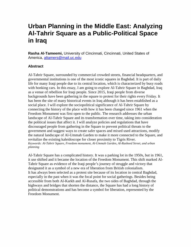
Research Methods Urban Context Al-Tahrir (figures 1-4) lies on the eastern side of Baghdad in area known as Bab-Alsharji (eastern gate). The Square has had and still has an important role in many revolutions, marches, and uprisings in Baghdad. It is called the Al-Tahrir, which in Arabic means “Liberation” in relation to freedom from British occupation and the colonial period. The Freedom Monument is located on the east side of the Square, and behind it is a garden known as Al-Umma Park or the Garden of Nation, while the Republic Bridge is located on the western side of the Square. To the left, this bridge is framed by the Tigris Primary School for Girls and the Al-Aqeeda High School for Girls, which were established in 1921. The right side of the bridge is marked by the former Turkish restaurant building, in addition to several bookstores including the Renaissance Bookshop (Al-Nahda Library). Republic Street1 runs along the north side of the Square, parallel to Al-Rrasheed Street. The southern side of Al-Tahrir Square leads to Al-Sadoun Street2.
Figure 1: Map of the area surrounding Al-Tahrir Square
Source: Google Earth
1 Republic Street, an old street that has been renewed to combine elements from traditional and contemporary architectural style, offers a public commercial scene with different markets including bazaars and retailers. 2 Al-Sadoun Street is one of the main streets in central Baghdad that houses popular medical clinics, travel/tourist offices, the very first cinemas (Sinbad and Victory), hotels, and bookstores. The street is named after Abdul-Muhsin al-Sadoun, former prime minister (1922-1929) who was involved in the anti-colonial political struggles of the time. Its development began in the 1930s when it was designed to be a posh residential neighborhood for the elite. Over the last several decades, however, it has been transformed into a commercial hub, with rich families having moved to quieter areas, thus inviting more blue-collar workers and low-income families into the area.

Figure 2: As described above, the Bridge at the top of the photo indicates West direction.
Source: http://wikimapia.org/1411861/al-Tahrir-Square#/photo/1491147
Figure 3: Al-Tahrir Square
Source: http://www.pukmedia.com/AR_Direje.aspx?Jimare=66628
The urban landscape of Baghdad is characterized by a spontaneous compact fabric, and the “hierarchical” layout of streets and alleys ends with cul-de-sacs. The land use was mixed (commercial and residential) in the past, but commercial use dominates the city center today. From the 1930s to the 1950s, Baghdad witnessed changes in its urban planning system from a semi-circular growth to the modern-day linear expansion system on the axis of Tigris River. The political past along with the economic progress gave way

to the construction of the street grid system, followed by schematic urban development. The First Modernism era in Iraq began with the establishment of Al-Kifah, Al-Khulafa, and Al-Rasheed streets. From the 1960s until the 1970s, Baghdad has mostly adopted modern architecture ranging from commercial, administrative, and governmental multi-storied buildings to private residential houses that showcased the experiences of local Iraqi architects who had studied abroad (Elsheshtawy, 2004, pp. 63-65). This period also witnessed a turning point in modern architecture, which is reminiscent of Baghdadi heritage through its search for identity unique to the Iraqi Architecture. This led to the establishment of the Freedom Monument for Jawad Saleem (pioneer of modern art in Iraq) in Al-Tahrir Square. Monumental architecture reflects architecture and urbanism, which are used to construct symbols of national identity (in wake of anti-colonialism) through traditional symbols or modern style, depending on the sociopolitical dimension of the authority (people in power) or government (AlSayyad, 1992, p. 9, 15). Thus, cities play an important role in creating symbols and identities besides a product of the dominant culture (AlSayyad, 1992, p.17). Freedom Monument Freedom Monument reflects people's voices and was designed and built by Iraqi artist and sculptor, Jawad Salim3. In 1950s, Baghdad witnessed developing art movements and was influenced by Baghdad Modern Art Group (Jamat Baghdad lil Fann al-Hadith). Many Iraqi artists were affected by European art, especially during WWII where soldiers from Europe and Poland (who were also painters) encouraged Iraqi artists to reject their artistic norms and invent individual paths (read: Expressionism). Thus, the Iraqi art group of pioneers (Al-Ruwad) emerged, including artists and sculptors Faiq Hassan and Jawad Salim, who developed a national style illustrating traditional life and nature. This period was marked by the Monument of Freedom (Nasb al-Hurriyah) in downtown Baghdad as a masterpiece of Jawad Salim embodying Arabic, Sumerian, and Babylonian features using western style and materials. The artists of this period wanted to modernize Iraqi heritage and tradition through new vocabularies and forms (Bernhardsson, 2008, pp. 85-86). According to Magnus (2008), “Baghdadi artists often left trapped between their social connection to Westernized elite of Iraq and their romantic, nostalgic visions of the local people and places they painted in country scenes or who represented the plight of the working poor in their poetry” (p. 86). The structure of the monument extends to a distance of fifty meters long and ten meters high; the bottom edge of the monument rises six meters from the ground. It exceeds the height of all the sculptural works of Jawad Salim. The structure of the monument frames the entrance of Al-Umma Park (Garden of Nation) in a similar manner to that of the ancient Assyrian gates. This gate’s structure is designed to be a horizontal elongation
3 Jewad Selim (1919–1961) was an Iraqi painter and sculptor who studied sculpture in Paris (1938-1939), Rome (1939-1940) , and London. He previously worked in the Department of Antiquities that gave him the knowledge of per-Islamic and Islam art. He then became the head of the Sculpture Department at the Institute of Fine Arts in Baghdad until his death in 1961. He also founded the Jama'et Baghdad lil Fen al-Hadith (The Baghdad Modern Art Group) and the new Baghdad School of Modern Art and is credited as the most influential artist in Iraq's modern art movement.

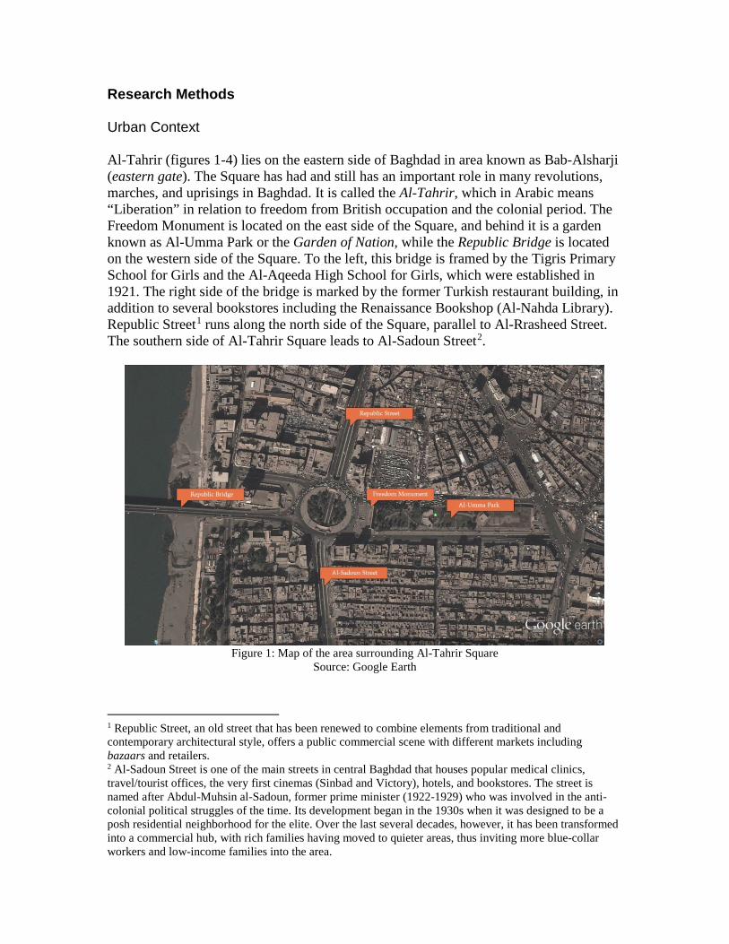
with the lack of geometrical lines and surfaces to emphasize the content of the monument. Rifat Chadirji took the idea of this structure from the protesters’ banners, which they used to support the July 14th Revolution of 1958. Chadirji told Salim, “Let us make another type of banner, which lives forever!” (Jabra, Jabra Ibrahım, 1974, p. 74-76). The monument consists of fourteen parts of discrete casted bronze. It denotes the history of Iraq in the ancient and modern times. Salim was inspired by the ancient Iraqi art of cylinder seals, in which a sheet of clay was rolled over a series of engraved images, creating a long and harmoniously balanced banner. The artist chose protruding sculptures because it is characteristic of Mesopotamia since the Babylonian and Assyrian Ages until the late Abbasid era (Jabra, Jabra Ibrahım, 1974, p. 76). The Iraqi government gave Salim all the freedom of expression to design the monument after the July 14th Revolution of 1958, so he went to Florence, France to work on this sculpture in the beginning of 1959. Muhamed Ghani Hekmat, who was his student at that time and spending his last year of studying sculpture in Rome, helped Salim in work of Freedom Monument (Jabra, Jabra Ibrahım, 1974, p. 80). The number, 14, represents the 14th of July Revolution, so the number has acquired mystical value besides that this number is the double of number 7 that has symbolic meaning of victory engrained in people’s minds. These fourteen parts contain twenty-five figures, notably a horse and an ox. Most of these figures are eight meters high. That results in verse of Arabic poetry after all the sculptures had been arranged to be read from right to left. Although each sculpted figure is a one part by itself, each one connects to the other in a coherent context to give the whole meaning of the monument, which highlights aspirations of Iraqi freedom since Ottoman Empire and the sacrifices made by people to gain it (Jabra, Jabra Ibrahım, 1974, p. 82). Soon after, Salim had a heart attack and died on January 23, 1961, when he was 42 years old, before finishing the structure that was completed by his wife Lorna, sculptor, Mohammed Ghani Hikmat, and architect, Refaat Al-Chaderchi. The monument had been finished according to the specific date, and the opening ceremony was on July 16, 1961 (Jabra, Jabra Ibrahım, 1974, p. 85).
Figure 4: Freedom Monument and its individual panels
Source: http://www.delcampe.net/en_GB/marketplace/postcards/iraq/iraq-irak-baghdad-tahrir-square-liberty-monument-freedom-monument-old-car-vintage-old-postcard-323199648.html
The fourteen individual panels of Freedom Monument start from the right to the left (like the Arabic language):
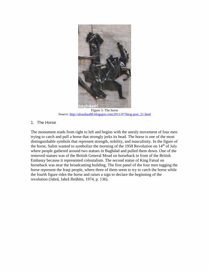
Figure 5: The horse
Source: http://aloushaa88.blogspot.com/2011/07/blog-post_21.html
1. The Horse
The monument reads from right to left and begins with the unruly movement of four men trying to catch and pull a horse that strongly jerks its head. The horse is one of the most distinguishable symbols that represent strength, nobility, and masculinity. In the figure of the horse, Salim wanted to symbolize the morning of the 1958 Revolution on 14th of July where people gathered around two statues in Baghdad and pulled them down. One of the removed statues was of the British General Moad on horseback in front of the British Embassy because it represented colonialism. The second statue of King Faisal on horseback was near the broadcasting building. The first panel of the four men tugging the horse represent the Iraqi people, where three of them seem to try to catch the horse while the fourth figure rides the horse and raises a sign to declare the beginning of the revolution (Jabra, Jabra Ibrahım, 1974, p. 136).

Figure 6: Pioneers of the Revolution
Source: http://aloushaa88.blogspot.com/2011/07/blog-post_21.html 2. Pioneers of the Revolution
In this panel, the movement of the figure continues toward the center of the monument to express the Revolution. Iraq’s long history has witnessed many revolutions against oppression, so this figure flowing out of the scene of the man-horse struggle symbolizes the pioneers of the revolution who raised their banners high in declaration of independence. Salim chose this figurative representation to exemplify people’s rebellions in Iraq against injustice, both past and present (Jabra, Jabra Ibrahım, 1974, p. 138).
Figure 7: The Child
Source: http://aloushaa88.blogspot.com/2011/07/blog-post_21.html
3. The Child
Salim presented the hope and future through the sculpture of a child who raises both of his innocent hands as though blessing human work and effort to produce a future of

freedom and justice. The child is the only sculpture that Salim constructed in three-dimension, unlike the others that are all bas-relief sculptures. Since Salim studied in Europe and was influenced by the art of the Italian Renaissance, he interpreted the sculpture of the child as Jesus Christ referencing the ideas of resurrection, new life, innocence, human love, and sacrifice (Jabra, Jabra Ibrahım, 1974, p. 140).
Figure 8: The crier
Source: http://aloushaa88.blogspot.com/2011/07/blog-post_21.html
4. The Crier
Salim chose to emphasize the important role of the Iraqi woman in rebellion and uprising. He embodied the woman according to the traditional way Iraqi women dress and react during tragic circumstances, where they rise above their abayas (cloak) to wrap the upper part of her body and then starts to cry and wail in sorrow for grievous events (Jabra, Jabra Ibrahım, 1974, p. 142).

Figure 9: The martyr
Source: http://aloushaa88.blogspot.com/2011/07/blog-post_21.html
5. The Martyr
In this sculpture and the one that follows it, Salim wanted to present the tragedy of the bereaved mother who is crying for her murdered son while surrounded by other women to reflect the image of the martyr, a figure that represents sacrifice and grief (Jabra, Jabra Ibrahım, 1974, p. 144).
Figure 10: The mother and her son
Source: http://aloushaa88.blogspot.com/2011/07/blog-post_21.html
6. The Mother and Son
Here, Salim expressed the dearest relationship in life through the compassion of the mother to her child where she envelops him as though an impervious wall, a gesture that signifies permanence, protection, love, and determination. This sculpture and the preceding panel emphasize not just the theme of the mother but also life and death, or in

other words, death in the sake of life. They represent the meaning of sacrifice and redemption (Jabra, Jabra Ibrahım, 1974, p. 146).
Figure 11: The prisoner-thinker
Source: http://aloushaa88.blogspot.com/2011/07/blog-post_21.html
7. The Prisoner-Thinker
This section consists of two connections: first is the prisoner-thinker whose right hand rests upon the bars conveying the power of the mind, which despite the confinement, can one day be emancipated and free when the revolution serve sjustice. The second part denotes the citizen who supports the thinker with the help of a soldier whose leg comes out of the successive panel. The soldier reaches out to help the citizen destroy the prison bars that surround the mind during the revolution to achieve freedom (Jabra, Jabra Ibrahım, 1974, p. 148).
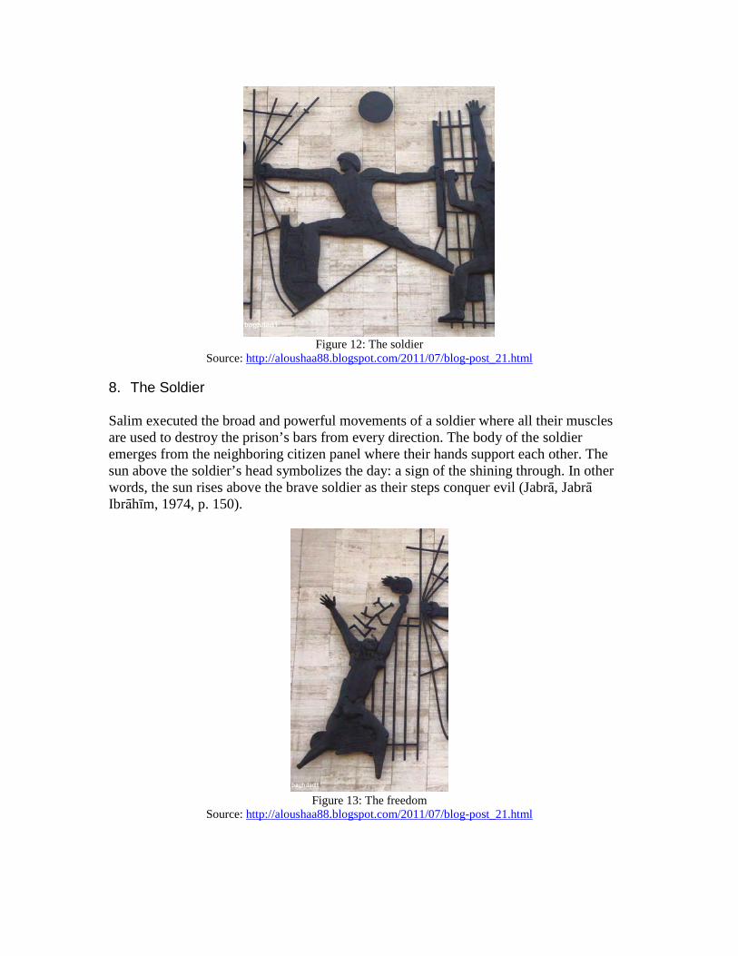
Figure 12: The soldier
Source: http://aloushaa88.blogspot.com/2011/07/blog-post_21.html
8. The Soldier
Salim executed the broad and powerful movements of a soldier where all their muscles are used to destroy the prison’s bars from every direction. The body of the soldier emerges from the neighboring citizen panel where their hands support each other. The sun above the soldier’s head symbolizes the day: a sign of the shining through. In other words, the sun rises above the brave soldier as their steps conquer evil (Jabra, Jabra Ibrahım, 1974, p. 150).
Figure 13: The freedom
Source: http://aloushaa88.blogspot.com/2011/07/blog-post_21.html

9. The Freedom
Here, Salim represented freedom as a woman holding a torch, in Greek style, and she exudes the feeling of ecstasy, elevating her into the sky. When Salim was questioned about the absence of the woman’s feet, he answered, “The feet would keep her on the ground while I want her to fly high” (Jabra, Jabra Ibrahım, 1974, p. 152).
Figure 14: The peace
Source: http://aloushaa88.blogspot.com/2011/07/blog-post_21.html
10. Peace
In this sculpture, Salim exemplifies tranquility, the human dream on the earth, which is in contrast to the previous panels. In this part, the prison bars have transformed into tree branches, taut faces from pain have shifted to the quiet and restful face with two braids, and the dress flows on the figures body as the river flows. Furthermore, the pigeon represents Baghdad, a place full of pigeons, especially in its mosques (Jabra, Jabra Ibrahım, 1974, p. 154).
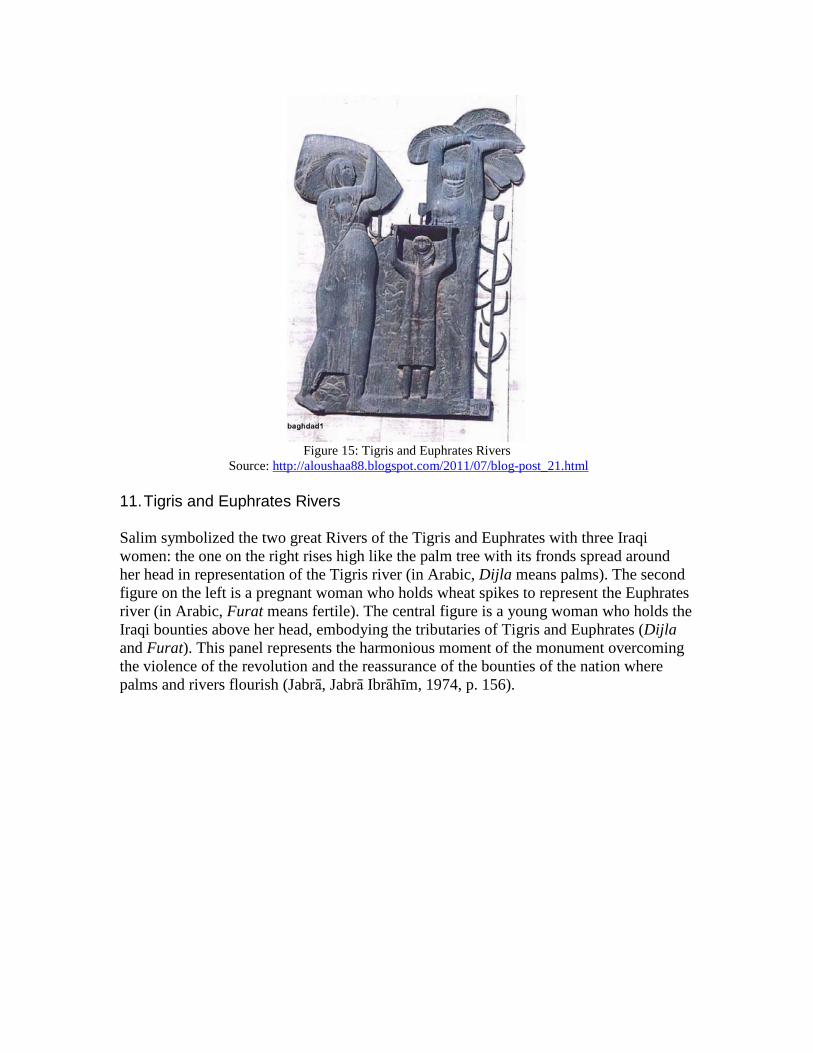
Figure 15: Tigris and Euphrates Rivers
Source: http://aloushaa88.blogspot.com/2011/07/blog-post_21.html
11. Tigris and Euphrates Rivers
Salim symbolized the two great Rivers of the Tigris and Euphrates with three Iraqi women: the one on the right rises high like the palm tree with its fronds spread around her head in representation of the Tigris river (in Arabic, Dijla means palms). The second figure on the left is a pregnant woman who holds wheat spikes to represent the Euphrates river (in Arabic, Furat means fertile). The central figure is a young woman who holds the Iraqi bounties above her head, embodying the tributaries of Tigris and Euphrates (Dijla and Furat). This panel represents the harmonious moment of the monument overcoming the violence of the revolution and the reassurance of the bounties of the nation where palms and rivers flourish (Jabra, Jabra Ibrahım, 1974, p. 156).

Figure 16: The agriculture
Source: http://aloushaa88.blogspot.com/2011/07/blog-post_21.html
12. Agriculture
In this panel, Salim depicted two men who represent an Arab and a Kurd, leaning on a shovel symbolizing the faithfulness to the Iraqi soil. These figures have strong solid hands because these are the hands that toil and plant, and the figures are bound together with love. One of the heads is symbolized as an Assyrian type to refer to the cultural continuity of Iraq. The two men in this section parallel the neighboring panel of two women in form and gesture (Jabra, Jabra Ibrahım, 1974, p. 158).
Figure 17: The ox
Source: http://aloushaa88.blogspot.com/2011/07/blog-post_21.html
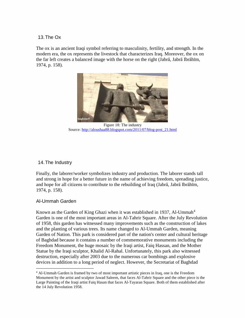
13. The Ox
The ox is an ancient Iraqi symbol referring to masculinity, fertility, and strength. In the modern era, the ox represents the livestock that characterizes Iraq. Moreover, the ox on the far left creates a balanced image with the horse on the right (Jabra, Jabra Ibrahım, 1974, p. 158).
Figure 18: The industry
Source: http://aloushaa88.blogspot.com/2011/07/blog-post_21.html 14. The Industry
Finally, the laborer/worker symbolizes industry and production. The laborer stands tall and strong in hope for a better future in the name of achieving freedom, spreading justice, and hope for all citizens to contribute to the rebuilding of Iraq (Jabra, Jabra Ibrahım, 1974, p. 158). Al-Ummah Garden Known as the Garden of King Ghazi when it was established in 1937, Al-Ummah4 Garden is one of the most important areas in Al-Tahrir Square. After the July Revolution of 1958, this garden has witnessed many improvements such as the construction of lakes and the planting of various trees. Its name changed to Al-Ummah Garden, meaning Garden of Nation. This park is considered part of the nation's center and cultural heritage of Baghdad because it contains a number of commemorative monuments including the Freedom Monument, the huge mosaic by the Iraqi artist, Faiq Hassan, and the Mother Statue by the Iraqi sculptor, Khalid Al-Rahal. Unfortunately, this park also witnessed destruction, especially after 2003 due to the numerous car bombings and explosive devices in addition to a long period of neglect. However, the Secretariat of Baghdad 4 Al-Ummah Garden is framed by two of most important artistic pieces in Iraq, one is the Freedom Monument by the artist and sculptor Jawad Saleem, that faces Al-Tahrir Square and the other piece is the Large Painting of the Iraqi artist Faiq Hasan that faces Al-Tayaran Square. Both of them established after the 14 July Revolution 1958.
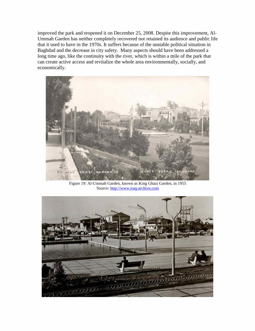
improved the park and reopened it on December 25, 2008. Despite this improvement, Al-Ummah Garden has neither completely recovered nor retained its audience and public life that it used to have in the 1970s. It suffers because of the unstable political situation in Baghdad and the decrease in city safety. Many aspects should have been addressed a long time ago, like the continuity with the river, which is within a mile of the park that can create active access and revitalize the whole area environmentally, socially, and economically.
Figure 19: Al-Ummah Garden, known as King Ghazi Garden, in 1955
Source: http://www.iraq-archive.com

Figure 20: Al-Ummah Garden in the early 1960s Source: http://www.iraq-archive.com
Figure 21: Al-Ummah Garden in the 1960s with the improvements
Source: http://www.non14.net
Figure 22: Al-Ummah Garden as a social public space in late 1960s
Source: http://www.panoramio.com/photo/94108015
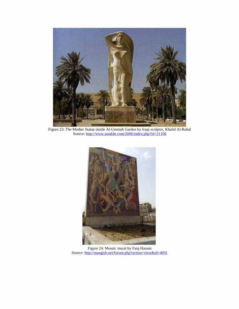
Figure 23: The Mother Statue inside Al-Ummah Garden by Iraqi sculptor, Khalid Al-Rahal
Source: http://www.sotakhr.com/2006/index.php?id=21106
Figure 24: Mosaic mural by Faiq Hassan
Source: http://mangish.net/forum.php?action=view&id=4691

Al-Rasheed Street Al Rasheed Street is one of the oldest and most famous streets in Baghdad, known during the Ottoman rule as Khalil Pasha Avenue. Khalil Pasha was the governor of Baghdad and the commander of the Ottoman army who ordered to expand and modify the road from the eastern gate (Bab Al Sharki) to Bab Al Muatham and named the street under his name. This street was established according to military reasons to facilitate the movement of the Ottoman army and their carriages. It is considered the first straight street within the organic traditional fabric of Al-Rusafa Baghdad, which was established during the end of the Ottoman reign. It is also known as New Street and was later named Al Rasheed Street in late 1920s. According to Caecilia (2015), in referring to the British traveler, Richard Coke, this street was implemented in one night because it was against the will of Sunni Awqaf that resulted in demolishment of close to 700 houses (p. 201). The work on this street was critical because it collided with the oppositions of religious people of Baghdad when they realized that the implementation of straight street could lead to demolish the Marjan Mosque, located on the road, in favor of the integrity of the street. The street also collided with the interest of powerful people and foreigners whose properties had been protected under foreign franchises. Thus, the demolition started with the poor properties and the absentee properties that did not have heirs. The work was performed by German military engineers who were in partnership with Ottomans and then between 1915-1916, Ottoman opened Rasheed Street to facilitate movement between warehouses and military offices during WWI. Caecilia (2015) analyses Al Rasheed Street as “another case of civic space subverted to a military agenda by facilitating the rapid crossing of the city from southern gate towards the northern sectors, where various military and governmental facilities were situated” (p. 21-22). Al Rasheed Street had positive commercial effects on the neighborhoods and area around, which included Souk Al-Saray, and it is considered one of the most important streets in Baghdad (Caecilia, 2015, p. 21-22). During WWI, the eastern side of Baghdad al-Rusafa developed after the establishment of al-Rashid Street as Commercial Boulevard along the Tigris River (Bernhardsson, 2008, 84-85). Al Rasheed Street has ancient historic mosques, including Al Haidarkhanh Mosque built by Dawood Pasha in 1819, in addition to Margan Mosque, Hussein Pasha Mosque, and old markets (souk) such as Souk Haraj and Souk Al Saray. At the end of the nineteenth century, few modern thoroughfares (bridges) were designed during the colonial period, and the first one was established in 1869-1871 to connect the suburbs of Karkh and Kadhimiya in the west side of Baghdad to Al-Rusafa in the east side. In 1910, Al-Nahar Street was opened along the east bank of the river, which influenced the administrative center around it (Caecilia, 2010, p. 21).

Figure 25: Map clarifies the location of Al-Rasheed Street and Al-Ummah Park in relation to Al-Tahrir
Square Source: http://wikimapia.org
Figure 26: Al-Rasheed Street in 1920 Figure 27: Marjan Mosque in Al Rasheed Street
Source for both: http://www.wikiwand.com/ar/%D8%B4%D8%A7%D8%B1%D8%B9_%D8%A- 7%D9%84%D8%B1%D8%B4%D9%8A%D8%AF

Figure 28: Al Rasheed Street, the dome of Hayder Khana's Mosque on the left
Source: https://en.wikipedia.org/wiki/Al_Rasheed_Street Disscusion Urban Analysis of Al-Tahrir Square Caecilia Pieri (2015) suggests that the “urbanism visions of Baghdad as the capital city of Iraq were mostly imposed from above, first by colonial powers and later by local governments with their own political and ideological agenda” (p.199). So, Caecilia chronologically categorized the urban form of Baghdad according to the political power that ruled Iraq, starting from colonial urbanism under late Ottoman rule and British Mandate (1870s-1930s), regulation urbanism in independent Iraq (1930s-1950s), urbanism that influenced by the beginning of World Bank (1950s), urbanism after the Socialist expansion as a territory for Cold War (after 1965), urbanism that conveys the National Identity in the context of Iraqi Arab leadership (1980s), and today, urbanism in Post-War context (Caecilia, 2015, p. 200-207). According to the two approaches adopted by Camillo Sitte recommending focus on the visible form and the public use of urban environment, Al-Tahrir Square’s area follows the former approach while lacking human-environmental and behavioral relations approaches and public design participation (Jarvis, 1980, p. 50). Three of the problems that Allan Jacobs and Donald Appleyard (1987) proposed in their manifesto were poor living environment, giantism, loss of control, large-scale privatization, and loss of public life in the area of Al-Tahrir square (p. 114). Unfortunately, this central area of Baghdad has lost a huge percentage of its residents, in part due to the inadequate environment that forced many inhabitants to sell their homes, which transformed to stores for the companies or commercial shop owners.

Sitte (1965) emphasized that city planning should consider the interaction between public buildings and open spaces to activate public life. He also emphasized that the center of plazas should be kept free and not blocked by monuments that would interfere with the view of buildings (p. 152-159). In the 1950s, Al-Tahrir Square was just a parking lot while in the 1960s, it was transformed into a functional plaza. Then in the middle of the 1970s, a tunnel was established to cross the middle of the square and ease vehicle movement. This process was against the principle of Sitte, but it also activated the square through construction of two levels, where the lower level contained small shops, barbers’ shops, and small banks. Al-Tahrir square witnessed a noteworthy transformation of its function over time, but regrettably, due to the unstable political situation, the lower level of the square deteriorated and was then abandoned. Today, the shops are owned by commercial businesses, and the green areas are overgrown with huge trees that block visual access. Therefore, today when many demonstrations and protests happen, people use the street around the square and near the Freedom Monument. Al-Tahrir square becomes more an ornamental part of the city than functional.
Figure 29: Al-Tahrir Square in the 1950s Figure 30: Al-Tahrir Square in 1960
Source for both: http://www.iraq-archive.com/-158716001575158115751578-1576159416001600158315751583-1---2.html
Figure 31: Aerial View showing Al-Tahrir Square and its surroundings before establishing the tunnel and
Freedom Monument
Source: http://www.iraq-archive.com
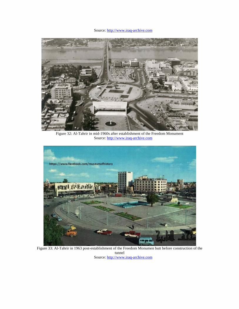
Figure 32: Al-Tahrir in mid-1960s after establishment of the Freedom Monument
Source: http://www.iraq-archive.com
Figure 33: Al-Tahrir in 1963 post-establishment of the Freedom Monumen butt before construction of the
tunnel Source: http://www.iraq-archive.com
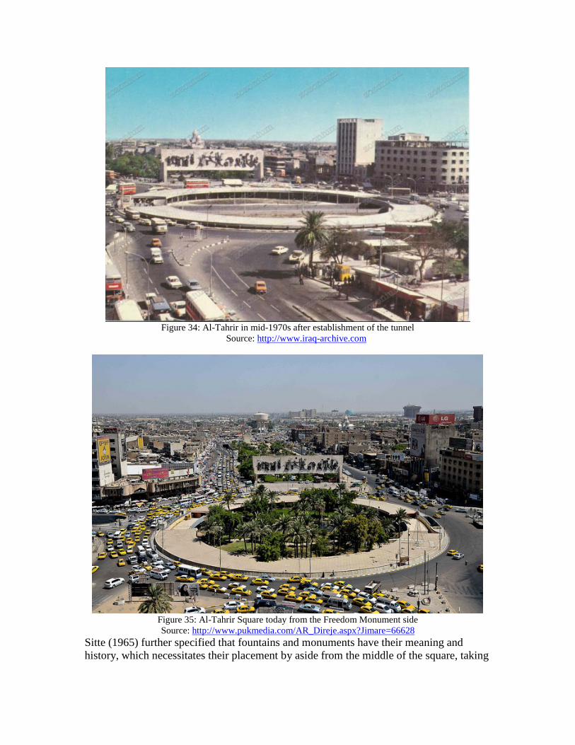
Figure 34: Al-Tahrir in mid-1970s after establishment of the tunnel
Source: http://www.iraq-archive.com
Figure 35: Al-Tahrir Square today from the Freedom Monument side Source: http://www.pukmedia.com/AR_Direje.aspx?Jimare=66628
Sitte (1965) further specified that fountains and monuments have their meaning and history, which necessitates their placement by aside from the middle of the square, taking

into consideration the orientation of the monument to the streets (p. 160-162). This is what makes Freedom Monument an ideal memorial place. According to Jakob Skovgaard-Petrsen (2001), there was an increasing interest in streets and squares as public spaces during the first half of the twentieth century due to their role in transferring the style and the language of the buildings and cities to people, which were often designed to express the national identity (p. 14). In the 1970s, Al-Tahrir Square played a vital role in social communication due to its location that connects Al-Saddun and Republic streets, two of the most important streets in Baghdad, in addition to the Republic Bridge that links Al-Rusafa and Al-Karkh, the two sides of Baghdad. Kevin Lynch (1960), in The Image of the City, identified three aspects of the environmental image: identity, structure, and meaning (p. 8). The first two aspects require recognizable entities and patterns of relations achieved by the physical features of Al-Tahrir Square, while meaning is achieved through the Freedom Monument with its historical and cultural significance in the collective memory of Iraqis and evocation of emotions of belonging to the place. Lynch (1960) wrote, “A vivid and integrated physical setting, capable of producing a sharp image, plays a social role as well. It can furnish the raw material for the symbols and collective memories of group communication” (p. 4). Therefore, a public-built environment is the unification of physical and behavioral patterns where streets can strengthen social communication in a meaningful public space. The pedestrian movement in the area of Al-Tahrir Square has been affected negatively by the traffic of cars, which has also led to the deterioration of small businesses that largely depend on foot traffic. In the urban experience, pedestrian movement would permit economic, social, and cultural exchanges because in most cases, walking would not be for one purpose, but to also stop to buy a newspaper, water, talk to a neighbor or colleague, for window shopping, or have a drink at a pavement café. Pedestrian paths encourage people to stop and spend time within the space while car circulation would end in the garage (Carmona, 2003, p. 201-202). Conrad C. Kickert (2015) in “Active Centers - Interactive Edges” mentions that “More specifically, an open, interactive relation between buildings and public space at the ground floor is a crucial factor in making urban environments walkable, both from the standpoint of function, safety, and experiential quality” (p. 27). Hence, walkability is important in creating comfortable, sociable public spaces that Al- Tahrir Square used to have before the increase of roads and traffic congestion. Moreover, there is no longer night life in the area of Al-Tahrir Square due to the types of businesses that exist, which are day businesses, operating mostly from 7am to 7 pm. While in the past, this area used to have luxury restaurants, bars, hotels, cinemas, and theaters that played a vital role in the public life of this area. Allan Jacobs and Donald Appleyard (1987) assert, “The most important public space must be for pedestrians, for no public life can take place between people in automobiles” (p. 119). That agrees with Jacobs’s perspective that the mixed-use area, which results in a mixture of users at different times due to the various time of occupation in the surrounding buildings, would assure constant use in the neighborhood (Jacobs, 1961, p. 96-97). During the reign of Ba’th party, Al-Tahrir Square did not witness any positive changes. A road was built to divide the Square into two halves, having a negative impact on the

social function of the Square through giving priority to car traffic over the social space that it previously provided. This clearly indicated that the government intentionally neglected the Square as part of a political agenda to first bring down the curtain on the era of freedom to present its power, and secondly, to divide any public space where people could gather to demonstrate or share their political perspectives. These policies have not only led to the decline the public space of Al-Tahrir Square, but also the Baghdad civic center, which drove many people to leave this area, especially the residential parts because it became a business area dependent mostly on vehicular traffic and flyovers with limited pedestrian movement after work hours. According to Caecilia (2015), Baghdad’s urban form during the reign of Saddam Hussein focused on creating the image of grand capital. She says “Foreign and Iraqi architects were given the mission of transforming this political agenda into a monumentalized Baghdad, emphasizing the direct relationship between politics and built form” (p. 207). In another word, the urban development of Baghdad (1979-2003) has responded to the political agenda which symbolizing Saddam’s power over the country rather than addressing the real urban requirements and the increased population. Politics and Public Space of Al-Tahrir Square Comparing the concept of public spaces from western and eastern perspectives and their origins, it can be stated that both had a political agenda. Robert Saliba remarks that during the 18th and 19th centuries, Europe witnessed urban changes through emergence of the bourgeois city and transportation:
Underlying this society of spectacle was the military agenda of controlling of public space as a potential setting for demonstrations and political contestations. Transferred to the colonial context, either through the superimposition by mandatory powers or self-imposed modernization by local rulers, formal squares retained their agenda of military control (mainly of the indigenous population), however they redefined the conventional understanding and practice of open space in European provincial territories extending from North Africa to the Levant. (Saliba, 2015, p. 213).
Earlier, the concept of public space in Middle Eastern cities, especially in traditional Islamic cities, used to be connected to institutional spaces due to the integration of the political and religious in mosques. Then, public space changed to be a space for proliferation of democratic dialogues and political protests (Saliba, 2015, p. 213). Cuthbert (2004) considers public? space as an ideological instrument of capitalism because it can be commodified and sold like other resources in favor of social reproduction (p. 2-3). Although there are opportunities for political criticism and opposition, the right of speech in these spaces is not clear enough. When public space is defined as the shared world where people can engage with one another and see themselves through the eyes of others, then free speech becomes an important characteristic for these places in which to argue, discuss, feel sympathy, agree, and refute. This democratic environment is essential for minorities to present and convince the majority to support their diverse perspectives (Kohn, 2003, p. 2-3)

According to the interpretation of Henri Lefebvre (1991), space is defined as perceived (spatial practice), conceived (representations of space), and lived (representational spaces) (p. 38-39). He defines the perceived space as that “which embraces production and reproduction, and the particular locations and spatial sets characteristic of each social formation” (1991, p. 33). This can be reflected in the physical place of Al-Tahrir Square in terms of buildings, monuments, and works of art to reflect the reality of spatial practices. The conceived space means the representations of space. This definition has varied across the historical timeline of Al-Tahrir Square. It was a free public space for social gatherings during the 1960s; during the 1970s, it started to be controlled indirectly through urban guidelines by addition of the tunnel in the center of the space. Though it created commercial spaces in the lower level of the square, the goal was to divide the coherence of the space to prevent people from gathering, which might lead to protests that threaten the security of the government. During the reign of Saddam Hussein, Al-Tahrir Square was intentionally neglected by the government, though it could not be destroyed because of the people’s sympathy for the 17th of July Revolution 1958, which represented an era of freedom and thinkers. During the 1980s until 2003, this square, like all other public spaces, was surveilled by police to prevent any kind of congregation that might shift to demonstration. After 2003, this square was emancipated politically but has still not fully recovered socially despite the slight developments that the surrounding areas of the Square and Al-Ummah Garden have witnessed over the past few years. The representational space, according to Lefebvre, is the lived space through its connection with a system of non-verbal symbols, signs, and images. He described this space as “This is the dominated – and hence passively experienced – which the imagination seeks to change and appropriate. It overlays physical space, making symbolic use of its objects” (Lefebvre, 1991, p. 39). This is what Al-Tahrir Square represents today, especially after the demonstrations that have started every Friday since 2015, where the political discourse unifies people from different backgrounds, religions, and sects in the public sphere. Such demonstrations are an instance of using public spaces to ask for people’s right to better services, economic reforms, and de-corruption. Though there are many obstacles to these demonstrations, such as blocking many streets in Baghdad and prohibiting using cars to pass, this forces people to walk long distances that not everyone is able to do. Recently, members of police authorities, related to people in politics, started to arrest leaders of civil organizations leading the demonstrations so as to force people to retreat from their goals. Figures (36) -(39) illustrate the people around Al-Tahrir Square, and the blocked streets and bridges that lead to it and how police prevent people from reaching the square. Eric Davis (2009) in his essay, "The Historical Genesis of the Public Sphere in Iraq, 1900–1963: Implications for Building Democracy in the Post-Ba‘thist Era," points out that the interest in the approach of civil society in the Arabic world is the result of three political factors that happened within the late 1980s and 1990s. The first factor is the collapse of the dogma of pan-Arabism after the Arab–Israeli War in 1967. The second factor is the spread of Islamist political movements during the 1970s such as the one in Iran that succeeded in establishing the Islamic republic after the overthrow of Shah Mohammed Reza Pahlavi in 1978–1979. Finally, the third one is the crash of the Soviet Union in 1991, which was ally to the East that failed to achieve the democratic freedoms

in many Arabic countries. This resulted in the re-examination of the ideologies of pan-Arabism and radical Islam by Arab intellectuals (p. 390-393). Digital public spaces also have a significant role in these demonstrations, especially Facebook and Twitter, to schedule and regulate demonstrations among activists and to inform general public of the demonstration. The participants then publish what happened at the sites to update others about the latest circumstances and conditions. Saskia Sassen (2011) in her essay, “The Global Street: Making the Political,” analyzes the uprisings of the Middle East and North Africa from an urban perspective and accentuates the concept of the global street that is a vehicle for making social and political claims and demonstrations as part of global modernity:
I think of the space of ‘the street’, which of course includes squares and any available open space, as a rawer and less ritualized space. The Street can, thus, be conceived as a space where new forms of the social and the political can be made, rather than a space for enacting ritualized routines. With some conceptual stretching, we might say that politically, ‘street and square’ are marked differently from ‘boulevard and piazza’: The first signals action and the second, rituals. (Sassen, 2011, p. 273-274).
Kohn (2004) states that there is a theoretical agreement for free speech, but on the other side, there is also a fear of being exposed to unfamiliar ideas and unwanted responsibilities. Thus, privatization of public space would be the solution for those who want to protect themselves from political provocations (p. 3-4). This would be the next step in an approach that many people fear.
Figure 36: Al-Tahrir Square today from Al-Jumhuria Bridge side with demonstrations in the road
Source: http://aliraqnews.com

Figure 37: People shout slogans during a demonstration against corruption and poor services in regard to
power cuts and water shortages, at Tahrir Square in central Baghdad, Iraq, August 7, 2015. Source: http://www.iraqtradelinknews.com/2015/09/calls-for-unified-leadership-for.html
Figure 38: Police and special authorities closed the Republic Bridge to prevent people to reach the Green
Zone where the government center is located. Source: http://www.alriyadh.com/1071522

Figure 39: The police blocked people from proceeding the Green Zone to demonstrate against the
government’s corruption Source: http://www.alriyadh.com/1071522
Conclusion and Recommendations An exploration of Al-Tahrir Square in Baghdad, Iraq as a venue of rebellion and site of many historical events in Iraq, as discussed in this paper, points out its sociopolitical significance and transformation over time as a public-political space. Thus, for urban design to be successful, it should have a mixture of physical form, both townscape and landscape, lively public life through mixed-use of land and pedestrian activities, and finally meaning through cultural symbolism that provoke collective memory and a sense of belonging to place. In Al-Tahrir Square, we need to focus on:
1. Creating safe and comfortable places for people by offering choices and social and visible attractions 1. Work with the landscape of Al-Ummah Garden in terms of nature, climate,
landform and ecology, and energy conservation 2. Encourage mixed use spaces with a variety of sizes and types 3. Support connection (visual and physical access, walkable interesting paths, scale
of walking, cycling and automobile) 4. Design to accommodate the change (flexibility in use of public buildings and
public use could be personalized over time, allowing growth and additions) 5. Preservation of historic buildings and parts of the urban fabric that exist in the
residential area, and 6. Plan open accesses and connections with the Tigris river, which is just about one
mile away.
Our connections with places should be like our relationships with other people. The place that we need is what Relph (2013) envisioned: “a place is a piece of the whole environment that has been claimed by feelings” (p. 120). This conveys the comprehensive concept of a place that consists of natural and human-made structures and functions that would allow people’s experiences to create new meanings and identities in relation to the place and then inculcate in them a strong sense of belonging. References Bernhardsson, Magnus T. (2008). Vision of Iraq modernizing the past in 1950s Baghdad. In S. Lsenstadt & K. Rizvi (Eds.), Modernism and the Middle East architecture and politics in the twentieth century (pp. 81-97). Seattle, WA: University of Washington Press. Carmona, M. (2010). Public places urban spaces: the dimensions of urban design. London: Routledge. Cuthbert, A. R. (2011). Understanding cities: method in urban design. London: Routledge. Davis, E. (2009). The historical genesis of the public sphere in Iraq, 1900–1963: Implications for building democracy in the post-Ba‘thist era." In S. Shami (Ed.), Publics, politics and participation: locating the public sphere in the Middle East and North Africa (pp. 383-427). New York, NY: Social Science Research Council. Elsheshtawy, Y. (2004). Planning Middle Eastern cities: an urban kaleidoscope in a globalizing world. London and New York: Routledge, Taylor & Francis Group. Jabra, Jabra Ibrahım. (1974). Jawad Salım Wa-Nusb Al-Hurrıyah: Dirasah Fı Atharih
Wa-araʼih. Baghdad: Wizarat Al-Iʻlam, Mudırıyat Al-Thaqafah Al-ʻAmmah. (In Arabic)
Jacobs, A., Donald, A. (1987). Toward an urban design manifesto. Journal of the American Planning Association 53 (1), 112-120. Jacobs, J. (1961). The death and life of great American cities. London: Pimlico. Jarvis, R. K. (1980). Urban environments as visual art or as social settings? Town Planning Review 51 (1), 50-66. Kickert, C. C. (2016). Active centers – interactive edges: The rise and fall of ground floor frontages. URBAN DESIGN International, 21(1), 55-77. doi:10.1057/udi.2015.27 Kohn, M. (2004). Brave new neighborhoods. New York, NY: Routledge. Lefebvre, H. (1991). The production of space. Oxford, OX, UK: Blackwell.

Low, S. M., & Neil S. (2006). The politics of public space. New York, NY: Routledge. Lynch, K. (1960). The Image of the City. Cambridge, Mass.: MIT Press. Nielsen, H. C., & Skovgaard-Petersen, J. (2001). Middle Eastern cities, 1900-1950: public places and public spheres in transformation. Aarhus: Aarhus University Press. Pieri, C. (2015). Sites of conflicts: Baghdad's suspended modernities versus a fragmented
reality. In R. Saliba (Ed.), Urban design in the Arab World: Reconceptualizing boundries (pp. 199-213), Burlington, VT: Ashgate Publishing Company.
Relph, E. (2013). Prospects for places from place and placelessness (1976). In M. Larice
& E. Macdonald (Eds.), The urban design reader (266-271). Second ed. New York, NY: Routledge.
Saliba, R., Salama, H. H., & Cherry, N. (2015). Sites of cntestation: Tahrir square; from
appropriation to design." In R. Saliba (Ed.), Urban design in the Arab World: Reconceptualizing boundries (213-227). Burlington, VT: Ashgate Publishing Company.
Sassen, S. (2011). The global street: Making the political. Globalizations, 8(5), 573. doi:10.1080/14747731.2011.622458 Sitte, C. (1965). City planning according to artistic principles. New York, NY: Random House. Bibliography Rasha Al-Tameemi I am a Ph.D. candidate in Architecture in the College of Design, Architecture, Art, and Planning at the University of Cincinnati, Cincinnati, Ohio, United States, where I also earned two certificates in Historic Preservation and Urban Planning. Currently, I am working on my dissertation, “Reading the Cultural Landscape of the Iraqi Marshlands: Eden and Its Marsh Arab Inhabitants.” I have also served as a faculty member at the University of Technology, Baghdad, Iraq, where I taught various undergraduate courses in architecture, interior design, landscape, planning and space programing. Besides, I have also presented several papers in many national conferences and recently published in the field of landscape (History, Theory and Culture).
Related Documents


![Hizb ut-Tahrir [Book]](https://static.cupdf.com/doc/110x72/5889aec91a28ab0e408c0ae2/hizb-ut-tahrir-book.jpg)


