URBAN MOBILITY IN ROCINHA BRIANNA BUSSINGER & HILTON BERREDO PROFESSOR A SOLUTION for the FUNICULAR system ? FUNICULAR RAILWAY CABLE CAR 2015.1 ? PUC-RJ

Urban Mobility at Rocinha - A Solution for the Funicular Railway
Aug 02, 2016
Final thesis of the Architecture and Urbanism course at the Pontifical Catholic University of Rio de Janeiro. Addresses the topic of urban mobility within the informal settlements of Rio de Janeiro. Using as an object of study the slum of Rocinha, the biggest "favela" in the world, analyses the controversy between building a funicular railway system that is designed in the official Master Plan of Rocinha and the governments wish to implement a cable car system instead. The architectural design consists of a detailed study of one of the main lines of the funicular railway predicted in the Master Plan of Rocinha and the design of one of the most important stations, the -Lookout Station-.
Welcome message from author
This document is posted to help you gain knowledge. Please leave a comment to let me know what you think about it! Share it to your friends and learn new things together.
Transcript

URBAN MOBILITY IN ROCINHA
BRIANNABUSSINGER& HILTON BERREDOPROFESSOR
A SOLUTION for the FUNICULAR system
?FUNICULAR
RAILWAY
CABLE CAR
2015.1
?
PUC-RJ


3BRIANNA BUSSINGER
Rocinha - são conradoview from Laboriaux neighbourhood

INTRODUCTION
LOCATION
DEVELOPMENT PLAN
URBAN MOBILITY
FUNICULARS IN RIO
CABLE CARS IN RIO
COMPARISON
IN ROCINHA
THE PROJECT:
FUNICULAR IN ROCINHA
STUDY OF STATIONS
LOOKOUT STATION:
ORGANIZING CIRCULATION
PROGRAMME AND INFRASTRUCTURE
MAIN STRUCTURE
CONCLUSION
CONTENTS
5BRIANNA BUSSINGER
CONTENTS
68
1114
222426
3032
34363742
79131721232527
3133
353739
20
--------
---
--
GÁVEA
ROCINHA
SÃO CONRADO
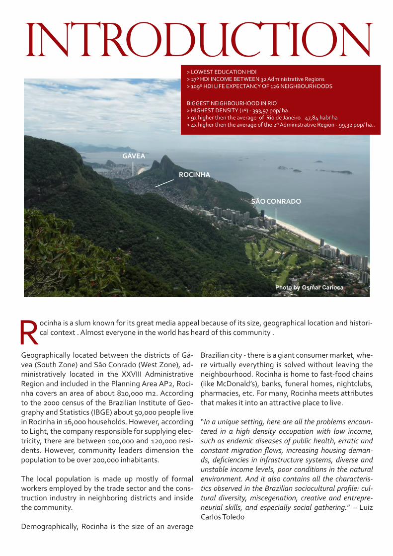
Rocinha is a slum known for its great media appeal because of its size, geographical location and histori-cal context . Almost everyone in the world has heard of this community .
INTRODUCTION
Geographically located between the districts of Gá-vea (South Zone) and São Conrado (West Zone), ad-ministratively located in the XXVIII Administrative Region and included in the Planning Area AP2, Roci-nha covers an area of about 810,000 m2. According to the 2000 census of the Brazilian Institute of Geo-graphy and Statistics (IBGE) about 50,000 people live in Rocinha in 16,000 households. However, according to Light, the company responsible for supplying elec-tricity, there are between 100,000 and 120,000 resi-dents. However, community leaders dimension the population to be over 200,000 inhabitants.
The local population is made up mostly of formal workers employed by the trade sector and the cons-truction industry in neighboring districts and inside the community.
Demographically, Rocinha is the size of an average
Brazilian city - there is a giant consumer market, whe-re virtually everything is solved without leaving the neighbourhood. Rocinha is home to fast-food chains (like McDonald’s), banks, funeral homes, nightclubs, pharmacies, etc. For many, Rocinha meets attributes that makes it into an attractive place to live.
“In a unique setting, here are all the problems encoun-tered in a high density occupation with low income, such as endemic diseases of public health, erratic and constant migration flows, increasing housing deman-ds, deficiencies in infrastructure systems, diverse and unstable income levels, poor conditions in the natural environment. And it also contains all the characteris-tics observed in the Brazilian sociocultural profile: cul-tural diversity, miscegenation, creative and entrepre-neurial skills, and especially social gathering.” – Luiz Carlos Toledo
> LOWEST EDUCATION HDI> 27º HDI INCOME BETWEEN 32 Administrative Regions> 109º HDI LIFE EXPECTANCY OF 126 NEIGHBOURHOODS
BIGGEST NEIGHBOURHOOD IN RIO> HIGHEST DENSITY (1º) - 393,97 pop/ ha> 9x higher then the average of Rio de Janeiro - 47,84 hab/ ha> 4x higher then the average of the 2º Administrative Region - 99,32 pop/ ha..

7BRIANNA BUSSINGER
ROCINHA
SANTA CRUZ
140 HA
12.000 HA190.000 pop
POPULATION:- Censo 2000 50.200 pop- Light 100.000 pop- Community 200.000 pop
Rocinha
santacruz rio metropolis
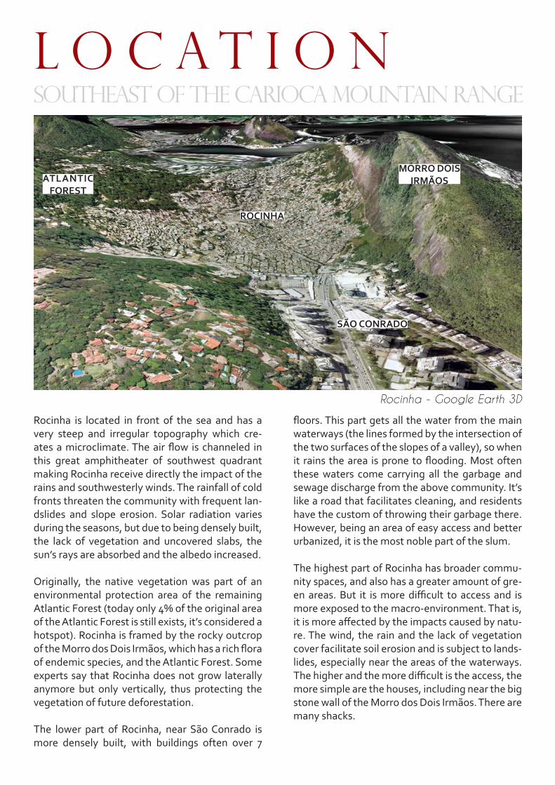
Rocinha is located in front of the sea and has a very steep and irregular topography which cre-ates a microclimate. The air flow is channeled in this great amphitheater of southwest quadrant making Rocinha receive directly the impact of the rains and southwesterly winds. The rainfall of cold fronts threaten the community with frequent lan-dslides and slope erosion. Solar radiation varies during the seasons, but due to being densely built, the lack of vegetation and uncovered slabs, the sun’s rays are absorbed and the albedo increased.
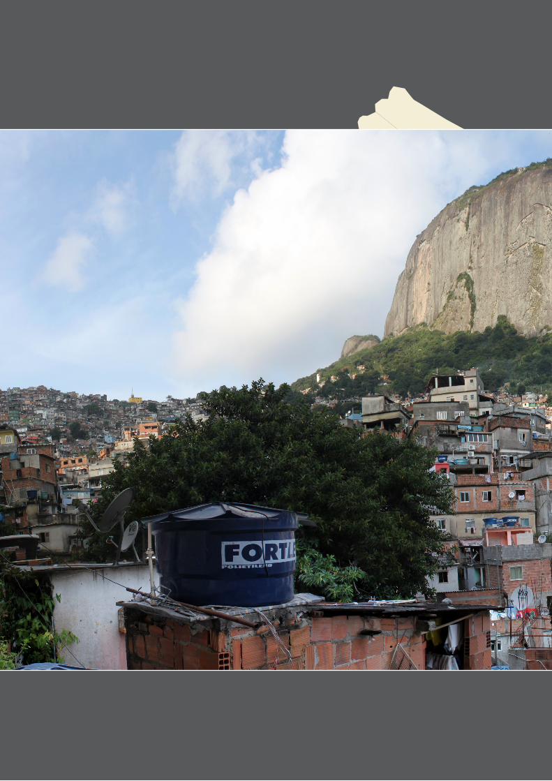
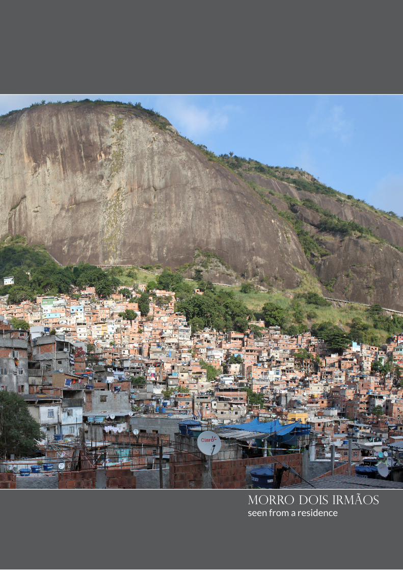
Originally, the native vegetation was part of an environmental protection area of the remaining Atlantic Forest (today only 4% of the original area of the Atlantic Forest is still exists, it’s considered a hotspot). Rocinha is framed by the rocky outcrop of the Morro dos Dois Irmãos, which has a rich flora of endemic species, and the Atlantic Forest. Some experts say that Rocinha does not grow laterally anymore but only vertically, thus protecting the vegetation of future deforestation.
The lower part of Rocinha, near São Conrado is more densely built, with buildings often over 7
L o c a t i o nSoutheast of the carioca mountain range
floors. This part gets all the water from the main waterways (the lines formed by the intersection of the two surfaces of the slopes of a valley), so when it rains the area is prone to flooding. Most often these waters come carrying all the garbage and sewage discharge from the above community. It’s like a road that facilitates cleaning, and residents have the custom of throwing their garbage there. However, being an area of easy access and better urbanized, it is the most noble part of the slum.
The highest part of Rocinha has broader commu-nity spaces, and also has a greater amount of gre-en areas. But it is more difficult to access and is more exposed to the macro-environment. That is, it is more affected by the impacts caused by natu-re. The wind, the rain and the lack of vegetation cover facilitate soil erosion and is subject to lands-lides, especially near the areas of the waterways. The higher and the more difficult is the access, the more simple are the houses, including near the big stone wall of the Morro dos Dois Irmãos. There are many shacks.
Rocinha - Google Earth 3D
SÃO CONRADO
ROCINHA
ATLANTIC FOREST
MORRO DOIS IRMÃOS
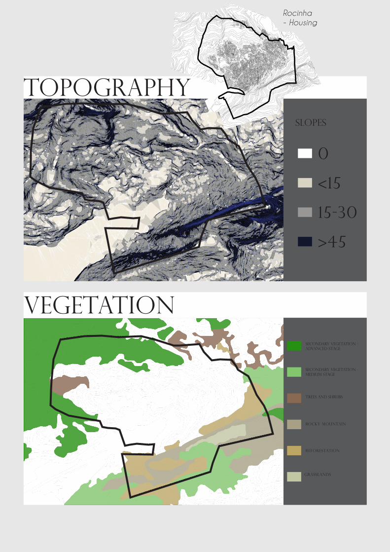
VEGETAtionsecondary vegetation - advanced stage
secondary vegetation - medium stage
trees and shrubs
rocky mountain
reforestation
grasslands
TOPOGRAphy
0
<15
15-30
>45
slopes
Rocinha - Housing
11BRIANNA BUSSINGER
morro dois irmãosseen from a residence
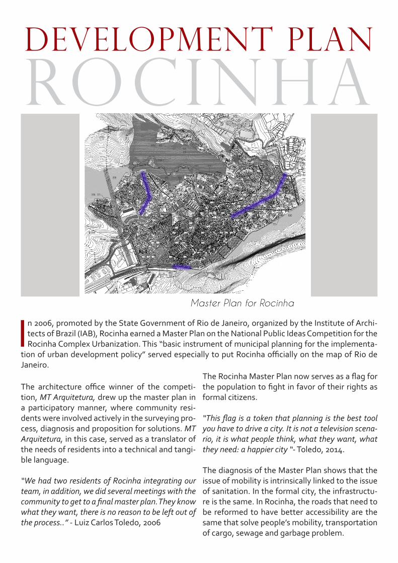
In 2006, promoted by the State Government of Rio de Janeiro, organized by the Institute of Archi-tects of Brazil (IAB), Rocinha earned a Master Plan on the National Public Ideas Competition for the Rocinha Complex Urbanization. This “basic instrument of municipal planning for the implementa-
tion of urban development policy” served especially to put Rocinha officially on the map of Rio de Janeiro.
The architecture office winner of the competi-tion, MT Arquitetura, drew up the master plan in a participatory manner, where community resi-dents were involved actively in the surveying pro-cess, diagnosis and proposition for solutions. MT Arquitetura, in this case, served as a translator of the needs of residents into a technical and tangi-ble language.
“We had two residents of Rocinha integrating our team, in addition, we did several meetings with the community to get to a final master plan. They know what they want, there is no reason to be left out of the process..” - Luiz Carlos Toledo, 2006
development plan ROCINHA
The Rocinha Master Plan now serves as a flag for the population to fight in favor of their rights as formal citizens.
“This flag is a token that planning is the best tool you have to drive a city. It is not a television scena-rio, it is what people think, what they want, what they need: a happier city “- Toledo, 2014.
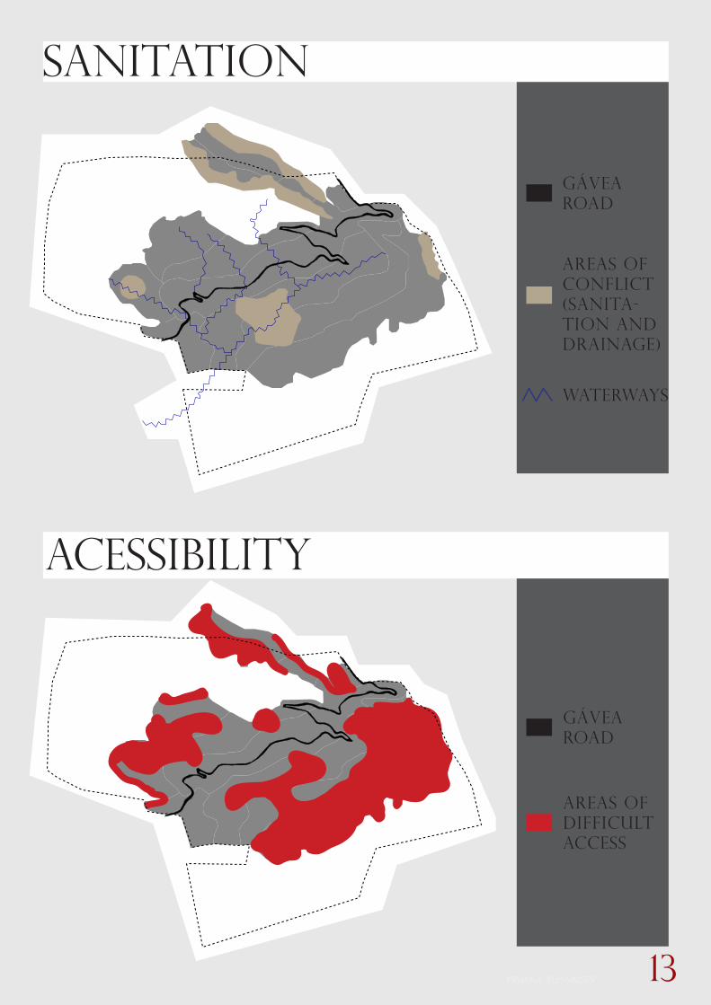
The diagnosis of the Master Plan shows that the issue of mobility is intrinsically linked to the issue of sanitation. In the formal city, the infrastructu-re is the same. In Rocinha, the roads that need to be reformed to have better accessibility are the same that solve people’s mobility, transportation of cargo, sewage and garbage problem.
Master Plan for Rocinha
13BRIANNA BUSSINGER
Acessibility
Sanitation
gávea road
areas of conflict(sanita-tion and drainage)
waterways
areas of difficult access
gávearoad

According to the official definition of the National Urban Mobility Policy Act: Mobility is the condition of displacement of people and goods in urban areas. It should also be taken into account all that we see, and also all that that we don’t see but is in motion, for example - the
sewage, light and water. This is also the dynamic part of the city.
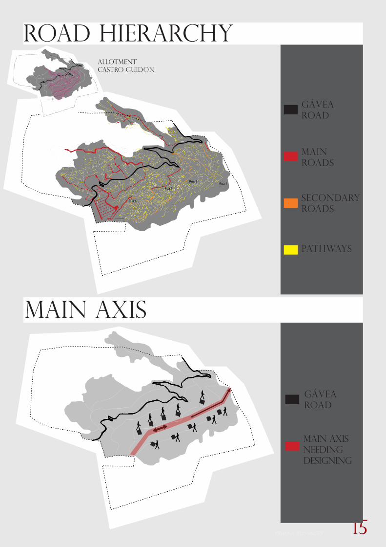
CURRENT URBAN MOBILITyThe major route of Rocinha is the Gávea Road, it connects the neighbourhoods of Gávea and São Conrado cutting through the urban tissue of Roci-nha. It was the only road that allowed the crossing of the hill in the 1800’s. With the emergence of Niemeyer Av. in 1916, the opening of Zuzu Angel tunnel in 1971 and now with the future opening of the São Conrado metro station, Gávea Road is increasingly used by the local population of the slum. The evolution of the community happens in its surroundings.
Within the neighborhood there are major roads that have characteristics of formal development. These are the streets 1,2,3,4 ... that are coming from a French Company’s allotment called Cas-tro Guidon. In the 60’s when the company went
bankrupt and the slumming process began, some features of this subdivision were lost, and the spontaneous “lanes” that are the paths created by the people that give access to their homes appear. These lanes are usually built according to the topography lines.
One of the biggest difficulties faced today by the locals is the distance and the physical effort re-quired to walk the path between their homes and the main points of public transportation. Because of the complex topography and the lack of ove-rall planning of mobility and circultation, the con-nection between the slum and the formal city is antisocial.
One of the main axes to be addressed is the axis parallel to the Gávea road.
urban mobility
ROCINHA
GÁVEA ROAD
NIEMEYER AVENUE - 1916
ZUZU ANGEL TUNNEL - 1971
METRO L INE 4 - 20 . . . . .
Rocinha
Gávea
Leblon
Vidigal
São Conrado
15BRIANNA BUSSINGER
Rua 4
Rua 3Rua 1
Rua 2
main axis
road hierarchy
main roads
secondaryroads
pathways
main axis needingdesigning
allotmentCASTRO GUIDON
gávearoad
gávearoad
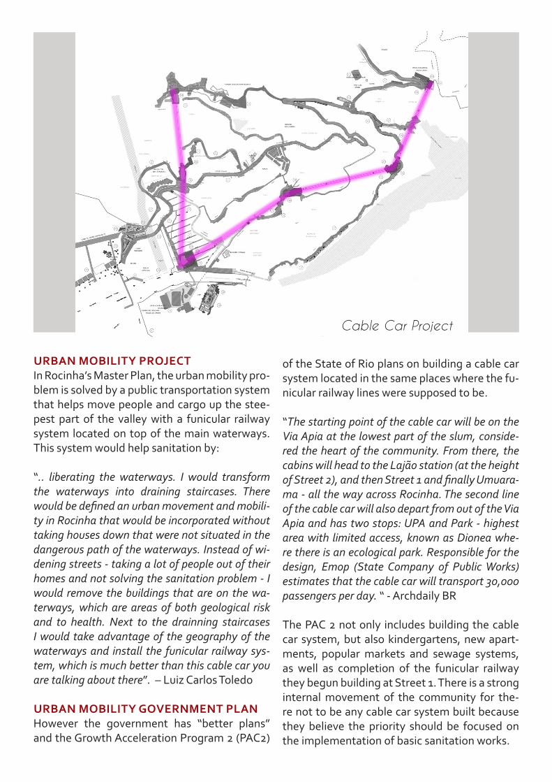
URBAN MOBILITy PROJECTIn Rocinha’s Master Plan, the urban mobility pro-blem is solved by a public transportation system that helps move people and cargo up the stee-pest part of the valley with a funicular railway system located on top of the main waterways. This system would help sanitation by:
“.. liberating the waterways. I would transform the waterways into draining staircases. There would be defined an urban movement and mobili-ty in Rocinha that would be incorporated without taking houses down that were not situated in the dangerous path of the waterways. Instead of wi-dening streets - taking a lot of people out of their homes and not solving the sanitation problem - I would remove the buildings that are on the wa-terways, which are areas of both geological risk and to health. Next to the drainning staircases I would take advantage of the geography of the waterways and install the funicular railway sys-tem, which is much better than this cable car you are talking about there”. – Luiz Carlos Toledo
URBAN MOBILITy GOVERNMENT PLANHowever the government has “better plans” and the Growth Acceleration Program 2 (PAC2)
of the State of Rio plans on building a cable car system located in the same places where the fu-nicular railway lines were supposed to be.
“The starting point of the cable car will be on the Via Apia at the lowest part of the slum, conside-red the heart of the community. From there, the cabins will head to the Lajão station (at the height of Street 2), and then Street 1 and finally Umuara-ma - all the way across Rocinha. The second line of the cable car will also depart from out of the Via Apia and has two stops: UPA and Park - highest area with limited access, known as Dionea whe-re there is an ecological park. Responsible for the design, Emop (State Company of Public Works) estimates that the cable car will transport 30,000 passengers per day. “ - Archdaily BR
The PAC 2 not only includes building the cable car system, but also kindergartens, new apart-ments, popular markets and sewage systems, as well as completion of the funicular railway they begun building at Street 1. There is a strong internal movement of the community for the-re not to be any cable car system built because they believe the priority should be focused on the implementation of basic sanitation works.
Cable Car Project
17BRIANNA BUSSINGER
cable car lines
funicular railway lines
cable carlines
gávearoad
funicularrailwaylines
gávearoad
roads to be reconstructed and reformed to complement the funicular system

“THE CITy IS IN CRISIS:URBAN MOBILITy IS ONE OF THE
BOTTLENECkS”
Ana Luiza Nobre (Architect)
master plan of rocinha
scenario:

“THE CITy IS IN CRISIS:URBAN MOBILITy IS ONE OF THE
BOTTLENECkS”
Ana Luiza Nobre (Architect)
Growth Acceleration Program 2(pac 2) of rocinha
scenario:

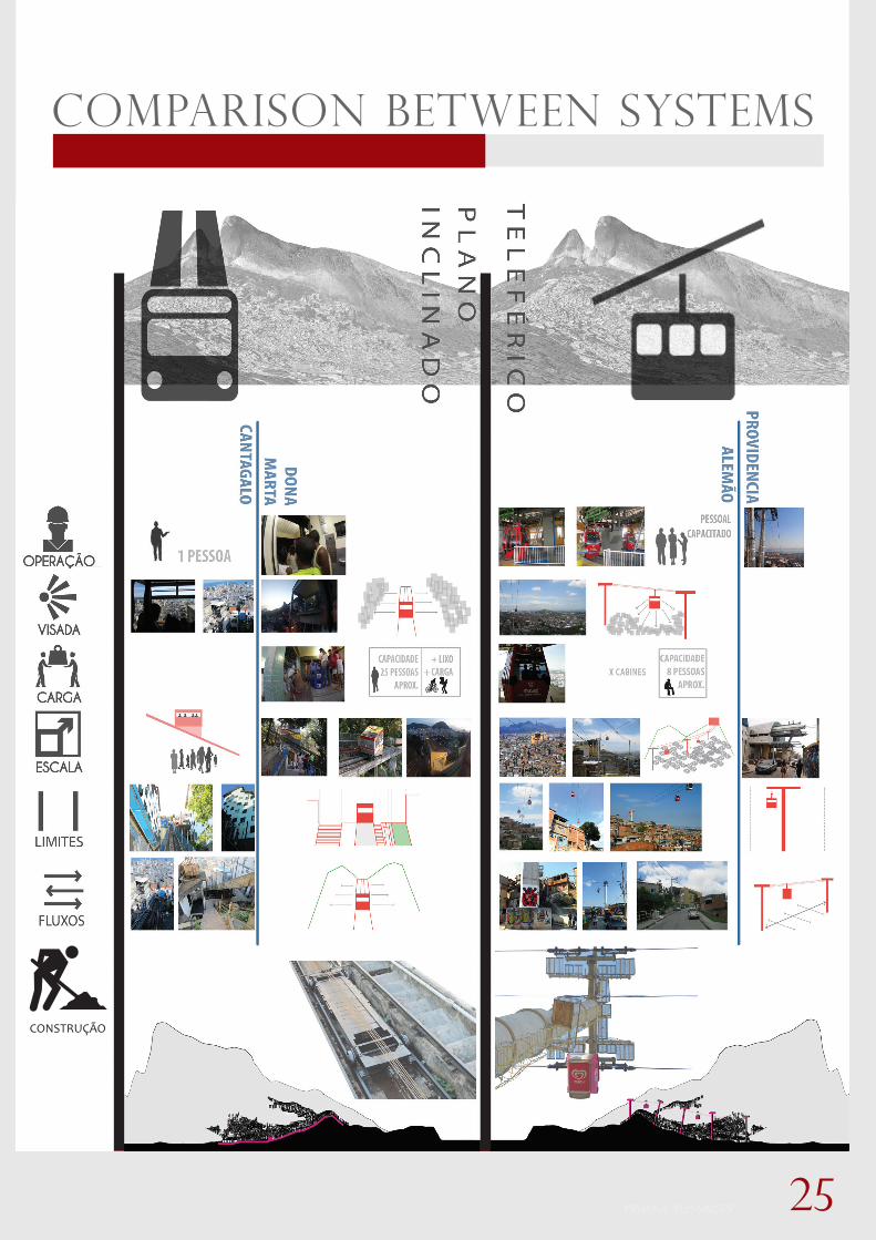
The funicular railway system as a solution for mobility inside of slums first appears in Rio de Janeiro in the Cantagalo slum in 1985, under the government Brizola and was reopened in 2011 by Mayor Eduardo Paes.
The implementation of the line has created an incision in the urban fabric of the slum. Beside the funicular runs a waterway and a drainage sys-tem for rainwater and sewage. If there is dramatic change in the inclina-
tion of the natural slope, it is necessary to build a transfer station, in this case this was prevented by raising the railway on top of an elevated structure. The result of the residual space under the railway is a dynamic life, where people move around, have shops, meet, grow plants, etc...
The residents relate positively to the funicular system. There is a feeling that it belongs to them, so people who use the system are also the ones that create the rules of operation. For example, it is a very old structure,
therefore, for its conservation, the community has determined it cannot be used to transport cargo, passengers only.
Asecond example we have of a funicular system installed in a slum is the best known - the funicular of Dona Marta slum in Botafogo neighbou-rhood. This system was implemented in 2008 under the government
Sérgio Cabral and today is highly used by locals and tourists.
The funicular of Dona Marta has five stations, one of the stations is a transfer station needed because there is a sudden change in the slope of the topography. The railway line is located between the edge of the
favela’s buildings and the forest that surrounds it , thus becoming a barrier to the expansion of illegal occupation.
This system is also very well accepted by the community residents (al-though , at the time of its construction, there has been resistance) . Because this is a more recent construction, it is possible to carry loads
beyond people, things such as: building materials, bicycles, furniture, boxes of beer, merchandise and garbage .
hist
ory
impl
emen
tatio
nre
side
nts
opin
ion
funicular railwayCANTAGALO slum
dona marta slum
hist
ory
impl
emen
tatio
nre
side
nts
opin
ion

21BRIANNA BUSSINGER
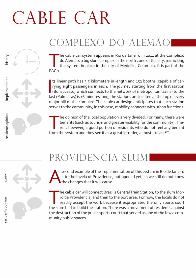
The cable car system appears in Rio de Janeiro in 2011 at the Complexo do Alemão, a big slum complex in the north zone of the city, mimicking the system in place in the city of Medellin, Colombia. It is part of the
PAC 2.
Its linear path has 3.5 kilometers in length and 152 booths, capable of car-rying eight passengers in each. The journey starting from the first station (Bonsucesso, which connects to the network of metropolitan trains) to the
last (Palmeiras) is 16 minutes long, the stations are located at the top of every major hill of the complex. The cable car design anticipates that each station serves to the community, in this case, mobility connects with urban functions.
The opinion of the local population is very divided. For many, there were benefits (such as tourism and greater visibility for the community). The-re is however, a good portion of residents who do not feel any benefit
from the system and they see it as a great intruder, almost like an ET.
A second example of the implementation of this system in Rio de Janeiro is in the favela of Providence, not opened yet, so we still do not know the changes that it will cause.
The cable car will connect Brazil’s Central Train Station, to the slum Mor-ro da Providencia, and then to the port area. For now, the locals do not readily accept the work because it expropriated the only sports court
the slum had to build the station. There was a movement of residents against the destruction of the public sports court that served as one of the few a com-munity public spaces.
Complexo do Alemão
PROVIDENCIA slum
cable carhi
stor
yim
plem
enta
tion
resi
dent
s op
inio
nhi
stor
yre
side
nts
opin
ion

23BRIANNA BUSSINGER
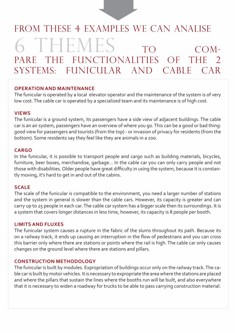
OPERATION AND MAINTENANCEThe funicular is operated by a local elevator operator and the maintenance of the system is of very low cost. The cable car is operated by a specialized team and its maintenance is of high cost.
VIEwSThe funicular is a ground system, its passengers have a side view of adjacent buildings. The cable car is an air system, passengers have an overview of where you go. This can be a good or bad thing: good view for passengers and tourists (from the top) - or invasion of privacy for residents (from the bottom). Some residents say they feel like they are animals in a zoo.
CARGOIn the funicular, it is possible to transport people and cargo such as building materials, bicycles, furniture, beer boxes, merchandise, garbage... In the cable car you can only carry people and not those with disabilities. Older people have great difficulty in using the system, because it is constan-tly moving, it’s hard to get in and out of the cabins.
SCALEThe scale of the funicular is compatible to the environment, you need a larger number of stations and the system in general is slower than the cable cars. However, its capacity is greater and can carry up to 25 people in each car. The cable car system has a bigger scale then its surroundings. It is a system that covers longer distances in less time, however, its capacity is 8 people per booth. LIMITS AND FLUXESThe funicular system causes a rupture in the fabric of the slums throughout its path. Because its on a railway track, it ends up causing an interruption in the flow of pedestrians and you can cross this barrier only where there are stations or points where the rail is high. The cable car only causes changes on the ground level where there are stations and pillars.
CONSTRUCTION METHODOLOGyThe funicular is built by modules. Expropriation of buildings occur only on the railway track. The ca-ble car is built by motor vehicles. It is necessary to expropriate the area where the stations are placed and where the pillars that sustain the lines where the booths run will be built, and also everywhere that it is necessary to widen a roadway for trucks to be able to pass carrying construction material.
FROM THESE 4 EXAMPLES WE CAN ANALISE
TO COM-PARE THE FUNCTIONALITIES OF THE 2 SYSTEMS: FUNICULAR AND CABLE CAR
6 THEMES
25BRIANNA BUSSINGER
CONSTRUÇÃO
COMPARISON BETWEEN SYSTEMS
To improve overall circulation of pedestrians, vehicles, motorcycles, air...there is a necessity to reform certain roads and lanes. The funicular railway system is impemented in the areas whe-re the slopes are very intense and require a lot of energy from the residents to go up-hill.
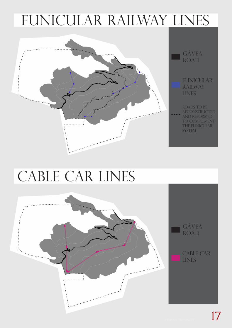
There are three cases where the funicular lines are present in the Master Plan:
• Street 2 to Umuarama• UPA to the Ecological Park• Valao Street to Street 1 (This funicular line still exists in the PAC 2).
The three funicular lines would be located on top of the main waterways, which in itself is an element that causes a natural rupture in the ur-ban fabric of the slum. These waterway paths are denominated as FNA’s (non building zones) where, by regulation, there should be no resi-dents because it is an area of high-risk.
The stations of the funicular system serve as crossing points, and result in small scale meeting points spread along the entire line. They would also have the purpose of improving the infras-tructure with the drainage of rainwater, sewage and garbage removal, as well as transportation of residents and cargo.
COMPARISON BETWEEN THE FUNICULAR RAIL-
WAY SYSTEM DETERMINED IN THE
MASTER PLAN AND THE
CABLE CAR PROJECT PREVIEWED IN THE
GOVERNMENT GROWTH ACCELERATION PROGRAM
PAC2ROCINHA
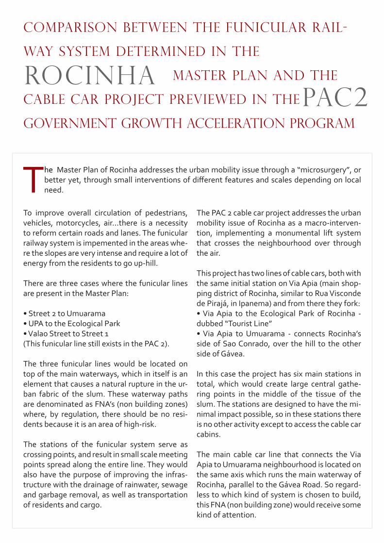
The Master Plan of Rocinha addresses the urban mobility issue through a “microsurgery”, or better yet, through small interventions of different features and scales depending on local need.
The PAC 2 cable car project addresses the urban mobility issue of Rocinha as a macro-interven-tion, implementing a monumental lift system that crosses the neighbourhood over through the air.
This project has two lines of cable cars, both with the same initial station on Via Apia (main shop-ping district of Rocinha, similar to Rua Visconde de Pirajá, in Ipanema) and from there they fork:• Via Apia to the Ecological Park of Rocinha - dubbed “Tourist Line”• Via Apia to Umuarama - connects Rocinha’s side of Sao Conrado, over the hill to the other side of Gávea.
In this case the project has six main stations in total, which would create large central gathe-ring points in the middle of the tissue of the slum. The stations are designed to have the mi-nimal impact possible, so in these stations there is no other activity except to access the cable car cabins.
The main cable car line that connects the Via Apia to Umuarama neighbourhood is located on the same axis which runs the main waterway of Rocinha, parallel to the Gávea Road. So regard-less to which kind of system is chosen to build, this FNA (non building zone) would receive some kind of attention.

27BRIANNA BUSSINGER
EXPROPRIATIONS
DESIGNS
FUNICULARLINES AND STATIONS
CABLE CAR LINES AND STATION
FOR THE CONSTRUCTION OF THE FUNICULAR SYSTEM
FOR THE CONSTRUCTION OF THE CABLE CAR SYSTEM

ONE TIME HUMAN ERROR
TWO TIMES STUPIDITY
The government estimated that 70% of the residents of the Complexo do
Alemao would use the cable cars. In 2013, the average registered is only 7%,
10 times less than expected.
29BRIANNA BUSSINGER
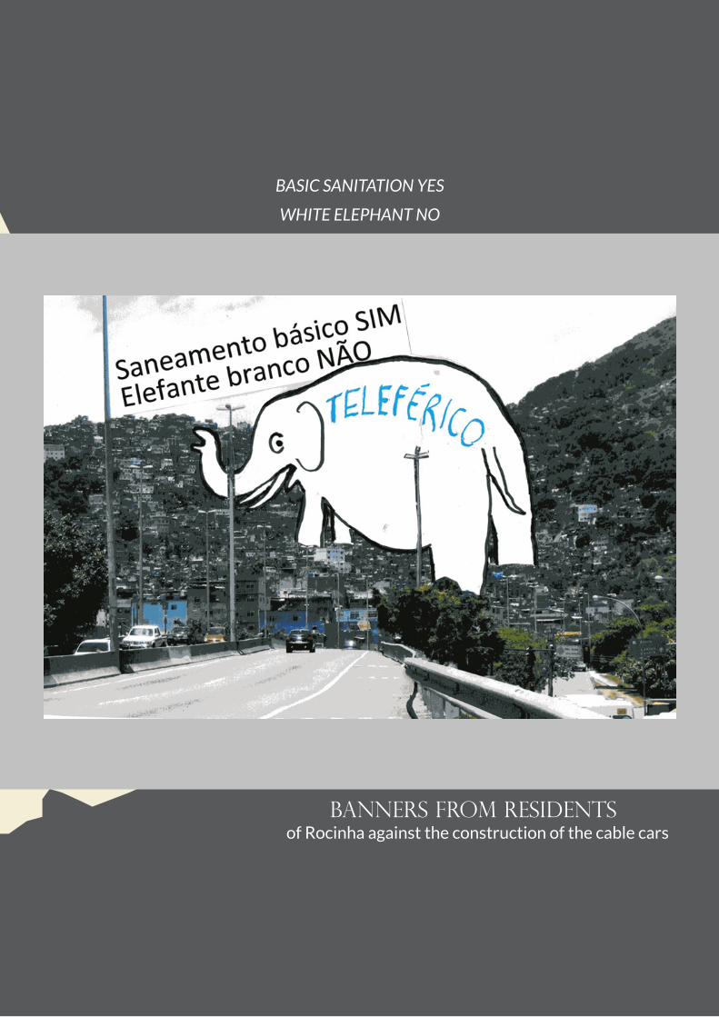
banners from residentsof Rocinha against the construction of the cable cars
BASIC SANITATION YES
WHITE ELEPHANT NO
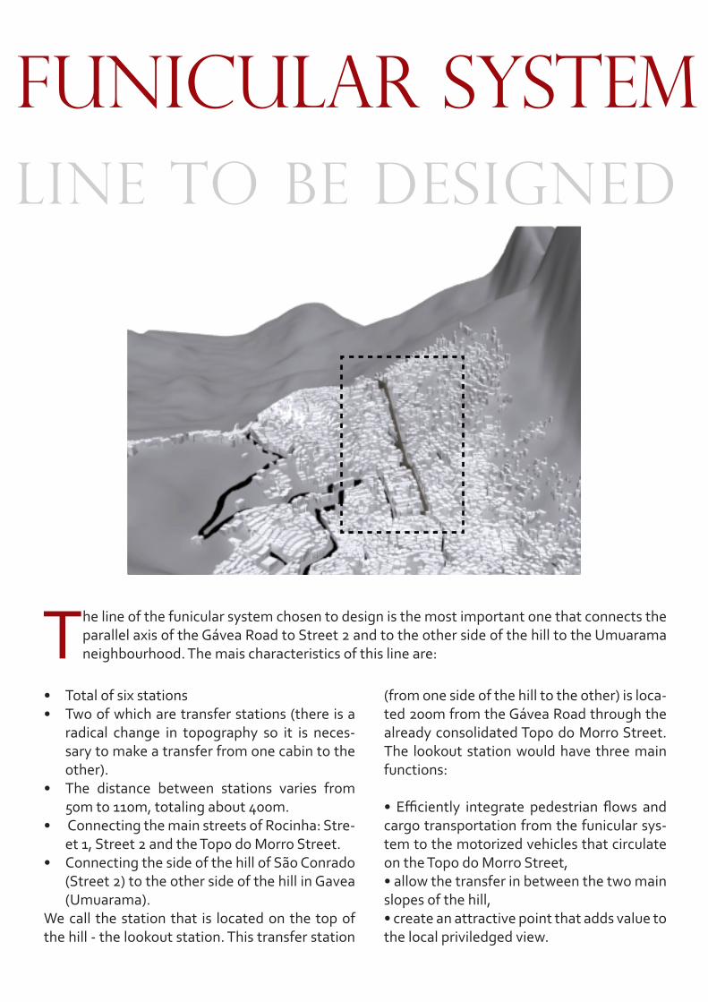
• Total of six stations• Two of which are transfer stations (there is a
radical change in topography so it is neces-sary to make a transfer from one cabin to the other).
• The distance between stations varies from 50m to 110m, totaling about 400m.
• Connecting the main streets of Rocinha: Stre-et 1, Street 2 and the Topo do Morro Street.
• Connecting the side of the hill of São Conrado (Street 2) to the other side of the hill in Gavea (Umuarama).
We call the station that is located on the top of the hill - the lookout station. This transfer station
FUNICULAR SYSTEMLINE TO BE DESIGNED
The line of the funicular system chosen to design is the most important one that connects the parallel axis of the Gávea Road to Street 2 and to the other side of the hill to the Umuarama neighbourhood. The mais characteristics of this line are:
(from one side of the hill to the other) is loca-ted 200m from the Gávea Road through the already consolidated Topo do Morro Street. The lookout station would have three main functions:
• Efficiently integrate pedestrian flows and cargo transportation from the funicular sys-tem to the motorized vehicles that circulate on the Topo do Morro Street,• allow the transfer in between the two main slopes of the hill,• create an attractive point that adds value to the local priviledged view.

31BRIANNA BUSSINGER
FUNICULAR SYSTEMLINE TO BE DESIGNED
110m
110m
50m
50m
60m
TOTAL: 400m
Funicular line to be studied:
ST. 2
UMUARAMA
TOPO DO MORRO ST.
ST. 1
Gavea Road (200m)
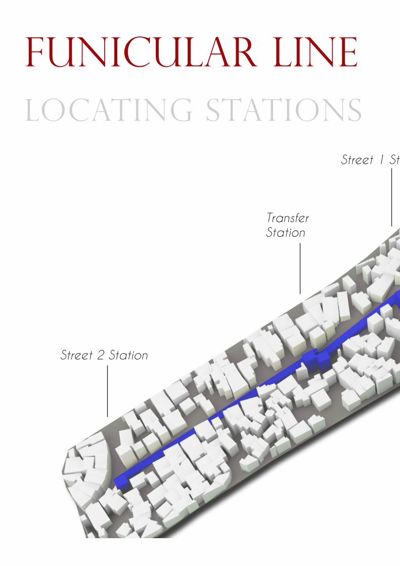
funicular linelocating stations
Street 2 Station
TransferStation
Street 1 Station
33BRIANNA BUSSINGER
funicular linelocating stations
LOOKOUTSTATION
Street 1 Station
Beco 199Station
UmuaramaStation
Street 2 Station
Transfer Station
Street 1 Station
Lookout Station
Beco 199Station
UmuaramaStation

At the place where the street meets the sta-tion, there is a roundabout created, thus being able to organize the circulation of motorized vehicles (such as moto-taxis, vans and garba-ge trucks) allowing transfers to be carried out efficiently.The ground level is the level where the different types of circulation patterns are distributed, it may be to:
• Access both sides of the funicular system
LOOKOUT STATION organizING CIRCULATION
To ensure that the Lookout Station is easily accessible and can support a large move-ment of people and cargo, the project previews a recharacterization of the Topo do Morro Street. It becomes a two-way street that supports automobile circulation to en-
sure connectivity to the main road, the Gávea Road.
(because it is free of ticketing, there is no need for ticketing offices or turnstiles),• to cross the Topo do Morro Street with coverage,• access other modes of transportation,• find garbage disposal points where tru-cks will be available for pickup.
Topo do Morro St.
Topo do Morro St.with roundabout
Now

35BRIANNA BUSSINGER
LOOKOUT STATION organizING CIRCULATION
Design: Reurbanizing Topo do Morro St. Floor Plan
Design: Lookout Station Floor Plan
Scale: 1.100
Scale: 1.100
Field
Shops
AccessFunicular
AccessFunicular
AccessLookout
AccessPolice
Moto-Taxi
Mirante
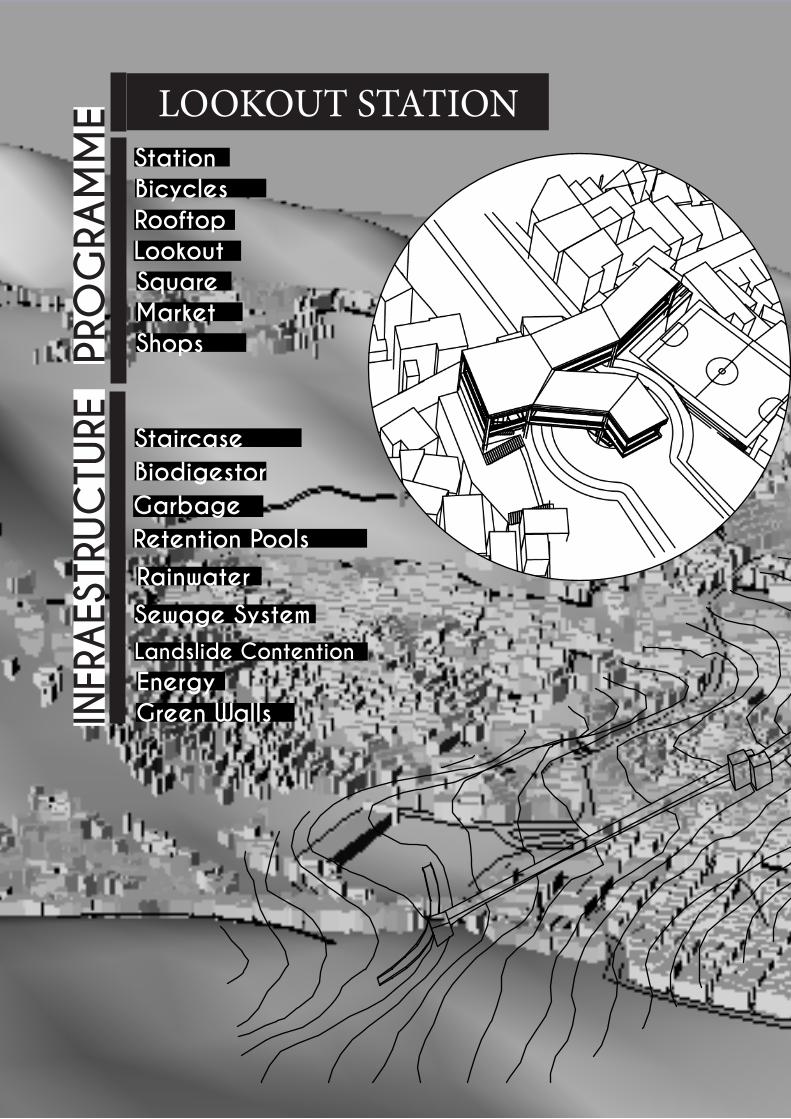
StationBicycles
SquareMarket
LookoutRooftop
Shops
BiodigestorGarbage
Rainwater
Green WallsEnergy
Sewage System
Retention Pools
Landslide Contention
Staircase
INFR
AES
TRUC
TURE
PRO
GRA
MM
E LOOKOUT STATION

37BRIANNA BUSSINGER

One can see from the top:• The South Zone, City Center, Niterói,
Christ the Redeemer Statue, Finger of God Mountain
• São Conrado, Rocinha• Rocky Mountains of the Morro dos Dois
Irmãos• Atlantic Forest
The additional functions (such as restaurants, cafeterias, bars, tourist information, sports court ...) will be naturally created within the community by the population that inhabits the adjacent areas to the station because they will identify the demand that new flows will generate. This is a very strong character-
LOOKOUT STATION MAIN STRUCTURE
The first floor of the lookout station is a platform dedicated exclusively to enjoying the beautiful and exclusive view that this location has to offer.
istic inside the brazilian slums.
Regarding the materials used to build the structure, a pre-molded light metal structure is chosen (easy to transport and assemble) with wood paneling coverage. The idea is that the structure is simple, fast and replaceable in construction.
In the cable car system implementation there will be no lookout station because Street 1 station is directly connected to Umuarama station. The only opportunity to contemplate the two sides of the hill at the same time would be in a moving booth, loosing this opportunity.
3D Structure - Lookout Station

39BRIANNA BUSSINGER
LOOKOUT STATION MAIN STRUCTURE
view TO THE SOUTH ZONE
vIEW TO THE SLUM
Facade: Lookout StationScale: 1.100
Facade: Lookout StationScale: 1.100


41BRIANNA BUSSINGER
perspective lookout stationview of Topo do Morro Street
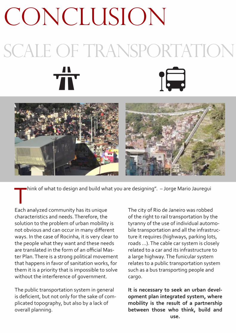
conclusionscale of transportation
Each analyzed community has its unique characteristics and needs. Therefore, the solution to the problem of urban mobility is not obvious and can occur in many different ways. In the case of Rocinha, it is very clear to the people what they want and these needs are translated in the form of an official Mas-ter Plan. There is a strong political movement that happens in favor of sanitation works, for them it is a priority that is impossible to solve without the interference of government.
The public transportation system in general is deficient, but not only for the sake of com-plicated topography, but also by a lack of overall planning.
Think of what to design and build what you are designing”. – Jorge Mario Jauregui
The city of Rio de Janeiro was robbed of the right to rail transportation by the tyranny of the use of individual automo-bile transportation and all the infrastruc-ture it requires (highways, parking lots, roads ...). The cable car system is closely related to a car and its infrastructure to a large highway. The funicular system relates to a public transportation system such as a bus transporting people and cargo.
It is necessary to seek an urban devel-opment plan integrated system, where mobility is the result of a partnership between those who think, build and
use.

43BRIANNA BUSSINGER
conclusionscale of transportation
bIBLIOgraphyFARR, Douglas (2008) Sustainable Urbanism: Urban Design With Nature, Hoboken, NJ
HAGAN, Susannah(2010) Ecological Urbanism Lars Muller PublishersMOSTAFAVI, Mohsen e DOHERTY, Gareth (2015) Urbanismo Ecológico, GG Brasil
National Association of Transportation Officials (NACTO) (2013) Urban Street Design Guide, Island PressNIMA (2011) Hydrographic Basin of Rainha’s River, PUC-RJ
SOS Rocinha Saneamento Contato: 91717072 (2014)TERRY, Tatiana, JAVOSKI, Daniela, ARAÚJO, Solange (2015) Cadernos Técnicos Morar Carioca, IAB RJ
TOLEDO, Luiz Carlos, (2007) “Plano Diretor da Rocinha: Derrubando muros” Revista CREA RJVLADIMIR Novotny, JACK Ahern, PAUL Brown (2010) Water Centric Sustainable Communities: Planning, Retrofitting and Building
the next Urban Environment, Hoboken, NJ
http://www.lowimpactdevelopment.orghttps://www.youtube.com/watch?v=GiJDUXg6H6Q
http://www2.rio.rj.gov.br/smu/caderno/site%20sao%20conrado/legislacao/especifica/3693.htmhttp://portalgeo.rio.rj.gov.br/bairroscariocas/mostra_temas_ra.php?ra=Rocinha&area=27
http://uppsocial.org/territorios/rocinha-2/http://www.mtarquitetura.com.br/
http://www.jauregui.arq.br/http://www.arquitraco.com.br/
http://www.rocinha.org/http://www.iabrj.org.br/
http://www.archdaily.com.br/br/01-112062/teleferico-na-comunidade-da-rocinha-tera-duas-linhas-e-seis-estacoeshttp://www.iabrj.org.br/morarcarioca/o_programa/
Related Documents