Delaware River Basin Commission Upstream- Downstream Delaware River Watershed Forum – October 22, 2014 Pamela M. Bush, J.D., M.R.P. [email protected]

Welcome message from author
This document is posted to help you gain knowledge. Please leave a comment to let me know what you think about it! Share it to your friends and learn new things together.
Transcript

Delaware River Basin Commission
Upstream-DownstreamDelaware River Watershed
Forum – October 22, 2014
Pamela M. Bush, J.D., [email protected]
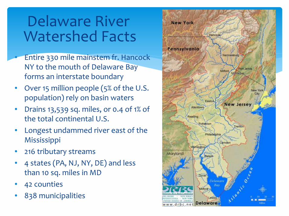
Delaware RiverWatershed Facts
• Entire 330 mile mainstem fr. Hancock NY to the mouth of Delaware Bay forms an interstate boundary
• Over 15 million people (5% of the U.S. population) rely on basin waters
• Drains 13,539 sq. miles, or 0.4 of 1% of the total continental U.S.
• Longest undammed river east of the Mississippi
• 216 tributary streams
• 4 states (PA, NJ, NY, DE) and less than 10 sq. miles in MD
• 42 counties
• 838 municipalities

60% Forested24% Agricultural9% Urban & Residential7% Surface Water & Other
80% of the population lives in 40% of total area
Appalachian Plateaus> 33% of land area< 3% of population85% forested
Land Use and Population

Hawk’s Nest Overlook

Photos Courtesy NYC DEP

Reservoir releases have created a world-class trout fishery in the Upper Delaware River and tributaries.
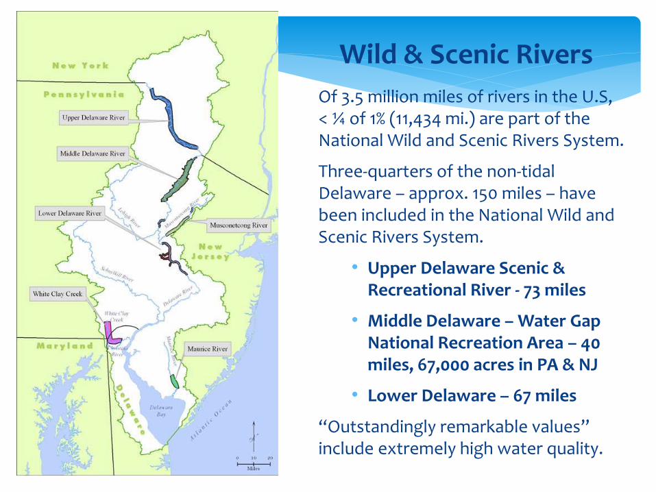
Of 3.5 million miles of rivers in the U.S, < ¼ of 1% (11,434 mi.) are part of the National Wild and Scenic Rivers System.
Three-quarters of the non-tidal Delaware – approx. 150 miles – have been included in the National Wild and Scenic Rivers System.
• Upper Delaware Scenic & Recreational River - 73 miles
• Middle Delaware – Water Gap National Recreation Area – 40 miles, 67,000 acres in PA & NJ
• Lower Delaware – 67 miles
“Outstandingly remarkable values” include extremely high water quality.
Wild & Scenic Rivers

MarcelusShale and Special Protection Waters
36% (4,937 mi2)
of the DRB is
underlain by
Marcellus Shale


Special Protection Waters
• Upper and Middle Delaware River designated SPW in 1992 (point discharges only)
• Non-point source requirements were added in 1994
• Lower Delaware was permanently designated in July 2008
It is the policy of the Commission that there be no measurable change in existing water quality except towards natural conditions in waters considered by the Commission to have exceptionally high scenic, recreational, ecological, and/or water supply values.

SPW RequirementsPoint Sources:
1. No-discharge alternatives to a direct discharge
2. Natural treatment alternatives
3. Best Demonstrable Technology (BDT) minimum for direct discharges
4. No Measurable Change (NMC) at water quality control points
5. No mixing zone for direct discharges to OBW
6. Emergency power, alarms, EMP
Non-Point Sources:
Non-Point Source Pollution Control Plan – applies to wastewater discharge and water withdrawal service areas

Delaware River Port Complex – One of World’s Largest Fresh Water Ports

photo © kbc119 (GoogleEarth)
Walt Whitman Bridge – RM 96.8
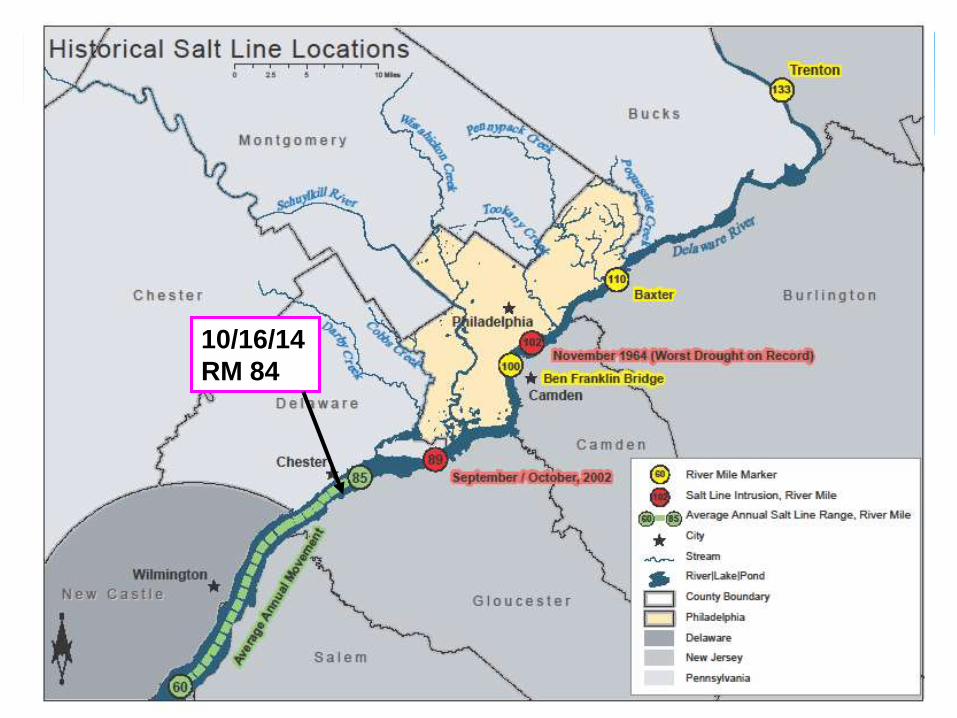
10/16/14
RM 84

Montague
Trenton
DRB Reservoirs
• New York City Delaware Basin Reservoirs drive the Basinwide Operating Plan
‒ Cannonsville
‒ Pepacton
‒ Neversink
• Merrill Creek
• Two USACE Reservoirs drive Lower Basin Operating Plan
− Beltzville
− Blue Marsh

DRB Reservoir Operations
NYC diversions – 800 MGD
New Jersey diversions – 100 MGD
Montague flow target – 1750 cfs
Trenton flow target – 3000 cfs
Salt Line Location – 250 mg/l chlorides @ River Mile 69 (avg)
Diversions and releases are adjusted during droughts


Oyster Restoration Project –Planting Shell

Canonsville Reservoir, December 20, 2001 –6.5% of capacity
Major main stem floods occurred in Sept. 2004, Apr. 2005 and June 2006
Will events like these become more severe?
More extreme?

ChallengesHow do we
preserve Water Quality in the non-tidal river?
maintain freshwater flows through the Estuary sufficient to protect habitat and urban drinking water supplies?
control flooding?
Maintain adequate flows during droughts
In the face of
growing development pressure in the Upper Basin?
prospect of a new drought of record?
salt migration with sea level rise
Questions
Do lower basin residents have a financial interest/stake in:
preserving forested riparian buffers
forested headwater areas
for the ecosystem services they provide?
clean water
flood control
scenic beauty
outdoor recreation – health and well-being
wildlife habitat
tourism
If so, how should we capture and apply that interest?

Thank You.Pamela M. Bush
Delaware River Basin Commission
Related Documents