www.iasscore.in Preparation Approach 22 Practice Sets & Model Hints Micro Detailling of UPSC Syllabus Previous Year Questions & Solutions Edited by: Manoj K. Jha GS PAPER 1 ANSWER WRITING WORKBOOK Complete Geography Revision through 200+ Question Geography UPSC MAINS UPDATED

Welcome message from author
This document is posted to help you gain knowledge. Please leave a comment to let me know what you think about it! Share it to your friends and learn new things together.
Transcript
www.iasscore.in
Preparation Approach
22 Practice Sets & Model Hints
Micro Detailling of UPSC Syllabus
Previous Year Questions & Solutions
Edited by:Manoj K. Jha
GS PAPER 1
ANSWER WRITINGWORKBOOK
Complete Geography Revision through 200+ Question
Geography
UPSCMAINS
UPDATED
PREFACE
While current affairs changes every year there are some parts in syllabus which do not change and a candidate requires conceptual understanding and a good grip over these topics. The purpose of this workbook is to serve as one stop destination for students. It will help in building a base of knowledge and conceptual clarity
GS answer writing workbook aims to function as a standalone product that will promote self-learning habits in students and help in maximum syllabus coverage of the static portion.
Features of Workbook The workbook has following features that aim to resolve various issues faced by students in an effi cient and holistic manner.
Feature Issue resolved
Static Topics from syllabus Conceptual clarity
Topic wise sets Syllabus coverage
Question & Answer format Answer writing practice & Time management
Approach before each answer Structuring of answers
Previous Year questions Analysis
Blank Page at the end of each set Self-note making
How to optimally make use of workbook In order to gain maximum out of it, a student must fi rst attempt each of the set by himself and then compare his answers with model hint given. This exercise will help them to gain confi dence in answer writing, in enrichment of their answers and in better management of time.
The approach given at the beginning of each answer is also aimed to give him an idea about how to approach an answer. Before going into the answer, he must fi rst build his own answer around the approach and then compare with the given answer.
Any extra point to be remembered, revised or any other extra additions can be made at the Blank Page given at the end of each set.
About GS score Geography workbook It consists of total 22 sets that are broadly divided as per UPSC syllabus. It is intended to guide you and serve as a reliable source of information, ideas, concepts and facts. This will help you to approach the subject with much more clarity and confi dence. It is essential that you must aim to utilize the workbook optimally as per steps given above, to gain maximum out of it

APPROACH TO PREPARE GEOGRAPHYFOR UPSC
Geography is often considered a tough subject under UPSC civil services examination. Its vastness sometimes poses a challenge for students but number of questions asked every year both in prelims and mains makes it inevitable.
It is essential that a student must make a comprehensive strategy that focuses on concept clarity as well as on answer writing practice. Geography involves understanding of multiple phenomena and their applications. Along with this a candidate must keep in mind the kind of questions been asked in UPSC every year.
Preparation of Geography is based on following 3 pillars
Study of past year papers
Books and resources
Strategizing
Study of past year papers Past year papers are the guiding light for preparation. They help in giving a direction to the course of your study and also enable you to gain maximum output. Every year 6-7 questions are asked in UPSC mains GS paper 1. Thus in order to get a good score a candidate must analyze the trends in questions and topics that are being asked.
Areas from where questions have been asked include-
Desertifi cation
Interlinking of rivers
Importance of mangroves
Location of steel industries
Industrial corridors
Mantle plume etc.
Thus as we can see above that what is required is point to point coverage of syllabus. Areas that have been asked require a broad overview, thus a candidate must keep in mind the syllabus also at all times.
Books and Resources Before going to any advanced books, it is advisable to go through NCERTs that will help in concept clarity and you will be able to gain confi dence on almost all areas of UPSC syllabus. It will help you write lucid answers. The following NCERT books must be referred to strengthen the basics:

NCERT Class 7 – Our Environment
NCERT Class 8 – Resources & Development.
NCERT Class 9 – Contemporary India 1
NCERT Class 10 - Contemporary India II
NCERT Class 11 - Fundamentals of Physical Geography
NCERT Class 11 - India – Physical Environment
NCERT Class 12- Fundamentals of Human Geography
NCERT Class 12th – India – People & Economy
Advance Books and Resources
Selected study of Certifi cate Physical and Human Geography by GC Leong
Oxford School atlas
Orient Black swan school atlas
GS score Geography material
Strategizing The best strategy is the one that works for you. It is best to devise a plan and stick to it. Thus discipline is the most important part in your strategy. After going through basics, cover the areas that you feel require more clarity from other sources. As soon as you come across any new place look into the map and study it in detail, mountain, seas, plateaus, ocean surrounding it etc. Frequent revisions are the key, if you require best outcomes. Instead of reading multiple sources stick to few. Answer writing practice is the most important part of the strategy. Make sure to give enough mocks and solve previous year papers to gain confi dence in answer writing and practice time management.
**********

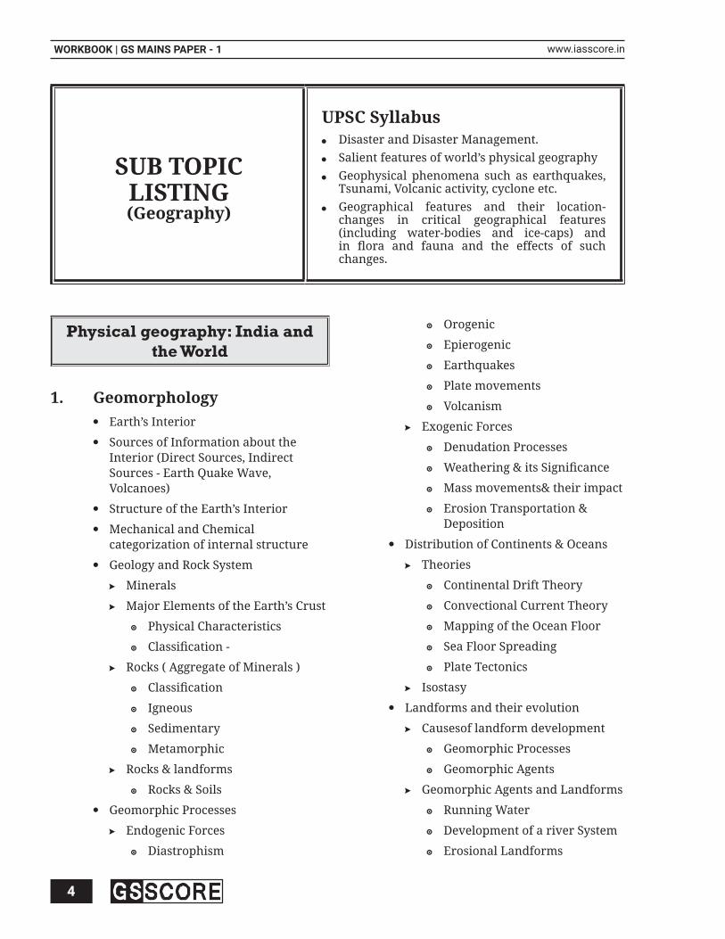
SYLLABUS MICRO DETAILING
4
WORKBOOK | GS MAINS PAPER - 1 www.iasscore.in
SUB TOPIC LISTING(Geography)
UPSC SyllabusDisaster and Disaster Management. Salient features of world’s physical geography Geophysical phenomena such as earthquakes, Tsunami, Volcanic activity, cyclone etc.Geographical features and their location- changes in critical geographical features (including water-bodies and ice-caps) and in fl ora and fauna and the effects of such changes.
Physical geography: India and the World
Geomorphology1. Earth’s Interior
Sources of Information about the Interior (Direct Sources, Indirect Sources - Earth Quake Wave, Volcanoes)
Structure of the Earth’s Interior
Mechanical and Chemical categorization of internal structure
Geology and Rock System
Minerals
Major Elements of the Earth’s Crust
Physical Characteristics
Classifi cation -
Rocks ( Aggregate of Minerals )
Classifi cation
Igneous
Sedimentary
Metamorphic
Rocks & landforms
Rocks & Soils
Geomorphic Processes
Endogenic Forces
Diastrophism
Orogenic
Epierogenic
Earthquakes
Plate movements
Volcanism
Exogenic Forces
Denudation Processes
Weathering & its Signifi cance
Mass movements& their impact
Erosion Transportation & Deposition
Distribution of Continents & Oceans
Theories
Continental Drift Theory
Convectional Current Theory
Mapping of the Ocean Floor
Sea Floor Spreading
Plate Tectonics
Isostasy
Landforms and their evolution
Causesof landform development
Geomorphic Processes
Geomorphic Agents
Geomorphic Agents and Landforms
Running Water
Development of a river System
Erosional Landforms

5
GEOGRAPHYwww.iasscore.in
Depositional Landforms
Ground Water (Karst Topography)
Erosional Landforms
Depositional landforms
Glaciers
Erosional Landforms
Depositional Landforms
Waves and Currents
Winds
Erosional Landforms
Depositional Landforms
Landforms across the world
Rivers and lakes
Mountain and Peaks
Plateaus
Oceanography2. Hydrosphere
Water on the Surface of the Earth
Hydrological Cycle
Submarine Relief Features
Relief of the Ocean fl oor
Divisions of the ocean fl oor
Minor relief features
Temperature and Salinity
Temperature of the Ocean Water
Factors affecting Temperature distribution
Horizontal and Vertical Distribution
Salinity of the Ocean Water
Factors affecting salinity
Horizontals distribution of salinity
Vertical Distribution of salinity
Density of Ocean Waters
Movements of Ocean Water
Factors infl uencing Movement
Waves
Motion of waves
Characteristics of wave
Tides
Types of Tides
Importance of Tides
Ocean Currents Characteristics of Ocean Currents Types of ocean currents: Major Ocean currents of the World Effects of Ocean Currents
Marine Resources
Surface water resources
Ground water resources
Inland water resources
Oceanic Water Resources (Marine Resource)
Utilization of oceans by man
Water consumption patterns
Water Conservation and Management (Techniques)
Ocean Deposits and Corals
Terrigenous Deposits
Volcanic Deposits
Biotic deposits
Abiotic Deposits
Coral Reefs
Probable origin of Coral Reef
Types and signifi cance of Coral Reef
Issue of Coral Bleaching
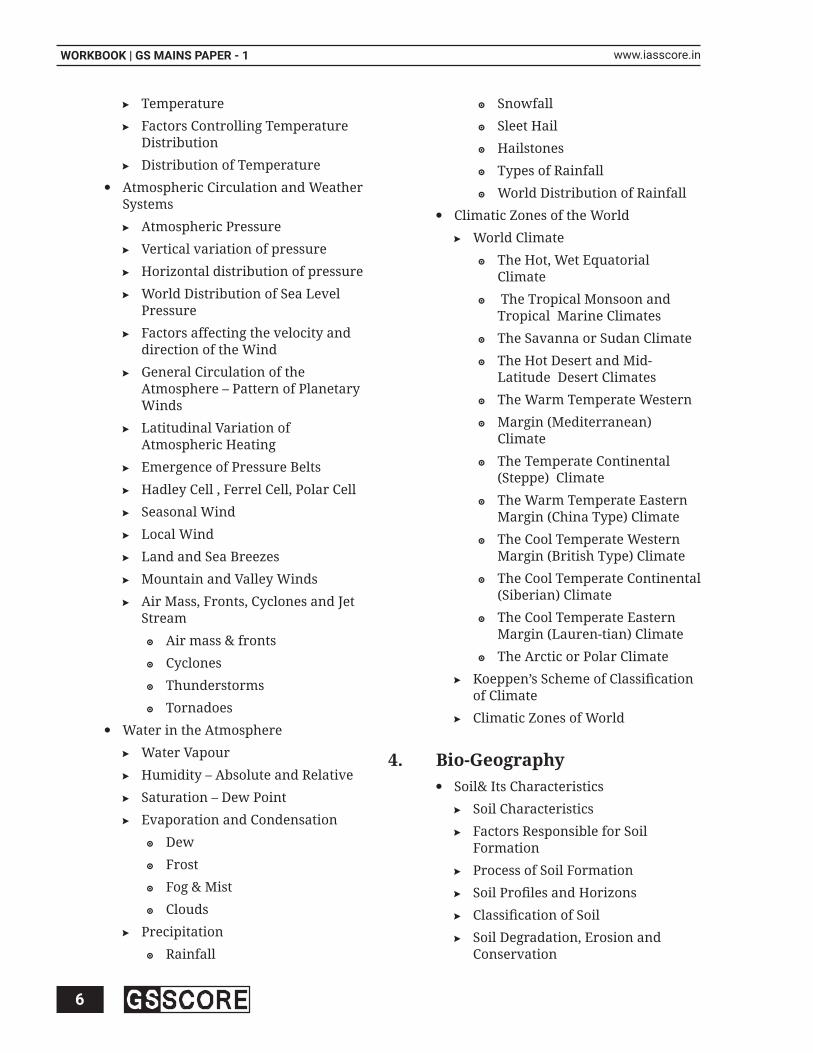
Climatology3. Atmosphere
Composition of the Atmosphere
Structure of the Atmosphere
Solar Radiation, Heat Balance and Temperature
Solar Radiation and Isolation
Heating and cooling of atmosphere
Terrestrial Radiation
Heat Budget of the Planet Earth
6
WORKBOOK | GS MAINS PAPER - 1 www.iasscore.in
Temperature
Factors Controlling Temperature Distribution
Distribution of Temperature
Atmospheric Circulation and Weather Systems
Atmospheric Pressure
Vertical variation of pressure
Horizontal distribution of pressure
World Distribution of Sea Level Pressure
Factors affecting the velocity and direction of the Wind
General Circulation of the Atmosphere – Pattern of Planetary Winds
Latitudinal Variation of Atmospheric Heating
Emergence of Pressure Belts
Hadley Cell , Ferrel Cell, Polar Cell
Seasonal Wind
Local Wind
Land and Sea Breezes
Mountain and Valley Winds
Air Mass, Fronts, Cyclones and Jet Stream
Air mass & fronts
Cyclones
Thunderstorms
Tornadoes
Water in the Atmosphere
Water Vapour
Humidity – Absolute and Relative
Saturation – Dew Point
Evaporation and Condensation
Dew
Frost
Fog & Mist
Clouds
Precipitation
Rainfall
Snowfall
Sleet Hail
Hailstones
Types of Rainfall
World Distribution of Rainfall
Climatic Zones of the World
World Climate
The Hot, Wet Equatorial Climate
The Tropical Monsoon and Tropical Marine Climates
The Savanna or Sudan Climate
The Hot Desert and Mid- Latitude Desert Climates
The Warm Temperate Western
Margin (Mediterranean) Climate
The Temperate Continental (Steppe) Climate
The Warm Temperate Eastern Margin (China Type) Climate
The Cool Temperate Western Margin (British Type) Climate
The Cool Temperate Continental (Siberian) Climate
The Cool Temperate Eastern Margin (Lauren-tian) Climate
The Arctic or Polar Climate
Koeppen’s Scheme of Classifi cation of Climate
Climatic Zones of World
Bio-Geography4. Soil& Its Characteristics
Soil Characteristics
Factors Responsible for Soil Formation
Process of Soil Formation
Soil Profi les and Horizons
Classifi cation of Soil
Soil Degradation, Erosion and Conservation

7
GEOGRAPHYwww.iasscore.in
Vegetation resources
Types of natural vegetation
Forests
Signifi cance of forests
Factors of forest development
Classifi cation of forests
forest cover
Grasslands
Desert vegetation
Tundra Vegetation
Deforestation
Conservation of forests
Reforestation
Afforestation
Forestry
Social forestry
Agro-forestry
Farm Forestry
Community Forestry
Important Geophysical 5. Phenomenon
Occurrence of Earthquakes
Earthquake Waves
Shadow Zone
Types of Earthquake
Measuring Earthquake
Effects of Earthquake
What Causes Tsunami
Effect of Tsunami
Mitigating the Impact of Tsunami
Volcanoes
Types of Volcanoes
What Causes Volcanoes?
Volcanic Landforms
Cyclone
Tropical Cyclones
Anti-Cyclone
Extra Tropical Cyclones
Critical geographical features 6. & effect of Climate change
Factors Causing Changes in Critical Geographical Features
Changing Geographical Features
Impact of Changing Geographical Features
Physical Geography of India7. Physiography of India
Location
Geopolitical Signifi cance of India
Geological Divisions
The Peninsular Block
The Himalayas and other Peninsular Mountains
Indo-Ganga-Brahmaputra Plain
Physiographic Divisions
Drainage System
Drainage Patterns
Drainage System of India
Himalayan Drainage System
River Systems of Himalayan Drainage
Indus river system
Ganga River System
Brahmaputra river system
Peninsular Drainage System
River Systems of Peninsular Drainage
Small Rivers Flowing Towards East and West
Climate
Factors infl uencing the climate of India
Monsoon
Mechanism of the Monsoon
Classical Theory
Modern theory
Air mass theory
Jet stream theory
8
WORKBOOK | GS MAINS PAPER - 1 www.iasscore.in
ELNINO and LANINA & their impact
The rhythm of Seasons
The cold weather season
The hot weather season
The southwest monsoon season
The retreating monsoon season
Climatic Regions of India
Soils in India
Classifi cation of Soils
Soil textures
Issue of Soil degradation & Soil Erosion
Soil Conservation
Natural Vegetation
Types of Forests in India
Forest Cover in India
Forest Conservation
Forest Problems in India
Factors of forest development
Causes and factors of deforestation:
Immediate causes of deforestation
Indirect deforestation
Conservation of forests
Forest conservation strategies
Reforestation
Monoculture plantation
Economic Geography
Natural resources1. Land Utilisation
Land Use Pattern
Land Degradation & Conservation
Forest Resources
Mangroves
Grasslands, Forests
Himalayan resources
Causes of Depletion
Conservation of Forests
Land-use Pattern and changes
Problems of Land Resources:
Land Degradation: Causes and Impact
Concept of Land Degradation Neutrality
Land Use Planning and Policy
Water Resources2. Extent of Water Resources
Water Resource Potential of India
Utilization and related problems (Pollution)
Inter- state water disputes in India
Water management, conservation and Development
National Water Policy
Marine & Freshwater
Water Scarcity
Water Conservation
Integrated Water Resources Management
Interlinking of Rivers
River pollution
Drainage basins
Agriculture3. Agriculture Basic Terminologies
Cropping pattern
Agriculture Productivity
Agriculture Intensity
Land capability
Location of agriculture
World Agriculture Typologies
Salient features of Indian Agriculture
Problems of Indian Agriculture
Factor Affecting Agriculture
Geographical factors
9
GEOGRAPHYwww.iasscore.in
Institutional factors
Technological factors
Major Crops and conditions for growth
Regionalization of Agriculture
Various Revolutions in Agriculture Sector
Green Revolution
Impact of Green Revolution
Evergreen Revolution
White Revolution
Operation Flood
Blue Revolution
Food Security
Nature of Food Insecurity: Duration, Severity and types
Trend and Pattern in Food Insecurity
Causes and Geography of famine
Key Dimension of food security
Efforts and Remedies to ensure food security
Mineral & Energy Resources4. Types of Mineral Resources
Distribution Pattern of Minerals in World
Major Mineral Belts of India
Problems related to mining
Conservation of Mineral Resources
National Mineral Policy, 2019
Classifi cation of Energy Resources
Distribution and production trend of major energy Resources
Coal
Petroleum
Natural gas
Strategic Oil Reserves
Exploration of Coal Bed Methane
Non-Conventional Energy Resources
Solar Energy
Wind Energy
Geothermal
Nuclear Energy Resources: Challenges and prospects in India
Recent Debates on Resources
Geopolitics of Natural Resources
Globalisation and unsustainable exploitation of natural resources
Depletion of natural resources versus Economic Growth
Changing Pattern of Land Use and Causes
Water Crisis: Causes, Confl icts and Resolution
Energy Crisis
Challenges and constraints faced by coal sector
Challenges in Hydropower sector
Renewable Energy: way toward sustainability
Energy Security: Energy Policy and strategy in India
Location of Industries & 5. Transport
Classifi cation of Industries
Factors affecting location of Industries
Weber’s Model of Industrial Location
Losch theory of Profi t Maximization
Various Industries: Location, Prospects and Challenges
Iron and Steel Industry
Textile Industry
Jute Industry
Auto Mobile Industry
Fertilizer Industry
Agro-based Industries
Other Industries
Industrial Regions and its Characteristics
Major Industrial Regions of the World

10
WORKBOOK | GS MAINS PAPER - 1 www.iasscore.in
Industrial Regions of India
Industrial Policies and Development
A Scheme for Promotion of Innovation, Rural Industry and Entrepreneurship (ASPIRE)
Scheme of Fund for Regeneration of Traditional Industries (SFURTI)
Stand Up India
Fourth Industrial Revolution
Role of Industrial development in minimizing regional inequalities
Problems of Industrial regions
Factors behind the growth and present location pattern of automobile industry in India
Pharmaceutical industry: Locational pattern and reasons
Sugar industry: Problems and challenges of current pattern
Food Processing Industry: Untapped Potential
Agro based Industries: Problems and Prospects
Impact of agro-based industries on cropping pattern
Tourism: Prospects and Impact on Environment
Defi nition, Development and scope of Economic Geography
Type of Economic Activities
Primary Activities
Secondary Activities
Tertiary, Quaternary and Quinary Activities
Land Transport
Roads
Classifi cation of roads
National Highway Grid
Problems and Prospects
BharatmalaPariyojana
Railways
Signifi cance and Problems of Indian Railways
Dedicated Freight Corridors
Privatisation of Railways
Pipelines
Signifi cance, Distribution and Challenges
WaterTransport
Inland: National Waterways
Factors affecting Inland waterways
Signifi cance and Challenges
Jal Marg Vikas Project
Seaways and Oceanic Route
Shipping
Major Ports of World and India
Challenges in Port Development
Sagarmala Project
Air Transport
National Airways
National Civil Aviation Policy
Regional Connectivity Scheme (UDAN)
International Airways
Communications
Communication Infrastructure
National telecom Policy
Major Issues in Transport and Communication
Role of Transport in Regional Development
Need for holistic transport planning to improve the city’s mobility
Carbon footprint of the transport sector
Road Transport: Investment Challenges
Inland Waterways: Development challenges and propects
Ports: Inclusive centres of economic development
Problem of Pot Development
Analysis of Sagarmala Project

11
GEOGRAPHYwww.iasscore.in
Environmental issues of maritime shipping
Role of Transport in Regional Development
Eco Tourism: Way toward Responsible Tourism
Human Geography
Population & Migration1. Concept of human resources
Factors affecting the distribution of Population
Population growth
Theories of Population Growth
Malthusian Theory
Marxian Theory
Demographic transition theory
Optimum Population Theory
Size, growth rate and distribution of population
Components of Population growth
Demographic Dividend
Demographic Window of Opportunity
Components of Population change
Birth Rate
Death Rate(Mortality Rate)
Migration
Factors responsible for migration
Type of Migration
Issues related to migration
Migration pattern in world and India
World Migration Report, 2018
Population Composition
Age Sex Pyramids & their signifi cance
Trends and Pattern in Sex Ratio
Initiatives to improve Sex ratio
Trends and Patterns in Literacy
Government’s Efforts
Fertility Rate
Impact of Population Change
Population Policies
Need for revision of National Population Policy
Population problems
Global Nutrition Report, 2018
Global Hunger Index
Rural Settlements
Classifi cation of Rural Settlements
Function of Rural Settlements
Patterns of Rural Settlements
Changing Pattern of Rural Settlements
Urban Settlements
Origin of Urban Settlements- Functional Classifi cation of Towns
Urbanization
Indian Mega Cities
Central Place Theory
Primate City
Morphology of Indian Cities
Conurbations
Urban Slums
Rural Urban Fringe
Rural Urban Continuum
Issues related to Urbanization in India
Habitat – III Conference
Concept of Region
Types of Regions
Issues of Regional Imbalances
Strategies for Regional Development
Growth v/s Development
Approaches to Human Development
Human Development Index

PRACTICEQUESTIONS
SET: 1 - 22

PHYSICAL GEOGRAPHY OF INDIA AND WORLD
14
WORKBOOK | GS MAINS PAPER - 1 www.iasscore.in
Describe the sources which provide the information about the Earth’s interior. Why Q1. seismology is the only method which gives complete authenticated information about the earth’s interior.
Evaluate the theory of Continental Drift as given by Wagner. How does the Q2. Plate Tectonic Theory seek to remove the shortcomings of the Continental Drift Theory?
Though oceanic fl oors are considered to be the most fundamental rocks in origin, Q3. no one of them are beyond the age of Mesozoic times. Explain it in the light of sea fl oor spreading theory. How is it different from continental drift theory?
Discuss briefl y the theory of Isostasy? What is its role in the geo-morphological Q4. context?
The interior of the earth can be understood only by indirect evidences as neither Q5. anyone has nor anyone can reach the interior of the earth. Elaborate.
Discuss the economic and strategic signifi cance of Indian islands.Q6.
Discuss the various reasons behind the formation of “Fire Girdle of Pacifi c” and Q7. major landforms along it.
Discuss the Orogenesis of Himalayan Mountain ranges on the basis of plate Q8. tectonics. Elaborate with geographical evidences supporting collision of different types and nature of tectonic plates during process of orogeny.
Different physiographic divisions of India are complementary to each other and Q9. lead to socio-economic development of the nation. Explain.
Discuss the formation of intermontane plateaus and tectonic plateaus citing Q10. examples.
**********
SET-1: QUESTIONSGEOMORPHOLOGY
15
GEOGRAPHYwww.iasscore.in
SET-1: ANSWERS
Describe the sources which provide the information about the Earth’s 1. interior. Why seismology is the only method which gives complete authenticated information about the earth’s interior.
(250 words)
Approach
Briefl y describe the sources which provide the information about the 1. Earth’s interior (100 words)
Defi ne the theories of the interior of the Earth. 2. (100 words)
Conclusion 3. (50 words)
Hints
Understanding of the earth’s interior is essential to understand the nature of changes that take place over and below the earth’s surface.
The sources which provide knowledge about the interior of the earth may be classifi ed into 3 groups,
Artifi cial Sources
Theories of the interior of the Earth
Natural Sources
Artifi cial Sources:
Density:The average density of the crust is around 2.9 to 3.3 g/cm3
While the average density of the Earth is 5.5
Thus, the core of the earth will be, without doubt, more than 5.5.
Later, the density of the earth core was found out to be 11
Pressure:Now the question is what is the reason for very high density of the core?

16
WORKBOOK | GS MAINS PAPER - 1 www.iasscore.in
Previously it was believed that, as pressure increases, density also increases due to super incumbent force.
But there is critical limit beyond which pressure increase does not increase density.
Thus, core must be composed of intrinsically heavy metallic materials of high density (i.e. iron and nickel)
Temperature:Temperature of the upper part of the magma slab representing upper portion of oceanic crust has been estimated to be 0°C, while temperature at around 70km was found out to be 1200°C.
With this rate of increase of temperature, core should be approx. 25000°C. But it would have melted the whole earth.
Thus, it is evident that most part of the radioactive materials which releases heat in large amount and thus causes rock melting, are concentrated in the crust.
While rate of increase of temperature downwards decreases with increasing depth.
Theories of the interior of the Earth:Edward Suess theory: According to him the earth is made up of three zones of different matter below the outer thin sedimentary cover viz. SIAL, SIMA and NIFE.
Natural Sources:Volcanism: The lava coming from inside the earth shows that the same material has to be there inside the earth.
However, all these methods were just speculations or partially proved concepts. The real concrete proof about the interior of the earth was provided by the Seismic studies.
The behaviour of seismic waves in different layers of the earth provides the most authentic evidence about the composition & structure of the earth. The different types of waves generated during the occurrence of earthquake, are generally divided into 3 broad categories; (a) Primary waves, (b) Secondary waves, (c) surface waves.
Seismic Waves - both P-waves & S-waves travel faster through rigid material than through soft or plastic material. The velocities of these waves travelling through specifi c part of earth give an indication of type of rocks there. Abrupt changes in seismic wave velocities indicate signifi cant changes in earth’s interior.
Seismic waves passing through the earth are refracted in ways that show distinct discontinuities within earth’s interior & provide basis for the belief that earth has
A solid inner core, (2) a liquid outer core, (3) a soft asthenosphere, (4) a rigid lithosphere.
Evaluate the theory of Continental Drift as given by Wagner. How does the 2. Plate Tectonic Theory seek to remove the shortcomings of the Continental Drift Theory?
(200 words)

17
GEOGRAPHYwww.iasscore.in
Approach
Give a detailed description of Continental Drift Theory 1. (50 words)
What provided base for the development of Plate tectonic theory 2. (60 words)
Differentiate the Plate Tectonic Theory with the Continental3. Drift Theory (60 words)
Conclusion 4. (30 words)
Hints
Continental drift is the movement of the Earth’s continents relative to each other, thus appearing to “drift” across the ocean bed. The speculation that continents might have ‘drifted’ was fi rst put forward by Abraham Ortelius in 1596. The concept was independently and more fully developed by Alfred Wegener in 1912, but his theory was rejected by some for lack of a mechanism (though this was supplied later by Arthur Holmes) and others because of prior theoretical commitments. The idea of continental drift has been subsumed by the theory of plate tectonics, which explains how the continents move.
Alfred Wegener a German meteorologist who put forth a comprehensive argument in the form of “the continental drift” in 1912.
According to Wegener, all the continents formed a single continental mass and Mega Ocean surrounded the same. The super continent was named Pangaea, which meant all earth and Mega Ocean surrounded it named Panthalassa, meaning all water. He argued that, around 200 million years ago, the super continent, Pangaea fi rst broke into two large continental masses as Laurasia and Gondwanaland forming the northern and southern component respectively. Subsequently, Laurasia and Gondwanaland continued to break into various smaller continents that exist today.
When Wegener proposed continental drift, many geologists were contractionists. They thought Earth’s incredible mountains were created because our planet was cooling and shrinking since its formation. But Wegener’s continental drift theory was great step ahead of contractionist theory. It provided base for development of Plate tectonic theory.
However, the theory has many fl aws:-He failed to explain the forces that lead to the drift of huge continental masses. As per the theory force of buoyancy, differential gravitational force along with tidal force of sun and moon are the real cause, which are not suffi cient enough to drift huge land masses.
nitially the theory considers that there is no resistance offered by the denser SIMA layer but later Wegener adopts the force full resistance offered by SIMA to explain the origin of mountains.
The theory did not talk about the direction of the drift and chronological sequence of this displacement.
At that time people hardly have any understanding about ocean bed topography.
Also Wegener provided those evidences which supports theory and neglected those which did not support.
Wegener did not explain about how Pangaea got formed .He don’t talk about pre Pangaea condition of earth.

18
WORKBOOK | GS MAINS PAPER - 1 www.iasscore.in
Plate tectonics is the widely accepted theory that Earth’s crust is fractured into rigid, moving plates. In the 1950s and 1960s, scientists discovered the plate edges through magnetic surveys of the ocean fl oor and through the seismic listening networks built to monitor nuclear testing. Alternating patterns of magnetic anomalies on the ocean fl oor indicated seafl oor spreading, where new plate material is born. Magnetic minerals aligned in ancient rocks on continents also showed that the continents have shifted relative to one another.
Though Wegner was a pioneer in bringing the concept of continental drift to limelight but the limitations in his theory ignited minds to improve the concept and explain the process. This gives rise to Plate Tectonic Theory.
Plate tectonics revolve around the concept of continental drift and sea fl oor spreading. The theory describes constructive plate margins or divergent plates leading to upwelling of lava from mantle that are responsible for forming new oceanic ridges.
It explains the destructive plate margins when two plates collide along a margin, leading to one plate overriding the other. The overridden plate is sub ducted into the mantle thereby losing a part of the crust.
Strahler & Stahler who are behind this new theory considered the constant thermal convection currents from the inner part of earth as the forces responsible for this movement along with geo magnetic fi eld of the earth.
To overcome the limitations of continental drift and to explain the cause of the drift incorporating seafl oor spreading moulded into plate tectonic theory in 1968. According to which, it was assumed that the Earth was divided into lithosphere and asthenosphere at about 7000km. As asthenosphere is said to be made of viscous fl owing material which can bear non hydrostatic force only for 1000-10000years or longer and convection currents can occur here. While lithosphere comprising of Earth’s crust and upper mantle having variable thickness of 200km, can bear non hydrostatic force for a 100 million years or so. The lithosphere is further divided into a number of large and small plates, which are in constant relative motion due to convection currents in the asthenosphere. It is this movement of tectonic plates which leads to the continental drift. This caused Pangaea to break up which is still continuing, that proves the Wegener’s hypothesis. Due to this tectonic framework, the continents have been coming together and then fragmenting and drifting apart for billions of years.
The plate tectonic was based on the evidence of seafl oor spreading and palaeomagnetism. Both concepts were backed by strong scientifi c evidence. The theory assumed that continents are part of “plates”, mass of lithosphere, which fl oats over asthenosphere, evidence for the same has been found. The theory suggests plate movement based thermal convective current movement in mantle.
Plate tectonic based on strong scientifi c evidence conclusively explained the breaking up Pangaea and drifting of continent as on present day. It also explains the expansion of oceans fl oor and orogeny. Thus the theory explains all events along with strong scientifi c evidence. And hence PT is a large improvement over CDT.
Though oceanic fl oors are considered to be the most fundamental rocks in 3. origin, no one of them are beyond the age of Mesozoic times. Explain it in the light of sea fl oor spreading theory. How is it different from continental drift theory?
(250 words)

19
GEOGRAPHYwww.iasscore.in
Approach
Discuss the theory of sea fl oor spreading. 1. (50 words)
“Though oceanic fl oors are considered to be the most fundamental 2. rocks in origin, no one of them are beyond the age of Mesozoic times” Give reasons behind this anomaly (100 words)
Discuss the difference between sea fl oor spreading and continental 3. drift theory are as follows (100 words)
Hints
Seafl oor spreading is a geologic process in which tectonic plates—large slabs of Earth’s lithosphere—split apart from each other.
The theory of sea fl oor spreading was propounded by Harry Hess. During Glomar expedition of the Atlantic Ocean he observed that oceanic rocks are the fi rst to form over the earth surface but still no one of them are beyond Mesozoic times. There were several reasons behind this anomaly as follows
There is a continuous release of magma along the mid oceanic ridge due to divergence and thus the oceanic fl oor is continuously getting formed.
Also, there if there would have been only divergent boundaries then earth size by now would have increased enormously which is not true.
Thus, he said that there must be some convergent boundary which exists between continental margins which sub ducts the oceanic slab and recycle them.
It may be concluded that due to subduction of the plates along the plate boundaries, the old plates are continuously consumed.
The difference between sea fl oor spreading and continental drift theory are as follows:
CDT explains movement of continental plates only while SFS theory explains movement of oceanic plates only.
Forces responsible for the movement of the continents according to CDT are buoyancy force, gravity, tidal currents while according to SFS the oceanic plates move due to convection currents.
CDT theory is too general with vague conclusions while SFS theory is partial in its explanation.
Discuss briefl y the theory of Isostasy? What is its role in the geo- 4. morphological context?
(200 words)
Approach
Discuss briefl y the theory of Isostacy 1. (100 words)
Discuss is its role in the geo-morphological context 2. (100 words)

20
WORKBOOK | GS MAINS PAPER - 1 www.iasscore.in
Hints
Isostasy is the state of gravitational equilibrium between Earth’s crust and mantle such that the crust “fl oats” at an elevation that depends on its thickness and density. The term ‘isostasy’ was coined in the year 1889 by the American geologist Clarence Dutton.
This concept is invoked to explain how different topographic heights can exist at Earth’s surface. When a certain area of Earth’s crust reaches the state of isostasy, it is said to be in isostatic equilibrium. Isostasy does not upset equilibrium but instead restores it (a negative feedback). It is generally accepted that Earth is a dynamic system that responds to loads in many different ways. However, isostasy provides an important ‘view’ of the processes that are happening in areas that are experiencing vertical movement.
For instance, certain areas (such as the Himalayas which are in its young stage) are not in isostatic equilibrium, which has forced researchers to identify other reasons to explain their topographic heights.
Isostasy controls the regional elevations of continents and sea fl oors in accordance with the densities of their underlying rocks. This means that an excess of mass seen as material above sea level, as in a mountain system, is due to a defi cit of mass, or low-density roots, below sea level. Consequently, high mountains have low-density roots that extend deep into the underlying mantle.
The concept of isostasy played an important role in the development of the hypothesis of plate tectonics.In the simplest example, isostasy is the principle of buoyancy wherein an object immersed in a fl uid is buoyed with a force equal to the weight of the displaced fl uid. On a geological scale, isostasy can be observed where Earth’s strong crust or lithosphere exerts stress on the weaker mantle or asthenosphere, which, over geological time, fl ows laterally such that the load is accommodated by height adjustments.
Isostatic effects of deposition and erosion:When large amounts of sediment are deposited on a particular region, the immense weight of the new sediment may cause the crust below to sink. A likely, when large amounts of material are eroded away from a region, the land may rise to compensate.
An analogy may be made with an iceberg - it always fl oats with a certain proportion of its mass below the surface of the water. If more ice is added to the top of the iceberg, the iceberg will sink lower in the water.
If a layer of ice is somehow sliced off the top of the iceberg, the remaining iceberg will rise. A likely, the Earth’s lithosphere “fl oats” in the asthenosphere.
Isostatic effects of plate tectonics:When continents collide, the continental crust may thicken at their edges in the collision. If this happens, much of the thickened crust may move downwards rather than up as with the iceberg analogy. The idea of continental collisions building mountains “up” is consequently rather a simplifi cation. Instead, the crust thickens and the upper part of the thickened crust may become a mountain range. However, some continental collisions are far more complex than this, and the region may not be in isostatic equilibrium, so this subject has to be treated with caution.

21
GEOGRAPHYwww.iasscore.in
Post-glacial rebound effect:Post-glacial rebound (sometimes called continental rebound, glacial isostasy, and glacial isostatic adjustment) is the rise of land masses that were depressed by the huge weight of ice sheets during the last glacial phase, through a process known as isostasy. It affects northern Europe (especially Scotland, Estonia, and northern Denmark), Siberia, Canada, the Great Lakes of Canada and the United States, the coastal region of the US state of Maine, parts of Patagonia, and Antarctica.
Post-glacial rebound produces measurable effects on vertical crustal motion, global sea levels, horizontal crustal motion, gravity fi eld, Earth’s rotational motion and a state of stress and earthquakes.
The interior of the earth can be understood only by indirect evidences 5. as neither anyone has nor anyone can reach the interior of the earth. Elaborate.
(150 words)
Approach
Explain why approaching earth’s interior is not possible yet 1. (30 words)
Elaborate on direct and indirect sources 2. (100 words)
Conclusion 3. (20 words)
Hints
The radius of the earth is 6,370 km, which makes it impossible to reach the center of the earth. Its changing interior composition and rapid increase in temperature towards its core, further limit direct observation of the earth’s interior. Thus, most of the knowledge about the interior of the earth is largely based on estimates and inferences.
Three centuries ago, Newton calculated average density of earth surface. Our knowledge of what’s inside the Earth has improved immensely since Newton’s time. Our current information comes from many direct and indirect sources.
Direct sources:Solid earth material:
Obtained through mining and volcanic eruptions.
Besides above, scientists have taken up a number of projects to penetrate deeper depths to explore the conditions in the crustal portions. Examples- Deep Ocean Drilling Project and Integrated Ocean Drilling Project.
Indirect Sources: Laboratory analysis: Laboratory experiments on surface minerals and rocks at high pressure and temperature provide many insights into earth’s interior.

22
WORKBOOK | GS MAINS PAPER - 1 www.iasscore.in
Data on the Earth’s interior also come from geological observation of surface rocks and studies of the Earth’s motions in the Solar System, and the fl ow of heat from inside the Earth.
Through mining activities, it is known that temperature and pressure increase from the surface towards the interior of the earth.
Meteors: The material and structure observed in the meteors are similar to that of the earth. They are solid bodies developed out of materials similar to our planet. Hence, when some of meteors reach earth, they become yet another source of information about the interior of the earth.
Gravitation force: It is not the same at different latitudes on the surface. It is greater near the poles and less at the equator. Gravity anomalies give us information about the distribution of mass of the material in the crust of the earth.
Magnetic surveys: They provide information about the distribution of magnetic materials in the crustal portion, and thus, provide information about the distribution of materials in this part.
Seismic activity: It is one of the most important sources of information about the interior of the earth. For it, paths and characteristics of earthquake waves travelling through the Earth are studied.
Discuss the economic and strategic signifi cance of Indian islands. 6. (200 words)
Approach
Briefl y introduce Indian islands 1. (40 words)
Discuss the economic signifi cance of these islands 2. (60 words)
Discuss the strategic signifi cance of these islands 3. (60 words)
Conclusion 4. (40 words)
Hints
There are two small groups of islands. One of these situated in the Bay of Bengal, off the coast of Myanmar is known as the Andaman and Nicobar Islands. The other is known as Lakshadweep and situated in Arabian Sea, off the coast of Kerala.
The economic signifi cance of these islands is: The Exclusive Economic Zone (EEZ) around the islands encompasses around 0.6 million sq. km which is 30 percent of the EEZ of India. This provides a great opportunity for fi sheries are exploitation of other marine resources.
Aquaculture is promoted in case of mud crab and lobster fattening, freshwater shrimp farming, and freshwater fi sh farming.
Tourism is one of the major developmental activities in these islands. The Andaman tropical evergreen rainforests, the beautiful silver sandy beaches, the serpentine mangrove-lines creeks, marine life abounding in rare species of plants, animals, corals, etc., provide a memorable experience to the tourists.

23
GEOGRAPHYwww.iasscore.in
Fishing and pisiculture is a big earning method for the Indian Territory of Andaman and Nicobar Islands and Lakshadweep.
The strategic signifi cance of these islands is:
The Andaman and Nicobar Islands straddle the busiest trade routes in the world and the onus of keeping them safe and sanitised, is one of the chief responsibilities of the Indian Navy.
Their southernmost point is just 150 km from Indonesia’s Sumatra and their northernmost fewer than 50 km from the Coco islands controlled by Burma. In effect, they give India a foothold in south-east Asia.
The location suits India’s grand ambition of becoming a regional naval power capable of extended operations beyond the range of shore-based support.
The Andaman’s’ natural harbours and coral reefs offer perfect locations for ships and submarines.
Further in case of Lakshadweep, proximity to the Indian western coast as well as to other island nations such as Sri Lanka and Maldives, nearness to busy shipping lanes, wide geographical spread, and a predominantly Muslim population all make the archipelago attractive to non-state actors. The fact that these islands could be used as safe havens or platforms for launching attacks by non-state actors cannot be denied. Hence security of islands is very important.
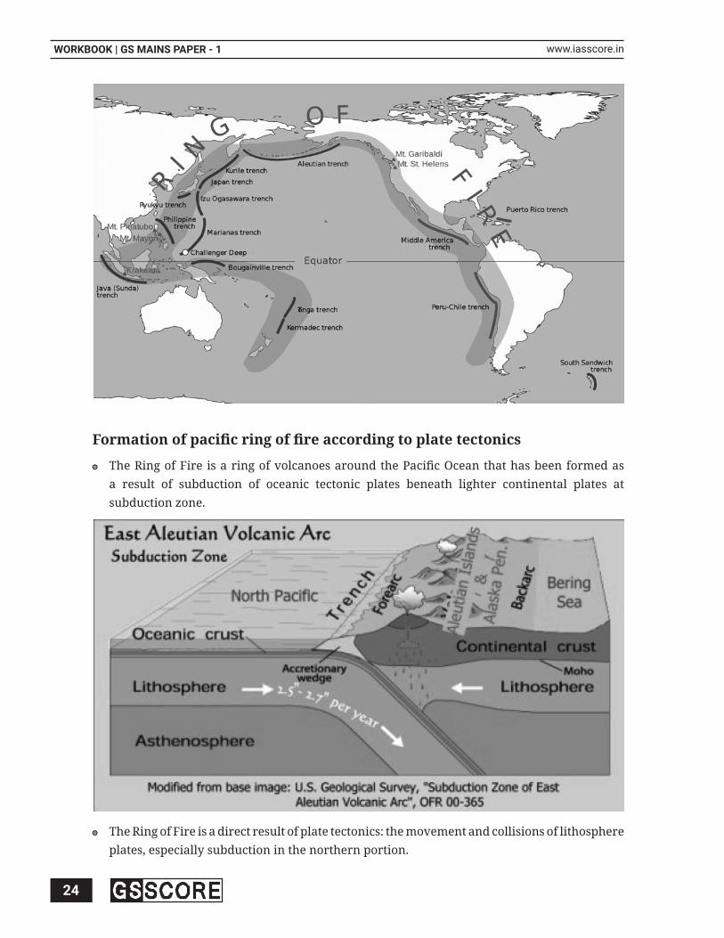
Discuss the various reasons behind the formation of “Fire Girdle of Pacifi c” 7. and major landforms along it.
(250 words)
Approach
Briefl y discuss about ‘Ring of Fire’ and its location, size and1. extent. (50 words)
Discuss the formation of pacifi c ring of fi re according to plate2. tectonics and landforms associated with it. (150 words)
Conclude with signifying importance of the region from3. geography point of view. (50 words)
Hints
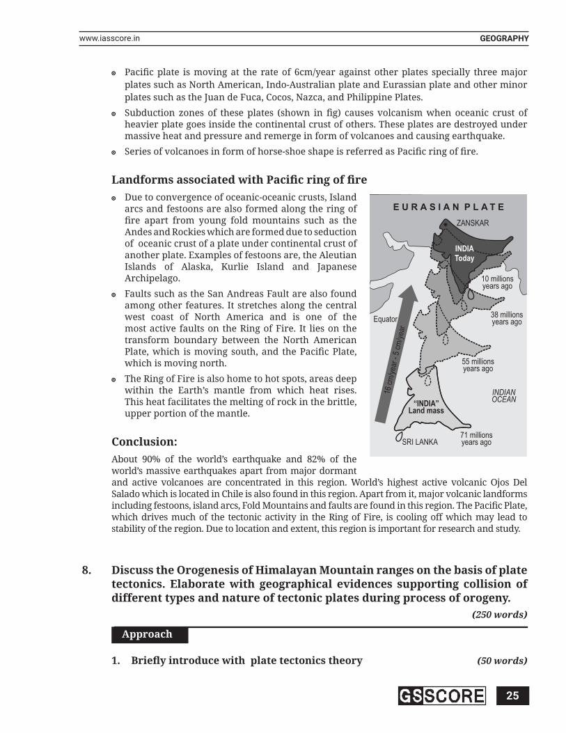
The Ring of Fire is a Pacifi c region home to over 452 volcanoes, including three of the world’s four most active volcanoes i.e. Mount St. Helens in the USA, Mount Fuji in Japan and Mount Pinatubo in the Philippines. It has an extension of 40,000 km and appears as horse-shoe shaped rather than a ring. It is also sometimes called the circum-Pacifi c belt. Pacifi c ring of fi re or the “ Fire Girdle of Pacifi c” is an example of subduction zone volcanism which occurs where two plates are converging on one another. One plate containing oceanic lithosphere descends beneath the adjacent plate, thus consuming the oceanic lithosphere into the earth’s mantle.
24
WORKBOOK | GS MAINS PAPER - 1 www.iasscore.in
Formation of pacifi c ring of fi re according to plate tectonics
The Ring of Fire is a ring of volcanoes around the Pacifi c Ocean that has been formed as a result of subduction of oceanic tectonic plates beneath lighter continental plates at subduction zone.
The Ring of Fire is a direct result of plate tectonics: the movement and collisions of lithosphere plates, especially subduction in the northern portion.
25
GEOGRAPHYwww.iasscore.in
Pacifi c plate is moving at the rate of 6cm/year against other plates specially three major plates such as North American, Indo-Australian plate and Eurassian plate and other minor plates such as the Juan de Fuca, Cocos, Nazca, and Philippine Plates.
Subduction zones of these plates (shown in fi g) causes volcanism when oceanic crust of heavier plate goes inside the continental crust of others. These plates are destroyed under massive heat and pressure and remerge in form of volcanoes and causing earthquake.
Series of volcanoes in form of horse-shoe shape is referred as Pacifi c ring of fi re.
Landforms associated with Pacifi c ring of fi reDue to convergence of oceanic-oceanic crusts, Island arcs and festoons are also formed along the ring of fi re apart from young fold mountains such as the Andes and Rockies which are formed due to seduction of oceanic crust of a plate under continental crust of another plate. Examples of festoons are, the Aleutian Islands of Alaska, Kurlie Island and Japanese Archipelago.
Faults such as the San Andreas Fault are also found among other features. It stretches along the central west coast of North America and is one of the most active faults on the Ring of Fire. It lies on the transform boundary between the North American Plate, which is moving south, and the Pacifi c Plate, which is moving north.
The Ring of Fire is also home to hot spots, areas deep within the Earth’s mantle from which heat rises. This heat facilitates the melting of rock in the brittle, upper portion of the mantle.
Conclusion: About 90% of the world’s earthquake and 82% of the world’s massive earthquakes apart from major dormant and active volcanoes are concentrated in this region. World’s highest active volcanic Ojos Del Salado which is located in Chile is also found in this region. Apart from it, major volcanic landforms including festoons, island arcs, Fold Mountains and faults are found in this region. The Pacifi c Plate, which drives much of the tectonic activity in the Ring of Fire, is cooling off which may lead to stability of the region. Due to location and extent, this region is important for research and study.
Discuss the Orogenesis of Himalayan Mountain ranges on the basis of plate 8. tectonics. Elaborate with geographical evidences supporting collision of different types and nature of tectonic plates during process of orogeny.
(250 words)
Approach
Briefl y introduce with plate tectonics theory 1. (50 words)
E U R A S I A N P L A T E
ZANSKAR
71 millionsyears agoSRI LANKA
16 c
m/y
ear
-5
cm/y
ear
Equator
10 millionsyears ago
38 millionsyears ago
55 millionsyears ago
INDIANOCEAN
INDIAToday
“INDIA”Land mass

26
WORKBOOK | GS MAINS PAPER - 1 www.iasscore.in
Formation of Himalayas by the process of plate tectonics 2. (90 words)
Evidences that support the formation of Himalayas as explained3. by plate tectonics (70 words)
Conclusion 4. (40 words)
Hints
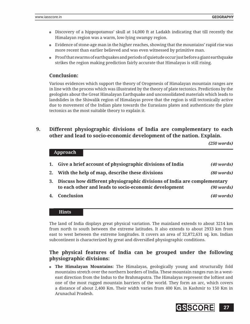
Plate tectonics has emerged as the most acceptable theory in modern time regarding formation of continents and oceans, Orogenesis, epeirogenesis and different other landforms. Himalayan mountains are young fold mountains and said to be still in the process of formation has been well defi ned by the theory of plate tectonics.
Formation of Himalayas by the process of plate tectonics100 million years ago, Indian plate collided with the Eurasian plate. Before collision there was a swampy sea between the two plates called the Tethys Sea.
First stage: Collision Oceanic-Oceanic crusts and formation of festoons or Island arcs
The oceanic crust of the Indian plate collided with the oceanic crust of the Eurassian plate and later being heavier subducted. This resulted in formation of island arc of explosive volcanic which developed in the Tethys Sea. Later they formed part of Ladakh and Tibet.
Second stage: Collision Oceanic-Continent crusts and formation of young fold mountains on margin of contienents
Indian plate continued its march towards Eurasian plate which led to subduction of its oceanic crust into the Eurasian continental crust. This led to formation of young fold mountain on the margin of the Eurasian land mass in the form of Karakoram Range.
Third Stage: Collision of continent-continent crusts and formation of Himalayas
Continent-Continent crusts of the Eurasians and Indian plate collided which resulted in folding of sediments of Tethy’s sea. Due to folding activity, young fold mountain, the Himalayas started to rise up. There are various evidences which support this theory.
Evidences that support the formation of Himalayas as explained by plate tectonics
Evidences of Island arcs in Drass sector of Himalayas.
Evidences support that Karakorum ranges are of volcanic origin.
Karewas in Kashmir valley prove that the valley was essentially a lake in the Pleistocene Epoch.
27
GEOGRAPHYwww.iasscore.in
Discovery of a hippopotamus’ skull at 14,000 ft at Ladakh indicating that till recently the Himalayan region was a warm, low-lying swampy region.
Evidence of stone-age man in the higher reaches, showing that the mountains’ rapid rise was more recent than earlier believed and was even witnessed by primitive man.
Proof that swarms of earthquakes and periods of quietude occur just before a giant earthquake strikes the region making prediction fairly accurate that Himalayas is still rising.
Conclusion:Various evidences which support the theory of Orogenesis of Himalayan mountain ranges are in line with the process which was illustrated by the theory of plate tectonics. Predictions by the geologists about the Great Himalayan Earthquake and unconsolidated materials which leads to landslides in the Shiwalik region of Himalayas prove that the region is still tectonically active due to movement of the Indian plate towards the Eurasians plates and authenticate the plate tectonics as the most suitable theory to explain it.
Different physiographic divisions of India are complementary to each 9. other and lead to socio-economic development of the nation. Explain.
(250 words)
Approach
Give a brief account of physiographic divisions of India 1. (40 words)
With the help of map, describe these divisions 2. (80 words)
Discuss how different physiographic divisions of India are complementary 3. to each other and leads to socio-economic development (90 words)
Conclusion 4. (40 words)
Hints
The land of India displays great physical variation. The mainland extends to about 3214 km from north to south between the extreme latitudes. It also extends to about 2933 km from east to west between the extreme longitudes. It covers an area of 32,872,631 sq. km. Indian subcontinent is characterized by great and diversifi ed physiographic conditions.
The physical features of India can be grouped under the following physiographic divisions:
The Himalayan Mountains: The Himalayas, geologically young and structurally fold mountains stretch over the northern borders of India. These mountain ranges run in a west-east direction from the Indus to the Brahmaputra. The Himalayas represent the loftiest and one of the most rugged mountain barriers of the world. They form an arc, which covers a distance of about 2,400 Km. Their width varies from 400 Km. in Kashmir to 150 Km in Arunachal Pradesh.

28
WORKBOOK | GS MAINS PAPER - 1 www.iasscore.in
The Northern Plains: The northern plain has been formed by the interplay of the three major river systems, namely — the Indus, the Ganga and the Brahmaputra along with their tributaries. This plain is formed of alluvial soil. The deposition of alluvium in a vast basin lying at the foothills of the Himalaya over millions of years, formed this fertile plain. It spreads over an area of 7 lakh sq. km. The plain being about 2400 km long and 240 to 320 km broad, is a densely populated physiographic division.
The Peninsular Plateau: The Peninsular plateau is a tableland composed of the old crystalline, igneous and metamorphic rocks. It was formed due to the breaking and drifting

29
GEOGRAPHYwww.iasscore.in
of the Gondwana land and thus, making it a part of the oldest landmass. The plateau has broad and shallow valleys and rounded hills. This plateau consists of two broad divisions, namely, the Central Highlands and the Deccan Plateau.
The Indian Desert: The Indian desert lies towards the western margins of the Aravali Hills. It is an undulating sandy plain covered with sand dunes. This region receives very low rainfall below 150 mm per year. It has arid climate with low vegetation cover.
The Coastal Plains: The Peninsular plateau is fl anked by stretch of narrow coastal strips, running along the Arabian Sea on the west and the Bay of Bengal on the east. The western coast, sandwiched between the Western Ghats and the Arabian Sea, is a narrow plain. It consists of three sections. The northern part of the coast is called the Konkan (Mumbai – Goa), the central stretch is called the Kannad Plain, while the southern stretch is referred to as the Malabar coast.
The Islands: India has two main groups of Islands. There are 204 islands in Bay of Bengal called as Andaman and Nicobar islands and 43 islands in Arabian Sea called as Lakshadweep islands The Andaman & Nicobar island extend from north to south in Bay of Bengal
Complementarities and socio-economic utility of physiographic divisions of India
It can be stated that physical features complement each other and make the country richer in its natural resources, thus helping the country develop.
The northern mountains are the major sources of water and forest wealth. The northern plains are the granaries of the country. They provide the base for early civilizations.
The plateau is a storehouse of minerals, which has played a crucial role in the industrialization of the country.
The coastal region and island groups provide sites for fi shing and port activities.
The rivers originate in the high mountains and plateaus and drain the plains to make them inhabitable and agriculturally suitable.
The plateaus provide the necessary minerals to assist the development of industries.
Himalayas prevent the cold waves from north (Tibetan Pleateau), in absence of which; Gangetic-plains would have been absent. Similarly these would have destroyed the low-pressure system, which pulls the monsoon winds from the ocean.
Conclusion:India has practically all major physical features of the earth, i.e., mountains, plains, deserts, plateaus and islands. The land of India displays great physical variation. Thus, the diverse physical features of the land have immense future possibilities of development.
Discuss the formation of intermontane plateaus and tectonic plateaus citing 10. examples.
(250 words)
Approach
Briefl y discuss location and examples of intermontane and tectonic 1. plateaus. (30 words)

30
WORKBOOK | GS MAINS PAPER - 1 www.iasscore.in
Discuss the formation of intermontane plateaus and tectonic plateaus2. with examples around the world. (90 words)
Conclude with socio-economic importance of intermontane and3. tectonic plateaus. (30 words)
Hints
A plateau which is enclosed or surrounded by mountain ranges is known as an intermontane plateau. They borders the mountain ranges (generally fold mountains) or are partly or fully enclosed within them. The Plateau of Tibet and the Plateau of Mongolia are the two intermontane plateaus in Asia. The Plateau of Tibet is surrounded by the Kunlun Mountains in the north and the Himalayas in the south. The Plateau of Mongolia is enclosed between a number of mountains like the Sayan Mountains, Hentiyn Mountains and the Nan mountains. Similarly, Tectonic plateaus are formed from various processes that create mountain ranges such as by volcanism (Deccan Plateau), crustal shortening (thrusting of one block of crust over another, and folding occurs.
Mountain Range
Intermontane Plateau
Mountain Range
Formation of intermontane plateausMany plateaus are located in or near mountain ranges, where tectonic uplift raised broad areas of fl at land as a single unit. As a group, they are called intermontane plateaus. The largest plateaus on Earth formed where two tectonic plates collided.
They are formed by folding and uplifting of fl at land between the two mountains.
Because they are lifted far above sea level, they are known as high altitude plateaus. The largest and highest is the Tibetan Plateau in South-Central Asia, which is a fl at valley fl oor at about 15,000 feet above sea level, rimmed on the south by the Himalayas.

31
GEOGRAPHYwww.iasscore.in
The Altiplano, which literally means ‘high plain,’ is located in the Andes in western South America. It is the second largest high altitude plateau in the world, and it lies at an elevation above 12,000 feet.
Formation of Tectonic plateausTectonic plateaus are formed from various processes that create mountain ranges such as volcanism, crustal shortening i.e thrusting of one block of crust over another, folding and thermal expansion.
It is formed by numerous small volcanic eruptions that slowly build up over time, forming a plateau from the resulting lava fl ows.
Magma that escapes from the Earth’s crust through fi ssures or narrow cracks reaches the surface and spreads over a large area, and later solidifi es to form a plateau. These types of plateaus are typically made up of layers of lava sheets. There are two types of volcanic plateaus: lava plateaus and pyroclastic plateaus.
Lava plateaus are formed as a result of highly fl uid basaltic lava that fl ows through vents after numerous eruptions and are formed when volcanic eruptions are quiet eruption and lava fl ow is of low viscosity. Columbian snake plateau in United States is fi ne example of such plateau.
Pyroclastic plateaus which are also known as ignimbrite plateaus, are formed due to large pyroclastic fl owsand are essentially layers of pyroclastic, such as volcanic ash, tephra, and agglomerate that have been cemented into felsic, mafi c, or tuffs. North Island Volcanic Plateau in New Zealand is fi ne example of this plateau.
Conclusion:Intermontane plateaus are highest plateaus in the world. These plateaus provide habitats at high altitude and are center of transhumance i.e seasonal migration of people in search of food and pastures, due to their rich pastoral grounds. Tibetan people for example practices transhumance for their livelihood. Similarly, tectonic plateaus are rich in black soil and other minerals which make them productive regions of the world. These regions produce crops such as cotton and sugarcane. Hence, location and formation of plateaus signifi cantly help a region to prosper in a better way.
**********

32
WORKBOOK | GS MAINS PAPER - 1 www.iasscore.in
NOTES
Related Documents


![UPSC MAINS 2016 - IAS Score...once been formal jobs become increasingly informalized over time. UPSC GS MAINS PAPER - 3 HINTS G S S C O R E [2] Hints: UPSC Mains Paper - 3 2. Women](https://static.cupdf.com/doc/110x72/5ecaa0d03d077d7ca90ecd6d/upsc-mains-2016-ias-score-once-been-formal-jobs-become-increasingly-informalized.jpg)


![[BigB] UPSC GS-2](https://static.cupdf.com/doc/110x72/577cc54c1a28aba7119bf4a6/bigb-upsc-gs-2.jpg)