
Welcome message from author
This document is posted to help you gain knowledge. Please leave a comment to let me know what you think about it! Share it to your friends and learn new things together.
Transcript
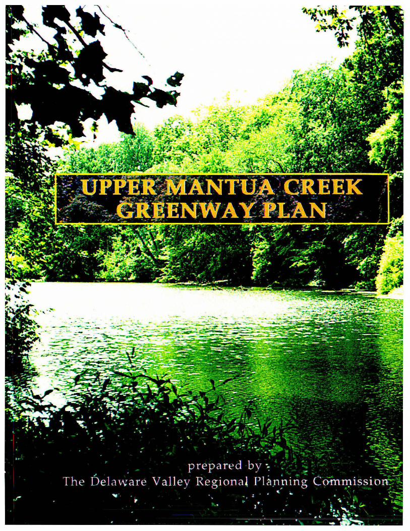

UPPER MANTUA CREEK
GREENWAY PLAN
Prepared by:
Delaware Valley Regional Planning Commission
April 1998

The preparation of this report was funded through federal grants from the U. S. Department of Transportation's Federal Highway Administration (FHW A) and Federal Transit Administration (FTA), the Pennsylvania and New Jersey Departments of Transportation as well as by DVRPC's state and local member governments. The authors, however, are solely responsible for its fmdings and conclusions, which may not represent the official views or policies of the funding agencies.
Created in 1965, the Delaware Valley Regional Planning Commission (DVRPC) is an interstate, intercounty and intercity agency which provides continuing, comprehensive and coordinated planning for the orderly growth and development of the Delaware Valley region. The region includes Bucks, Chester, Delaware, and Montgomery counties as well as the City of Philadelphia in Pennsylvania and Burlington, Camden, Gloucester, and Mercer counties in New Jersey. The Commission is an advisory agency which divides its planning and service functions between the Office of the Executive Director, the Office of Public Affairs, and three line Divisions: Transportation Planning, Regional Planning, and Administration. DVRPC's mission for the 1990s is to emphasize technical assistance and services and to conduct high priority studies for member state and local governments, while determining and meeting the needs of the private sector.
The DVRPC logo is adapted from the official seal of the Commission and is designed as a stylized image of the Delaware Valley. The outer ring symbolizes the region as a whole while the diagonal bar signifies the Delaware River flowing through it. The two adjoining crescents represent the Commonwealth of Pennsylvania and the State of New Jersey. The logo combines these elements to depict the areas served by DVRPC.
DELAWARE V ALLEY REGIONAL PLANNING COMMISSION
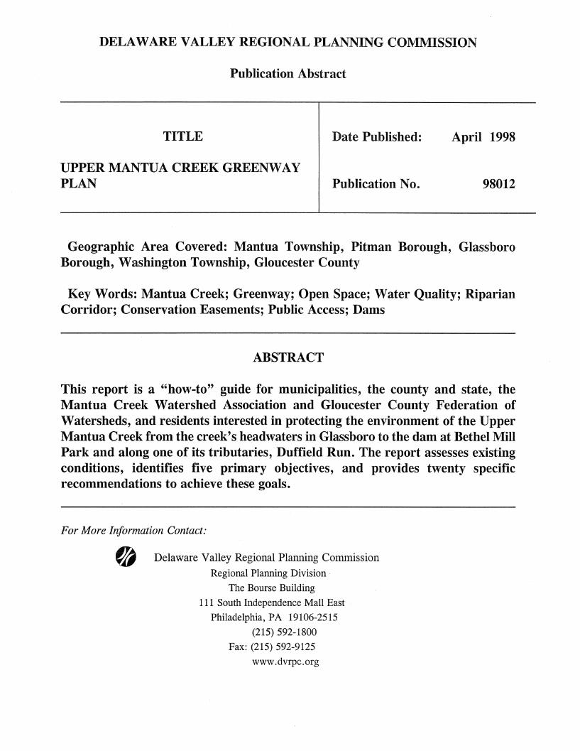
Publication Abstract
TITLE
UPPER MANTUA CREEK GREENWAY PLAN
Date Published:
Publication No.
April 1998
98012
Geographic Area Covered: Mantua Township, Pitman Borough, Glassboro Borough, Washington Township, Gloucester County
Key Words: Mantua Creek; Greenway; Open Space; Water Quality; Riparian Corridor; Conservation Easements; Public Access; Dams
ABSTRACT
This report is a "how-to" guide for municipalities, the county and state, the Mantua Creek Watershed Association and Gloucester County Federation of Watersheds, and residents interested in protecting the environment of the Upper Mantua Creek from the creek's headwaters in Glassboro to the dam at Bethel Mill Park and along one of its tributaries, Duffield Run. The report assesses existing conditions, identifies five primary objectives, and provides twenty specific recommendations to achieve these goals.
For More Information Contact:
fA Delaware Valley Regional Planning Commission Regional Planning Division
The Bourse Building
111 South Independence Mall East
Philadelphia, PA 19106-2515
(215) 592-1800
Fax: (215) 592-9125
www.dvrpc.org

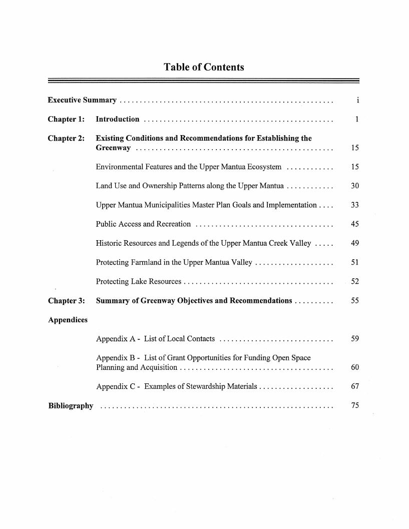
Table of Contents
Executive Summary . . . . . . . . . . . . . . . . . . . . . . . . . . . . . . . . . . . . . . . . . . . . . . . . . . . . . . 1
Chapter 1: Introduction. . . . . . . . . . . . . . . . . . . . . . . . . . . . . . . . . . . . . . . . . . . . . . . . 1
Chapter 2: Existing Conditions and Recommendations for Establishing the Greenway... .. . . .... . . ....... ..... .... ............ . .... . ... 15
Environmental Features and the Upper Mantua Ecosystem ............ 15
Land Use and Ownership Patterns along the Upper Mantua. . . . . . . . . . . . 30
Upper Mantua Municipalities Master Plan Goals and Implementation. . . . 33
Public Access and Recreation ................................... 45
Historic Resources and Legends of the Upper Mantua Creek Valley. . . . . 49
Protecting Farmland in the Upper Mantua Valley. . . . . . . . . . . . . . . . . . . . 51
Protecting Lake Resources. . . . . . . . . . . . . . . . . . . . . . . . . . . . . . . . . . . . . . 52
Chapter 3: Summary of Greenway Objectives and Recommendations. . . . . . . . . . 55
Appendices
Appendix A - List of Local Contacts ............................. 59
Appendix B - List of Grant Opportunities for Funding Open Space Planning and Acquisition . . . . . . . . . . . . . . . . . . . . . . . . . . . . . . . . . . . . . . . 60
Appendix C - Examples of Stewardship Materials. . . . . . . . . . . . . . . . . . . 67
Bibliography ........................................................... 75

List of Maps
Year 2020 Open Space Network for the Delaware Valley Region .................. 3
Gloucester County Open Space Values Map .................................... 7
Gloucester County Recreational Needs Map .................................... 9
Gloucester County Farmland Preservation Priorities Map ......................... 11
Mantua Creek Greenway Map 1 - Natural Resources ............................. 21
Mantua Creek Greenway Map 2 - Land Use .................................... 31
Mantua Creek Greenway Map 3 - Type of Ownership ............................ 35
Mantua Creek Greenway Map 4 - Type of Zoning ............................... 43
Mantua Creek Greenway Map 5 - Type of Open Space ........................... 47
List of Planning Tools
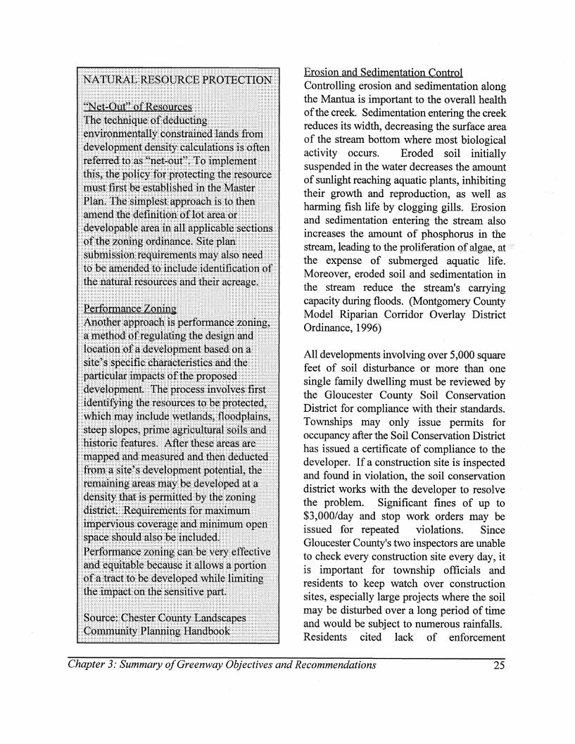
Natural Resource Protection ................................................ 25
Best Management Practices to Effectively Control Stormwater Runoff Quality and Quantity . . . . . . . . . . . . . . . . . . . . . . . . . . . . . . . . . . . . . . . . . . . . . . . . . . . . . . . . . . . 27
Official Greenway Map . . . . . .. . . . . . . . . . . . . . . . . . . . . . . . . . . . . . . . . . . . . . . . . . . . . . 34
Conservation Design for New Subdivisions .................................... 39
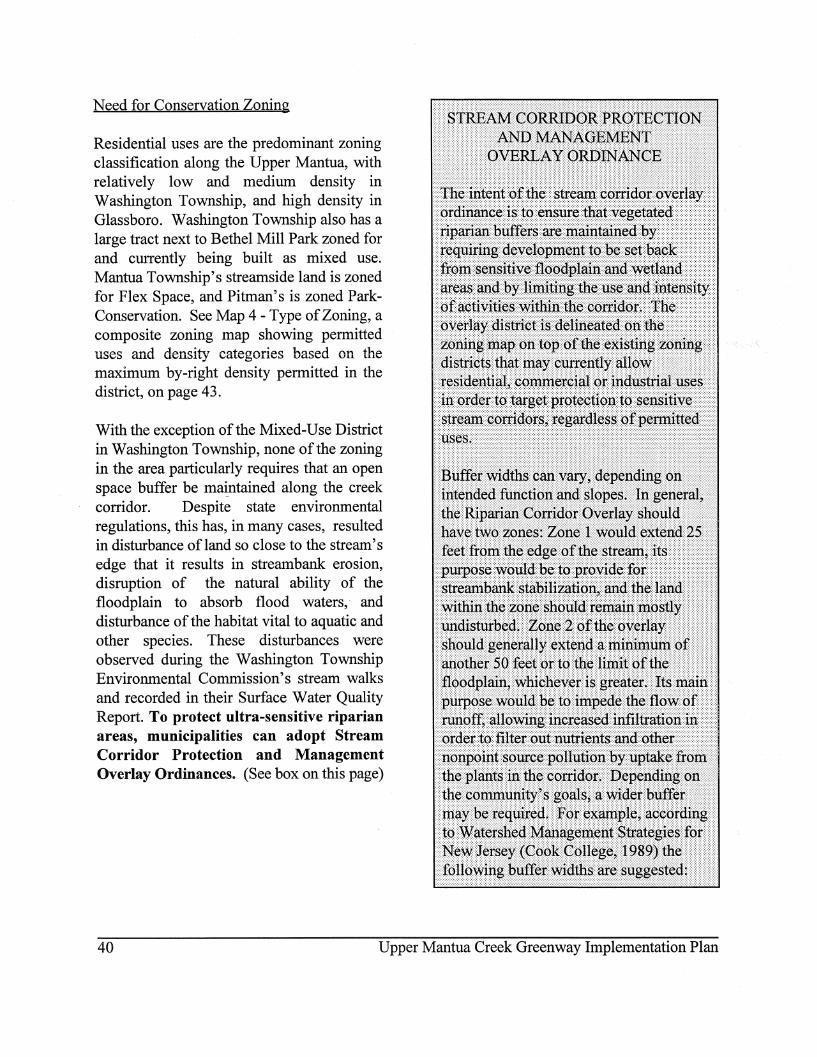
Stream Corridor Protection and Management Overlay Ordinance ................... 40
Conservation Easements ................................................... 42


Acknowledgements
The Upper Mantua Creek Greenway Plan brings together an array of information on the environmental, recreational and quality of life issues facing the creek. The compilation of resource material would not have been possible without the help of numerous individuals, organizations and agencies. Special appreciation is extended to:
The Gloucester County Federation of Watersheds for helping organize the public forums, and to their President, Suzanne McCarthy, for her insightful direction throughout the greenway planning process;
The Washington Township Environmental Commission for their valuable work assessing conditions along the Mantua Creek, and to its Chair, Bill Coughlin, for providing these materials, playing escort on numerous treks along the creek, and encouraging creekside residents to attend the greenway public meetings;
The Mantua Creek Watershed Association (MCWA) for forming and taking on the responsibility of overseeing implementation of the plan's recommendations, and to its President, Paul Greger, for taking the initiative to organize the association, and for also playing escort for treks along the creek and giving direction to the planning process;
The Gloucester County Planning Department for providing technical assistance to the plan and especially to Janet Eisenhauer, for her unending support and ability to always fmd answers to any question;
To all the residents who offered their input regarding problems and solutions for protecting the Upper Mantua Creek environs.

Executive Summary
The Upper Mantua Creek Greenway Implementation Plan has been developed as a "how-to" guide for municipalities, the county and state, the Mantua Creek Watershed Association and Gloucester County Federation of Watersheds, and residents interested in protecting the creek environment and people's enjoyment of it. The greenway plan extends from the creek's headwaters in Glassboro Borough to the dam at Bethel Mill Park, and along one of its tributaries, Duffield Run in Washington Township. This area was chosen for study because it is known as a healthy stream corridor supporting swimming, fishing, boating and habitat for numerous species, including some which are endangered, but it is also under development pressures threatening these uses.
Through research, analysis and public outreach, five main greenway objectives have come forth. The plan provides the background for these objectives, and proposes recommended actions that, if implemented, will serve to achieve them:·
Objective #1: Preserve a natural vegetative buffer along the Mantua Creek and Duffield Run
Major Recommended Actions 1. Pitman Borough, Washington Township and Mantua Township should amend their Floodplain Ordinances to prohibit any structural development or impervious surfaces in the 100 year floodplain.
2. Municipalities should adopt Stream Corridor Conservation Ordinances that ensure that vegetated riparian buffers, generally extending a minimum of 75 feet from the edge of a stream, are maintained in their natural state.
3. Municipalities should adopt Official Greenway Maps which designate stream corridor areas to be protected.
4. Developers and landowners should offer Conservation Easements on environmentally sensitive lands.
Objective #2: Manage stormwater on a watershed basis to more effectively control runoff quantity and quality
Major Recommended Action 1. Pending the outcome of the Watershed Study for the Lower Delaware Tributaries, which includes the Mantua Creek, NJDEP, the Delaware River Basin Commission and Gloucester County should work with municipalities to develop a Mantua Creek Watershed Stormwater Management Plan. Following the plan, municipalities should adopt stormwater management ordinances incorporating Best Management Practices.
Objective #3: Educate and involve the public on water quality issues, the importance of stream buffers and good land stewardship
i
Major Recommended Action 1. The newly formed Mantua Creek Watershed Association should actively advocate for municipalities to implement recommendations from the greenway plan, as well as to organize stream clean-ups, spearhead storm-drain stencil programs, encourage school districts to incorporate environmental education into their curriculum, develop and distribute good stewardship educational materials and otherwise address issues facing the creek.
Objective #4: Provide sufficient public access, recreational and educational opportunities along the Mantua so as to instill appreciation for the creek and to discourage trespass on private property
Major Recommended Action 1. The Mantua Creek Watershed Association, municipalities and the Gloucester County Planning Department, Parks and Recreation Department and Utility Authority should facilitate the development of trail linkages between Bethel Mill Park, Park Place, extant trails in Pitman, Washington Lake Park, extant trails in Washington Township, and the county proposed Rail-to-Trail project running parallel to Route 322, as described in the plan.
Objective #5: Protect farmland, historic resources, lakes and other scenic areas to preserve the area's heritage and to boost community pride
Major Recommended Actions 1. Historical Societies, environmental commissions, and economic development agencies should work together to develop a heritage tour to familiarize people with local
11
historic resources, places with interesting vernacular architecture, and local lore.
2. Residents enjoying lakeside frontage should form and contribute to a Lake Association charged with regularly addressing lake related issues, including the need to fund dam restorations.
It is hoped that the greenway planning process, which involved numerous meetings with the public and conversations with public officials' and residents, as well as the plan itself, will not only raise awareness and concern for the environmental, recreational and quality of life issues facing the Upper Mantua, but will also encourage residents, associations and local officials to seek creative and cooperative solutions to creek related issues, as they arise.
Cha pte r 1INTRODUC TI ON

Chapter 1 INTRODUCTION
Background
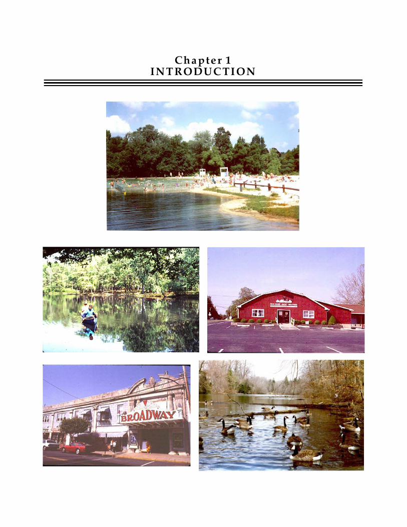
Imagine an area that could be called "Land of Lakes", where many people can walk out their back doors to swim, fish, boat and birdwatch. Imagine that living in the area is open to all income levels through a true mix of housing types, and that it also offers diverse shopping options - in an oldfashioned small town, a fanners market selling locally grown goods, and in new strip commercial centers. Imagine employment opportunities ranging from the local to the regional, with Center City Philadelphia and Cherry Hill each only a 30 minute drive away. You need not leave such a desirable place to the imagination - a land of lakes exists in the Upper Mantua Creek Valley of Gloucester County.
The Upper Mantua Creek Valley covers portions of Mantua Township, Pitman Borough, Glassboro Borough and Washington Township. There are at least nine named lakes in the valley, connected by the Mantua Creek and its tributaries. Much, but not all of the land in the Upper Mantua Valley has been subdivided for residential or other uses in recent decades. Remaining land is under pressure for development. Recognizing the impact of surrounding development on the Upper Mantua Creek environment, the intent of this plan is to identify measures that will serve to protect the resources that have made the Mantua Creek Valley so attractive and appealing in the first place. If implemented, the efforts of this planning process will result . in a greenway that protects the natural
Chapter 1,' Introduction
environment, scenic vistas and recreational opportunities along the Upper Mantua Creek for generations to come.
Why a Greenway
But why a greenway along the Mantua? A greenway is like a ribbon of open space· linking '" natural, cultural, and recreational resources together. Due to its linear nature, a greenway corridor passes through a variety of communities, connecting people to open space. It is the perfect response to preserve what is special about the Mantua. A greenway established along the Mantua can provide many benefits. It can preserve the environmental features in the area, and thereby provide natural protection from flooding, improve water quality and provide a hospitable corridor for wildlife migration. It can offer scenic relief from the urban landscape, preserve the integrity of historic sites and nostalgic places, and enhance people's enjoyment of the creek. As the common thread tying municipalities together, it can also improve intermunicipal communication and cooperation. In addition to these benefits, a greenway can raise individual property values as well.
Although it may sound like a tall order, a greenway implemented with community support really can provide all the benefits mentioned above. Realization of some of the benefits may be subtle, such as improved water quality over time. Other benefits are intrinsic, such as the protection of certain rare or endangered species. Still others may be
1
taken for granted, such as a lack of flooding. Yet all these benefits can be generated from implementing the primary intent of the greenway; to create and maintain a clean, green open space buffer along both sides of the Upper Mantua Creek. .
Upper Mantua Creek Study Area Defined
The Upper Mantua Creek study area extends from the creek's headwaters in Glassboro Borough to the dam at Bethel Mill Park, and along one of its tributaries, Duffield Run in Washington Township. This area was chosen for study because it has good water quality but is also under development pressure. In addition, at the time the study was initiated, there was no organized group actively working to protect the Mantua Creek.
One of the particular objectives of the greenway planning effort was to raise residents' interest to form a Mantua Creek Watershed Association (MCWA). Such an association did form after the second public meeting and is currently organizing a host of activities including a newsletter and website that will list facts about the Mantua along with a schedule of planned events. Upcoming events include a field trip to learn about landscaping with indigenous plants and springtime canoe trips down the Mantua. Membership in the association is not limited to the greenway area but is drawn from all of the municipalities in the Mantua Creek watershed. As many of the issues and recommendations of the Upper Mantua Greenway Plan are pertinent throughout the watershed, the MCW A can play an important role by spreading this information and advocating for broader implementation of the recommendations, as appropriate.
Study Purpose in Regional Context
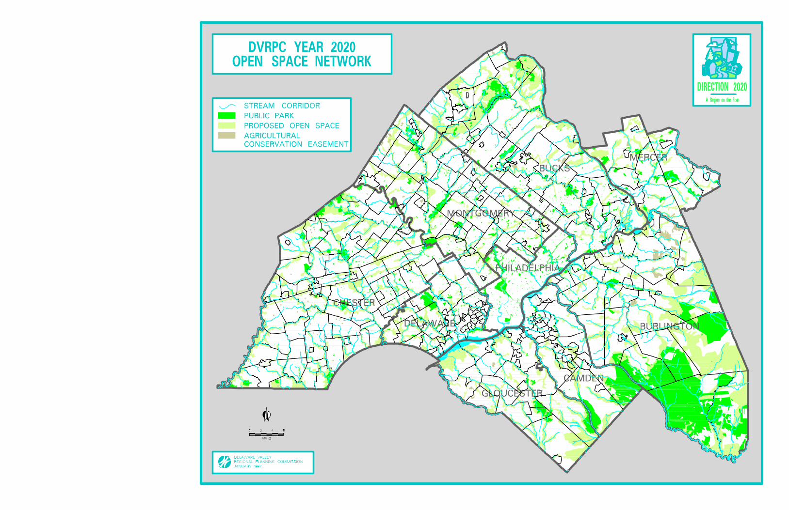
The Upper Mantua Creek Greenway Implementation Plan is a follow-up study to the Open Space Element of DVRPC's Year 2020 Comprehensive Plan, DIRECTION 2020. The open space element within the plan identified areas throughout the region, such as the Mantua Creek and other environmentally sensitive stream corridors, proposed for open space preservation to provide both natural resource protection and recreational opportunities. Although the nine-county region covered in the DVRPC plan contains h.
more than 1.5 million acres of open space, only about 250,000 acres are currently protected as public parks. The year 2020 Proposed Open Space Network (see map on following page) presents a proposed open space network sufficient in area to meet the region's recreational needs through the year 2020 and beyond. It also designates for protection woodlands and upland habitat areas that provide an environment for plants and animals, and the river and stream corridors and wetlands that supply clean water for drinking, habitat for fish, plants and other wildlife. This and other DVRPC greenway implementation plans are intended to be "how-to" guides, containing the necessary data base of information, analysis, community input, recommendations, and responsible parties to translate the broad goal of preservmg open space into concrete implementation strategies.
Relationship to State and County Plans
The intent of the Upper Mantua Creek Implementation Plan is consistent with and supported by the 1997 New Jersey State Development and Redevelopment Plan Reexamination Report and Preliminary Plan
2 Upper Mantua Creek Greenway Implementation Plan

(Reexam Report), the 1994 New Jersey Open Space and Outdoor Recreation Plan, and the 1997 Gloucester County Farmland Preservation, Open Space Protection and Recreational Needs Study.
In the 1997 Reexam Report, proposed planning goals and strategies reflected in the Upper Mantua Greenway Plan include conserving the State's natural resources and preserving and enhancing areas with historic, cultural, scenic, open space and recreational value by using collaborative planning, design, investment and management techniques.
In the 1994 State Open Space and Outdoor Recreation Plan, one of the primary objectives is to preserve sufficient open space for current and future public use and to utilize the environmental protection amenities of open space to protect important natural and historic resources for the maintenance and enhancement of the quality of life in New Jersey. It is also the specific policy of the State of New Jersey to establish a greenway network through cooperative regional initiatives with local governments and nonprofit land trusts and by legislative, planning and financial efforts.
Recent county efforts also support preservation of the Upper Mantua Creek. A Nvember 1993 ballot referendum approved by two-thirds of the voters created a County Open Space and Farmland Preservation Tax to protect open space and farmland and provide for the recreational needs of the county's growing population. The tax of one cent per $100 valuation is placed in a Trust Fund, projected to generate about $1 million per year for land acquisition. State law requires an adopted plan for how the money would be spent before the tax may be
Chapter 1: Introduction
expended. The Gloucester County Freeholders initiated the required planning effort in 1996 with a series of public meetings to elicit broad participation in the process. The filW plan was adopted by the Freeholders in June of 1997, and the procedures for implementing the trust fund were adopted in November 1997.
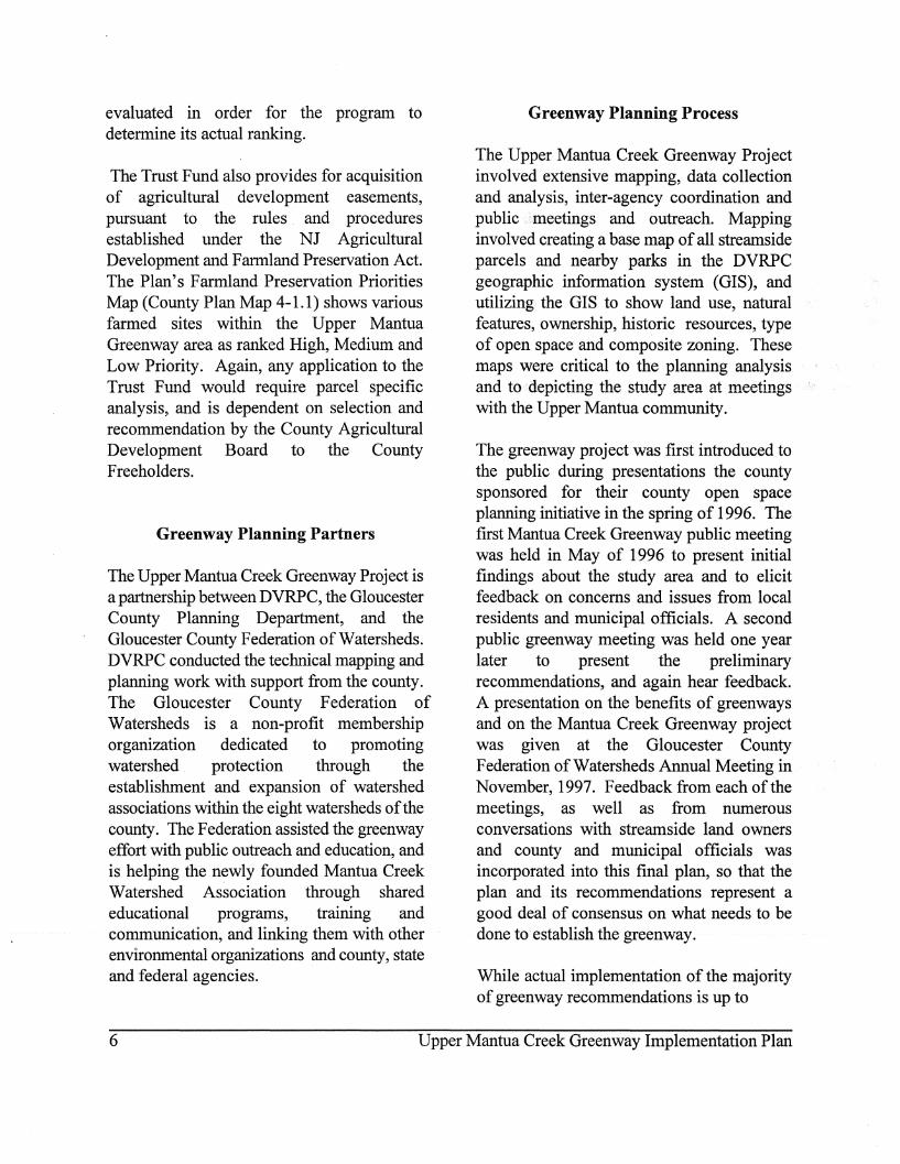
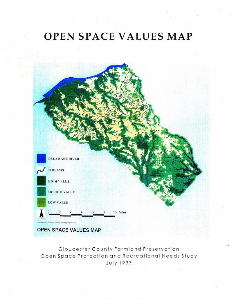
According to the procedures, land acquisition for open space preservation and recreational use will· be considered based on a parcel's combined ranking from three Open Space Ranking,Models and the recommendation of the Open Space Advisory Committee. The Open Space Values Model ranks parcels based on their environmental attributes (wetlands, steep slopes, woodlands, endangered species habitat), and their location with respect to highway access and sewer service. The Recreational Needs Model ranks parcels according to the determined need for community and regional recreation, as per the plan. The third, Special Considerations Model, ranks sites according to whether they provide essential linkages, and considers additional factors such as a parcel's unique features, public access and the availability of special financial opportunities.
Based on the Open Space Values Map in the County Plan (see County Plan Map 5.1-1 on the following page), the Upper Mantua Creek riparian corridor is ranked high and surrounding lands are ranked medium. For recreational needs, Glassboro is ranked High Need, and most of the study area is shown for Recommended Developed Recreation (County Plan Map 6-1.1). However, the maps developed for the County Plan are not parcel specific, so the above ranking models must be applied to each individual parcel being
5
evaluated in order for the program to determine its actual ranking.
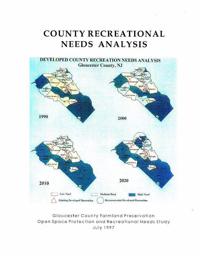
The Trust Fund also provides for acquisition of agricultural development easements, pursuant to the rules. and procedures established under the NJ Agricultural Development and Farmland Preservation Act. The Plan's Farmland Preservation Priorities Map (County Plan Map 4-1.1) shows various farmed sites within the Upper Mantua Greenway area as ranked High, Medium and Low Priority. Again, any application to the Trust Fund would require parcel specific analysis, and is dependent on selection and recommendation by the County Agricultural Development Board to the County Freeholders.
Greenway Planning Partners
The Upper Mantua Creek Greenway Project is a partnership between DVRPC, the Gloucester County Planning Department, and the Gloucester County Federation of Watersheds. DVRPC conducted the technical mapping and planning work with support from the county. The Gloucester County Federation of Watersheds is a non-profit membership organization dedicated to promoting watershed protection through the establishment and expansion of watershed associations within the eight watersheds of the county. The Federation assisted the greenway effort with public outreach and education, and is helping the newly founded Mantua Creek Watershed Association through shared educational programs, training and communication, and linking them with other environmental organizations and county, state and federal agencies.
Greenway Planning Process
The Upper Mantua Creek Greenway Project involved extensive mapping, data collection and analysis, inter-agency coordination and public ;i?meetings and outreach. Mapping involved creating a base map of all streamside parcels and nearby parks in the DVRPC geographic information system (GIS), and utilizing the GIS to show land use, natural features, ownership, historic resources, type of open space and composite zoning. These maps were critical to the planning analysis and to!depicting the study area at meetings with the Upper Mantua community.
The greenway project was first introduced to the public during presentations the county sponsored for their county open space planning initiative in the spring of 1996. The first Mantua Creek Greenway public meeting was held in May of 1996 to present initial findings about the study area and to elicit feedback on concerns and issues from local residents and municipal officials. A second public greenway meeting was held one year later to present the preliminary recommendations, and again hear feedback. A presentation on the benefits of greenways and on the Mantua Creek Greenway project was given at the Gloucester County Federation of Watersheds Annual Meeting in November, 1997. Feedback from each of the meetings, as well as from numerous conversations with streamside land owners and county and municipal officials was incorporated into this final plan, so that the plan and its recommendations represent a good deal of consensus on what needs to be done to establish the greenway.
While actual implementation of the majority of greenway recommendations is up to
6 Upper Mantua Creek Greenway Implementation Plan
OPEN SPACE VALUES MAP
DELA WARE RIYER
HIGH , 'ALUE
i\ I EDI t.: :'I1 V A. L li E
1. 2-?, __ 21""'"'_4 __ ~---':O Miles
OPEN SPACE VALUES MAP
G louces t er Coun ty Farmland Preser v a ti o n
Open Space Protect ion and Recreationa l Needs Stu dy
Jul y 1997


governing bodies and streamside residents, the Mantua Creek Watershed Association will be charged with advocating for action on them. To continue to present these ideas, a companion to the greenway report in the form of a slide show program can be borrowed or presented by the Mantua Creek Watershed Association at future public forums.
Chapter 1: Introduction 13

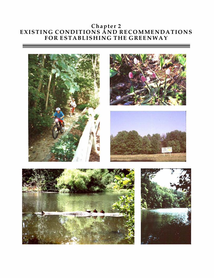
Cha pte r 2EXISTI NG CONDITIONS AND R ECOMMENDATIONS
FOR ESTABLISHING THE GREENWAY

Chapter 2 EXISTING CONDITIONS and RECOMMENDATIONS for
ESTABLISHING the GREENWAY
To examine existing conditions along the Mantua, DVRPC compiled data on land use, ownership, environmental features, historic resources, and zoning for each parcel in the study area. Related data on topics such as water quality, endangered species and recreational facilities was also researched. In addition, federal, state, and local plans and regulations affecting the environment and development along the Mantua were reviewed and assessed. This information, along with issues and concerns elicited at the public meetings, was integrated to determine the best measures for implementing a greenway along the Upper Mantua.
Environmental Features and the Upper Mantua Ecosystem
The stream and its associated floodplains, wetlands, woodlands and wildlife are intricately interconnected within the Mantua ecosystem. Disturbances to any of the ecosystem's components threaten to unbalance the system. The following section assesses the conditions contributing to and dependent on the Mantua ecosystem.
Stream Water Quality
The water quality of a creek such as the Mantua is affected by two forms of pollution, point and nonpoint. Examples of point
sources are sewage treatment plants or industries that discharge directly into a stream. Less obvious are the nonpoint sources, pollution that does not come 'from anyone specific place but enters the stream after flowing over or under land within the watershed. A watershed is all the land that water flows across or under on its way to a particular stream. On its way, water travels over the surface of parking lots, streets, suburban lawns and farm fields, or it seeps into the soil and travels as ground water. Either way, water picks up pollutants such as sediments from construction projects, toxins from pesticides, and pathogens from human or animal fecal matter, and delivers them to the stream. The entire Mantua Creek watershed is 50 square miles, covering portions of 10 municipalities. The Mantua drains into the Delaware River at Paulsboro.
The Mantua Creek's water quality is regarded by the New Jersey Department of Environmental Protection as threatened, as are all waterways in the state, due to the level of development, the population density, the economic pressures for development, the intensity of land use and the ubiquitous nature of non-point source pollution. The most common water quality problems affecting most of the state's streams are total and fecal coliform bacteria, nutrients, depressed dissolved' oxygen levels, pH fluctuations, siltation, road salts, and oil and grease. Nonpoint sources of pollution are a major factor in the degradation of the state's creeks.
Chapter 3: Summary of Greenway Objectives and Recommendations 15
Nonpoint sources include stormwater outfalls, construction, and urban and agricultural runoff. (NJ Water Quality Inventory Report, 1992 and 1994)
The New Jersey Department of Environmental Protection governs the protection and enhancement of the state's water resources through the rules and regulations promulgated in the Surface Water Quality Standards (N.J. A.C. 7:9B) as amended, April 1994. The Standards classify streams by their level of degradation, salinity, and their use, and establish procedures for limiting effluent discharges by stream classification. The entire Mantua Creek is classified by the state as FW2-NT/SE2, meaning freshwater class 2 -non-trout/saline estuary water class 2. Designated uses of FW2 classified waters include 1) maintenance, migration and propagation of the natural and established biota; 2) primary and secondary contact recreation; 3) industrial and agricultural water supply; 4) public potable water supply after such treatment as required by law or regulations; and 5) any other reasonable use. Designated uses for SE2 classified waters are: 1) maintenance, migration and propagation of the natural and established biota; 2) migration of diadromous fish; 3) maintenance of wildlife; 4) secondary contact recreation; and 5) any other reasonable uses.
The New Jersey Department of Environmental Protection monitors and assesses water quality for aquatic life use support and for primary contact use support (swimming) in many but not all of the state's streams. Watershed profiles and water quality assessments are described in the State Water Quality Inventory Reports, published about every two years. The Mantua Creek was not profiled in the 1992 or 1994 Reports, and the
1996 report was not available as of January, 1998. However, water quality monitoring data for the study area was retrieved from the NJDEP's Storet files, which archive agency collecte,d data. According to the Storet files, water quality has been monitored for various parameters along the Upper Mantua at Pitman between 1957 and 1982, and at the dam at Bethel Mill Lake during 1979 and 1980. However, the parameters sampled and the dates sampling took place were inconsistent over the time period, rendering uniform comparisons at regular intervals impossible. Given this inconsistency, the following data was extracted to give a picture of water quality over a 24 year time period:
Mantua Creek at Pitman Parameter 10/57 10/75 10L81 pH 6.8 6.7 7.3 Conductivity 79 121 120 Chloride mg/l 8 8 9 DO 9.5 10 Fecal Colif 240 13
Dam at Bethel Mill Lake 10/79
pH 8.1 DO 8.3 Fecal Colif . 270
More recently, water quality along the Mantua has been monitored on a fairly regular basis by the Washington Township Environmental Commission. The following table shows selected results, from March and June 1994, and April 1996 and 1997 sampling events. Parameters that were monitored at most sampling events and that are most indicative of the health of creek were included in these tables:
16 Upper Mantua Creek Greenway Implementation Plan
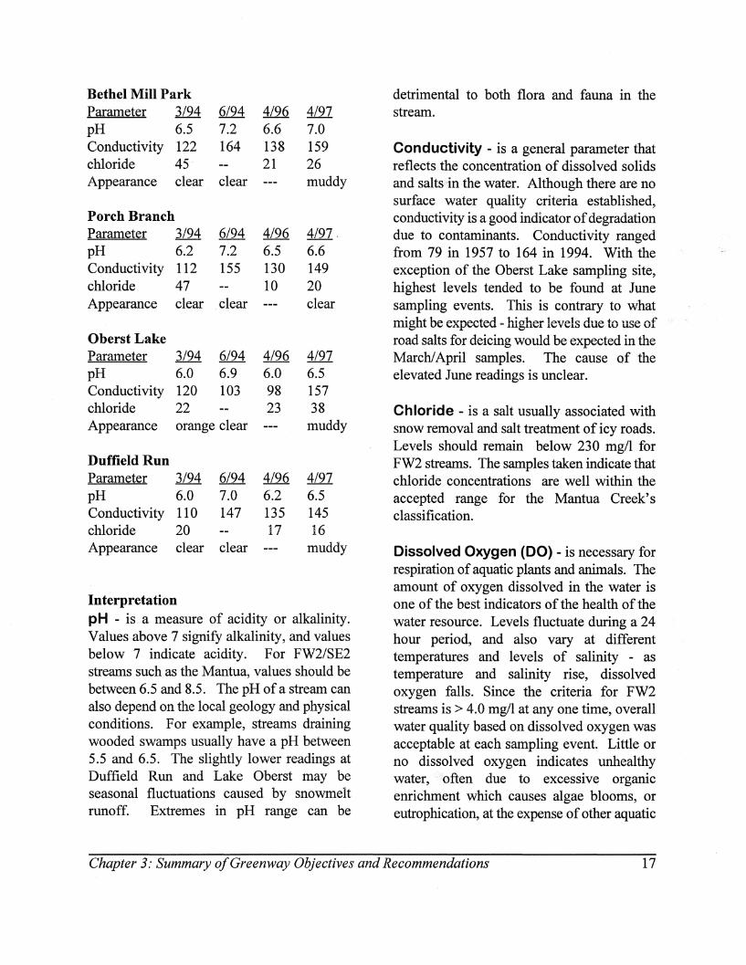
Bethel Mill Park Parameter 3/94 6/94 4/96 4/97 pH 6.5 7.2 6.6 7.0 Conductivity 122 164 138 159 chloride 45 21 26 Appearance clear clear muddy
Porch Branch Parameter 3/94 6/94 4/96 4/97, pH 6.2 7.2 6.5 6.6 Conductivity 112 155 130 149 chloride 47 10 20 Appearance clear clear clear
Oberst Lake Parameter 3/94 6/94 4/96 4/97 pH 6.0 6.9 6.0 6.5 Conductivity 120 103 98 157 chloride 22 23 38 Appearance orange clear muddy
Duffield Run Parameter 3/94 6/94 4/96 4/97 pH 6.0 7.0 6.2 6.5 Conductivity 110 147 135 145 chloride 20 17 16 Appearance clear clear muddy
Interpretation pH - is a measure of acidity or alkalinity. Values above 7 signify alkalinity, and values below 7 indicate acidity. For FW2/SE2 streams such as the Mantua, values should be between 6.5 and 8.5. The pH ofa stream can also depend on the local geology and physical conditions. For example, streams draining wooded swamps usually have a pH between 5.5 and 6.5. The slightly lower readings at Duffield Run and Lake Oberst may be seasonal fluctuations caused by snowmelt runoff. Extremes in pH range can be
detrimental to both flora and fauna in the stream.
Conductivity - is a general parameter that reflects .the concentration of dissolved solids and salts"in the water. Although there are no surface . water quality criteria established, conductivity is a good indicator of degradation due to contaminants. Conductivity ranged from 79 in 1957 to 164 in 1994. With the exception of the Oberst Lake sampling site, highest levels tended to be found at June sampling events. This is contrary to what might be expected - higher levels due to use of road salts for deicing would be expected in the Marchi April samples. The cause of the elevated June readings is unclear.
Chloride - is a salt usually associated with snow removal and salt treatment of icy roads. Levels should remain below 230 mg/l for FW2 streams. The samples taken indicate that chloride concentrations are well within the accepted range for the Mantua Creek's classification.
Dissolved Oxygen (DO) - is necessary for respiration of aquatic plants and animals. The amount of oxygen dissolved in the water is one of the best indicators of the health of the water resource. Levels fluctuate during a 24 hour period, and also vary at different temperatures and levels of salinity - as temperature and salinity rise, dissolved oxygen falls. Since the criteria for FW2 streams is > 4.0 mg/l at anyone time, overall water quality based on dissolved oxygen was acceptable at each sampling event. Little or no dissolved oxygen indicates unhealthy water,'ofien due to excessive organic emichment which causes algae blooms, or eutrophication, at the expense of other aquatic
Chapter 3: Summary o/Greenway Objectives and Recommendations 17
life. The Washington Township Environmental Commission did not have equipment to test for this parameter.
Fecal Coliform- measures the level of bacteria in the water. For FW2 streams, levels should not exceed 200/100ml; for SE2 class streams, levels should not exceed 770/100ml. The DEP samples taken in 1975, 1979 and 1981 were all within acceptable range. It is unclear why there is such a low number, 13, in 1981. Seven other sampling events around the same time produced similarly low numbers, indicating that it was not due to testing or recording error. The Washington Township Environmental Commission did not have eqUipment to test this parameter.
Appearance - Water appearance can be a first indicator of pollution. For example, very green water often indicates an algae bloom due to excessive nutrients released into the stream. The muddy and orange tinged water recorded in the Environmental Commission's March and April sampling events are probably due to sediment run-off from snow storms. June appearances were always clear.
The data from the NJDEP archives and the more recent sampling events show water quality in the Upper Mantua to be good. Nevertheless, during the Washington Township Environmental Commission's first stream walk, they observed stormwater management problems, areas where streambank erosion was occurring, and incidences of improper land stewardship hindering the ecological preservation of the stream corridor. These problems. and the Commission's proposed solutions were described in their March 1995 Surface Water Quality Report, and are referenced in this report. In addition, declining water quality in
the Mantua was one of the greatest concerns of residents attending the greenway public meetings.
Although the measured parameters show water quality able to support aquatic life, additional measures, such as biomonitoring of macroinvertibrates, would further determine the quality of water along the Upper Mantua. Macroinvertebrates are animals which lack a backbone and are large enough to be seen with the naked eye, such as clams, mussels, snails, worms,. crabs, and numerous insects. Macroinvertebrates are very useful for assessing water quality because they cannot move around much, and therefore cannot escape from changes in water quality. If and when pollution impacts a water resource, the macroinvertebrate populations are adversely affected and require considerable time to recover. It is therefore possible to assess the overall health of a water resource by determining the number and variety of organisms present. In general, the greater number and diversity of organisms the better the water quality. Macroinvertebrate surveys reflect past influences, and therefore give a more accurate picture of the health of the stream than chemical parameters, which generally only indicate water quality at the time of testing. (NJ Waterwatch Field Guide) Chemical analysis, though, can more accurately pinpoint the nature of a pollution problem.
While the water quality in the Upper Mantua Creek is generally good, the area is also anticipated to undergo additional growth in the coming decade. New development increases stormwater runoff, sedimentation and other nonpoint source pollution in the watershed, which eventually reaches the river. New development may also threaten and
18 Upper Mantua Creek Greenway Implementation Plan
stress the floodplains and fresh water wetlands, whose function in filtering out pollutants before they reach the stream becomes even more paramount. Protecting these features from encroachment and limiting nonpoint source pollution is therefore imperative to improving water quality inthe creek.
The Washington Township Environmental Commission is pursuing enhancing its water quality monitoring program by including tests for dissolved oxygen, nitrates, phosphates, and fecal coliform for specific areas. The Mantua Creek Watershed Association plans to coordinate with the Washington Township Environmental Commission and to expand the monitoring effort throughout the watershed. Neighboring environmental commissions in Pitman, Glassboro and Mantua Township also should join the water quality monitoring process, and macro invertebrate analysis should be incorporated into the program.
In all cases, the information obtained from water quality monitoring should be complemented with proactive public outreach to municipal officials. Water quality data can be used to influence land planning decision making and can provide impetus for land stewardship educational outreach.
Schools can also playa role in monitoring the water quality of the Upper Mantua and teach about water issues and local ecology at the same time. There is currently a variety of environmental programs available geared toward both students and educators. Summer classes for students are held at the Environmental Nature Center located in Washington Lake Park, and some Washington Township schools arrange class trips to the
Nature Center. Selected high school students can learn how to assess the health of their watershed, determine its needs, and identify and implement a watershed enhancement project such as restoring a stream bank or recreating.wetlands as part of the Watershed Stewards Program, a leadership program sponsored by the Youth Environmental Society and the NJ DEP.
Environmental enrichment activities are offered to teachers and youth leaders through Project>Learning Tree Workshop, an awardwinnning supplemental environmental education curriculum that correlates with the NJ Core Curriculum Content Standards for Science. Within Gloucester County, a nature curriculum and teacher training workshops are offered through Scotland Run Park Nature Center. One particular program, the WILD School Sites Workshop for Teachers, shows educators how to enhance habitat on school grounds as a way to teach students stewardship skills that can translate to positive citizen action. The Audubon Society has developed an elementary school level environmental curriculum called "Bridges to the Natural World" that has been used by teachers in more than 150 school districts statewide. The Society has also created a high school program called New Jersey Waters which fosters communications between neighboring schools who each monitor surface water quality in their area of the watershed.
Local schools' adoption of a water quality monitoring program along the Mantua would provide another opportunity to monitor the creek's water quality on a regular basis, and simultaneously provide a lesson in civics by having students present data to public officials. Although many schools are participating In some environmental
Chapter 3: Summary of Greenway Objectives and Recommendations 19

programs, many still are not. Environmental Commissions, the Gloucester County Federation of Watersheds and the Mantua Creek Watershed Association should urge local school boards to incorporate environmental education, including participation in hands-on stewardship activities, into the regular school curriculum.
Floodin~ and Floodplain Mana~ement All streamfront properties along the Upper Mantua are floodprone, as shown on Map 1 -Natural Resource Areas, which shows the 100 year flood delineations of the Federal Emergency Management Agency (FEMA). Left in their natural state, floodplains perform many important functions. Floodplains drain floodwaters, preventing serious on-site and downstream flooding and erosion which destroys property and endangers human life. Floodplains also naturally enhance water quality by filtering nonpoint source pollution, especially sedimentation and stormwater runoff, before they reach the stream. Moreover, floodplains provide ground area and passageway for wildlife to nest and migrate.
Because the floodplains along the Upper Mantua have been largely undeveloped, they have been able to perform their natural function in absorbing floodwaters. This function, however, is at risk, since an assessment of local floodplain regulations revealed them to allow more development than has occurred.
Development in flood hazard areas (defined as 25% greater than 100 year flood delineations) along the Mantua is subject to review and permitting by the state DEP and by the
municipality where there are local floodplain ordinances in effect. The state issues waterfront development permits for stream encroachments provided that the proposed development meets specific criteria, such as not obstructing stream flow and adequately complying with stormwater runoff and water quality regulations.
Local floodplain ordinances allow municipalities to more closely control the amount and type of development they will accept in the fragile flood hazard areas in order to prevent flooding and its serious consequences to human life and property. A related type of ordinance called a "Stream Protection and Management Overlay Ordinance" can be used in conjunction with the floodplain ordinance to further protect the environmental values of streambank land. This type of ordinance is explained in the box on page 40.
There are five basic approaches to local floodplain management. All are solidly supported by the New Jersey ,Municipal Land Use Law Section 40:55D-2 (Purpose of Act).
1) Permit development infloodplain provided it meets state and foderal guidelines for being floodproof and not increasing water level of waterway. Pitman Borough and Washington Township use this approach. Washington Township's ordinance is somewhat confusing in that it appears to prohibit structures in the floodplain, but it then lists the application procedure for floodplain permits to develop within the floodplain area. It therefore seems that limited development meeting federal, state and local conditions may be permitted.
2) Permit development meeting conditions as above, but prohibit certain activities such as
20 Upper Mantua Creek Greenway Implementation Plan
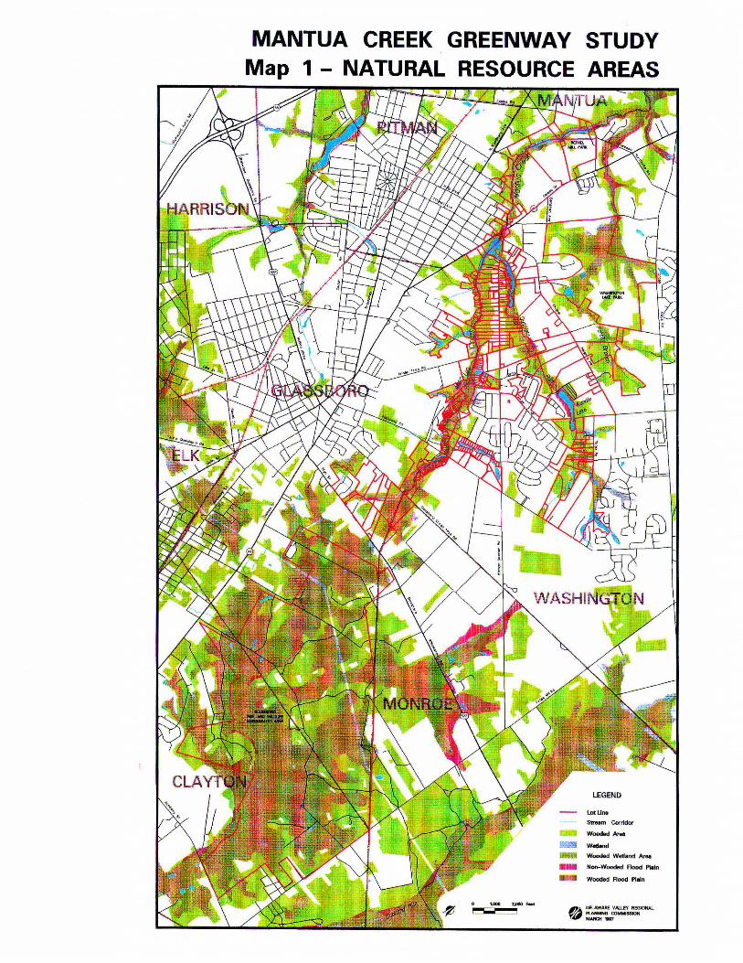
MANTUA CREEK GREENWAY STUDY Map 1 - NATURAL RESOURCE AREAS
LEGEND
- lotUn8
Stream Corridor
Wooded ArM
!K~ wedond
W~ Wdand Ar8I
.... Non-Wooded Rood PIoln
.. Wooded Flood Plain
0' DB..AWARE VALLEY REOIONAI.. ~ CONMISSIOH MAIICH ".,

nursing homes, hospitals, jails, day care centers or similar uses where human life would be endangered in jlood situations.
3) Permit limited development meeting conditions as above, but offer an incentive of a density bonus on the non-critical portion of the tract in exchange for not developing the jloodplain. Mantua Township uses this approach. Specifically, the township's ordinance grants an additional unit on the noncritical portion of a tract for the preservation of every five acres of "critical area" contained within the tract, with some fmal density caps according to zoning district. Critical areas include 100 year floodplains, steep slopes, and wetlands.
4) Prohibit construction withinjlood hazard areas and provide a density bonus on a noncritical portion of the tract.
5) Prohibit development within the jlood hazard area without offering density bonuses elsewhere on the tract. Glassboro uses this approach. The borough's regulations prohibit all structures and septic tanks within the 100 year flood plain and limit development to "farming, overflow parking, lawns, detention basins and ponds meeting other state regulations and open space/recreation uses not requiring structures."
Floodplain ordinances such as Glassboro's that prohibit any development or impervious coverage in the floodplain better protect the entire stream system than those that permit even limited construction. This is because allowing development in flood hazard areas, albeit with a permit, disturbs the natural ability of floodplains to provide sufficient storage for floodwaters, and can have a cumulatively detrimental effect on
downstream properties. Only by leaving floodplains in their natural vegetated state can the floodplain fully absorb floodwaters, filter pollution before it reaches the stream, and provide habitat for wildlife.
According to the 1994 U.S. Supreme Court's decision in the case of Dolan v. Tigard, protecting floodplains and prohibiting development that increases impervious surfaces are legitimate public purposes that can be supported due to the potential adverse effects from such development on the environment., However, there must be a···· sufficient relationship between the development's impacts and any required dedications or limitations to development. Such an ordinance would also better withstand legal challenges if a density bonus was offered on the non-flood hazard portion of the tract. To maximize floodplain protection, the municipalities in the study area should ensure that this relationship is clearly stated in their Master Plans and ordinances, and Pitman Borough and Washington and Mantua Townships should amend their floodplain ordinances to prohibit any structural development or impervious surfaces in the 100 year floodplain.
Wetlands Wetlands cover a significant portion of the Mantua riparian corridor and, due to their environmental value, are extremely important to protect. In their natural state, wetlands help control floods, reduce erosion, improve water quality, contribute to wildlife habitat, and provide':open spaces that increase property values and enhance quality of life.
Chapter 3: Summary of Greenway Objectives and Recommendations 23
Many of these benefits were not known or appreciated until the 1970's and 1980's. By then, more than half the nations marshes, swamps, and bogs had been filled, and the need to halt wetland loss was considered critical. Against this background, local, state and federal agencies responded by creating a series of regulatory programs.
Since wetlands are considered a critical natural resource, they are protected under a number of state laws and regulations, including the Freshwater Wetlands Protection Act of 1987, The Wetlands Act of 1970, Waterfront Development Act, Coastal Area Facility Review Act (CAFRA), Flood Hazard Area Control Act (Stream Encroachment) and Water Quality Criteria. Federal acts regulating development in wetlands include the Clean Water Act, Rivers and Harbors Act, National Environmental Policy Act and Coastal Zone Management Act. The U.S. Army Corps of Engineers issues federal permits, in cooperation with the USEP A. The definition of wetlands has historically been a contentious issue and is subject to change, along with the degree of rules governing wetland development.
In addition to regulating wetlands themselves, NJDEP also regulates Transition Areas or buffers around freshwater wetlands. Buffers are considered important to reduce developments' impact on wetlands. A permit is required for practically any activity proposed in a wetland. Permits allow limited types of activities in wetlands, provided specific permit conditions are met relating to their impact on the environment.
At the local level, municipalities which are proactive in wetland management rather than relying on state and federal oversight are often
able to protect more of their wetlands. State and federal regulations may exempt wetlands under a certain size that are locally significant, especially when connected as a system; and the definitions and rules governing wetlands are still subject to change. For example, the Army Corp of Engineers has drafted controversial new guidelines regarding wetlands·that opponents claim would open up thousands more acres of sensitive lands for development. (Philadelphia Inquirer article "New Rules are Offered on Use of Wetlands", by Joby.Warrick, 2/2/98)
Municipalities should use planning tools such as performance zoning, or net-out of resources to protect their natural areas, including wetlands, floodplains, steep slopes, and other environmentally significantly features. (See box on next page)
24 Upper Mantua Creek Greenway Implementation Plan
Erosion and Sedimentation Control Controlling erosion and sedimentation along the Mantua is important to the overall health of the creek. Sedimentation entering the creek reduces its width, decreasing the surface area of the stream bottom where most biological activity occurs. Eroded soil initially suspended in the water decreases the amount of sunlight reaching aquatic plants, inhibiting their growth and reproduction, as well as harming fish life by clogging gills. Erosion and sedimentation entering the stream also increases the amount of phosphorus in the stream, leading to the proliferation of algae, at the expense of submerged aquatic life. Moreover, eroded soil and sedimentation in the stream reduce the stream's carrying capacity during floods. (Montgomery County Model Riparian Corridor Overlay District Ordinance, 1996)
All developments involving over 5,000 square feet of soil disturbance or more than one single family dwelling must be reviewed by the Gloucester County Soil Conservation District for compliance with their standards. Townships may only issue permits for occupancy after the Soil Conservation District has issued a certificate of compliance to the developer. If a construction site is inspected and found in violation, the soil conservation district works with the developer to resolve the problem. Significant fines of up to $3,000/day and stop work orders may be issued for repeated violations. Since Gloucester County's two inspectors are unable to check every construction site every day, it is important for township officials and residents to keep watch over construction sites, especially large projects where the soil may be disturbed over a long period of time and would be subject to numerous rainfalls. Residents cited lack of enforcement
Chapter 3: Summary o/Greenway Objectives and Recommendations 25
concerning sedimentation and other stream pollution as a major problem in the area. Township officials and neighbors should notify the Soil Conservation District if they suspect a problem.
When erosion and sedimentation problems on development sites do occur it is often due to lack of knowledge of proper control measures by construction crews. Both the States of Delaware and Maryland require classes and certification for state-of-the-art sediment and stormwater control measures geared toward foremen responsible for on-site clearing and land disturbing activities during construction. The states also require at least one supervisory person with certification to be on location at each construction site. State staff report little resistance to the program, and positive feedback from both communities and the regulated contractors and developers. Incorporating a sediment and stormwater control certification program in New Jersey could improve compliance within the state.
Stormwater Mana~ement Effective stormwater management is important to prevent flooding and to decrease the amount of runoff pollutants reaching the waterway. Stormwater drainage systems are generally designed to limit the rate of runoff from any new development to not exceed the
. rate of runoff that occurred before development. They do this by detaining rainwater on-site in basins or underground holding tanks and releasing the stormwater at a controlled rate equal to the predevelopment rate. Although the release rate is designed to be the same as before development, the quantity of stormwater is increased. This is because the impervious coverage associated with the development results in less water
being absorbed directly into the ground with more water draining as surface runoff. The cumulative effect of many basins within a watershed releasing increased amounts of water over time can be damaging to the creek's banks (although it is obviously preferable to sudden flash floods that might occur without stormwater management facilities). In addition, the increase in runoff quantity can also have a detrimental impact on the creek's water quality.
To comprehensively address these issues, NJDEp,Jhas recently drafted amendments to the Stormwater Management Rules that specify new technical standards for stormwater runoff water quality and quantity, and that establish criteria for watershed control of stormwater runoff from new and existing development. The basic premise behind the proposed amendments is that watershed based planning and program implementation for stormwater runoff control, that moves beyond site-by-site calculations after land development projects are proposed and implemented, can more effectively manage runoff quantity and water quality at lower total cost. (NJDEP Watershed Focus, Winter 1996, and telephone conversation with NJDEP's Liz Rosenblatt, September 1996)
In addition to the new rules, NJDEP also recently prepared a Nonpoint Source Pollution Best Management Practices Manual to serve as a guide for nonpoint source pollution and stormwater management. The manual demonstrates how to integrate nonpoint source pollution and stormwater management control practices into the development planning process.
For example, it shows how to apply pollution prevention techniques through innovative site
26 Upper Mantua Creek Greenway Implementation Plan
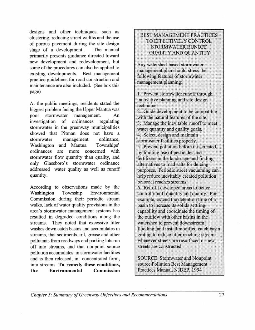
designs and other techniques, such as clustering, reducing street widths and the use of porous pavement during the site design stage of a development. The manual primarily presents guidance directed toward new development and redevelopment, but some of the procedures can also be applied to existing developments. Best management practice guidelines for road construction and maintenance are also included. (See box this page)
At the public meetings, residents stated the biggest problem facing the Upper Mantua was poor stormwater management. An investigation of ordinances regulating stormwater in the greenway municipalities showed that Pitman does not have a stormwater management ordinance, Washington and Mantua Townships' ordinances are more concerned with stormwater flow quantity than quality, and only Glassboro's stormwater ordinance addressed water quality as well as runoff quantity.
According to observations made by the Washington Township Environmental Commission during their periodic stream walks, lack of water quality provisions in the area's stormwater management systems has resulted in degraded conditions along the streams. They noted that excessive litter washes down catch basins and accumulates in streams, that sediments, oil, grease and other pollutants from roadways and parking lots run off into streams, and that nonpoint source pollution accumulates in stormwater facilities and is then released, in concentrated form, into streams. To remedy these conditions, the Environmental Commission
Chapter 3: Summary a/Greenway Objectives and Recommendations 27
recommended that the township update its stormwater management ordinance to incorporate water quality as well as flood control provisions in the design of stormwater facilities, install new catch basin gratings whenever streets are resurfaced or new streets are constructed, and establish a street sweeping (or vacuuming) program to occur after snowmelts in the spring to pick up sand, other grit and accumulated pollutants. These recommendations can, in fact, apply to all municipalities in the study area since they all drain into the Mantua.
Presently, NJDEP is developing a framework for a watershed study for the Lower Delaware River tributaries, including the Mantua Creek. The watershed study will characterize each watershed, identify the major problems and issues it faces, and recommend solutions, such as municipal adoption of stormwater management plans based on Best Management Practices.
While residents and government officials may agree that a watershed-based stormwater management plan is needed to adequately address the issue, there may be little
. agreement on how to fund such a plan, and how to fund capital improvements needed to fix existing problems. Long term residents often feel the problem stems from new development, but in fact all development, regardless of when it was built, contributes to stormwater runoff. One solution that has become prevalent in the mid-west and is more recently being adopted in the eastern United States is the establishment of a stormwater utility.
A stormwater utility funds local stormwater management programs through monthly or
quarterly user-charges assessed on all property within a watershed. The usercharge is based on each parcel's contribution of stormwater flow to the local drainage system" The user-charge would cover local costs for operation and maintenance, basin planning, facility construction and program administration, similar to user-charges for other public utilities. Advantages of a stormwater utility include a stable, dedicated funding source for the proper planning, design, construction, operation and maintenance of stormwater facilities, ability to use this funding source as leverage for bond issues to finance large-scale capital improvements, and an equitable user fee based on runoff contribution rather than property value. Disadvantages include expensive startup costs in determining parcel-based user fees, and public reluctance to what may be perceived as a new tax. In addition, establishing a stormwater utility in New Jersey would require state enabling legislation. The impetus for this possibility may come from the NJDEP watershed studies presently being conducted throughout the state, especially if rmding a new technique for funding management of stormwater arises as a major issue .
Wastewater Mana~ement Improperly treated wastewater discharged into a stream can be a major source of pollution. The NJDEP administers the New Jersey Pollutant Discharge Elimination System (NJPDES), which regulates facilities and activities discharging or releasing pollutants into the surface and ground waters in the State. According to the Draft 1993 Wastewater Management Plan for Gloucester County, data from the NJDEP Bureau of Permit Management, Division of Water
28 Upper Mantua Creek Greenway Implementation Plan
Quality, and file searches at the Central File Unit of NJDEP, there are 10 facilities with permits to discharge into the Mantua Creek. F our of these facilities, one in Pitman and three in Glassboro, discharge into the Upper Mantua. Of the three files that were available for review in the winter of 1997, all were complying with their permit standards. The file for Sony Music Entertainment in Pitman was being used by NJDEP staff and was therefore not available for review.
Almost all areas within the study area are served by the Gloucester County Utilities Authority. The GCUA interceptor runs back and forth across the Mantua Creek within the study area, and there are local pump stations in Washington Township, Glassboro and Pitman on properties adjacent to the creek. Neither the individual municipalities, nor the GCU A, discharge into the creek.
NJDEP is currently undertaking a major initiative to update and improve the NJPDES program. In concurrence with the stormwater management watershed approach, the main focus of the NJPDES program improvement is a m9ve to a watershed cycle for the issuance of discharge-to-surface-water permits. The watershed approach is intended to be a comprehensive program of planning, monitoring, modeling, total maximum daily load development and permitting, integrating both point and nonpoint source pollution controls, and public outreach. (NJ Water Quality Inventory, 1994)
Toxic Discharges Up until 1991, the NJDEP maintained a program assessing waters where toxic discharges from point sources were suspected. Neither the Mantua Creek nor any of the lakes in the study area were identified in the
program as having experienced violations, and the fish in the creek were not cited as containing PCBs. (NJ Water Quality Inventory, 1994) Nearby Alcyon Lake in Pitman"on the Chestnut Branch draining into the Mantua at Wenonah, was a Superfund Site with advisories on largemouth bass and chain pickerel. However, the lake has recently been reclaimed through a significant clean up effort.
Nonpoint Source Pollution Nonpoint source pollution is a major cause of water quality problems'in all the state's rivers . and streams, including the Mantua, and is a major concern for groundwater quality as well. Rainwater flowing over land or through stormwater sewer systems conveys most of the nonpoint source pollution affecting waterways. Since the Mantua Creek landscape is becoming increasingly developed, the greenway plan will focus on urban and suburban nonpoint source categories rather than agricultural sources.
As mentioned above, NJDEP recently prepared a nonpoint source pollution Best Management Practice Manual that will serve as a guide for nonpoint source pollution as well as stormwater management. In addition, there are many actions that residential and commercial landowners can take to reduce nonpoint source pollution. For example, property owners should limit the amount of pesticides and fertilizers used in their yards, and they should properly dispose of hazardous household wastes. The Gloucester County Federation of Watersheds, Mantua Creek Watershed Association, and local environmental commissions can help spread this information by continuing to produce and distribute information on good stewardship. Washington Township
Chapter 3: Summary a/Greenway Objectives and Recommendations 29
Environmental Commission has produced an excellent pamphlet on streams, water quality and nonpoint source pollution called Streams of Washington Township that could be adapted by neighboring municipalities. Examples of stewardship outreach materials are shown in Appendix C.
Endangered Wildlife and Habitat Data from the Natural Heritage Program at the NJDEP indicates there may be three rare species inhabiting the Upper Mantua Creek area. The three species are fly poison, the two-flowered bladderwort, and swamp pink, all vascular plants. All three are listed as endangered within New Jersey, in immediate danger of extinction. They are also listed as very rare globally because they are only found in a very restricted range.
Swamp pink, as its name implies, is a wetland plant limited to shady forested headwater and meandering streamlet areas, as are found in the Mantua Creek Greenway study area. The plant is characterized by a bright pink flower cluster that blooms in early spring. Clearing, draining and filling activities associated with development destroy the plant and its habitat, but even more subtle assaults that create changes in water quality and water supply can eliminate the sensitive species without destroying the remaining wetland.
Swamp pink is found only along the coastal plain from New Jersey to Virginia and in small isolated bog areas. New Jersey contains more than 70% of the known swamp pink sites, and represents the global stronghold for this endangered plant. Loss of the swamp pink's forested wetland habitat and the plant's subsequent decline in distribution prompted the U.S. Fish and Wildlife Service to designate the plant as "threatened" under the
Endangered Species Act, in 1988. A species designated as threatened is likely to be in danger of extinction in the near future. (U.S.Fish and Wildlife Service Identification Guide for Swamp Pink)
About 100 other rare plant and animal species have also been recorded by the state's Natural Heritage Program to survive at various locations within Gloucester County. Since the Mantua Creek has high quality wetlands and forested areas, some of these countyrecorded species may depend on the Upper Mantua Creek area for food, migration and nesting habitat. Residents can help provide habitat for wildlife by planting native species whenever possible, which also tend to be less invasive.
Land Use and Ownership Patterns along the Upper Mantua
Map 2 - Land Use on the following page was created by interpreting aerial photography taken in 1995 into seventeen land use categories. For the Upper Mantua, it shows that the predominant land uses are single family residential, farmland and woodlands. Higher density development patterns are found in Pitman and Glassboro. Medium to low density residential development is found in Washington Township, and a cattle farmstead is located in the Mantua Township portion of the study area. The remaining significant lands are found along Duffield Run in Washington Township. The farmland on Delsea Drive adjacent to Bethel Mill Park is currently being developed into Park Place, a mixed lise community. The major woodlands in the area are found along the creek and in the Glassboro Fish and Wildlife Management Area and Washington Lake Park. The fact
30 Upper Mantua Creek Greenway Implementation Plan
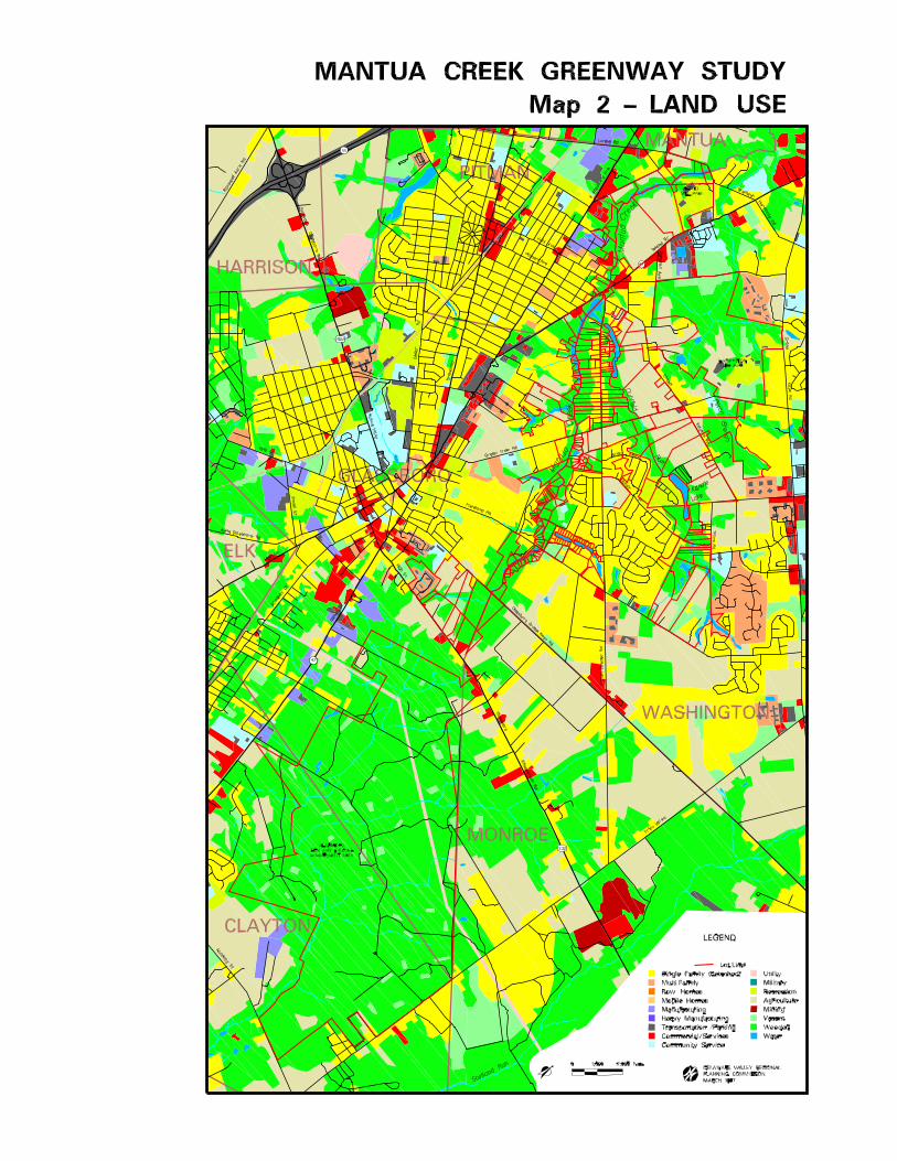

that the area contains a mix of neighborhoods and open spaces supports the greenway concept of connecting people with open space.
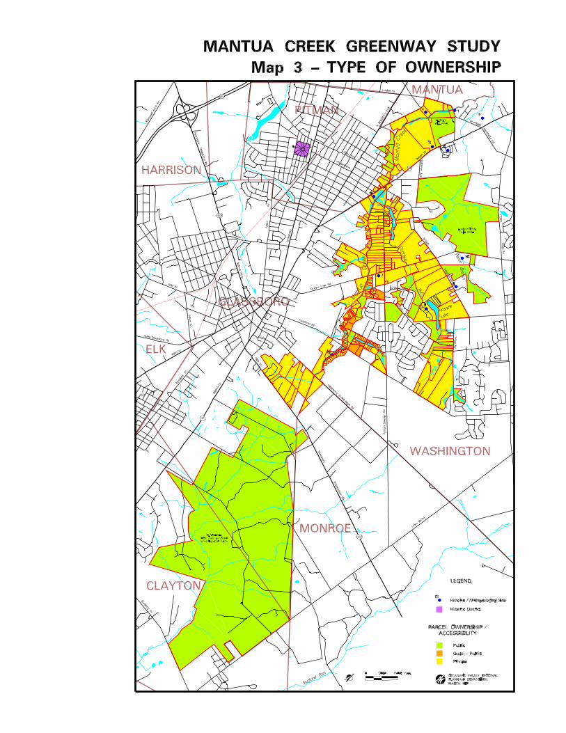
About 75% of the 230 properties in the study area are in private ownership, and 25% are in public ownership or quasi-public (homeowners association or institutional land, considered quasi-public because it is more accessible to the general public than privately held land), as shown on Map 3 - Type of Ownership. The predominance of privately owned parcels does not have to be a deterrent to creating the greenway. Residents have an important role to play in being good stewards of the land, in offering scenic and conservation easements, and in supporting municipal adoption of open space preservation land use techniques. In addition, developers of large tracts can support the greenway by designing neighborhoods that leave a wide buffer along the creek as common open space for both natural resource protection and the recreational enjoyment of neighborhood residents or the public.
At the same time, the presence of large publicly owned lands ensures that significant open spaces will remain in an otherwise suburbanizing environment. Areas like the Glassboro Fish and Wildlife Management Area, Washington Lake Park, and Bethel Mill Park not only provide natural area protection and recreational opportunities on their own, but as part of the greenway they are like anchors. These parks, and any other large remaining open spaces become the resources that the rest of the greenway serves to link. F or example, with respect to providing a hospitable corridor for wildlife, the greenway open space buffer along the creek provides the migratory corridor and the anchors provide the stopping grounds.
Upper Mantua Municipalities Master Plan Goals
and Implementation
Municipal master plans examine a community's existing conditions, defme what the community wants to look like in the future, and develop a set of policies and goals to reach that vision. These policies and goals are then implemented through the community's ordinances, which dictate the municipality's pattern of land use and development.
Municipalities wishing to preserve their natural features and provide for open space and recreation should therefore first incorporate these goals into their master plan, and then follow up with appropriate and effective ordinances.
Each of the four communities in the study area recognizes the importance of natural areas and has developed policies to protect them in their Master Plans. However, each has taken a different approach in terms of implementing their conservation goals through municipal regulations.
Washington Township's Master Plan goals entail developing an interconnected system of protected open space based on critical natural features throughout the township. Through its proactive Environmental Commission, the township has implemented a number of measures towards this goal. F or example, the Environmental Commission has prepared an environmental resource inventory, an open space inventory and a surface water quality reporttoassess township conditions and make recommendations. Some of their proposed recommendations have been implemented,
Chapter 3: Summary a/Greenway Objectives and Recommendations 33
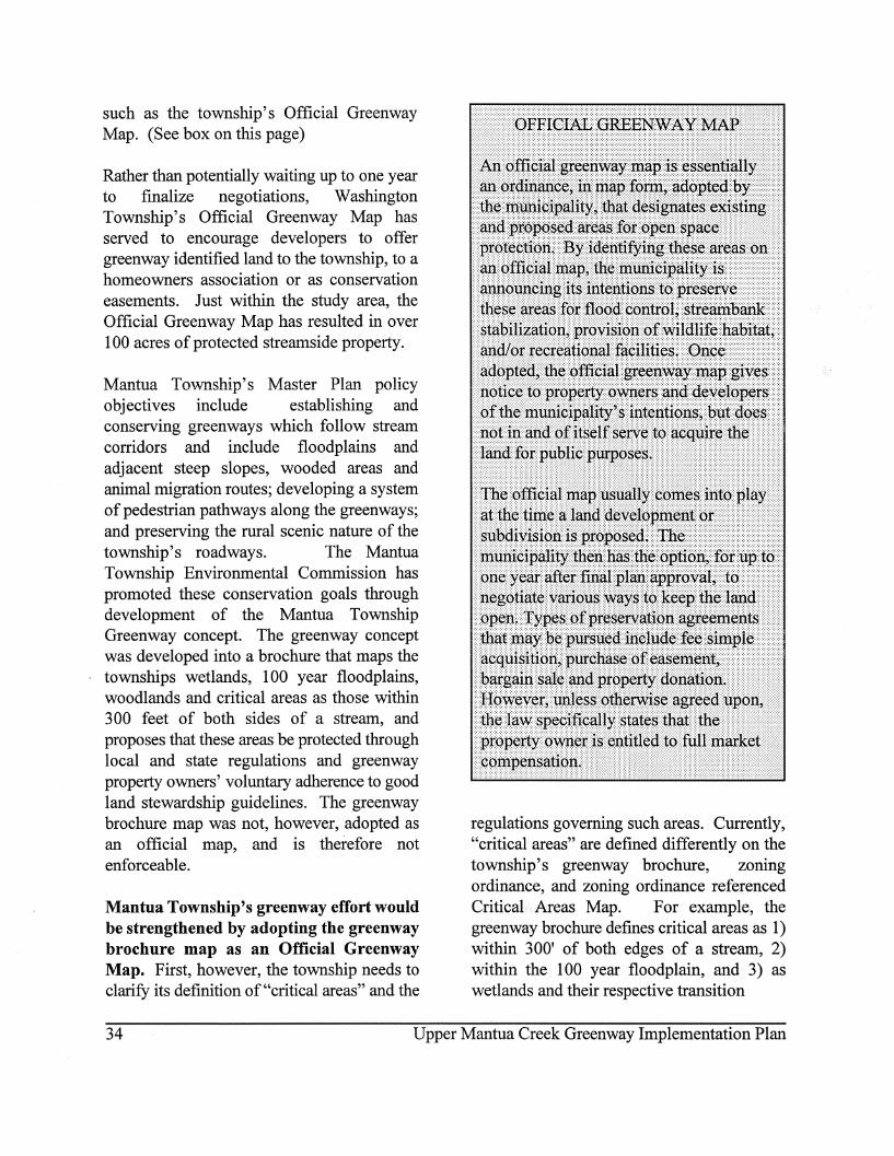
such as the township's Official Greenway Map. (See box on this page)
Rather than potentially waiting up to one year to finalize negotiations, Washington Township's Official Greenway Map has served to encourage developers to offer greenway identified land to the township, to a homeowners association or as conservation easements. Just within the study area, the Official Greenway Map has resulted in over 100 acres of protected streamside property.
Mantua Township's Master Plan policy objectives include establishing and conserving greenways which follow stream corridors and include floodplains and adjacent steep slopes, wooded areas and animal migration routes; developing a system of pedestrian pathways along the greenways; and preserving the rural scenic nature of the township's roadways. The Mantua Township Environmental Commission has promoted these conservation goals through development of the Mantua Township Greenway concept. The greenway concept was developed into a brochure that maps the townships wetlands, 100 year floodplains, woodlands and critical areas as those within 300 feet of both sides of a stream, and proposes that these areas be protected through local and state regulations and greenway property owners' voluntary adherence to good land stewardship guidelines. The greenway brochure map was not, however, adopted as an official map, and is therefore not enforceable.
Mantua Township's greenway effort would be strengthened by adopting the greenway brochure map as an Official Greenway Map. First, however, the township needs to clarify its definition of "critical areas" and the
regulations governing such areas. Currently, "critical areas" are defmed differently on the township's greenway brochure, zoning ordinance, and zoning ordinance referenced Critical Areas Map. For example, the greenway brochure defines critical areas as 1) within 300' of both edges of a stream, 2) within the 100 year floodplain, and 3) as wetlands and their respective transition
34 Upper Mantua Creek Greenway Implementation Plan

buffers. The same defmition is also found in the township's Tree Protection Ordinance. The township's zoning ordinance "Critical Areas Map" shows critical areas as those with "alluvial soil and muck" (wetlands), and areas of slopes greater than 8%. Yet, the text of the zoning ordinance defines critical areas as those areas where seasonal hi-water table is 24" or less, slope is 25% or greater, and areas within the 100 floodplain. The zoning ordinance language prohibits buildings and structures, filling or excavating other than that related to the construction of roadways, and any attempts to alter the existing conditions of critical areas in any areas so defined. '
Since the definition of critical areas in the township's greenway brochure and tree protection ordinance includes more sensitive lands than the current zoning ordinance language and map, using it would protect more land and best serve the intent of the Master Plan. The critical areas could be protected by adopting the greenway map brochure as an Official Greenway Map, as well as adopting a riparian corridor overlay ordinance to maintain the areas in their natural state. (See box on page 40)
Mantua Township's Master Plan goal of preserving the rural scenic nature of its roadways would be better implemented by reexamining the zoning of the small, yet scenic, area of the Township that falls into the Upper Mantua Creek Greenway Study. The area is currently zoned Flex Space, which is inconsistent with the objective to preserve rural scenic roadways. This area currently has two large lot residences and the 44 acre Bethel Mill Farm. The west side of Bethel Mill Road, just outside the study area, is already developed as large lot residential. The bucolic views from Lambs Road and Bethel Mill
Road - of rolling meadows, barns and picket fences, would be lost forever if the area were developed as Flex Space, which allows office buildings, warehousing and distribution facilities, with a maximum impervious coverage· allowance of 80%. Furthermore, the area also has poor truck access, making it inappropriate for flex space. The township should consider a more appropriate zoning district, such as low-density residential, as they proceed with their current zoningreexamination effort.
Glassboro Borough's Master Plan goals include preserving critical areas as open space, incorporating design elements that deal effectively with a site's natural limitations, and integrating various parks and public services with a pedestrian system.
The entire area of the borough within the study area is zoned R-5 Low Density Residential. According to the ordinance, the intent of this district is to provide residential design options in order to control access to abutting streets, provide recreational areas and open spaces and to avoid encroachment on environmentally sensitive areas. However, nothing in the R-5 requirements seems to require that any of these intents are realized. In addition, the district's bulk standards, which require a minimum lot size of 8,000 square feet but a maximum density of 3 dwelling units per acre, have resulted in larger lots fragmenting the environmentally sensitive areas instead of protecting them. Of the R-5 subdivisions recently built and proposed to be built along the Mantua, no common open space along the creek was preserved (or proposed to be preserved). This is despite the intent of the ordinance, and despite the existence of a Gloucester County Utility Authority sewer line easement that runs
Chapter 3: Summary o/Greenway Objectives and Recommendations 37
parallel to the creek. No development is permitted on the 40 foot wide sewer line easement adjacent to the creek, although residents may own the land down to the creek's edge. Consequently, an opportunity to provide a continuous linear park with trail facilities, and to better ensure the protection of the creek's buffer, has been lost along the majority of Glassboro's banks of the Mantua.
However, there are still a few remaining large undeveloped parcels just south of Greentree Road and below Fishpond Road. Glassboro could ensure that unfragmented open space along the creek is maintained in these areas by mandating the preservation of common open space along the creek, while still maintaining the maximum density of 3 units per acre. Since this land has floodplains, wetlands, steep slopes and the sewer line easement, it cannot be built on anyway. A method of protecting significant natural resources and providing passive or active recreation for neighborhood residents, while still allowing landowners to achieve equity on their property, is described in the box on the following page.
Pitman Borough's Master Plan goals with respect to the Mantua Creek involve recognizing that creekside land presents a valuable open space and natural resource area where development and expansion of existing development should be highly restricted.
The Borough has implemented this objective by zoning a 200 foot wide buffer along the creek as Park/Conservation, which requires a minimum lot size of 1 acre for any allowed use. Permitted uses are limited to single family dwellings, schools, country clubs, lodges, churches, and funeral homes. Since the Master Plan recognizes that this land is
environmentally fragile and should be preserved, it seems incongruent that even the above uses are permitted. In any case, almost all of the land along the creek in Pitman is owned by the Borough, and therefore not subjectto development. Uses include Walton Park, a practice pistol range for Pitman police, and a wooded area with a meandering unpaved pathway system. The pathway system is not part of Walton Park, and probably unknown to most borough residents.
38 Upper Mantua Creek Greenway Implementation Plan

Chapter 3: Summary o/Greenway Objectives and Recommendations 39
Need for Conservation Zoning
Residential uses are the predominant zoning classification along the Upper Mantua, with relatively low and medium density in Washington Township, and high density in Glassboro. Washington Township also has a large tract next to Bethel Mill Park zoned for and currently being built as mixed use. Mantua Township's streamside land is zoned for Flex Space, and Pitman's is zoned ParkConservation. See Map 4 - Type of Zoning, a composite zoning map showing permitted uses and density categories based on the maximum by-right density permitted in the district, on page 43.
With the exception of the Mixed-Use District in Washington Township, none of the zoning in the area particularly requires that an open space buffer be maintained along the creek corridor. Despite state environmental regulations, this has, in many cases, resulted in disturbance ofland so close to the stream's edge that it results in streambank erosion, disruption of the natural ability of the floodplain to absorb flood waters, and disturbance of the habitat vital to aquatic and other species. These disturbances were observed during the Washington Township Environmental Commission's stream walks and recorded in their Surface Water Quality Report. To protect ultra-sensitive riparian areas, municipalities can adopt Stream Corridor Protection and Management Overlay Ordinances. (See box on this page)
40 Upper Mantua Creek Greenway Implementation Plan
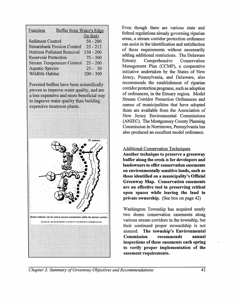
Even though there are various state and federal regulations already governing riparian areas, a stream corridor protection ordinance can assist in the identification and satisfaction of these requirements without necessarily adding additional restrictions. The Delaware Estuary, Comprehensive Conservation Management Plan (CCMP), a cooperative initiative undertaken by the States of New Jersey, Pennsylvania, and Delaware, also recommends the establishment of riparian corridor protection programs, such as adoption of ordinances, in the Estuary region. Model Stream Corridor Protection Ordinances and names of municipalities that have adopted them are available from the Association of New Jersey Environmental Commissions (ANJEC). The Montgomery County Planning Commission in Norristown, Pennsylvania has also produced an excellent model ordinance.
Additional Conservation Techniques Another technique to preserve a greenway buffer along the creek is for developers and landowners to offer conservation easements on environmentally sensitive lands, such as those identified on a municipality's Official Greenway Map. Conservation easements are an effective tool in preserving critical open spaces while leaving the land in private ownership. (See box on page 42)
Washington Township has acquired nearly two dozen conservation easements along various stream corridors in the township, but their continued proper stewardship is not assured. The township's Environmental Commission recommends annual inspections of these easements each spring to verify proper implementation of the easement requirements.
Chapter 3: Summary o/Greenway Objectives and Recommendations 41
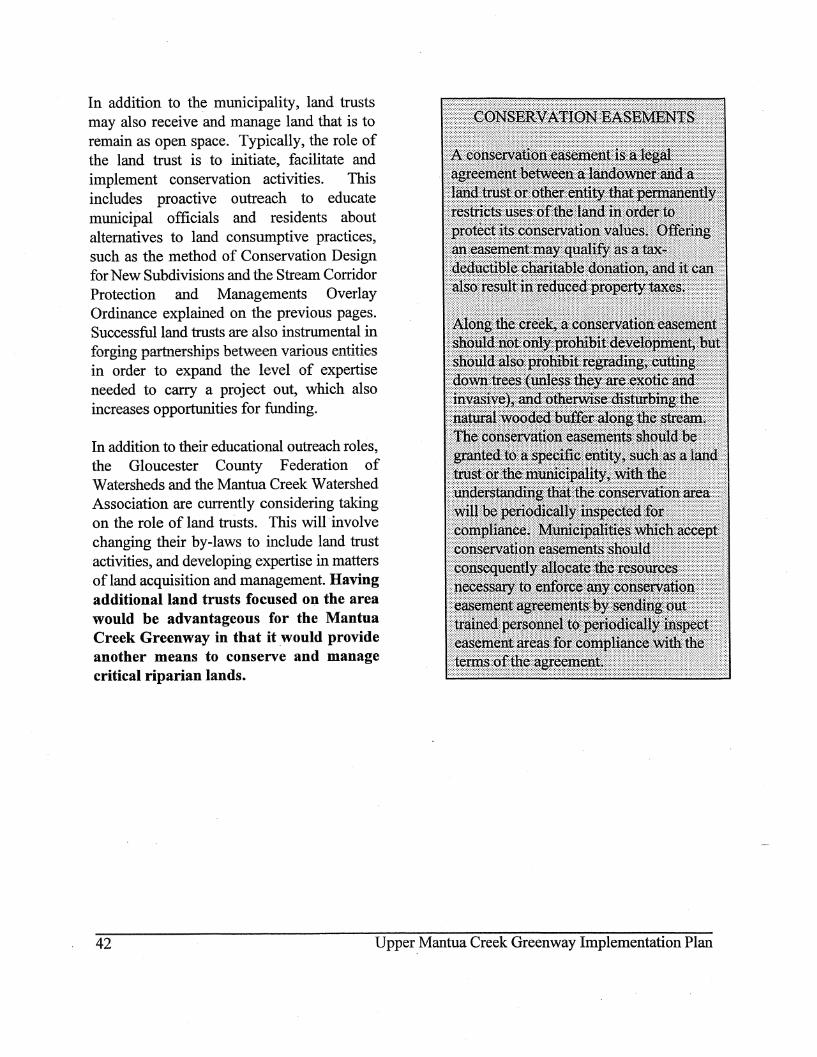
In addition to the municipality, land trusts may also receive and manage land that is to remain as open space. Typically, the role of the land trust is to initiate, facilitate and implement conservation activities. This includes proactive outreach to educate municipal officials and residents about alternatives to land consumptive practices, such as the method of Conservation Design for New Subdivisions and the Stream Corridor Protection and Managements Overlay Ordinance explained on the previous pages. Successful land trusts are also instrumental in forging partnerships between various entities in order to expand the level of expertise needed to carry a project out, which also increases opportunities for funding.
In addition to their educational outreach roles, the Gloucester County Federation of Watersheds and the Mantua Creek Watershed Association are currently considering taking on the role of land trusts. This will involve changing their by-laws to include land trust activities, and developing expertise in matters of land acquisition and management. Having additional land trusts focused on the area would be advantageous for the Mantua Creek Greenway in that it would provide another means to conserve and manage critical riparian lands.
42 Upper Mantua Creek Greenway Implementation Plan
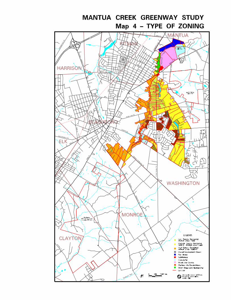

Public Access and Recreation
Map 5 - Type of Open Space, shows that creek access and recreation is currently provided by a mix of public and private entities along the Upper Mantua. Bethel Mill Park, at the north end of the study area, is a very popular 58 acre county park providing ball courts, playgrounds, picnic facilities and trails. One of the trails winds down to Bethel Mill Pond, and many people walk this route to enjoy the lake scenery and catch glimpses of turtles, frogs, ducks and geese. Washington Lake Park is an approximately 750 acre Washington Township park with ballfields, trails; and picnic facilities accessed from Greentree Road. Lake Washington swimming and the Washington Township Nature Center are accessed from Chapel Heights Road. Because the park was· purchased with Green Acres funding, its use is open to the public at large. Walton Park, a 2 acre municipal park in Pitman, offers picnicking and playground equipment adjacent to the Mantua, although there are no trails that bring people down to the creek. The other major public recreational facility in the study area is the over 3,000 acre state-run Glassboro Fish and Wildlife Management Area. The wildlife area has roadways and trails for hunting small game.
The Upper Mantua Creek area used to offer at least three privately run lake resorts: Kandle Lakes, Senior Lakes and Lake Oberst. Senior Lakes is now called Waters Edge, is no longer a lake, and has been developed for luxury homes. Lake Oberst remains a lake but has had its docks and picnic areas removed since the early 1970s and is also now luxury homes. Only Kandle Lake remains a resort in the area, where many patrons return year after year with their trailers for extended summer getaways.
Groffs Nursery on Delsea Drive backs up onto Cresse Lake, and the public is invited to use the nursery's pier for fishing, provided they sign in at the store and respect the surroundings. People also fish in some of the headwater lakes of Duffield Run near Thies Road and Altair Drive, but there are no official fishing piers.
Residents whose properties back up on the lakes, of course, have private access for swimming, boating and fishing. Some of these residents have complained that trespassing is a problem, even to the extent that trespassers will "borrow" their boats for a ride on the lake. Trespassing for fishing reportedly declined somewhat after the Groffs opened the nursery pier for public use.
Gloucester County's Farmland, Open Space and Recreational Needs Study included a survey of municipal recreational needs. Trails were ranked as the highest priority recreational need by the majority of municipalities responding. This reflects national recreational surveys which have also documented the popularity of trails for jogging, biking, roller blading and hiking.
The Washington Township Master Plan and Open Space Inventory have proposed pedestrian and bikeway linkages along stream corridors and other areas to create a primarily off-road trail network throughout the township. As site plans are reviewed, trail connections are incorporated into the design where feasible. For example, the Park Place development includes provisions to extend the lakeside trail in Bethel Mill Park into the adjacent mixed use community. The developer of Park Place has also agreed, in a 9/27/95letler to the Director of the Gloucester County Parks and Recreation Department, to
Chapter 3: Summary of Greenway Objectives and Recommendations 45
create a pedestrian/bikeway linkage between Bethel Mill Park and Washington Lake Park by dedicating a 5 foot wide cross-hatched area on Hollydell Drive. Trail provisions within Washington Lake Park would be needed to connect this entryway with the park's other trails and facilities. The Washington Township Environmental Commission and Mantua Creek Watershed Association should serve as watchdogs to make sure these agreements are executed.
In addition to the trails existing in parks, there are several "hidden" networks of trails in the area. One network meanders through the woods owned by Pitman Borough on the other side of the creek from Park Place. These parcels are shown on the Type of Open Space Map as "Community Open Space", because, although owned by the borough, the land is not parkland. These unpaved trails could potentially be linked with the Park Place and Bethel Mill Park trails by a foot bridge over the creek. However, the status of Pitman's practice pistol range, adjacent to one of the pathways, and its incompatibility with public trail usage, would need to be addressed.
Another "hidden" network of trails parallels the Mantua Creek on parcels mapped as "Community Open Space" between Fishpond Road and Greentree Road in Washington Township. Most of this land is owned by Washington Township, acquired through the site plan review process. Two parcels are privately owned, by Archway School Systems and Calvary Hill Church. Development of either site would be extremely difficult due to the degree of wetlands.
Part of the trail is a utility easement, and the remainder appears to have been worn in by
neighborhood residents' use. There is a neighborhood access point off of Lupus Lane, with an unpaved trail leading out to PitmanDowner Road.
On the;:vGlassboro side of the creek, below Fishpond Road, the Gloucester County Utility Authority maintains a sewer line easement paralleling the creek to its headwaters, where the easement then turns south and intersects with the Williamstown Branch of the abandoned Pennsylvania-Reading Seashore Lines, about Y:z mile away. Efforts have been ongoing 'to convert this abandoned railroad to a 5 mile trail that would ultimately connect Glassboro, the Glassboro Fish and Wildlife Management Area, Scotland Run Park and the Monroe Township Bike Path. Linking the rail-to-trail project with a new trail along the sewer easement and the extant trails in Washington Township would create a very impressive off-road network of pathways for the residents of Gloucester County.
According to conversations and correspondence with the Executive Director of the Gloucester County Utility Authority about use of its easement for a trail, the Authority has several concerns, but would not otherwise oppose trail usage if their concerns could be resolved. One concern was the potential for odor complaints. During a spring, 1997 walk through the area, though, no odors were perceived. Another concern was about vandalism, but the experience of other communities across the country has consistently shown that most trail users live nearby, that well-used trails are self-policing, and that property along such trails does not experience higher rates of vandalism.
The Authority was also concerned about their responsibility for trail restoration should their
46 Upper Mantua Creek Greenway Implementation Plan
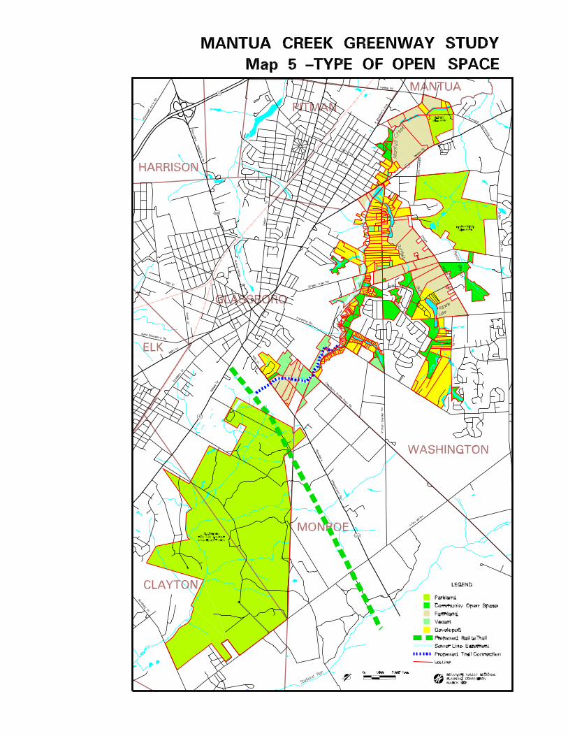

maintenance work result in damage to the trail system. To remedy this, an agreement could be arranged to limit their liability, and pathways could be constructed to adequately handle Authority equipment.
The Authority'S other concern was dealing with complaints of trespassing made by adjacent property owners. Most of the proposed trail easement goes through nonresidential property - vacant land and a tree farm, but one portion goes directly through a resident's garden, and down a dirt road fronting several rental bungalows on Oberst Lake. Final plan approval has been granted to develop this area - the Glassboro side of Oberst Lake - into luxury homes (as was completed on the Washington Township side of the lake). However, as of the spring, 1997, the developer's representative said the current plan no longer made sense and would probably be revised. (Telephone conversation with Bob Bower of John B. Canuso, 4/29/97)
The design of a new plan could incorporate a trail that circumvents the existing property owner's lot (block 412.07 - unit 10.02) and reconnects with the sewer easement on the dirt road, as illustrated on Map 5. The development could then be marketed as providing lakefront access and trail facilities for all units within the neighborhood; By creating the trail as part of the development, only new homeowners who want to live near such a facility will buy into the development, and the developer can turn an otherwise unusable strip of land into a community asset. The Glassboro Environmental Commission and Planning Board should encourage the developer to incorporate these uses before significant reengineering is completed.
Historic Resources and Legends of the Upper Mantua Creek Valley
History The Lenni Lenape Indians were the original inhabitants of the Upper Mantua Creek. Lake Oberst, near the creek's headwaters, is reported to have been the site of an Indian village, and Bethel Cemetery was originally an Indian burial ground. The area was probably inhabited by the flrst Europeans about 1700, when the Dilkes Family settled near the Mantua in what is now Washington Township.
James Dilkes divided his land holdings among his eight children as they were married, resulting in the area eventually being called Dilkesboro, a name still used by older residents of the area today. The area continued to attract farmers and millers during the eighteenth and nineteenth centuries. Most of the lakes were formed by dams built to utilize water power for grist and sawmills. Up until the latter half of the 20th century, the east side of the Upper Mantua remained rural, occupied by farms and summer lake resorts such as Kandle Lakes, Senior Lakes and Lake Oberst. Suburbanization of this portion of the Mantua Valley began to occur in the late 1960s.
History took a different turn on the west banks of the Upper Mantua, where the distinct town centers of Glassboro and Pitman developed. Pitman was founded in 1870 by a small group of Methodist ministers as the Pitman Grove Camp Meeting. The sight was selected for its wonderful views overlooking the Mantua Valley: The center of this development is unique in that it represents a wagon wheel with twelve radiating avenues as the spokes. The inner circle was the hub, where events are
Chapter 3: Summary of Greenway Objectives and Recommendations 49
held to this day. Until World War II, the Grove was a thriving summer resort. Many of
. the seasonal visitors eventually bought homes in the town and remained year round. Pitman was originally part of Mantua Township, but as the population grew, a movement to incorporate began and the town became the Borough of Pitman in 1905.
The first known resident of present day Glassboro was Solomon Stanger, who purchased land in the borough in 1779 and soon after entered the glass-making trade. The la.1'J.d provided the necessary resources for glass-making - timber for the furnaces, fine white sand for the glass and silica deposits and stone for the foundations. Glass-making factories attracted growing numbers of immigrants to the borough and were the main vocation for residents until orchard, dairy and poultry farming sprang up after the Civil War. Glass-making started to decline by the 1920's and people relied more on farming and small businesses. The predecessor to Rowan University, Glassboro Normal School, was founded in 1923 to prepare students for teaching. On June 23, 1967, Glassboro became the focus of world-wide attention as it hosted a summit between President Lyndon B. Johnson and Russian Premier Alexei N. Kosygin which resulted in lasting improvements in Soviet-American relations.
The Type of Ownership Map on page 35 shows 12 historic and archaeological sites located within the greenway area that have been documented by the Office of New Jersey Heritage andlor the Washington Township Historical Society (provided by Joan B. Michael, Librarian, Washington Township Historical Society).
Historic and Archaeological Sites
1. Bethel Mill Ruins - foundation of early 19th century grist mill.
2. Bethel Methodist Cemetery - Was Indian burial grounds before Dilkes family purchased lot. See following legend.
3. Hillcrest Cemetery - May have been burial ground for first generation of Dilkes family, original settlers of area.
4. Bethel Mill Farm House- circa 1875 farmhouse.
5. Pitman Grove - Unique settlement pattern founded in 1870 as Pitman Grove Camp Meeting by Methodist Ministers. Listed on National Register of Historic Places since 1977.
6. Groffs Nursery House - circa 1850 farmhouse, now used as nursery/crafts shop. May have been built by member of Dilkes family.
7. Banks Residence - 19th century farmhouse, owners ran adjacent Senior Lakes swim park.
8. Chapel Heights Methodist Church - Built in 1870, it's the oldest church building in Washington Township and has been in continuous use since its founding.
9. Kandle Lakes - 19th century saw mill remains, now an active lake resort.
10. Davis Farm Site - circa 1800 house and barn.
50 Upper Mantua Creek Greenway Implementation Plan
11. Old Oak Tree - Was used as a boundary landmark in a deed dated 1771. Probably over 300 years old now.
12. Lake Oberst - Indian village, "old fishing hole", thriving picnic and swim park, and most recently, luxury home development. Lake's reputation as "old fishing hole" gave name to Fish Pond Road.
The Upper Mantua Creek environs are rich not only in the physical remains of historic resources, but also in the stories that go with them. (These stories were provided by Joan B. Michael, Librarian for the Washington Township Historical Society) For example, historical evidence shows that Bethel Mill Cemetery was once an Indian burial ground. But more intriguing is the legend, passed down from generation to generation until recorded in one local resident's diary, of Indian braves spending three days and three nights howling and chanting wildly as they performed an Indian burial ritual, terrifying nearby residents.
Other stories reveal the origin of place names commonly seen on road signs, such as Hurffville. Hurff Town was first settled by Thomas W. Hurff, who came from as far away as Turnersville! The original Hurffhouse was built in 1842 and was tom down for a Heritage Dairy .store in 1985. Hurff Town absorbed Fairview, Bethel and Dilkesboro to become Hurffville in 1850.
There are also colorful stories about former residents of the area. For example, way back before America had General Colin Powell, our country was served by another very patriotic Powell family. These Powells raised a family of 20 sons and one daughter and, even more remarkable, 17 of those sons have proven
records of serving in the American army during the War of Independence. Due to the efforts of the Daughters of the Revolution, those 17 Powell boys' names are engraved on the walls of the Valley Forge Memorial Bell Tower. The tombstone of their mother, Charity Chew Powell, was engraved:
"Some have children, Some have none. Here lies the mother of Twenty -One."
It is these stories and more that show there is a wealth. of cultural resources and legends in the area, but they are not widely known. Protecting the documented historic sites as well as vernacular features like the 300 year old oak tree can offer the greenway communities both cultural and economic benefits by enhancing community identity and
.. pride, attracting visitors, and promoting investment. By working together, historical societies, environmental commissions and even economic development agencies could develop a heritage tour that familiarizes people with historic resources, places with interesting vernacular architecture and local lore, and how they are all connected to people's use of the land and its natural resources.
Protecting Farmland in the Upper Mantua Valley
Agriculture is rapidly disappearing in Gloucester County. Nowhere is that more apparent than in the Upper Mantua Creek ValleYlwhere only a few farms remain today. Maintaining local land in agriculture is important in that it contributes to the local economy, it reduces shipping time and costs and delivers fresher products to the public, it
Chapter 3: Summary o/Greenway Objectives and Recommendations 51
allows for groundwater recharge, it reduces tax rates by paying more in tax revenues than it costs in services, and it provides scenic relief from the built environment.
There are only two significant farms left in the greenway study area; Duffield Farm and Kandle Farm. In the 1997 state farmland preservation program, the Kandle Farm was ranked second in the state, and will enter the state's permanent easement program.
As a landmark in Gloucester County, the Duffield Farm is also i..'TIportant to preserve. The Duffield Family has established a farm market which features home grown produce, a bakery, and speciality items. The farm and marketplace also serve as a destination for year round activities including hayrides, farm tours, pick your own fruits and vegetables, and special holiday festivities. Visits from school children give students the opportunity to learn where their food comes from and to see farm animals, crop fields and farm
. equipment up close.
. The Gloucester County Farmland Preservation Coordinator is currently working with the farmer on an arrangement to purchase the farm's development rights that would be funded by contributions from Washington Township, the county and the state Green Acres program. Due to the funding sources, such an arrangement has the potential to include provisions for limited public access somewhere on the farm, provided such access would not interfere with farm operations. If the previously mentioned trail connections are pursued, this may offer an opportunity to link the trail network through the common open land in the Orion Way Development with
Washington Lake Park, via Chapel Heights Road or Green Tree Road.
. Protecting Lake Resources
There are at least 9 named lakes within the study area: Bethel Lake, Lake Washington, Cresse Lake, Sterling Lake, Kandle Lake, Senior Lake, Spring Lake, Ward Lake, and Lake Oberst. The lakes are a multi-faceted asset to the community at large in that they are scenic,they provide habitat for wildlife and recreational opportuJ:'lities for swimming, fishing and boating, and they ·also receive the community's stormwater runoff. However, they also suffer from problems such as siltation and other non-point source pollution, and some of the lakes' dams have been classified as high hazard (potential for loss of life if dam fails) by the NJDEP, Division of Engineering and Construction, Dam Safety Section. The Dam Safety Section has established rules on the construction, maintenance and inspection of dams in the state in order to protect human life, property and the environment.
To assist government units, private lake associations, and owners of private dams with the costs of restoring dams, the 1992 Dam Restoration and Clean Water Trust Fund was established pursuant to the Green Acres, Clean Water, Farmland and Historic Preservation Bond Act of 1992. The Trust Fund is a revolving, low-interest loan fund that offers loans at 2% interest over a 20 year period. The latest monies, $8.6 million, were appropriated in September of 1996, and trust fund monies will not be available again for four years.
52 Upper Mantua Creek Greenway Implementation Plan
There are at least five dams in Gloucester County classified as high hazard. Two of them, Cresse Lake dam and Sterling Lake dam, are in the greenway study area. The individual property owners who own the land the dams sit. on are being held financially responsible by NJDEP for restoring these dams. However, costs of required engineering studies and actual restoration can prove prohibitive for anyone resident to fund. Consequently, the private landowners responsible for these two dams have not resolved the safety issue, despite the ability of DEP to impose significant fines.
Owners of high hazard dams are given two basic options; repair the dam, or remove the dam and drain the lake. Temporarily draining the lake without removing the dam can buy the landowner time, but is not considered a permanent solution. If they opt to remove the dam and drain the lake, the landowner is required to conduct environmental impact studies and obtain particular permits from the DEP. Other lakeside owners may petition against the drainage, but they would then be required to contribute to the dam's restoration.
Both high hazard dams are within Washington Township, and the Washington Township Mayor assigned township engineers to study the dams and submit their assessment to the state. The engineer's report specified needed work on the spillways and some other areas of the dam, but the report was not the detailed assessment of how the dam should be fixed that the DEP is requiring. This type of engineering study has been estimated to cost about $75,000 per dam.
Conversations with both landowners revealed that each is willing to dedicate lakeside land including the dam to Washington Township in
exchange for relief from liability. The township would take on the responsibility of repairing the dams, and could then create two public parks with lake access. Washington Township Council is reportedly discussing these options at their March 1998 meeting. Some of the other lakeside neighbors, however, have expressed displeasure at the notion of public access to the lake.
Despite the state's approach, the financial burden of repairing these dams is clearly beyond, what most individuals can afford, leavingilthe problem U!lJesolved. Another approach would be to change state legislation to spread the burden of dam restoration among a larger group of entities. However, this is unlikely to happen in the near future. A nonlegislative approach is for landowners and others to build broad-based coalitions of interested parties to work together to find solutions to problem dams. Potential partners in these coalitions might include lakeside landowners, municipal, county and state government agencies, and other downstream landowners, businesses and other entities that would be effected by the hydrological impacts of removing a dam. For example, the county roads department and the NJDOT could become potential partners in situations where removal of the dams would leave culverts under county and state roads inadequate to handle the increased volume of stormwater runoff.
Lake Associations are the most logical candidates to take the lead organizing these coalitions which in turn study the situation, identify all parties that might be potentially impacted, identify funding sources and raise money accordingly. Surprisingly, there are currently no lake associations for any of the lakes in the study area, although residents say
Chapter 3: Summary o/Greenway Objectives and Recommendations 53
that there used to be one for Sterling Lake. However, other Gloucester County lakes such as Lake Gilman, Silver Lake and Glen Lake all have associations from which much can be learned. Lake Gilman, in particular, is also dealing with a dam ranked as high hazard by theNJDEP.
In addition to facilitating the resolution of crisis such as high hazard dams, lake associations are also valuable in bringing lakeside owners together on a regular basis to discuss and address other issues facing lakes, such as siltation, other non-point source pollution, proper stewardship of lakeside land, water quality monitoring, weed and invasive species control, trespass, and recreational use. Residents enjoying lakeside frontage should form and contribute to a Lake Association charged with regularly addressing lake related issues, including the need for dam restoration.
54 Upper Mantua Creek Greenway Implementation Plan
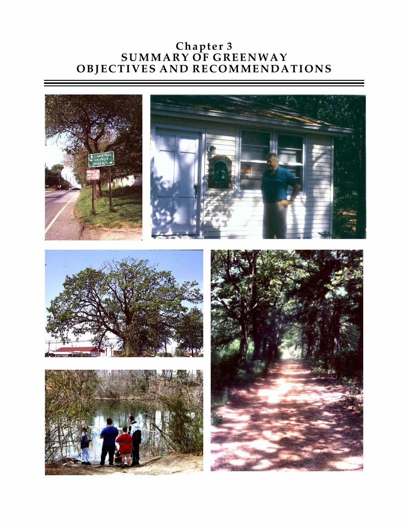
Cha pte r 3SUMMARY OF GREENWAY
OBJ EC TIVES AND R ECOMMENDATI ONS

Chapter 3 SUMMARY of GREENWAY OBJECTIVES
and RECOMMENDATIONS
The combination of mapping, research, analyses and discussions with the public elicited the following major objectives that the Upper Mantua Greenway Plan should address. Recommended actions for municipal, county and state government agencies are included, together with actions for the Mantua Creek Watershed Association and local residents. Each recommendation is based on analyses in the report on the noted pages.
Objective #1: Preserve a natural vegetative buffer along the Mantua Creek and Duffield Run
1. Pitman Borough, Washington Township and Mantua Township should amend their Floodplain Ordinances to prohibit any structural development or impervious surfaces in the 100 year floodplain. (Pages 20-23)
2. Municipalities should use planning tools such as Performance Zoning to protect their wetlands, floodplains, steep slopes, and other environmentally significantly resources. (Pages 23-25)
3. Municipalities should adopt Riparian Corridor Conservation Ordinances that ensure that vegetated riparian buffers, generally extending a minimum of 75 feet from the edge of a stream, are maintained in their natural state. (pages 40-41)
4. Pitman, Glassboro and Mantua Township should adopt Official Greenway Maps which designate stream corridor areas to be protected. (Pages 34-37)
5. Developers and landowners should be encouraged to offer Conservation Easements on environmentally sensitive lands, such as those identified on an official greenway map. (Pages 41-42 )
6. Easement lands should be inspected annually to verify proper implementation of the easement requirements. (Pages 41-42)
7. Gloucester County Federation of Watershed Associations and Man~ Creek Watershed Association should develop the expertise to become land trusts in order to provide another means to conserve and manage critical riparian lands. (Page 42)
Objective #2: Manage storm water on a watershed basis to more effectively control runoff quantity and quality
8. Pending the outcome of the Watershed Study for the Lower Delaware Tributaries, which includes Mantua Creek, NJDEP and Gloucester County should work with municipalities to develop a Mantua Creek Watershed Stormwater Management Plan. Following the plan, municipalities should adopt stormwater management ordinances incorporating Best Management Practices. In addition, the impetus for establishing a Stormwater Utility, which would require enabling legislation in New Jersey, may result from the watershed studies as a means to fund and better manage increasing stormwater problems. (pages 26-28)
Chapter 3: Summary o/Greenway Objectives and Recommendations 55
9. To remedy existing problems, municipalities should begin to incorporate Best Management Practices such as installing new catch basin gratings whenever streets are resurfaced or new streets are constructed and establishing a street sweeping (or vacuuming) program to occur after snowmelts in the spring to pick up sand, other grit and accumulated pollutants, as suggested by the Washington Township Environmental Commission. (Pages 27-28)
Objective #3: Educate and involve the public on water quality issues, the importance oj stream buffers and good land stewardship
10. The newly formed Mantua Creek Watershed Association should actively advocate for municipalities to implement recommendations from the greenway plan, as well as to organize stream clean-ups, spearhead storm-drain stencil programs, and otherwise address issues facing the creek. They should develop and distribute educational materials on the local
_ environment and native species for plantings, other good stewardship practices, and authorities to notify when residents suspect an environmental infraction. They should also facilitate broader participation from watershed communities in water quality monitoring efforts (especially from the Pitman, Glassboro and Mantua Township Environmental Commissions), and they should encourage inclusion of macroinvertibrate analyses into the program. (Pages 18-54)
11. Environmental Commissions, the Gloucester County Federation of Watersheds and the Mantua Creek Watershed Association should urge local school boards to incorporate environmental education, including participation In hands-on
stewardship activities, into the regular school curriculum. (pages 19-20)
12. New Jersey Department of Environmental Protect jon and County Soil Conservation Districts· should create and require a training program on proper sediment, erosion and stormwater control measures for building foreman responsible for land disturbing activities during construction. (Pages 25-26)
Objective # 4: Provide sufficient public access, recreational and educational opportunities along the Mantua so as to instill appreciation for the creek and to discourage trespass on private property
13. Glassboro should strengthen its R-5 zoning district by requiring unfragmented common open space along the creek to ensure stream corridor protection and a neighborhood facility for recreation, while still maintaining the maximum density of 3 units per acre. (Pages 37-39)
14. The Nature Center at Washington Lake Park should expand its environmental programs to reach students from surrounding municipalities, especially those that may be otherwise underserved. It should also establish a program for adults. (Page 19)
15. The Mantua Creek Watershed Associations, municipalities, and the Gloucester County Planning Department, Parks and Recreation Department and Utility Authority should facilitate the development of trail'linkages between Bethel Mill Park, Park Place, extant trails in Pitman, Washington Lake Park, extant trails in Washington Township, and the county
56 Upper Mantua Creek Greenway Implementation Plan
proposed Rail-to-Trail project running parallel to Route 322. (Pages 45-49 and 52)
16. Environmental Commissions and the Mantua Creek Watershed Association should serve as watchdogs to ensure developer agreements to provide common open space and recreational facilities such as trails are actually executed. (pages 45-46)
Objective #5: Protect farmland, historic resources, lakes and other scenic areas to preserve the area's heritage and to boost community pride
17. Mantua Township should re-examine the appropriateness of Flex-Space zoning for the area across the creek from Bethel Mill Park, and rezone the area for a less intensive use such as low-density residential. (page 37)
18. Farmers, the township and the county should work together with the state to preserve the remaining agriculture in the area. (Pages 51-52)
19. Historical Societies, environmental commissions, and economic development agencies should work together to develop a heritage tour to familiarize people with local historic resources, places with interesting vernacular architecture, and local lore. (Pages 49-51 )
20. Residents enjoying lakeside frontage should form and contribute to a Lake Association charged with funding dam restoration and other lake related projects. (Pages 52-54 )
Chapter 3: Summary of Greenway Objectives and Recommendations 57

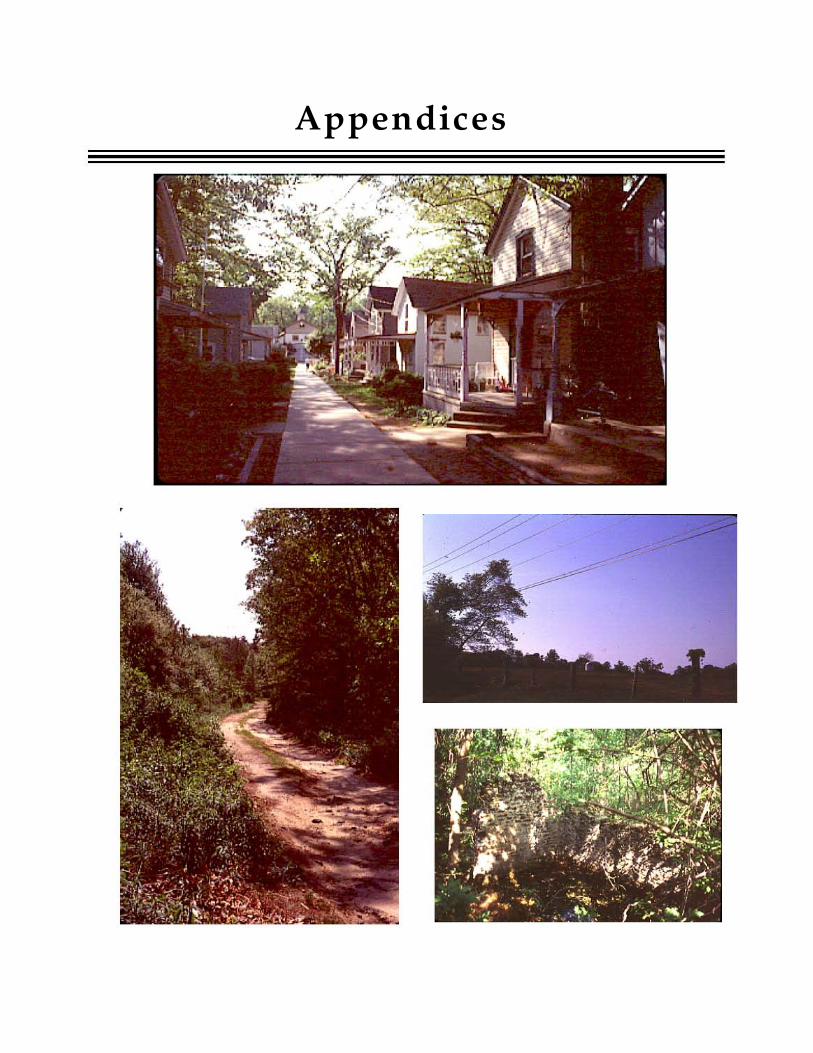
Appendices

Appendix A LIST OF LOCAL CONTACTS
ANJEC P.O. Box 157 Mendham, NJ 07945 201-539-7547
Gloucester County Soil Conservation District 72 East Holly Avenue, Suite 108 Pitman, NJ 08071 609-589-5250
Gloucester County Planning Department County Office Building N. Delsea Drive Clayton, NJ 08312 609-863-6661 Chuck Romick, Director
Gloucester County Parks and Recreation Department 6 Blackwood-Barnesboro Road Sewell, NJ 08080 609-468-0100 Rod Groff, Director Janet Eisenhauer, Open Space Coordinator
Delaware Valley Regional Planning Commission 111 South Independence Mall East Philadelphia, P A 19106 215-592-1800 Patty Elkis, Greenway Project Manager
Federation of Gloucester County Watersheds P.O. Box 233 Glassboro, NJ 08028 609-694-3681 Suzanne McCarthy, President
Mantua Creek Watershed Association
Appendices
P.O. Box 156 Glassboro, NJ 08028 609-58,2-9232 Paul Greger, President
South Jersey Land Trust 229 Lake Avenue Pitman, NJ 08071 609-589-2049 Dirk Van Nest, President
NJ Coalition of Lake Associations 21 Boardwalk Sparta, NJ 201-729-6156 Fran Smith, President
NJ Department of Environmental Protection Office of Environmental Planning CN418 Trenton, NJ 08625-0418 609-633-1179 Waterwatch Program 609-984-3588 Environmental Education 609-984-9802
Delaware Riverkeeper Network P.O. Box 326 Washington Crossing, PA 18977 215-369-1188 Fred Stine, Delaware Estuary Coordinator 609-854-5108 Pollution Hotline 1-800-8-DELA WARE
59
Appendix B LIST of GRANT OPPORTUNITIES
for FUNDING OPEN SPACE PLANNING and ACQUISITION
COUNTY 1. Gloucester County Open Space and Farmland Preservation Trust Fund Funds raised through the collection of a maximum tax of one cent per $100 of assessed valuation in any given year will be used to preserve open space and farmland. This funding, estimated at about $1 million per year, will supplement the county's continued active participation in the State's Farmland Preservation Program and Green Acres land acquisition program. Contact person is Janet Eisenhauer, Open Space Coordinator, Gloucester County Parks and Recreation Department, 609-468-0100
2. Public Lands Clean-Up Program Eli~ible awlicants: Volunteer Groups of 15 people or more with proof of liability Insurance Eli~ible projects: Litter clean-up and removal Maximum grant: $300 awarded to groups meeting above conditions that work for a minimum of three hours cleaning up litter along streams or roads or in parks. Program provides vests and trash bags Required match?: Labor Awlication Round: Ongoing throughout year Contact: Clean Communities Program, Gloucester County Parks and Recreation Department, Ann Seebold, 609-468-0100
STATE 1. New Jersey Green Acres Program Eli~ible awlicants: Municipalities and counties
Eli~ible projects: open space acquisition and outdoor recreational facility development Awlication Round: Applications typically due October 31 for that year of funding Project Cate~ories:
a. Standard Program - Offers 2% loans to finance eligible costs associated with the acquisition and development of recreation lands. Acquisitions are for the purchase of lands which may not possess inherently unique or sensitive natural resource characteristics, but which will serve as sites for active and/or passive open space recreation opportunities. Although there is no definite ceiling limit, proposals in excess of $500,000 are subject to additional criteria, such as project phasing or partial funding consideration.
b. Grants Incentive (Acquisition Only) - Offers 75% loans and 25% grants to finance up to 100% of eligible project costs. Proposals must meet one or more of the following criteria: environmental significance, historic significance, donations or waterfront parks.
c. Urban Aid Program - Funding is available in the form of75% loan and 25% grant. This category is limited to acquisition and development projects sponsored by local units eligible to receive state aid pursuant to P.L. 1978, c. 14
60 Upper Mantua Creek Greenway Implementation Plan

(C.52:27D-178 et seq.) Glassboro Borough is eligible.
d. Planning Incentive (PI): awards 25% grant and 75% loan funding to a municipality or county to acquire lands for recreation and conservation purposes identified in its Open Space and Recreation Plan (OSRP). In addition to an OSRP, the local government applicant must also have established and be collecting an open space tax pursuant to either N.J.S.A. 40:12-16 for a county or N.J.S.A. 19:37-1 et seq for a municipality to participate.
NOTE: Grants may be up to 50%, with 50% loans, depending on available funds each year
e. Nonprofit Organization Program: The Green Acres Program also runs Green Trust Funding Rounds for nonprofit charitable conservancies, subject to funding availability. The program offers 50% grants, with the match being made with cash or a donation of land. Maximum grants are $500,000.
f. Tax Exempt Program: Program provides exemption from local property taxes to eligible nonprofit organizations which own recreation or conservation lands and open their private lands to the public
Contact: Kathleen Z. Croes 609-984-0500
2. New Jersey Local Coastal Planning Grant Program Funds proj ects that promote sustainability and environmental protection in the coastal
Appendices
zone. The program is dependent on the availability offunds. For updated status of the grant program, call Dorrina Frizzera of the Coastal Planning Unit, Office of Environmental Planning, NJDEP, at 609~ 777-3251.
3. New Jersey Office of Environmental Planning Non-point Source Pollution Control and Management Implementation (Section 319(h» Grants) Eligible awlicants: Regional comprehensive planning or health organizations and coalitions of municipal, county governments andlor local or county environmental commissions, watershed and water resource associations, nonprofit organizations Eligible projects: a. Category I - Management Practices Projects that implement BMPs which have been proven to work either in the proposed proj ect area or in another area of similar environmental conditions
b. Category II - Education and Outreach to Critical Audiences Projects that provide mechanisms that teach people to implement BMPs or NPS Pollution Management Programs
Maximum grant: At least $850,000 will be available for State Fiscal Year 1999 Required Match: Funds in the amount equivalent to at least 20% of the total project amount required, and may consist of cash, in-kind services, or a combination of both Application Round: Pre-proposal submission deadline for FY 99 is February 27, 1998, complete proposals by April 17, 1998. Contact: Kimberly Cenno, Office of Environmental Planning at 609-292-2113
61
4. New Jersey Office of Environmental Services Matching Grants Program Eligible am>licants: Local environmental agencles Eligible projects: Projects that promote the protection of natural resources by documenting those resources, preparing policy recommendations to protect those resources, and by preparing and disseminating information about the ways in which the public can participate in protecting the environment. Examples of previously funded projects include natural resource inventories, water quality studies, master plan and zoning ordinance amendments, open space plans, greenway planning, and public education programs. Maximum grant: $2,500 ReQ.uired match?: Yes, at least 50% Am>lication Round: Typical deadline is early December for awards in following year Contact person: Dianne Shatin, Coordinator, 609-984-0828
5. NJDEP Clean Lakes Program Eligible am>licants: Municipal, county and regional government agencies Eligible projects: Projects that improve the recreational water quality at public lakes Maximum grant: Up to 70% USEP A funding for Phase I Diagnostic Feasibility Projects; up to 50% state funding for Phase I Diagnostic Feasibility Projects. Up to 50% USEP A funding for Phase II Implementation Projects; up to 75% state funding for Phase II Implementation Projects Am>lication round: typically September 1 each year Contact: Bud Cann, Supervising Environmental Specialist, Water Monitoring Management,609-292-0427
6. 1992 Dam Restoration and Inland Water Projects Loan Program Eligible Am>licants: Local governments, private lake associations and owners of private dams as co-applicants with a local government Eligible projects: Dam restorations, flood control projects, water pollution control projects and water related recreation and conservation projects Maximum grant: Low interest loans, generally 2% over 20 year period, are offered according to the program rules Am>lication round: Application periods are established periodically, depending on availability of revolving funds. The latest monies, $8.6 million, were appropriated in September 1996 and trust fund monies may not be available again for four years. Contact: Dam Safety Section, Engineering and Construction, 609-984-0859
7. National Recreational Trails Act Projects - Administered through NJDEP, Division of Parks and Forestry, Office of Natural Lands Management Eligible am>licants: public agencies and nonprofit organizations Eligible projects: Trail proposal must be located on land that is publicly owned or privately owned with a government agency holding an easement or lease for public access. Projects must be completed by August 31, 200 l. Maximum grant: $10,000 Match reQ.uired: 50%, may be cash or fair market value of labor or materials Application round: Varies yearly. Current deadline for submittals in April 1, 1998. Contact: Celeste Tracy; Office of Natural Lands Management, 609-984-1339.
62 Upper Mantua Creek Greenway Implementation Plan
FEDERAL 1. National Parks Service Rivers, Trails and Conservation Assistance Program Eligible aDPlicants: Community groups, municipalities, partnerships Eligible projects: Greenway plans, stream restoration, trail design, conservation workshops, inventories of natural, cultural and recreational resources Maximum grant: Staff involvement (technical assistance) rather than fmancial assistance Required match?: Projects are undertaken as partnerships, and costs are shared with other organizations. Cost-sharing arrangements may involve money and/or in-kind services. ADPlication Round: On-going assistance offered to applicants developing proposals, July deadline for formal application for assistance Contact: Robert Potter, Program Manager, 215-597-1787
2. Wetlands Reserve Program of the USDA Natural Resources Conservation Service (NRCS): Eligible applicants: Landowners (NRCS determines final eligibility) Eligible projects: Land with the potential to contribute to desired ecosystem functions and values fitting into one the following categories: agricultural lands with restorable wetlands, former or degraded wetlands occurring in range and forest production land, riparian areas that connect with protected wetlands along streams or other waterways, adjacent lands that will contribute significantly to the wetland functions and values, previously restored wetlands under a State or Federal restoration program, privately developed wetland areas meeting NRCS restoration standards Maximum grant: The program offers landowners three options to choose from
Appendices
when enrolling: a permanent easement, a 30 year easement, and a cost-share agreement in lieu of requiring an easement. Easement payment is for the agricultural value of the land, an established payment cap, or an amountoffered by the landowner. Restoration projects are fully funded by the NRCS for permanent and 30 year easements, and are funded 50 -75% for non-easement agreements. Required Match: 25-50% for non-easement agreements. Landowner is responsible for protecting and maintaining the wetlands within the boundaries of the easement. Public access to the easement area is not required. Acceptable uses of the land will be spelled out in detail and approved, and may include hunting, fishing, timber harvest, and haying or grazing, depending on the situation. Application round: Ongoing, open sign-up in New Jersey began October 1, 1996. Contact: Tim Dunne, Resource Conservationist, USDA, 908-735-0733
3. Environmental Protection Agency Environmental Education Grants Program Eligible aDPlicants: Government agencies, school districts, colleges or universities, nonprofit organizations, and noncommercial educational broadcasting entities Eligible activities: Include, but are not limited to: Training educators; designing and demonstrating field methods, educational practices and techniques, including assessing environmental and ecological conditions or specific environmental issues or problems; designing, demonstrating or disseminating environmental curricula; and fostering international cooperation in addressing environmental issues and problems in the U.S., Canada andlor Mexico.
63
Maximum Grant: Approximately $3 million available for FY 98; 25% of available funds must go to small grants of $5,000 or less, maximum limit of $250,000 for any single grant. Required Match: A minimum of 25% of total cost of project required AruJlication round: May vary yearly, was November 15, 1997. Contact: Nan Ides, Project Officer. Customer Service hotline: 1-800-438-2474
FOUNDATIONS 1. Conservation Foundation American Greenways Dupont Award Eligible applicants: Primarily nonprofit organizations, although individuals and local governments may apply Eligible projects: Mapping, assessments, surveying, conferences and design activities, printed and audio-visual interpretative materials, building paths or bridges and other creative projects Maximum grant: $2,500 Required Match? No Application Round: Applications typically due December 31 of each year Contact person: 703-525-6300
2. Dodge Foundation Eligible applicants: Non-profit organizations with 501 (c)(3) status Eligible projects: Projects that fit under the foundation's "Public Issues" category that focus on issues of sustainability, ecosystem preservation, energy conservation, pollution prevention and reduction, and environmental education and outreach that lead to enlightened environmental policy Maximum grant: Grants generally range from $10,000 to $100,000 Required Match? No Application Round: A one-page letter of inquiry by the applicant is encouraged to
determine if a project falls within the foundation's guidelines. Applications for Public Issues Grants must be post-marked by September 15 of each year. Contact: 201-540-8442
3. Environmental Endowment for NJ Eligible aruJlicants: Preference for nonprofits with 501(c)(3) designation, but other nonprofits also eligible Eligible projects: Research, litigation, public education and other activities that will promote the conservation, preservation and improvement of the air, land, water and other natural resources Maximum grant available: $20,000 Required Match? no Application Round: Typically announced in November with applications due in January Contact: Richard Sullivan, President, 609-737-9698
4. New Jersey Conservation Foundation Matching Mini Grant Program Eligible aruJlicants: Nonprofit organizations such as emerging land trust, citizen groups and greenway planning groups (organizations do not need nonprofit status) Eligible projects: land planning, land acquisition, conservation easements Maximum grant available: $5,000 Required Match? yes, 50% AruJlication Round: Typically announced in October or November, applications due 4 to 6 weeks after announcement Contact: Beth Davisson 908-234-1225
5. Pew Charitable Trust Eligible applicants: Organizations classified as non,;profit under section 501(c)(3) of the IRS Code, and as charitable under 509(a) of that Code Eligible projects: Projects whose goals are to reduce the use and production of highly
64 Upper Mantua Creek Greenway Implementation Plan
persistent toxic substances that adversely affect the environment and public health, and projects that halt the destruction and further degradation of forest and marine ecosystems in North America Maximum ~rant: Majority of grants range from $50,000 to $250,000 Required match? No Awlication Round: Proposals accepted year round and reviewed on rolling basis Contact: Nahed Danial, 215-575-4744
6. Schumann Fund for New Jersey Eli~ible am>licants: Non-profit organizations with 501(c)(3) status Eli~ible projects: Projects that support protection of natural resources, environmental quality and wildlife. Maximum lUant: No maximum was stated in the foundation's annual report, but previous environmental protection grants ranged from $10,000 to $80,000 Required match?: No, but preference given to proposals indicating a high level of time and/or money contributed from the group to be served Awlication Round: No yearly deadline; proposals are reviewed quarterly Contact: 201-509-9883
7. Victoria Foundation Eli~ible applicants: Non-profit organizations with 501 (c)(3) status Eli~ible projects: For land acquisitionprojects must be eligible for consideration by the State Green Acres Program, must have passed their initial screening process and must be in active consideration by Green Acres. Special consideration is given to proj ects that will protect wetlands and transition areas, farmland, critical wildlife habitats, headwaters, exceptional ecosystems, watershed lands, and aquifer
Appendices
recharge areas. Other eligible projects involve environmental education and leadership training, environmental research, public education and advocacy, and resource conseryation in New Jersey .. Maximum ~rant: Land Acquisition - grants may be used toward all or part of the 50% match for Green Acres grants, usually up to $500,000. Other projects generally range from $8,000 to $50,000 Required match?: Land acquisition - Green Acres grant; Other grants - No Awlication Round: Ongoing Contact: Nancy Zimmerman, 201-783-4450
8. William Penn Foundation Eli~ible awlicants: Non-profit organizations with 501(c)(3) status Eli~ible projects: Projects that support the goals of promoting open space preservation, promoting development, maintenance and use of natural areas within Philadelphia, and that support environmental education Maximum ~rant:? Required match?: No, but the Foundation prefers to make grants for projects that receive support from several sources and that do not dependent upon the Foundation for total funding Application Round: Accepts grant requests throughout the year. Contact: 215-988-1830
Other sources of information on grants:
Environmental Grant Makin~ Foundations, published by Resources for Global Sustainability, P.O. Box 22770, Rochester, NY 14692-2770. Telephone: 1-800-724-1857; Fax: 716-473-0968; e-mail: [email protected]; website: http:/home.eznet.netl~rgs. Costs about $90
65
The Mitchell Guide to NJ Foundations, published by Janet Mitchell, 430 Federal City Road, Pennington, NJ 08534-4209, 609-737-7224. The guide profiles 412 private foundations which donated more than $200 million to 18,000 charitable agencIes.
66 Upper Mantua Creek Greenway Implementation Plan
Appendix C EXAMPLES OF STEW ARDSIDP BROCHURES
Much has been written about good land stewardship. The following materials have been included as examples of stewardship information designed for easy reproduction and dissemination. These flyers and pamphlets were developed, respectively, by:
1) The Washington Township Environmental Commission. A portion of the booklet is reproduced here. For a copy of the entire booklet, contact the Commission at P.O. Box 1106, Turnersville, NJ 08012, or cal'l the township municipal building at 609-589-0520
2) The Media Area League of Women Voters in cooperation with the Darby Creek Valley Association and the ChesterlRidley/Crum Watersheds Associations;
3) The New Jersey Coalition for Alternatives to Pesticides and the NJ Envionmental Federation, with printing costs funded by Whole Earth Center;
4) Jennifer Robinson, compiled from a 1994 newsletter of the Wildlands Conservancy, Emmaus, Pennsylvania
Another excellent source of information too lengthy to include here is "The Clean Water Book - Lifestyle Choices for Water Resource Protection" produced by the NJ Department of Environmental Protection, Office of Environmental Planning. Copies of this booklet can be obtained by calling Kyra Hoffman at 609-633-1179.
Appendices 67

TkStreams o/"Washington Township
fj3ufferill!l 'Ifie Stream Corridor
The best protection for a stream is to be surrounded with a good buffer area of woods, shrubs, wetlands and grasses. The less "groomed" this buffer area is, the more it can perform its normal functions:
• protecting the banks from erosion; • storing water and filtering it to ground water; • removing sediment and excess nutrients~ • filtering out pollutants; • shading and cooling the stream; • providing organic debris for the stream's food chain.
Ideally, the buffer should be a minimum of 50 feet wide on each side of the stream, with a variety of plants on gently sloping banks. Every effort should be made to maintain the natural vegetation within the buffer area, including grasses, flowers and shrubs. Trees planted at the top of the bank provide vital shade as well as erosion control.
Native Tree Species for Washington Stream Banks
Trees for higher areas Alder Red Maple Black Willow Sweet Gum White Ash
Trees for top of bank Red Oak Tulip Poplars White Oak Black Locust
13
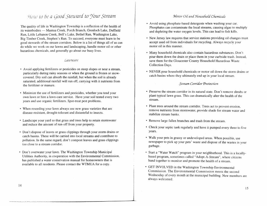
a (iood"-Ste'l()ard" to Your -Stream
The quality of life in Washington Township is a reflection of the health of its waterbodies - Mantua Creek, Porch Branch, Grenloch Lake, Duffield Run, Little Lebanon Creek, Bell's Lake, Bethel Run, Washington Lake, Big Timber Creek, Stephen's Run. To succeed, everyone must learn to be good stewards of the stream corridors. Below is a list of things all of us can do while we work on our lawns and landscaping, handle motor oil or other hazardous chemicals, and generally go about our busy lives.
Lawncare
• A void applying fertilizers or pesticides on steep slopes or near a stream, particularly during rainy seasons or when the ground is frozen or snowcovered. Dry soil can absorb the rainfall, but when the soil is already saturated, additional rainfall will nm off, carrying with it nutrients from the fertilizer or manure.
• Minimize the use of fertilizers and pesticides, whether you tend your own lawn or hire a lawn-care service. Have your soil tested every two years and use organic fertilizers. Spot-treat pest problems.
• When reseeding your lawn always use new grass varieties that are disease-resistant, drought-tolerant and distasteful to insects.
• Landscape your yard so that grass and trees help to retain storm water and reduce the amount of run-off from your property.
• Don't dispose of leaves or grass clippings through your storm drains or catch basins. These will be carried into local streams and contribute to pollution. In the same regard, don't compost leaves and grass clippings too close to a stream corridor.
• Don't overwater your lawn. The Washington Township Municipal Utilities Authority, in cooperation with the Environmental Commission, has published a water conservation manual for homeowners that is available to all residents. Please contact the WTMUA for a copy.
14
f i I I
Motor Oil and J{ou..seho{d" Chernicars
• A void using phosphate-based detergents when washing your car. Phosphates can contaminate the local streams, causing algae to multiply and depleting the water oxygen levels. This can lead to fish kills.
• New Jersey law requires that service stations providing oil changes must accept used oil from individuals for recycling. Always recycle your motor oil in this manner. .
• Many household chemicals also contain hazardous substances. Don't pour them down the drain or place them in your curbside trash. Instead, save them for the Gloucester County Household Hazardous Waste Collection Days.
• NEVER pour household chemicals or motor oil down the storm drains or catch basins where they ultimately end up in your local stream.
Stream Com'cfor Protection
• Preserve the stream corridor in its natural state. Don't remove shrubs or plant typical lawn grass. This can dramatically alter the health of the stream.
• Plant trees around the stream corridor. Trees act to prevent erosion, remove nutrients from storm water, provide shade for stream water and stabilize stream banks.
• Remove large fallen branches and trash from the stream.
• Check your septic tank regularly and have it pumped every three to five years.
• Walk your pets in grassy or undeveloped areas. When possible, use newspaper to pick up your pets' waste and dispose of the wastes in your garbage.
• Start a "Water Watch" program in your neighborhood. This is a locallybased program, sometimes called "Adopt-A-Stream", where citizens band together to monitor and promote the health of a stream.
GET INVOL VED in the Washington Township Environmental Commission. The Environmental Commission meets the second Wednesday of every month at the municipal building. New members are always welcomed.
15
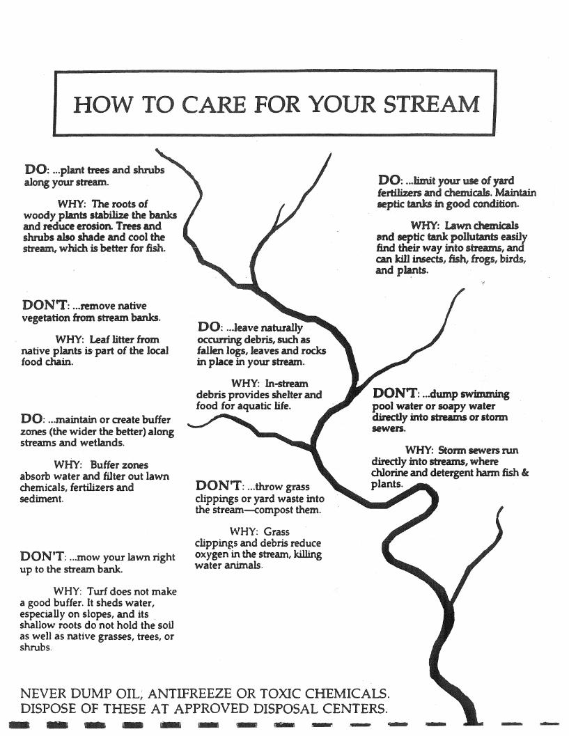
HOW TO CARE FOR YOU
DO: ... plant trees and shrubs along your stream.
WHY; The roots of woody plants stabilize the banks and reduce erosion Trees and shrubs also shade and cool the stream,wt-Jch is better fOTom.
DON'T: ... remove native vegetation from stream banks.
WHY: Leaf litter from nativeplmts is' part of the local food chain.
DO: ... maintain or create buffer zones (the wider the better) along streams and wetlands.
WHY: Buffer zones absorb water and filter out lawn chemicals, fertilizers and sediment.
DON'T: ... mow your lawn right up to the stream. bank.
WHY: Turf does not make a good buffer. It sheds water, especially on slopes, and its. shallow roots do not hold the soil as well as native grasses, trees, or shrubs.
DO: .. .leave naturally occurring debris, such as fallen logs, leaves and rocb in place in yoW" stream.
WHY: m-stream debris provides shelter and food for aquatic life.
DONtT: ... throw grass clippingS or yard waste into the stream--compost them.
\VHY: Grass clippings and debris reduce oxygen in the stream, killing water animals.
STREAM
DO: ... limit your use of yard lertiliz.ers and chemiaJs. Maintain leptic tanks in good condition.
WHY: lAwn chemicals !lnd leptic tank pollutants easily find their way into streams, and am kill insects, fish, frogs, birds, and plants.
DONT: ... dump swimming pool water or soapy water directly into streams or storm sewers.
WHY: Stonn sewers nm directly into mearns, where chlorine and detergent harm fish « plants.
NEVER DUMP OIL; ANTIFREEZE OR TOXIC CHEMICALS. DISPOSE OF THESE AT APPROVED DISPOSAL CENTERS. - -
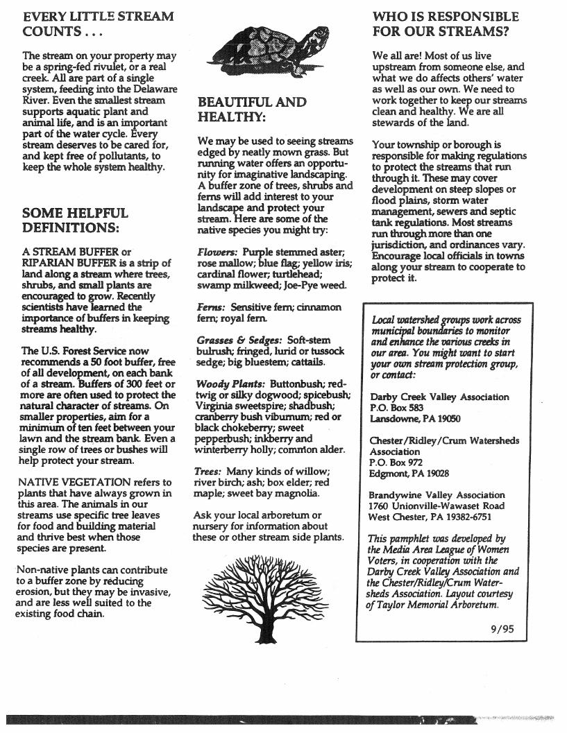
EVERY LITTLE STREAM COUNTS .•.
The stream on your property may be a spring-fed rivulet, or a real creek. All are part of a single system, feeding into the Delaware River. Even the smallest stream supports aquatic plant and animal life, and is an important part of the water cycle. Every stream deserves to be cared for, and kept free of pollutants, to keep the whole system healthy.
SOME HELPFUL DEFINITIONS:
A STREAM BUFFER or· RIPARIAN BUFFER is a strip of land along a stn!am where trees, shrubs, and small plants are encouraged to grow. Recently scientists have learned the importance of buffers in keeping streams healthy.
The U.S. Forest Service now recommends a 50 foot buffer, free of all deVelopment, on each bank ola stream. Buffers of 300 feet or more are often used to protect the natural character of streams. On smaller properties, aim for a minimUm of ten feet between your laWn and the stream bank. Even a single row of trees or bushes will help protect your stream.
NA TIVE VEGETATION refers to plants that have always grown in this area. The animals in our streams use specific tree leaves for food and building material and thrive best when those species are present.
Non-native plants can contribute to a buffer zone by reducing erosion, but they may be invasive, and are less well suited to the existing food chain.
BEAUTIFUL AND HEALTHY:
We may be used to seeing streams edged by neatly mown grass. But running water offers an opportunity for imaginative landscaping. A buffer zone of trees, shrubs and ferns will add interest to your landscape and protect your stream. Here are some of the native species you might try:
Flowers: Purple stemmed aster; rose mallow; blue flag; yellow iris; cardinal flower; turtlehead; swamp milkweed; Joe-Pye weed.
Ferns: Sensitive fern; cinnamon fern; royal fern.
GrlUsa & Sedges: Soft-stem bulrush; hinged, lurid or tussock sedge; big bluestem; cattails.
Woody PlIants: Buttonbush; redtwig or silky dogwood; spicebush; Virginia sweetspire; shadbush; aanberry bush viburnum; red or black chokeberry; sweet pepp~ush; inkberry and winterberry holly; comn\on alder.
Trees: Many kinds of willow; river birch; ash; box elder; red maple; sweet bay magnolia.
Ask your local arboretum or nursery for.information about these or other stream side plants.
WHO IS RESPONfiIBLE FOR OUR STREAMS?
We all are! Most of us live upstream from someone else, and what we do affects others' water as well as our own. We need to work together to keep our streams clean and healthy. We are all stewards of the land.
Your township or borough is responsible for making regulations to protect the streams that run through it These may cover development on steep slopes or flood plains, storm water management, sewers and septic tank regulations. Most streams run through more than one jurisdiction, and ordinances vary. Encourage local officials in towns along your stream to cooperate to protect it.
Local Wlltershed groups work IlCTOSS municiptll boundaries to monitor and en1umce the "Otl7'itms creeks in our artII. You might want to start your own stream protection group, oreontact:
Darby Creek Valley Association P.O.BoxS83 Lansdowne, PA 19ffiO
Chester /Ridley /Crum Watersheds Association P.O. Box 972 Edgmont, PA 19028
Brandywine Valley Association 1760 Unionville-Wawaset Road West Chester, PA 19382-6751
This pamphlet was developed by the Medill Area League of Women Voters, in cooperation with the Darby Creek Valley Association and the Chester/Ridley/Crum Watersheds Association. Layout courtesy of Taylor Memorial Arboretum.
9/95
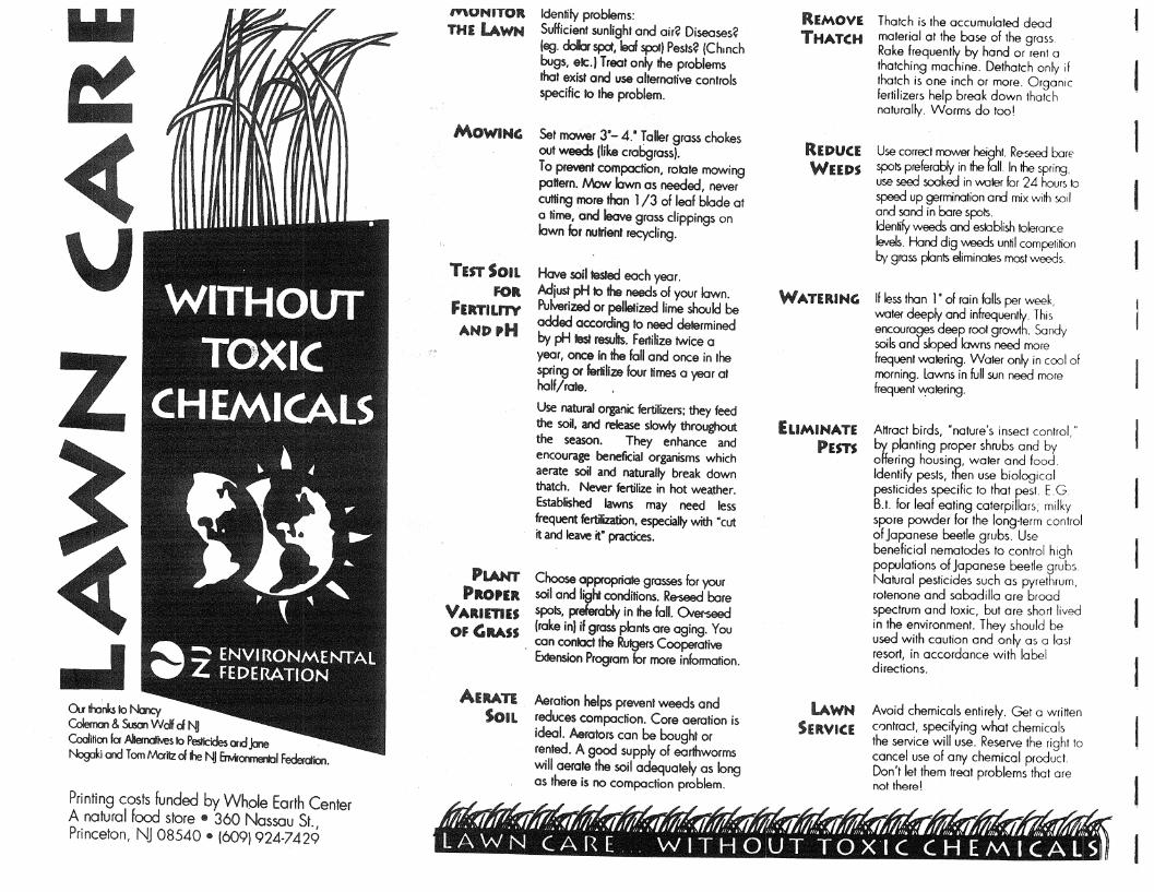
w.I
~
v z
au 1honb 10 t-mcy Coleman & Sum wdf d "II CoaIiIioo fa AlterndNes 10 Peslicides and,lCl1e Noglki and TomMaitzd~ NJ Enw~ Federdion.
Printing costs funded by Whole Earth Center A natural food store • 360 Nassau St., Princeton, NJ 08540 • (6091924-7429
",UNITOR THE LAWN
MOWING
TEST SOIL FOR
FERTILI1Y AND pH
Identify problems: Sufficient sunlight and air? Diseases? leg. deb spct, leaf spaI) Pests? IChmch bugs, ale.) Treat only the problems that exist and use alternative conlrols specific to the problem.
Set ITIO\Ner 3"- 4." Toller gross chokes oul weeds Ikkecrabgross). To pre'J8l1f compaction, rotole mowing pattern. Now lawn as needed, never cutting more than 1/3 of leaf blade 01 a time,<Jnd Ieove gross clippings on lawn for nutrient recycling.
Hove soil tested each year. Adjust pH 10 the needs of your lawn. PuJ.Jerized or pelletized lime should be added according 10 need determined by pH fest resuhs. Fertihze twice a year, once In the fall and once in the spring or fertilize four times a year 01 half/rate.
Use naturaJ organic fertilizers; they feed the soil. and release slowly throughout the season. They enhance and encourage beneficial organisms which aerate soil and naturally break down thatch. Never fertilize in hot wea,ther. Established lawns may need less frequent fertilization. especially with ·cut it and ~ it" practices.
PLANT Choose appropriate grasses for your PROPER soil and light conditions. Reseed bare
VARlmEl spots, preferably in the fall. o..er-seed OF GRASS lrake inl if grass plants are aging. You
. con contocl the Rutgers Cooperative Extension Program for more information.
AERATE Aeration helps prevent weeds and SoiL reduces compaction. Core aeration is
ideal. Aerators can be boughl or rented. A good supply of earthworms will aerate the soil adequately as long as there is no compaction problem.
REMOVE THATCH
REDUCE WEEDS
WATERING
ELIMINATE PEm
LAWN SERVICE
Thatch is the accumulated dead material at the base of the grass. Rake frequently by hand or rent a thatching machine. Dethatch only if thotch is one inch or more. OrganiC fertilizers help break down thatch naturally. Worms do too!
Use correct mower height. Re-seed barE' spol5 preferably in the fall. In the sprirg, use seed sooked in v.oter for 24 hours to speed up germination and mix with soil and sand in bare spol5. Identify weeds and establish tolerarce levels. Hand dig v-.-eeds until competition ~, glOss pIonl5 eliminates most weeds
If less than l' of rain foIls per week, v.oter deeply and infrequently. This encourages deep root growth. Sandy soils and sloped lawns need more frequent v.otering. Waler only in cool of morning. lawns in full sun need more frequent ~tering.
Attract birds, "nature's insect control,· by plonting proper shrubs and by offering hOUSing, water and food. Identify pests, then use biological pesticides specific to that pest. E. G B.t. for leaf eating caterpillars; milky spore powder for the long-term control of Japonese beetle grubs. Use beneficial nematodes to control high populations of Japanese beetle grubs. Natural pesticides such as pyrethrum. rotenone and sabadilla are broad spectrum and toxic, but are short lived in the environment. They should be used with caution and only as a last resort, in accordance with label directions.
Avoid chemicals entirely. Gel a written contract, specifying what chemicals the service will use. Reserve the right to cancel use of any chemical product. Don't let them treat problems that are not there!
Illr: 0;(1,((.; (Iif(:.; (IJI':.; HI llr:.; (Iiir:.;{f; i1!:.;, 1ft:. <flJiI!: -:,,,1;1;. -:HI M:. .;("M:. .;, 1M:. .;, ;n .;?fti1d:. .;~ ~ LAWN CARE .. WITHOUT TOXIC CHEMICALS
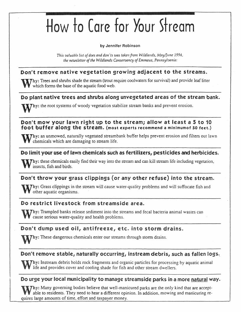
How to (are for Your Shearn by Jennifer Robinson
This valuable list of does and don'ts was taken from Wildlallds, May/June 1994, the newsletter of the Wildlands Conservancy of Emmaus, Pennsylvania:
Don't remove native vegetation growing adjacent to the streams.
Why: Trees and shrubs shade the stream (trout require cool waters for survival) and provide leaf liner which fonTIS the base of the aquatic food web.
Do plant native trees and shrubs along unvegetated areas of the stream bank.
Why: the root systems of woody vegetation stabiiize stream banks and prevent erosion.
Don't mow your lawn right up to the stream; allow at least a 5 to 10 foot buffer along the stream. (most experts recommend a mlnlmumof 50 feet.)
Why: an unmowed, naturally vegetated stream bank buffer helps prevent erosion and filters out lawn chemicals which are damaging to stream life.
Do limit your use of lawn chemicals sUch as fertilizers, pesticides and herbicides.
Why: these chemicals easily find their way into the stream and can kill stream life including vegetation. insects, fish and birds.
Don't throw your grass clippings (or any other refuse) into the stream.
Why: Grass c.lippings. in the stream will cause water-quality problems and will suffocate fish and other aquatIc organIsms. '
Do restrict'livestock from streams ide area.
Why: Trampled banks release sediment into the streams and fecal bacteria animal wastes can cause serious water-quality and health problems.
Don't dump used oil, antifreeze, etc. into storm drains.
Why: These dangerous chemicals enter our streams through stonn drains.
Don't remove stable, naturally occurring, instream debris, such as fallen logs ..
Why: Instream debris holds rock fragments and organic particles for processing by aquatic animal life and provides cover and cooling shade for fish and other stream dwellers.
l Do urge your local municipality to manage streamside parks in a more natural way.
Why: Many governing bodies believe that well-manicured parks are the only kind that are acceptable to residents. They need to hear a different opinion. In addition. mowing and manicuring re
quires large amounts of time. effort and taxpayer money. ,~------'---<----=----------'
I . NATURAL LANDS MANAGEMENT I
CAUTIONS AND RESTRICTIONS ON NATURAL HERITAGE DATA
The quantity and quality of data collected by the Natural Heritage Program is dependent on the research and observations of many individuals and organizations. Not all of this information is the result of comprehensive or site-specific field surveys. Some natural areas in New Jersey have never been thoroughly surveyed. As a result, new locations for plant and animal species are continuously added to the data base. Since data acquisition is a dynamic, ongoing process, the Natural Herttage Program cannot provide a definitive statement on the presence, absence, or condition of biological elements in any part of New Jersey. Information supplied by the Natural Heritage Program summartzes existing data known to the program at the time of the request regarding the biological elements or locations in question. They should never be regarded as final statements on the elements or areas being considered, nor should they be substituted for on-site surveys required for environmental assessments. The attached data is provided as one source of information to assist others in the preservation of. natural diversity.
This office cannot provide a letter of interpretation or a statement addressing the classification of wetlands as defined by the Freshwater Wetlands Act. Requests for such determination should be sent to the DEP Land Use Regulation Program, eN 401, Trenton, NJ 08625-0401.
This cautions and restrictions notice must be included whenever information provided by the Natural Heritage Database is published.
N.J. Department of Environmental Protection Division of Parks & Forestry

Bibliography
Association of New Jersey Environmental Commissions, "Protecting Our Streams," 1992.
Boyer, John, former Chair of Washington Township Environmental Commission, telephone conversation winter 1997.
Bucks County Planning Commission, "Wetlands in Coastal Zone Areas of Bucks County", 1994.
Coughlin, Bill, Washington Township Environmental Commission and Washington Nature Center, numerous conversations 1996-1998.
Delaware Riverkeeper Network, "Toxic Fish Alert", April 18, 1997.
Delaware Valley Regional Planning Commission, Guiding Regional Growth -Land Use Element of the DVRPC Year 2020 Plan, July 1995.
DeVasto, Victor, District Manager, Gloucester County Soil Conservation District, telephone conversation March 7, 1997.
Dixon, Robert, Executive Director, Gloucester County Utility Authority, telephone conversations Spring 1997 and correspondence April 30, 1997.
Division of Water Quality, Bureau of Permit Management, New Jersey Department of Environmental Protection, list of dischargers to the Mantua Creek, February, 1996.
Bibliography
Duffield, Dave, Mantua Creek resident, telephone conversations spring 1997 and January 1998.
Eisenhauer, Janet, Gloucester County Open Space Coordinator, numerous conversations, 1996-1998.
Funaro, Dennis, Waetzman Planning Group, Mantua Township Planning Consultant, telephone conversations spring 1997 and January 1998.
Glassboro Borough Master Plan, Zoning and Land Use Regulations
Gloucester County Farmland Preservation. Open Space Protection and Recreational Needs Study, July 1997
Gloucester County, "Procedures for Implementation of the County Open Space and Farmland Preservation Program," November, 1997.
Gloucester County Planning Department, Still Run Watershed Stormwater Management Plan Final Report, February 1994.
Gloucester County Utility Authority, Draft Wastewater Management Plan, September 1993.
Green Acres Program, New Jersey Department of Environmental Protection, New Jersey Open Space and Outdoor Recreation Plan, 1994.
75
Greger, Paul, President, Mantua Creek Watershed Association, Washington Township Environmental Commission, and Glassboro Borough Engineer, numerous conversations 1996-1998.
Groff, Mandy and Wayne, Mantua Creek residents, several conversations 1997-1998.
Hall, Wayne, Mantua Creek resident, telephone conversation March 21, 1997.
Howe, Linda, Keeping our Garden State Green: A Local Government Guide for Greenway and Open Space Planning, Association of New Jersey Environmental Commissions, 1989.
Louis Berger and Associates, Inc., Model Stream Corridor Protection and Management Overlay Zone Ordinance, July 1994.
Mantua Township Master Plan and Land Development and Use Regulations
McCarthy, Suzanne, President, Gloucester County Federation of Watersheds, numerous conversations, 1996-1998.
Michael, Joan B., Librarian, Historical Society of Washington Township, Historical Reference Materials.
Montgomery County Planning Commission, Riparian Corridor Overlay District Model Ordinance, 1996.
Moyle, John, Chief, Dam Safety Section, New Jersey Department of Environmental Protection, telephone conversations spring 1997.
New Jersey Department of Environmental Protection and Department of Agriculture, Stormwater and Nonpoint Source Pollution Control Best Management Practices Manual. December 1994.
New Jersey Department of Environmental Protection, Surface Water Quality Standards N.J.A.C. 7:9B, April 1994.
New Jersey Department of Environmental Protection, Storet Retrieval, Water Quality Data for the Mantua Creek, retrieved February 21, 1996.
New Jersey Department of Environmental Protection, Waterwatch Program, Water Watch Field Guide, 1987.
New Jersey Department of Environmental Protection, "Watershed Focus", Winter 1996.
New Jersey Department of Environmental Protection, "The Dry Facts - Building Near Wetlands" brochure. .
New Jersey State Planning Commission, Communities of Place-The New Jersey State Development and Redevelopment Plan. Reexamination Report and Preliminary Plan, June 25, 1997.
Office of Natural Lands Management, Division of Parks and Forestry, New Jersey Department of Environmental Protection, Draft New Jersey Trails Plan, February, 1995.
Office of Land and Water Planning, New Jersey Department of Environmental Protection, New Jersey State Water Quality Inventory Report, 1992 and 1994.
76 Upper Mantua Creek Greenway Implementation Plan

Office of Natural Lands Management, Division of Parks and Forestry, NJ Department of Environmental Protection, ''Natural Heritage Data", 1996.
Office of New Jersey Heritage, Division of Parks and Forestry, Department of Environmental Protection, New Jersey and National Re~isters of Historic Places. 1988 and Addendum 1992.
Pennsylvania Department of Environmental Protection, "Water Pollution Control in Pennsylvania Fact Sheet", 1996.
Pitman Borough Master Plan, Zoning and Land Development Ordinance
Schwarz, Loring LaB., editor, Flink, Charles A., and Seams, Robert M., authors, Greenways-A Guide to Plannin~. Desi~n. and Development, The Conservation Fund, Island Press: Washington, DC, 1993.
Taylor, Jill, Naturalist, Scotland Run Nature Center, telephone conversation winter, 1997.
Todd, Jay, Manager, Pitman Borough, telephone conversations winter 1997.
Warrick, Joby. ''New Rules are Offered on Use of Wetlands," Philadelphia Inquirer, February, 2, 1998.
Washington Township Master Plan, Zoning Ordinance and Land Development Ordinance.
Washington Township Environmental Commission, Open Space Inventory and Conservation Report, March 1995.
Bibliography
Washington Township Environmental Commission, Surface Water Quality Report, March 1995.
Washington Township Environmental Commission, Environmental Resources Inventory, 1991.
Westagaard, Rick, Environmental Planner, Gloucester County Planning Department, conversations 1996-1998.
Yeats, Jim, Gloucester County Farmland Preservation Coordinator, telephone conversations 1996-1997.
77

Related Documents


