Upper Kennebec Region Management Plan View from US 201DOT rest stop toward Attean Pond (center) and No. 5 Bog (center left) with Attean Mountain in the middle background. Maine Department of Agriculture, Conservation and Forestry Bureau of Parks and Lands June 2019

Welcome message from author
This document is posted to help you gain knowledge. Please leave a comment to let me know what you think about it! Share it to your friends and learn new things together.
Transcript

Upper Kennebec Region
Management Plan
View from US 201DOT rest stop toward Attean Pond (center) and No. 5 Bog (center left) with
Attean Mountain in the middle background.
Maine Department of Agriculture, Conservation and Forestry
Bureau of Parks and Lands
June 2019


.

i
Table of Contents I. Introduction .............................................................................................................................. 1
About this Document .................................................................................................................. 1
What is the Upper Kennebec Region? ........................................................................................ 1
The Lands of the Upper Kennebec Region ................................................................................. 2
Acquisition History ..................................................................................................................... 3
II. The Planning Process and Resource Allocation System....................................................... 6
Statutory and Policy Guidance.................................................................................................... 6
Public Participation and the Planning Process ............................................................................ 6
Summary of the Resource Allocation System ............................................................................ 8
Forest Certification ..................................................................................................................... 9
III. Planning Context .................................................................................................................. 10
Conservation Lands and Public Recreation Resources in the Upper Kennebec Region .......... 10
Recreation Resources ............................................................................................................ 10
Other Recreation Opportunities in the Upper Kennebec Region .......................................... 15
Moosehead Lake Region Concept Plan and Conservation Easement Lands ........................ 15
Other Major Conservation Lands in the Region ................................................................... 16
Maine Residents’ Participation in Outdoor Recreation Activities and Visitation to Public Reserved Lands and State Parks ............................................................................................... 16
Summary of Planning Implications .......................................................................................... 17
IV. Resources and Management Issues for Lands in the Upper Kennebec Region ............. 18
General Management Focus ..................................................................................................... 18
Holeb Unit ................................................................................................................................. 19
Character of the Land Base ................................................................................................... 19
Natural Resources ................................................................................................................. 20
Wildlife and Fisheries Resources .......................................................................................... 22
Historic and Cultural Resources ........................................................................................... 25
Access ................................................................................................................................... 25
Recreation and Visual Resources .......................................................................................... 26
Timber Resources - West Section ......................................................................................... 30
Timber Resources – East Section ......................................................................................... 32
Management Issues, Concerns and Opportunities ................................................................ 33
Administrative Issues ............................................................................................................ 35

ii
Vision for the Holeb Unit ..................................................................................................... 36
Resource Allocations for the Holeb Unit .............................................................................. 37
Management Recommendations for the Holeb Unit ............................................................ 42
Cold Stream Forest Unit ........................................................................................................... 43
Character of the Land Base and Acquisition History ........................................................... 43
Natural Resources ................................................................................................................. 43
Wildlife and Fisheries Resources .......................................................................................... 45
History and Culture ............................................................................................................... 47
Access ................................................................................................................................... 47
Recreation Resources ............................................................................................................ 47
Timber Resources ................................................................................................................. 52
Management Issues, Concerns and Opportunities ................................................................ 52
Administrative Issues ............................................................................................................ 54
Resource Allocations for the Cold Stream Forest Unit ........................................................ 56
Management Recommendations for the Cold Stream Forest Unit ....................................... 61
Sandy Bay Unit ......................................................................................................................... 63
Character of the Land Base and Acquisition History ........................................................... 63
Natural Resources ................................................................................................................. 63
Wildlife and Rare Animal Species ........................................................................................ 65
Access ................................................................................................................................... 65
Recreation and Visual Resources .......................................................................................... 65
Timber Resources ................................................................................................................. 65
Management Issues, Concerns and Opportunities ................................................................ 67
Vision for the Sandy Bay Unit .............................................................................................. 68
Resource Allocations for the Sandy Bay Unit ...................................................................... 68
Management Recommendations for the Sandy Bay Unit ..................................................... 72
Smaller Public Lots ................................................................................................................... 73
Dennistown Plantation Lot ................................................................................................... 73
Moose River North and South Lots ...................................................................................... 74
Bradstreet Township South Lot ............................................................................................ 76
Upper Enchanted Twp. (Coburn Mountain) Lot................................................................... 78
Johnson Mountain and West Forks Northeast Lots .............................................................. 81
West Forks Plantation Northwest, Central and Southwest Lots ........................................... 83
Moxie Gore and The Forks Plantation North Lots ............................................................... 85

iii
The Forks Plantation South and Caratunk North Lots .......................................................... 87
Bald Mountain (Moxie Bald) Lot ......................................................................................... 89
Caratunk South and East Lots ............................................................................................... 91
Highland Plantation East and Pleasant Ridge Lots ............................................................... 93
Resource Allocations for the Smaller Lots ........................................................................... 96
Summary of Resource Allocations on the Smaller Public Lots ............................................ 98
Management Recommendations for the Smaller Lots ........................................................ 110
V. Monitoring and Evaluation ................................................................................................. 112
Implementation of Plan Recommendations ............................................................................ 112
Recreation ............................................................................................................................... 112
Wildlife ................................................................................................................................... 113
Timber Management ............................................................................................................... 113

iv
Appendices
A. Public Consultation Process
• Advisory Committee Members
• Public Consultation Summary
• Public Comments and Bureau Responses B. Guiding Statutes and Agreements
• MRSA Title 12
• Cold Stream Forest Reciprocal Easement Agreement
• Cold Stream Forest Fisheries Habitat Management Agreement
• Cold Stream Forest Deer Wintering Area Habitat Management Agreement C. Summary of BPL’s Resource Allocation System - Criteria and Management Direction D. Upper Kennebec Plan Area Forest Stocking and Sustainable Harvest Levels E. Glossary F. References
v
Acknowledgements
The Upper Kennebec Region Management Plan was prepared through a collaborative effort involving contributions from the following Bureau of Parks and Lands staff: Jim Vogel – Management Plan Coordinator Peter Smith – Regional Manager, Western Region (through 6/18/18) Doug Reed – Regional Manager, Western Region (6/21/18 through 11/30/18) Tim Post – Acting Regional Manager, Western Region (beginning 12/3/18) Marc Albert – Forester, Western Region Jeff Bartley – Forester, Western Region Rex Turner – Outdoor Recreation Planner Tom Charles – Chief of Silviculture Joe Wiley – MDIF&W Wildlife Biologist assigned to the Bureau (through 8/31/16) Nate Webb – MDIF&W Wildlife Biologist assigned to the Bureau (3/13/17 through 5/6/18) Sarah Spencer – MDIF&W Wildlife Biologist assigned to the Bureau (beginning 8/20/18) Brian Bronson – ORV Program ATV Coordinator Joe Higgins – ORV Program Snowmobile Coordinator Gena Denis – Geographic Information System Coordinator The Bureau also acknowledges the helpful participation of the Upper Kennebec Region Management Plan Advisory Committee, and the members of the public who participated in public meetings held during preparation of this Plan and submitted comments on the Plan (see Appendix A for more details on the public consultation process).

vi
1
I. Introduction
About this Document This document constitutes a fifteen-year Management Plan (the Plan) for more than 43,000 acres of Public Reserved land in the Upper Kennebec Region, managed by the Maine Bureau of Parks and Lands (the Bureau). This is the first regional management plan addressing this assemblage of Public Reserved Lands management units and lots. It will replace the 1989 Management Plan for the Holeb Public Reserved Lands and the 1978 Management Plans for two smaller units, the Dennistown Plantation and Caratunk Public Reserved Lands. It will also cover the Sandy Bay Public Reserved Land and several additional smaller Public Reserved land units. The Plan includes background information about the planning process and the regional context of the Plan. The core of the Plan is a description of the character and resources of the units, a Vision for the future of each major unit, and management allocations and recommendations. One objective of the regional plan is to provide a balanced spectrum of opportunities across the Region, and in keeping with the opportunities and resources available in the broader surrounding Upper Kennebec Region. In developing the management recommendations for the reserved lands and undeveloped park lands, the Bureau has been mindful of this broader perspective. The Upper Kennebec Region Management Plan is a commitment to the public that the Public Reserved lands in the Region will be managed in accordance with the Bureau’s mission and goals, and within prescribed mandates. Revisions to the Plan commitments will occur only after providing opportunities for public comment. The Management Plan will also serve as guidance to the Bureau staff. It will provide clear management objectives, while providing a degree of flexibility in achieving these objectives. It will not, however, be a plan of operations. An important aspect of the management of public lands is monitoring commitments made in the plans, and evaluating the outcomes of management activities relative to overall objectives. This management plan describes monitoring and evaluation procedures for recreational use, wildlife management, and timber management.
Under current policy, the Bureau’s management plans cover a period of 15 years after the date of adoption. A review of current issues and progress on implementing this Plan’s recommendations will be undertaken in 2022, as part of the first mandated 5-year review and update of the regional plan.
What is the Upper Kennebec Region? The Upper Kennebec Region encompasses 35 townships and plantations, four towns, and portions of three additional townships, a total area of over 800,000 acres, extending from the Boundary Mountains along the Canadian border south to Wyman Lake near Bingham. The entire Plan area, apart from five townships west of Holeb, is within Somerset County. The Upper Kennebec Region is a largely natural landscape that in large part is also a working landscape, where commercial forestry is the predominant land use. A significant portion of the

2
commercial forestland in the region is managed under conservation easements held by the Bureau and other entities. The region is crossed by the Moose River, which flows eastward into Moosehead Lake, and the upper Kennebec River, which flows southward from Moosehead Lake. The rugged landscape is highly dissected by small, steep sided streams. Because of the region’s comparatively high elevation, it experiences some of the coldest weather and harshest winters in New England. The average daily high January temperature in Jackman is 22oF, and the average daily high temperature in July is 76oF. In an average year there are only 109 frost free days. Average annual precipitation is relatively low (41”), but average annual snowfall is 108”, and some mountains receive as much as 200 inches of snow (McMahon 1990). The region’s complex bedrock features some of the oldest rocks in Maine in the Chain Lakes Massif, west of Jackman, where metamorphic rocks date to 1.5 billion years and sedimentary rocks date to 700 million years ago (Cheatham et al. 1989). The region also features a number of plutons (intrusions of harder bedrock) of Devonian origin (~375 million years ago), including the granite that forms Moxie Bald Mountain. The surficial geology of much of the landscape is characterized by glacial till from the last glaciation, roughly 11,000 years ago. Other areas are characterized by peat deposits, bedrock outcrops, and ribbed moraines.
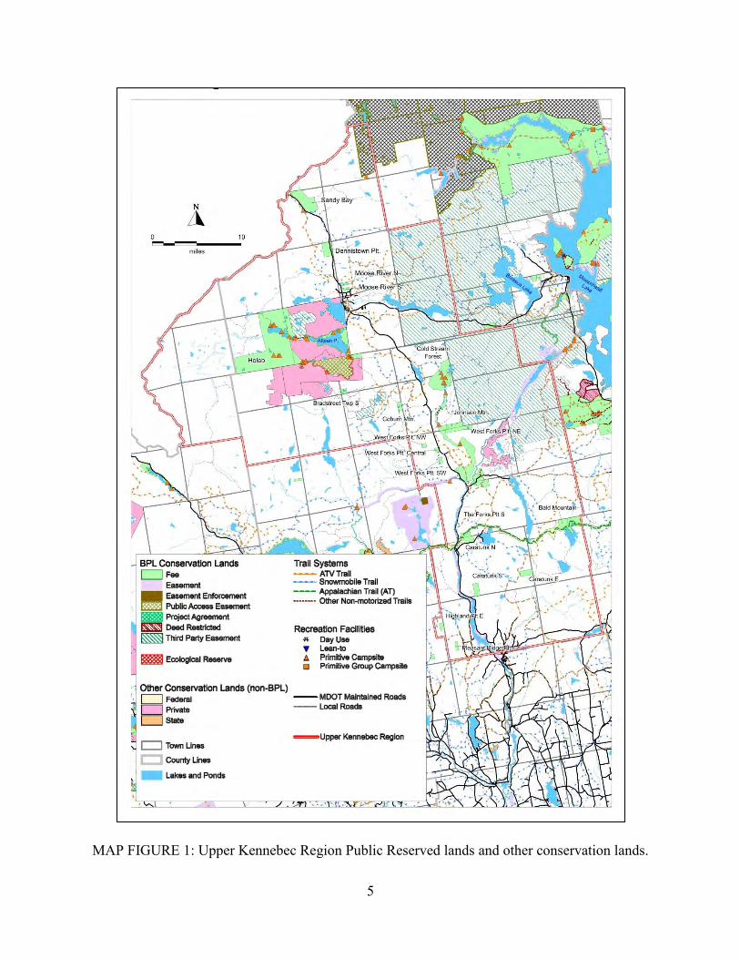
The Lands of the Upper Kennebec Region The Upper Kennebec Region lands comprise a total of about 43,000 acres designated as Public Reserved Lands. The region contains one of the most extensive public lands units in the State, the Holeb Unit, south and west of the town of Jackman. Other major units include the recently acquired Cold Stream Forest extending northward from The Forks area, where the Dead River joins the Kennebec, and Sandy Bay on US Route 201 and abutting the Canadian border. Together, these three units account for more than 80 percent of the Public Reserved Lands in the region. Nineteen smaller public lots, most of which are on or near the US 201 corridor which forms the backbone of the region, complete the portfolio of Public Reserved Lands in the region. These lots range in size from about 130 to 1,800 acres, and together comprise about 8,500 acres. The Bureau’s Parks division manages the Moxie Falls parcel (not addressed by this Plan), abutting two of the smaller public lots in The Forks area. The table below summarizes the acreage contained in each property addressed in the Plan. Map Figure 1 on page 5 depicts the Public Reserved Lands of the Upper Kennebec Region as well as other conservation lands, major roads, trail systems and other recreation facilities in the region. (A larger version of the map is available from the Bureau.)

3
The Public Reserved Lands of the Upper Kennebec Region Name and Location Fee Acres
Holeb Unit (Holeb, Attean, T5 R7 BKP WKR and Bradstreet Townships) 23,612 Cold Stream Forest Unit (Parlin Pond & Johnson Mtn. Townships, West Forks Plantation) 8,159 Sandy Bay Unit 2,712 Smaller Lots (listed geographically, generally from north to south) Dennistown Plantation Lot 1,000 Moose River North and South Lots 282 Bradstreet Township South Lot 210 Upper Enchanted Township (Coburn Mountain) Lot 320 Johnson Mountain Lot 525 West Forks Plantation Northeast, Northwest, Central and Southwest Lots 1,204 Moxie Gore Lot 480 The Forks Plantation North and South Lots 1,011 Bald Mountain Lot 1,771 Caratunk North, South and East Lots 1,330 Highland Plantation East Lot 200 Pleasant Ridge Plantation Lot 207 Total 43,023 Note: Figures listed are derived from deeded acres or estimated acres for unsurveyed original public lots; acreage as determined by surveys or GIS may differ.
In addition, the Bureau also has responsibility for monitoring compliance within two conservation easements that fall entirely or in part within the Upper Kennebec Region. In total, these easements cover nearly 1,400 acres, over 830 acres of which are within the region. The Moose River easement is adjacent to the No. 5 Bog portion of the Holeb Unit. Both are described in more detail in the Planning Context section (Section III). Conservation Easements in the Upper Kennebec Region
Easement Name Townships Acres Notes
Indian Pond Big Moose Twp. Sapling Twp.
721* Pond shoreline zone, owned by Brookfield Renewables, LLC
Moose River T5 R7 BKP WKR 111 South shore of Moose River, owned by Riverview Foundation
* 555 additional acres covered by this easement are in Sapling and Big Moose Townships on upper Indian Pond (within the BPL Moosehead Region)
Acquisition History The majority of the approximately 23,600-acre Holeb Unit was acquired from Great Northern Nekoosa Corporation in 1975 and from Coburn Lands Trust in 1982 and 1985. Approximately 1,200 acres on the east shore of Attean Pond and an adjacent portion of Bradstreet Twp. are original public lots. An additional 700 acres of shorelands on the north and south sides of Attean Pond and a buffer strip along 1.5 miles of the Moose River were acquired from Lowell and Company in 1994. Two small outlots on Attean Pond and a lot on Little Big Wood Pond were acquired in 2006-07. The 4,576-acre No. 5 Bog acquisition (including 85 acres along the Moose
4
River near Holeb Falls) was completed in 2009. Most recently, a one-acre inholding on the Moose River at the margin of the No. 5 Bog parcel was acquired in 2012. The 8,152 acre Cold Stream Forest Unit was acquired in March 2016 from the Weyerhaeuser Company. This acquisition was funded in part through the federal Forest Legacy and state Land for Maine’s Future programs, through a partnership with the Trust for Public Land, Trout Unlimited, and Maine Department of Inland Fisheries and Wildlife (MDIF&W). The 2,721 acres comprising the Sandy Bay Unit was acquired in 1985 from Louis O. Hilton in trade for an original public lot and timber and grass rights. The 1,650 acre Bald Mountain Lot is composed of an original Public Lot and two parcels totaling about 780 acres acquired in trade from S.D. Warren in 1990. The 312 acre Moose River Lots were acquired from Irving Pulp and Paper in 1990 as part of a land trade. The remaining smaller lots, all situated on or near US 201 – the Dennistown, Bradstreet Twp.,
Coburn Mountain, Johnson Mountain, West Forks Plantation, Moxie Gore, The Forks
Plantation, Caratunk, Highland Plantation, and Pleasant Ridge Plantation lots – are Original Public Lots or portions of such lots remaining in State ownership after various land sales and trades.
5
MAP FIGURE 1: Upper Kennebec Region Public Reserved lands and other conservation lands.
6
II. The Planning Process and Resource Allocation System This section describes the Bureau’s planning process for development of its management plans and the statutes and policies that guide its management decisions. The planning process includes a robust public participation effort, intended to provide input to the Bureau’s management. In addition, the Bureau is guided by statutes requiring and directing the Bureau to develop management plans. Overall, management of Bureau lands is guided by the Integrated Resource Policy (IRP), which itself was developed with a significant public process. Finally, the Bureau’s forest management, where allowed under the multiple purpose management system defined by the IRP, is conducted sustainably, and is third party certified under the Sustainable Forestry Initiative (SFI) and the Forestry Stewardship Council (FSC) programs. The following describes these important influences guiding the development of this Plan in further detail.
Statutory and Policy Guidance Multiple use management plans are statutorily required for Public Reserved Lands pursuant to Title 12 MRSA § 1847 (2) (see Appendix B), and must be prepared in accordance with the guidelines set forth in the IRP revised and adopted in December 2000 by the Bureau. The IRP provides further policy guidance for development of resource management plans, and applies to Parks as well as Public Reserved Lands. These laws and policies direct the Bureau to identify and protect important natural, ecological, and historic attributes; enhance important fisheries and wildlife habitat; provide opportunities for a variety of quality outdoor recreation experiences; and provide a sustained yield of forest products by utilizing forest management techniques and silvicultural practices that enhance the forest environment. Revenues received from timber harvesting are retained by the Bureau to manage Public Reserved Lands. The portion of the IRP addressing management of fisheries and wildlife resources makes reference to the Bureau’s Wildlife Guidelines. The guidelines provide specific management objectives and strategies for wetland, riparian and upland ecosystems on the public reserved lands, including areas designated for timber harvesting. Additional guidance is provided for management of special habitat features such as mast trees, snags, and forest openings/old fields, and for species of special concern, such as bald eagle, osprey and great blue heron. The overall fisheries and wildlife resources policy of the Bureau is to strive to maintain a landscape characterized by a rich variety of native species and the functioning ecosystems on which they depend. This plan meets the requirements for multiple use management plans for the Public Reserved Land properties set forth in Title 12 M.R.S.A. § 1847 (2), and is consistent with the Integrated Resource Policy.
Public Participation and the Planning Process Overall, the development of Management Plans includes a series of steps, each involving interdisciplinary review, as well as extensive efforts to solicit and consider public comment, in order to achieve a Plan that integrates the various perspectives and needs while protecting and conserving the resources of the Public Reserved Lands. In total four public meetings were held in the development of this Final Plan, as described below.

7
Resource Assessments: The first phase of the planning process includes a thorough study of the resources and opportunities available on the Public Reserved Lands. Beginning in the summer of 2016, Bureau staff undertook a review of the natural and geological, historic and cultural, fisheries and wildlife, recreation, and timber and renewable resources. In anticipation of this Plan, natural resource surveys were conducted between 2014 and 2016 by the Maine Natural Areas Program (MNAP) and MDIF&W staff, which focused on updating the data on higher elevation lands, wetlands and other areas that have been managed under the past plans as special resources. The Holeb Unit and Coburn Mountain, Bald Mountain, and Moxie Gore lots were included in these new surveys. Additional surveys were conducted at the newly acquired Cold Stream Forest Unit in 2017. Resource professionals from within the agency provided information on wildlife, recreation, and timber resources. Mapping and GIS-related information was also obtained as part of this phase. Staff also participated in reconnaissance field trips to the major units and some of the smaller lots to view first-hand and characterize the land-based resources and recreational features. In October 2016, the Plan Coordinator and several Bureau staff participated in a planned tour of the Cold Stream Forest Unit focused on examining existing recreational development, road access and condition, and forest conditions. Other staff visits in the fall and winter of 2016-17 included visits to the Sandy Bay and Holeb Units and several of the smaller lots. Advisory Committee: An Upper Kennebec Region Advisory Committee was convened in August 2016 of the start of the Plan process and invited to a public scoping meeting that would formally kick off the Plan’s development. Issue Identification/Public Scoping Session: The first step in the planning process is a public scoping meeting. The purpose of the scoping meeting is to help ensure broad-based public input regarding management direction and other issues needing to be addressed by the Plan. The public scoping meeting was held in Bingham on October 19, 2016. Attendees were invited to submit written comments during the one month period following the meeting. First Advisory Committee Meeting: The initial Advisory Committee meeting was held on November 17, 2016 in Bingham. The purpose of the meeting was to gain a fuller understanding of the issues and opportunities to be addressed in the Plan, including guidance on developing an overall Vision for each of the major properties covered by the Plan. In addition, the group explored concerns of user groups and management challenges that may be associated with certain issues and opportunities. The meeting was guided by the list of Upper Kennebec Region Issues, Needs and Opportunities developed during scoping and subsequent BPL staff discussions, and which was distributed to the AC in advance. Subsequent to the meeting, several AC members and members of the public submitted written comments on management issues and their vision for the region and specific management units. Second Advisory Committee Meeting: Through 2017 and the first five months of 2018 the Bureau compiled the resources and management issues identified as described above, and drafted vision statements, proposed resource allocations and management recommendations into a Draft Plan. An Advisory Committee meeting to review the Draft Plan was held June 20, 2018.

8
Comments on the Draft Plan from the Advisory Committee and the public are included in Appendix A of this document and were reflected in the Final Draft Plan. Public Meeting on the Final Draft Plan: The Bureau prepared the Final Draft Plan over the second half of 2018; the Final Draft was presented and discussed at a public meeting on February 7, 2019. Attendees were invited to submit written comments during the three-week period following the meeting. Commissioner’s Review of the Final Plan, and Plan Adoption: Comments received on the Final Draft Plan were considered in preparing the Final Management Plan. Upon recommendation from the Director of the Bureau of Parks and Lands, the Final Plan was then reviewed and adopted by the Commissioner of the Department of Agriculture, Conservation and Forestry. Five-Year Plan Review and Updates: The Bureau’s management plans are normally adopted for a 15-year period. The Bureau is required to report to the Upper Kennebec Region Advisory Committee at five-year intervals on accomplishments and changing conditions that may warrant amendments to the plan. The first mandated Five-Year Review of the regional plan is scheduled for 2024. Advisory Committee members will review the Bureau’s report on actions taken to implement management recommendations in the Plan and will be asked to identify any new issues or circumstances they feel warrant Committee input or action. If neither the Bureau nor the Advisory Committee identifies any new issues or circumstances that warrant Committee input or action, the review process is completed. If any of the Advisory Committee members identifies new issues or circumstances that, in their opinion, may require an amendment to the plan, or that should be discussed with the Committee prior to the Bureau taking action without amending the plan, then the Bureau will seek Committee comment through correspondence or a meeting. Depending on Committee input, a decision will be made to formally amend the plan or to take action without amending the plan. If a decision is made to formally amend the plan, the Bureau will hold a public meeting to gather public input on the proposed amendment(s), document public comments and Bureau responses, and adopt the plan amendment. If a decision is made to take action without amending the plan, the Bureau will document the Committee discussion and the specific actions that can be taken without a plan amendment.
Summary of the Resource Allocation System The Bureau’s Resource Allocation System is a land management-planning tool first developed in the 1980’s, and formalized in the IRP. The current version of the IRP was adopted December 18, 2000, following a public review and refinement process. The Resource Allocation System, which assigns appropriate management based on resource characteristics and values, is based on a hierarchy of natural and cultural resource attributes found on the land base. The hierarchy ranks resources along a scale from those that are scarce and/or most sensitive to management activities and where dispersed recreation facilities or activities are most appropriate, to those that are less sensitive and where more intensive recreation facilities or activities may be appropriate. The resource attributes are aggregated into seven categories or “allocations”. The hierarchy of the allocation system defines the type of management that will be applied depending on the particular resource attributes present, with dominant and secondary use or

9
management designations as appropriate to achieve an integrated, multi-use management. Allocations, from most sensitive to least, include:
o Special Protection Areas (including Ecological Reserves and Significant Natural Areas) o Backcountry Recreation Areas (Motorized and Non-mechanized) o Wildlife Areas (essential wildlife habitat, significant habitats, and specialized habitat
areas and features including rare natural communities) o Remote Recreation Areas
o Visual Protection Areas
o Developed Recreation Areas
o Timber Management Areas
Appendix C includes a more detailed description of the Resource Allocation System categories and the management direction defined for each category.
Forest Certification In 1999 the Bureau made the decision to demonstrate exemplary forest management through participation in two nationally recognized sustainable forestry certification programs. The Bureau was awarded certification of its forestlands under the Sustainable Forestry Initiative (SFI) and the Forest Stewardship Council (FSC) programs in 2002. These third-party audits were conducted to determine if these lands were being managed on a sustainable basis. Successful completion of the FSC/SFI systems also qualified the Bureau to enter into the “chain of custody” program to market its “green-certified” wood. The process for enrollment in this program was completed in 2003, with certified wood now being marketed from Bureau managed lands. The process for conducting the SFI and FSC audits was rigorous and unique in that the Bureau underwent the two audit programs simultaneously. The audit was comprised of a field analysis of forest management practices at selected sites around the state, and an analysis of the Bureau's financial, personnel, policy development, and record-keeping systems. A Bureau-wide certification team was implemented to address “conditions” and “minor non-conformances” stipulated in the audit reports, including: significant enhancements to forest inventory data, development of a computerized forest-modeling program, a timeline for updating management plans for the entire land base, improvements in the use of Best Management Practices to protect water quality, and new commitments to public outreach and education programs. The Bureau is required to meet these conditions within certain timeframes in order to keep its certification status in good standing over the five-year certification period. In 2006, the Bureau hosted its first full recertification by FSC, concurrently undergoing its first surveillance audit by SFI, the latter now required under SFI’s updated standards. Although the field portion took place during and immediately after a heavy November rainstorm, Best Management Practices implemented on Bureau lands were working well, and certifiers for both systems were very pleased with Bureau silviculture at all sites visited. The Bureau’s second full recertification audit for FSC took place in December 2011, again in challenging weather conditions, and the third took place in December 2016. Annual surveillance audits under the SFI program have occurred each year, a have concurrent FSC audits in the years between full audits. In each case, the BPL forests were again certified as being well managed, with only a small number of corrective action requests (now known as minor non-conformances), which the

10
Bureau needed to satisfy as it continues to improve its forest management which has already been certified as being exemplary.
III. Planning Context The purpose of this Plan is to identify management allocations and recommendations for the Public Reserved Lands in the region. The Plan has been developed taking into account the context of the region’s other conservation lands and recreation resources. The following narrative provides examples of the major conservation and recreation resources, but this is not comprehensive⎯the full spectrum of resources in this region is rich and diverse and will not be fully described here.
Conservation Lands and Public Recreation Resources in the Upper Kennebec Region The south end of the region at Bingham, just downstream of the Wyman Lake impoundment on the Kennebec River, is about a 1.25 hour drive from Augusta, 1.5 hour drive from Bangor, and 2 hour drive from Portland, placing it within a reasonable day-trip or weekend travel distance to a majority of the state’s population. Destinations in the vicinity of Jackman, in the northern part of the region, add about 1 hour of travel from these urban areas as compared to the south end of the region. The northern end of the region is easily reached by those coming into the state from Quebec. The broader region includes a substantial amount of conservation lands within a matrix of commercial forest lands, with a number of camps, lodges and resorts. Recreation Resources Access
US Route 201, known as the Old Canada Road within the Plan area, is the backbone of the Upper Kennebec region, extending the length of the region from north to south and passing through several small towns. Most of the commercial activity in the region is on or near this road. Communities along US 201 such as Bingham, Moscow, West Forks, The Forks Plt., Jackman and Moose River provide lodging, campgrounds, restaurants, groceries, outfitters, gift shops, and other outlets to supply visitors’ needs. State Route 6/15, also known as Long Pond Road, links the Jackman area to Moosehead Lake. Other DOT, county and town-maintained routes connected to US 201 and providing access to recreation include Moxie Lake Road and Pleasant Pond Road. Most other vehicle access to the region’s lakes and ponds is over private roads originally constructed for timber management. Hiking
Hiking opportunities in this region is not as extensive as compared to adjacent areas, such as the western mountains and the Moosehead Lake areas. However, some hiking opportunities stand out. The trail to Moxie Falls, one of the highest waterfalls in the state, is among the most popular in the region. The one-mile out-and-back walk is on a wide and generally flat trail, with an extensive system of boardwalks providing safe viewing of the falls at the end. The trail primarily crosses State Park property with a trailhead on a public reserved lands parcel. The extensive system of non-motorized trails constructed by the Maine Huts and Trails organization in the past decade currently has its northern terminus at a trailhead on US 201 in

11
West Forks. A 14.2-mile section of trail winds along the Dead River from that trailhead to the Grand Falls Hut, within a Bureau-held easement. This challenging trail is groomed for Nordic skiing in the winter. The Appalachian Trail (A.T.) crosses the southern end of the Upper Kennebec Region, crossing the Kennebec River (where a shuttle is available to hikers in-season) and US 201 at Caratunk. From a trailhead at Caratunk, the A.T. continues east about 15 miles to Bald Mountain Lake and then onward out of the region toward Monson. Most of this section is on federally-owned trail corridor lands; however, just east of Caratunk and at Bald Mountain Lake about three miles of the trail crosses BPL parcels. A popular day-hike to 2,470-foot Pleasant Pond Mountain, with extensive views from the summit, is a highlight of this section of the A.T. A trail within The Nature Conservancy (TNC)-owned Leuthold Forest Preserve leads to the summit of 3,156-foot No. 5 Mountain, providing panoramic views of No. 5 Bog and Attean Pond. The owner of the Attean Township lands north of Attean Pond provides a network of hiking trails. One trail extends from the BPL-owned shoreline of Attean Pond to the summit of Sally Mountain, about one mile to the north. Camping
As will be described in more detail later, a number of drive-to campsites are available within the Bureau’s Cold Stream Forest Unit, while the Holeb Unit features more than 20 primarily boat-in campsites. Drive-to campsites are scattered on private forest lands in the region, particularly in Dennistown, Chase Stream and Misery Townships. Three lean-tos and a hike-in campsite are available along the portion of the A.T. that crosses the region. All are primitive campsites, with no potable water and vault or pit toilets. A number of commercial campgrounds are available in Moose River, Jackman, West Forks and The Forks Plt. Brookfield Renewables, LLC operates a public campground on Indian Pond, under the conditions of its hydropower project license. Fishing
The many ponds and rivers in the Upper Kennebec region provide diverse destinations for cold-water fishing. The larger waters such as Attean Pond, Big Wood Pond, Long Pond, Parlin Pond, Moxie Pond (aka Lake Moxie), Indian Pond and Wyman Lake (the latter two are impoundments on the Kennebec River) are generally accessible by vehicle, with developed boat launch facilities. A number of smaller ponds require some hiking, increasing the opportunity to fish in relative solitude. Among the popular species are smallmouth bass, white perch, brook trout, landlocked salmon, and togue (lake trout). MDIF&W highlights landlocked salmon fishing on Attean Pond and Big Wood Pond, high quality smallmouth bass fishing on Indian Pond, as well as a number of walk-in and drive-to ponds offering wild and stocked brook trout fishing. A number of ponds in the region, several of which are on the Public Reserved Lands, are classified by MDIF&W as State Heritage Fish Waters (SHFW; waters that have never been stocked or that have not been stocked in at least 25 years and now have self-sustaining brook trout or arctic charr populations). By statute, a person may not use live fish as bait or possess live fish to be used as bait on a SHFW. Special regulations to protect the self-sustaining

12
populations of brook trout and charr have been enacted for these waters. A few ponds in the region are managed for trophy brook trout, with a more restrictive bag limits, minimum size and/or catch and release restriction. Many other ponds and streams in the region are stocked by MDIF&W.
The Dead River and Kennebec River are destinations for anglers seeking brook trout and salmon and the less numerous brown trout and rainbow trout, particularly during the spring and fall. However, limited road access (other than along US 201) and high flows due to upstream dam releases are constraints. The fishing season is extended through October on the Kennebec and through November on the Dead River. Both rivers are artificial lure only waters, with a two-fish total daily bag limit and 12 inch minimum length for trout and salmon. The Dead River is catch-and-release only during the fall season. Local guides offer drift boat outings on these rivers.
Boating
Canoeing and kayaking are common activities on many of the regions lakes, ponds and rivers. Most prominent among paddling opportunities in this region is the “Moose River Bow Trip.” This historic and popular multi-day outing is considered one of the most outstanding canoe trips in Maine. Local outfitters offer rental equipment and some offer shuttle services. Additional details on the Bow Trip are provided in the Holeb Unit section of this Plan. Both anglers and pleasure boaters have trailer-launching access to many of the larger lakes and ponds in the region, including about a dozen public boat ramps, most state owned or funded by the Bureau’s boating facility program and operated by local entities. Other privately-operated access points can be found at lodges, sporting camps and campgrounds around those and other waters. A segment of the Northern Forest Canoe Trail (NFCT), which stretches from the Adirondacks of New York to the Canadian border at Fort Kent, Maine, crosses the northern part of the Upper Kennebec Region. This section includes the Spencer Stream watershed and the Moose River through its outlet in Moosehead Lake, including a segment of the Moose River along the margin of the No. 5 Bog Ecological Reserve and Attean Pond. BPL campsites on the Moose River and Attean Pond are on the NFCT. The Forks area is a center of whitewater rafting in the state. A number of outfitters provide professionally led trips on the Dead River and the Kennebec River gorge area upstream of the Kennebec’s confluence with the Dead River. Rafting on the Dead River takes advantage of scheduled releases from Flagstaff Lake (weekends, May through September), while more frequent hydropower releases from Indian Pond support this activity on the Kennebec. Some outfitters provide lodging, camping and other ancillary services. Snowmobiling
In winter, snowmobiling provides access into remote areas of the region, with a variety of loop rides possible. As shown on the map below, several Interconnected Trail System (ITS) corridor trails come together at The Forks. ITS 86 and 87 link to Greenville and Bingham to the south and east, with ITS 87 continuing north through the region to the Moose River. ITS 86 continues west to a junction with ITS 89, which extends north to Jackman and on to the Canadian border,

13
and south toward Flagstaff Lake and Eustis. ITS 88 runs east/west, connecting ITS 89 north of Jackman with Rockwood on Moosehead Lake. A number of club-maintained trails provide connections between these main routes. A particular highlight among snowmobile destinations in the region is the summit of Coburn Mountain. The groomed snowmobile route to the summit follows an old road to the former site of a fire tower, now occupied by an observation platform on a 20-foot steel tower.
Major Snowmobile Trails: Interconnected Trail System (ITS) 2017-18 season

14
ATV Riding
A network of club-maintained trails is also available in the Upper Kennebec region, similar to and in places co-located with the snowmobile trail network. Trails extending north and south meet at The Forks, with trails linking to Jackman and on to the Canadian border, to Greenville, and to Rockwood. The Town of Jackman has designated ATV routes on downtown roadways to permit riders to safely pass through and to access the town’s services. The map below depicts the major ATV routes in the region.
ATV Trails (excerpt of 2018 ATV Program state map)
(numbers in circles indicate local clubs)

15
Hunting
Ample hunting opportunities exist in the Upper Kennebec region for deer, black bear, moose, ruffed grouse, snowshoe hare and coyote. In addition to the State lands addressed in this plan, much of the commercial forestland in the region is open to hunting. A number of guides offer deer, moose, bear and upland game bird hunts. Other Recreation Opportunities in the Upper Kennebec Region As is true throughout the state, the region provides many wildlife viewing opportunities due to the rich and varied wildlife habitats available, including extensive forests of varying ages and types, numerous ponds and wetlands, with varied topography. Moose watching is especially popular, and some guide services based in the region offer moose watching tours as well as outings focused on birding and other wildlife watching. A variety of non-game birds are commonly seen on the lakes, ponds and wetlands in the region. The Old Canada Road National Scenic Byway/Maine Scenic Byway extends 78 miles along US Route 201 from Solon to the Canadian border. DOT and Kennebec Valley Tourism Council sponsored webpages communicate to travelers the history and highlights of the byway and well as suggestions for a number of side-trips. The Jackman Region Chamber of Commerce and other community entities sponsor a number of special events, many centered around outdoor recreation, each year. Some examples include a cross country snowmobile race and a benefit snowmobile trail ride. Moosehead Lake Region Concept Plan and Conservation Easement Lands In 2009, the Maine Land Use Regulation Commission (LURC) approved Plum Creek Timber Company’s Concept Plan for the Moosehead Lake Region.1 The Concept Plan addresses conservation, ecological resources, contiguous working forests, recreation, economic development and regional planning. The Plan includes a 363,000-acre conservation easement, which covers a majority of the private forest lands to the west of Moosehead Lake, including all of several townships along the eastern side of the Upper Kennebec region. The easement is held by the Forest Society of Maine with BPL as a third-party holder with rights of enforcement. (These easement lands are depicted on Map Figure 1 as BPL Conservation Lands - Third Party Easement.) The Cold Stream Forest Unit and two of the smaller lots addressed in this plan abut the easement lands. The easement will ensure that sustainable forestry continues to be practiced on the subject lands, protect wildlife habitat, prohibit residential development, and forever guarantee the right for the public to access the lands for traditional recreational pursuits.
The Concept Plan also incorporates noteworthy recreational amenities which include, among other things, guaranteed access to 400,000 acres of land with more than 170 miles of road and trail easements that will expand and diversify outdoor opportunities for residents and visitors. The Bureau has worked closely with Weyerhaeuser, with the guidance of a Trails Advisory Committee, to identify routes for new non-motorized trails protected by trail easements. The Bureau is closing in on completion of construction on these trails with funds provided by Weyerhaeuser. Nearly 30 miles of new trails will be established through this process. The nine 1 In February 2016, Plum Creek Company merged with Weyerhaeuser Company; the Weyerhaeuser name will be used in the remainder of this document apart from references to pre-merger ownership, plans, and actions.
16
trail projects in eight townships will increase the diversity of non-motorized trails available to the public. The Bureau is also working to accept acreage donated by Weyerhaeuser for new trailheads, boat access, and campsites, not to exceed 50 acres in total. Of particular note to the Upper Kennebec Region are completed trails projects at Williams Mtn. (Misery Twp. – trailhead parking area pending), portage trail improvements associated with the NFCT along the Moose River (Sandwich Academy Grant Twp. west of Brassua Lake), and pond access sites located in townships east of Cold Stream Forest (planned as part of the 50 acre donation process).
Close to four percent of the Concept Plan area will be zoned for planned development (house lots and resorts) which can occur over the next 30 years under the terms of the Plan. One of the residential development zones is on Long Pond, along Route 6, within the Upper Kennebec Region.
Other Major Conservation Lands in the Region The TNC Leuthold Forest Preserve encompasses 16,934 acres of forestland southwest of Jackman, and just south of the Moose River, abutting the Holeb Unit on the south. Number 5 Mountain (3,156 feet) and Number 6 Mountain (3,315 feet), dominate the west end of the preserve. The preserve features a unique Fir-Heart Leaved Birch Alpine Forest and the fourth largest contiguous Spruce-Fir/Northern Hardwood Forest in Maine. The complete shorelines of seven ponds are also protected within the preserve. The Forest Society of Maine (FSM) holds conservation easements on most of Attean Township, totaling over 19,000 acres and including important ecological areas, the north and south shorefront of Attean Pond (now in BPL ownership), numerous islands in Attean Pond, Benjamin Pond and Big Wood Pond, prominently visible mountain slopes, and productive forest land. The State of Maine holds a third-party right of enforcement on a substantial portion of the FSM easements, including the Benjamin Valley Ecological Preserve and Benjamin Valley Conservation Area. FSM also owns about 900 acres in fee within Attean Twp., encompassing the north half of No. 5 Bog and a nearby Jack Pine stand. Both parcels abut the Bureau’s No. 5 Bog Ecological Reserve, established to protect these special resources on the BPL fee land in the adjacent townships.
Maine Residents’ Participation in Outdoor Recreation Activities and Visitation to Public Reserved Lands and State Parks Recent survey data collected for the Maine State Comprehensive Outdoor Recreation Plan (SCORP) and somewhat older data collected for the National Survey on Recreation and the Environment (NSRE) shed light on the outdoor recreation activity participation and preferences of Mainers (particularly as regards trail activities) and their use of the state’s public lands. The 2002-2009 NSRE data indicates the day hiking is second only to walking in participation among Maine residents. The 2015 SCORP survey data also support the popularity of hiking among Mainers with nearly 70 percent of Maine resident recreationist participating and nearly two-third among residents overall. Also of interest are the nearly 48 percent of recreationists who snowshoe, 34 percent who ride an ATV and 32 percent who snowmobile. The SCORP data indicate that nearly 80 percent of Maine resident recreationists visited Maine State Parks within
17
the past two years, and nearly half had visited the Public Reserved Lands. Regarding opinions on the most needed non-motorized trail resources contained in the SCORP survey, the Maine general population, recreationists, and non-resident recreationists who visited Maine were in agreement that easy and moderate day-hike trails in natural settings and educational/natural history trails were the most needed. All three of these types of trails were considered by a majority of Maine residents to be “most needed.” Overall, these data indicate the types of activities offered on the public lands in the Moosehead Region remain popular with Mainers and the Public Reserved Lands and State Parks are among the most commonly used venues to enjoy those activities. Given these facts, the Bureau can expect continue high interest and demand for outdoor recreation access and amenities on the properties addressed by the Plan.
Summary of Planning Implications
1. The Upper Kennebec Region Public Reserved Lands lie in an area highly valued for its natural resources. The culture and economy of the area are historically linked to the forest resources and outdoor recreation.
2. The recreation opportunities on the Public Reserved Lands are part of a much larger
landscape-level system connecting the numerous lakes and ponds with surrounding mountain ranges and historic travel routes – including the nationally significant Appalachian Trail and Old Canada Road Scenic Byway; the Northern Forest Canoe Trail; an interstate system of snowmobile trails, and a regional network of ATV trails.
3. New public and private initiatives to further develop the recreation-based economy, and to conserve the special natural areas in the Region are strong. The tens of thousands of acres of conservation easement lands in the region, primarily on Weyerhaeuser’s commercial forestland surrounding Moosehead Lake and the major portion of Attean Township, are central to both objectives.
4. The overriding attraction of the area for recreationists is the region’s many lakes, ponds and streams – particularly those associated with the Moose River Bow Trip -- and the mix of undeveloped backcountry and commercial forest land open to traditional recreation uses. Careful stewardship is needed to protect these values while making the public lands available to enjoy.
5. There are many opportunities for development of public-private partnerships to further
both conservation, and development and stewardship of recreational opportunities on the Bureau managed Public Reserved Lands - including partnerships or cooperative agreements with local towns; the Jackman-Moose River and Forks Area Chambers of Commerce; Maine Appalachian Trail Club (MATC); Brookfield Renewable, LLC; local snowmobile and ATV clubs; and others. These collaborative relationships are essential to good stewardship of the public lands.
Related Documents