39 Geological maps are core products of national geological surveys and represent the sum of geological knowledge of any given area. However, dedicated and extensive mapping projects in the Arctic are mostly a thing of the past due to difficulty in financing such costly basic research efforts. To- day, an overview of the geology of Greenland is portrayed by a seamless digital 1:500 000 scale geological map (Kokfelt et al. 2013; Pedersen et al. 2013), based on printed maps on this scale produced since 1982 by the Geological Survey of Denmark and Greenland (GEUS; see Holst et al. 2013). The digital map now makes it possible to update smaller areas with new, published or otherwise quality-controlled geologi- cal data (e.g. Kolb et al. 2016). This ensures that the map re- flects the current state of geological knowledge without un- dertaking extensive new mapping to update individual map sheets, as has previously been the modus operandi. An online version of the map is available from www.greenmin.dk/map. However, procedures are required to ensure that updates are carried out routinely and that the quality and coherence of the updated map is of the Survey’s standards. Results of recent field work in the Wandel Sea Basin (Fig. 1) and in particular the publication of a new geological map sheet Kilen on a scale of 1:100 000 (Svennevig in press) have implications for the geology shown on the above mentioned 1:500 000 scale seamless geological map of Greenland. The post-Devonian part of this map in eastern North Green- land has been updated according to the results of studies published since the publication of the original printed maps (Bengaard & Henriksen 1986; Jepsen 2000). The changes do not call for an update of the 1:2 500 000 scale geological map of Greenland (Henriksen et al. 2009). Update of the seamless 1:500 000 scale geological map of Greenland based on recent field work in the Wandel Sea Basin, eastern North Greenland Kristian Svennevig Greenland Triassic Older rocks Faults Carboniferous–Permian Palaeogene Jurassic–Cretaceous Dykes, mostly Late Cretaceous Quaternary 36°W 28°W 20°W 83°N 12°W 82°N 81°N HFFZ TLFZ PEARY LAND EGFZ Holm Land Amdrup Land Kilen W a n d e l H av Kap Washington 100 km Kim Fjelde KCTZ G r ø n l a n d s h a vet KRONPRINS CHRISTIAN LAND In l a n d Ice Kap Rigsdagen Station Nord Prinsesse Thyra Ø Fig. 1. Simplified geological map of the Wandel Sea Basin showing the major structural elements and Upper Palaeozoic to Palaeogene sediments. Modified from Bengaard & Henriksen (1986) and Henriksen (2003) with updates from Kilen modified from Svennevig (in press). EGFZ: East Greenland Fault Zone. HFFZ: Harder Fjord Fault Zone. KCTZ: Kap Cannon Thrust Zone. TLFZ: Trolle Land Fault Zone. Red frame shows the position of Fig. 2 and black arrow shows the new occurrence of Thyra Ø Formation. © 2018 GEUS. Geological Survey of Denmark and Greenland Bulletin 41, 39–42. Open access: www.geus.dk/bulletin

Welcome message from author
This document is posted to help you gain knowledge. Please leave a comment to let me know what you think about it! Share it to your friends and learn new things together.
Transcript

39
Geological maps are core products of national geological surveys and represent the sum of geological knowledge of any given area. However, dedicated and extensive mapping projects in the Arctic are mostly a thing of the past due to difficulty in financing such costly basic research efforts. To-day, an overview of the geology of Greenland is portrayed by a seamless digital 1:500 000 scale geological map (Kokfelt et al. 2013; Pedersen et al. 2013), based on printed maps on this scale produced since 1982 by the Geological Survey of Denmark and Greenland (GEUS; see Holst et al. 2013). The digital map now makes it possible to update smaller areas with new, published or otherwise quality-controlled geologi-cal data (e.g. Kolb et al. 2016). This ensures that the map re-flects the current state of geological knowledge without un-dertaking extensive new mapping to update individual map sheets, as has previously been the modus operandi. An online
version of the map is available from www.greenmin.dk/map. However, procedures are required to ensure that updates are carried out routinely and that the quality and coherence of the updated map is of the Survey’s standards. Results of recent field work in the Wandel Sea Basin (Fig. 1) and in particular the publication of a new geological map sheet Kilen on a scale of 1:100 000 (Svennevig in press) have implications for the geology shown on the above mentioned 1:500 000 scale seamless geological map of Greenland. The post-Devonian part of this map in eastern North Green-land has been updated according to the results of studies published since the publication of the original printed maps (Bengaard & Henriksen 1986; Jepsen 2000). The changes do not call for an update of the 1:2 500 000 scale geological map of Greenland (Henriksen et al. 2009).
Update of the seamless 1:500 000 scale geological map of Greenland based on recent field work in the Wandel Sea Basin, eastern North Greenland
Kristian Svennevig
Greenland
Triassic
Older rocks
Faults
Carboniferous–Permian
Palaeogene
Jurassic–Cretaceous
Dykes, mostly Late Cretaceous
Quaternary36°W 28°W 20°W
83°N
12°W
82°N
81°N
HFFZ
TLFZ
PEARY LAND
EGFZ
HolmLand
AmdrupLand
Kilen
Wandel Hav
Kap Washington
100 kmKim Fjelde
KCTZ
Grøn
land
shav
etKRONPRINS CHRISTIAN LAND
Inland Ice
KapRigsdagen
StationNord
Prinsesse Thyra Ø
Fig. 1. Simplified geological map of the Wandel Sea Basin showing the major structural elements and Upper Palaeozoic to Palaeogene sediments. Modified from Bengaard & Henriksen (1986) and Henriksen (2003) with updates from Kilen modified from Svennevig (in press). EGFZ: East Greenland Fault Zone. HFFZ: Harder Fjord Fault Zone. KCTZ: Kap Cannon Thrust Zone. TLFZ: Trolle Land Fault Zone. Red frame shows the position of Fig. 2 and black arrow shows the new occurrence of Thyra Ø Formation.
© 2018 GEUS. Geological Survey of Denmark and Greenland Bulletin 41, 39–42. Open access: www.geus.dk/bulletin

4040
Updates to the geological map based on recent field work in the Wandel Sea BasinParts of the seamless 1:500 000 geological map of Greenland (Kokfelt et al. 2013; Pedersen et al. 2013) have been updated. These updates are based on data from extensive field work in 2012, 2013 and 2016 in the Carboniferous–Palaeogene Wandel Sea Basin in eastern North Greenland (Bojesen-Koefoed et al. 2014; Hovikoski et al. in press; Piasecki et al. in press), the results of a recent PhD-thesis (Svennevig in press; Svennevig et al. 2016, 2017) and previously published work (Pedersen & Håkansson 1999; Henriksen 2003). In the course of this work, two old map units have been emended and four new ones established. Furthermore, four map units
have been expanded to encompass new areas. The legend of the seamless map has been updated accordingly. Twenty-one lithological units from the new 1:100 000 scale map sheet (Svennevig in press) are reduced to five units in the 1:500 000 scale map, and the revised stratigraphic res-olution is seen in Fig. 2B. The letter codes mentioned below (IF, C2, MM, LP, MI, Tr, J, JC, LC and UC) refer to the code used in the GEUS map database.
1. Expansion of unit C2: Upper Carboniferous sediments. A small occurrence of tentatively dated Upper Palaeozoic mel-ange unit at Kilen is included in the unit ‘Upper Carbonif-erous sediments’ (C2) found on Amdrup and Holm Land.
25 km
G r ø n l a n d s h a v e t
F l a d e I s b l i n k
25 km
G r ø n l a n d s h a v e t
F l a d e I s b l i n k
I
II
GT
CD
ST
Normal fault
Upper PalaeozoicOlder rocks
Carboniferous
Palaeogene
Upper Cretaceous
JurrasicUpper Permian
SynclineAnticlineJurrasic - Cretaceous
QuaternaryGeneric fault
Reverse faultNormal faultDetachment fault
Jurassic
Triassic
Older rocksCarboniferousLower Permian
Upper PermianPalaeogene
Upper CretaceousLower Cretaceous
SynclineAnticline
Quaternary
Generic fault
A B
NakkehovedNakkehoved
StationNord
Prinsesse Ingeborg Halvø
Prinsesse Ingeborg Halvø
Erik S. Henius Land
NordostrundingenNordostrundingen
KR O
NP R I N
S C HR I S T I A
N L A
ND
KR O
NP R I N
S C HR I S T I A
N L A
ND
Kilen
Kilen
Amdrup LandAmdrup Land
81°N 81°N
StationNord
Erik S. Henius Land
Wandel Hav
Wandel Hav
15°W 15°W
Fig. 2. Geological maps of Kronprins Christian Land showing the geology before (A) and after (B) the update of the digital map. One of the items on the new map (Fig. 2B) is a N–S-verging fold and thrust belt covering Prinsesse Ingeborg Halvø and Kilen as described by Svennevig (in press) and Svennevig et al. (2016, 2017). Faults on Fig. 2B adopted from Svennevig (in press): I and II: Normal Fault I and II. CD: Central Detachment, ST: Sadelfjeld Thrust. GT: Gåseslette Thrust.

41
Furthermore, the ‘Mallemuk Mountain Group’ (MM) in Kim Fjelde on Peary Land, a relic from the old printed map (Bengaard & Henriksen 1986), is included in the C2 unit following (Stemmerik et al. 1996, 2000) and the map unit ‘Mallemuk Mountain Group’ (MM) has thus been emend-ed. The unit is also found on Prinsesse Ingeborg Halvø (see below, Fig. 2).
2. Erection of a new unit Tr: Triassic siliciclastic sediments, un-divided. The newly discovered Triassic Isrand Formation at Kilen and the Triassic on Amdrup Land (Alsen et al. 2017), is combined in a new map unit called ‘Triassic siliciclastic sediments, undivided’ (Tr). The strata on Amdrup Land were previously mapped as Jurassic (Fig. 2A; Stemmerik et al. 2000).
3. Erection of a new unit J: Jurassic siliciclastic sediments, undivided. Jurassic formations at Kilen: the Gletscherport, Mågensfjeld, Birkelund Fjeld and Kuglelejet Formations (Hovikoski et al. in press; Svennevig et al. in press) are com-bined into the new map unit ‘Jurassic siliciclastic sediments, undivided’ (J) which is only found at Kilen.
4. Erection of a new unit LC: Lower Cretaceous siliciclastic sediments, undivided. The lowermost Lower Cretaceous for-mations at Kilen, the Dromledome and Lichenryg Forma-tions, are combined with the Upper Aptian – early to middle Cenomanian Galadriel Fjeld Formation (Hovikoski et al. in press; Svennevig et al. in press) in the new map unit ‘Lower Cretaceous siliciclastic sediments, undivided’ (LC).
5. Expansion of the unit UC: Upper Cretaceous siliciclastic sediments, undivided. The Sølverbæk Formation at Kilen (Hovikoski et al. in press; Svennevig et al. in press) is in-cluded in the unit UC, ‘Upper Cretaceous siliciclastic sedi-ments, undivided’, together with small occurrences of Upper Cretaceous sediments at Kap Washington in northernmost Greenland. A number of regionally significant faults and fold axes from the 1:100 000 scale Kilen map sheet have also been adapted for the 1:500 000 scale map. These are the normal Fault I and II and the reverse faults of the Central Detach-ment, the Gåseslette Thrust, and the Saddelfjeld Thrust (Fig 2B; Svennevig in press; Svennevig et al. in press).
Updates based on published work on Prinsesse Ingeborg HalvøThe geology on Prinsesse Ingeborg Halvø has also been up-dated (Fig. 2). In the original version of the 1:500 000 scale
map this area was mapped as mainly “Undivided Upper Proterozoic to Lower Palaeozoic sediments” (Bengaard & Henriksen 1986; Kokfelt et al. 2013). Since the publication of the printed map in 1986, a map was published as fig. 7 in Pedersen & Håkansson (1999). This figure was also adapt-ed for a 1:1 000 000 scale map of the Caledonian orogeny (Henriksen 2003). The 1:500 000 scale seamless map has been updated according to this and now contains three Car-boniferous–Permian map units of the Wandel Sea Basin: ‘Upper Carboniferous sediments’ (C2), the new unit ‘Lower Permian sediments, undivided’ (LP) which is only found at Prinsesse Ingeborg Halvø, and the Upper Permian ‘Midnats-fjeld and Kim Fjelde Formations’ (MI). Furthermore, a fault sliver of Proterozoic basement of the ‘Independence Fjord Group’ (IF) has also been mapped (Fig. 2B).
Updates based on recently published work on the Kap Rigsdagen bedsFollowing a recent publication identifying these beds as be-longing to the Upper unit of the Early Cretaceous Ladegård-såen Formation (Piasecki et al. in press), the outcrops found at Kap Rigsdagen (Fig. 1) are also assigned to the new map unit LC. Likewise, a small locality in southern Kim Fjelde in Peary Land is interpreted as Lower Cretaceous (Håkansson et al. 1981). In previous versions of the 1:500 000 scale map (Bengaard & Henriksen 1986) these two areas were assigned to the very broad map unit JC (Upper Jurassic – Lower Cre-taceous sediments) along with strata at Kilen. This map unit is thus no longer necessary for the 1:500 000 scale map and has been emended. Piasecki et al. (in press) further ascribed a new occurrence of the Paleocene to possibly Eocene Thyra Ø Formation on top of the Ladegårdsåen Formation at Kap Rigsdagen. This occurrence has been shown as a small poly-gon with dashed outline on the updated map, since the lat-eral distribution of the formation at this locality is unknown (Fig. 1, arrow).
Suggested procedure for updating geological maps at GEUS In order to make sure that the maps published by GEUS re-flect the current state of geological knowledge, the digital geological maps should be routinely updated by including re-sults from of multi-year regional field work such as the 2012, 2013 and 2016 expeditions to the Wandel Sea Basin, and which was also done after field work in South-East Green-land (Kolb et al. 2016). In order to ensure the quality of the maps, it is important that only quality-tested and preferably peer-reviewed data
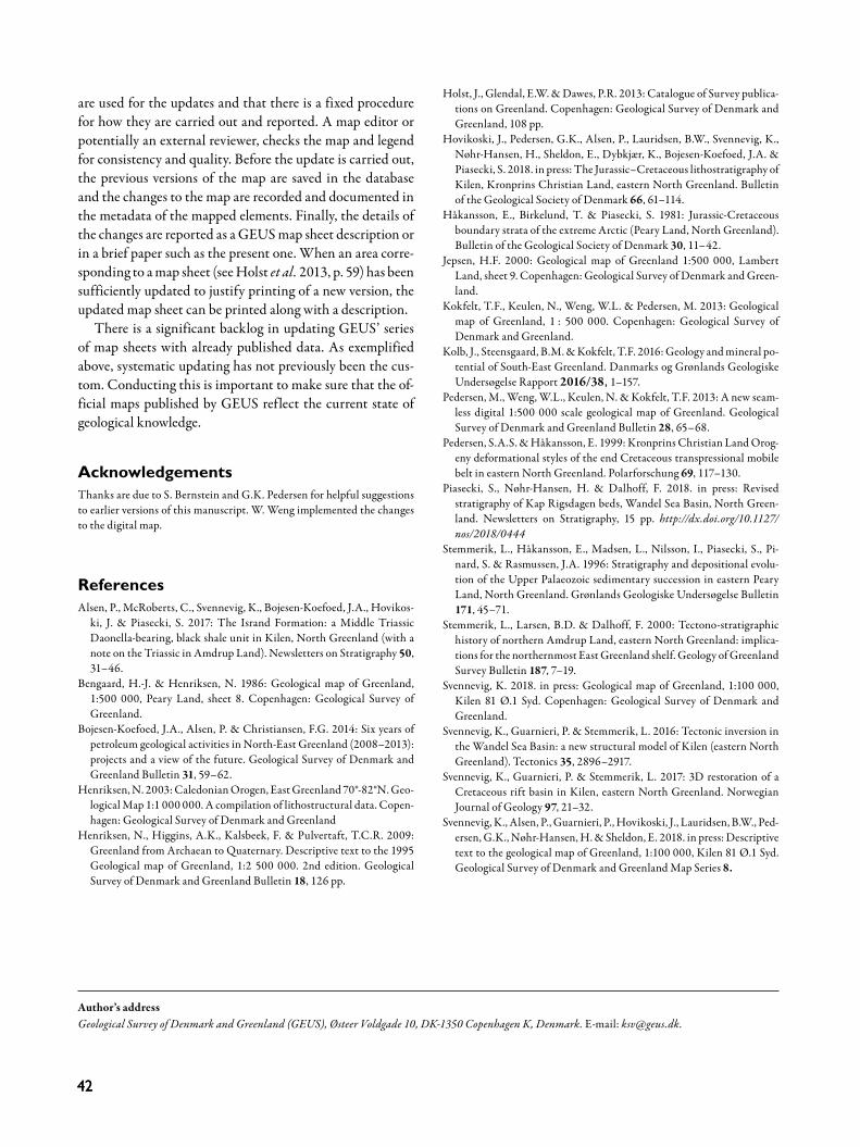
4242
are used for the updates and that there is a fixed procedure for how they are carried out and reported. A map editor or potentially an external reviewer, checks the map and legend for consistency and quality. Before the update is carried out, the previous versions of the map are saved in the database and the changes to the map are recorded and documented in the metadata of the mapped elements. Finally, the details of the changes are reported as a GEUS map sheet description or in a brief paper such as the present one. When an area corre-sponding to a map sheet (see Holst et al. 2013, p. 59) has been sufficiently updated to justify printing of a new version, the updated map sheet can be printed along with a description. There is a significant backlog in updating GEUS’ series of map sheets with already published data. As exemplified above, systematic updating has not previously been the cus-tom. Conducting this is important to make sure that the of-ficial maps published by GEUS reflect the current state of geological knowledge.
AcknowledgementsThanks are due to S. Bernstein and G.K. Pedersen for helpful suggestions to earlier versions of this manuscript. W. Weng implemented the changes to the digital map.
ReferencesAlsen, P., McRoberts, C., Svennevig, K., Bojesen-Koefoed, J.A., Hovikos-
ki, J. & Piasecki, S. 2017: The Isrand Formation: a Middle Triassic Daonella-bearing, black shale unit in Kilen, North Greenland (with a note on the Triassic in Amdrup Land). Newsletters on Stratigraphy 50, 31–46.
Bengaard, H.-J. & Henriksen, N. 1986: Geological map of Greenland, 1:500 000, Peary Land, sheet 8. Copenhagen: Geological Survey of Greenland.
Bojesen-Koefoed, J.A., Alsen, P. & Christiansen, F.G. 2014: Six years of petroleum geological activities in North-East Greenland (2008–2013): projects and a view of the future. Geological Survey of Denmark and Greenland Bulletin 31, 59–62.
Henriksen, N. 2003: Caledonian Orogen, East Greenland 70°-82°N. Geo-logical Map 1:1 000 000. A compilation of lithostructural data. Copen-hagen: Geological Survey of Denmark and Greenland
Henriksen, N., Higgins, A.K., Kalsbeek, F. & Pulvertaft, T.C.R. 2009: Greenland from Archaean to Quaternary. Descriptive text to the 1995 Geological map of Greenland, 1:2 500 000. 2nd edition. Geological Survey of Denmark and Greenland Bulletin 18, 126 pp.
Holst, J., Glendal, E.W. & Dawes, P.R. 2013: Catalogue of Survey publica-tions on Greenland. Copenhagen: Geological Survey of Denmark and Greenland, 108 pp.
Hovikoski, J., Pedersen, G.K., Alsen, P., Lauridsen, B.W., Svennevig, K., Nøhr-Hansen, H., Sheldon, E., Dybkjær, K., Bojesen-Koefoed, J.A. & Piasecki, S. 2018. in press: The Jurassic–Cretaceous lithostratigraphy of Kilen, Kronprins Christian Land, eastern North Greenland. Bulletin of the Geological Society of Denmark 66, 61–114.
Håkansson, E., Birkelund, T. & Piasecki, S. 1981: Jurassic-Cretaceous boundary strata of the extreme Arctic (Peary Land, North Greenland). Bulletin of the Geological Society of Denmark 30, 11–42.
Jepsen, H.F. 2000: Geological map of Greenland 1:500 000, Lambert Land, sheet 9. Copenhagen: Geological Survey of Denmark and Green-land.
Kokfelt, T.F., Keulen, N., Weng, W.L. & Pedersen, M. 2013: Geological map of Greenland, 1 : 500 000. Copenhagen: Geological Survey of Denmark and Greenland.
Kolb, J., Steensgaard, B.M. & Kokfelt, T.F. 2016: Geology and mineral po-tential of South-East Greenland. Danmarks og Grønlands Geologiske Undersøgelse Rapport 2016/38, 1–157.
Pedersen, M., Weng, W.L., Keulen, N. & Kokfelt, T.F. 2013: A new seam-less digital 1:500 000 scale geological map of Greenland. Geological Survey of Denmark and Greenland Bulletin 28, 65–68.
Pedersen, S.A.S. & Håkansson, E. 1999: Kronprins Christian Land Orog-eny deformational styles of the end Cretaceous transpressional mobile belt in eastern North Greenland. Polarforschung 69, 117–130.
Piasecki, S., Nøhr-Hansen, H. & Dalhoff, F. 2018. in press: Revised stratigraphy of Kap Rigsdagen beds, Wandel Sea Basin, North Green-land. Newsletters on Stratigraphy, 15 pp. http://dx.doi.org/10.1127/nos/2018/0444
Stemmerik, L., Håkansson, E., Madsen, L., Nilsson, I., Piasecki, S., Pi-nard, S. & Rasmussen, J.A. 1996: Stratigraphy and depositional evolu-tion of the Upper Palaeozoic sedimentary succession in eastern Peary Land, North Greenland. Grønlands Geologiske Undersøgelse Bulletin 171, 45–71.
Stemmerik, L., Larsen, B.D. & Dalhoff, F. 2000: Tectono-stratigraphic history of northern Amdrup Land, eastern North Greenland: implica-tions for the northernmost East Greenland shelf. Geology of Greenland Survey Bulletin 187, 7–19.
Svennevig, K. 2018. in press: Geological map of Greenland, 1:100 000, Kilen 81 Ø.1 Syd. Copenhagen: Geological Survey of Denmark and Greenland.
Svennevig, K., Guarnieri, P. & Stemmerik, L. 2016: Tectonic inversion in the Wandel Sea Basin: a new structural model of Kilen (eastern North Greenland). Tectonics 35, 2896–2917.
Svennevig, K., Guarnieri, P. & Stemmerik, L. 2017: 3D restoration of a Cretaceous rift basin in Kilen, eastern North Greenland. Norwegian Journal of Geology 97, 21–32.
Svennevig, K., Alsen, P., Guarnieri, P., Hovikoski, J., Lauridsen, B.W., Ped-ersen, G.K., Nøhr-Hansen, H. & Sheldon, E. 2018. in press: Descriptive text to the geological map of Greenland, 1:100 000, Kilen 81 Ø.1 Syd. Geological Survey of Denmark and Greenland Map Series 8.
Author’s addressGeological Survey of Denmark and Greenland (GEUS), Østeer Voldgade 10, DK-1350 Copenhagen K, Denmark. E-mail: [email protected].
Related Documents