Jaguars in the New Millennium Data Set Update: The State of the Jaguar in 2006 A report prepared for the Wildlife Conservation Society’s Jaguar Conservation Program September 7, 2007 Kathy Zeller 7905 Holstein St. Takoma Park, MD 20912 (406) 546-4154 0T[email protected] T 1T[email protected] T

Welcome message from author
This document is posted to help you gain knowledge. Please leave a comment to let me know what you think about it! Share it to your friends and learn new things together.
Transcript

1
Jaguars in the New Millennium Data Set Update:
The State of the Jaguar in 2006
A report prepared for the Wildlife Conservation Society’s Jaguar Conservation Program
September 7, 2007
Kathy Zeller
7905 Holstein St. Takoma Park, MD 20912
(406) 546-4154
2
Acknowledgements The update of this data set is the product of the hard work of many of people. Over the year and a half year life span of this project, I have many people to thank. First I am thankful to Alan Rabinowitz and Kathy Conforti for their trust and confidence in giving me the opportunity to work with the Jaguar Conservation Program in a project as immense as this one. Their support, feedback, and enthusiasm throughout this process has been wonderful. I am grateful to Jim Barborak for inspiring my initial involvement with jaguar research and WCS. Eric Sanderson, the primary source behind the original data set and methodology was wonderful at catching me up to speed on the project and very patient in answering the mountain of questions I had at the start of this process. I appreciate all the wonderful groundwork Eric and his team laid for me to follow. Gosia Bryja, Tim Bean, and Karen Minkowski also provided GIS support to this project. And then, there are the experts who gratefully gave their time and energy to this project in the name of jaguar conservation. Each one had invaluable information to contribute to the data set and many had insightful feedback to provide during our initial draft of the data set. Without the generosity of their time and the quality of their research and resultant data, this data set on the state of the jaguar would not be possible. For this, I thank: Bill VanPelt, Marcelo Aranda, Octavio Monroy-Vilchis, Octavio Rosas-Rosas, Rodrigo Nuñez, Oscar Agustín Villarreal Espino Barros, Cuauhtémoc Chávez, Mircea Gabriel Hidalgo Mihart, Carlos López González, Roan McNab, José Soto, Anthony Novack, Christian Estrada, Bart Harmsen, Rebecca Foster, Carolyn Miller, Linde Ostro, Scott Silver, Marcella Kelly, Mark Weckel, Steve Brechin, Jesse Buff, Sharon Matola, Jeff Muntifering, Arnulfo Medina, Kim Williams-Guillen, Sergio Vilchez, Jorgen Peter Kjelosen, John Polisar, Eduardo Carrillo, Joel Sáenz, Ricardo Moreno, Rocky McBride, Luis Zavala, Emilio Buongermini, Carlos Bonilla Ruz, Héctor Portillo Reyes, Cintia Zelaya, José González-Maya, Jan Schipper, Ronit Amit, José Moreira, Guillermo López, Daniel Thornton, Jan Meerman, Juan Carlos Faller-Menéndez, Marco Lazcano Barrero, Rafael and Julieta Samudio, Jorge Pino, Rony Garcia, Josiah Townsend, Esteban Payan, Esteban Suarez, Victor Utreras, Galo Zapata-Rios, Antonio Gonzalez-Fernandez, Melva Olmos Yat Sing, Hemchandranauth Sambu/Iwokrama Forest, Duane Desfritas, Marie-Louise Felix, Burton Lim, James Sanderson, Benoit de Thoisy, Francois Catzefliz, Julio Dalponte, Leonardo Rodrigo Viana, Sandra Cavalcanti, Almira Hoogesteijn, Laury Cullen, Tadeu Oliviera, Mariluce Rezende Messias, Marcelo Mazzoli, Frank Wolff, Fabio Olmos, Pedro Lima, Ricardo Boulhosa, Emiliano Esterci Ramalho, Claudia Silva, Karina Schiaffino/Parque Nacional Iguazú, Agustin Paviolo, Carlos DeAngelo, Mariana Altrichter, Arturo Canedi, Patricia Canedi, Lara Denapole, Mariana Cosse, Nora Neris, Freddy Ramírez, Sixto Fernández, Myriam Velázquez, Alejandro Arambiza, Joaquin Barrientos, Damián Rumiz, Rosario Arispe, Erika Cuéllar, Rosa Leny Cuéllar, Leonardo Maffei, Andy Noss, Rob Wallace, Humberto Gomez, Guido Ayala, Boris Rios, Louise Emmons, Armando Valdes-Velasquez, Alicia Kuroiwa, Richard Bodmer, Pablo Puertas, and finally Maria Renata Pereira Leite Pitman whose perceptivity and unerring dedication in providing data, contacts, and assistance to this project cannot be forgotten.

3
Table of Contents
Introduction 1
Methodology 3 Jaguar Geographic Regions 3
Questionnaire Survey Method 5 Experts Surveyed 5 Questionnaire Survey Form 5
Extent of Jaguar Knowledge 8 Jaguar Point Observations 8 Reported Jaguar Range 8 Jaguar Conservation Units 8 Further Data Collection 9 Literature 9 Revision Solicitation 9 Mesoamerican Workshop 9 Data Compilation and Analysis 10 Data Entry 10 Data Compilation and Analysis 10
Results 12 Extent of Jaguar Knowledge 12 Reported, Currently Occupied Jaguar Range 18
Jaguar Point Observations 25 Jaguar Conservation Units 32
Jaguar Conservation Units and Protected Areas 39 Jaguar Conservation Unit Prioritization 44 Discussion 54 Literature Cited 58 Appendix: Jaguars in the New Millennium Data Set Update Survey 60

4
Tables 1. Contributing Experts to the 1999 Jaguars in the New Millennium Survey 6 2. Contributing Experts to the 2006 Jaguars in the New Millennium Survey 7 3. Summary of the 1999 and 2006 Surveys and the Jaguars in the New
Millennium Data Set Update 13 4. Distribution of the 1999, 2006, and Updated Data Sets by Jaguar Geographic Region 14 5. Analysis of the Limiting Factors for the 1999 and 2006
Reported Areas of Jaguar Distribution 21 6. Analysis of the Factors that Threaten Jaguars within the 1999 and 2006
Reported Areas of Distribution 22 7. Analysis of Jaguar Point Observations by Method of Observation 30 8. Analysis of Jaguar Point Observations by Type of Habitat and Land Use 31 9. Analysis of Jaguar Conservation Units by Type, Population Estimates, and Threats 37 10. Analysis of Jaguar Prey Consumed in the Updated Jaguar Conservation Units 38 11. Analysis of the Effectiveness of Protected Areas in the
Updated Jaguar Conservation Units 40 12. Protected Status of Individual Updated Jaguar Conservation Units 41 13. Categories for Jaguar Conservation Unit Categorization
and Adopted Score/Weighting Scheme 44 14. Prioritized Ranking of Updated Jaguar Conservation Units
by Jaguar Geographic Region 48
Figures 1. Jaguar Geographic Regions 4 2. 1999 Extent of Surveyed Expert Knowledge 15 3. Updated Extent of Surveyed Expert Knowledge 16 4. Current Areas Where Surveyed Experts Lacked Knowledge 17 5. 1999 Reported Jaguar Range 23 6. Updated Reported Jaguar Range 24 7. Jaguar Point Observations from 1989-1999 28
8. Jaguar Point Observations from 1999-2006 29 9. Jaguar Conservation Units Identified by Experts in the 1999 Survey 34 10. Updated Jaguar Conservation Units 35 11. Updated Jaguar Conservation Units Classified by Type I and Type II 36 12. Percent of Updated Jaguar Conservation Units that have Protected Status 43 13. Updated Jaguar Conservation Units Under Prioritization Scheme 47

1
Introduction The jaguar (Panthera onca), the largest cat in the Americas and the only living representative of the genus Panthera in the new world, historically ranged from the far southwestern United States to southern Argentina (Guggisberg 1975). Like most large carnivore species, jaguars are declining throughout their current range and have been eliminated from parts of their historic range (Nowell and Jackson 1996, Swank and Teer 1989, Sanderson et al. 2002(b)). This historic range has shrunk considerably and today, jaguars range from the southern border of the United States only as far as northern Argentina. Even though the jaguar is the third largest cat in the world, the jaguar lags behind the other big cats in terms of biological and ecological research. Studies on this species have only just begun and have been inherently localized in place and singular in ecosystem type. This localized nature of the knowledge base we have traditionally had on jaguars is reflected in the conservation accomplishments for this species. All of these accomplishments, though significant, have not succeeded in stemming the tide of jaguar extirpation across their range (Weber and Rabinowitz 1996, Sanderson et al. 2002(a)). National borders, linguistic barriers, lack of knowledge on the overall status of jaguars, and the absence of consensus on conservation priorities have thwarted attempts at range-wide conservation efforts (Sanderson et al. 2002(a)). Jaguars use an incredible array of habitat types, from tropical moist forests, to xeric shrub lands, to tropical dry forests, to grasslands and savannas, and range over a large geographic area. Only by combining all the important information from independent studies in these different habitat types can we gain an overall picture of the jaguar and its status throughout its range. Saving jaguars requires range-wide planning that recognizes ecological, not political boundaries and focuses on populations in the array of habitat types that jaguars are known to utilize (Sanderson et al. 2002(a)). By forming a geographic atlas of jaguar data, a much-needed comprehensive conservation plan across the jaguar’s range can be realized. In 1999, the Wildlife Conservation Society, in conjunction with the Institute of Ecology at the National Autonomous University of Mexico, set out to create this atlas. Entitled ‘Jaguars in the New Millennium’, this atlas was a geographically based, range-wide assessment and priority setting exercise for the jaguar and was modeled after the first ecologically based assessment for a large carnivore species, which focused on tigers throughout their entire range (Wikramanayake et al. 1998). Thirty-five jaguar experts were brought together for this assessment to share knowledge about the ecology, distribution, and conservation status of the jaguar, to identify priority areas for its conservation on a range-wide basis, and to build an international consensus for conservation of the species.

2
Each expert filled out a survey that asked for information regarding, 1) the geographic extent of their knowledge about jaguar status and distribution, 2) the area where jaguars are currently present, 3) important areas for jaguar conservation, and 4) point localities where jaguars were observed in the last 10 years. This survey culminated in a conference where the experts came to a consensus on the aforementioned data. These experts also established criteria for prioritizing the areas deemed important for jaguar conservation. The resultant prioritization scheme ranks all the areas deemed important to jaguar conservation in the same ecoregion against one another. This provides a conservation framework highlighting the highest priority jaguar populations in each ecoregion where jaguars live. The results from this conference constitute the largest, most comprehensive data set on jaguars throughout their entire range, and serve as the basis for the research directives and conservation activities of the Wildlife Conservation Society’s Jaguar Conservation Program. The results of this range-wide data set and priority setting exercise are described in: ‘Planning to Save a Species: the Jaguar as a Model’, Sanderson et al. 2002, Conservation Biology, 16:58-72, ‘A geographic analysis of the state of conservation and distribution of jaguars across their area of distribution’, Sanderson et al. 2002, El Jaguar en el Nuevo Milenio, pp. 551- 600, and ‘Priorities for Jaguar Conservation’, Sanderson et al. 2002, El Jaguar en el Nuevo Milenio, pp. 601-627. The geographic data layers from 1999 can also be downloaded and viewed from the Wildlife Conservation Society’s Jaguar Conservation Program website, www.savethejaguar.com. This conference and the data resulting from it has drawn attention to the jaguar and the need for more research on, and conservation action for this species. In addition, it provided a geographical framework, which aided in pinpointing areas where this research and conservation would be most effective. The response to this data base over the last 6 years has been amazing in both the increased level of awareness about the jaguar, the amount of research focused on jaguars, and conservation actions on the jaguar’s behalf. The number of scientists now studying this cat has seen an exponential increase and the information base has grown larger. Because of this increased level of research and knowledge there was a need to update the 1999 dataset to reflect this new knowledge base. To address this need, a second survey was undertaken that included 110 jaguar experts from throughout the jaguar’s range. These experts were surveyed from November 2004 through October 2006 using the same survey forms as used in the 1999 survey. Experts were asked to report information on jaguars collected since the 1999 conference. The results of this survey are presented in this report and the conclusions represent an improved and expanded outline of the status of jaguars today. The conclusions also propose broad conservation actions which, if implemented, will aid in the jaguar’s persistence throughout its current range.

3
Methodology The methods for the data base update originated from the first range-wide survey of jaguar experts in 1999 (Sanderson et al. 2002 (a)). The methods were designed, via questionnaire survey, to collect data on the geographical location and extent of expert knowledge of jaguars, jaguar presence, point locations of jaguar observations, and areas important to jaguar conservation. Within these geographical delineations, information is also collected describing jaguar populations, prey populations, and threats to jaguars in these areas. This information was then compiled and analyzed. This section details the survey itself, the process by which the survey took place, and how the data from this survey was compiled and analyzed. Jaguar Geographic Regions For the 1999 survey, Jaguar Geographic Regions (JGRs) were developed to identify ecologically distinct populations of jaguars (See Sanderson et al. 2002(b)). These JGRs are geographic units defined by potential habitat and bioregion across the jaguar’s historic range (Figure 1). It is assumed that the ecology of jaguars in tropical moist lowland forests is significantly different from that in xeric deserts because of differences in habitat use, prey base, and other ecological interactions. Saving jaguars does not mean saving jaguar populations at random sites throughout their range, but instead means saving ecologically distinct jaguar populations that comprise the species as a whole. Tying these different ecological attributes to JGRs provides an ecologically based unit for conservation planning (Sanderson et al. 2002(a)). Each JGR is named by its geographic region and then the habitat type in that region. The limits of the JGRs were approximated from Seymour (1989) as the historical range of jaguars around the year 1900. Combining the historic range with North and South American ecoregions resulted in 36 JGRs covering an area of approximately 19.1 million square kilometers (Dinerstein et al. 1995).

4
Figure 1. Jaguar Geographic Regions

5
Questionnaire Survey Methodology Experts Surveyed For the both the 1999 survey and the survey update, experts were chosen based upon the scientific literature (published, unpublished, and grey literature) on jaguars and by consulting prominent experts across the area of jaguar distribution. These experts were also asked to inform us of other researchers who could contribute meaningful data to this data base. We created a list which was both geographically comprehensive and spanned a wide array of expertise with regards to jaguar conservation. Thirty-five experts participated in the 1999 survey (Table 1), and 110 experts participated in the most recent survey (Table 2). Accounting for the 15 experts that partook in both survey periods, a total of 130 experts contributed to these surveys. Questionnaire Survey Forms Survey forms were sent to jaguar experts in early 1999, before these same experts congregated in March of that same year to come to a consensus on this contributed data. For the survey update, survey forms were sent to experts from November of 2004 through October of 2006. The survey update will henceforth be referred to as the 2006 survey. The survey was structured to obtain four types of data via a hierarchical process based upon the historic range of the jaguar. First, experts identified areas on this historic range where they have knowledge of the status of the jaguars, whether or not jaguars are present in an area (‘extent of knowledge’). Second, within their area of knowledge, the experts identified where jaguars are currently found (‘reported jaguar range’). Third, within this reported range, the experts then identified the most important areas for jaguar conservation (‘jaguar conservation units’). These important areas for conservation were then prioritized by ranking the areas in each geographic region against each other with the aim of conserving ecologically distinct jaguar populations. Lastly, point observation locations were also collected to serve as a check against bias in expert-driven experiments. Each expert received a set of instructions, a map, and a set of 3 survey forms to collect detailed information about the four types of data described above (see Appendix). The map provided to each expert was either hard copy or digital and showed the JGRs and basic reference information including lines of latitude and longitude, national boundaries, major rivers and towns, and elevation at a 1:2,000,000 – 1:4,000,000 scale. It was assumed that each expert could identify jaguar locations on the map within 1cm (20-40 km in map units). The experts also used these maps as base maps on which to draw polygons representing their extent of knowledge, jaguar range, and conservation units. Each point or polygon the experts placed on the map was labeled and one of the 3 corresponding data sheets mentioned above were filled out to provide supplemental information for this feature.
6
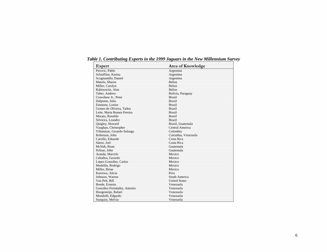
Table 1. Contributing Experts in the 1999 Jaguars in the New Millennium Survey Expert Area of Knowledge Perovic, Pablo Argentina Schiaffino, Karina Argentina Scognamillo, Daniel Argentina Matola, Sharon Belize Miller, Carolyn Belize Rabinowitz, Alan Belize Taber, Andrew Bolivia, Paraguay Crawshaw Jr., Peter Brazil Dalponte, Julio Brazil Emmons, Louise Brazil Gomes de Oliveira, Tadeu Brazil Leite, Maria Renata Pereira Brazil Morato, Ronaldo Brazil Silvieira, Leandro Brazil Quigley, Howard Brazil, Guatemala Vaughan, Christopher Central America Villamizar, Gerardo Suluaga Colombia Robinson, John Colombia, Venezuela Carrillo, Eduardo Costa Rica Sáenz, Joel Costa Rica McNab, Roan Guatemala Polisar, John Guatemala Aranda, Marcelo Mexico Ceballos, Gerardo Mexico López-González, Carlos Mexico Medellín, Rodrigo Mexico Miller, Brian Mexico Kuroiwa, Alicia Peru Johnson, Warren South America Van Pelt, Bill United States Boede, Ernesto Venezuela González-Fernández, Antonio Venezuela Hoogesteijn, Rafael Venezuela Mondolfi, Edgardo Venezuela Sunquist, Melvin Venezuela
7
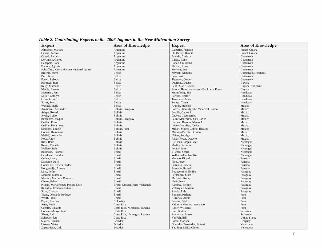
Table 2. Contributing Experts to the 2006 Jaguars in the New Millennium Survey Expert Area of Knowledge Expert Area of Knowledge Altrichter, Mariana Argentina Catzefliz, Francois French Guiana Canedi, Arturo Argentina De Thoisy, Benoit French Guiana Canedi, Patricia Argentina Estrada, Christian Guatemala DeAngelo, Carlos Argentina Garcia, Rony Guatemala Denapole, Lara Argentina López, Guillermo Guatemala Paviolo, Agustin Argentina McNab, Roan Guatemala Schiaffino, Karina /Parque Nacional Iguazú Argentina Moriera, José Guatemala Brechin, Steve Belize Novack, Anthony Guatemala, Honduras Buff, Jesse Belize Soto, José Guatemala Foster, Rebecca Belize Thornton, Daniel Guatemala Harmsen, Bart Belize Desfritas, Duane Guyana Kelly, Marcella Belize Felix, Marie-Louise Guyana, Suriname Matola, Sharon Belize Sambu, Hemchandranauth/Iwokrama Forest Guyana Meerman, Jan Belize Muntifering, Jeff Honduras Miller, Carolyn Belize Portillo, Héctor Honduras Ostro, Linde Belize Townsend, Josiah Honduras Silver, Scott Belize Zelaya, Cintia Honduras Weckel, Mark Belize Aranda, Marcelo Mexico Arambiza , Alejandro Bolivia, Paraguay Barros, Oscar Agustín Villarreal Espino Mexico Arispe, Rosario Bolivia Bonilla, Carlos R. Mexico Ayala, Guido Bolivia Chávez, Cuauhtémoc Mexico Barrientos, Joaquin Bolivia, Paraguay Faller-Menéndez, Juan Carlos Mexico Cuéllar, Erika Bolivia Lazcano Barrero, Marco A. Mexico Cuéllar, Rosa Leny Bolivia López González, Carlos Mexico Emmons, Louise Bolivia, Peru Mihart, Mircea Gabriel Hidalgo Mexico Gomez, Humberto Bolivia Monroy-Vilchis, Octavio Mexico Maffei, Leonardo Bolivia Nuñez, Rodrigo Mexico Noss, Andy Bolivia Rosas-Rosas, Octavio Mexico Rios, Boris Bolivia Kjelosen, Jorgen Peter Nicaragua Rumiz, Damián Bolivia Medina, Arnulfo Nicaragua Wallace, Rob Bolivia Polisar, John Nicaragua Boulhosa, Ricardo Brazil Vilchez, Sergio Nicaragua Cavalcanti, Sandra Brazil Williams-Guillen, Kim Nicaragua Cullen, Laury Brazil Moreno, Ricardo Panama Dalponte, Julio Brazil Pino, Jorge Panama Gomes de Oliviera, Tadeu Brazil Samudio, Julieta Panama Hoogesteijn, Almira Brazil Samudio, Rafael Panama Lima, Pedro Brazil Boungermini, Emilio Paraguay Mazzoli, Marcelo Brazil Fernández, Sixto Paraguay Messias, Mariluce Rezende Brazil McBride, Rocky Paraguay Olmos, Fabio Brazil Neris, Nora Paraguay Pitman, Maria Renata Periera Leite Brazil, Guyana, Peru, Venezuela Ramírez, Freddy Paraguay Ramalho, Emiliano Esterci Brazil Velázquez, Myriam Paraguay Silva, Claudia Brazil Zavala, Luis Paraguay Viana, Leonardo Rodrigo Brazil Bodmer, Richard Peru Wolff, Frank Brazil Kuroiwa, Alicia Peru Payan, Esteban Colombia Puertas, Pablo Peru Amit, Ronit Costa Rica Valdes-Velasquez, Armando Peru Carrillo, Eduardo Costa Rica, Nicaragua, Panama Robert Williams Peru González-Maya, José Costa Rica Lim, Burton Suriname Sáenz, Joel Costa Rica, Nicaragua, Panama Sanderson, James Suriname Schipper, Jan Costa Rica VanPelt, Bill United States Suarez, Esteban Ecuador Cosse, Mariana Uruguay Utreras, Victor Ecuador Gonzalez-Fernandez, Antonio Venezuela Zapata-Rios, Galo Ecuador Yat Sing, Melva Olmos Venezuela

8
Extent of Jaguar Knowledge Each expert was first asked to draw on their map their extent of knowledge. This area was defined as areas across the historic range where the expert has sufficient knowledge and information about the status and distribution of jaguars on which to comment for the survey.
Jaguar Point Observations Each expert was asked to provide localities where jaguars have been observed. The experts in the 1999 survey were asked for point observations in the 10 years prior to the conference date. The experts in the 2006 survey were asked for point observations since March of 1999. The experts were asked to combine all jaguar observations within 20km of the center coordinates of the point locality. Each point was characterized by the dates of first and last observation, observation methods used, and habitat/land use type in which the observation was made. Point observations could only be provided if:
1. the expert or someone whose judgment the expert trusts has seen a live jaguar; or, 2. the expert or someone whose judgment the expert trusts has radiotracked a jaguar; or 3. the expert or someone whose judgment the expert trusts has seen a jaguar track and there is no confusion with a
puma track; or, 4. the expert or someone whose judgment the expert trusts has collected scat that has been reliably identified as a
jaguar; or, 5. a skin or skull or other remains exists with proper documentation or incontrovertible proof of origin.
Reported Jaguar Range (RJR) Experts were asked to draw on their maps the approximate range of jaguars where they reasonably know jaguars exist. Experts commented on what limited the boundaries of the polygons they drew (e.g. habitat type, elevational limit, etc.) and the percentage of the area of the polygon in which jaguars are threatened by various factors (e.g. habitat conversion, hunting of jaguars, etc.).
Jaguar Conservation Units (JCU) Experts were asked to draw on their maps areas that are critical for long-term jaguar conservation. A JCU area is defined as either:
Type I. an area with a stable prey community, currently known or believed to contain a population of resident jaguars large enough (at least 50 breeding individuals) to be potentially self-sustaining over the next 100 years, or
9
Type 2. areas containing fewer jaguars but with adequate habitat and a stable diverse prey base, such that jaguar populations in the area could increase if threats were alleviated.
JCUs were not restricted to or required to contain protected areas. For each JCU the experts were asked to classify the JCU under one of the two categories above, estimate population size, provide names of important prey species, information about threats to this JCU, and information about the percentage and effectiveness of land tenure in the area. They were also asked to characterize the JCU with respect to factors that may contribute to the long term survival of jaguars such as habitat connectivity, habitat quality, area size, hunting pressure on jaguars, hunting pressure on prey, population status, and any other factors they felt are important.
Further Data Collection Literature In some cases, jaguar point localities and jaguar range areas were not provided by experts but found through an extensive literature search. This information was also added to the data base and the authors of the papers credited. Revision Solicitation Once the initial data was compiled and analyzed, it was sent out to all contributing experts for review. During the review process, experts sometimes reported on new information gathered since their initial questionnaire was submitted. The review process lasted for two months in order to give contributors ample time to respond with suggestions, corrections, and further data. Reminder emails were sent out to experts on a regular basis until a reply regarding the data base was received. Mesoamerican Workshop The opportunity for jaguar experts throughout Mesoamerica to meet occurred at the beginning of November, 2006, at a jaguar symposium that was held at the annual meeting of the Socieded Mesoamericana para la Biología y la Conservación. We took advantage of this gathering and held a workshop for experts in the region to come to a consensus on the JCUs in the region. Prior to the workshop, we acquired the list of people whose talks were accepted for the jaguar symposium. We contacted both people who had already contributed data to the survey as well as people who were new to the survey. We invited everyone to participate in the workshop, to be held the second afternoon of the symposium, and provided people who were new to the survey with all the survey materials. All the presenters from the Mesoamerican region participated in the workshop. The experts were divided into regional groups and asked to come to a consensus on the JCUs in their area of expertise.
10
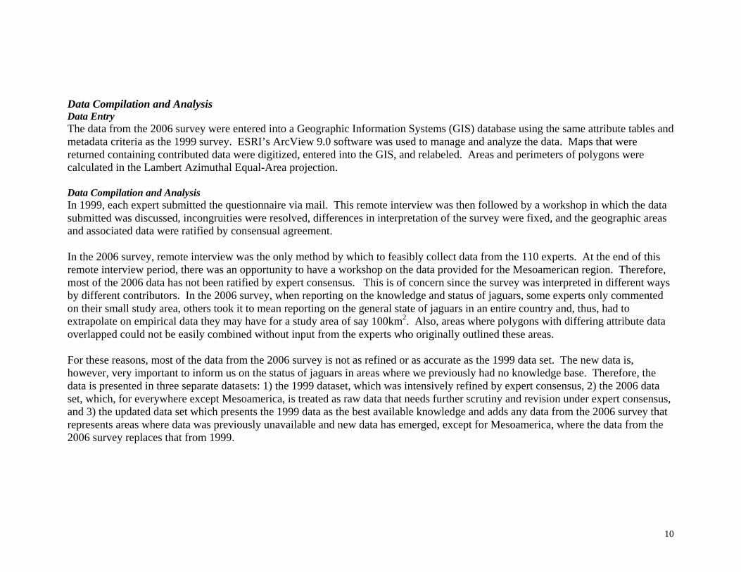
Data Compilation and Analysis Data Entry The data from the 2006 survey were entered into a Geographic Information Systems (GIS) database using the same attribute tables and metadata criteria as the 1999 survey. ESRI’s ArcView 9.0 software was used to manage and analyze the data. Maps that were returned containing contributed data were digitized, entered into the GIS, and relabeled. Areas and perimeters of polygons were calculated in the Lambert Azimuthal Equal-Area projection. Data Compilation and Analysis In 1999, each expert submitted the questionnaire via mail. This remote interview was then followed by a workshop in which the data submitted was discussed, incongruities were resolved, differences in interpretation of the survey were fixed, and the geographic areas and associated data were ratified by consensual agreement. In the 2006 survey, remote interview was the only method by which to feasibly collect data from the 110 experts. At the end of this remote interview period, there was an opportunity to have a workshop on the data provided for the Mesoamerican region. Therefore, most of the 2006 data has not been ratified by expert consensus. This is of concern since the survey was interpreted in different ways by different contributors. In the 2006 survey, when reporting on the knowledge and status of jaguars, some experts only commented on their small study area, others took it to mean reporting on the general state of jaguars in an entire country and, thus, had to extrapolate on empirical data they may have for a study area of say 100km2. Also, areas where polygons with differing attribute data overlapped could not be easily combined without input from the experts who originally outlined these areas. For these reasons, most of the data from the 2006 survey is not as refined or as accurate as the 1999 data set. The new data is, however, very important to inform us on the status of jaguars in areas where we previously had no knowledge base. Therefore, the data is presented in three separate datasets: 1) the 1999 dataset, which was intensively refined by expert consensus, 2) the 2006 data set, which, for everywhere except Mesoamerica, is treated as raw data that needs further scrutiny and revision under expert consensus, and 3) the updated data set which presents the 1999 data as the best available knowledge and adds any data from the 2006 survey that represents areas where data was previously unavailable and new data has emerged, except for Mesoamerica, where the data from the 2006 survey replaces that from 1999.

11
These three different data sets are presented for the areas of expert knowledge, the reported jaguar range, and the jaguar conservation units. Because point observation data the only subjective data in this survey, we felt expert consensus was not necessary and this data is only presented as data from the 1999 survey and then data from the 2006 survey. The data on the JCUs received further analysis. Each JCU was given an identifier number and name corresponding to a national park or other geographic descriptor. The attribute data from these JCUs such as jaguar population size, prey species, threats to the JCUs, and effectiveness of land tenure were analyzed. The protected status of the JCUs was also analyzed by overlaying the JCUs with the World Database on Protected Areas (UNDP 2004). The updated JCU data set was prioritized as in the 1999 study. The JCUs from the 2006 survey representing new areas were included in the prioritization with the caveat that they need further research and expert consensus. Each JCU was assigned to the JGR where the majority of its area occurred. In cases where a JCU overlapped with more than one JGR, the JCU was assigned to the JGRs with which it shared over 1,250km of area, or the equivalent of one point observation. If the JGR had no representative JCUs, the size criteria was relaxed to include any JCUs that occur in that JGR, no matter the amount of overlap. The total size of the JCU, not the area of JCU within a given JGR, was used for calculating priorities, because jaguar populations were assumed to use the entire JCU, not just the portion within one habitat type. For each JCU, the experts characterized six factors contributing to the long-term survival of jaguars — 1) habitat connectivity, 2) habitat quality, 3) JCU size, 4) hunting of jaguars, 5) hunting of prey, and 6) population status – as ‘good for jaguars’, ‘medium for jaguars’, and ‘bad for jaguars’. These classes were given scores of 3, 1, and 0 respectively for the prioritization. Each of these factors was also weighted using the priority scheme developed by experts at the 1999 Jaguars in the New Millennium conference. The weighting scheme is as follows: JCU size (30 points), connectivity (23 points), habitat quality (23 points), hunting of jaguars (10 points), hunting of prey (10 points), and jaguar population status (4 points). The final prioritization for each JCU was determined by multiplying the JCU’s score (3, 1, or 0) for each of the six factors by its corresponding weight and then adding the products for the six factors. The JCUs within the same JGR were then ranked. If JCUs had the same score, they were given the same rank for that JGR.

12
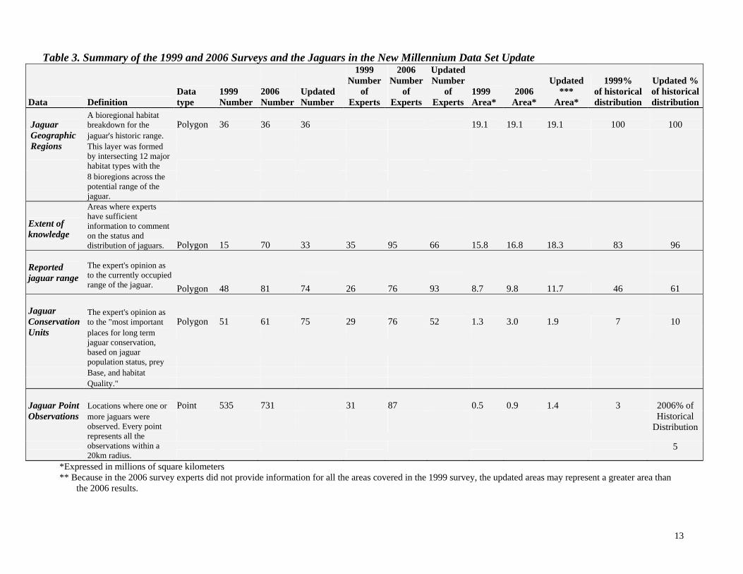
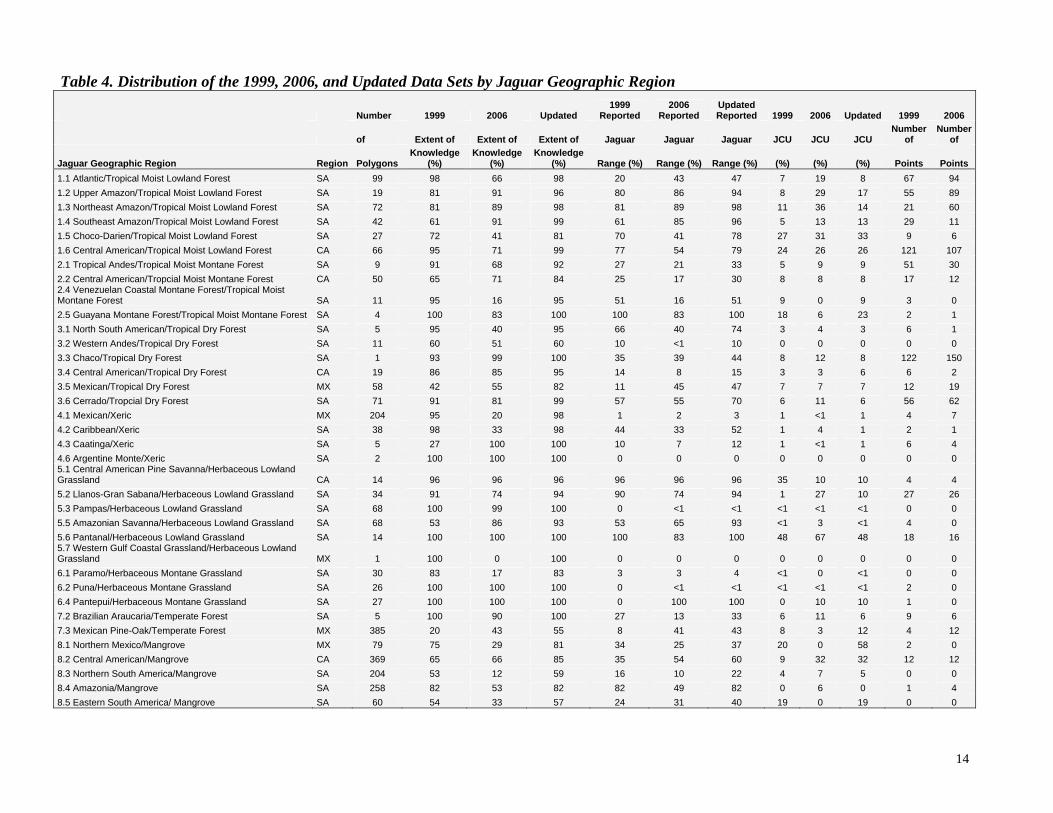
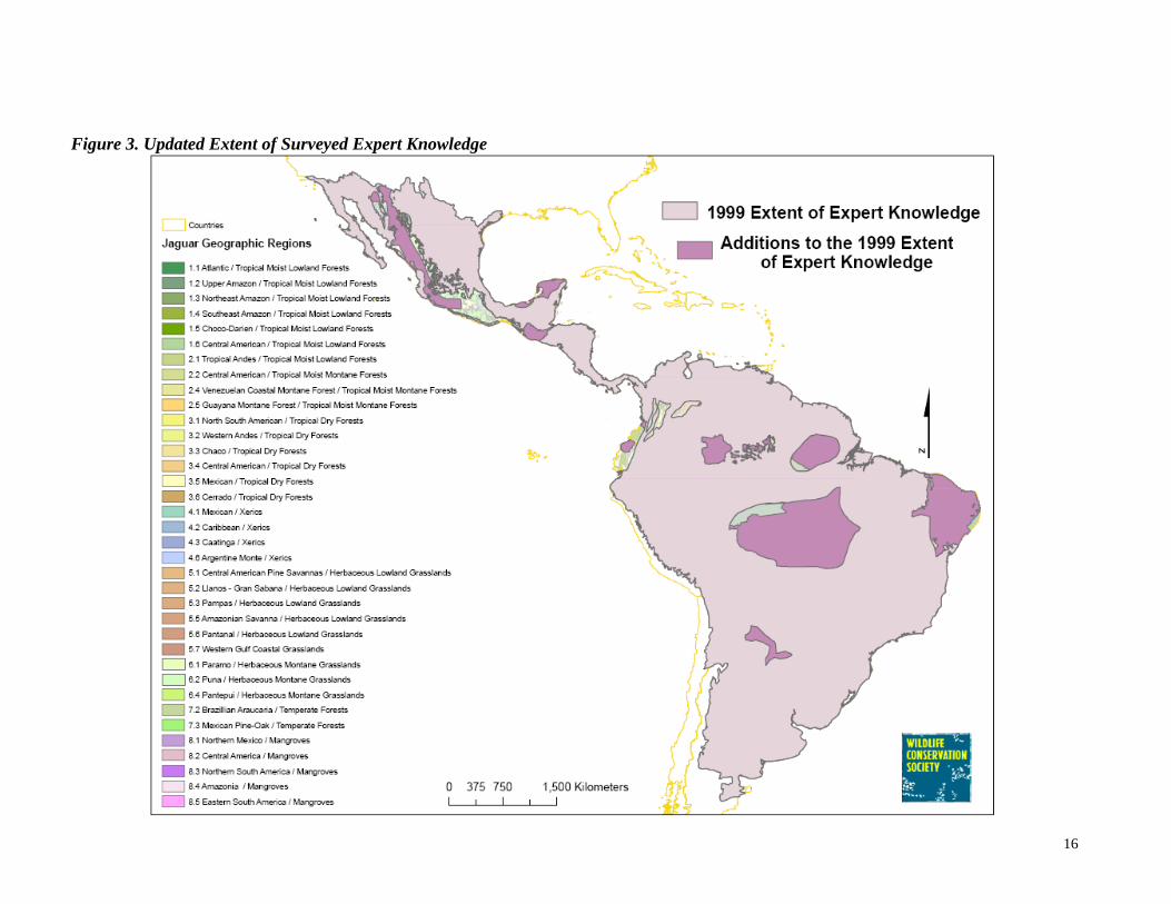
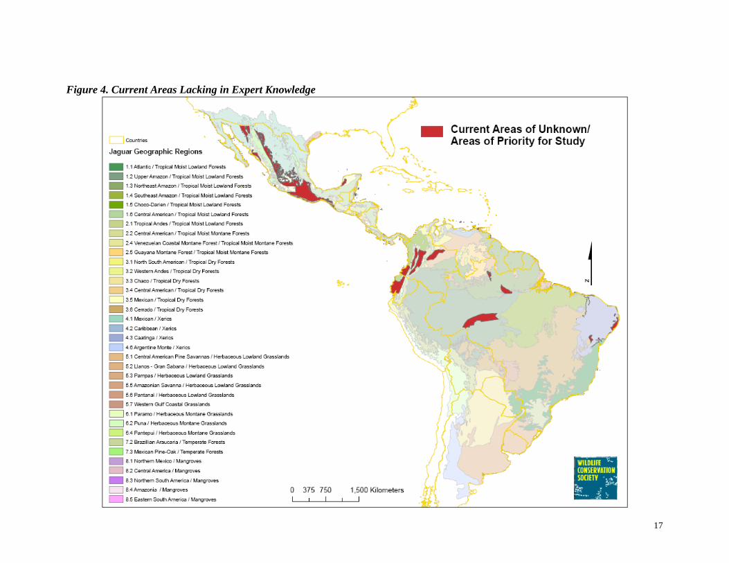
Results Extent of Jaguar Knowledge In the 1999 survey, the extent of knowledge reported by the experts covered 83% of the jaguar’s historic range (Table 3, Figure 2). In the 2006 survey, experts reported knowledge an additional 13% of the jaguar’s historic range. The updated area of knowledge for the range of the jaguar covers 96% of the jaguar’s historic range (Table 3, Figure3). The 1999 survey contained knowledge gaps in areas such as the Sierra Madre Occidental and the northern Yucatan peninsula in Mexico, central Brazil, the Caatinga region of eastern Brazil, areas in northeastern and northwestern Brazil, and the northern Chaco of northern Argentina (Figure 2). The 2006 contributions contained information on these previously unknown areas (Figure 3). The distribution of this updated jaguar knowledge by JGR reflects the distribution of expert knowledge throughout these geographic regions (Table 4). Twenty-five of the 36 JGRs have over 90% of their areas reported as known by experts. The other 11 JGRs have knowledge of at least 50% of their areas. Figure 4 displays areas where there is no reported expert knowledge. Since we currently have no knowledge of the status of jaguars in these areas, they are a high priority for study.
13
Table 3. Summary of the 1999 and 2006 Surveys and the Jaguars in the New Millennium Data Set Update
Data Definition Data type
1999 Number
2006 Number
Updated Number
1999 Number
of Experts
2006 Number
of Experts
UpdatedNumber
of Experts
1999 Area*
2006 Area*
Updated
*** Area*
1999% of historical distribution
Updated % of historical distribution
Jaguar A bioregional habitat breakdown for the Polygon 36
36
36 19.1 19.1
19.1 100
100
Geographic jaguar's historic range. Regions This layer was formed
by intersecting 12 major habitat types with the
8 bioregions across the
potential range of the jaguar.
Extent of knowledge
Areas where experts have sufficient information to comment on the status and distribution of jaguars. Polygon 15 70
33 35 95
66 15.8 16.8
18.3 83
96
Reported jaguar range
The expert's opinion as to the currently occupied range of the jaguar. Polygon 48 81
74 26 76
93 8.7 9.8
11.7 46
61
Jaguar Conservation
The expert's opinion as to the "most important Polygon 51 61
75 29 76 52 1.3 3.0
1.9 7
10 Units places for long term
jaguar conservation, based on jaguar population status, prey
Base, and habitat Quality."
Jaguar Point Locations where one or Point 535 731 31 87
0.5 0.9
1.4 3
2006% of
Observations more jaguars were Historical
observed. Every point represents all the
Distribution
observations within a 20km radius.
5
*Expressed in millions of square kilometers ** Because in the 2006 survey experts did not provide information for all the areas covered in the 1999 survey, the updated areas may represent a greater area than
the 2006 results.
14
Table 4. Distribution of the 1999, 2006, and Updated Data Sets by Jaguar Geographic Region
Number 1999 2006 Updated 1999
Reported 2006
Reported Updated Reported 1999 2006 Updated 1999 2006
of Extent of Extent of Extent of Jaguar Jaguar Jaguar JCU JCU JCU Number
of Number
of
Jaguar Geographic Region Region PolygonsKnowledge
(%) Knowledge
(%) Knowledge
(%) Range (%) Range (%) Range (%) (%) (%) (%) Points Points 1.1 Atlantic/Tropical Moist Lowland Forest SA 99 98 66 98 20 43 47 7 19 8 67 94 1.2 Upper Amazon/Tropical Moist Lowland Forest SA 19 81 91 96 80 86 94 8 29 17 55 89 1.3 Northeast Amazon/Tropical Moist Lowland Forest SA 72 81 89 98 81 89 98 11 36 14 21 60 1.4 Southeast Amazon/Tropical Moist Lowland Forest SA 42 61 91 99 61 85 96 5 13 13 29 11 1.5 Choco-Darien/Tropical Moist Lowland Forest SA 27 72 41 81 70 41 78 27 31 33 9 6 1.6 Central American/Tropical Moist Lowland Forest CA 66 95 71 99 77 54 79 24 26 26 121 107 2.1 Tropical Andes/Tropical Moist Montane Forest SA 9 91 68 92 27 21 33 5 9 9 51 30 2.2 Central American/Tropcial Moist Montane Forest CA 50 65 71 84 25 17 30 8 8 8 17 12 2.4 Venezuelan Coastal Montane Forest/Tropical Moist Montane Forest SA 11 95 16 95 51 16 51 9 0 9 3 0 2.5 Guayana Montane Forest/Tropical Moist Montane Forest SA 4 100 83 100 100 83 100 18 6 23 2 1 3.1 North South American/Tropical Dry Forest SA 5 95 40 95 66 40 74 3 4 3 6 1 3.2 Western Andes/Tropical Dry Forest SA 11 60 51 60 10 <1 10 0 0 0 0 0 3.3 Chaco/Tropical Dry Forest SA 1 93 99 100 35 39 44 8 12 8 122 150 3.4 Central American/Tropical Dry Forest CA 19 86 85 95 14 8 15 3 3 6 6 2 3.5 Mexican/Tropical Dry Forest MX 58 42 55 82 11 45 47 7 7 7 12 19 3.6 Cerrado/Tropcial Dry Forest SA 71 91 81 99 57 55 70 6 11 6 56 62 4.1 Mexican/Xeric MX 204 95 20 98 1 2 3 1 <1 1 4 7 4.2 Caribbean/Xeric SA 38 98 33 98 44 33 52 1 4 1 2 1 4.3 Caatinga/Xeric SA 5 27 100 100 10 7 12 1 <1 1 6 4 4.6 Argentine Monte/Xeric SA 2 100 100 100 0 0 0 0 0 0 0 0 5.1 Central American Pine Savanna/Herbaceous Lowland Grassland CA 14 96 96 96 96 96 96 35 10 10 4 4 5.2 Llanos-Gran Sabana/Herbaceous Lowland Grassland SA 34 91 74 94 90 74 94 1 27 10 27 26 5.3 Pampas/Herbaceous Lowland Grassland SA 68 100 99 100 0 <1 <1 <1 <1 <1 0 0 5.5 Amazonian Savanna/Herbaceous Lowland Grassland SA 68 53 86 93 53 65 93 <1 3 <1 4 0 5.6 Pantanal/Herbaceous Lowland Grassland SA 14 100 100 100 100 83 100 48 67 48 18 16 5.7 Western Gulf Coastal Grassland/Herbaceous Lowland Grassland MX 1 100 0 100 0 0 0 0 0 0 0 0 6.1 Paramo/Herbaceous Montane Grassland SA 30 83 17 83 3 3 4 <1 0 <1 0 0 6.2 Puna/Herbaceous Montane Grassland SA 26 100 100 100 0 <1 <1 <1 <1 <1 2 0 6.4 Pantepui/Herbaceous Montane Grassland SA 27 100 100 100 0 100 100 0 10 10 1 0 7.2 Brazilian Araucaria/Temperate Forest SA 5 100 90 100 27 13 33 6 11 6 9 6 7.3 Mexican Pine-Oak/Temperate Forest MX 385 20 43 55 8 41 43 8 3 12 4 12 8.1 Northern Mexico/Mangrove MX 79 75 29 81 34 25 37 20 0 58 2 0 8.2 Central American/Mangrove CA 369 65 66 85 35 54 60 9 32 32 12 12 8.3 Northern South America/Mangrove SA 204 53 12 59 16 10 22 4 7 5 0 0 8.4 Amazonia/Mangrove SA 258 82 53 82 82 49 82 0 6 0 1 4 8.5 Eastern South America/ Mangrove SA 60 54 33 57 24 31 40 19 0 19 0 0
15
Figure 2. 1999 Extent of Surveyed Expert Knowledge
16
Figure 3. Updated Extent of Surveyed Expert Knowledge
17
Figure 4. Current Areas Lacking in Expert Knowledge

18
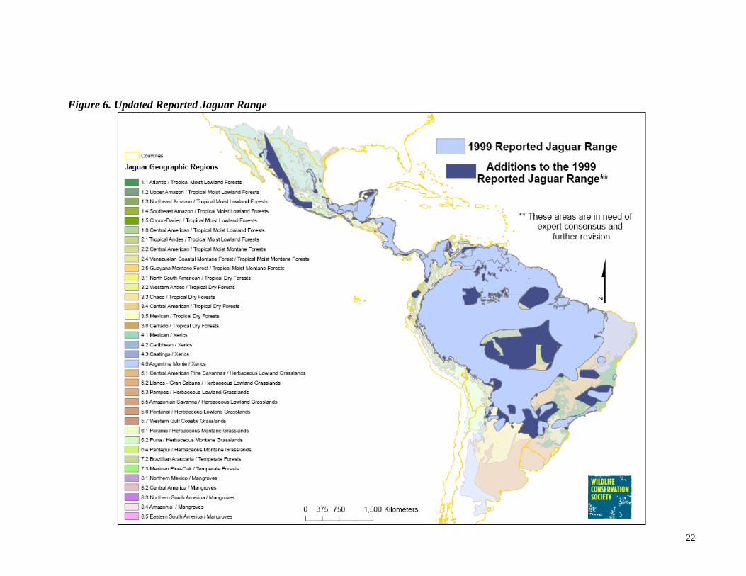
Reported, Currently Occupied Jaguar Range (RJR) The approximate jaguar range reported by experts in the 1999 survey covered 46% of the jaguar’s historical range (Table 3, Figure 5). Incorporating data from the 2006 survey that represent new geographic areas, the updated reported jaguar range covers 61% of the jaguar’s historic range (Table 3, Figure 6). This does not necessarily mean that the jaguar’s range has grown over the last 6 years, but may simply reflect a greater representation of knowledge on the jaguar throughout its historic range. In addition, this updated dataset assumes that the range of the jaguar has not decreased over the last 6 years. A total of 89 experts reported information on the extent of this updated jaguar range. All JGRs are represented within the updated RJR boundary with the exception of the Argentine monte xerics (JGR 4.6), and the western gulf coastal grasslands (JGR 5.7) (Table 4). Other areas that are underrepresented (<20%) include the western Andes tropical dry forest (JGR 3.2), the Central American tropical dry forest (JGR 3.4), the Mexican xerics (JGR 4.1), the Caatinga xerics (JGR 4.3), the Pampas grasslands (JGR 5.3), and the Paramo and Puna grasslands (JGRs 6.1 and 6.2). Many JGRs are reported to have a large percentage of their areas as current jaguar range. The Guyana montane forest (JGR 2.5), the Pantanal grasslands (JGR 5.6), and the Pantepui herbaceous montane grasslands (JGR 6.4) are all completely represented in the current jaguar range. Jaguars are reported to range in over 80% of the following JGRs: Upper Amazon, Northeast Amazon, and Southeast Amazon tropical moist lowland forests (JGRs 1.2, 1.3, and 1.4), the Central American pine savanna lowland grassland (JGR 5.1), the Llanos-Gran Sabana lowland grasslands (JGR 5.2), the Amazonian grasslands (JGR 5.5), and the Amazonian mangroves (JGR 8.4). In 1999, it was reported that jaguars were not present in the Pampas, Puna, and Pantepui grasslands in South America (JGRs 5.3, 6.2, and 6.4), the Argentine monte xerics (JGR 4.6), and the western gulf coastal grasslands of the United States (JGR 5.7). In the updated RJR data set, jaguars are still reportedly absent in the Argentine monte and the western gulf coastal grasslands, but jaguar presence is reported for small areas of the Pampas and Puna grasslands, and throughout the Pantepui grasslands of South America (Table 4). The experts were asked to describe what limited the boundaries of the polygons they drew for their reported jaguar range, and what threats jaguars faced within the boundaries of these polygons. This attribute data is described separately for the 1999 survey and the 2006 survey in Table 5 and Table 6. The updated dataset is not analyzed. Visually, we can display the 1999 reported jaguar range and the additional areas to this range reported in the 2006 survey, but because the polygons of many of these new areas overlapped with polygons from 1999, the data associated with the boundary limitations and threats cannot be extracted accurately and thus, an analysis

19
of the updated reported jaguar range cannot be performed. The general trends of the 1999 reported range and the 2006 reported range are described below. In 1999 as well as in 2006, the factor most limiting to the range of the jaguar was reported to be the hunting of jaguars. Hunting of jaguars reportedly occurs via retaliation for cattle depredation, killing out of fear, killing opportunistically when encountered, and through sport and commercial hunting. The next factor most limiting the reported jaguar distribution for both 1999 and 2006 is reported to be human population density resulting from large cities, small villages, and rural settlements (Table 5). Other prominent factors limiting the range of the jaguar for the two survey years were reported to be insufficient prey from lack of quality habitat and sport and subsistence hunting, habitat transition from natural areas to urban areas, forestry areas, and agricultural lands, altitude which varied from being limiting to jaguars anywhere from 500 meters to 3,700 meters and up, and water barriers from oceans, primary rivers. Other barriers the experts identified were roads and lack of dispersal corridors. The limiting factors to the reported area of jaguar distribution can also be analyzed in terms of the number of polygons that represent these factors (Table 5). The most important limiting factor from both survey years was reported to be human population density. The second most important limiting factor reported in the 1999 survey was habitat transition and the second most important limiting factor reported in the 2006 survey was the hunting of jaguars. The third limiting factor reported in the 1999 survey was the hunting of jaguars and in the 2006 survey was habitat transition. These were followed by insufficient prey, altitude, and water barriers. Within the reported jaguar range for the 1999 survey, the experts reported that the hunting of jaguars was the threat affecting the highest percentage of the RJR area (Table 6). This was the second most prominent threat affecting the areas reported in the 2006 survey. This killing is a result of hunting jaguars following cattle depredation, sport and commercial hunting, opportunistic hunting, and killing out of fear. The next most prominent threat for the 1999 survey was reported to be the hunting of jaguar prey from subsistence hunting, opportunistic hunting, and sport hunting. This was reported to be the most prominent threat to the RJR in the 2006 survey. Habitat conversion was the third most prominent threat reported in 1999 and the fourth most prominent threat reported in 2006. Resource extraction was the fourth most prominent threat in 1999 and the third most prominent threat in 2006. Habitat conversion was reported to be in the form of agriculture, pasture, logging, and human development and settlements. Resource extraction was due to activities such as logging, agriculture, mining, firewood collecting, and road building.
20
Other threats were also identified by the experts from the two survey years (Table 6). These threats include disease, lack of judicial and legal framework for protection, drought, fencing and border patrol (on United States/Mexico border), restricted areas, small jaguar populations, habitat fragmentation, tourism developments, lack of local knowledge, and illegal drug cultivation and associated activities. Based on the percentage of polygons affected by these threats, the hunting of prey affected the highest percentage of polygons representing the range of the jaguar in both survey years. In 1999, the second most prominent threat by polygon percentage was habitat conversion. In 2006, the second most prominent threat by polygon percentage was hunting of jaguars. The third most prominent threat by polygon percentage in 1999 was the hunting of jaguars and in 2006 was habitat conversion. These were followed by resource extraction and other threats. In general, jaguars experience more than one of the above threats in the same area and thus, the percentages of these threats can add up to over 100%.

21
Figure 5. 1999 Reported Jaguar Range
22
Figure 6. Updated Reported Jaguar Range

23
Table 5. Analysis of the Limiting Factors for the 1999 and 2006 Reported Areas of Jaguar Distribution*
Perimeter 1999 Perimeter 2006** 1999 1999 2006** 2006** 1999 2006
Limiting Factor Length 1999 (km)
Percentage of total
RJR Perimeter
Length 2006** (km)
Percentage of total
RJR Perimeter
PolygonNumber
Percentage of total
RJR polygon number
PolygonNumber
Percentage of total
RJR polygon number
Description Description
Hunting of Jaguars 32,547 36 36,067 28 24 50 36 45 hunting for cattle hunting for cattle depredation, sport, depredation, sport, And protection commercial, and fear
Human Population Density 31,936 35 29,472 23 30 63 43 54 large and small cities and towns
large and small cities and rural settlements
Altitude 28,736 31 4,052 3 9 19 13 16 average = 1,508 meters average= 1,892 meters
variation from variation from 500-3,700 meters 1000 - 3000 meters
Insufficient Prey 25,718 28 25,672 20 23 48 30 38 sport, subsistence, and lack of quality habitat, occasional hunting sport hunting, and subsistence hunting
Water Barrier 15,456 17 8,229 6 7 15 16 20 oceans and primary rivers
primary rivers, large lakes, and oceans
Habitat Transition 13,898 15 19,827 15 28 58 32 40 urban areas, forestry, urban areas, forestry,
ranching, agriculture, ranching, agriculture, desert, human
settlementsdesert, human
settlements
Limit of Expert Knowledge 4,911 5 26,328 20 10 21 30 38 large areas, difficult access, lack of time
Other Barrier 3,417 4 10,304 8 7 15 12 15 roads, mountain ranges, roads and lack of and settlements dispersal corridors
Map Border 158 <1 8,998 7 2 4 7 9 Border of Protected Area 151 <1 0 0 2 4 0 0
No data 12,746 14 35,006 27 7 15 27 33 * The updated dataset could not be analyzed due to overlapping polygons and inaccuracies that would result from merging or clipping these polygons. ** The data from the 2006 survey is in need of further expert consensus and revision.

24
Table 6. Analysis of the Factors that Threaten Jaguars within the 1999 and 2006 Reported Areas of Jaguar Distribution*
1999 Area of Distribution 2006 Area of Distribution** 1999 Polygons 2006 Polygons**
Threats Area (km2)
Percentage of total RJR
area
Area (km2)
Percentage of total RJR area
Number Percentage of total RJR polygon number
Number Percentage of total RJR polygon number
Details 1999 Details 2006
Hunting of Jaguars 2,684,999 31 3,348,735 34 26 54 43 54 hunting for cattle hunting for cattle
depredation, sport and depredation, sport, opportunistic hunting, commercial, and hunting for zoos or
circuseshunting out of fear
Hunting of Prey 2,371,719 27 3,879,531 39 29 60 44 55 sport, subsistence, and sport, subsistence, and
opportunistic hunting opportunistic hunting
Habitat Conversion 1,875,922 21 1,993,636 20 28 58 41 51 Agriculture, pasture, infrastructure, human development agriculture, logging, pasture, human settlements Resource Extraction 266,959 3 3,257,081 33 15 31 26 32 logging, agriculture, logging, firewood,
minerals, road construction
minerals, agriculture
Other 197,926 2 656,170 7 14 29 15 19 drug cultivation, disease, fencing and
tourism, increase border patrol (US), in human population, lack of judicial and restricted areas legal framework for protection, drought, small population size, habitat fragmentation, tourism,
developments, lack of local knowledge,illegal drug cultivation and
activity No Threat (specified)
2,253 0 181,721 2 1 2 6 8
No data 619,557 7 2,478,431 25 9 19 27 33 * The updated dataset could not be analyzed due to overlapping polygons and inaccuracies that would result from merging or clipping these polygons. ** The data from the 2006 survey is in need of further expert consensus and revision.

25
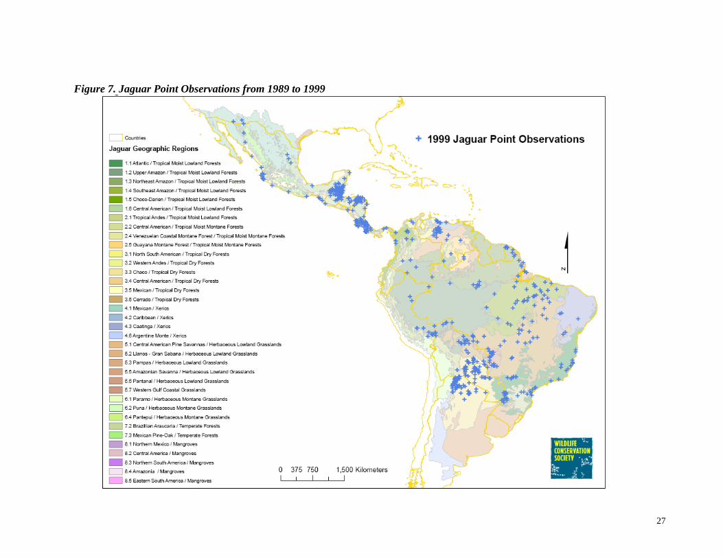
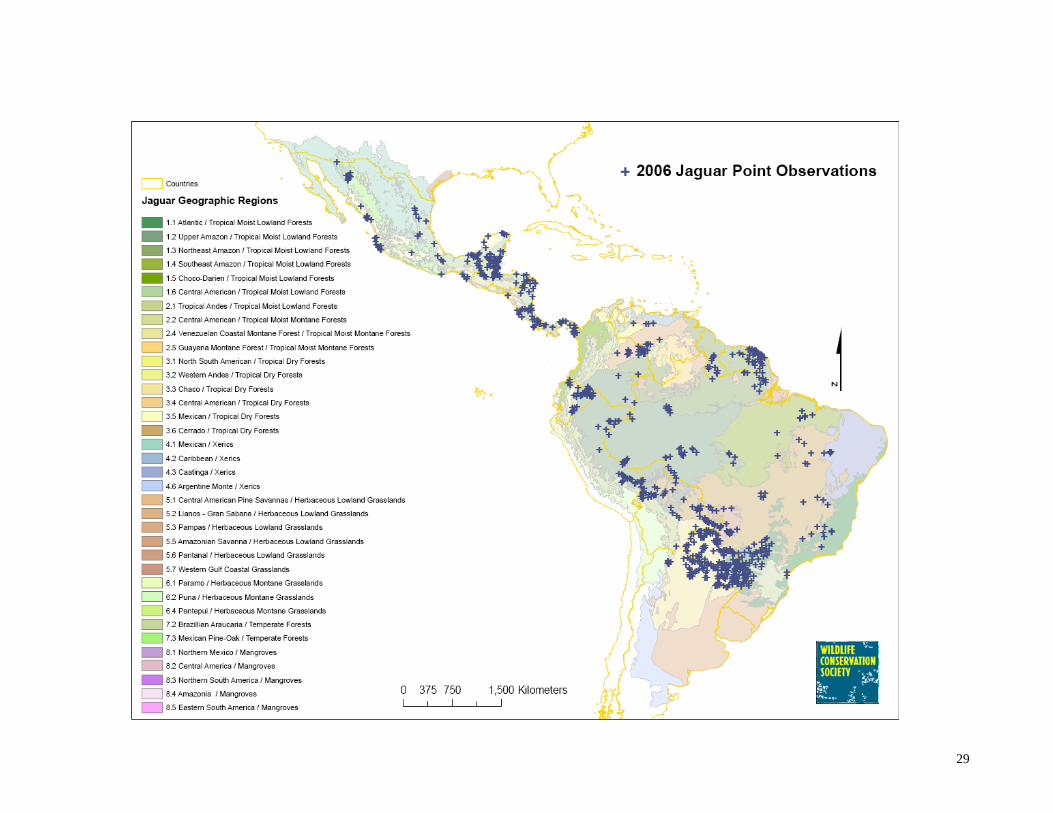
Jaguar Point Observations In the 1999 survey, experts provided jaguar point observations that occurred the ten years before the March 1999 survey. The 1999 points data set contains 5,680 point observations at 535 different localities (each locality represents 20km2 and may contain more than one observation) (Figure 7, Table 7). In the 2006 survey, experts provided jaguar point observations that occurred from March 1999 to December 2005. There were 17,207 point observations at 731 different point localities during the last 6 years (Figure 8, Table 7). As point data can be considered concrete objective information, this data does not need to be subjected to expert consensus. Given this, there is no ‘updated’ point data set. It is simply presented as the point observations submitted in the 1999 survey and the point observations submitted in the 2006 survey. The density of point observations in all the data sets is uneven across the jaguar’s range, most likely representing concentrations of research rather than concentrations of jaguars. This can also be attributed to jaguars occurring at naturally low densities in some of the JGRs. In the 2006 data set, the Chaco dry forest (JGR 3.3) has the most point locations of all the JGRs (150) (Table 4). Other areas that have large numbers of jaguar point locations include the Central American tropical moist lowland forest (JGR 1.6) with 107 point locations, the Atlantic tropical moist lowland forests of South America (JGR 1.1) with 92 point locations, and the upper Amazon tropical moist lowland forest (JGR 1.2) with 89 point locations. Point locations are found in every JGR except for the Venezuelan coastal montane forest (JGR 2.4), the western Andes tropical dry forest (JGR 3.2), the Pampas, Amazonian savannah, Paramo, Puna, and Pantepui grasslands (JGRs 5.3, 5.5, 6.1, 6.2, and 6.3), the mangroves of northern Mexico, northern South America, and eastern South America (JGRs 8.1, 8.3, and 8.5) and, of course, in the JGRs that were not included in the updated RJR (Table 4, RJR results). Jaguar point locations were determined through a variety of different observation methods (Table 7). Eighty-two percent of the observations in the 2006 points layer were based on at least one of the more reliable observation methods: direct sighting by a researcher, photograph, radio telemetry, or discovery of jaguar remains. The most common method of observation was through radio-collar locations (72% of point observations). Seeing jaguar scat or tracks was the next most reported method of observation for the point observations (13%), followed by seeing live jaguars (5%), remains of an animal killed by a jaguar (3%), photographic evidence (3%), unconfirmed reports (3%), and remains of a jaguar (2%). Jaguar vocalizations and other sounds and captured jaguars made up less than 1% of the observations.
26
For each point observation, experts provided the type of habitat or landscape feature in which the observation was made (Table 8). In the 2006 point data, jaguars were most commonly observed in primary forest (30% of observations). This was followed by secondary forest (24%), moist broadleaved forest (23%), and dry broadleaved forest (14%). Other major habitat types where jaguars were observed in the last six years were grasslands and savannas (10%), flooded grasslands (9%), riparian areas (4%), mangrove forests (2%), and conifer forests (2%). Habitat types where jaguars were observed in 1% or less of the point locations include non-xeric shrub lands, montane grasslands, rocky or icy areas, beaches, marshlands or wetlands, Mediterranean scrub land, Varzea forests, and xeric shrublands. The average distance a point location was from a human settlement was 25.9 km. The minimum distance was 0 and the maximum distance was 1,000 km. The distances are reported for the center of the point observation locality. Because jaguars are found close to humans and human activities, experts were also asked to classify the human land use type where the jaguar observation was made. The most common human-designated land use where jaguars were observed was protected areas (27% of the observation locations). This was closely followed by ranching and livestock areas (22%). Other land use types where jaguars were observed were less prevalent: logging areas (8%), garden/forest matrix lands (6%), agricultural areas (6%), tourism areas (1%), urban areas (1%), and mining areas (1%).
27
Figure 7. Jaguar Point Observations from 1989 to 1999
28
Figure 8. Jaguar Point Observations from 1999 to 2006
29

30
Table 7. Analysis of Jaguar Point Observations by Method of Observation
1999 Observations 2006 Observations 1999 Point Localities 2006 Point Localities Method of
Observation No. Percentage
of total observations
No. Percentage of total
observations
No. Percentage of total points
No. Percentage of total points
Tracks or scat 2,678 47 2,192 13 314 59 301 41 Radio collar location 1,501 26 12,357 72 13 2 19 3
Live 859 15 904 5 218 41 189 25 Remains of animal killed by jaguar
230 4 576 3 33 6 40 5
Remains of jaguar 223 4 260 2 135 25 129 18
Marks and sounds of scratching
80 1 1 <1 4 1 1 <1
Captured jaguar 33 1 17 <1 16 3 13 2 Photographic evidence 23 <1 478 3 7 1 38 5
Vocalization 15 <1 12 <1 5 1 8 1 Unconfirmed reports 14 <1 471 3 14 3 245 34
Other type (unspecified) 24 <1 12 <1 17 3 6 1
No Data 28 5 88 12
Total 5,680 100 17,206 100

31
Table 8. Analysis of Jaguar Point Observations by Type of Habitat and Land Use
1999 Points 2006 Points Number Percentage Number Percentage
Habitat Type/ LandscapeFeature
Primary Forest 265 50 219 30Secondary Forest 225 42 177 24
Moist Broadleaved Forest 200 37 169 23Dry Broadleaved Forest 136 25 103 14
Conifer Forest 5 1 12 2Grassland/Savanna 76 14 73 10
Non-xeric shrubland 3 1 6 1Flooded Grassland 51 10 69 9
Montane Grassland 6 1 4 <1Desert 22 4 0 0
Rocks and/or ice 6 1 4 <1
Other Habitat Types/ Landscape Features
Beach 2 <1 1 <1Cloud Forest 3 1 0 0
Gallery Forest 3 1 0 0Hilly Terrain 3 1 0 0
Mangrove Forest 14 3 13 2Marshland or Wetland 10 2 10 1
Oak Forest 5 1 0 0Mediterranean Scrub 1 <1 5 <1
Varzea Forest 2 <1 4 <1Xeric Shrubland 1 <1 5 <1
Riparian Area 0 0 31 4
Human Land Use Type Agriculture 24 4 41 6
Ranching/Livestock 200 37 162 22Logging 97 18 61 8
Protected Area 168 31 203 27Garden/Forest Matrix 25 5 46 6
Designated Hunting Area 0 0 1 <1Tourism or Ecotourism 8 1 7 1
Mining 3 1 6 1Hydroelectric Power 2 <1 1 <1
Indigenous People's Reserve 1 <1 0 0Urban Area 6 1 11 1

32
Jaguar Conservation Units In the 1999 survey, experts identified 51 areas as being important to the long-term survival of jaguars. These areas totaled 1.3 million km2 or 7% of the jaguar’s historic range (Table 3, Figure 9). Adding to this data set JCUs identified in the 2006 survey that represented new geographic areas or areas that were ratified by expert consensus, the updated JCU data set contains 90 areas identified as important to the long-term survival of jaguars. These areas total 1.9 million km2 or 10% of the historic range of the jaguar (Table 3, Figure 10). The updated JCUs vary in area from 211 km2 to 99,574 km2. The smallest JCU is in the northwestern corner of Ecuador and the largest JCU resides in central Brazil. The JCUs are distributed throughout the area of expert knowledge with 31 JCUs in Mexico and Central America and 59 in South America. More than one JGR was represented in 57 of the 90 JCUs. The JCUs in the updated JCU data set are found wholly or partially in 33 of the 36 JGRs and represent most of the ecological settings where jaguars currently range (Table 4). Two JGRs not represented by a JCU are areas where jaguars have been extirpated or were never present in large numbers: Argentine monte xerics (JGR 4.6) and the western gulf coastal grasslands (JGR 5.7). Various JGRs are underrepresented in the JCUs (<5%). These are the Mexican, Caribbean, and Caatinga xerics (JGRs 4.1, 4.2, and 4.3), the Pampas and Amazonian grasslands (JGRs 5.3 and 5.5), and the Paramo and Puna grasslands (JGRs 6.1, and 6.2). This is most likely because of lack of researcher information about the status of jaguars in these habitat types, or because these are areas where jaguars exist at naturally low densities. The JGRs that contain the highest number of JCUs are the Upper Amazon tropical moist lowland forest (JGR 1.2) and the Central American tropical moist lowland forest, both containing 17 JCUs. Other JGRs that are highly represented (>10 JCUs) are the tropical Andes moist lowland forest (JGR 2.1) and the Cerrado dry forest (JGR 3.6). Based on area, the JGR with the highest percentage of its area covered by one or more JCUs is the Pantanal grasslands (JGR 5.6; 48% of the total JGR area) (Table 4). This is followed by the Choco-Darien tropical lowland forests (JGR 1.5; 33%), the Central American mangrove forests (JGR 8.2: 32%), and the Central American tropical moist lowland forests (JGR 1.6; 26%) The experts characterized the JCUs as Type I or Type II based on jaguar population size (Table 9, Figure 10, individual JCU population estimates are displayed in Table 14). JCUs of Type I are defined as areas with at least 50 breeding jaguars and a stable prey base. JCUs of Type II are defined as areas with fewer jaguars but adequate habitat and prey to sustain a large jaguar population if

33
threats were alleviated. Fifty-one percent of the JCUs were identified as Type I. Of these, experts estimated that 11 JCUs have jaguar populations of over 500 individuals. These JCUs represent parts of the Pantanal grasslands (JGR 5.6), the Chaco dry forests (JGR 3.3), the tropical moist lowland forests of the Amazon (JGRs 1.2, 1.3, 1.4), the tropical moist lowland forest of Central America (JGR 1.6), the dry tropical forests of Mexico and the Cerrado (JGRs 3.5 and 3.6), the topical Andes moist montane forest (JGR 2.1), and the Northern Mexico mangroves (JGR 8.1). There are 14 JCUs with jaguar populations ranging from 200-500 individuals, 9 with populations of 100-200 jaguars, 27 with populations of 50-100 jaguars, and 23 with fewer than 50 jaguars. The experts based their typing on their own studies, density studies in the same environments, the size of the area, the quality of habitat and abundance of prey, and the state of conservation of the area. The threats for the updated JCU data set are similar to the threats that affect the updated reported range of the jaguar (Table 9). Hunting of jaguar prey is the most important threat affecting 78% of the updated JCUs. Hunting of jaguars is the next most reported threat affecting 73% of the JCUs. This is followed by habitat conversion affecting 70% of the JCUs. Resource extraction affects 41% of the JCUs. Experts also identified other threats not specified in the survey. These threats affect 19% of the JCUs and include illegal drug cultivation, oil extraction and establishment of gas lines, new roads, lack of law enforcement, illegal settlements in protected areas, disease transmitted by domestic animals, and drought cycles which affect prey populations. No associated data on threats was provided for 11% of the JCUs. Experts were also asked to report on the six most important prey species, in terms of biomass consumed, for jaguars within a JCU (Table 10). For the updated JCUs, the most important prey species for jaguars across their range are peccaries which are consumed in 92% of the JCUs. Collared peccary (Pecari tajacu) is hunted by jaguars in 39 of the JCUs, and white-lipped peccary (Tayassu pecari) in 26 of the JCUs. Non-specified peccary species are consumed in 18 of the JCUs. The next most important prey for jaguars are deer species, which are consumed in 59% of the JCUs. Brocket deer (Mazama Americana) is important for jaguars in 24 JCUs, white-tailed deer (Odocoileus virginianus) are important for jaguars in 12 JCUs, and unspecified deer species are consumed in another 17 JCUs. Peccaries and deer are followed by pacas (agouti paca), consumed in 19 JCUs, capybara (Hyrochaeris hydrochaeris), consumed in 16 JCUs, and then armadillos (Dasypodidae), consumed in 15 JCUs. Jaguars consume a wide variety of other prey species from birds, to caimans, to reptiles, to small mammals.

34
Figure 9. Jaguar Conservation Units Identified by Experts in the 1999 Survey

35
Figure 10. Updated Jaguar Conservation Units

36
Figure 11. Updated Jaguar Conservation Units Classified as Type I or Type II
Type I: an area with a stable prey community, currently known or believed to contain a population of resident jaguars large enough (at least
50 breeding individuals) to be potentially self-sustaining over the next 100 years Type II: an area containing fewer jaguars but with adequate habitat and a stable, diverse prey base, such that jaguar populations in the area
could increase to viable levels if threats were alleviated.

37
Table 9. Analysis of JCUs by Type, Population Estimates, and Threats
Number Percentage Number Percentage Number Percentage JCU Type 1999 1999 2006 2006 Updated Updated
Type I 34 67 39 51 46 51Type II 17 33 30 39 38 42No data 0 0 7 10 6 7
Population
Estimates
> 500 10 20 13 17 11 12200 - 500 7 14 11 14 14 16100 - 200 5 10 10 13 9 10
50-100 11 22 15 20 27 30<50 17 33 20 26 23 26
No data 1 2 7 10 6 6
Threats Hunting of
Jaguars 31 61 48 63 66 73Hunting of Prey 38 75 50 66 70 78
Resource Extraction 19 37 33 43 37 41
Habitat Conversion 31 61 47 62 63 70
Other Threat 14 27 14 18 17 19No data 6 12 10 13 10 11
Total 51 76 90

38
Table 10. Analysis of Jaguar Prey Consumed in the Updated JCUs Number of JCUs where this prey is hunted by Jaguars
Importance of prey in terms of biomass consumed
Prey Total 1 2 3 4 5 6Agouti paca 16 0 6 4 3 4 2
Aves 1 0 0 0 1 1 0Atelocynus microtis 1 0 0 0 0 1 0
Bos spp.. 3 0 1 1 0 0 1Caiman crocodilus 4 0 2 0 0 0 2
Caiman spp. 1 0 0 0 1 0 0Caviomorpha 1 0 0 1 0 0 0Cebidae spp. 1 0 0 0 0 0 1
Cervidae 8 1 3 2 2 0 0Cheloniidae 2 0 0 0 2 0 0
Cracidae 2 0 0 0 1 1 0Crax rubra 1 0 0 0 0 0 1
Dasypodidae. 13 1 1 4 4 2 1Dasyprocta azarae 1 0 0 0 0 1 0
Dasyprocta fuliginosa 1 0 0 1 0 0 0Dasypus novemcinctus 11 2 1 0 3 3 2
Dasyprocta prymnolopha 1 0 0 1 0 0 0Dasyprocta punctata 14 0 1 4 3 2 4
Dasyprocta spp. 7 0 0 2 3 2 0Didelphis 1 0 0 0 0 0 1
Dolichotis salinicola 1 0 0 0 0 1 0Domestic cattle 1 0 1 0 0 0 0Equus caballus 1 0 0 0 0 0 1
Geochelone spp. 1 0 0 0 1 0 0Hydrochaeris hydrochaeris 16 6 4 2 2 2 0
Hydrochaeris isthmus 3 0 0 3 0 0 0Iguana iguana 2 0 0 1 0 1 0
Lagothrix lagothricha 2 0 0 1 0 1 0Leporidae 1 0 1 0 0 0 0
Mazama americana 24 3 9 8 1 0 3Mazama gouazoubira 1 1 0 0 0 0 0
Mazama spp. 17 4 3 3 4 3 0Megalonychoidea 2 0 0 0 0 2 0
Myrmecophagidae 1 0 1 0 0 0 0Nasua nasua 2 0 0 1 1 0 0Nasua narica 9 2 1 3 1 1 1
Odocoileus virginianus 12 2 2 1 4 2 1Ozotocerus bezoarticus 1 0 0 0 0 1 0
Pecari tajacu 39 15 16 5 2 1 0Pleurodira 1 0 0 0 0 0 1
Pseudemys scripta callirostris 1 0 0 0 1 0 0Sloths 1 0 0 0 0 0 1
Small prey 8 0 0 2 0 3 3Sus scrofa 2 0 0 0 0 0 2
Tamandua spp. 1 0 0 0 1 0 0Tapirus spp. 4 1 1 1 1 0 0
Tapirus terrestris 3 1 0 0 1 1 0Tayassu pecari 26 17 6 1 0 2 1
Tayassu spp. 18 7 6 2 2 0 1Testudinata 2 0 1 0 0 1 0
Testudinidae 3 0 0 3 0 0 0Unknown - 27 34 36 45 52 60
39
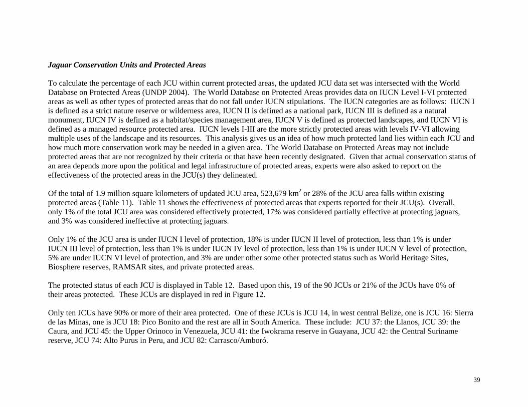
Jaguar Conservation Units and Protected Areas To calculate the percentage of each JCU within current protected areas, the updated JCU data set was intersected with the World Database on Protected Areas (UNDP 2004). The World Database on Protected Areas provides data on IUCN Level I-VI protected areas as well as other types of protected areas that do not fall under IUCN stipulations. The IUCN categories are as follows: IUCN I is defined as a strict nature reserve or wilderness area, IUCN II is defined as a national park, IUCN III is defined as a natural monument, IUCN IV is defined as a habitat/species management area, IUCN V is defined as protected landscapes, and IUCN VI is defined as a managed resource protected area. IUCN levels I-III are the more strictly protected areas with levels IV-VI allowing multiple uses of the landscape and its resources. This analysis gives us an idea of how much protected land lies within each JCU and how much more conservation work may be needed in a given area. The World Database on Protected Areas may not include protected areas that are not recognized by their criteria or that have been recently designated. Given that actual conservation status of an area depends more upon the political and legal infrastructure of protected areas, experts were also asked to report on the effectiveness of the protected areas in the JCU(s) they delineated. Of the total of 1.9 million square kilometers of updated JCU area, 523,679 km2 or 28% of the JCU area falls within existing protected areas (Table 11). Table 11 shows the effectiveness of protected areas that experts reported for their JCU(s). Overall, only 1% of the total JCU area was considered effectively protected, 17% was considered partially effective at protecting jaguars, and 3% was considered ineffective at protecting jaguars. Only 1% of the JCU area is under IUCN I level of protection, 18% is under IUCN II level of protection, less than 1% is under IUCN III level of protection, less than 1% is under IUCN IV level of protection, less than 1% is under IUCN V level of protection, 5% are under IUCN VI level of protection, and 3% are under other some other protected status such as World Heritage Sites, Biosphere reserves, RAMSAR sites, and private protected areas. The protected status of each JCU is displayed in Table 12. Based upon this, 19 of the 90 JCUs or 21% of the JCUs have 0% of their areas protected. These JCUs are displayed in red in Figure 12. Only ten JCUs have 90% or more of their area protected. One of these JCUs is JCU 14, in west central Belize, one is JCU 16: Sierra de las Minas, one is JCU 18: Pico Bonito and the rest are all in South America. These include: JCU 37: the Llanos, JCU 39: the Caura, and JCU 45: the Upper Orinoco in Venezuela, JCU 41: the Iwokrama reserve in Guayana, JCU 42: the Central Suriname reserve, JCU 74: Alto Purus in Peru, and JCU 82: Carrasco/Amboró.

40
Table 11. Analysis of the Effectiveness of Protected Areas in the Updated JCU Areas Effectiveness of Protection
Completely Partially Ineffective No data Total
Type of Land Tenure
Area (km2)
Percentage of Total JCU Area
Area (km2)
Percentage of Total JCU Area
Area (km2)
Percentage of Total JCU Area
Area (km2)
Percentage of Total JCU Area
Area (km2)
Percentage of Total JCU Area
IUCN I 2,655 <1 5,117 <1 4,121 <1 4,265 <1 16,158 1 IUCN II 3,643 <1 234,048 12 15,860 1 85,833 4 339,384 18 IUCN III 0 0 847 <1 5,041 <1 107 <1 5,995 <1 IUCN IV 3 <1 1,407 <1 2,369 <1 2,427 <1 6,206 <1 IUCN V 885 <1 1,215 <1 533 <1 5,674 <1 8,307 <1 IUCN VI 160 <1 62,843 3 22,827 1 2,110 <1 87,940 5 Other Protected Area 4,758 <1 30,346 2 15,012 1 9,573 <1 59,689 3 Total 12,104 1 335,823 18 65,763 3 109,989 6 523,679 28

41
Table 12. Protected Status of Updated JCU Areas
JCU Number JCU Area (km2)
Area Protected under IUCN I
Area Protected under IUCN II
Area Protected under IUCN III
Area Protected under IUCN IV
Area Protected under IUCN V
Area Protected under IUCN VI
Area Protected under Other designation
Total % of JCU Protected
1 13,613 0 0 0 0 0 489 0 4% 2 21,618 0 1,882 68 0 0 0 1,186 15% 3 1,387 0 0 0 0 0 0 0 0% 4 29,409 311 0 0 0 0 753 2,047 11% 5 8,760 189 0 0 0 0 377 0 6% 6 8,935 638 0 0 0 0 5,997 0 74% 7 7,920 0 1,712 46 0 0 3,534 0 66% 8 40,297 2,500 4,288 801 975 0 15,580 408 61% 9 4,776 729 0 0 0 0 1,118 0 39% 10 5,022 94 0 0 0 0 1,259 506 37% 11 17,383 378 62 0 0 0 4,790 0 30% 12 658 0 30 0 27 0 146 0 31% 13 577 0 22 0 31 0 371 0 73% 14 6,155 464 1,248 27 681 0 3,685 0 99% 15 1,047 0 0 0 0 0 0 473 45% 16 2,042 0 0 0 0 0 1,843 0 90% 17 339 0 0 0 170 0 0 0 50% 18 501 0 485 0 0 0 0 33 97% 19 24,788 0 3,911 0 0 0 7,710 8,432 81% 20 10,506 4,265 0 0 1,382 0 3,061 0 83% 21 5,922 75 1,285 0 0 0 481 71 32% 22 1,229 0 189 0 3 0 40 25 21% 23 1,224 0 376 0 0 0 362 0 60% 24 13,789 18 4,901 0 250 0 2,041 2,037 67% 25 1,724 0 591 0 12 0 587 189 80% 26 1,606 0 0 0 0 0 0 0 0% 27 4,769 0 347 0 0 0 0 847 25% 28 797 0 0 0 0 0 0 0 0% 29 2,981 0 1,326 0 0 52 0 402 60% 30 3,639 0 0 0 0 0 0 402 11% 31 64,280 174 8,203 0 0 0 690 7,939 26% 32 6,916 0 0 0 0 0 0 0 0% 33 8,236 0 165 0 0 0 0 0 2% 34 2,630 0 0 0 0 0 0 0 0% 35 1,428 0 0 0 135 0 0 0 9% 36 976 0 0 0 438 0 0 0 45% 37 7,124 0 0 0 0 69 137 6,918 100% 38 1,623 0 354 39 0 71 0 0 29% 39 18,736 0 546 192 0 1,093 16,905 0 100% 40 81,800 0 37,760 0 0 5,674 0 0 53% 41 3,732 0 0 0 0 0 0 3,732 100% 42 16,529 0 11,897 0 0 0 0 4,632 100% 43 71,750 0 0 0 0 0 0 0 0% 44 22,712 0 0 0 0 0 0 0 0% 45 56,665 0 42,711 1,309 0 0 9,578 0 95% 46 2,819 0 0 0 0 0 0 0 0%

42
Table 12. Continued JCU Number JCU Area
(km2) Area Protected under IUCN I
Area Protected under IUCN II
Area Protected under IUCN III
Area Protected under IUCN IV
Area Protected under IUCN V
Area Protected under IUCN VI
Area Protected under Other designation
Total % of JCU Protected
47 21,041 0 6,370 0 0 0 0 0 30% 48 11,758 0 2,942 0 0 0 0 0 25% 49 4,145 0 0 0 0 0 0 0 0% 50 211 0 0 0 0 0 174 0 82% 51 900 0 0 0 0 0 675 0 75% 52 2,460 0 0 0 0 0 2,020 0 82% 53 1,356 0 0 0 0 0 1,086 0 80% 54 5,774 0 2,600 0 0 0 1,028 0 63% 55 7,538 0 0 0 0 0 0 0 0% 56 47,572 0 10,310 0 0 0 5,347 0 33% 57 7,538 0 2,731 0 0 0 0 0 36% 58 38,162 0 21,161 0 0 0 0 0 55% 59 20,211 1,691 0 0 0 0 0 0 8% 60 9,256 0 0 0 0 0 0 0 0% 61 22,930 0 0 0 0 0 17,997 0 78% 62 67,598 0 0 0 0 0 0 0 0% 63 38,413 0 8,412 0 0 0 0 0 22% 64 32,183 999 0 0 0 0 0 0 3% 65 6,253 0 0 0 0 0 0 0 0% 66 7,193 0 892 0 0 0 0 0 12% 67 99,574 2,486 0 0 0 0 0 0 2% 68 36,779 0 0 0 0 0 0 0 0% 69 13,378 0 300 0 0 0 0 0 2% 70 45,397 0 0 0 0 0 0 0 0% 71 29,846 0 4,139 0 0 0 0 0 14% 72 66,816 0 0 0 0 0 0 0 0% 73 54,143 0 7,417 0 0 0 0 0 14% 74 35,687 0 34,973 0 0 0 0 0 98% 75 43,389 0 7,304 0 0 0 0 0 17% 76 58,879 0 12,218 0 0 0 519 0 22% 77 68,480 0 15,656 0 0 0 0 0 23% 78 10,281 0 687 0 0 0 0 1,792 24% 79 4,635 0 419 0 0 0 0 0 9% 80 2,435 0 0 0 0 0 0 0 0% 81 20,268 0 8,218 0 0 0 0 0 41% 82 8,681 0 8,191 0 0 0 0 0 95% 83 87,033 126 2,377 0 0 0 0 0 3% 84 89,116 0 50,380 0 0 0 0 0 57% 85 3,512 0 0 0 0 0 0 0 0% 86 12,572 0 2,234 0 981 0 0 0 26% 87 17,731 0 0 0 0 0 0 0 0% 88 7,153 0 0 0 0 0 458 0 6% 89 36,716 0 3,677 0 0 0 0 0 10% 90 30,843 263 1,228 0 0 0 0 12,975 47%

43
Figure 12. Protected Status of Updated JCUs

44
Jaguar Conservation Unit Prioritization All JCUs are important for jaguar conservation. However, they all vary in terms of size, habitat quality, level of threats, connectivity to other JCUs, and representation of ecologically distinct populations of jaguars. The prioritization scheme developed by the jaguar experts at the 1999 conference ranks JCUs that are large, have a high degree of connectivity, good habitat quality, high population numbers, and low levels of threats as the highest priority level for conservation. Therefore, JCUs of highest priority are where jaguars are most likely to persist. The JCUs were divided into three categories for each JGR, which reflect their priority: Highest, Higher, and High. Again, the JCUs added from the most recent expert survey, though included in this prioritization analysis, are considered as needing further refining and expert consensus. This prioritization scheme is described in more detail in the methodology above and illustrated in Table 13. The highest possible rank a JCU could earn was 300.
Table 13. Categories for JCU Characterization and Adopted Score/Weighting Scheme
Important Factors for long term jaguar conservation
Characterization WeightJCU Connectivity Frequent Dispersal Infrequent Dispersal No Dispersal 23
Habitat Quality High Medium Poor 23JCU Size > 5000 km2 500-5000 km2 <500 km2 30
Hunting of Jaguars None Some Much 10Hunting of Prey None Some Much 10
Population Status Increasing Stable Decreasing 4Other Good for Jaguars Medium for Jaguars Bad for Jaguars -
Designated Scores 3 1 0
The JCUs were prioritized within each JGR, and the JCUs within a given JGR were compared only among one another (Table 14). For example, the highest priority JCU for the Upper Amazon JGR is in and around the Yavarí area in Peru (JCU 60). Other JCUs with higher levels of hunting or a lower quality of habitat ranked slightly lower. These JCUs are mapped in Figure 13. Thirty-two JCUs were ranked as highest priority, and fifteen JCUs were ranked as higher priority within the JGRs. The remaining JCUs, ranked 3-8, were considered of high priority. JCUs that are of highest priority are: JCU 1: Sonora, Mexico, JCU 4: Jalisco, Mexico, JCU 7: Montes Azules/Sierra Lacandon, Mexico/Guatemala, JCU 8: the Selva Maya of Mexico, Guatemala, and Belize, JCU 11: Sian Ka’An, Mexico, JCU 14: West-central Belize, JCU 19: the Corazón Biosphere spanning the border of Honduras and
45
Nicaragua, JCU 21: Northwestern Costa Rica, JCU 24: Talamanca, in Costa Rica and Panama, JCU 31: Choco-Darien in Panama and Colombia, JCU 37: Llanos, Venezuela, JCU 38: Guatopo, Venezuela, JCU 39: Cuara, Venezuela, JCU 40: Canaima/Kaieteur in Venezuela, Guyana, and Brazil, JCU 43: Amapá in Brazil and French Guiana, JCU 44: Vichada, Colombia, JCU 45: Upper Orinoco, Venezuela, JCU 47: Macarena, Colombia, JCU 48: Pico de Neblina, Brazil, JCU 60: Yavarí, Peru, JCU 63: Amazonia, Brazil, JCU 64: Xingu, Brazil, JCU 66: Serra da Capivara, Brazil, JCU 70: Chapada das Mangabeiras, Brazil, JCU 74: Alto Purus, Peru, JCU 76: Madidi in Bolivia and Peru, JCU 77: Noel Kempff Mercado, Bolivia, JCU 84: Gran Chaco in Bolivia and Paraguay, JCU 86: Baritu-Calilegua in Argentina and Bolivia, JCU 87: Upper Rio Paraná, Brazil, JCU 89: Missiones in Argentina and Brazil, and JCU 90: Atlantic Forests, Brazil. JCUs that are of highest priority for more than one JGR are: JCU 4: Jalisco, Mexico, JCU 21: Northwestern Costa Rica, JCU 31: Choco-Darien in Panama and Colombia, JCU 37: Llanos, Venezuela, JCU 45: Upper Orinoco, Venezuela, JCU 84: Gran Chaco in Bolivia and Paraguay, and JCU 90: Atlantic Forests, Brazil. JCUs of higher priority are: JCU 2: Sierra Madre Oriental, Mexico, JCU 6: Laguna de Terminos, Mexico, JCU 9: Los Petenes, Mexico, JCU 10: Yum Belem, Mexico, JCU 16: Sierra de las Minas, Guatemala, JCU 30: Corrigimiento de Naranja, JCU 41: Iwokrama, Guyana, JCU 46: Serra de Estrutura, Brazil, JCU 53: Reserva Ecologica Mache-Chindul, Ecuador, JCU 54: Estribaciones Orientales de los Andes, Ecuador, JCU 63: Amazonia, Brazil, JCU 68: Cayabi, Brazil, JCU 75: Manu, Peru, JCU 83: Pantanal in Brazil and Bolivia, JCU 85: Rio Doce, Brazil, and JCU 88: Chaco, Argentina. All other JCUs, ranked 3 or higher, were given a high priority, falling behind JCUs ranked as highest or higher. For a listing of all JCU representatives of JGRs please refer to Table 14. Of the JGRs that were represented by JCUs, many had only one or two representative JCUs. These are, the Venezuelan coastal montane forest (JGR 2.4), the Chaco dry forest (JGR 3.3), the north South American tropical dry forest (JGR 3.1), the Mexican, Caribbean, and Caatinga xerics (JGRs 4.1, 4.2, and 4.3), the Central American pine savannas (JGR 5.1), the Llanos-Gran Sabana, Pampas, Amazonian, Pantanal, Paramo, Puna, and Pantepui grasslands (JGRs 5.2, 5.3, 5.6, 6.2, and 6.4), the Brazilian Araucaria (JGR 7.2), and the Northern Mexico and Eastern South American mangroves (JGRs 8.1 and 8.5). JGRs whose JCU representatives all had scores of under 200 were the Atlantic tropical moist lowland forest (JGR 1.1), the Venezuelan coastal montane forest (JGR 2.4), the Mexican, Caribbean, and Caatinga xerics (JGRs 4.1, 4.2, and 4.3), the Llanos-Gran Sabana and

46
Pampas grasslands (JGRs 5.2 and 5.3), the Brazilian Araucaria forests (JGR 7.2), the Mexican Pine-Oak forests (JGR 7.3), and the Eastern South American Mangroves (JGR 8.5). There are many JCUs of highest priority. Addressing the conservation needs of all these JCUs at once is not feasible due to the simple limitation of resources. The highest prioritized JCUs for all the JGRs can also be ranked against each other for conservation initiatives via three different criteria. One, putting weight on those JCUs that are a high priority for more than one JGR, second, putting weight on the JCUs that are within JGRs that have only one or two representative JCUs, and third, putting weight on the JCUs in JGRs whose representatives all have lower scores. There are 7 JCUs that are of highest priority for more than one JGR. By conserving these JCUs, jaguar populations in at least 14 JGRs will be represented for the long term. These JCUs are listed above. There are many JCUs that are sole representatives of a JGR. These are, JCU 1: Sonora, Mexico, , JCU 19: the Corazón Biosphere in Honduras and Nicaragua, JCU 31: Choco-Darien in Colombia and Panama, JCU 38: Guatopo in Venezuela, JCU 40: Canaima/Kaieteur in Venezuela, Guyana, and Brazil, JCU 47: Macarena in Colombia, JCU 48: Pico de Neblina, JCU 66: Serra da Capivara in Brazil, JCU 86: Baritu-Calilegua, JCU 89: Missiones and two of these JCUs which are of highest priority for more than one JGR: JCU 37: Llanos, Venezuela and JCU 90: the Atlantic forests of Brazil. Conserving these JCUs is important because they are the last viable populations of jaguars left in these ecosystem types. If they are compromised, we will have lost these ecologically distinct populations of jaguars forever. Conserving the highest priority JCUs in JGRs whose JCUs all have lower scores is also of immediate import because the JCUs with lower scores are inherently more threatened. If all the JCUs in a given JGR have lower scores, the jaguar in that JGR as a whole is most likely at risk. JCUs of highest priority for JGRs whose JCUs all have scores under 200 are, JCU 1: Sonora, Mexico, JCU 2: Sierra Madre Oriental, JCU 37: the Llanos in Venezuela, JCU 38: Guatopo in Venezuela, JCU 66: Serra da Capivara, Brazil, JCU 89: Missiones in Argentina and Brazil, and JCU 90: the Atlantic forests of Brazil.
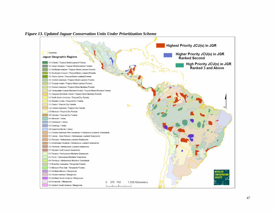
47
Figure 13. Updated Jaguar Conservation Units Under Prioritization Scheme

48
Table 14. Prioritized Ranking of Updated JCUs by JGRs Area of Total Expert characterization of JCUs in terms of factors important Estimated Ranking JCU in area of for long-term jaguar survival Population
JGRs and JCUs Score in JGR JGR JCU connectivity habitat quality hunting of hunting of population Size (km2) (km2) jaguars prey status
1.1 Atlantic/Tropical Moist Lowland Forest JCU 90: Atlantic Forests (Brazil) 182 1 25,971 30,843 Infrequent dispersal High Much Much Decreasing 50-100
JCU 87: Upper Rio Paraná (Brazil) 182 1 15,233 17,731 Infrequent dispersal High Much Much Decreasing 50-100JCU 85: Rio Doce (Brazil) 132 2 3,512 3,512 Infrequent dispersal High Some Much No data <50
JCU 89: Missiones (Argentina, Brazil) 113 3 26,119 36,716 No dispersal Medium Much Much Decreasing 100-200
1.2 Upper Amazon/Tropical Moist Lowland Forest JCU 60: Yavarí (Peru) 300 1 9,275 9,275 Frequent dispersal High None None Increasing 50-100
JCU 63: Amazonia (Brazil) 292 2 17,998 20,415 Frequent dispersal High None None Stable >500JCU 74: Alto Purus (Peru) 260 3 30,979 35,687 Frequent dispersal High Some Some Increasing >500
JCU 75: Manu (Peru) 252 4 38,213 43, 389 Frequent dispersal High Some Some Stable 200-500JCU 76: Madidi (Bolivia, Peru) 252 4 34,889 58,879 Frequent dispersal High Some Some Stable >500
JCU 77: Noel Kempff Mercado (Bolivia) 252 4 32,338 68,480 Frequent dispersal High Some Some Stable >500JCU 57: Amacayacu (Colombia) 252 4 7,538 7,538 Frequent dispersal High Some Some Stable 50-100
JCU 68: Cayabi (Brazil) 252 4 5,107 36,779 Frequent dispersal High Some Some Stable 50-100JCU 56: Cuyabeno/Yasuni/Pastaza (Ecuador) 252 4 47,572 47,572 Frequent dispersal High Some Some Stable >500
JCU 55: Condor-Kutuku (Ecuador) 242 5 1,684 7,538 Frequent dispersal High Some Much Stable 200-500JCU 47: Macarena (Colombia) 214 6 14, 022 21,041 Frequent dispersal Medium Some Some Stable 50-100
JCU 67: Aripuana (Brazil) 196 7 99,574 99,574 Infrequent dispersal High Some Much Decreasing 100-200JCU 49: Rio Apaporis (Colombia) 182 8 4,145 4,145 Frequent dispersal High Some Much Stable <50
JCU 61: Pacaya Samiria (Peru) 179 9 22,930 22,930 no data High Some Some No data 200-500JCU 62: Javari (Brazil) no data 10 67,598 67,598 no data no data no data no data no data 50-100
JCU 81: Isiboro-Secure (Bolivia) no data 10 14,628 20,268 no data no data no data no data no data no dataJCU 73: Pacas Novos (Brazil) no data 10 54,119 54,143 no data no data no data no data no data no data
1.3 Northeast Amazon/Tropical Moist Lowland Forest
JCU 43: Amapá (Brazil, French Guiana) 252 1 71,743 71,750 Frequent dispersal High Some Some Stable >500JCU 44: Vichada (Colombia) 252 1 22, 384 22,712 Frequent dispersal High Some Some Stable 50-100
JCU 45: Upper Orinoco (Venezuela) 252 1 18,927 56,665 Frequent dispersal High Some Some Stable 200-500JCU 41: Iwokrama (Guyana) 139 2 3,732 3,732 no data High None Some no data no data
JCU 48: Pico da Neblina (Brazil) no data 3 11,687 11,758 no data no data no data no data no data 50-100JCU 58: Rio Jau (Brazil) no data 3 38,162 38,162 no data no data no data no data no data 50-100
JCU 42: Central Suriname Nature Reserve (Suriname) no data 3 15,934 16,529 no data no data no data no data no data no dataJCU 40: Canaima/Kaieteur (Venezuela, Guyana, Brazil) no data 3 16,433 81,800 no data no data no data no data no data no data
1.4 Southeast Amazon/Tropical Moist Lowland Forest
JCU 64: Xingu (Brazil) 292 1 32,183 32,183 Frequent dispersal High None None Stable >500JCU 63: Amazonia (Brazil) 292 1 20,415 38,413 Frequent dispersal High None None Stable >500
JCU 68: Cayabi (Brazil) 252 2 31,672 36,779 Frequent dispersal High Some Some Stable 50-100JCU 72: Upper Xingu River (Brazil) 242 3 68,514 69,059 Frequent dispersal High Some Much Stable 200-500
JCU 59: Gurupi (Brazil) 133 4 20,211 20,211 no data Medium Some Some Decreasing 200-500JCU 69: Araguaia (Brazil) no data 5 6,951 13,378 no data no data no data no data no data no data
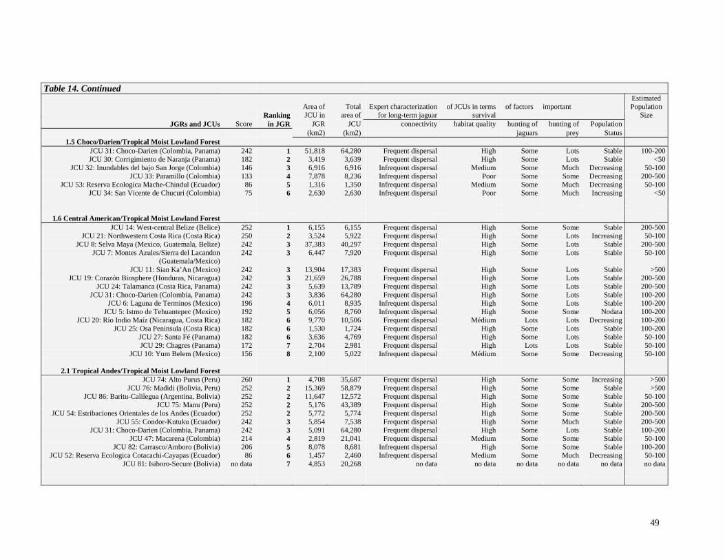
49
Table 14. Continued
Area of Total
Expert characterization of JCUs in terms
of factors
important
Estimated Population
Ranking JCU in area of for long-term jaguar survival Size JGRs and JCUs Score in JGR JGR JCU connectivity habitat quality hunting of hunting of Population
(km2) (km2) jaguars prey Status1.5 Choco/Darien/Tropical Moist Lowland Forest
JCU 31: Choco-Darien (Colombia, Panama) 242 1 51,818 64,280 Frequent dispersal High Some Lots Stable 100-200JCU 30: Corrigimiento de Naranja (Panama) 182 2 3,419 3,639 Frequent dispersal High Some Lots Stable <50
JCU 32: Inundables del bajo San Jorge (Colombia) 146 3 6,916 6,916 Infrequent dispersal Medium Some Much Decreasing 50-100JCU 33: Paramillo (Colombia) 133 4 7,878 8,236 Infrequent dispersal Poor Some Some Decreasing 200-500
JCU 53: Reserva Ecologica Mache-Chindul (Ecuador) 86 5 1,316 1,350 Infrequent dispersal Medium Some Much Decreasing 50-100JCU 34: San Vicente de Chucuri (Colombia) 75 6 2,630 2,630 Infrequent dispersal Poor Some Much Increasing <50
1.6 Central American/Tropical Moist Lowland Forest JCU 14: West-central Belize (Belice) 252 1 6,155 6,155 Frequent dispersal High Some Some Stable 200-500
JCU 21: Northwestern Costa Rica (Costa Rica) 250 2 3,524 5,922 Frequent dispersal High Some Lots Increasing 50-100JCU 8: Selva Maya (Mexico, Guatemala, Belize) 242 3 37,383 40,297 Frequent dispersal High Some Lots Stable 200-500
JCU 7: Montes Azules/Sierra del Lacandon (Guatemala/Mexico)
242 3 6,447 7,920 Frequent dispersal High Some Lots Stable 50-100
JCU 11: Sian Ka’An (Mexico) 242 3 13,904 17,383 Frequent dispersal High Some Lots Stable >500JCU 19: Corazón Biosphere (Honduras, Nicaragua) 242 3 21,659 26,788 Frequent dispersal High Some Lots Stable 200-500
JCU 24: Talamanca (Costa Rica, Panama) 242 3 5,639 13,789 Frequent dispersal High Some Lots Stable 200-500JCU 31: Choco-Darien (Colombia, Panama) 242 3 3,836 64,280 Frequent dispersal High Some Lots Stable 100-200
JCU 6: Laguna de Terminos (Mexico) 196 4 6,011 8,935 Infrequent dispersal High Some Lots Stable 100-200JCU 5: Istmo de Tehuantepec (Mexico) 192 5 6,056 8,760 Infrequent dispersal High Some Some Nodata 100-200
JCU 20: Río Indio Maíz (Nicaragua, Costa Rica) 182 6 9,770 10,506 Frequent dispersal Médium Lots Lots Decreasing 100-200JCU 25: Osa Peninsula (Costa Rica) 182 6 1,530 1,724 Frequent dispersal High Some Lots Stable 100-200
JCU 27: Santa Fé (Panama) 182 6 3,636 4,769 Frequent dispersal High Some Lots Stable 50-100JCU 29: Chagres (Panama) 172 7 2,704 2,981 Frequent dispersal High Lots Lots Stable 50-100
JCU 10: Yum Belem (Mexico) 156 8 2,100 5,022 Infrequent dispersal Médium Some Some Decreasing 50-100
2.1 Tropical Andes/Tropical Moist Lowland Forest JCU 74: Alto Purus (Peru) 260 1 4,708 35,687 Frequent dispersal High Some Some Increasing >500
JCU 76: Madidi (Bolivia, Peru) 252 2 15,369 58,879 Frequent dispersal High Some Some Stable >500JCU 86: Baritu-Calilegua (Argentina, Bolivia) 252 2 11,647 12,572 Frequent dispersal High Some Some Stable 50-100
JCU 75: Manu (Peru) 252 2 5,176 43,389 Frequent dispersal High Some Some Stable 200-500JCU 54: Estribaciones Orientales de los Andes (Ecuador) 252 2 5,772 5,774 Frequent dispersal High Some Some Stable 200-500
JCU 55: Condor-Kutuku (Ecuador) 242 3 5,854 7,538 Frequent dispersal High Some Much Stable 200-500JCU 31: Choco-Darien (Colombia, Panama) 242 3 5,091 64,280 Frequent dispersal High Some Lots Stable 100-200
JCU 47: Macarena (Colombia) 214 4 2,819 21,041 Frequent dispersal Medium Some Some Stable 50-100JCU 82: Carrasco/Amboro (Bolivia) 206 5 8,078 8,681 Infrequent dispersal High Some Some Stable 100-200
JCU 52: Reserva Ecologica Cotacachi-Cayapas (Ecuador) 86 6 1,457 2,460 Infrequent dispersal Medium Some Much Decreasing 50-100JCU 81: Isiboro-Secure (Bolivia) no data 7 4,853 20,268 no data no data no data no data no data no data
50
Table 14. Continued
Area of Total
Expert characterization of JCUs in terms
of factors
important
Estimated Population
Ranking JCU in area of for long-term jaguar survival Size JGRs and JCUs Score in JGR JGR JCU connectivity habitat quality hunting of hunting of Population
(km2) (km2) jaguars prey Status2.2 Central American/Tropical Moist Montane Forest
JCU 21: Northwestern Costa Rica (Costa Rica) 242 1 1,329 5,922 Frequent dispersal High Some Lots Stable 50-100JCU 24: Talamanca (Costa Rica, Panama) 242 1 7,805 13,789 Frequent dispersal High Some Lots Stable 200-500
JCU 31: Choco-Darien (Colombia, Panama) 242 1 2,046 64,280 Frequent dispersal High Some Lots Stable 100-200JCU 16: Sierra de las Minas (Guatemala) 132 2 1,592 2,042 Frequent dispersal Medium Some Lots Decreasing 50-100
2.4 Venezuelan Coastal Montane Forest/Tropical Moist
Montane Forest
JCU 38: Guatopo (Venezuela) 132 1 1,322 1,623 Infrequent dispersal High Some Much Decreasing <50
2.5 Guayana Montane Forest/ Tropical Moist Montane Forest
JCU 45: Upper Orinoco (Venezuela) 252 1 37,713 56,665 Frequent dispersal High Some Some Stable 200-500JCU 39: Caura (Venezuela) 252 1 18,724 18,736 Frequent dispersal High Some Some Stable 200-500
JCU 46: Serra de Estrutura (Brazil) no data 2 2,819 2,819 no data no data no data no data no data <50JCU 40: Canaima/Kaieteur (Venezuela, Guyana, Brazil) no data 2 19,474 81,800 no data no data no data no data no data no data
3.1 North South American/Tropical Dry Forest
JCU 47: Macarena (Colombia) 214 1 4,088 21,041 Frequent dispersal Medium Some Some Stable 50-100
3.2 Western Andes/Tropical Dry Forest Not represented by any JCUs
3.3 Chaco/Tropical Dry Forest
JCU 84: Gran Chaco (Bolivia, Paraguay) 252 1 85,677 89,116 Frequent dispersal High Some Some Stable >500JCU 88: Chaco (Argentina) 192 2 7,153 7,153 Infrequent dispersal High Some Much Decreasing <50
3.4 Central American/Tropical Dry Forest
JCU 21: Northwestern Costa Rica (Costa Rica) 250 1 1,034 5,922 Frequent dispersal High Some Lots Increasing 50-100JCU 24: Talamanca (Costa Rica, Panama) 242 2 31 13,789 Frequent dispersal High Some Lots Stable 200-500
JCU 31: Choco-Darien (Colombia, Panama) 242 2 137 64,280 Frequent dispersal High Some Lots Stable 100-200JCU 27: Santa Fé (Panama) 182 3 85 4,769 Frequent dispersal High Some Lots Stable 50-100
JCU22: Nicoya Peninsula (Costa Rica) 85 4 809 1,229 No dispersal Médium Some Some Increasing <50
3.5 Mexican/Tropical Dry Forest JCU 8: Selva Maya (Mexico, Guatemala, Belize) 242 1 2,914 40,297 Frequent dispersal High Some Lots Stable 200-500
JCU 7: Montes Azules/Sierra del Lacandon (Guatemala/Mexico)
242 1 1,462 7,920 Frequent dispersal High Some Lots Stable 50-100
JCU 4: Jalisco (Mexico) 238 2 17,792 29,409 Frequent dispersal High Some Much Decreasing >500JCU 5: Istmo de Tehuantepec (Mexico) 192 3 1,800 8,760 Infrequent dispersal High Some Some Nodata 192
51
Table 14. Continued
Area of Total
Expert characterization of JCUs in terms
of factors
important
Estimated Population
Ranking JCU in area of for long-term jaguar survival Size JGRs and JCUs Score in JGR JGR JCU connectivity habitat quality hunting of hunting of Population
(km2) (km2) jaguars prey Status3.5 Mexican/Tropical Dry Forest (continued)
JCU 9: Los Petenes (Mexico) 156 4 2,852 4,776 Infrequent dispersal Medium Some Some Decreasing 50-100JCU 10: Yum Belem (Mexico) 156 4 1,257 5,022 Infrequent dispersal Médium Some Some Decreasing 50-100
JCU 1: Sonora (Mexico) 140 5 2,014 13,613 Infrequent dispersal Medium Much Much Stable 50-100
3.6 Cerrado/Tropical Dry Forest JCU 70: Chapada das Mangabeiras (Brazil) 252 1 44,706 45,397 Frequent dispersal High Some Some Stable 200-500
JCU 77: Noel Kempff Mercado (Bolivia) 252 1 36,102 68,480 Frequent dispersal High Some Some Stable >500JCU 76: Madidi (Bolivia, Peru) 252 1 8,611 58,879 Frequent dispersal High Some Some Stable >500
JCU 83: Pantanal (Brazil, Bolivia) 238 2 9,095 87,033 Frequent dispersal High Much Some Decreasing >500JCU 65: Maranho (Brazil) 202 3 6,253 6,253 Frequent dispersal Medium Some Some Decreasing 100-200JCU 71: Araguaia (Brazil) 196 4 29,795 29,846 Frequent dispersal Medium Some Much Stable 50-100
JCU 87: Upper Rio Paraná (Brazil) 182 5 2,498 17,731 Infrequent dispersal High Much Much Decreasing 50-100JCU 78: Chapada dos Veadeiros (Brazil) 156 6 10,281 10,281 Infrequent dispersal Medium Some Some Decreasing <50
JCU 66: Serra da Capivara (Brazil) 146 7 2,087 7,193 Infrequent dispersal Medium Some Much Decreasing <50JCU 79: Grande Sertao Veredas (Brazil) 142 8 4,635 4,635 Frequent dispersal Medium Some Some Decreasing <50
JCU 80: Goias/Cerrado (Brazil) no data 9 2,091 2,435 no data no data no data no data no data <50JCU 69: Rio Araguaia (Brazil) no data 9 6,427 13,378 no data no data no data no data no data no data
4.1 Mexican/Xerics
JCU 1: Sonora (Mexico) 140 1 10,359 13,613 Infrequent dispersal Medium Much Much Stable 50-100
4.2 Caribbean/Xerics JCU 37: Llanos (Venezuela) 196 1 1,503 7,124 Frequent dispersal Medium Much Some Stable 50-100
4.3 Caatinga/Xerics
JCU 66: Serra da Capivara (Brazil) 146 1 5,106 7,193 Infrequent dispersal Medium Some Much Decreasing <50
4.6 Argentine Monte/Xerics Not represented by any JCUs
5.1 Central American Pine Savannas/Herbaceous
Lowland Grassland
JCU 19: Corazón Biosphere (Honduras, Nicaragua) 242 1 2,251 24,788 Frequent dispersal High Some Lots Stable 200-500
5.2 Llanos-Gran Sabana/Herbaceous Lowland Grassland
JCU 37: Llanos (Venezuela) 196 1 5,621 7,124 Frequent dispersal Medium Much Some Stable 50-100JCU 40: Canaima/Kaieteur (Venezuela, Guyana, Brazil) no data 2 41,396 81,800 no data no data no data no data no data no data

52
Table 14. Continued
Area of Total
Expert characterization of JCUs in terms
of factors
important
Estimated Population
Ranking JCU in area of for long-term jaguar survival Size JGRs and JCUs Score in JGR JGR JCU connectivity habitat quality hunting of hunting of Population
(km2) (km2) jaguars prey Status5.3 Pampas/Herbaceous Lowland Grassland
JCU 89: Missiones (Argentina, Brazil) 113 1 16 36,716 No dispersal Medium Much Much Decreasing 100-200
5.5 Amazonian Savanna/Herbaceous Lowland Grassland
JCU 48: Pico da Neblina (Brazil) no data 1 64 11,758 no data no data no data no data no data 50-100
5.6 Pantanal/Herbaceous Lowland Grassland JCU 84: Gran Chaco (Bolivia, Paraguay) 252 1 3,439 89,116 Frequent dispersal High Some Some Stable >500
JCU 83: Pantanal (Brazil, Bolivia) 238 2 77,938 87,033 Frequent Dispersal High Much Some Decreasing >500
5.7 Western Gulf Coastal Grasslands/Herbaceous Lowland Grassland
Not represented by any JCUs
6.1 Paramo/Herbaceous Montane Grassland JCU 31: Choco-Darien (Colombia, Panama) 242 1 5 64,280 Frequent dispersal High Some Lots Stable 100-200
6.2 Puna/Herbaceous Montane Grassland
JCU 86: Baritu-Calilegua (Argentina, Bolivia) 252 1 919 12,572 Frequent dispersal High Some Some Stable 50-100
6.4 Pantepui/Herbaceous Montane Grassland JCU 40: Canaima/Kaieteur (Venezuela, Guyana, Brazil) no data 1 4,497 81,800 no data no data no data no data no data no data
7.2 Brazilian Araucaria/Temperate Forest
JCU 90: Atlantic Forests (Brazil) 182 1 3,047 30,843 Infrequent dispersal High Much Much Decreasing 50-100JCU 89: Missiones (Argentina, Brazil) 113 2 10,581 36,716 No dispersal Medium Much Much Decreasing 100-200
7.3 Mexican Pine-Oak/Temperate Forest
JCU 4: Jalisco (Mexico) 238 1 10,161 29,409 Frequent dispersal High Some Much Decreasing >500JCU 2: Sierra Madre Oriental (Mexico) 160 2 21,618 21,618 Infrequent dispersal Poor Some Some Decreasing 50-100
JCU 3: Sierra Tamaulipas (Mexico) 90 3 1,387 1,387 Infrequent dispersal Medium Some Much Stable 50-100
8.1 Northern Mexico/Mangrove JCU 4: Jalisco (Mexico) 238 1 1,432 29,409 Frequent dispersal High Some Much Decreasing >500
JCU 6: Laguna de Terminos (Mexico) 196 2 2,735 8,935 Infrequent dispersal High Some Lots Stable 100-200

53
Table 14. Continued
Area of Total
Expert characterization of JCUs in terms
of factors
important
Estimated Population
Ranking JCU in area of for long-term jaguar survival Size JGRs and JCUs Score in JGR JGR JCU connectivity habitat quality hunting of hunting of Population
(km2) (km2) jaguars prey Status8.2 Central American/Mangrove
JCU 11: Sian Ka’An (Mexico) 242 1 3,479 17,383 Frequent dispersal High Some Lots Stable >500JCU 9: Los Petenes (Mexico) 156 2 1,924 4,776 Infrequent dispersal Medium Some Some Decreasing 50-100
JCU 10: Yum Belem (Mexico) 156 2 1,665 5,022 Infrequent dispersal Médium Some Some Decreasing 50-100
8.3 Northern South America/Mangrove JCU 31: Choco-Darien (Colombia, Panama) 242 1 763 64,280 Frequent dispersal High Some Lots Stable 100-200
JCU 53: Reserva Ecologica Mache-Chindul (Ecuador) 86 2 33 1,356 Infrequent dispersal Medium Some Lots Decreasing 50-100JCU 50: Manglares Cayaps Mataje (Ecuador) 56 3 211 211 Infrequent dispersal Medium Some Lots Decreasing <50
8.4 Amazonia/Mangrove
Not represented by any JCUs
8.5 Eastern South America/Mangrove JCU 90: Atlantic Forests (Brazil) 182 1 1,825 30,843 Infrequent dispersal High Much Much Decreasing 50-100

54
Discussion Most species-based conservation plans are limited by political boundaries. There can be a plan to conserve jaguars in Costa Rica, which would help to conserve jaguars in tropical moist lowland forests, but this will fail to conserve jaguars in the wide variety of ecosystems in which they live. If we are to truly conserve a species such as the jaguar, we need to conserve all the ecologically distinct populations of jaguars that occur through its entire range. This involves planning across the complete biological range of the species. As a means to this end, the goal of this project was to collect data from throughout the 19.1 million km2 of the jaguar’s historic range and identify the most important sites for ecologically distinct populations of jaguars using a geographic proxy as a framework (JGRs). One hundred and thirty experts from 20 different countries contributed their knowledge on jaguars to this project. The incredible research and generosity of these experts was the basis of this dataset and was the first step in overcoming political barriers to conservation. Range-wide data sets that are derived from expert knowledge are inherently inexact. Personal opinions and different interpretations of the survey are a quality of human nature. When reporting on the knowledge and status of jaguars, some experts only felt comfortable giving detailed comments on their small study area and others took it to mean reporting on the general status of jaguars in an entire region or country and thus, had to extrapolate on empirical data they may have for a smaller study area. Also, the more intimate a researcher is with a place, the more they see the presence of threats. The less one knows a place, the less apparent the threats may be, resulting in possible over or underreporting of threats to jaguars in certain areas. The 1999 data is a result of the experts reconciling these differences of interpretation and reaching a consensus on the polygons and associated attribute data. In the Jaguars in the New Millennium meeting, experts that reported on the same region and had overlapping polygons discussed the areas, resolved boundary differences, and lines were redrawn so that areas truly represented the status of jaguars. Barring Mesoamerica, the data from the 2006 survey did not undergo this scrutiny and is therefore not as refined as the 1999 data. Therefore, the 1999 data for most of the range was retained as the basis for this data set as the best available data and was supplemented with data from the 2006 survey that represented new areas. Despite this apparent drawback, these data sets together present a wealth of information about the jaguar throughout its range. The Jaguars in the New Millennium Data Set Update provides invaluable range-wide information about jaguars, their status, and the threats they face in an increasingly human-dominated landscape. This data set also provides an outline for conservation action on behalf of the jaguar by detailing areas of priority for study, areas of priority for conservation, and the threats that need to be addressed in different regions of the jaguar’s range to stem its decline across the Americas.

55
This data set is nested in a geographic hierarchy that accounts for the different knowledge experts provided about the species. The first step in this hierarchical process is to determine areas in which experts had knowledge (extent of knowledge) and areas in which experts lacked knowledge (unknown). The updated data set reflects expert knowledge of 96% of the jaguar’s historic range. The 4% of the range where the status of jaguars is unknown is a high priority for study. These areas include portions of northern and central Mexico, central Colombia and southwestern Ecuador, and parts of the Brazilian Amazon. The next distinction in the nested hierarchy, was to separate areas where jaguars are found (reported jaguar range) from those where they have been extirpated, within the area of expert knowledge. Jaguars no longer inhabit 39% of their historic range. The range where they still persist is subject to a variety of threats, the major ones being the hunting of jaguars and the hunting of jaguar prey. The next step within the nested hierarchy of the data sets was to identify, in those areas where jaguars are found, where the most robust populations exist based upon population size, size of the area, and ability of the area to retain a long-term populations of jaguars (JCUs). Experts identified 90 JCUs that were fairly evenly distributed across the current range of the jaguar. Of these JCUs, 46 were characterized as Type I, indicating healthy jaguar populations. Eleven of these were reported to have jaguar populations of over 500 breeding individuals. The majority of JCUs (56%), however, were reported to have populations of less than 100 individuals. The most prominent threat to the JCUs is the hunting of jaguar prey, followed by the habitat conversion and the hunting of jaguars. Many of the experts reported the hunting of jaguars was mainly due to livestock depredation, or the fear of livestock depredation throughout the jaguar’s range. This, coupled with the fact that ranchland was one of the most prominent land use types in which jaguars were observed points to rancher-jaguar conflict mitigation as a major conservation priority for jaguars throughout their range. Other conservation priorities are addressing the hunting of jaguars, the hunting of jaguar prey, and habitat conversion. For both JCUs and the current range of the jaguar the hunting of jaguars is obviously a major threat that needs attention, despite laws prohibiting the hunting of jaguars. The hunting of prey species and habitat conversion are two threats that not only affect jaguars, but the ecosystems in which they live. Decreasing the effects of these threats on the range of the jaguar and JCUs will benefit more than just this one species. The point observations provide an internal check against the opinion-driven nature of the survey. The point observations represent the only concrete objective information on where jaguars are located. We know that at each point observation at least one jaguar has been observed. Of course, the distribution of the points indicate areas of research before concentrations of jaguars, however, this

56
information is invaluable for providing concrete data against which the more subjective data can be measured. All the updated point observations fell within the reported range of jaguars, and over one third of the points fell within areas designated as JCUs. The next step in completing the data set was to rank the JCUs within the JGR framework. This resulted in identifying the most important sites for ecologically distinct populations of jaguars. This process identified 32 areas as the highest priority sites for jaguar conservation work and 15 areas as higher priority sites for jaguar conservation work. All JCUs are, of course, important for the long-term conservation of the jaguar. Working on all these sites at once, however, may prove difficult. To further prioritize the highest priority JCUs, putting weight on those that either 1) are a high priority for more than one JGR, 2) are within JGRs that have only one or two representative JCUS, or 3) are within JGRs whose JCUs all have lower scores, may be the most prudent course of action. JCUs were also analyzed in terms of protected area status. There are 19 JCUs, or 21%, that have 0% of their area protected, and there are 11 more JCUs, or 12%, that have less than 10% of their habitat protected under the protected areas provided by the World Database on Protected Areas. This number includes some of the highest-ranking JCUs in several JGRs. A few JCUs of highest priority that have no protected habitat are the Upper Rio Paraná in Brazil, Yavarí in Peru, Chapada das Mangabeiras in Brazil, and Amapá in Brazil and French Guiana. Maintaining protected habitat for jaguars is paramount to conserving ecologically distinct populations of jaguars throughout their range. One result of this analysis is the awareness of the need to establish protected areas in at least the highest priority JCUs in each JGR. Management of these protected areas is also very important. The experts also commented on the effectiveness of protected lands within JCUs. Of the 27% of the JCU area that is classified as protected in the World Database on Protected Areas, the experts only identified 1% of this area as effectively protected. This is of great concern since there is already a dearth of protected lands within the JCUs. Work needs to be done to improve the management of already existing protected areas. This data set complements coarse-filter approaches to conservation planning by testing the generality of conserving ecosystems or hotspots through an emphasis on single species requirements. Conserving supra-organismal entities such as these does not guarantee the conservation of jaguars. Using a large carnivore, such as the jaguar, to test these hotspot tactics and add areas that are important for jaguars will result in a more comprehensive conservation scheme. Carnivore attributes such as slow reproductive rates and incompatibility with humans make them a very vulnerable element of biodiversity. Because of this, they are useful for identifying geographic areas that offer prime opportunities for conservation for, if carnivores are still present, it signifies biological communities
57
that have been least affected by human presence and change. Incorporating both range-wide jaguar conservation and hotspot or ecoregion conservation can enhance the conservation of the Americas. The Jaguars in the New Millennium Data Set Update provides the most up-to-date information on jaguars throughout their range. The increased number of jaguar studies throughout this cat’s range (reflected by the number of experts that were able to contribute to this survey) displays an increased level of awareness about the importance of this species to the ecosystems of the Americas. The current state of the jaguar shows that healthy populations of jaguars exist throughout their range, and that there are also populations of jaguars that are in decline due to the increasing threats that come from human population growth and associated activities. This data set reflects the continued need for further studies on jaguars and more conservation measures in areas that are important for long-term jaguar survival. The analyses result in a geographically referenced range-wide assessment of the conservation status of jaguars with explicit recommendations for priority areas for action to ensure the long-term survival of this great cat. This data set is only the initial step in the long walk towards jaguar conservation. I hope it will serve as a guide towards the most effective strategies for conserving this great cat throughout its entire range.

58
Literature Cited Dinerstein, E., D.M. Olson, D.J. Graham, A.L. Webster, S.A. Primm, M.P. Bookbinder, and G. Ledec. 1995. A conservation assessment of the
terrestrial ecoregions of Latin America and the Caribbean. World Wildlife Fund and the World Bank, Washington D.C. Guggisberg. 1975. Cats of the World. Taplinger Publications Co., New York. Medellin, R.A., C. Chetkiewicz, A. Rabinowitz, K.H. Redford, J.G. Robinson, E.W. Sanderson, and A. Taber. 2001. El Jaguar en el Nuevo
milenio: una evaluacion de su estado, deteccion, de prioridades y recomendaciones para la conservacion de los jaguars en America. Universidad Nacional Autonoma de Mexico and Wildlife Conservation Society, Mexico, D.F.
Miller, C.M. and B. Miller. 2005. Jaguar Densities in La Selva Maya. Report for the Wildlife Conservation Society. Navarro-Serment, C. J., C.A. López-González, and J.P. Gallo-Reynoso. 2005. Occurrence of the Jaguar (Panthera onca) in Sinaloa, Mexico. The
Southwestern Naturalist 50:102-106. Nowell, K. and P. Jackson. 1996. Wild Cats: Status Survey and Conservation Action Plan. IUCN/SSC Cat Specialist Group. IUCN, Gland,
Switzerland. 382 pp. Sanderson, E.W., K.H. Redford, C.B. Chetkiewicz, R.A. Medellin, A.R. Rabinowitz, J.G. Robinson, A.B. Taber. 2002. Planning to Save a
Species: the Jaguar as a Model. Conservation Biology 16: 58-71. ___________, E.W., C.B. Chetkiewicz, R.A. Medellin, A. Rabinowitz, K.H. Redford, J.G. Robinson, A.B. Taber. 2002. Un análisis geográphico
del estado de conservación y distribucion de los jaguars a través de su área de distibución, in El Jaguar En El Nuevo Milenio (R.A. Medellin, C. Equihua, C.B. Chetkiewicz, P.G. Crawshaw Jr., A. Rabinowitz, K.H. Redford, J.G. Robinson, E.W. Sanderson, and A.B. Taber, eds.), pp. 551-600, Fondo de Cultura Economica, Universidad Nacional Autonoma de Mexico, and the Wildlife Conservation Society, Mexico.
___________, E.W., C.B. Chetkiewicz, R.A. Medellin, A. Rabinowitz, K.H. Redford, J.G. Robinson, A.B. Taber. 2002. Prioridades geográphicas para la conservación del jaguar, in El Jaguar En El Nuevo Milenio (R.A. Medellin, C. Equihua, C.B. Chetkiewicz, P.G. Crawshaw Jr., A. Rabinowitz, K.H. Redford, J.G. Robinson, E.W. Sanderson, and A.B. Taber, eds.), pp. 601-628, Fondo de Cultura Economica, Universidad Nacional Autonoma de Mexico, and the Wildlife Conservation Society, Mexico.
59
Seymour, K.L. 1989. Panthera onca. Mammalian Species 340. Swank, W.G., and J.G. Teer. 1989. Status of the jaguar. Oryx 23:14-21. UNDP. 2004. World Database on Protected Areas. UNEP-WCMC and the IUCN World Commission on Protected Areas (WCPA). Available
from <2Thttp://sea.unep-wcmc.org/wdbpa/T>. Weber, W., and A. Rabinowitz. 1996. A global perspective on large carnivore conservation. Conservation Biology 10:1046-1054. Wikramanayake, E. D., E. Dinerstein, J.G. Robinson, U. Karanth, A. Rabinowitz, D. Olson, T. Mathew, P. Hedao, M. Conner, G. Hemley, and D.
Bolze. 1998. An ecology-based method for defining priorities for large mammal conservation: the tiger as a case study. Conservation Biology 12:865-878.
60
Appendix I: Jaguars in the New Millennium Data Set Update Survey
Re: Participation in the Jaguars in the New Millennium Data Set Update Dear, In March 1999, the Wildlife Conservation Society (WCS), with support from National University of Mexico and Jaguar Cars North America, sponsored the Jaguars in the New Millennium Workshop to assess the status and distribution of jaguars into the next millennium. Our workshop had four objectives:
1. Establish a linkage between jaguar researchers throughout the Americas in order to facilitate information exchange, standardization of methods, and cooperation across borders;
2. Assess the state of our knowledge about the ecology, distribution, and status of jaguars throughout their range.
3. Prioritize current threats to the jaguar’s survival and create a framework for assessing and alleviating these threats.
4. Identify priority areas for jaguar conservation efforts, prioritize topics for further research, and further investigate key themes that are essential to ensure jaguar conservation through the next millennium.
The results from this workshop have been compiled in a volume entitled, “El Jaguar en el Nuevo Milenio – Una evalucion de su condicion actual, historia natural y prioridades para su conservacion” (Medellin, R.A., Chetkiewicz, C-L, Crawshaw Jr., P., Rabinowitz, A., Redford, K.H., Robinson, J.G., Sanderson, E.W., and Taber, A. Eds.) You can also read about the workshop and review the workshop results on the web at 3Twww.savethejaguar.comT. We are writing you because it is time to update this data set and we believe this data set can benefit from your knowledge and expertise. We strongly believe that the workshop, the proceedings and the CD ROM containing the data set developed at the workshop have helped set the standard for conservation planning of large carnivores and other landscape species. These products represent the culmination of a year-long process to develop a scientific, knowledge-based assessment of jaguar conservation status and develop priorities for action to reduce threats to jaguars across their range.

61
The results have laid the foundation for the WCS Jaguar Conservation Program, which focuses on: 1) population status and distribution surveys; 2) long-term ecological research; 3) cattle-jaguar research and rancher outreach; 4) population monitoring; 5) health and genetics of jaguar populations; and, 6) education and policy initiatives. In the five years since the workshop, the Jaguar Conservation Program has initiated research and conservation efforts under each of these components in countries throughout the jaguar’s range. We have initiated surveys in areas that were identified as “unkowns” at the Jaguars in the New Millennium Workshop using standardized protocols and drawing on the expertise of researchers in the region. We have initiated long-term research projects on jaguar ecology in Brazil and Bolivia. We are supporting jaguar-livestock workshops and depredation research projects in the Pantanal, Brazil, Valencia, Venezuela, Sonora, Mexico, and Cockscomb Basin, Belize, among others. And, we are working with WCS Education to conduct a preliminary assessment of available educational material on jaguars in Latin America and creating educational curriculum based on jaguar ecology and conservation. WCS is committed to using the most reliable and up-to-date data for our programs. The Jaguars in the New Millennium Data set has served to direct the research and conservation efforts for the last five years. The direction of the Jaguar Conservation Program is only as valid as the data on which it is based. Therefore, the Jaguars in the New Millennium Data set must be updated to reflect new information that has resulted from jaguar research as well as landscape changes throughout the range of the jaguar since 1999. Maintaining this data set will fail without the willingness and expertise of individual researchers like yourself. You have been contacted because of your experience with jaguars and jaguar conservation. We are asking for some of your time to fill out the survey forms enclosed in this mailing for the sake of the jaguar. We are committed to ensuring that each piece of information that is contributed to the data set is linked to your name to assure proper credit and that you have access to the updated data set once it is complete. Please read all the instructions and then fill out the map(s) and datasheets enclosed in this mailing. In order for this update to be carried out in a timely manner, please return all the required materials to us by November 1, 2004. If you have any questions, please do not hesitate to contact Kathy Marieb, Data set Coordinator, by phone or email. Kathy can be reached at: (406) 829-6596 or [email protected]. WCS greatly appreciates your help in our effort to conserve jaguars throughout their range. Sincerely yours, Kathleen Conforti Coordinator Jaguar Conservation Program

62
Jaguars in the New Millennium Data set Update: Mapping Instructions Introduction We very much appreciate your involvement in the Jaguars in the New Millennium Data set. Established in 1999, this data set has served as the basis for range-wide jaguar conservation measures. In order for this data set to be effective, however, it needs to be updated to reflect new data from research as well as landscape changes that have occurred throughout the jaguar’s range. To maintain continuity in the data set, these instructions seek to acquire all the information that was obtained in the 1999 survey. If you previously participated in the Jaguars in the New Millennium Workshop, we ask that you provide all the information asked for in these instructions regardless of what you provided in 1999. This will enable us to determine changes in threats to jaguars, jaguar population status, jaguar distribution, and other factors that affect the survival of this species. In order to establish a common framework for mapping data on jaguars we used the Latin American/Caribbean ecoregion map developed by WWF for the World Bank. The range of the jaguar covers eight bioregions and 12 major habitat types; from these we developed a set of 53 Jaguar Geographic Regions (JGRs) for Latin America. (See the glossary at the end of this document for definition of these terms). Each of you will be working on one or more of these 53 JGRs and sending us the results. It is important to remember that the major habitat types on which these JGRs are based are themselves only potential habitat types (the presumed extent of the habitat in the absence of modern human activity). They do not include the dramatic effects of habitat destruction and conversion, which are prevalent across the jaguar’s range; however, these effects are important for you to consider as you complete this exercise. In this package, you are provided with a map or maps containing one or more JGRs in your region of expertise. On these maps, you will be delineating jaguar point locations, areas of approximate jaguar range, and areas that are critical for jaguar conservation. For each of these kinds of spatial data, you will answer additional questions on forms that accompany the maps. We will also ask you to indicate areas where you do not feel confident in mapping jaguar distributions so that as a group we can determine gaps in our knowledge. Although each mapping exercise is focused on a particular JGR or set of JGRs, you will see that the maps cover much more extensive areas, at a scale of 1:3,800,000. Please do not limit yourself to the JGR boundaries. If you have additional information beyond the JGR boundaries, please include it, labeling the polygons and points and filling out the forms, etc. These other areas are particularly important because only about one-half of the 53 JGRs have expert mappers, so any additional information you have may be the only information there is. Reference information, including the locations of major cities, rivers and national boundaries, are included on the map to help guide your mapping. Note however that these data come from global data sets that have many flaws and inconsistencies that become apparent at larger scales (rivers that start and stop flowing, incomplete city names, etc.). Use your best judgement and the labeled latitude and longitude grids as your most important guides as you map your jaguar information. Finally it is important that you follow the instructions carefully (steps 1-10) to minimize errors in the conversion of your data to digital form. After you submit your data to us, we will combine the data with the information from the other expert mappers, creating an updated data set on jaguars

63
throughout their range. After the update is complete, you will receive the updated data set in GIS format on CD-ROM. For the data set to be updated in a timely manner, it is essential that you return the maps and datasheets to us by the November 1st deadline to insure inclusion of your data. We would like to apologize beforehand for the short turnaround time, but we appreciate all your efforts to make this data set a success. If you have questions and/or suggestions as you complete these mapping exercises, please do not hesitate to contact Kathy Marieb. Contact information is included at the end of these instructions. Getting Started 1. Please find the following materials in your mapping kit: -These instructions -A color jaguar geographic region base map or maps -A pencil -Permanent “Sharpie” marking pens in four colors (black, blue, red and green.) -Several copies each of data entry forms A, B and C (you can make more copies, as necessary.) -A return label with the mailing address -The mailing tube these materials arrived in 2. Please read these instructions entirely and review the data entry forms A, B and C before beginning. If you have any questions or are missing any materials, contact us immediately so we can help. Delineate Areas of Jaguar Knowledge 3. On the base map, draw a polygon or polygons using the pencil delineating those areas where you feel you have sufficient information about jaguars to complete the following questions. Draw a large X through those areas where you do not feel confident to complete the exercise. After you have double-checked this information and made any necessary changes, draw over the pencil markings with the BLACK marker. Point Observations of Jaguars 4. On the same base map, now draw a point marker (a “plus sign”, i.e. +) using a pencil at each location where one or more jaguars have been observed within the last 5 years. Each point will be assumed to represent a circular area of radius 20 km. Lump all observations within the area of a 20 km circle under the same point. Make each point marker by making a horizontal line, 0.5 cm long, and crossing it with a vertical line, 0.5 cm long, such that the intersection exactly marks the location of the point. Code each point marker uniquely with a number, prefixed by a “P” for point location (e.g. P1, P2, P3, etc.) Place a point marker if the following conditions have been met: a. you or someone whose judgement you trust has seen a live jaguar; or, b. you or someone whose judgement you trust has radiotracked a jaguar, or,
DEADLINE:
November 1, 2004
64
c. you or someone whose judgement you trust has seen a jaguar track, and there is no confusion with a puma track; or, d. you or someone whose judgement you trust has collected scat that has been reliably identified as jaguar; or d. a skin or skull (or other remains) exists with proper documentation or incontrovertible proof of origin; and e. the evidence is less than five years old. After you have double-checked your point observations and made any necessary changes, draw over the penciled point markers and codes with the BLUE marker. For each coded point marker, indicate on Form A the dates of first and last observations at that location, the exact coordinates of the location (if known, preferably in latitude/longitude), the number of different kinds observations made at that location, and the habitat and land use types at that location. Approximate Range of Jaguars (AJRs) 5. On the same map, now draw a polygon or polygons using pencil delineating those areas where you reasonably know jaguars currently exist (Approximate Range of Jaguar polygons or AJRs). Inside each polygon, write a unique code, labeled as “R” and then a number, identifying the polygon (e.g. R1, R2, R3, etc.) After you have double-checked your approximate range and made any necessary changes, draw over the penciled polygons and codes with the RED marker. On Form B explain your reasoning for drawing the boundaries for each polygon (e.g. habitat type, elevation limit, limit of knowledge, etc.) Estimate the percentage of the polygon boundary for which that limit applies (e.g. if the only reason for drawing the boundary is change of habitat type, then habitat type would score 100%). Estimate the percentage of the area of the polygon in which jaguars are threatened by various causes (e.g. habitat conversion, hunting of jaguars, depletion of prey, etc.) Jaguar Conservation Units (JCUs) 6. On the same map, now draw a polygon or polygons using a pencil delineating those areas which are critical for long-term jaguar conservation (Jaguar Conservation Units or JCUs). Inside each polygon, write a unique code, labeled as “J” and then a number, identifying the polygon (e.g. J1, J2, J3, etc.) A JCU is defined as an area: I. with a stable prey community, currently known or believed to contain a population of
resident jaguars large enough (at least 50 breeding individuals) to be potentially self-sustaining over the next 100 years; or
II. containing fewer jaguars, but with adequate habitat and a stable, diverse prey base, such
that jaguar populations in the area could increase if threats were alleviated. A JCU need not be restricted to or contain protected areas. After you have double-checked your conservation units and made any necessary changes, draw over the penciled polygons and codes with the GREEN marker.

65
For each of these areas, on Form C, indicate:
a. Whether it is of a type I or a type II JCU (see above) and the evidence used for this designation;
b. What you know or believe to be the general status of the jaguar population in the area (increasing, stable, declining, or unknown). Estimate the population size (50-100; 100-200; 200-500; more than 500). What is your basis for this assessment? What are important prey species to jaguar in that area? What are the threats to jaguars in that JCU? c. How would you characterize this JCU with respect to factors contributing to the long term survival of jaguars (e.g. habitat connectivity, habitat quality, habitat size, hunting pressure, population status)? How important are each of these factors, relative to each other, for conservation of jaguars in this JCU? d. What legal land tenure systems apply to this JCU? Estimate the percentage of area of the JCU under each land tenure system. How effective is the actual protection (as opposed to the legally sanctioned protection) of each land tenure system for this JCU? (e.g. a cattle rancher concerned about jaguar conservation may provide more effective protection than a national park with poor enforcement.) The Final Version 7. If you have additional notes beyond what we have asked you, add them to the map or the appropriate data form. When you are satisfied with the information you have placed on the base map, sign and date the map with the BLUE marking pen along the bottom edge, such that it does not interfere with any other line you have drawn. Be sure the datasheets are filled out completely and have your name on them. Returning the Maps to Us 8. Roll up the map or maps and return them to the mailing tube. Roll up the completed data forms and any other materials you would like to send us and place them in the tube. Please keep the pens. Seal the tube and tape the ends closed. Remove the old mailing label and attach the new label that reads:
Kathy Marieb Data set Coordinator 338 South 2nd ,West Missoula, MT 59801
a. Please return the data set via either DHL or Federal Express priority overnight. b. The Jaguar Conservation Program will cover the cost of returning the maps, so please
mark “Payment by Third Party” on the airbill. c. In the space given for shipper’s reference, write “Org 35950, ID# 9SX18”. d. Our Federal Express account number: 1104-6014-7. e. Our DHL account number: 760017625 f. Email Kathy informing her to expect delivery of the package.
9. Please return the mapped information to us by November 1, 2004. Thank you for your help. Contact Information

66
Please contact us with any questions, comments, or suggestions by phone, fax, or email. Kathy Marieb Data set Coordinator 338 South 2nd West Missoula, MT 59801 Phone: (406) 829-6596 Email: [email protected] Glossary Approximate Jaguar Range (AJR): Areas that are known or believed to have resident jaguars today. These may be areas under various land tenures systems and with various kinds of threats to jaguars. Polygons indicating the Approximate Jaguar Range should be drawn on the map with the RED marking pen. Form B should be filled out for each Approximate Jaguar Range polygon. Base Map: The large paper map showing the JGR polygons, rivers, cities and national boundaries for the region you are being asked about. Add additional comments and notes to the base map which you feel are useful. The base map will be used with the acetate overlay to interpret you information. Bioregion: Large, subcontinental regions with similar biogeographic characteristics. There are eight bioregions in Latin America. They are Northern Mexico, Central America, Northern Andes, Orinoco, Amazonia, Eastern South America, Central Andes, and Southern South America. Expert Mappers: Leading authorities in the area of jaguar biology, ecology and conservation from across the jaguar’s range, from northern Argentina to southern Arizona. Each mapper has been given one or more jaguar geographic regions to map critical information for setting priorities for jaguar conservation into the next millennium. Geographic Information Systems (GIS): A computer data base for querying, analysing and storing spatial information like maps. The Environmental Systems Research Institute (ESRI) GIS software, ARC/INFO and Arcview, will be used to store, view and analyse this data set. The Wildlife Conservation Society gratefully acknowledges a software grant from ESRI. Jaguar Conservation Unit (JCU): Areas which are critical for jaguar conservation because of their potential for long term jaguar survival. Type I Jaguar Conservation Units are defined as
Areas with a stable prey community, currently known or believed to contain a population of resident jaguars large enough (at least 50 breeding individuals) to be potentially self-sustaining over the next 100 years.
Type II Jaguar Conservation Units are defined as
Areas containing fewer jaguars (than JCU Type I), but with adequate habitat and a stable, diverse prey base, such that jaguar populations in the area could increase if threats were alleviated.
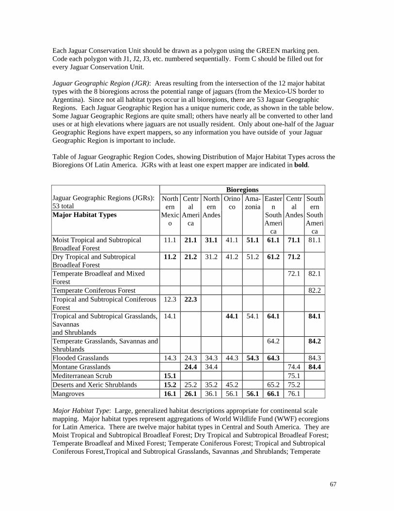
67
Each Jaguar Conservation Unit should be drawn as a polygon using the GREEN marking pen. Code each polygon with J1, J2, J3, etc. numbered sequentially. Form C should be filled out for every Jaguar Conservation Unit. Jaguar Geographic Region (JGR): Areas resulting from the intersection of the 12 major habitat types with the 8 bioregions across the potential range of jaguars (from the Mexico-US border to Argentina). Since not all habitat types occur in all bioregions, there are 53 Jaguar Geographic Regions. Each Jaguar Geographic Region has a unique numeric code, as shown in the table below. Some Jaguar Geographic Regions are quite small; others have nearly all be converted to other land uses or at high elevations where jaguars are not usually resident. Only about one-half of the Jaguar Geographic Regions have expert mappers, so any information you have outside of your Jaguar Geographic Region is important to include. Table of Jaguar Geographic Region Codes, showing Distribution of Major Habitat Types across the Bioregions Of Latin America. JGRs with at least one expert mapper are indicated in bold.
Bioregions Jaguar Geographic Regions (JGRs): 53 total Major Habitat Types
Northern
Mexico
Central
America
Northern
Andes
Orinoco
Ama-zonia
Eastern
South Ameri
ca
Central
Andes
Southern
South Ameri
ca Moist Tropical and Subtropical Broadleaf Forest
11.1 21.1 31.1 41.1 51.1 61.1 71.1 81.1
Dry Tropical and Subtropical Broadleaf Forest
11.2 21.2 31.2 41.2 51.2 61.2 71.2
Temperate Broadleaf and Mixed Forest
72.1 82.1
Temperate Coniferous Forest 82.2 Tropical and Subtropical Coniferous Forest
12.3 22.3
Tropical and Subtropical Grasslands, Savannas and Shrublands
14.1 44.1 54.1 64.1 84.1
Temperate Grasslands, Savannas and Shrublands
64.2 84.2
Flooded Grasslands 14.3 24.3 34.3 44.3 54.3 64.3 84.3 Montane Grasslands 24.4 34.4 74.4 84.4 Mediterranean Scrub 15.1 75.1 Deserts and Xeric Shrublands 15.2 25.2 35.2 45.2 65.2 75.2 Mangroves 16.1 26.1 36.1 56.1 56.1 66.1 76.1 Major Habitat Type: Large, generalized habitat descriptions appropriate for continental scale mapping. Major habitat types represent aggregations of World Wildlife Fund (WWF) ecoregions for Latin America. There are twelve major habitat types in Central and South America. They are Moist Tropical and Subtropical Broadleaf Forest; Dry Tropical and Subtropical Broadleaf Forest; Temperate Broadleaf and Mixed Forest; Temperate Coniferous Forest; Tropical and Subtropical Coniferous Forest,Tropical and Subtropical Grasslands, Savannas ,and Shrublands; Temperate

68
Grasslands, Savannas and Shrublands; Flooded Grasslands; Montane Grasslands; Mediterranean Scrub; Deserts and Xeric Shrublands; and Mangroves Point: A single location on the map defined by its x and y coordinates. For this exercise, points should be considered circular areas with 20 km radius. Lump all observations made within a given 20 km radius area under the same point location. Point locations should be indicated on the map by making a plus sign (e.g. +) using the BLUE marking pen. Each point location should be coded with P1, P2, P3, etc. numbered sequentially. Additional information about the point should be included on Form A. Polygon: An irregularly shaped, closed area on the map. The placement of the polygon code indicates the interior of the polygon. Each polygon should be coded to match information on the data forms.
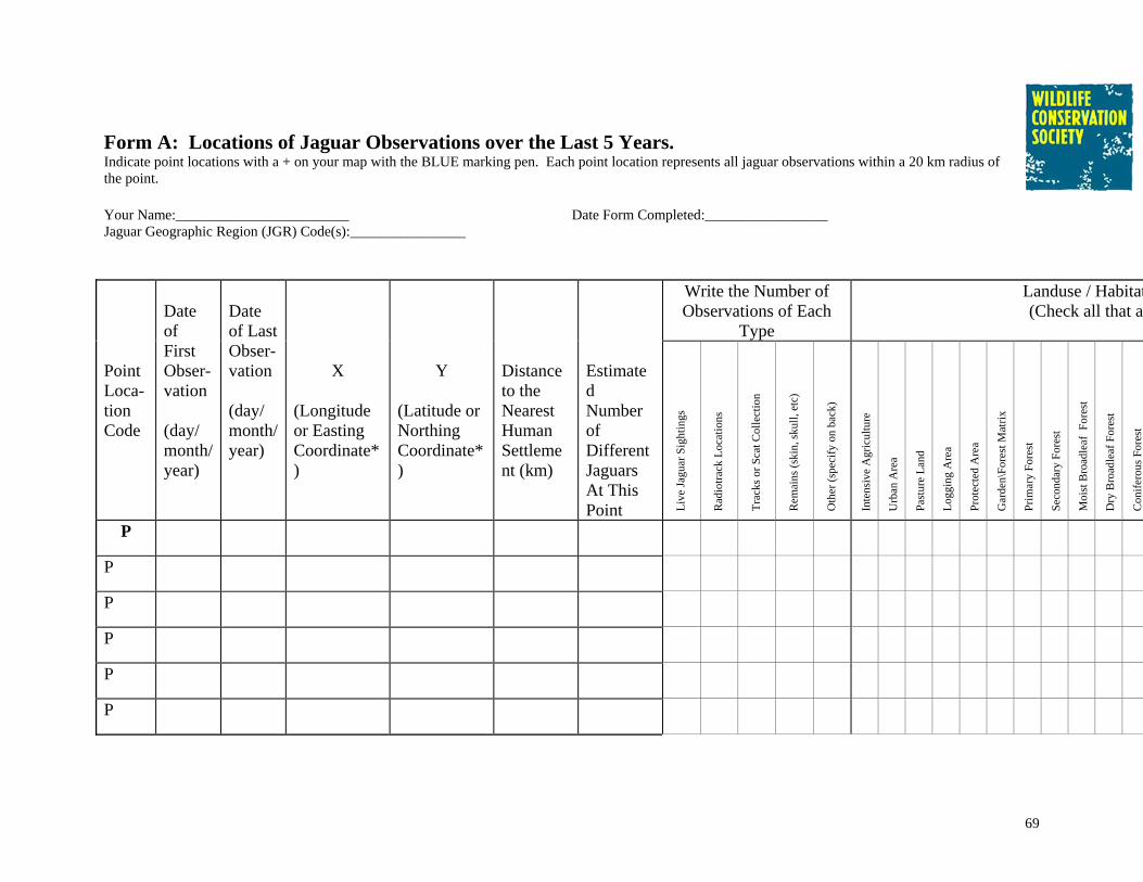
69
Form A: Locations of Jaguar Observations over the Last 5 Years. Indicate point locations with a + on your map with the BLUE marking pen. Each point location represents all jaguar observations within a 20 km radius of the point. Your Name:________________________ Date Form Completed:_________________ Jaguar Geographic Region (JGR) Code(s):________________
Write the Number of Observations of Each
Type
Landuse / Habitat(Check all that ap
Point Loca-tion Code
Date of First Obser-vation (day/ month/ year)
Date of Last Obser-vation (day/ month/ year)
X (Longitude or Easting Coordinate*)
Y (Latitude or Northing Coordinate*)
Distance to the Nearest Human Settlement (km)
Estimated Number of Different Jaguars At This Point Li
ve Ja
guar
Sig
htin
gs
Rad
iotra
ck L
ocat
ions
Trac
ks o
r Sca
t Col
lect
ion
Rem
ains
(ski
n, sk
ull,
etc)
Oth
er (s
peci
fy o
n ba
ck)
Inte
nsiv
e A
gric
ultu
re
Urb
an A
rea
Past
ure
Land
Logg
ing
Are
a
Prot
ecte
d A
rea
Gar
den\
Fore
st M
atrix
Prim
ary
Fore
st
Seco
ndar
y Fo
rest
Moi
st B
road
leaf
For
est
Dry
Bro
adle
af F
ores
t
Con
ifero
us F
ores
t
P
P
P
P
P
P

70
P
P
P
P
*if using coordinate system different from latitude/longitude, indicate on the back of this form. Additional Notes about the Point Observations on this sheet: (Include relevant citations, the names and contact information for observers other than yourself, information about the age, sex and resident/transient status of jaguars) Point Code
Type of Remains Other Kind of Jaguar Observation
Other Landuse / Habitat Type 1
Other Landuse / Habitat Type 2
Additional Notes
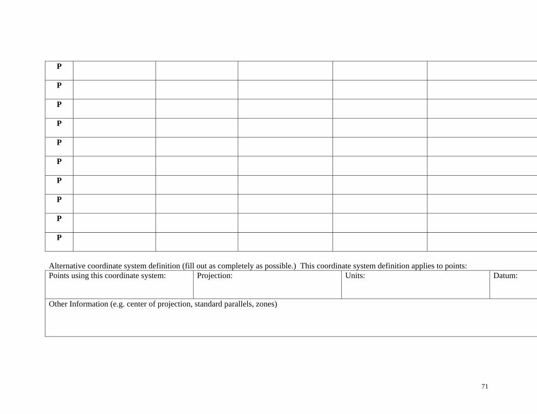
71
P
P
P
P
P
P
P
P
P
P
Alternative coordinate system definition (fill out as completely as possible.) This coordinate system definition applies to points: Points using this coordinate system:
Projection: Units: Datum:
Other Information (e.g. center of projection, standard parallels, zones)

72
Form B: Approximate Jaguar Range over the Last 5 Years. Indicate approximate jaguar range polygons on your map with the RED marking pen. Your Name:________________ Date Form Completed:________________ Jaguar Geographic Region (JGR) Code(s):________________ Approximate Jaguar Range (AJR) Polygon Code: R-________________ Definition of Range What limits the range of jaguars for this polygon? Estimate the percentage of polygon boundary defined by each factor. Limiting Factor
Percentage of Boundary limited by this factor*
Notes/ Specifics
Habitat Transition
Specify transition from what to what:
Human Population Density
Name settlement or settled region, if possible:
Hunting of Jaguar
Specify type of hunting activity:
Insufficient Prey
Specify what limits prey:
Elevation Limit
Specify limit in meters:
Physical Barrier (water)
Name water barrier:
Physical Barrier (other)
Specify other barrier. Name if possible:
Limit of Your Knowledge
Edge of Map
Other 1 (specify)
Specify:
Other 2 (specify)
Specify:
*Percentages can total more than 100% if portions of the polygon boundary are limited by multiple factors.
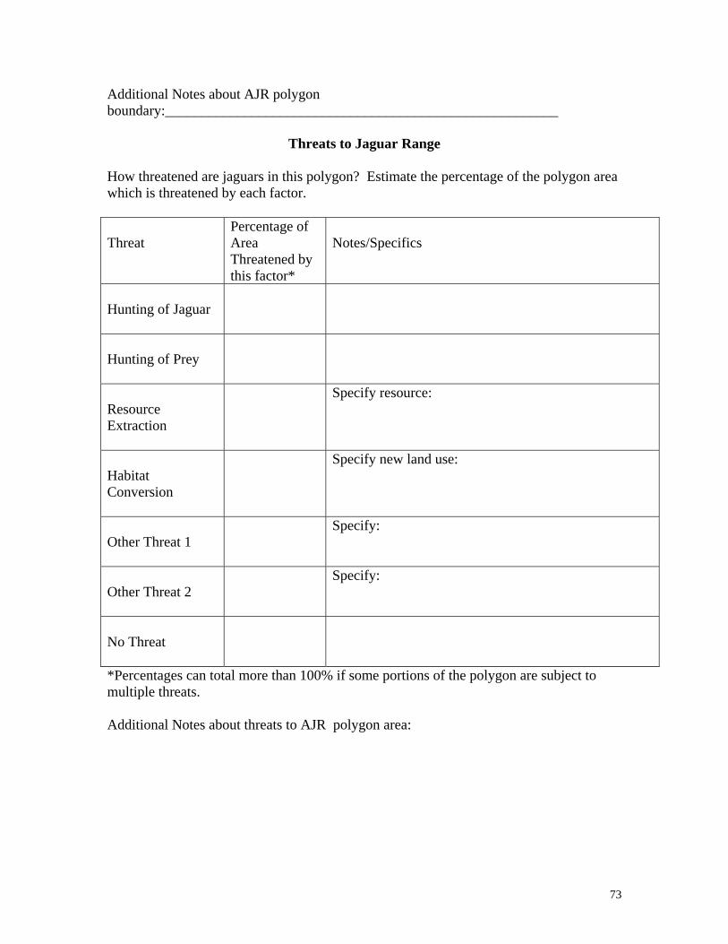
73
Additional Notes about AJR polygon boundary:_______________________________________________________
Threats to Jaguar Range How threatened are jaguars in this polygon? Estimate the percentage of the polygon area which is threatened by each factor. Threat
Percentage of Area Threatened by this factor*
Notes/Specifics
Hunting of Jaguar
Hunting of Prey
Resource Extraction
Specify resource:
Habitat Conversion
Specify new land use:
Other Threat 1
Specify:
Other Threat 2
Specify:
No Threat
*Percentages can total more than 100% if some portions of the polygon are subject to multiple threats. Additional Notes about threats to AJR polygon area:

74
Form C: Important Areas for Jaguar Conservation (Jaguar Conservation Units or JCUs). Your Name:________________________ Date Form Completed:_________________ Jaguar Geographic Region Code(s):____________ JCU ID Code: J-________________ Definition of Jaguar Conservation Unit A Jaguar Conservation Unit (JCU) is defined as an area: III. with a stable prey community, currently known or believed to contain a population of resident
jaguars large enough (at least 50 breeding individuals) to be potentially self-sustaining over the next 100 years;
or
IV. containing fewer jaguars, but with adequate habitat and a stable, diverse prey base, such that jaguar populations in the area could increase if threats were alleviated.
What type of Jaguar Conservation Unit is this polygon? (circle one)
JCU Type I JCU Type II Evidence for choosing this JCU Type: ______________________________________________________________ What do you estimate the population size of jaguars is in this JCU? (circle one)
More than 500 200-500 100-200 50-100 Less than 50 What is the basis of your assessment of the population? ________________________________________________ What are prey species for jaguars in this JCU? Rank them by biomass taken by jaguars. Species 1:
Species 4:
Species 2:
Species 5:
Species 3:
Species 6:
What are the threats to jaguars in this JCU? Check () all that apply. Hunting of Jaguar Hunting of Prey Resource Extraction Habitat Conversion Other (specify):
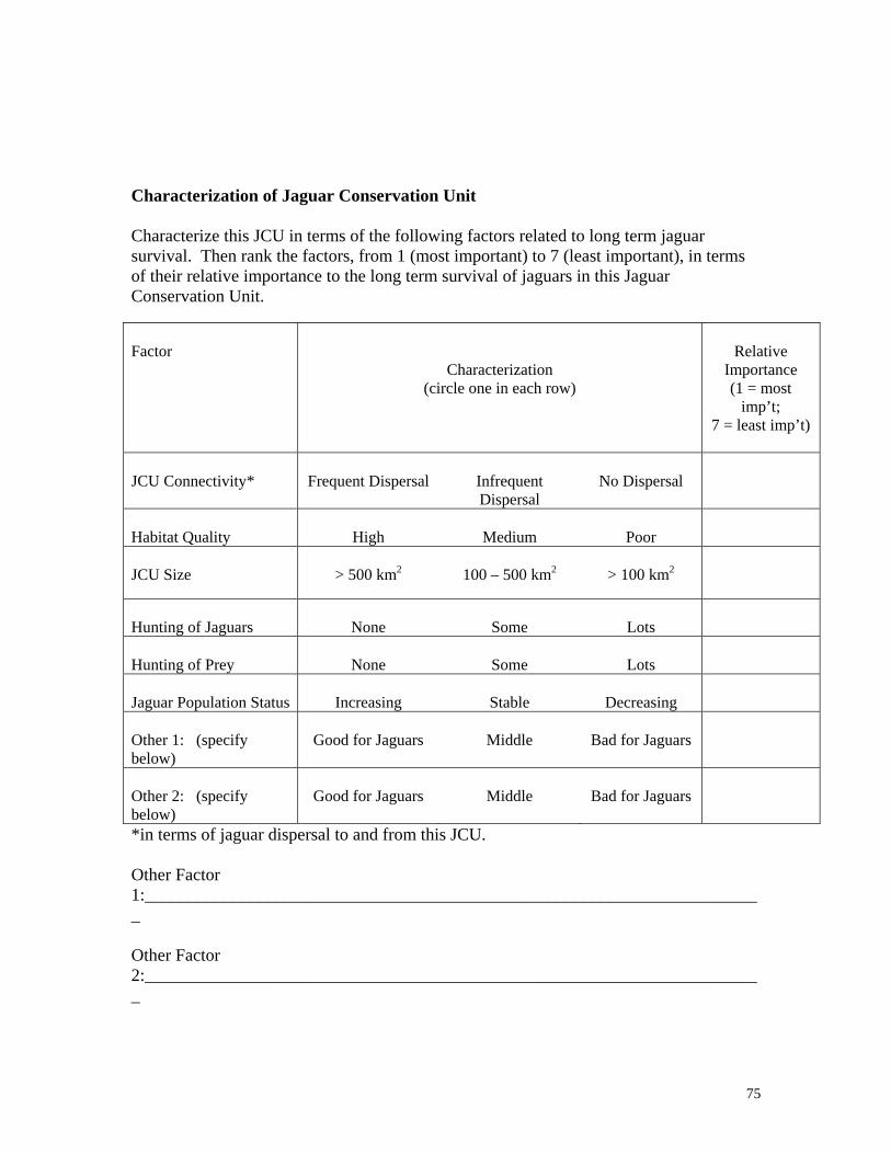
75
Characterization of Jaguar Conservation Unit Characterize this JCU in terms of the following factors related to long term jaguar survival. Then rank the factors, from 1 (most important) to 7 (least important), in terms of their relative importance to the long term survival of jaguars in this Jaguar Conservation Unit. Factor
Characterization (circle one in each row)
Relative
Importance (1 = most
imp’t; 7 = least imp’t)
JCU Connectivity*
Frequent Dispersal
Infrequent Dispersal
No Dispersal
Habitat Quality
High
Medium
Poor
JCU Size
> 500 km2
100 – 500 km2
> 100 km2
Hunting of Jaguars
None
Some
Lots
Hunting of Prey
None
Some
Lots
Jaguar Population Status
Increasing
Stable
Decreasing
Other 1: (specify below)
Good for Jaguars
Middle
Bad for Jaguars
Other 2: (specify below)
Good for Jaguars
Middle
Bad for Jaguars
*in terms of jaguar dispersal to and from this JCU. Other Factor 1:_______________________________________________________________________ Other Factor 2:_______________________________________________________________________

76
Assessment of Legal and Actual Protection for Jaguar Conservation Unit Estimate the percentage of the JCU under different land tenure systems and how effective the actual protection (as opposed to the paper protection) of this area is for long term survival of jaguars. Legal Land Tenure System
Estimate the percentage of this JCU under different land tenure systems.
Effectiveness of Protection
Private Ownership
Fully Effective
Partially Effective
Ineffective
No Effective Ownership Fully Effective
Partially Effective
Ineffective
IUCN Category 1
Fully Effective
Partially Effective
Ineffective
IUCN Category 2
Fully Effective
Partially Effective
Ineffective
IUCN Category 3
Fully Effective
Partially Effective
Ineffective
IUCN Category 4
Fully Effective
Partially Effective
Ineffective
IUCN Category 5
Fully Effective
Partially Effective
Ineffective
Other (specify)
Fully Effective
Partially Effective
Ineffective
Land Tenure Definitions: Private Ownership: Lands owned by private individuals or corporations. No effective ownership: Lands not owned by private individuals or corporations nor actively managed by any governmental body. IUCN Protected Area Management Category 1: Strict Nature Reserve/Scientific Reserve. Lands designated “to protect nature and maintain natural processes in an undisturbed state in order to have ecologically representative examples of the natural environment available for scientific study, environmental monitoring, education, and for the maintenance of genetic resources in a dynamic and evolutionary state.” IUCN Protected Area Management Category 2: National Park. Lands designated “to protect outstanding natural and scenic areas of national or international significance for scientific, educational, and recreational use. These are relatively large natural areas not materially altered by human activity where extractive resource uses are not allowed.” IUCN Protected Area Management Category 3: Natural Monument/Natural Landmark. Lands designated “to protect and preserve nationally significant natural
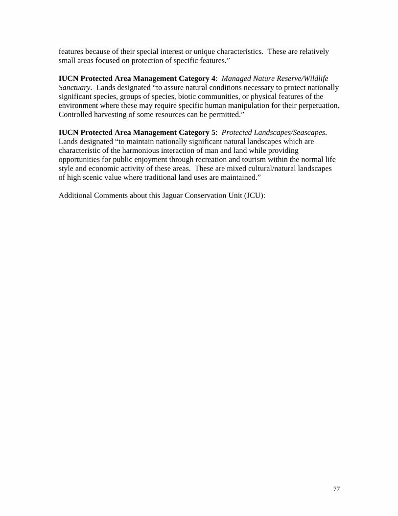
77
features because of their special interest or unique characteristics. These are relatively small areas focused on protection of specific features.” IUCN Protected Area Management Category 4: Managed Nature Reserve/Wildlife Sanctuary. Lands designated “to assure natural conditions necessary to protect nationally significant species, groups of species, biotic communities, or physical features of the environment where these may require specific human manipulation for their perpetuation. Controlled harvesting of some resources can be permitted.” IUCN Protected Area Management Category 5: Protected Landscapes/Seascapes. Lands designated “to maintain nationally significant natural landscapes which are characteristic of the harmonious interaction of man and land while providing opportunities for public enjoyment through recreation and tourism within the normal life style and economic activity of these areas. These are mixed cultural/natural landscapes of high scenic value where traditional land uses are maintained.” Additional Comments about this Jaguar Conservation Unit (JCU):

Related Documents