UNITAR-UNOSAT | Tropical Cyclone Matthew-16, Haiti, Cuba, Jamaica, Dominican Republic | Population Exposure Analysis UNOSAT Preliminary Exposure/Impact Analysis Haiti, Cuba, Jamaica, Dominican Republic Update 1 Tropical Cyclone Matthew-16 5 October 2016 Geneva, Switzerland UNOSAT Contact: Postal Address: Email: [email protected] UNITAR – UNOSAT, IEH T: +41 22 767 4020 (UNOSAT Operations) Chemin des Anémones 11, 24/7 hotline: +41 76 411 4998 CH-1219, Genève, Suisse

Welcome message from author
This document is posted to help you gain knowledge. Please leave a comment to let me know what you think about it! Share it to your friends and learn new things together.
Transcript
UNITAR-UNOSAT | Tropical Cyclone Matthew-16, Haiti, Cuba, Jamaica, Dominican Republic | Population Exposure Analysis
UNOSAT Preliminary Exposure/Impact Analysis Haiti, Cuba, Jamaica, Dominican Republic Update 1 Tropical Cyclone Matthew-16
5 October 2016 Geneva, Switzerland
UNOSAT Contact: Postal Address:
Email: [email protected] UNITAR – UNOSAT, IEH T: +41 22 767 4020 (UNOSAT Operations) Chemin des Anémones 11, 24/7 hotline: +41 76 411 4998 CH-1219, Genève, Suisse
UNITAR-UNOSAT | Tropical cyclone Matthew-16, Haiti, Cuba, Jamaica, Dominican Republic | Population Exposure Analysis
2
Overview
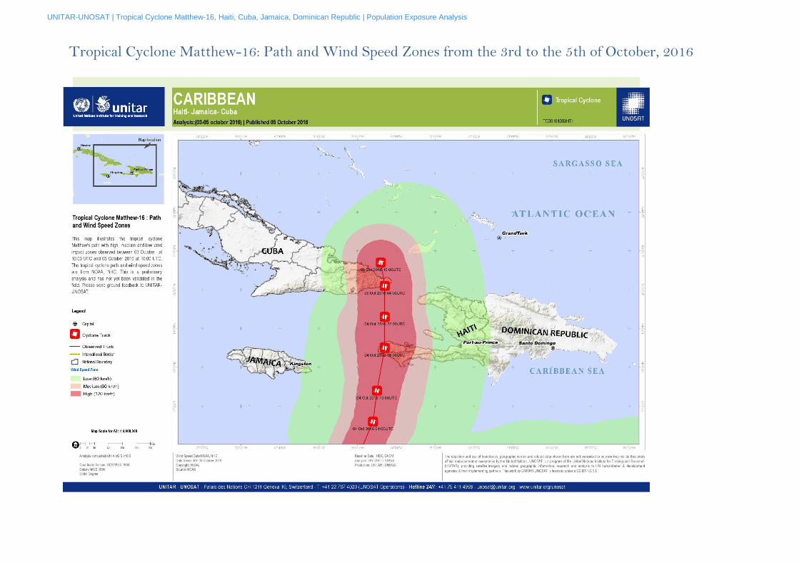
As of the 5th of October 2016, cyclone Matthew is travelling northwest towards the Bahamas, decreasing in intensity, with predicted sustained wind speeds of greater than 200km/h. Tropical cyclone Matthew formed near the Windward Islands on Wednesday, the 28th of September 2016. It continued westwards over the Caribbean Sea, and on Monday, the 3rd of October 2016 at 21:00 UTC had sustained winds of 222km/h. Tropical cyclone Matthew then continued northeast intensifying and on Tuesday, the 4th of October 2016 at 11:00 UTC, made landfall near Les Anglais, Haiti with sustained wind speeds of 230km/h which affected approximately 630,000 people. The winds and torrential rain created a humanitarian crisis. Matthew then continued northwest and travelled towards the eastern part of Cuba, near Guantanamo city, with sustained wind speeds of 222km/h at 18:00 UTC. In Cuba over a million people were affected. Matthew caused severe flooding and killed 4 people in Dominican Republic and at least 2 people in Haiti (Reuters). The UN Secretary General’s Deputy Special Representative for Haiti, Mourad Wahba, said “much of the population” in Haiti was displaced by Matthew and at least 10,000 were in shelters. Farmland and businesses in Haiti were also devastated by the storm (Heifer International). This report provides a preliminary population exposure analysis of tropical cyclone Matthew according to the observed cyclone track, sustained wind speed zones, (NHC, Advisory 29, 5 October 2016 10:00 UTC) and estimated precipitation accumulation (GPM data, 4 Oct 2016 15:00 UTC to 5 Oct 2016 03:00 UTC) over Haiti, Cuba, Dominican Republic, and Jamaica. A complete excel table of the population exposure analysis is accessible here and the accumulated precipitation analysis here.
The population exposure estimates are based on administrative levels from HDX and GADM, population data from WorldPop, and cyclone track & wind speed zones from NHC.

UNITAR-UNOSAT | Tropical cyclone Matthew-16, Haiti, Cuba, Jamaica, Dominican Republic | Population Exposure Analysis
3
Population Exposure in Haiti
10,887,658 Total population of Haiti
213,
Country / Department Wind Speed Zones
Total 60 km/h 90 km/h 120 km/h
Haiti 9,253,694 508,562 1,125,402 10,887,658 ARTIBONITE 1,722,460 1,722,460 CENTRE 750,382 750,382 GRAND'ANSE 472,788 472,788 NIPPES 35,636 244,130 58,647 338,413 NORD 1,067,549 1,067,549 NORD EST 400,195 400,195 NORD OUEST 639,793 80,712 720,505 OUEST 3,987,570 20,848 4,008,419 SUD 15,762 162,872 593,967 772,601 SUD-EST 634,347 634,347
Total 9,253,694 508,562 1,125,402 10,887,658 Sources: Admin levels- HDX, Population Data- WorldPop, Cyclone Wind Speed Zones- NOAA, NHC
Analysis: UNITAR-UNOSAT
The population exposure, summarized by Department, has been calculated using a 100 m resolution WorldPoP dataset. This is a preliminary analysis & has not yet been validated in the field.
Download the complete excel table which provides estimates of the population exposed to sustained wind speed zones here. Download the complete excel table which provides estimates of the population exposed to accumulated precipitation from the 4th to the 5th of October 2016, divided in 4 classes, here.
1,125,402 Total population living in 120 km/h wind speed zones
508,562 Total population living in 90 km/h wind speed zones
9,253,694 Total population living in 60 km/h wind speed zones

UNITAR-UNOSAT | Tropical cyclone Matthew-16, Haiti, Cuba, Jamaica, Dominican Republic | Population Exposure Analysis
4
Population Exposure in Cuba
213,
Country / Province / Municipality
Wind Speed Zones Total
60 km/h 90 km/h 120 km/h Cuba 932,393 331,422 269,449 1,533,264
Guantánamo 33,616 270,622 195,706 499,944 Baracoa 80,272 80,272 Caimanera 754 9,239 384 10,377 El Salvador 21,679 19,919 41,597 Guantánamo 220,962 220,962 Imías 22,583 22,583 Maisí 27,160 27,160 Manuel Tames 10,916 27,170 38,086 Niceto Pérez 11,183 4,823 16,006 San Antonio del Sur 24,890 24,890 Yateras 4,763 13,247 18,010
Holguín 227,325 60,800 73,743 361,868 Antilla 12,257 12,257 Báguanos 4,892 4,892 Banes 78,105 78,105 Cueto 19,296 19,296 Frak País 6,518 16,729 23,247 Mayarí 99,280 99,280 Moa 3,189 71,058 74,247 Rafael Freyre 4,257 4,257 Sagua de Tánamo 2,719 40,882 2,685 46,286
Santiago de Cuba 671,453 671,453 Mella 21,442 21,442 Palma Soriano 3,540 3,540 San Luis 74,267 74,267 Santiago de Cuba 440,754 440,754 Segundo Frente 38,444 38,444 Songo-La Maya 93,006 93,006
Total 932,393 331,422 269,449 1,533,264 Sources: Admin levels- GADM, Population Data- WorldPop, Cyclone Wind Speed Zones- NOAA, NHC
Analysis: UNOSAT
The population exposure, summarized by Province and Municipality, has been calculated using a 100 m resolution WorldPoP dataset. This is a preliminary analysis & has not yet been validated in the field.
Download the complete excel table which provides estimates of the population exposed to sustained wind speed zones here. Download the complete excel table which provides estimates of the population exposed to accumulated precipitation from the 4th to the 5th of October 2016, divided in 4 classes, here.
269,449 Total population living in 120 km/h wind speed zones
331,422 Total population living in 90 km/h wind speed zones
932,393 Total population living in 60 km/h wind speed zones
11,027,973 Total population of Cuba
UNITAR-UNOSAT | Tropical cyclone Matthew-16, Haiti, Cuba, Jamaica, Dominican Republic | Population Exposure Analysis
5
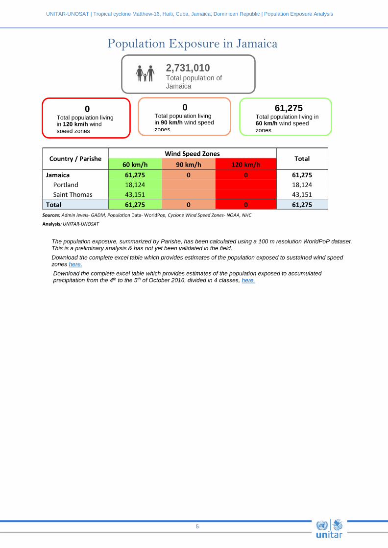
Population Exposure in Jamaica
2,731,010 Total population of Jamaica
213,
Country / Parishe Wind Speed Zones
Total 60 km/h 90 km/h 120 km/h
Jamaica 61,275 0 0 61,275 Portland 18,124 18,124 Saint Thomas 43,151 43,151
Total 61,275 0 0 61,275 Sources: Admin levels- GADM, Population Data- WorldPop, Cyclone Wind Speed Zones- NOAA, NHC
Analysis: UNITAR-UNOSAT
The population exposure, summarized by Parishe, has been calculated using a 100 m resolution WorldPoP dataset. This is a preliminary analysis & has not yet been validated in the field. Download the complete excel table which provides estimates of the population exposed to sustained wind speed zones here. Download the complete excel table which provides estimates of the population exposed to accumulated precipitation from the 4th to the 5th of October 2016, divided in 4 classes, here.
0 Total population living in 120 km/h wind speed zones
0 Total population living in 90 km/h wind speed zones
61,275 Total population living in 60 km/h wind speed zones

UNITAR-UNOSAT | Tropical cyclone Matthew-16, Haiti, Cuba, Jamaica, Dominican Republic | Population Exposure Analysis
6
Population Exposure in Dominican Republic
9,213,246 Total population of Jamaica
213,
Country / Province Wind Speed Zones
Total 60 km/h 90 km/h 120 km/h
Dominican Republic 133,512 0 0 133,512 Baoruco 3,839 3,839 Dajabón 22,712 22,712 Elías Piña 53,636 53,636 Independencia 32,916 32,916 Monte Cristi 1,785 1,785 Pedernales 10,742 10,742 San Juan 7,882 7,882 Total 133,512 0 0 133,512
Sources: Admin levels- HDX, Population Data- WorldPop, Cyclone Wind Speed Zones- NOAA, NHC Analysis: UNITAR-UNOSAT
The population exposure, summarized by Province, has been calculated using a 100 m resolution WorldPoP dataset. This is a preliminary analysis & has not yet been validated in the field. Download the complete excel table which provides estimates of the population exposed to sustained wind speed zones here. Download the complete excel table which provides estimates of the population exposed to accumulated precipitation from the 4th to the 5th of October 2016, divided in 4 classes, here.
0 Total population living in 120 km/h wind speed zones
0 Total population living in 90 km/h wind speed zones
133,512 Total population living in 60 km/h wind speed zones
UNITAR-UNOSAT | Tropical Cyclone Matthew-16, Haiti, Cuba, Jamaica, Dominican Republic | Population Exposure Analysis
Tropical Cyclone Matthew-16: Path and Wind Speed Zones from the 3rd to the 5th of October, 2016

UNITAR-UNOSAT | Tropical cyclone Matthew-16, Haiti, Cuba, Jamaica, Dominican Republic | Population Exposure Analysis
8
Estimated Precipitation Accumulation from the 4th to the 5th of October, 2016
Related Documents