UNIVERSITY PRECINTS IN LISBON METROPOLITAN AREA: A MORPHOLOGICAL DESCRIPTION Cannas da Silva, Luísa and Heitor, Teresa Instituto Superior Técnico Abstract This paper was carried out as part of the framework of IN_LEARNING research project (http://in‐ learning.ist.utl.pt) and aims at exploring an exploratory tool to map and describe university facilities. The main purpose is to understand their morphological features and spatial integration patterns within the urban territory, considering both the metropolitan area scale and the city‐ university interaction. Lisbon is therefore used to test the proposed tool. This paper is organized in four parts. The first one reviews the key themes involving university facilities planning and design in contemporary urban societies and justifies the relevance of designing an exploratory tool to map and describe their location and morphological features. The second introduces the descriptive strategies applied in the design of the exploratory tool and the corresponding spatial and non‐spatial variables that were selected. The third part illustrates the application of the proposed tool to map and describe university facilities in the Metropolitan Area of Lisbon. In the fourth part, nine university precincts were used as case studies to test the capabilities of the technique. The proposed tool reveals a high level of performance to explore how university facilities turn out to be integrated into the urban structure. In particular it allows understanding the extent of their spatial concentration versus spatial dispersion and the definition of inner city locus versus city nodes or outskirt. Keywords: university precincts, morphological description, descriptive tool 1284

Welcome message from author
This document is posted to help you gain knowledge. Please leave a comment to let me know what you think about it! Share it to your friends and learn new things together.
Transcript
UNIVERSITY PRECINTS IN LISBON METROPOLITAN AREA: A MORPHOLOGICAL DESCRIPTION
Cannas da Silva, Luísa and Heitor, Teresa
Instituto Superior Técnico
Abstract
This paper was carried out as part of the framework of IN_LEARNING research project (http://in‐
learning.ist.utl.pt) and aims at exploring an exploratory tool to map and describe university
facilities. The main purpose is to understand their morphological features and spatial integration
patterns within the urban territory, considering both the metropolitan area scale and the city‐
university interaction. Lisbon is therefore used to test the proposed tool.
This paper is organized in four parts. The first one reviews the key themes involving university
facilities planning and design in contemporary urban societies and justifies the relevance of
designing an exploratory tool to map and describe their location and morphological features. The
second introduces the descriptive strategies applied in the design of the exploratory tool and the
corresponding spatial and non‐spatial variables that were selected. The third part illustrates the
application of the proposed tool to map and describe university facilities in the Metropolitan Area
of Lisbon. In the fourth part, nine university precincts were used as case studies to test the
capabilities of the technique.
The proposed tool reveals a high level of performance to explore how university facilities turn out
to be integrated into the urban structure. In particular it allows understanding the extent of their
spatial concentration versus spatial dispersion and the definition of inner city locus versus city
nodes or outskirt.
Keywords: university precincts, morphological description, descriptive tool
1284
1.INTRODUCTION
Accompanying the expansion of higher education systems worldwide, beginning in the 1950’s and
60’s in the western societies and recently pronounced in many developing regions, university
facilities were established not only in, but also outside the city core, i.e. the morphological center
(Heitor, 2006) and, above all, in urban edges, facilitating new urban expansions. When conceived
as autonomous entities, universities facilities cause the isolation of academic communities,
highlighting ruptures within the urban fabric and originating unsustainable mobility patterns
(Hillier, 2007). On the other hand, one can argue that when universities facilities are built within
the city core, the preservation of their uniqueness and distinctive features may be easily affected
by the surrounding environment thus requiring special consideration.
Since the late 20th century, the role of university facilities in the urban dynamics has become a
focus of research within the framework of urban revitalization (Wievel and Perry, 2008). Research
has involved the identification and debate of the effects of university facilities on the process of
urban development, such as employment, housing, mobility, leisure and consumer activities
(Indovina 1998) as well as the discussion on gains from developments and broader institutional
relationships with the city in which university facilities are located (RIBA 2008). These studies have
emphasised the ambiguous and contingent role often played by university facilities in the process
of urban development worldwide, which are not always explicitly incorporated into the strategy of
the main urban agents and planning decisions.
Yet it becomes consensual that Universities’ activities impact in many ways on their vicinity and
wider communities to the mutual benefit of both. In addition to educational and R&D activities, a
third strand, that of civic engagement, is progressively becoming more significant in today’s
universities mission. This may have substantial implications for the built environment since the
wider community will have access and make use of university facilities for a range of activities.
Besides, universities can contribute to urban regeneration, by directly improving the quality of the
urban fabric, and helping to reclaim parts of cities and leverage funds from public regional players.
Equally, there is evidence, that the spatial structure of university facilities has a major impact on
the “flow of technology” (Allen 1977) and can act as catalysts for the transformation process from
an industrial to a knowledge based society. Policy research over the last two decades highlights
the role of knowledge in economic and social developments (Conceição and Heitor, 1999; Barnett
1285

and Temple, 2006), and some authors suggest that higher education sector will become one of the
main drivers of emerging economies in the next decades (Duderstadt, 1999)
Furthermore, the increasing democratization of higher education, student enrolment and diversity,
and advances in technology, the spectrum and scope of knowledge‐based environments are
expected to continue to transform and evolve, putting pressure on existent university facilities
(Thomas and Brown, 2011; Wagner, 2012).
Research suggests that a paradigm shift is required to ensure modernizing university learning
environments in coming decades and points out that university facilities must be reconfigured to
better support changes, foster the production of innovative knowledge to support
competitiveness and promote exchanges with the local economy.
Actually, higher education excellence requires universities facilities that provide the academic and
scientific community with resources and services, which not only support education and research
in their respective fields but also lead its development into new directions and create an attractive
environment for those who use them. A research study conducted in England by CABE (CABE,
2005) focused upon the quality, functionality and impact of built space from the perspective of the
academic community, shows that students who indicated that the physical environment had an
influence upon their learning performance stated that it has contributed in three main ways. First,
it helped to motivate students in their work. Second, it facilitated inspiration amongst students,
and finally it provided key facilities critical to the course. Staff indicated that academic factors
associated with their job (including interest in the type of work and the quality of their fellow staff
and support staff), together with the facilities they had access to, (including the quality of the
office and support facilities) impacted equally upon their performance.
Besides rethinking university‐learning spaces at the architectural design scale, it becomes critical
to reassess university facilities in terms of their spatial integration within the urban territory,
considering both the metropolitan area scale and the city‐university interaction, which should be
understood as an inevitable component of university collective life.
The purpose of this paper is to contribute to such efforts by developing a specific exploratory tool
to map spatial and non‐spatial data concerning existing or proposed university facilities and
relating their morphological features to the urban territories where they are located.
Such analytical tool was developed within the framework of IN_LEARNING research project
1286
(http://in‐learning.ist.utl.pt), which concentrates on the design of learning facilities including the
definition of a typological classification for learning spaces and the evaluation of future needs for
universities facilities.
2. THE ANALYTICAL TOOL RATIONALE
The analytical tool was specifically designed as a mapping profile, aiming at:
• compiling spatial and non‐spatial information on existing university facilities
• creating a base map upon which to place the information
• building a comprehensive data base inventory ;
• defining a typological classification of university facilities;
• understanding which spatial features are relevant;
• developing a spatial benchmarking system, making possible comparisons between
university facilities
2.1. METHODOLOGY: THE UNIVERSITY MAPPING PROFILE
The mapping profile was developed to operate on two scales by combining a macro analysis of the
urban structure with a microanalysis of the internal structure of the university facilities. It
combines spatial network analysis (space syntax), with documentary analysis complemented by in‐
situ observations.
At the macro scale, Depthmap software (Turner 2004) was used in order to build a topological
map (axial map), which is used as a base map, considering the scale of the metropolitan area
under analysis.
The axial map description (Heitor and Pinelo, 2006) operates as a macro analysis of the urban
structure. It allows a representation of information on a plane in topological relationship and with
measurable horizontal distances, i.e. a metric analysis of the catchment area and an angular
segment analysis of global integration (closeness centrality) and global choice (betweeness
centrality). At same time it has sufficient geographic reference information to identify the location
of each university infrastructure.
At the micro‐scale, the university infrastructure was analysed taking into consideration spatial and
non‐spatial data. The analysis was carried out in two different stages. The first one considered
1287
direct observations and fieldwork. It includes the survey of spatial and non‐spatial data. Variables
were chosen in order to create an objective and accurate analysis and to allow the definition of
ratios in order to identify spatial patterns, (e.g the average space available for student).
The second stage was focused on the data analysis. Spatial data were manipulated and presented
in a graphical support, based on physical‐analogue representations, in order to provide a clear and
legible communication tool in a simple and informative manner.
3. THE MACRO ANALYSIS: UNIVERSITY FACILITIES IN THE LISBON METROPOLITAN AREA
The Lisbon Metropolitan Area, with a total area of 2.962,6 Km2 and a population of about
2.815.851 inhabitants (2011 census), has been growing since the 60s until the late 80's according
to a centre‐periphery model, based on a process of suburbanization highly dependent on road and
public transport networks leading to the dispersion of population with lower together with less
qualified urban activities. From the eighties on, the evolution of the metropolitan structure was
characterized by the fragmentation of its economic, urban, natural and social dimensions and the
constellations of new central places, no longer coincident with the conventional urban centres. In
the nineties this dynamic was reinforced by a demographic and functional reshaping of the
metropolitan area due to the decrease of population in the city centre and the relocation of new
activities on more peripheral areas, such as university/science and technology parks, office parks
and large shopping malls.
The spatial pattern of university facilities in the LMA is related with this process of urban growth.
It comprises a total of 92 university facilities, of which 46 (50%) are public, 36 (40%) private, 5 (5%)
concordate and 5 (5%) military.
These facilities are located in only 8 of the 19 municipalities that compose the LMA. Their
dispertion is extremely uneven, since 92 (80%) of the university buildings are located in the city of
Lisbon, while Almada and Oeiras host 6 (6,5%) each, Amadora, Loures and Odivelas host 1 (1%)
and Cascais and Sintra both host 2 (2%) university facilities, as observed in the picture below
(Figure 1).
1288

Figure 1 - Distribution of university facilities within the LMA
The university location pattern shows a higher degree of concentration towards the city centre in
opposition to a more disperse pattern in the surrounding areas with a tendency to become more
disseminated as the distance from the city centre increases. While the oldest facilities are placed
in the city core, universities founded from the late 1960s up to 1980s are positioned on the edges
of the city or adjacent to city nodes and those established after the 1990s can be found on the
outskirts of the city in sparsely populated areas, often integrated, or adjacent to science and
technology parks.
These university facilities were classified in two main groups: isolated buildings and precincts. Due
to the ambiguous meaning of “university campus” and its connotation with the American model
(Turner, 1984) it was decided to adopt the term “precinct” to designate all the university facilities,
which involve more than one isolated building whether they are located within a gated territory or
imbedded in the urban tissue (Cannas da Silva, 2011). The precincts size vary between 6 700m2
and 140 000m2.
Public higher education Private higher education Concordat higher education Military higher education
+ integration -
1289
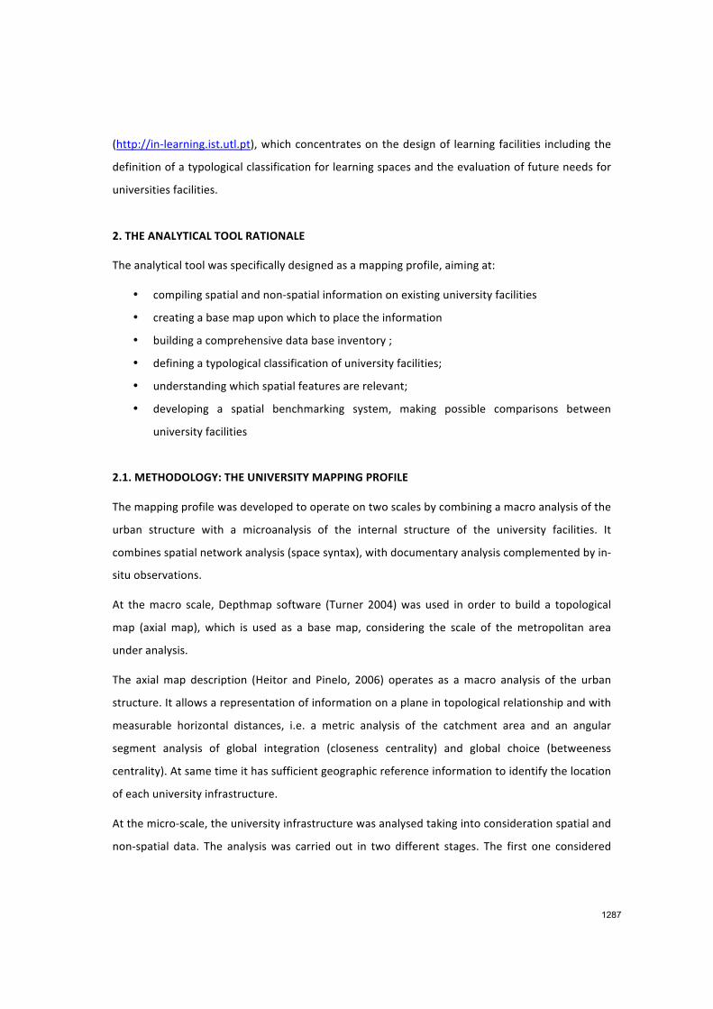
It is also possible to infer a connection between the location and the size of the university precinct,
with a tendency for the largest and most recent precincts to be located outside of the city core. In
the late 20th century, university facilities were also developed from the conversion of existing
facilities, which were vacant and deteriorating such as military barracks, hospitals or industrial
buildings.
About 52% of university precincts occupy privileged areas in terms of accessibility, being located
within the integration core i.e. the 25 % of the most integrated spaces (Hillier and Hanson 1984).
61% of the analysed precincts show integration values above the average value (0.222)
considering the whole spatial system. The precincts located outside the city centre tend to exhibit
a lower density of occupation.
>100 000 m2 30 000 – 100 000 m2 10 000 – 30 000 m2 5 000 – 10 000 m2 <5 000 m2
Figure 2 - Relation integration/area of the university precincts in the LMA
1290
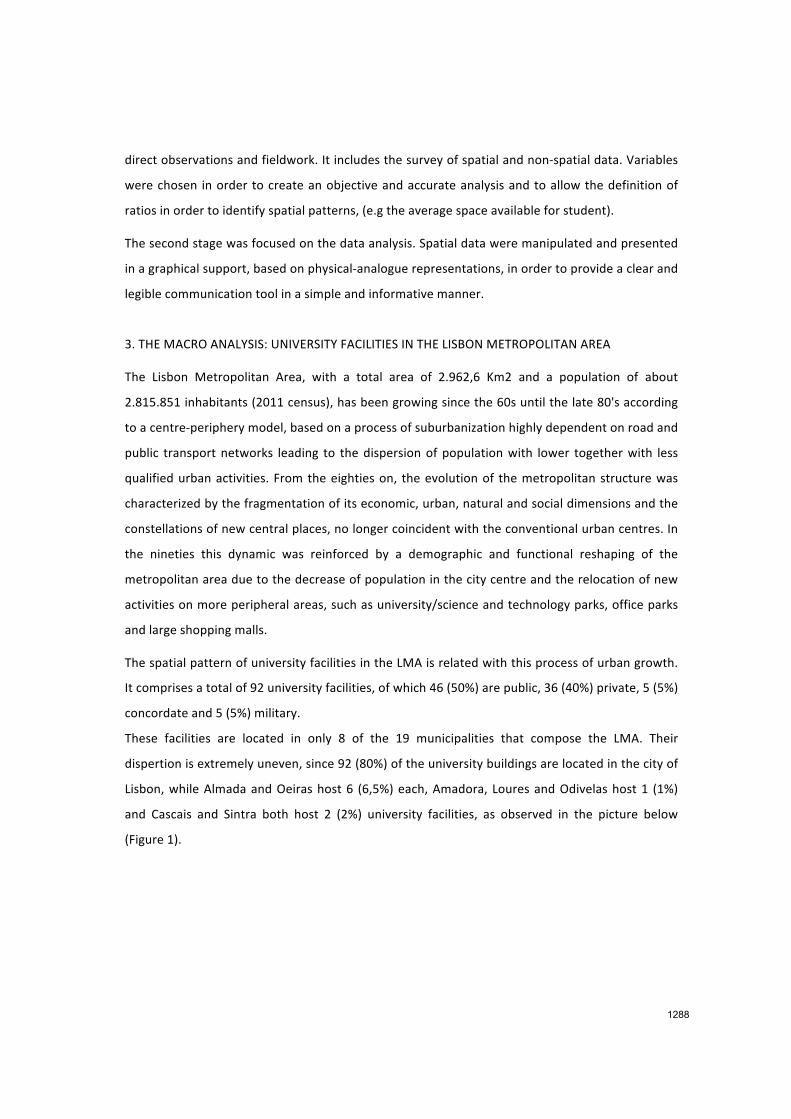
Chart 1 - Campus integration value
4. THE MICRO ANALYSIS: INTERNAL STRUCTURE OF THE UNIVERSITY FACILITIES
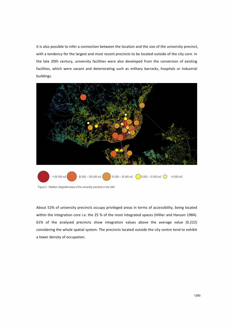
The microanalysis was focused on the internal structure of university facilities. It was tested in a
set of nine public university precincts, illustrated in the picture below. (Figure 4)
Figure 3 - Location of the case studies
1 – University City of Lisbon; 2 – Alto da Ajuda Campus; 3 – ISA Campus; 4 – IST Alameda Campus; 5 – IST Taguspark Campus; 6 – Campolide Campus; 7 – FCT Campus; 8 – Benfica Campus; 9 – ISEL Campus
0,20
4 0,24
4
0,25
0
0,25
5
0,26
2
0,26
6
0,26
8
0,27
3
0,28
8
0,29
7
0,30
0
0,30
6
0,30
8
0,31
4
0,31
4
0,32
1
0,32
2
0,32
7
0,32
9
0,33
0
0,33
3
0,33
4
0,33
4
0,35
1
0,07
1
0,22
0
0,000
0,050
0,100
0,150
0,200
0,250
0,300
0,350
0,400
Aca
dem
ia d
a F
orça
Aér
ea C
ampu
s
Sin
tra
Cam
pus
IST
-Ta
gusp
ark
Cam
pus
IST
-IT
N C
ampu
s
Uni
vers
idad
e A
tlânt
ica
Cam
pus
Am
eixo
eira
Cam
pus
Ega
s M
oniz
Cam
pus
Inst
ituto
Jea
n P
iage
t - A
lmad
a C
ampu
s
Esc
ola
Nav
al C
ampu
s
FC
T C
ampu
s
Alto
da
Aju
da C
ampu
s
ISE
L C
ampu
s
Cam
polid
e C
ampu
s
Ben
fica
Cam
pus
ISE
C C
ampu
s
ISA
Cam
pus
Aca
dem
ia M
ilita
r C
ampu
s
UA
L S
ta M
arta
Cam
pus
Uni
vers
idad
e Lu
sófo
na C
ampu
s
Uni
vers
ity C
ity o
f Lis
bon
IST
- A
lam
eda
Cam
pus
Av.
de
Ber
na C
ampu
s
Pal
ma
de C
ima
Cam
pus
Lisb
on -
Max
imum
Lisb
on -
Min
imum
Lisb
on -
Ave
rage
Campus - Integration Value (main access)
1291
Spatial data includes location, shape and dimension, geo‐morphological attributes, land use
patterns of university facilities as well as their accessibilities to road network and to public
transports network. In order to apply the same basis of analysis, quantifiable and measurable
variables were chosen, such as surface and net floor area, open space area, number of users, type
of physical boundaries and accessibility. Non‐spatial data considers information regarding the
institution’s mission, history, and development process, previous uses and structures, university
population, admissions records and census data.
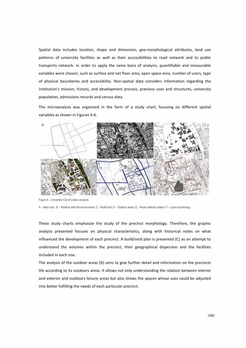
The microanalysis was organized in the form of a study chart, focusing on different spatial
variables as shown in Figures 4‐6.
Figure 4 – University City of Lisbon analysis
A – Main axis; B – Relation with the environment; C – Built/Void; D – Outdoor areas; E – Road network system; F – Land morphology
These study charts emphasize the study of the precinct morphology. Therefore, the graphic
analysis presented focuses on physical characteristics, along with historical notes on what
influenced the development of each precinct. A build/void plan is presented (C) as an attempt to
understand the volumes within the precinct, their geographical dispersion and the facilities
included in each one.
The analysis of the outdoor areas (D) aims to give further detail and information on the precincts
life according to its outdoors areas. It allows not only understanding the relation between interior
and exterior and outdoors leisure areas but also shows the spaces whose uses could be adjusted
into better fulfilling the needs of each particular precinct.
A B C
D E F
1292
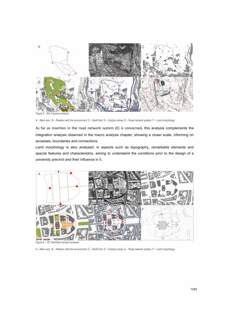
Figure 5 - ISA Campus analysis
A – Main axis; B – Relation with the environment; C – Built/Void; D – Outdoor areas; E – Road network system; F – Land morphology
As far as insertion in the road network system (E) is concerned, this analysis complements the
integration analysis observed in the macro analysis chapter, showing a closer scale, informing on
accesses, boundaries and connections.
Land morphology is also analysed, in aspects such as topography, remarkable elements and
special features and characteristics, aiming to understand the conditions prior to the design of a
university precinct and their influence in it.
Figure 6 – IST Alameda Campus analysis
A – Main axis; B – Relation with the environment; C – Built/Void; D – Outdoor areas; E – Road network system; F – Land morphology
A B C
D E F
A B C
D E F
1293
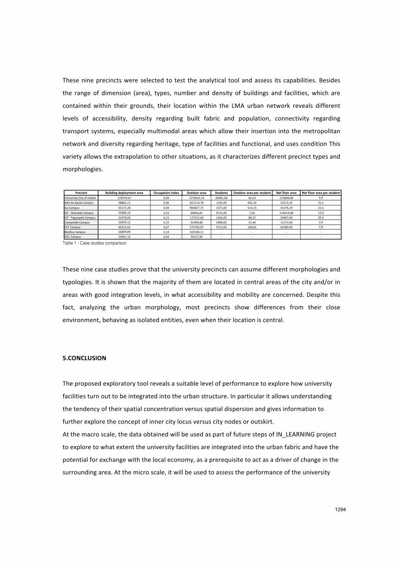
These nine precincts were selected to test the analytical tool and assess its capabilities. Besides
the range of dimension (area), types, number and density of buildings and facilities, which are
contained within their grounds, their location within the LMA urban network reveals different
levels of accessibility, density regarding built fabric and population, connectivity regarding
transport systems, especially multimodal areas which allow their insertion into the metropolitan
network and diversity regarding heritage, type of facilities and functional, and uses condition This
variety allows the extrapolation to other situations, as it characterizes different precinct types and
morphologies.
Table 1 - Case studies comparison
These nine case studies prove that the university precincts can assume different morphologies and
typologies. It is shown that the majority of them are located in central areas of the city and/or in
areas with good integration levels, in what accessibility and mobility are concerned. Despite this
fact, analyzing the urban morphology, most precincts show differences from their close
environment, behaving as isolated entities, even when their location is central.
5.CONCLUSION
The proposed exploratory tool reveals a suitable level of performance to explore how university
facilities turn out to be integrated into the urban structure. In particular it allows understanding
the tendency of their spatial concentration versus spatial dispersion and gives information to
further explore the concept of inner city locus versus city nodes or outskirt.
At the macro scale, the data obtained will be used as part of future steps of IN_LEARNING project
to explore to what extent the university facilities are integrated into the urban fabric and have the
potential for exchange with the local economy, as a prerequisite to act as a driver of change in the
surrounding area. At the micro scale, it will be used to assess the performance of the university
!"#$%&$' ()%*+%&,-+#.*/01#&'-2"#2 3$$).2'%/&-%&+#4 3)'+//"-2"#2 5')+#&'6 3)'+//"-2"#2-.#"-6')+#&' 7#'-8*//"-2"#2 7#'-8*//"-2"#2-.#"-6')+#&'
!"#$%&'#()*+#()*,-*.#'/," 012345674 8682 0148719633 18220688 78693 013:52688 962
;<(,*=>*;?@=>*+>AB@' 3:::9611 8687 78000564: 0121688 579617 31903639 1961
C'>*+>AB@' 3904161: 8685 275:14641 0940688 705609 39147612 1169
CDE*F*;<>A%=>*+>AB@'* 353:7602 8633 72:376:0 2030688 4679 00:30568: 0368
CDE*F*E>G@'B>&H*+>AB@'* 1154:688 8609 014911688 0559688 ::619 12584688 1865
+>AB,<#=%*+>AB@' 07982601 8609 205286:: 128:688 30657 00141688 362
I+E*+>AB@' 58193623 8684 949423684 9413688 088670 593:8688 462
J%"-#K>*+>AB@' 07:826:2 8605 083028600 F F F F
CDL.*+>AB@' 17271607 8655 351346:5 F F F F
1294
facilities and in particular to understand the impact of the university physical environment in the
process of new knowledge generation and its transmission. The axial map description applied as a
base map in the macro analysis can also be used to explore the variable form‐space of the
precincts in order to reveal their internal accessibility, the physical and visual barriers and the level
of permeability of the internal space, as well as the distribution of uses and the patterns of
movements and encounters.
The mapping tool provides a collaborative environment that promotes information sharing, data
visualization, interpretation and analysis. It also detects relationships between spatial and non‐
spatial variables and association rules and recognizes spatial distribution and clustering patterns.
As it was organized and accessed in an inventory format and computerized as a data base
inventory, the data collected can be integrated within a GIS platform in a user‐friendly manner
and combined with spatial data mining techniques so as to select as many variables for analysis as
appropriate, to define spatial attributes hierarchy and control thresholds in different levels.
REFERENCES
Allen, Tom (1977) “Managing the flow of technology#, MIT Press, Cambridge MA.
Barnett, R. and Temple, P. ( 2006) “Impact on Space of Future Changes in Higher Education” UK
Higher Education Space Management Project, for Space Management Group,
(www.smg.ac.uk/documents/FutureChangesInHE.pdf)
Blyth (2011) Blyth, Creating space for education: Innovation in the Design of Learning
Environments, II Seminario Internacional – Espacios innovadores para la excelencia universitaria,
studio de paradigmas de optimización docente y adaptación al Espacio Europeo de Educación
Superior , Madrid.
CABE (2005) “Design with Distinction: The value of good building design in higher education”,
Commission of Architecture and Built Environment, London UK
Cannas da Silva (2011) “Atlas Universitário da Área Metropolitana de Lisboa” Tese de Mestrado,
Lisboa, Instituto Superior Técnico ‐ UTL
Conceição and Heitor (1999) “On the Role of the University in the Knowledge Economy” Science
and Public Policy, vol 26(1), pp.37‐51
1295

Duderstadt (1999) “New Roles for the 21st‐Century University”, Issues in Science and Technology,
Winter: 37‐44
Edwards (2001) Heitor and Pinelo, 2006‐ Lisbon Metropolitan Area‐ axial map
Hillier, B. (2009) “Spatial sustainability in cities: organic patterns and sustainable forms” In: Koch,
D. and Marcus, L. and Steen, J., (eds.) Proceedings of the 7th International Space Syntax
Symposium. (pp. p. 1). Royal Institute of Technology (KTH): Stockholm, Sweden.
Heitor, T. (2006)
Indovina, F. (1998) “Sinergi Tra Communità e Università.” Archivio di Studi Urbani e Regionali 60–
61: 85–114.
RIBA (2008) “Growing by Degrees Universities in the Future of Urban Development”, Building
Futures, RIBA initiative, RIBA, London
Thomas, D. and Brown, J.S. (2011), “A New Culture of Learning: Cultivating the Imagination for a
world of constant change” Lexington, Ky: Create Space?
Turner, A (2001) “Depthmap: a program to perform visibility graph analysis” in Proceedings 3rd
International Symposium on Space Syntax pp. 31.1–31.9
Turner, P.V. (1984) “Campus: An American Planning Tradition” New York: The Architectural
History Foundation, and Cambridge, Mass. and London, England: The MIT Press
Wagner, T. (2012) “Creating Innovators: The Making of Young People Who Will Change the
World”, Scribner, New York.
Wievel and Perry (2008) “Global Universities and Urban Development: Case Studies and Analysis”,
Armonk, NY: M.E. Sharpe
ACKNOWLEDGEMENTS
This research has been carried out within the framework of the IN_LEARNING project. It was
funded by the Portuguese Science Foundation (FCT). We FCT). We thank the FCT for supporting
our work.
1296
Related Documents