University of Bristol Strategic Masterplan July 2006 Supplementary Planning Document Number 11

Welcome message from author
This document is posted to help you gain knowledge. Please leave a comment to let me know what you think about it! Share it to your friends and learn new things together.
Transcript
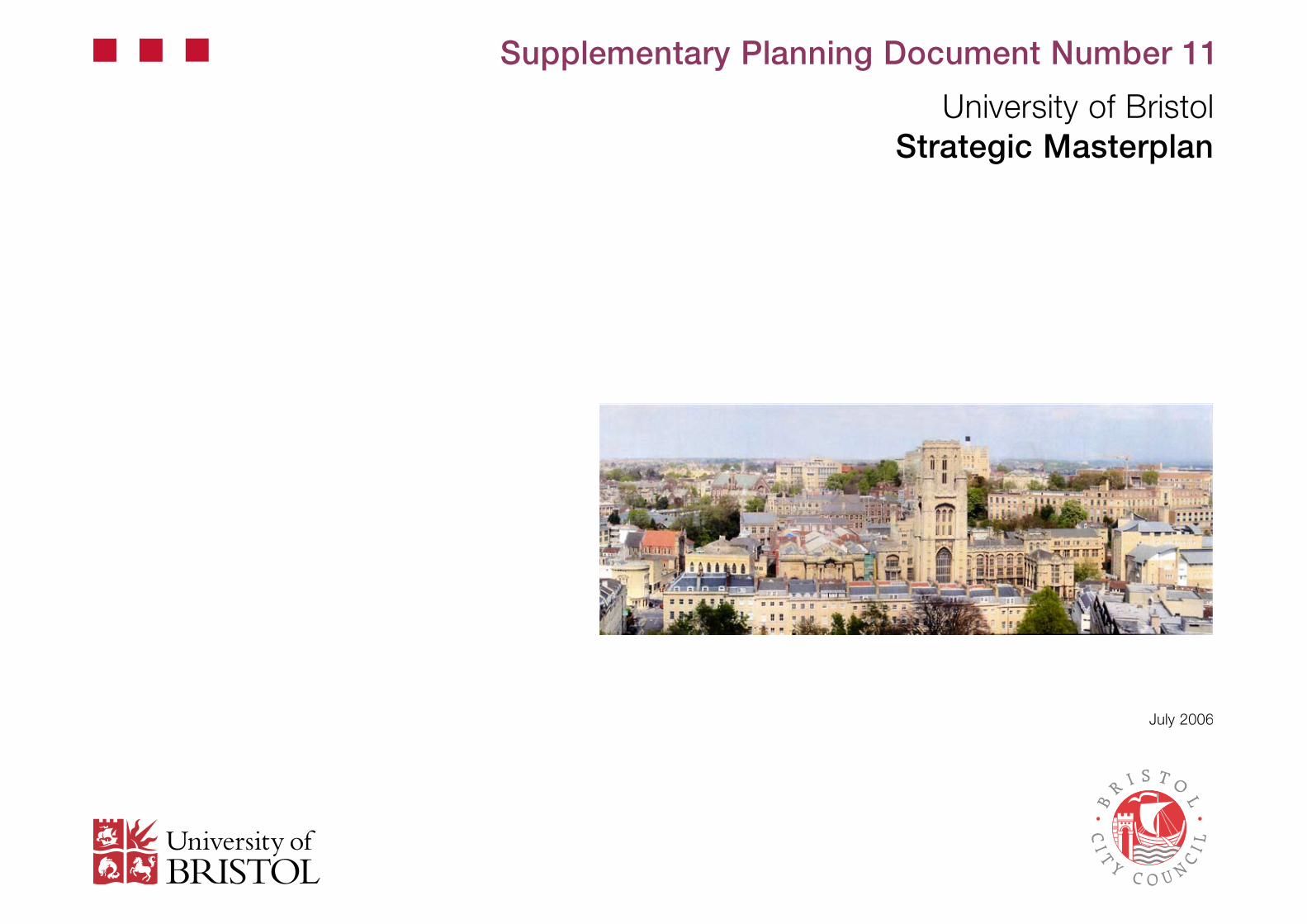
University of BristolStrategic Masterplan
July 2006
Supplementary Planning Document Number 11
p. �
0.1 Foreword
0.2 Executive Summary
0.3 Introduction
1.0 The University
2.0 Historical Context
2.1 Summary of Significance2.2 Development of Bristol2.� Development of the University2.4 Post-War Expansion2.5 Recent Developments2.6 Royal Fort House2.7 Wills Memorial Building2.8 H H Wills Physics Laboratory2.9 Children’s Hospital Site2.10 The Hawthorns Site2.11 St Michael’s Hills2.12 Tyndall Avenue2.1� Archaeological Significance2.14 Brief Landscape History
3.0 Contextual Analysis
�.1 Social Context�.2 Physical Context�.� Architectural Context�.4 Urban Context�.5 Wider Context�.6 Existing Movement and Transportation�.7 Urban Landscape and External Realm�.8 Planning Policy�.9 Consultation Process During Preparation of the Masterplan
4.0 Masterplan
4.1 Ten Strategic Moves4.2 Strategic Move 1: To make Tyndall Avenue the social heart of the University4.� Strategic Move 2: To continue and complete University Walk4.4 Strategic Move �: To create a new, identifiable entrance to the University at Tyndall Place4.5 Strategic Move 4: To create new routes, views and vistas from St Michael’s Hill to Royal Fort Gardens4.6 Strategic Move 5: To create new links between the University and the City4.7 Strategic Move 6: To improve the public realm in order to strengthen the identity of the Precinct4.8 Strategic Move 7: To provide a new Department of Life Sciences on the east side of the Precinct4.9 Strategic Move 8: To relocate the Students’ Union and create facilities for a new Learning and Resource Centre4.10 Strategic Move 9: To re-develop the Hawthorns site4.11 Strategic Move 10: To provide/develop a new building adjacent to the Lodge site
5.0 Design Framework
5.1 Access and Movement5.2 Design Quality5.� External Realm Design5.4 A Sustainable Masterplan5.5 Phasing, Implementation and Planning Obligations5.6 Programme
6.0 The Way Forward
7.0 Glossary of Appendices
0.0 Contents
This report has been prepared for Bristol City Council and the University of Bristol by:
Feilden Clegg Bradley Architects LLP : Masterplanning and Architectural ConsultantsNorthcroft : Project ManagersCSJ Planning : Planning ConsultantsNicholas Pearson Associates : Landscape DesignersArup : Traffic and Highway EngineersAvril Baker Consulting : Consultation FacilitatorHamilton-Baillie Associates : Urban Design and Movement
If you would like this information in a different format, for example Braille, audio tape, large print or computer disc, or community languages, please contact the Strategic and City Wide Policy Team on0117 90� 6720
p. 5
0.1 Foreword
Bristol University and the City Council have a shared vision for the city, as a successful European capital, that promotes learning and sustainable development; a place that values diversity and thrives culturally, socially and economically. The ability to offer world-class cultural and educational facilities is at the heart of this vision.
The University’s past is intimately entwined with that of the City. The institution only came into existence because of the determination of people in Bristol, and its foundation was a cause of major, citywide celebration. From the start, it was recognised that the presence of a great university would lend Bristol additional authority and render it more competitive and dynamic. The same holds true today – we know that local residents are proud that their city boasts two highly respected universities, and there is little doubt that Bristol’s designations as a Science City and as a Centre of Cultural Excellence owe much to the fact that higher education is thriving here. For its part, the University benefits enormously from the energy and creativity that exist here, and its international profile complements rather than contradicts its local roots and commitments.
A successful future for the city and that of the University is similarly linked. There has been immense regeneration in recent years, which has transformed large parts of Bristol City Centre. The University has been responsible for signature developments and has consolidated its position among the UK leaders in higher education and strengthened its global presence. There is a need to do more – particularly to ensure that both research and teaching match the highest national and international standards.
The role of the City Council as the planning authority is crucial to the successful implementation of this Masterplan. It is also recognised that the City Council has a key part to play in other capacities such, as traffic and highway authority, in achieving the Masterplan aims.
This Masterplan, which reflects the input of local people and other stakeholders, represents a vision of the University precinct that will enable Bristol University to build on its achievement of the past and provide a new high quality and stimulating educational quarter of which all Bristolians can share and be proud.
Mike Phipps Dennis BrownBursar Executive Member, Transport and ControlUniversity of Bristol Bristol City Council

p. 7
0.2 Executive Summary
This Strategic Masterplan has been developed to help the University strengthen its position as a world-class, research-intensive higher education organisation within the City of Bristol, capable of attracting internationally renowned academic staff and high quality students.
Over the last 20 years there has been growth in student numbers from 8,000 to 12,000 and a greatly increased demand for research facilities. In order to accommodate this growth and maintain the current high standards, the University will require an additional �8,000m² of new academic space over the next 10 years.
Much of the existing University building stock has development constraints and is not ideally suited to modern teaching and research requirements. New buildings are required that are flexible and adaptable in order that they will remain viable in a continually changing academic environment. The University faculty structure requires close inter-relationships and ease of access between specific departments. At present, many of the departments are not ideally located and have little room for expansion.
The City Council’s Local Development Plan has defined a central University Precinct area and directs future development of the University within these limits. The plan requires that a masterplan is produced to provide a framework for the University’s future growth and development.
The Precinct is a historically important part of Bristol covered by four separate Conservation Areas and has a number of listed and iconic buildings that are key parts of the University’s character. The location of the University on high ground means that many of its buildings contribute significantly to the skyline and are identifiable from many parts of Bristol. Development within the Precinct needs to consider carefully the effects upon the historic and wider context.
The University is important to Bristol. It is a major employer and contributes greatly to the city’s economy and its cultural life, dynamism and reputation. By the same token, the University benefits from being part of an attractive and successful city.
The Council encouraged the University to work closely with local communities in the development of the Masterplan through community consultation and stakeholder workshops.
This Masterplan describes a balance of proposals which seek to deliver the following aims:
• To create better accessibility to, across and throughout the University – by providing new pedestrian and cycle routes and connections and improving safety and traffic flow through ‘shared space’ traffic management principles and by improving accessibility through other more sustainable modes of travel.
• To create better relationships between the University and its neighbouring communities – through careful design, consultation and the creation of a broad range of benefits for local communities.
• To create a better mix of spaces and uses in the central Precinct area – by improving relationships between existing and new academic departments, enlivening public areas and creating new facilities that are flexible to meet future needs.
• To deliver an improved physical environment – by conserving and enhancing historic environments and landscapes and creating first-class new buildings and spaces.
• To design for a sustainable future – by designing new ‘green’ buildings, maximising sustainable energy supplies and recycling and minimising waste and moving the University towards improved financial sustainability.
This Masterplan is structured around ten strategic moves which form the framework for proposed development over the next 10 to 15 years. Together, the strategic moves present a vision for the future which has the potential to deliver an exciting, sustainable and world-class University of Bristol.
This Strategic Masterplan is formally adopted by the Council as a Supplementary Planning Document (SPD). It is accompanied by a Statement of Community Involvement (Appendix �) and a Sustainability Appraisal (Appendix 15). Other appendices have been produced during the preparation of the SPD to inform its evolution, its content and to provide background information. A brief description of the appendices listed on this page is provided in the Glossary of Appendices.
Appendices Report
1 Ecological Walkover Survey (NPA)2 Tree Survey (NPA)3 Statement of Community Involvement (Avril Baker)4 Summary of Public Benefit (FCBa)5 Floor Plate Design (FCBa)6 Schedule of New Areas (FCBa)7 Sustainability Matrix (FCBa)8 Existing Accommodation (FCBa)9 Tall Buildings (FCBa) - Learning Resource Centre Site10 Building Assessment Matrices (FCBa)
Strategic Masterplan Report
0.0 Executive Summary0.1 Introduction1.0 The University2.0 Historical Context3.0 Contextual Analysis4.0 Masterplan5.0 Design Framework6.0 The Way Forward7.0 Glossary
TheHawthorns
11
Assessment ofPotential forDevelopment
inc
FCBa
SustainabilityAppraisal
15
CSJ
Archaeological Report
14
Desktop Studyrevised with
hot-spot dwgand mitigation
statement
BaRAS
UrbanLandscape
and External Realm
13
LandscapeAnalysis
NPA
Royal Fort Lodge
12
Assessment ofPotential forDevelopment
FCBa
TheChildren’s Hospital
16
BuildingsAssessment
FCBa
BRISTOL UNIVERSITY MASTERPLAN
Feilden Clegg Bradley Architects LLP
p. 9
Introduction
The Masterplan document has been prepared under the initial direction of the University of Bristol by Feilden Clegg Bradley Architects LLP. The document builds upon an earlier study prepared by Percy Thomas Partnership (now Capita) in February 2004. Feilden Clegg Bradley LLP have acted as design team leaders for the following consultants, all of whom have contributed to the content of this document.
Feilden Clegg Bradley Architects LLP ArchitectNorthcroft Project Manager CSJ Planning Planning Consultants Nicholas Pearson Associates Landscape Architects and EcologistsArup Traffic EngineersAvril Baker Consultants Consultation FacilitatorHamilton-Baillie Associates Ltd Transport and Urban Design Council officers have shaped the emerging proposals, so that they fully integrate into the existing and emerging planning and sustainable development framework for the city.
Purpose of the Masterplan
The purpose of the Masterplan is to provide the University and the people of Bristol with a clear framework for the development of the precinct over the next 10 to 15 years.
In addition, the plan aims:
• To improve the physical environment.• To create a better mix of spaces and uses within the Precinct.• To create better accessibility to and throughout the Precinct.• To design for a sustainable future.• To create better relationships between the University and neighbouring
communities.
Document Structure
The Masterplan document has four main sections. The first focuses on the University’s place in the city. It also looks at how the University functions within the current estate and the problems it is encountering. It then sets out the University’s needs and aspirations for future development.
The second section describes the historic context of the University, which informs the Masterplan proposals. The chronological development of the area is examined, as well as the significance of the historic fabric and archaeology.
The third section looks at the Precinct and its location, and examines the impact the University has upon the city. An analysis is also made of the character and quality of the buildings and the external realm of the Precinct. The contextual study also focuses on relevant planning issues that influence and inform the Masterplan proposals. Each separate area of contextual analysis informs the approach to development within the Precinct which is described in the fourth section of the document.
The fourth section describes the overall concept and design proposals for the Masterplan. This section is divided into sub-sections, each relating to a different aspect of the design. In particular it explains how the University plans to achieve its objectives through a series of ten strategic moves.
Document Status
The document has been prepared with the full involvement of and consultation with English Heritage, the Conservation Advisory Panel, CABE and local stakeholders. The Masterplan was adopted by Bristol City Council as an SPD and will remain an accepted document for the development of the Precinct over the next 10-15 years. It is accompanied by a Statement of Community Involvement (Appendix �) and Sustainability Appraisal (Appendix 15).
0.3 Introduction
Further Documents
Other documents that have informed the evolution, content of the SPD and to provide background information are:
• Bristol University Masterplan Appendices 1-10• The Hawthorns Assessment of Potential for Development, FCBA,
Appendix 11• The Royal Fort Lodge Site, Assessment of Potential for Development,
FCBA, Appendix 12• Urban Landscape and External Realm, Nicholas Pearson Associates,
Appendix 1�• Archaeological Report, BaRAS, Appendix 14• Sustainability Scoping Report, CSJ, Appendix 15• The Children’s Hospital, Historic Buildings Assessment, FCBA, Appendix
16
A brief description of these documents is provided in a Glossary at Section 7.
Adoption as a Supplementary Planning Document
The development of the Masterplan was guided by PPS 12: Local Development Frameworks, 2004 and its companion guides, which set out the processes for the preparation and adoption of Supplementary Planning Documents.
In accordance with PPS 12, the Masterplan is consistent with and supplements the adopted Local Plan. The SPD principally conforms with policy CC4.
p. 11
1.0 The University
‘The overall aim of the University is to create a world-class university through a series of developments over the next 10 to 15 years’
p. 1�
1.0 The University
Background to the University Development Requirements
The main objective of the University of Bristol is to strengthen its position as a world-class research-intensive higher education organisation, capable of attracting internationally renowned academic staff and high quality students. This objective must be achieved in a self-sustaining manner that moves progressively towards increasing financial independence for the University.
Over the last 20 years, student numbers have grown from 8,000 to approximately 12,000, as well as a growing demand for the facilities required to conduct world-class research. The University has responded by consolidating and re-investing in its estate, which has been achieved by the strategic rationalisation of its built assets, the purchase of property and new development. The University has a turnover of £240m, within which is a continuing capital investment programme of £100m over 10 years. This process of consolidating and re-investing is ongoing. The ambition is to concentrate academic activity, and administrative services and social facilities within the Precinct.
The Bristol Local Plan supports this concentration of University activities within the Precinct.
The Estate Today
The University currently operates through six faculties:
1) Arts2) Social Sciences and Law�) Science (including)
i) Mathematics, Earth Sciences and Geographyii) Biology, Psychology, Chemistry and Physics
4) Engineering (including Computer Science)5) (Clinical) Medicine and Dentistry6) Medical and Veterinary Sciences
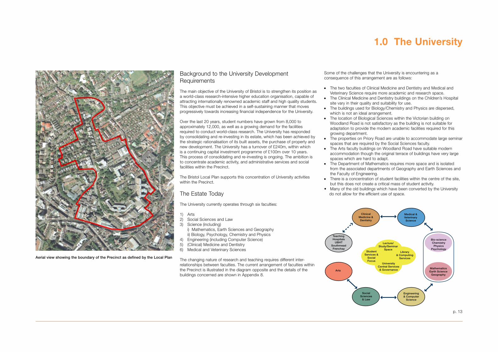
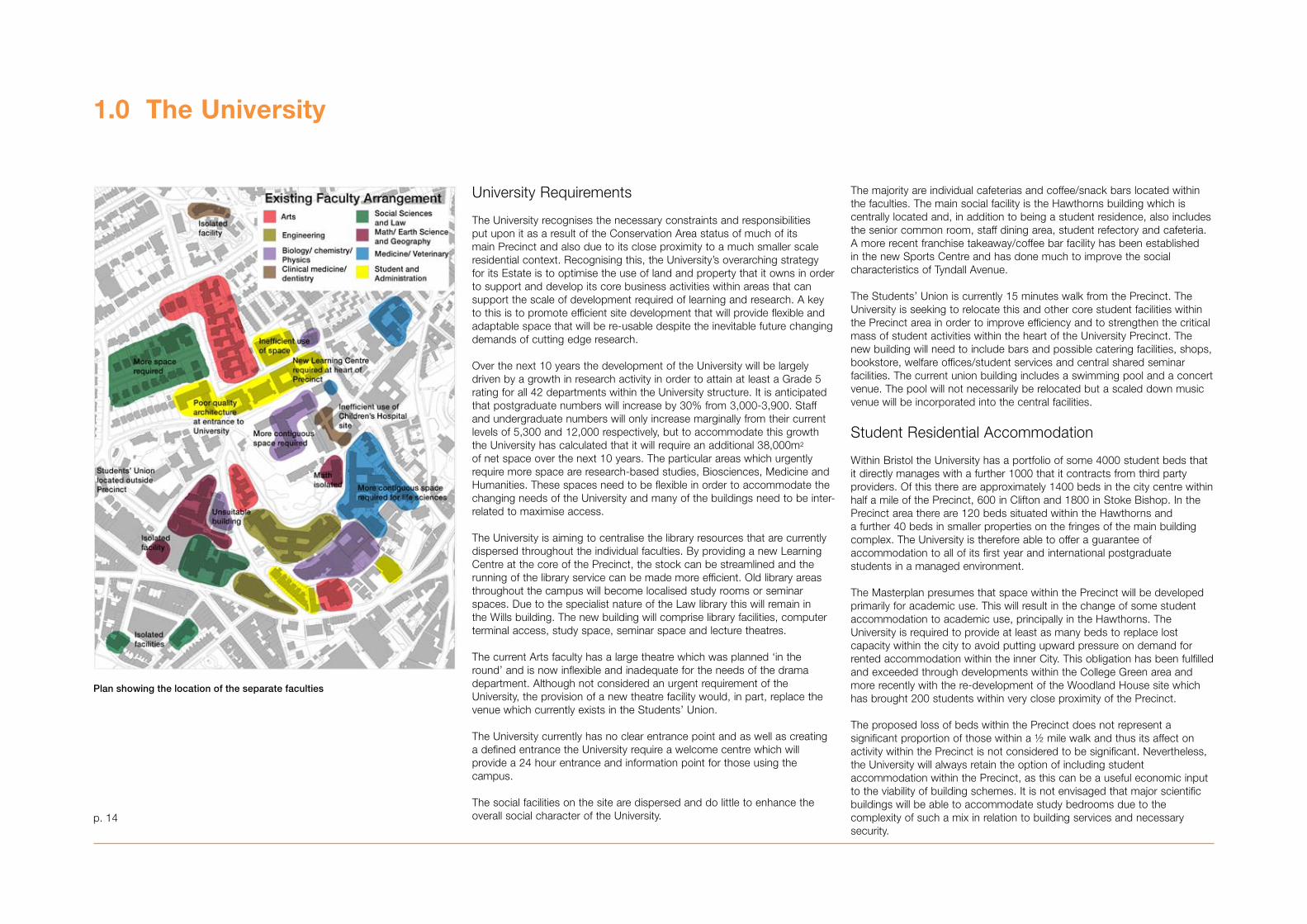
The changing nature of research and teaching requires different inter-relationships between faculties. The current arrangement of faculties within the Precinct is illustrated in the diagram opposite and the details of the buildings concerned are shown in Appendix 8.
Some of the challenges that the University is encountering as a consequence of this arrangement are as follows:
• The two faculties of Clinical Medicine and Dentistry and Medical and Veterinary Science require more academic and research space.
• The Clinical Medicine and Dentistry buildings on the Children’s Hospital site vary in their quality and suitability for use.
• The buildings used for Biology/Chemistry and Physics are dispersed, which is not an ideal arrangement.
• The location of Biological Sciences within the Victorian building on Woodland Road is not satisfactory as the building is not suitable for adaptation to provide the modern academic facilities required for this growing department.
• The properties on Priory Road are unable to accommodate large seminar spaces that are required by the Social Sciences faculty.
• The Arts faculty buildings on Woodland Road have suitable modern accommodation though the original terrace of buildings have very large spaces which are hard to adapt.
• The Department of Mathematics requires more space and is isolated from the associated departments of Geography and Earth Sciences and the Faculty of Engineering.
• There is a concentration of student facilities within the centre of the site, but this does not create a critical mass of student activity.
• Many of the old buildings which have been converted by the University do not allow for the efficient use of space.
Aerial view showing the boundary of the Precinct as defined by the Local Plan
TeachingHospitals
UBHTSouthmeadFrenchay
ClinicalMedicine &Dentistry
Medical &VeterinaryScience
Arts
SocialSciences
& Law
Bio-scienceChemistryPhysics
Psychology
MathematicsEarth Science
Geography
Engineering& Computer
Science
Lecture/Study/Seminar
Space
UniversityCentral Services& Governance
StudentServices &
SocialFocus
Library& Computing
Services
1.0 Heading1.1 Sub-headIf no main heading required, delete it and insert hard return
p. 14
1.0 The University
University Requirements
The University recognises the necessary constraints and responsibilities put upon it as a result of the Conservation Area status of much of its main Precinct and also due to its close proximity to a much smaller scale residential context. Recognising this, the University’s overarching strategy for its Estate is to optimise the use of land and property that it owns in order to support and develop its core business activities within areas that can support the scale of development required of learning and research. A key to this is to promote efficient site development that will provide flexible and adaptable space that will be re-usable despite the inevitable future changing demands of cutting edge research.
Over the next 10 years the development of the University will be largely driven by a growth in research activity in order to attain at least a Grade 5 rating for all 42 departments within the University structure. It is anticipated that postgraduate numbers will increase by �0% from �,000-�,900. Staff and undergraduate numbers will only increase marginally from their current levels of 5,�00 and 12,000 respectively, but to accommodate this growth the University has calculated that it will require an additional �8,000m2 of net space over the next 10 years. The particular areas which urgently require more space are research-based studies, Biosciences, Medicine and Humanities. These spaces need to be flexible in order to accommodate the changing needs of the University and many of the buildings need to be inter-related to maximise access.
The University is aiming to centralise the library resources that are currently dispersed throughout the individual faculties. By providing a new Learning Centre at the core of the Precinct, the stock can be streamlined and the running of the library service can be made more efficient. Old library areas throughout the campus will become localised study rooms or seminar spaces. Due to the specialist nature of the Law library this will remain in the Wills building. The new building will comprise library facilities, computer terminal access, study space, seminar space and lecture theatres.
The current Arts faculty has a large theatre which was planned ‘in the round’ and is now inflexible and inadequate for the needs of the drama department. Although not considered an urgent requirement of the University, the provision of a new theatre facility would, in part, replace the venue which currently exists in the Students’ Union.
The University currently has no clear entrance point and as well as creating a defined entrance the University require a welcome centre which will provide a 24 hour entrance and information point for those using the campus.
The social facilities on the site are dispersed and do little to enhance theoverall social character of the University.
The majority are individual cafeterias and coffee/snack bars located within the faculties. The main social facility is the Hawthorns building which is centrally located and, in addition to being a student residence, also includes the senior common room, staff dining area, student refectory and cafeteria. A more recent franchise takeaway/coffee bar facility has been established in the new Sports Centre and has done much to improve the social characteristics of Tyndall Avenue.
The Students’ Union is currently 15 minutes walk from the Precinct. The University is seeking to relocate this and other core student facilities within the Precinct area in order to improve efficiency and to strengthen the critical mass of student activities within the heart of the University Precinct. The new building will need to include bars and possible catering facilities, shops, bookstore, welfare offices/student services and central shared seminar facilities. The current union building includes a swimming pool and a concert venue. The pool will not necessarily be relocated but a scaled down music venue will be incorporated into the central facilities.
Student Residential Accommodation
Within Bristol the University has a portfolio of some 4000 student beds that it directly manages with a further 1000 that it contracts from third party providers. Of this there are approximately 1400 beds in the city centre within half a mile of the Precinct, 600 in Clifton and 1800 in Stoke Bishop. In the Precinct area there are 120 beds situated within the Hawthorns anda further 40 beds in smaller properties on the fringes of the main buildingcomplex. The University is therefore able to offer a guarantee of accommodation to all of its first year and international postgraduate students in a managed environment.
The Masterplan presumes that space within the Precinct will be developed primarily for academic use. This will result in the change of some student accommodation to academic use, principally in the Hawthorns. The University is required to provide at least as many beds to replace lost capacity within the city to avoid putting upward pressure on demand for rented accommodation within the inner City. This obligation has been fulfilled and exceeded through developments within the College Green area and more recently with the re-development of the Woodland House site which has brought 200 students within very close proximity of the Precinct.
The proposed loss of beds within the Precinct does not represent a significant proportion of those within a ½ mile walk and thus its affect on activity within the Precinct is not considered to be significant. Nevertheless, the University will always retain the option of including student accommodation within the Precinct, as this can be a useful economic inputto the viability of building schemes. It is not envisaged that major scientific buildings will be able to accommodate study bedrooms due to the complexity of such a mix in relation to building services and necessary security.
Plan showing the location of the separate faculties
1.0 Heading1.1 Sub-head
If no main heading required, delete it and insert hard return
p. 15
1.0 The University
University Masterplan Aims
The overall aim of the Masterplan is to create a world-class University through a series of developments over the next 10 to 15 years. This vision for a sustainable and cost-effective future for the University can be summarised in the following five aims:
1. To deliver an improved physical environment:
• By conserving and enhancing historic environments and landscapes within the Precinct.
• By concentrating University activity within the heart of the University.
• By addressing potential development sites and by rationalising the University’s use of its existing estate.
• By creating first-class new buildings which complement and enhance both the streetscape of the Conservation Areas and contribute to distant views of the University skyline.
2. To create better accessibility to, across and through the University:
• By providing new routes and connections to improve permeability for students and local residents on foot and by bicycle.
• By reducing the impact of cars within the Precinct and creating a balance between people and vehicles.
• By continuing to promote the use of sustainable forms of transport.
• By introducing safe, accessible and legible routes in and around new development areas.
3. To create a better mix of spaces and uses in the Central Precinct areas:
• By improving inter-relationships between existing and new academic departments.
• By enlivening the public realm and encouraging activity.
• By creating a ‘sense of place’ within the urban realm and creating a stronger identity for the University.
• By creating new facilities that are flexible for future needs.
4. To design for a sustainable future:
• By promoting the use of the latest green technologies and materials within new buildings.
• By incorporating long-life, loose-fit principles within the design of new buildings.
• By creating a robust and sustainable financial future for the University.
• By setting Design Codes for future development which will ensure that all proposals will be of high quality and will read as part of a cohesive whole.
5. To create better relationships between the University and neighboring communities:
• By contributing to the wider community of Bristol through roughly 800 highly qualified students feeding into the local knowledge based economy each year.
• By the spending power of staff and students feeding into both the local and wider Bristol economy.
• By creating new opportunities in adult education.
• By providing meeting and event space for local organisations.
• By carrying out community liasion on isues of mutual concern such as emerging development proposals and management issues.
However it is anticipated that the activity in some of the smaller buildings on lower St Michaels Hill will in due course become absorbed into the Life Sciences area on the Children’s Hospital site and become surplus to requirements. These properties are unsuitable for core academic use and the University envisages them being turned back to residential use, potentially for international students with families or key workers. Opportunities might also be created with the proposed Hawthorns development, subject to the amount and form of space possible on that site. It is the University’s intention to retain existing residential accommodation on Woodland Road unless the need to provide academic space becomes more pressing.
As part of the consolidation of the Precinct a number of functions that are accommodated in Berkeley Square will be relocated. The Education Department in �5 Berkeley Square will move near to the Social Sciences main centre in Priory Road and the Institute for Learning Research and Technology in 8-10 Berkley Square will move to a location close to the new Learning Centre.
In addition to the areas stated the University will be disposing of 2,000 m2 of space from Canynge Hall, 2,000 m2 from Berkeley Square and 4,000 m2 from the existing Students’ Union building.
In order to achieve the objectives for further estate development, the following accommodation will be required within the Precinct over the next ten years.
The University has approximately 150,600 m2 (net) useable floorspace, which includes some buildings outside the Precinct area. Of this it is envisaged that approximately 16944 m2 (net) floorspace will be lost through demolition and faculty/department relocation. It is therefore calculated that with the provision of �8,000 m2 (net) over the next ten years there will be an overall increase of approximately 21,000 m2 (net) floorspace within the Precinct.
22,000m2 (net) Core academic space 9,000m Bio-sciences which will include 9,000m Medical sciences 2,000m Education 2,000m Incubator spaces
12,000m2 (net) New Learning Centre
�,000m2 (net) New Students’ Union
1,000m2 (net) Student Services
38,000m2 (net) Total
54,000m2 (gross)
1.0 Heading1.1 Sub-headIf no main heading required, delete it and insert hard return
1.0 The University
Estate Development Strategy
There are a number of key factors that currently influence the University’s development strategy. A primary aim of the University is to work towards achieving greater financial self-sufficiency, as much of the University’s resources have been derived from Government funding which is being reduced. As a consequence the University must invest efficiently and progressively towards increasing financial independence.
The University covers a wide area. In order to maximise efficiency, academic activity needs to be located in identifiable and co-ordinated physical space which matches the established faculty structure. In addition, research themes are becoming multidisciplinary, which also affects the pattern of adjacencies. Class sizes vary immensely, and today range from 20 to 240 students. Much of the existing accommodation was constructed in the 1960s and was not designed to cope with these numbers. There is therefore a need within the University for a range of flexible teaching spaces and to avoid creating large, under-used spaces. Changing teaching and research methods also require increasing access to computer study/workstations.
Another factor influencing the development strategy of the University is the desire to improve safety within the campus. Out of academic hours, activity within the Precinct declines quickly and this is not conducive to creating a safe and secure environment, particularly for young female students. The central Precinct should become an area that is active and safe until late into the evening.
Development Sites
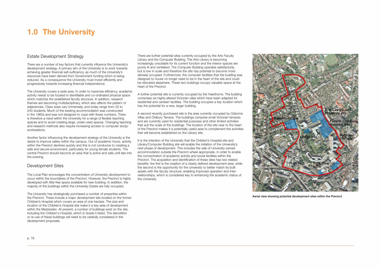
The Local Plan encourages the concentration of University development to occur within the boundaries of the Precinct. However, the Precinct is highly developed with little free space available for new building. In addition, the majority of the buildings within the University Estate are fully occupied.
The University has strategically purchased a number of properties within the Precinct. These include a major development site located on the former Children’s Hospital which covers an area of one hectare. The size and location of the Children’s Hospital site make it a key area of development within the Masterplan. At present, a number of buildings exist on the site, including the Children's Hospital, which is Grade II listed. The demolition or re-use of these buildings will need to be carefully considered in the development proposals.
There are further potential sites currently occupied by the Arts Faculty Library and the Computer Building. The Arts Library is becoming increasingly unsuitable for its current function and the interior spaces are poorly lit and ventilated. The Computer Building operates satisfactorily, but is low in scale and therefore the site has potential to become more densely occupied. Furthermore, the computer facilities that the building was designed to house no longer need to be in the heart of the site and could be relocated elsewhere. These two buildings occupy valuable space at the heart of the Precinct.
A further potential site is currently occupied by the Hawthorns. The building comprises six highly altered Victorian villas which have been adapted for residential and canteen facilities. The building occupies a key location which has the potential for a new, larger building.
A second recently purchased site is the area currently occupied by Osborne Villas and Oldbury Terrace. The buildings comprise small Victorian terraces and are currently used for residential purposes and other limited activities that suit the scale of the buildings. The location of the site near to the heart of the Precinct makes it a potentially useful area to complement the activities that will become established on the Library site.
It is the intention of the University that the Children’s Hospital site and Library/Computer Building site will enable the initiation of the University’s next phase of development. This includes the sale of University-owned accommodation outside the Precinct where appropriate, in order to enable the concentration of academic activity and social facilities within the Precinct. The acquisition and identification of these sites has two related benefits: the first is the creation of a clearly defined development area, while the second is the opportunity for the University to better match its built assets with the faculty structure, enabling improved operation and inter-relationships, which is considered key to enhancing the academic status of the University.
Aerial view showing potential development sites within the Precinct
Hawthorns site
Arts Library and IT Centre site
Former Childrens Hospital site
Lodge site Potential infill site
Park Row sites
p. 16
2.0 Historical Context
‘Bristol University is proud to be a world- class higher education institution within the City of Bristol’
p. 17
A thorough understanding of the significance of the historic environment is an essential foundation to the University’s Masterplan for the future. With this in mind new historical research, design studies and specialist reports have been commissioned as part of the Masterplan. This section presents a summary of the significance of the University Precinct, and provides a statement on each of the key areas of interest. It also provides information on how to find out more on the range of research undertaken, which is presented within the Masterplan Appendices.
Property owned by Bristol University spreads across the city and is protected by four separate Conservation Areas. The University contains more than sixty Listed Buildings, the majority Grade II but an important Grade I and four Grade II*. The significance of the University Precinct therefore inevitably resides in a wide range of historical and architectural elements. To account for every detail of this significance would be far too detailed for the purposes of this masterplan and it is therefore proposed to concentrate on the particular significance of those areas which the current study has highlighted for potential redevelopment. While focusing on individual areas of the Precinct, however, it is useful to have in mind that the University is an integral part of the city of Bristol and that, quite frequently, the significance of a particular building may have nothing at all to do with the University itself.
Significance of Key Elements
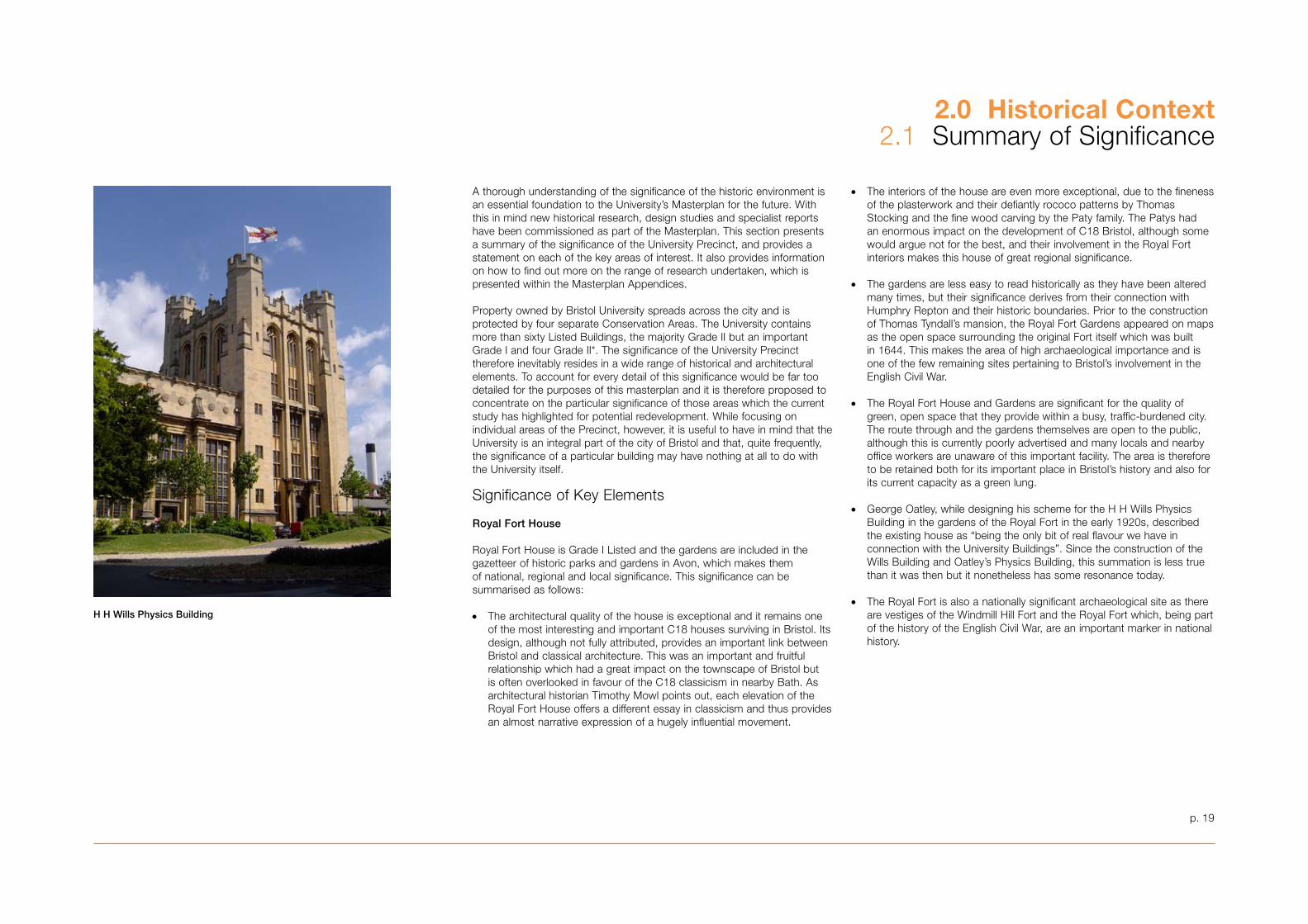
Royal Fort House
Royal Fort House is Grade I Listed and the gardens are included in the gazetteer of historic parks and gardens in Avon, which makes them of national, regional and local significance. This significance can be summarised as follows:
• The architectural quality of the house is exceptional and it remains one of the most interesting and important C18 houses surviving in Bristol. Its design, although not fully attributed, provides an important link between Bristol and classical architecture. This was an important and fruitful relationship which had a great impact on the townscape of Bristol but is often overlooked in favour of the C18 classicism in nearby Bath. As architectural historian Timothy Mowl points out, each elevation of the Royal Fort House offers a different essay in classicism and thus provides an almost narrative expression of a hugely influential movement.
• The interiors of the house are even more exceptional, due to the fineness of the plasterwork and their defiantly rococo patterns by Thomas Stocking and the fine wood carving by the Paty family. The Patys had an enormous impact on the development of C18 Bristol, although some would argue not for the best, and their involvement in the Royal Fort interiors makes this house of great regional significance.
• The gardens are less easy to read historically as they have been altered many times, but their significance derives from their connection with Humphry Repton and their historic boundaries. Prior to the construction of Thomas Tyndall’s mansion, the Royal Fort Gardens appeared on maps as the open space surrounding the original Fort itself which was built in 1644. This makes the area of high archaeological importance and is one of the few remaining sites pertaining to Bristol’s involvement in the English Civil War.
• The Royal Fort House and Gardens are significant for the quality of green, open space that they provide within a busy, traffic-burdened city. The route through and the gardens themselves are open to the public, although this is currently poorly advertised and many locals and nearby office workers are unaware of this important facility. The area is therefore to be retained both for its important place in Bristol’s history and also for its current capacity as a green lung.
• George Oatley, while designing his scheme for the H H Wills Physics Building in the gardens of the Royal Fort in the early 1920s, described the existing house as “being the only bit of real flavour we have in connection with the University Buildings”. Since the construction of the Wills Building and Oatley’s Physics Building, this summation is less true than it was then but it nonetheless has some resonance today.
• The Royal Fort is also a nationally significant archaeological site as there are vestiges of the Windmill Hill Fort and the Royal Fort which, being part of the history of the English Civil War, are an important marker in national history.
2.0 Historical Context2.1 Summary of Significance
H H Wills Physics Building
p. 19
The Hawthorns
• Acquired by the University as late as 1991 and currently used for student accommodation and a staff refectory, the architectural merit of the Hawthorns has been submerged under many additions and interventions. The building began life in 1888 as four separate villas which were gradually merged, extended and modified to create increasing amounts of hotel bedrooms between 1924 and the early 1960s. The quality of intervention is generally quite poor and therefore their significance resides more in their connection to the original villas lower down Elton Road than to the fabric of the building itself.
• The historic materials and the large massing of the masonry blocks have provided a landmark in Bristol for over 50 years and the building’s contribution to the streetscape requires some consideration.
Tyndall Avenue
• First laid out in 190� this broad avenue was originally lined with pairs of villas, only two of which remain at the east end. The buildings on Tyndall Avenue were at one time domestic, albeit on a slightly larger scale than the parallel streets of St Michael’s Park and Osborne Villas. Today the majority of the buildings are of large, institutional scale, with the result that the remaining domestic buildings are rather overwhelmed.
• Osborne Villas and St Michael’s Park, which are parallel to Tyndall Avenue, were developed earlier in the 1870s by George Gay and Benjamin Vowles. The historic setting for these brick and stone terraces was Oldbury House, Highbury Villas and Tyndalls Park. The terraced houses lining these streets are unremarkable but have some group value. Their significance has been greatly eroded by the development of the University which has grown up around them.
• Moving from East to West, the buildings of significance are Oldbury House (C17), the Arts Library by Twist & Whitley (1975), Brentnall’s extension to the Physics Building (1968) and his Senate House (1965). The architectural quality of these buildings is not outstanding but, with the exception of Oldbury House, the combination of these buildings tell the story of the important post-war expansion of the University. This entails a story of shifting architectural styles as well as the more human narrative of higher education for all and the University’s growing impact on the wider city.
• The Physics Building stands on part of the site where Cromwell House once stood. This was a C17 dwelling which was demolished during the C19. While there are no remains above ground, the importance of Cromwell House as a marker of the rise of the merchant classes and their gradual gentrification is a significant element in the evolution of what was to become Tyndall Avenue.
St Michael’s Hill and the Children’s Hospital Site
• St Michael’s Hill is of great significance, not only for the many listed buildings which line the street but because of its unique contribution to the historic townscape. Gap sites currently diminish the impact of the whole street but the significance is powerful nonetheless. Its raised pavement and steep topography, its stunning city views and jumble of gables, its elegant C18 town houses and beautifully-crafted C17 Almshouses give the area a strong historic character and identity.
• Nos. 65-67 are Grade II* listed.
• Robert Curwen’s street front design of the hospital is of significance as an important late C19 architectural feature. The materials are local Pennant and Brandon Stone Grit which would have been quarried at the top of nearby Jacobs Well Road. Such materials are no longer readily available and are characteristic of Bristol and therefore of local and regional significance.
• Large pennant and Brandon stone retaining walls are a historic feature of the hospital site and should be retained as a significant marker of the unusual topography and the local distinctiveness of Bristol’s geology.
Park Row
• Today’s buildings on Park Row were largely developed during the late C19 and early C20. The distinctive features here are the Pennant and Brandon Stone Grit retaining walls which define the north side. Also of significance is the building financed by the Bristol Hebrew Congregation which became the first purpose-built synagogue in Bristol, consecrated in 1871.
Conservation Strategy
Given the significance of a great many elements of the University Precinct in general, and of the sites described above in particular, it is important to generate some general policies to protect the architectural and historic character of the various areas. These policies may be summarised as follows:
• Appropriate uses should be found for existing buildings and their historic significance should be enhanced. This has often been diminished by piecemeal intervention in the past.
• Where buildings are listed they should be retained and where altered or extended this should be done in a manner that preserves or enhances their character, appearance and setting.
• The preference is for early University buildings to be retained and where expansion is required this should be done in a way that produces an enhancement to their setting and the character and appearance of the Conservation Area.
• New buildings should be congruent both with their immediate surroundings and their wider context. If tall buildings are proposed they should be tested against SPD1 and should contribute to the historic environment at street level as well as to the wider views of the city.
• It is not possible to carry out thorough archaeological surveys at this stage but where sensitive sites appear they should be treated with due care and attention in accordance with SPD7.
It should be noted that further information regarding the significance of the Hawthorns, Royal Fort Lodge and the Children’s Hospital can be found in Appendices 10, 11, 12 and 16.
2.0 Historical Context2.1 Summary of Significance
p. 20
p. 21
2.0 Historical Context2.2 Development of Bristol
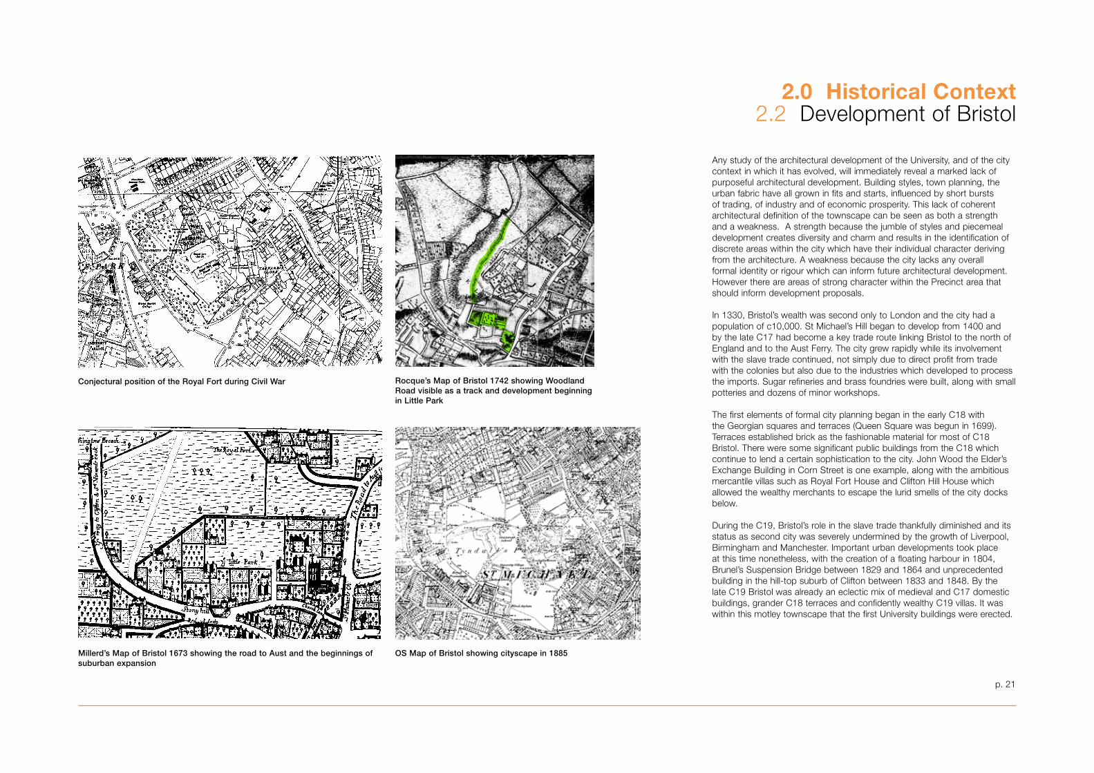
Conjectural position of the Royal Fort during Civil War Rocque’s Map of Bristol 1742 showing Woodland Road visible as a track and development beginningin Little Park
Millerd’s Map of Bristol 1673 showing the road to Aust and the beginnings ofsuburban expansion
Any study of the architectural development of the University, and of the city context in which it has evolved, will immediately reveal a marked lack of purposeful architectural development. Building styles, town planning, the urban fabric have all grown in fits and starts, influenced by short bursts of trading, of industry and of economic prosperity. This lack of coherent architectural definition of the townscape can be seen as both a strength and a weakness. A strength because the jumble of styles and piecemeal development creates diversity and charm and results in the identification of discrete areas within the city which have their individual character deriving from the architecture. A weakness because the city lacks any overall formal identity or rigour which can inform future architectural development. However there are areas of strong character within the Precinct area that should inform development proposals.
In 1��0, Bristol’s wealth was second only to London and the city had a population of c10,000. St Michael’s Hill began to develop from 1400 and by the late C17 had become a key trade route linking Bristol to the north of England and to the Aust Ferry. The city grew rapidly while its involvement with the slave trade continued, not simply due to direct profit from trade with the colonies but also due to the industries which developed to process the imports. Sugar refineries and brass foundries were built, along with small potteries and dozens of minor workshops.
The first elements of formal city planning began in the early C18 with the Georgian squares and terraces (Queen Square was begun in 1699). Terraces established brick as the fashionable material for most of C18 Bristol. There were some significant public buildings from the C18 which continue to lend a certain sophistication to the city. John Wood the Elder’s Exchange Building in Corn Street is one example, along with the ambitious mercantile villas such as Royal Fort House and Clifton Hill House which allowed the wealthy merchants to escape the lurid smells of the city docks below.
During the C19, Bristol’s role in the slave trade thankfully diminished and its status as second city was severely undermined by the growth of Liverpool, Birmingham and Manchester. Important urban developments took place at this time nonetheless, with the creation of a floating harbour in 1804, Brunel’s Suspension Bridge between 1829 and 1864 and unprecedented building in the hill-top suburb of Clifton between 18�� and 1848. By the late C19 Bristol was already an eclectic mix of medieval and C17 domestic buildings, grander C18 terraces and confidently wealthy C19 villas. It was within this motley townscape that the first University buildings were erected.
OS Map of Bristol showing cityscape in 1885
p. 22
2.0 Historical Context2.� Development of the University
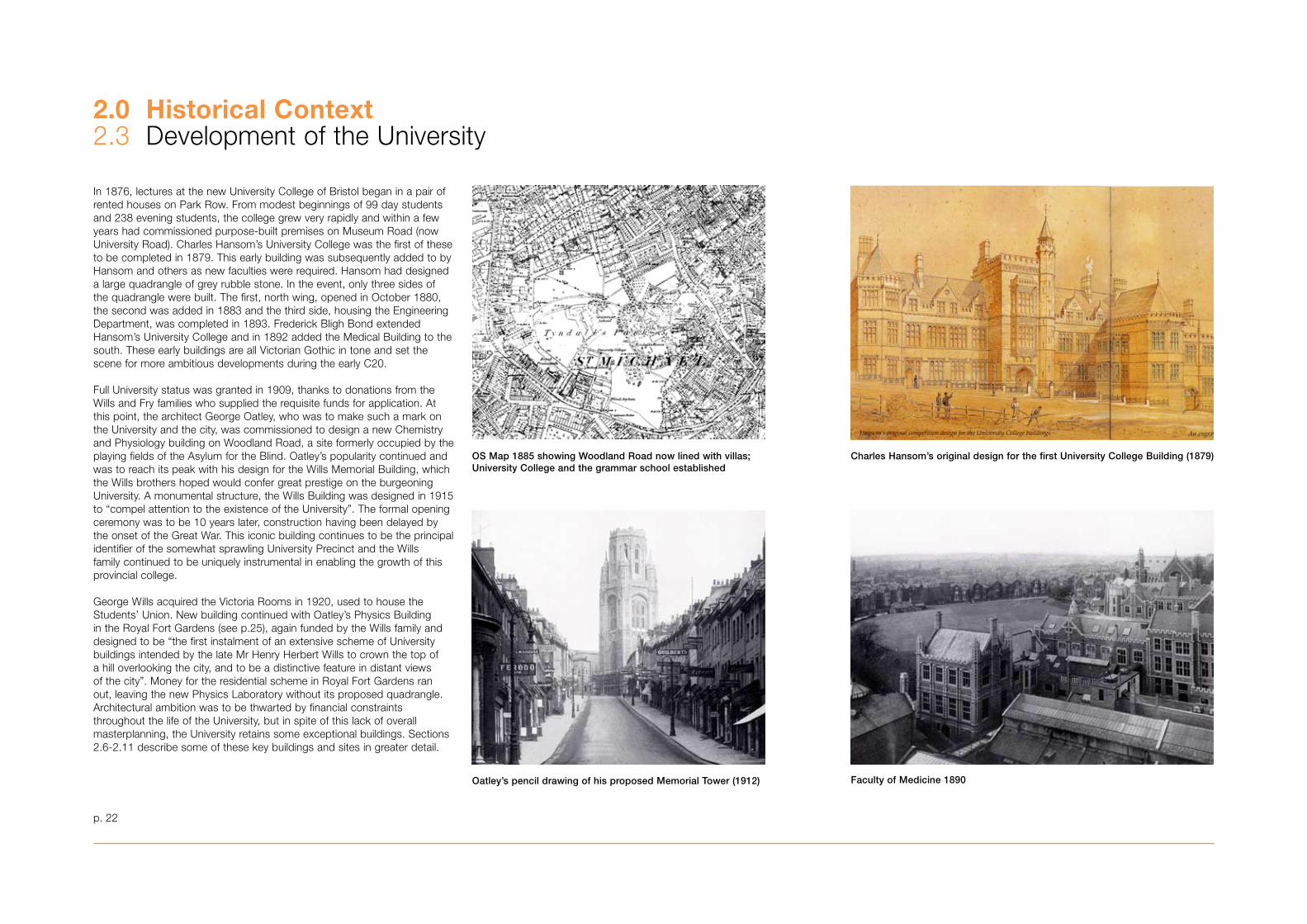
OS Map 1885 showing Woodland Road now lined with villas; University College and the grammar school established
Faculty of Medicine 1890Oatley’s pencil drawing of his proposed Memorial Tower (1912)
Charles Hansom’s original design for the first University College Building (1879)
In 1876, lectures at the new University College of Bristol began in a pair of rented houses on Park Row. From modest beginnings of 99 day students and 2�8 evening students, the college grew very rapidly and within a few years had commissioned purpose-built premises on Museum Road (now University Road). Charles Hansom’s University College was the first of these to be completed in 1879. This early building was subsequently added to by Hansom and others as new faculties were required. Hansom had designed a large quadrangle of grey rubble stone. In the event, only three sides of the quadrangle were built. The first, north wing, opened in October 1880, the second was added in 188� and the third side, housing the Engineering Department, was completed in 189�. Frederick Bligh Bond extended Hansom’s University College and in 1892 added the Medical Building to the south. These early buildings are all Victorian Gothic in tone and set the scene for more ambitious developments during the early C20.
Full University status was granted in 1909, thanks to donations from the Wills and Fry families who supplied the requisite funds for application. At this point, the architect George Oatley, who was to make such a mark on the University and the city, was commissioned to design a new Chemistry and Physiology building on Woodland Road, a site formerly occupied by the playing fields of the Asylum for the Blind. Oatley’s popularity continued and was to reach its peak with his design for the Wills Memorial Building, which the Wills brothers hoped would confer great prestige on the burgeoning University. A monumental structure, the Wills Building was designed in 1915 to “compel attention to the existence of the University”. The formal opening ceremony was to be 10 years later, construction having been delayed by the onset of the Great War. This iconic building continues to be the principal identifier of the somewhat sprawling University Precinct and the Wills family continued to be uniquely instrumental in enabling the growth of this provincial college.
George Wills acquired the Victoria Rooms in 1920, used to house the Students’ Union. New building continued with Oatley’s Physics Building in the Royal Fort Gardens (see p.25), again funded by the Wills family and designed to be “the first instalment of an extensive scheme of University buildings intended by the late Mr Henry Herbert Wills to crown the top of a hill overlooking the city, and to be a distinctive feature in distant views of the city”. Money for the residential scheme in Royal Fort Gardens ran out, leaving the new Physics Laboratory without its proposed quadrangle. Architectural ambition was to be thwarted by financial constraints throughout the life of the University, but in spite of this lack of overall masterplanning, the University retains some exceptional buildings. Sections 2.6-2.11 describe some of these key buildings and sites in greater detail.
p. 2�
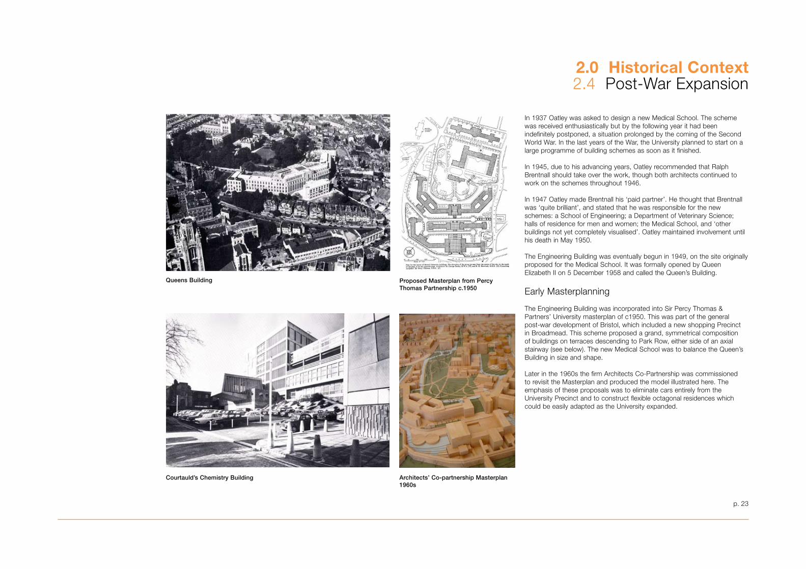
Queens Building
In 19�7 Oatley was asked to design a new Medical School. The scheme was received enthusiastically but by the following year it had been indefinitely postponed, a situation prolonged by the coming of the Second World War. In the last years of the War, the University planned to start on a large programme of building schemes as soon as it finished.
In 1945, due to his advancing years, Oatley recommended that Ralph Brentnall should take over the work, though both architects continued to work on the schemes throughout 1946.
In 1947 Oatley made Brentnall his ‘paid partner’. He thought that Brentnall was ‘quite brilliant’, and stated that he was responsible for the new schemes: a School of Engineering; a Department of Veterinary Science; halls of residence for men and women; the Medical School, and ‘other buildings not yet completely visualised’. Oatley maintained involvement until his death in May 1950.
The Engineering Building was eventually begun in 1949, on the site originally proposed for the Medical School. It was formally opened by Queen Elizabeth II on 5 December 1958 and called the Queen’s Building.
Early Masterplanning
The Engineering Building was incorporated into Sir Percy Thomas & Partners’ University masterplan of c1950. This was part of the general post-war development of Bristol, which included a new shopping Precinct in Broadmead. This scheme proposed a grand, symmetrical composition of buildings on terraces descending to Park Row, either side of an axial stairway (see below). The new Medical School was to balance the Queen’s Building in size and shape.
Later in the 1960s the firm Architects Co-Partnership was commissioned to revisit the Masterplan and produced the model illustrated here. The emphasis of these proposals was to eliminate cars entirely from the University Precinct and to construct flexible octagonal residences which could be easily adapted as the University expanded.
Proposed Masterplan from Percy Thomas Partnership c.1950
Courtauld’s Chemistry Building Architects’ Co-partnership Masterplan1960s
2.0 Historical Context2.4 Post-War Expansion
p. 24
2.0 Historical Context2.5 Recent Developments
Synthetic Chemistry
Nanotechnology Building currently under construction
Merchant Venturers Building or University Gate
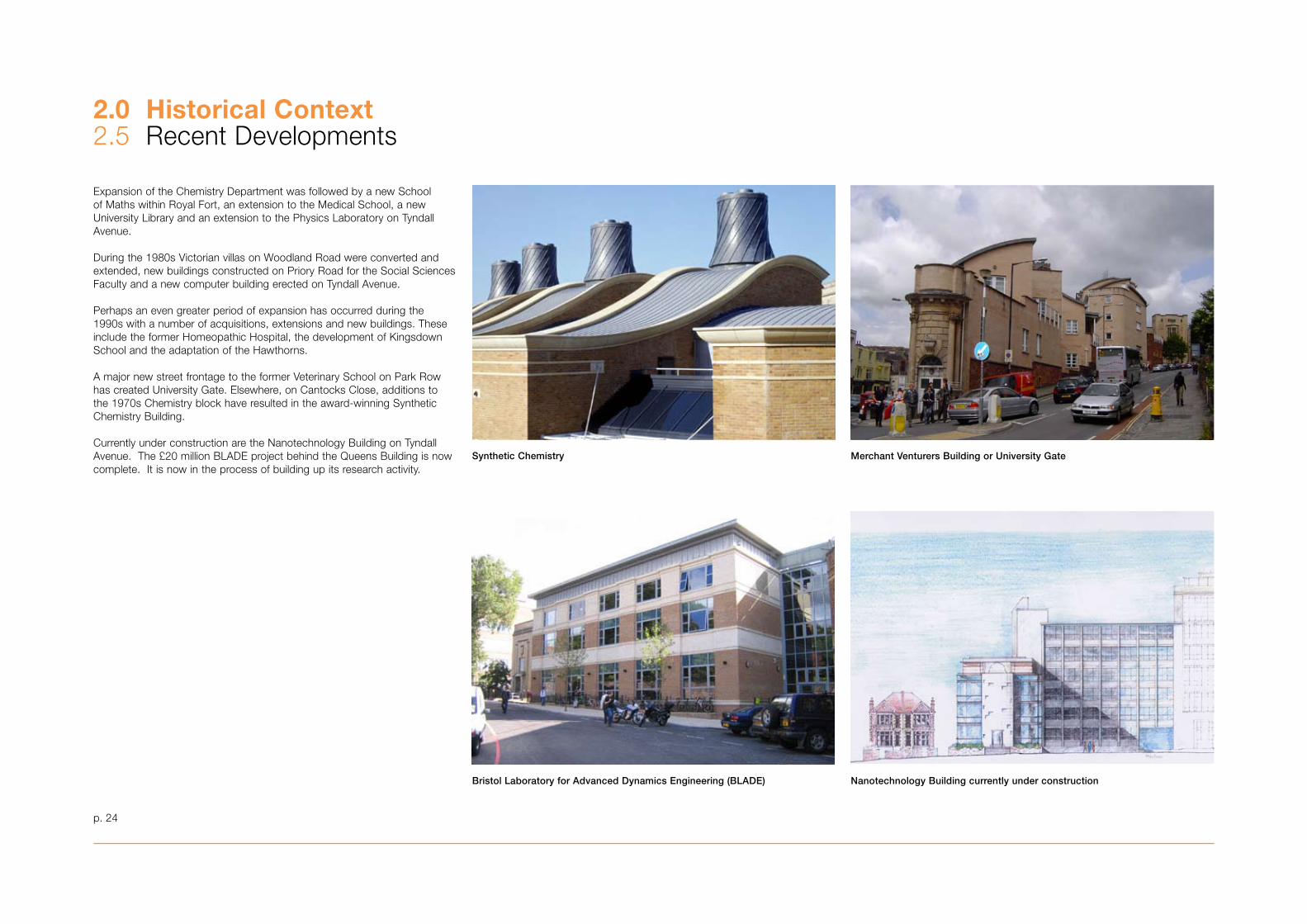
Expansion of the Chemistry Department was followed by a new School of Maths within Royal Fort, an extension to the Medical School, a new University Library and an extension to the Physics Laboratory on Tyndall Avenue.
During the 1980s Victorian villas on Woodland Road were converted and extended, new buildings constructed on Priory Road for the Social Sciences Faculty and a new computer building erected on Tyndall Avenue.
Perhaps an even greater period of expansion has occurred during the 1990s with a number of acquisitions, extensions and new buildings. These include the former Homeopathic Hospital, the development of Kingsdown School and the adaptation of the Hawthorns.
A major new street frontage to the former Veterinary School on Park Row has created University Gate. Elsewhere, on Cantocks Close, additions to the 1970s Chemistry block have resulted in the award-winning Synthetic Chemistry Building.
Currently under construction are the Nanotechnology Building on Tyndall Avenue. The £20 million BLADE project behind the Queens Building is now complete. It is now in the process of building up its research activity.
Bristol Laboratory for Advanced Dynamics Engineering (BLADE)
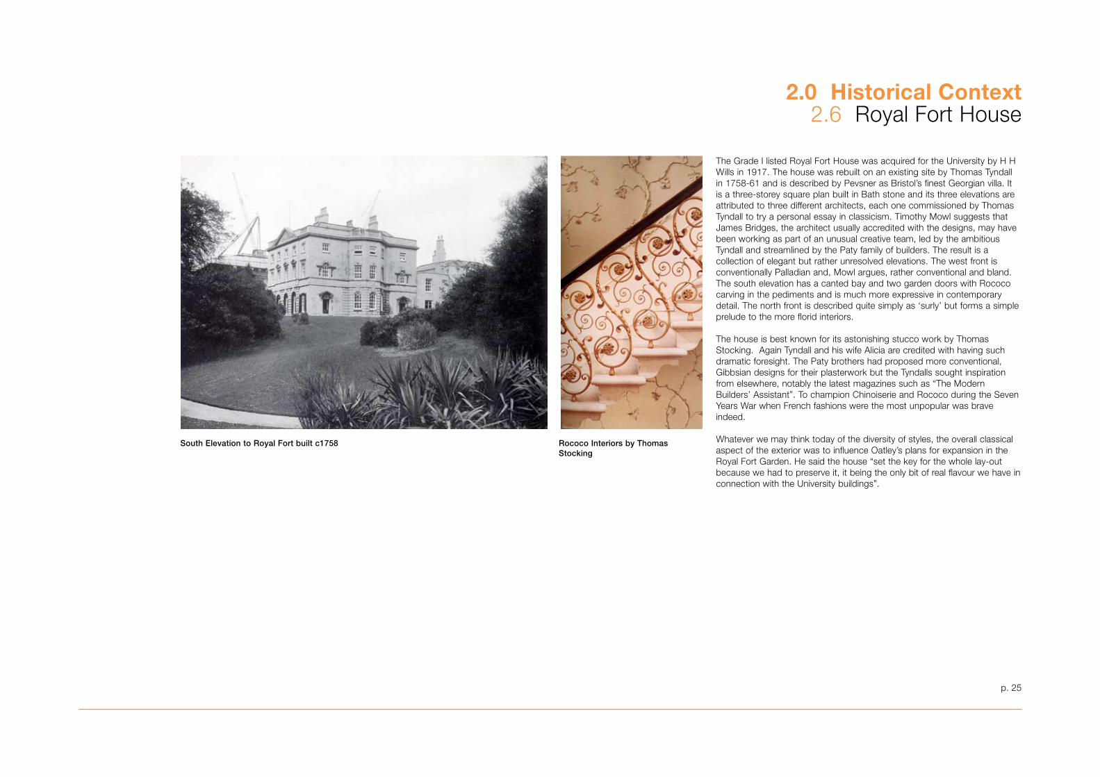
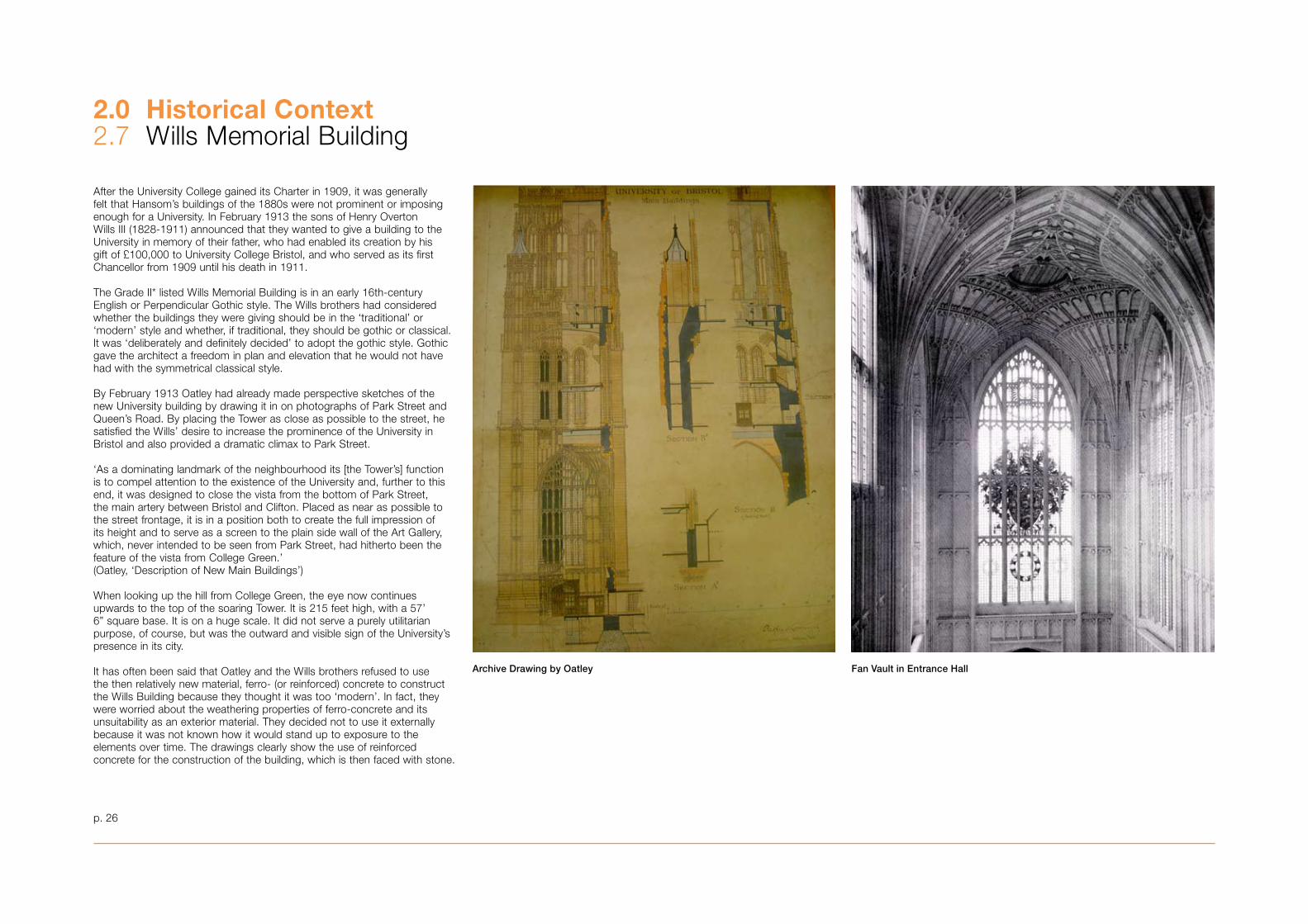
South Elevation to Royal Fort built c1758 Rococo Interiors by ThomasStocking
The Grade I listed Royal Fort House was acquired for the University by H H Wills in 1917. The house was rebuilt on an existing site by Thomas Tyndall in 1758-61 and is described by Pevsner as Bristol’s finest Georgian villa. It is a three-storey square plan built in Bath stone and its three elevations are attributed to three different architects, each one commissioned by Thomas Tyndall to try a personal essay in classicism. Timothy Mowl suggests that James Bridges, the architect usually accredited with the designs, may have been working as part of an unusual creative team, led by the ambitious Tyndall and streamlined by the Paty family of builders. The result is a collection of elegant but rather unresolved elevations. The west front is conventionally Palladian and, Mowl argues, rather conventional and bland. The south elevation has a canted bay and two garden doors with Rococo carving in the pediments and is much more expressive in contemporary detail. The north front is described quite simply as ‘surly’ but forms a simple prelude to the more florid interiors.
The house is best known for its astonishing stucco work by Thomas Stocking. Again Tyndall and his wife Alicia are credited with having such dramatic foresight. The Paty brothers had proposed more conventional, Gibbsian designs for their plasterwork but the Tyndalls sought inspiration from elsewhere, notably the latest magazines such as “The Modern Builders’ Assistant”. To champion Chinoiserie and Rococo during the Seven Years War when French fashions were the most unpopular was brave indeed.
Whatever we may think today of the diversity of styles, the overall classical aspect of the exterior was to influence Oatley’s plans for expansion in the Royal Fort Garden. He said the house “set the key for the whole lay-out because we had to preserve it, it being the only bit of real flavour we have in connection with the University buildings”.
p. 25
2.0 Historical Context2.6 Royal Fort House
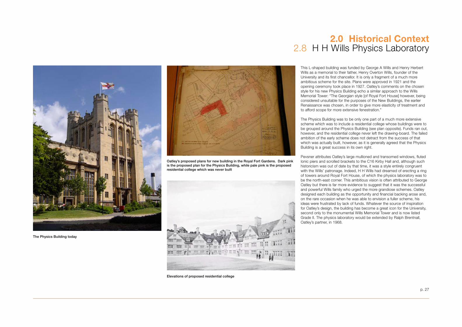
Archive Drawing by Oatley
After the University College gained its Charter in 1909, it was generally felt that Hansom’s buildings of the 1880s were not prominent or imposing enough for a University. In February 191� the sons of Henry Overton Wills III (1828-1911) announced that they wanted to give a building to the University in memory of their father, who had enabled its creation by his gift of £100,000 to University College Bristol, and who served as its first Chancellor from 1909 until his death in 1911.
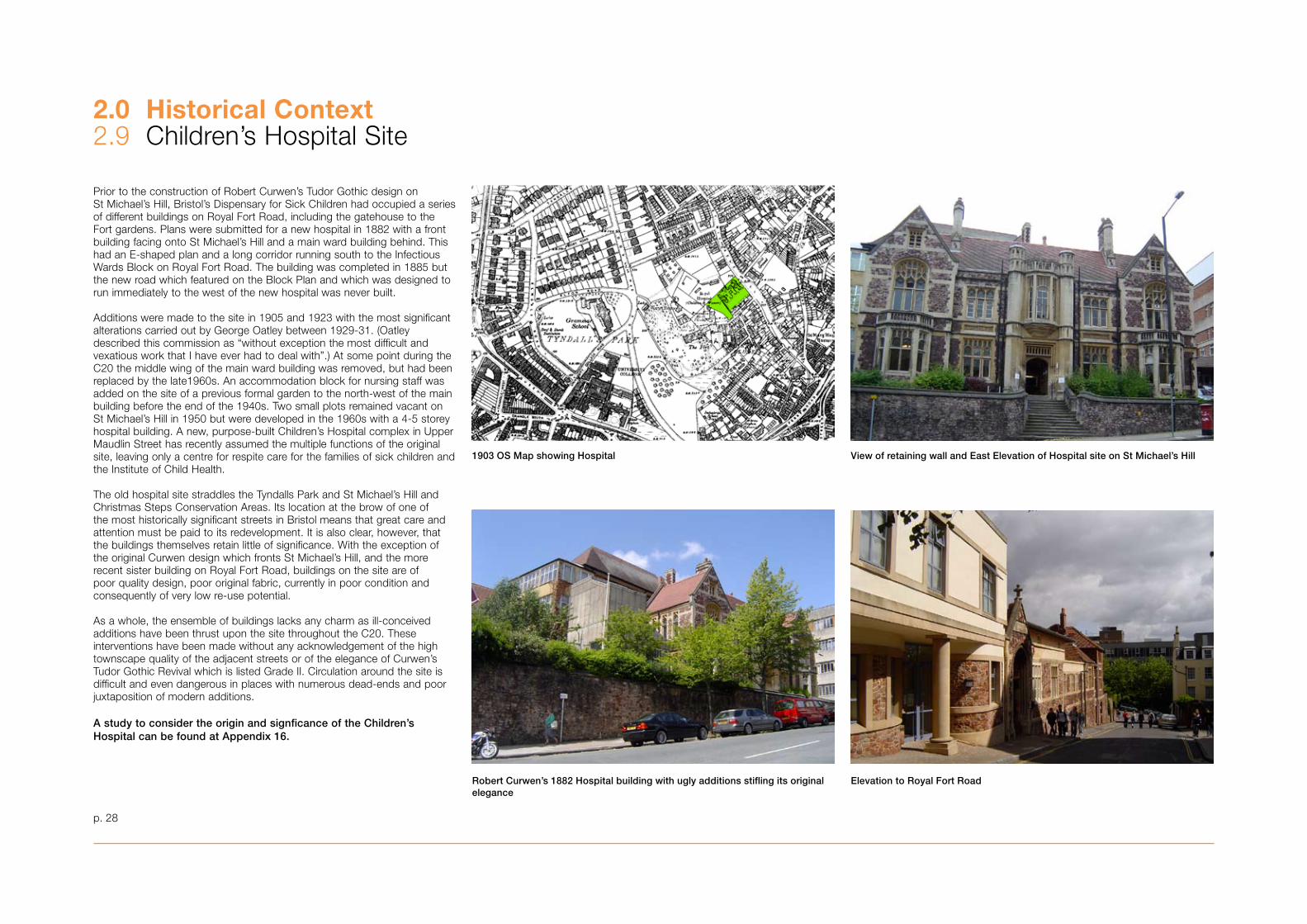
The Grade II* listed Wills Memorial Building is in an early 16th-century English or Perpendicular Gothic style. The Wills brothers had considered whether the buildings they were giving should be in the ‘traditional’ or ‘modern’ style and whether, if traditional, they should be gothic or classical. It was ‘deliberately and definitely decided’ to adopt the gothic style. Gothic gave the architect a freedom in plan and elevation that he would not have had with the symmetrical classical style.
By February 191� Oatley had already made perspective sketches of the new University building by drawing it in on photographs of Park Street and Queen’s Road. By placing the Tower as close as possible to the street, he satisfied the Wills’ desire to increase the prominence of the University in Bristol and also provided a dramatic climax to Park Street.
‘As a dominating landmark of the neighbourhood its [the Tower’s] function is to compel attention to the existence of the University and, further to this end, it was designed to close the vista from the bottom of Park Street, the main artery between Bristol and Clifton. Placed as near as possible to the street frontage, it is in a position both to create the full impression of its height and to serve as a screen to the plain side wall of the Art Gallery, which, never intended to be seen from Park Street, had hitherto been the feature of the vista from College Green.’ (Oatley, ‘Description of New Main Buildings’)
When looking up the hill from College Green, the eye now continues upwards to the top of the soaring Tower. It is 215 feet high, with a 57’ 6” square base. It is on a huge scale. It did not serve a purely utilitarian purpose, of course, but was the outward and visible sign of the University’s presence in its city.
It has often been said that Oatley and the Wills brothers refused to use the then relatively new material, ferro- (or reinforced) concrete to construct the Wills Building because they thought it was too ‘modern’. In fact, they were worried about the weathering properties of ferro-concrete and its unsuitability as an exterior material. They decided not to use it externally because it was not known how it would stand up to exposure to the elements over time. The drawings clearly show the use of reinforced concrete for the construction of the building, which is then faced with stone.
Fan Vault in Entrance Hall
p. 26
2.0 Historical Context2.7 Wills Memorial Building
Elevations of proposed residential college
Oatley’s proposed plans for new building in the Royal Fort Gardens. Dark pink is the proposed plan for the Physics Building, while pale pink is the proposed residential college which was never built
The Physics Building today
This L-shaped building was funded by George A Wills and Henry Herbert Wills as a memorial to their father, Henry Overton Wills, founder of the University and its first chancellor. It is only a fragment of a much more ambitious scheme for the site. Plans were approved in 1921 and the opening ceremony took place in 1927. Oatley’s comments on the chosen style for his new Physics Building echo a similar approach to the Wills Memorial Tower: “The Georgian style [of Royal Fort House] however, being considered unsuitable for the purposes of the New Buildings, the earlier Renaissance was chosen, in order to give more elasticity of treatment and to afford scope for more extensive fenestration.”
The Physics Building was to be only one part of a much more extensive scheme which was to include a residential college whose buildings were to be grouped around the Physics Building (see plan opposite). Funds ran out, however, and the residential college never left the drawing-board. The failed ambition of the early scheme does not detract from the success of that which was actually built, however, as it is generally agreed that the Physics Building is a great success in its own right.
Pevsner attributes Oatley’s large mullioned and transomed windows, fluted Ionic piers and scrolled brackets to the C16 Kirby Hall and, although such historicism was out of date by that time, it was a style entirely congruent with the Wills’ patronage. Indeed, H H Wills had dreamed of erecting a ring of towers around Royal Fort House, of which the physics laboratory was to be the north-east corner. This ambitious vision is often attributed to George Oatley but there is far more evidence to suggest that it was the successful and powerful Wills family who urged the more grandiose schemes. Oatley designed each building as the opportunity and financial backing arose and, on the rare occasion when he was able to envision a fuller scheme, his ideas were frustrated by lack of funds. Whatever the source of inspiration for Oatley’s design, the building has become a great icon for the University, second only to the monumental Wills Memorial Tower and is now listed Grade II. The physics laboratory would be extended by Ralph Brentnall, Oatley’s partner, in 1968.
2.0 Historical Context2.8 H H Wills Physics Laboratory
p. 27
View of retaining wall and East Elevation of Hospital site on St Michael’s Hill
Elevation to Royal Fort RoadRobert Curwen’s 1882 Hospital building with ugly additions stifling its original elegance
1903 OS Map showing Hospital
Prior to the construction of Robert Curwen’s Tudor Gothic design on St Michael’s Hill, Bristol’s Dispensary for Sick Children had occupied a series of different buildings on Royal Fort Road, including the gatehouse to the Fort gardens. Plans were submitted for a new hospital in 1882 with a front building facing onto St Michael’s Hill and a main ward building behind. This had an E-shaped plan and a long corridor running south to the Infectious Wards Block on Royal Fort Road. The building was completed in 1885 but the new road which featured on the Block Plan and which was designed to run immediately to the west of the new hospital was never built.
Additions were made to the site in 1905 and 192� with the most significant alterations carried out by George Oatley between 1929-�1. (Oatley described this commission as “without exception the most difficult and vexatious work that I have ever had to deal with”.) At some point during the C20 the middle wing of the main ward building was removed, but had been replaced by the late1960s. An accommodation block for nursing staff was added on the site of a previous formal garden to the north-west of the main building before the end of the 1940s. Two small plots remained vacant on St Michael’s Hill in 1950 but were developed in the 1960s with a 4-5 storey hospital building. A new, purpose-built Children’s Hospital complex in Upper Maudlin Street has recently assumed the multiple functions of the original site, leaving only a centre for respite care for the families of sick children and the Institute of Child Health.
The old hospital site straddles the Tyndalls Park and St Michael’s Hill and Christmas Steps Conservation Areas. Its location at the brow of one of the most historically significant streets in Bristol means that great care and attention must be paid to its redevelopment. It is also clear, however, that the buildings themselves retain little of significance. With the exception of the original Curwen design which fronts St Michael’s Hill, and the more recent sister building on Royal Fort Road, buildings on the site are of poor quality design, poor original fabric, currently in poor condition and consequently of very low re-use potential.
As a whole, the ensemble of buildings lacks any charm as ill-conceived additions have been thrust upon the site throughout the C20. These interventions have been made without any acknowledgement of the high townscape quality of the adjacent streets or of the elegance of Curwen’s Tudor Gothic Revival which is listed Grade II. Circulation around the site is difficult and even dangerous in places with numerous dead-ends and poor juxtaposition of modern additions.
A study to consider the origin and signficance of the Children’s Hospital can be found at Appendix 16.
2.0 Historical Context2.9 Children’s Hospital Site
p. 28
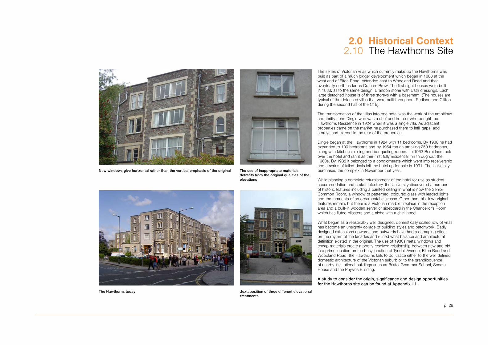
The Hawthorns today Juxtaposition of three different elevational treatments
The series of Victorian villas which currently make up the Hawthorns was built as part of a much bigger development which began in 1888 at the west end of Elton Road, extended east to Woodland Road and then eventually north as far as Cotham Brow. The first eight houses were built in 1888, all to the same design, Brandon stone with Bath dressings. Each large detached house is of three storeys with a basement. (The houses are typical of the detached villas that were built throughout Redland and Clifton during the second half of the C19).
The transformation of the villas into one hotel was the work of the ambitious and thrifty John Dingle who was a chef and hotelier who bought the Hawthorns Residence in 1924 when it was a single villa. As adjacent properties came on the market he purchased them to infill gaps, add storeys and extend to the rear of the properties.
Dingle began at the Hawthorns in 1924 with 11 bedrooms. By 19�8 he had expanded to 100 bedrooms and by 1954 ran an amazing 250 bedrooms, along with kitchens, dining and banqueting rooms. In 196� Berni Inns took over the hotel and ran it as their first fully residential Inn throughout the 1960s. By 1988 it belonged to a conglomerate which went into receivership and a series of failed deals left the hotel up for sale in 1991. The University purchased the complex in November that year.
While planning a complete refurbishment of the hotel for use as student accommodation and a staff refectory, the University discovered a number of historic features including a painted ceiling in what is now the Senior Common Room, a window of patterned, coloured glass with leaded lights and the remnants of an ornamental staircase. Other than this, few original features remain, but there is a Victorian marble fireplace in the reception area and a built-in wooden server or sideboard in the Chancellor’s Room which has fluted pilasters and a niche with a shell hood.
What began as a reasonably well designed, domestically scaled row of villas has become an unsightly collage of building styles and patchwork. Badly designed extensions upwards and outwards have had a damaging effect on the rhythm of the facades and ruined what balance and architectural definition existed in the original. The use of 19�0s metal windows and cheap materials create a poorly resolved relationship between new and old. In a prime location on the busy junction of Tyndall Avenue, Elton Road and Woodland Road, the Hawthorns fails to do justice either to the well defined domestic architecture of the Victorian suburb or to the grandiloquence of nearby institutional buildings such as Bristol Grammar School, Senate House and the Physics Building.
A study to consider the origin, significance and design opportunities for the Hawthorns site can be found at Appendix 11.
New windows give horizontal rather than the vertical emphasis of the original The use of inappropriate materials detracts from the original qualities of the elevations
p. 29
2.0 Historical Context2.10 The Hawthorns Site
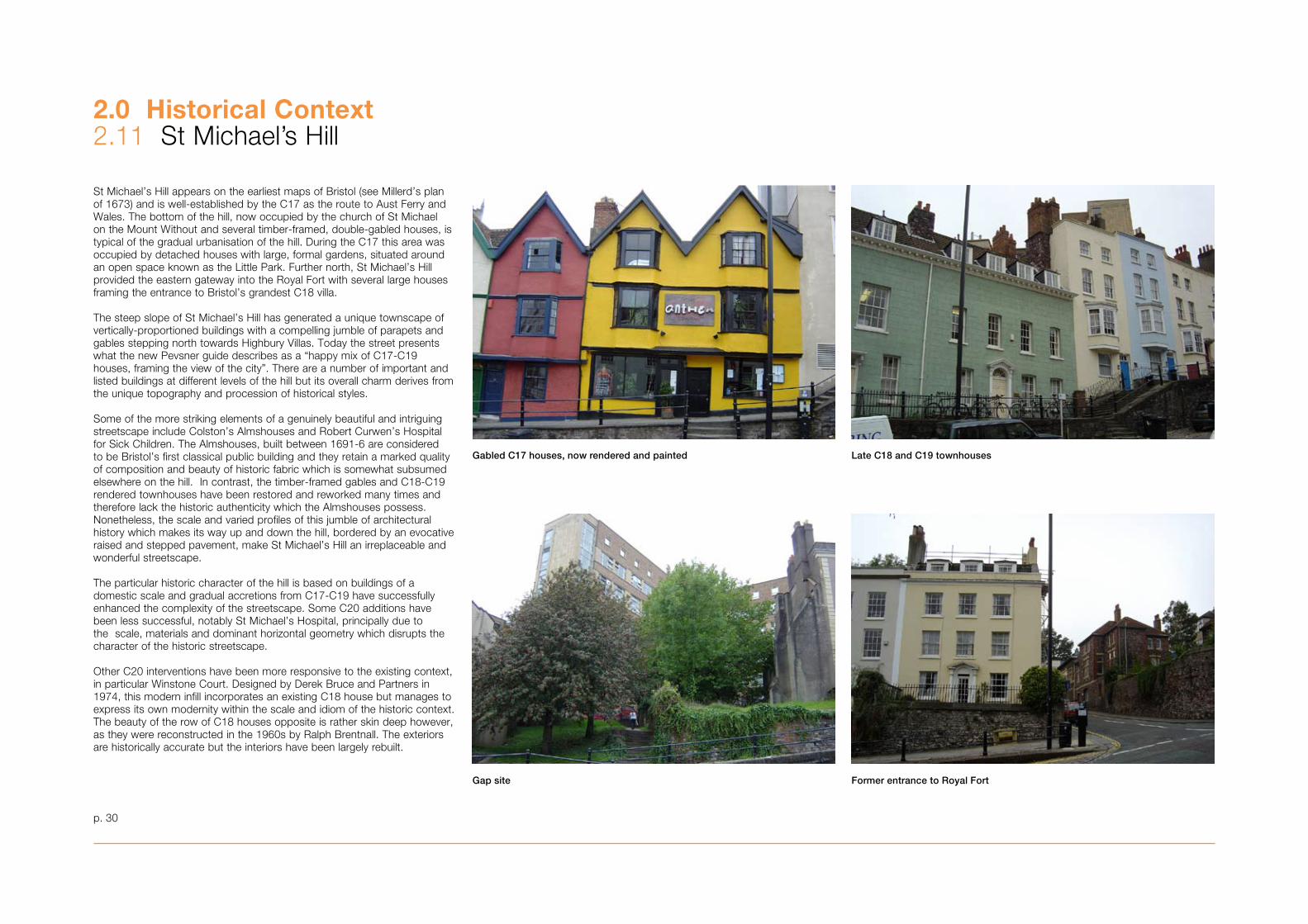
St Michael’s Hill appears on the earliest maps of Bristol (see Millerd’s plan of 167�) and is well-established by the C17 as the route to Aust Ferry and Wales. The bottom of the hill, now occupied by the church of St Michael on the Mount Without and several timber-framed, double-gabled houses, is typical of the gradual urbanisation of the hill. During the C17 this area was occupied by detached houses with large, formal gardens, situated around an open space known as the Little Park. Further north, St Michael’s Hill provided the eastern gateway into the Royal Fort with several large houses framing the entrance to Bristol’s grandest C18 villa.
The steep slope of St Michael’s Hill has generated a unique townscape of vertically-proportioned buildings with a compelling jumble of parapets and gables stepping north towards Highbury Villas. Today the street presents what the new Pevsner guide describes as a “happy mix of C17-C19 houses, framing the view of the city”. There are a number of important and listed buildings at different levels of the hill but its overall charm derives from the unique topography and procession of historical styles.
Some of the more striking elements of a genuinely beautiful and intriguing streetscape include Colston’s Almshouses and Robert Curwen’s Hospital for Sick Children. The Almshouses, built between 1691-6 are considered to be Bristol’s first classical public building and they retain a marked quality of composition and beauty of historic fabric which is somewhat subsumed elsewhere on the hill. In contrast, the timber-framed gables and C18-C19 rendered townhouses have been restored and reworked many times and therefore lack the historic authenticity which the Almshouses possess. Nonetheless, the scale and varied profiles of this jumble of architectural history which makes its way up and down the hill, bordered by an evocative raised and stepped pavement, make St Michael’s Hill an irreplaceable and wonderful streetscape.
The particular historic character of the hill is based on buildings of a domestic scale and gradual accretions from C17-C19 have successfully enhanced the complexity of the streetscape. Some C20 additions have been less successful, notably St Michael’s Hospital, principally due to the scale, materials and dominant horizontal geometry which disrupts the character of the historic streetscape.
Other C20 interventions have been more responsive to the existing context, in particular Winstone Court. Designed by Derek Bruce and Partners in 1974, this modern infill incorporates an existing C18 house but manages to express its own modernity within the scale and idiom of the historic context. The beauty of the row of C18 houses opposite is rather skin deep however, as they were reconstructed in the 1960s by Ralph Brentnall. The exteriors are historically accurate but the interiors have been largely rebuilt.
Gabled C17 houses, now rendered and painted Late C18 and C19 townhouses
Gap site
2.0 Historical Context2.11 St Michael’s Hill
p. �0
Former entrance to Royal Fort
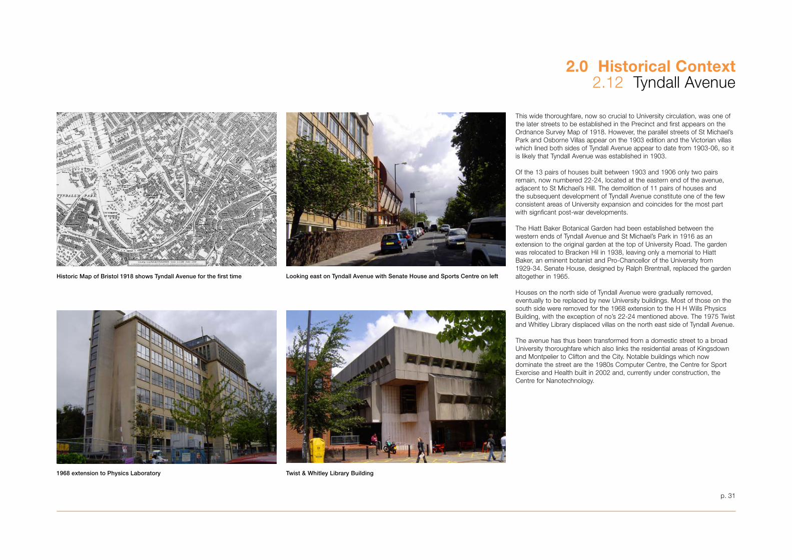
Historic Map of Bristol 1918 shows Tyndall Avenue for the first time
1968 extension to Physics Laboratory Twist & Whitley Library Building
Looking east on Tyndall Avenue with Senate House and Sports Centre on left
This wide thoroughfare, now so crucial to University circulation, was one of the later streets to be established in the Precinct and first appears on the Ordnance Survey Map of 1918. However, the parallel streets of St Michael’s Park and Osborne Villas appear on the 190� edition and the Victorian villas which lined both sides of Tyndall Avenue appear to date from 190�-06, so it is likely that Tyndall Avenue was established in 190�.
Of the 1� pairs of houses built between 190� and 1906 only two pairs remain, now numbered 22-24, located at the eastern end of the avenue, adjacent to St Michael’s Hill. The demolition of 11 pairs of houses and the subsequent development of Tyndall Avenue constitute one of the few consistent areas of University expansion and coincides for the most part with signficant post-war developments.
The Hiatt Baker Botanical Garden had been established between the western ends of Tyndall Avenue and St Michael’s Park in 1916 as an extension to the original garden at the top of University Road. The garden was relocated to Bracken Hil in 19�8, leaving only a memorial to Hiatt Baker, an eminent botanist and Pro-Chancellor of the University from 1929-�4. Senate House, designed by Ralph Brentnall, replaced the garden altogether in 1965.
Houses on the north side of Tyndall Avenue were gradually removed, eventually to be replaced by new University buildings. Most of those on the south side were removed for the 1968 extension to the H H Wills Physics Building, with the exception of no’s 22-24 mentioned above. The 1975 Twist and Whitley Library displaced villas on the north east side of Tyndall Avenue.
The avenue has thus been transformed from a domestic street to a broad University thoroughfare which also links the residential areas of Kingsdown and Montpelier to Clifton and the City. Notable buildings which now dominate the street are the 1980s Computer Centre, the Centre for Sport Exercise and Health built in 2002 and, currently under construction, the Centre for Nanotechnology.
p. �1
2.0 Historical Context2.12 Tyndall Avenue
2.0 Historical Context2.1� Archaeological Significance
p. �2
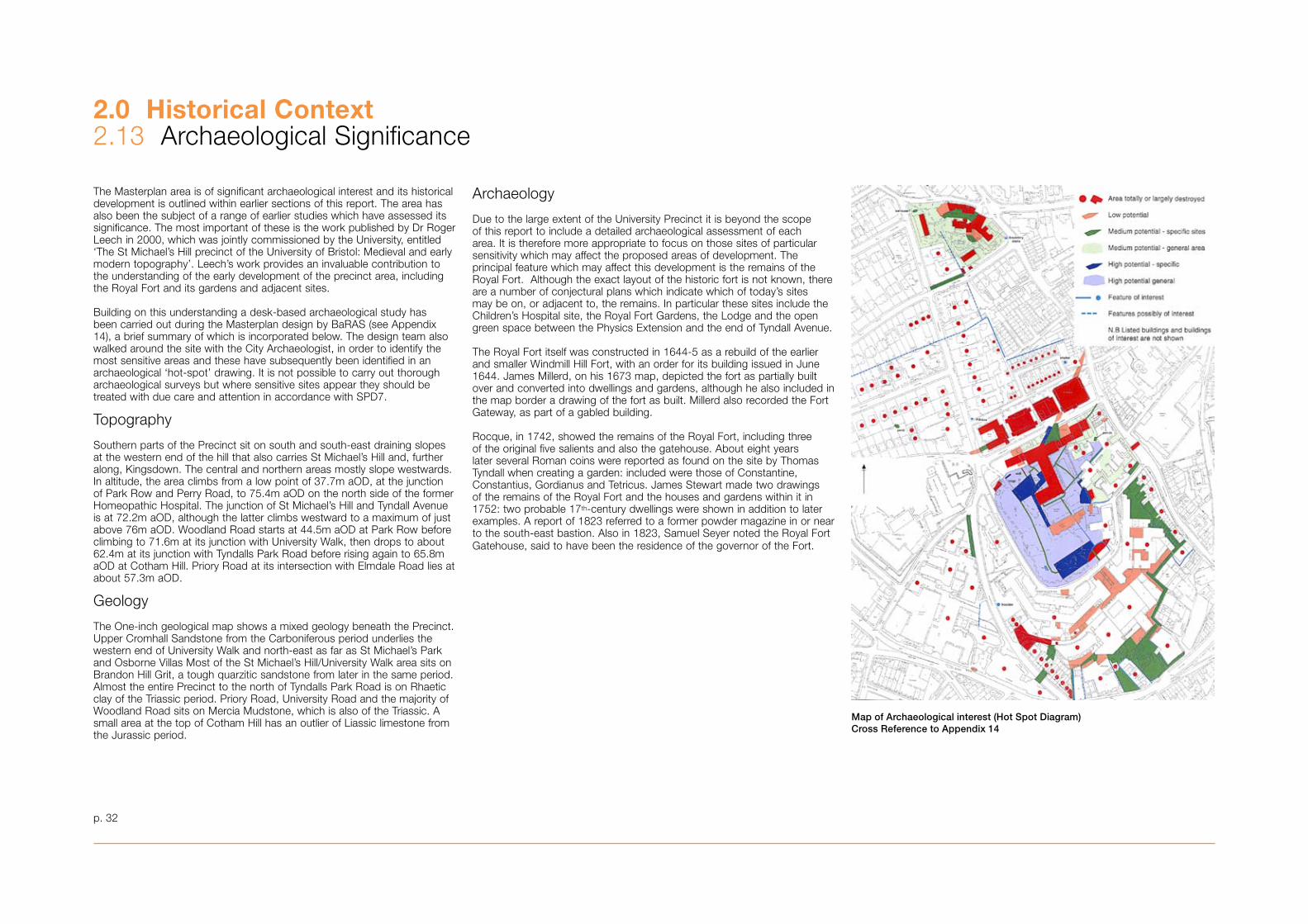
The Masterplan area is of significant archaeological interest and its historical development is outlined within earlier sections of this report. The area has also been the subject of a range of earlier studies which have assessed its significance. The most important of these is the work published by Dr Roger Leech in 2000, which was jointly commissioned by the University, entitled ‘The St Michael’s Hill precinct of the University of Bristol: Medieval and early modern topography’. Leech’s work provides an invaluable contribution to the understanding of the early development of the precinct area, including the Royal Fort and its gardens and adjacent sites.
Building on this understanding a desk-based archaeological study has been carried out during the Masterplan design by BaRAS (see Appendix 14), a brief summary of which is incorporated below. The design team also walked around the site with the City Archaeologist, in order to identify the most sensitive areas and these have subsequently been identified in an archaeological ‘hot-spot’ drawing. It is not possible to carry out thorough archaeological surveys but where sensitive sites appear they should be treated with due care and attention in accordance with SPD7.
Topography
Southern parts of the Precinct sit on south and south-east draining slopes at the western end of the hill that also carries St Michael’s Hill and, further along, Kingsdown. The central and northern areas mostly slope westwards. In altitude, the area climbs from a low point of �7.7m aOD, at the junction of Park Row and Perry Road, to 75.4m aOD on the north side of the former Homeopathic Hospital. The junction of St Michael’s Hill and Tyndall Avenue is at 72.2m aOD, although the latter climbs westward to a maximum of just above 76m aOD. Woodland Road starts at 44.5m aOD at Park Row before climbing to 71.6m at its junction with University Walk, then drops to about 62.4m at its junction with Tyndalls Park Road before rising again to 65.8m aOD at Cotham Hill. Priory Road at its intersection with Elmdale Road lies at about 57.�m aOD.
Geology
The One-inch geological map shows a mixed geology beneath the Precinct. Upper Cromhall Sandstone from the Carboniferous period underlies the western end of University Walk and north-east as far as St Michael’s Park and Osborne Villas Most of the St Michael’s Hill/University Walk area sits on Brandon Hill Grit, a tough quarzitic sandstone from later in the same period. Almost the entire Precinct to the north of Tyndalls Park Road is on Rhaetic clay of the Triassic period. Priory Road, University Road and the majority of Woodland Road sits on Mercia Mudstone, which is also of the Triassic. A small area at the top of Cotham Hill has an outlier of Liassic limestone from the Jurassic period.
Archaeology
Due to the large extent of the University Precinct it is beyond the scope of this report to include a detailed archaeological assessment of each area. It is therefore more appropriate to focus on those sites of particular sensitivity which may affect the proposed areas of development. The principal feature which may affect this development is the remains of the Royal Fort. Although the exact layout of the historic fort is not known, there are a number of conjectural plans which indicate which of today’s sites may be on, or adjacent to, the remains. In particular these sites include the Children’s Hospital site, the Royal Fort Gardens, the Lodge and the open green space between the Physics Extension and the end of Tyndall Avenue.
The Royal Fort itself was constructed in 1644-5 as a rebuild of the earlier and smaller Windmill Hill Fort, with an order for its building issued in June 1644. James Millerd, on his 167� map, depicted the fort as partially built over and converted into dwellings and gardens, although he also included in the map border a drawing of the fort as built. Millerd also recorded the Fort Gateway, as part of a gabled building. Rocque, in 1742, showed the remains of the Royal Fort, including three of the original five salients and also the gatehouse. About eight years later several Roman coins were reported as found on the site by Thomas Tyndall when creating a garden: included were those of Constantine, Constantius, Gordianus and Tetricus. James Stewart made two drawings of the remains of the Royal Fort and the houses and gardens within it in 1752: two probable 17th-century dwellings were shown in addition to later examples. A report of 182� referred to a former powder magazine in or near to the south-east bastion. Also in 182�, Samuel Seyer noted the Royal Fort Gatehouse, said to have been the residence of the governor of the Fort.
Map of Archaeological interest (Hot Spot Diagram)Cross Reference to Appendix 14
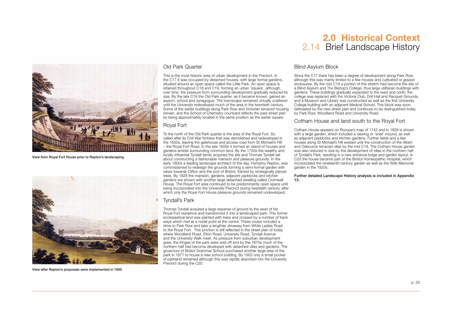
p. ��
2.0 Historical Context2.14 Brief Landscape History
Old Park Quarter
This is the most historic area of urban development in the Precinct. In the C17 it was occupied by detached houses, with large formal gardens, situated around an open space called the Little Park. An open space is retained throughout C18 and C19, forming an urban ‘square’, although, over time, the pressure from surrounding development gradually reduced its size. By the late C19 the Old Park quarter, as it became known, gained an asylum, school and synagogue. The townscape remained virtually unaltered until the University redeveloped much of the area in the twentieth century. Some of the earlier buildings along Park Row and Victorian terraced housing remain, and the School of Chemistry courtyard reflects the past street plan by being approximately located in the same position as the earlier square.
Royal Fort
To the north of the Old Park quarter is the area of the Royal Fort. So called after its Civil War fortress that was demolished and redeveloped in the 1650s, leaving the gatehouse and access road from St Michael’s Hill – the Royal Fort Road. In the late 1600s it formed an island of houses and gardens amidst surrounding common land. By the 1750s the wealthy and locally influential Tyndall family acquired the site and Thomas Tyndall set about constructing a fashionable mansion and pleasure grounds. In the early 1800s a leading landscape architect of the day, Humphry Repton, was commissioned to redesign the grounds forming a semi-formal garden with views towards Clifton and the port of Bristol, framed by strategically placed trees. By 1828 the mansion, gardens, adjacent paddocks and kitchen gardens are shown with another large detached dwelling called Cromwell House. The Royal Fort area continued to be predominantly open space until being incorporated into the University Precinct during twentieth century, after which only the Royal Fort House pleasure grounds remained undeveloped.
Tyndall’s Park
Thomas Tyndall acquired a large expanse of ground to the west of his Royal Fort residence and transformed it into a landscaped park. This former ecclesiastical land was planted with trees and crossed by a number of track ways which met at a nodal point at the centre. These routes included a drive to Park Row and later a lengthier driveway from White Ladies Road to the Royal Fort. This junction is still reflected in the street plan of today where Woodland Road, Elton Road, University Road, Tyndall Avenue and the University Walk meet. As pressure from suburban development grew, the fringes of the park were sold off and by the 1870s much of the northern half had become developed with detached villas and gardens. The governors of Bristol Grammar School purchased another large area of the park in 1877 to house a new school building. By 190� only a small pocket of parkland remained although this was rapidly absorbed into the University Precinct during the C20.
Blind Asylum Block
Since the C17 there has been a degree of development along Park Row, although this was mainly limited to a few houses and cultivated or grazed enclosures. By the mid C19 a portion of this stretch had become the site of a Blind Asylum and The Bishop’s College, thus large utilitarian buildings with gardens. These buildings gradually expanded to the west and north; the college was replaced with the Victoria Club, Drill Hall and Racquet Grounds, and a Museum and Library was constructed as well as the first University College building with an adjacent Medical School. This block was soon delineated by the new street plan and continues to be distinguished today by Park Row, Woodland Road and University Road.
Cotham House and land south to the Royal Fort
Cotham House appears on Rocque’s map of 1742 and in 1828 is shown with a large garden, which included a viewing or ‘snail’ mound, as well as adjacent paddocks and kitchen gardens. Further fields and a few houses along St Michael’s Hill existed until the construction of the Albert and Osbourne terraced villas by the mid C19. The Cotham House garden was also reduced in size by the development of villas in the northern half of Tyndall’s Park, resulting in a new entrance lodge and garden layout. In C20 the house became part of the Bristol Homeopathic Hospital, which incorporated the nineteenth century garden as well as the Wills Memorial garden in the 1920s.
Further detailed Landscape History analysis is included in Appendix 13.
View from Royal Fort House prior to Repton’s landscaping
View after Repton’s proposals were implemented in 1800
p. �5
3.0 Contextual Analysis
‘The University plays a wide role in the life of the City’
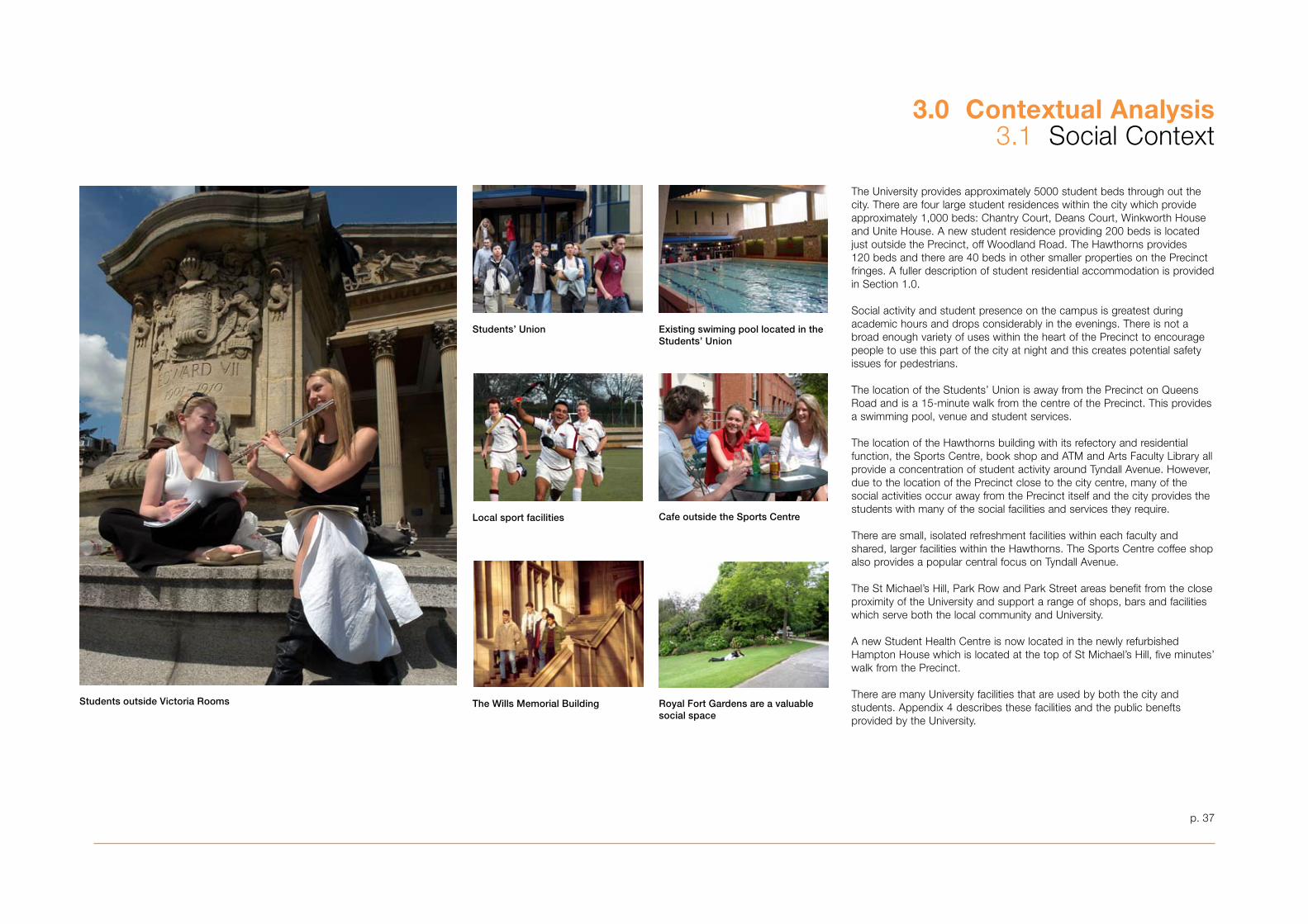
3.0 Contextual Analysis�.1 Social Context
p. �7
The University provides approximately 5000 student beds through out the city. There are four large student residences within the city which provide approximately 1,000 beds: Chantry Court, Deans Court, Winkworth House and Unite House. A new student residence providing 200 beds is located just outside the Precinct, off Woodland Road. The Hawthorns provides 120 beds and there are 40 beds in other smaller properties on the Precinct fringes. A fuller description of student residential accommodation is provided in Section 1.0.
Social activity and student presence on the campus is greatest during academic hours and drops considerably in the evenings. There is not a broad enough variety of uses within the heart of the Precinct to encourage people to use this part of the city at night and this creates potential safety issues for pedestrians.
The location of the Students’ Union is away from the Precinct on Queens Road and is a 15-minute walk from the centre of the Precinct. This provides a swimming pool, venue and student services.
The location of the Hawthorns building with its refectory and residential function, the Sports Centre, book shop and ATM and Arts Faculty Library all provide a concentration of student activity around Tyndall Avenue. However, due to the location of the Precinct close to the city centre, many of the social activities occur away from the Precinct itself and the city provides the students with many of the social facilities and services they require.
There are small, isolated refreshment facilities within each faculty and shared, larger facilities within the Hawthorns. The Sports Centre coffee shop also provides a popular central focus on Tyndall Avenue.
The St Michael’s Hill, Park Row and Park Street areas benefit from the close proximity of the University and support a range of shops, bars and facilities which serve both the local community and University.
A new Student Health Centre is now located in the newly refurbished Hampton House which is located at the top of St Michael’s Hill, five minutes’ walk from the Precinct.
There are many University facilities that are used by both the city and students. Appendix 4 describes these facilities and the public benefts provided by the University.
Students’ Union
Royal Fort Gardens are a valuable social space
Existing swiming pool located in the Students’ Union
Cafe outside the Sports CentreLocal sport facilities
The Wills Memorial Building Students outside Victoria Rooms
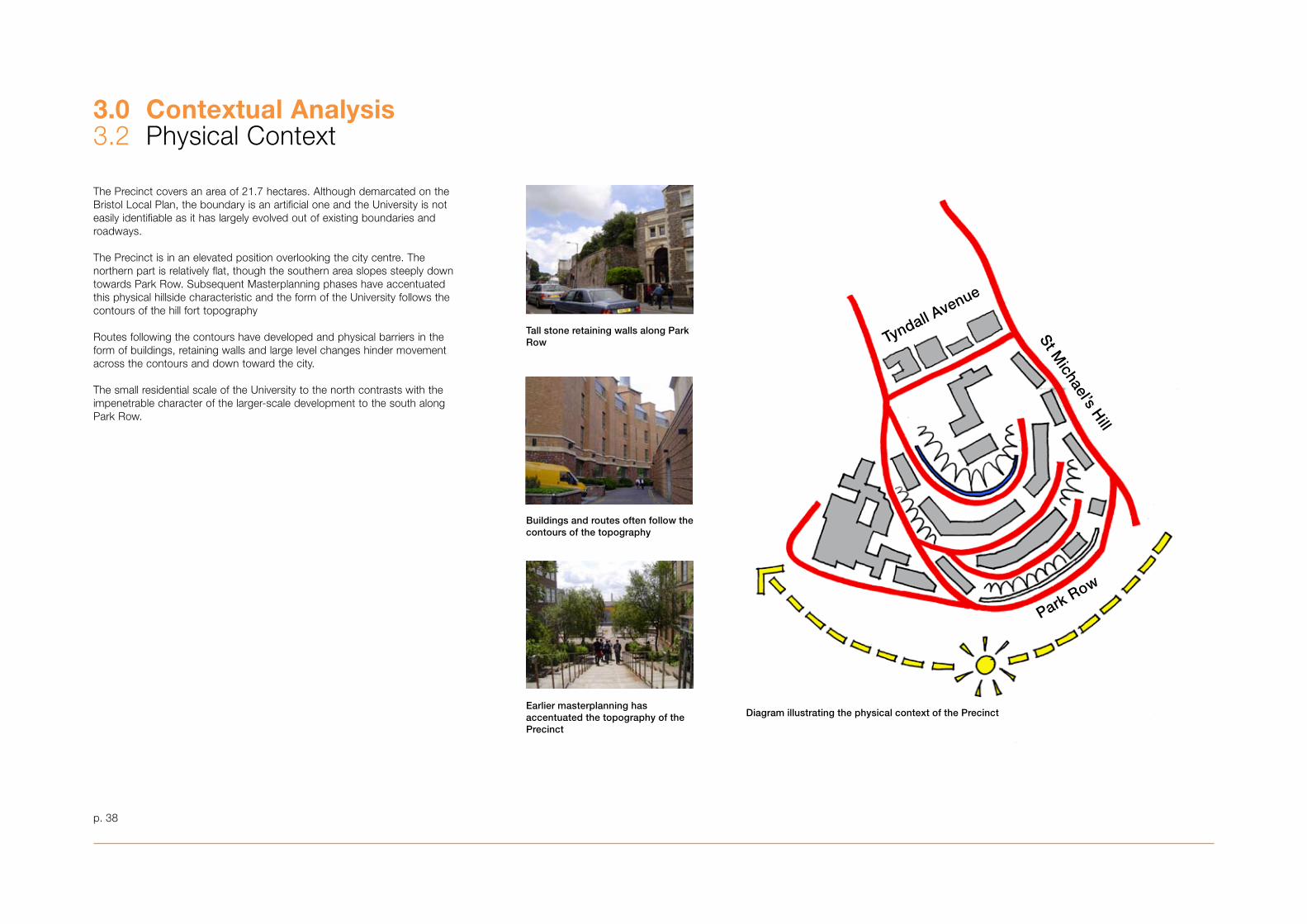
3.0 Contextual Analysis�.2 Physical Context
p. �8
The Precinct covers an area of 21.7 hectares. Although demarcated on the Bristol Local Plan, the boundary is an artificial one and the University is not easily identifiable as it has largely evolved out of existing boundaries and roadways.
The Precinct is in an elevated position overlooking the city centre. The northern part is relatively flat, though the southern area slopes steeply down towards Park Row. Subsequent Masterplanning phases have accentuated this physical hillside characteristic and the form of the University follows the contours of the hill fort topography
Routes following the contours have developed and physical barriers in the form of buildings, retaining walls and large level changes hinder movement across the contours and down toward the city.
The small residential scale of the University to the north contrasts with the impenetrable character of the larger-scale development to the south along Park Row.
Tall stone retaining walls along Park Row
Buildings and routes often follow the contours of the topography
Earlier masterplanning has accentuated the topography of the Precinct
Diagram illustrating the physical context of the Precinct
Tyndall Avenue
St Michael’s H
ill
Park Row
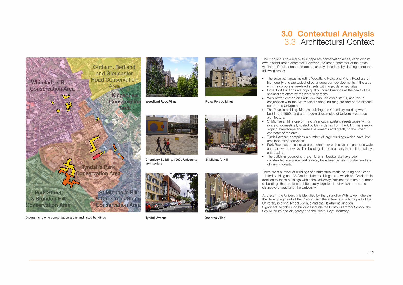
p. 39
The Precinct is covered by four separate conservation areas, each with its own distinct urban character. However, the urban character of the areas within the Precinct can be more accurately described by dividing it into the following areas;
• The suburban areas including Woodland Road and Priory Road are of high quality and are typical of other suburban developments in the area which incorporate tree-lined streets with large, detached villas.
• Royal Fort buildings are high quality, iconic buildings at the heart of the site and are offset by the historic gardens.
• Wills Tower located on Park Row has key iconic status, and this in conjunction with the Old Medical School building are part of the historic core of the University.
• The Physics building, Medical building and Chemistry building were built in the 1960s and are modernist examples of University campus architecture.
• St Michael’s Hill is one of the city’s most important streetscapes with a range of domestically scaled buildings dating from the C17. The steeply sloping streetscape and raised pavements add greatly to the urban character of the area.
• Tyndall Avenue comprises a number of large buildings which have little architectural cohesiveness.
• Park Row has a distinctive urban character with severe, high stone walls and narrow routeways. The buildings in the area vary in architectural style and quality.
• The buildings occupying the Children’s Hospital site have been constructed in a piecemeal fashion, have been largely modified and are of varying quality.
There are a number of buildings of architectural merit including one Grade 1 listed building and 38 Grade II listed buildings, 4 of which are Grade II*. In addition to these buildings within the University Precinct there are a number of buildings that are less architecturally significant but which add to the distinctive character of the University.
At present the University is identified by the distinctive Wills tower, whereas the developing heart of the Precinct and the entrance to a large part of the University is along Tyndall Avenue and the Hawthorns junction. Significant neighbouring buildings include the Bristol Grammar School, the City Museum and Art gallery and the Bristol Royal Infirmary.
3.0 Contextual Analysis3.3 Architectural Context
Woodland Road Villas
Tyndall Avenue Osborne Villas
St Michael’s Hill
Royal Fort buildings
Chemistry Building, 1960s University architecture
Woodland Road Villas
Diagram showing conservation areas and listed buildings
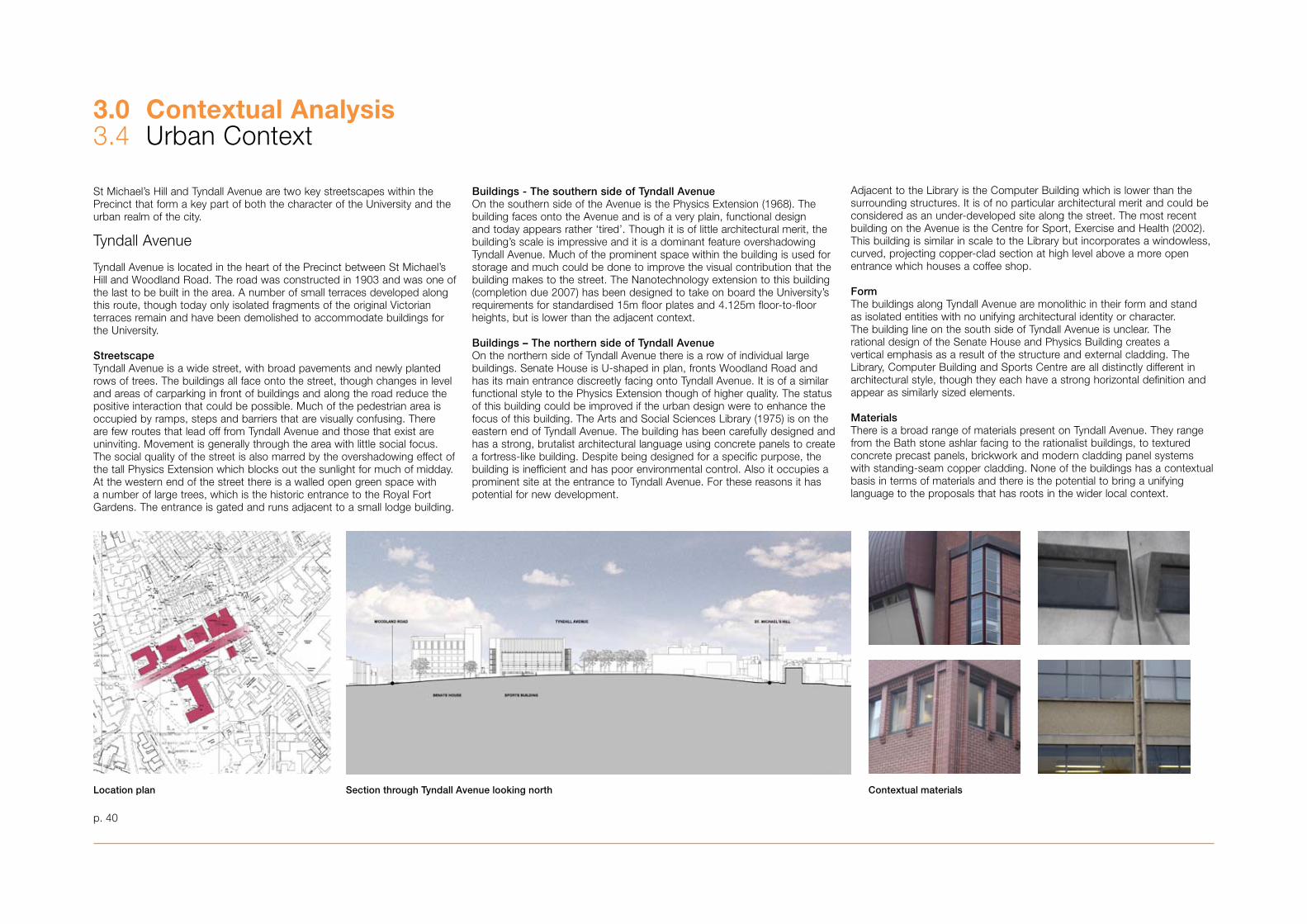
3.0 Contextual Analysis�.4 Urban Context
p. 40
St Michael’s Hill and Tyndall Avenue are two key streetscapes within the Precinct that form a key part of both the character of the University and the urban realm of the city.
Tyndall Avenue
Tyndall Avenue is located in the heart of the Precinct between St Michael’s Hill and Woodland Road. The road was constructed in 190� and was one of the last to be built in the area. A number of small terraces developed along this route, though today only isolated fragments of the original Victorian terraces remain and have been demolished to accommodate buildings for the University.
StreetscapeTyndall Avenue is a wide street, with broad pavements and newly planted rows of trees. The buildings all face onto the street, though changes in level and areas of carparking in front of buildings and along the road reduce the positive interaction that could be possible. Much of the pedestrian area is occupied by ramps, steps and barriers that are visually confusing. There are few routes that lead off from Tyndall Avenue and those that exist are uninviting. Movement is generally through the area with little social focus. The social quality of the street is also marred by the overshadowing effect of the tall Physics Extension which blocks out the sunlight for much of midday. At the western end of the street there is a walled open green space with a number of large trees, which is the historic entrance to the Royal Fort Gardens. The entrance is gated and runs adjacent to a small lodge building.
Buildings - The southern side of Tyndall AvenueOn the southern side of the Avenue is the Physics Extension (1968). The building faces onto the Avenue and is of a very plain, functional design and today appears rather ‘tired’. Though it is of little architectural merit, the building’s scale is impressive and it is a dominant feature overshadowing Tyndall Avenue. Much of the prominent space within the building is used for storage and much could be done to improve the visual contribution that the building makes to the street. The Nanotechnology extension to this building (completion due 2007) has been designed to take on board the University’s requirements for standardised 15m floor plates and 4.125m floor-to-floor heights, but is lower than the adjacent context.
Buildings – The northern side of Tyndall AvenueOn the northern side of Tyndall Avenue there is a row of individual large buildings. Senate House is U-shaped in plan, fronts Woodland Road and has its main entrance discreetly facing onto Tyndall Avenue. It is of a similar functional style to the Physics Extension though of higher quality. The status of this building could be improved if the urban design were to enhance the focus of this building. The Arts and Social Sciences Library (1975) is on the eastern end of Tyndall Avenue. The building has been carefully designed and has a strong, brutalist architectural language using concrete panels to create a fortress-like building. Despite being designed for a specific purpose, the building is inefficient and has poor environmental control. Also it occupies a prominent site at the entrance to Tyndall Avenue. For these reasons it has potential for new development.
Adjacent to the Library is the Computer Building which is lower than the surrounding structures. It is of no particular architectural merit and could be considered as an under-developed site along the street. The most recent building on the Avenue is the Centre for Sport, Exercise and Health (2002). This building is similar in scale to the Library but incorporates a windowless, curved, projecting copper-clad section at high level above a more open entrance which houses a coffee shop.
FormThe buildings along Tyndall Avenue are monolithic in their form and stand as isolated entities with no unifying architectural identity or character. The building line on the south side of Tyndall Avenue is unclear. The rational design of the Senate House and Physics Building creates a vertical emphasis as a result of the structure and external cladding. The Library, Computer Building and Sports Centre are all distinctly different in architectural style, though they each have a strong horizontal definition and appear as similarly sized elements. MaterialsThere is a broad range of materials present on Tyndall Avenue. They range from the Bath stone ashlar facing to the rationalist buildings, to textured concrete precast panels, brickwork and modern cladding panel systems with standing-seam copper cladding. None of the buildings has a contextual basis in terms of materials and there is the potential to bring a unifying language to the proposals that has roots in the wider local context.
Location plan Section through Tyndall Avenue looking north Contextual materials
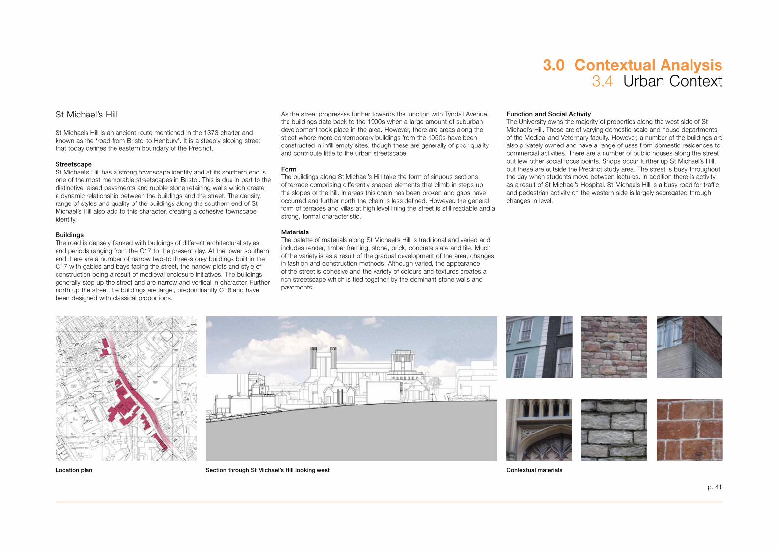
p. 41
3.0 Contextual Analysis�.4 Urban Context
St Michael’s Hill
St Michaels Hill is an ancient route mentioned in the 1�7� charter and known as the ‘road from Bristol to Henbury’. It is a steeply sloping street that today defines the eastern boundary of the Precinct.
StreetscapeSt Michael’s Hill has a strong townscape identity and at its southern end is one of the most memorable streetscapes in Bristol. This is due in part to the distinctive raised pavements and rubble stone retaining walls which create a dynamic relationship between the buildings and the street. The density, range of styles and quality of the buildings along the southern end of St Michael’s Hill also add to this character, creating a cohesive townscape identity.
BuildingsThe road is densely flanked with buildings of different architectural styles and periods ranging from the C17 to the present day. At the lower southern end there are a number of narrow two-to three-storey buildings built in the C17 with gables and bays facing the street, the narrow plots and style of construction being a result of medieval enclosure initiatives. The buildings generally step up the street and are narrow and vertical in character. Further north up the street the buildings are larger, predominantly C18 and have been designed with classical proportions.
As the street progresses further towards the junction with Tyndall Avenue, the buildings date back to the 1900s when a large amount of suburban development took place in the area. However, there are areas along the street where more contemporary buildings from the 1950s have been constructed in infill empty sites, though these are generally of poor quality and contribute little to the urban streetscape.
FormThe buildings along St Michael’s Hill take the form of sinuous sections of terrace comprising differently shaped elements that climb in steps up the slopes of the hill. In areas this chain has been broken and gaps have occurred and further north the chain is less defined. However, the general form of terraces and villas at high level lining the street is still readable and a strong, formal characteristic.
MaterialsThe palette of materials along St Michael’s Hill is traditional and varied and includes render, timber framing, stone, brick, concrete slate and tile. Much of the variety is as a result of the gradual development of the area, changes in fashion and construction methods. Although varied, the appearance of the street is cohesive and the variety of colours and textures creates a rich streetscape which is tied together by the dominant stone walls and pavements.
Function and Social ActivityThe University owns the majority of properties along the west side of St Michael’s Hill. These are of varying domestic scale and house departments of the Medical and Veterinary faculty. However, a number of the buildings are also privately owned and have a range of uses from domestic residences to commercial activities. There are a number of public houses along the street but few other social focus points. Shops occur further up St Michael’s Hill, but these are outside the Precinct study area. The street is busy throughout the day when students move between lectures. In addition there is activity as a result of St Michael’s Hospital. St Michaels Hill is a busy road for traffic and pedestrian activity on the western side is largely segregated through changes in level.
Contextual materialsSection through St Michael’s Hill looking westLocation plan

3.0 Contextual Analysis�.5 Wider Context
p. 42
Visual Analysis of the University from the City
The interrelationship of topography and built form combines to give certain University buildings, both individually and in aggregate, a considerable degree of prominence in the wider view of the city. Landmark buildings include the Wills Memorial Tower, the Physics building and the Chemistry buildings.
Their contribution is a historic and valued one, and is a key contribution to the urban morphology and distinctive character of Bristol. SPD1:Tall Buildings has identified key views across the city. These recognise the importance of landmark buildings and their interrelationship in the townscape. This provides an appreciation of the diverse character of the city and helps to inform future development.
Using SPD1 as a baseline, an appraisal has been undertaken of those views in which University of Bristol buildings are a material component. Additional key views gained within the locality and environs of the University have also been identified and assessed with regard to the nature and extent of views to and of the University buildings.
For the purposes of Masterplan analysis, 10 key views have been selected as being representative of those views in which the University buildings feature. These views, both distant to and in the vicinity of the University, provide reference points for analysing potential changes that might result from the introduction of new built form. The form, mass and appearance of the cityscape has been analysed, as has the University building component within these views.
Appendix 1� Urban Landscape and External Realm has been prepared by Nicholas Pearson Associates and clearly examines the key distant views and local views of the University Precinct.
From many parts of the city, the University buildings are clearly visible due to their elevated location. The main University buildings form a closely related and cohesive cluster of layered, large-scale built form, which together contribute to the skyline. Constituent vertical elements of note are the Wills Memorial building and the Physics Tower, juxtaposed with the more horizontal, varied form of the other faculty buildings.
View from Wells Road
View from the Industrial Museum
Key to distant views
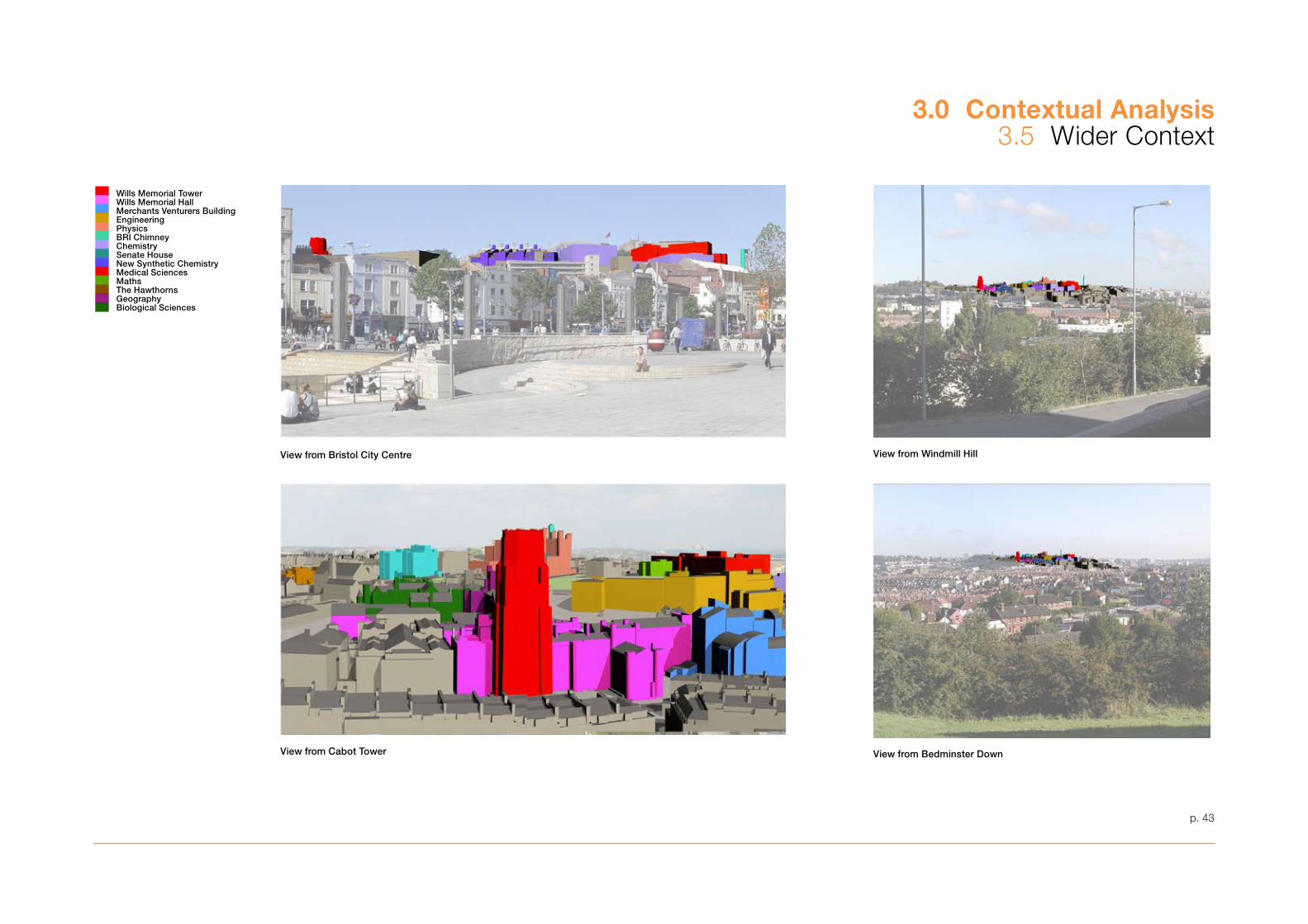
p. 4�
3.0 Contextual Analysis�.5 Wider Context
View from Bristol City Centre
View from Cabot Tower
View from Windmill Hill
View from Bedminster Down
Wills Memorial TowerWills Memorial HallMerchants Venturers BuildingEngineeringPhysicsBRI ChimneyChemistrySenate HouseNew Synthetic ChemistryMedical SciencesMathsThe HawthornsGeographyBiological Sciences
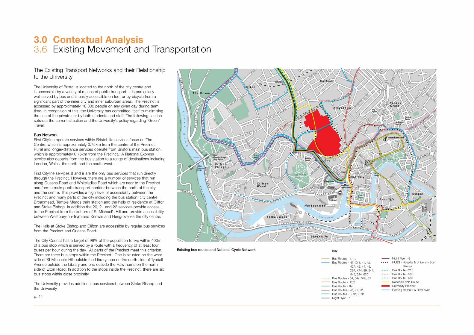
3.0 Contextual Analysis�.6 Existing Movement and Transportation
p. 44
The Existing Transport Networks and their Relationship to the University
The University of Bristol is located to the north of the city centre and is accessible by a variety of means of public transport. It is particularly well served by bus and is easily accessible on foot or by bicycle from a significant part of the inner city and inner suburban areas. The Precinct is accessed by approximately 18,�00 people on any given day during term time. In recognition of this, the University has committed itself to minimising the use of the private car by both students and staff. The following section sets out the current situation and the University’s policy regarding ‘Green’ Travel.
Bus NetworkFirst Cityline operate services within Bristol. Its services focus on The Centre, which is approximately 0.75km from the centre of the Precinct. Rural and longer-distance services operate from Bristol’s main bus station, which is approximately 0.75km from the Precinct. A National Express service also departs from the bus station to a range of destinations including London, Wales, the north and the south-west.
First Cityline services 8 and 9 are the only bus services that run directly through the Precinct. However, there are a number of services that run along Queens Road and Whiteladies Road which are near to the Precinct and form a main public transport corridor between the north of the city and the centre. This provides a high level of accessibility between the Precinct and many parts of the city including the bus station, city centre, Broadmead, Temple Meads train station and the halls of residence at Clifton and Stoke Bishop. In addition the 20, 21 and 22 services provide access to the Precinct from the bottom of St Michael’s Hill and provide accessibility between Westbury-on-Trym and Knowle and Hengrove via the city centre.
The Halls at Stoke Bishop and Clifton are accessible by regular bus services from the Precinct and Queens Road.
The City Council has a target of 98% of the population to live within 400m of a bus stop which is served by a route with a frequency of at least four buses per hour during the day. All parts of the Precinct meet this criterion. There are three bus stops within the Precinct. One is situated on the west side of St Michael’s Hill outside the Library, one on the north side of Tyndall Avenue outside the Library and one outside the Hawthorns on the north side of Elton Road. In addition to the stops inside the Precinct, there are six bus stops within close proximity.
The University provides additional bus services between Stoke Bishop and the University.
Key
Bus Routes - 1, 1aBus Routes - N7, X14, 41, 42, 42A, 43, 44, 49, X67, X74, 99, 544, 545, 624, 625Bus Routes - 54, 54a, 54b, 55Bus Route - X62Bus Route - 99Bus Routes - 20, 21, 22Bus Routes - 8, 8a, 9, 9aNight Flyer - 7Night Flyer - 8HUBS - Hospital & University Bus ServiceBus Route - 218Bus Route - 586Bus Route - 587National Cycle RouteUniversity PrecinctFloating Harbour & River Avon
Existing bus routes and National Cycle Network
Key
Bus Routes - 1, 1aBus Routes - N7, X14, 41, 42, 42A, 43, 44, 49, X67, X74, 99, 544, 545, 624, 625Bus Routes - 54, 54a, 54b, 55Bus Route - X62Bus Route - 99Bus Routes - 20, 21, 22Bus Routes - 8, 8a, 9, 9aNight Flyer - 7Night Flyer - 8HUBS - Hospital & University Bus ServiceBus Route - 218Bus Route - 586Bus Route - 587National Cycle RouteUniversity PrecinctFloating Harbour & River Avon
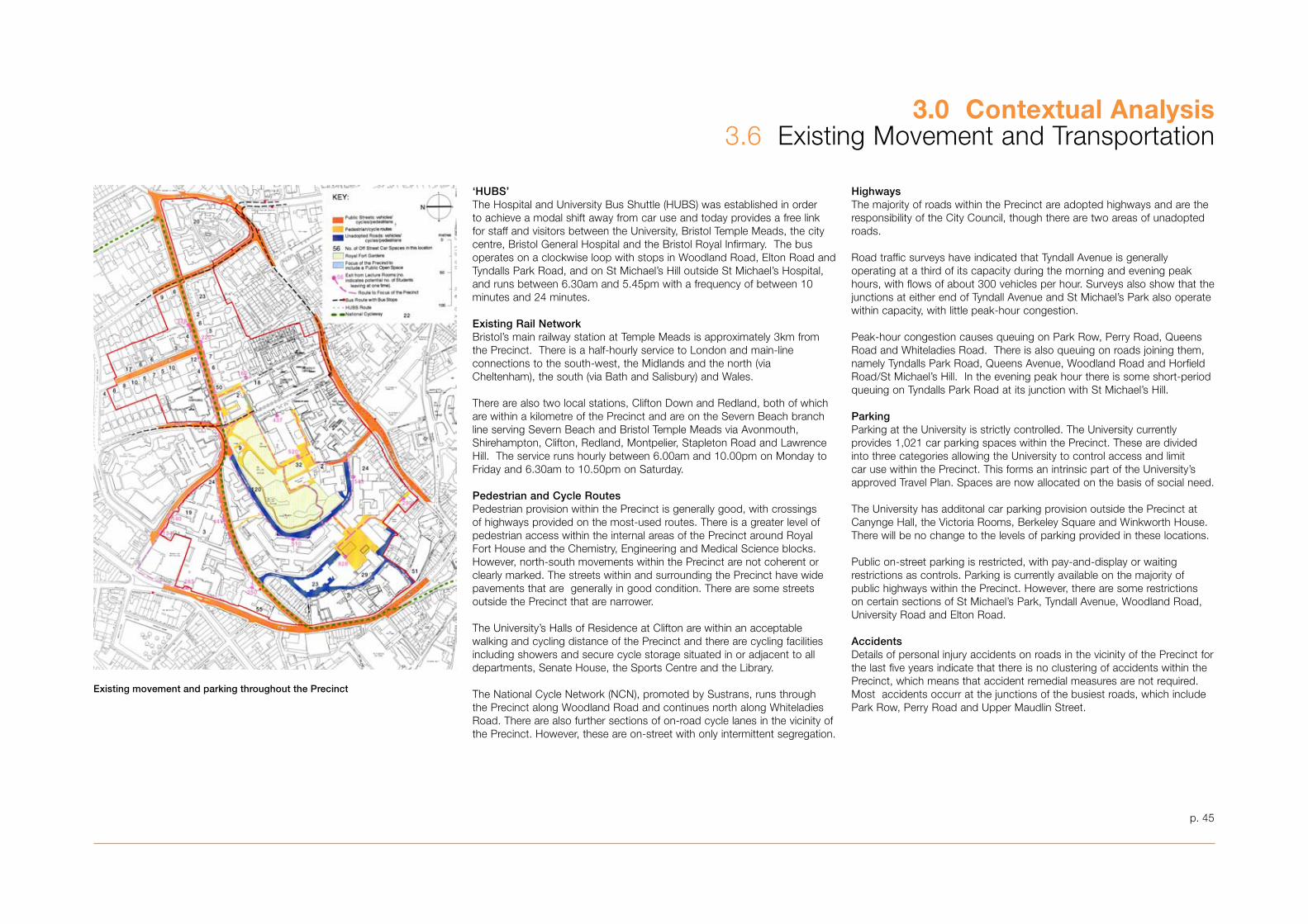
3.0 Contextual Analysis�.6 Existing Movement and Transportation
‘HUBS’The Hospital and University Bus Shuttle (HUBS) was established in order to achieve a modal shift away from car use and today provides a free link for staff and visitors between the University, Bristol Temple Meads, the city centre, Bristol General Hospital and the Bristol Royal Infirmary. The bus operates on a clockwise loop with stops in Woodland Road, Elton Road and Tyndalls Park Road, and on St Michael’s Hill outside St Michael’s Hospital, and runs between 6.�0am and 5.45pm with a frequency of between 10 minutes and 24 minutes.
Existing Rail NetworkBristol’s main railway station at Temple Meads is approximately �km fromthe Precinct. There is a half-hourly service to London and main-lineconnections to the south-west, the Midlands and the north (via Cheltenham), the south (via Bath and Salisbury) and Wales.
There are also two local stations, Clifton Down and Redland, both of which are within a kilometre of the Precinct and are on the Severn Beach branch line serving Severn Beach and Bristol Temple Meads via Avonmouth, Shirehampton, Clifton, Redland, Montpelier, Stapleton Road and Lawrence Hill. The service runs hourly between 6.00am and 10.00pm on Monday to Friday and 6.�0am to 10.50pm on Saturday.
Pedestrian and Cycle RoutesPedestrian provision within the Precinct is generally good, with crossings of highways provided on the most-used routes. There is a greater level of pedestrian access within the internal areas of the Precinct around Royal Fort House and the Chemistry, Engineering and Medical Science blocks. However, north-south movements within the Precinct are not coherent or clearly marked. The streets within and surrounding the Precinct have wide pavements that are generally in good condition. There are some streets outside the Precinct that are narrower.
The University’s Halls of Residence at Clifton are within an acceptable walking and cycling distance of the Precinct and there are cycling facilities including showers and secure cycle storage situated in or adjacent to all departments, Senate House, the Sports Centre and the Library.
The National Cycle Network (NCN), promoted by Sustrans, runs through the Precinct along Woodland Road and continues north along Whiteladies Road. There are also further sections of on-road cycle lanes in the vicinity of the Precinct. However, these are on-street with only intermittent segregation.
HighwaysThe majority of roads within the Precinct are adopted highways and are the responsibility of the City Council, though there are two areas of unadopted roads.
Road traffic surveys have indicated that Tyndall Avenue is generally operating at a third of its capacity during the morning and evening peak hours, with flows of about �00 vehicles per hour. Surveys also show that the junctions at either end of Tyndall Avenue and St Michael’s Park also operate within capacity, with little peak-hour congestion.
Peak-hour congestion causes queuing on Park Row, Perry Road, Queens Road and Whiteladies Road. There is also queuing on roads joining them, namely Tyndalls Park Road, Queens Avenue, Woodland Road and Horfield Road/St Michael’s Hill. In the evening peak hour there is some short-period queuing on Tyndalls Park Road at its junction with St Michael’s Hill.
ParkingParking at the University is strictly controlled. The University currently provides 1,021 car parking spaces within the Precinct. These are divided into three categories allowing the University to control access and limit car use within the Precinct. This forms an intrinsic part of the University’s approved Travel Plan. Spaces are now allocated on the basis of social need.
The University has additonal car parking provision outside the Precinct at Canynge Hall, the Victoria Rooms, Berkeley Square and Winkworth House. There will be no change to the levels of parking provided in these locations.
Public on-street parking is restricted, with pay-and-display or waiting restrictions as controls. Parking is currently available on the majority of public highways within the Precinct. However, there are some restrictions on certain sections of St Michael’s Park, Tyndall Avenue, Woodland Road, University Road and Elton Road.
AccidentsDetails of personal injury accidents on roads in the vicinity of the Precinct for the last five years indicate that there is no clustering of accidents within the Precinct, which means that accident remedial measures are not required. Most accidents occurr at the junctions of the busiest roads, which include Park Row, Perry Road and Upper Maudlin Street.
p. 45
Existing movement and parking throughout the Precinct
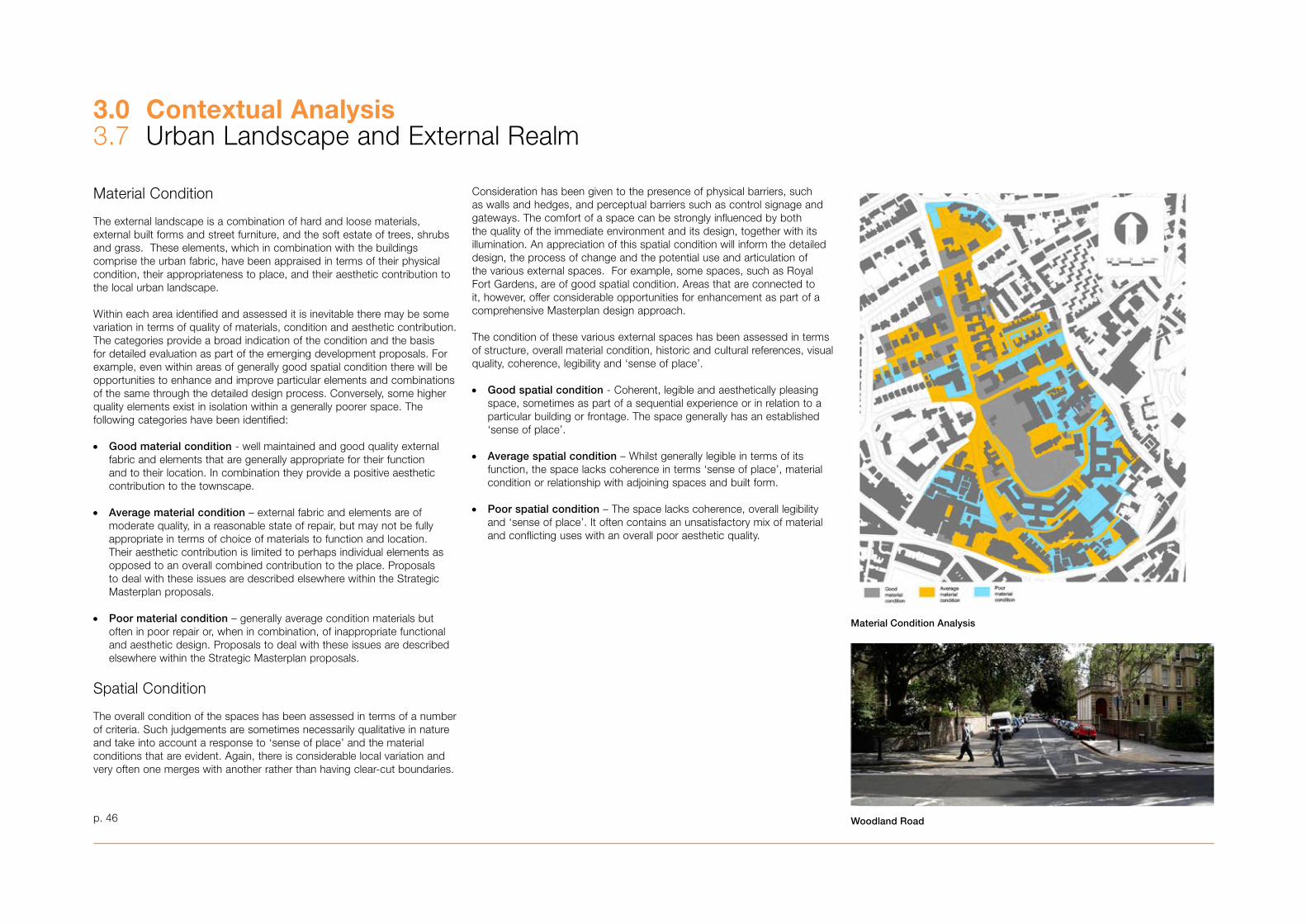
3.0 Contextual Analysis�.7 Urban Landscape and External Realm
p. 46
Material Condition
The external landscape is a combination of hard and loose materials, external built forms and street furniture, and the soft estate of trees, shrubs and grass. These elements, which in combination with the buildings comprise the urban fabric, have been appraised in terms of their physical condition, their appropriateness to place, and their aesthetic contribution to the local urban landscape.
Within each area identified and assessed it is inevitable there may be some variation in terms of quality of materials, condition and aesthetic contribution. The categories provide a broad indication of the condition and the basis for detailed evaluation as part of the emerging development proposals. For example, even within areas of generally good spatial condition there will be opportunities to enhance and improve particular elements and combinations of the same through the detailed design process. Conversely, some higher quality elements exist in isolation within a generally poorer space. The following categories have been identified:
• Good material condition - well maintained and good quality external fabric and elements that are generally appropriate for their function and to their location. In combination they provide a positive aesthetic contribution to the townscape.
• Average material condition – external fabric and elements are of moderate quality, in a reasonable state of repair, but may not be fully appropriate in terms of choice of materials to function and location. Their aesthetic contribution is limited to perhaps individual elements as opposed to an overall combined contribution to the place. Proposals to deal with these issues are described elsewhere within the Strategic Masterplan proposals.
• Poor material condition – generally average condition materials but often in poor repair or, when in combination, of inappropriate functional and aesthetic design. Proposals to deal with these issues are described elsewhere within the Strategic Masterplan proposals.
Spatial Condition
The overall condition of the spaces has been assessed in terms of a number of criteria. Such judgements are sometimes necessarily qualitative in nature and take into account a response to ‘sense of place’ and the material conditions that are evident. Again, there is considerable local variation and very often one merges with another rather than having clear-cut boundaries.
Consideration has been given to the presence of physical barriers, such as walls and hedges, and perceptual barriers such as control signage and gateways. The comfort of a space can be strongly influenced by both the quality of the immediate environment and its design, together with its illumination. An appreciation of this spatial condition will inform the detailed design, the process of change and the potential use and articulation of the various external spaces. For example, some spaces, such as Royal Fort Gardens, are of good spatial condition. Areas that are connected to it, however, offer considerable opportunities for enhancement as part of a comprehensive Masterplan design approach.
The condition of these various external spaces has been assessed in terms of structure, overall material condition, historic and cultural references, visual quality, coherence, legibility and ‘sense of place’.
• Good spatial condition - Coherent, legible and aesthetically pleasing space, sometimes as part of a sequential experience or in relation to a particular building or frontage. The space generally has an established ‘sense of place’.
• Average spatial condition – Whilst generally legible in terms of its function, the space lacks coherence in terms ‘sense of place’, material condition or relationship with adjoining spaces and built form.
• Poor spatial condition – The space lacks coherence, overall legibility and ‘sense of place’. It often contains an unsatisfactory mix of material and conflicting uses with an overall poor aesthetic quality.
Material Condition Analysis
Woodland Road
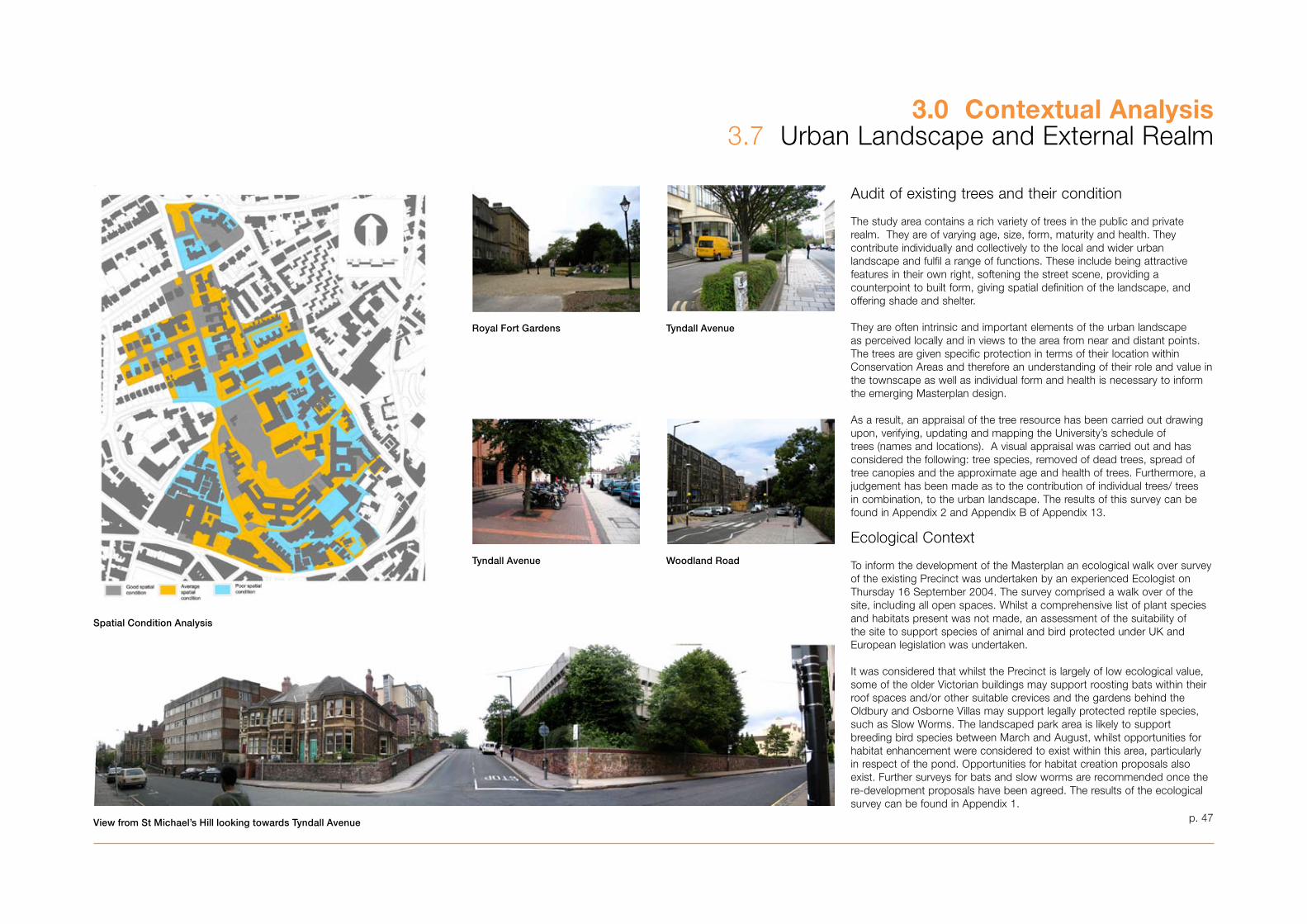
p. 47
3.0 Contextual Analysis�.7 Urban Landscape and External Realm
Audit of existing trees and their condition
The study area contains a rich variety of trees in the public and private realm. They are of varying age, size, form, maturity and health. They contribute individually and collectively to the local and wider urban landscape and fulfil a range of functions. These include being attractive features in their own right, softening the street scene, providing a counterpoint to built form, giving spatial definition of the landscape, and offering shade and shelter.
They are often intrinsic and important elements of the urban landscape as perceived locally and in views to the area from near and distant points. The trees are given specific protection in terms of their location within Conservation Areas and therefore an understanding of their role and value in the townscape as well as individual form and health is necessary to inform the emerging Masterplan design.
As a result, an appraisal of the tree resource has been carried out drawing upon, verifying, updating and mapping the University’s schedule of trees (names and locations). A visual appraisal was carried out and has considered the following: tree species, removed of dead trees, spread of tree canopies and the approximate age and health of trees. Furthermore, a judgement has been made as to the contribution of individual trees/ trees in combination, to the urban landscape. The results of this survey can be found in Appendix 2 and Appendix B of Appendix 1�.
Ecological Context
To inform the development of the Masterplan an ecological walk over survey of the existing Precinct was undertaken by an experienced Ecologist on Thursday 16 September 2004. The survey comprised a walk over of the site, including all open spaces. Whilst a comprehensive list of plant species and habitats present was not made, an assessment of the suitability of the site to support species of animal and bird protected under UK and European legislation was undertaken.
It was considered that whilst the Precinct is largely of low ecological value, some of the older Victorian buildings may support roosting bats within their roof spaces and/or other suitable crevices and the gardens behind the Oldbury and Osborne Villas may support legally protected reptile species, such as Slow Worms. The landscaped park area is likely to support breeding bird species between March and August, whilst opportunities for habitat enhancement were considered to exist within this area, particularly in respect of the pond. Opportunities for habitat creation proposals also exist. Further surveys for bats and slow worms are recommended once the re-development proposals have been agreed. The results of the ecological survey can be found in Appendix 1.
Spatial Condition Analysis
View from St Michael’s Hill looking towards Tyndall Avenue
Royal Fort Gardens Tyndall Avenue
Tyndall Avenue Woodland Road
Planning Context
The Masterplan has been produced in accordance with the requirements of PPS12 and associated regulations.
In accordance with Section �8 (6) of the Planning and Compulsory Purchase Act, 2004 planning applications for any future development within the University Precinct will be determined in accordance with the statutory Development Plan “unless material considerations indicate otherwise”.
This Masterplan is a material consideration with the status of a Supplementary Planning Document, principally providing supplementary policy guidance to policy CC4 of the adopted Local Plan.
Relevant Planning Policies
The Statutory Development Plan comprises:
• The Joint Replacement Structure Plan, September 2002; and • The Bristol Local Plan, adopted December 1997.
It is informed by a range of current national and regional planning policy guidance, including:
• RPG 10: Regional Planning Guidance for the South West, 2001• PPS 1: Delivering Sustainable Development, 2005• PPG �: Housing, 2000• PPS 6: Planning for Town Centres, 2005• PPG 9: Nature Conservation, 1994• PPS 12: Local Development Frameworks, 2004• PPG 1�: Transport, 2001• PPG 15: Planning and The Historic Environment, 1994• PPG 16: Archaeology and Planning, 1990
A range of Supplementary Planning Guidance and documents adopted by the Council in accordance with the Development Plan has informed the Masterplan and will guide future detailed development. These include:
• “Conservation Area Enhancement Statements”, 199�• “Responding to Local Character” • SPD7 “Archaeology and Development”, 2006 • SPD1 “Tall Buildings”. 2005 • “Creating an Accessible Environment” • “Safety and Security” • SPD4 “Planning Obligations”, 2005 • SPD5 “Sustainable Construction”, 2005
There is also a range of additional non-statutory guidance, which comprises:
• Bristol’s Local Transport Plan• Bristol’s City Centre Strategy (Nov 2005) • Creating Excellent Buildings, A Guide for Clients, CABE 200�• Secured By Design
• Enabling a Sustainable City, Enabling Strategy 200�/04 – 2005/06• The Equalities Policy, April 200�• Bristol’s Local Agenda 21 Strategy and Action Plan• Bristol’s Community Strategy, 2006• The Value of Urban Design, CABE and DETR, 2001; and• Design Review, Guidance on how CABE Evaluates Quality in Architecture
and Urban Design, CABE 2002
The emerging Alterations to the Bristol Local Plan have now been halted in favour of the progression of the Local Development Framework. But the Local Plan has been ‘saved’ until replaced by Local Development Documents.
Location and Designation
The adopted Local Plan situates the University Precinct within the north-west of Bristol’s city centre in an area designated as the University Area. This area covers parts of the neighbourhoods of Clifton, Cotham and Kingsdown.
The University Precinct lies adjacent to the Cotham, Redland and Gloucester Road Conservation Area and is covered by four separate Conservation Areas. These are:
• Tyndall’s Park• Park Street and Brandon Hill• Whiteladies Road• St Michael’s Hill and Christmas Steps
The Royal Fort and its gardens, situated within the heart of the Precinct, is designated an historic landscape and an area of open space, playing fields and recreation ground.
The University Precinct is situated within the Inner Area Parking Zone.
The Principal Policy Tests
Six principal policy issues are relevant to the Masterplan and any future development within the University Precinct. These are set out in detail in the following sections:
i) Sustainabilityii) Development of appropriate land uses within the defined University
Precinctiii) Impact on the historic environmentiv) Impact on the built environmentv) Impact on the natural environment; andvi) Vehicular and pedestrian movement
This list is not exhaustive and there are other policy tests and material considerations that will need to be taken into account.
Sustainability
Development Plan In accordance with Policy 1 of the Joint Replacement Structure Plan the Masterplan must ensure that future development of the Precinct is ‘sustainable’ in the widest sense of the word:
• maximising the efficient use of brownfield land• creating an integrated transport system• high quality urban and detailed design• reusing existing buildings, where feasible• minimising the environmental impact of new development• creating sustainable communities• maximising access to community, cultural and leisure facilities• engaging the community in the development process, and • maximising opportunities for local businesses, labour and training
Government GuidanceRPG 10 seeks to ensure that development is sustainable in terms of accessing a variety of modes of transport and reducing car use, managing natural, built and infrastructure resources, high quality design and improving the region’s economic performance and prosperity.
PPS 1 seeks to ensure sustainable development is pursued in an integrated manner, is accessible, is of a high quality urban and detailed design, maximises the efficient use of land, protects or enhances the environment and involves the local community in the production of a vision for their area.
Supplementary Planning Guidance/DocumentSPD5 ‘Sustainable Construction’ seeks to ensure that future development encompasses the principles of sustainability. It also seeks to ensure that local residents, key stakeholders and minority groups are involved in the process of developing the Masterplan. Development of Appropriate Land Uses Within the Defined University Precinct
The University is seeking to consolidate academic facilities within the University Precinct, along with the necessary administrative and support services. This range of activities finds encouragement in planning policies at all levels.
Development Plan Policy CC4 of the adopted Local Plan encourages the University to focus University-related development within the defined Precinct and on sites outside the Precinct currently in institutional or commercial use. This encouragement allows for the development of the University’s ancillary facilities including social facilities such as the Students’ Union, refectories and associated bars and cafés.
The Explanatory Text seeks to ensure that new development within the University Precinct:
• Retains existing buildings and features that contribute to the area’s character and where necessary secure the enhancement of their setting
p. 48
3.0 Contextual Analysis�.8 Planning Policy
3.0 Contextual Analysis�.8 Planning Policy
• Is of a sympathetic design• Improves the pedestrian environment, increases safety and security,
landscaping and traffic calming and reduces the visual impact of parked cars; and
• Creates a lively, active environment outside academic hours
Policy CS7 of the adopted Local Plan ensures that the expansion and development of new higher education facilities does not adversely affect residential amenity or highway safety, and that it is accessible by public transport.
Adopted Local Plan policies H8 and H10 seek to utilise upper floors of commercial development for residential accommodation and allow for the development of student accommodation in the form of non self contained bed sits, shared accommodation or hostels.
Adopted Local Plan policy EC1 allows for commercial development providing there is no unacceptable residential and environmental impact, the site is accessible by a variety of modes of transport and will not adversely affect highway safety. Policies S1 and S2 of the adopted Local Plan seek to ensure the protection of the vitality and viability of Bristol’s shopping provision, including the nearby Local Centres of St. Michael’s Hill and Perry Road.
Government GuidancePPS 1 and PPG 1� encourage the development of high-density mixed uses, particularly at strong public transport nodes and in locations readily accessible by a variety of means of transport. PPS 6 encourages the development of a diversity of uses (including University and ancillary facilities) within town centres to enhance their vitality and viability.
The inclusion of ancillary facilities will ensure the development of more attractive, safe and vibrant areas, which provide a range of uses that are accessible beyond normal academic hours and throughout the year and that supplement the existing retail centre of St Michael’s Hill. RPG 10 seeks to ensure that as part of the region’s spatial strategy and in accordance with the requirement to focus growth and economic development in Bristol. Policy EN5: Health, Education, Safety and other Social Infrastructure seeks to ensure the varied provision of facilities for education and training.
Impact on the Historic Environment
Development Plan In accordance with policy 19 of the Joint Replacement Structure Plan, policies B1�, B15, B16, B17, B18, B19 and B21 of the adopted Local Plan seek to ensure that future development involving listed buildings and buildings within designated Conservation Areas preserves or enhances the character and appearance of the buildings and the Conservation Area. Policy B22 of the adopted Local Plan is of relevance as the University Precinct is situated within an archaeologically sensitive area. Where there is evidence of archaeological remains as identified in the site-wide Archaeological Desk Top Study and archaeological hot-spot drawing that have already been produced by BARAS and where required by the City Archaeologist, pre or post-determination evaluations will be undertaken for individual applications on sites affected by the Masterplan proposals.
If nationally significant remains are revealed, then any future development proposals will have to demonstrate that they can be preserved in situ or the impact of the proposal can be mitigated. If the remains are not scheduled or of national importance, that the site is adequately recorded prior to destruction.
Government GuidancePPG 15 seeks to ensure the positive management of change within the historic environment and the protection or enhancement of listed buildings and buildings that make a positive contribution to the character and appearance of designated Conservation Areas.
PPG 16 establishes government policy on how archaeological remains should be assessed and handled through re-development proposals. This is reflected in the requirements of adopted Local Plan policy B22.
Supplementary Planning Guidance/DocumentsThe City Council’s Conservation Area Enhancement Statements provide a description of each Conservation Area, the key issues affecting them and general enhancement objectives for future development within them. SPD7, Archaeology and Development, gives further guidance on the principles as set out in policy B22 and explains the procedures which the Council expects to be followed in the development process.
Impact on the Built Environment
Development Plan In conjunction with policy 19 of the Joint Replacement Structure Plan, policies B1, B2, B4, B5, B6, B7 and B10 of the adopted Local Plan seek to ensure that future development is of a high quality design that integrates well with its context in terms of built form and landscaping and that creates a secure and safe environment that maximises pedestrian accessibility and minimises car movements.
Government GuidancePPS 1 seeks to ensure new development and public and private spaces within the Precinct are of high quality urban design and detailed building design that accords with its context and creates or reinforces local distinctiveness, are safe and accessible and are sustainable, durable and adaptable and make efficient use of resources. It advocates that good design should be the aim of all those involved in the development process. It can help promote sustainable development by supporting local facilities and transport networks, improve the quality of the existing environment, attract investment and reinforce a sense of place.
Supplementary Planning Guidance/DocumentsSPD1 Tall Buildings, deals with the development of tall buildings within Bristol. It identifies an area within the designated Precinct that may be suitable for a single iconic tall building on the top of the Clifton/Kingsdown Escarpment.
In accordance with this Supplementary Planning Document, a new tall building must be of a contemporary and memorable design, work sensitively within its context and not undermine existing landmark buildings within the Precinct, as well as satisfying other criteria in SPD1.
Impact on the Natural Environment
Development Plan Policies NE1, NE9, NE10 and L1 of the adopted Local Plan seek to protect, maintain, enhance and restore existing open spaces, including historic landscapes, existing playing fields and recreational areas. The University Precinct is not covered by any designated wildlife habitats, sites of nature conservation interest, sites of special scientific interest and/or nature reserves. However, the relevant tests of policy 18 of the Joint Replacement Structure Plan and policies NE6 and NE8 of the adopted Local Plan seek to protect and, where possible, enhance the city’s wildlife network and ensure the protection of nationally protected species and habitats.
Government Guidance The protection of nationally protected species is controlled by the provisions of a range of legislation; specifically the Wildlife and Countryside Act 1981. The protection, management and enhancement of ecological networks are recognised as important in the EU Habitats Directive and PPG 9.
PPG 9 seeks to ensure that policies for nature conservation contribute to the conservation of the abundance and diversity of the wildlife and habitats, minimise the adverse effects on wildlife and ensure effective conservation of wildlife and natural habitats.
Supplementary Planning Guidance/DocumentsThe Bristol City Centre Strategy Draft Consultation Update 2005-2010 seeks to ensure that new development enhances the appearance of the area, reduces the visual impact of parked cars, maintains footpath links and retains mature planting.
Vehicular and Pedestrian Movement
Development Plan In accordance with the requirements of policies 47, 51, 52 and 59 of the Joint Replacement Structure Plan, policies M1, M2, M� and M16 of the adopted Local Plan seek to ensure that new development does not increase the use of cars. They aim to minimise excessive traffic, increase pedestrian and cycle movement, increase public transport facilities, provide traffic calming and improvement measures and improve accessibility for people with impaired mobility.
Government GuidancePPG 1� seeks to ensure the development of more sustainable transport choices in conjunction with environmental and land-use planning policies to ensure improved accessibility by public transport and a variety of modes of transport other than the private car.
p. 49

3.0 Contextual Analysis�.9 Consultation Process During Preparation of the Masterplan
p. 50
Approach
The University of Bristol has been committed to involving stakeholders and the wider public as an integral part of the process for bringing forward a Masterplan for the central Precinct area in accordance with the requirements of PPS 12: Local Development Frameworks (2004). A stakeholder consultation programme was drawn up to guide the work of informing and engaging with individuals, groups and organisations with a direct interest in the site. This was then broadened out to include a wider audience within the local community.
The development of the Masterplan and the necessary consultation process has evolved over a period of nearly three years. However, prior to this the University had already begun internally to consult on its long-term estate needs when the potential to acquire the Children’s Hospital site arose in 2000.
The first-stage consultation period on the Masterplan ran from September 200� to January 2004. Following feedback from the consultation process and an appraisal by the University, it was agreed that some further work was required, particularly in relation to analysis of conservation and history of the area and the need to focus more on the quality and design of the public realm. As a result, new architects and landscape architects were appointed to take forward Stage 2. The Masterplan was reviewed and significantly reworked, which allowed further consideration of comments received during the initial stage of consultation. A second series of consultations was carried out from November 2004 to January 2005.
A third stage – the formal public consultation on the Draft Supplementary Planning Document 11 (SPD11) was undertaken by the University and Bristol City Council. This public consultation process ran for a six week period from 28 November 2005 – 9 January 2006. The Council evaluated the feedback given during this period and this has helped to inform the final wording and format of the Masterplan documentation. Appendix � provides more detail on the consultation procedure and the events and activities that took place between September 200� and February 2006. What follows is a summary of the three main stages of consultation. Further involvement and consultation will be required as the masterplan is translated into schemes and proposals. The University and Council are committed to further consultation.
Consultation Strategy for Stages 1 & 2
The process was devised with the following aims and objectives:• To raise awareness that the University is committed to producing a
Masterplan to guide future development of the Precinct area over the next decade.• To explain the background to the Masterplan, how the brief meets the
University’s future needs and define the area covered by the proposals.• To introduce the project team and make these consultants available to
stakeholders and public. • To provide a clear and transparent mechanism for allowing and
encouraging individuals and representatives of groups to be involved in the process.• To find out what the stakeholders and general public feel about the
proposals as the Masterplan evolves and to be able to update them on progress and feedback changes.
• To demonstrate that the resulting solution has benefited from the input and contribution of stakeholders, consultees and the public.
The involvement and consultation process has targeted a number of different audiences. These included local and Bristol-wide stakeholders, the University community, members of the public living/working in the Precinct and surrounding area and other key consultees.
Format of the Consultation Process
The consultation process has involved a range of formal and more informal events including: small stakeholder presentations and workshops, key topic area hands-on focus group workshops, internal University briefings, members briefings, public drop-in sessions and one-to-one briefings with named consultees.
All stakeholder sessions, workshops and drop-in sessions have been facilitated by Avril Baker, an independent adviser. Proceedings and feedback have been compiled into reports which have been circulated to all invitees. Comments raised at all these sessions have been fed back to the project team to assist in the ongoing preparation of the draft Masterplan.
Stakeholders were notified of events by letter and for the public drop-in sessions members of the local community received hand-delivered invitations supported by public notices in the local newspapers. Internally, staff and students were informed through the University website, in-house magazine and directorate/faculty briefings.
Stakeholder and Public Consultation Programme22 September 200� first stakeholder workshop25 November 200� members briefing for Bristol City Council1 December 200� second stakeholder workshop
Stakeholder workshop
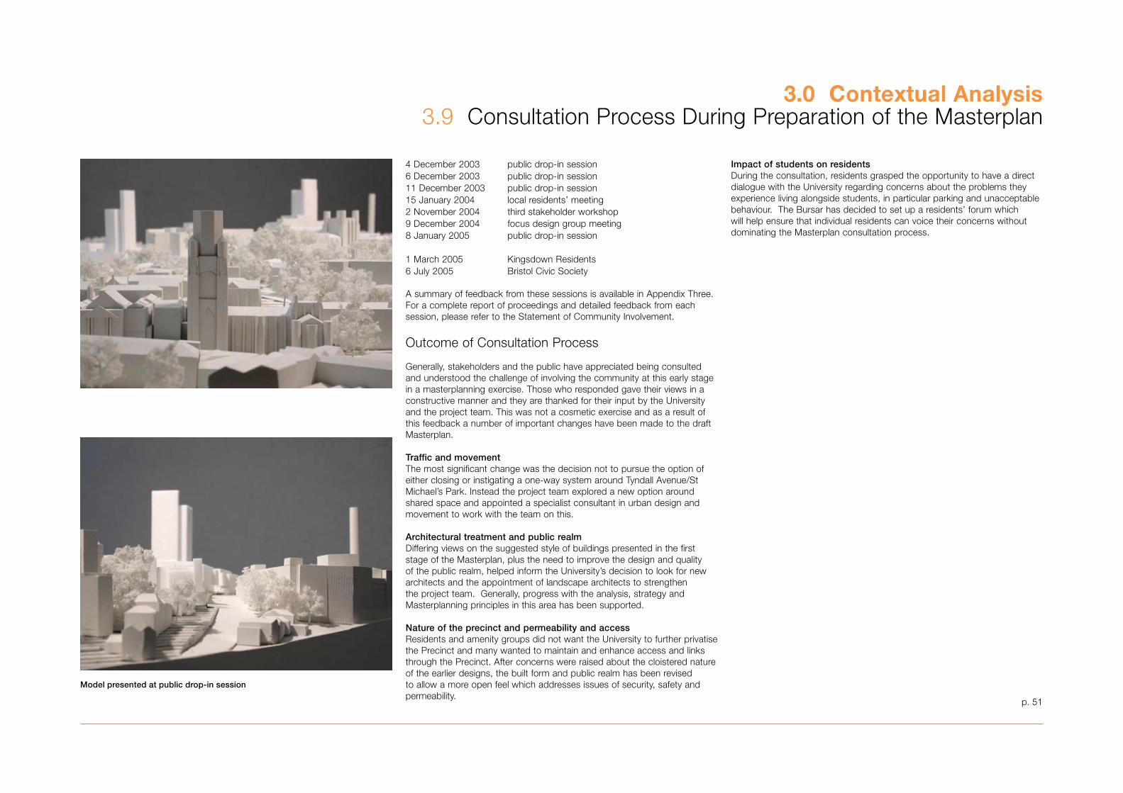
p. 51
Impact of students on residentsDuring the consultation, residents grasped the opportunity to have a direct dialogue with the University regarding concerns about the problems they experience living alongside students, in particular parking and unacceptable behaviour. The Bursar has decided to set up a residents’ forum which will help ensure that individual residents can voice their concerns without dominating the Masterplan consultation process.
3.0 Contextual Analysis�.9 Consultation Process During Preparation of the Masterplan
4 December 200� public drop-in session6 December 200� public drop-in session11 December 200� public drop-in session15 January 2004 local residents’ meeting2 November 2004 third stakeholder workshop9 December 2004 focus design group meeting8 January 2005 public drop-in session
1 March 2005 Kingsdown Residents6 July 2005 Bristol Civic Society
A summary of feedback from these sessions is available in Appendix Three. For a complete report of proceedings and detailed feedback from each session, please refer to the Statement of Community Involvement.
Outcome of Consultation Process
Generally, stakeholders and the public have appreciated being consulted and understood the challenge of involving the community at this early stage in a masterplanning exercise. Those who responded gave their views in a constructive manner and they are thanked for their input by the University and the project team. This was not a cosmetic exercise and as a result of this feedback a number of important changes have been made to the draft Masterplan.
Traffic and movementThe most significant change was the decision not to pursue the option of either closing or instigating a one-way system around Tyndall Avenue/St Michael’s Park. Instead the project team explored a new option around shared space and appointed a specialist consultant in urban design and movement to work with the team on this.
Architectural treatment and public realmDiffering views on the suggested style of buildings presented in the first stage of the Masterplan, plus the need to improve the design and quality of the public realm, helped inform the University’s decision to look for new architects and the appointment of landscape architects to strengthen the project team. Generally, progress with the analysis, strategy and Masterplanning principles in this area has been supported.
Nature of the precinct and permeability and accessResidents and amenity groups did not want the University to further privatise the Precinct and many wanted to maintain and enhance access and links through the Precinct. After concerns were raised about the cloistered nature of the earlier designs, the built form and public realm has been revised to allow a more open feel which addresses issues of security, safety and permeability.
Model presented at public drop-in session
Public Consultation on Draft SPD11, Stage 3
A six week public consultation exercise was carried out by the Council and the University and their project team. The consultation ran from 28 November 2005 through to 9 January 2006.
Notifying public and stakeholdersA full colour leaflet was prepared which provided information on the masterplan documentation and the public consultation exercise. This included details of the public exhibition at Senate House and later Brunel House with information about meet the team sessions at both locations. It also gave addresses of the City Council and University websites which both carried the full masterplan documentation and an online questionnaire.
Five thousand copies of the leaflet were distributed. Local residents and neighbours in the surrounding area were notified of the consultation through a hand-delivered leaflet which was also available in local libraries and University public buildings. A letter and leaflet was also sent to all those stakeholders who had participated in previous stakeholder workshops and to members of the public who had attended one of the public drop-in sessions.
Public notices were placed by the Council in the Bristol Evening Post and the Western Daily Press. A press release was issued to coincide with the start of the consultation which received wide coverage in local press & media.
Within the University there were articles placed in the University staff magazine, in the student newspaper Epigram and on the University website.
Stakeholder and public consultation programme:6 October 2005 update workshop and presentation for core stakeholders – Senate House28 November – 9 December 2005 Public Exhibition at Senate House6 December 2005 meet the team session12 December 2005 – 10 January 2006 – Public Exhibition at Brunel House15 December 2005 meet the team session� January 2006 Bristol Physical Access Group presentation17 January 2006 presentation by officers to the Conservation Advisory Panel8 February 2006 presentation by officers to the Development Control (Central) Committee22 February 2006 presentation by the University’s project team to the Clifton & Hotwells Improvement Society
Outcome of the Consultation Process
Many people took up the opportunity to visit the exhibition at either Senate House or Brunel House and over 75 attended one of the meet the team sessions. A total of 119 responses to the on line questionnaire were received either on line or in hard copy form and a further �8 bodies and individuals made written comments. These responses were evaluated and assessed by the Council and are summarised in the report to the Council’s Cabinet. There was a very broad range of issues covered in the responses and the main headlines were concerned with:
• Access, movement and parking• The tall building• Scale and character of development on St Michael’s Hill frontage• Loss of green space for the Welcome Centre and Tyndall Place proposal• The form of a redeveloped Hawthorns site
The report to Cabinet identifies the changes made to the draft SPD leading to this adopted version.
Changes to the masterplan documentationAs a result of consultation and feedback there have been further discussions between the Council and the University and certain amendments and additions have been made to the SPD documentation as follows:
Transport, access & parking – existing information has been drawn together from various sections of the masterplan documentation and new information has been presented within the renamed ‘Access & Movement’ section. Information particularly shows how the masterplan fits with the University’s own green travel plan and the impact of proposals on the wider area.
A Strategic Access Statement has been produced following feedback from the Bristol Physical Access Group meeting. This has been agreed with officers and provided as a new stand alone document.
Tall building – modelling has been undertaken of the view from the M�2 approach into the city. This additional key view has been added to Appendix 9. Additional text has also been added to Strategic Move 8/Appendix 9 to more closely relate development aspirations to the requirements of SPD 1.
Building Design guidance – additional text and diagrams have been provided to section 5.1 to strengthen and enhance the building design codes throughout the precinct and in relation to specific development sites.
St Michael’s Hill frontage – further graphics and text has been added to the strategic move to underline the importance of the historic context, the juxtaposition between old and new buildings and the resulting design rationale.
Welcome Centre and Tyndall Place and the Hawthorns –alternative options for the proposed new buildings on each site have been brought into the main document from the appendices. Further explanation has been given regarding the opportunities to improve the open space/public realm and on building style.
Student Accommodation – additional information about the University’s position regarding student numbers and the future location of any student, post graduate or staff residences has been provided in section 1.
Statement of community involvement – this section (�.9) and Appendix � have been brought up to date to include the public consultation exercise.
Section 2 – the order of the text in Section 2 has been amended so that section 2.14 now works as an executive summary for this section of the Masterplan.
Other - During the public consultation a number of other issues and comments were raised which were outside the scope of the Masterplan. These will help to inform the University’s future work especially relations with the local community.
3.0 Contextual Analysis�.9 Consultation Process During Preparation of the Masterplan
p. 52
p. 5�
4.0 Masterplan
‘The Masterplan has five key objectives:
It will deliver an improved physical environment
It will create a better mix of spaces and uses in the Central Precinct area
It will create better accessibility to, across and throughout the University It will design for a sustainable future It will create better relationships between the University and neighbouring communities’
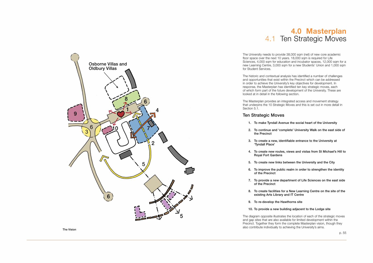
p. 55
4.0 Masterplan4.1 Ten Strategic Moves
The University needs to provide �8,000 sqm (net) of new core academic floor space over the next 10 years. 18,000 sqm is required for Life Sciences, 4,000 sqm for education and incubator spaces, 12,000 sqm for a new Learning Centre, �,000 sqm for a new Students’ Union and 1,000 sqm for Student Services.
The historic and contextual analysis has identified a number of challenges and opportunities that exist within the Precinct which can be addressed in order to achieve the University’s key objectives for development. In response, the Masterplan has identified ten key strategic moves, each of which form part of the future development of the University. These are looked at in detail in the following section.
The Masterplan provides an integrated access and movement strategy that underpins the 10 Strategic Moves and this is set out in more detail in Section 5.1.
Ten Strategic Moves
1. To make Tyndall Avenue the social heart of the University
2. To continue and ‘complete’ University Walk on the east side of the Precinct
3. To create a new, identifiable entrance to the University at ‘Tyndall Place’
4. To create new routes, views and vistas from St Michael’s Hill to Royal Fort Gardens
5. To create new links between the University and the City
6. To improve the public realm in order to strengthen the identity of the Precinct
7. To provide a new department of Life Sciences on the east side of the Precinct
8. To create facilities for a New Learning Centre on the site of the existing Arts Library and IT Centre
9. To re-develop the Hawthorns site
10. To provide a new building adjacent to the Lodge site
The diagram opposite illustrates the location of each of the strategic moves and gap sites that are also available for limited development within the Precinct. Together they form the complete Masterplan vision, though they also contribute individually to achieving the University’s aims.
The Vision
Osborne Villas and Oldbury Villas
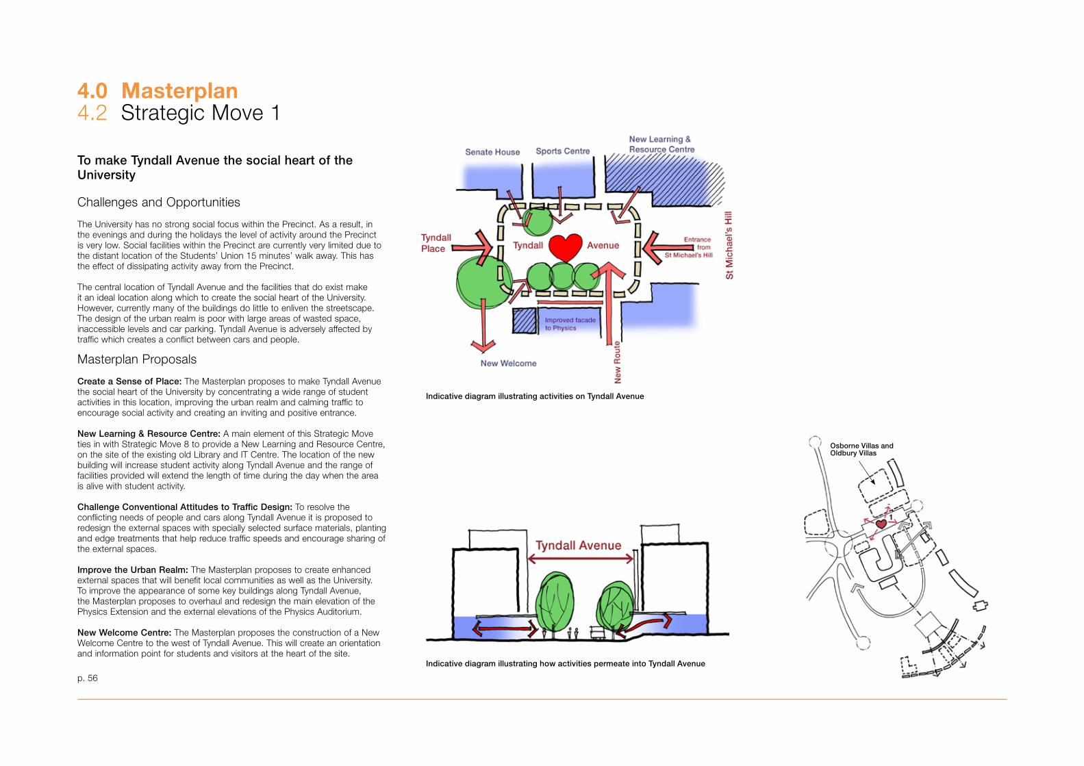
p. 56
4.0 Masterplan4.2 Strategic Move 1
To make Tyndall Avenue the social heart of the University
Challenges and Opportunities
The University has no strong social focus within the Precinct. As a result, in the evenings and during the holidays the level of activity around the Precinct is very low. Social facilities within the Precinct are currently very limited due to the distant location of the Students’ Union 15 minutes’ walk away. This has the effect of dissipating activity away from the Precinct.
The central location of Tyndall Avenue and the facilities that do exist make it an ideal location along which to create the social heart of the University. However, currently many of the buildings do little to enliven the streetscape. The design of the urban realm is poor with large areas of wasted space, inaccessible levels and car parking. Tyndall Avenue is adversely affected by traffic which creates a conflict between cars and people.
Masterplan Proposals
Create a Sense of Place: The Masterplan proposes to make Tyndall Avenue the social heart of the University by concentrating a wide range of student activities in this location, improving the urban realm and calming traffic to encourage social activity and creating an inviting and positive entrance.
New Learning & Resource Centre: A main element of this Strategic Move ties in with Strategic Move 8 to provide a New Learning and Resource Centre, on the site of the existing old Library and IT Centre. The location of the new building will increase student activity along Tyndall Avenue and the range of facilities provided will extend the length of time during the day when the area is alive with student activity. Challenge Conventional Attitudes to Traffic Design: To resolve the conflicting needs of people and cars along Tyndall Avenue it is proposed to redesign the external spaces with specially selected surface materials, planting and edge treatments that help reduce traffic speeds and encourage sharing of the external spaces.
Improve the Urban Realm: The Masterplan proposes to create enhanced external spaces that will benefit local communities as well as the University. To improve the appearance of some key buildings along Tyndall Avenue, the Masterplan proposes to overhaul and redesign the main elevation of the Physics Extension and the external elevations of the Physics Auditorium.
New Welcome Centre: The Masterplan proposes the construction of a New Welcome Centre to the west of Tyndall Avenue. This will create an orientation and information point for students and visitors at the heart of the site.
Indicative diagram illustrating activities on Tyndall Avenue
Indicative diagram illustrating how activities permeate into Tyndall Avenue
Osborne Villas and Oldbury Villas
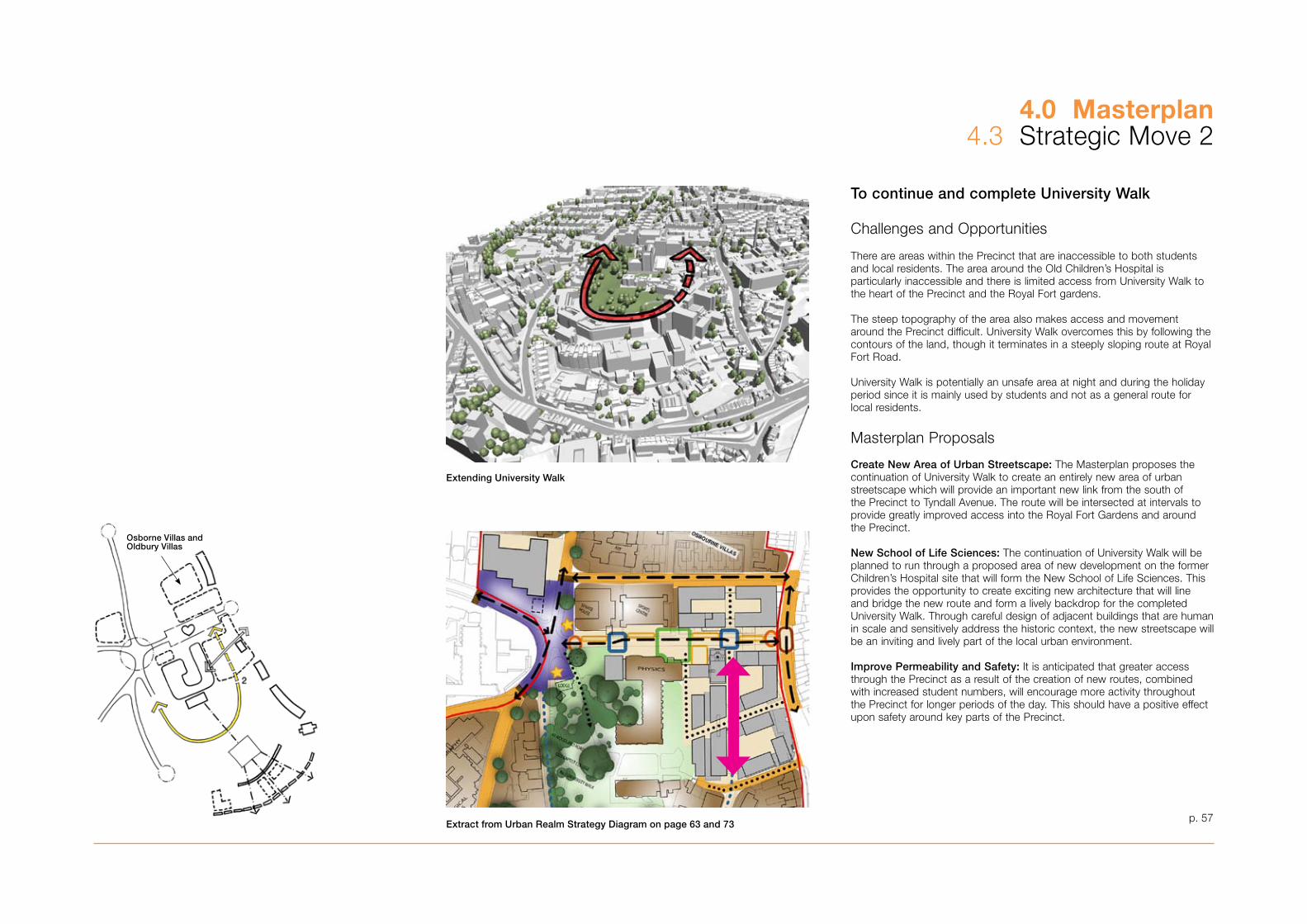
p. 57
4.0 Masterplan4.� Strategic Move 2
To continue and complete University Walk
Challenges and Opportunities
There are areas within the Precinct that are inaccessible to both students and local residents. The area around the Old Children’s Hospital is particularly inaccessible and there is limited access from University Walk to the heart of the Precinct and the Royal Fort gardens.
The steep topography of the area also makes access and movement around the Precinct difficult. University Walk overcomes this by following the contours of the land, though it terminates in a steeply sloping route at Royal Fort Road.
University Walk is potentially an unsafe area at night and during the holiday period since it is mainly used by students and not as a general route for local residents.
Masterplan Proposals
Create New Area of Urban Streetscape: The Masterplan proposes the continuation of University Walk to create an entirely new area of urban streetscape which will provide an important new link from the south of the Precinct to Tyndall Avenue. The route will be intersected at intervals to provide greatly improved access into the Royal Fort Gardens and around the Precinct.
New School of Life Sciences: The continuation of University Walk will be planned to run through a proposed area of new development on the former Children’s Hospital site that will form the New School of Life Sciences. This provides the opportunity to create exciting new architecture that will line and bridge the new route and form a lively backdrop for the completed University Walk. Through careful design of adjacent buildings that are human in scale and sensitively address the historic context, the new streetscape will be an inviting and lively part of the local urban environment.
Improve Permeability and Safety: It is anticipated that greater access through the Precinct as a result of the creation of new routes, combined with increased student numbers, will encourage more activity throughout the Precinct for longer periods of the day. This should have a positive effect upon safety around key parts of the Precinct.
Extending University Walk
Extract from Urban Realm Strategy Diagram on page 63 and 73
Osborne Villas and Oldbury Villas
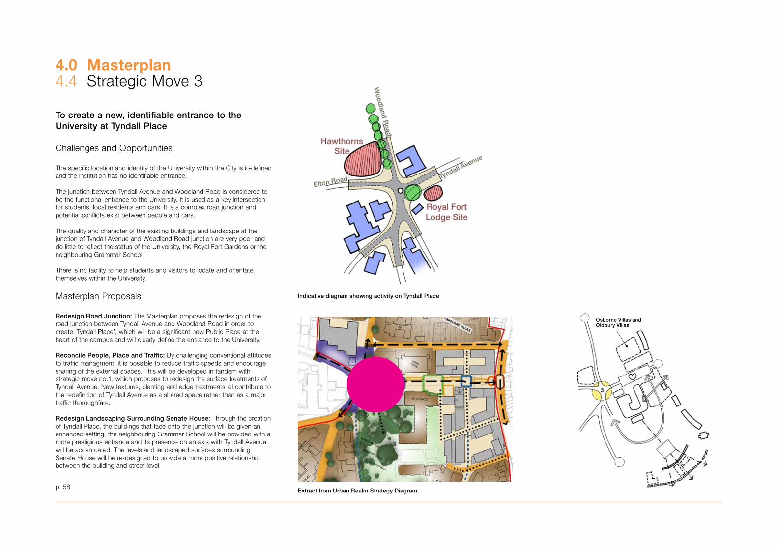
p. 58
To create a new, identifiable entrance to the University at Tyndall Place
Challenges and Opportunities
The specific location and identity of the University within the City is ill-defined and the institution has no identifiable entrance.
The junction between Tyndall Avenue and Woodland Road is considered to be the functional entrance to the University. It is used as a key intersection for students, local residents and cars. It is a complex road junction and potential conflicts exist between people and cars.
The quality and character of the existing buildings and landscape at the junction of Tyndall Avenue and Woodland Road junction are very poor and do little to reflect the status of the University, the Royal Fort Gardens or the neighbouring Grammar School
There is no facility to help students and visitors to locate and orientate themselves within the University.
Masterplan Proposals
Redesign Road Junction: The Masterplan proposes the redesign of the road junction between Tyndall Avenue and Woodland Road in order to create ‘Tyndall Place’, which will be a significant new Public Place at the heart of the campus and will clearly define the entrance to the University.
Reconcile People, Place and Traffic: By challenging conventional attitudes to traffic managment, it is possible to reduce traffic speeds and encourage sharing of the external spaces. This will be developed in tandem with strategic move no.1, which proposes to redesign the surface treatments of Tyndall Avenue. New textures, planting and edge treatments all contribute to the redefinition of Tyndall Avenue as a shared space rather than as a major traffic thoroughfare.
Redesign Landscaping Surrounding Senate House: Through the creation of Tyndall Place, the buildings that face onto the junction will be given an enhanced setting, the neighbouring Grammar School will be provided with a more prestigious entrance and its presence on an axis with Tyndall Avenue will be accentuated. The levels and landscaped surfaces surrounding Senate House will be re-designed to provide a more positive relationship between the building and street level.
4.0 Masterplan4.4 Strategic Move �
Indicative diagram showing activity on Tyndall Place
Extract from Urban Realm Strategy Diagram
Osborne Villas and Oldbury Villas
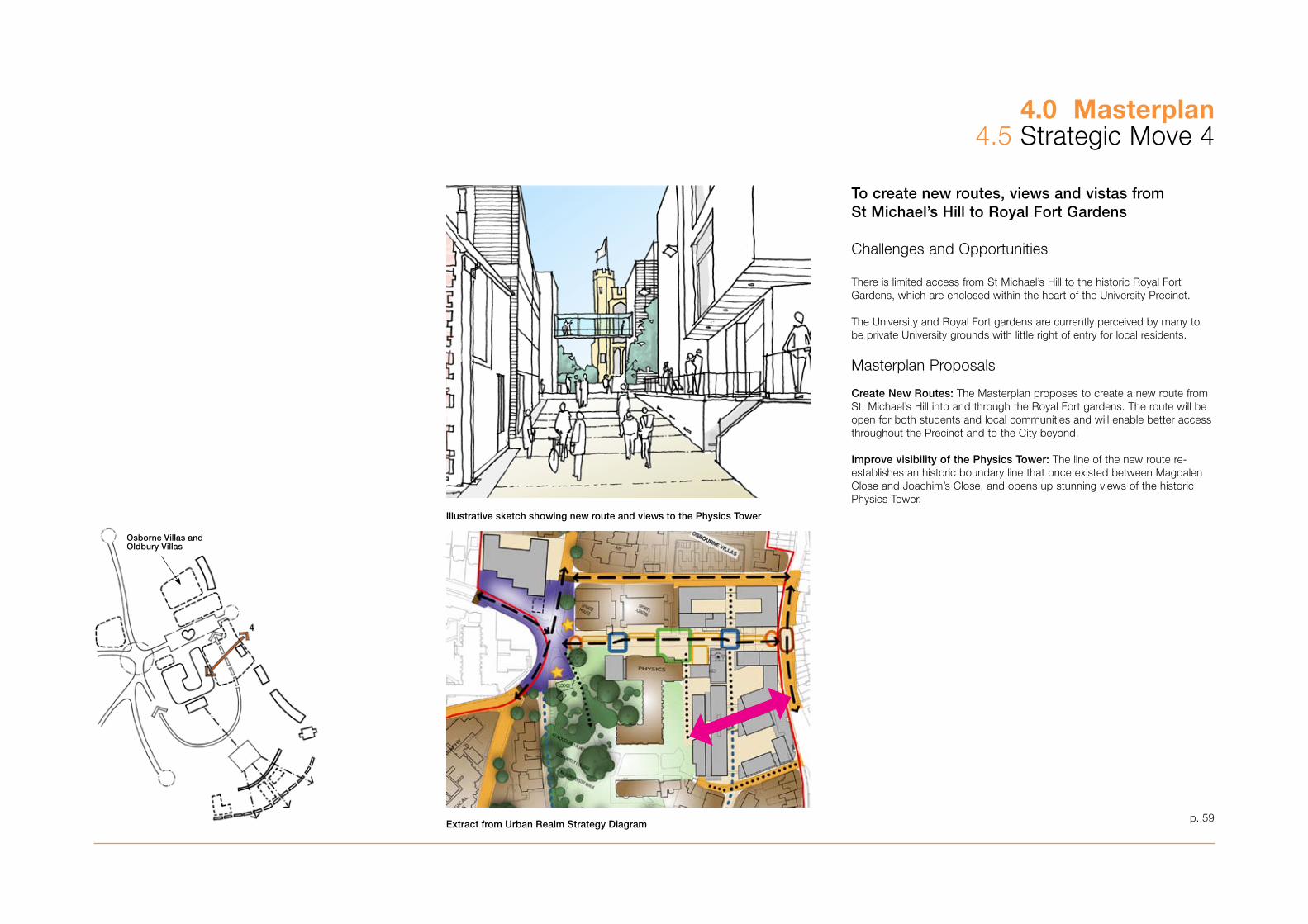
p. 59
To create new routes, views and vistas from St Michael’s Hill to Royal Fort Gardens
Challenges and Opportunities
There is limited access from St Michael’s Hill to the historic Royal Fort Gardens, which are enclosed within the heart of the University Precinct.
The University and Royal Fort gardens are currently perceived by many to be private University grounds with little right of entry for local residents.
Masterplan Proposals
Create New Routes: The Masterplan proposes to create a new route from St. Michael’s Hill into and through the Royal Fort gardens. The route will be open for both students and local communities and will enable better access throughout the Precinct and to the City beyond.
Improve visibility of the Physics Tower: The line of the new route re-establishes an historic boundary line that once existed between Magdalen Close and Joachim’s Close, and opens up stunning views of the historic Physics Tower.
4.0 Masterplan4.5 Strategic Move 4
Illustrative sketch showing new route and views to the Physics Tower
Extract from Urban Realm Strategy Diagram
Osborne Villas and Oldbury Villas

p. 60
To create new links between the University and the City
Challenges and Opportunities
The buildings in some parts of the University restrict movement and permeability between the University and the City to the south.
Earlier Masterplan proposals from the 1950s aimed to create direct links from the Royal Fort gardens down through Chemistry Square and on into the City. However, these ideas were never implemented. Instead a series of interesting spaces have evolved with wonderful views that are under-used and are not shared by the rest of the City.
Some of the University buildings to the south of the Precinct are of poor quality and contribute little to the quality of the urban environment and the appearance of the University.
Masterplan Proposals
Sites at the periphery of the current Precinct offer opportunities for development of relatively small scale buildings. The sites close to Park Row can carry up to approximately 2000m2 each of useable space and thus would be suitable for a medium sized department but would not be large enough to contain a major scientific activity. However in that area of the Precinct the opportunity would exist for creating additional activity space for the Departments of Engineering or Chemistry should this be needed in the future. In addition these areas offer the potential for a reconfiguration of the Department of Drama who are located on a large site which, albeit being somewhat isolated from other performing Arts activities in the University, does provide an interface with the City on Park Row which could be made to be more obvious and welcoming.
The gap site on St Michaels’ Hill similarly offers the opportunity to provide extra space for Medical Sciences, or indeed for residential development.
There are no firm plans for these potential development areas at present and proposals will be in line within the overall Faculty location plans as set out elsewhere in the Masterplan.
In the future the growth in the University’s very successful recycling scheme will create the need for a larger scale collection and delivery arrangement.
4.0 Masterplan4.6 Strategic Move 5
Illustrative diagram showing the existing routes in red and possible new links to be decided and formed in blue between the city and the University
Opportunities to broaden use of Chemistry Square will be researched
Moreover, in order to channel vehicles involved in the collection of recyclable material into suitable areas it will be necessary to create a central marshalling point for all recyclable materials. It is envisaged that existing hard standing areas, including car parks, would be the most appropriate for the location of such facilities. At present the most suitable potential site for this is adjacent to the buildings at 1-9 Old Park Hill. The loss of car parking space that would arise has been factored into the calculations elsewhere in the Masterplan.
Celebrate Bristol’s Topography: As part of the Masterplan it is proposed to improve the links between the City to the south and the University by providing new routes that bridge the topography of the site and the impenetrable barriers created by the University’s buildings. These routes will be achieved through the construction of new buildings on infill or replacement sites, stairs and ramps that allow through-movement and changes in level.
Enliven Under-used Spaces: In providing access from the City, under-used spaces including Chemistry Square will become more vibrant parts of the University.
Osborne Villas and Oldbury Villas
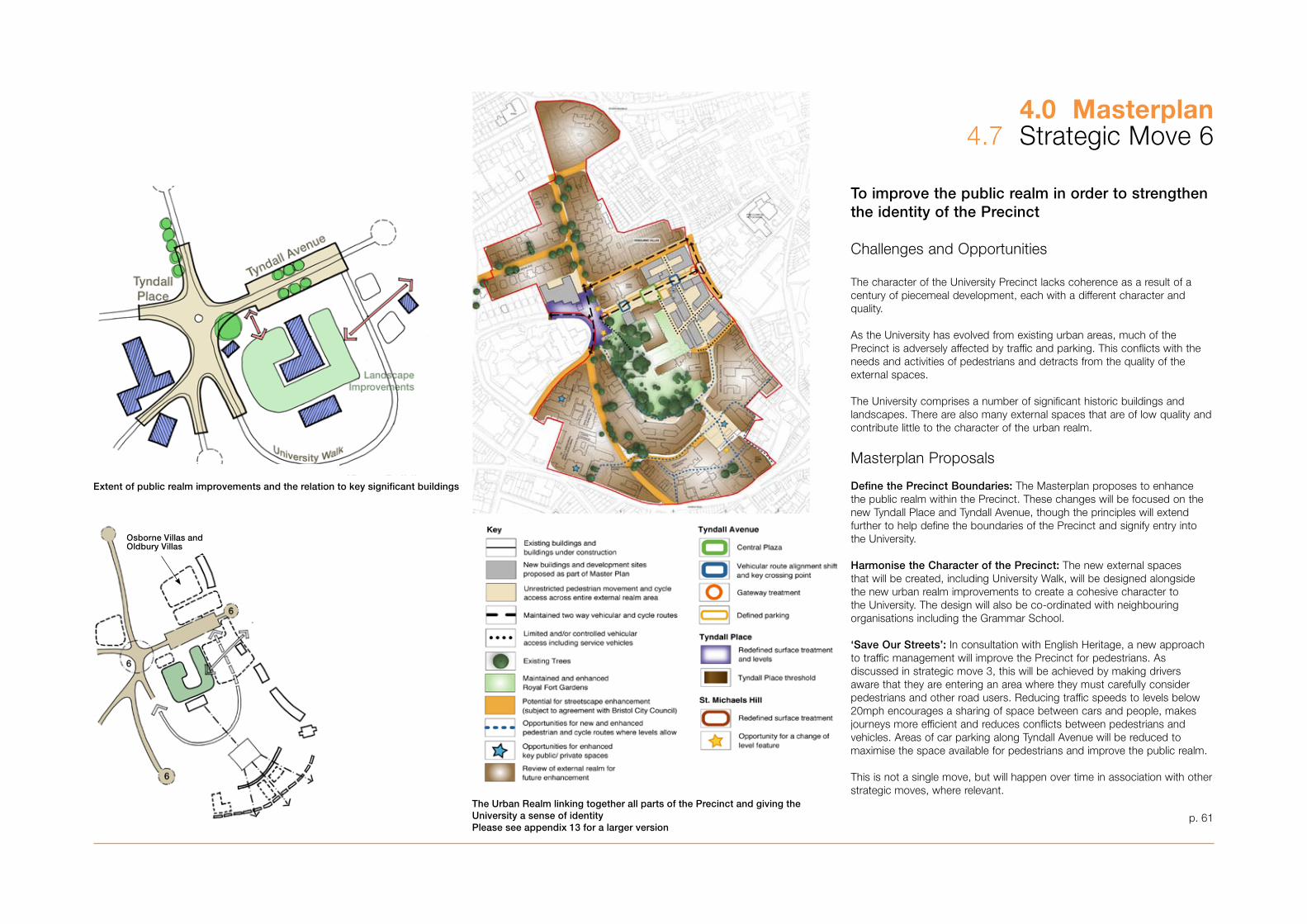
p. 61
To improve the public realm in order to strengthen the identity of the Precinct
Challenges and Opportunities
The character of the University Precinct lacks coherence as a result of a century of piecemeal development, each with a different character and quality. As the University has evolved from existing urban areas, much of the Precinct is adversely affected by traffic and parking. This conflicts with the needs and activities of pedestrians and detracts from the quality of the external spaces.
The University comprises a number of significant historic buildings and landscapes. There are also many external spaces that are of low quality and contribute little to the character of the urban realm.
Masterplan Proposals
Define the Precinct Boundaries: The Masterplan proposes to enhance the public realm within the Precinct. These changes will be focused on the new Tyndall Place and Tyndall Avenue, though the principles will extend further to help define the boundaries of the Precinct and signify entry into the University.
Harmonise the Character of the Precinct: The new external spaces that will be created, including University Walk, will be designed alongside the new urban realm improvements to create a cohesive character to the University. The design will also be co-ordinated with neighbouring organisations including the Grammar School.
‘Save Our Streets’: In consultation with English Heritage, a new approach to traffic management will improve the Precinct for pedestrians. As discussed in strategic move �, this will be achieved by making drivers aware that they are entering an area where they must carefully consider pedestrians and other road users. Reducing traffic speeds to levels below 20mph encourages a sharing of space between cars and people, makes journeys more efficient and reduces conflicts between pedestrians and vehicles. Areas of car parking along Tyndall Avenue will be reduced to maximise the space available for pedestrians and improve the public realm.
This is not a single move, but will happen over time in association with other strategic moves, where relevant.
4.0 Masterplan4.7 Strategic Move 6
Extent of public realm improvements and the relation to key significant buildings
The Urban Realm linking together all parts of the Precinct and giving the University a sense of identityPlease see appendix 13 for a larger version
Osborne Villas and Oldbury Villas
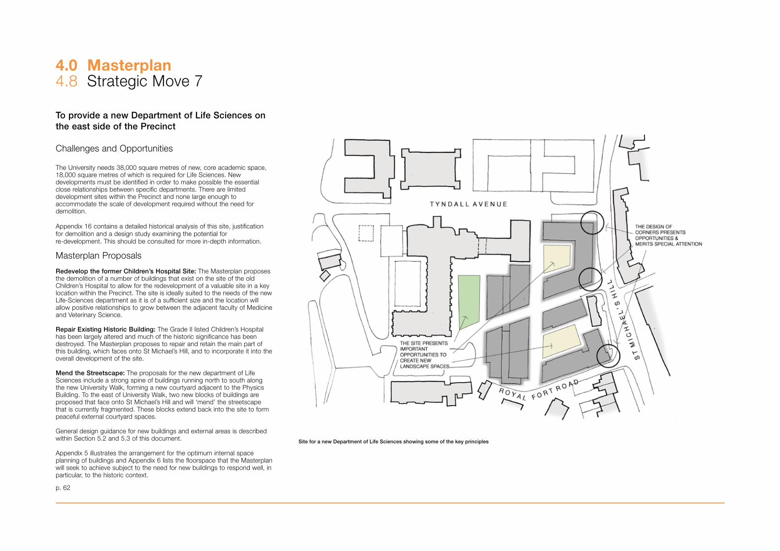
To provide a new Department of Life Sciences on the east side of the Precinct
Challenges and Opportunities
The University needs �8,000 square metres of new, core academic space,18,000 square metres of which is required for Life Sciences. New developments must be identified in order to make possible the essential close relationships between specific departments. There are limited development sites within the Precinct and none large enough to accommodate the scale of development required without the need for demolition.
Appendix 16 contains a detailed historical analysis of this site, justification for demolition and a design study examining the potential for re-development. This should be consulted for more in-depth information.
Masterplan Proposals
Redevelop the former Children’s Hospital Site: The Masterplan proposes the demolition of a number of buildings that exist on the site of the old Children’s Hospital to allow for the redevelopment of a valuable site in a key location within the Precinct. The site is ideally suited to the needs of the new Life-Sciences department as it is of a sufficient size and the location will allow positive relationships to grow between the adjacent faculty of Medicine and Veterinary Science.
Repair Existing Historic Building: The Grade II listed Children’s Hospital has been largely altered and much of the historic significance has been destroyed. The Masterplan proposes to repair and retain the main part of this building, which faces onto St Michael’s Hill, and to incorporate it into the overall development of the site.
Mend the Streetscape: The proposals for the new department of Life Sciences include a strong spine of buildings running north to south along the new University Walk, forming a new courtyard adjacent to the Physics Building. To the east of University Walk, two new blocks of buildings are proposed that face onto St Michael’s Hill and will ‘mend’ the streetscape that is currently fragmented. These blocks extend back into the site to form peaceful external courtyard spaces.
General design guidance for new buildings and external areas is described within Section 5.2 and 5.� of this document.
Appendix 5 illustrates the arrangement for the optimum internal space planning of buildings and Appendix 6 lists the floorspace that the Masterplan will seek to achieve subject to the need for new buildings to respond well, in particular, to the historic context.
4.0 Masterplan4.8 Strategic Move 7
p. 62
Site for a new Department of Life Sciences showing some of the key principles
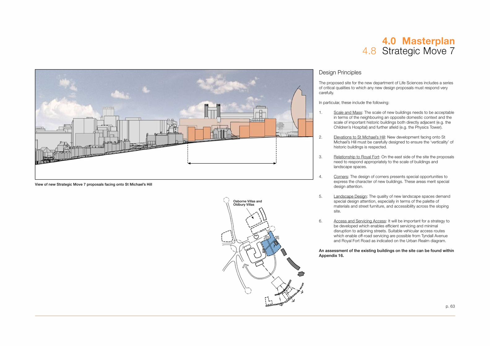
4.0 Masterplan4.8 Strategic Move 7
p. 6�
Design Principles
The proposed site for the new department of Life Sciences includes a series of critical qualities to which any new design proposals must respond very carefully.
In particular, these include the following:
1. Scale and Mass: The scale of new buildings needs to be acceptable in terms of the neighbouring an opposite domestic context and the scale of important historic buildings both directly adjacent (e.g. the Children’s Hospital) and further afield (e.g. the Physics Tower).
2. Elevations to St Michael’s Hill: New development facing onto St Michael’s Hill must be carefully designed to ensure the ‘verticality’ of historic buildings is respected.
�. Relationship to Royal Fort: On the east side of the site the proposals need to respond appropriately to the scale of buildings and landscape spaces.
4. Corners: The design of corners presents special opportunities to express the character of new buildings. These areas merit special design attention.
5. Landscape Design: The quality of new landscape spaces demand special design attention, especially in terms of the palette of materials and street furniture, and accessibility across the sloping site.
6. Access and Servicing Access: It will be important for a strategy to be developed which enables efficient servicing and minimal disruption to adjoining streets. Suitable vehicular access routes which enable off-road servicing are possible from Tyndall Avenue and Royal Fort Road as indicated on the Urban Realm diagram.
An assessment of the existing buildings on the site can be found within Appendix 16.
View of new Strategic Move 7 proposals facing onto St Michael’s Hill
Osborne Villas and Oldbury Villas

To relocate the Students’ Union and create facilities for a new Learning and Resource Centre
Challenges and Opportunities
The Arts Library and IT Centre on Tyndall Avenue are becoming increasingly unsuitable for their existing functions. The decentralised nature of many student facilities, including departmental libraries and catering facilities, makes them inefficient to operate and manage. The existing Students’ Union is inefficient and costly to operate and its location dissipates student activity away from the Precinct. There is therefore a strong need for a major new Learning Resource Centre to meet with the changing needs of the University. There is limited space within the Precinct for future development and the area currently occupied by the Library and IT Centre presents a valuable opportunity for the expansion of the University. 16,000sqm is required for a new Learning & Resource Centre, Students’ Union and student services.
Masterplan Proposals
Focus Student Activities: The University proposes to combine and relocate its main student facilities into a single building at the heart of the Precinct in order to encourage wider usage and improve operational efficiency. The Students’ Union and student services facilities will be moved from the existing building on Queens Road and housed in a New Learning and Resource Centre on the site of the existing Arts Library and IT Centre. The LRC will also incorporate a single library facility that will replace the individual faculty libraries that exist on the campus.
The architectural form will respond to the scale of the surrounding University buildings and could, in accordance with the Council’s adopted Tall Buildings Policy incorporate a tower that signifies the importance of the building and emphasises its location and seminal function within the Precinct. This also accords with the University’s desire to combine a number of closely related student based activities into one cohesive environment. Appendix 9 contains a study that shows where a tower could be located within the new Learning and Resources Centre and in terms of impact on strategic views this opportunity has not been ruled out. It is important to note that this Masterplan does not propose a tower here, it simply acknowledges that there is an opportunity to achieve a tower here provided that it is of exceptional and iconic quality and meets all the criteria set out in SP1: Tall Buildings.
It is possible that the developing needs of the University will necessitate redevelopment of the site of Osborne Villas and Oldbury Villas during the life of the Masterplan. The University’s aspiration to demolish and use the area of Osborne Villas for educational purposes is acknowledged, however it is considered that there is currently no case within the existing statutory and policy context for this to occur.
4.0 Masterplan4.9 Strategic Move 8
p. 64
View of new Strategic Move 8 proposals facing onto St Michael’s Hill
Plan showing the agreed potential location for a tall building as part of Strategic Move 8
Osborne Villas and Oldbury Villas

Design Study: ‘Ellipse’
Design Study: ‘Roof Deck’
Design Study: ‘Spinnaker’
p. 65
4.0 Masterplan4.9 Strategic Move 8
However, the City Council recognises the importance of development of this area to the University’s strategic objectives and the wider social and economic benefit to the city which this entails. A compelling case within the existing framework has not been made but were such a case to be made, or were there to be a change in the legislative or policy context, the City Council would be willing to consider reviewing this guidance. General design guidance for new buildings and external areas is described within Section 5.2 and 5.� of this document.
Appendix 5 illustrates an arrangement for the optimum internal space of planning of buildings and Appenidx 6 lists the floorspace that the Masterplan will seek to achieve, subject to the need for new buildings to respond well, in particular, to the historic context.
Design Principles
The proposed site for Strategic Move 8 occupies a key site within the new Masterplan. It is a major site on Tyndall Avenue and is the focus of the new University Walk, the following aspects will require particularly careful attention in the design approach for the site:
1. Tall Building: There is an opportunity for an iconic tall building to be accommodated as part of a new development on the site. Any such proposal would be subject to rigorous tests as part of the planning approval process as these are set down within the Council’s adopted Tall Buildings Policy SPD1. In particular, there is a need to consider the shape, height and profile of any proposal to ensure that it would positively contribute to the compositon of buildings within its immediate context.
2. Scale and Mass: The scale of the other new buildings on the site needs to respect the scale of residential development on a range of surrounding sites. These include frontage onto St Michael’s Hill and other neighbouring residential areas.
�. Active Uses: The function of the building is expected to make it the focus of student activities for the future. There is a clear opportunity to focus ‘active’ users at ground floor and on the street-side of the building to enliven Tyndall Avenue.
4. Public Accessibility: The new development is likely to incorporate a range of utilities which could include a café, book-shop, banking facilities and perhaps a performance space. It would be the University’s intention to continue to allow appropriate public access to these kinds of facilities.
5. Access and Servicing: It will be important for a strategy to be developed which enables efficient servicing and minimal disruption to adjoining streets. Suitable vehicular access can be achieved from St Michael’s Park.
Note that design options exploring the potential for a tall building is explored within Appendix 9.
These illustrations show a number of design studies carried out to inform the testing of the potential for a tall building as part of this strategic move. Further design work and scheme testing will be required to satisfy all local plan policies and guidance if a planning application is brought forward.
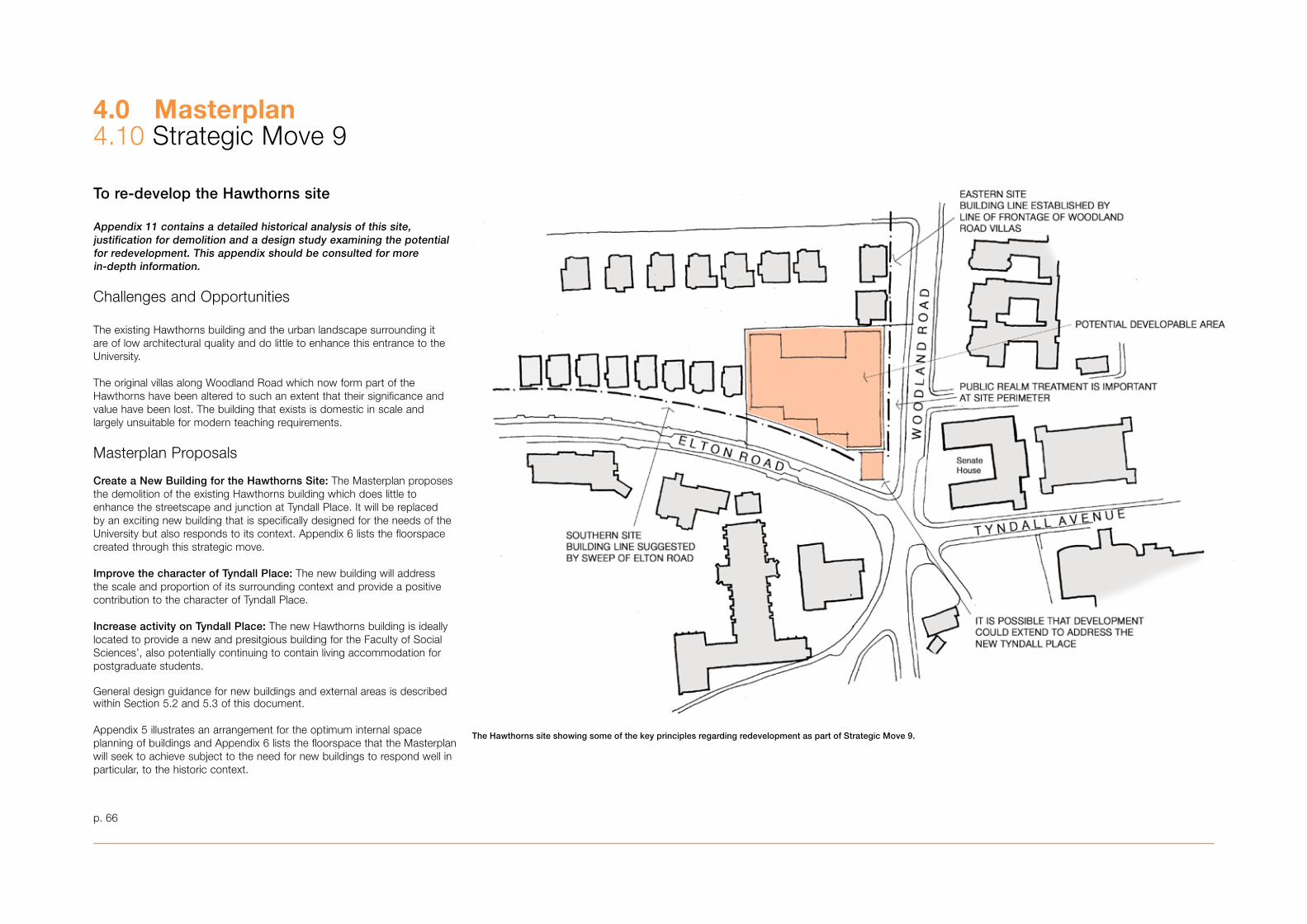
4.0 Masterplan4.10 Strategic Move 9
To re-develop the Hawthorns site
Appendix 11 contains a detailed historical analysis of this site, justification for demolition and a design study examining the potential for redevelopment. This appendix should be consulted for more in-depth information.
Challenges and Opportunities
The existing Hawthorns building and the urban landscape surrounding it are of low architectural quality and do little to enhance this entrance to the University.
The original villas along Woodland Road which now form part of the Hawthorns have been altered to such an extent that their significance and value have been lost. The building that exists is domestic in scale and largely unsuitable for modern teaching requirements.
Masterplan Proposals
Create a New Building for the Hawthorns Site: The Masterplan proposes the demolition of the existing Hawthorns building which does little to enhance the streetscape and junction at Tyndall Place. It will be replaced by an exciting new building that is specifically designed for the needs of the University but also responds to its context. Appendix 6 lists the floorspace created through this strategic move.
Improve the character of Tyndall Place: The new building will address the scale and proportion of its surrounding context and provide a positive contribution to the character of Tyndall Place.
Increase activity on Tyndall Place: The new Hawthorns building is ideally located to provide a new and presitgious building for the Faculty of Social Sciences’, also potentially continuing to contain living accommodation for postgraduate students.
General design guidance for new buildings and external areas is described within Section 5.2 and 5.� of this document.
Appendix 5 illustrates an arrangement for the optimum internal space planning of buildings and Appendix 6 lists the floorspace that the Masterplan will seek to achieve subject to the need for new buildings to respond well in particular, to the historic context.
p. 66
The Hawthorns site showing some of the key principles regarding redevelopment as part of Strategic Move 9.
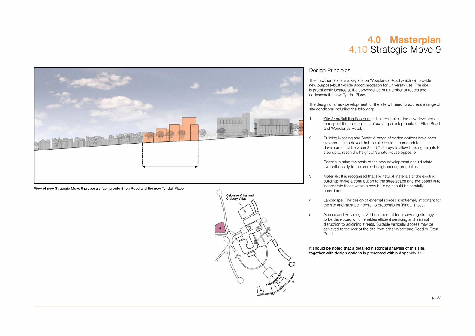
4.0 Masterplan4.10 Strategic Move 9
p. 67
Design Principles
The Hawthorns site is a key site on Woodlands Road which will provide new purpose-built flexible accommodation for University use. The site is prominently located at the convergence of a number of routes and addresses the new Tyndall Place.
The design of a new development for the site will need to address a range of site conditions including the following:
1. Site Area/Building Footprint: It is important for the new development to respect the building lines of existing developments on Elton Road and Woodlands Road.
2. Building Massing and Scale: A range of design options have been explored. It is believed that the site could accommodate a development of between � and 7 storeys to allow building heights to step up to reach the height of Senate House opposite.
Bearing in mind the scale of the new development should relate sympathetically to the scale of neighbouring proprieties.
�. Materials: It is recognised that the natural materials of the existing buildings make a contribution to the streetscape and the potential to incorporate these within a new building should be carefully considered.
4. Landscape: The design of external spaces is extremely important for the site and must be integral to proposals for Tyndall Place.
5. Access and Servicing: It will be important for a servicing strategy to be developed which enables efficient servicing and minimal disruption to adjoining streets. Suitable vehicular access may be achieved to the rear of the site from either Woodland Road or Elton Road.
It should be noted that a detailed historical analysis of this site, together with design options is presented within Appendix 11.
View of new Strategic Move 9 proposals facing onto Elton Road and the new Tyndall Place
Osborne Villas and Oldbury Villas
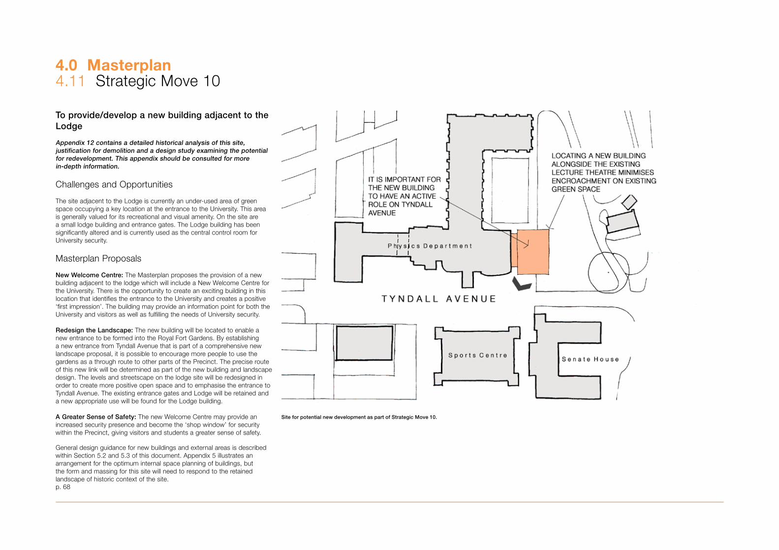
4.0 Masterplan4.11 Strategic Move 10
To provide/develop a new building adjacent to the Lodge
Appendix 12 contains a detailed historical analysis of this site, justification for demolition and a design study examining the potential for redevelopment. This appendix should be consulted for more in-depth information.
Challenges and Opportunities
The site adjacent to the Lodge is currently an under-used area of green space occupying a key location at the entrance to the University. This area is generally valued for its recreational and visual amenity. On the site are a small lodge building and entrance gates. The Lodge building has been significantly altered and is currently used as the central control room for University security.
Masterplan Proposals
New Welcome Centre: The Masterplan proposes the provision of a new building adjacent to the lodge which will include a New Welcome Centre for the University. There is the opportunity to create an exciting building in this location that identifies the entrance to the University and creates a positive ‘first impression’. The building may provide an information point for both the University and visitors as well as fulfilling the needs of University security.
Redesign the Landscape: The new building will be located to enable a new entrance to be formed into the Royal Fort Gardens. By establishing a new entrance from Tyndall Avenue that is part of a comprehensive new landscape proposal, it is possible to encourage more people to use the gardens as a through route to other parts of the Precinct. The precise route of this new link will be determined as part of the new building and landscape design. The levels and streetscape on the lodge site will be redesigned in order to create more positive open space and to emphasise the entrance to Tyndall Avenue. The existing entrance gates and Lodge will be retained and a new appropriate use will be found for the Lodge building.
A Greater Sense of Safety: The new Welcome Centre may provide an increased security presence and become the ‘shop window’ for security within the Precinct, giving visitors and students a greater sense of safety.
General design guidance for new buildings and external areas is described within Section 5.2 and 5.� of this document. Appendix 5 illustrates an arrangement for the optimum internal space planning of buildings, but the form and massing for this site will need to respond to the retained landscape of historic context of the site.p. 68
Site for potential new development as part of Strategic Move 10.
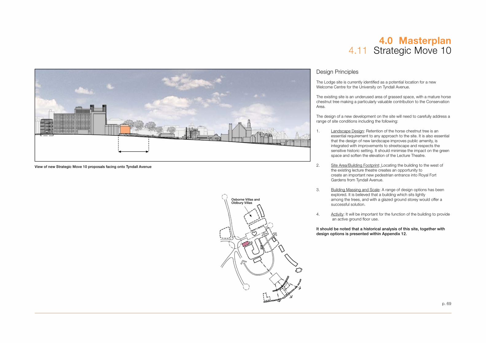
p. 69
4.0 Masterplan4.11 Strategic Move 10
Design Principles
The Lodge site is currently identified as a potential location for a new Welcome Centre for the University on Tyndall Avenue.
The existing site is an underused area of grassed space, with a mature horse chestnut tree making a particularly valuable contribution to the Conservation Area.
The design of a new development on the site will need to carefully address a range of site conditions including the following:
1. Landscape Design: Retention of the horse chestnut tree is an essential requirement to any approach to the site. It is also essential that the design of new landscape improves public amenity, is integrated with improvements to streetscape and respects the sensitive historic setting. It should minimise the impact on the green space and soften the elevation of the Lecture Theatre.
2. Site Area/Building Footprint: Locating the building to the west of the existing lecture theatre creates an opportunity to create an important new pedestrian entrance into Royal Fort Gardens from Tyndall Avenue.
�. Building Massing and Scale: A range of design options has been explored. It is believed that a building which sits lightly among the trees, and with a glazed ground storey would offer a successful solution.
4. Activity: It will be important for the function of the building to provide an active ground floor use.
It should be noted that a historical analysis of this site, together with design options is presented within Appendix 12.
View of new Strategic Move 10 proposals facing onto Tyndall Avenue
Osborne Villas and Oldbury Villas

p. 71
5.0 Design Framework
‘The primary goal for the implementation of the Masterplan is the delivery of high quality, flexible and environmentally efficient buildings that also respond well to their context and the enhancement of the urban realm’
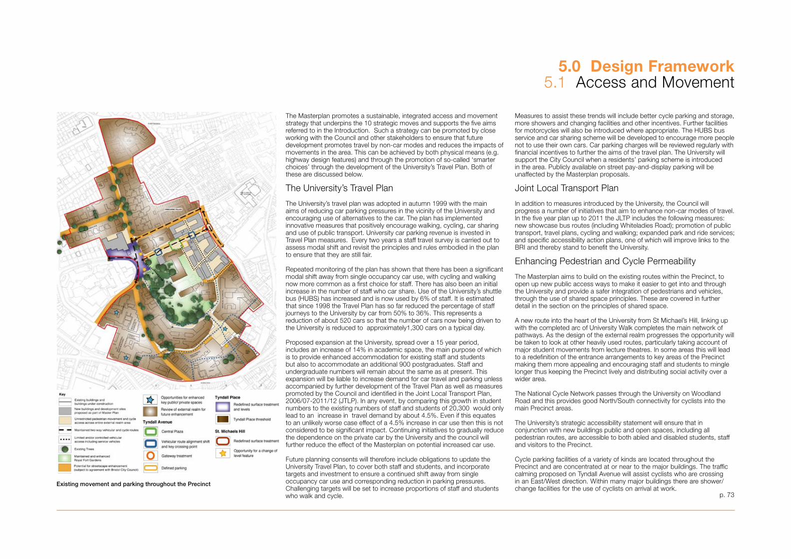
The Masterplan promotes a sustainable, integrated access and movement strategy that underpins the 10 strategic moves and supports the five aims referred to in the Introduction. Such a strategy can be promoted by close working with the Council and other stakeholders to ensure that future development promotes travel by non-car modes and reduces the impacts of movements in the area. This can be achieved by both physical means (e.g. highway design features) and through the promotion of so-called ‘smarter choices’ through the development of the University’s Travel Plan. Both of these are discussed below.
The University’s Travel Plan
The University’s travel plan was adopted in autumn 1999 with the main aims of reducing car parking pressures in the vicinity of the University and encouraging use of alternatives to the car. The plan has implemented innovative measures that positively encourage walking, cycling, car sharing and use of public transport. University car parking revenue is invested in Travel Plan measures. Every two years a staff travel survey is carried out to assess modal shift and revisit the principles and rules embodied in the plan to ensure that they are still fair.
Repeated monitoring of the plan has shown that there has been a significant modal shift away from single occupancy car use, with cycling and walking now more common as a first choice for staff. There has also been an initial increase in the number of staff who car share. Use of the University’s shuttle bus (HUBS) has increased and is now used by 6% of staff. It is estimated that since 1998 the Travel Plan has so far reduced the percentage of staff journeys to the University by car from 50% to �6%. This represents a reduction of about 520 cars so that the number of cars now being driven to the University is reduced to approximately1,�00 cars on a typical day.
Proposed expansion at the University, spread over a 15 year period, includes an increase of 14% in academic space, the main purpose of which is to provide enhanced accommodation for existing staff and students but also to accommodate an additional 900 postgraduates. Staff and undergraduate numbers will remain about the same as at present. This expansion will be liable to increase demand for car travel and parking unless accompanied by further development of the Travel Plan as well as measures promoted by the Council and identified in the Joint Local Transport Plan, 2006/07-2011/12 (JTLP). In any event, by comparing this growth in student numbers to the existing numbers of staff and students of 20,�00 would only lead to an increase in travel demand by about 4.5%. Even if this equates to an unlikely worse case effect of a 4.5% increase in car use then this is not considered to be significant impact. Continuing initiatives to gradually reduce the dependence on the private car by the University and the council will further reduce the effect of the Masterplan on potential increased car use.
Future planning consents will therefore include obligations to update the University Travel Plan, to cover both staff and students, and incorporate targets and investment to ensure a continued shift away from single occupancy car use and corresponding reduction in parking pressures. Challenging targets will be set to increase proportions of staff and students who walk and cycle.
5.0 Design Framework5.1 Access and Movement
Measures to assist these trends will include better cycle parking and storage, more showers and changing facilities and other incentives. Further facilities for motorcycles will also be introduced where appropriate. The HUBS bus service and car sharing scheme will be developed to encourage more people not to use their own cars. Car parking charges will be reviewed regularly with financial incentives to further the aims of the travel plan. The University will support the City Council when a residents’ parking scheme is introduced in the area. Publicly available on street pay-and-display parking will be unaffected by the Masterplan proposals.
Joint Local Transport Plan
In addition to measures introduced by the University, the Council will progress a number of initiatives that aim to enhance non-car modes of travel. In the five year plan up to 2011 the JLTP includes the following measures: new showcase bus routes (including Whiteladies Road); promotion of public transport, travel plans, cycling and walking; expanded park and ride services; and specific accessibility action plans, one of which will improve links to the BRI and thereby stand to benefit the University.
Enhancing Pedestrian and Cycle Permeability
The Masterplan aims to build on the existing routes within the Precinct, to open up new public access ways to make it easier to get into and through the University and provide a safer integration of pedestrians and vehicles, through the use of shared space principles. These are covered in further detail in the section on the principles of shared space.
A new route into the heart of the University from St Michael’s Hill, linking up with the completed arc of University Walk completes the main network of pathways. As the design of the external realm progresses the opportunity will be taken to look at other heavily used routes, particularly taking account of major student movements from lecture theatres. In some areas this will lead to a redefinition of the entrance arrangements to key areas of the Precinct making them more appealing and encouraging staff and students to mingle longer thus keeping the Precinct lively and distributing social activity over a wider area.
The National Cycle Network passes through the University on Woodland Road and this provides good North/South connectivity for cyclists into the main Precinct areas.
The University’s strategic accessibility statement will ensure that in conjunction with new buildings public and open spaces, including all pedestrian routes, are accessible to both abled and disabled students, staff and visitors to the Precinct.
Cycle parking facilities of a variety of kinds are located throughout the Precinct and are concentrated at or near to the major buildings. The traffic calming proposed on Tyndall Avenue will assist cyclists who are crossing in an East/West direction. Within many major buildings there are shower/change facilities for the use of cyclists on arrival at work.
Existing movement and parking throughout the Precinct
p. 7�

5.0 Design Framework5.1 Access and Movement
With further modal shift towards the cycle provision for cycle storage will need to grow, in particular with emphasis being given to secure storage. As with existing facilities and storage these will be associated with new development sites, including the Learning Resources Centre, the Life Sciences development, the Hawthorns and the Lodge site.
Car Use and Parking
One of the principal aims of the Travel Plan as described above is to reduce the University’s dependence on the private car. With anticipated modal shift away from car use continuing at the same levels, the total space dedicated to the University’s car parking use may be reduced by about 5% over the next 10 years from the current level of provision of 1021 spaces without putting further significant pressure on neighbouring residential areas. The design of the urban landscape will lessen the visual impact of parked cars on the University’s own land. Spaces freed of car parking will allow social amenity to be restored thus supporting the desire to spread social activity throughout the precinct.
The University will continue to provide a proportion of parking spaces designated for use by staff and visitors who have a mobility impairment.
Over 95% of students live within three miles of the University Precinct based on postcode analysis of student accommodation. Based on this data and observations of the high levels of students that walk and cycle to the University it is reasonable to conclude that most students walk, cycle or use public transport to access the Precinct and this will not be affected by the relocation of the Students’ Union to the heart of the Precinct.
It is not considered that there will be any significant adverse impact from cars either parking within or accessing the Precinct nor a change in the modes of transport used to access the Students’ Union following its relocation from Queens Road to the heart of Tyndall Avenue, as the vast majority of students do not use cars to access this facility. One of the benefits of relocating this facility within the heart of the Precinct is to extend the time that students stay within the Precinct, which amongst other things minimises the number of journeys that will need to be made between facilities. This is further supported by the use of in-house mini bus taxi services provided by the Students’ Union for evening events and the continuing accessibility of public transport both inside and in proximity of the Precinct.
It is acknowledged that understanding the proximity of the student population to the Precinct, through continued postcode analysis, is not enough. So in conjunction with prohibiting students from parking within University car parks in the Precinct and discouraging students that live in Halls of Residence from bringing cars, the University is working with the Students’ Union to find ways of reducing student car use, encouraging alternative modes of travel and generating a sense of social responsibility within the community. The University appreciates that there is a question over student traffic movements in the City, but due to the areas within
which the vast majority of students live and the restrictions on parking within the Precinct it is not believed that changes being proposed within the Masterplan will have a significant impact on traffic movements within this part of Bristol.
However, the University is committed to continuing the postcode analysis and conducting student surveys as part of the Travel Plan to establish travel patterns and the nature of parking problems and the production of a student travel plan in order to identify and test measures to discourage car ownership and use.
The City Council is committed to a review of commuter parking surrounding the city centre and will consider extending the boundary of the existing controlled parking zone into areas experiencing the greatest pressure on parking. The University strongly supports the reappraisal of the Kingsdown Controlled Parking Zone as this, coupled with the limited availability for staff parking and prohibited student car parking within University owned car parks, will act as a further deterrent for both staff and student car use.
In order to manage movements of service vehicles, a servicing strategy will be produced for each site as part of a detailed site brief. This will either be submitted as part of an application package or dealt with through a condition of a planning permission.
HUBS
The use of the University Shuttle Bus service is growing and this gives good connectivity to the Bus Station at Marlborough Street and to Temple Meads Railway station. Frequency of the service is being examined in order to provide more capacity. Both the University and UBHT wish to see this service remain as free to users and will continue to provide the necessary funding for this.
The University is also working with the University of the West of England to explore whether a combined bus service linking the city to the Frenchay Campus is viable. This may have the additional benefit of opening up other areas of the city as being viable locations for student accommodation and thus may reduce the pressure of concentration of students in areas close to the main University Precinct.
Public Transport
Despite the fact that the University is well served both directly and indirectly by public bus services it is noteworthy to see that the use of this mode of transport is slowly reducing despite the University’s significant promotional efforts. As part of its travel plan initiatives the University offers interest free loans to staff who wish to purchase season tickets for public transport and through its travel web site offers extensive information to travellers to the University.
The existing bus stops will be retained throughout the Precinct. Furthermore the University will also work with Firstbus and others to identify ways in which it may be able to influence this trend. p. 74
Conventional attitudes to traffic design
Highway engineering at the Hawthorns junction
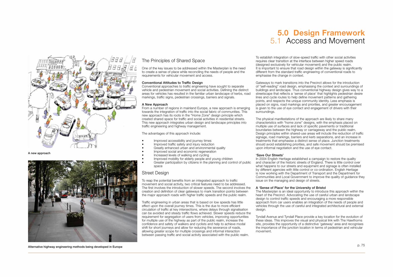
5.0 Design Framework5.1 Access and Movement
The Principles of Shared Space
One of the key issues to be addressed within the Masterplan is the need to create a sense of place while reconciling the needs of people and the requirements for vehicular movement and access.
Conventional Attitudes to Traffic DesignConventional approaches to traffic engineering have sought to separate vehicle and pedestrian movement and social activities. Defining the distinct areas for vehicles has resulted in the familiar urban landscape of kerbs, road markings, traffic signs, pedestrian crossings, barriers and signals.
A New ApproachFrom a number of regions in mainland Europe, a new approach is emerging towards the integration of traffic into the social fabric of communities. This new approach has its roots in the “Home Zone” design principle which created shared space for traffic and social activities in residential streets. This new approach integrates urban design and landscape principles into traffic engineering and highway management.
The advantages of this approach include:
• Improved accessibility and journey times• Improved traffic safety and injury reduction• Greatly enhanced urban and environmental quality• Improved social and economic regeneration• Increased levels of walking and cycling• Improved mobility for elderly people and young children• Greater participation by citizens in the planning and control of public space
Street Design
To reap the potential benefits from an integrated approach to traffic movement and social activity, two critical features need to be addressed. The first involves the introduction of slower speeds. The second involves the creation and definition of clear gateways to mark transition points between the major approach roads with higher traffic speeds and the public realm.
Traffic engineering in urban areas that is based on low speeds has little effect upon the overall journey times. This is the due to more efficient circulation of traffic at key intersections, where delays through signalisation can be avoided and steady traffic flows achieved. Slower speeds reduce the requirement for segregation of users from vehicles, improving opportunities for multiple use of the highway as part of the public realm, increase the confidence and safety of walkers and cyclists and help to achieve modal shift for short journeys and allow for reducing the severance of roads, allowing greater scope for multiple crossings and informal interaction between passing traffic and social activity associated with the public realm.
To establish integration of slow-speed traffic with other social activities requires clear transition at the interface between higher speed roads (designed exclusively for vehicular movement) and the public realm. It is important to ensure that road design within the gateway is significantly different from the standard traffic engineering of conventional roads to emphasise the change in context.
Gateways to mark transitions into the Precinct allows for the introduction of “self-reading” road design, emphasising the context and surroundings of buildings and landscape. Thus conventional highway design gives way to a streetscape that reflects a ‘sense of place’ that highlights pedestrian desire lines and cycle routes to help define movement patterns and gathering points, and respects the unique community identity. Less emphasis is placed on signs, road markings and priorities, and greater encouragement is given to the use of eye contact and engagement of drivers with their surroundings.
The physical manifestations of the approach are likely to share many characteristics with “home zone” designs, with the emphasis placed on multiple use of surfaces and lack of specific pavements or traditional boundaries between the highway or carriageway and the public realm. Design principles within shared-use areas will include the reduction of traffic signage, road markings, barriers and kerb separations, and an increase in treatments that emphasise a distinct sense of place. Junction treatments should avoid establishing priorities, and safe movement should be premised upon informal negotiation and the use of eye contact.
‘Save Our Streets’In 2004 English Heritage established a campaign to restore the quality and character of the historic streets of England. There is little control over what happens to our streets and equipment and signage is often installed by different agencies with little control or co-ordination. English Heritage is now working with the Department of Transport and the Department for Communities and Local Government to improve the quality of guidance they issue on the managing and design of streets.
A ‘Sense of Place’ for the University of BristolThe Masterplan is an ideal opportunity to introduce this approach within the heart of the Precinct. Advocating the use of careful urban and landscape design to control traffic speeds and encouraging a more responsible approach from car users enables an integration of the needs of people and vehicles through the use of careful and integrated architectural and external design.
Tyndall Avenue and Tyndall Place provide a key location for the evolution of these ideas. This improves the visual and physical link with The Hawthorns site, provides the opportunity of a distinctive ‘gateway’ area and recognises the importance of the junction location in terms of pedestrian and vehicular movement.
p. 75
A new approach
Alternative highway engineering methods being developed in Europe
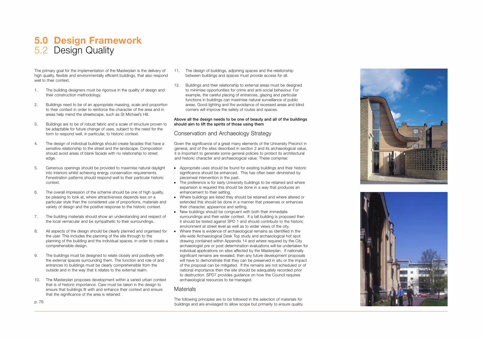
5.0 Design Framework5.2 Design Quality
The primary goal for the implementation of the Masterplan is the delivery of high quality, flexible and environmentally efficient buildings, that also respond well to their context.
1. The building designers must be rigorous in the quality of design and their construction methodology.
2. Buildings need to be of an appropriate massing, scale and proportion to their context in order to reinforce the character of the area and in areas help mend the streetscape, such as St Michael’s Hill.
�. Buildings are to be of robust fabric and a scale of structure proven to be adaptable for future change of uses, subject to the need for the form to respond well, in particular, to historic context.
4. The design of individual buildings should create facades that have a sensitive relationship to the street and the landscape. Composition should avoid areas of blank facade with no relationship to street edge.
5. Generous openings should be provided to maximise natural daylight into interiors whilst achieving energy conservation requirements. Fenestration patterns should respond well to their particular historic context.
6. The overall impression of the scheme should be one of high quality, be pleasing to look at, where attractiveness depends less on a particular style than the considered use of proportions, materials and variety of design and the positive response to the historic context.
7. The building materials should show an understanding and respect of the local vernacular and be sympathetic to their surroundings.
8. All aspects of the design should be clearly planned and organised for the user. This includes the planning of the site through to the planning of the building and the individual spaces, in order to create a comprehensible design.
9. The buildings must be designed to relate closely and positively with the external spaces surrounding them. The function and role of and entrances to buildings must be clearly comprehensible from the outside and in the way that it relates to the external realm.
10. The Masterplan proposes development within a varied urban context that is of historic importance. Care must be taken in the design to ensure that buildings fit with and enhance their context and ensure that the significance of the area is retained.
11. The design of buildings, adjoining spaces and the relationship between buildings and spaces must provide access for all.
12. Buildings and their relationship to external areas must be designed to minimise opportunities for crime and anti-social behaviour. For example, the careful placing of entrances, glazing and particular functions in buildings can maximise natural surveillance of public areas. Good lighting and the avoidance of recessed areas and blind corners will improve the safety of routes and spaces.
Above all the design needs to be one of beauty and all of the buildings should aim to lift the spirits of those using them
Conservation and Archaeology Strategy
Given the significance of a great many elements of the University Precinct in general, and of the sites described in section 2 and its archaeological value, it is important to generate some general policies to protect its architectural and historic character and archaeological value. These comprise:
• Appropriate uses should be found for existing buildings and their historic significance should be enhanced. This has often been diminished by piecemeal intervention in the past.
• The preference is for early University buildings to be retained and where expansion is required this should be done in a way that produces an enhancement to their setting.
• Where buildings are listed they should be retained and where altered or extended this should be done in a manner that preserves or enhances their character, appearnce and setting.
• New buildings should be congruent with both their immediate surroundings and their wider context. If a tall building is proposed then it should be tested against SPD 1 and should contribute to the historic environment at street level as well as to wider views of the city.
• Where there is evidence of archaeological remains as identified in the site-wide Archaeological Desk Top study and archaeological hot spot drawing contained within Appendix 14 and where required by the City archaeologist pre or post determination evaluations will be undertaken for individual applications on sites affected by the Masterplan. If nationally significant remains are revealed, then any future development proposals will have to demonstrate that they can be preserved in situ or the impact of the proposal can be mitigated. If the remains are not scheduled or of national importance then the site should be adequately recorded prior to destruction. SPD7 provides guidance on how the Council requires archaeological resources to be managed.
Materials
The following principles are to be followed in the selection of materials for buildings and are envisaged to allow scope but primarily to ensure quality. p. 76
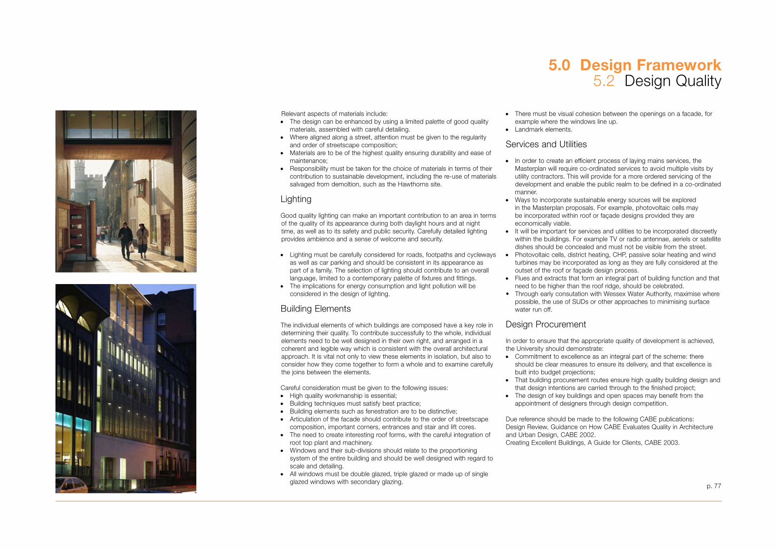
p. 77
• There must be visual cohesion between the openings on a facade, for example where the windows line up.
• Landmark elements.
Services and Utilities
• In order to create an efficient process of laying mains services, the Masterplan will require co-ordinated services to avoid multiple visits by utility contractors. This will provide for a more ordered servicing of the development and enable the public realm to be defined in a co-ordinated manner.
• Ways to incorporate sustainable energy sources will be explored in the Masterplan proposals. For example, photovoltaic cells may be incorporated within roof or façade designs provided they are economically viable.
• It will be important for services and utilities to be incorporated discreetly within the buildings. For example TV or radio antennae, aeriels or satellite dishes should be concealed and must not be visible from the street.
• Photovoltaic cells, district heating, CHP, passive solar heating and wind turbines may be incorporated as long as they are fully considered at the outset of the roof or façade design process.
• Flues and extracts that form an integral part of building function and that need to be higher than the roof ridge, should be celebrated.
• Through early consutation with Wessex Water Authority, maximise where possible, the use of SUDs or other approaches to minimising surface
water run off.
Design Procurement
In order to ensure that the appropriate quality of development is achieved, the University should demonstrate:• Commitment to excellence as an integral part of the scheme: there
should be clear measures to ensure its delivery, and that excellence is built into budget projections;
• That building procurement routes ensure high quality building design and that design intentions are carried through to the finished project;
• The design of key buildings and open spaces may benefit from the appointment of designers through design competition.
Due reference should be made to the following CABE publications:Design Review, Guidance on How CABE Evaluates Quality in Architectureand Urban Design, CABE 2002.Creating Excellent Buildings, A Guide for Clients, CABE 200�.
5.0 Design Framework5.2 Design Quality
Relevant aspects of materials include:• The design can be enhanced by using a limited palette of good quality
materials, assembled with careful detailing.• Where aligned along a street, attention must be given to the regularity
and order of streetscape composition;• Materials are to be of the highest quality ensuring durability and ease of
maintenance;• Responsibility must be taken for the choice of materials in terms of their
contribution to sustainable development, including the re-use of materials salvaged from demoltion, such as the Hawthorns site.
Lighting
Good quality lighting can make an important contribution to an area in terms of the quality of its appearance during both daylight hours and at night time, as well as to its safety and public security. Carefully detailed lighting provides ambience and a sense of welcome and security.
• Lighting must be carefully considered for roads, footpaths and cycleways as well as car parking and should be consistent in its appearance as part of a family. The selection of lighting should contribute to an overall language, limited to a contemporary palette of fixtures and fittings.
• The implications for energy consumption and light pollution will be considered in the design of lighting.
Building Elements
The individual elements of which buildings are composed have a key role in determining their quality. To contribute successfully to the whole, individual elements need to be well designed in their own right, and arranged in a coherent and legible way which is consistent with the overall architectural approach. It is vital not only to view these elements in isolation, but also to consider how they come together to form a whole and to examine carefully the joins between the elements.
Careful consideration must be given to the following issues:• High quality workmanship is essential;• Building techniques must satisfy best practice;• Building elements such as fenestration are to be distinctive;• Articulation of the facade should contribute to the order of streetscape
composition, important corners, entrances and stair and lift cores.• The need to create interesting roof forms, with the careful integration of
root top plant and machinery.• Windows and their sub-divisions should relate to the proportioning
system of the entire building and should be well designed with regard to scale and detailing.
• All windows must be double glazed, triple glazed or made up of single glazed windows with secondary glazing.
Feilden Clegg Bradley Architects LLP Northcroft Nicholas Pearson Associates CSJ Planning Arup Hamilton-Baillie Associates Avril Baker Consulting
p. 78
5.0 Design Framework5.� External Realm Design
Creating a Sense of Place and an Identity for the University
The external realm design concept has been fully informed by a detailed understanding of the land use function and material and spatial condition of individual and composite spaces, as well as an analysis of the historic landscape. A comprehensive approach has been taken to the design of the external realm of the environs of the University. This comprises the public realm, including highways, and private estate, hard and soft landscape areas, street furniture, signage and public art. External Realm Design Codes have been produced for the Precinct. The Design Codes are included within this section. The external realm design concept will be further developed as design work progresses to provide a ‘Design Handbook for the Public Realm’ and will be included as appropriate in the design briefs for individual buildings.
‘The community dynamic’
The community dynamic needs to be incorporated into the design process by recognising:• The constant and inseparable interaction between those who live and
those who study in the area. The interaction is physical, visual and temporal.
• A natural graduation of University influence moving to and through the public realm, which is at its strongest in Tyndall Avenue and the local environs.
• Activity and movement is ever present by those who live, study and/ or travel through the area.
The principles of the external realm design
The principles of external realm design, led by the University’s need for new buildings and facilities, are:• The opportunity to enhance the entire public and private external realm.• The recognised importance of a comprehensive solution in terms of
integrating new build with existing fabric.• The creation of a ‘sense of place’, to achieve local distinctiveness.• Providing a ‘legible’ external realm that improves physical and visual
connectivity and movement, and ensures inviting and welcoming spaces. • Considering the needs of both the University and the resident
community. • The opportunity for the introduction of solutions for the public highway
led by a ‘shared space’ concept, giving the pedestrian increased priority and clearing the external realm of unnecessary visual and physical clutter.
• Using appropriate elements and mechanisms to provide the best practical solution for this part of Bristol.
• The opportunity to ensure ‘access for all’.
• Through early consutation with Wessex Water Authority, maximise where possible, the use of SUDs or other approaches to minimising surface
water run off. Servicing
The design concept has also incorporated a ‘Servicing Strategy’ prepared by Arup. ‘AutoTrack’ has been used to check servicing manoeuvres are feasible with a large rigid vehicle. This will be incorporated into detailed design and planning applications.
Phasing
The external realm will be delivered as part of and directly linked with the phased development of the University. The details of design and external realm boundaries between phases will be subject to the agreement of the Council.
Nature Conservation
An ecology survey of the University area has been carried out. Overall, the area is considered to be of low ecological value, although opportunities exist to create and enhance habitats to provide an area of higher value. Further surveys to confirm the presence of protected species including bats and slow worms will be required once the detailed development proposals have been agreed. The design principles will include habitat protection and conservation and will inform the future landscape management of the external realm.
Trees
A tree audit has been carried out. This brings together a considerable database of information from a variety of sources, central to which are the University’s own records.
The University places considerable importance and value on the tree resource and to its conservation and enhancement and this ethos of care will be incorporated into the detailed design process.
External Realm Design Codes
The design code has been fully informed by a detailed understanding of the land use function and material and spatial condition of individual and composite spaces, both within the area for the coding and adjacent to it.The purpose of this design code is to provide sufficient information in terms of design intent and objectives to allow the principles to be agreed by all stakeholders as part of the Masterplan and to provide a clear guide for future detail design.
The code has been set at a level such that it is sufficiently flexible to allow for changes in the form, extent and phasing of the Masterplan. The area covered by the design code comprises:• Tyndall Avenue.• Woodland Road; between University Road and St Michael’s Park.• Elton Road in the vicinity of The Hawthorns.• The area to the north of the gatehouse lodge at the entrance to Royal
Fort Gardens.• St Michael’s Hill at the junction with Tyndall Avenue.
Design Code elements common to all areas
The key Design Code elements will:• Allow, as far as possible, free, safe pedestrian movement and activity
throughout the area.• Maintain existing vehicular movements through the area, but with
reduced vehicle speeds.• Maintain the provision of short-stay public car parking• Ensure that, where possible, service vehicle access is via routes other
than Tyndall Avenue.
Design Code - Tyndall Avenue
The study has established that Tyndall Avenue, due to the presence of a number of University core activities and its elevated and central position, is a key external space. It has been recognised that there is a significant and substantial opportunity to comprehensively redesign and enhance this space. The proposal is that the entire streetscape of Tyndall Avenue is transformed to provide a defined focus and hub for University activities, as space that links with those adjoining, and a high quality environment for all users of the area.
The key design objectives are:• To provide a distinctive character and special quality, which reflect the
use and function of the place, including the existing fabric.• To provide a unified design for the space that seamlessly presents the entire external realm to the widest number of users. • To remove the dominance of the road and associated vehicle
movements, whilst maintaining vehicular movement through the space.• To provide a space that will stand the test of time, and be to a standard
that is adoptable by the Highway Authority.
These objectives will be achieved by:•Establishing and agreeing with relevant authorities and users the priority
and use of the street.•Clearly defining the physical and visual presence of vehicular routes through the space.•Utilising features, treatments and events at appropriate locations to encourage vehicle speed reduction.
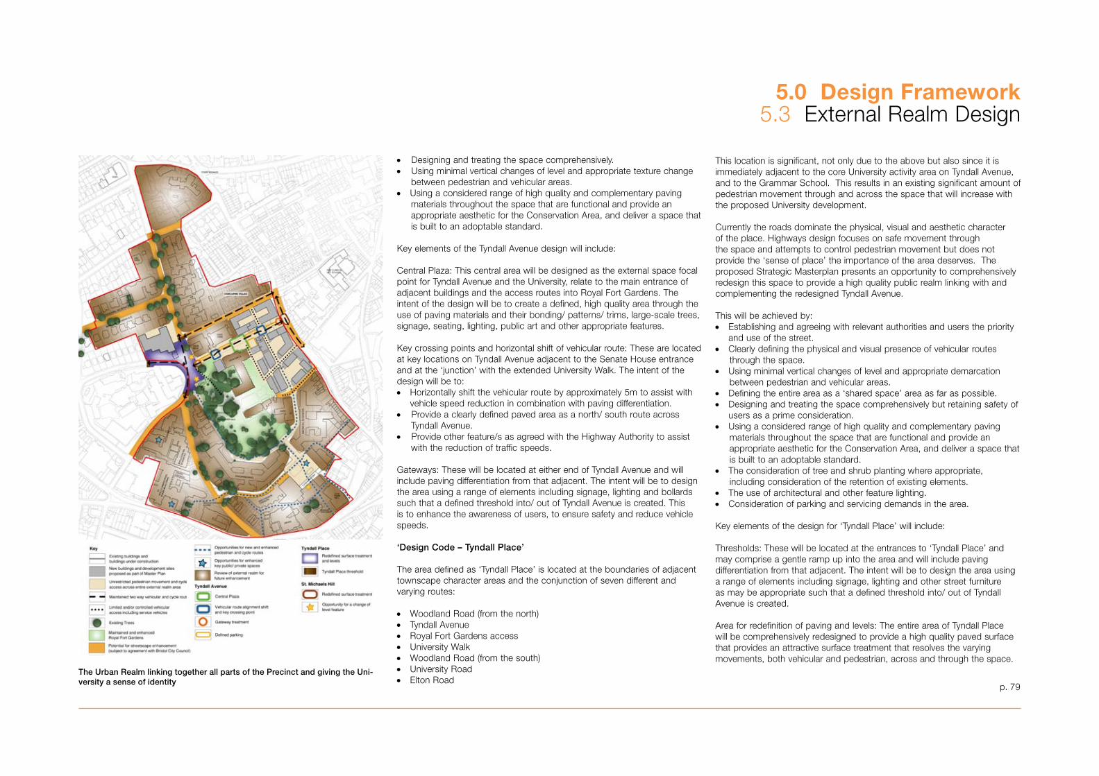
p. 79
5.0 Design Framework5.� External Realm Design
This location is significant, not only due to the above but also since it is immediately adjacent to the core University activity area on Tyndall Avenue, and to the Grammar School. This results in an existing significant amount of pedestrian movement through and across the space that will increase with the proposed University development.
Currently the roads dominate the physical, visual and aesthetic character of the place. Highways design focuses on safe movement through the space and attempts to control pedestrian movement but does not provide the ‘sense of place’ the importance of the area deserves. The proposed Strategic Masterplan presents an opportunity to comprehensively redesign this space to provide a high quality public realm linking with and complementing the redesigned Tyndall Avenue.
This will be achieved by:• Establishing and agreeing with relevant authorities and users the priority
and use of the street.• Clearly defining the physical and visual presence of vehicular routes through the space.• Using minimal vertical changes of level and appropriate demarcation between pedestrian and vehicular areas.• Defining the entire area as a ‘shared space’ area as far as possible.• Designing and treating the space comprehensively but retaining safety of users as a prime consideration.• Using a considered range of high quality and complementary paving materials throughout the space that are functional and provide an appropriate aesthetic for the Conservation Area, and deliver a space that is built to an adoptable standard. • The consideration of tree and shrub planting where appropriate, including consideration of the retention of existing elements.• The use of architectural and other feature lighting.• Consideration of parking and servicing demands in the area.
Key elements of the design for ‘Tyndall Place’ will include:
Thresholds: These will be located at the entrances to ‘Tyndall Place’ and may comprise a gentle ramp up into the area and will include paving differentiation from that adjacent. The intent will be to design the area using a range of elements including signage, lighting and other street furniture as may be appropriate such that a defined threshold into/ out of Tyndall Avenue is created.
Area for redefinition of paving and levels: The entire area of Tyndall Place will be comprehensively redesigned to provide a high quality paved surface that provides an attractive surface treatment that resolves the varying movements, both vehicular and pedestrian, across and through the space.
•Designing and treating the space comprehensively. •Using minimal vertical changes of level and appropriate texture change between pedestrian and vehicular areas.• Using a considered range of high quality and complementary paving materials throughout the space that are functional and provide an appropriate aesthetic for the Conservation Area, and deliver a space that is built to an adoptable standard.
Key elements of the Tyndall Avenue design will include:
Central Plaza: This central area will be designed as the external space focal point for Tyndall Avenue and the University, relate to the main entrance of adjacent buildings and the access routes into Royal Fort Gardens. The intent of the design will be to create a defined, high quality area through the use of paving materials and their bonding/ patterns/ trims, large-scale trees, signage, seating, lighting, public art and other appropriate features.
Key crossing points and horizontal shift of vehicular route: These are located at key locations on Tyndall Avenue adjacent to the Senate House entrance and at the ‘junction’ with the extended University Walk. The intent of the design will be to: • Horizontally shift the vehicular route by approximately 5m to assist with
vehicle speed reduction in combination with paving differentiation.•Provide a clearly defined paved area as a north/ south route across Tyndall Avenue.•Provide other feature/s as agreed with the Highway Authority to assist with the reduction of traffic speeds.
Gateways: These will be located at either end of Tyndall Avenue and will include paving differentiation from that adjacent. The intent will be to design the area using a range of elements including signage, lighting and bollards such that a defined threshold into/ out of Tyndall Avenue is created. This is to enhance the awareness of users, to ensure safety and reduce vehicle speeds.
‘Design Code – Tyndall Place’
The area defined as ‘Tyndall Place’ is located at the boundaries of adjacent townscape character areas and the conjunction of seven different and varying routes:
• Woodland Road (from the north)• Tyndall Avenue• Royal Fort Gardens access• University Walk• Woodland Road (from the south)• University Road• Elton Road
The Urban Realm linking together all parts of the Precinct and giving the Uni-versity a sense of identity

p. 80
5.0 Design Framework5.� External Realm Design
Changes of level: There is a need to improve permeability through the Precinct because there are significant changes of level between Woodland Road and both Senate House and the entrance area into Royal Fort Gardens.
Design Code - St Michael’s Hill Junction
The junction of Tyndall Avenue and St Michael’s Hill has been identified as a key location where, when moving towards the main University area, the presence of University activity becomes generally more dominant.
As part of the comprehensive review of the public realm it is very important that a clear and distinctive feature or treatment is incorporated in this location. Such treatment will announce that the location provides a boundary/ gateway into a different ‘place,’ where the prevailing approach to highway design has been altered. The design will incorporate the full width of the highway and public realm.
The feature or treatment may be relatively simple, will be clearly visible and in contrast to surrounding elements and might, in combination with the ‘Gateway’ on Tyndall Avenue include:• The use of contrasting paving surface or materials in terms of colour texture and pattern.• The use of special lighting.• The use of signage.• The use of artwork.• The use of vertical features, possible combining one or more elements of
lighting, signage and artwork.
Design Code - The former Children’s Hospital site
The area and environs of the former Children’s Hospital is identified for substantial redevelopment in the Masterplan. This presents the opportunity to provide significant new areas of high quality public realm. The area has very limited and poor connectivity with adjoining areas with no significant landscape elements worthy of retention.
The objectives of the external realm design are to:• Reinforce and build upon existing routes and movement corridors.• Respond to existing visual links to and through the area.• Provide new routes that link with the adjacent network significantly
improving connectivity.• Provide a variety of legible hierarchy of routes and spaces.• Provide a design that presents a unified approach to external space
design, linking with adjacent areas.• Provide for necessary service and emergency access.• Positively utilise the topographic context of the site.
The key elements of the external realm design are:• The provision of an extension of University Walk, from Royal Fort Road to
Tyndall Avenue, designed as a primary pedestrian route.• The creation of a new route between St Michael’s Hill and Royal Fort
Gardens, reinforcing and taking advantage of the existing view through to the Physics Tower.
• The creation of three new accessible open spaces (as part of Strategic Move 7), within the new development, adding to and complementing the existing townscape spatial sequence.
• The inclusion of entrances to new development directly onto adjoining streets to maintain and improve street activity, including at the corner of St Michael’s Hill and Royal Fort Road.
• The opportunity to enhance Royal Fort Road, in terms of paving material and aesthetic design and as a setting to the Royal Fort Gatehouse.
Design Code - Royal Fort Gardens
Royal Fort Gardens provides the green ‘heart’ for the immediate environs of the University and the setting for the key built elements (and Listed Buildings) of Royal Fort House, the Physics Tower and Stuart House. The historic appraisal and analysis undertaken in Appendix 1� confirms its value as an important landscape resource.
A substantial area of the garden is of a high quality in terms of material and spatial condition. However, some of the areas, in terms of use, material type and condition detract from the quality of this space. This particularly relates to the area between the Physics building, the former Children’s Hospital and Royal Fort House.
The Masterplan removes the low-rise laboratory building to the immediate east of the Physics building, and redesigns the external realm to the south and east of the Physics building as part of Strategic Move 7 to: • Present an enhanced landscape setting to adjacent Listed buildings
(Royal Fort House, the Physics Tower and Stuart House) and the new development.
• Provide an enhanced link between Royal Fort Gardens, Tyndall Avenue and Royal Fort Road.
• Provide high quality attractive external spaces, enhancing the overall quality of the area.
The design of the space will include:• A significant area of soft landscape to relate to the historic quality of the
wider gardens.• High quality hard landscape area.• Considered use of large-scale tree species.• Maintained and enhanced ecological value to the overall area.
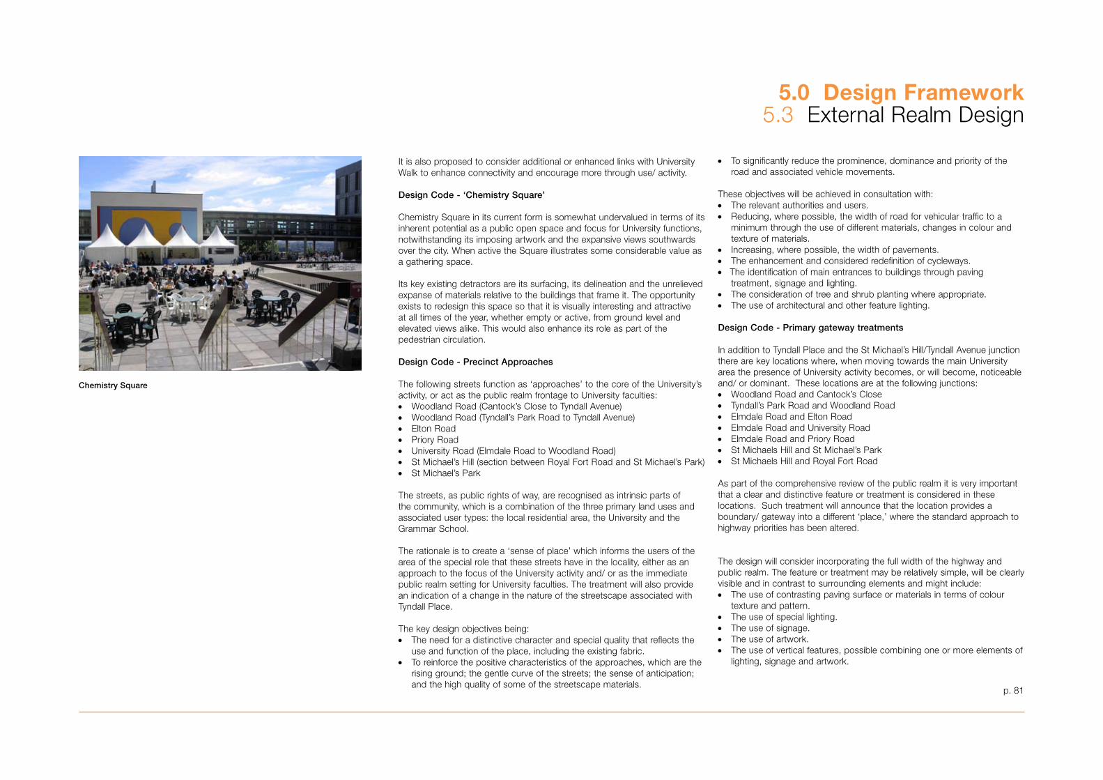
It is also proposed to consider additional or enhanced links with University Walk to enhance connectivity and encourage more through use/ activity.
Design Code - ‘Chemistry Square’
Chemistry Square in its current form is somewhat undervalued in terms of its inherent potential as a public open space and focus for University functions, notwithstanding its imposing artwork and the expansive views southwards over the city. When active the Square illustrates some considerable value as a gathering space.
Its key existing detractors are its surfacing, its delineation and the unrelieved expanse of materials relative to the buildings that frame it. The opportunity exists to redesign this space so that it is visually interesting and attractive at all times of the year, whether empty or active, from ground level and elevated views alike. This would also enhance its role as part of the pedestrian circulation.
Design Code - Precinct Approaches
The following streets function as ‘approaches’ to the core of the University’s activity, or act as the public realm frontage to University faculties: • Woodland Road (Cantock’s Close to Tyndall Avenue)• Woodland Road (Tyndall’s Park Road to Tyndall Avenue)• Elton Road• Priory Road• University Road (Elmdale Road to Woodland Road)• St Michael’s Hill (section between Royal Fort Road and St Michael’s Park)• St Michael’s Park
The streets, as public rights of way, are recognised as intrinsic parts of the community, which is a combination of the three primary land uses and associated user types: the local residential area, the University and the Grammar School.
The rationale is to create a ‘sense of place’ which informs the users of the area of the special role that these streets have in the locality, either as an approach to the focus of the University activity and/ or as the immediate public realm setting for University faculties. The treatment will also provide an indication of a change in the nature of the streetscape associated with Tyndall Place.
The key design objectives being: • The need for a distinctive character and special quality that reflects the use and function of the place, including the existing fabric.• To reinforce the positive characteristics of the approaches, which are the rising ground; the gentle curve of the streets; the sense of anticipation; and the high quality of some of the streetscape materials.
• To significantly reduce the prominence, dominance and priority of the road and associated vehicle movements.
These objectives will be achieved in consultation with:• The relevant authorities and users.• Reducing, where possible, the width of road for vehicular traffic to a minimum through the use of different materials, changes in colour and
texture of materials. • Increasing, where possible, the width of pavements.• The enhancement and considered redefinition of cycleways. •The identification of main entrances to buildings through paving treatment, signage and lighting.• The consideration of tree and shrub planting where appropriate.• The use of architectural and other feature lighting.
Design Code - Primary gateway treatments
In addition to Tyndall Place and the St Michael’s Hill/Tyndall Avenue junction there are key locations where, when moving towards the main University area the presence of University activity becomes, or will become, noticeable and/ or dominant. These locations are at the following junctions: • Woodland Road and Cantock’s Close• Tyndall’s Park Road and Woodland Road• Elmdale Road and Elton Road• Elmdale Road and University Road• Elmdale Road and Priory Road• St Michaels Hill and St Michael’s Park• St Michaels Hill and Royal Fort Road
As part of the comprehensive review of the public realm it is very important that a clear and distinctive feature or treatment is considered in these locations. Such treatment will announce that the location provides a boundary/ gateway into a different ‘place,’ where the standard approach to highway priorities has been altered.
The design will consider incorporating the full width of the highway and public realm. The feature or treatment may be relatively simple, will be clearly visible and in contrast to surrounding elements and might include:• The use of contrasting paving surface or materials in terms of colour texture and pattern.• The use of special lighting.• The use of signage.• The use of artwork.• The use of vertical features, possible combining one or more elements of lighting, signage and artwork.
5.0 Design Framework5.� External Realm Design
Chemistry Square
p. 81
5.0 Design Framework5.� External Realm Design
p. 82
Design Code - Secondary gateway treatments
There are a number of secondary and sometimes almost incidental entrances/ gateways where public access and a route is, or could be made, available in to the environs of the University.
These are usually pedestrian routes, although some provide vehicular access, and are located along:• St Michael’s Hill (Tankards Close, Park Place, Upper Church Lane)• Perry Road (Old Park Hill, Woodland Rise)
In these locations the existing treatment often does not provide a clear sense of identity or legibility of the presence of University activities.
It is proposed that in these locations a consistent approach is provided to the immediate setting of the access location as a designed ‘threshold’ or ‘doormat’. The treatment might include:• A local change in material, with a consistent material and design/ pattern for each location.• The use of a particular lighting fitting.• The use of signage.• The use of artwork.
Design Code - Pedestrian routes
There are a number of existing routes and links that provide various routes into and through the environs of the University. Often these routes are utilitarian and provide little relationship to the University, and where they provide vehicular access, are dominated by highway engineering elements or are little more than car parks, reducing the attractiveness for pedestrian use. The topography of the site has led to routes running with the contours with links up and down limited and poorly defined, especially those to and from the city to the south.
The opportunity exists as part of the comprehensive approach to the external realm to sensitively enhance these routes through new paving, lighting and signage, reducing the priority for vehicles and increasing pedestrian priority.
The key routes are:• University Walk• Cantock’s Close• Tankards Close• Park Place• Upper Church Lane
• Old Park Hill• Woodland Rise
Public Art
Policies of the Bristol Local Plan, along with the Council’s Public Art Strategy, seek the inclusion of public art in development. This includes the involvement of artists in the formulation of masterplans, the design and detailing of architecture and landscape architecture, and the presentation of context-specific temporary artworks within the public realm.
In accordance with Bristol City Council’s Public Art Policy and Strategy, developers are requested to appoint Public Art Consultants, Lead Artists and other artists to prepare and implement a Public Art Strategy. A Public Art Strategy will be submitted to and approved by the Council prior to development and submission of the first planning application relating to the Strategic Moves identified within the SPD.
The appointment of a Public Art Consultant, Lead Artist, other artists and the preparation and implementation of the Public Art Strategy will be done in consultation with the Senior Public Art Officer for the Council.
The Public Art Strategy will include:• A description of opportunities identified by the Lead Artist for the Lead Artist and other artists to collaborate with other design professionals on the architecture and landscape architecture of the University.• A programme of temporary public art commissions that will investigate and promote the development of the University.• Details of maintenance responsibilities and budget allocations.• A time frame for the commissions and a description of the commissioning and approval process.
The content of the Public Art Strategy will be integrated with the ‘Design Handbook for the Public Realm’ and the design briefs for buildings. This will be in accordance with the University’s developing cultural strategy which sets out objectives in the main in relation to cultural activities. A sub set of this is the opportunity to celebrate art in its physical form as features in the estate. From this a programme of incorporation of artwork into the Precinct will be initiated which will feed into the development programme of the University and be secured within Section 106 Agreements.
5.0 Design Framework5.4 A Sustainable Masterplan
This section of the Masterplan is structured around the Council’s Sustainable Development Profile, which aims to go beyond the current Building Regulations legislation in order to promote a more sustainable approach to the way in which buildings are planned and built. The guide identifies specific objectives which new developments should meet. It should be noted that the University has an extremely strong track record in applying sustainable practices and information on this is included in Appendix 15 and throughout the Masterplan proposals. (It should also be noted that a checklist in response to the Council’s Sustainable Development Criteria is included at Appendix 7, and a Sustainability Appraisal is included at Appendix 15.)
Neighbourhood and Social Issues
To ensure there are opportunities and facilities for community engagement during development of the MasterplanAs part of the Masterplan briefing and development process the University employed a professional facilitator to carefully manage a programme of public consultation sessions and community stakeholder workshops. Information was made accessible to local people through individual mail drops, public exhibitions and public drop-in sessions. The resulting interests and responses were recorded and incorporated into the Masterplan process where possible. An example of this has been the changing approach to the traffic calming along Tyndall Avenue, additional view analysis of the tall building, more detailed guidance for Hawthorns, St Michael’s Hill and the Lodge site. To maximise access to community, cultural and leisure facilitiesThe Masterplan includes an analysis of the existing city and University social facilities and proposes the relocation of the existing Students’ Union from outside the Precinct to within the heart of the new development in order to maximise student access and encourage broader use of the facilities. It is also proposed that as part of the development the University will be creating a new Student Services Centre and Welcome Centre which it is envisaged could also be integrated with an Information Centre for visitors to the city. A main element within the proposals is the creation of new centralised library facilities. This will enable the University to separate special collections such as the ‘Brunel’ and ‘Theatre’ collections, which can then be made more available to the public. The Masterplan also proposes that in the future there is the possibility of creating a performing arts centre in the heart of the Precinct, which will be an improved outlet for the music and drama departments and will broaden the range of public events that can be staged by students. The viability of this development will be looked at in more detail by the University and is seen as a future stage of the evolution of the Masterplan.
Reduce car use and the need to travel by linking development of public transport and providing high quality pedestrian and cycle routes and facilitiesThe University has an established Travel Plan which has been in operation since 1998. An intrinsic part of this is to encourage the use of alternative modes of transport to the private car for staff and students. The Travel Plan objectives are:
• To increase the number of modes of transport that staff can viably use to travel to work;
• To encourage staff to use alternatives to the private car;• To dissuade students from bringing cars to Bristol• To operate a strictly controlled process of allocating car parking spaces.
Measures that have been introduced since the Travel Plan’s implementation are as follows:
• The provision of HUBS • Development of an in-house car-sharing scheme;• Cycling and walking facilities including:
- £�50,000 has been invested over the last six years to improve facilities; these include the provision of 10 -15 locked cycle sheds, 500 cycle stands and shower facilities.
- Cycling allowance of 10p per mile for University business trips.- Interest-free loans to purchase bus and train season tickets and
bicycles and motorbikes.- More effective car parking management as previously detailed.
Since its implementation in 1998 there has been a 27% modal shift away from solo car use. Work on monitoring and developing the plan continues by the University’s own Travel Plan Co-ordinator.
The aim of the Masterplan has been to promote the public realm as a social space for people rather than vehicles. In order to do this the Masterplan proposes to:
• Reduce car parking around new buildings and within the heart of the Precinct.
• Increase bicycle storage• Redesign roads to encourage slower speeds and promote ‘shared
space’ principles• Increase permeability and access through the University for
pedestrians and cyclists• Link the proposals in with existing bus routes
To provide high quality inclusive design which is fully accessible to disabled peopleThe Masterplan will ensure easy and level access routes throughout new development and the Precinct generally and will utilise level changes within buildings and ramped external surfaces to overcome the steeply sloping site topography. This has to be viewed in conjunction with the University’s Accessibility Statement.
Local Economy and Employment Issues
To maximise opportunities for local businessesThe expansion of the University will have a direct spin-off in creating jobs in the local economy. Although difficult to quantify it is estimated that for every £1 million of additional turnover in the higher education sector, an extra £800,000 is generated in the local economy. In addition the opportunity exists to include small businesses within the heart of the site where there will be intensified student activity. At present there is a thriving bookshop and café on Tyndall Avenue. By increasing permeability and numbers moving through the site, a critical mass will develop that will create a sustainable and viable environment for new businesses.
Although the majority of students come from outside the region, many do stay in the city and Bristol has the highest proportion of graduate trained residents compared with other core cities in the UK, which is why the region sustains such a strong knowledge and technology-based economy. The Masterplan proposals will provide new opportunities for training local people, by increasing the space available and improving access.
p. 8�
5.0 Design Framework5.4 A Sustainable Masterplan
Environmental Issues
To maximise efficient use of land and buildingsAlthough the site has little undeveloped land, significant areas are under-developed, inefficient and unsuitable for University use. The Masterplan aims to develop the sites to their full potential. The Masterplan also includes a study of the existing buildings and the space that they provide and gives an assessment of the development opportunities of the existing estate. The Precinct is covered by a number of conservation areas. Archaeological, historical and cultural remains will be safeguarded through adherence to the recommendations outlined in the historic context section of the Masterplan.
To contribute positively to a high quality urban environmentThe Masterplan sets guidance for the design development of the urban realm that will ensure that reference is made to the local character of the area. The existing urban environment is varied. Much can be done to enhance the character and quality of the spaces within the Precinct.
The University aims to create a safe urban environment and currently works very closely with the local police force and already has a dedicated beat officer covering the main Precinct. The University has its own Security Officer and is able to ensure that building developments are carefully thought-through in terms of safety and security. The ODPM guidance on ‘safer places’ will be used as a key reference as they develop the built form of the plan.
To maximise sustainable energy supplies and efficient use of energyAll new buildings will aspire to achieve the equivalent of BREEAM ‘excellent’ rating. The use of renewable energy sources will be adopted where possible on a building-by- building basis. The form of the development proposed is intended to exploit natural ventilation and maximise the use of natural daylight while providing flexible space that will be adaptable to future uses.
The University is under an obligation to reduce its carbon dioxide emissions by �,804 tonnes by December 2007, which equates to a 10% reduction in energy consumption (compared with the base year of 200�). An investment programme is in place to deliver these savings to counteract the increase in total Carbon use created by the growth in the Estate. New buildings and refurbishments will incorporate best practice approaches which will improve the overall carbon performance of the Estate.
Beyond 2007 there will be new obligations to reduce carbon further, based upon the baselines reached at that time. In addition it is expected that other greenhouse gases will be included within the overall targets for reduction expected of the University.
To minimise waste and maximise recycling both during construction and after occupationThe Masterplan will incorporate space for a recycling centre at Old Park Hill which will allow the University to handle greater quantities of waste, reducing the amount of waste currently created by 60% (based on 1998 figures) by the year 2010. The University will maximise the re-use of materials arising out of demolition. Contractors will be required to operate rigorous management procedures in order to avoid unnecessary waste and minimise landfill deposits through careful re-use and recycling of waste that cannot be avoided.
To conserve water resourcesAll new developments should incorporate grey water conservation measures including the use of low water consumption fittings.
To minimise polluting emissions to water, air and soil and minimise light pollutionAll new developments should be built under guidelines that incorporate SUDS where practical as the Precinct is founded on rock. Sewage will be discharged into existing mains drainage systems. Water conservation will minimise the level of discharge. There is no known contamination on the site and new development will follow current good construction procedures in order to ensure that pollution is minimised during construction. Light pollution will be minimised through the careful specification of external luminaires and internal blinds which will be referred to in the University’s ‘Outcome Specification’. Noise pollution will be controlled through the appropriate siting of different activities. The new Students’ Union will be located in the heart of the Precinct to minimise its impact on the local area, while new teaching space will be buffered from traffic noise by being located largely in a pedestrian-only area. A survey of traffic noise will be undertaken to ensure that sustainable ventilation strategies can be achieved which do not compromise the internal built environment. All new buildings will be designed to achieve low emissions.
To maximise use of materials from local and sustainable sourcesThe development guidelines in the Masterplan identify key local materials that are desirable and are rooted in the local character and will also refer to the specification of materials only incorporating a Grade A rating within the BRE Green Guide Specification. Only timbers from approved sustainable sources will be used in the construction of new buildings. In addition the individual building design briefs will promote the avoidance where possible of PVC in all new buildings.
To protect and enhance biodiversityThe Masterplan includes an ecological assessment of the site, including off-site impacts, and individual proposals will put forward any mitigation necessary. The urban realm proposals will ensure that tree planting and the palette of soft landscaping enhances biodiversity on the site and will have a positive impact on the local ecology of the Precinct.
The potential of including brown or green roofs will be assessed during the building design process.
p. 84
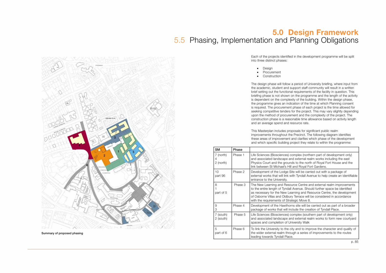
5.0 Design Framework5.5 Phasing, Implementation and Planning Obligations
Each of the projects identified in the development programme will be split into three distinct phases:
• Design• Procurement • Construction
The design phase will follow a period of University briefing, where input from the academic, student and support staff community will result in a written brief setting out the functional requirements of the facility in question. This briefing phase is not shown on the programme and the length of the activity is dependent on the complexity of the building. Within the design phase, the programme gives an indication of the time at which Planning consent is required. The procurement phase of each project is the time allowed for seeking competitive tenders for the project. This may vary slightly depending upon the method of procurement and the complexity of the project. The construction phase is a reasonable time allowance based on activity length and an average spend and resource rate.
This Masterplan includes proposals for significant public realm improvements throughout the Precinct. The following diagram identifies these areas of improvement and clarifies which phase of the development and which specific building project they relate to within the programme:
Summary of proposed phasing
251
3
4
6
p. 85
SM Phase
7 (north)42 (north)
Phase 1 Life Sciences (Biosciences) complex (northern part of development only)and associated landscape and external realm works including the eastPhysics Court and the grounds to the north of Royal Fort House and thelink between St Michael’s Hill and Royal Fort Gardens.
10part 96
Phase 2 Development of the Lodge Site will be carried out with a package ofexternal works that will link with Tyndall Avenue to help create an identifiableentrance to the University.
81part of 5
Phase � The New Learning and Resource Centre and external realm improvementsto the entire length of Tyndall Avenue. Should further space be identifiedas necessary for the New Learning and Resource Centre, the developmentof Osborne Villas and Oldbury Terrace will be considered in accordancewith the requirements of Strategic Move 8.
9�
Phase 4 Development of the Hawthorns site will be carried out as part of a broaderpackage of works that will include the creation of Tyndall Place.
7 (south)2 (south)
Phase 5 Life Sciences (Biosciences) complex (southern part of development only)and associated landscape and external realm works to form new courtyardspaces and completion of University Walk
5part of 6
Phase 6 To link the University to the city and to improve the character and quality ofthe wider external realm through a series of improvements to the routesleading towards Tyndall Place.
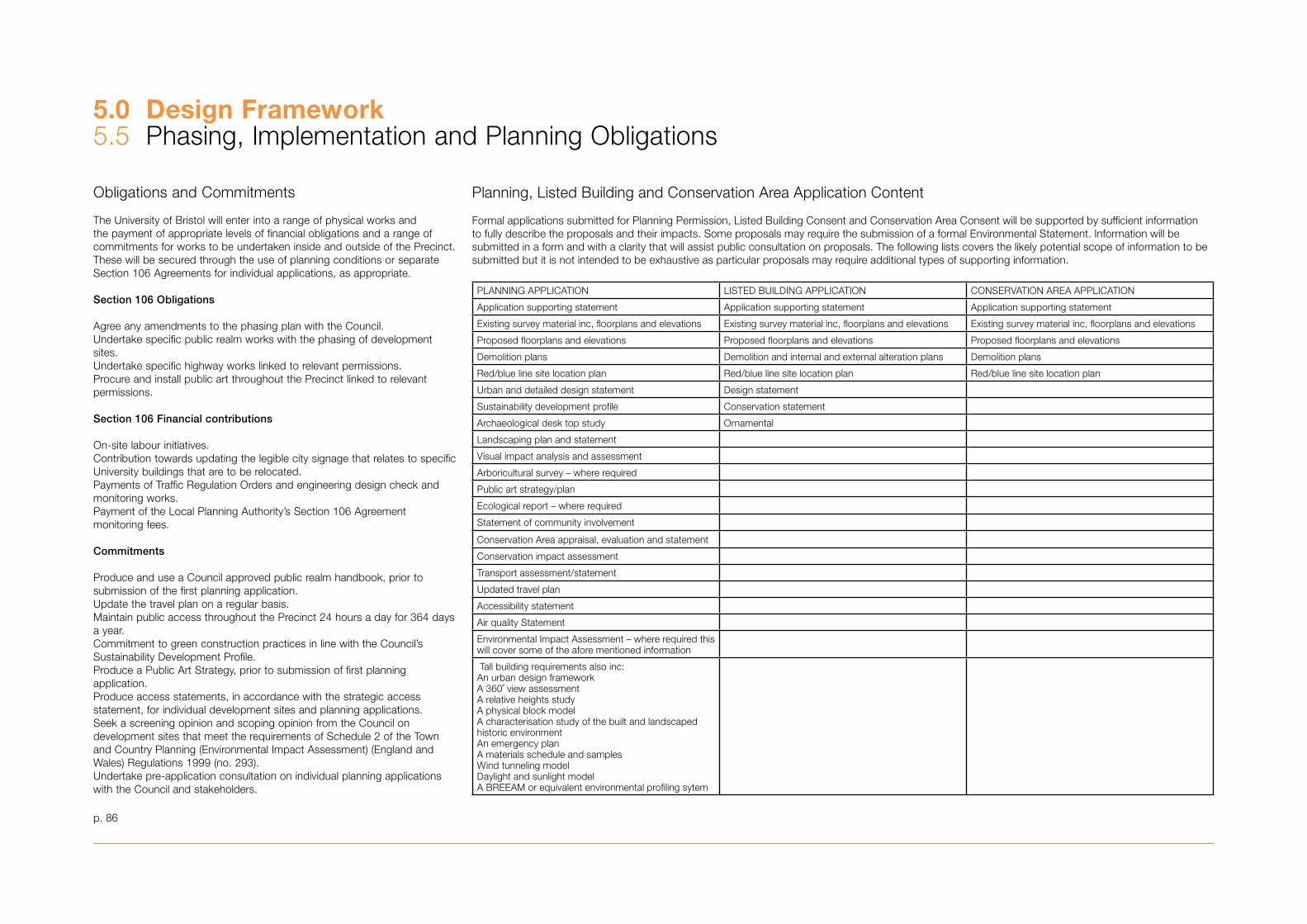
5.0 Design Framework5.5 Phasing, Implementation and Planning Obligations
Obligations and Commitments
The University of Bristol will enter into a range of physical works and the payment of appropriate levels of financial obligations and a range of commitments for works to be undertaken inside and outside of the Precinct. These will be secured through the use of planning conditions or separate Section 106 Agreements for individual applications, as appropriate.
Section 106 Obligations
Agree any amendments to the phasing plan with the Council.Undertake specific public realm works with the phasing of development sites. Undertake specific highway works linked to relevant permissions. Procure and install public art throughout the Precinct linked to relevant permissions.
Section 106 Financial contributions
On-site labour initiatives. Contribution towards updating the legible city signage that relates to specific University buildings that are to be relocated. Payments of Traffic Regulation Orders and engineering design check and monitoring works.Payment of the Local Planning Authority’s Section 106 Agreement monitoring fees.
Commitments
Produce and use a Council approved public realm handbook, prior to submission of the first planning application.Update the travel plan on a regular basis.Maintain public access throughout the Precinct 24 hours a day for �64 days a year. Commitment to green construction practices in line with the Council’s Sustainability Development Profile. Produce a Public Art Strategy, prior to submission of first planning application.Produce access statements, in accordance with the strategic access statement, for individual development sites and planning applications.Seek a screening opinion and scoping opinion from the Council on development sites that meet the requirements of Schedule 2 of the Town and Country Planning (Environmental Impact Assessment) (England and Wales) Regulations 1999 (no. 29�).Undertake pre-application consultation on individual planning applications with the Council and stakeholders.
Formal applications submitted for Planning Permission, Listed Building Consent and Conservation Area Consent will be supported by sufficient information to fully describe the proposals and their impacts. Some proposals may require the submission of a formal Environmental Statement. Information will be submitted in a form and with a clarity that will assist public consultation on proposals. The following lists covers the likely potential scope of information to be submitted but it is not intended to be exhaustive as particular proposals may require additional types of supporting information.
PLANNING APPLICATION LISTED BUILDING APPLICATION CONSERVATION AREA APPLICATION
Application supporting statement Application supporting statement Application supporting statement
Existing survey material inc, floorplans and elevations Existing survey material inc, floorplans and elevations Existing survey material inc, floorplans and elevations
Proposed floorplans and elevations Proposed floorplans and elevations Proposed floorplans and elevations
Demolition plans Demolition and internal and external alteration plans Demolition plans
Red/blue line site location plan Red/blue line site location plan Red/blue line site location plan
Urban and detailed design statement Design statement
Sustainability development profile Conservation statement
Archaeological desk top study Ornamental
Landscaping plan and statement
Visual impact analysis and assessment
Arboricultural survey – where required
Public art strategy/plan
Ecological report – where required
Statement of community involvement
Conservation Area appraisal, evaluation and statement
Conservation impact assessment
Transport assessment/statement
Updated travel plan
Accessibility statement
Air quality Statement
Environmental Impact Assessment – where required this will cover some of the afore mentioned information
Tall building requirements also inc:An urban design frameworkA 360˚ view assessmentA relative heights studyA physical block modelA characterisation study of the built and landscaped historic environmentAn emergency planA materials schedule and samples Wind tunneling model Daylight and sunlight modelA BREEAM or equivalent environmental profiling sytem
Planning, Listed Building and Conservation Area Application Content
p. 86
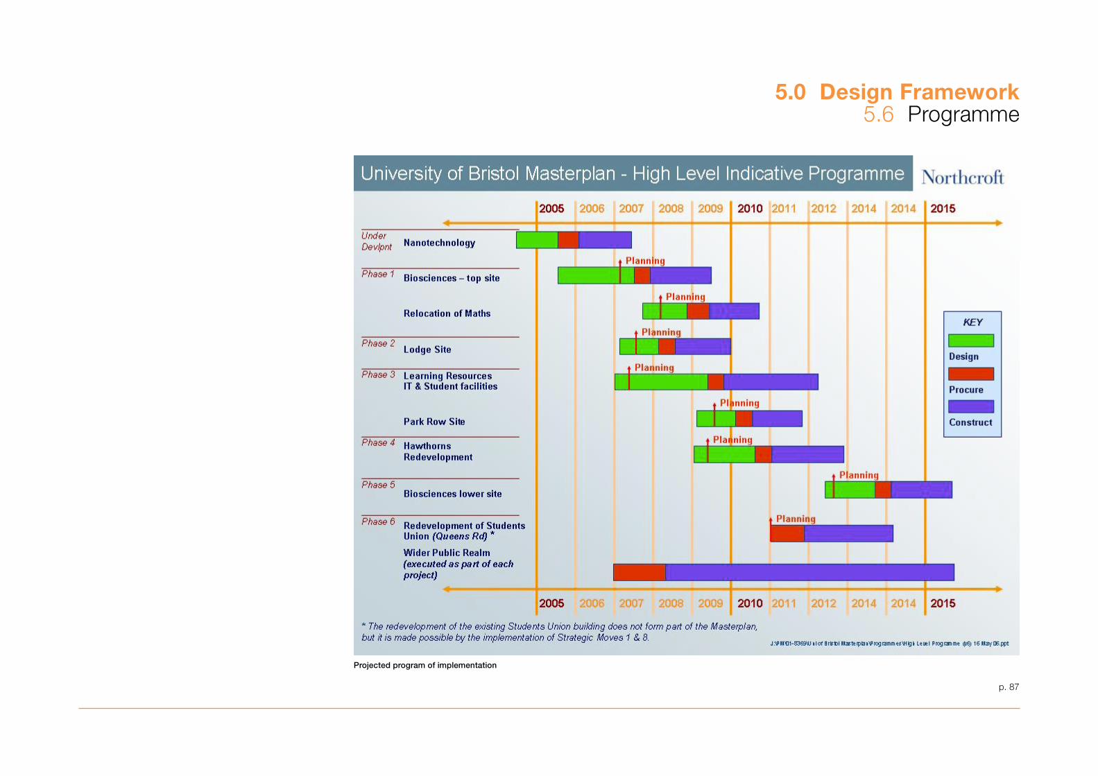
5.0 Design Framework5.6 Programme
Projected program of implementation
p. 87
6.0 The Way Forward
In order to maintain its position as a world-class organisation, Bristol University needs to plan to meet the demands for the future. The purpose of the Masterplan is to provide a physical framework for development of the Precinct over the next 10 to 15 years.
The Masterplan demonstrates that it is possible to accommodate the anticipated growth and development required over this period within the University Precinct in a balanced, dynamic and sustainable manner in accordance with its historic context. This is achievable through redevelopment of existing sites and the design of flexible new buildings which make efficient use of the available land and provide the right facilities for evolving teaching and research methods.
The Precinct is located on a site of significant historical importance. It is essential that development of the University is carried out with a thorough understanding of that heritage, and that proposals respect and enhance the historic character of the area. Any development that requires the demolition or alteration of listed buildings or buildings within a conservation area must be carefully considered and will only be viable should the proposals be of high quality and provide considerable public benefit.
It is imperative that any new buildings and landscapes created are carefully designed and of high quality in accordance with planning policy to fully reflect the aspirations and aims of the University and for the benefit of Bristol and its citizens. There is the opportunity to create exciting new architecture and iconic buildings that enhance the Precinct and create an identity for the University.
The presence of the University within the city and the wider area has been an important consideration in the development of the Masterplan and the effects of the proposals on the skyline must be carefully considered.
However, new buildings alone will not provide the University with the unified character that it needs in order to reinforce its identity as a significant part of the fabric of the City. The design of the public realm is critical in reuniting the disparate elements of the University and creating a ‘sense of place’ that it is currently lacking.
A key element of the Masterplan is the move to concentrate and rationalise the existing student facilities to create a social heart to the University and enliven the Precinct throughout the year. The effect of these changes must be considered in relation to local residents and the effects upon local businesses.
The University has sometimes been perceived in the past as being an isolated community within the city. The University understands the importance of working with and living alongside its neighbouring communities and development on this scale cannot be achieved successfully in isolation. The continued involvement and support of the local communities and stakeholders are required throughout the future development of the University.
In particular, the support of the Council is very important to the successful implementation of this Masterplan in addition to its role as local planning authority. For example the Council has an important role to play, often in association with other partners, in implementing its city centre parking strategy, promoting more sustainable means of transport and reducing anti-social behaviour and crime. The Council looks forward to continuing working with the University to pursue these and other initiatives that will assist the aims of the University as set out in the Masterplan.
p. 89
7.0 Glossary of Appendices
Appendix 1 Ecological Walkover Survey
This appendix contains an ecological walkover survey of the Precinct area, including all open spaces. It forms an assessment of the suitability of the Precinct to accommodate animal and bird species protected under UK and European legislation.
Appendix 2 Tree Survey
This appendix contains the summary plan of all trees contained within the Precinct. This must be read in conjunction with the full detailed schedule contained within Appendix B of Appendix 1�.
Appendix 3 Statement of Community Involvement
This appendix provides an overview of the consultation process that was undertaken prior to the adoption of the Masterplan as a Supplementary Planning Document. It dates from Autumn 200� – Winter 2005. It summarises the range of activities and consultation processes undertaken, the range of stakeholders involved in the process and the amendments that have been made to the Masterplan as a result of this. This must be read in conjunction with the Council’s Cabinet report which provides a summary of the formal public consultation process undertaken prior to the adoption of the Masterplan as SPD.
Appendix 4 Areas of Public ‘Benefit’ Provided by the University
This appendix summarises the range of benefits that the University provides, not only for its own staff and students, but also for the City and citizens of Bristol. This includes public lectures and events undertaken throughout the year, buildings that can be hired for public events, accessibility to the Libraries, the Brunel, Theatre and Penguin Book collections and archives, use of its sports facilities and organised recreational activities, the voluntary and mentoring work undertaken by the Students’ Union and public access to the gardens and grounds of University buildings such as Royal Fort, the Botanic Garden and, on specific occasions, Goldney Grotto.
Appendix 5 Standardised Floorplate Design
This appendix assesses the standardised floorplate design of 15m deep in plan and where necessary 1�.5m deep in plan, required by the University for new development within the Precinct.
Appendix 6 New Building Areas
This appendix provides a schedule of floorspace areas for the principal development sites throughout the Precinct.
Appendix 7 Sustainability Criteria
This appendix provides a preliminary response to the contents of the Council’s Sustainable Development Profile. This assesses the Masterplan’s impact on neighbourhood and social issues, the local economy and employment and environmental issues. This must be read in conjunction with Appendix 15, the Sustainability Appraisal.
Appendix 8 The Estate Today
This appendix provides on overview of the Faculties in terms of their buildings and their associated functions, floorspace areas, and architectural quality. This does include a range of buildings situated outside of the Precinct area.
Appendix 9 Tall Buildings
This appendix provides a summary of the design assessment for the opportunity and suitability of a tall building as part of Strategic Move 8, the development of the Learning Resource Centre. This looks at a tall building’s relationship to the overall objectives of the Masterplan, its impact on 10 key views across Bristol, associated environmental constraints and the impact of a physical form and a series of illustrative design studies.
Appendix 10 Buildings Assessment Matrices
This appendix assesses the historic and architectural significance and merit of the Former Childrens Hospital and associated buildings including former nurses houses and accommodation, the Institute of Child Health, the Intensive Care Unit, the Bone Marrow Transplant Unit, short stay family accommodation, outpatients building and lift tower, 7� – 77 St Michael’s Hill, 22 – 24 Tyndall Avenue and the Hawthorns. Appendix 11 and 16 must also be read in conjunction with the sections on the Hawthorns and the Former Childrens Hospital, as these contain a much more comprehensive assessment of these particular sites and their collection of buildings.
Appendix 11 The Hawthorns – Assessment of Potential for Development
This appendix explores the potential for the re-development of this site. It includes a building audit and re-development options. These comprise a detailed analysis of the history and evolution of the buildings, a site analysis and description of its current use and an evaluation of its architectural and historic merit, its contribution to the Conservation Area and streetscape and key design principles.
Appendix 12 The Royal Fort Lodge Site – Assessment of Potential for Development
This appendix examines the potential for development of this site. It includes a building audit and a series of re-development options. These comprise an analysis and assessment of the history and evolution of the building and surrounding site and development of the landscape, a description of the building’s current use and an evaluation of its contribution to the Conservation Area and key design principles.
Appendix 13 Urban Landscape and External Realm
This appendix appraises the historic evolution of the Precinct, particularly focusing on Royal Fort Gardens, analyses the urban realm’s character, use, spatial condition and materials, provides a tree audit, undertakes a visual appraisal of 10 key viewpoints from around Bristol and sets out a design concept for the enhancement of the Precinct’s public realm.
Appendix 14 Archaeological Report
This appendix examines the historic and archaeological environment of the Precinct from the late C19 to the present day. This should be read in conjunction with Dr Roger Leech’s study of the St Michael’s Hill Precinct of the University (2000) which covered the period up to the early C19.
Appendix 15 Sustainability Appraisal
This appendix provides an assessment of the sustainability appraisal process undertaken to evaluate the affects of the Masterplan’s objectives against a set of sustainability targets and objectives and the outcomes of that process.The Masterplan’s objectives of delivering an improved physical environment, creating a better mix of spaces and uses and better accessibility to, across and throughout the Precinct, design for a sustainable future and creating better relationships with neighbouring communities are assessed against the sustainability appraisal’s objectives of environmental responsibility, the prudent use of natural resources, social progress and economic strength.
Appendix 16 The Former Childrens Hospital – Historic Buildings Assessment
This appendix examines the significance of the former Childrens Hospital’s former ward and entrance buildings. This comprises a summary of the historical development and significance of the buildings including as an example of a Victorian Children’s Hospital, a summary of changes that have taken place and an assessment of the extent of remaining original fabric.
p. 91
Related Documents