United States Department of Agriculture Forest Service Frazier Creek Placer Mining Exploration Environmental Assessment Beckwourth Ranger District, Plumas National Forest, Plumas County, California September 2015

Welcome message from author
This document is posted to help you gain knowledge. Please leave a comment to let me know what you think about it! Share it to your friends and learn new things together.
Transcript
United States Department of Agriculture
Forest Service
Frazier Creek Placer Mining Exploration Environmental Assessment
Beckwourth Ranger District, Plumas National Forest, Plumas County, California
September 2015

For More Information Contact:
Leslie Edlund Beckwourth Ranger District, Plumas National Forest
P.O. Box 7 Blairsden, CA 96103
Phone: (530) 836-2575 Email: [email protected]
Fax: (530) 836-0493
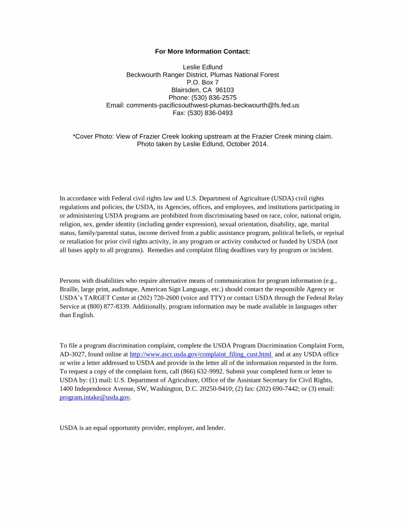
*Cover Photo: View of Frazier Creek looking upstream at the Frazier Creek mining claim. Photo taken by Leslie Edlund, October 2014.
In accordance with Federal civil rights law and U.S. Department of Agriculture (USDA) civil rights
regulations and policies, the USDA, its Agencies, offices, and employees, and institutions participating in
or administering USDA programs are prohibited from discriminating based on race, color, national origin,
religion, sex, gender identity (including gender expression), sexual orientation, disability, age, marital
status, family/parental status, income derived from a public assistance program, political beliefs, or reprisal
or retaliation for prior civil rights activity, in any program or activity conducted or funded by USDA (not
all bases apply to all programs). Remedies and complaint filing deadlines vary by program or incident.
Persons with disabilities who require alternative means of communication for program information (e.g.,
Braille, large print, audiotape, American Sign Language, etc.) should contact the responsible Agency or
USDA’s TARGET Center at (202) 720-2600 (voice and TTY) or contact USDA through the Federal Relay
Service at (800) 877-8339. Additionally, program information may be made available in languages other
than English.
To file a program discrimination complaint, complete the USDA Program Discrimination Complaint Form,
AD-3027, found online at http://www.ascr.usda.gov/complaint_filing_cust.html and at any USDA office
or write a letter addressed to USDA and provide in the letter all of the information requested in the form.
To request a copy of the complaint form, call (866) 632-9992. Submit your completed form or letter to
USDA by: (1) mail: U.S. Department of Agriculture, Office of the Assistant Secretary for Civil Rights,
1400 Independence Avenue, SW, Washington, D.C. 20250-9410; (2) fax: (202) 690-7442; or (3) email:
USDA is an equal opportunity provider, employer, and lender.

i
Contents Contents ............................................................................................................................................ i Introduction ..................................................................................................................................... 1
Proposed Project Location ....................................................................................................... 1 Background ..................................................................................................................................... 3 Need for the Proposal ...................................................................................................................... 3
Decision Framework ................................................................................................................. 3 Land Management Direction ................................................................................................... 4
Public Involvement and Tribal Consultation ................................................................................... 6 Proposed Action and Alternatives ................................................................................................... 6
Alternative A – Plan of Operations as submitted ........................................................................ 6 Alternative B - Proposed Action with Mitigations...................................................................... 7 Alternative C – No Action ........................................................................................................ 10
Environmental Impacts of the Proposed Action and Alternatives................................................. 10 Botanical Resources .................................................................................................................. 10 Wildlife ..................................................................................................................................... 13 Hydrology ................................................................................................................................. 16 Heritage Resources ................................................................................................................... 17
References ..................................................................................................................................... 17
List of Tables
Table 1. Summary of Weed Responses to Risk for Frazier Creek Mine Project Factors .............. 12
List of Figures
Figure 1. Vicinity map ..................................................................................................................... 2

Beckwourth Ranger District, Plumas National Forest
1
Introduction The Plumas National Forest is preparing to authorize mineral exploration on the Frazier Creek Placer mining
claim. This action is proposed to be implemented on the Beckwourth Ranger District of the Plumas National
Forest.
The environmental assessment (EA) will evaluate whether implementation of the Frazier Creek Placer
mineral exploration project may significantly affect the quality of the human environment and thereby
require the preparation of an environmental impact statement. By preparing this EA, we are fulfilling agency
policy and direction to comply with the National Environmental Policy Act (NEPA). For more details of the
proposed action, see the Proposed Action and Alternative sections of this document.
Proposed Project Location The project area is located south of Graeagle, California, along County Road 519, Gold Lake Highway. The
project area is along the stream terrace and banks of Frazier Creek. Frazier Creek is a perennial stream that
drains to the Middle Fork of the Feather River. There is a dispersed campsite and access road on the west
side of Frazier Creek. The road is behind a locked gate so public access is limited except on foot. Frazier
Creek is currently and historically used for mining and also by recreational visitors. Vegetation in the area is
primarily mixed conifer with some brush and riparian vegetation. Vegetation is sparse on the west side of the
creek because of continued public use. The project as proposed would target areas primarily on the west
side of the creek. The east side of the creek is steeper and less accessible. The Frazier Creek mining claim is
20 acres in size, work is proposed across 4.9 acres, and disturbance will be less than 1 acre.
Access to the claim from Graeagle is south on Hwy 89 to County Road 519 (Gold Lake Highway). Travel
west on Gold Lake Highway approximately 1 mile to a dirt road on the left. The project area is within the
Beckwourth Ranger District, Plumas National Forest. The legal location is T22N, R12E, NE ¼ and NW ¼ of
Section 27, MDBM.

Frazier Creek Placer Mining Exploration
2
Figure 1. Vicinity map
Beckwourth Ranger District, Plumas National Forest
3
Background The Frazier Creek mining claim has been held by Mr. John Weaver since January of 2013. On a site visit on
March 28th,
2014, Forest Service personnel informed the claimants about the regulations for highbanking and
informed them that they would need a Plan of Operations for their work. Mr. Weaver submitted a Plan of
Operations for exploratory mining on May 29, 2014. It was submitted as a 5 year plan. Upon analysis of the
Plan, the proposed work area was found to be potential habitat for the Sierra Nevada Yellow-Legged frog.
Because of the potential habitat for the frog, it was determined that there were extraordinary circumstances
which would require analysis of this proposal under an Environmental Assessment (EA). This environmental
assessment is conducted in an effort to identify resource concerns and alternatives associated with
implementation of this Plan. Mitigation of these resource concerns will be incorporated into the proposal and
attached to the Plan of Operations as submitted.
Need for the Proposal An individual seeks to discover the mineral potential of his claim which is located on National Forest System
lands. He has submitted a Plan of Operations to obtain authorization for the surface disturbance associated
with the exploration methods he will use to extract the locatable minerals. This Plan of Operations is needed
to authorize: use of hand tools for excavation along the banks of Frazier Creek, use of a highbanker to
process material, replacement and use of the gate along the access road, use of the non-system access road,
and dispersed camping at the site while mining.
This Environmental Assessment is needed because this Plan of Operations has been submitted requesting
authorization for exploration of a locatable minerals claim. According to Code of Federal Regulations (36
CFR 228; Subpart A), the Forest must provide a timely response to a proposed Plan of Operations. In order
to provide a response and provide reasonable changes, modifications and/or mitigations to the submitted
proposal, we evaluate the proposal through an Environmental Assessment.
According to the 1988 Plumas National Forest Land and Resource Management Plan, as amended, the Forest
Service must encourage mineral exploration and development that reasonably protects surface resources and
provides for land reclamation. The purpose of this specific analysis is to determine if the proposed Plan of
Operations can be approved as submitted, approved with accompanying design features and mitigations
required to protect surface resources, or if the Plan cannot be approved at all because it is contrary to law or
regulation.
Decision Framework The deciding official for this proposal is the Beckwourth District Ranger of the Plumas National Forest
(PNF). This Environmental Assessment (EA) serves to disclose the environmental consequences of no-
action, the proposed Frazier Creek Placer Plan of Operations as proposed and the proposed Frazier Creek
Placer Plan of Operations with mitigations. Once the Environmental Assessment is complete, the deciding
official will decide whether to approve the proposal as submitted, approve the proposal with recommended
mitigations or deny operations as proposed. The Forest Service cannot deny a locatable mineral Plan of
Operations where the proposed activities are reasonably incident to mining and would comply with other
Federal laws.
Although the approval of a Plan of Operations is not a discretionary action, the deciding official is legally
bound to provide for resource protection without unreasonably inhibiting or restricting the activities of
miners and/or prospectors. The ensuing Decision Notice (DN) linked to this EA does NOT directly result in
the approval of the claimant’s Plan of Operations (PoO). Rather, the Decision Notice fulfills legal
requirements and provides rationale for establishing reasonable mitigations or “Conditions of Approval”,
such as fire prevention measures, hazmat spill requirements, reclamation requirements, posting of a bond,
and compliance with other Federal, State and Local regulations. The Frazier Creek Placer PoO would be

Frazier Creek Placer Mining Exploration
4
authorized subsequently when signed by the deciding official, contingent upon the claimant’s willingness to
comply with the requirements of the Agency’s decision.
Land Management Direction The Mining Law of 1872, as amended, governs the prospecting for and appropriation of metallic and
nonmetallic minerals on federally owned lands. Under the Forest Service, Organic Administrative Act of
June 4, 1897, 30 Stat. 35, as amended, the law specifically did not reserve the Forests from the mining laws:
“Nor shall anything herein prohibit any person from entering upon such Forest Reservations for all
proper and lawful purposes, including that of prospecting, locating, and developing the mineral
resources thereof.”
Since the mineral estate in National Forest System lands is not “reserved” within the meaning of the 1897
Organic Act, the Secretary of the Interior maintains jurisdiction, acting through the Bureau of Land
Management, to provide for the management of mineral resources. The mining laws are comprised of two
parts: (1) the statutes themselves, which are general in nature; and (2) the decisions of the courts and of the
Department of the Interior, which interpret and apply the statutes to specific cases (FSM, Title 2800 –
Minerals and Geology, subsection 2819).
The Multiple Use Mining Act of 1955 authorized multiple uses of surface resources on mining claims,
resulting in the Locatable Minerals Surface Management Regulations (36 CFR 228 Subpart A). Although
regulations do not constitute a permit to explore or mine, as that is already a statutory right, they do provide
that such activities be conducted to protect non-mineral values of National Forest System lands against
unnecessary or unreasonable damage (36 CFR 228, Subpart A – Locatable Minerals).
As directed under 36 CFR 228.8, Requirements for Environmental Protection:
“All Plans of Operation shall contain appropriate Terms and Conditions for the protection of the
environment, including but not limited to stipulations covering air quality, water quality, solid
wastes, scenic values, fishery habitat, roads and surface reclamation and rehabilitation.”
In the subsequent Mining and Minerals Policy Act of 1970, Congress declared that it is the continuing policy
of the Federal Government, in the national interest, to foster and encourage private enterprise in the
development of economically sound and stable industries, and in the orderly and economic development of
domestic mineral resources to help assure satisfaction of industrial, security, and environmental needs. In the
case United States v. Weiss, 642 F.2d 296, 299 (1981), the Ninth Circuit declared there is nothing in the 36
Code of Federal Regulations which authorizes the Forest Service to prohibit the claimant’s right to the
possession and enjoyment of their claims, or to encroach impermissibly upon those rights, by circumscribing
their use in a manner that amounts to a prohibition.
The National Forest Management Act (NFMA) of 1976 (which amended The Forest and Rangeland
Renewable Resources Planning Act of 1974) requires the maintenance and protection of the productivity of
the land and, where appropriate, the improvement of the quality of soil and water resources. The Act
specifies that substantial and permanent impairment of productivity must be avoided.
The Plumas National Forest Land and Resource Management Plan (PNF LRMP) (USDA 1988), as amended
by the Sierra Nevada Forest Plan Amendment (SNFPA) Final Environmental Impact Statement (FEIS) and
Record of Decision (ROD) (USDA 2004a, 2004b) establishes standards and guidelines for protection and
maintenance of Forest soils, watersheds, water quality, and water supply. These standards and guidelines are
applied as Best Management Practices (BMPs), Streamside Management Zones (SMZs) (per guidelines in
Appendix M of the PNF LRMP) and Riparian Conservation Areas (RCAs). The 2004 SNFPA ROD
(Appendix A; section D) outlines the Standards and Guidelines for project design and implementation to
Beckwourth Ranger District, Plumas National Forest
5
ensure that Riparian Conservation objectives are met within RCAs, based on the nature of the waterway or
feature.
Critical Aquatic Refuges (CARs) are sub-watersheds that have locations of threatened, endangered, or
sensitive species, highly vulnerable populations of native plant or animal species, or localized populations of
rare native aquatic- or riparian-dependent plant or animal species. Specific management direction for CARs
is outlined in the Sierra Nevada Forest Plan Amendment (SNFPA) Final Environmental Impact Statement
(FEIS) and Record of Decision (ROD) (USDA 2004a, 2004b).
The 1988 PNF LRMP (pages 4-46 through 4-47) provides for encouraging mineral and materials
development that reasonably protects surface resources, and provides for land reclamation. Further
requirements for inspections, monitoring, reclamation, and guidelines for road use and vegetation
management are outlined in the 2004 SNFPA FEIS ROD (pages 58-59).
The Clean Water Act (CWA) of 1948 (as amended in 1972 and 1987) establishes, as Federal policy, the
control of both point and non-point source pollution and assigns to the states the primary responsibility of
governing water quality. All Plans of Operation are subject to CWA standards.
Non-point source pollution on the Plumas National Forest is managed through the water quality management
program contained in “Water Quality Management for Forest System Lands in California” (USDA Forest
Service September 2000). This document describes Forest Service practices and procedures for protection of
water quality and contains the 1981 Management Agency Agreement (MAA) between the California State
Water Resources Control Board (CSWRCB) and the USDA, Forest Service. The State Board has designated
the Forest Service as the management agency for all activities on National Forest lands and the MAA
constitutes the basis of regional waivers for non-point source pollution. All Plans of Operation are reviewed
by the CSWRCB for compliance with the Clean Water Act. Communications from the State Water Board are
part of the project record located at the Mt. Hough Ranger District.
The Forest Service water quality protection program relies on implementation of prescribed best
management practices (BMPs). Best Management Practices are procedures, techniques, and mitigation
measures that are incorporated in project actions and have been determined by the state to be the most
effective, practicable means of preventing or reducing the amount of pollution generated by nonpoint sources
to a level compatible with water quality goals. All mining operations authorized under a Plan of Operations
are required to comply with Best Management Practices. Random evaluations are conducted on operations
each year to evaluate the operation for sediment transport and deposition, signs of erosion, and improper
refuse or waste disposal.
The Surface Mining and Reclamation Act of 1975 (SMARA) was enacted by the California Legislature to
address the need for a continuing supply of mineral resources, and to prevent or minimize the negative
impacts of surface mining to public health, property and the environment. The Act's requirements apply to
anyone engaged in surface mining operations in California (including those on federally managed lands)
which disturb more than one acre or remove more than 1,000 cubic yards of material.
The National Environmental Policy Act (NEPA) was signed into law on January 1, 1970. NEPA requires
federal agencies to assess the environmental effects of their proposed actions prior to making decisions. The
range of actions covered by NEPA is broad and includes: making decisions on permit applications, adopting
federal land management actions, and constructing highways and other publicly-owned facilities.
Using the NEPA process, agencies evaluate the environmental and related social and economic effects of
their proposed actions. Agencies also provide opportunities for public review and comment on those
evaluations.
Section 101 of the NEPA requires the federal government to preserve important historic, cultural and natural
aspects of our natural heritage. To accomplish this, federal agencies utilize the Section 106 process of the
National Historic Preservation Act (NHPA). This process has been codified in 36 CFR 800 Subpart B. The
Frazier Creek Placer Mining Exploration
6
coordination or linkage between the Section 106 process of the NHPA and the mandate to preserve our
national heritage under NEPA is well understood and is formally established in 36 CFR 800.3b and 800.8.
Locally, the Plumas National Forest uses a programmatic agreement (PA) between Region 5 of the USFS, the
California State Historic Preservation Officer and the Advisory Council on Historic Preservation to
implement the Section 106 process.
Public Involvement and Tribal Consultation This proposal was listed in the Schedule of Proposed Actions from June 2014 to the present time. In
addition, as part of the public involvement process, the Forest Service notified local tribes.
The Forest Service consulted the following individuals, Federal, State, tribal, and local agencies during the
development of this EA:
TRIBES:
Maidu Summit Consortium
Susanville Indian Rancheria
Greenville Rancheria
Washoe Tribe of Nevada and California
OTHERS:
Plumas National Forest Schedule of Proposed Action
Central Valley Regional Water Quality Control Board
Proposed Action and Alternatives The Plumas National Forest proposes to approve the Frazier Creek mining Plan of Operations as described in
“Alternative B – Proposed Action with Mitigations”. This action is needed to establish the appropriate terms
and conditions which the claimant must abide by while exercising his right to mine as established by the
General Mining Law of 1872 while protecting National Forest resources consistent with other applicable law,
regulation and policy.
In addition to Alternative B the Forest Service also evaluated the Proposed Action as submitted by the
claimant and the No Action alternative. These alternatives are described in more detail below.
Alternative A – Plan of Operations as submitted The proposed action is the Plan of Operations as submitted by the proponent and is summarized below.
The project will explore the subsurface using hand tools such as shovels and picks to dig approximately 10-
20 holes along the edge of the creek. Holes will be approximately 2-3 feet in diameter and will be within a
10 feet of the edge of the creek. Holes will be approximately 4-5 feet deep. Excavated material will be put
through a highbanker and processed using water that is pumped from Frazier Creek. Waste water will be
returned to a small settling pit to percolate. No waste water or sediment will be returned to the stream
course.
The highbanker would be moved to areas around the claim central to the area that is being excavated.

Beckwourth Ranger District, Plumas National Forest
7
Concurrent reclamation of the test sites will be accomplished by backfilling each hole as the material is
processed. Waste material will be transported and replaced back into the excavations and compacted.
Operations will be seasonal from spring through the fall depending on weather. There will be no stream
crossings or streambed alteration.
The site will be reclaimed for seasonal closure by November 15th or the onset of winter weather.
Intermittent camping in tents or camp trailers will take place during the course of seasonal mining. One to
three persons may be on site during active mining operations. Camping will take place at the existing
dispersed site.
The plan would also authorize use of a gate at the access road. The existing gate would be replaced and a
new gate, double locked with a Forest Service lock would be installed. The Plan would be valid for 5 years.
Alternative B - Proposed Action with Mitigations Alternative B is the proposed action with mitigations. Under this alternative, mining exploration as proposed
in the Plan of Operations would take place with the following mitigations.
MITIGATIONS
Soil and Hydrological Resources:
Best Management Practices (BMPs) to protect water quality as specified in the Pacific Southwest Region
Water Quality Management Handbook (USDA 2011) would be implemented. Conditions of approval for the
Plan of Operations will outline specific Best Management Practices that are applicable to this project.
Applicable Best Management Practices can be found in the Hydrology and Soils report in the project record
at the Mt. Hough District office.
Incorporation of the following operational guidelines would help minimize the risk of soil erosion and
degraded water quality resulting from the proposed mining activities:
Riparian Conservation Areas (RCAs)
Operations within RCAs: Holes and settling pits to be excavated by hand within the RCA of Frazier Creek
will be allowed within the designated areas discussed with the permittee and that are covered within the
Frazier Placer Mining Exploration EA. Any variations from this should be discussed between the permittee
and the Forest Service personnel prior to the occurrence of any additional activity within the RCA. Settling
pits will be located in areas far enough away from Frazier Creek as to not have direct sediment laden water
flow directly into the creek from these pits. Holes and settling pits that are to be hand dug should be filled in
before the onset of wet weather conditions (see “Wet Weather Operations Standards” under the “Soil
Protection” measures). No waste laden water from, or caused by, the operation will enter the creek.
Intermittent camping will be located at designated areas as discussed with the permittee. Trailers will be
taken off site for sewage disposal at approved facilities
Restoring Disturbed Areas: Areas disturbed by operations should be restored to a like or better condition
than prior to operations. Install erosion control measures (e.g. seeding of vegetation, slash material, etc.)
where erosional issues are evident or expected.
Material near Stream Courses: Remove any material outside of RCAs that are generated by project activities
that may impede flow prior to the end of operations.
Hazard Trees in RCAs: Hazard trees may be hand-felled and left in place or removed from RCAs if
necessary in a manner that minimizes disturbance to the RCA.

Frazier Creek Placer Mining Exploration
8
Hazardous Material Use and Operational Waste: Follow all applicable Best Management Practices in storing,
using, and disposing of hazardous material (e.g. petroleum products, etc.) and operational waste.
Soil Protection
Ground Cover: A 60% ground cover recommendation may apply to the areas disturbed along the stream
terraces at the end of the seasonal operations if deemed necessary by the District Hydrologist.
Wet Weather Operations Standards: Conduct operations when soil is dry; that is, in the spring when soil
moisture in the upper 8 inches is not sufficient to allow a soil sample to be squeezed and hold its shape, or
will crumble when the hand is tapped. In the summer and early fall after storm event(s) when soil moisture
between 2-8 inches in depth is not sufficient to allow a soil sample to be squeezed and hold its shape, or will
crumble when the hand is tapped. If rain events are forecast, erosion control measures will be put into place
to prevent soil movement. The site will be reclaimed for seasonal closure by November 15th or the onset of
winter weather.
Road Access: This permit is authorizing the reuse of the existing road that leads to the proposed camping
area. Departure from this road with vehicles would not be allowed under this permit.
Botanical Resources:
Require all off-road equipment and vehicles (Forest Service and contracted) used for project implementation
to be weed-free. Clean all equipment and vehicles of all attached mud, dirt and plant parts at a vehicle
washing station or steam cleaning facility before the equipment and vehicles enter the project area. In
addition, clean all off-road equipment prior to leaving areas infested with noxious weeds.
Make every effort to ensure that all materials (i.e. gravel, fill, mulches, etc.) used on the NFS are free of
invasive species and/or noxious weeds. Use onsite sand, gravel, rock or organic matter where possible.
Encourage use of certified weed free hay and straw. Where states have legislative authority to certify
materials as weed-free (or invasive free) and have an active State program to make those State-certified
materials available to the public, rules shall be developed that restrict the possession, use, and transport of
those materials unless proof exists that they have been State certified.
Early Detection and Rapid Response (EDRR): Inventory and survey so as to quickly detect invasive species
infestations, and subsequently implement immediate and specific actions to eradicate those infestations
before they become established and/or spread. Coordinate detection and response Noxious Weed Risk
Assessment Plumas National Forest.
Pro-actively manage aquatic and terrestrial areas of the NFS to increase the ability of those areas to be self-
sustaining and resistant (resilience) to the establishment of invasive species. Where necessary, implement
restoration, rehabilitation, and/or revegetation activities following invasive species treatments to prevent or
reduce the likelihood of the reoccurrence or spread of invasive species.
Where restoration, rehabilitation, or revegetation activities are planned, use weed-free equipment, mulches,
and seed sources. Avoid seeding in areas where revegetation will occur naturally, unless noxious weeds are a
concern. Save topsoil from disturbance and put it back to use in onsite revegetation, unless contaminated
with noxious weeds. All activities that require seeding or planting will need to use only locally collected
native seed sources. Plant and seed material should be collected from as close to the project area as possible,
from within the same watershed and at a similar elevation whenever possible. Persistent non-natives such as
timothy, orchard- grass, or ryegrass will be avoided. This will implement the USFS Region 5 policy that
directs the use of native plant material for revegetation and restoration for maintaining "the overall national
goal of conserving the biodiversity, health, productivity, and sustainable use of forest, rangeland, and aquatic
ecosystems".
Monitor the project area in summer; identify and treat any newly found noxious weed plants.

Beckwourth Ranger District, Plumas National Forest
9
All vehicles and equipment will be washed prior to entering the project area and will arrive free of all plant
material. Guidelines to prevent the introduction of noxious weed will be adhered to.
A seeding plan utilizing local, native seeds and weed free mulch will be incorporated into the conditions of
approval for the Plan if deemed necessary by botany staff.
Wildlife Resources:
All applicable Standards and Guides and the appropriate BMPs, see “Sierra Nevada yellow-legged frogs
(specifically)” under Appendix D of the Biological Assessment/Biological Evaluation (BA/BE) (on file at the
Beckwourth Ranger District).
Operations are subject to a limited operating period. All work would be completed between April 15th and
October 1st (or the first wetting rain).
All equipment (highbanker) must be kept out of Frazier Creek, all riparian vegetation and wet meadows or
wet areas (springs, etc.).
Suction strainers must be used on all drafting hoses and contain screens with less than 2mm holes. The
suction strainer shall be inserted close to the substrate in the deepest water available; the suction strainer shall
be placed in a bucket to avoid substrate and amphibian disturbance.
No storage of fuels and other toxic materials within Riparian Conservation Areas RCAs) and Critical Aquatic
Refuges (CARs). No refueling within RCAs and CARs unless there are no other alternatives. Ensure that
spill plans are reviewed and up-to-date.
Cultural Resources:
The Frazier Creek Placer Exploration project would meet the requirements of the National Historic
Preservation Act (NHPA) by protecting cultural resources through a field survey, tribal consultation, and
protection of sites in the Project Area. All known archaeological sites within the area of potential effect for
the Project, were field visited, documented, and site boundaries were flagged for avoidance. As outlined in
the Programmatic Agreement (USDA 2013), protection measures would be implemented, as appropriate, for
all cultural resources located within the Project Area. The application of the protection measures would result
in the Project having “no effect” on cultural resources and the USFS would have taken into account the effect
of the Project on cultural resource sites in compliance with the Programmatic Agreement and Section 106 of
the NHPA.
If any unrecorded cultural resources (artifacts, features or sites) are encountered as a result of project
operations, all activities in the vicinity of such finds will immediately cease pending an examination by the
Forest or District Archaeologist.
At a minimum, cultural resource sites shall be avoided where activities associated with the Project will occur.
1. All known cultural resource sites within the area of potential effect shall be clearly delineated prior to
implementing any associated activities that have the potential to affect cultural resource sites.
2. Buffer zones may be established to ensure added protection where the Forest or District Archaeologist
determines that they are necessary. The use of buffer zones may be applicable where setting contributes
to the property’s eligibility under 36 CFR 60.4, or where it may be an important attribute of some types
of cultural resource sites (e.g., historic buildings or structures with associated historic landscapes; or
traditional cultural properties important to Native Americans). The size of buffer zones shall be
determined by the Forest or District Archaeologist on a case-by-case basis.
3. When any changes in proposed activities are necessary to avoid historic properties (e.g., Project
modifications, redesign, or elimination; removing old or confusing project markings or engineering

Frazier Creek Placer Mining Exploration
10
stakes within site boundaries; or revising maps or changing specifications), these changes shall be
completed prior to initiating any Project activities.
4. Monitoring by heritage program specialists may be used to enhance the effectiveness of protection
measures.
Minerals Administration Evaluation of Proposed Operation:
Regular inspections of the site would be implemented to ensure that mining activities fall within the scope of
the Plan of Operations and Conditions of Approval and to ensure that reclamation is being performed in a
timely manner.
A bond which covers the potential costs of resource damage or equipment removal will be in place prior to
the start of operations. Reclamation will be inspected by Plumas National Forest staff to ensure timely and
successful reclamation.
Compliance with State and Local Agency Regulations
This operation falls under the thresholds specified by the Surface Mining and Reclamation Act of 1975
(SMARA).
A determination that Waste Discharge Requirements are not required has been received by the Forest Service
from the Central Valley Regional Water Quality Control Board.
Alternative C – No Action The No-Action Alternative represents no change from the current condition. This alternative acts as a
baseline to describe the existing environmental and social setting, by which the predicted effects of the
Proposed Action may be compared.
Under the No-Action alternative, current management plans would continue to guide management of the
project area. Without an approved plan, the mining claimant could conduct activities allowed under 36 CFR
228.4; limited to using vehicles on approved NFS roads, searching for and occasionally removing small
mineral samples, prospecting and sampling while not causing any significant surface resource disturbance,
marking and monumenting the claim, and conducting subsurface operations which would not cause surface
resource disturbance.
Environmental Impacts of the Proposed Action and Alternatives This section summarizes the potential impacts of the proposed action and alternatives for each impacted
resource. Resources that were not impacted and therefore not further analyzed include range and fuels
management.
Botanical Resources The area of analysis for the noxious weed risk assessment includes the project area and surrounding land up
to 1 mile outside the project boundary. Access routes to the project area were also considered in analyzing the
risk of noxious weed infestation. The project area was surveyed for noxious weeds by Plumas National
Forest botanists in spring and summer of 2014.
The California Department of Food and Agriculture’s noxious weed list (http://www.cdfa.ca.gov) divides
noxious weeds into categories A, B, and C. A-listed weeds are those for which eradication or containment is
required at the state or county level. With B-listed weeds, eradication or containment is at the discretion of
the County Agricultural Commissioner. C-listed weeds require eradication or containment only when found

Beckwourth Ranger District, Plumas National Forest
11
in a nursery or at the discretion of the County Agricultural Commissioner. At present, no A-, B-, or C-listed
weeds are known to occur in the project area.
Habitat Vulnerability
Vulnerability to noxious weed invasion and establishment is greatly influenced by plant cover, soil cover, and
overstory shade. The project area is predominantly characterized by Sierra mixed conifer, and montane
chaparral, with some red fir, white fir, and Douglas-fir stands, montane hardwoods, and a riparian
component. A granite-armored, perennial riparian channel that provides habitat for a diverse native plant
community forms the focus of the Frazier Creek Mine Project activities.
In addition to the vegetation composition, past timber harvest, wildfire and associated suppression activities,
historic mining, and recreational activity such as off-highway vehicle use and woodcutting contribute to the
risk of weed invasion within the project area. The area is commonly used for recreation. A short spur road
west of Frazier Creek, running south-southwest off of Gold Lake Highway (County Road 519/ Forest Road
24) provides access to the project area. Historic mining, firewood gathering activities, and off-highway
vehicle use have resulted in disturbed soil, contributing to a moderate-to- high vulnerability to noxious weed
invasion. Bare soil within the project area is particularly susceptible to noxious weed infestation.
The Frazier Creek Mine Proposed Action includes high-banking using a single motorized water pump, with
up to four operators using the same equipment (in turn) throughout the summer months, no removal of
vegetation, and the re-filling of any holes made. Overnight camping in tents may occur and a porta-potty may
be brought on site. The existing gate would be removed and a new (approved) gate would be installed.
Vehicles and equipment used during the project activities can transport weed seeds or plant fragments.
Disturbed soil is particularly susceptible to noxious weed infestation. Important to the introduction and
spread of noxious weeds is the amount of soil disturbance and the amount of available sunlight. Many
noxious weeds are early seral (i.e. pioneer) species that invade newly disturbed places with bare soils and
ample sunlight. Activities that create these conditions are at risk of invasion. The more disturbance caused,
the greater the area available for introduction, and thus the greater the risk. Therefore high disturbance
activities are considered more at risk of invasion by noxious weeds than low disturbance.

Frazier Creek Placer Mining Exploration
12
Anticipated Weed Response to Proposed Action
Table 1. Summary of Weed Responses to Risk for Frazier Creek Mine Project Factors
Factors Variation Risk
NON-PROPOSED ACTION DEPENDENT FACTORS
1. Inventory Selected areas were surveyed Low
2.Known Noxious Weeds None identified Moderate
3. Habitat vulnerability Moderate current disturbance Moderate current risk
4. Non-project dependent
vectors
Moderate current vectors;
upcoming Lakes Basin fuels
reduction project includes high
risk vectors
Moderate current risk;
upcoming PNF fuels reduction
project will create a high risk
of spread by vectors
PROPOSED ACTION DEPENDENT FACTORS
5. Habitat alteration
expected as a result of
project.
Low ground disturbance;
moderate change in vegetative
ground cover
Moderate
6. Increased vectors as a
result of project
implementation
Vehicles used in
implementation increase risk
when compared to no action
Moderate
7. Mitigation measures No SOPs measures
implemented
High
Some SOPs measures
implemented
Moderately reduced
All SOPs measures
implemented
Greatly reduced
8. Anticipated weed response
to proposed action
Some or no SOPs measures
implemented
Moderate to high potential for
weed infestation as a result of
project implementation
All SOPs measures
implemented
Low-to-moderate potential for
weed infestation as a result of
project implementation if all
SOPs are implemented.
9. Cost estimates 2014: Spraying, monitoring,
and/or control 5 days GS 9 =
$1400 2015: Spraying,
monitoring, and/ or control 5
days GS 9 = $1400
Generally, it is more
economical and efficient to
treat small infestations than to
wait until they are large.

Beckwourth Ranger District, Plumas National Forest
13
Wildlife A list of Threatened, Endangered, Proposed, Candidate and Sensitive (TEPCS) species, Management
Indicator Species (MIS) and Migratory Birds that potentially occur on the Plumas National Forest may be
found in the project record located at the Beckwourth Ranger District office.
There were no detected Threatened, Endangered or Proposed species (Sierra Nevada Yellow-Legged
frog) in the analysis area, however it is considered suitable habitat.
There is no designated or proposed critical habitat for Threatened or Endangered species in the analysis
area.
The project is compliant with any applicable species recovery, conservation, management plans or
programmatic agreements.
Analysis Area
For the purposes of the proposed project, the wildlife analysis area is the proposed treatment area.
The Frazier Creek Placer Mining Exploration Project area encompasses a portion of Frazier Creek with a
vegetation component predominately consisting of riparian deciduous shrubs and trees, conifer and shrubs.
Presently, there is suitable habitat for riparian deciduous shrubs and trees, open conifer, riverine and meadow
associated MIS species.
Surveys/Site Visits
Surveys were conducted for species of interest during the summer of 2013 for the Lakes Basin Project. No
species of interest (Sierra Nevada yellow-legged frogs (SNYLFs) and foothill yellow-legged frogs (FYLFs))
were detected in the Wildlife Analysis Area. Surveys of all utilization unknown habitat (suitable habitat with
unknown occupancy) would be conducted prior to implementation of the project.
ENVIRONMENTAL CONSEQUENCES
Direct and Indirect Effects
Direct effects include the potential for killing or injuring of individuals (SNYLFs) from the people walking
along the stream bank, within the stream channel and digging holes in the suitable habitat. Harassment of
individual frogs from mining activity (e.g. noise disturbance and ground vibration) within or near suitable
habitat may also directly affect the species.
The Frazier Creek Placer Mining Exploration Project would have a minimal effect on yellow-legged frogs
(YLFs) or their habitat. This is based on the use of hand equipment and digging holes in the suitable habitat
and the potential for increased turbidity and sediment load in Frazier Creek due to project activities.
Indirect effects could occur in the form of: the potential for increased turbidity and sediment load in Frazier
Creek due to project activities.
The perennial stream, Frazier Creek within the project area contain rainbow and brown trout, both known
predators of YLFs. Implementation of Best Management Practices (BMPs), Mitigation Measures (MMs), and
meeting Riparian Conservation Objectives (RCOs) would maintain suitable habitat conditions for trout in
Frazier Creek where they currently occupy.
All three species of garter snakes (Thamnophis sp.) that occur within the wildlife analysis area will feed on
frogs, tadpoles and egg masses. Garter snake populations, especially those of the aquatic garter snake, are not
expected to be affected by project activities.

Frazier Creek Placer Mining Exploration
14
Cumulative Effects
The analysis of cumulative effects of the proposed action evaluates the impact on TES habitat from the
existing condition within the Wildlife Analysis Area.
Cumulative effects on YLFs could occur with the incremental loss of the quantity and/or quality of habitat
for these species. Overall, increases in urbanization, increases in recreational use of National Forest System
lands, and the utilization of natural resources on state, private and federal lands may contribute to habitat loss
for these species.
Future activities on NFS include the Lakes Basin Project. The timber harvest activities in these projects
would reduce the availability of old forest (CWHR Habitat 4M, 4D, 5M and 5D) stand structure and
characteristics however; these activities would maintain the existing condition of riverine and lacustrine
habitat in the wildlife analysis area.
The fuelwood gathering and Christmas tree cutting programs on the PNF are ongoing programs that have
been in existence for years and are expected to continue. The past and future effect of these actions has and
would be to shift forest successional stages to somewhat earlier stages, while generally retaining continuous
forest cover which would have no effect on the YLFs.
Most of the recreation use within the Wildlife Analysis Area consists of dispersed camping, fishing, hiking,
horseback riding, hunting, mining, mountain biking, off highway vehicles (OHV) use, pleasure driving, and
wildlife watching. The use is expected to continue at the current rate. These activities may affect this species
through direct disturbance, trampling or crushing by humans, pack stock and/or OHV, etc., and habitat
degradation however in this area these effects are expected to be minimal on the YLFs. This is based on the
dispersed nature of the activities in this area and the lack of concentrated recreation use areas (campgrounds,
etc.).
DETERMINATION OF EFFECTS AND RATIONALE FOR DETERMINATION
The determinations are based on full implementation of all Mitigations or Protection Measure identified
above in Alternative B.
Threatened, Endangered, Proposed, Candidate and Sensitive species
Based on the type and degree of proposed activities within the wildlife analysis area for the proposed action
would directly or indirectly affect any Threatened, Endangered, Proposed, Candidate and Sensitive species.
Those are listed below in Table 2.
Management Indicator Species
Based on the type and degree of proposed activities within the wildlife analysis area for the proposed action
would not directly or indirectly affect any MIS species or their habitat. Further information is available in the
Management Indicator Species Report located at the Beckwourth Ranger District.
Migratory Birds
Based on the type and degree of proposed activities within the wildlife analysis area for the proposed action
would not directly or indirectly affect the American peregrine falcon or black swift. Further information is
available in the Migratory Bird Species Report located at the Beckwourth Ranger District.
Beckwourth Ranger District, Plumas National Forest
15
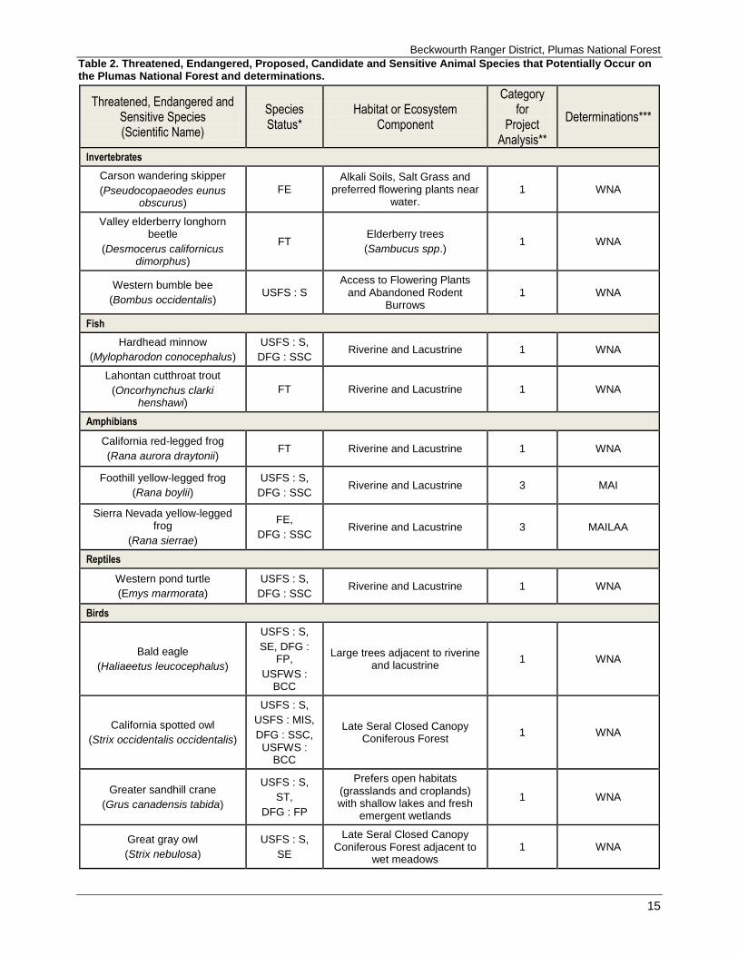
Table 2. Threatened, Endangered, Proposed, Candidate and Sensitive Animal Species that Potentially Occur on the Plumas National Forest and determinations.
Threatened, Endangered and Sensitive Species (Scientific Name)
Species Status*
Habitat or Ecosystem Component
Category for
Project Analysis**
Determinations***
Invertebrates
Carson wandering skipper
(Pseudocopaeodes eunus obscurus)
FE Alkali Soils, Salt Grass and
preferred flowering plants near water.
1 WNA
Valley elderberry longhorn beetle
(Desmocerus californicus dimorphus)
FT Elderberry trees
(Sambucus spp.) 1 WNA
Western bumble bee
(Bombus occidentalis) USFS : S
Access to Flowering Plants and Abandoned Rodent
Burrows 1 WNA
Fish
Hardhead minnow
(Mylopharodon conocephalus)
USFS : S,
DFG : SSC Riverine and Lacustrine 1 WNA
Lahontan cutthroat trout
(Oncorhynchus clarki henshawi)
FT Riverine and Lacustrine 1 WNA
Amphibians
California red-legged frog
(Rana aurora draytonii) FT Riverine and Lacustrine 1 WNA
Foothill yellow-legged frog
(Rana boylii)
USFS : S,
DFG : SSC Riverine and Lacustrine 3 MAI
Sierra Nevada yellow-legged frog
(Rana sierrae)
FE,
DFG : SSC Riverine and Lacustrine 3 MAILAA
Reptiles
Western pond turtle
(Emys marmorata)
USFS : S,
DFG : SSC Riverine and Lacustrine 1 WNA
Birds
Bald eagle
(Haliaeetus leucocephalus)
USFS : S,
SE, DFG : FP,
USFWS : BCC
Large trees adjacent to riverine and lacustrine
1 WNA
California spotted owl
(Strix occidentalis occidentalis)
USFS : S,
USFS : MIS,
DFG : SSC, USFWS :
BCC
Late Seral Closed Canopy Coniferous Forest
1 WNA
Greater sandhill crane
(Grus canadensis tabida)
USFS : S,
ST,
DFG : FP
Prefers open habitats (grasslands and croplands) with shallow lakes and fresh
emergent wetlands
1 WNA
Great gray owl
(Strix nebulosa)
USFS : S,
SE
Late Seral Closed Canopy Coniferous Forest adjacent to
wet meadows 1 WNA

Frazier Creek Placer Mining Exploration
16
Threatened, Endangered and Sensitive Species (Scientific Name)
Species Status*
Habitat or Ecosystem Component
Category for
Project Analysis**
Determinations***
Northern goshawk
(Accipiter gentilis)
USFS : S,
DFG : SSC
Late Seral Closed Canopy Coniferous Forest
1 WNA
Western yellow-billed cuckoo
(Coccyzus americanus occidentalis)
FT Montane Riparian Habitat 1 WNA
Willow flycatcher
(Empidonax trailii brewsteri)
USFS : S,
SE,
USFWS : BCC
Riparian with dense willows 1 WNA
Mammals
American marten
(Martes americana) USFS : S
Late Seral Closed Canopy Coniferous Forest
1 WNA
California wolverine
(Gulo gulo luteus)
FT, USFS : S,
ST, DFG : FP
Late Seral Closed Canopy Coniferous Forest
1 WNA
Fringed Myotis
(Myotis thysanodes) USFS : S
Open Canopy Hardwood-Conifer Forest
1 WNA
Pacific fisher
(Martes pennanti pacifica)
FC, USFS : S,
DFG : SSC
Late Seral Closed Canopy Coniferous Forest
1 WNA
Pallid bat
(Antrozous pallidus)
USFS : S,
DFG : SSC
Most common in open, dry habitats with rocky areas (rocky outcrops, cliffs and
crevices)
1 WNA
Townsend’s big-eared bat
(Corynorhinus townsendii)
USFS : S,
DFG : SSC Mesic Habitats 1 WNA
*Species Status: FE = Federal Endangered, FT = Federal Threatened, FP = Federal Proposed, FC = Federal Candidate, USFS : S = U.S. Forest Service - Sensitive, USFS : MIS = U.S. Forest Service – Management Indicator Species, SE = State Endangered, ST = State Threatened, DFG : FP = State Fully Protected, DFG : SSC = State Species of Special Concern, USFWS : BCC = U. S. Fish and Wildlife Service Birds of Conservation Concern, SOI = Species of Interest. ** Category 1: Species whose habitat is not in or adjacent to the wildlife analysis area and would not be affected by the project. Category 2: Species whose habitat is in or adjacent to the wildlife analysis area, but would not be either directly or indirectly affected by the project. Category 3: Species whose habitat would be either directly or indirectly affected by the project. ***Determinations: T, E & P Species: WNA = Will Not Affect, MAINLA = May Affect but Is Not Likely to Adversely Affect Individuals or their designated critical habitat, MAILAA = May Affect and Is Likely to Adversely Affect Individuals or their designated critical habitat. FS Sensitive Species: WNA = Will Not Affect, MAI = May Affect Individuals, but is not likely to result in a trend toward Federal listing or loss of viability, MAILRTFL = May Affect Individuals, and is Likely to Result in a Trend toward Federal Listing or loss of viability.
Hydrology Environmental Consequences
Activities associated with all action alternatives (the Proposed Action and Alternative B) of this project can
result in erosion and/or increase of sedimentation into Frazier Creek, thereby affecting water quality.
However, by effectively planning and mitigating for erosion control and potential sedimentation into Frazier
Creek, water quality can be protected and maintained. Forest Service personnel developed mitigation
measures along with selecting applicable Best Management Practices (BMPs) for Alternative B of this
project by using an interdisciplinary team approach during the planning phase of this project. Mitigation
measures and applicable BMPs are included in the mitigation measures outlined above. It is expected that by
following the appropriate BMPs, along with stated mitigation measures there will be no detrimental direct,
Beckwourth Ranger District, Plumas National Forest
17
indirect, or cumulative effects to the resources of hydrology or soils. The No-Action Alternative (Alternative
C) would have limited direct, indirect, and/or cumulative effects on hydrology or soils since mining claimant
could conduct activities allowed under 36 CFR 228.4.
A full Riparian Conservation Objective (RCO) Analysis is included in the Hydrology/Soils report located at
the Beckwourth Ranger District office.
Heritage Resources Environmental Consequences
Activities associated with all action alternatives (the Proposed Action and Alternative B) of this project have
the potential to affect cultural resources. However, following protection measures outlined in Alternative B
for all cultural resources located within the project area would result in the project having “no effect” on
cultural resources.
The No-Action Alternative (Alternative C) would have limited direct, indirect, and/or cumulative effects on
cultural resources since the mining claimant could conduct activities allowed under 36 CFR 228.4.
References USDA Forest Service 1988 - Plumas National Forest Land and Resource Management Plan.
USDA Forest Service, Plumas National Forest, Quincy, CA.
USDA Forest Service 2001- Sierra Nevada Forest Plan Amendment (SNFPA) Final Environmental Impact
Statement (FEIS) and Record of Decision (ROD).
USDA Forest Service, Pacific Southwest Region, Vallejo, CA.
USDA Forest Service 2004 - Sierra Nevada Forest Plan Amendment Final Supplemental Environmental
Impact Statement. USDA Forest Service Pacific Southwest Region, Vallejo, CA.
USDA Forest Service 2004 - Record of Decision — Sierra Nevada Forest Plan Amendment Final
Supplemental Environmental Impact Statement.
USDA Forest Service Pacific Southwest Region, Vallejo, CA.
The Mining Law of 1872, as amended
Forest Service, Organic Administrative Act of June 4, 1897, 30 Stat. 35, as amended
FSM, Title 2800 – Minerals and Geology, subsection 2819
The Multiple Use Mining Act of 1955
Code of Federal Regulations (36 CFR 228; Subpart A)
Region 5 FSM 2500 chapter 2550 Supplement (USDA 2012)
Mining and Minerals Policy Act of 1970
National Environmental Policy Act (NEPA) (1969)
National Forest Management Act (NFMA) of (1976)
Clean Water Act (CWA) of 1948 (as amended in 1972 and 1987)
Frazier Creek Placer Mining Exploration
18
“Water Quality Management for Forest System Lands in California” (USDA Forest Service 2000).
Soil and Water Conservation Handbook, Chapter 10 (Water Quality Management Handbook) (USDA 2011)
2012 Best Management Practices for Water Quality Management on National Forest System Lands
2015 Archaeological Reconnaissance Report for the Frazier Creek Placer Exploration Project. HRM # 01-
07-2015. On file at the Beckwourth Ranger District office.
2013 Programmatic Agreement among the USDA Forest Service, Pacific Southwest Region (Region 5),
California State Historic Preservation Officer, Nevada State Historic Preservation Officer, and the
Advisory Council on Historic Preservation.
Related Documents


![Federated States of Micronesia Agriculture Policy Agriculture Policy... · Federated States of Micronesia Agriculture Policy [2] FEDERATED STATES OF MICRONESIA Department of Resources](https://static.cupdf.com/doc/110x72/5b86505c7f8b9a8f318c3dfb/federated-states-of-micronesia-agriculture-agriculture-policy-federated-states.jpg)


![News Release · Web view2 [Type text] United States Department of Agriculture United States Department of Agriculture United States Department of Agriculture USDA is an equal opportunity](https://static.cupdf.com/doc/110x72/5e93a9243156a46f565ddec0/news-release-web-view-2-type-text-united-states-department-of-agriculture-united.jpg)


