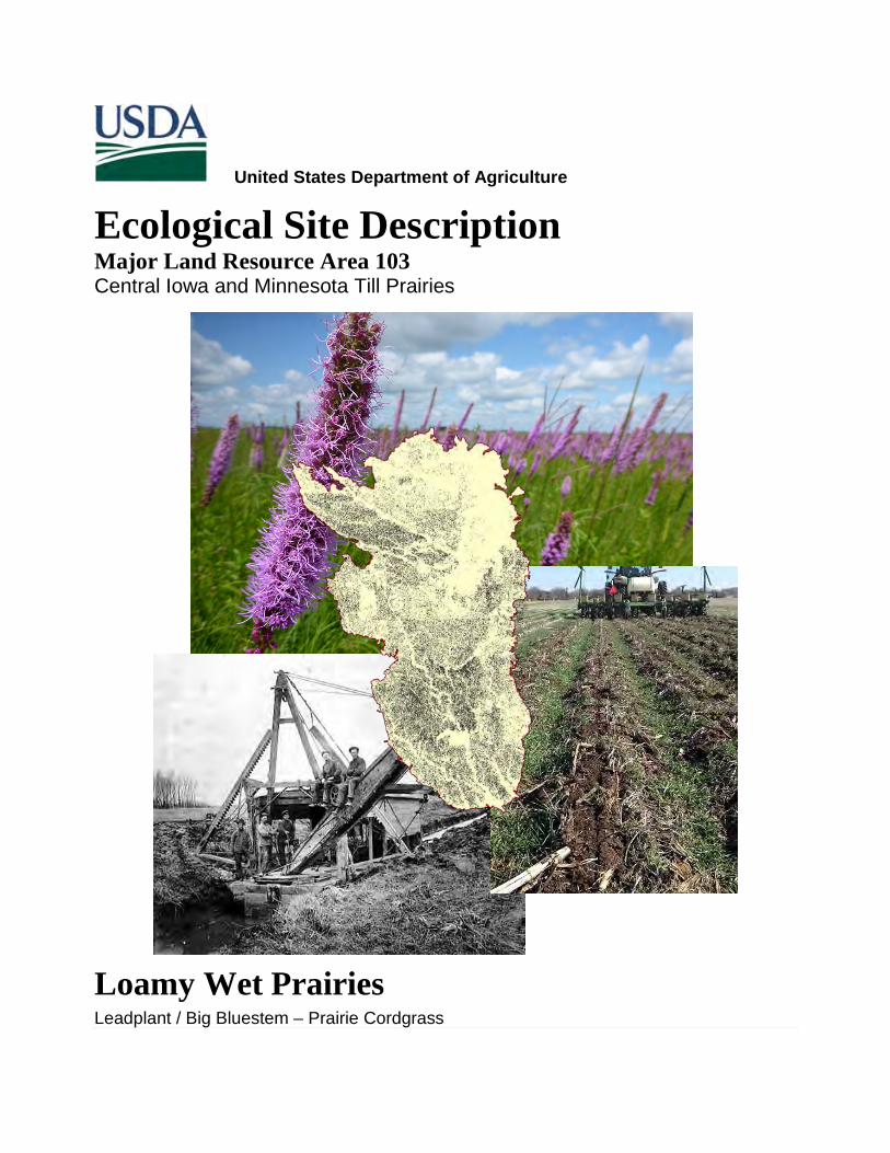
United States Department of Agriculture Ecological Site Description Major Land Resource Area 103 Central Iowa and Minnesota Till Prairies Loamy Wet Prairies Leadplant / Big Bluestem – Prairie Cordgrass

Welcome message from author
This document is posted to help you gain knowledge. Please leave a comment to let me know what you think about it! Share it to your friends and learn new things together.
Transcript
Ecological Site Description MLRA 103
1 | P a g e S e p t e m b e r 1 8 , 2 0 1 5
United States Department of Agriculture
Ecological Site Description Major Land Resource Area 103 Central Iowa and Minnesota Till Prairies
Loamy Wet Prairies
Leadplant / Big Bluestem – Prairie Cordgrass
Ecological Site Description MLRA 103
2 | P a g e S e p t e m b e r 1 8 , 2 0 1 5
Contact for Lead Authors: Kyle Steele ([email protected]), Ecological Site Specialist, United States Department of Agriculture - Natural Resources Conservation Service (USDA-NRCS), Albert Lea, MN; and Clayton Johnson ([email protected]), Soil Survey Office Leader, USDA-NRCS, Albert Lea, MN.
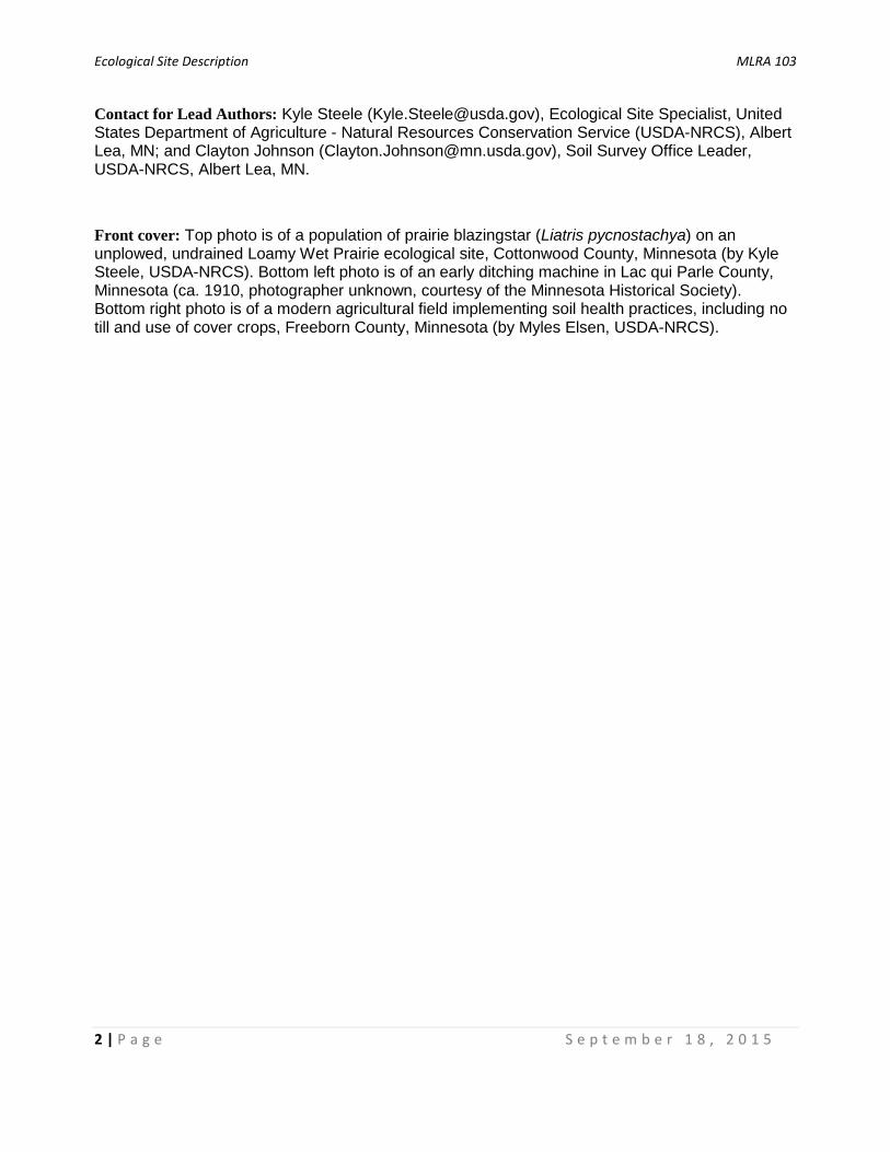
Front cover: Top photo is of a population of prairie blazingstar (Liatris pycnostachya) on an unplowed, undrained Loamy Wet Prairie ecological site, Cottonwood County, Minnesota (by Kyle Steele, USDA-NRCS). Bottom left photo is of an early ditching machine in Lac qui Parle County, Minnesota (ca. 1910, photographer unknown, courtesy of the Minnesota Historical Society). Bottom right photo is of a modern agricultural field implementing soil health practices, including no till and use of cover crops, Freeborn County, Minnesota (by Myles Elsen, USDA-NRCS).
Ecological Site Description MLRA 103
3 | P a g e S e p t e m b e r 1 8 , 2 0 1 5
Table of Contents General Information ......................................................................................................................... 5
MLRA Notes ................................................................................................................................ 5
Ecological Site Concept ............................................................................................................... 7
Physiographic Features ................................................................................................................... 8
Climatic Features .......................................................................................................................... 10
Influencing Water Features ........................................................................................................... 13
Representative Soil Features ........................................................................................................ 15
States and Community Phases ..................................................................................................... 18
Ecological Dynamics .................................................................................................................. 18
STATE 1 – REFERENCE STATE .......................................................................................... 28
Community Phase 1.1 High Diversity Prairie ....................................................................... 29
Community Phase 1.2 Old Growth Prairie........................................................................... 32
STATE 2 – GRASSLAND STATE .......................................................................................... 33
Community Phase 2.1 Cool Season Grassland .................................................................. 35
Community Phase 2.2 Warm Season Grassland ................................................................ 35
STATE 3 – SCRUB WOODLAND STATE .............................................................................. 36
Community Phase 3.1 Scrub Woodland with Grassland Openings ..................................... 38
Community Phase 3.2 Closed Scrub Woodland ................................................................. 39
STATE 4 – CROP PRODUCTION STATE ............................................................................. 39
Community Phase 4.1 Conventional Tillage Field ............................................................... 40
Community Phase 4.2 Conservation Tillage Field ............................................................... 42
Community Phase 4.3 Conservation Tillage/Alternative Crop Field .......................................... 44
Supporting Information .................................................................................................................. 46
Relationship to Other Established Classifications ...................................................................... 46
Associated Ecological Sites ....................................................................................................... 46
Similar Ecological Sites .............................................................................................................. 47
Inventory Data References ........................................................................................................ 48
Other References ...................................................................................................................... 49
Acknowledgements .................................................................................................................... 53

Ecological Site Description MLRA 103
4 | P a g e S e p t e m b e r 1 8 , 2 0 1 5
This page was intentionally left blank.
Ecological Site Description MLRA 103
5 | P a g e S e p t e m b e r 1 8 , 2 0 1 5
General Information
Ecological Site Name:
Abiotic: Loamy Wet Prairies
Biotic: Leadplant / Big Bluestem – Prairie Cordgrass
Amorpha canescens / Andropogon gerardii – Spartina pectinata
Ecological Site ID: 103XY001
Hierarchical Framework Relationships: Major Land Resource Area (MLRA): Central Iowa and Minnesota Till Prairies (103)
USFS Subregions: North Central Glaciated Plains Section (251B); Upper Minnesota River-Des Moines Lobe (251BA) and Southern Des Moines Lobe (251Be) Subsections
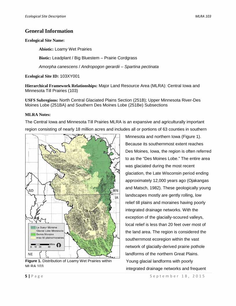
MLRA Notes:
The Central Iowa and Minnesota Till Prairies MLRA is an expansive and agriculturally important
region consisting of nearly 18 million acres and includes all or portions of 63 counties in southern
Minnesota and northern Iowa (Figure 1).
Because its southernmost extent reaches
Des Moines, Iowa, the region is often referred
to as the “Des Moines Lobe.” The entire area
was glaciated during the most recent
glaciation, the Late Wisconsin period ending
approximately 12,000 years ago (Ojakangas
and Matsch, 1982). These geologically young
landscapes mostly are gently rolling, low
relief till plains and moraines having poorly
integrated drainage networks. With the
exception of the glacially-scoured valleys,
local relief is less than 20 feet over most of
the land area. The region is considered the
southernmost ecoregion within the vast
network of glacially-derived prairie pothole
landforms of the northern Great Plains.
Young glacial landforms with poorly
integrated drainage networks and frequent
Figure 1. Distribution of Loamy Wet Prairies within MLRA 103.

Ecological Site Description MLRA 103
6 | P a g e S e p t e m b e r 1 8 , 2 0 1 5
closed depressions cause nearly ubiquitous drainage issues, resulting in hydric soils covering
nearly half of the land area within the MLRA. Lakes and various types of wetlands, ranging from
permanently-ponded depressions to non-ponded flats and gentle slopes, are abundant.
Soils are primarily Mollisols but also include Alfisols, Inceptisols, Histosols, and a small area of
Vertisols. Nearly 300 soil series are mapped in the MLRA, but the top ten represent over half of the
land area. The dominant parent material is calcareous fine-loamy till (18-35 percent clay)
containing distinctive limestone and shale fragments (Ojakangas and Matsch, 1982). Smaller
amounts of both fine till (35-60 percent clay) and coarse-loamy till (<18 percent clay) occur in the
far northern and the far southern portions of the region, respectively. Other parent materials
include alluvium, outwash, lacustrine sediments, and organic deposits. Areas of outwash and
alluvium occur along the major rivers and streams (e.g., Minnesota River, Des Moines River,
Skunk River, etc.). Ephemeral glacial lakes deposited silty and/or clayey sediments. Organic
deposits occur throughout the region but are most common to the east, particularly in the higher
relief landscapes of the Le Sueur Moraine.
On a continental scale, MLRA 103 is unique because it is located on the transition from prairie soils
to the west and forest soils to the east. In contrast to other parts of the prairie pothole region, the
ratio of precipitation to evapotranspiration is nearly equal (or higher) throughout much of the
MLRA. Adequate precipitation, coupled with a predominance of fertile prairie soils, makes MLRA
103 one of the most productive agricultural regions in the World. Pre-settlement vegetation was
primarily tallgrass prairie interspersed with wet meadow and marsh communities. Oak savanna and
woodland occurred on the lee sides of river valleys, lakes, and other topographic features that
provided protection from fire. A large area of mixed hardwood forest also occurred in the northeast
part of the MLRA, broadly coincident with the rougher topography of the Le Sueur Moraine.
Although geologically related, the Le Sueur moraine is ecologically different from other portions of
the Des Moines Lobe, and thus other ecological classification systems classify that area as distinct
from the prairie landscapes to the west (Cleland et al., 2007; MN DNR, 2005a).

Ecological Site Description MLRA 103
7 | P a g e S e p t e m b e r 1 8 , 2 0 1 5
Ecological Site Concept:
Loamy Wet Prairie is nearly ubiquitous and occurs throughout the region, covering over 20% of
MLRA 103 (Figure 1). These ecological sites are fringe wetlands and have an inherent water table
(i.e., endosaturated), but are not ponded. They are developed from low-lying mineral soils
occurring mostly as inter-depressional flats with a slight slope, usually not more than two percent.
As a result, these sites do not pond but they have restricted drainage and are classified as poorly
drained. Parent material is primarily calcareous fine-loamy till, but can also include medium-
textured lacustrine materials. Soils are Mollisols that developed under prairie vegetation with dark
(black-colored) surface horizons, rich in organic matter, that generally range from 10 to 24 inches
thick above depleted (gray-colored) subsurface horizons. The hydrodynamics of these sites are
complex in that subtle differences in landform and elevation affect the depth and duration of the
water table, and thus plant community structure and composition.
Plant communities are remarkably diverse and include grass- and forb-dominated wet-mesic and
wet prairies (also known as low prairies) but can be sedge-dominated in wetter conditions. This
variation in plant community is dependent upon minor variations in depth and duration of water
table within the top 12 inches of the soil profile. Since these are fringe wetlands, the Wetland
Indicator Status of characteristic plants on a given site ranges from obligate to upland.
Dominant grasses are those characteristic of the tallgrass prairie, especially big bluestem
(Andropogon gerardii) and Indiangrass (Sorghastrum nutans). Prairie cordgrass (Spartina
pectinata) is an important species indicative of wetland conditions, and can be codominant.
Sedges are often an important component, particularly on the wetter end of this ecological site.
The most common species are Bicknell’s Sedge (Carex bicknellii), wooly sedge (Carex pellita),
and Buxbaum’s sedge (Carex buxbaumii). Common forbs include classic tallgrass prairie species
like prairie blazing star (Liatris pycnostachya) and compassplant (Silphium laciniatum), as well as
species typical of wetland conditions like narrow-leaved loosestrife (Lysimachia quadriflora) and
swamp milkweed (Asclepias incarnata). Shrub cover is typically low, with the most common
species being leadplant (Amorpha canescens) and prairie rose (Rosa arkansana). Other
shrubs, like dogwoods (Cornus spp.) and willows (Salix spp.) quickly establish in the absence
of frequent fire.

Ecological Site Description MLRA 103
8 | P a g e S e p t e m b e r 1 8 , 2 0 1 5
Physiographic Features
With the exception of the prairie-forest transition area of the Le Sueur Moraine, the finer-textured
soils of Glacial Lake Minnesota, and the dissected Bemis Moraine, Loamy Wet Prairies are a
dominant ecological site occurring across the many till plains and moraines of MLRA 103. These
sites typically are part of broader semi-closed wetland basins and commonly are hydrologically-
connected to adjacent “prairie pothole” marshes (Figure 2). As a result, delineations of these map
units often are irregularly-shaped, usually surrounding multiple depressions of varying sizes. These
wetland basins were created by multiple types of glacial events (i.e., various till plains and
moraines). The speed and timing of glacial melt (whether it melts while stagnant or advancing)
determines the size, shape, and density of these depressions. An advancing glacier can
mechanically gouge out lower areas, while a stagnant glacier can melt in place, leaving hummocky
topography with deeply defined depressions (i.e., stagnation moraines). Uneven sediment load in
the glacier can arbitrarily deposit less drift in some locations, forming geographic lows. In some
cases, sub-glacial drainage networks leave these depressions. In other cases, blocks of ice are
buried by glacial sediment and subsequent melting creates subsurface voids in the sediment (i.e.,
ice block depressions).
Figure 2. Representative block diagram of Loamy Wet Prairie and associated ecological sites.

Ecological Site Description MLRA 103
9 | P a g e S e p t e m b e r 1 8 , 2 0 1 5
Regardless of the glacial events responsible for these wetland complexes, the term “flat” probably
best describes the landscape position of Loamy Wet Prairies, which are defined as “a level or
nearly level surface or small area of land marked by little or no local relief,” (Table 1, USDA-NRCS
2015). Low relief 0 to 2 percent linear slopes with fine-loamy soil textures interact to make this
ecological site wetter than the adjacent upslope areas but drier than adjacent downslope
depressional areas. The low slope gradient and linear to slightly concave slope shape are the most
defining parameters. As a result, these sites do not typically pond water. However, the water table
is usually at or near the soil surface during the spring months.
Often in natural, undrained conditions, minor inclusions of wetter sites that may briefly pond water
can occur towards the middle of broader flats, while slightly drier sites occur on footslopes that
transition to the upland. Swales, or connections between depressions, often are a part of these
landforms and receive concentrated groundwater flow, and may pond or flood for brief periods
during significant rain events. These aforementioned wetter conditions also have a slightly higher
water table and support sedge meadow plant communities.
Elevation ranges from 689 to 1,837 feet. These sites receive runoff and lateral subsurface flow
from adjacent, upslope ecological sites. They also produce runoff and lateral subsurface flow
downslope into adjacent discharge depressions.
Table 1. Physiographic features of Loamy Wet Prairies. (Data and information presented here are based on NRCS integrated plot data and the National Soil Information System.)
Minimum Maximum Elevation (ft.) 689 1,837 Slope (percent) 0 2 Water Table Depth (in.) 0 12 Flooding none none Ponding none none Landforms: till plains and moraines
Hillslope Positions: flats and subtle depressions, swales, and toeslopes Slope Shape: linear to slightly concave (both up and across slope)

Ecological Site Description MLRA 103
10 | P a g e S e p t e m b e r 1 8 , 2 0 1 5
Climatic Features
In contrast to drier prairie regions of the Great Plains, the Des Moines Lobe receives more rainfall
(Gilbert et al., 2006) and is part of the “prairie peninsula,” a region that is widely considered to have
been suitable for forest development (Transeau, 1935). Instead, because of frequent (sometimes
annual) fires over the course of millennia, these areas developed as prairies, which form soils high
in organic matter content. Although wetland basins and their associated complex of wet prairies,
meadows, and marshes are a central concept of all prairie pothole landscapes, only in the milder
and wetter climate of MLRA 103 do poorly drained low prairie soils (i.e., Loamy Wet Prairies)
become abundant. Elsewhere, these fringe wetlands occur in narrower zones with a shorter
distance between ponded depressions and non-hydric, upland soils. In addition, the adjacent
depressions historically held more water for longer time periods and had fewer draw-downs than
regions to the west and north (Johnson et al., 2010). Severe droughts historically occurred every
10-12 years, often followed by unusually wet cycles (Galatowitsch and van der Valk, 1994). It is
likely that gradual transition in vegetation composition accompanied these cyclical changes,
selecting for upland prairie species during dry times and expansion of sedge meadow species
during wetter times.
The soil temperature regime of MLRA 103 is classified as “mesic” (i.e., mean annual soil
temperature between 46 and 59°F). The average frost-free period is about 140 days and the
average freeze-free period is 164 days (Table 2). Average annual precipitation is 32.7 inches,
which includes rainfall plus the water equivalent from snowfall (Table 3). Two-thirds or more of the
precipitation falls during the growing season. The majority of rainfall occurs as high intensity,
convective thunderstorms during the summer months (Evans and Freeland, 2001). Most of the
spring snowmelt runs off the uplands and into adjacent depressions. The average annual
temperature is 42.8 to 50°F. Frost pockets and cold air drainage from above, and the fact that wet
soils are generally colder than dry soils, make this ecological site colder than adjacent upland
ecological sites. As a result, snow and frost remain longer in the spring, thus resulting in shorter
growing seasons. These are averages derived from multiple weather stations across the range of
this ecological site. It is important to note this MLRA is quite large (nearly 18 million acres), and
there are undoubtedly important temperature and precipitation differences from north to south and
west to east (e.g., gradually becoming warmer and wetter).
Ecological Site Description MLRA 103
11 | P a g e S e p t e m b e r 1 8 , 2 0 1 5
Table 2. Frost-free and freeze-free days. (Data were obtained from NOAA weather stations within the range of this ecological site, using 30-year averages.) Average days Frost-free period (32.5°F or greater, 90% probability) 140 Freeze-free period (Less than 28.5 °F, 90% probability) 164
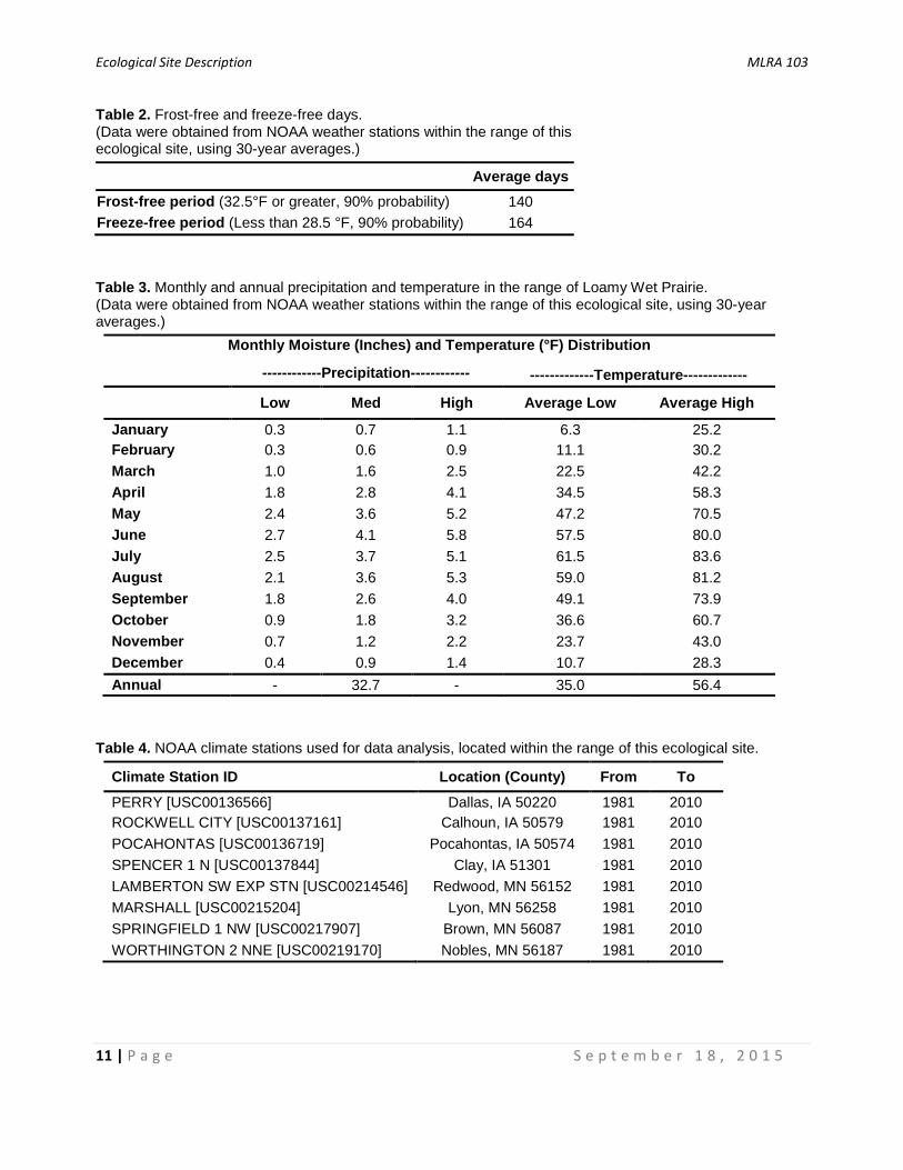
Table 3. Monthly and annual precipitation and temperature in the range of Loamy Wet Prairie. (Data were obtained from NOAA weather stations within the range of this ecological site, using 30-year averages.)
Monthly Moisture (Inches) and Temperature (°F) Distribution
------------Precipitation------------ -------------Temperature-------------
Low Med High Average Low Average High
January 0.3 0.7 1.1 6.3 25.2 February 0.3 0.6 0.9 11.1 30.2 March 1.0 1.6 2.5 22.5 42.2 April 1.8 2.8 4.1 34.5 58.3 May 2.4 3.6 5.2 47.2 70.5 June 2.7 4.1 5.8 57.5 80.0 July 2.5 3.7 5.1 61.5 83.6 August 2.1 3.6 5.3 59.0 81.2 September 1.8 2.6 4.0 49.1 73.9 October 0.9 1.8 3.2 36.6 60.7 November 0.7 1.2 2.2 23.7 43.0 December 0.4 0.9 1.4 10.7 28.3 Annual - 32.7 - 35.0 56.4
Table 4. NOAA climate stations used for data analysis, located within the range of this ecological site.
Climate Station ID Location (County) From To PERRY [USC00136566] Dallas, IA 50220 1981 2010 ROCKWELL CITY [USC00137161] Calhoun, IA 50579 1981 2010 POCAHONTAS [USC00136719] Pocahontas, IA 50574 1981 2010 SPENCER 1 N [USC00137844] Clay, IA 51301 1981 2010 LAMBERTON SW EXP STN [USC00214546] Redwood, MN 56152 1981 2010 MARSHALL [USC00215204] Lyon, MN 56258 1981 2010 SPRINGFIELD 1 NW [USC00217907] Brown, MN 56087 1981 2010 WORTHINGTON 2 NNE [USC00219170] Nobles, MN 56187 1981 2010

Ecological Site Description MLRA 103
12 | P a g e S e p t e m b e r 1 8 , 2 0 1 5
As mentioned previously, the Loamy Wet Prairie ecological site becomes much less common in the
northeast portion of MLRA 103, especially on the northern part of the Le Sueur Moraine. Much of
this area is referred to locally as the “Big Woods,” because the pre-settlement vegetation was
mature hardwood forest. Higher relief landforms with frequent north-facing slopes were protected
from fires, and that combined with a climate conducive to tree growth produced the extensive
forests that contrasted sharply with areas of prairie (Grimm, 1984). In the face of a warming climate
the region will become drier due to higher temperatures and elevated evapotranspiration (Johnson
et al., 2010), although an increase in precipitation may mediate this effect. Climate data and
analyses are derived from 30-year averages gathered from eight National Oceanic and
Atmospheric Administration (NOAA) weather stations contained within the range of this ecological
site, but were not necessarily located on correlated map units (Table 4).
Ecological Site Description MLRA 103
13 | P a g e S e p t e m b e r 1 8 , 2 0 1 5
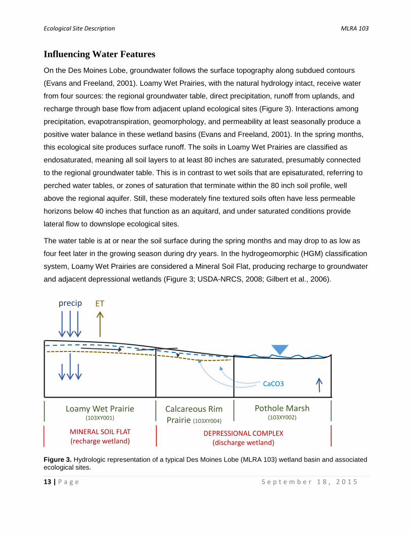
Influencing Water Features
On the Des Moines Lobe, groundwater follows the surface topography along subdued contours
(Evans and Freeland, 2001). Loamy Wet Prairies, with the natural hydrology intact, receive water
from four sources: the regional groundwater table, direct precipitation, runoff from uplands, and
recharge through base flow from adjacent upland ecological sites (Figure 3). Interactions among
precipitation, evapotranspiration, geomorphology, and permeability at least seasonally produce a
positive water balance in these wetland basins (Evans and Freeland, 2001). In the spring months,
this ecological site produces surface runoff. The soils in Loamy Wet Prairies are classified as
endosaturated, meaning all soil layers to at least 80 inches are saturated, presumably connected
to the regional groundwater table. This is in contrast to wet soils that are episaturated, referring to
perched water tables, or zones of saturation that terminate within the 80 inch soil profile, well
above the regional aquifer. Still, these moderately fine textured soils often have less permeable
horizons below 40 inches that function as an aquitard, and under saturated conditions provide
lateral flow to downslope ecological sites.
The water table is at or near the soil surface during the spring months and may drop to as low as
four feet later in the growing season during dry years. In the hydrogeomorphic (HGM) classification
system, Loamy Wet Prairies are considered a Mineral Soil Flat, producing recharge to groundwater
and adjacent depressional wetlands (Figure 3; USDA-NRCS, 2008; Gilbert et al., 2006).
Figure 3. Hydrologic representation of a typical Des Moines Lobe (MLRA 103) wetland basin and associated ecological sites.
MINERAL SOIL FLAT(recharge wetland)
DEPRESSIONAL COMPLEX(discharge wetland)
precip ET
CaCO3
Loamy Wet Prairie (103XY001)
Calcareous Rim Prairie (103XY004)
Pothole Marsh (103XY002)
Ecological Site Description MLRA 103
14 | P a g e S e p t e m b e r 1 8 , 2 0 1 5
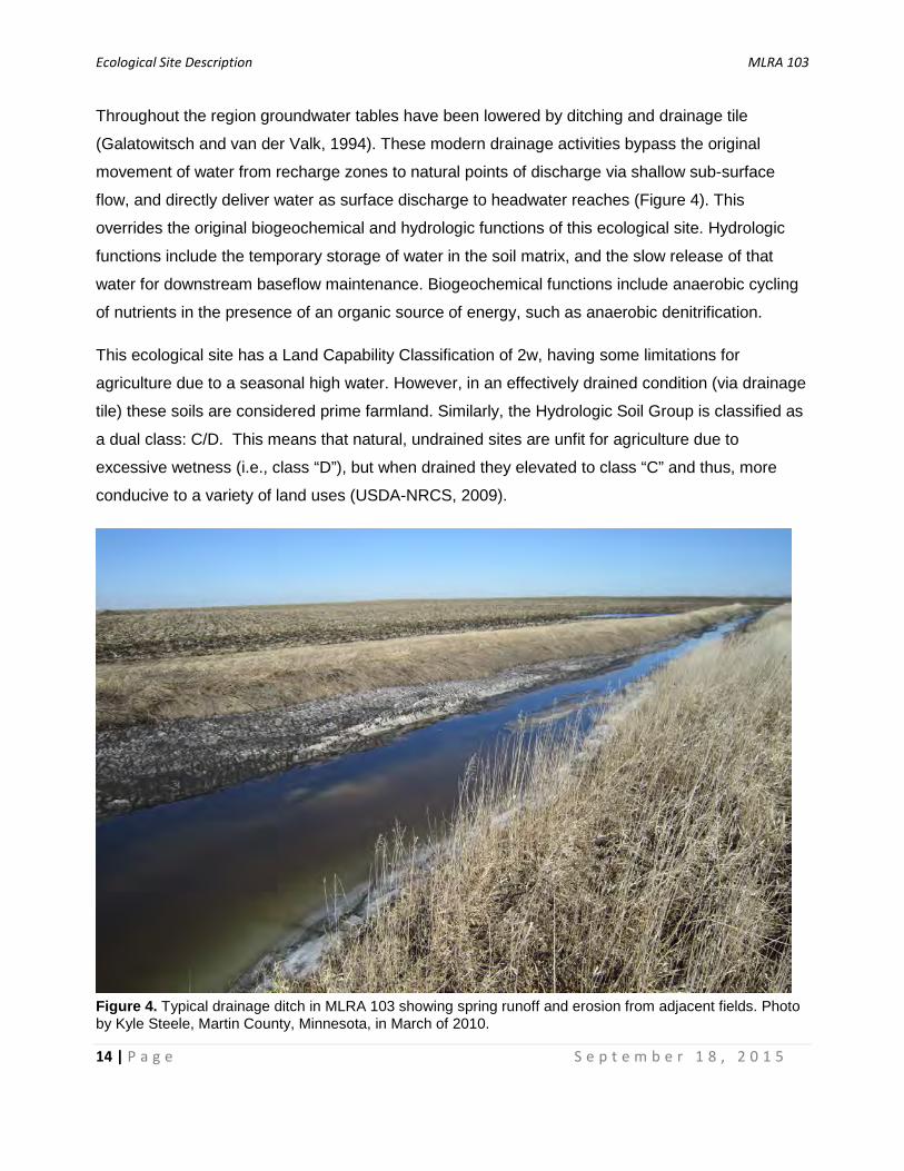
Throughout the region groundwater tables have been lowered by ditching and drainage tile
(Galatowitsch and van der Valk, 1994). These modern drainage activities bypass the original
movement of water from recharge zones to natural points of discharge via shallow sub-surface
flow, and directly deliver water as surface discharge to headwater reaches (Figure 4). This
overrides the original biogeochemical and hydrologic functions of this ecological site. Hydrologic
functions include the temporary storage of water in the soil matrix, and the slow release of that
water for downstream baseflow maintenance. Biogeochemical functions include anaerobic cycling
of nutrients in the presence of an organic source of energy, such as anaerobic denitrification.
This ecological site has a Land Capability Classification of 2w, having some limitations for
agriculture due to a seasonal high water. However, in an effectively drained condition (via drainage
tile) these soils are considered prime farmland. Similarly, the Hydrologic Soil Group is classified as
a dual class: C/D. This means that natural, undrained sites are unfit for agriculture due to
excessive wetness (i.e., class “D”), but when drained they elevated to class “C” and thus, more
conducive to a variety of land uses (USDA-NRCS, 2009).
Figure 4. Typical drainage ditch in MLRA 103 showing spring runoff and erosion from adjacent fields. Photo by Kyle Steele, Martin County, Minnesota, in March of 2010.

Ecological Site Description MLRA 103
15 | P a g e S e p t e m b e r 1 8 , 2 0 1 5
Representative Soil Features
Soils for Loamy Wet Prairies are in the Mollisol order and are classified further as Typic
Endoaquolls. These mineral soils are rich in organic matter and were developed under prairie
vegetation. Prairie soils by definition have
thick, dark (nearly black, e.g., N 2/0 and
10YR 2/1) organic-rich surface horizons.
The “mollic” surfaces of Loamy Wet Prairies
are especially thick, often over 20 inches.
Twenty-two inches was the average surface
depth across 40 field observations located
at various state natural areas and other
unplowed, undrained sites. Roughly one-
third of these observations had mollic
epipedons over 24 inches, and were
classified as cumulic subgroups. It is
possible these cumulic phases were more
common prior to agricultural conversion and
associated tillage practices. The high
organic matter associated with these
horizons greatly increases the fertility, the
ease of tillage, and available water capacity
of these soils. Because these sites are wet,
which lowers exposure to oxygen, organic
matter decomposes (i.e., oxidizes) more
slowly than it does within drier soils, which
in turn causes thicker A horizons. In addition, these sites are located in landscape positions that
can receive runoff and erosional sediments (both natural and human accelerated) which also may
lead to thicker dark surface horizons than upslope ecological sites.
These soils were formed under saturated conditions that produced anaerobic conditions during at
least part of the year. Thick, dark surfaces tend to mask the typical redoximorphic features used to
determine seasonal high water table depths. Beneath the mollic surface horizons, these soils have
a depleted matrix with low chroma (2 or less) and high value (4 or more; Figure 5). The primary
Figure 5. Photo of a Webster soil series (Fine-loamy, mixed, superactive, mesic Typic Endoaquolls) pedon in Iowa (photo by J. Sandor, Iowa State University Extension and Outreach).
Ecological Site Description MLRA 103
16 | P a g e S e p t e m b e r 1 8 , 2 0 1 5
hydric soil indicators include: Depleted Below Dark Surface (A11), Thick Dark Surface (A12), and
Redox Dark Surface (F6, option a; USDA-NRCS, 2010).
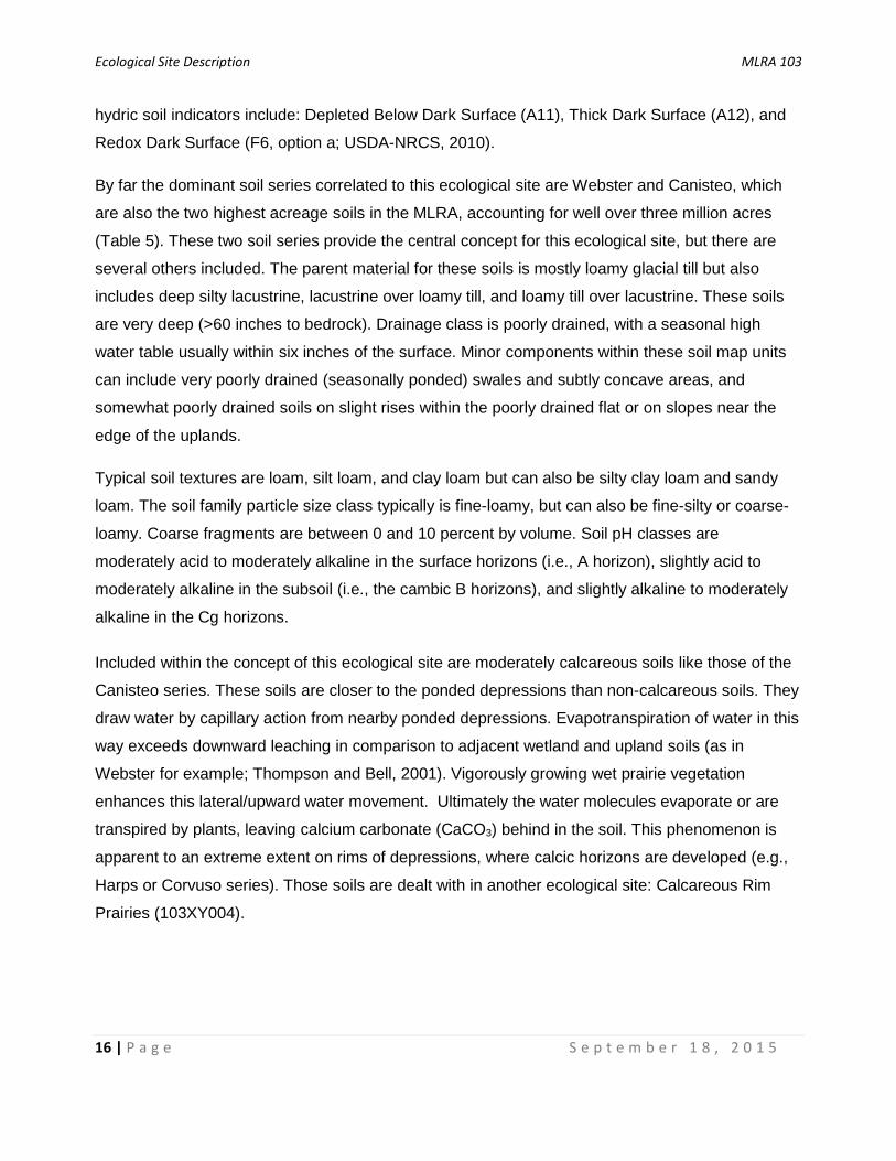
By far the dominant soil series correlated to this ecological site are Webster and Canisteo, which
are also the two highest acreage soils in the MLRA, accounting for well over three million acres
(Table 5). These two soil series provide the central concept for this ecological site, but there are
several others included. The parent material for these soils is mostly loamy glacial till but also
includes deep silty lacustrine, lacustrine over loamy till, and loamy till over lacustrine. These soils
are very deep (>60 inches to bedrock). Drainage class is poorly drained, with a seasonal high
water table usually within six inches of the surface. Minor components within these soil map units
can include very poorly drained (seasonally ponded) swales and subtly concave areas, and
somewhat poorly drained soils on slight rises within the poorly drained flat or on slopes near the
edge of the uplands.
Typical soil textures are loam, silt loam, and clay loam but can also be silty clay loam and sandy
loam. The soil family particle size class typically is fine-loamy, but can also be fine-silty or coarse-
loamy. Coarse fragments are between 0 and 10 percent by volume. Soil pH classes are
moderately acid to moderately alkaline in the surface horizons (i.e., A horizon), slightly acid to
moderately alkaline in the subsoil (i.e., the cambic B horizons), and slightly alkaline to moderately
alkaline in the Cg horizons.
Included within the concept of this ecological site are moderately calcareous soils like those of the
Canisteo series. These soils are closer to the ponded depressions than non-calcareous soils. They
draw water by capillary action from nearby ponded depressions. Evapotranspiration of water in this
way exceeds downward leaching in comparison to adjacent wetland and upland soils (as in
Webster for example; Thompson and Bell, 2001). Vigorously growing wet prairie vegetation
enhances this lateral/upward water movement. Ultimately the water molecules evaporate or are
transpired by plants, leaving calcium carbonate (CaCO3) behind in the soil. This phenomenon is
apparent to an extreme extent on rims of depressions, where calcic horizons are developed (e.g.,
Harps or Corvuso series). Those soils are dealt with in another ecological site: Calcareous Rim
Prairies (103XY004).
Ecological Site Description MLRA 103
17 | P a g e S e p t e m b e r 1 8 , 2 0 1 5
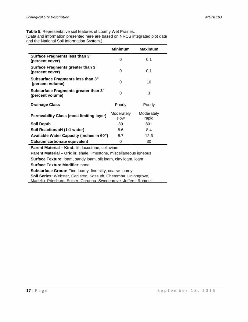
Table 5. Representative soil features of Loamy Wet Prairies. (Data and information presented here are based on NRCS integrated plot data and the National Soil Information System.)
Minimum Maximum Surface Fragments less than 3” (percent cover) 0 0.1
Surface Fragments greater than 3” (percent cover) 0 0.1
Subsurface Fragments less than 3” (percent volume) 0 10
Subsurface Fragments greater than 3” (percent volume) 0 3
Drainage Class Poorly Poorly
Permeability Class (most limiting layer) Moderately slow
Moderately rapid
Soil Depth 80 80+ Soil Reaction/pH (1:1 water) 5.6 8.4 Available Water Capacity (inches in 60”) 8.7 12.6 Calcium carbonate equivalent 0 30 Parent Material – Kind: till, lacustrine, colluvium Parent Material – Origin: shale, limestone, miscellaneous igneous Surface Texture: loam, sandy loam, silt loam, clay loam, loam Surface Texture Modifier: none Subsurface Group: Fine-loamy, fine-silty, coarse-loamy Soil Series: Webster, Canisteo, Kossuth, Chetomba, Uniongrove, Madelia, Prinsburg, Spicer, Corunna, Swedegrove, Jeffers, Romnell
Ecological Site Description MLRA 103
18 | P a g e S e p t e m b e r 1 8 , 2 0 1 5
States and Community Phases
Ecological Dynamics
Loamy Wet Prairies occur mostly on inter-depressional linear flats with slight, zero to two percent
slopes. With subtle topographic boundaries, these sites gradually transition to upland prairies
upslope and to sedge meadows downslope (MN DNR, 2005a). A fluctuating seasonal water table
that produces anaerobic conditions in the rooting zone is the most important site factor. Species
characteristic of this ecological site are adapted to this variation in water saturation. In addition,
species common to wet prairies (and prairies in general) have physiological adaptations allowing
them to withstand frequent stand-replacing fires, grazing, and extreme changes in temperature
(Weaver, 1963). Similar wet prairie ecological sites are widely distributed throughout the prairie
pothole region, however, in MLRA 103 Loamy Wet Prairies are particularly common, due in large
part to lower evapotranspiration and increased precipitation, making poorly drained flats wetter and
more expansive compared to adjacent regions (Tom Neuenfeldt, NRCS Soil Scientist, personal
communication, 2015; Carter et al., 2010).
Prior to European settlement, open prairies have persisted on these sites since the Holocene
Thermal Maximum, approximately 9,000 to 5,000 BP (i.e., the hypsithermal time period). Beginning
3,000 to 5,000 years ago, environmental conditions have favored woodland expansion in the
region (MN DNR, 2005a; Grimm, 1984; Transeau, 1935). Fire and the interaction of fire with
various topographic factors kept much of the MLRA in prairie vegetation leading up to European
settlement (Grimm, 1984; Gleason, 1913). Fire, drought, and native grazing were the primary
natural disturbances on pre-settlement Des Moines Lobe prairies. There is little known about
historical grazing by native ungulates. It may have been more important in upland areas (MN DNR,
2005b). Undoubtedly whitetail deer (Odocoileus virginianus) and especially prairie elk (Cervus
elaphus manitobensis) grazed these sites, particularly as they used the adjacent depressions as
water sources (NatureServe, 2013). Elk likely were extirpated from the region by the early 1900s,
primarily by over-hunting (MN DNR, 2015). Bison (Bison bison) likely also grazed these sites,
although many speculate they weren’t abundant this far east (NatureServe, 2013; Landfire, 2009).
For thousands of years, humans have been an integral part of the tallgrass prairies of the Midwest.
It has long been understood that the vast majority of prairie fires were ignited by Native Americans,
and not by lightning (Grimm, 1984; McComb and Loomis, 1944; Gleason, 1913). However, it
seems reasonable to consider that lightning-caused fires from the western Great Plains could
periodically have been driven into this part of the prairie peninsula given the correct weather
Ecological Site Description MLRA 103
19 | P a g e S e p t e m b e r 1 8 , 2 0 1 5
conditions. Historically, there was a direct relationship between fire frequency and climate, in that
fire occurrence was more likely during times of drought. It is likely that these sites burned at three
to five times per decade, and in times of drought burned annually (Figure 6; Landfire, 2009).
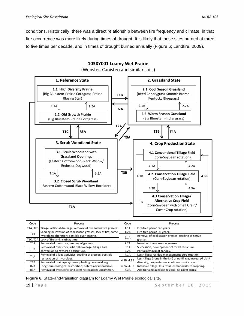
Figure 6. State-and-transition diagram for Loamy Wet Prairie ecological site.
1. Reference State
1.2 Old Growth Prairie(Big Bluestem-Prairie Cordgrass)
1.1 High Diversity Prairie(Big Bluestem-Prairie Cordgrass-Prairie
Blazing Star)
2. Grassland State
103XY001 Loamy Wet Prairie(Webster, Canisteo and similar soils)
1.1A 1.2A
T1B
Code ProcessT1A, T2B Tillage; artificial drainage; removal of fire and native grazers.
T1B Seeding or invasion of cool season grasses; lack of fire; some hydrologic alteration; possible over-grazing.
T1C, T2A Lack of fire and grazing; time.T3A Removal of overstory; seeding of grasses.
T3B Removal of overstory; artificial drainage; tillage and conversion to row crop agriculture.
T4A Removal of tillage activities, seeding of grasses; possible restoration of hydrology.
T4B Removal of drainage systems; planting perennial veg. R2A Long term ecological restoration; potentially impossible.R3A Removal of overstory; long term restoration; uncommon.
2.2 Warm Season Grassland(Big Bluestem-Indiangrass)
2.1A 2.2AR2A
4. Crop Production State
4.1 Conventional Tillage Field (Corn-Soybean rotation)
4.1A 4.2A
4.2 Conservation Tillage Field(Corn-Soybean rotation)
2.1 Cool Season Grassland(Reed Canarygrass-Smooth Brome-
Kentucky Bluegrass)
Code Process1.1A Fire-free period 3-5 years. 1.2A Fire-free period <3 years.
2.1A Removal of cool season grasses; seeding of native grasses.
2.2A Invasion of cool season grasses.3.1A Succession, development of forest structure.3.2A Partial removal of canopy.4.1A Less tillage; residue management; crop rotation.
4.1B, 4.2B Less tillage (none in the fall) or no tillage; increased plant diversity; crop rotation; continuous soil cover.
4.2A, 4.3B Intensive tillage; less residue; monoculture cropping.4.3A Additional tillage; less residue; no cover crops.
T4A
3. Scrub Woodland State
3.2 Closed Scrub Woodland(Eastern Cottonwood-Black Willow-Boxelder)
3.1 Scrub Woodland with Grassland Openings
(Eastern Cottonwood-Black Willow/ Redosier Dogwood)
3.1A 3.2A T3B
T1CT2A
T3A
T1A
T2B
4.3 Conservation Tillage/ Alternative Crop Field
(Corn-Soybean with Small Grain/ Cover Crop rotation)
4.2B 4.3A
4.3B4.1B
R3A
Ecological Site Description MLRA 103
20 | P a g e S e p t e m b e r 1 8 , 2 0 1 5
Fires occurred throughout the year, including during the growing season during dry years.
However, the most substantial fires occurred during the dormant season, and in particular during
the fall months (Gleason, 1913). These periodic fires removed built-up thatch and dead litter,
stimulated growth and flowering of grasses and forbs, and limited the occurrence of shrubs and
trees. Only during long, fire-free intervals, likely associated with times of higher than average
precipitation, would shrubs increase on wet prairies. However, areas protected from fire such as
stream valleys, high-relief landforms, and areas of high lake density would have likely supported
savanna, woodland, or barrens communities. These areas would have provided sources for
increased shrub density on some Loamy Wet Prairies.
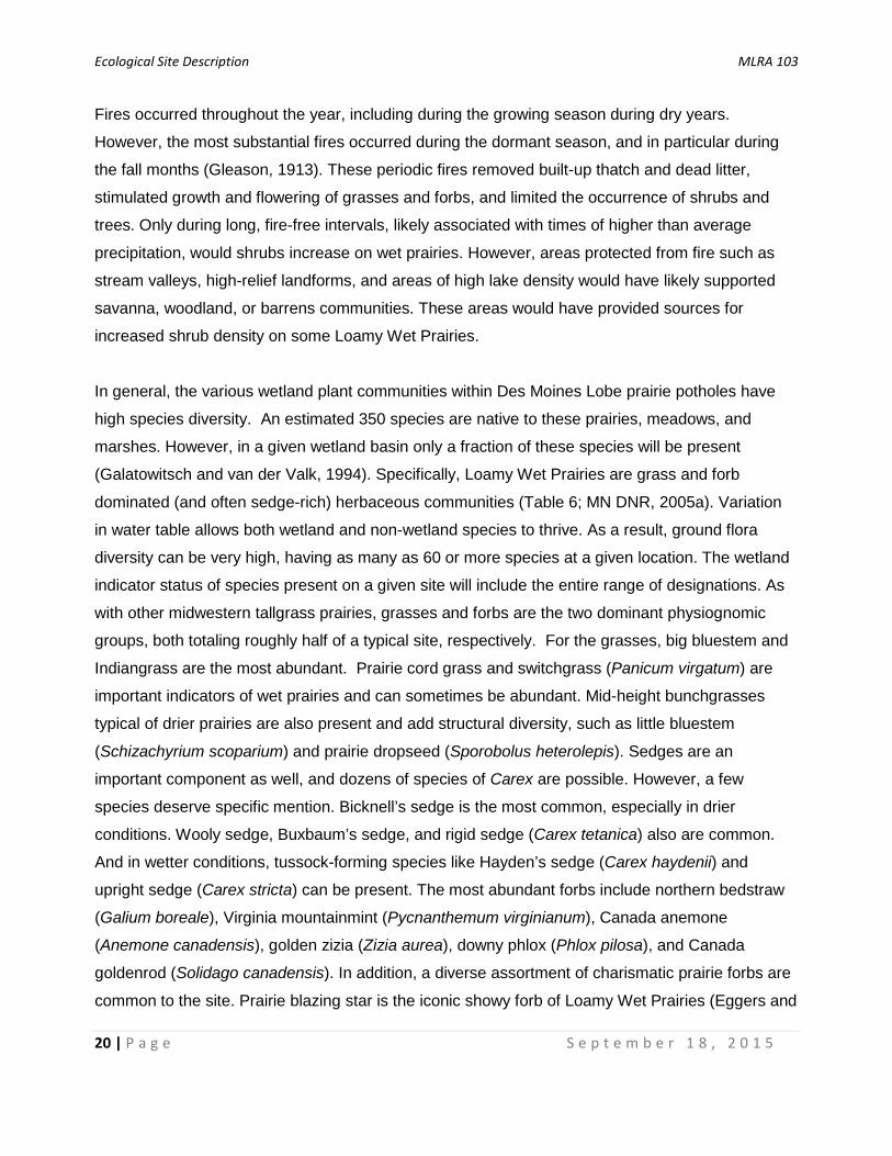
In general, the various wetland plant communities within Des Moines Lobe prairie potholes have
high species diversity. An estimated 350 species are native to these prairies, meadows, and
marshes. However, in a given wetland basin only a fraction of these species will be present
(Galatowitsch and van der Valk, 1994). Specifically, Loamy Wet Prairies are grass and forb
dominated (and often sedge-rich) herbaceous communities (Table 6; MN DNR, 2005a). Variation
in water table allows both wetland and non-wetland species to thrive. As a result, ground flora
diversity can be very high, having as many as 60 or more species at a given location. The wetland
indicator status of species present on a given site will include the entire range of designations. As
with other midwestern tallgrass prairies, grasses and forbs are the two dominant physiognomic
groups, both totaling roughly half of a typical site, respectively. For the grasses, big bluestem and
Indiangrass are the most abundant. Prairie cord grass and switchgrass (Panicum virgatum) are
important indicators of wet prairies and can sometimes be abundant. Mid-height bunchgrasses
typical of drier prairies are also present and add structural diversity, such as little bluestem
(Schizachyrium scoparium) and prairie dropseed (Sporobolus heterolepis). Sedges are an
important component as well, and dozens of species of Carex are possible. However, a few
species deserve specific mention. Bicknell’s sedge is the most common, especially in drier
conditions. Wooly sedge, Buxbaum’s sedge, and rigid sedge (Carex tetanica) also are common.
And in wetter conditions, tussock-forming species like Hayden’s sedge (Carex haydenii) and
upright sedge (Carex stricta) can be present. The most abundant forbs include northern bedstraw
(Galium boreale), Virginia mountainmint (Pycnanthemum virginianum), Canada anemone
(Anemone canadensis), golden zizia (Zizia aurea), downy phlox (Phlox pilosa), and Canada
goldenrod (Solidago canadensis). In addition, a diverse assortment of charismatic prairie forbs are
common to the site. Prairie blazing star is the iconic showy forb of Loamy Wet Prairies (Eggers and

Ecological Site Description MLRA 103
21 | P a g e S e p t e m b e r 1 8 , 2 0 1 5
Reed, 2015). Other common prairie forbs include compassplant, purple prairie clover (Dalea
purpurea), false sunflower (Heliopsis helianthoides), stiff goldenrod (Oligoneuron rigidum), several
species of milkweed (Asclepias spp.), and sawtooth sunflower (Helianthus grosseserratus).
Additional species, which generally are found in more obvious wetlands, include narrow-leaved
loostrife (which is very common), swamp milkweed, spotted water hemlock (Cicuta maculata), and
on high quality sites, white lady’s slipper (Cypripedium candidum). Although more so than adjacent
upland prairies, these wet prairies historically had low cover of woody plants but added to the
structural diversity of plant communities. Species like leadplant and prairie rose were common but
not abundant, and typically grew more or less as low-growing herbaceous plants, rarely putting on
enough growth to become a true shrub before being burned back by fire (Smith, 2008). Various
species of willow and dogwood may be present and will quickly spread in the absence of frequent
fire.
Loamy Wet Prairie ecological sites have a long history of post-settlement land use, accompanied
by a complicated array of land use policies and legislation. By the mid-1800s the fire frequency
needed to maintain the Reference State plant communities was already decreasing, partly due to
the early presence of European settlers and partly due to the wide-scale removal of Native
Americans from the region. During the early settlement of the Midwest (prior to 1850), prairies in
general were thought to be unfertile as well as dangerous because of the presence of prairie fire
(Beauchamp, 1987). It wasn’t until settlers began farming the land that the fertility of prairie soils
was realized (Smith, 1992). Initially, settlers kept to prairie margins such as wooded edges and
savannas along streams and rivers. As other regions of the Midwest were settled, later arrivals
were eventually forced to settle on the prairie. Areas furthest from main water courses, particularly
wetland areas, were settled last. Wetlands were widely seen as a nuisance for economic and
agricultural development, as evidenced by the Swamp Lands Acts of the mid-1800s, in which the
Federal Government granted nearly 65 million acres of wetland to state governments (Dahl and
Allord, 1997). In exchange, the states agreed to pursue wetland drainage activities. Minnesota and
Iowa together received about six million acres, all of which were eventually drained and sold off
(Anderson, 2005).
Population growth in the Midwest slowed during the Civil War, but picked up again by the 1870s,
coincident with railroad expansion and development of new farm machinery technologies. By 1880,
settlement was expanding across the Des Moines Lobe prairies (Smith, 1998). Ultimately, these
prairie wetland landscapes were the last frontier of the once vast tallgrass prairie (Smith, 1998).

Ecological Site Description MLRA 103
22 | P a g e S e p t e m b e r 1 8 , 2 0 1 5
Table 6. Reference State Community Phase 1.1 composition. (This list is based on USDA-NRCS integrated plot data and Eggers and Reed 2015, Hipp 2008, Runkel and Roosa 2014 and MN DNR 2005. Not all species are assumed to be present in one location.)
Layer Common Name Scientific Name USDA Symbol
Annual Production
(lbs/ac)
Cover (%)
Shrubs Leadplant** Amorpha canescens AMCA6 100-300 5-10 Prairie Rose Rosa arkansana ROAR3 100-300 5-10 Willow Salix spp. SALIX 0-300 0-10
Dogwood Cornus spp. CORNU 0-150 0-5 Grasses/ Big Bluestem Andropogon gerardii ANGE 300-900 15-40 Grasslike Prairie Cordgrass Spartina pectinata SPPE 100-400 5-25 Indiangrass Sorghastrum nutans SONU2 100-400 5-25 Switchgrass Panicum virgatum PAVI2 100-400 5-25 Little Bluestem Schizachyrium scoparium SCSC 100-400 5-25 Prairie Dropseed Sporobolus heterolepis SPHE 100-400 5-25 Fowl Bluegrass Poa palustris POPA2 0-100 0-5 Leiberg's Panicum Dichanthelium leibergii DILE2 0-100 0-5 Virginia Wildrye Elymus virginicus ELVI3 0-100 0-5 Bicknell’s Sedge Carex bicknellii CABI3 10-300 1-15 Wooly Sedge* Carex pellita CAPE42 10-250 1-10 Buxbaum’s Sedge* Carex buxbaumii CABU6 10-100 1-5 Rigid Sedge Carex tetanica CATE6 0-100 0-5 Hayden’s Sedge* Carex haydenii CAHA7 0-350 0-20 Upright Sedge* Carex stricta CAST8 0-350 0-20 Sedges Carex spp. CAREX 100-350 5-20 Rushes Juncus spp. JUNCU 0-100 0-5 Flatstem Spikerush Eleocharis compressa ELCO2 0-100 0-5 Forbs Canada Anemone Anemone canadensis ANCA8 100-400 5-25 Northern Bedstraw Galium boreale GABO2 100-400 5-25 Sawtooth Sunflower Helianthus grosseserratus HEGR4 200-600 5-25 Stiff Goldenrod** Oligoneuron rigidum OLRIR 200-600 5-25 Downy Phlox Phlox pilosa PHPI 100-400 5-25 Virginia Mountainmint Pycnanthemum virginianum PYVI 100-400 5-25 Canada Goldenrod Solidago canadensis SOCA6 100-400 5-25 Golden Zizia Zizia aurea ZIAU 100-400 5-25 Prairie Dogbane Apocynum cannabinum APCA 100-300 5-15 Swamp Milkweed* Asclepias incarnata ASIN 200-400 5-15 Purple Prairie Clover** Dalea purpurea DAPU5 100-300 5-15 Showy Ticktrefoil Desmodium canadense DECA7 100-300 5-15 Prairie Blazing Star Liatris pycnostachya LIPY 100-300 5-15 Compassplant** Silphium laciniatum SILA3 200-600 5-15 Purple Meadow-rue Thalictrum dasycarpum THDA 100-300 5-15

Ecological Site Description MLRA 103
23 | P a g e S e p t e m b e r 1 8 , 2 0 1 5
Species list continued
Layer Common Name Scientific Name USDA Symbol
Annual Production
(lbs/ac)
Cover (%)
Common Milkweed Asclepias syriaca ASSY 200-400 5-15 Narrow-leaved Loostrife* Lysimachia quadriflora LYQU 100-300 5-15 Virginia Strawberry Fragaria virginiana FRVI 100-250 5-10 False Sunflower Heliopsis helianthoides HEHE5 100-250 5-10 Spotted Water Hemlock* Cicuta maculata CIMA2 0-400 0-20 Bastard Toadflax Comandra umbellata COUM 0-250 0-10 Bluntleaf Bedstraw Galium obtusum GAOB 0-250 0-10
Yellow Stargrass Hypoxis hirsuta HYHI2 0-250 0-10 Marsh Pea Lathyrus palustris LAPA4 0-250 0-10 Hoary Puccoon** Lithospermum canescens LICA12 0-250 0-10 Giant Goldenrod Solidago gigantea SOGI 0-250 0-10 Common Yarrow Achillea millefolium ACMI2 0-250 0-10 Prairie Milkweed** Asclepias sullivantii ASSU3 0-250 0-10 Butterfly Milkweed** Asclepias tuberosa ASTU 0-250 0-10 Tall Thistle Cirsium altissimum CIAL2 0-250 0-10 Prairie Coreopsis** Coreopsis palmata COPA10 0-250 0-10 White Lady’s Slipper* Cypripedium candidum CYCA5 0-250 0-10 Smooth Horsetail Equisetum laevigatum EQLA 0-250 0-10 Rattlesnake Master Eryngium yuccifolium ERYU 0-250 0-10 Grass-leaved Goldenrod Euthamia graminifolia EUGR5 0-250 0-10 Closed Bottle Gentian Gentiana andrewsii GEAN 0-250 0-10 Common Sneezeweed Helenium autumnale HEAU 0-250 0-10 Maximilian Sunflower** Helianthus maximiliani HEMA2 0-250 0-10 Richardson’s Alumroot Heuchera richardsonii HERI 0-250 0-10 Winged Lythrum* Lythrum alatum LYAL4 0-250 0-10 Riddell’s Goldenrod* Oligoneuron riddellii OLRI2 0-250 0-10 Balsam Ragwort Packera paupercula PAPA20 0-250 0-10 Gray-headed Coneflower** Ratibida pinnata RAPI 0-250 0-10 Prairie Blue-eyed Grass** Sisyrinchium campestre SICA9 0-250 0-10 White Heath Aster Symphyotrichum ericoides SYER 0-250 0-10 White Panicle Aster Symphyotrichum lanceolatum SYLAL4 0-250 0-10 New England Aster Symphyotrichum novae-angliae SYNO2 0-250 0-10 Skyblue Aster**
Symphyotrichum oolentangiense SYOOO 0-250 0-10 Swamp Verbena Verbena hastata VEHA2 0-250 0-10 Prairie Ironweed Vernonia fasciculata VEFA2 0-250 0-10 Culver’s Root Veronicastrum virginicum VEVI4 0-250 0-10 Prairie Violet Viola pedatifida VIPE2 0-250 0-10 *OBL species; **UPL species (USACE 2015)

Ecological Site Description MLRA 103
24 | P a g e S e p t e m b e r 1 8 , 2 0 1 5
There was originally little interest in the region due to high concentration of wetlands, lack of
navigable waterways, and general impassability (Beauchamp, 1987; Smith, 1998; Galatowitsch
and van der Valk, 1994). In a wet spring, it was likely that much of the area was a matrix of water-
logged prairies, sloughs, wet meadows, and marshes (Smith, 1998). Mosquito infestations and
associated diseases like malaria and ague caused further dislike of wetlands. The upland prairies
were plowed and converted to row crops (mainly corn) while the wettest marshes remained idle.
Some Loamy Wet Prairie sites may have been farmed, but in general they were too wet for a
profitable crop and were used as wild hay fields and cattle pastures (Smith, 1992). Heavy,
continuous grazing was most certainly a major factor in degradation of Loamy Wet Prairies during
this time period. Nonnative, cool-season grasses like Kentucky bluegrass (Poa pratensis) and
smooth brome (Bromus inermis) were introduced and responded well to these disturbances and
began replacing native species (Smith, 1998). Although transitioning to a degraded state, Loamy
Wet Prairies in this condition resembled their native condition.
Drainage of wetlands mainly began in the 1870s and 1880s, initially by draining surface water
using shallow, hand dug ditches (Schrader, 1955). This resulted in limited success since it was
difficult to drain water from one piece of land without flooding another. Ultimately, more aggressive
means of draining land on a broad scale were employed by the formation of public drainage
districts. By the 1890s wetland drainage had tripled corn production in Iowa and decreased cases
of malaria (Crumpton et al., 2012). Excessive ditching took land out of production and it was
eventually realized that in order to effectively drain wetlands, both surface and subsurface drainage
were needed. Tile drainage using clay tile became a popular means to drain wetlands. Much of the
early subsurface tile drainage networks were dug by hand, or by a combination of hand-digging
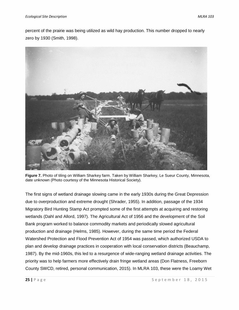
and plowing with teams of horses (Figure 7). Using this method, two men and a team of horses
could complete an average of 300-500 feet of trench per day (Beauchamp, 1987). Throughout the
latter half of the nineteenth century, various horse-drawn tiling machines were invented, followed
by highly mechanized steam engines, and by gasoline engines starting in 1908 (Beauchamp,
1987). Even with increasing mechanization some companies specializing in hand-dug drainage tile
remained in business into the 1960s (Don Flatness, Freeborn County SWCD, retired, personal
communication, 2015). The Reclamation Act of 1902 initiated the first direct involvement of the
USDA in farm drainage activities on privately-owned lands. By about 1930, 95% of wetlands in the
region were at least partially drained (Doak, 2015; Shrader, 1955). The utilization of wetlands for
wild hay also decreased in this time period. An Iowa agricultural census in 1896 showed that 5.5
Ecological Site Description MLRA 103
25 | P a g e S e p t e m b e r 1 8 , 2 0 1 5
percent of the prairie was being utilized as wild hay production. This number dropped to nearly
zero by 1930 (Smith, 1998).
Figure 7. Photo of tiling on William Sharkey farm. Taken by William Sharkey, Le Sueur County, Minnesota, date unknown (Photo courtesy of the Minnesota Historical Society).
The first signs of wetland drainage slowing came in the early 1930s during the Great Depression
due to overproduction and extreme drought (Shrader, 1955). In addition, passage of the 1934
Migratory Bird Hunting Stamp Act prompted some of the first attempts at acquiring and restoring
wetlands (Dahl and Allord, 1997). The Agricultural Act of 1956 and the development of the Soil
Bank program worked to balance commodity markets and periodically slowed agricultural
production and drainage (Helms, 1985). However, during the same time period the Federal
Watershed Protection and Flood Prevention Act of 1954 was passed, which authorized USDA to
plan and develop drainage practices in cooperation with local conservation districts (Beauchamp,
1987). By the mid-1960s, this led to a resurgence of wide-ranging wetland drainage activities. The
priority was to help farmers more effectively drain fringe wetland areas (Don Flatness, Freeborn
County SWCD, retired, personal communication, 2015). In MLRA 103, these were the Loamy Wet
Ecological Site Description MLRA 103
26 | P a g e S e p t e m b e r 1 8 , 2 0 1 5
Prairie soils. As a result, an estimated 125,000 acres of prairie pothole wetlands were drained
between 1964 and 1968 alone (Weller, 1994). By the early 1970s, tile drainage sped up because
of the invention of corrugated plastic tubing which replaced clay and concrete drainage tile
(Beauchamp, 1987). By this time over 99 percent of wetlands in Iowa, most of which were in MLRA
103, had been drained (Crumpton et al., 2012). Also during this time, small-scale family dairy farms
were declining in the region, accompanied by conversion of so-called “permanent pastures” and a
variety of other crops to corn and soybean farming (Don Flatness, Freeborn County SWCD, retired,
personal communication, 2015).
From the mid-1980s through the early-1990s, a number of important conservation measures took
place that continue to positively impact the conservation of prairie pothole wetlands today,
including Loamy Wet Prairies. In 1985, the first Food Security Act was passed (often referred to as
the “Farm Bill”), which introduced two important items related to wetland conservation. First was
“Swampbuster,” which sought to remove Federal subsidies to farmers who drained or otherwise
converted wetlands for the purpose of planting crops (Votteler and Muir, 2002). This program was
meant not only to protect wetlands, but to decrease the amount of land available for agriculture to
help maintain stable commodity prices. Swampbuster compliance remains the most important
government legislation protecting agricultural wetlands that were not converted prior to December
23, 1985 (Crumpton et al., 2012). The second important item introduced with the 1985 Food
Security Act was the Conservation Reserve Program (CRP), which provides rental payments to
farmers to take marginal agricultural land out of production for 10 or 15 year contract periods, with
the potential to re-enroll. The Wetland Reserve Program (WRP), introduced in the 1990 Food
Security Act, is another important program for wetland restoration. The WRP gives landowners
financial payment for restoring or protecting wetlands through long term, often permanent
easements. Additionally, the State of Minnesota’s “Reinvest In Minnesota Reserve Program” has
partnered with the Federal WRP to provide additional incentives, enhancing 30-year WRP
contracts into perpetual easements (BWSR, 2005). Finally, in 1991 the State of Minnesota passed
the Wetland Conservation Act, creating a “no net loss” policy of Minnesota’s remaining wetlands
(BWSR, 2015). As a result of these conservation measures, in recent decades the conversion of
wetlands has slowed. And meanwhile, many thousands of acres have been protected or
reestablished. However, corn and soybean prices have increased since 2007, particularly during
the crop years of 2011, 2012, and 2013 which recorded historic highs, averaging over $6/bushel
(Univ. of Illinois, 2015). This change in the agricultural market has put increased pressure on
Ecological Site Description MLRA 103
27 | P a g e S e p t e m b e r 1 8 , 2 0 1 5
remaining wetland areas by providing yet another wide-scale incentive for farmers to take land out
of perennial vegetation and further drain wetlands.
In the end, during the span of less than a century, almost all of the original 240 million acres of
tallgrass prairie of the prairie peninsula were converted to agriculture (Smith, 1992). As a result,
there is much we don’t know about these ecosystems. Of all the tallgrass prairie regions, MLRA
103 is perhaps the most ecologically altered. This portion of Minnesota and Iowa was once part of
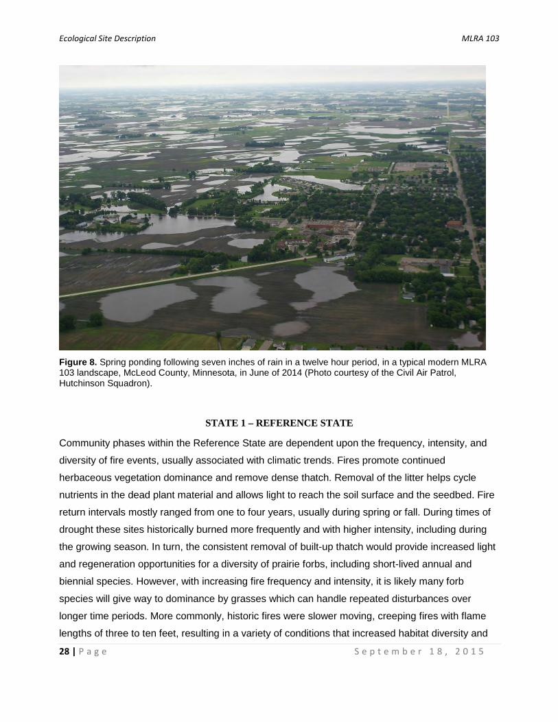
one of the most important wetland regions in the World. As much as three quarters of North
American waterfowl reproduction comes from the prairie pothole region during a given year (Mitsch
and Gosselink, 2007). Loamy Wet Prairies, adjacent to the pothole depressions, once provided
critical nesting habitat for many species (Galatowitsch and van der Valk, 1994). However, today,
the Des Moines Lobe is no longer important for waterfowl production. Despite this reality, remnant
and restored wetlands still provide important stopover sites during migration, and during times of
excessive precipitation and soil saturation, these former wetland basins show signs of their former
self (Figure 8).
Depending upon which land cover dataset is analyzed, around 99 percent of the land area of this
ecological site is in private ownership, one percent is considered wetland via the National Wetland
Inventory, 90 percent is in cultivated crops, one to four percent in grass or pasture, and the rest is
miscellaneous developed land. The information provided in this publication is based on
accumulated knowledge gained through the literature as well as data and field experience from
both high quality managed prairie natural areas as well as sites in various stages of degradation.
Incredibly, there are a number of small virgin prairie pothole basin remnants that escaped
conversion. Either by luck, or by the foresight of visionary landowners, there are a few blocks of
land that were not drained and farmed, but most of these sites are small or are old cemeteries or
railroad/road rights-of-way. Few, if any locations within the MLRA remain connected to larger areas
of intact prairie-wetland complexes needed to maintain populations of the many declining area-
sensitive grassland wildlife species (Galatowitsch and van der Valk, 1994).
Ecological Site Description MLRA 103
28 | P a g e S e p t e m b e r 1 8 , 2 0 1 5
Figure 8. Spring ponding following seven inches of rain in a twelve hour period, in a typical modern MLRA 103 landscape, McLeod County, Minnesota, in June of 2014 (Photo courtesy of the Civil Air Patrol, Hutchinson Squadron).
STATE 1 – REFERENCE STATE
Community phases within the Reference State are dependent upon the frequency, intensity, and
diversity of fire events, usually associated with climatic trends. Fires promote continued
herbaceous vegetation dominance and remove dense thatch. Removal of the litter helps cycle
nutrients in the dead plant material and allows light to reach the soil surface and the seedbed. Fire
return intervals mostly ranged from one to four years, usually during spring or fall. During times of
drought these sites historically burned more frequently and with higher intensity, including during
the growing season. In turn, the consistent removal of built-up thatch would provide increased light
and regeneration opportunities for a diversity of prairie forbs, including short-lived annual and
biennial species. However, with increasing fire frequency and intensity, it is likely many forb
species will give way to dominance by grasses which can handle repeated disturbances over
longer time periods. More commonly, historic fires were slower moving, creeping fires with flame
lengths of three to ten feet, resulting in a variety of conditions that increased habitat diversity and
Ecological Site Description MLRA 103
29 | P a g e S e p t e m b e r 1 8 , 2 0 1 5
provided refugia for wildlife (MN DNR, 2005a; Gleason, 1913). However, some forb species would
not have been able to compete with the competitive grasses if recurrent fires were too low in
intensity (Landfire, 2009). Grazing by native ungulates would also have affected the diversity of
vegetation by creation of microsites for certain plant species. The combination of fire and grazing
generally was sufficient to keep woody species from proliferating. However, in times of higher than
average precipitation, some areas may accumulate significant woody cover, although historically
this was rare.
In addition to fire and grazing, high water tables are needed to maintain plant communities within
the Reference State. In natural conditions, at least some part of the top foot of the rooting zone is
saturated for several weeks during the early growing season. Longer-term, inter-annual changes in
precipitation can shift these boundaries and create conditions favorable to species tolerant of
wetter or drier conditions. This also contributes to the diversity of species present. As a result, the
mesic prairie-wet prairie-sedge meadow continuum can range somewhat, with upland prairie
species expanding during dry cycles, and sedges and wetland obligate species expanding during
wet cycles.
Areas in the Reference State currently are likely degraded to some extent. Undoubtedly remaining
natural areas were grazed and/or hayed at one time. And with no source populations nearby it is
very likely many prairie species have been extirpated. Others likely benefited. For example,
Virginia mountainmint, one of the most common forbs encountered, may be more common today
because of its ability to persist in the face of heavy grazing (Eggers and Reed, 2015).
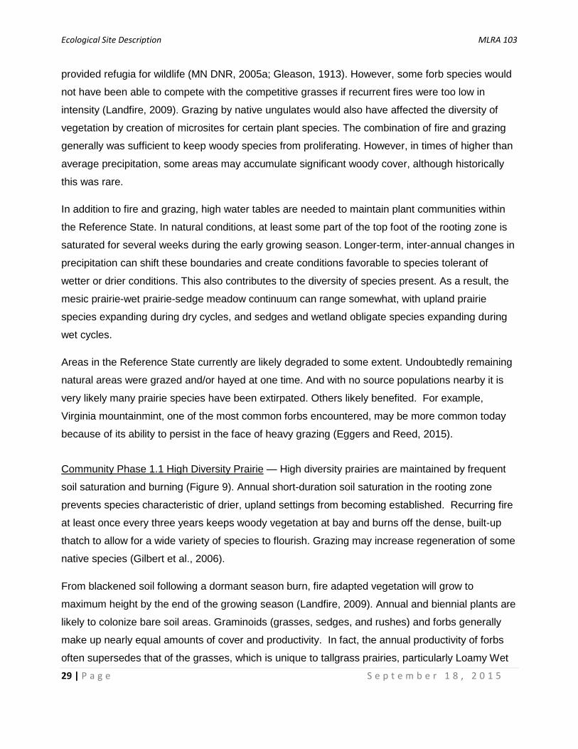
Community Phase 1.1 High Diversity Prairie — High diversity prairies are maintained by frequent
soil saturation and burning (Figure 9). Annual short-duration soil saturation in the rooting zone
prevents species characteristic of drier, upland settings from becoming established. Recurring fire
at least once every three years keeps woody vegetation at bay and burns off the dense, built-up
thatch to allow for a wide variety of species to flourish. Grazing may increase regeneration of some
native species (Gilbert et al., 2006).
From blackened soil following a dormant season burn, fire adapted vegetation will grow to
maximum height by the end of the growing season (Landfire, 2009). Annual and biennial plants are
likely to colonize bare soil areas. Graminoids (grasses, sedges, and rushes) and forbs generally
make up nearly equal amounts of cover and productivity. In fact, the annual productivity of forbs
often supersedes that of the grasses, which is unique to tallgrass prairies, particularly Loamy Wet

Ecological Site Description MLRA 103
30 | P a g e S e p t e m b e r 1 8 , 2 0 1 5
Prairies (Table 7). Big bluestem is the dominant grass, sometimes growing in excess of eight feet
tall. Indiangrass and prairie cord grass are co-dominant. Other grasses include switchgrass, fowl
bluegrass, prairie dropseed, and scattered little bluestem. Sedges are common but usually not
dominant. In cases where sedges are dominant, there likely is a water table higher in the soil
profile, such as sites that are hydrologically connected to nearby lakes. An individual location can
have a wide variety of forbs depending upon whether it is on the wet or dry end of the ecological
site range. Common species are Canada goldenrod, sawtooth sunflower, Canada anemone, Indian
hemp, swamp milkweed, palespike lobelia, winged lythrum, Virginia mountainmint, giant goldenrod,
white heath aster, purple meadow rue, swamp verbena, prairie ironweed, Culver’s root, and golden
zizia. Tables 7 through 9 provide species composition, productivity, and structure of a typical High
Diversity Prairie plant community.
Pathway 1.1A - Average fire return intervals of three to five years for a decade or more.
Table 7. Reference State, Community Phase 1.1 Annual Production. Estimates are based on dried weights. (Data presented are based on three type locations.)
Table 8. Reference State, Community Phase 1.1 vertical structure. (Data presented are based on three type locations.)
Lbs/acre
Growth Form Low Normal High
Grass/Grasslike 1,000 1,500 2,500 Forb 1,200 2,000 3,000 Shrub/Vine 0 250 500
Total Annual Production
2,200 3,750 6,000
Percent Cover
Height Above Ground (ft.)
Grass/ Grasslike Forb Shrub/
Vine Tree
0.5’
10-20 10-20 0-1 - 0.5-1’ 25-50 35-65 1-5 - 1-2’ 25-50 35-65 1-10 - 2-4.5’ 40-70 25-50 0-1 - 4.5-13’ 10-40 5-15 - -

Ecological Site Description MLRA 103
31 | P a g e S e p t e m b e r 1 8 , 2 0 1 5
Table 9. Reference State, Community Phase 1.1 ground surface cover. (Data presented are based on ground cover transects at NRCS type locations.)
Figure 9. Community Phase 1.1 High Diversity Prairie for Loamy Wet Prairie ecological site; Webster soils. Photo by Kyle Steele, Cottonwood County, Minnesota, in August of 2015.
Type Minimum (%)
Maximum (%)
Grass/Grasslike 15 30 Forb 15 30 Shrub/Vine 0 1 Tree 0 0 Non-Vascular Plants 0 1 Biological Crust 0 2 Litter 15 75 Surface Fragments (.25-3”) 0 0 Surface Fragments (>3”) 0 0 Bedrock 0 0 Water 0 2 Bare Ground 0 25

Ecological Site Description MLRA 103
32 | P a g e S e p t e m b e r 1 8 , 2 0 1 5
Figure 10. Community Phase 1.2 Old Growth Prairie for Loamy Wet Prairie ecological site; Canisteo soils. Photo by Kyle Steele, Kossuth County, Iowa, in June of 2015.
Community Phase 1.2 Old Growth Prairie — This phase occurs when fire frequency is reduced to
three to five year intervals, and hydrology is unchanged. Plant litter is removed less frequently
which favors the grasses and results in a reduction in overall plant diversity (Figure 10). The dense
build-up of plant litter also tends to reduce the height of the dominant species. The plant litter ties
up nutrients and shades the ground in the spring, keeping the soil cooler and slowing germination
and early growth. Vegetation on sites in the Old Growth Prairie condition is heavily dominated by
grasses, especially big bluestem, Indiangrass, and prairie cord grass. Other prairie grasses may
increase as well. Due to increased competition and thatch build-up produced by the grasses,
native forbs and sedges are still common but have reduced cover. Leadplant, prairie rose, and
other shrubs onsite increase.
Pathway 1.2A - Average fire return intervals of less than three years.

Ecological Site Description MLRA 103
33 | P a g e S e p t e m b e r 1 8 , 2 0 1 5
Transition 1A - Tillage; artificial drainage; removal of fire and native grazers.
Transition 1B - Seeding or invasion of cool season grasses; lack of fire; some hydrologic alteration; possible over-grazing.
Transition 1C - Lack of fire and grazing; time (>10 years without disturbance).
STATE 2 – GRASSLAND STATE
Community phases within this state are essentially simplified grassland plant communities.
Beginning in the late 1800s, many Loamy Wet Prairies were transitioning to this state resulting
from the removal of fire, cattle grazing, and haying practices. The reduction in fire frequency led to
more uniform habitat conditions over time which reduced species diversity. The dominant species
were both native warm season grasses and nonnative cool season grasses. At first, native prairie
grasses and various shrubs increased, while the majority of other species decreased. During this
time, Kentucky bluegrass and smooth brome were introduced to extend the grazing season of
prairie pastures (Smith, 1998). These nonnative grasses increased following intense over-grazing,
at the expense of native vegetation. At some point nonnative cultivars of reed canarygrass
(Phalaris arundinacea) were introduced due to its ability to grow in wet areas. Over time it became
extremely aggressive and is now one of the most common grasses in the region. Sites that haven’t
been drained and converted to row crop agriculture are often hayed or grazed.
Most restoration sites in the MLRA fit into this state. With active vegetation management, it is
possible for remnant sites to be restored to the Reference State. However, due to broad scale
ditching and tile drainage, in most locations the regional groundwater tables are unnaturally low
which makes it challenging to truly restore hydrology. Currently, the majority of sites in the
Grassland State are a result of WRP and CRP vegetation establishment. In these settings,
restoration of Loamy Wet Prairies is often overlooked due to the focus being on pothole marshes
and the perception that ponded water is the only important habitat for waterfowl use.
Consequently, wetland restorations typically focus on the development of submergent and
emergent vegetation in ponded areas (Galatowitsch and van der Valk, 1994). Reed canarygrass is
almost always a dominant and aggressive invader. In addition, it has been found that sites with
greater than 20 years of agriculture will have depleted native seed banks (Weinhold and van der
Valk, 1989). On Loamy Wet Prairie soils, slope wash from adjacent cultivated uplands may bury
the existing seedbank if one exists (Gilbert et al. 2006). Thus, effective restoration will require
artificial regeneration of vegetation and intensive management of invasive vegetation. Ultimately,
Ecological Site Description MLRA 103
34 | P a g e S e p t e m b e r 1 8 , 2 0 1 5
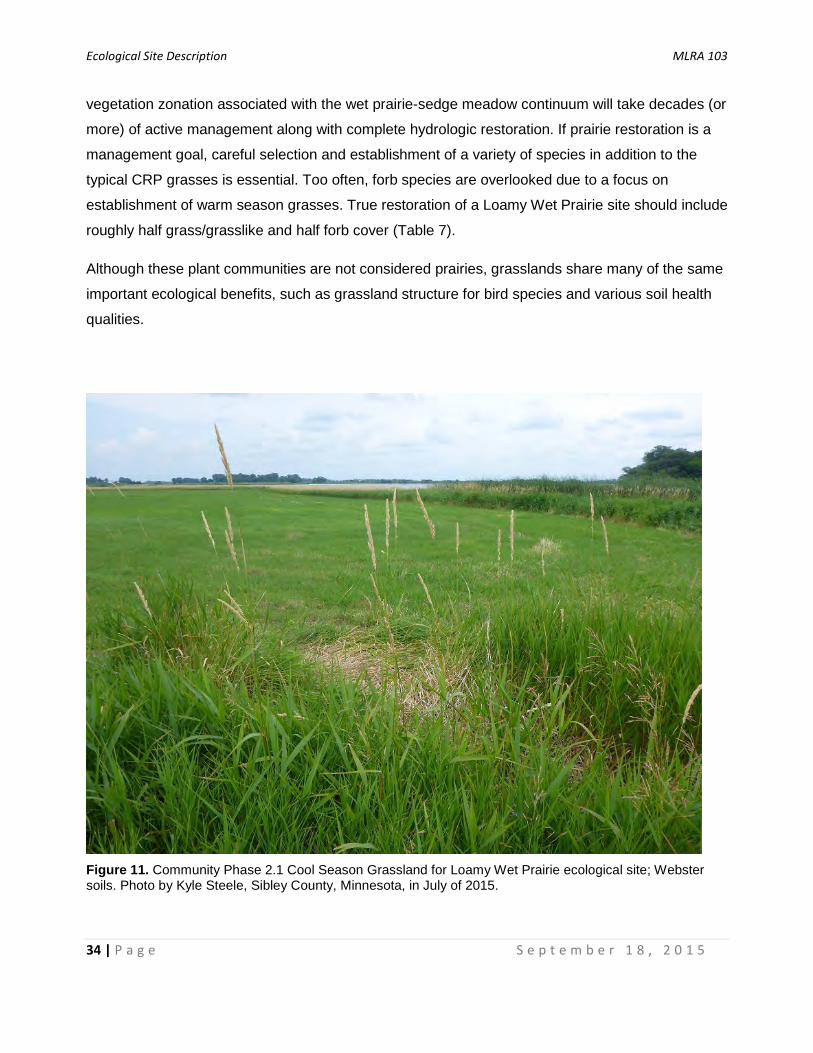
vegetation zonation associated with the wet prairie-sedge meadow continuum will take decades (or
more) of active management along with complete hydrologic restoration. If prairie restoration is a
management goal, careful selection and establishment of a variety of species in addition to the
typical CRP grasses is essential. Too often, forb species are overlooked due to a focus on
establishment of warm season grasses. True restoration of a Loamy Wet Prairie site should include
roughly half grass/grasslike and half forb cover (Table 7).
Although these plant communities are not considered prairies, grasslands share many of the same
important ecological benefits, such as grassland structure for bird species and various soil health
qualities.
Figure 11. Community Phase 2.1 Cool Season Grassland for Loamy Wet Prairie ecological site; Webster soils. Photo by Kyle Steele, Sibley County, Minnesota, in July of 2015.

Ecological Site Description MLRA 103
35 | P a g e S e p t e m b e r 1 8 , 2 0 1 5
Community Phase 2.1 Cool Season Grassland — These sites are strongly dominated by nonnative
cool season grasses, typically about three to five feet tall. Reed canarygrass is probably the most
common across all sites (Figure 11). This species does well in the wet prairie hydrologic regime
and grows earlier in the season than the native warm season grasses (Maurer and Zedler, 2002).
Other nonnative cool season grasses that can be common to abundant are smooth brome,
Kentucky bluegrass, redtop (Agrostis gigantea), and quackgrass (Elymus repens). Vegetation
establishment in old crop field settings are mostly likely to result in this community phase
(Mulhouse and Galatowitsch, 2003).
Pathway 2.1A - Removal of cool season grasses; seeding.
Community Phase 2.2 Warm Season Grassland — Sites in this community phase are strongly
dominated by warm-season native grasses about three to eight feet tall (Figure 12). This
community results from either the loss of diversity due to over-grazing, mowing, and removal of fire
or from planting for restoration or other conservation purposes. The latter is the most common.
Dominant grasses are similar to Community Phase 1.2, but diversity is much lower and the
dominants can form near-monotypic stands. This is the most common plant community occurring in
CRP plantings. Planted grasses include big bluestem, Indiangrass and switchgrass. Prairie cord
grass may establish at these sites naturally. Due to the increased dominance by grasses and the
reduced fire frequency, plant litter buildup tends to be heavy. Most CRP and WRP plantings also
include forb species, but they are often few in number and their cover is sparse, in large part due to
the competitive nature of the aforementioned grass species. If prairie restoration is a management
goal, it is important to prioritize forb establishment, as well as planting additional grasses, sedges,
and even wet prairie shrubs.
Pathway 2.2A - Invasion of cool season grasses.
Transition 2A - Lack of fire and grazing for greater than 10 years.
Transition 2B - Tillage; artificial drainage; removal of fire and native grazers. The majority of early post-settlement areas within the Grassland State were drained and transitioned to crop production.
Restoration Pathway 2A - Long term ecological restoration, including establishment of typical wet prairie vegetation composition and structure, complete restoration of hydrology, and reintroduction of a diversity of disturbances, including multi-season burning and grazing.

Ecological Site Description MLRA 103
36 | P a g e S e p t e m b e r 1 8 , 2 0 1 5
Figure 12. Community Phase 2.2 Warm Season Grassland for Loamy Wet Prairie ecological site; Typic Endoaquoll soils. Photo by Kyle Steele, Freeborn County, Minnesota, in July of 2015.
STATE 3 – SCRUB WOODLAND STATE
Without fire to kill woody vegetation, trees and tall shrubs can become established and spread,
potentially converting the site to a closed woodland. In general, community phases in this state
have greater than 25 percent cover with a dense herbaceous, usually grass-dominated,
understory. Trees range from short to medium height (15 to 30 feet). Eastern cottonwood (Populus
deltoides), black willow (Salix nigra), green ash (Fraxinus pennsylvanica) boxelder (Acer negundo),
quaking aspen (Populus tremuloides), and peachleaf willow (Salix amygdaloides) are the most
common trees. Common shrubs are redosier dogwood (Cornus sericea), meadow willow (Salix
petiolaris), Bebb willow (Salix bebbiana), pussy willow (Salix discolor), Missouri River willow (Salix
eriocephala), and possibly others. In areas without complete canopy closure, the understory is
similar to Community Phase 2.1, dominated by reed canarygrass and smooth brome. Kentucky
bluegrass, redtop, and quackgrass may also be present. Giant ragweed (Ambrosia trifida) is often
Ecological Site Description MLRA 103
37 | P a g e S e p t e m b e r 1 8 , 2 0 1 5
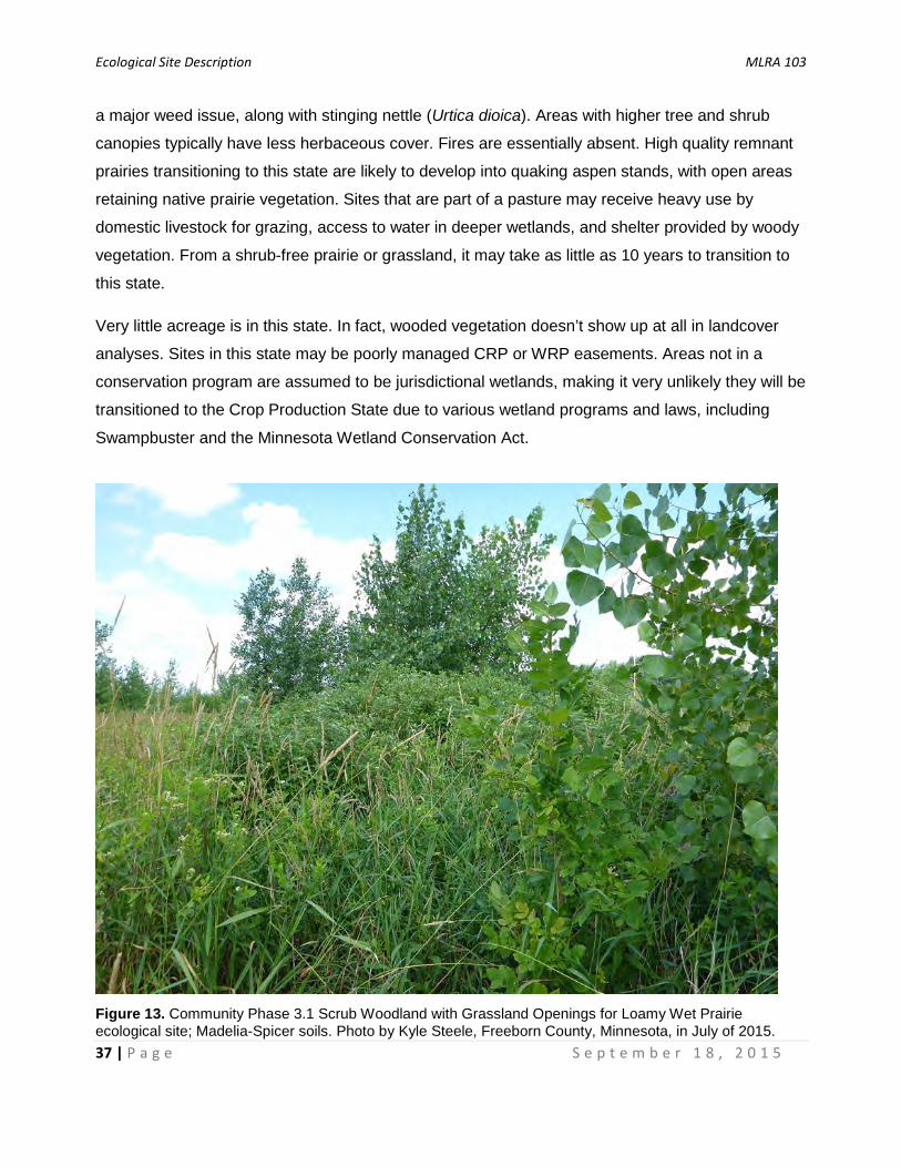
a major weed issue, along with stinging nettle (Urtica dioica). Areas with higher tree and shrub
canopies typically have less herbaceous cover. Fires are essentially absent. High quality remnant
prairies transitioning to this state are likely to develop into quaking aspen stands, with open areas
retaining native prairie vegetation. Sites that are part of a pasture may receive heavy use by
domestic livestock for grazing, access to water in deeper wetlands, and shelter provided by woody
vegetation. From a shrub-free prairie or grassland, it may take as little as 10 years to transition to
this state.
Very little acreage is in this state. In fact, wooded vegetation doesn’t show up at all in landcover
analyses. Sites in this state may be poorly managed CRP or WRP easements. Areas not in a
conservation program are assumed to be jurisdictional wetlands, making it very unlikely they will be
transitioned to the Crop Production State due to various wetland programs and laws, including
Swampbuster and the Minnesota Wetland Conservation Act.
Figure 13. Community Phase 3.1 Scrub Woodland with Grassland Openings for Loamy Wet Prairie ecological site; Madelia-Spicer soils. Photo by Kyle Steele, Freeborn County, Minnesota, in July of 2015.

Ecological Site Description MLRA 103
38 | P a g e S e p t e m b e r 1 8 , 2 0 1 5
Community Phase 3.1 Scrub Woodland with Grassland Openings — This phase consists of plant
communities with 25 to 75 canopy cover of trees and shrubs, generally ranging from 10 to 30 feet
in height (Figure 13). Eastern cottonwood, black willow, green ash, and redosier dogwood are the
most frequent woody species. Open areas are generally dominated by reed canarygrass, along
with other grasses and weedy forbs. Giant ragweed can sometimes produce monotypic stands in
open areas. In rare cases, higher quality sites can be dominated by quaking aspen and scattered
wet prairie grasses and forbs.
Pathway 3.1A - Succession, greater than 20 years without fire or grazing, development of forest structure.
Figure 14. Community Phase 3.2 Closed Scrub Woodland for Loamy Wet Prairie ecological site; miscellaneous hydric soils. Photo by Kyle Steele, Freeborn County, Minnesota, in July of 2015.
Ecological Site Description MLRA 103
39 | P a g e S e p t e m b e r 1 8 , 2 0 1 5
Community Phase 3.2 Closed Scrub Woodland — This phase includes closed, or nearly closed
woodlands, ranging from 75 to 100 percent canopy cover (Figure 14). Like Community Phase 3.1,
Eastern cottonwood, black willow, green ash, and redosier dogwood are the most frequent woody
species. The few open areas will be dominated by reed canarygrass, but herbaceous cover is
generally low. Stinging nettle is frequently the most common species. Again, in higher quality sites
quaking aspen may be the dominant tree. Eventually these sites will begin to accumulate shade-
tolerant herbaceous plants.
Pathway 3.2A - Partial removal of canopy.
Transition 3A - Removal of overstory; seeding of grasses.
Transition 3B - Removal of overstory; tillage; artificial drainage; conversion to row crop agriculture.
Restoration Pathway 3A - Removal of overstory; long term restoration; uncommon.
STATE 4 – CROP PRODUCTION STATE
The vast majority (over 90 percent) of modern Loamy Wet Prairie sites are in the Crop Production
State. Most, but not all ecological functions have been destroyed, converted, or otherwise removed
from the system. In farmed conditions, dynamic soil properties can change quickly as a result of
various agricultural practices and are the best way to understand the effects of these practices on
the condition of individual fields. The vast majority of these sites are and will likely continue to be in
corn and soybean production. There are certain management practices that are proven to be
destructive, not only to the individual field, but to the watershed as a whole. Collectively, excessive
tillage, monoculture cropping systems, the pervasive use of fertilizers and other chemicals, and
many modern farming practices have unwanted effects that are neither good for the future of the
site nor for the ecosystem as a whole. Subsurface tile drainage and tillage are the two primary
factors affecting transition to this state. Counties in MLRA 103 are estimated to have had 64 to 100
percent of all wetlands converted to agricultural uses (Gleason et al., 2004). However, it is
assumed that virtually all Loamy Wet Prairie sites in the Crop Production State have been
effectively drained. The main purpose of tile drainage is to produce drier and warmer conditions in
the spring so growers can enter fields as soon as possible. In a natural condition, these wetlands
are not directly connected to riverine systems. However, modern drainage activities transfer water
through drainage tile and ditch networks directly into riverine systems, effectively overriding the
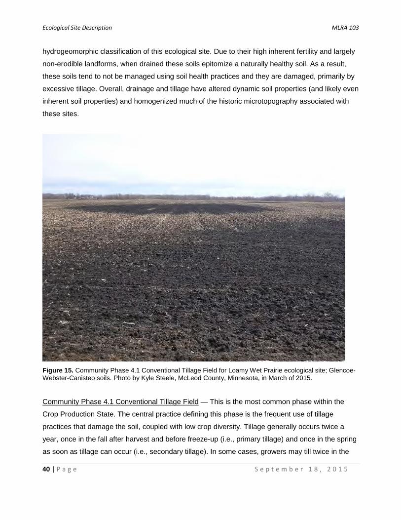
Ecological Site Description MLRA 103
40 | P a g e S e p t e m b e r 1 8 , 2 0 1 5
hydrogeomorphic classification of this ecological site. Due to their high inherent fertility and largely
non-erodible landforms, when drained these soils epitomize a naturally healthy soil. As a result,
these soils tend to not be managed using soil health practices and they are damaged, primarily by
excessive tillage. Overall, drainage and tillage have altered dynamic soil properties (and likely even
inherent soil properties) and homogenized much of the historic microtopography associated with
these sites.
Figure 15. Community Phase 4.1 Conventional Tillage Field for Loamy Wet Prairie ecological site; Glencoe-Webster-Canisteo soils. Photo by Kyle Steele, McLeod County, Minnesota, in March of 2015.
Community Phase 4.1 Conventional Tillage Field — This is the most common phase within the
Crop Production State. The central practice defining this phase is the frequent use of tillage
practices that damage the soil, coupled with low crop diversity. Tillage generally occurs twice a
year, once in the fall after harvest and before freeze-up (i.e., primary tillage) and once in the spring
as soon as tillage can occur (i.e., secondary tillage). In some cases, growers may till twice in the
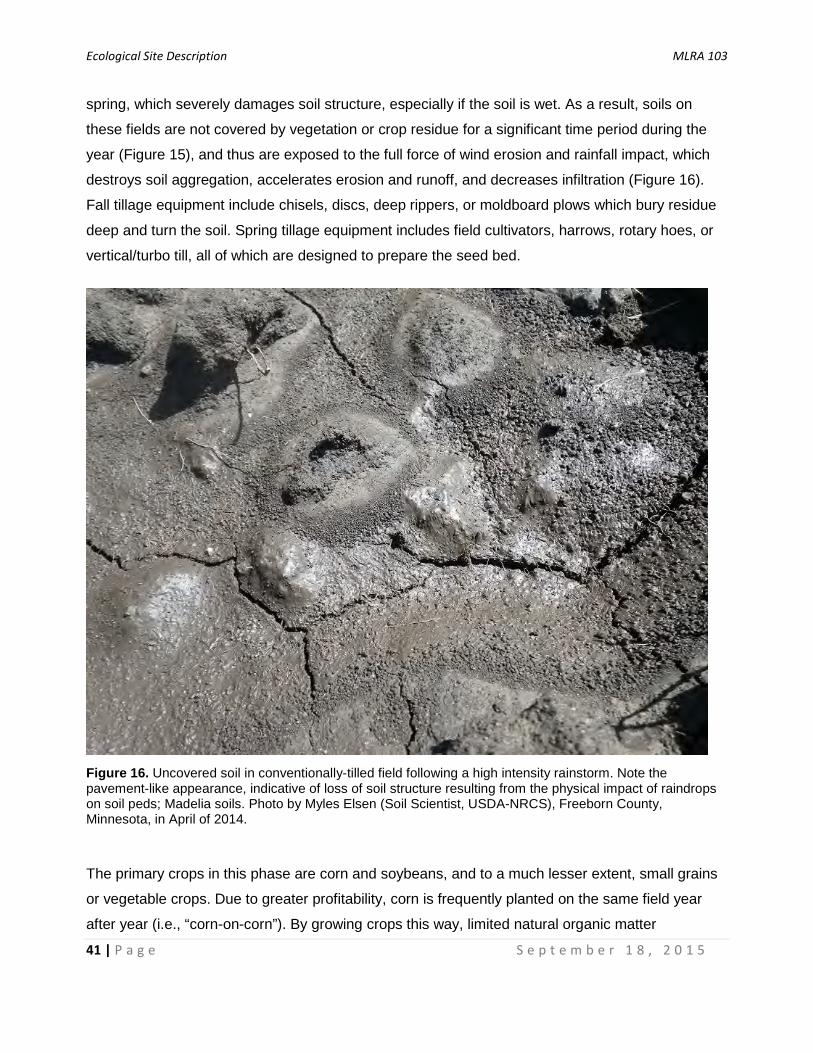
Ecological Site Description MLRA 103
41 | P a g e S e p t e m b e r 1 8 , 2 0 1 5
spring, which severely damages soil structure, especially if the soil is wet. As a result, soils on
these fields are not covered by vegetation or crop residue for a significant time period during the
year (Figure 15), and thus are exposed to the full force of wind erosion and rainfall impact, which
destroys soil aggregation, accelerates erosion and runoff, and decreases infiltration (Figure 16).
Fall tillage equipment include chisels, discs, deep rippers, or moldboard plows which bury residue
deep and turn the soil. Spring tillage equipment includes field cultivators, harrows, rotary hoes, or
vertical/turbo till, all of which are designed to prepare the seed bed.
Figure 16. Uncovered soil in conventionally-tilled field following a high intensity rainstorm. Note the pavement-like appearance, indicative of loss of soil structure resulting from the physical impact of raindrops on soil peds; Madelia soils. Photo by Myles Elsen (Soil Scientist, USDA-NRCS), Freeborn County, Minnesota, in April of 2014.
The primary crops in this phase are corn and soybeans, and to a much lesser extent, small grains
or vegetable crops. Due to greater profitability, corn is frequently planted on the same field year
after year (i.e., “corn-on-corn”). By growing crops this way, limited natural organic matter
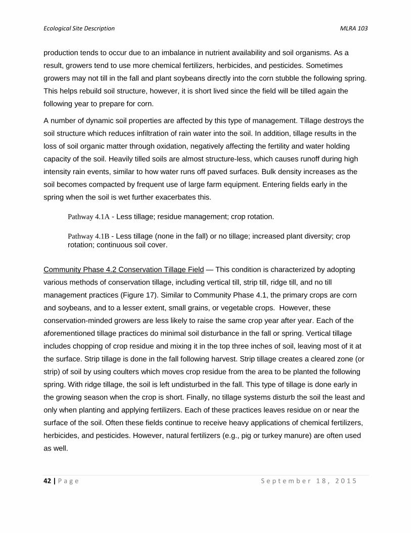
Ecological Site Description MLRA 103
42 | P a g e S e p t e m b e r 1 8 , 2 0 1 5
production tends to occur due to an imbalance in nutrient availability and soil organisms. As a
result, growers tend to use more chemical fertilizers, herbicides, and pesticides. Sometimes
growers may not till in the fall and plant soybeans directly into the corn stubble the following spring.
This helps rebuild soil structure, however, it is short lived since the field will be tilled again the
following year to prepare for corn.
A number of dynamic soil properties are affected by this type of management. Tillage destroys the
soil structure which reduces infiltration of rain water into the soil. In addition, tillage results in the
loss of soil organic matter through oxidation, negatively affecting the fertility and water holding
capacity of the soil. Heavily tilled soils are almost structure-less, which causes runoff during high
intensity rain events, similar to how water runs off paved surfaces. Bulk density increases as the
soil becomes compacted by frequent use of large farm equipment. Entering fields early in the
spring when the soil is wet further exacerbates this.
Pathway 4.1A - Less tillage; residue management; crop rotation.
Pathway 4.1B - Less tillage (none in the fall) or no tillage; increased plant diversity; crop rotation; continuous soil cover.
Community Phase 4.2 Conservation Tillage Field — This condition is characterized by adopting
various methods of conservation tillage, including vertical till, strip till, ridge till, and no till
management practices (Figure 17). Similar to Community Phase 4.1, the primary crops are corn
and soybeans, and to a lesser extent, small grains, or vegetable crops. However, these
conservation-minded growers are less likely to raise the same crop year after year. Each of the
aforementioned tillage practices do minimal soil disturbance in the fall or spring. Vertical tillage
includes chopping of crop residue and mixing it in the top three inches of soil, leaving most of it at
the surface. Strip tillage is done in the fall following harvest. Strip tillage creates a cleared zone (or
strip) of soil by using coulters which moves crop residue from the area to be planted the following
spring. With ridge tillage, the soil is left undisturbed in the fall. This type of tillage is done early in
the growing season when the crop is short. Finally, no tillage systems disturb the soil the least and
only when planting and applying fertilizers. Each of these practices leaves residue on or near the
surface of the soil. Often these fields continue to receive heavy applications of chemical fertilizers,
herbicides, and pesticides. However, natural fertilizers (e.g., pig or turkey manure) are often used
as well.
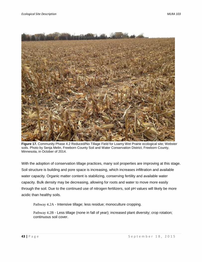
Ecological Site Description MLRA 103
43 | P a g e S e p t e m b e r 1 8 , 2 0 1 5
Figure 17. Community Phase 4.2 Reduced/No Tillage Field for Loamy Wet Prairie ecological site; Webster soils. Photo by Senja Melin, Freeborn County Soil and Water Conservation District, Freeborn County, Minnesota, in October of 2014.
With the adoption of conservation tillage practices, many soil properties are improving at this stage.
Soil structure is building and pore space is increasing, which increases infiltration and available
water capacity. Organic matter content is stabilizing, conserving fertility and available water
capacity. Bulk density may be decreasing, allowing for roots and water to move more easily
through the soil. Due to the continued use of nitrogen fertilizers, soil pH values will likely be more
acidic than healthy soils.
Pathway 4.2A - Intensive tillage; less residue; monoculture cropping.
Pathway 4.2B - Less tillage (none in fall of year); increased plant diversity; crop rotation; continuous soil cover.
Ecological Site Description MLRA 103
44 | P a g e S e p t e m b e r 1 8 , 2 0 1 5
Community Phase 4.3 Conservation Tillage/Alternative Crop Field — This is the optimal,
sustainable condition of a cropped field, where a range of conservation practices are implemented
with the goal to follow soil health principles. This phase may use all of the tillage-related items
described in 4.2, but the guiding principle is to disturb the soil as little as possible. This phase also
adds more diversity in crops and other plants used to keep the soil covered throughout the year
(i.e., cover crops; Figure 18). These cover crops generally include grasses, nitrogen-fixing
legumes, brassicas, and non-legume broadleaf plants. A number of cover crop planting options are
available, such as by airplane or helicopter, spinner and pendulum spreaders, highboys, drills,
incorporation with tillage, or spreading with manure slurry. Adding cover crops helps to limit pest
cycles (e.g., corn root worm or soybean cyst nematode), adds nutrients, and increases soil fertility.
In general, cover crops have different root systems than corn and soybeans, which helps build soil
structure by aggregating soil particles with newly made organic matter. The use of a diversity of
cover crops produces a variety of root exudates that can feed and encourage more diverse and
balanced soil biota, including predatory biota of various kinds, thus providing natural pest control.
Practicing soil health principles may result in less need for chemical fertilizers and pesticides.
Collectively, the benefits of this farm management system and tends to result in high corn and
soybean yields with lower costs, and thus greater profitability.
It is possible to attempt transition to this phase from conventional tillage (Community Phase 4.1),
but results will not be immediate. In heavily degraded soils it will take at least three to five years
before dynamic soil properties improve, such as development granular soil structure, increased
porosity, increased soil organic matter, increased available water capacity, and decreased bulk
density. In some cases in southern Minnesota, growers and conservationists have found that soils
can be improved to the extent that they rival the productivity of a natural prairie soil. However, this
may take decades of continual management to achieve. In MLRA 103, adoption of these
management techniques is currently low, but is growing as more farmers learn how to successfully
implement soil health principles, including managing cover crops. Once in Community Phase 4.3, it
is unlikely the field will transition back to 4.1, unless farm ownership or management changes.
Similar to Community Phase 4.2, the implementation of soil health principles through the use of
various conservation practices improves a number of dynamic soil properties. Structureless soils
begin to re-aggregate, which improves infiltration and available water capacity. Soil organic matter
content is increasing, adding to fertility and available water capacity. As soil organic matter
increases, soil biota diversifies, and pH becomes less acid. Finally, although these fields continue
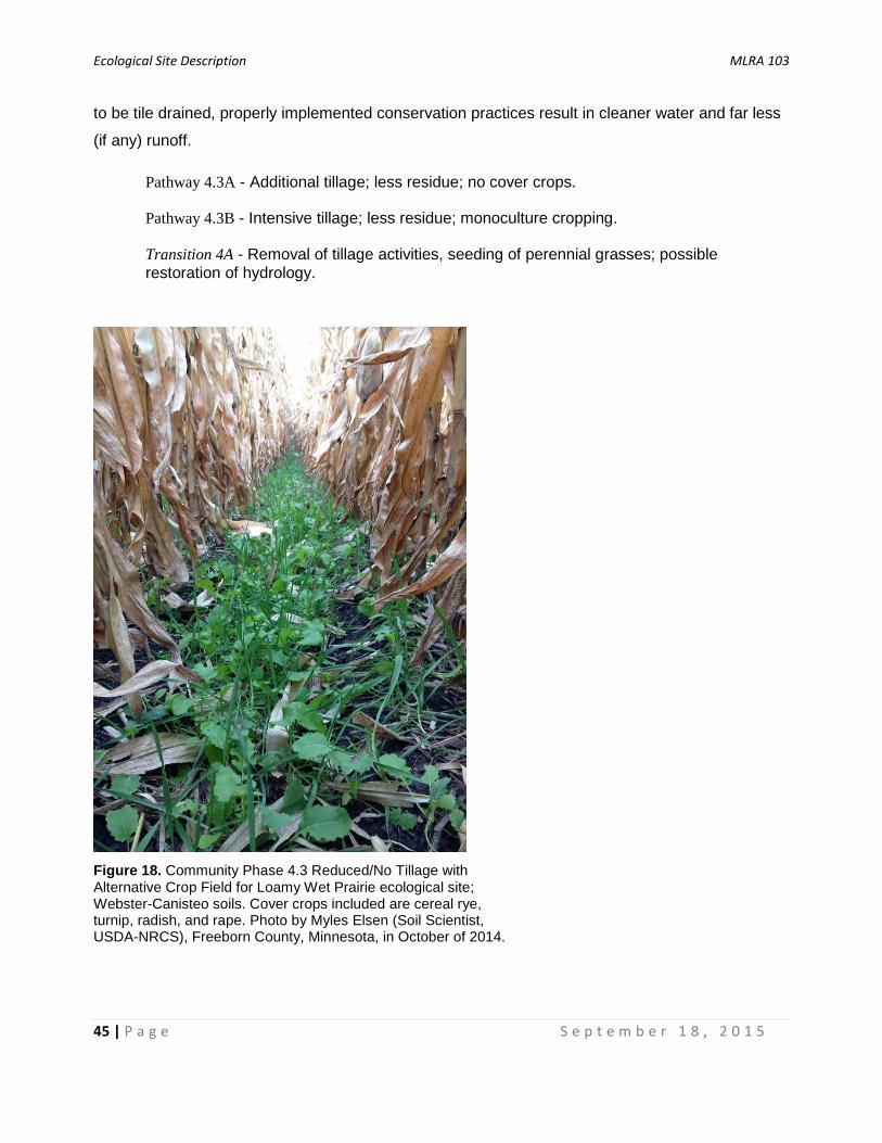
Ecological Site Description MLRA 103
45 | P a g e S e p t e m b e r 1 8 , 2 0 1 5
to be tile drained, properly implemented conservation practices result in cleaner water and far less
(if any) runoff.
Pathway 4.3A - Additional tillage; less residue; no cover crops.
Pathway 4.3B - Intensive tillage; less residue; monoculture cropping.
Transition 4A - Removal of tillage activities, seeding of perennial grasses; possible restoration of hydrology.
Figure 18. Community Phase 4.3 Reduced/No Tillage with Alternative Crop Field for Loamy Wet Prairie ecological site; Webster-Canisteo soils. Cover crops included are cereal rye, turnip, radish, and rape. Photo by Myles Elsen (Soil Scientist, USDA-NRCS), Freeborn County, Minnesota, in October of 2014.
Ecological Site Description MLRA 103
46 | P a g e S e p t e m b e r 1 8 , 2 0 1 5
Supporting Information
Relationship to Other Established Classifications:
Biophysical Setting (Landfire, 2009); the reference community of this ecological site is most similar to:
Central Tallgrass Prairie (4214210)
Circular 39 (USFWS 1956); the reference community of this ecological site is most similar to:
Type 1 - Seasonally Flooded Basin or Flat; and Type 2 - Wet Meadow
Cowardin et al., 1979; the reference community of this ecological site is most similar to:
Palustrine System, Emergent Wetland Class, Persistent Subclass, and Saturated Water Regime (i.e., PEMB)
Ecological Systems (National Vegetation Classification System, NatureServe, 2013); the reference community of this ecological site is most similar to:
Northern Tallgrass Prairie (CES205.686);
Eastern Great Plains Wet Meadow, Prairie and Marsh (CES205.687)
MN DNR Native Plant Community (MN DNR, 2005); the reference community of this ecological site is most similar to:
Primary: WPs54b Southern Wet Prairie
Secondary: WPs54a Southern Wet Seepage Prairie; UPs23a Southern Mesic Prairie; WMp73a Prairie Wet Meadow/Carr
Stewart and Kantrud, 1971; the reference community of this ecological site is most similar to:
Class I - Ephemeral; and Class II - Temporary
Vegetation Associations (National Vegetation Classification System, NatureServe, 2013); the reference community of this ecological site is most similar to:
Andropogon gerardii - Panicum virgatum - Helianthus grosseserratus Herbaceous Vegetation (CEGL002024)
Associated Ecological Sites: Pothole Marsh (103XY002) – Pothole Marshes are concave small- to medium-sized depressions
and occur downslope in close proximity to Loamy Wet Prairies. They are very poorly drained and
ponded throughout the early part of the growing season in most years (i.e., seasonal wetlands).
Soils are typically Cumulic Endoaquolls. Characteristic vegetation includes cattails (Typha spp.),
bulrushes (Scirpus and Schoenoplectus spp.), sedges, and other emergent wetland species. This
is currently a Provisional Ecological Site.
Ecological Site Description MLRA 103
47 | P a g e S e p t e m b e r 1 8 , 2 0 1 5
Organic Pothole Marsh (103XY003): Organic Pothole Marshes occur in concave medium- to large-
sized depressions, occur downslope from Loamy Wet Prairies, and occur either at the edges of
lakes or in the center of depressions that are surrounded by Pothole Marshes. They are very
poorly drained and are ponded throughout the growing season in most years (i.e., semi-permanent
or permanent wetlands). Soils are developed from organic parent materials and consist of a variety
of Histosol classifications. Characteristic vegetation includes interspersed emergent and floating
wetland plants surrounded by shallow, open water. Although they occur throughout the MLRA, they
are larger and more common in the northeast. This is currently a Provisional Ecological Site.
Calcareous Rim Prairie (103XY004): Calcareous Rim Prairies typically occur between Loamy Wet
Prairies and Pothole Marshes. Soils appear similar to Loamy Wet Prairies but are classified as
Typic Calciaquolls. They are poorly drained, not ponded, and develop diagnostic calcic horizons
due to their adjacency to ponded depressions. Hydrologic interaction with adjacent Pothole
Marshes classifies these sites as depressional discharge wetlands. Characteristic vegetation
includes a mix of wet prairie grasses and forbs, particularly those that are tolerant of calcareous
conditions. This is currently a Provisional Ecological Site.
Loamy Upland Prairie (103XY005): Loamy Upland Prairies is the most common ecological site in
the MLRA. They are the typically adjacent to Loamy Wet Prairies. Soils are non-hydric Typic and
Aquic Hapludolls usually on two to nine percent slopes. Characteristic vegetation is tallgrass prairie
with very few, if any wetland species. This is currently a Provisional Ecological Site.
Similar Ecological Sites:
Calcareous Rim Prairie (103XY004): Calcareous Rim Prairies typically occur between Loamy Wet
Prairies and Pothole Marshes. Soils appear similar to Loamy Wet Prairies but are classified as
Typic Calciaquolls. They are poorly drained, not ponded, and develop diagnostic calcic horizons
due to their adjacency to ponded depressions. Hydrologic interaction with adjacent Pothole
Marshes classifies these sites as depressional discharge wetlands. Characteristic vegetation
includes a mix of wet prairie grasses and forbs, particularly those that are tolerant of calcareous
conditions. This is currently a Provisional Ecological Site.
Clayey Wet Prairie (103XY006): Clayey Wet Prairies are poorly drained and not ponded. Thus they
have similar plant communities to Loamy Wet Prairies. Soils are developed from lacustrine
materials and may include both Mollisols and Vertisols having fine and very fine textural families.
This is currently a Provisional Ecological Site and more research is needed to fully develop this site
concept.
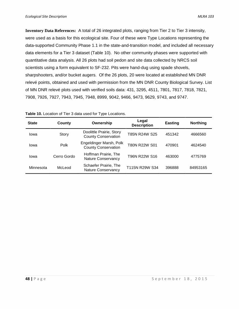
Ecological Site Description MLRA 103
48 | P a g e S e p t e m b e r 1 8 , 2 0 1 5
Inventory Data References: A total of 26 integrated plots, ranging from Tier 2 to Tier 3 intensity,
were used as a basis for this ecological site. Four of these were Type Locations representing the
data-supported Community Phase 1.1 in the state-and-transition model, and included all necessary
data elements for a Tier 3 dataset (Table 10). No other community phases were supported with
quantitative data analysis. All 26 plots had soil pedon and site data collected by NRCS soil
scientists using a form equivalent to SF-232. Pits were hand-dug using spade shovels,
sharpshooters, and/or bucket augers. Of the 26 plots, 20 were located at established MN DNR
relevé points, obtained and used with permission from the MN DNR County Biological Survey. List
of MN DNR relevé plots used with verified soils data: 431, 3295, 4511, 7801, 7817, 7818, 7821,
7908, 7926, 7927, 7943, 7945, 7948, 8999, 9042, 9466, 9473, 9629, 9743, and 9747.
Table 10. Location of Tier 3 data used for Type Locations.
State County Ownership Legal Description Easting Northing
Iowa Story Doolittle Prairie, Story County Conservation T85N R24W S25 451342 4666560
Iowa Polk Engeldinger Marsh, Polk County Conservation T80N R22W S01 470901 4624540
Iowa Cerro Gordo Hoffman Prairie, The Nature Conservancy T96N R22W S16 463000 4775769
Minnesota McLeod Schaefer Prairie, The Nature Conservancy T115N R29W S34 396888 84953165

Ecological Site Description MLRA 103
49 | P a g e S e p t e m b e r 1 8 , 2 0 1 5
Other References:
Anderson, D. 2005. Draining the Land (MN). Star Tribune Media Company LLC, Minneapolis, MN. Available online at http://www.iatp.org/news/draining-the-land-mn; last accessed August 21, 2015. Beauchamp, K.H. 1987. A History of Drainage and Drainage Methods. In: Pavelis, G.A. (Ed.), Farm Drainage in the United States: History, Status, and Prospects. Misc. Publication No. 1455, USDA Economic Research Service, Washington D.C., 13-29. Cleland, D.T., J.A. Freeouf, J.E. Keys, G.J. Nowacki, C. Carpenter, and W.H. McNab. 2007. Ecological Subregions: Sections and Subsections of the Conterminous United States. USDA Forest Service, General Technical Report WO-76. Washington, DC. Cowardin, L. M., V. Carter, F. C. Golet, and E.T. LaRoe. 1979. Classification of Wetlands and Deepwater Habitats of the United States. FWS/OBS-79/31, U.S. Department of Interior-Fish and Wildlife Service, Washington, D.C. Crumpton, W., A. van der Valk, W. Hoyer and D. Osterberg. 2012. Wetland Restoration in Iowa: Challenges and Opportunities. The Iowa Policy Project, Iowa City, IA. Doak, R. 2015. The Story of Pioneer Iowa: From Wetland to Farmland. The Des Moines Register, Des Moines, IA. Available online at http://www.desmoinesregister.com/story/opinion/columnists/2015/03/01/story-pioneer-iowa-wetland-farmland/24212331/; last accessed August 21, 2015. Dahl, T.E. and G.J. Allord. 1997. History of Wetlands in the Conterminous United States. In: In: Fretwell, J.D., J.S. Williams and P.J. Redman (Eds.), National Water Summary on Wetland Resources. United States Geological Survey Water Supply Paper 2425. Reston, VA, 19-26. Eggers, S.D. and D.M. Reed. 2015. Wetland Plants and Plant Communities of Minnesota and Wisconsin, Version 3.2. U.S. Army Corps of Engineers, St. Paul, MN. Evans, C.V. and J.A. Freeland. 2001. Wetland Soils of Basins and Depressions of Glacial Terrains. In: Richardson, J.L. and M.J. Vepraskas (Eds.), Wetland Soils: Genesis, Hydrology, Landscapes, and Classification. CRC Press LLC. Boca Raton, FL, 251-256. Galatowitsch, S.M. and A.G. van der Valk. 1994. Restoring Prairie Wetlands: An Ecological Approach. Iowa State University Press. Ames, IA. Gilbert, M.C., P.M. Whited, E.J. Clairain, Jr., and D.R. Smith. 2006. A Regional Guidebook for Applying the Hydrogeomorphic Approach to Assessing Wetland Functions of Prairie Potholes. ERDC/EL TR-06-5, U.S. Army Corps of Engineers, Vicksburg, MS. Gleason, H.A. 1913. The Relation of Forest Distribution and Prairie Fires in the Middle West. Torreya 13:8, 173-181. Gleason, R. A., N. H. Euliss Jr., D. E. Hubbard, and W. G. Duffy. 2004. Invertebrate Egg Banks of Restored, Natural, and Drained Wetlands in the Prairie Pothole Region of the United States. Wetlands 24:3, 562-572.

Ecological Site Description MLRA 103
50 | P a g e S e p t e m b e r 1 8 , 2 0 1 5
Grimm, E.C. 1984. Fire and Other Factors Controlling the Big Woods Vegetation of Minnesota in the Mid-Nineteenth Century. Ecol. Monog. 54:3, 291-311. Helms, J.D. 1985. Brief History of the USDA Soil Bank Program. Available online at http://www.nrcs.usda.gov/Internet/FSE_DOCUMENTS/stelprdb1045666.pdf; last accessed August 21, 2015. Hipp, A.L. 2008. Haunts and Habits of Midwest Sedges. The Morton Arboretum, Lisle, IL. Available online at http://systematics.mortonarb.org/lab/lecturesAndSeminars/hauntsAndHabitsOfMidwestSedges_2008.pdf; last accessed August 21, 2015. Johnson, W.C., B. Werner, G.R. Guntenspergen, R.A. Voldseth, B. Millet, D.E. Naugle, M. Tulbure, R.W.H. Carroll, J. Tracy, and C. Olawsky. 2010. Prairie Wetland Complexes as Landscape Functional Units in a Changing Climate. Bioscience 60:2, 128-140. Landfire. 2009. Biophysical Setting 4214210 Central Tallgrass Prairie. In: Landfire National Vegetation Dynamics Models. USDA For. Serv. and U.S. Department of Interior. Washington, DC. Maurer, D. A. and J. B. Zedler. 2002. Differential Invasion of a Wetland Grass Explained by Tests of Nutrients and Light Availability on Establishment of Clonal Growth. Oecologia 131, 279-288. McComb, A.L. and W.E. Loomis. 1944. Subclimax Prairie. B. Torrey Bot. Club 71:1, 46-76. Minnesota Board of Water and Soil Resources. 2015. History of Wetland Regulation and Conservation in Minnesota. Available online at http://www.bwsr.state.mn.us/wetlands/wca/history.html; last accessed August 21, 2015. Minnesota Board of Water and Soil Resources. 2005. Reinvest in Minnesota Reserve Fact Sheet. Available online at http://www.bwsr.state.mn.us/easements/rim/RIM.pdf; last accessed August 21, 2015. Minnesota Department of Natural Resources. 2005a. Field Guide to the Native Plant Communities of Minnesota: the Prairie Parkland and Tallgrass Aspen Parklands Provinces. Ecological Land Classification Program, Minnesota County Biological Survey, and Natural Heritage and Nongame Research Program. St. Paul, Minnesota. Minnesota Department of Natural Resources. 2005b. Native Species Profile: Cervus elaphus. Available online at http://www.dnr.state.mn.us/rsg/profile.html?action=elementDetail&selectedElement=AMALC01010; last accessed August 30, 2015. Mitsch, W.J. and J.G. Gosselink. 2007. Wetlands, Fourth Edition. John Wiley & Sons, Inc. New York, NY. Mulhouse, J. M. and S. M. Galatowitsch. 2003. Revegetation of Prairie Pothole Wetlands in the Mid-continental US: Twelve Years Post-reflooding. Plant Ecol. 169, 143-159. NatureServe. 2013. Associations and Alliances of Iowa. NatureServe, St. Paul, Minnesota.

Ecological Site Description MLRA 103
51 | P a g e S e p t e m b e r 1 8 , 2 0 1 5
Ojakangas, R.W. and C.L. Matsch. 1982. Minnesota’s Geology. University of Minnesota Press. Minneapolis, MN. Runkel, S.T. and D.M. Roosa. 2014. Wildflowers and Other Plants of Iowa Wetlands, Second Edition. University of Iowa Press, Iowa City, IA. Schrader, T.A. 1955. Waterfowl and Potholes of the North Central States. Yearbook of Agric. 596-604. Smith, W.R. 2008. Trees and Shrubs of Minnesota. University of Minnesota Press. Minneapolis, MN. Smith, D.D. 1998. Iowa Prairie: Original Extent and Loss, Preservation, and Recover Attempts. Jour. Iowa Acad. Sci. 105:3, 94-108. Smith, D.D. 1992. Tallgrass Prairie Settlement: Prelude to the Demise of the Tallgrass Ecosystem. In: Smith, D.D and C.A. Jacobs (Eds.), Proceedings of the Twelfth North American Prairie Conference: Recapturing a Vanishing Heritage, Cedar Falls, IA, August 5-9, 1990. University of Northern Iowa, Cedar Falls, IA, 195-199. Stewart, R.E. and H.A. Kandtrud. 1971. Classification of Natural Ponds and Lakes in the Glaciated Prairie Region. U.S. Fish and Wildlife Service. Resource Publication 92. Washington D.C. Thompson, J.A. and J.C. Bell. 2001. Hydric Soil Indicators in Mollisol Landscapes. In: Richardson, J.L. and M.J. Vepraskas (Eds.), Wetland Soils: Genesis, Hydrology, Landscapes, and Classification. CRC Press LLC. Boca Raton, FL, 371-382. Transeau, E.N. 1935. The Prairie Peninsula. Ecology 16:3, 423-437. United States Army Corps of Engineers. 2015. National Wetland Plant List. Available online at http://rsgisias.crrel.usace.army.mil/NWPL/; last accessed August 30, 2015. University of Illinois. 2015. US Average Farm Price Received Database. Available online at http://www.farmdoc.illinois.edu/manage/uspricehistory/us_price_history.html; last accessed August 26, 2015. USDA-NRCS. 2015. National Soil Survey Handbook, Title 430-VI. Available online at http://www.nrcs.usda.gov/wps/portal/nrcs/detail/soils/ref/?cid=nrcs142p2_054242; last accessed August 21, 2015. USDA-NRCS. 2010. Field Indicators of Hydric Soils in the United States, A Guide for Identifying and Delineating Hydric Soils, Version 7.0. Washington, DC. USDA-NRCS. 2009. National Engineering Handbook, Part 630, Chapter 7, Hydrologic Soil Groups. Available online at http://www.wcc.nrcs.usda.gov/ftpref/wntsc/H&H/NEHhydrology/ch7.pdf; last accessed August 21, 2015. USDA-NRCS. 2008. Hydrogeomorphic Wetland Classification System: An Overview and Modification to Better Meet the Needs of the Natural Resources Conservation Service. Technical Note No. 190–8–76. Washington D.C.
Ecological Site Description MLRA 103
52 | P a g e S e p t e m b e r 1 8 , 2 0 1 5
Votteler, T.H. and T.A. Muir. 1997. Wetland Protection Legislation. In: Fretwell, J.D., J.S. Williams and P.J. Redman (Eds.), National Water Summary on Wetland Resources. United States Geological Survey Water Supply Paper 2425. Reston, VA. Weaver, J.E. 1963. The Wonderful Prairie Sod. J. Range Manage 16:4, 165-171. Weinhold, C. E. and A. G. van der Valk. 1989. The Impact of Duration of Drainage on the Seedbanks of Northern Prairie Wetlands. Can. J. Bot. 67:6, 1878-1884. Weller, M.W. 1994. Freshwater Marshes. University of Minnesota Press, Minneapolis, MN.

Ecological Site Description MLRA 103
53 | P a g e S e p t e m b e r 1 8 , 2 0 1 5
Acknowledgements
Without the assistance of Peter Hartman, who accumulated nearly 200 hours of Earth Team
Volunteer time, we could not have completed this project as is. His guidance, enthusiasm, work
ethic, and extensive experience with the soils and ecology of the region added significantly to our
team. He participated in many tasks associated with this project.
A number of USDA-NRCS staff supported this project (Table 11). Myles Elsen helped prepare the
Crop Production State as well as collected and entered dozens of soil descriptions. Rich Weber
helped with the hydrogeomorphic context of the Clarion-Webster catena. Mark Krupinski and Dan
Nath provided peer review throughout the duration of the project. Doug Oelmann (retired) collected
soil descriptions. Scott Brady conducted the quality control review and helped with analysis of
production data. Dan Nath also helped with quality control. Stacey Clark conducted the quality
assurance review and provided guidance throughout the development of this ecological site
description. Michael Whited initially developed the site concept. And Joe Brennan and Pete Weikle
provided database support.
A number of partners participated in this project. Dr. Tom Rosburg led the collection of Tier 3 data.
Shannon Menard and Jim Drake helped with the state and community phase narratives. And
Amber Steele and Chad Billat provided peer review throughout the duration of the project.
The following organizations provided research permits for data collection: MN DNR Scientific and
Natural Areas Program, MN DNR Division of Parks and Trails, IA DNR State Preserves Program,
and The Nature Conservancy.
Finally, we thank the Minnesota Department of Natural Resources for the use of their relevè plot
database and associated Native Plant Community Classification.

Ecological Site Description MLRA 103
54 | P a g e S e p t e m b e r 1 8 , 2 0 1 5
Table 11. List of primary contributors and reviewers.
Organization Name Title Location Ducks Unlimited Chad Billat Wetland Consultant Albert Lea, MN
Drake University Dr. Tom Rosburg Professor of Ecology and Botany Des Moines, IA
MN Board of Soil and Water Resources
Amber Steele Wetland Specialist Rochester, MN
Natural Resources Conservation Service
Dr. John Beck MN State Soil Scientist St. Paul, MN Rick Bednarek IA State Soil Scientist Des Moines, IA Scott Brady Ecological Site Specialist Havre, MT Joe Brennan Soil Data Quality Spec. St. Paul, MN Stacey Clark Regional Ecol. Site Spec. St. Paul, MN Myles Elsen Soil Scientist Albert Lea, MN Danielle Evans GIS Specialist Duluth, MN Peter Hartman Earth Team Voluneer Rochester, MN Clayton Johnson Soil Survey Leader Albert Lea, MN Mark Krupinski Ecological Site Specialist Rhinelander, WI Doug Oelmann Soil Scientist Des Moines, IA Dan Nath Soil Scientist Rochester, MN Rich Weber Hydrologic Engineer Fort Worth, TX Pete Weikle Soil Data Quality Spec. St. Paul, MN Michael Whited Soil Survey Regional Dir. St. Paul, MN Kyle Steele Ecological Site Specialist Albert Lea, MN
NatureServe Jim Drake Regional Vegetation Ecologist St. Paul, MN
Dr. Shannon Menard Senior Regional Ecologist St. Paul, MN
Ecological Site Description MLRA 103
55 | P a g e S e p t e m b e r 1 8 , 2 0 1 5
The U.S. Department of Agriculture (USDA) prohibits discrimination against its customers. If you believe you experienced discrimination when obtaining services from USDA, participating in a USDA program, or participating in a program that receives financial assistance from USDA, you may file a complaint with USDA. Information about how to file a discrimination complaint is available from the Office of the Assistant Secretary for Civil Rights. USDA prohibits discrimination in all its programs and activities on the basis of race, color, national origin, age, disability, and where applicable, sex (including gender identity and expression), marital status, familial status, parental status, religion, sexual orientation, political beliefs, genetic information, reprisal, or because all or part of an individual’s income is derived from any public assistance program. (Not all prohibited bases apply to all programs.)
To file a complaint of discrimination, complete, sign, and mail a program discrimination complaint form, available at any USDA office location or online at www.ascr.usda.gov, or write to:
USDA Office of the Assistant Secretary for Civil Rights 1400 Independence Avenue, SW Washington, DC 20250-9410
Or call toll free at (866) 632-9992 (voice) to obtain additional information, the appropriate office, or to request documents. Individuals who are deaf, hard of hearing, or have speech disabilities may contact USDA through the Federal Relay service at (800) 877-8339 or (800) 845-6136 (in Spanish). USDA is an equal opportunity provider, employer, and lender.
Persons with disabilities who require alternative means for communication of program information (e.g., Braille, large print, audiotape, etc.) should contact USDA's TARGET Center at (202) 720-2600 (voice and TDD).
Related Documents


