Understanding Subsidence in Coastal Louisiana

Welcome message from author
This document is posted to help you gain knowledge. Please leave a comment to let me know what you think about it! Share it to your friends and learn new things together.
Transcript

Understanding Subsidence in Coastal Louisiana

ii

Understanding Subsidence in Coastal Louisiana
Prepared by:
Denise J. Reed Brendan Yuill Pontchartrain Institute for Environmental Sciences University of New Orleans New Orleans, LA For the Louisiana Coastal Area Science and Technology Program Barbara Kleiss, Director February 26, 2009 Contract # W912HZ-08-2-0001
iii

iv

Table of Contents
List of Figures & Tables ............................................................................................................ vi Preface ...................................................................................................................................... viii Acknowledgements .................................................................................................................... ix
Executive Summary ........................................................................................................................ x Key Terms ................................................................................................................................ xiv
I. Introduction ................................................................................................................................. 1 II. Subsidence Processes in Coastal Louisiana ............................................................................... 2
1. Tectonic Subsidence ............................................................................................................... 2 2. Holocene Sediment Compaction ............................................................................................. 9 3. Sediment Loading ................................................................................................................. 14 4. Glacial Isostatic Adjustment (GIA) ...................................................................................... 17 5. Anthropogenic Fluid Withdrawal ......................................................................................... 19 6. Surface Water Drainage & Management .............................................................................. 22 7. Section II. Summary ............................................................................................................ 25
III. Methods of Subsidence Measurement .................................................................................... 26 1. Re-leveling Survey................................................................................................................ 27 2. Continuously Operating Reference Stations (CORS) ........................................................... 28 3. Tide Gauge ............................................................................................................................ 28 4. InSAR ................................................................................................................................... 29 5. Sediment Elevation Tables ................................................................................................... 30 6. Peat Chronostratigraphy ........................................................................................................ 31 7. Extensometers ....................................................................................................................... 32 8. Section III. Summary ........................................................................................................... 32
IV. Implications ............................................................................................................................ 37 1. Levee and Flood Gate Construction. .................................................................................... 38 2. Barrier Island Restoration ..................................................................................................... 40 3. Mechanical Marsh Creation .................................................................................................. 42 4. Land Building through River Diversion. .............................................................................. 43 5. Summary ............................................................................................................................... 45 6. Future Needs ......................................................................................................................... 47
References ..................................................................................................................................... 48
v

List of Figures & Tables
List of Figures
Figure 1: Profile view of the generalized faulting along coastal Louisiana and the Gulf of Mexico. 3
Figure 2 Timeline of the major events in the development of the modern Mississippi River delta. 4
Figure 3: Major salt presences in the Gulf of Mexico and the relative density of indentified faults nearby. 5
Figure 4: Map of major faults located in southern Louisiana. 6
Figure 5: Subsidence due to salt diapirism. 7
Figure 6: A profile view of an example fault zone penetrating Holocene sediments in southern Louisiana. 8
Figure 7: The three primary processes of sediment compaction. 10
Figure 8: An example of compacting stratigraphy in coastal Louisiana. 11
Figure 9: Example mechanisms of sediment consolidation and compression. 12
Figure 10: Sediment loading within the Mississippi River Delta. 16
Figure 11: The extent of glaciated and forebulge areas during the peak of the last ice age, 20,000 yr BP. 17
Figure 12: Isostatic mechanisms of forebulge collapse. 18
Figure 13: An example of the relationship between reservoir size, depth, and the likely magnitude of the surface expression of subsidence caused by reservoir compaction.
21
Figure 14: Natural gas, oil, and water withdrawal and Rates of Land loss in coastal Louisiana. 22
Figure 15: Subsidence due to dewatering wetlands 23
Figure 16: The temporal and spatial scales of the different processes contributing to subsidence and relative sea-level rise. 25
Figure 17: The temporal and spatial scales of subsidence measurement methods. 33
vi

List of Figures (continued)
Figure 18: A hypothetical scenario including subsidence caused by faulting and sediment compaction. 34
Figure 19: Examples of the different displacement distances each measurement technique uses to infer subsidence within Earth’s lithosphere.
36
Figure 20: Examples of how coastal resource management projects are planned, managed, and maintained at a range of temporal and spatial scales.
46
List of Tables
Table 1: The range of subsidence rates and affected area of associated subsidence processes. 26
Table 2: Measurement characteristics of techniques used in subsidence research. 37
Table 3: The key differences between mechanical marsh creation and land building river diversion projects regarding how each may be affected by subsidence.
44
Table 4: The likelihood a subsidence process may significantly affect a management project based on the similarity of the scales between each processes and project.
46
vii

Preface The objective of this document is to explain the contemporary, scientific understanding of subsidence in coastal Louisiana in a straight forward manner, comprehensible to a non-technical reader. Discussion emphasizes research that is recent, peer-reviewed, and well cited. There is some debate in the research community on the relative accuracy and limitations of a number of the techniques used to measure subsidence discussed in this text. This debate is centered on the fact that some researchers using a specific measurement technique report subsidence rates in conflict with that reported by other researchers using different measurement techniques. This document only discusses reported research and does not make any judgment on the relative accuracy, limitations, or misuse of any measurement technique or specific research result. Descriptions of measurement techniques, including their accuracy and limitations, referenced in this text are based on the descriptions reported in research that employed that specific technique. It is expected that scientific research on subsidence will continue to advance and more will be learned. For the non-technical audience to fully appreciate the challenge subsidence poses to all coastal activities this synthesis document will require revision in the future.
viii

Acknowledgements This document represents the final report of a project funded by the Louisiana Coastal Area Science and Technology Program. It has greatly benefited from the counsel of the project steering committee: Del Britsch (USACE), Roy Dokka (Louisiana State University), Joe Dunbar (USACE), Christopher Knotts (LA OCPR), Dawn Lavoie (USGS), David Miller (LA OCPR), Jeffery Mount (University of California, Davis), Torbjorn Tornqvist (Tulane University), and David B. Zilkoski (NOAA NGS [retired]).
The participation of Clark Alexander (Skidway Institute of Oceanography), Mike Blum (ExxonMobil), Alvin Chan (Shell), Larry Gilbert (Ardaman & Assoc., Inc.), Stephen Gill (NOAA CO-OPS), Richard Raynie (LA OCPR), and Dru Smith (NOAA NGS) as expert reviewers is greatly appreciated.
The final section of this report is the outcome of discussions from a symposium held in
January 2009 at the University of New Orleans. The attendees of the symposium are thanked for their very helpful contributions as well as Tim Dixon (University of Miami) for his participation and counsel.
ix

Executive Summary Observed rates of subsidence span two orders of magnitude in coastal Louisiana with the largest values exceeding 10.0 mm yr-1 [3 ft per century]. Subsidence is defined as a relative decrease in elevation in respect to a defined reference elevation or datum. A relative decreases in elevation in respect to sea-level promotes land loss and endangers infrastructure and ecosystem health in and around Louisiana’s coastal communities by increasing the likelihood of flooding and damage from storms. The dire consequences of subsidence make it important that coastal resource managers understand its underlying causes to better predict, plan for, and mitigate its potential effects on coastal management and engineering projects. However, the causes of subsidence in coastal Louisiana are complicated as they include a multitude of environmental processes and human activities. Likely, subsidence is caused by a combination of these processes, with the relative influence of each dependent on the location the subsidence is observed and the time period in which the observations are made. Therefore, a proper understanding of coastal subsidence will be built on knowledge of each process as well as where and when each process is most influential. Contemporary research describes six primary processes causing subsidence in coastal Louisiana:
• Tectonic Subsidence, Southern Louisiana contains many indentified fault zones formed from the development of the Gulf of Mexico basin and the Mississippi River Delta. Fault slip in these areas may result in net downward movement of the surface topography and subsidence.
• Holocene Sediment Compaction, Large quantities of riverine sediment have been deposited within the Mississippi River delta where it naturally compresses and consolidates in time. Sediment compaction reduces the overall volume of sediment initially deposited, resulting in subsidence. Compaction rates are primarily controlled by properties of the sediments, the depth of the compacting sediment column, the load imposed above the compacting sediments, and the time dependent natural dewatering processes taking place within the sediment.
• Sediment Loading, The large load imposed by the accumulation of riverine sediment in the Mississippi River Delta region since the last ice-age has induced a downward flexure in the underlying lithosphere causing regional subsidence.
• Glacial Isostatic Adjustment (GIA), Coastal Louisiana lies just outside the periphery of the location of a large ice sheet (the Laurentide ice sheet) that existed during the last ice-age. The strain of the ice sheet on the underlying lithosphere produced uplift (a forebulge) due to isostatic compensation along its outer margins. Ice sheet retreat during
x

the Holocene has led to gradual subsidence along the forebulge. The relatively high viscosity of the lithosphere produces a very slow response time to loading and unloading.
• Fluid Withdrawal, Areas experiencing water and hydrocarbon withdrawal from subsurface reservoirs have been spatially correlated to spatial gradients of subsidence in southern Louisiana. Fluid withdrawal induces a decrease in pressure within the reservoir which may promote local sediment compaction or reactivate fault slip within the nearby fault zones that are often associated with underground fluid reservoirs.
• Surface Water Drainage and Management, Anthropogenic manipulation of the regional hydrology has drastically altered the magnitude and path of both surface and subsurface runoff. Dewatering of formally inundated soil initiates sediment consolidation and the oxidation of soil organics which reduces soil volume.
These processes are not necessarily isolated mechanisms occurring independently from one another. Some processes entail similar mechanics or they experience significant feedback from one another making it difficult to partition the causes of subsidence. However, to increase the efficiency of subsidence management it is desirable to know what subsidence processes may most influence a specific area and which ones may be disregarded, even if the distinction is approximated.
One way to differentiate the influence of each process is to define the spatial and temporal scales each is most effective in coastal Louisiana. Each process occurs at unique locations within Earth’s lithosphere and over unique time periods. The fact that each process occurs at a unique set of scales may be responsible for the wide range of subsidence rates reported in research. Subsidence research employs a range of different measurement methodologies and techniques, each with different assumptions and limitations. These techniques include:
• Re-leveling Survey, Repeated occupation and survey of geodetically referenced monuments in respect to each other in time can record the relative vertical displacement between the two. A series of these measurements may be integrated and extrapolated over a wider area to estimate the subsidence along a transect or area.
• Continuously Operating Reference Stations (CORS), This network consists of GPS based instruments operating at fixed locations. Their relative accuracy increases with the total length of their sampling period and may approach 1 cm accuracy at the oldest locations. The contemporary network includes ~1400 stations (adding 200 stations annually) within the US, >30 in Louisiana.
• Tide gauge, Tide gauge measurements are analyzed to formulate local tidal datums (i.e. mean water levels) which may be referenced to terrestrial benchmarks to calculate local relative sea-level rise (subsidence + eustatic sea-level rise). Generally, a tidal datum requires 19 years (a lunar epoch) of sea-level measurements to differentiate the influence
xi

of seasonal and lunar cycles although this may be impossible for rapidly subsiding areas such as coastal Louisiana.
• InSAR (Interferometric Synthetic Aperture Radar), Topographic change may be recorded with great accuracy (< 1.0 cm) using a time series of remotely sensed SAR images which produce field based values of relative displacement. InSAR sensors may be stationed on space-based platforms allowing collection of a reliable time-series of data.
• Sediment Elevation Tables (SETs), SETs are primarily used in marsh environments and consist of a leveling arm attached to a benchmark pole ~ 6 m in length. The pole is driven deep into marsh sediments, usually anchored into a relatively stable basement material. The bottom of the pole is the datum for which elevation change is compared. The arm extends out laterally from the top of the pole. Pins connected to the arm record the distance between the arm and the top of the topographical marsh surface with the mean recorded as the local elevation. Repeated measurements recording a loss of elevation indicate subsidence or erosion of material between the pin tip and the bottom of the benchmark pole.
• Peat Chronostratigraphy, Radiocarbon dating of organic material within a buried peat horizon in respect to a datum (a historically reconstructed sea-level) produces an estimation of local subsidence. Radiocarbon dating defines when the peat formed while the reconstructed sea-level estimates its elevation at the time of formation. Its current displacement is the cumulate subsidence.
• Extensometer, An extensometer is a highly accurate subsidence measurement instrument. Their size and difficult installation process make them relatively capital and labor intensive. It consists of a rod or wire anchored to the bottom of a well with the borehole enclosed in a steel casing. The top of the rod or wire is attached to the topographical surface, monitoring the distance between the surface and the well bottom. As the ground between the bottom of the well and the topographical surface compacts, the monitoring device records the change in distance as local subsidence.
Each of these techniques measure subsidence occurring at a unique range of spatial and
temporal scales. These scales are set by the extent subsidence can be differentiated in space and the time period analyzed to derive a mean subsidence rate for each measurement technique. Effective application of these techniques would consider the different range of scales at which subsidence processes occur and specifically target processes that share similar scales. Measuring subsidence occurring at multiple scales likely requires the integration of subsidence observations made by multiple techniques. Each measurement technique should be used to measure only the subsidence processes of complimentary spatial and temporal scales. Measurement results can then be applied to subsidence management practices and policy. Accurately predicting the spatial and temporal scales a specific location may experience subsidence aids in the design of local coastal management projects, as each project has a range of spatial and temporal scale it is most susceptible to subsidence. For example, a levee system is a relatively large structure that has a
xii

long design lifetime and is therefore susceptible to the impacts of any regional subsidence that may take place. However, a marsh creation project has a small spatial footprint making it unlikely to be affected by subsidence that only affects discrete locations. In this regard, it is important to define the scales any management project is susceptible to subsidence to mitigate its likely impact.
xiii

Key Terms The following terms are routinely used throughout the text and may not be familiar or used in a way familiar to resource managers. To ensure their definitions, in the context of this report, are properly communicated, they are listed below. Aggradation Topographic uplift due to accumulation of deposited sediment.
Anthropocene In geologic terms, the age when human activity became the
dominate driver shaping Earth’s landscape, climate, and ecology.
CORS Fixed location, GPS instruments that measure 3-dimensional movement in space in reference to a datum.
Datum A reference elevation from which vertical measurements are referenced. Common datums are geodetic benchmarks, tidal/ sea level, the center of the Earth, and mathematically derived models of the Earth.
Dewatering Removal of soil water resulting in a loss of pore water pressure.
Eustatic Sea-level Rise An increase in the elevation of sea-level due to an increase in the volume of sea water.
Fault A discontinuity in the Earth’s crust. It can include a single instance or an area of many instances (a fault zone). The discontinuity is a result of past differential crustal movement in one side of the discontinuity (fault block) in respect to the other (fault block).
Fault Slip Differential crustal movement at a previously formed fault.
Faulting Differential crustal movement that creates faults.
Geopressure Total underground pressure borne at a location within the Earth.
Isostacy The study of the response of Earth’s surface to the addition, subtraction, and spatial arrangement of large loads (e.g. fluvial sediment, glacial ice).
xiv

xv
Key Terms (continued) Peat Soil consisting primarily of decaying organic material.
Porosity The ratio of the volume of pore space to the volume of solid
material (e.g. rock, soil organics) in a set volume of soil or sediment.
Relative Sea-level Rise An increase in elevation of sea-level relative to a terrestrial datum. Relative sea-level rise includes the effects of both terrestrial subsidence and eustatic sea-level rise.
Salt Diapir A volume of underground salt intruding vertically upwards into overlying material due to its relative buoyancy. It is less dense than most rock.
Sediment Compaction The loss of soil volume without loss of grain mass (no grain removal).
Sediment Compression Sediment compaction due to an applied stress.
Sediment Consolidation Sediment compaction due to a loss of pore pressure.
Sediment Loading The long-term delivery and deposition of sediments to a specific location, generally by fluvial processes.
Stratigraphic Column A representation of the vertical profile of the different lithologies (facies) at a certain spot and certain depth within the lithosphere.
Stratigraphic Facies A relatively uniform layer located within a stratigraphic column, composed of a singular rock type or substrate (i.e. sand, clay).
Subsidence Downward displace of the Earth’s surface in respect to a datum. The opposite of the geologic term “uplift”.

I. Introduction
Coastal Louisiana is experiencing high rates ( > 10 mm yr-1 [3 ft per century] locally ) of subsidence due to its proximal location to the Mississippi River Delta as well as from the anthropogenic manipulation of the local environment (Day and Giosan, 2008; Dixon et al., 2006a; Dokka, 2006; Gonzalez and Tornqvist, 2006; Meckel et al., 2006; Morton et al., 2005; Tornqvist et al., 2008). These high rates have led to widespread land loss and the deterioration of coastal ecosystem health as well as to a multitude of challenges to coastal resource managers attempting to deal with these environmental problems (Day et al., 2007). Coastal land loss is especially detrimental along the Gulf coast where coastal beaches and wetlands function as the first line of defense against the destructive power of large storms which appear to be increasing in frequency and intensity due to climate change (Emanuel, 2005; Webster et al., 2005). The effects of subsidence are difficult to incorporate into engineering plans and policy due to the spatial and temporal gradients of the observed subsidence rates which span two orders of magnitude. The disparity in reported subsidence rates is a result of the multitude of contributing processes and the alternative methods of measurement currently used to calculate subsidence rates. These factors make it difficult to reconcile the wide range of data produced by subsidence research in coastal Louisiana into useable guidance for coastal resource managers (Dixon and Dokka, 2008; Meckel, 2008). Resource management and policy decisions must consider the effects of the predicted subsidence rates but they must also understand the uncertainty associated with how the predicted rates were derived. This will help to ensure the best management practices are followed in response to subsidence. The purpose of this report is to communicate our scientific understanding relating to subsidence in coastal Louisiana into a text accessible and relevant to the management and planning community but scientifically robust and reflective of modern thought.
This document has three objectives. The first objective is to define and discuss the
physical processes contributing to subsidence in coastal Louisiana. It is important to know the causal processes of subsidence at a specific location because each process occurs at a unique temporal and spatial scale. Knowledge of the different processes contributing to subsidence and where they occur provides a better understanding of the expected regional and temporal distribution of subsidence rates along the coast so their effects can be locally predicted and mitigated. The second objective of this document is to define and discuss the methods in which subsidence is measured. The spatial and temporal scales over which certain methods measure subsidence determine their applicability to measure each contributing process and the compatibility of their individual results with other measurement methods (Meckel, 2008). The most common methods of measurement are discussed in Section 3 of this report. The final objective, discussed in Section 4, is to define the implications of our understanding of subsidence
1

in coastal Louisiana and its associated processes in a resource management, engineering, and planning context.
II. Subsidence Processes in Coastal Louisiana A survey of contemporary subsidence research relating to coastal Louisiana and the Gulf of Mexico defined six primary contributing processes, 1) tectonics, 2) Holocene sediment compaction, 3) sediment loading, 4) glacial isostatic adjustment, 5) fluid withdrawal, and 6) surface water drainage and management. These processes are not entirely independent from one another and may entail overlap in the physical mechanisms that causes the observed subsidence. Also as common in environmental systems, there will be feedback between processes where one process directly affects the frequency or magnitude of another. Subsidence in coastal Louisiana is caused by a continuum of processes that likely make absolute boundaries impossible to discern. For this manuscript, the processes are differentiated into categories commonly used in contemporary subsidence research that may be based on the subsidence mechanism (tectonic subsidence, sediment loading, glacial isostatic adjustment), the depth of where the subsidence occurs (Holocene sediment compaction), or the activity that triggers the subsidence mechanism (fluid withdrawal, surface water drainage). The subsidence categories do not necessarily share the same spatial or temporal scales and therefore the attributed subsidence rates are not equivalent and should be compared verse one another with caution. This section offers a brief overview of each process in the context of coastal Louisiana, describes the physical mechanism that causes subsidence, and defines derived measures (both observed and modeled) of its contribution to local subsidence rates. The objective of this section is to inform the reader on the background context of commonly cited causes of subsidence in coastal Louisiana. A better understanding of the background will invariably lead to better interpretation of what associated subsidence rates mean, in terms of past activity and future prediction, as well as its effect on coastal resource management projects.
1. Tectonic Subsidence
Overview: Tectonic processes, i.e. that relating to the structure and evolution of the underlying lithosphere, have been attributed as the cause of a large fraction of the subsidence occurring in coastal Louisiana. This subsection describes tectonic processes associated with natural faulting processes, including that relating to the Gulf of Mexico basin development and delta extension, as well as salt movement. The following subsections describe processes relating to additional
2

tectonic processes including sediment loading (Section 2.3), isostatic adjustment (Section 2.4), and faulting induced by subsurface fluid withdrawal (Section 2.5). The subsection divisions follow the way tectonically related subsidence is commonly divided for study in contemporary research.
In coastal Louisiana, faulting is often cited as a primary driver of tectonic subsidence (Dokka, 2006; Gagliano et al., 2003a; Lavoie and Reed, submitted). Faulting is the differential movement of Earth’s crust, either horizontal (a strike-slip fault) or vertical (a dip-slip fault) along a fault plane (Burbank and Anderson, 2000; Scheidegger, 2004). Normal faulting occurs as a net change in distance between two neighboring fault blocks by either the increase or decrease of elevation by one block in respect to the other. If the faulting occurs at a shallow depth or is of sufficient magnitude, the resulting fault movement may produce observable displacement at the Earth’s surface. A vertical drop in the topographical surface of a fault block in respect to a stable vertical datum would be observed as subsidence. Numerous vertical faults have been located in southern Louisiana and the Gulf of Mexico (Figure 1). Their presence has been attributed to processes associated with the growth of the Mississippi Delta and the evolution of the Gulf of Mexico basin which include basin rifting, underground salt movement (halokinesis), and growth faulting (Berman, 2005; Diegel et al., 1995; Dokka et al., 2006; Gagliano et al., 2003a; Gagliano et al., 2003b; Gore, 1992; Murray, 1961).
Figure 1: Profile view of the generalized faulting along coastal Louisiana and the Gulf of Mexico.
Older, deep-seated faults have been identified within the Gulf of Mexico basin basement
associated with its initial formation during the late Triassic (~200 million years before present [Ma BP]). At that time, the supercontinent Pangaea broke up in response to the development of continental rifts, with one such rift opening and extending the Gulf of Mexico basin. The initial rifting (i.e. faulting occurring along continental plate margins) and evolution of the basin produced a periphery of normal, extension faults (Gagliano et al., 2003a); however, they may be
3

considered relatively inactive since a stabilization of basin development in the Late Jurassic (~150 Ma BP) (Gore, 1992).
Figure 2: Timeline of the major events in the development of the modern Mississippi River delta.
Beginning in the Jurassic Period and lasting to the early Neogene (200 – 20 Ma BP),
fluctuating sea-levels and ocean currents promoted the precipitation of large masses of salt along the basin floor which remained under shallow water throughout the time period. Later growth and expansion of the Mississippi Delta over the salt deposits has added to the tectonic instability of the region. The relative low density of salt as compared to that of the surrounding sedimentary fill creates relative buoyancy (Jackson, 1995; Schuster, 1995). This net upwards force causes the salt to rise up through the overlaying lithosphere (halokinesis), especially in areas of increased potential mobility near fault zones that can act as salt conduits. The upwards intrusion of salt into fault zones may induce fault slip by increasing local gradients of geopressure or by creating new radial fault zones around regions experiencing large upwards migration of salt (salt domes). In coastal Louisiana, there has been little evidence directly linking salt migration with the magnitude of the current subsidence rates although there has been little research completed on the subject. Presently, the largest shallow salt bodies lie beyond the continental shelf margin and north of the Sigsbee Escarpment, which is the steepened front of downslope movement of the existing salt stores (Figure 3). Shoreward, the salt basins have predominately been evacuated through past diapirism (Diegel et al., 1995). Diapirism is the geologic term often used to describe the vertical ascent of buoyant subsurface material due to its low density relative to surrounding material, often deforming the overlying strata. Salt intrusion and diapirism have rarely extended into Holocene sediments and there has been no evidence of the surface exposure of salt within Louisiana (Lavoie and Reed, submitted).
4

Figure 3: Major salt presences in the Gulf of Mexico and the relative density of indentified faults nearby (after Diegel et al. 1995).
In coastal Louisiana, growth faulting has been attributed to the construction and
extension of the Mississippi river delta plain southward into the Gulf of Mexico basin which began loading with fluvial sediment in the early Paleocene (60 Ma). Large scale shifts in Mississippi River hydrology associated with glacial cycles have stripped and re-deposited sediment into the Gulf many times since then with most of the current sediments of Holocene origin (i.e. deposited within the last 10,000 yrs) (Roberts et al., 1994). The growth faults have a general east-west orientation, perpendicular to the direction of delta growth (Figure 4). Growth faults form as the sedimentary fill constructing the delta progrades (i.e. the forward or downslope movement of a sediment mass due to sediment aggradation) down an inclined basement. Downslope overextension of the prograding delta front may induce detachment and the formation of fault zones which slip by breakaway and gravitational slumping (Dokka et al., 2006).
5

Figure 4: Map of major faults located in southern Louisiana. Dashed lines indicate the location of a growth fault and arrows indicate fault dip (downward slope) direction. From Gagliano et al. (2004; 2006).
Subsidence Mechanisms: 1) Fault slip occurs in active fault zones as a gradient in geopressure develops between adjacent fault blocks oriented parallel to the fault plane. This may occur at a large spatial scale, as in the case of the rifting of large continental plates, or it may occur at a smaller scale from shifting crustal loads and stresses which is the more frequent case in Louisiana. The slip is triggered when the pressure overcomes the resisting friction force prohibiting motion in the slip direction. 2) Salt diapirs intrude vertically upwards through crustal material due to buoyancy effects. The presence of the intruded salt may activate proximal faults by shifting gradients of geopressure within the fault zone. Faulting resulting in a down-thrown fault block with surficial topographical expression induces subsidence. The migration of large salt domes may create new radial fault zones extending outwards from its margins. The surface expression of subsidence, if present, is likely a result of extensional faulting and graben (i.e. a tectonically formed valley) formation above the observed salt migration (Figure 5). Subsidence due to diapirism would occur very slowly over geologic timescales (> 1000 yrs) at the spatial scale of the horizontal diameter of the diapir, 1 – 100 km2.
6

Figure 5: Subsidence due to salt diapirism. Based on seismic profiles presented in Rowan et al., 1999.
Observations: The geologic structure of coastal Louisiana and the Mississippi Delta is well documented from over a century of study (Hilgard, 1871; Kulp, 2000). While many fault zones have been indentified, actual slip rates have been difficult to discern due to the infrequency of their activity in modern times (Dokka et al., 2006; Gagliano, 2002, 2005; Gagliano et al., 2003a; Gagliano et al., 2003b). Recent studies using peat chronostratigraphy to calculate Holocene sea-level rise suggest that in their study period, coastal Louisiana has experienced very low tectonic subsidence rates (approximate order of magnitude near 0.1 mm yr-1) (Gonzalez and Tornqvist, 2006; Törnqvist et al., 2006). There is little seismic evidence of contemporary fault activity in Louisiana; however, a few small earthquakes (3 – 4 on the Richter scale) have occurred since the 1960s (U.S. Geological Survey, 2008). Most contemporary faulting does not produce observable earthquakes (‘aseimic’). This is likely due to the relatively soft sedimentary substrate (little shallow ‘brittle’ bedrock) of coastal Louisiana, which leads to a more plastic deformation within a fault zone. Such deformation would be steadier in time than the more sudden fault slip associated with earthquakes. Evidence indicating modern faulting is generally inferred from displacement in recent geologic (i.e. stratigraphic facies) and geomorphic structures (i.e. hillslopes, river channels) (Dokka et al., 2006; Gagliano et al., 2003a). The soft, less rigid Holocene sediments reduce the surface expression of any faults in the underlying lithosphere. For example, faulting within the Pleistocene-aged sediments and below is often realized as the differential movement between two (or more) coherent fault blocks occurring along a plane (or crack). However, as the effect of the fault movement is perpetuated up through the younger Holocene-aged material, it becomes diffused through the less viscous
7

sediments (Figure 6). Because of this, if the fault shows any surface expression it takes the form of a broad slump rather than a discrete scarp. This has the net effect of making the surface expression of the underlying faults less pronounced and occur over a wider area.
Figure 6: A profile view of an example fault zone penetrating Holocene sediments in southern Louisiana.
The highest rates of subsidence attributed to faulting in published research (e.g. Dokka, 2006) occur at the fault zone and decay with distance. Measured subsidence from the Golden Meadow and Theriot fault zones in south Louisiana has range from 0.1 – 1.0 m since the start of a recent period of tectonic activity in the 1960s (Gagliano et al., 2003a). Re-leveling surveys from between 1969 and 1971 have measured nearly 120 mm of subsidence occurring between 1969 and 1971 on the down thrown side of the Michaud fault, a normal growth fault. Between 1977 and 1995 the same position experienced a mean subsidence rate of 20 mm yr-1 while regions 5 km away from the fault area on either side experiences subsidence rates closer to 15 mm yr-1 (Dokka, 2006). In contrast, Edrington (2008) calculated mean long-term mean (spanning ~12 Ma BP to present) subsidence rates for the Michaud area from geological data between 0.14 – 0.18 mm yr. Such low, long term rates indicate the much higher contemporary values record a temporally discrete or anomalous phenomenon.
Summary:
• The geologic structure of coastal Louisiana is dominated by the evolution of the Mississippi River Delta.
• Delta substrate extends over a basement capped with mobile salt deposits which produce instability in the overlying material and faulting.
8

• Delta extension has produced multiple growth faults throughout the delta structure. The fault lines commonly run perpendicular to the direction of delta extension with the seaward (southern) fault block experiencing subsidence during fault movement.
2. Holocene Sediment Compaction
Overview: In delta environments deposited fluvial and marine sediment may compact in time. This compaction can result from physical, biological, and chemical processes (van Asselen et al., 2009). Along coastal Louisiana and the Mississippi River Delta, physical compaction is the most commonly cited compaction-related cause of subsidence, which includes both sediment compression and consolidation. Compression relates to a decrease in soil volume due to a restructuring of internal grain alignment as a result of an applied stress, where the sediment becomes more tightly packed. Consolidation relates to the time dependent expulsion of pore water in response to an applied stress which reduces the internal pore pressure causing pore collapse. Compression occurs in relatively short timescales upon application of an applied load and is generally controlled by the geotechnical properties of the soil while consolidation is a gradual process that is controlled by soil-water interactions (van Asselen et al., 2009). In regions with abundant peat, which is composed of a large percentage of organic material, located within the underlying substrate, significant compaction may occur from biological (microbial decay of organic material) or chemical (oxidation of organic carbon) processes. Under the current state of the Mississippi Delta evolution, where the Holocene delta building began ~10,000 yr BP and was controlled by humans ~ 100 yr BP, these processes are not as dominate as the physical compaction processes (Figure 7). However, specific anthropogenic activities like manipulation of surface water drainage may reinvigorate or accelerate these processes and increase their relative influence on subsidence. Sediment compaction may cause subsidence if the loss of soil volume results in topographic lowering.
9

Figure 7: The three primary processes of sediment compaction and the scales in which they are most active (after van Asselen et al., 2009).
The majority of present day compaction occurs in the more recent shallow Holocene
sediments comprising the modern delta plain and valley fill of the Pleistocene entrenchment (Roberts et al., 1994). Significant rates of compaction begin during the initial dewatering and degassing of the deposited sediment. These rates must slow and eventually stop as there is a finite compressible volume (the pore space); however, substantial rates have been measured in sediments buried for millennia (Tornqvist et al., 2008). Rates of compaction are influenced by geotechnical parameters of the compacting sediments such as compressibility, porosity, organic content, and bulk density as well as the mass of accumulated overburden (Knott et al., 1987; Kuecher et al., 1993; Meckel et al., 2007; Tornqvist et al., 2008). In coastal Louisiana, soil columns composed of peat (accumulated partially-decayed organic matter) and clay are expected to experience greater compaction rates and total net compaction than other lithologies because of their high initial porosity and compressibility (Kuecher et al., 1993).
10

Figure 8: An example of compacting stratigraphy in coastal Louisiana. The total subsidence due to the compaction of Holocene sediments is linked to the depth of the sediment deposit (A) as well as the geotechnical characteristics of its stratigraphy (B). Figure 8.B displays a hypothetical vertical soil profile; as the depth of overburden increases so does the degree of compaction.
In coastal Louisiana marshes, the shallow subsidence attributed to the compaction of
recently deposited sediment has historically been mitigated by similar rates of sediment accretion. However, widespread human manipulation of the sediment delivery processes throughout the Mississippi Delta has reduced the fluvial sediment supply to coastal marshes (Day et al., 2007; Dixon and Dokka, 2008). The reduction of accretion rates in respect to sediment compaction rates accentuates the topographic expression of subsidence.
Subsidence Mechanisms: Physical sediment compaction results from the reduction of inter-grain pore volume which occurs due to the reorientation and enhanced packing of sediment grains (compression) as well as the reduced of pore pressure due to dewatering (consolidation) (Figure 9). Both processes occur where pressure applied from the overburden weight overcomes the pore pressure that was initially stabilizing the soil structure. This destabilization leads to eventual pore collapse. Pore collapse causes a net decrease in porosity and an increase in bulk density. Sediment may also compact through the natural settling processes where grains are sorted into a more tightly packed arrangement through gradual shifts in the lithosphere (e.g. earthquakes) and the effects of gravity. Sediment compaction also results from non-mechanical processes such as the decomposition of soil organic matter and the dissolution of soil minerals. Past observations (e.g. Turner et al., 2006) indicated that these processes may not play a large role in subsidence in
11

Louisiana; however, these processes have not been specifically studied in coastal Louisiana and their actual effects are not well quantified.
Figure 9: Example mechanisms of sediment consolidation and compression. Sediment compacts from volume A. to B. as water pressure (arrows) is reduced within the soil pores (consolidation) and sediment grains compress into a tighter arranged geometry under the overburden load (compression).
Observations: Much of the current research on sediment compaction has used peat chronostratigraphy in coastal Louisiana (e.g. Gonzalez and Tornqvist, 2006; Kulp, 2000; Roberts et al., 1994; Tornqvist et al., 2006; Tornqvist et al., 2004). Peat chronostratigraphy is widely used for measuring sediment compaction in southern Louisiana because of the near ubiquitous peat layer within the soil profile and the well constrained sea-level curve which defines the elevation of its formation (Tornqvist et al., 2004). Also, areas of southern Louisiana are assumed to be tectonically stable at depth (including the Pleistocene basement and below), constraining subsidence within the Holocene sediment layer where compaction is the dominate subsidence process (Tornqvist et al., 2008). Using peat chronostratigraphy, Tornqvist et al. (2008) identified mean rates of compaction up to 5 mm yr-1 over a millennial time period by averaging the total vertical compaction of Holocene sediment deposits along the margins of the Mississippi Delta over the time period since its initial deposition (1400 yr BP).
12

Numerical modeling of Holocene sediment compaction by Meckel et al. (2006; 2007) computed a probability distribution of subsidence rates within the Mississippi Delta plain using a range of influential factors including shallow stratigraphy and overburden thickness. They computed the cumulative probability distribution by modeling mean subsidence rates in a large number of hypothetical delta environments using a Monte Carlo simulation technique. The hypothetical environments were designed to explore the effect of a range of geotechnical parameters (e.g. compressibility, porosity) along the Mississippi Delta on subsidence, numerically predicting the effect of variable stratigraphy (sand, peat, mud, etc.), sedimentation rates (10 – 110 m of sediment deposition), and accumulation times (1 - 12 k yr). Their research predicted subsidence rates averaging between 1 - 3 mm yr-1. Pizzuto and Schwendt (1997) developed a numerical model to predict rates of consolidation in complex sequences of coastal Holocene stratigraphy. The model estimates the physical behavior of a stratigraphic column based on assumed geotechnical properties of composing (stratigraphic) facies in response to variable sedimentation rates in time. They calibrated their model in a salt marsh in Delaware where their predicted values matched that observed from geologic measurements well, that a 10 m thick deposit compacted 2.3 m in a 6000 yr period. The successful use of compaction models indicate the primary mechanics of the processes are understood can be reliably replicated to cause a similar response to that observed. Model results are not directly comparable to measured values of subsidence which are subject to the influence of and disturbance from numerous additional environmental processes. Dokka (2006) isolated a subsidence rate from re-leveling surveys (1969-1971 and 1971-1977) by comparing differences in the vertical displacement of benchmarks anchored at various depths. Dokka (2006) defined rates between 1.5 and 2.5 mm yr-1 due to sediment compaction and consolidation between the surface and a depth of 178 m, the shallowest depth interval examined. This rate likely includes Holocene subsidence and any subsidence occurring within Pleistocene sediments which are located within that depth profile.
Using high resolution topographic measurements made from sediment elevation tables (SETs) of two coastal salt marshes in Louisiana over a two year period, Cahoon et al. (1995) calculated short term subsidence rates ranging from 4 to 24 mm yr-1 resulting from the compaction of Holocene sediments within the top 4.0 m of the soil profile. These may have been enhanced by high rates of sediment deposition during the study period (induced by Hurricane Andrew), increasing the overburden thickness. For a detailed description of the use and assumptions of sediment elevations tables, please see subsection 3.5 in this report.
13

Summary:
• Deposited Holocene sediments consolidate and compact in time causing subsidence.
• Sediment compaction rates generally decrease in time. • High organic content (i.e. peat) and overburden thickness increase sediment
compaction rates. • Current mean subsidence rates due to Holocene sediment compaction range from
1 to 5 mm yr-1 (4 to 24 in 100 yr-1). Short term compaction rates of recently deposited sediment or that under increased strain from an overlying load may be significantly greater.
3. Sediment Loading
Overview: The Mississippi River is the dominate supply of sediments to the Mississippi River Delta and the Louisiana coast (Coleman et al., 1998). While historically the sediment supply rates would be affected by upland tectonics and changes in climate, recent variations are heavily influenced by isostatic recovery from the last North American glaciation, ongoing sea-level rise, and the construction of reservoirs by humans. In a natural state, these factors combine to steadily supply large sediment loads to the continental margin with little long term sediment storage within the lower Mississippi River valley. A slowdown in the sea-level rise responding to the deglaciation (~ 8000 yr BP) promoted the near-shore aggradation of the fluvial sediment loads leading to the development of the Mississippi River Delta Plain (Coleman and Smith, 1964). The weight of the increased load of the deposited fluvial sediments induces subsidence due to downward flexure within the underlying crust (Blum et al., 2008; Bowie, 1927). In general, Earth’s crust acts ‘elastically’, deforming under strain but evolving back to its original form for after the strain is removed. The mantle acts as a highly viscous fluid, permanently deforming (a ‘plastic’ response) under strain. If the mean surface displacement due to the downward flexure of the underlying lithosphere (i.e. the crust and upper mantle) is greater than the mean increase in elevation due to sediment aggradation over the affected area, subsidence will be observed. This phenomenon occurs in areas with a large accommodation space capable of trapping large loads of sediment within a relatively small area (e.g. valleys, lakes, deltas) (Reynolds et al., 1991; Paola et al, 2001). Sediment loading is differentiated from sediment compaction because it refers to subsidence in the material underlying a sediment load rather within the load itself.
14
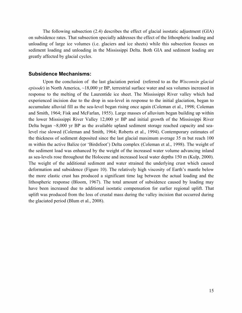
The following subsection (2.4) describes the effect of glacial isostatic adjustment (GIA) on subsidence rates. That subsection specially addresses the effect of the lithospheric loading and unloading of large ice volumes (i.e. glaciers and ice sheets) while this subsection focuses on sediment loading and unloading in the Mississippi Delta. Both GIA and sediment loading are greatly affected by glacial cycles.
Subsidence Mechanisms: Upon the conclusion of the last glaciation period (referred to as the Wisconsin glacial episode) in North America, ~18,000 yr BP, terrestrial surface water and sea volumes increased in response to the melting of the Laurentide ice sheet. The Mississippi River valley which had experienced incision due to the drop in sea-level in response to the initial glaciation, began to accumulate alluvial fill as the sea-level began rising once again (Coleman et al., 1998; Coleman and Smith, 1964; Fisk and McFarlan, 1955). Large masses of alluvium began building up within the lower Mississippi River Valley 12,000 yr BP and initial growth of the Mississippi River Delta began ~8,000 yr BP as the available upland sediment storage reached capacity and sea-level rise slowed (Coleman and Smith, 1964; Roberts et al., 1994). Contemporary estimates of the thickness of sediment deposited since the last glacial maximum average 35 m but reach 100 m within the active Balize (or ‘Birdsfoot’) Delta complex (Coleman et al., 1998). The weight of the sediment load was enhanced by the weight of the increased water volume advancing inland as sea-levels rose throughout the Holocene and increased local water depths 150 m (Kulp, 2000). The weight of the additional sediment and water strained the underlying crust which caused deformation and subsidence (Figure 10). The relatively high viscosity of Earth’s mantle below the more elastic crust has produced a significant time lag between the actual loading and the lithospheric response (Bloom, 1967). The total amount of subsidence caused by loading may have been increased due to additional isostatic compensation for earlier regional uplift. That uplift was produced from the loss of crustal mass during the valley incision that occurred during the glaciated period (Blum et al., 2008).
15

Figure 10: Sediment loading within the Mississippi River Delta. Deposited Mississippi River sediments within the Holocene delta region load down the underlying lithosphere, causing downwarping. The local downwarping scales with the depth of overlying sediments.
Observations: Because of the large spatial and temporal scales in which sediment loading occurs, its effect on subsidence is often calculated using various numerical modeling techniques, relying on geologic observations (such as that made with peat chronostratigraphy) for calibration. Crustal flexure from sediment loads is often modeled using ‘elastic’ or ‘visco-elastic’ (modeling the combined effects of the elastic and viscous properties of Earth’s crust) models that predict crustal strain using inputs of imposed loads (stress), mantle viscosity, and lithosphere thickness (Kulp, 2000; Watts, 2001). For the Mississippi Delta region, lithospheric viscosity is estimated to range from 1019 to 3 x 10²² Pa s and the lithosphere thickness is assumed to be approximately 30 to 50 km (Blum et al., 2008; Ivins et al., 2007; Kulp, 2000; Simms et al., 2007). Model results are also dependent on the assumed sediment loading rates and predicted total load of delta sediment. A recent study using a numerical model to calculate the isostatic response to Holocene sediment loading within the Mississippi Delta, predicted subsidence rates ranging from 1 to 8 mm yr-1 for coastal Louisiana using a predicted sediment loading rate of 0.68 gigatons annually over the last 10,000 years BP (Ivins et al., 2007). The contemporarous subsidence rates predicted by the model fit current observations of subsidence using GPS.
Summary:
• The mass of fluvial sediment deposited by the Mississippi River along the delta region during the Holocene causes downward flexure of the underlying crust equating to subsidence.
• Subsidence due to sediment loading is calculated using numerical models of the lithosphere’s visco-elastic response to loading.
16
• Subsidence rates due to sediment loading are spatially correlated to the mass and loading history of local sediment deposition and are predicted to be on the order of millimeters per year for coastal Louisiana.
4. Glacial Isostatic Adjustment (GIA)
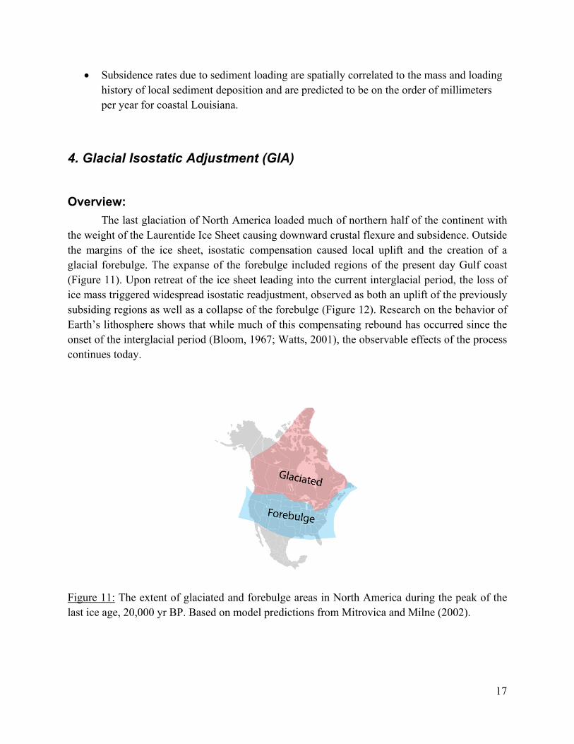
Overview: The last glaciation of North America loaded much of northern half of the continent with the weight of the Laurentide Ice Sheet causing downward crustal flexure and subsidence. Outside the margins of the ice sheet, isostatic compensation caused local uplift and the creation of a glacial forebulge. The expanse of the forebulge included regions of the present day Gulf coast (Figure 11). Upon retreat of the ice sheet leading into the current interglacial period, the loss of ice mass triggered widespread isostatic readjustment, observed as both an uplift of the previously subsiding regions as well as a collapse of the forebulge (Figure 12). Research on the behavior of Earth’s lithosphere shows that while much of this compensating rebound has occurred since the onset of the interglacial period (Bloom, 1967; Watts, 2001), the observable effects of the process continues today.
Figure 11: The extent of glaciated and forebulge areas in North America during the peak of the last ice age, 20,000 yr BP. Based on model predictions from Mitrovica and Milne (2002).
17

Figure 12: Isostatic mechanisms of forebulge collapse. The weight of the Laurentide Ice Sheet upon northern North America causes downward flexure on the underlying lithosphere coupled with isostatically compensated uplift along the peripheral margins (A). After the ice sheet retreat, the previously subsided region under the ice sheet raises to its original position as the uplifted margin lowers (B). Subsidence Mechanism: Forebulge collapse is an isostatically driven process occurring at a geologic timescale ( > 1000s of years). While the timing of the collapse is dependent on the rate of ice sheet unloading, the nature of the underlying mantle (i.e. the mantle viscosity and thickness) produces a substantial lag between the two. Despite the full disappearance of the Laurentide Ice Sheet ~ 6000 yr BP, models of isostatic adjustment and recent CORS observations suggest the forebulge is still present and is assumed to be subsiding at a slow but nearly constant rate (Peltier and Jiang, 2004; Sella et al., 2007).
Observations: Little is currently known about the topographical properties of the glacial forebulge as it
existed during the last ice age (~ 10,000 – 100,000 yr BP) within coastal Louisiana, including the extent of its maximum uplift. Such information enhances our scientific understanding of the associated total compensating subsidence. Rates of subsidence linked to the forebulge collapse are not easily measured and have been primarily estimated from numerical model predictions of Earth’s lithosphere flexure in response to loading and unloading. Current GIA modeling studies that include the Gulf coast region are at the continental scale and do not predict significant
18

variation in the effects of isostatic compensation within the Gulf coast (e.g. Sella et al., 2007; Mitrovica and Milne, 2002). Further, the relatively slow subsidence rate and the broad geographic scale in which the isostatic response occurs inhibits easy differentiation between the effects of the forebulge collapse and the other local subsidence processes within coastal Louisiana. Research by Gonzalez and Tornqvist (2006) attributes a current relative sea-level rise rate of 0.55 mm yr-1 (calculated as the mean rate for the last millennium) primarily to the glacial forebulge collapse. They derive this rate by assuming subsidence due to the forebulge collapse explains the non-eustatic component of relative sea-level rise measured by tide gauges at tectonically stable locations (i.e. near Pensacola, FL, island locations within the Caribbean) along the Gulf coast. Their rate is of a similar magnitude to that reported by Sella et al. (2007) which calculated continental-scale GIA subsidence rates of 1 - 2 mm yr-1 along the glacial forebulge region using available CORS measurements.
Summary:
• Subsidence is caused by crustal isostatic adjustment to the removal of the Laurentide Ice Sheet, which covered the Northern Half of North America during the last glaciation.
• Rates of subsidence caused by glacial isostatic adjustment are calculated using continental-scale numerical modeling of Earth’s lithosphere.
• The rate is assumed steady in space and time for coastal Louisiana. • Subsidence rates due to GIA are predicted using models of lithospheric processes.
Previous research reports rates on the order of 0.55 – 2.0 mm yr-1.
5. Anthropogenic Fluid Withdrawal
Overview: Active and historical hydrocarbon fields punctuate the deep subsurface of coastal Louisiana and much of the Gulf coast. There is evidence that areas which experienced high rates of hydrocarbon production in the past also experienced the highest rates of subsidence (Morton et al., 2006). The production of hydrocarbons requires the withdrawal of subsurface liquid hydrocarbons (in the form of petroleum and natural gas) and of significant quantities of groundwater. This subsurface fluid withdrawal depressurizes the underground reservoirs, altering the arrangement of in-situ stresses within the reservoir and the nearby substrate. Depending on the relative magnitude of the geopressure (pressure within the lithosphere) drawdown, its spatial arrangement, and the geotechnical properties of the substrate, the reservoir may compact under the stress of the overlying substrate (Donaldson et al., 1995). The sediment compaction caused
19

by the collapsing reservoir may exhibit a surface expression in the form of ground subsidence (Chan and Zoback, 2007). Additionally, alteration to subsurface geopressure fields near fault zones may upset an existing equilibrium between the shear and friction forces inducing slip (Chan and Zoback, 2007; Morton et al., 2006; Morton et al., 2005; White and Morton, 1997).
Subsidence Mechanisms: Subsidence due to subsurface fluid withdrawal is primarily caused from reservoir
compaction although research indicates induced fault slip may play a small, additional role (Chan and Zoback, 2007; Mallman and Zoback, 2007). Reservoir compaction occurs as hydrocarbon fluid withdrawal causes loss of subsurface pore pressure, with measured pressure gradients (a good geotechnical parameter of compaction susceptibility) often dropping 95 % during the lifespan of production (Donaldson et al., 1995; Morton et al., 2002). Fluid withdrawal accelerates natural consolidation processes within the compacting reservoir. The large producing hydrocarbon fields in southern Louisiana occur within relatively thin sand reservoirs located at depths ~2 - 4 km below the surface. Decreased reservoir depth and increased reservoir thickness generally increases the overall subsidence depth; however, increased reservoir depth also increases the overall area of the surface expression (Figure 13) (Mallman and Zoback, 2007). Depending on the geotechnical properties of the reservoir substrate, fluid withdrawal and may produce inelastic, time dependent physical compaction which may account for the observed continued subsidence over discontinued production fields in southern Louisiana (Mallman and Zoback, 2007).
Observations: The strongest documentation of the role that hydrocarbon production plays in causing land subsidence is from studies in coastal Texas, where delta (i.e. sedimentary) processes such as sediment compaction, sediment loading, or growth faulting do not play a significant role. However, in Louisiana the connection between hydrocarbon withdrawal and subsidence is well characterized by a historical re-leveling survey line (e.g. Shinkle and Dokka, 2004) that crosses many known hydrocarbon producing fields and a comprehensive land loss survey of the Mississippi River Delta and Chenier plains (e.g. Britsch and Dunbar, 1993). Land loss rates correlate with rates of fluid withdrawal during hydrocarbon production which started regionally in the 1950s and peaked in the 1970s (Morton et al., 2002). Physical measures of hydrocarbon production include the volume of fluid extracted and the decrease in reservoir pore pressure during production as measured from the extracting well.
20
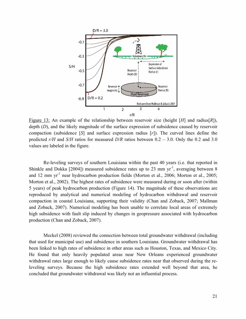
Figure 13: An example of the relationship between reservoir size (height [H] and radius[R]), depth (D), and the likely magnitude of the surface expression of subsidence caused by reservoir compaction (subsidence [S] and surface expression radius [r]). The curved lines define the predicted r/H and S/H ratios for measured D/R ratios between 0.2 – 3.0. Only the 0.2 and 3.0 values are labeled in the figure.
Re-leveling surveys of southern Louisiana within the past 40 years (i.e. that reported in Shinkle and Dokka [2004]) measured subsidence rates up to 23 mm yr-1, averaging between 8 and 12 mm yr-1 near hydrocarbon production fields (Morton et al., 2006; Morton et al., 2005; Morton et al., 2002). The highest rates of subsidence were measured during or soon after (within 5 years) of peak hydrocarbon production (Figure 14). The magnitude of these observations are reproduced by analytical and numerical modeling of hydrocarbon withdrawal and reservoir compaction in coastal Louisiana, supporting their validity (Chan and Zoback, 2007; Mallman and Zoback, 2007). Numerical modeling has been unable to correlate local areas of extremely high subsidence with fault slip induced by changes in geopressure associated with hydrocarbon production (Chan and Zoback, 2007).
Meckel (2008) reviewed the connection between total groundwater withdrawal (including
that used for municipal use) and subsidence in southern Louisiana. Groundwater withdrawal has been linked to high rates of subsidence in other areas such as Houston, Texas, and Mexico City. He found that only heavily populated areas near New Orleans experienced groundwater withdrawal rates large enough to likely cause subsidence rates near that observed during the re-leveling surveys. Because the high subsidence rates extended well beyond that area, he concluded that groundwater withdrawal was likely not an influential process.
21

Figure 14: Natural gas, oil, and water withdrawal and Rates of Land loss in coastal Louisiana. After Morton et al. (2005).
Summary: • Regions that experienced high rates of fluid withdrawal due to hydrocarbon production
have been spatially correlated to areas of high subsidence as reflected in re-leveling data in coastal Louisiana since the 1950s.
• Subsurface fluid withdrawal causes a loss of pore pressure in the underground reservoirs which increases the effective stress borne by reservoir sediments and accelerates consolidation processes.
• Subsurface fluid withdrawal destabilizes existing gradients of geopressure locally which may initiate slip in nearby fault zones.
• Near hydrocarbon production fields peak subsidence rates have reached 23 mm yr-1 (1 in yr-1) and average between 8 to 12 mm yr-1 ( ~ 0.5 in yr-1) in southern Louisiana.
6. Surface Water Drainage & Management
Overview: Changes in surface water storage and drainage patterns primarily influence subsidence
rates by altering gradients of soil moisture (Deverel and Rojstaczer, 1996; Kool et al., 2006; Wosten et al., 1997). By changing the course of natural drainages, landscapes that evolved as wetlands are decoupled from their water supply while previously dry areas become inundated. A large component of subsidence in organic rich soils (i.e. peat) is produced from the decomposition of soil organic carbon. Soil organic carbon is oxidized into gas from exposure to
22

atmospheric oxygen and decomposed by biological processes which reduce its volume in the soil matrix (Figure 15). The rate in which decomposition takes place is reduced with soil moisture and increased with soil temperature (Deverel and Rojstaczer, 1996). Saturated soil near Earth’s surface commonly experiences cooler maximum temperatures than that unsaturated. Therefore, dewatering previously saturated or partially saturated soils will increase the potential rate of decomposition of soil organics which will, in turn, increase the potential rate of subsidence. Additionally, the magnitude of the organic material entering the soil matrix is influenced by soil moisture as water-rich, riparian zones produce greater biomass than dryer areas. Dewatering soil also initiates the sediment consolidation process described in the fluid withdrawal section of this text.
Figure 15: Subsidence due to dewatering wetlands. Marshland (shown in its natural state in A.) is drained and decoupled from its natural water supply. The water table is lowered (B.), exposing soil organics, initially established in saturated soil, to higher concentrations of atmospheric oxygen which enhances the rate of decomposition and oxidation. The loss of soil organics decreases the soil volume which promotes compaction and subsidence. Modified from Mount and Twiss (2005).
Subsidence Mechanism: Surface water drainage and management is not by itself a mechanism from which
subsidence occurs. However, it includes the human initiation and control of environmental processes that cause subsidence, similar to fluid withdrawal described in the previous subsection. As soil organics decompose, the organic carbon oxidizes (combines with atmospheric oxygen) into carbon dioxide gas (CO2). The produced CO2 gas is mobile compared to solid soil organics and may evacuate the soil matrix for the atmosphere (Gambolati et al., 2003). The loss of soil carbon results in a net loss of soil mass and an increase in porosity. Consolidation of porous soil in time results in a loss of soil volume and subsidence (Deverel and Rojstaczer, 1996; Price and Schlotzhauer, 1999). Removing or decreasing the supply of water into a soil matrix will increase the rate of soil organic carbon oxidation by increasing the amount of oxygen in the soil. The increased soil porosity and decreased hydrostatic pressure resulting from the removal of soil water, increases the relative overburden pressure within the soil matrix promoting consolidation (Ewing and Vepraskas, 2006; Wosten et al., 1997). Furthermore, the decay of organic matter by
23

biological processes (i.e. microbial decay) occurs at a faster rate in partially or seasonally saturated conditions rather than in continually saturated conditions (van Asselen et al., 2009).
Observations: Subsidence related to soil dewatering has been primarily measured by local topographic
surveys in field studies investigating the effects of draining wetlands for agricultural use (e.g. Deveral and Rojstaczer, 1996; Stephens and Speir, 1969). These studies have a regional spatial scale (uniform physiography, area on the order of tens of square meters to square kilometers) and have study periods ranging from years to multiple decades. Mean subsidence rates observed in studies specially examining the effects of dewatering soil on subsidence range within the orders of 0.1 – 10.0 mm yr-1. In some areas of high soil organic content, the majority of the observed subsidence has been attributed to carbon oxidization (Deverel and Rojstaczer, 1996; Mount and Twiss, 2005; Wosten et al., 1997). In such areas, subsidence rates were found to decrease in time as the mass of soil carbon is depleted due to oxidation after initial dewatering (Ewing and Vepraskas, 2006; Wosten et al., 1997). There has been little specific research on the role of oxidation of soil organic carbon in coastal Louisiana and its influence on local subsidence rates are not known.
Dixon et al. (2006a) derived a spatially dense array of subsidence rates for the metro area of New Orleans, Louisiana over a three year period (2002 – 2005) using remotely sensed satellite measurements (i.e. interferometric synthetic aperture radar). They found subsidence rates ranging from no subsidence to 29.0 mm yr-1 locally. Analysis of their data showed that the areas that displayed the highest rates of subsidence had experienced the most recent development and had likely experienced more recent manipulation of their surface water drainage.
Summary:
• Modifying surface water drainages alters soil water moisture. In soils with high organic content, changes in soil moisture may affect subsidence rates.
• The rate of land subsidence due to the decomposition and oxidation of soil organics decreases with soil water content.
• Subsidence rates due to the oxidation of soil organics are highly variable and have been observed to span two orders of magnitude 0.1 to 10.0 mm yr-1 ( 0.4 - 4.0 in. per century).
• Historical development in coastal Louisiana was responsible for draining large areas of wetlands. These areas are likely subject to high subsidence rates as discussed in this section.
24

7. Section II. Summary The six processes discussed in this section are those most linked to coastal subsidence in contemporary scientific studies. Each process produces a range of subsidence rates dependent on local environmental factors and each process occurs across a unique set of scales (Figure 16).
Figure 16: The temporal and spatial scales of the different processes contributing to subsidence and relative sea-level rise. Each process spans a unique distribution of temporal and spatial scales. Further, for each scale, each process may contribute to the net observed subsidence at different rates. At some scales, a specific process may not be relevant at all. The time scales defined in this diagram are approximately quantified as instantaneous = 0 – 1 yr, management = 1 – 20 yrs, Anthropocene = 20 – 400 years (for Louisiana), and geologic = >400 years, although the defined timescales would entail overlap.
Each process contributes at rates spanning from less than a millimeter per year to over 10.0 millimeters per year (~4.0 in. per century) in some locations. It is important to note they are not all completely distinct phenomenon and many share common mechanics or characteristics. Together they combine to produce the observed rates of subsidence in coastal Louisiana. In some cases it is possible to differentiate the effects of one process from the others at a given location; however, in some cases it is likely not. Specific measurement techniques employed in subsidence research record subsidence within a select range of spatial and temporal scales. This tendency to selectively measure subsidence at specific scales makes certain measurement techniques more efficient at recording particular subsidence processes than others. If the tendencies for process-
25

selective measurement are well understood for each technique, their results can be analyzed in the context that they are reporting subsidence caused by the processes sharing similar scales and not reporting the subsidence with vastly different scales. It may be in this way the effects of individual subsidence processes are best differentiated. The next section discusses the different techniques commonly employed in subsidence research and the spatial and temporal scales they best record subsidence.
Process Range of Identified Rates
(mm yr-1) Representative Area
Affected
Tectonic 0.1 – 20.0 coastal regions, continental
margins, Holocene delta Holocene Sediment
Compaction 1.0 – 5.0
Holocene delta, lower Mississippi River valley
Sediment Loading 1.0 – 8.0 Holocene delta, lower
Mississippi River valley Fluid Withdrawal up to 23 coastal regions
G.I.A. 0.6 – 2.0 Gulf region Hydrological Management 0.1 – 10.0 developed wetlands
Table 1: The range of subsidence rates and affected area of associated subsidence processes. The precision of these values vary between processes because the subsidence rates associated with each processes are determined at different resolutions. Due to this difference, comparative values are only possible in very general terms, such as value ranges (as opposed to mean values) and broad geographic areas.
III. Methods of Subsidence Measurement Contemporary subsidence research employs a wide range of measurement and analytical methods. Each method contains of its own set of assumptions, precision, and uncertainty. It is important to understand these factors when interpreting research observations and when comparing values of different research projects with one another. Further, knowing the range of spatial and temporal scales that each technique best measures helps determine if it is selectively recording the effects of specific subsidence processes which occur at those scales and not measuring processes occurring at different scales. Below is a brief description of the most commonly used subsidence measurement methods in coastal Louisiana.
26

1. Re-leveling Survey A time series of re-leveling surveys documenting the vertical position of monumented benchmarks in respect to a stable vertical datum provides a precise measurement of subsidence. Subsidence is derived as a negative (downward) change in vertical position of one benchmark as compared to another. A change in the vertical position of a benchmark is attributed to a change in Earth’s subsurface below the benchmark, measured as a vertical distance in reference to the datum. The net change between two measurements in time is the net subsidence (or alternatively uplift if the distance between the benchmark and datum increases). By dividing the net subsidence by the time period between the measurements, the subsidence takes the form of a displacement length per unit time, a rate. Surveys conducted with proper regard to geodetic leveling standards (in terms of measurement methodology and survey network geometry) can produce differential vertical measurements with sub-millimeter precision between two points (Shinkle and Dokka, 2004). The National Oceanic and Atmospheric Administration/National Geodetic Survey (NOAA/NGS) is responsible for defining and maintaining a National Spatial Reference System which historically included the national network of geodetic benchmarks from which re-leveling surveys are based. However, most of these physical terrestrial landmarks are currently unmaintained. Traditional leveling survey methods relied on line-of-sight measurements requiring densely sampled transects to extrapolate a relative position from a stable datum. The actual stability of the datums was never precisely known as they were often terrestrial monuments subject to movement from large scale processes (e.g., continental drift, soil creep) within the lithosphere or tidal datums. Tidal datums are not inherently stable due to the natural variability found in sea-level as a result of environmental cycles and eustasy. Currently, NGS is establishing a national height moderation program that creates a National Spatial Reference System based on Continuously Operating Reference System/Global Positioning System (CORS/GPS) rather than physical topographical benchmarks (www.ngs.noaa.gov/heightmod). This system creates an effectively stable datum, although it is decoupled from the surface of the Earth.
Scales of measurement: Spatial: Re-leveling surveys measure point subsidence that is often combined with other
nearby measurements (in linear transects) to estimate horizontal gradients in subsidence that can span kilometers.
Temporal: Re-leveling survey data are collected during survey campaigns. The reoccurrence interval of a survey campaign is on the order of decades because of the requirements of labor.
27

2. Continuously Operating Reference Stations (CORS) A continuously operating reference station (CORS) is an instrument employing a global positioning system (GPS) designed to measure and record a continuous record of its three dimensional GPS position at a fixed location. Louisiana is currently monitored by over 40 CORS instruments from two networks under the supervision of NGS, the National CORS/ LSU GULFNet network run by NGS and Louisiana State University, and the Cooperative CORS network run by a collection of independent agencies that meet NGS specifications. CORS records position measurements at 30 second intervals that may be re-sampled into longer measurements. The vertical accuracies of the measurements are dependent on the length of the dataset collected at a specific location, increasing in time. The net accuracy of a GPS measurement is dependent on the instrumentation, user, and local physiography and may be less than 2.0 cm in elevation measurements at sites with long measurement records. Scales of measurement:
Spatial: CORS record long-term point measurement of subsidence at a fixed location. CORS networks can estimate fields of subsidence at a regional scale within the continental United States. The density of the network is expanding over time.
Temporal: CORS datasets consist of near continuous measurements and are primarily less than a decade in length due to their recent development.
3. Tide Gauge A network of tide gauges has recorded relative sea-level rise (RSLR) in coastal Louisiana since the late 1930s. Two long term gauges operated by the National Ocean Service (NOS), located on Grand Isle and Eugene Island were part of the National Water Level Observation Network (NWLON). The Grand Isle gauge was moved 1.4 km in 1982 and Eugene Island gauge has recently been discontinued. NWLON gauges are intended for the long-term continuous monitoring of local sea-level and are used to derive U.S. tidal datums. NWLON data are routinely used in scientific research on sea-level. NOAA publishes sea-level elevation trends from NWLON gauges when datasets become of sufficient size (~ 35 years) to meet prescribed error standards. Seven additional tide gauges in Louisiana are now run as part of the NWLON network but have not been in operation long enough to establish an accurate datum. These gauges are located at USCG New Canal (Lake Pontchartrain), Shell Beach at Lake Borgne, Southwest Pass, Amerada Pass in Atchafalaya Bay, Freshwater Canal, Lake Charles, and Calcasieu Pass. There are two other tide gauges operated by NOS located at Cocodrie and Venice, LA; however, they have significantly shorter records of data (~ 20 yrs). The USACE
28

operates a network of 192 tide gauges in Louisiana (Fearnley et al., unpublished). The USACE tide gauge data was primarily intended for river navigation and engineering applications, requiring relatively less precision as compared to NWLON gauges. USACE gauges historically measure sea-level at one time per day (~ 8:00 am) and were subject to frequent changes in location. The USACE is currently increasing the precision of their tide gauge database (Frost, 2008); however, it is not currently used for scientific purposes. In coastal Louisiana, measurements of relative sea-level computed by tide gauges contain a eustatic and subsidence component. The eustatic component records the rise in sea-level due an increased volume of water within the world’s oceans. Eustatic sea-level rise is primarily caused by the increase in sea volume due to thermal expansion and from the melt-water from long term glacier, ice sheet, and snowpack storage (Cabanes et al., 2001). While this rate may be slightly variable throughout the world, regionally (i.e. along the U.S. Gulf of Mexico) it may be considered uniform. The global mean eustatic sea-level rise (ESLR) is currently considered to be near 3.0 mm yr-1 (Church and White, 2006; IPCC, 2007). The subsidence component is a measure of the rate of topographic lowering compared to stable vertical datum, computed as the residual of the relative sea-level rise and the eustatic sea-level rise. If the eustatic sea-level rise is known, a subsidence rate can therefore be calculated from tide gauge measurements. The mean RSLR values measured at the Grand Isle and Eugene Island tide gauges are 9.85 mm yr-1 and 9.74 mm yr-1, respectfully (Zervas, 2001). Subtracting the ESLR from the RSLR defines local subsidence rates of 8.15 and 8.04 mm yr-1. Scales of measurement:
Spatial: Tide gauges record point measurements of relative sea-level rise from which total subsidence can be partitioned. Tide gauge networks can estimate subsidence at a regional scale along coastal United States.
Temporal: The length of tide gauge records may span decades to over a century. Tide gauges take daily measurements that are often extrapolated into month and annual average values. The precise calculation of a tidal datum requires a measurement period surpassing a predetermined measurement epoch from which natural tidal fluctuations can be determined. A tidal epoch lasts 19 years, although shorter time periods (e.g. 5 years) are used in regions experiencing large rates of relative sea-level rise (such as coastal Louisiana).
4. InSAR Interferometric synthetic aperture radar (InSAR) is a remote sensing technique used to measure displacement from a time series of derived topographical surfaces. Commonly
29

employed from a satellite, radar waves are targeted at a swath of Earth with a known location which reflects at variable values of intensity and phase (Sabins, 1996). The phase is a property of the radar wave that is dependent on its travel distance. Repeated measurements of phase returns from a surface can differentiate changes in the relative distance between the surface and the sensor (Sabins, 1996). The position of a satellite in orbit is very well constrained so any change in distance must reflect a change in topography, such as subsidence. The accuracy of InSAR is dependent on the sensor, image processing methods, and the atmospheric conditions when the measurements were acquired (Dixon et al., 2006b; Sabins, 1996). The maximum measurement precision reported for current InSAR measurements of subsidence ranges between 2.0 and 3.0 mm (Buckley et al., 2003; Dixon et al., 2006b).
Scales of measurement: Spatial: InSAR calculates field-based values of subsidence based on repeat
measurements of topography. Typically, the spatial extent of InSAR studies span the local to regional levels (e.g. urban centers), ranging from 10 – 100 km2 (4 – 40 mi2).
Temporal: InSAR computes subsidence between two separate measurements of topography in time. Measurements employing InSAR exist for only specific regions over the past decade.
5. Sediment Elevation Tables Sediment elevation tables (SETs) are stationary instruments installed into marshland to measure shallow subsidence (that within approximately 0 – 5.0 meters of the topographical surface). A bench pipe (~ 6.1 m long) is driven vertically into the marsh sediments by sledge hammer or vibracore to a depth of 3 to 5 m, ideally penetrating to a highly compacted, stable layer of Holocene marsh sediments. An arm extends horizontally out from the bench pipe that can be rotated laterally into four or eight fixed positions around the circumference of the pipe. The arm can be adjusted with respect to a bubble-level to ensure it is plumb with the bench pipe and measurements are consistently taken in the same place over time. The end of the arm has a plate parallel to the ground that holds 9 adjustable pins that extend vertically downward. To record a measurement, each pin is set so the bottom tip touches the topographical surface below. The length of the extension of the pin from the leveled arm to the topographical surface is recorded and averaged with the measurements from the eight other pins to produce a singular mean length at each preset position around the pipe. Shallow subsidence is assumed if the distance between the leveled arm and topographical surface becomes greater in time. These measurements allow an accuracy of ± 2.0 mm of elevation change (Cahoon et al., 1995).
30

Additionally, marker horizons (such as feldspar) can be applied to the marsh surface to establish a dated surface datum for future measurements of subsidence or accretion. Scales of measurement:
Spatial: Sediment elevation tables (SETs) record point measurements of subsidence. SET networks may produce subsidence values extrapolated to the local marsh level.
Temporal: SETs compute total shallow subsidence between two separate measurements in time. Generally, > 5 yrs of measurements are required to differentiate subsidence from random environmental variability. SET databases in coastal Louisiana may span a decade.
6. Peat Chronostratigraphy Current methods in peat chronostratigraphy rely on accelerator mass spectrometry (AMS) radiocarbon dating to determine the formation date of a buried peat horizon within a stratigraphic column. The peat is assumed to have formed at near contemporaneous sea-level in marsh-like environments. Knowledge of the elevation of historical sea-levels in relation to the age of the peat can then be used to determine the initial elevation of the peat horizon at the time of its formation. The vertical displacement between the initial peat elevation and its modern elevation is assumed to have been a result of subsidence in the underlying substrate. A mean subsidence rate is calculated by dividing the total displacement by the time interval between the formation age of the peat and the present. This value attributes a singular mean subsidence rate for the peat horizon since the period of its formation; however, it is likely the actual subsidence rate was not uniform in time (Tornqvist et al., 2008). Peat chronostratigraphy employs AMS radiocarbon dating to determine the concentration of Carbon-14 in the organic matter located within the peat matrix. The relative concentration of Carbon-14 is an indicator of the length in which the organic material has been in decay. AMS radiocarbon dating extracts approximate age data from less organic material than traditional radiocarbon dating and is therefore subject to greater error because there is a greater chance the dated material does not represent the age of the surrounding material. Measuring multiple samples from one location reduces this error. Modern use of AMS radiocarbon to date basal peat in subsidence studies assumes temporal uncertainties of approximately 200 years (e.g. Gonzalez and Tornqvist, 2006; Tornqvist et al., 2008).
31

Scales of measurement: Spatial: Peat chronostratigraphy records point measurements (usually taken as sediment
cores) that can be combined with other nearby measurements to extrapolate local areas of subsidence if the underlying geology is known.
Temporal: Peat chronostratigraphy produces mean rates of subsidence constrained by the period in time for which dateable peat is available (> 100 BP) and by the assumptions of radiocarbon dating.
7. Extensometers As used in geotechnical engineering, an extensometer (sometimes spelled extensiometer) is a stationary instrument that measures subsidence in time at a single location. Extensometers consist of a vertical shaft (on the order of > 10.0 m deep, ~ 0.10 m in diameter) encased with a metal tube. A thin metal rod or wire passes through the tube and is anchored at the bottom of the well in cement. The rod or wire extends to the surface where it is attached to a device that calculates the distance from the bottom of the rod or wire to the topographical surface on which it rests. As subsidence occurs, the length of the rod or wire between the bottom of the well and the measurement device at the surface becomes smaller. Extensometers report subsidence that occurs between the bottom of the well, which can range in depth, to the topographical surface with a vertical accuracy near 3.0 can mm (CA DWR, 2009).
Scales of measurement: Spatial: Extensometers record point based measurements of subsidence.
Temporal: Extensometers measure near continuous subsidence during the period of
instrumentation.
8. Section III. Summary There are many different ways in which subsidence is currently measured. Each technique or method measures subsidence that occurs over a specific area and over a specific time period (Figure 17). The subsidence rate derived from any one method is heavily influenced by the specific spatial and temporal scales measured. Measurements recording subsidence resulting from a process that fluctuates in time over a long time period will likely incorporate
32

both periods of high and low rates into an average value. This average value accurately reflects the long term geologic subsidence rate but may not be indicative of subsidence rates occurring at shorter time scales (e.g. at the management time scale) (Meckel, 2008). Measurements recording a shorter time period are more likely to only capture a time period of either low or high subsidence rates and may not provide reliable data depending on the accuracies and assumptions associated with the measurement technique. Such measurements define subsidence more appropriate to management time scales but do not adequately represent the long term geologic rate. It is important that the scale in which a subsidence rate is measured is considered when interpreting its results. Extensometers, SETs, and CORS record subsidence at small spatial scales while peat chronostratigraphy, InSAR, and Re-leveling surveys take measurements over a much broader area.
Figure 17: The temporal and spatial scales of subsidence measurement methods. The techniques used to calculate of subsidence each record and measure specific spatial and temporal scales. The ability for each technique to record subsidence changes at different scales. Some techniques are only applicable for the measurement of specific subsidence processes.
Figure 18 illustrates how the temporal scale of measurement may affect the magnitude of
the observed subsidence rate. The plots display instantaneous and temporally averaged subsidence rates produced by faulting and sediment compaction for a hypothetical location in coastal Louisiana. The top plot displays a scenario where subsidence due to sediment
33

compaction steadily decreases in time after its initiation at 1000 yrs BP (perhaps in response to dewatering). Also, within the scenario faulting causes subsidence for a brief period between 700 and 900 yrs BP. Averaged over the time interval 100 yrs BP to 1000 yrs BP (time interval C.) both subsidence processes share a similar rate (i.e. 5 mm yr-1). However, averaged over different time intervals (A. and B.), the subsidence rates are quite different.
Figure 18: A hypothetical scenario including subsidence caused by faulting and sediment compaction. The top plot displays the mean instantaneous subsidence rate at 100 yr time intervals. The bottom plot displays the average value for each type of subsidence computed for time periods of increasing lengths. The time periods increase from left to right on the x-axis, starting at the axis origin, 100 yrs BP (a 100 yr time period) and extend at 100 yr intervals to 1000 yrs BP (a 1000 yr time period). The plot values are computed as the net subsidence that occurred in each time period divided by the length of the time period. For example, 800 yrs BP the instantaneous subsidence rate attributed to faulting was 50 mm yr-1(top plot). The bottom plot illustrates that the average subsidence rate attributed to faulting for the period 100 yrs BP to 800 yrs BP was 6.25 mm yr-1 (i.e. the net subsidence that occurred during that time period, 5 m, divided by the length of the time period, 800 years, equals 6.25 mm of subsidence per year).
34

The different measurement techniques also record subsidence occurring at different depths, in terms of the total range of depths as well as where within the Earth’s lithosphere it can detect subsidence (Figure 19). Further, some methods such as CORS and extensometers record subsidence at near continuous intervals while other methods produce an average rate of subsidence based on a displacement distance that occurred over a known time period (which can be short, in the case of InSAR, or much longer, in the case of peat chronostratigraphy). Because the processes that produce subsidence occur at specific spatial and temporal scales, proper measurement should use methods that record subsidence over the same range of scales.
The most effective methodologies to monitor and measure subsidence in the future will
likely include an integrated approach, employing multiple measurement techniques. This discussion examined each technique independently for simplicity. There are present monitoring programs that couple techniques, such that combining measurements made with sediment elevation tables and tide gauges with CORS measurements to reference local subsidence observations to a universal datum. Future efforts will be required to integrate the multitude of subsidence data collected using different techniques into a comprehensive database with comparable and complementary values. Such a database would be useful in constructing a map of our knowledge of the spatial gradients and patterns of subsidence.
35

Figure 19: Examples of the different displacement distances each measurement technique uses to infer subsidence within Earth’s lithosphere. Extensometers and SETs assume the subsidence occurs with these depths while the other techniques assume the subsidence occurs below (Table 2).
36

Method Displacement Measured Theoretical Depth
Measured Subsidence Processes
Measured
Re-leveling between two benchmarks Depth below benchmark Tectonic, sediment
loading, Fluid withdrawal, & GIA.
CORS between instrument and
geodetic datum (i.e. NAVD 88)
Depth below benchmark Tectonic, sediment
loading, Fluid withdrawal, & GIA.
Tide Gauge Temporally averaged tidal height relative to a nearby
benchmark
Between tidal datum and depth of benchmark
Relative sea-level rise.
InSAR the land surface in a time series of images
Depth below land surface All.
SETs Between land surface and depth of SET/benchmark
Between land surface and depth of SET/benchmark
Holocene sediment compaction, Surface
water drainage.
Peat Chronostrat.
Relative vertical displacement of peat horizon
Between peat horizon and historical Sea-level
Holocene sediment compaction, relative
sea-level rise.
Extensometer Between land surface and well bottom
Between land surface and well bottom
Holocene sediment compaction, Fluid
withdrawal.
Table 2: Measurement characteristics of techniques used in subsidence research.
IV. Implications
Subsidence will affect each resource management project differently dependent on the project’s temporal and spatial scale (i.e. life expectancy and footprint). Each project will have its own life expectancy over which it is expected to effectively achieve a specific function. Some projects can still be considered effective if the level of function produced changes over time while others, such as levee protection system, are normally expected to perform at a specific level for their entire lifespan. Likewise, the physical footprint of resource management projects varies according to their purpose and expected outcome. These temporal and spatial scales and
37

their location within the coastal landscape determine how susceptible different projects are to the effects of subsidence.
If a project has a designed life expectancy much less than the time scale it takes
subsidence to reduce the project’s effectiveness, then the effects of subsidence may be disregarded - otherwise its effects should be considered in the project design and maintenance schedule. Further, as different subsidence processes occur at different timescales (as discussed in Section 2), the observed effect of subsidence on a management project will depend on the similarities between the temporal scale of each subsidence process affecting the project and the project’s life expectancy and objective. Likewise, the relationship between a resource project’s spatial scale and the spatial scale of each subsidence process dictates how susceptible a specific project is to each subsidence process. For example, if the footprint of a project is much less than the spatial scale at which a subsidence process affects the coast, the project may be uniformly affected by that subsidence process. However, larger projects may be differentially affected by subsidence processes. The effect of glacial isostatic adjustment (GIA) does not change significantly throughout southern Louisiana. It would likely have a uniform effect on all projects across the coast. In contrast, local drainage and dewatering can alter the magnitude and variability of local subsidence rates (through sediment compaction, etc.) over areas smaller than the footprint of many management projects. In such a case, the spatial variation of the subsidence rates must be considered in the project design because different areas of the project will experience different effects from the subsidence.
To illustrate how the spatial and temporal scales of different resource management
projects influence the way each project is impacted by subsidence, four examples of how management projects are impacted by subsidence are discussed. Each example includes a brief description of one type of management project, its susceptibility to subsidence, and an overview of how the impact of subsidence on that type of project is currently accounted for by relevant management agencies.
1. Levee and Flood Gate Construction.
Project Characteristics Levee and flood gate construction refers here to the design and construction of new protection levees and flood gates as well as the maintenance of existing systems. The construction of new levee and flood gates entails building entirely new structures while maintenance is assumed to include increasing levee height or building supplemental structures. Building a new levee or structure introduces a new load to a relatively natural undisturbed environment. Depending on the setting, natural drainage patterns may be altered through
38

pumping and/or channelization of flow. Alternatively, levee maintenance introduces additional load to an already altered substrate environment. Geographically, levee projects are essentially linear features that may span kilometers in length. Flood gates have relatively small spatial footprints located within a levee system. The design lifespan for levee systems and flood gates is relatively long (usually at least 50 years). Levee and flood gate design requires a precisely defined relationship between the elevation of the structure at any location and the surface elevation of the adjacent terrestrial and water surfaces. Any future failure of these systems would lead to catastrophic damage and therefore projects are designed with the expectation of no loss of effectiveness over the project lifespan, and maintenance requirements are planned at the outset. The large spatial and temporal scales in which levee systems operate make it probable they will be affected by subsidence. To prevent a loss of protection effectiveness over time they are generally designed with safety factors high enough to account for some uncertainties.
Susceptibility to Subsidence: The load of the levee structure or load of additional material introduced for maintenance or improvement purposes will increase the stress on the underlying soil likely increasing compaction related subsidence. The actual compaction will be related to the load of the previous structure if present, the load of the new structure, the timing in which each load was introduced, as well as the geotechnical properties of the underlying soil. Levee structures that change local drainage patterns can also increase sediment compaction due to the oxidation of soil organics. The size of a levee system increases the likelihood that it may span across a fault zone or an area affected by hydrocarbon production. If the levee system spans a fault zone it may be subject to subsidence if there is downward displacement of the downthrown block. If the system spans an area that historically experienced hydrocarbon withdrawal it may be subject to subsidence due to underlying reservoir compaction. Because levee and flood gate designs are made to a high degree of precision relative to the majority of other coastal management projects, they are more generally susceptible to the effects of subsidence.
Current Design & Maintenance Strategies. In modern levee and flood gate design, the effects of subsidence (that due the processes discussed in this text) are differentiated from the effects of the natural ‘settlement (sediment consolidation)’ of the underlying soil due to the project (subsidence that occurs in direct response to the project implementation, i.e. the imposed load of the engineered feature and the surface disturbance due to construction). The effects of settlement are predicted by employing well
39

established methods that are dependent on geotechnical measurements of the underlying soil. These measurements are usually from borings made within the project area. Levees and flood gate design accounts for subsidence in southern Louisiana, through less established practices including enhanced safety specifications (overdesign). Federal levees constructed and maintained by the US Army Corps of Engineers (USACE) add an additional 2 ft (0.61 m) to the design height of a levee system specifically to mitigate the effects of future height loss due to subsidence. However, in most cases this additional height is not calculated on the basis of local expected subsidence rates. Flood gates are designed to withstand similar hydraulic forces as levees and are anchored on a deeper foundation. Local settlement is predicted based on local geotechnical measurements – in general the geotechnical information obtained to support the planning of flood gates is more spatially dense than that used for levees. Management agencies continuously monitor levee systems and flood gates for damage subsidence related damage and make design adjustments as needed rather than to design and maintain them to s predetermined ‘life expectancy’.
2. Barrier Island Restoration
Project Characteristics Barrier island restoration alters island morphology in an attempt to improve barrier
integrity over time and to provide specific habitats. Barrier islands evolve in time as part of the natural delta cycle; however, anthropogenic manipulations to the Mississippi River have retarded key components of the cycle, and most islands in coastal Louisiana are now degrading. Barrier islands naturally evolve through the erosion of the seaward face and deposition of sediments along its landward side, resulting in landward translation. If the erosion and deposition approximate each other, the relative size of the island remains unaffected. However, the dredging of inlets and canals along the coast has disrupted natural sediment movements. This disruption has led to a decrease in the sediment supplied to barrier islands, making them more susceptible to net erosion, especially during storms. Most approaches to barrier island restoration involve the periodic augmentation of island sediments. The introduced sediments are often dredged from offshore sand bodies. Methods exist to increase the retention of the introduced sediment on the islands such as sand dune construction (which increases island height and decreases the frequency of over-wash) and by establishing island vegetation (which stabilizes sand dunes and aids the development of back barrier marshes on the landward side of each island). However, such methods cannot eliminate island erosion – this would require an increase in the natural sediment supply to the island. Because of the barrier islands are constantly evolving, restoration
40

projects often have relatively short design life expectancies (i.e. <20 years) before additional restoration is likely required. Due to the difficulty of predicting island change over time, maintenance of the restored footprint and configuration is rarely planned in advance.
Susceptibility to Subsidence Barrier island restoration requires the introduction of sediments to the island footprint.. The introduced sediments are usually delivered during a single discrete time interval. The sudden deposition of a large load of sediment is usually followed by a period of sediment consolidation which peaks soon after the initial placement and decreases in time. In addition, the introduced sediment may promote further sediment compaction and subsidence by increasing the stress on the underlying material leading to sediment compression. Local sediment compaction rates are dependent on the thickness of the new sediment deposited which determines the depth of the original underlying sediments susceptible to compaction. Barrier islands located at the delta margins in the Barataria and Terrebonne Basins overlie the thickest package of Holocene sediments in the Delta Plain and likely experience large rates of subsidence caused by multiple processes (e.g., Holocene sediment compaction, sediment loading). These subsidence processes coupled with eustatic sea-level rise produce rates of relative sea-level rise near 10 mm yr-1 (Zervas, 2001). Such high rates may affect restoration projects even with short life expectancies and should be factored into the design criteria. The relatively large spatial scale of a barrier island restoration project, similar to a levee system, makes it susceptible to a wide range of subsidence processes and increases the likelihood that the project will be in close proximity to a fault zone. However, the short life-expectancy makes it less likely that a fault zone will experience significant slip that would affect the barrier island restoration project objectives.
Current Design & Maintenance Strategies. Barrier island restoration projects are limited by the availability of new sand supplies used to augment the original island sand volume. Sea bed sources of sand are rare and those close to shore are becoming depleted, contributing to an increasing interest in using riverine sediments for barrier restoration projects. The sand volume requirement for restoration projects are set to ensure a desired dune height (above current sea-level) and beach slope from which the project’s design life-expectancy is predicted. Subsidence is rarely considered during the dune height calculations because dune design life-expectancy is shorter than the time period that would be necessary for the design
41

height to be negatively affected by subsidence. For example, the effects of storm surge and wave attack decrease barrier island profile height at a greater rate than subsidence. Barrier island restoration may entail the addition of sediments to back marsh areas within the landward side. This side is generally designed with a lower mean elevation and requires the establishment of marsh vegetation which can be adversely effected by excessive inundation increasing its susceptibility to subsidence at shorter time intervals.
3. Mechanical Marsh Creation
Project Characteristics Mechanical marsh creation is used here to describe projects where new marsh substrate is created in open water or within deteriorated marsh areas through the introduction of sediment, raising the local water bottom to an elevation where marsh vegetation can grow. The introduced sediment is composed of dredged silts and sands and is generally placed at the site within a short time period (less than a year). Project area can vary from tens of hectares to over a thousand. Dependent upon the successful establishment of marsh vegetation and local sediment dynamics, created marshland may maintain an elevation relative to current sea-level despite relative sea-level rise through the natural sediment and organic material accretion process.
Susceptibility to Subsidence Newly deposited marsh sediments are subject to high rates of subsidence due to sediment compaction (primarily by consolidation) as it settles. The rate of sediment compaction decreases over time with the mean rate dependent on the overall thickness of the deposited marsh sediments. While the load of marsh sediments may compress underlying sediments, promoting further compaction, the smaller thickness of sediment load in marsh creation projects (as compared to the thickness of sediments deposited near land building river diversions) causes relatively smaller compression rates. However, where new sediment is deposited on top of preexisting, organic-rich marsh substrate, sediment compaction rates may be high compared to areas with little soil organic content (i.e. near barrier islands) due to the additional biological and chemical compaction processes that affect soil organics. The relative small spatial scale of marsh creation projects make it less likely that it will be significantly affected by the same multitude of subsidence processes as larger projects. The temporal scale of marsh creation projects is variable, influenced by the ability of the marsh substrate to promote accretion rates comparable to relative sea-level rise. As the marsh lifespan
42
increases the period it may be impacted by subsidence processes likewise increases. This is especially true for subsidence processes that occur discontinuous in time (i.e. tectonics/ fault-slip).
Current Design & Maintenance Strategies. Similar to levee design, mechanical marsh design procedures consider the effect of sediment settlement and the associated subsidence. Borings are taken to measure the geotechnical properties of the underlying soil and those data are incorporated into the design specifications. Subsidence unrelated to consolidation is usually disregarded in the design which seeks to attain an elevation relative to the current sea-level at the time on construction. Once implemented, marsh creation projects are expected to be self sustaining, through natural sediment deposition and organic accumulation, and little maintenance work is usually planned.
4. Land Building through River Diversion.
Project Characteristics Land building through river diversions aims to raise the elevation of adjacent water
bottoms to an elevation where vegetation can grow through the deposition of introduced riverine sediments. River water and sediments are routed through engineered openings within the flood protection levee into shallow open water to promote land building. This method of sediment delivery produces a steady supply of sediment to an area, varying seasonally and inter-annually depending upon the sediment load being carried by the river. This is in contrast to mechanical marsh creation which introduces large sediment loads at discrete intervals. The major differences between river diversion projects and mechanical marsh creation are illustrated in Table 3. The deposition of the sediment can be encouraged by constructing berms to reduce local water velocity. In addition to sediment, the river water delivers nutrients that may stimulate local vegetation growth. Over a period of decades, land building through river diversions is expected to produce square kilometers of new land.
Susceptibility to Subsidence River diversion projects designed to build land will likely experience similar amounts of net subsidence as marsh creation; however, it will occur over a longer time period and over a wider spatial area thus rates are likely to be lower. Much of this subsidence will occur as sediment compaction. The new sediment load accumulates relatively slowly but may end up
43

orders of magnitude larger than that produced by marsh creation at the completion of the land building project. In time, the accumulated sediment volume may present enough strain on the underlying lithosphere to induce subsidence associated with sediment loading.
Table 3: The key differences between mechanical marsh creation and land building river diversion projects regarding how each may be affected by subsidence.
River diversion projects occur over moderate to large spatial scales where they may be susceptible to multiple subsidence processes. Possible locations for future diversion projects may be more constrained than marsh creation projects due to the required proximity to sediment-laden stream flow making it more difficult to specifically avoid implementing projects in areas more susceptible to subsidence. River diversion projects have a long life-expectancy which increases the likelihood that they may be impacted by subsidence processes occurring discretely in time (i.e. faulting). Also, longer life-spans make it more likely a project will experience significantly different subsidence rates in time. This may make it necessary to plan for a dynamic subsidence rate rather than a singular value. Unlike other management projects with large spatial and temporal scales, such as levee construction, land building projects may be resilient to moderate rates of subsidence This is due to their ability to self maintain themselves due to the steady supply of new sediment brought by the diverted flow.
Current Design & Maintenance Strategies. The design of river diversion projects has not considered the effects of subsidence including the effects of sediment consolidation explicitly. Land building due to river diversions
44

occurs at a more gradual pace over a longer time period than the other management projects leading to a greater probability of and tolerance for variable results. Similar to mechanical marsh creation, river diversion projects are expected to be relatively self sustaining and management plans do not necessarily include a maintenance regime other than any maintenance necessary to maintain operation of the diversion. However, the long life-expectancy of river diversion projects make it advantageous to monitor project results over time. Operations may be adjusted to correct evolving problems. For example, diversion openings and/or flow rates could be increased or decreased in size to control the rate of flow and sediment diverted.
5. Summary The four resource management projects discussed serve as examples of how different projects are designed and maintained at various spatial and temporal scales. These scales play an influential role on what subsidence processes may affect them and to what degree. Figure 20 illustrates the approximate range of scales from which each project is likely affected. Comparing this figure to Figure 16 in Section 2, which displays the scales of which each subsidence process occurs at, offers insight into which processes may significantly affect each project. Subsidence occurring at larger spatial scales will affect a project in a consistent and uniform manner. Subsidence occurring at smaller spatial scales may affect a project only in certain areas or perhaps not at all. Subsidence processes occurring at longer temporal scales likely affect a project at a steady rate but at a low or insignificant magnitude. Subsidence process occurring at smaller temporal scales may affect a project for a fraction of its lifespan and at variable magnitudes - or not at all. Table 4 summarizes the likelihood a specific subsidence process may significantly affect each of the four discussed management projects.
45

Figure 20: Examples of how coastal resource management projects are planned, managed, and maintained at a range of scales. Subsidence produces different implications for management at each scale.
Subsidence Process
Levee & Floodgate Construction
Barrier Island Restoration
Mechanical Marsh Creation
River Diversion Land Building
Project Design
Maintenance Project Design
Maintenance Project Design
Maintenance Project Design
Maintenance
GIA not likely
likely not likely
not likely not likely
not likely not likely
not likely
Sediment Loading
likely likely not likely
not likely not likely
not likely not likely
likely
Tectonics likely likely not likely
likely likely likely likely likely
Sediment Compaction
likely likely likely likely likely likely likely likely
Fluid Withdrawal
likely likely not likely
not likely not likely
likely not likely
not likely
Surface Water Mgmt.
likely likely not likely
not likely not likely
likely not likely
not likely
Table 4: The likelihood a subsidence process may significantly affect a management project based on the similarity of the scales between each processes (Figure 16) and project (Figure 20). Each project is divided into two intra-project objectives ‘project design’ and ‘maintenance’.
46

6. Future Needs At present, the resource management community does consider some of the effects of subsidence on most coastal projects. However, this consideration usually focuses on the more well-known and consistently influential processes, such as sediment consolidation, while disregarding those more variable in time and space. This is, in part, due to a lack of information available to resource managers regarding spatially explicit mechanisms and rates of subsidence. Also important, project design specifications often consider the contemporary landscape as base-level from which dynamic environmental values are measured (e.g. elevation, sea-level). However, the future landscape may be drastically different than it is today, changing the basic assumptions from which the designs are made. These landscape changes may include the permanent inundation of certain areas and changes in the current delivery pathways of surface water and sediment. Such large scale changes are likely improbable in the short term. However, because coastal Louisiana is experiencing large rates of environmental change and these rates are expected to increase in the future due to climate change and eustatic sea-level rise, there is a high degree of uncertainty in both the prediction of the future environmental conditions and the magnitude and character of future subsidence. Because of this uncertainty, it is likely wise to consider the full range of future scenarios involving what the coastal environment will be and how subsidence will impact it. Current coastal resource management projects neglect the effect of many of the subsidence processes discussed in this text. For example, the locations of fault zones are rarely considered when deciding the placement of future project sites. This neglect of many subsidence processes arises from two main causes, 1) the inconsistent communication of our scientific understanding of subsidence from researchers to mangers and 2) the lack of subsidence data readily available for management applications. The primary objective of this document is to help address the first of these factors. The coastal resource management community does currently consider some important aspects of subsidence. For example, sediment consolidation is generally regarded as well understood and its effects are planned for in engineering and management design. However, it is possible to help planners incorporate a greater variety of subsidence effects. The geotechnical measurements obtained by taking soil borings at the site of prospective project sites can likely offer insight on the area’s susceptibility to other subsidence processes beyond consolidation. However, research on subsidence shows us that this procedure would only be effective if the density of the borings is greater than the spatial gradient of the affecting subsidence. As discussed in Section 2, the spatial gradients in which subsidence rates significantly change (i.e. change in magnitude to a degree that would affect resource management and engineering projects) are controlled by which subsidence processes affect each area and will vary by location.
47
This serves as a good example of the valuable insights current subsidence research provide and why it must be communicated effectively to the resource management community. The construction of graphic maps illustrating the location and spatial variability of the different subsidence processes in coastal Louisiana would be of great benefit to the resource management community and may be possible with future research. A major obstacle preventing such a comprehensive map is that the resolution at which each process is mapped is often very different from that of other processes. This is because a wide array of measurement techniques are required to adequately measure the numerous and unique subsidence processes found in coastal Louisiana, with each technique operating under different assumptions and limitations (as discussed in Section 3). Often the mappable resolution for a singular process varies from one study area to another in southern Louisiana because measurement procedures are not standardized in research, even when the same technique is employed. Such discrepancies must be reconciled before a seamless map of subsidence can be created that would be useful to the resource management community. In this regard, an additional objective of this text is to inform the management community of what is not understood about subsidence in coastal Louisiana and why.
References Berman, A. E., 2005, Guest Editorial: The Debate Over Subsidence in Coastal Louisiana and
Texas: Houston Geological Society Bulletin, v. 48, p. 47-52.
Bloom, A., 1967, Pleistocene shorelines: a new test of isostacy: Geological Society of America Bulletin, v. 78, p. 1477-1494.
Blum, M. D., J. H. Tomkin, A. Purcell, and R. R. Lancaster, 2008, Ups and Downs of the Mississippi Delta: Geology, v. 36, p.375-378.
Bowie, W., 1927, Isostacy - The science of the equilibrium of the Earth's crust: New York, 275 p.
Britsch, L. D., and J. B. Dunbar, 1993, Land Loss Rates - Louisiana Coastal-Plain: Journal of Coastal Research, v. 9, p. 324-338.
Buckley, S. M., P. A. Rosen, S. Hensley, and B. D. Tapley, 2003, Land subsidence in Houston, Texas, measured by radar interferometry and constrained by extensometers: Journal of Geophysical Research - Solid Earth, v. 108, p. 2542-2560.
Burbank, D., and R. Anderson, 2000, Tectonic Geomorphology, Blackwell Science, 274 p.
48

Cabanes, C., A. Cazenave, and C. Le Provost, 2001, Sea level rise during the past 40 years determined from satellite and in Situ observations: Science, v. 294, p. 840-842.
Cahoon, D. R., D. J. Reed, and J. W. Day, 1995, Estimating Shallow Subsidence in Microtidal
Salt Marshes of the Southeastern United-States - Kaye and Barghoorn Revisited: Marine Geology, v. 128, p. 1-9.
CA DWR, 2009.The State of California Department of Water Resources, web page, http://www.nd.water.ca.gov/Data/Extensometers/Monitoring/index.cfm, accessed 2/19/09.
Chan, A. W., and M. D. Zoback, 2007, The role of hydrocarbon production on land subsidence and fault reactivation in the Louisiana coastal zone: Journal of Coastal Research, v. 23, p. 771-786.
Church, J. A., and N. J. White, 2006, A 20th century acceleration in global sea-level rise: Geophysical Research Letters, v. 33.
Coleman, J. M., H. H. Roberts, and G. W. Stone, 1998, Mississippi River delta: an overview: Journal of Coastal Research, v. 14, p. 698-716.
Coleman, J. M., and W. G. Smith, 1964, Late recent sea-level rise: Geological Society of America Bulletin, v. 72, p. 133-134.
Day, J. W., D. F. Boesch, E. J. Clairain, G. P. Kemp, S. B. Laska, W. J. Mitsch, K. Orth, H. Mashriqui, D. J. Reed, L. Shabman, C. A. Simenstad, B. J. Streever, R. R. Twilley, C. C. Watson, J. T. Wells, and D. F. Whigham, 2007, Restoration of the Mississippi Delta: Lessons from Hurricanes Katrina and Rita: Science, v. 315, p. 1679-1684.
Day, J. W., and L. Giosan, 2008, Geomorphology: Survive or subside?: Nature Geoscience, v. 1, p. 156-157.
Deverel, S. J., and S. Rojstaczer, 1996, Subsidence of agricultural lands in the Sacramento - San Joaquin Delta, California: Role of aqueous and gaseous carbon fluxes: Water Resources Research, v. 32, p. 2359-2367.
Diegel, F. A., J. F. Karlo, D. C. Schuster, and R. C. Shoup, 1995, Cenozoic structural evolution and tectono-stratigraphic framework if the northern Gulf Coast continental margin, in M. P. A. Jackson, D. G. Roberts, and S. Snelson, eds., Salt Tectonics: a global perspective: AAPG Memoir, v. 65, p. 109-151.
Dixon, T. H., and R. Dokka, 2008, Earth scientists and public policy: Have we failed New Orleans?: EOS, Transactions, American Geophysical Union, v. 89, p. 96.
Dixon, T. H., F. Novali, F. Rocca, R. Dokka, G. Sella, S. W. Kim, S. Wdowinski, D. Whitman, F. Amelung, and A. Ferretti, 2006a, Space geodesy: Subsidence and flooding in New Orleans: Nature, v. 441, p. 587-588.
49

Dixon, T. H., F. Novali, F. Rocca, R. Dokka, G. Sella, S. W. Kim, S. Wdowinski, D. Whitman, F. Amelung, and A. Ferretti, 2006b, Supplementary Information for Space geodesy: Subsidence and flooding in New Orleans: Analytical Techniques and Measurement Uncertainty: Nature, v. 441, p. published online. (http://www.nature.com/nature/journal/v441/n7093/suppinfo/441587a.html)
Dokka, R. K., 2006, Modern-day tectonic subsidence in coastal Louisiana: Geology, v. 34, p. 281-284.
Dokka, R. K., G. F. Sella, and T. H. Dixon, 2006, Tectonic control of subsidence and southward displacement of southeast Louisiana with respect to stable North America: Geophysical Research Letters, v. 33, L23308.
Donaldson, E. C., G. V. Chilingarian, and H. H. Rieke, 1995, Stresses in sediments, in G. V. Chilingarian, E. C. Donaldson, and T. F. Yen, eds., Subsidence due to fluid withdrawal: Developments in Petroleum Science, Elsevier Science, p. 165-190.
Edrington, C. 2008. Long-term susbdience and compaction rates: a new model for the Michoud area, south Louisiana. Master’s Thesis. Department of Geology, Louisiana State University, Baton Rouge, LA, 78 pages.
Emanuel, K., 2005, Increasing destructiveness of tropical cyclones over the past 30 years: Nature, v. 436, p. 686-688.
Ewing, J. M., and M. J. Vepraskas, 2006, Estimating primary and secondary subsidence in an organic soil 15, 20, and 30 years after drainage: Wetlands, v. 26, p. 119-130.
Fearnley, S., S. Penland, and M. Kulp, unpublished, Relative sea level history in Louisiana, PIES CRL Technical Report Series 06001, Pontchartrain Institute of Environmental Sciences, p. 67.
Fisk, H. N., and E. J. McFarlan, 1955, Late Quaternary deltaic deposits of the Mississippi River: Geological Society of America Bulletin, v. Special Paper 62, p. 279-302.
Frost, R. M., 2008, Computing historical subsidence rates from USACE gauge data, Informal US ACE report.
Gagliano, S. M., 2002, Fault-Related Subsidence and Land Submergence in Southeastern Louisiana: NOGS.
Gagliano, S. M., 2005, Effects of natural fault movement on land subsidence in coastal Louisiana: Proceedings of the 14th Biennial Coastal Zone Conference, July 17 - 21, 2005.
Gagliano, S. M., E. B. Kemp, and K. M. Wicker, 2003a, Active geological faults and land
change in southern Louisiana, a report prepared for the U.S. Army Corps of Engineers by Coastal Environments, Inc. , p. 179.
50

Gagliano, S. M., E. B. Kemp, K. M. Wicker, K. Wiltenmuth, and R. W. Sabate, 2003b, Neo-tectonic framework of the southeast Louisiana and applications to coastal restoration: Transactions Gulf Coast Association of Geological Societies, v. 53, p. 262-272.
Gambolati, G., P. Putti, P. Teatini, and G. G. Stori, 2003, Subsidence due to peat oxidation and its impact on drainage infrastructures in a farmland catchment south of the Venice Lagoon: RMZ - Materials and Geoenvironment, v. 50, p. 125-128.
Gonzalez, J. L., and T. E. Tornqvist, 2006, Coastal Louisiana in crisis: Subsidence or sea level rise?: EOS, Transactions, American Geophysical Union, v. 87, p. 493-498.
Gore, R. H., 1992, The Gulf of Mexico, Pineapple Press, 512 p.
Hilgard, E. W., 1871, On the Geological History of the Gulf of Mexico: The American Naturalist, v. 5, p. 514-524.
IPCC (Bindoff, N. L., J. Willebrand, V. Artale, A. Cazenave, J. Gregory, S. Gulev, K. Hanawa, C. Le Quere, S. Levitus, Y. Nojiri, C. K. Shum, L. D. Talley, and A. Unnikrishnan,) 2007, Observations: Oceanic Climate Change and Sea Level, in S. Solomon, M. Qin, M. Manning, Z. Chen, M. Marquis, K. B. Averyt, M. Tignor, and H. L. Miller, eds., Climate Change 2007: The Physical Science Basis. Contribution of Working Group I to the Fourth Assessment Report of the Intergovernmental Panel on Climate Change: Cambridge, UK & New York, USA, Cambridge University Press (http://www.ipcc.ch/ipccreports/ar4-wg1.htm).
Ivins, E. R., R. K. Dokka, and R. G. Blom, 2007, Post-glacial sediment load and subsidence in coastal Louisiana: Geophysical Research Letters, v. 34, L16303.
Jackson, M. P. A., 1995, Retrospective salt tectonics, in M. P. A. Jackson, D. G. Roberts, and S. Snelson, eds., Salt Tectonics: a global prespective: AAPG Memoir, AAPG, p. 1-28.
Knott, J. F., W. K. Nuttle, and H. F. Hemond, 1987, Hydrologic parameters of salt marsh peat: Hydrological Processes, v. 1, p. 211-220.
Kool, D. M., P. Buurman, and D. H. Hoekman, 2006, Oxidation and compaction of a collapsed peat dome in Central Kalimantan: Geoderma, v. 137, p. 217-225.
Kuecher, G. J., N. Chandra, H. H. Roberts, J. N. Suhayda, S. J. Williams, S. Penland, and W. J. Autin, 1993, Consolidation settlement potential in south Louisiana: Proceedings, Coastal Zone 1993, 8th symposium on coastal and ocean management, p. 1197-1214.
Kulp, M., 2000, Holocene stratigraphy, history, and subsidence: Mississippi Delta Region, north-central Guld of Mexico, University of Kentucky, 336 p.
Lavoie, D., and D. J. Reed, submitted, Understanding subsurface contributions to subsidence in coastal Louisiana: The Journal of Coastal Research, p. 14 pp.
51

Mallman, E. P., and M. D. Zoback, 2007, Subsidence in the Louisiana coastal zone due to hydrocarbon production: Journal of Coastal Research, v. SI 50, p. 443-449.
Meckel, T. A., 2008, An attempt to reconcile subsidence rates determined from various techniques in southern Louisiana: Quaternary Science Reviews, v. 27, p. 1517-1522.
Meckel, T. A., U. S. ten Brink, and S. J. Williams, 2006, Current subsidence rates due to compaction of Holocene sediments in southern Louisiana: Geophysical Research Letters, v. 33, L11403.
Meckel, T. A., U. S. Ten Brink, and S. J. Williams, 2007, Sediment compaction rates and subsidence in deltaic plains: Numerical constraints and stratigraphic influences: Basin Research, v. 19, p. 19-31.
Mitrovica, J. X., and G. A. Milne, 2002, On the origin of late Holocene sea-level highstands within equatorial ocean basins: Quaternary Science Reviews, v. 21, p. 2179-2190.
Morton, R. A., J. C. Bernier, and J. A. Barras, 2006, Evidence of regional subsidence and associated interior wetland loss induced by hydrocarbon production, Gulf Coast region, USA: Environmental Geology, v. 50, p. 261-274.
Morton, R. A., J. C. Bernier, J. A. Barras, and N. F. Ferina, 2005, Rapid Subsidence and Historical Wetland Loss in the Mississippi Delta Plain: Likely Causes and Future Complications, Terrebonne Parish, Louisiana: U.S. Geological Survey Open-File Report 2005-1216, p. 116.
Morton, R. A., N. A. Buster, and M. D. Krohn, 2002, Subsurface controls on historical subsidence rates and associated wetland loss in Southcentral Louisiana: Gulf Coast Association of Geological Societies Transactions, v. 52, p. 767-778.
Mount, J., and R. Twiss, 2005, Subsidence, sea level rise, and seismicity in the Sancramento - San Joaquin Delta: San Francisco Estuary & Watershed, v. 3.
Murray, G. E., 1961, Geology of the Atlantic Gulf Coastal Province of North America: New York, Harper, 692 p.
Paola, C., J. Mullin, C. Ellis, D. C. Mohrig, J. B. Swenson, G. Parker, T. Hickson, P. L. Heller, L. Pratson, J. Syvitski, B. Sheets, and N. Strong, 2001, Experimental Stratigraphy: GSA Today, v. 11, p. 4-9.
Peltier, W. R., and X. Jiang, 2004, Mantle vicosity, glacial isostatic adjustment and the eustatic level of sea level: Surveys in Geophysics, v. 18, p. 239-277.
Pizzuto, J. E., and A. E. Schwende, 1997, Mathematical modeling of autocompaction of a Holocene transgressive valley-fill deposit, Wolfe Glade, Delaware: Geology, v. 25, p. 57-60.
52

Price, J. S., and S. M. Schlotzhauer, 1999, Importance of shrinkage and compression in determining water storage changes in peat: the case of a mined peatland: Hydrological Processes, v. 13, p. 2591-2601.
Reynolds, D. J., M. S. Steckler, and B. J. Coakley, 1991, The Role of the Sediment Load in Sequence Stratigraphy: The Influence of Flexural Isostasy and Compaction: J. Geophys. Res., v. 96.
Roberts, H. H., A. Bailey, and G. J. Kuecher, 1994, Subsidence is the Mississippi River delta: Inportant influences of valley filling by cyclic deposition, primary consolidation phenomena, and early disgenesis: Transactions Gulf Coast Association of Geological Societies, v. 44, p. 619-629.
Sabins, F. F., 1996, Remote sensing: principles and interpretations, W.H. Freeman, 432 p.
Scheidegger, A. E., 2004, Morphotectonics, Springer, 197 p.
Schuster, D. C., 1995, Deformation of allochtonous salt and evolution of related salt-structural sytems, eastern Louisiana Guld Coast, in M. P. A. Jackson, D. G. Roberts, and S. Snelson, eds., Salt Tectonics: a global prespective: AAPG Memoir, AAPG, p. 177-198.
Sella, G., S. Stein, T. H. Dixon, M. Craymer, T. S. James, S. Mazzotti, and R. Dokka, 2007, Observation of glacial isostatic adjustment in ‘‘stable’’ North America with GPS: Geophysical Research Letters, v. 34.
Shinkle, K. D., and R. Dokka, 2004, Rates of vertical displacement at benchmarks in the lower Mississippi Valley and the northern Gulf Coast: NOAA technical Report, NOS/NGS 50.
Simms, A. R., K. Lambeck, A. Purcell, J. B. Anderson, and A. B. Rodriguez, 2007, Sea-level history of the Gulf of Mexico since the Last Glacial Maximum with implications for the melting history of the Laurentide Ice Sheet: Quaternary Science Reviews, v. 26, p. 920-940.
Stephens, J. C., and W. H. Speir, 1969, Subsidence of organic soils in the U.S.A.: The Tokyo symposium on land subsidence, p. 523-534.
Törnqvist, T. E., S. J. Bick, K. van der Borg, and A. F. M. de Jong, 2006, How stable is the Mississippi Delta?: Geology, v. 34, p. 697-700.
Tornqvist, T. E., J. L. Gonzalez, L. A. Newsom, K. van der Borg, A. F. M. de Jong, and C. W. Kurnik, 2004, Deciphering Holocene sea-level history on the US Gulf Coast: A high-resolution record from the Mississippi Delta: Geological Society of America Bulletin, v. 116, p. 1026-1039.
Tornqvist, T. E., D. J. Wallace, J. E. A. Storms, J. Wallinga, R. L. Van Dam, M. Blaaum, M. S. Derksen, C. J. W. Klerks, C. Meijneken, and E. M. A. Snijders, 2008, Mississippi delta
53

54
subsidence primarily caused by compaction of Holocene strata: Nature Geoscience, v. advance online publication, p. 1-4.
Turner, R. E., C. S. Milan, and E. M. Swenson, 2006, Recent volumetric changes in salt marsh soils: Estuarine Coastal and Shelf Science, v. 69, p. 352-359.
Watts, A. B., 2001, Isostacy and the flexure of the lithosphere, Cambridge University Press, 458 p.
Webster, P. J., G. J. Holland, J. A. Curry, and H. R. Chang, 2005, Changes in tropical cyclone number, duration, and intensity in a warming environment: Science, v. 309, p. 1844.
White, W. A., and R. A. Morton, 1997, Wetland Losses Related to Fault Movement and Hydrocarbon Production, Southeastern Texas Coast: Journal of Coastal Research, v. 13, p. 1305-1320.
Wosten, J. H. M., A. B. Ismail, and A. L. M. van Wijk, 1997, Peat subsidence and its practical implications: a case study in Malaysia: Geoderma, v. 78, p. 22-36.
Zervas, C., 2001, Sea level variations of the United States 1854-1999: NOAA Technical Report NOS CO-OPS, v. 36, p. 66.
Related Documents