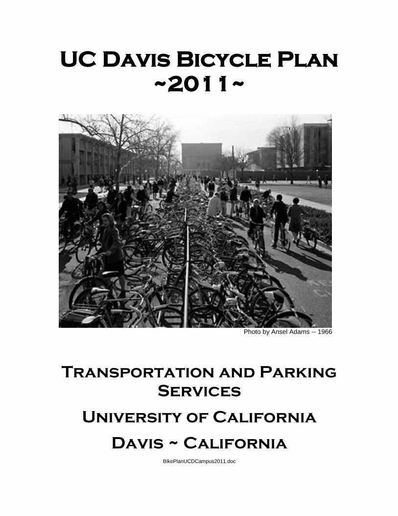
UC Davis Bicycle Plan ~2011~ Photo by Ansel Adams -- 1966 Transportation and Parking Services University of California Davis ~ California BikePlanUCDCampus2011.doc

Welcome message from author
This document is posted to help you gain knowledge. Please leave a comment to let me know what you think about it! Share it to your friends and learn new things together.
Transcript
UC Davis Bicycle Plan
~2011~
Photo by Ansel Adams -- 1966
Transportation and Parking
Services
University of California
Davis ~ California
BikePlanUCDCampus2011.doc
1
UC Davis Bicycle Plan
Table of Contents Purpose………………………………………………………………………………..2
Introduction…………………………………………………………..……………....2
Consistency with Related Plans…………………………………………………..3
Community Involvement……………………………………………......................3
Bicycle Planning and Implementation at UC Davis…………………...……….3
Engineering………………………………………………………...…………4
Enforcement…………………………………………………………………..7
Education………………………………………………………………………8
Encouragement……………………………………………………………….9
Evaluation…….…………………………………………………..….……….11
References……………………………………………………………………………12
Appendices
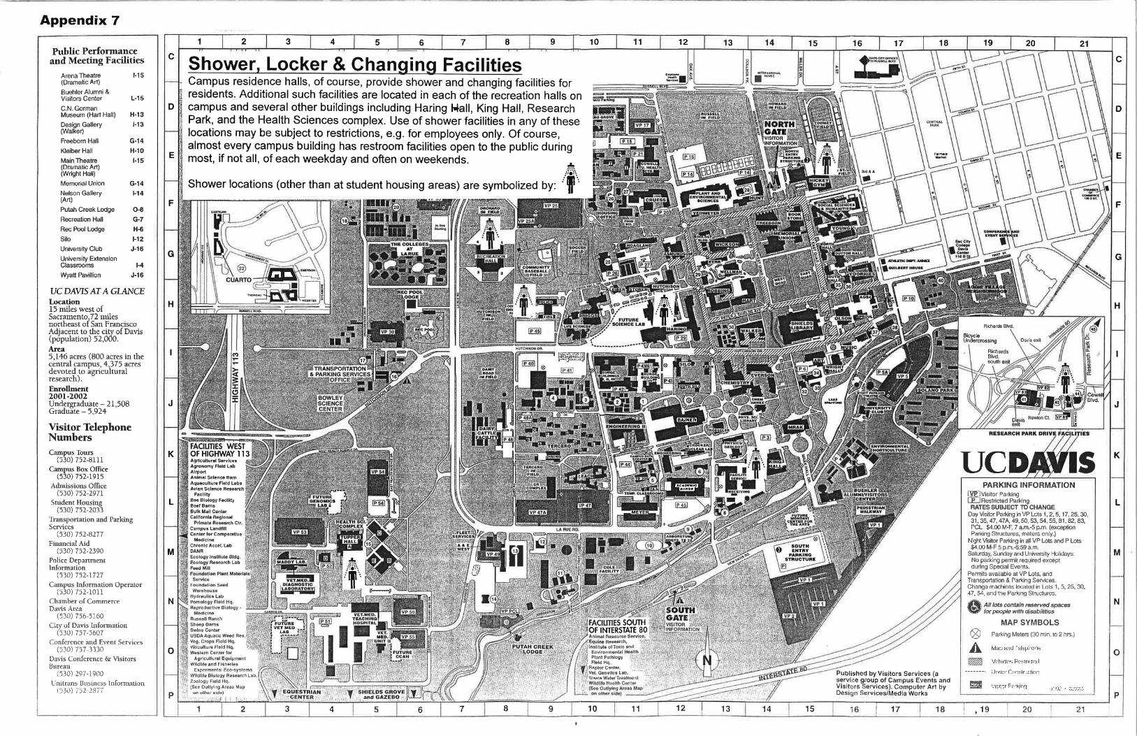
1. Proposed projects descriptions……………………………….…………..13 2. Street and Highways Code 891.2 and 891.4. State law relating to city and county bicycle plans…………………………………………………...…16 3. Past expenditures for bicycle facilities……………..…………….……….18 4. Existing and Proposed Bikeways. More detail on existing bikeways may be seen in the Davis Bike Map in Appendix 5. The Bikeways & Transit Corridor map from the UC Davis Long Range Development Plan depicts existing as well as proposed bike paths and bike lanes……………...…...20 5. Existing Land Use and Settlement Patterns. The attached Davis Bike Map shows major UC Davis campus facilities and the University’s setting in the City of Davis…………………………………….………(attached map)
6. Location of campus shower & changing facilities…..…...(attached map) 7. Major campus transit terminals……………………..….….(attached map)
2
Purpose The purpose of the UC Davis Bicycle Plan is to serve as a guide to the continuing improvement and encouragement of bicycling as a significant mode of transportation to, from and on the University of California campus at Davis. As such, this document describes existing policies and facilities related to campus bicycling, and it includes a list of projects and programs intended to improve the UC Davis cycling environment in the future. The plan complies with the requirements and guidelines spelled out in Section 891.2 of the California Streets and Highways Code (Appendix 1). This plan is not intended to serve as a standards manual for the design and construction of bicycle facilities. The appropriate design and standards manuals are referenced in the appendices. Introduction The UC Davis and the City of Davis enjoy a global reputation as being one of the most “bike friendly” communities in existence. In fact, the community was designated the first (and still only) Platinum (highest) Lever Bicycle Friendly Community by the League of American Bicyclists in 2005. That singular recognition was renewed through 2011 in October, 2007. The city and campus earned this recognition through their steadfast efforts to encourage and expand the use of bicycles for transportation and recreation over the past four decades. A history of the growth of the city and campus as a “Mecca” for bicycling is available on the UC Davis web site (see references). UC Davis differs from many other college and university campuses that also enjoy high bicycle use in that for over forty years it has taken the approach of encouraging and accommodating maximum bicycle use. In other words, there are very few restrictions to bicycle use on campus. Roads or bike paths lead to every campus destination, and every effort is made to provide ample and secure bike parking at each destination. It is estimated that 15,000 – 20,000 bicycles are in use on campus on weekdays during good weather in the fall and spring quarters. The UC Davis campus is expected to increase in population by 6000 students, staff and faculty by 2010. This growth should see a corresponding increase in bicycle use. It is difficult to forecast the impact of projects on the future growth of cycling on campus. However, it is probably safe to say that if the University does not maintain its bicycle-friendly environment, including expansion to accommodate the burgeoning population, bike use will decrease. Unpredictable factors, such as a significant increase in gasoline prices or other driving-related costs could do more to promote cycling for transportation than any facilities or program improvements.
3
Consistency with Related Plans This plan is consistent with the goals and objectives of the following local and regional transportation plans that call for the maintenance, improvement and expansion of bicycle transportation in their respective jurisdictions:
The UC Davis Transportation and Parking Services (TAPS) Long Range Access Plan Options Study
The Pedestrian and Bicycle Circulation element of the UC Davis Long Range Development Plan
The Bicycle/Pedestrian Plan Element of the UC Davis/City of Davis Joint Transportation Systems Management Plan
The Guiding and Implementing Policies of the Davis General Plan
The Goals and Objectives of the City of Davis Comprehensive Bicycle Plan
The Goal and Policy Statement of the Yolo County Bikeway Plan
The Traffic Safety Plan of the UC Davis Police Department Community Involvement The bicycle plan has been reviewed by the UC Davis Committee on Bicycle Programs and the Transportation and Parking Work Group. Bicycle Planning and Implementation at UC Davis The Five “E’s” Bicycle planners often use the “Five E’s” rubric to organize and categorize their efforts. The four E’s are Engineering, Enforcement, Education, Encouragement and Evaluation. This section provides an overview of existing standards as well as the guiding principles used at UC Davis to promote the safe and beneficial use of bicycles on campus. The Five E’s are defined below along with how they are incorporated in the planning, operation and maintenance of bicycle transportation on campus.
4
Engineering “Engineering” encompasses all infrastructure used by bicyclists. This includes bicycle parking facilities, bikeways (e.g. roads, bike paths, and trails), signage, signals, pavement markings, etc.
Bikeways “Bikeway” is an all-inclusive term to denote any facility intended to be ridden upon by bicyclists. In addition to the obvious bike paths and bike lanes, any street or roadway is a bikeway with the exception of restricted-access roads such as some freeways. In other words, a road does not need a bike lane or any special markings or other accommodations to be thought of as a “bikeway”. Even a sidewalk can be a “bikeway” if bicycling thereupon is not prohibited. The design of most bikeways follows state standards and guidelines found in the Caltrans Highway Design Manual. Additional information is found in the American Association of State and Highway Transportation Officials (AASHTO) Guide for the Development of Bicycle Facilities. Occasionally, existing space restrictions, funding limitations or other constraints result in facilities that may be a compromise between best practices and reality. Because of the large volume of bicycles operating daily, bike paths, bike lanes, and other bikeways at UC Davis are almost always wider than the minimum standards. Design width of new bikeways may even “err” on the side of too wide with the expectation that bicycle traffic volumes will increase in the future. Consideration must also be given to strength and durability if there is to be any motor traffic expected on the bike paths. In fact, most campus bike paths see occasional service vehicle traffic, so materials and design must be sufficient to accommodate this use. Some bike paths are campus fire routes and must be built to accommodate occasional multi-ton fire equipment. Most bike paths are really multi-use paths, also referred to as “shared use” paths in the AASHTO Guide. In other words, cyclists often share these paths with pedestrians, joggers, skaters, dog walkers and the like. With the volume of bicycle use at UC Davis, mixing cyclists and non-cyclists at certain times of the day, particularly peak-use times, increases the risk of collisions. As a result, many campus bike paths are paralleled by separate pedestrian facilities, and that is the preferred design standard and should be followed in any future construction. Several campus streets have bike lanes and more are planned for the near future. Some streets are not wide enough for bike lanes and others without bike

5
lanes accommodate cyclists and motorists with no significant problems. The addition of bike lanes on campus roadways should be evaluated case by case. Since the early 1970s, UC Davis has made use of roundabouts to improve the flow of traffic at bike path intersections as well as core area roadway/bike path intersections. At present there are more than a dozen such treatments on campus. They have proven to be very effective in maintaining a steady flow of movement through intersections especially during peak traffic periods such as class breaks.
Bicycle Parking Bicycle parking facilities include the actual devices used for securing or storing bikes, e.g. racks and lockers, as well as the area set aside for parking. Details about approved bike parking devices used at UC Davis can be found in the UC Davis Campus Standards and Design Guide. The University is continually upgrading deficient or substandard bike parking facilities by expanding existing bike parking lots, adding new ones, or replacing older style racks with newer, higher security devices. For over forty years, UC Davis has consistently attempted to provide sufficient bike parking at every campus destination. This practice is unusual at college campuses with high bicycle usage where the more usual custom is to provide a limited number of large bike parking areas, often on the perimeter of the campus center. In those circumstances, cyclists are expected to park their bikes and walk to most campus destinations. At UC Davis, many cyclists use their bikes to travel between most campus destinations throughout the day, even where distances are relatively short. One of the requirements of Streets and Highways Code Section 891.2 for bicycle plans is a map depicting bicycle parking facilities. Because of the universal placement of racks and other parking devices on campus, one need only see the attached Davis Bike Map and visualize bike parking at every campus building and major destination. The practice of providing “universal” campus bike parking serves to encourage bicycle use and discourages illegal, unsafe or inconvenient parking practices. Not only is bike parking provided at each destination, the parking is usually sited with the cyclist’s convenience and security in mind. Again, in contrast to practices at other campuses where “unsightly” bike parking may be placed behind building facades, on the campus perimeter, or hidden behind walls or landscaping, the intent at UC Davis is to site parking conveniently near to building entrances and usually in high visibility areas to discourage theft. Determining the number of bicycle spaces to provide at any given campus destination is done by estimating the maximum use of the site or building and calculating how many of those users are likely to arrive by bicycle. For example, if a building has total classroom space for 500 students and office space for 100
6
staff and faculty, 325 bike spaces would be a reasonable estimate based on commuter mode split surveys that indicate that 60% of students and 25% of staff/faculty use bicycles as their primary means to get to campus. Other factors may enter into the equation, such as proximity to existing bike parking areas that may be under- or over-utilized, or if the area is likely to be used for special events drawing in significantly more cyclists on occasion. The campus standard for bike racks is based on several design factors including theft-preventing features, ease of use, cost, durability and appearance. 76 rental bike locker spaces are available on campus. Lockers provide users with additional security and protection from the weather. The program is managed by TAPS, and the lockers are found in four locations: the south side of Lot 25 near the ARC Pavilion, the north side of Hickey Gym, at the South Entry Parking Structure, and at the West Entry Parking Structure. Bike lockers are mostly used by students or staff who drive to campus from outside of Davis and want to use their bikes during the day. A few of the lockers are used by people who commute regularly by bicycle from outside of Davis and want a secure place to store their good commuting bike while at work or in class. Two sets of lockers are sited close to shower facilities to accommodate these out-of-town bike commuters. The campus standard for bike lockers is an all-steel locker chosen for its theft-resistance, durability and ease of maintenance. The campus also has twelve “BikeLid™” lockers in four campus locations. These are available to cyclists on a “first come, first served” basis. In other words there is no rent or fee associated with their use, but they are for short-term use only.
Signage Most signage related to campus bicycle use is found on roadways and must comply with Caltrans Traffic Manual standards. Signs and markings on campus bike paths generally follow Caltrans Traffic Manual designs, but often in smaller sizes. A variety of signs and pavement markings are used to designate bike parking areas or areas where bike parking is prohibited. Pavement markings are often used on campus bikeways. Indeed, they may be more visible to cyclists than signs on poles. However, care must be taken in applying pavement markings to reduce the possible “slip” hazards associated with their use, particularly in wet conditions. Bike parking regulatory signs currently in use on campus are in need of upgrading and replacement. New bike parking signs should be standardized and designed to complement other campus signage.

7
Traffic Signals For the most part, traffic signal lights on campus are standard “red, amber, green” installations. However, at the intersection of Russell Boulevard and Sycamore Lane on the north perimeter of campus, traffic is controlled by a combination of standard signals and innovative bicycle signal heads. The City of Davis pioneered the use of these signals in the 1990s, working with UC Davis to coordinate this particular installation which provides separate phases for cyclists and motorists, significantly reducing conflicts and collisions between the two modes. Bicycle signal heads were also installed at the junction of Hutchison Drive and Dairy Road in 2006 to provide a safer north/south crossing for cyclists at this intersection in association with the opening of a new 1600 vehicle parking structure.
Tire Air Stations The campus provides publicly-accessible air compressors fitted with hoses and pump heads to allow cyclists to fill their bike tires with air. At present, seven such stations exist (at Segundo, Tercero and Cuarto Student Housing areas, the ASUCD Bike Barn, Fire/Police Station, Fleet Services and the Memorial Union). Additional stations are being considered for other campus locations. Enforcement Enforcement of bicycle use on campus involves two departments, the University Police and Transportation & Parking Services (TAPS). With so much cycling activity on campus, campus and state regulations pertaining to bicycle operation, equipment and parking must be enforced in order to ensure a reasonable degree of compliance and promote a safe bicycling environment. A comprehensive body of rules and regulations coupled with good signage is not sufficient to bring about and maintain safe and legal cycling behavior. Enforcement is essential. Campus cyclists are subject to the California Vehicle Code and the UC Davis Traffic and Parking Code. The Traffic and Parking Code covers parking, equipment and operation regulations specific to the UC Davis campus. The University Police are authorized to enforce all bicycling rules and regulations on campus. The department currently has four officers who have received standard bicycle patrol training. They have fully-equipped police bikes and the requisite accessories and uniforms. As staffing and events allow, the goal is to have significant coverage of the campus by at least one officer on bicycle at any given time especially during weekdays when school is in session and bicycle traffic is highest. In addition to providing additional bicycle traffic enforcement, the University Police Department engages in a variety of crime prevention activities that help to
8
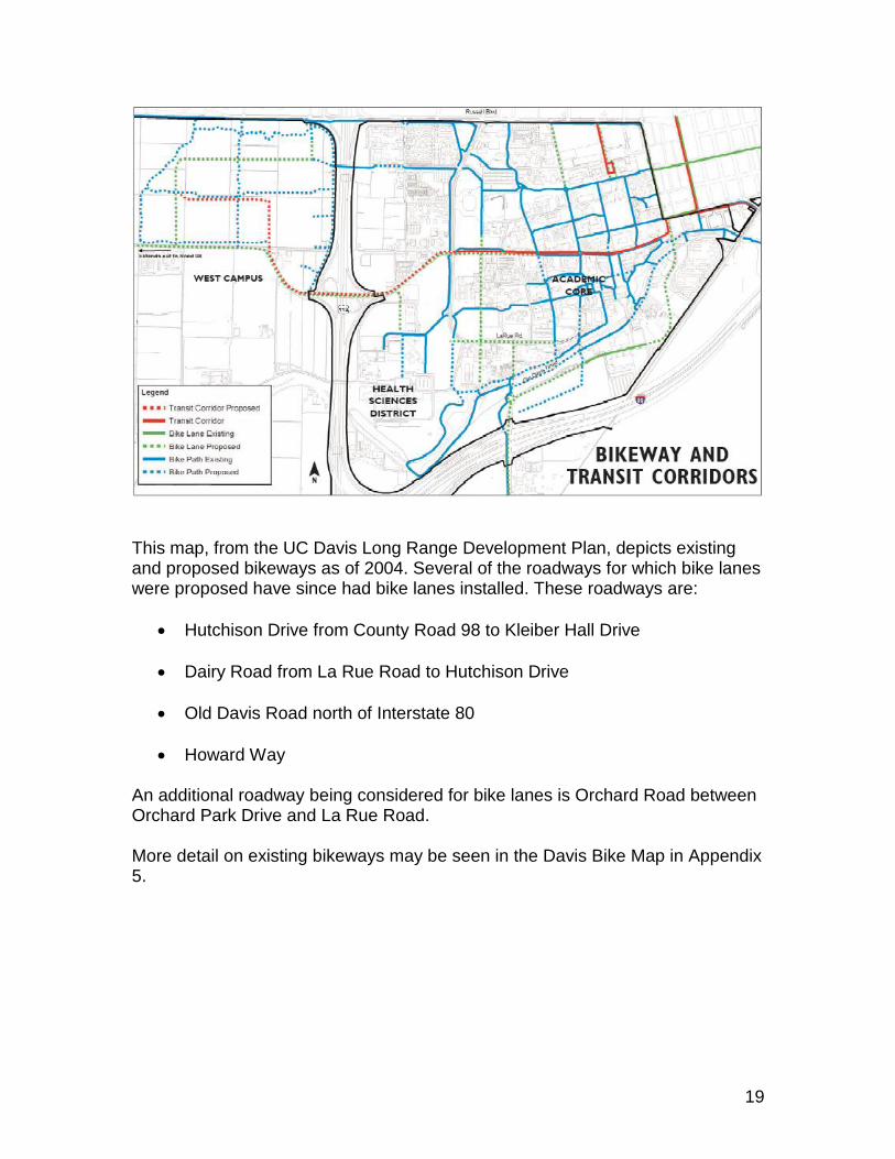
keep bicycle theft numbers down. The police also take bike theft reports, respond to bicycle crashes, and maintain theft and crash statistics. Bicycle parking rules are enforced by the TAPS Bike Patrol --part-time student employees who patrol the campus and place warnings on illegally parked or abandoned bikes and impound bicycles in violation as necessary. Bicycle registration is mandatory for all bikes operated on campus, and licenses are available at TAPS and three downtown bike shops. TAPS oversees the program which makes use of the California Bicycle License system managed by the state Department of Motor Vehicles. Registration aids in the recovery of stolen bicycles, and it is also very useful in managing the large numbers of bikes at UC Davis. For example, being able to identify the owners of bikes through the license information is helpful in dealing with abandoned bikes, illegally parked bikes, and verifying ownership when removing locks for bike owners who have lost their keys. In the coming year, the University Police and TAPS will be reinstituting their bike traffic school for those cited for equipment and moving violations. The school has been in hiatus for the past year while it has been transitioning from a TAPS program to a joint police and TAPS endeavor. Positive discussions with the Yolo County Court may lead to the school being offered for all cyclists county wide who are cited for bicycle violations. Attending the class reduces the normal bail of over $100 to a nominal administrative fee. The classes also serve an educational purpose as students are shown a bicycle safety video, given a quiz, and discuss safe cycling practices with the instructor. Education Efforts at educating campus bicyclists have varied over the years. For many years, and continuing at present, various printed materials with bicycle safety messages have been made available on campus. Since the early nineties, the most widely distributed bicycle information item has been the Davis Bike Map (see sample in appendices). The map side of this document depicts all the bikeways in the city and on campus, including all streets marked with bike lanes. It also shows bike shop locations, tire air sources, and a variety of other features of interest or use to bicyclists. The reverse side of the map provides bike riding tips, safety information and security information, and a list of local resources for cyclists. The Davis Bike Map, distributed freely at a variety of campus and city locations including local bike shops, is particularly effective because unlike most bike safety brochures, it includes information that many people want to keep and will find useful –the map itself.
9
TAPS also distributes a flier, updated annually, that is directed at new students, staff and faculty. It provides the basic information one should know to be a successful cyclist at Davis. It is sent to all new incoming students who will be living in the residence halls, and it is made available at many events and campus locations. Additional brochures have been developed over time as the need arises to deal with particular situations. A 19 minute video, “How to Avoid Face Plants” is a production filmed entirely on campus and in the city of Davis and is geared toward the college student population. It is used in the TAPS bike traffic school, shown on campus closed-circuit TV, and is also used in a variety of presentations on campus. The TAPS Bicycle Coordinator gives bike safety talks to student and staff groups, and as a certified League Cycling Instructor with the League of American Bicyclists, has taught classes in cycling skills and knowledge. Bicycle repair classes have been offered regularly at the ASUCD Bike Barn through the ASUCD Experimental College. Hundreds of students and community members have learned to repair, overhaul and maintain their bikes through these courses over the years. Encouragement According to the TAPS Mission Statements, its Bicycle Program “maintains and encourages the popular and beneficial use of bicycles as an important mode of transportation to, from and on campus by providing the campus community with a safe, secure, and efficient cycling environment in response to customer needs and expectations.” “Encouragement” of campus cycling takes many forms, some obvious and others not immediately apparent. The “not so obvious” means include the provision of efficient bicycle access by establishing and maintaining a network of roads and paths that make cycling at UC Davis safe and efficient. Convenient and secure bicycle parking facilities also promote cycling on campus. In short, much of what has already been described above in the Engineering, Enforcement and Education sections serves to create and maintain a welcoming environment for bicyclists. However, other programs and institutions also serve UC Davis cyclists. Examples include:
The Committee on Bicycle Programs, a subcommittee of the campus Transportation and Parking Work Group (TPWG), meets monthly to discuss issues, projects, and matters related to the use of bicycles at UC Davis. Comprised of representatives from TAPS, University Police, Facilities Services, ASUCD, the Graduate Division, the faculty, Resource Management
10
and Planning, and the City of Davis Bicycle Program, the committee is very effective at resolving problems or concerns brought to its attention. Issues beyond its scope or authority are referred to TPWG.
The UC Davis Bicycle Users Group (“UCD BUG”) was established in 2006 to advocate for better bicycle facilities, programs and policies on campus.
ASUCD Bike Barn, which for over thirty years has provide a centralized source of bicycles, parts, service, accessories, repair, maintenance and a place where Aggies can work on their own bikes by making use of the Barn’s tool loan service.
The Davis Bike Church, a campus organization, provides self-service bike repair and repair instruction. They also refurbish bikes for use in the community and have several projects and programs to encourage more bicycling in Davis.
Bike auctions are held twice yearly at which usually between 400 and 425 bikes are made available to the highest bidders. Besides offering the community a large selection of “fixer-upper” bicycles at low cost, the proceeds from the auctions go directly into the campus bicycle program. In 2007, the campus is expanding its auctions to include occasional on-line sales through
eBay.
TAPS provides lock-cutting services for campus cyclists who lose their keys or otherwise need locks removed from bikes.
Temporary “A” parking permits are available for purchase by staff and faculty cyclists who don’t have regular long-term parking permits. These allow holders to drive a vehicle and park in lots closest to most campus activities. The permits provide up to twelve day use permits per six-month period. Such permits are useful for some cyclists who must occasionally transport large loads to or from campus, or who wish to avoid riding in inclement weather, or have any other reason to drive a vehicle rather than bicycle on certain days. In short, this permit system provides the regular cyclist with another option when bicycling or taking the bus is not as practical.
The city of Davis and the university have co-hosted a variety of special events over the years to promote bicycling in the community. Cyclebration, Bike Commute Day, and the Transportation Fair are current or former events that are fun, informational and encourage bicycling for transportation and recreation.
Coupons for discounts on bike helmets, bike lights and other related items have been offered periodically over the years as they have become available from manufacturers, bike shops, or special programs.
11
Evaluation Documenting the effectiveness of the above measures is an important component of a comprehensive bicycle program. Beginning in the academic year 2007 – 2008, TAPS will implement regular bicycle parking utilization surveys to assess the demand for bike parking facilities throughout campus. In addition, an annual Campus Travel Assessment survey is being developed that will answer the following questions and will be helpful in future bicycle planning at UC Davis: 1. How does the campus community get to campus? 2. What transportation-related programs are they using? 3. What are the main barriers for people to walk, bike, and bus more to get to campus? 4. Are people trying to make a difference through their transportation choices? In 2007 – 2008, the UC Davis Bikeway and Transit Network planning study will evaluate the bicycle facilities and transit network serving the UC Davis campus. The study will identify needed improvements to the bicycle paths, lanes and the transit network on campus to accommodate future campus growth. The study will focus on the bicycle and transit connections throughout campus and will include circulation issues between a large new residential development planned west of State Highway 113 (West Village) and the Central Campus east of State Highway 113. The study will also address pedestrian accessibility at transit stops. Design guidelines for the on-street and off-street bicycle facilities on campus will also be developed through the study.
12
References California Highway Design Manual, California Department of Transportation, 1995. http://www.dot.ca.gov/hq/oppd/hdm/hdmtoc.htm California Manual on Uniform Traffic Control Devices. California Department of Transportation, 2006. http://www.dot.ca.gov/hq/oppd/hdm/hdmtoc.htm Campus Standards and Design Guide, UC Davis Architects and Engineers, 2005. http://gstickley.ae.ucdavis.edu/CSDG/WFB/wfb.asp Evolution of a Cyclist-Friendly Community: the Davis Model, David Takemoto-Weerts, 1998. http://www.taps.ucdavis.edu/bicycle/davis/community.html Guide for the Development of Bicycle Facilities, American Association of State Highway and Transportation Officials, 1999. http://www.wsdot.wa.gov/Bike/PDF/Bikebook.pdf Traffic and Parking Code, UC Davis, 2007. http://www.taps.ucdavis.edu/parking/citations/code.html
13
Appendix 1 Proposed Projects Descriptions (“H”,”M”, and “L” after each project indicates its relative priority, “High”, “Medium” or “Low”: Bicycle Parking Improvements: Continue to replace substandard racks with high security racks throughout the campus. Add additional bike lockers to meet demand, and add covered bike parking where appropriate. H Expand and improve bicycle parking facilities to serve the MU transit stop by creating a large parking area on the east side of Hunt Hall and creating additional parking space on the west side of Hickey Gym. H Create expanded bicycle parking areas on the east side of Wellman Hall, the east or south sides of Haring Hall, and the east side of 194 Chemistry. H Bikeway Improvements: Reconfigure roundabout on Sprocket Lane immediately south of Student Housing Office to improve circulation and safety. H Establish new bike link from the Sciences lab to the roundabout by the former A&E barn. L Add new bikeways in the Health Sciences district, particularly from the new north entry to the southeast, eventually ending up at the Arboretum. L Upgrade existing arboretum paths, particularly at the west end. Add new paths as appropriate. L Convert Old Davis Road from Mrak Hall Drive to A Street from an auto street to a bike path when the new perimeter road is completed. M Construct off street bike path improvements on Orchard Road from the 113 bike bridge to Orchard Park Circle. H Add bike lanes striping on Orchard Road from Orchard Park Circle to La Rue Road. H Construct network of bike paths and bike lanes in West Village with efficient connections to routes to and from the central campus (e.g. Hutchison Drive, Russell Boulevard, Orchard Drive). H
14
Construct separate pedestrian walk on east side of bike path between Student Housing office roundabout and Kleiber Hall Drive. H New bike path from California Ave to West Quad Avenue on north side of Kerr Hall and south side of Wickson Hall to allow path on south side of Kerr Hall to be pedestrian only. L As part of general roadway and landscaping improvements, study the addition of roundabouts at the intersection of North Quad and East Quad streets and /or at the intersection of North Quad and West Quad streets. M Provide bicycle connections to establish a direct bike route between La Rue Road at a point just east of Meyer Hall northward to connect with the existing bike path on the east side of the Briggs Hall. L Stripe bicycle lanes on California Avenue north of the California gate to Russell Boulevard. M Add to the existing bicycle network in order to connect and complete shorter bikeway segments. Examples of additions needed include bike paths on the east side of Academic Surge, the west side of King Hall, and the south side of Kemper Hall. L Build a bike path from the east end of the Orchard Park bike bridge to the Russell Blvd. Bike Path parallel to State Highway 113 to provide a direct and less congested bike route. M Other Improvements: Produce new campus-specific bicycle safety video to replace 1992 video to be used as part of on-line bicycle traffic school and other safety education efforts. H Bring existing roundabouts into compliance by installing “Yield” signs and/or pavement markings as appropriate and according to state standards. H Supplement existing tire air and bike repair stations to provide these services to all campus housing areas as well as additional high-volume bicycle traffic areas. M Expand campus bicycle maintenance and repair facilities by providing the ASUCD Bike Barn a more spacious facility. As part of the West Village project, build a “satellite” Bike Barn to serve the residents and visitors as well as students, staff and faculty members living in west Davis. M
15
Appendix 2 California Streets and Highways Code sections 891.2 and 891.4 relating to city and county bicycle plans: 891.2. A city or county may prepare a bicycle transportation plan, which shall include, but not be limited to, the following elements: (a) The estimated number of existing bicycle commuters in the plan area and the estimated increase in the number of bicycle commuters resulting from implementation of the plan. (b) A map and description of existing and proposed land use and settlement patterns which shall include, but not be limited to, locations of residential neighborhoods, schools, shopping centers, public buildings, and major employment centers. (c) A map and description of existing and proposed bikeways. (d) A map and description of existing and proposed end-of-trip bicycle parking facilities. These shall include, but not be limited to, parking at schools, shopping centers, public buildings, and major employment centers. (e) A map and description of existing and proposed bicycle transport and parking facilities for connections with and use of other transportation modes. These shall include, but not be limited to, parking facilities at transit stops, rail and transit terminals, ferry docks and landings, park and ride lots, and provisions for transporting bicyclists and bicycles on transit or rail vehicles or ferry vessels. (f) A map and description of existing and proposed facilities for changing and storing clothes and equipment. These shall include, but not be limited to, locker, restroom, and shower facilities near bicycle parking facilities. (g) A description of bicycle safety and education programs conducted in the area included within the plan, efforts by the law enforcement agency having primary traffic law enforcement responsibility in the area to enforce provisions of the Vehicle Code pertaining to bicycle operation, and the resulting effect on accidents involving bicyclists. (h) A description of the extent of citizen and community involvement in development of the plan, including, but not limited to, letters of support. (i) A description of how the bicycle transportation plan has been
16
coordinated and is consistent with other local or regional transportation, air quality, or energy conservation plans, including, but not limited to, programs that provide incentives for bicycle commuting. (j) A description of the projects proposed in the plan and a listing of their priorities for implementation. (k) A description of past expenditures for bicycle facilities and future financial needs for projects that improve safety and convenience for bicycle commuters in the plan area. 891.4. (a) A city or county that has prepared a bicycle transportation plan pursuant to Section 891.2 may submit the plan to the county transportation commission or transportation planning agency for approval. The city or county may submit an approved plan to the department in connection with an application for funds for bikeways and related facilities which will implement the plan. If the bicycle transportation plan is prepared, and the facilities are proposed to be constructed, by a local agency other than a city or county, the city or county may submit the plan for approval and apply for funds on behalf of that local agency. (b) The department may grant funds applied for pursuant to subdivision (a) on a matching basis which provides for the applicant's furnishing of funding for 10 percent of the total cost of constructing the proposed bikeways and related facilities. The funds may be used, where feasible, to apply for and match federal grants or loans. Appendix 3 Past Expenditures for Bicycle Facilities: UC Davis has been providing bicyclists with quality facilities for over forty years. Records of earlier expenditures are not readily available, but beginning in the 1960s the University began allocating considerable funds for expanded bicycle parking, bicycle paths, and grade separations to provide more secure, safer, and more convenient access to the campus. The following is a partial list of major
17
bicycle facilities which have received special funding and were constructed in the more recent past. It is important to note that many bicycle facility improvements on campus are funded through the budgets of particular major campus projects. For example, when a new building is being planned, its budget will almost always include funding for new bicycle parking and any roadway or bike path improvements needed to allow for changes in bicycle circulation associated with the project.
Russell Bike Path Improvements 1994 Total project cost: $135,520. $108,416 from Transportation Enhancements funds, $27,104 from UC Davis funds.
Lot 23 Bike Path Conversion 1994 Total project cost: $175,300. $140,240 from Transportation Enhancements funds, $35,060 from UC Davis funds.
Campus-wide bike parking improvements 1994 Total project cost: $73,000. $109,700 from Transportation Enhancements funds, $14,260 from UC Davis funds.
Aggie Village Bike Path 1998 Total project cost: $250,000. $200,000 from Transportation Enhancements funds, $50,000 from developer funds.
South Campus Bikeway Improvements 2002 Total project cost: $124,000. $109,700 from Transportation Enhancements funds, $14,260 from UC Davis funds.
Arboretum Bike Path Improvements 2002 Total project cost: $111,000. $98,235 from Transportation Enhancements funds, $12,765 from UC Davis funds.
Hutchison Drive Bike Lanes Addition 2006 Total project cost $1,193,106.00. $1,118,173.00 from Transportation Enhancement funds, $49,933.00 from UC Davis funds.
Bicycle Parking Improvements 2006 – 2007 Total project cost $260,788.00. $234,709.00
18
from Bicycle Transportation Account funds and $26,079.00 from UC Davis funds.
UC Davis Bikeway and Transit Network Planning Study (to be completed in 2008)
Total project cost $178,500. $142,800 from Caltrans Community-based Transportation Planning Grant and $35,700 from UC Davis funds.
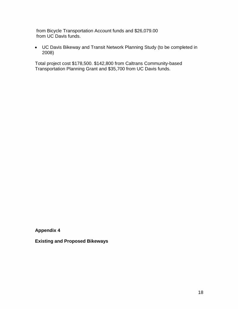
Appendix 4 Existing and Proposed Bikeways
19
This map, from the UC Davis Long Range Development Plan, depicts existing and proposed bikeways as of 2004. Several of the roadways for which bike lanes were proposed have since had bike lanes installed. These roadways are:
Hutchison Drive from County Road 98 to Kleiber Hall Drive
Dairy Road from La Rue Road to Hutchison Drive
Old Davis Road north of Interstate 80
Howard Way An additional roadway being considered for bike lanes is Orchard Road between Orchard Park Drive and La Rue Road. More detail on existing bikeways may be seen in the Davis Bike Map in Appendix 5.
Related Documents