HAL Id: hal-02314136 https://hal.archives-ouvertes.fr/hal-02314136 Submitted on 11 Oct 2019 HAL is a multi-disciplinary open access archive for the deposit and dissemination of sci- entific research documents, whether they are pub- lished or not. The documents may come from teaching and research institutions in France or abroad, or from public or private research centers. L’archive ouverte pluridisciplinaire HAL, est destinée au dépôt et à la diffusion de documents scientifiques de niveau recherche, publiés ou non, émanant des établissements d’enseignement et de recherche français ou étrangers, des laboratoires publics ou privés. UAV-Assisted Reactive Routing for Urban VANETs Omar Oubbati, Abderrahmane Lakas, Mesut Güneş, Fen Zhou, Mohamed Bachir Yagoubi To cite this version: Omar Oubbati, Abderrahmane Lakas, Mesut Güneş, Fen Zhou, Mohamed Bachir Yagoubi. UAV- Assisted Reactive Routing for Urban VANETs. ACM Symposium on Applied Computing, Apr 2017, Marrackech, Morocco. 10.1145/3019612.3019904. hal-02314136 brought to you by CORE View metadata, citation and similar papers at core.ac.uk provided by Archive Ouverte en Sciences de l'Information et de la Communication

Welcome message from author
This document is posted to help you gain knowledge. Please leave a comment to let me know what you think about it! Share it to your friends and learn new things together.
Transcript
HAL Id: hal-02314136https://hal.archives-ouvertes.fr/hal-02314136
Submitted on 11 Oct 2019
HAL is a multi-disciplinary open accessarchive for the deposit and dissemination of sci-entific research documents, whether they are pub-lished or not. The documents may come fromteaching and research institutions in France orabroad, or from public or private research centers.
L’archive ouverte pluridisciplinaire HAL, estdestinée au dépôt et à la diffusion de documentsscientifiques de niveau recherche, publiés ou non,émanant des établissements d’enseignement et derecherche français ou étrangers, des laboratoirespublics ou privés.
UAV-Assisted Reactive Routing for Urban VANETsOmar Oubbati, Abderrahmane Lakas, Mesut Güneş, Fen Zhou, Mohamed
Bachir Yagoubi
To cite this version:Omar Oubbati, Abderrahmane Lakas, Mesut Güneş, Fen Zhou, Mohamed Bachir Yagoubi. UAV-Assisted Reactive Routing for Urban VANETs. ACM Symposium on Applied Computing, Apr 2017,Marrackech, Morocco. �10.1145/3019612.3019904�. �hal-02314136�
brought to you by COREView metadata, citation and similar papers at core.ac.uk
provided by Archive Ouverte en Sciences de l'Information et de la Communication
HAL Id: hal-02314136https://hal.archives-ouvertes.fr/hal-02314136
Submitted on 11 Oct 2019
HAL is a multi-disciplinary open accessarchive for the deposit and dissemination of sci-entific research documents, whether they are pub-lished or not. The documents may come fromteaching and research institutions in France orabroad, or from public or private research centers.
L’archive ouverte pluridisciplinaire HAL, estdestinée au dépôt et à la diffusion de documentsscientifiques de niveau recherche, publiés ou non,émanant des établissements d’enseignement et derecherche français ou étrangers, des laboratoirespublics ou privés.
UAV-Assisted Reactive Routing for Urban VANETsOmar Oubbati, Abderrahmane Lakas, Mesut Güneş, Fen Zhou, Mohamed
Bachir Yagoubi
To cite this version:Omar Oubbati, Abderrahmane Lakas, Mesut Güneş, Fen Zhou, Mohamed Bachir Yagoubi. UAV-Assisted Reactive Routing for Urban VANETs. ACM Symposium on Applied Computing, Apr 2017,Marrackech, Morocco. �hal-02314136�
UAV-Assisted Reactive Routing for Urban VANETs
Omar Sami OubbatiLaboratory of Computer
Science and MathematicsUniversity of Laghouat
Abderrahmane LakasCollege of Information
TechnologyUnited Arab Emirates
UniversityP.O. Box 17551, Al Ain, UAE
Mesut GünesInstitute of Computer Science
University of MünsterGermany
Fen ZhouComputer Science Laboratory
of Avignon (LIA)University of Avignon
P.O. Box 1228, Avignon,France
Mohamed Bachir YagoubiLaboratory of Computer
Science and MathematicsUniversity of Laghouat
ABSTRACTVehicular ad hoc networks (VANETs) are characterized by frequent path failures due to the high mobility caused by the sudden changes of vehicles direction. The routing paths be-tween two different vehicles should be established with this challenge in mind. It must be stable and well connected in order to guarantee a reliable and safe delivery of packets. The aim of this work is to present a new reactive routing technique providing effective and well-regulated communi-cation paths. These discovered paths are created based on a robust flooding discovery process involving UAVs (Un-manned Aerial Vehicles) to ensure the connectivity when the network is sparsely connected. The evaluation of this technique is performed using NS-2 simulator and its perfor-mances are compared with on-demand protocols dedicated for VANET. Simulation results show clearly that our ap-proach gives interesting outcomes ensuring a high delivery ratio with a minimum delay. This hybrid communication between the vehicles and UAVs is attractive to initiate more smart connected nodes in the near future.
CCS Concepts•Computer systems organization → Embedded sys-tems; Redundancy; Robotics; •Networks → Network reli-ability;
KeywordsVANETs, Routing, Discovery phase, Urban Environment,Connectivity, UAVs, Traffic Density Estimation.
1. INTRODUCTIONThe theme of vehicular networking has gained the atten-tion of many scientists and researchers from both industryand academia. The establishment of such network providesa lot of possibilities to develop many applications that cansupply a safe and comfortable driving experience. In addi-tion, it offers useful services and entertainment applicationsto the drivers and passengers respectively. For example,vehicles can exchange information with each other aboutthe real-time traffic congestion or incidents on the road inorder to avoid traffic jam and enhance the road capacity.Furthermore, these communications can also include help-ful infotainments like the weather, restaurant locations, gasstation, parking places. Reliable data forwarding is consid-ered as a foundation to put on the field these aforementionedapplications.
Data packet routing plays a basic role to support the per-formance success of vehicular networks. Numerous routingchallenges need to be addressed in order to adapt the pro-posed solutions to the unique characteristics of VANETs, es-pecially the movements of vehicles (various speeds and direc-tions). Most of the reactive routing protocols for VANETs[1, 4, 6, 8–12] only indicate presence or absence of routingpaths between two vehicles; they also use a recovery processwhen a link-breakage takes place. When there is a path fail-ure, a significant delay is diagnosed in the initializing of anew path. In addition, most of them do not take into ac-count whether the discovered path is dense with vehicles ornot in order to increase the chances of a successful deliver-ing data packet between a source and destination. When thenetwork is sparsely connected (no existing path), these pro-tocols cannot forward the data packets because their routemaintenance process (new route discovery) fails to find a
new path, consequently, the data packets cannot reach theirfinal destination.
The aim of this work is to design a reactive routing pro-tocol destined for city environments that is based on for-warding packets using the densest (connected) and stablepath which includes the fastest path in term of delay. Im-proved techniques are used in the discovery process that aimto minimize the delay and the control traffic overhead. Inthe case where there are several discovered paths, a scoringtechnique is used to select the optimal path based on severalcriteria. The route maintenance process is ensured based ontwo steps: (i) another alternative path can be used in eachpath breakage without re-initiating the discovery process.When there is no routing path, (ii) Unmanned Aerial Vehi-cles (UAVs) are used to establish a connection between thetwo disconnected clusters to create an alternative path.
The rest of this paper is structured as follows. First of all,we present an overview on the works already done on reac-tive routing protocols for VANETs in Section II. In SectionIII, our proposed routing protocols will be described in de-tails. The performance evaluation and the results analysisof our approach are presented in Section IV. Finally, SectionV concludes the paper and summarizes some future perspec-tives.
2. RELATED WORKDuring the last few years, different types of reactive routingcontributions are proposed for VANETs. All these proto-cols are based on the broadcasting and the flooding of theentire network in order to discover always new routes. How-ever, they all fail to deliver the data packets when there isno existing paths between a pair of source and destination.Another problem detected in this kind of routing protocols isthat most of them do not consider the well-balanced density(i.e., real distribution of vehicles) in the discovered pathswhich is an important parameter to ensure a reliable trans-mission of packets.
Road-Based using Vehicular Traffic (RBVT) [6] is basedon two different routing protocols, the proactive protocol(RBVT-P) and the on-demand routing protocol well-knownas reactive (RBVT-R). RBVT-R performs route discoveryon-demand and reports back to the source based on thegreedy forwarding using a route reply (RR) which includesin its header, the position of the destination and a list oftraversed intersections. In the case when the destination re-ceived several route discovery (RD), this means that RBVT-R has to choose the path that has the smaller number of tra-versed junctions (shortest path to the source) among manydiscovered paths and then to send the RR through it. Oncethe source receives a RR, it starts sending data packet viathe same path traversed by the RR. As drawback, RBVT-Rselects the shortest path (minimum number of traversed in-tersections) back to the source without taking into accountthe vehicle density on the road segments which may cause adisconnection problem at any time.
MURU (Multi-hop Routing protocol for Urban VANET)[4] calculates a metric called Expected Disconnection De-gree (EDD) which is a probability that a given path mightbe disconnected during a given time period. The lower of
EDD, the better is the path. The EDD is estimated bycombining the vehicle positions, velocities, and trajectories.Consequently, path along vehicles moving in similar speedsand directions are more stable and therefore more desirable.After calculating the shortest path to the destination, thesource initiates the route discovery, at the same time theEDD is calculated permanently at each hop and stored inthe route request (RREQ). When the destination receivesa certain number of RREQ, it chooses the path with thesmallest EDD. The principal drawback of this protocol isthat it does not take into consideration the vehicles densitywhich is an important factor to measure the connectivityand ensure an efficient data delivery.
The authors in [12] use a route discovery process for bothfinding the destination location and installing a robust datadelivery path. At the end, several RREQ reach the destina-tion indicating several routing paths. Then, the destinationcalculates a weight for each different path (a set of inter-sections) based on the vehicles density and the delay. Thepath which obtains the best weight will be selected to sendthe route reply (RREP) back to the source using a greedyforwarding technique. To deal with the mobility of the des-tination, an intermediate vehicle can use a trajectory predic-tion based on additional information (velocity and motiondirection of the destination) included in data packets. Themajor disadvantage of this protocol is that does not calcu-late the real distribution of vehicles between two successiveintersections on the selected path which may cause a pathfailure even if this path contains a large number of vehicles.
LCAD (Load Carry and Deliver Routing) [3], is among thefirst routing protocols involving unmanned aerial vehicles(UAVs). It is completely dedicated for Mobile Ad hoc Net-works (MANets) allowing UAVs to assist nodes on the groundin the data delivery process enhancing the connectivity onsparsely connected network. LCAD uses the technique ofCarry & Forward only with the UAVs in order to carry thepackets to the destination by flying, so this type of protocolis called Disruption Tolerant Network (DTN) and it is usedonly in the sky. However, on the ground Ad hoc On DemandDistance Vector (AODV) [7] is used. The major drawbackof this proposed protocol is that UAVs do not use GPS in-formation and trajectory calculation during route discoveryand data forwarding.
To deal with all the aforementioned drawbacks, we propose anew reactive routing approach for urban VANETs. It takesinto account the real distribution of vehicles on the discov-ered paths based on scoring technique involving many crite-ria. Furthermore, UAVs may belong to the discovered paths,and it can also be used as forwarding node connecting dis-connected clusters when the network is sparsely connected.
3. UAV-ASSISTED REACTIVE ROUTING FORURBAN VANET
This section describes in details the different functionalitiesof the proposed reactive routing approach. The main ideabehind this approach is to exploit the discovery phase tohave an accurate vision about the traffic density in eachdiscovered path. A multi-criteria score is given to each dis-covered path based on the real distribution of vehicles and
the end-to-end delays.
In some situations, the selected path that was created be-tween a source and destination cannot remain constant dueto the high mobility of vehicles. This is the reason whywe use an intelligent route maintenance process based onalternative paths discovered beforehand and stored in thesource. UAVs can play a role of a routing assistant, both inthe discovery process and recovery strategy.
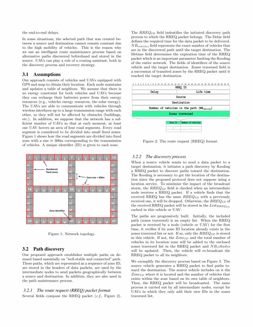
3.1 AssumptionsOur approach consists of vehicles and UAVs equipped withGPS and map to obtain their location. Each node maintainsand updates a table of neighbors. We assume that there isno energy constraint for both vehicles and UAVs becausethey can recharge their batteries power from their energyresources (e.g., vehicles energy resources, the solar energy).The UAVs are able to communicate with vehicles throughwireless interfaces up to a large transmission range with eachother, so they will not be affected by obstacles (buildings,etc.). In addition, we suppose that the network has a suf-ficient number of UAVs so that at each moment, at leastone UAV hovers an area of four road segments. Every roadsegment is considered to be divided into small fixed zones.Figure 1 shows how the road segments are divided into fixedzone with a size ≈ 300m corresponding to the transmissionof vehicles. A unique identifier (ID) is given to each zone.
12 3 4 5 6
78 9 10
14
15
16
17
18
31
131211
32
33
34
35
52
53
54
55
24
56
57
58
59
41
60
61
62
63
30
51
50
49
48
47
19 20 21 22 23
36 37 38 39 40
25 26 27 28 29
42 43 44 45 46
Numbered fixed zones
Zone size ≈ 300m
Zone identifier
Figure 1: Network topology.
3.2 Path discoveryOur proposed approach establishes multiple paths on de-mand based essentially on ”well-stable and connected” path.These paths, which are represented as a sequence of zone ID,are stored in the headers of data packets, are used by theintermediate nodes to send packets geographically betweena source and destination. In addition, they are also used inthe path maintenance process.
3.2.1 The route request (RREQ) packet formatSeveral fields compose the RREQ packet (c.f., Figure 2).
The RREQID field indentifies the initiated discovery pathprocess to which the RREQ packet belongs. The Delay fielddefines the required time for the data packet to be delivered.NBvehicles field represents the exact number of vehicles thatare in the discovered path until the target destination. Thelifetime field determines the expiration time of the RREQpacket which is an important parameter limiting the floodingof the entire network. The fields of identifiers of the sourcevehicle and the target destination. Zones traversed field isa succession of transited zones by the RREQ packet until itreached the target destination.
0 1 2 3 4 5 6 7 8 9 10 11 12 13 14 15 16 17 18 19 20 21 22 23 24 25 26 27 28 29 30 31
RREQ ID
Delay Life time
Source
Destination
Number of vehicles in the path (NBvehicles)
Zones traversed
Zone ID Number of vehicles
… …
Figure 2: The route request (RREQ) format.
3.2.2 The discovery processWhen a source vehicle wants to send a data packet to atarget destination, it initiates a path discovery by floodinga RREQ packet to discover paths toward the destination.The flooding is necessary to get the location of the destina-tion since the proposed protocol does not suppose using alocation service. To minimize the impact of the broadcaststorm, the RREQID field is checked when an intermediatenode receives a RREQ packet. If a vehicle finds that thereceived RREQ has the same RREQID with a previouslyreceived one, it will be dropped. Otherwise, the RREQID ofthe received RREQ packet will be stored in the ListRREQID
cached in this vehicle or UAV.
The paths are progressively built. Initially, the includedpath (zones traversed) is an empty list. When the RREQpacket is received by a node (vehicle or UAV) for the firsttime, it verifies if its zone ID location already exists in thezones traversed list or not. If so, only the RREQID is storedin this vehicle. If not, the ZoneID and the total number ofvehicles in its location zone will be added to the enclosedzones traversed list in the RREQ packet and NBvehicleswill be updated. Then, the vehicle will re-broadcast theRREQ packet to all its neighbors.
We exemplify the discovery process based on Figure 3. Thesource vehicle generates a RREQ packet to find paths to-ward the destination. The source vehicle includes on it theZoneID where it is located and the number of vehicles thatexists within the zone based on its own table of neighbors.Then, the RREQ packet will be broadcasted. The sameprocess is carried out by all intermediate nodes, except forUAVs in which they only add their own IDs in the zonestraversed list.
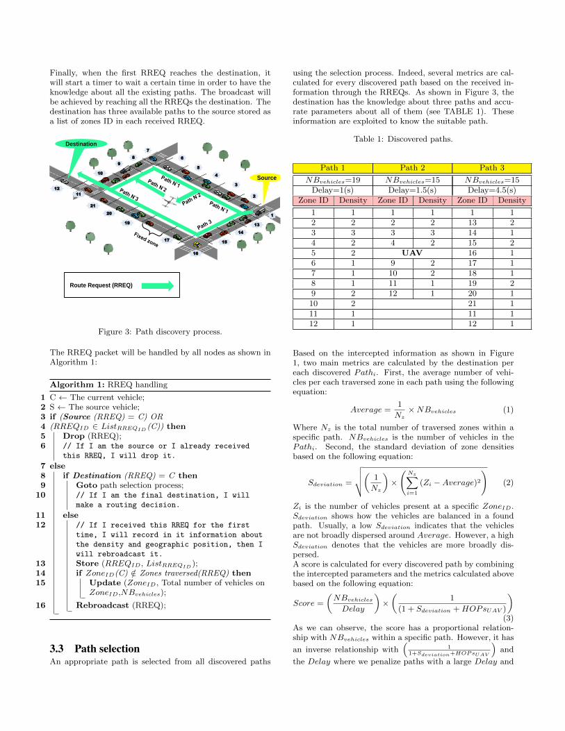
Finally, when the first RREQ reaches the destination, itwill start a timer to wait a certain time in order to have theknowledge about all the existing paths. The broadcast willbe achieved by reaching all the RREQs the destination. Thedestination has three available paths to the source stored asa list of zones ID in each received RREQ.
Route Request (RREQ)
Source
Destination
2
1
3
4
5
6
7
8
9
10
11
12
13
14
15
16
17
19
20
21
Figure 3: Path discovery process.
The RREQ packet will be handled by all nodes as shown inAlgorithm 1:
Algorithm 1: RREQ handling
1 C ← The current vehicle;2 S ← The source vehicle;3 if (Source (RREQ) = C) OR4 (RREQID ∈ ListRREQID (C)) then5 Drop (RREQ);6 // If I am the source or I already received
this RREQ, I will drop it.
7 else8 if Destination (RREQ) = C then9 Goto path selection process;
10 // If I am the final destination, I will
make a routing decision.
11 else12 // If I received this RREQ for the first
time, I will record in it information about
the density and geographic position, then I
will rebroadcast it.
13 Store (RREQID, ListRREQID );14 if ZoneID(C) /∈ Zones traversed(RREQ) then15 Update (ZoneID, Total number of vehicles on
ZoneID,NBvehicles);
16 Rebroadcast (RREQ);
3.3 Path selectionAn appropriate path is selected from all discovered paths
using the selection process. Indeed, several metrics are cal-culated for every discovered path based on the received in-formation through the RREQs. As shown in Figure 3, thedestination has the knowledge about three paths and accu-rate parameters about all of them (see TABLE 1). Theseinformation are exploited to know the suitable path.
Table 1: Discovered paths.
Path 1 Path 2 Path 3
NBvehicles=19 NBvehicles=15 NBvehicles=15Delay=1(s) Delay=1.5(s) Delay=4.5(s)
Zone ID Density Zone ID Density Zone ID Density
1 1 1 1 1 12 2 2 2 13 23 3 3 3 14 14 2 4 2 15 25 2 UAV 16 16 1 9 2 17 17 1 10 2 18 18 1 11 1 19 29 2 12 1 20 110 2 21 111 1 11 112 1 12 1
Based on the intercepted information as shown in Figure1, two main metrics are calculated by the destination pereach discovered Pathi. First, the average number of vehi-cles per each traversed zone in each path using the followingequation:
Average =1
Nz×NBvehicles (1)
Where Nz is the total number of traversed zones within aspecific path. NBvehicles is the number of vehicles in thePathi. Second, the standard deviation of zone densitiesbased on the following equation:
Sdeviation =
√√√√( 1
Nz
)×
(Nz∑i=1
(Zi −Average)2
)(2)
Zi is the number of vehicles present at a specific ZoneID.Sdeviation shows how the vehicles are balanced in a foundpath. Usually, a low Sdeviation indicates that the vehiclesare not broadly dispersed around Average. However, a highSdeviation denotes that the vehicles are more broadly dis-persed.A score is calculated for every discovered path by combiningthe intercepted parameters and the metrics calculated abovebased on the following equation:
Score =
(NBvehicles
Delay
)×(
1
(1 + Sdeviation + HOPsUAV )
)(3)
As we can observe, the score has a proportional relation-ship with NBvehicles within a specific path. However, it has
an inverse relationship with(
11+Sdeviation+HOPsUAV
)and
the Delay where we penalize paths with a large Delay and
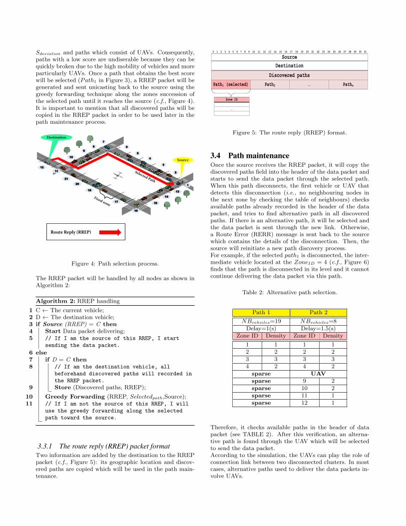
Sdeviation and paths which consist of UAVs. Consequently,paths with a low score are undiserable because they can bequickly broken due to the high mobility of vehicles and moreparticularly UAVs. Once a path that obtains the best scorewill be selected (Path1 in Figure 3), a RREP packet will begenerated and sent unicasting back to the source using thegreedy forwarding technique along the zones succession ofthe selected path until it reaches the source (c.f., Figure 4).It is important to mention that all discovered paths will becopied in the RREP packet in order to be used later in thepath maintenance process.
Route Reply (RREP)
Source
Destination
2
1
3
4
5
6
7
8
9
10
11
12
13
14
15
16
17
19
20
21
Figure 4: Path selection process.
The RREP packet will be handled by all nodes as shown inAlgorithm 2:
Algorithm 2: RREP handling
1 C ← The current vehicle;2 D ← The destination vehicle;3 if Source (RREP) = C then4 Start Data packet delivering;5 // If I am the source of this RREP, I start
sending the data packet.
6 else7 if D = C then8 // If am the destination vehicle, all
beforehand discovered paths will recorded in
the RREP packet.
9 Store (Discovered paths, RREP);
10 Greedy Forwarding (RREP, Selectedpath,Source);11 // If I am not the source of this RREP, I will
use the greedy forwarding along the selected
path toward the source.
3.3.1 The route reply (RREP) packet formatTwo information are added by the destination to the RREPpacket (c.f., Figure 5): its geographic location and discov-ered paths are copied which will be used in the path main-tenance.
ed
0 1 2 3 4 5 6 7 8 9 10 11 12 13 14 15 16 17 18 19 20 21 22 23 24 25 26 27 28 29 30 31
Source
Destination
Discovered paths
Path1 (selected) Path2 … Pathn
Zone ID
…
Figure 5: The route reply (RREP) format.
3.4 Path maintenanceOnce the source receives the RREP packet, it will copy thediscovered paths field into the header of the data packet andstarts to send the data packet through the selected path.When this path disconnects, the first vehicle or UAV thatdetects this disconnection (i.e., no neighbouring nodes inthe next zone by checking the table of neighbours) checksavailable paths already recorded in the header of the datapacket, and tries to find alternative path in all discoveredpaths. If there is an alternative path, it will be selected andthe data packet is sent through the new link. Otherwise,a Route Error (RERR) message is sent back to the sourcewhich contains the details of the disconnection. Then, thesource will reinitiate a new path discovery process.For example, if the selected path1 is disconnected, the inter-mediate vehicle located at the ZoneID = 4 (c.f., Figure 6)finds that the path is disconnected in its level and it cannotcontinue delivering the data packet via this path.
Table 2: Alternative path selection.
Path 1 Path 2
NBvehicles=19 NBvehicles=8Delay=1(s) Delay=1.5(s)
Zone ID Density Zone ID Density
1 1 1 12 2 2 23 3 3 34 2 4 2sparse UAVsparse 9 2sparse 10 2sparse 11 1sparse 12 1
Therefore, it checks available paths in the header of datapacket (see TABLE 2). After this verification, an alterna-tive path is found through the UAV which will be selectedto send the data packet.According to the simulation, the UAVs can play the role ofconnection link between two disconnected clusters. In mostcases, alternative paths used to deliver the data packets in-volve UAVs.
Data packet
Source
Destination
2
1
3
4
5
6
7
8
9
10
11
12
13
14
15
16
17
19
18
21
Figure 6: Path maintenance process.
4. PERFORMANCE EVALUATIONSIn this section, we present the evaluation of the proposedapproach. NS-2 (Network Simulator 2) is used to performthe simulations in order to conduct series of experiments.Our approach is compared with reactive routing protocolsfor urban vehicular environment such as, RBVT-R [6] andAGP [12].
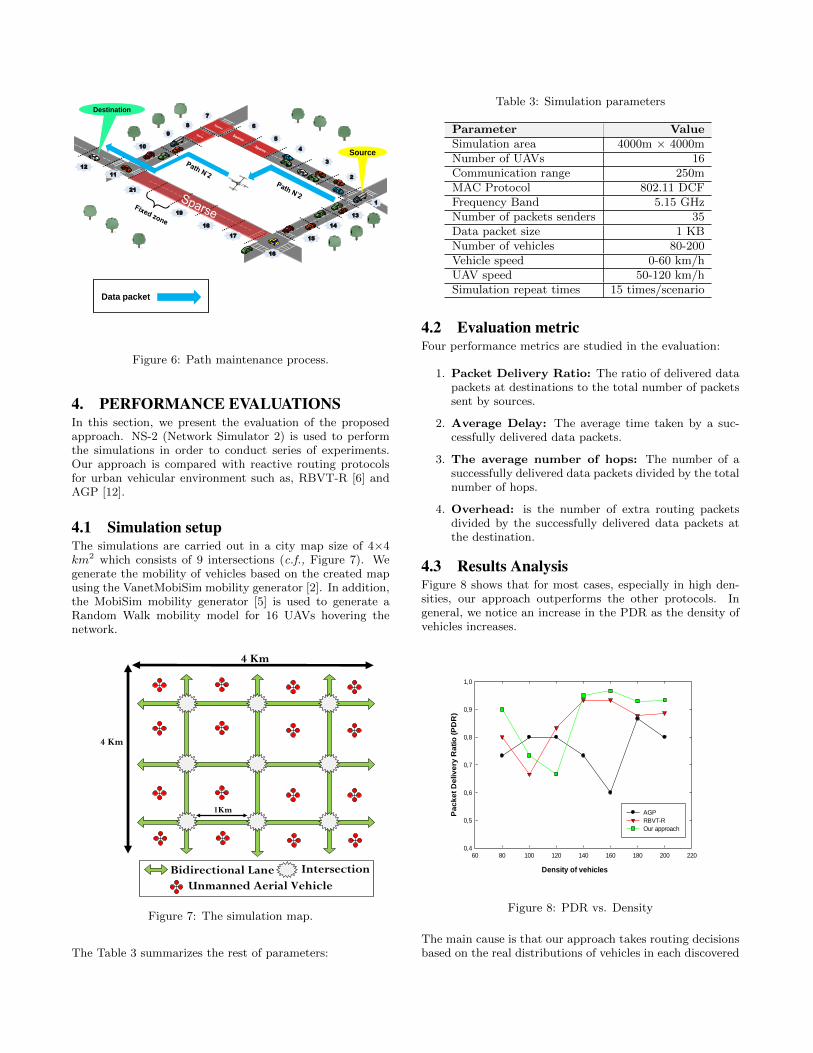
4.1 Simulation setupThe simulations are carried out in a city map size of 4×4km2 which consists of 9 intersections (c.f., Figure 7). Wegenerate the mobility of vehicles based on the created mapusing the VanetMobiSim mobility generator [2]. In addition,the MobiSim mobility generator [5] is used to generate aRandom Walk mobility model for 16 UAVs hovering thenetwork.
Intersection Bidirectional Lane
Unmanned Aerial Vehicle
(UAV)
4 Km
4 Km
1Km
Figure 7: The simulation map.
The Table 3 summarizes the rest of parameters:
Table 3: Simulation parameters
Parameter ValueSimulation area 4000m × 4000mNumber of UAVs 16Communication range 250mMAC Protocol 802.11 DCFFrequency Band 5.15 GHzNumber of packets senders 35Data packet size 1 KBNumber of vehicles 80-200Vehicle speed 0-60 km/hUAV speed 50-120 km/hSimulation repeat times 15 times/scenario
4.2 Evaluation metricFour performance metrics are studied in the evaluation:
1. Packet Delivery Ratio: The ratio of delivered datapackets at destinations to the total number of packetssent by sources.
2. Average Delay: The average time taken by a suc-cessfully delivered data packets.
3. The average number of hops: The number of asuccessfully delivered data packets divided by the totalnumber of hops.
4. Overhead: is the number of extra routing packetsdivided by the successfully delivered data packets atthe destination.
4.3 Results AnalysisFigure 8 shows that for most cases, especially in high den-sities, our approach outperforms the other protocols. Ingeneral, we notice an increase in the PDR as the density ofvehicles increases.
Density of vehicles
60 80 100 120 140 160 180 200 220
Pa
ck
et
De
liv
ery
Ra
tio
(P
DR
)
0,4
0,5
0,6
0,7
0,8
0,9
1,0
AGP
RBVT-R
Our approach
Figure 8: PDR vs. Density
The main cause is that our approach takes routing decisionsbased on the real distributions of vehicles in each discovered
path which allow the senders to forward data packets effi-ciently with a minimum packet losses increasing the averagedelivery ratio. In addition, when there are path failures, wedistinguish clearly the role of UAVs to enhance the connec-tivity in the network contributing also to this result. RBVT-R performs well than AGP in PDR. As RBVT-R uses a re-liable recovery strategy based on a dynamic route updatingtechnique when paths break due to the high mobility of ve-hicles which is not the case of AGP. RBVT-R demonstratescertain advantages in term of PDR than AGP.
In Figure 9 we can observe the performance in terms of av-erage delay achieved by the evaluated protocols for differentdensities of vehicles. As we can see, in overall, our approachprovides the lowest delay compared with RBVT-R and AGP,particularly when the network is weakly connected (fewerthan 140 vehicles) The use of UAVs gurantees the connec-tivity and ensures the shortest path towards the target des-tination in certain situation which leads to the small delaycomparing with the other protocols. However, in the highdensities (more than 140 vehicles), RBVT-R outperformsour approach and AGP which results in the routes whichremain active for longer periods of time thanks to the reli-able route maintenance used by the source vehicle. UnlikeRBVT-R, the routes composed of UAVs in our approach areconstantly not stable due to high mobility thus causing thetriggering of the path discovery process in each path failure.AGP achieves the high delay because it needs more time todiscover routing paths and does not have a recovery strategy.
Density of vehicles
60 80 100 120 140 160 180 200 220
Av
era
ge
En
d-t
o-E
nd
De
lay
(E
ED
) [s
]
0,0
0,2
0,4
0,6
0,8
1,0
1,2
1,4
1,6
1,8
2,0
AGP
RBVT-R
Our approach
Figure 9: EED vs. Density
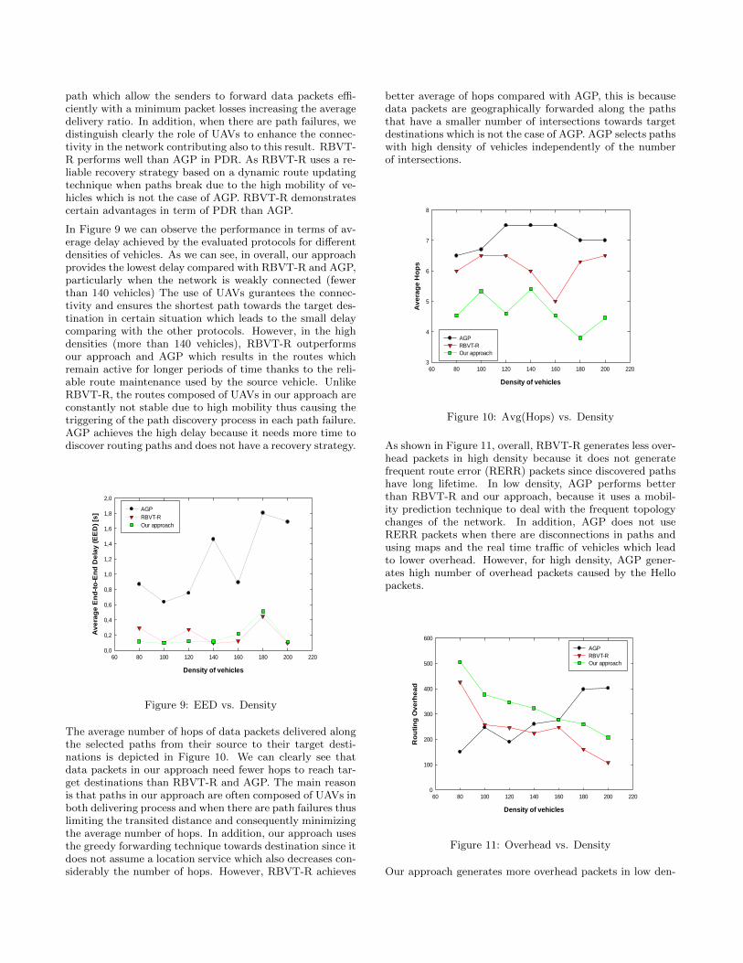
The average number of hops of data packets delivered alongthe selected paths from their source to their target desti-nations is depicted in Figure 10. We can clearly see thatdata packets in our approach need fewer hops to reach tar-get destinations than RBVT-R and AGP. The main reasonis that paths in our approach are often composed of UAVs inboth delivering process and when there are path failures thuslimiting the transited distance and consequently minimizingthe average number of hops. In addition, our approach usesthe greedy forwarding technique towards destination since itdoes not assume a location service which also decreases con-siderably the number of hops. However, RBVT-R achieves
better average of hops compared with AGP, this is becausedata packets are geographically forwarded along the pathsthat have a smaller number of intersections towards targetdestinations which is not the case of AGP. AGP selects pathswith high density of vehicles independently of the numberof intersections.
Density of vehicles
60 80 100 120 140 160 180 200 220
Av
era
ge
Ho
ps
3
4
5
6
7
8
AGP
RBVT-R
Our approach
Figure 10: Avg(Hops) vs. Density
As shown in Figure 11, overall, RBVT-R generates less over-head packets in high density because it does not generatefrequent route error (RERR) packets since discovered pathshave long lifetime. In low density, AGP performs betterthan RBVT-R and our approach, because it uses a mobil-ity prediction technique to deal with the frequent topologychanges of the network. In addition, AGP does not useRERR packets when there are disconnections in paths andusing maps and the real time traffic of vehicles which leadto lower overhead. However, for high density, AGP gener-ates high number of overhead packets caused by the Hellopackets.
Density of vehicles
60 80 100 120 140 160 180 200 220
Ro
uti
ng
Ov
erh
ea
d
0
100
200
300
400
500
600
AGP
RBVT-R
Our approach
Figure 11: Overhead vs. Density
Our approach generates more overhead packets in low den-
sities but reduced progressively with the increase in densityof vehicles. This is because our approach generates moreRERR packets in low densities because there are no alter-native paths. As the number of vehicles increases, our ap-proach always finds alternative paths to recover the selectedpaths decreasing the number of packets overhead.
5. CONCLUSIONThis paper has introduced a reactive routing technique ded-icated for urban VANET that takes into account the stabil-ity and the real distribution of vehicles in the path selectionprocess. In addition, UAVs can be involved to both en-sure better connectivity in sparsely connected networks andmaintain the paths when the link failures occur. Simulationresults show that our approach outperforms existing rout-ing in terms of delivery ratio and average number of hopsfor high densities. It is believed that our approach should beable to provide good performances in terms of delivery ratioand average delay in both highway and rural environments.As future work we plan to deal with the mobility of UAVsin order to improve an efficient cooperation with vehicleson the ground. In addition, we plan to enhance this rout-ing protocol by dividing it into two heterogeneous routingcomponents. The first one is executed in the sky exclusivelywith UAVs and the second one is executed on the groundwith vehicles. Furthermore, our recovery strategy will beimproved to support the high mobility of UAVs.
AcknowledgmentThis research was partially supported by grant # 31R012from the UAEU Roadway, Transportation and Traffic SafetyResearch Center.
6. REFERENCES[1] M. H. Eiza and Q. Ni. An evolving graph-based
reliable routing scheme for VANETs. IEEETransactions on Vehicular Technology,62(4):1493–1504, 2013.
[2] J. Harri, F. Filali, C. Bonnet, and M. Fiore.VanetMobiSim: generating realistic mobility patternsfor vanets. In Proceedings of the 3rd internationalworkshop on Vehicular ad hoc networks, pages 96–97.ACM, 2006.
[3] M. Le, J.-S. Park, and M. Gerla. UAV assisteddisruption tolerant routing. In Proceedings of IEEEMilitary Communications Conference (MILCOM),pages 1–5, 2006.
[4] Z. Mo, H. Zhu, K. Makki, and N. Pissinou. MURU: Amulti-hop routing protocol for urban vehicular ad hocnetworks. In Proceedings of the 3rd Annual IEEEInternational Conference on Mobile and UbiquitousSystems: Networking & Services, pages 1–8, 2006.
[5] S. M. Mousavi, H. R. Rabiee, M. Moshref, andA. Dabirmoghaddam. Mobisim: A framework forsimulation of mobility models in mobile ad-hocnetworks. In Proceedings of the 3rd IEEEInternational Conference on Wireless and Mobile
Computing, Networking and Communications(WiMOB), pages 82–82, 2007.
[6] J. Nzouonta, N. Rajgure, G. Wang, and C. Borcea.VANET routing on city roads using real-timevehicular traffic information. IEEE Transactions onVehicular Technology,, 58(7):3609–3626, 2009.
[7] C. Perkins, E. Belding-Royer, and S. Das. Ad hocon-demand distance vector (aodv) routing. Technicalreport, 2003.
[8] C. Sommer and F. Dressler. The DYMO routingprotocol in vanet scenarios. In Proceedings of the 66thIEEE Vehicular Technology Conference (VTC-2007Fall), pages 16–20, 2007.
[9] W. Sun, H. Yamaguchi, K. Yukimasa, andS. Kusumoto. Gvgrid: A qos routing protocol forvehicular ad hoc networks. In Proceedings of the 14thIEEE International Workshop on Quality of Service(IWQoS), pages 130–139, 2006.
[10] T. Taleb, E. Sakhaee, A. Jamalipour, K. Hashimoto,N. Kato, and Y. Nemoto. A stable routing protocol tosupport its services in vanet networks. IEEETransactions on Vehicular Technology,56(6):3337–3347, 2007.
[11] C. Tee and A. Lee. Adaptive reactive routing forVANET in city environments. In Proceedings of the10th IEEE International Symposium on PervasiveSystems, Algorithms, and Networks (ISPAN), pages610–614, 2009.
[12] S. Yan, X.-y. JIN, and S.-z. CHEN. AGP: ananchor-geography based routing protocol withmobility prediction for vanet in city scenarios. TheJournal of China Universities of Posts andTelecommunications, 18:112–117, 2011.
Related Documents

![UAV Relay in VANETs Against Smart Jamming with ...bbcr.uwaterloo.ca/~wzhuang/papers/VANETdouble_v8.pdfstrategy via trials-and-errors if the game is long enough [8], [9]. As a model-free](https://static.cupdf.com/doc/110x72/5fcd8bcd8c47e30b077caa4f/uav-relay-in-vanets-against-smart-jamming-with-bbcr-wzhuangpapersvanetdoublev8pdf.jpg)