
Welcome message from author
This document is posted to help you gain knowledge. Please leave a comment to let me know what you think about it! Share it to your friends and learn new things together.
Transcript


���������������
����������������� �����
��������� ��!�" ����"#$����%������������"%�������� ���#�"��������������&��%��' ()�"��'���*���%����������"� ��'+��%��"����&�,�&�'���'��"%�'��������-!��%�����������&��������%���''"�������������" ����'!�.�/���'�,��'� ����'-!����0��#��!��'��"�����"������'*
1�'��%��##'���(��"%!������$�/�$!������" �(��"����������' "%��'����'��"�����"������!�'�"����234��&���������%��(��&�����' "%��'������'�������( �����&������#�5
6�'�7���,$�'-�"���"��8 �"���������"����%/���#"����(����"���� ��&�/��%��%�'��##��"����*9
:
:���##��"�(���7��' "%���" �(��"���##���'9*
;##��"��������</���1�����'������������'����%���##��"���������%��/������%������*
=>>� ������
�%��#�'��/%�/���'��%��#����*
<&���'�����7����##��"�(��9+
�'����;���''+� �������'����*<*�?0!�������%��������'�%��+
�����+ @�'��:���+ A ����+
�'�"��+A����+A ( (BC"����$+
A�*�:*+D����:*+ A�*�:���+
:���+
E�������>�����F��G��� ��H A�����'��##��"���
<&���'�����7����##��"�(��9+
IJKLKMNJKMOLKPKLLKQMRSTNURNMOKLVSTMPSLMNJKMUOOWXRUNXSTMXVMQXPPKLKTNMPLSYMNJKMUOOWXRUTNZMOLS[XQKMNJKMQKNUXWVMSPMNJUNMOKLVST\
�'�"��+A����+A ( (BC"����$+
A�*�:*+D����:*+ A�*�:���+
:���+
�����+ @�'��:���+ A ����+
E������� �]����� ���]����>>� �����̂_���������>����������̀
? '���''�#%��+
a(����#%��+
b����+
@�0+
cWKUVKMOLS[XQKMUNMWKUVNMSTKMRSTNURNMOJSTKMTdYeKLMf
^̀ �����
�%��#�'���&���'�����/%�/�'��%������
g%����%��/����'��������������%���##��"���!�#������%��������'����%���#�'���&���'����*
<&���'�����7����##��"�(��9+
</��-'�A�&��� ��7<#�����9+ 1���+�
��$�B����%�B�$��
�'�"��+A����+A ( (BC"����$+
A�*�:*+D����:*+ A�*�:���+
A�����'��##��"���:���+
�����+ @�'��:���+ A ����+
�'����;���''+� �������'����*<*�?0!�������%��������'�%��+
�'����;���''+� �������'����*<*�?0!�������%��������'�%��+
h���� ���i�̀ ��i�����G� �����G���G�G�j���>�G���̀ ��
@��0��#��!���"���!��%����/�����&'!�����"���"�����/��%��/�#�"������'!���"��'�����'�� ����/��%�kl�'���'!�&�m��&*
nopqrpstuvwsxprpwsqu
��������#�������%���0�'���&�"������'*��%�'������'�%��#� �*
yz{|}~�|z��|��|{�������|z~��{|���|~�����}�����
�� ��}�{ �{{
��}����|���|���
��� ����~���|���{{�
��}}����|���� ��� ����
��}�{���}������~ ���
���¡����¢¢
�� £�� y���{�
¢�� ��¤~��}��|�~��
¥}��{� ��� ��¦�
§
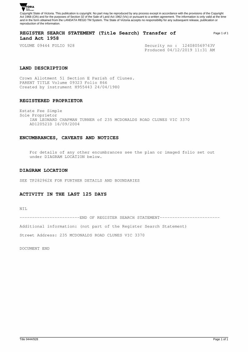
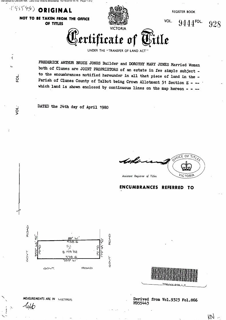
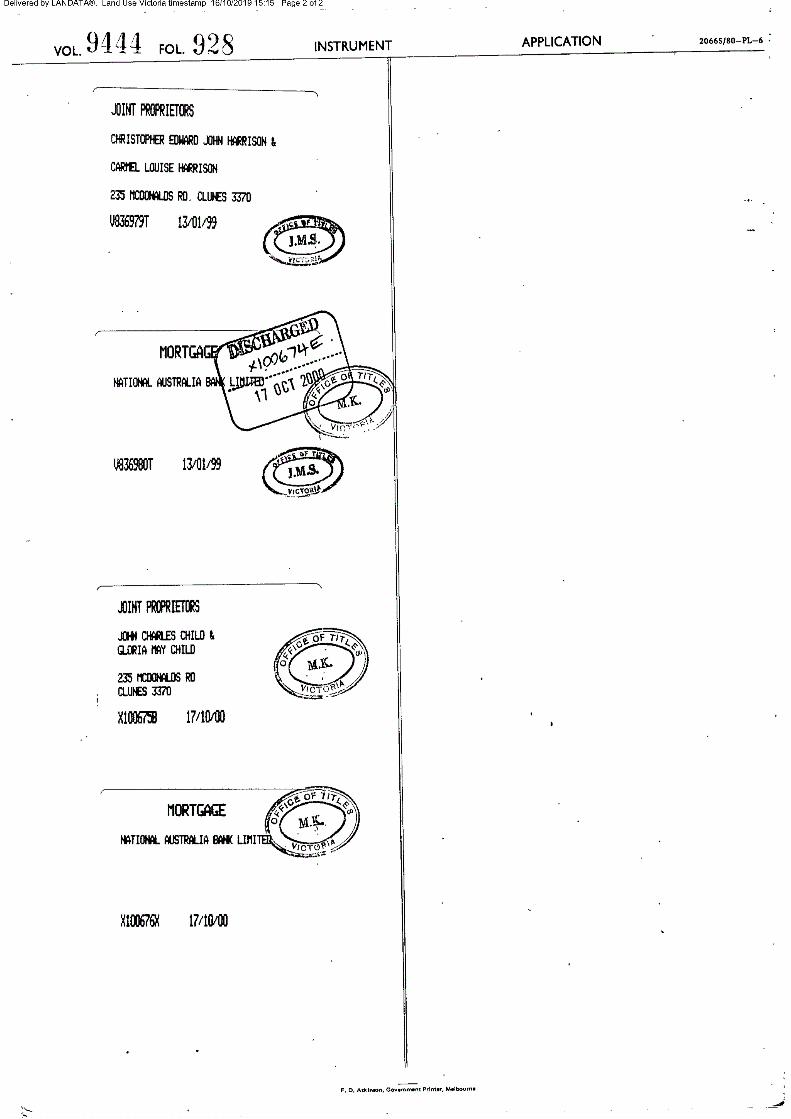
VOLUME 09444 FOLIO 928 Security no : 124080569743V Produced 04/12/2019 11:31 AM
LAND DESCRIPTION
Crown Allotment 51 Section E Parish of Clunes.PARENT TITLE Volume 09323 Folio 866Created by instrument H955443 24/04/1980
REGISTERED PROPRIETOR
Estate Fee SimpleSole Proprietor IAN LEONARD CHAPMAN TURNER of 235 MCDONALDS ROAD CLUNES VIC 3370 AD120521D 16/09/2004
ENCUMBRANCES, CAVEATS AND NOTICES
For details of any other encumbrances see the plan or imaged folio set out under DIAGRAM LOCATION below.
DIAGRAM LOCATION
SEE TP282962X FOR FURTHER DETAILS AND BOUNDARIES
ACTIVITY IN THE LAST 125 DAYS
NIL
------------------------END OF REGISTER SEARCH STATEMENT------------------------
Additional information: (not part of the Register Search Statement)
Street Address: 235 MCDONALDS ROAD CLUNES VIC 3370
DOCUMENT END
Copyright State of Victoria. This publication is copyright. No part may be reproduced by any process except in accordance with the provisions of the CopyrightAct 1968 (Cth) and for the purposes of Section 32 of the Sale of Land Act 1962 (Vic) or pursuant to a written agreement. The information is only valid at the timeand in the form obtained from the LANDATA REGD TM System. The State of Victoria accepts no responsibility for any subsequent release, publication orreproduction of the information.
REGISTER SEARCH STATEMENT (Title Search) Transfer of Land Act 1958
Page 1 of 1
Title 9444/928 Page 1 of 1

PLANNING PERMIT
REPORT FOR A DWELLING
AT 235 MCDONALDS RD,
CLUNES

Page 2 of 19
981 235 McDonalds rd Clunes Oct 2019
Planning Report for
235 McDonalds Rd, Clunes
Project:981
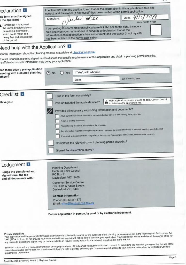
Report prepared by: Julie Lee of Natural Resource Link Pty Ltd
Natural Resource Link Pty Ltd
ACN 609 952 025
ABN 83 609 952025
194 Victoria Street, Ballarat East, Vic, 3350
Ph: 0406 459 522
Email: [email protected]
Copyright
Natural Resource Link Pty Ltd shall retain ownership of the reports and drawings, design, displays and other work produced by Natural Resource Link Pty Ltd during fulfilling a commission until final payment by the client.
Disclaimer
Natural Resource Link Pty Ltd does not accept any liability for an error, omission or loss or other consequence that may arise from relying on this report.
REV DATE DETAILS
A 8/10/2019 Draft
B 3/12/2019 Final
C
D
Page 3 of 19
981 235 McDonalds rd Clunes Oct 2019
Contents
INTRODUCTION ............................................................................................................................... 4
OBJECT SITE AND SITE CONTEXT ............................................................................................... 5
PROPOSAL ..................................................................................................................................... 12
Planning .......................................................................................................................................... 12
Zones .......................................................................................................................................... 12
Overlays ....................................................................................................................................... 13
Particular Provisions.....................................................................................................................15
CONCLUSION................................................................................................................................. 16
Appendix.1 Existing Plan .............................................................................................................. 17
Appendix.2 Proposed Plans ......................................................................................................... 18
Appendix.3 Subdivision Plan ....................................................................................................... 19
Page 4 of 19
981 235 McDonalds rd Clunes Oct 2019
INTRODUCTION
c
Applicant Natural Resource Link Pty Ltd
Proposal Subdivision Application.
Location 235 McDonalds Rd Clunes
Zone Low Density Residential Zone (LDRZ)
Schedule to Low Density Residential Zone (GRZ1)
Environmental Significant Overlay (ESO)
Schedule 1 to Environmental Significant Overlay (ESO1)
Land Subject to inundation Overlay-(LSIO)
Schedule to Land Subject to inundation (LSIO)
Bushfire Management Overlay (BMO)
Lot size 8.159ha
Responsible Authority Hepburn Shire
Prepared by Natural Resource Link Pty Ltd
Page 5 of 19
981 235 McDonalds rd Clunes Oct 2019
Natural Resource Link has been engaged by the owner to resubmit an amendment to Planning
Permit 2033
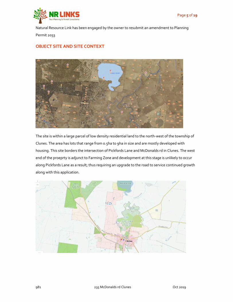
OBJECT SITE AND SITE CONTEXT
The site is within a large parcel of low density residential land to the north-west of the township of
Clunes. The area has lots that range from 0.5ha to 9ha in size and are mostly developed with
housing. This site borders the intersection of Pickfords Lane and McDonalds rd in Clunes. The west
end of the proeprty is adjunct to Farming Zone and development at this stage is unlikely to occur
along Pickfords Lane as a result; thus requiring an upgrade to the road to service continued growth
along with this application.

Page 6 of 19
981 235 McDonalds rd Clunes Oct 2019
The site has a drainage line that runs through the property as shown below the area around this
drainage line is covered by a LSIO overlay.
This area is not to be developed as part of this application
Page 7 of 19
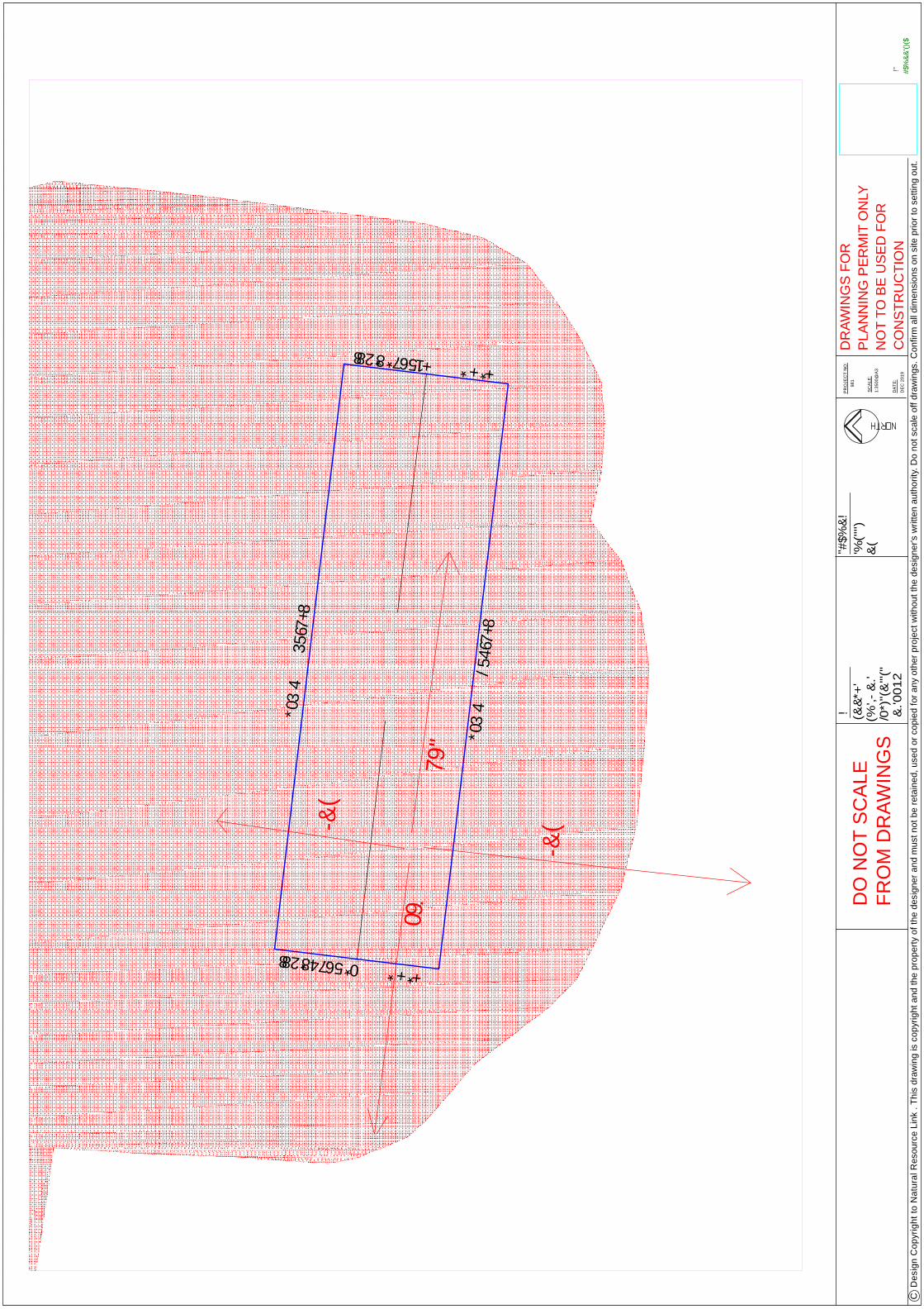
981 235 McDonalds rd Clunes Oct 2019
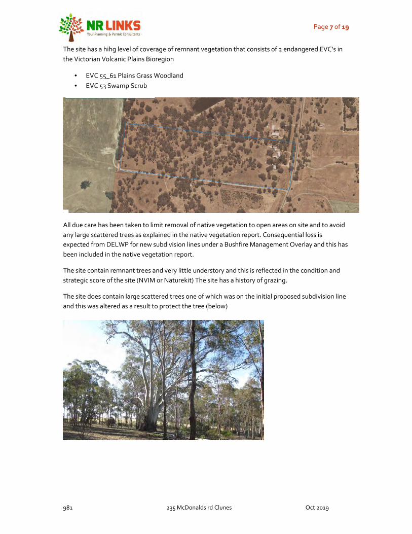
The site has a hihg level of coverage of remnant vegetation that consists of 2 endangered EVC’s in the Victorian Volcanic Plains Bioregion
• EVC 55_61 Plains Grass Woodland • EVC 53 Swamp Scrub
All due care has been taken to limit removal of native vegetation to open areas on site and to avoid any large scattered trees as explained in the native vegetation report. Consequential loss is expected from DELWP for new subdivision lines under a Bushfire Management Overlay and this has been included in the native vegetation report.
The site contain remnant trees and very little understory and this is reflected in the condition and strategic score of the site (NVIM or Naturekit) The site has a history of grazing.
The site does contain large scattered trees one of which was on the initial proposed subdivision line and this was altered as a result to protect the tree (below)

Page 8 of 19
981 235 McDonalds rd Clunes Oct 2019
There is an exisitng house on lot.2 that is partially screened from the road and has several sheds located nearby
Large shed to the south of the existing house.
Page 9 of 19
981 235 McDonalds rd Clunes Oct 2019
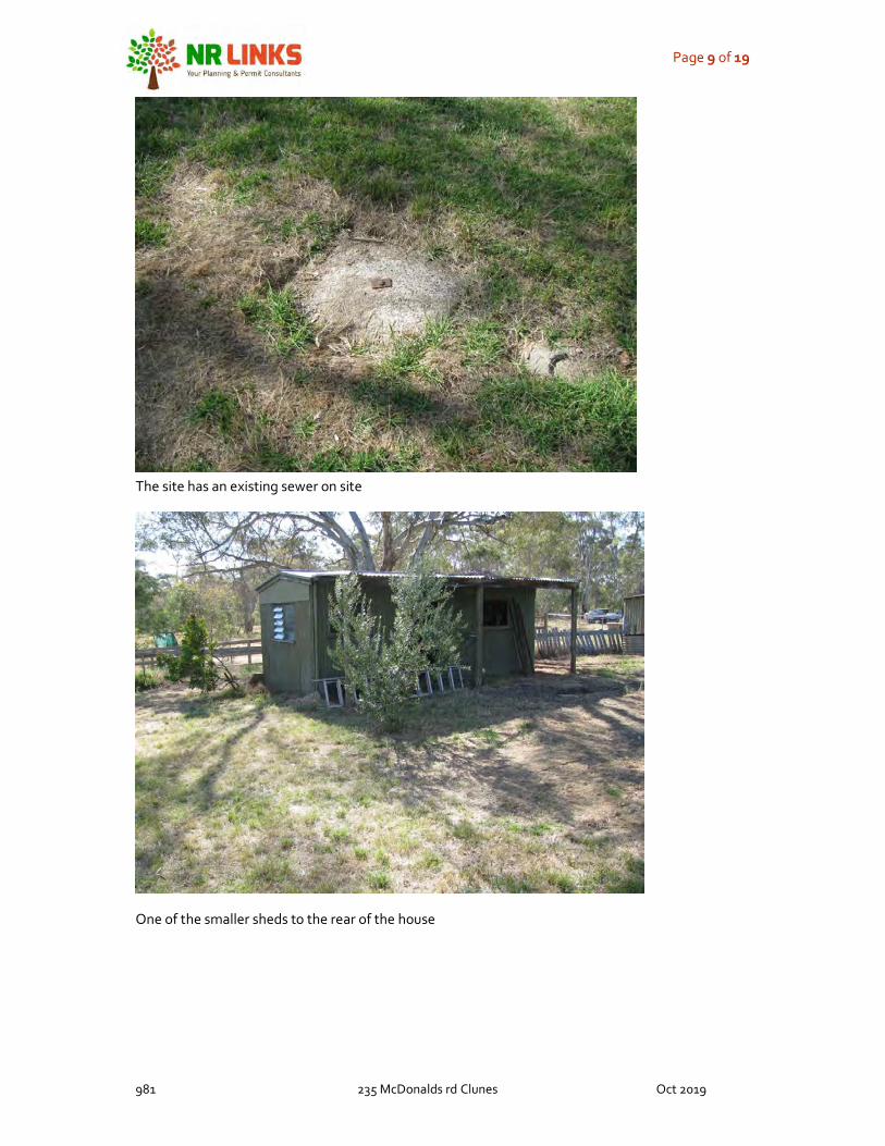
The site has an existing sewer on site
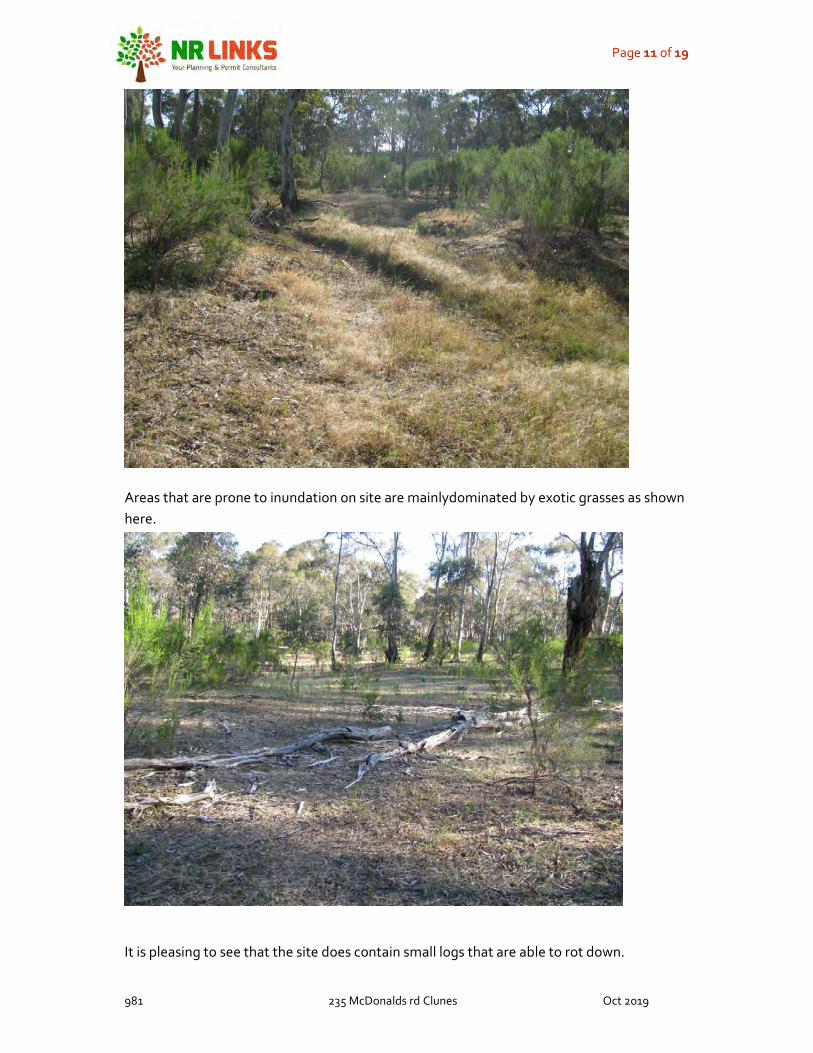
One of the smaller sheds to the rear of the house

Page 10 of 19
981 235 McDonalds rd Clunes Oct 2019
Smaller shed to the north end behind the house
Vegetation to the east of the site consisting of areas of recruitment (trees) and larger scattered trees with Cassinia and exotic grasses.
Page 11 of 19
981 235 McDonalds rd Clunes Oct 2019
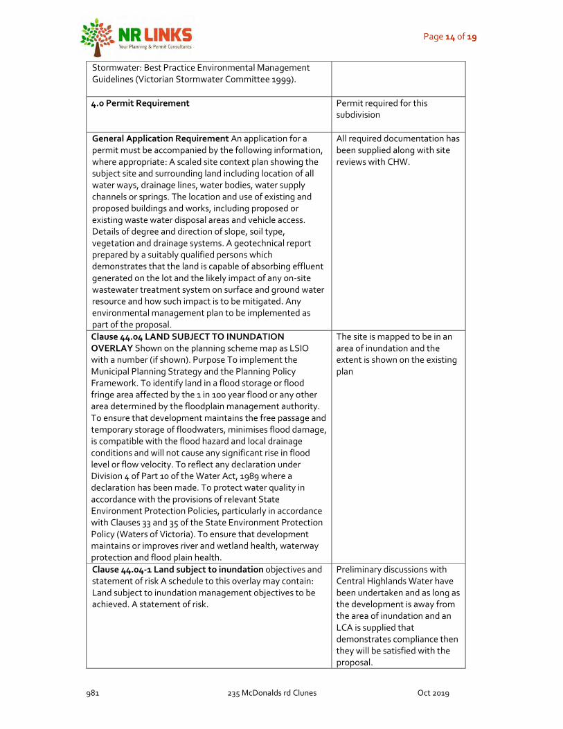
Areas that are prone to inundation on site are mainlydominated by exotic grasses as shown here.
It is pleasing to see that the site does contain small logs that are able to rot down.

Page 12 of 19
981 235 McDonalds rd Clunes Oct 2019
PROPOSAL
Planning approval is for a two-lot subdivision
Planning
Zones
Comment Clause 32.03 LOW DENSITY RESIDENTIAL ZONE Shown on the planning scheme map as LDRZ with a number (if shown). Purpose To implement the Municipal Planning Strategy and the Planning Policy Framework. To provide for low-density residential development on lots which, in the absence of reticulated sewerage, can treat and retain all wastewater.
The proposal proposes a two-lot subdivision.
Clause 32.03-3 Subdivision Permit requirement A permit is required to subdivide land. Each lot must be at least the area specified for the land in a schedule to this zone. Any area specified must be at least: 0.4 hectare for each lot where reticulated sewerage is not connected. If no area is specified each lot must be at least 0.4 hectare. 0.2 hectare for each lot with connected reticulated sewerage. If no area is specified each lot must be at least 0.2 hectare.
The proposed lots will be above 0.4ha and a LCA provide to demonstrate compliance.
Clause 32.03-5 1 Application requirements Subdivision An application must be accompanied by a site analysis, documenting the site in terms of land form, vegetation coverage and the relationship with surrounding land, and a report explaining how the proposed subdivision has responded to the site analysis. The report must: In the absence of reticulated sewerage, include a land assessment which demonstrates that each lot is capable of treating and retaining all wastewater in accordance with the State Environment Protection Policy (Waters of Victoria) under the Environment Protection Act 1970. Show for each lot: – A building envelope and driveway to the envelope. – Existing vegetation. – In the absence of reticulated sewerage, an effluent disposal area. Show how the proposed subdivision relates to the existing or likely use and development of adjoining and nearby land
The application includes a Land assessment for effluent, building envelopes, effluent areas, access and any natural features that are relevant. Including adjacent developments. A LCA has been included for both lots due to the large coverage of LSIO and a complexity of drainage lines and waterways on site.
Clause 32.03-6 Decision guidelines General Before deciding on an application, in addition to the decision guideline sin Clause 65, the responsible authority must consider, as appropriate: The Municipal Planning Strategy and the Planning Policy Framework. Subdivision The protection and enhancement of the natural environment and character of the area including the retention of vegetation and faunal habitat and the need to plant
The site contains remnant vegetation to a large proportion of the site which is significant in the Bioregion.

Page 13 of 19
981 235 McDonalds rd Clunes Oct 2019
vegetation along waterways, gullies, ridgelines and property boundaries. The availability and provision of utility services, including sewerage, water, drainage, electricity, gas and telecommunications. In the absence of reticulated sewerage: The capability of the lot to treat and retain all wastewater in accordance with the State Environment Protection Policy (Waters of Victoria) under the Environment Protection Act 1970. – The benefits of restricting the size of lots to the minimum required to treat and retain all wastewater in accordance with the State Environment Protection Policy (Waters of Victoria). – The benefits of restricting the size of lots to generally no more than 2 hectares to enable lots to be efficiently maintained without the need for agricultural techniques and equipment. The relevant standards of Clauses 56.07-1 to 56.07-4. SCHEDULE TO THE LOW-DENSITY RESIDENTIAL ZONE No minimum subdivision size
specified.
Overlays
Clause 42.01 ENVIRONMENTAL SIGNIFICANCE
OVERLAY Shown on the planning scheme map as ESO with a number. Purpose To implement the Municipal Planning Strategy and the Planning Policy Framework. To identify areas where the development of land may be affected by environmental constraints. To ensure that development is compatible with identified environmental values.
There is a waterway on site and an area of inundation that is not involved in the development.
Clause 42.01-2 Permit requirement A permit is required to:. Subdivide land. This does not apply if a schedule to this overlay specifically states that a permit is not required..
Permit is triggered
SCHEDULE 1 TO THE ENVIRONMENTAL SIGNIFICANCE
OVERLAY Shown on the planning scheme map as ESO1. PROCLAIMED CATCHMENT PROTECTION
Site is within a catchment
2.0 Environmental objective to be achieved To protect the quality of domestic water supplies within the Shire and the broader region. To maintain and where practicable enhance the quality and quantity of water within watercourses. To prevent increased runoff or concentration of surface water leading to erosion or siltation of watercourses. To prevent erosion of banks, streambeds adjoining land and siltation of watercourses, drains and other features. To prevent pollution and increased turbidity and nutrient levels of water in natural watercourses, water bodies and storages.
Application acknowledges the importance of protection to waterways within a catchment and proposes where possible to site effluent to flat areas over 100m away from a water way to minimise impact.
3.0 Mandatory Requirement All on-site wastewater must be treated and disposed of in accordance with the relevant EPA Code of Practice – On Site Wastewater Management. All stormwater must be managed and discharged to the satisfaction of the responsible Authority and generally in accordance with the principles described in Urban
LCA submitted
Page 14 of 19
981 235 McDonalds rd Clunes Oct 2019
Stormwater: Best Practice Environmental Management Guidelines (Victorian Stormwater Committee 1999).
4.0 Permit Requirement Permit required for this subdivision
General Application Requirement An application for a permit must be accompanied by the following information, where appropriate: A scaled site context plan showing the subject site and surrounding land including location of all water ways, drainage lines, water bodies, water supply channels or springs. The location and use of existing and proposed buildings and works, including proposed or existing waste water disposal areas and vehicle access. Details of degree and direction of slope, soil type, vegetation and drainage systems. A geotechnical report prepared by a suitably qualified persons which demonstrates that the land is capable of absorbing effluent generated on the lot and the likely impact of any on-site wastewater treatment system on surface and ground water resource and how such impact is to be mitigated. Any environmental management plan to be implemented as part of the proposal.
All required documentation has been supplied along with site reviews with CHW.
Clause 44.04 LAND SUBJECT TO INUNDATION
OVERLAY Shown on the planning scheme map as LSIO with a number (if shown). Purpose To implement the Municipal Planning Strategy and the Planning Policy Framework. To identify land in a flood storage or flood fringe area affected by the 1 in 100 year flood or any other area determined by the floodplain management authority. To ensure that development maintains the free passage and temporary storage of floodwaters, minimises flood damage, is compatible with the flood hazard and local drainage conditions and will not cause any significant rise in flood level or flow velocity. To reflect any declaration under Division 4 of Part 10 of the Water Act, 1989 where a declaration has been made. To protect water quality in accordance with the provisions of relevant State Environment Protection Policies, particularly in accordance with Clauses 33 and 35 of the State Environment Protection Policy (Waters of Victoria). To ensure that development maintains or improves river and wetland health, waterway protection and flood plain health.
The site is mapped to be in an area of inundation and the extent is shown on the existing plan
Clause 44.04-1 Land subject to inundation objectives and statement of risk A schedule to this overlay may contain: Land subject to inundation management objectives to be achieved. A statement of risk.
Preliminary discussions with Central Highlands Water have been undertaken and as long as the development is away from the area of inundation and an LCA is supplied that demonstrates compliance then they will be satisfied with the proposal.

Page 15 of 19
981 235 McDonalds rd Clunes Oct 2019
Clause 44.04-3 Subdivision A permit is required to subdivide land
Triggers a permit application for a subdivision. .
SCHEDULE TO THE LAND SUBJECT TO INUNDATION
OVERLAY
N/A
Clause 44.06 BUSHFIRE MANAGEMENT OVERLAY Shown on the planning scheme map as BMO with a number (if shown). Purpose To implement the Municipal Planning Strategy and the Planning Policy Framework. To ensure that the development of land prioritises the protection of human life and strengthens community resilience to bushfire. To identify areas where the bushfire hazard warrants bushfire protection measures to be implemented. To ensure development is only permitted where the risk to life and property from bushfire can be reduced to an acceptable level.
A Bushfire management report for the new lot has been undertaken and will complete all of the requirements for the Bushfire Management Overlay.
Particular Provisions
Clause 52.17 NATIVE VEGETATION Purpose To ensure that there is no net loss to biodiversity as a result of the removal, destruction or lopping of native vegetation. This is achieved by applying the following three step approach in accordance with the Guidelines for the removal, destruction or lopping of native vegetation (Department of Environment, Land, Water and Planning, 2017) (the Guidelines): 1. Avoid the removal, destruction or lopping of native vegetation. 2. Minimise impacts from the removal, destruction or lopping of native vegetation that cannot be avoided. 3. Provide an offset to compensate for the biodiversity impact if a permit is granted to remove, destroy or lop native vegetation. To manage the removal, destruction or lopping of native vegetation to minimise land and water degradation.
A native vegetation report has been supplied to show compliance to Clause 52.17

Page 16 of 19
981 235 McDonalds rd Clunes Oct 2019
CONCLUSION
The proposal seeks to provide a new lot to the rear of McDonalds Road which can comply with all the planning controls. The site is of enough size to contain offsets on site (First Party) and all due care has been taken to minimise the loss of native vegetation as the site does contain parts (trees)of endangered EVC’s.
There have been preliminary discussions with CHW in relation to developing the site for effluent and water. It is cost prohibitive to extend water and power down Pickfords Lane for only this one site; the road leads to Farming Zone and is unlikely to be developed for dwellings. So, in discussions with CHW and the owner it was decided to battle axe the rear lot to McDonalds rd so that it could connect into the water and power along McDonalds Rd. Typically if the land to the west was sufficiently zoned to allow for development then it would have been in the public interest to extend services down the side lane; however in relation to long term policies with Farming Zone this is unlikely to be changed in even a mid term range of 10-20 years. Currently to my knowledge there are no strategic works out to amend any of the farming zone land to the west of the site. There is good midterm potential to infill the current land areas of Low Density Residential.
The site is also heavily covered with vegetation that is listed as Endangered and has a large area of inundation as a result the potential to further develop this site other than what is proposed is quite difficult.
The proposal does meet the decision guidelines and objectives of the zoning and meets the requirements of the relevant overlays and planning provisions and should be approved by council.
.

Page 17 of 19
981 235 McDonalds rd Clunes Oct 2019
Appendix.1 Existing Plan

Not
e th
e co
ntra
ctor
shal
l ver
ify a
ll di
men
sion
s an
d al
l und
ergr
ound
ser
vice
s at
the
site
bef
ore
com
men
cing
wor
k. T
he c
ontr
acto
r sha
ll ve
rify
all l
evel
s fr
om th
eco
nsul
ting
engi
neer
prio
r to
cons
truc
tion.
C:\
Use
rs\N
RL\
Des
ktop
\squ
are.
pdf_
page
_1.jp
g
DO
NO
T S
CA
LEF
RO
M D
RA
WIN
GS
DR
AW
ING
S F
OR
PLA
NN
ING
PE
RM
IT O
NLY
NO
T T
O B
E U
SE
D F
OR
CO
NS
TR
UC
TIO
N C
D
esig
n C
opyr
ight
to
Nat
ural
Res
ourc
e Li
nk .
Thi
s dr
awin
g is
cop
yrig
ht a
nd th
e pr
oper
ty o
f the
des
igne
r an
d m
ust n
ot b
e re
tain
ed, u
sed
or c
opie
d fo
r an
y ot
her
proj
ect w
ithou
t the
des
igne
r's w
ritte
n au
thor
ity. D
o no
t sca
le o
ff dr
awin
gs. C
onfir
m a
ll di
men
sion
s on
site
prio
r to
set
ting
out.
LEG
EN
D
EX
IST
ING
DW
ELL
ING
SR
EM
NA
NT
VE
GE
TAT
ION
EX
ISIT
NG
SH
ED
S
NA
TU
RA
LR
ES
OU
RCE
LIN
K P
TY
LT
D19
4 V
icto
ria
Str
eet,
Bal
lara
t E
ast,
33
50
julie
@nr
link
s.co
m.a
u
PRO
PER
TY ID
ENTI
FIC
ATIO
NS
BLA
CK
- PR
OPE
RTY
AD
DR
ESS
BLU
E - A
LLO
TMEN
T N
UM
BER
OR
AN
GE
- CR
OW
N A
LLO
TMEN
TRE
D -
CR
OW
N S
ECTI
ON
PRO
JEC
T:D
WG
TIT
LE:
PR
OJE
CT
NO
:
DA
TE
:
SC
ALE
:
1:40
00@
A3
EX
IST
ING
PLA
N
DE
C 2
019
981
ALL
OT.
51
SE
C. E
PAR
ISH
OF
CLU
NE
S23
5 M
cDO
NA
LDS
RO
AD
CLU
NE
S 3
370
WA
TE
RW
AY
S /
DR
AIN
AG
E L
INE
SD
AM
SC
ON
TO
UR
S
EXIS
TIN
G S
ITE
INFO
RM
ATIO
N
SITE
DET
AIL
S -
BLO
CK
SIZ
E -
EXIS
ITN
G B
UIL
DIN
GS
-
INU
ND
AT
ION
OV
ER
LAY
PIC
KF
OR
DS
LA
NE
57 240
1 115
2 105
59 95
60 65
78 110
56 230
61 21
0
14 180
1 215
1 215
2 195
2 209
1 205
18 195
1 185
1
52 245
53 255
5 75
21E
MCDONALDS ROAD
MCDONALDS ROAD
FAW
CE
TT D
RIV
E
DR
IVE
FAIR
VIE
W
WORSLEY ROAD
MCDONALDS ROAD
538.
6m
89º4
1'
538.
6m
296º
41'
151.5m 179º45'50''
151.5m 359º46'50''
AL
LO
TM
EN
T 5
18
.15
9h
a
PIC
KF
OR
DS
LA
NE
21E
105

Page 18 of 19
981 235 McDonalds rd Clunes Oct 2019
Appendix.2 Proposed Plans

Not
e th
e co
ntra
ctor
shal
l ver
ify a
ll di
men
sion
s an
d al
l und
ergr
ound
ser
vice
s at
the
site
bef
ore
com
men
cing
wor
k. T
he c
ontr
acto
r sha
ll ve
rify
all l
evel
s fr
om th
eco
nsul
ting
engi
neer
prio
r to
cons
truc
tion.
DO
NO
T S
CA
LEF
RO
M D
RA
WIN
GS
DR
AW
ING
S F
OR
PLA
NN
ING
PE
RM
IT O
NLY
NO
T T
O B
E U
SE
D F
OR
CO
NS
TR
UC
TIO
N C
D
esig
n C
opyr
ight
to
Nat
ural
Res
ourc
e Li
nk .
Thi
s dr
awin
g is
cop
yrig
ht a
nd th
e pr
oper
ty o
f the
des
igne
r an
d m
ust n
ot b
e re
tain
ed, u
sed
or c
opie
d fo
r an
y ot
her
proj
ect w
ithou
t the
des
igne
r's w
ritte
n au
thor
ity. D
o no
t sca
le o
ff dr
awin
gs. C
onfir
m a
ll di
men
sion
s on
site
prio
r to
set
ting
out.
NA
TU
RA
LR
ES
OU
RCE
LIN
K P
TY
LT
D19
4 V
icto
ria
Str
eet,
Bal
lara
t E
ast,
33
50
julie
@nr
link
s.co
m.a
u
PRO
JEC
T:D
WG
TIT
LE:
PR
OJE
CT
NO
:
DA
TE
:
SC
ALE
:
1:60
00@
A3
PR
OP
OS
ED
PLA
N
DE
C 2
019
981
ALL
OT.
51
SE
C. E
PAR
ISH
OF
CLU
NE
S23
5 M
cDO
NA
LDS
RO
AD
CLU
NE
S 3
370
LEG
EN
D
DW
ELL
ING
S
GA
RA
GE
S /
CA
RP
OR
TS
RE
MN
AN
TV
EG
ETA
TIO
N
RO
AD
S
DA
MS
WA
TE
R W
AY
S
BU
ILD
ING
EN
VE
LOP
EP
RO
PO
SE
DA
CC
ES
S
MCDONALDS ROAD
151.5m 179º45'50''151.5m 179º45'50''
1000
0
1 215
1 215
2 195
2 209
1 205
18 195
52 245
53 255
MCDONALDS ROAD
MCDONALDS ROAD
FAIR
VIE
W
MCDONALDS ROAD
LO
T 1
4.5
44
ha
LO
T 2
3.5
9h
a
284.
06m
8
9º41
'
252.
8m
296
º41'
254.
6m
89º
41'
151.5m 359º46'50''
151.5m 179º45'50''
538.
6m
89º4
1'
538.
6m
296º
41'
151.5m 179º45'50''
151.5m 359º46'50''
AL
LO
TM
EN
T 5
18
.15
9h
a
1000
0
PIC
KF
OR
DS
LA
NE
BE
BE

Page 19 of 19
981 235 McDonalds rd Clunes Oct 2019
Appendix.3 Subdivision Plan

Not
e th
e co
ntra
ctor
shal
l ver
ify a
ll di
men
sion
s an
d al
l und
ergr
ound
ser
vice
s at
the
site
bef
ore
com
men
cing
wor
k. T
he c
ontr
acto
r sha
ll ve
rify
all l
evel
s fr
om th
eco
nsul
ting
engi
neer
prio
r to
cons
truc
tion.
DO
NO
T S
CA
LEF
RO
M D
RA
WIN
GS
DR
AW
ING
S F
OR
PLA
NN
ING
PE
RM
IT O
NLY
NO
T T
O B
E U
SE
D F
OR
CO
NS
TR
UC
TIO
N C
D
esig
n C
opyr
ight
to
Nat
ural
Res
ourc
e Li
nk .
Thi
s dr
awin
g is
cop
yrig
ht a
nd th
e pr
oper
ty o
f the
des
igne
r an
d m
ust n
ot b
e re
tain
ed, u
sed
or c
opie
d fo
r an
y ot
her
proj
ect w
ithou
t the
des
igne
r's w
ritte
n au
thor
ity. D
o no
t sca
le o
ff dr
awin
gs. C
onfir
m a
ll di
men
sion
s on
site
prio
r to
set
ting
out.
NA
TU
RA
LR
ES
OU
RCE
LIN
K P
TY
LT
D19
4 V
icto
ria
Str
eet,
Bal
lara
t E
ast,
33
50
julie
@nr
link
s.co
m.a
u
PRO
JEC
T:D
WG
TIT
LE:
PR
OJE
CT
NO
:
DA
TE
:
SC
ALE
:
1:60
00@
A3
SU
BD
IVIS
ION
PLA
N
DE
C 2
019
981
ALL
OT.
51
SE
C. E
PAR
ISH
OF
CLU
NE
S23
5 M
cDO
NA
LDS
RO
AD
CLU
NE
S 3
370
LEG
EN
D
DW
ELL
ING
S
GA
RA
GE
S /
CA
RP
OR
TS
RE
MN
AN
TV
EG
ETA
TIO
N
RO
AD
S
DA
MS
WA
TE
R W
AY
S
210
1 215
12
2 209
1 205
18 195
52 245
53 255
MCDONALDS ROAD
MCDONALDS ROADMCDONALDS ROAD
LO
T 1
4.5
44
ha
LO
T 2
3.5
9h
a
284.
06m
8
9º41
'
252.
8m
296
º41'
254.
6m
89º
41'
151.5m 359º46'50''
151.5m 179º45'50''
538.
6m
89º4
1'
538.
6m
296º
41'
151.5m 179º45'50''
151.5m 359º46'50''
AL
LO
TM
EN
T 5
18
.15
9h
a
1000
0
PIC
KF
OR
DS
LA
NE
MCDONALDS ROAD
151.5m 179º45'50''151.5m 179º45'50''
1000
0

Bushfire Management Report
For 235 McDonalds rd, Clunes
Report commissioned by
Ian Turner
October 2019
Page 2 of 27
981 235 McDonalds Rd Clunes… ….. Oct 2019
Bushfire Report for a two lot subdivision
235 McDonalds Rd, Clunes
Project: 981
Report prepared by: Julie Lee of Natural Resource Link Pty Ltd
Natural Resource Link Pty Ltd
ABN: 83 609 952 025
194 Victoria Street, Ballarat East, Vic, 3350
Ph: 0406 459 522
Email: [email protected]
Copyright
Natural Resource Link shall retain ownership of the reports and drawings, design, displays and other work produced by Natural Resource Link during the course of fulfilling a commission until final payment by the client.
Disclaimer
Natural Resource Link does not accept any liability for an error, omission or loss or other consequence that may arise from relying on this report. Bushfires are a complex set of inter-related activities and environmental parameters and that the onus is on the owner to ensure all due care is taken to manage the risk. The owners survival relies on constant vigilance, maintenance and a completed bushfire survival plan.
REV DATE DETAILS
A DRAFT 25/10/2019
B FINAL
C
D

Page 3 of 27
981 235 McDonalds Rd Clunes… ….. Oct 2019
Contents BUSHFIRE MANAGEMENT STATEMENT ........................................................................................................................... 4
Introduction ....................................................................................................................................................................... 5
Application Details ............................................................................................................................................................. 6
Site Description .................................................................................................................................................................. 6
Bushfire Landscape Assessment-Site .................................................................................................................................. 7
Bushfire Management Statement-Site .............................................................................................................................. 11
Bushfire Hazard Assessment-Lot.1. ................................................................................................................................... 14
Construction Level-Lot.1. .................................................................................................................................................. 15
Water Supply Requirement-Lot.1 ...................................................................................................................................... 16
Access Requirement-Lot.1 (55m) ....................................................................................................................................... 17
Appendix. One- Vegetation management standards ......................................................................................................... 18
Appendix Two - Water supply requirements ...................................................................................................................... 19
Appendix Three - Access requirements .............................................................................................................................. 21
Appendix Four - Bushfire Attack Levels (BALs) ................................................................................................................. 22
Appendix Five – Existing Plan ............................................................................................................................................ 23
Appendix 6– Subdivision Plan ........................................................................................................................................... 24
Appendix 7 – Landscape Risk Assessment-SITE .................................................................................................................25
Appendix 8– Site Assessment-Lot.1 ................................................................................................................................. 26
Appendix.9– Bushfire Management Plan-Lot.1. ................................................................................................................ 27
Page 4 of 27
981 235 McDonalds Rd Clunes… ….. Oct 2019
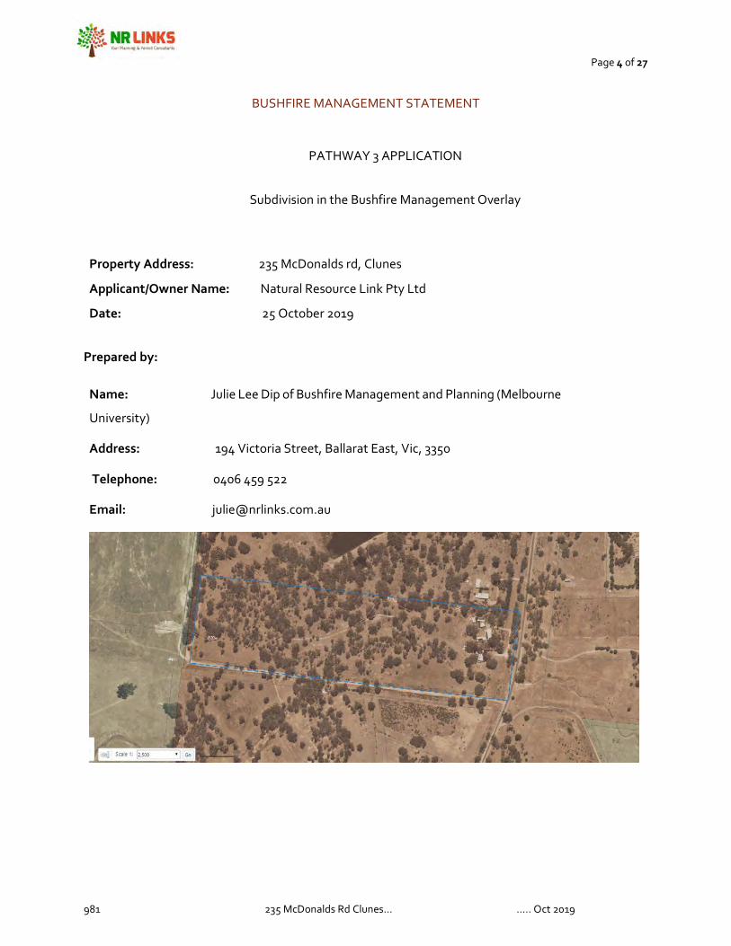
BUSHFIRE MANAGEMENT STATEMENT
PATHWAY 3 APPLICATION
Subdivision in the Bushfire Management Overlay
Property Address: 235 McDonalds rd, Clunes
Applicant/Owner Name: Natural Resource Link Pty Ltd
Date: 25 October 2019
Prepared by:
Name: Julie Lee Dip of Bushfire Management and Planning (Melbourne
University)
Address: 194 Victoria Street, Ballarat East, Vic, 3350
Telephone: 0406 459 522
Email: [email protected]
Page 5 of 27
981 235 McDonalds Rd Clunes… ….. Oct 2019
Introduction
This Bushfire Management Statement has been prepared in response to the requirements of Clause 44.06-1 – Bushfire Management Overlay, and in accordance with the application requirements of Clause 52.47 – Planning for Bushfire.
The statement contains three components:
1. A bushfire hazard landscape assessment including a plan that describes the bushfire hazard of the general locality more than 150 metres from the site. Photographs or other techniques may be used to assist in describing the bushfire hazard.
2. A bushfire hazard site assessment including a plan that describes the bushfire hazard within 150 metres of the proposed development. The description of the
hazard must be prepared in accordance with Section 2.2.3 to 2.2.5 of
AS3959:2009 Construction of buildings in bushfire prone areas (Standards
Australia). Photographs or other techniques maybe used to assist in describing the bushfire hazard.
3. A bushfire management statement describing how the proposed
development responds to the requirements of Clause 44.06 and 52.47.

Page 6 of 27
981 235 McDonalds Rd Clunes… ….. Oct 2019
Application Details
Municipality:
Hepburn Council
Title description:
Allot 51 Sec E Parish of Clunes
Overlays:
Bushfire Management Overlay (BMO), Environmental Significant Overlay (ESO). Land Subject to Inundation (LSIO)
Zoning: Low Density Residential Zone
Site Description
Site shape:
Rectangle
Site Dimensions:
151m x 540 m
Site Area
8ha
Existing use and
siting of buildings
and works on and
near the land:
Low Density Residential area
Existing vehicle
arrangements:
Existing house has existing driveway
Location of nearest fire hydrant:
None
Any other features of
the site relevant to
bushfire
considerations:
No

Page 7 of 27
981 235 McDonalds Rd Clunes… ….. Oct 2019
Bushfire Landscape Assessment-Site
The landscape scenario that represents this is Broader Landscape Type Two as the site is within an area that
is well managed and has access via sealed roads to a place of safety. There is access to safety back to the
township of Clunes. The site is on the interfaces with surrounding farmland that is used for dryland cropping
and grazing purposes. The surrounding landscape does contain areas of crown land reserves.
The area in low density has some coverage of native vegetation across the site around that is farming zone
that is mostly clear.
Page 8 of 27
981 235 McDonalds Rd Clunes… ….. Oct 2019
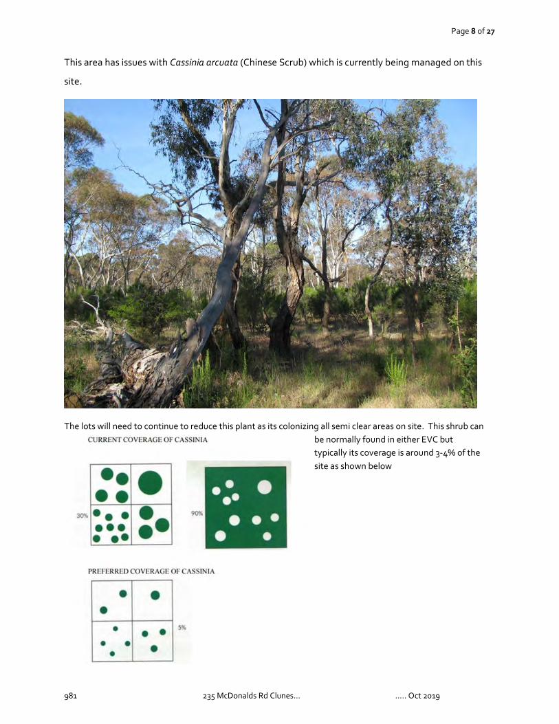
This area has issues with Cassinia arcuata (Chinese Scrub) which is currently being managed on this
site.
The lots will need to continue to reduce this plant as its colonizing all semi clear areas on site. This shrub can be normally found in either EVC but typically its coverage is around 3-4% of the site as shown below

Page 9 of 27
981 235 McDonalds Rd Clunes… ….. Oct 2019
The profile to the North-west of the site is fragmented by fuel loads; areas of high density under low
elevation rises and open areas of pasture. This can mean that the fire travels more slowly in the high fuel
load areas but is impacted heavily by winds once out in the open pasture. Rises in elevations are below
100m giving rise to a low risk of ember density to site.
The are where the arrow is placed is a point close to the site where there is a rapid rise in elevation through
a high fuel load area a landscape fire through this area would typically impact embers to site. There would
also be a large increase in fire intensity (slope affect) and would enable the fire to reach the canopy and
increase risk to site.
A more gradual
increase in elevation
is present from the
north and through
areas of high and
low-moderate fuel
loads. A low risk of
ember density to site
would be expected.

Page 10 of 27
981 235 McDonalds Rd Clunes… ….. Oct 2019
A short run to the south-west of the site (southerly change risk) with the site being down on a
lower level but sufficiently away that there would only be a low decrease in wind speed as a result.
The site if impacted with a south-west change could potentially push out a flank into a large head
fire given the right conditions.
The vegetation is fragmented but of sufficient length to enable a fire to reach residence time and to
reach the canopy. Couple this with the moderate bark risk and slope and the potential for increases in
intensity from the surrounding landscape is possible. A large landscape fire could potentially impact
houses in the area; the site is well serviced by sealed roads with at least two exit points one to the
north-east and the other to the south. There is good to very good mobile reception to enable
warnings to go out to home owners.
What is the likely fire behaviour impacting the site?
The likely bushfire behavior from the north-west to the site is a fragmented forest-pasture fire
through steep undulating and that is less than 100m in height producing a low density of ember
to the site. The undulation enables the fire to have flame lengths that would encompass the
canopy.

Page 11 of 27
981 235 McDonalds Rd Clunes… ….. Oct 2019
Bushfire Management Statement-Site CLAUSE
COMMENT
Clause 13.02-1S Reduce human risk to an acceptable level The subdivision takes into account the landscape risk
and also deals with how that risk can be further mitigated.
Applies best science to identify vegetation, topography and climatic conditions that create a bushfire hazard
Assessment use review of topography including height and classifiable vegetation in landscape review. This highlights any issues of rapid or extensive increases that will pose a medium to elevated risk of ember density to site.
Consider siting Siting has been considered and all lots can comply with current regulations. Building envelopes are sited as far as possible away from risk.
Address Landscape risk Landscape risk is addressed and considered for the siting of the building envelopes.
Ensure biodiversity and environmental objectives are compatible
Site contains an endangered EVC’s and reducing impact has been a high priority behind human safety.
Ensure easy implementation of mitigation requirements
Mitigation of the landscape risk has been occurring with local council advising land holders to reduce the extent of the Cassina on site
Ensure access and egress are compatible for emergency vehicle access
The site provides good clear and level egress for emergency vehicles.
Clause 44.06 Prioritises protection of human life Human life does have a priority and all due care has
been taken to ensure that all risks have been included and the proposal can achieve compliance.
Clause 44.06-1 A permit is required to subdivide A permit is required to subdivide Clause 44.06-2 Must meet Clause 52.47 Clause 44.06-3
Mandatory Section 173 required for a new single lot in rural or residential rural purposes. To be constructed in conjunction with what is specified in the Bushfire Management Plan
Specified building envelopes are recommended to ensure that siting objectives are considered.
Clause 53.02
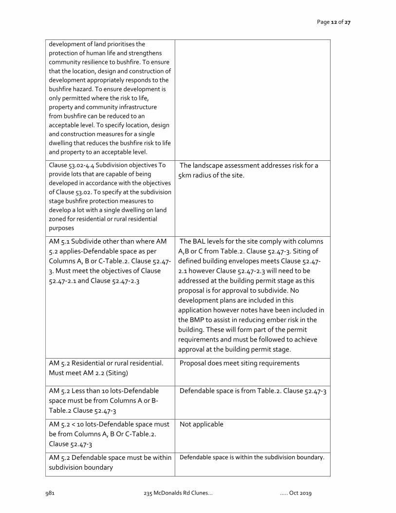
Purpose To implement the Municipal Planning Strategy and the Planning Policy Framework. To ensure that the
Site assessment considers all classifiable vegetation within a 15om radius
Page 12 of 27
981 235 McDonalds Rd Clunes… ….. Oct 2019
development of land prioritises the protection of human life and strengthens community resilience to bushfire. To ensure that the location, design and construction of development appropriately responds to the bushfire hazard. To ensure development is only permitted where the risk to life, property and community infrastructure from bushfire can be reduced to an acceptable level. To specify location, design and construction measures for a single dwelling that reduces the bushfire risk to life and property to an acceptable level.
Clause 53.02-4.4 Subdivision objectives To provide lots that are capable of being developed in accordance with the objectives of Clause 53.02. To specify at the subdivision stage bushfire protection measures to develop a lot with a single dwelling on land zoned for residential or rural residential purposes
The landscape assessment addresses risk for a 5km radius of the site.
AM 5.1 Subdivide other than where AM 5.2 applies-Defendable space as per Columns A, B or C-Table.2. Clause 52.47-3. Must meet the objectives of Clause 52.47-2.1 and Clause 52.47-2.3
The BAL levels for the site comply with columns A,B or C from Table.2. Clause 52.47-3. Siting of defined building envelopes meets Clause 52.47-2.1 however Clause 52.47-2.3 will need to be addressed at the building permit stage as this proposal is for approval to subdivide. No development plans are included in this application however notes have been included in the BMP to assist in reducing ember risk in the building. These will form part of the permit requirements and must be followed to achieve approval at the building permit stage.
AM 5.2 Residential or rural residential. Must meet AM 2.2 (Siting)
Proposal does meet siting requirements
AM 5.2 Less than 10 lots-Defendable space must be from Columns A or B-Table.2 Clause 52.47-3
Defendable space is from Table.2. Clause 52.47-3
AM 5.2 < 10 lots-Defendable space must be from Columns A, B Or C-Table.2. Clause 52.47-3
Not applicable
AM 5.2 Defendable space must be within subdivision boundary
Defendable space is within the subdivision boundary.
Page 13 of 27
981 235 McDonalds Rd Clunes… ….. Oct 2019
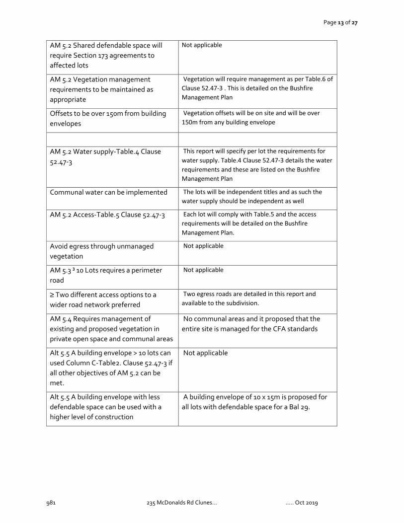
AM 5.2 Shared defendable space will require Section 173 agreements to affected lots
Not applicable
AM 5.2 Vegetation management requirements to be maintained as appropriate
Vegetation will require management as per Table.6 of
Clause 52.47-3 . This is detailed on the Bushfire
Management Plan
Offsets to be over 150m from building envelopes
Vegetation offsets will be on site and will be over
150m from any building envelope
AM 5.2 Water supply-Table.4 Clause 52.47-3
This report will specify per lot the requirements for
water supply. Table.4 Clause 52.47-3 details the water
requirements and these are listed on the Bushfire
Management Plan
Communal water can be implemented The lots will be independent titles and as such the
water supply should be independent as well
AM 5.2 Access-Table.5 Clause 52.47-3 Each lot will comply with Table.5 and the access
requirements will be detailed on the Bushfire
Management Plan.
Avoid egress through unmanaged vegetation
Not applicable
AM 5.3 ³ 10 Lots requires a perimeter road
Not applicable
≥ Two different access options to a wider road network preferred
Two egress roads are detailed in this report and
available to the subdivision.
AM 5.4 Requires management of existing and proposed vegetation in private open space and communal areas
No communal areas and it proposed that the entire site is managed for the CFA standards
Alt 5.5 A building envelope > 10 lots can used Column C-Table2. Clause 52.47-3 if all other objectives of AM 5.2 can be met.
Not applicable
Alt 5.5 A building envelope with less defendable space can be used with a higher level of construction
A building envelope of 10 x 15m is proposed for all lots with defendable space for a Bal 29.

Page 14 of 27
981 235 McDonalds Rd Clunes… ….. Oct 2019
Bushfire Hazard Assessment-Lot.1.
Classify the vegetation within 150 metres of the proposed development in accordance with AS3959:2009 Construction of buildings in bushfire prone areas.
Direction (Aspect)
N
S
W
E
Vegetation
(within 150 metres
of subdivision)
Excludable / Low
Threat ☐
Modified ☐
Forest ☐
Woodland √
Scrub (tall) ☐
Shrubland (short) ☐
Mallee ☐
Rainforest ☐
Grassland ☐
Excludable / Low
Threat ☐
Modified ☐
Forest ☐
Woodland √
Scrub (tall) ☐
Shrubland (short) ☐
Mallee ☐
Rainforest ☐
Grassland ☐
Excludable / Low
Threat ☐
Modified ☐
Forest ☐
Woodland √
Scrub (tall) ☐
Shrubland (short) ☐
Mallee ☐
Rainforest ☐
Grassland ☐
Excludable / Low
Threat ☐
Modified ☐
Forest ☐
Woodland √
Scrub (tall) ☐
Shrubland (short) ☐
Mallee ☐
Rainforest ☐
Grassland ☐
Effective
Slope
(under the
classifiable
vegetation within
150 metres)
Upslope / Flat √
DOWNSLOPE
>0 to 5 ° ☐
>5 to 10° ☐
>10° to 15° ☐
>15 to 20° ☐
Upslope / Flat √
DOWNSLOPE
>0 to 5 ° ☐
>5 to 10° ☐
>10° to 15° ☐
>15 to 20° ☐
Upslope / Flat √
DOWNSLOPE
>0 to 5 ° ☐
>5 to 10° ☐
>10° to 15° ☐
>15 to 20° ☐
Upslope / Flat ☐
DOWNSLOPE
>0 to 5 ° √
>5 to 10° ☐
>10° to 15° ☐
>15 to 20° ☐
Defendable
space(m) and
BAL
16m
BAL 29
16m
BAL 29
16m
BAL 29
21m
BAL 29

Page 15 of 27
981 235 McDonalds Rd Clunes… ….. Oct 2019
Construction Level-Lot.1.
A building is constructed to the bushfire attack level:
That corresponds to the defendable space provided in accordance with Table 2 column A, B or C to Clause 52.47-3. The building will be constructed to BAL 29
The bushfire attack level that corresponds to the defendable space provided in accordance with
Table.2 must be noted on the building envelope.
Defendable space must be wholly contained within the boundaries of the proposed subdivision.
Defendable space maybe shared between lots within the subdivision
Any other comments
The bushfire risk to the development from the landscape beyond the site can be mitigated
to an acceptable level.
The risk from the landscape has been mitigated with the following conditions
which will provide a higher level of protection from embers:
o All external doors to be protected with non-combustible screens that
comply with Clause 7.5.1.A (AS3959-2009)
o If using a metal roof place, a non-combustible insulation to all joins and edge of the
roof to prevent the entry of embers. The building is a square and limits re-entry corners
with a simplified one level roof design.
Page 16 of 27
981 235 McDonalds Rd Clunes… ….. Oct 2019
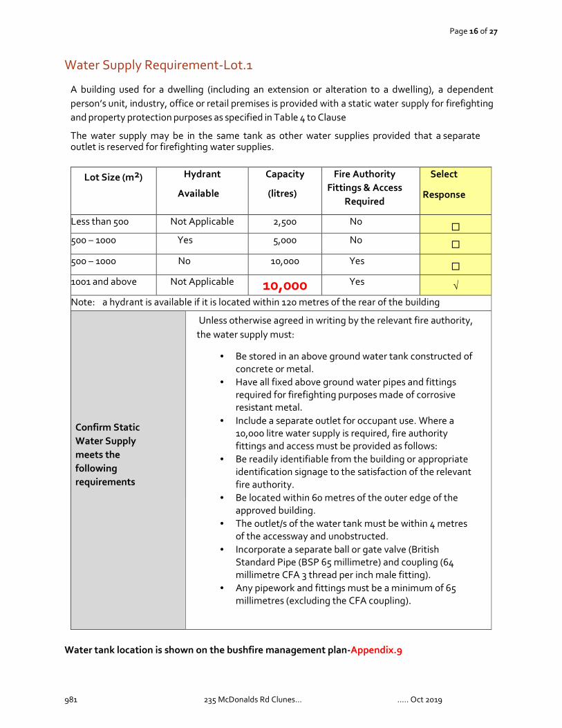
Water Supply Requirement-Lot.1
A building used for a dwelling (including an extension or alteration to a dwelling), a dependent person’s unit, industry, office or retail premises is provided with a static water supply for firefighting and property protection purposes as specified in Table 4 to Clause
The water supply may be in the same tank as other water supplies provided that a separate outlet is reserved for firefighting water supplies.
Lot Size (m2) Hydrant
Available
Capacity
(litres)
Fire Authority Fittings & Access
Required
Select
Response
Less than 500 Not Applicable 2,500 No ☐
500 – 1000 Yes 5,000 No ☐
500 – 1000 No 10,000 Yes ☐
1001 and above Not Applicable 10,000 Yes √
Note: a hydrant is available if it is located within 120 metres of the rear of the building
Confirm Static Water Supply meets the following requirements
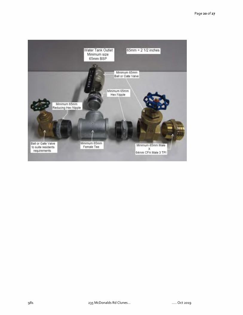
Unless otherwise agreed in writing by the relevant fire authority, the water supply must:
• Be stored in an above ground water tank constructed of concrete or metal.
• Have all fixed above ground water pipes and fittings required for firefighting purposes made of corrosive resistant metal.
• Include a separate outlet for occupant use. Where a 10,000 litre water supply is required, fire authority fittings and access must be provided as follows:
• Be readily identifiable from the building or appropriate identification signage to the satisfaction of the relevant fire authority.
• Be located within 60 metres of the outer edge of the approved building.
• The outlet/s of the water tank must be within 4 metres of the accessway and unobstructed.
• Incorporate a separate ball or gate valve (British Standard Pipe (BSP 65 millimetre) and coupling (64 millimetre CFA 3 thread per inch male fitting).
• Any pipework and fittings must be a minimum of 65 millimetres (excluding the CFA coupling).
Water tank location is shown on the bushfire management plan-Appendix.9
Page 17 of 27
981 235 McDonalds Rd Clunes… ….. Oct 2019
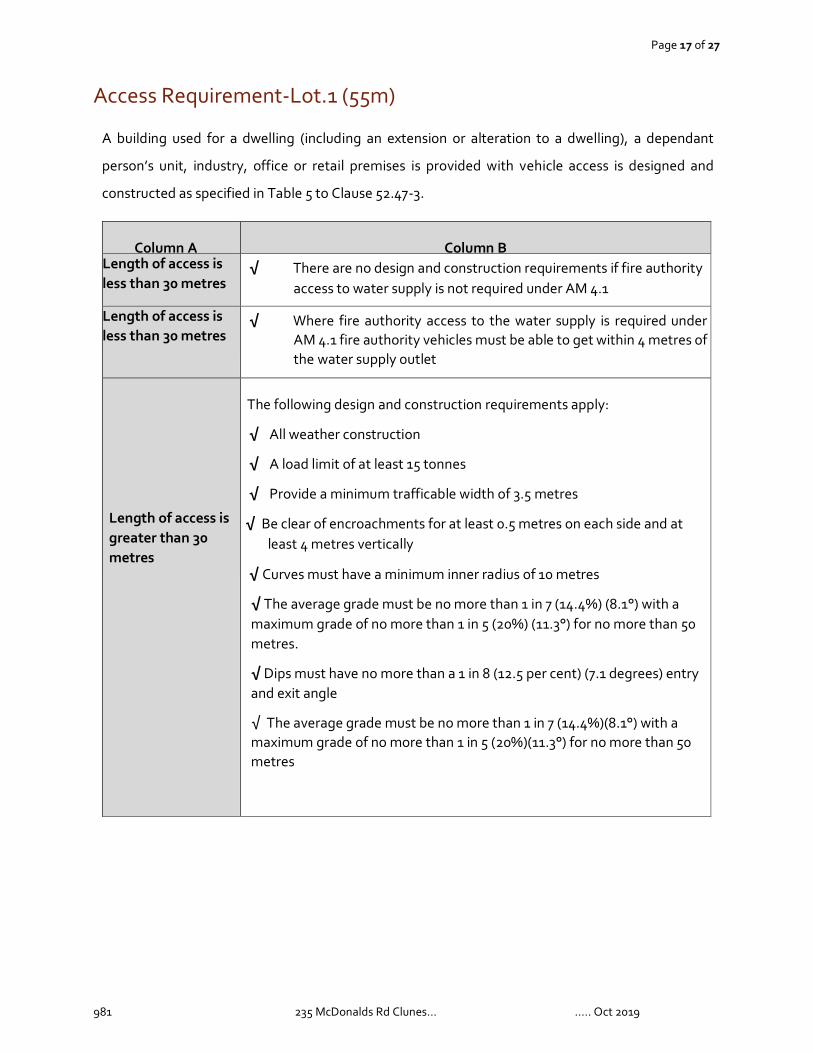
Access Requirement-Lot.1 (55m)
A building used for a dwelling (including an extension or alteration to a dwelling), a dependant
person’s unit, industry, office or retail premises is provided with vehicle access is designed and
constructed as specified in Table 5 to Clause 52.47-3.
Column A
Column B Length of access is less than 30 metres
√ There are no design and construction requirements if fire authority access to water supply is not required under AM 4.1
Length of access is less than 30 metres
√ Where fire authority access to the water supply is required under AM 4.1 fire authority vehicles must be able to get within 4 metres of the water supply outlet
Length of access is greater than 30 metres
The following design and construction requirements apply:
√ All weather construction
√ A load limit of at least 15 tonnes
√ Provide a minimum trafficable width of 3.5 metres
√ Be clear of encroachments for at least 0.5 metres on each side and at least 4 metres vertically
√ Curves must have a minimum inner radius of 10 metres
√ The average grade must be no more than 1 in 7 (14.4%) (8.1°) with a maximum grade of no more than 1 in 5 (20%) (11.3°) for no more than 50 metres.
√ Dips must have no more than a 1 in 8 (12.5 per cent) (7.1 degrees) entry and exit angle
√ The average grade must be no more than 1 in 7 (14.4%)(8.1°) with a maximum grade of no more than 1 in 5 (20%)(11.3°) for no more than 50 metres

Page 18 of 27
981 235 McDonalds Rd Clunes… ….. Oct 2019
Appendix. One- Vegetation management standards
Vegetation management standards for the defendable space are provided below
Table 6 Clause 52.47-3
Vegetation management requirement
Defendable space is provided and is managed in accordance with the following requirements:
• Grass must be short cropped and maintained during the declared fire danger period.
• All leaves and vegetation debris must be removed at regular intervals during the declared fire
danger period.
• Within 10 metres of a building, flammable objects must not be located close to the vulnerable
parts of the building.
• Plants greater than 10 centimetres in height must not be placed within 3 metres of a window
or glass feature of the building.
• Shrubs must not be located under the canopy of trees.
• Individual and clumps of shrubs must not exceed 5 square metres in area and must be
separated by at least 5 metres.
• Trees must not overhang or touch any elements of the building. ♣ The canopy of trees must
be separated by at least 5 metres.
• There must be a clearance of at least 2 metres between the lowest tree branches and ground
level.

Page 19 of 27
981 235 McDonalds Rd Clunes… ….. Oct 2019
Appendix Two - Water supply requirements
Unless otherwise agreed in writing by the relevant fire authority, the water supply must:
• Be stored in an above ground water tank constructed of concrete or metal. • Have all fixed above ground water pipes and fittings required for firefighting purposes
made of corrosive resistant metal. • Include a separate outlet for occupant use. Where a 10,000 litre water supply is
required, fire authority fittings and access must be provided as follows: • Be readily identifiable from the building or appropriate identification signage to the
satisfaction of the relevant fire authority. • Be located within 60 metres of the outer edge of the approved building. • The outlet/s of the water tank must be within 4 metres of the accessway and
unobstructed. • Incorporate a separate ball or gate valve (British Standard Pipe (BSP 65 millimetre)
and coupling (64 millimetre CFA 3 thread per inch male fitting). • Any pipework and fittings must be a minimum of 65 millimetres (excluding the CFA
coupling
Page 20 of 27
981 235 McDonalds Rd Clunes… ….. Oct 2019

Page 21 of 27
981 235 McDonalds Rd Clunes… ….. Oct 2019
Appendix Three - Access requirements
Access 30m to 100m
The following design and construction requirements apply:
√ All weather construction
√ A load limit of at least 15 tonnes
√ Provide a minimum trafficable width of 3.5 metres
√ Be clear of encroachments for at least 0.5 metres on each side and at least 4 metres vertically
√ Curves must have a minimum inner radius of 10 metres
√ The average grade must be no more than 1 in 7 (14.4%) (8.1°) with a maximum grade of no more than 1 in 5 (20%) (11.3°) for no more than 50 metres.
√ Dips must have no more than a 1 in 8 (12.5 per cent) (7.1 degrees) entry and exit angle
√ The average grade must be no more than 1 in 7 (14.4%)(8.1°) with a maximum grade of no more than 1 in 5 (20%)(11.3°) for no more than 50 metres

Page 22 of 27
981 235 McDonalds Rd Clunes… ….. Oct 2019
Appendix Four - Bushfire Attack Levels (BALs)

Page 23 of 27
981 235 McDonalds Rd Clunes… ….. Oct 2019
Appendix Five – Existing Plan

Not
e th
e co
ntra
ctor
shal
l ver
ify a
ll di
men
sion
s an
d al
l und
ergr
ound
ser
vice
s at
the
site
bef
ore
com
men
cing
wor
k. T
he c
ontr
acto
r sha
ll ve
rify
all l
evel
s fr
om th
eco
nsul
ting
engi
neer
prio
r to
cons
truc
tion.
C:\
Use
rs\N
RL\
Des
ktop
\squ
are.
pdf_
page
_1.jp
g
DO
NO
T S
CA
LEF
RO
M D
RA
WIN
GS
DR
AW
ING
S F
OR
PLA
NN
ING
PE
RM
IT O
NLY
NO
T T
O B
E U
SE
D F
OR
CO
NS
TR
UC
TIO
N C
D
esig
n C
opyr
ight
to
Nat
ural
Res
ourc
e Li
nk .
Thi
s dr
awin
g is
cop
yrig
ht a
nd th
e pr
oper
ty o
f the
des
igne
r an
d m
ust n
ot b
e re
tain
ed, u
sed
or c
opie
d fo
r an
y ot
her
proj
ect w
ithou
t the
des
igne
r's w
ritte
n au
thor
ity. D
o no
t sca
le o
ff dr
awin
gs. C
onfir
m a
ll di
men
sion
s on
site
prio
r to
set
ting
out.
LEG
EN
D
EX
IST
ING
DW
ELL
ING
SR
EM
NA
NT
VE
GE
TAT
ION
EX
ISIT
NG
SH
ED
S
NA
TU
RA
LR
ES
OU
RCE
LIN
K P
TY
LT
D19
4 V
icto
ria
Str
eet,
Bal
lara
t E
ast,
33
50
julie
@nr
link
s.co
m.a
u
PRO
PER
TY ID
ENTI
FIC
ATIO
NS
BLA
CK
- PR
OPE
RTY
AD
DR
ESS
BLU
E - A
LLO
TMEN
T N
UM
BER
OR
AN
GE
- CR
OW
N A
LLO
TMEN
TRE
D -
CR
OW
N S
ECTI
ON
PRO
JEC
T:D
WG
TIT
LE:
PR
OJE
CT
NO
:
DA
TE
:
SC
ALE
:
1:40
00@
A3
EX
IST
ING
PLA
N
DE
C 2
019
981
ALL
OT.
51
SE
C. E
PAR
ISH
OF
CLU
NE
S23
5 M
cDO
NA
LDS
RO
AD
CLU
NE
S 3
370
WA
TE
RW
AY
S /
DR
AIN
AG
E L
INE
SD
AM
SC
ON
TO
UR
S
EXIS
TIN
G S
ITE
INFO
RM
ATIO
N
SITE
DET
AIL
S -
BLO
CK
SIZ
E -
EXIS
ITN
G B
UIL
DIN
GS
-
INU
ND
AT
ION
OV
ER
LAY
PIC
KF
OR
DS
LA
NE
57 240
1 115
2 105
59 95
60 65
78 110
56 230
61 21
0
14 180
1 215
1 215
2 195
2 209
1 205
18 195
1 185
1
52 245
53 255
5 75
21E
MCDONALDS ROAD
MCDONALDS ROAD
FAW
CE
TT D
RIV
E
DR
IVE
FAIR
VIE
W
WORSLEY ROAD
MCDONALDS ROAD
538.
6m
89º4
1'
538.
6m
296º
41'
151.5m 179º45'50''
151.5m 359º46'50''
AL
LO
TM
EN
T 5
18
.15
9h
a
PIC
KF
OR
DS
LA
NE
21E
105

Page 24 of 27
981 235 McDonalds Rd Clunes… ….. Oct 2019
Appendix 6– Subdivision Plan

������
������
����
��
��� �
�����
������
������
����
������
����
�����
�����
�����
������
�����
������
������
�����
������
����
����
�� ��
�����
��� ��
�����
����
������
������
������
����
�����
�����
������
DO
NO
T S
CA
LEF
RO
M D
RA
WIN
GS
DR
AW
ING
S F
OR
PLA
NN
ING
PE
RM
IT O
NLY
NO
T T
O B
E U
SE
D F
OR
CO
NS
TR
UC
TIO
N C
D
esig
n C
opyr
ight
to
Nat
ural
Res
ourc
e Li
nk .
Thi
s dr
awin
g is
cop
yrig
ht a
nd th
e pr
oper
ty o
f the
des
igne
r an
d m
ust n
ot b
e re
tain
ed, u
sed
or c
opie
d fo
r an
y ot
her
proj
ect w
ithou
t the
des
igne
r's w
ritte
n au
thor
ity. D
o no
t sca
le o
ff dr
awin
gs. C
onfir
m a
ll di
men
sion
s on
site
prio
r to
set
ting
out.
������
����
���
���� �
�� ���
��� ��
������
�����
�����
�����
�����
!"
#$���
%&
���&
'�(��)
(�$
�����
�!"#
$��%
�&�!
PR
OJE
CT
NO
:
DA
TE
:
SC
ALE
:
1:60
00@
A3
SU
BD
IVIS
ION
�&'�
DE
C 2
019
981
'&&
����(
)�*�
���
�'�%
*+��,
� &-�
�*./(
�0�"
��'&
"*���
'" &
-��*
�//1
2
&�$
��"
"#�&
&%
�$*
$'�'
$�*
�3 '�
����*
RE
MN
AN
T4
�$��'
�%��
��'"*
"'0*
#'��
��#'5
*
.)2
) .)(
).
. .26
) .2(
)7 )6(
(. .8(
(/ .((
MCDONALDS ROAD
MCDONALDS ROADMCDONALDS ROAD
� �� �
�� �
� ��
� �
� ��
� ��
. 78�
29�
����7
6:8)
;
. (. �
7����
�.69
:8) ;
. (8�
9����
�76:
8);
)()�(�����/(6:89;(2;;
)()�(�����)16:8(;(2;;
(/7�
9����
�76:
8);
( /7�
9����
�.69
:8) ;
)()�(�����)16:8(;(2;;
)()�(�����/(6:89;(2;;
�� �
�� �
� �� �
� �� �
� �
1000
0
PIC
KF
OR
DS
LA
NE
MCDONALDS ROAD
)()�(�����)16:8(;(2;;)()�(�����)16:8(;(2;;
1000
0

Page 25 of 27
981 235 McDonalds Rd Clunes… ….. Oct 2019
Appendix 7 – Landscape Risk Assessment-SITE

Not
e th
e co
ntra
ctor
shal
l ver
ify a
ll di
men
sion
s an
d al
l und
ergr
ound
ser
vice
s at
the
site
bef
ore
com
men
cing
wor
k. T
he c
ontr
acto
r sha
ll ve
rify
all l
evel
s fr
om th
eco
nsul
ting
engi
neer
prio
r to
cons
truc
tion.
PRO
JEC
T:D
WG
TIT
LE:
PR
OJE
CT
NO
:
DA
TE
:
SC
ALE
:
1:35
00@
A3
LAN
DS
CP
E R
ISK
AS
SE
SS
ME
NT
PLA
N
DO
NO
T S
CA
LEF
RO
M D
RA
WIN
GS
DR
AW
ING
S F
OR
PLA
NN
ING
PE
RM
IT O
NLY
NO
T T
O B
E U
SE
D F
OR
CO
NS
TR
UC
TIO
N C
D
esig
n C
opyr
ight
to
Nat
ural
Res
ourc
e Li
nk .
Thi
s dr
awin
g is
cop
yrig
ht a
nd th
e pr
oper
ty o
f the
des
igne
r an
d m
ust n
ot b
e re
tain
ed, u
sed
or c
opie
d fo
r an
y ot
her
proj
ect w
ithou
t the
des
igne
r's w
ritte
n au
thor
ity. D
o no
t sca
le o
ff dr
awin
gs. C
onfir
m a
ll di
men
sion
s on
site
prio
r to
set
ting
out.
NA
TU
RA
LR
ES
OU
RCE
LIN
K P
TY
LT
D19
4 V
icto
ria
Str
eet,
Bal
lara
t E
ast,
33
50
julie
@nr
link
s.co
m.a
uD
EC
201
9
981
ALL
OT.
51
SE
C. E
PAR
ISH
OF
CLU
NE
S23
5 M
cDO
NA
LDS
RO
AD
CLU
NE
S 3
370
LEG
EN
D
BU
SH
FIR
E
SIT
E
AC
CE
SS
TO
SIT
E BU
RN
RE
SE
RV
E
STA
TE
FOR
ES
T
MA
IN R
OA
D
1985
2015
2014
2007
2012
1977
1969
2015
2012
2008
1980
2012
2007
1985
2015
2007
2015
2012
2007

Page 26 of 27
981 235 McDonalds Rd Clunes… ….. Oct 2019
Appendix 8– Site Assessment-Lot.1
������
������
����
��
��� �
�����
������
������
����
������
����
�����
�����
�����
������
�����
������
������
�����
������
����
����
�� ��
�����
��� ��
�����
����
������
������
������
����
�����
�����
������
�����
�!"#
$��%
�&�!
PR
OJE
CT
NO
:
DA
TE
:
SC
ALE
:
1:35
00@
A3
'%���
(''�'
')���
�&(�
DO
NO
T S
CA
LEF
RO
M D
RA
WIN
GS
DR
AW
ING
S F
OR
PLA
NN
ING
PE
RM
IT O
NLY
NO
T T
O B
E U
SE
D F
OR
CO
NS
TR
UC
TIO
N C
D
esig
n C
opyr
ight
to
Nat
ural
Res
ourc
e Li
nk .
Thi
s dr
awin
g is
cop
yrig
ht a
nd th
e pr
oper
ty o
f the
des
igne
r an
d m
ust n
ot b
e re
tain
ed, u
sed
or c
opie
d fo
r an
y ot
her
proj
ect w
ithou
t the
des
igne
r's w
ritte
n au
thor
ity. D
o no
t sca
le o
ff dr
awin
gs. C
onfir
m a
ll di
men
sion
s on
site
prio
r to
set
ting
out.
������
����
���
���� �
�� ���
��� ��
������
�����
�����
�����
�����
!"
#$���
%&
���&
'�(��)
(�$
DE
C 2
019
981
(&&
����*
+�'�
���
�(�%
',��-
� &.��'
/0*�
)�"�
�(&
"'���
(" &
.��'�0
01
2
*03�
4����
�356
7+8
*03�
4����
�/54
67+8
+*+�*�����+1567*8*288
+*+�*�����0*56748*288
�� �
�� �
� �� �
� �
�
�
-&(�
79"
09.
-&(�
�� �
� �� �
�
�� �
� �� �
�
�� �
� �� �
�
�� �
� �� �
�
�� �
� �� �
�
�� �
� �� �
��
� �� �
� ��
�� �
� �� �
�
� �� �
�� �
��
��
��
�� �
� ��
� �� �
�� �
��
��
��
�� �
� ��
� �� �
�� �
��
��
��
�� �
� ��

Page 27 of 27
981 235 McDonalds Rd Clunes… ….. Oct 2019
Appendix.9– Bushfire Management Plan-Lot.1.

������
�����
���
������
����
�����
����
�������
������
��
������
�� �
��� ��
����
�����
������
�����
������
������
������
����
������
������
� ���
�!�"
#��
�����
�����
��$���
�����
������
�� ��
������
����
�%��
�����
�����
���&
'�"
������
�����
������
������
������
��(�
������
!�)�
������
������
�����
������
������
���
)� ��
������
���*�
��$���
�� ���
��+���
������
�� ��$
���
���
�����
�����
�$���
������
�����
�����
������
�����
����,�
�����
����$
���
��������
�����
"���
������
������
��
�����
������
�����
������
�� ���
'����
���� �
������
������
�����
������
������
�����
,����
�����
��
������
���%
�����
������
� ��
�������
�$$�
%�
������
��,�
�����
�����#
-"&
"���
�� ���
������
�����
�����
��� '�
������
����
����
��� ��
�%��
������
����
������
����$
$�%
���
��,�
�����
�����#
-"&
���
�����
���%
���
������
��������
������
�����
���
��-
������
�����
������
����$
$�%
������
�"
�����
������
�����
������
�����
��� '�
������
� ����
�����
�����
������
������
�����
����,�
�����
���$
$�%
.���
/����
������
������
��"
������
����
������
������
�&!��
�����"
0���
������
����
�����
�����
����
� ����
"!
�������
"���
������
������
���� �
������
������
������
'"!���
������
�����
����
������
������
�-���
������
�����
��%"
������
������
�����
����
�����
������
�����
�&'��
����
�"� �
������
������
������
������
������
�� ���
&��
�1�*
&-"
-2+
�*3"
&4+
�� ��
���5
������
������
������
��� �
��&��
�!�*�
'2+
�*&
&"
4+���
������
�����
���!'�
�����
�"6
$����
��� ��
������
�����
�����&
���3
�*&
�"!�$
������
�+
�*1"
&���
�����+
����%
������
5���
����"
������
�� ��
����
������
��
������
��� �
���7
�������
"
������
7�)��
�����
������
������
��,��
�����
)�����
�����
������
������
,����
���6�
������
����$
�����
�$���
�����
�����
������
���
������
������
� ��
������
����
��,��
������
./�8
������
������
�� ���
����$
$����
�����
�����
����
����
������
������
������
����$�
���"
/�����
������
������
������
�����
�����
������
������
������
������
�����
������
�����
� ����
�����
����
�������
$��
��"/�
� ��
&'��
������
������
����
�9��
�������
���:
������
������
������
������
������
�����
����
������
��$���
������
����
����"
/�0���
������
������
���&
'�����
�����
����
�� �
������
������
$����
����
�� ��
������
����
�����
������
������
������
���� �
�����
��"
/�� ��
������
������
������
������
������
����
�$%
������
���"
/�;��
�����
������
���$�
�����
������
������
��5
�����!
��,���
������
�����
������
������
����
��$���
�����%
������
����!�
������
"/��
������
������
������
�����
������
���%
������
������
� ����
����
"/��
�����
�$%
������
������
������
��$���
�����%
������
���!��
�����"
/�� ��
������
������
������
������
������
�����
������
������
���� �
������
������
������
�����
����
������
���"
<����
���$�
���
������
�� ��
�������
�� ��
���
������
�����
����
���� �
�����
�����
������
����
������
����
��� ��
�%�+�
�����
��$$�
%���
����
���
���
$��$
����
(���
��� ��
�%���
,����
����
<����
���� �
�����
������
�����
����
�%��
����
������
����
��� ��
�%9�
� ��
�������
�$$�
%���
�.���
������
�����
������
������
������
������
������
������
������
������
������
��"=�
������
��5
������
������
��������
��$
$��
�����
��
������
,���
������
���
�� �
��
$��$
������
������
������
�����
�����
������
��";��
������
���$�
������
������
������
��$���
����"
����
��&'9
'''��
������
������
$$�%
����,
����9
����
��� ��
�%�
���
��������
������
��������
$���
������
������
��.���
�����
%��
����
�����
������
�����
������
�$$�
�$��
�����
���
������
�����
��� �
�����
�����
������
�����
������
���
��� ��
�%"
������
������
� ��
7'���
������
��� ��
�����
������
��� ��
�$$�
������
����
�"� �
������
�>���
��� ��
������
������
������
�� �
�-���
������
��� ��
������
��%���
����
������
���"
;����$
������
����$
������
������
������
������
*���
� ���
������
�0$
��*��0
�7!
����
����+
������
��$��
��*7-
����
������
�(� ��
�����
$���
�� ���
����
����+
"��%
�$$
������
�����
��
���������
����
����
�����7
!����
�����
��*�5
�����
��� �
�(����
�$��
�+"
6���
��%���
��� �!
!�
?����
� ����
������
��� �
������
�%���
�����
�����
������
������
������
������
�����
���� �
�����
������
������
�����
���"��
�����
������
��� ��
�����
�%���
����
������
�����
����
�����
�����
�����$
�����
������
�����
��"
0@A
BC
��.6
8��;�
�C.
PR
OJE
CT
NO
:
DA
TE
:
SC
ALE
:
NT
S@
A3
BU
SH
FIR
EM
AN
AG
EM
EN
TP
LAN
(B
MP
)
DO
NO
T S
CA
LEF
RO
M D
RA
WIN
GS
DR
AW
ING
S F
OR
PLA
NN
ING
PE
RM
IT O
NLY
NO
T T
O B
E U
SE
D F
OR
CO
NS
TR
UC
TIO
N C
D
esig
n C
opyr
ight
to
Nat
ural
Res
ourc
e Li
nk .
Thi
s dr
awin
g is
cop
yrig
ht a
nd th
e pr
oper
ty o
f the
des
igne
r an
d m
ust n
ot b
e re
tain
ed, u
sed
or c
opie
d fo
r an
y ot
her
proj
ect w
ithou
t the
des
igne
r's w
ritte
n au
thor
ity. D
o no
t sca
le o
ff dr
awin
gs. C
onfir
m a
ll di
men
sion
s on
site
prio
r to
set
ting
out.
������
����
���
���� �
�� ���
��� ��
������
�����
�����
�����
�����
!"
#$���
%&
���&
'�(��)
(�$
DE
C 2
019
981
���A
�"�!&
��C�"
�C0�
@;�=
�A(�
��<?
C�
� !�#
�6A
?��6
��@A
�6��<
?C
�� 1
'
21m
16m
16m
16m
��� �
� �� �
� �
����
��
� �� �
� �� �
� �
�� �
�
� ��
& &&
!
&�
& �'!
!� �-!
MCDONALDS ROAD
WORSLEY ROAD
� ��
�� �
� �� �
�� �
��
� �� �
� ��
� 7� "
����
�3� D
- &E
� 1� "
3����
��� 7
D-&E
� 7� "
����
�3� D
- &E
� !� "
- ����
��� 7
D-&E
&!&"!����� !�D-7E!'EE
&!&"!�����&1�D-!E!'EE
2606
21
21m
16m
! 3"
7����
�3� D
- &E
! 3"
7����
��� 7
D-&E
&!&"!�����&1�D-!E!'EE
&!&"!����� !�D-7E!'EE
�� �
�� �
!�
� �" �
� �� �
�
16m
16m
� ��
� �� �
���
�� � �
��
� �� �
� � � �
� �
�� �
� �
� �
PIC
KF
OR
DS
LA
NE
Related Documents


