Economic Botany 54(4) pp. 513–527. 2000 2000 by The New York Botanical Garden Press, Bronx, NY 10458-5126 U.S.A. UTILIZATION OF MANGROVE WOOD PRODUCTS AROUND MIDA CREEK (KENYA)AMONGST SUBSISTENCE AND COMMERCIAL USERS 1 F. DAHDOUH-GUEBAS, C. MATHENGE, J. G. KAIRO, AND N. KOEDAM Dahdouh-Guebas, F. (Laboratory of General Botany and Nature Management, Mangrove Management Group, Vrije Universiteit Brussel, Pleinlaan 2, B-1050 Brussel, Belgium), C. Mathenge (Laboratory of General Botany and Nature Management, Mangrove Management Group, Vrije Universiteit Brussel, Pleinlaan 2, B-1050 Brussel, Belgium), J. G. Kairo (Kenya Marine and Fisheries Research Institute, PO Box 81651, Mombasa, Kenya and Laboratory of General Botany and Nature Management, Mangrove Management Group, Vrije Universiteit Brussel, Pleinlaan 2, B-1050 Brussel, Belgium), and N. Koedam (Laboratory of General Bot- any and Nature Management, Mangrove Management Group, Vrije Universiteit Brussel, Plein- laan 2, B-1050 Brussel, Belgium). UTILIZATION OF MANGROVE WOOD PRODUCTS AROUND MIDA CREEK (KENYA)AMONGST SUBSISTENCE AND COMMERCIAL USERS. Economic Botany 54(4):513– 527, 2000. Mida Creek (Kenya) comprises mangrove forests and other marine resources that are of economic, ecological, and environmental importance to the local village communities. In total 116 households (100 of which could be used for numerical analysis), which are esti- mated to correspond to a coverage of ca. 30% of the total Mida Creek population, were interviewed to assess the human reliance on mangrove resources in Mida Creek. The survey indicates that mangroves are a major resource of wood for house construction, fuel wood, charcoal, and boat building. Minor uses of mangrove products include pharmaceutical and medicinal applications, tanning material, and furniture making. Rhizophora mucronata, Ceriops tagal, and Bruguiera gymnorrhiza are the major resources for house construction and fuel wood, while Sonneratia alba and Xylocarpus granatum were reported to be useful for boat building and medicinal uses respectively. The survey further describes harvesting activities and house construction, and reveals species preferences within this one particular use. As a result of depletion of the supply and the banning of mangrove harvesting, the local people are turning to other wood materials and to poaching. In our view, local utilization patterns rather than global usefulness data are required to establish a conservation policy of both mangroves and users’ subsistence requirements. UTILIZACIO ´ N DE PRODUCTOS DE LA MADERA DEL MANGLE ALREDEDOR DE MIDA CALA (KENYA) ENTRE SUBSISTENCIA Y USUARIOS COMERCIALES. La ensenada de Mida (Kenya) posee bosques de manglar y otros recursos marinos de importancia econo ´mica, ecolo ´gica y ambiental para las comunidades de los pueblos. En total 116 hogares (100 de los cuales podrı ´an ser usados para ana ´lisis nume ´ricos) corresponden a una cobertura total del 24% de la totalidad de la poblacio ´n de ensenada de Mida. El sondeo indica que los manglares son la mayor fuente de madera para la construccio ´n de casas y botes, combustible y carbo ´n de madera. Usos menores de los productos de manglar incluyen aplicaciones farmace ´uticas y medicinales, material de ten ˜ido y muebles. Rhizophora mucronata, Ceriops tagal y Brugeuiera gymnorrhiza son las prin- cipales fuentes para combustible y construccio ´n de casas, mientras que Sonneratia alba y Xylocarpus granatum fueron reportados como aptos para la construccio ´n de botes y usos medicinales respectivamente. El sondeo describe adicionalmente actividades de consecha y construccio ´n de casas revelando preferencias de especies para este caso en particular. Como resultado de la destruccio ´n del recurso y la prohibicio ´n de la cosecha de mangle, los pobla- dores se han inclinado por el uso de otras maderas y a la pesca furtiva. Consideramos que se requieren patrones de utilizacio ´n local ma ´s que datos globales para establecer una polı ´tica de conservacio ´n de manglares y requerimientos para la subsistencia de los usuarios. Key Words: mangrove; ethnobotany; wood; survey analysis; Kenya. 1 Received 24 July 1999; accepted 21 March 2000.

Welcome message from author
This document is posted to help you gain knowledge. Please leave a comment to let me know what you think about it! Share it to your friends and learn new things together.
Transcript

Economic Botany54(4) pp. 513–527. 2000� 2000 by The New York Botanical Garden Press, Bronx, NY 10458-5126 U.S.A.
UTILIZATION OF MANGROVE WOOD PRODUCTS AROUND MIDA
CREEK (KENYA) AMONGST SUBSISTENCE AND COMMERCIAL
USERS1
F. DAHDOUH-GUEBAS, C. MATHENGE, J. G. KAIRO, AND N. KOEDAM
Dahdouh-Guebas, F. (Laboratory of General Botany and Nature Management, MangroveManagement Group, Vrije Universiteit Brussel, Pleinlaan 2, B-1050 Brussel, Belgium), C.Mathenge (Laboratory of General Botany and Nature Management, Mangrove ManagementGroup, Vrije Universiteit Brussel, Pleinlaan 2, B-1050 Brussel, Belgium), J. G. Kairo (KenyaMarine and Fisheries Research Institute, PO Box 81651, Mombasa, Kenya and Laboratory ofGeneral Botany and Nature Management, Mangrove Management Group, Vrije UniversiteitBrussel, Pleinlaan 2, B-1050 Brussel, Belgium), and N. Koedam (Laboratory of General Bot-any and Nature Management, Mangrove Management Group, Vrije Universiteit Brussel, Plein-laan 2, B-1050 Brussel, Belgium). UTILIZATION OF MANGROVE WOOD PRODUCTS AROUND MIDA
CREEK (KENYA) AMONGST SUBSISTENCE AND COMMERCIAL USERS. Economic Botany 54(4):513–527, 2000. Mida Creek (Kenya) comprises mangrove forests and other marine resources thatare of economic, ecological, and environmental importance to the local village communities.In total 116 households (100 of which could be used for numerical analysis), which are esti-mated to correspond to a coverage of ca. 30% of the total Mida Creek population, wereinterviewed to assess the human reliance on mangrove resources in Mida Creek. The surveyindicates that mangroves are a major resource of wood for house construction, fuel wood,charcoal, and boat building. Minor uses of mangrove products include pharmaceutical andmedicinal applications, tanning material, and furniture making.Rhizophora mucronata, Ceriopstagal, and Bruguiera gymnorrhiza are the major resources for house construction and fuelwood, whileSonneratia alba and Xylocarpus granatum were reported to be useful for boatbuilding and medicinal uses respectively. The survey further describes harvesting activities andhouse construction, and reveals species preferences within this one particular use. As a resultof depletion of the supply and the banning of mangrove harvesting, the local people are turningto other wood materials and to poaching. In our view, local utilization patterns rather thanglobal usefulness data are required to establish a conservation policy of both mangroves andusers’ subsistence requirements.
UTILIZACION DE PRODUCTOS DE LA MADERA DEL MANGLE ALREDEDOR DE MIDA CALA (KENYA)ENTRE SUBSISTENCIA Y USUARIOS COMERCIALES. La ensenada de Mida (Kenya) posee bosquesde manglar y otros recursos marinos de importancia econo´mica, ecolo´gica y ambiental paralas comunidades de los pueblos. En total 116 hogares (100 de los cuales podrı´an ser usadospara analisis numericos) corresponden a una cobertura total del 24% de la totalidad de lapoblacion de ensenada de Mida. El sondeo indica que los manglares son la mayor fuente demadera para la construccio´n de casas y botes, combustible y carbo´n de madera. Usos menoresde los productos de manglar incluyen aplicaciones farmace´uticas y medicinales, material detenido y muebles.Rhizophora mucronata, Ceriops tagal y Brugeuiera gymnorrhiza son las prin-cipales fuentes para combustible y construccio´n de casas, mientras queSonneratia alba yXylocarpus granatum fueron reportados como aptos para la construccio´n de botes y usosmedicinales respectivamente. El sondeo describe adicionalmente actividades de consecha yconstruccio´n de casas revelando preferencias de especies para este caso en particular. Comoresultado de la destruccio´n del recurso y la prohibicio´n de la cosecha de mangle, los pobla-dores se han inclinado por el uso de otras maderas y a la pesca furtiva. Consideramos que serequieren patrones de utilizacio´n local mas que datos globales para establecer una polı´tica deconservacio´n de manglares y requerimientos para la subsistencia de los usuarios.
Key Words: mangrove; ethnobotany; wood; survey analysis; Kenya.
1 Received 24 July 1999; accepted 21 March 2000.

514 [VOL. 54ECONOMIC BOTANY
All over the world the mangrove ecosystemis threatened with destruction through variousforms of human pressure (e.g., Farnsworth andEllison 1997). The observed decline in Kenya ismainly a result of mangrove harvest exports asbuilding material and fuel wood to Somalia, Sa-udi Arabia, and other Middle East countries(Rawlins 1957). Mangroves are well developedin many areas along the Kenyan coastline, par-ticularly in creeks, bays, and estuaries. Estimatesof total area of mangrove forest vary accordingto different sources. The Kenya Forestry De-partment lists 644 km2, the World Mangrove At-las 961 km2 (Spalding, Blasco, and Field 1997),but the more rigorous studies made by Doute,Ochanda, and Epp (1981) indicate that there are530 km2 of mangroves along the Kenyan coast,the bulk of which are in Lamu (335 km2) withsubstantially smaller areas in Kwale (88 km2),Kilifi (66 km2) and Mombasa districts (20 km2).All nine typical East-African mangrove speciesoccur along the Kenyan coast, i.e., Avicenniamarina (Forsk.) Vierh., Bruguiera gymnorrhiza(L.) Lam., Ceriops tagal (Perr.) C.B. Robinson,Heritiera littoralis Dryand., Lumnitzera race-mosa Willd., Pemphis acidula Forst., Rhizopho-ra mucronata Lam., Sonneratia alba Sm., Xy-locarpus granatum Koen, and X. moluccensis(Lamk.) Roem. (nomenclature according toTomlinson 1986). However, on a local level notnecessarily all of these are present (Dahdouh-Guebas et al. subm.).
The people of the Kenyan coast (Swahilicommunity) are united by their common lan-guage (Kiswahili, but in the area of Mida CreekGiriama is common as well), common cultureand religion (Islam), and common home, thecoastal zone (Salim 1985). Most of these peoplehave strong economic ties with the coastal eco-systems with which they interfere, as fishermen,as mangrove cutters, as coral collectors, and soforth.
The main reason for this study arose fromsome policy developments concerning environ-mental resources in Kenya in 1996, involving aproposal to lift a ban on mangrove export (ini-tially in place in 1978, lifted in 1981 and againinstalled in 1982). Authorization for the exploi-tation and clearing of mangroves for any pur-pose has to be obtained from the Kenya ForestryDepartment at the Ministry of Environment andNatural Resources. In addition to controlling op-erations, all vehicles transporting mangrove
poles must have a transit permit and timberstatement. The local communities were affectedin many ways by these measures as they havelived within the mangrove forests for severalgenerations or visited them to make use of theirresources. Restricting access through changes inproperty rights has been shown elsewhere to in-crease poverty (Reddy and Chakravarty 1999).The issues of indigenous resource rights and en-vironmental conservation have been reported tobe complementary as well as contradictory, ashighlighted by Aagesen (1998).
The objectives of this study were: (a) to pro-vide data on the uses of mangroves by localcommunities within and around Mida Creek; (b)to assess the most significant use of the man-groves for these communities; (c) to investigatethe local residents’ perception of the current sta-tus of the mangrove forest; and (d) to examinethe factors influencing frequency of harvestingactivities, preferred harvesting areas, preferredspecies and actual organization of the harvestingactivities. The combination of this informationmay give a clue to establish the community’sdependence on the mangrove resource.
DESCRIPTION OF THE SITES STUDIED
Mida Creek (03�21�S, 39�59�E) is located inMalindi district, 88 km north of Mombasa andapproximately 25 km south of Malindi town(Fig. 1). The creek lies in a planigraphic area of31.6 km2 (Brakel, 1979).
In recognition of its scenery both above andbelow the water level Watamu Marine NationalReserve in Mida Creek was declared a protectedarea, one out of the three protected areas withmangroves in Kenya (Spalding, Blasco, andField 1997). It was established as a reserve in1968, and gazetted under the Wildlife Conser-vation Management Act in 1976. In 1979, Wa-tamu Marine National Reserve was designatedthe status of a Biosphere Reserve together withthe adjoining coast (Kennedy 1988). Mida Creekhas a number of distinct habitats comprisingmangrove forest, sand flats, rock outcrops, sea-grass beds, coral growths, and deep water. Un-like most of the coastal areas in Kenya, MidaCreek lacks overland freshwater input (cf. Fig.1a).
Administratively the Mida Creek area was di-vided into two sublocations: Gede and Matsan-goni. For the purpose of this study we consid-ered the area bordered by the Mombasa-Malindi

2000] 515DAHDOUH-GUEBAS ET AL.: UTILIZATION OF MANGROVE WOOD PRODUCTS
Fig
.1a
(lef
t).
Loc
atio
nm
apof
the
sout
hern
part
ofth
eK
enya
nco
ast.
The
rect
angl
ear
ound
Mid
aC
reek
refe
rsto
Fig
.1b
.F
ig.1
b(r
ight
).D
etai
led
map
ofou
rst
udy
site
Mid
aC
reek
(dig
itiz
edfr
om11
aeri
alph
otog
raph
s)in
dica
ting
the
exis
ting
hum
anse
ttle
men
tsbo
rder
ing
the
cree
k.T
hela
tter
are
seld
omif
ever
indi
cate
don
map
s,w
heth
erof
fici
alor
not.
DK
�D
ongo
kund
u,K
is.K
.�K
isiw
ani
Kub
wa,
Kis
.n.�
Kis
iwan
ind
ogo,
Kir.
�K
irep
we.

516 [VOL. 54ECONOMIC BOTANY
main road east, excluding the northwestward re-gions further away from the creek in the Gedesublocation. According to official records, the1991 census for Kenya revealed the populationof Mida Creek as approximately 23 000, ofwhom 60% are below the age of 16. An esti-mated 20% of this population live in the tradecenters in Timboni and Gede and the Watamutourist village, which are two to three km distantfrom the mangroves. Timboni is a small tradingcenter that deals with mainly farm produce fromMombasa and up-country. It is also an importanttrading area for building materials like man-grove poles, bricks, gravel and cement. Gede onthe other hand is an important historical villagewith 16th century ruins. In addition, it is a tradecenter for agricultural produce, and at presentalso the home of the Kipepeo Butterfly Project,that cultures the endemic Lepidoptera species ofArabuko Sokoke National Park, the largestblock of indigenous coastal terrestrial forest inEast Africa (KIFCON 1995). The people ofthese villages derive their livelihood from trad-ing foodstuffs, building material, curios, andsouvenirs to tourists and as government admin-istration. Besides the villages that dot the areaaround the entire creek, the shore is lined withtourist lodges as well as properties owned byforeign residents (Hirsch and Mauser 1992).
MATERIAL AND METHODS
Data collection was done by interviews at 116households around the creek, systematically fill-ing out questionnaires (Appendix 1), andthrough observation of everyday life in thehouseholds visited. One hundred questionnaireswere used for numerical analysis (see below).Only one person per household was interviewedto avoid repetition from members of the samehousehold, who could, however, interfere withthe interview. Households were approached di-rectly in the field, as topographic or administra-tive maps showing their distribution were un-available. In densely populated areas, such asUyombo and Dongokundu, systematic samplingwas done by visiting every second household,whereas in sparsely populated areas all house-holds were visited (e.g., Kisiwani Island andChafisi). The settlements of Timboni and Gedewere not included in the survey for reasons out-lined in the introduction. Secondary data werepursued from official government records, butthe archival research was restricted by the local
authorities because of the highly unstable polit-ical situation at the time of data collection in thenational election year 1997.
The interviews were conducted in Kiswahiliand/or the local Giriama, depending on which ofthe languages the respondents felt more com-fortable with. Often the elderly folk preferred tocommunicate in Giriama, whereas the middle-aged people and the youth felt more comfortableusing Kiswahili. A guide, a local resident, facil-itated moving around the creek reducing possi-ble hostility, facilitating a comfortable receptionand a fluent conversation with the respondentsin the visited households. The information gath-ered was then filled out in questionnaire sched-ules in English. The questionnaire involvedquestions that sought to provide general infor-mation about the respondents, questions posedto reveal ‘‘the way of forest life’’ of the mem-bers of the community, i.e., how they conductedvarious activities in the forest and what kind ofpreferences they had, as well as questions aimedat bringing out the respondents’ opinions con-cerning various issues (public opinion polls;Bailey 1987). The questionnaire had a semi-structured nature with short multiple-choicequestions as well as some open-ended questions,the former of which mainly aimed at narrowingdown the answer categories to facilitate and en-hance data analysis. The interviews often beganby assessing the understanding of the term man-grove to ensure that the respondent and inter-viewer were talking about the same concept andsubject area. As it turned out, the respondentsreferred to the vegetation whenever they usedthe Kiswahili or Giriama term corresponding tomangrove (mkoko) rather than to the entire man-grove ecosystem.
In situations where cultural inhibitions limitedor prevented the respondents from answeringcertain questions, visual observation was substi-tuted as a method to acquire the required infor-mation. In the other situation observations wereimportant to visually check and complete the re-spondent’s answers. Some of the uses of man-groves were quite easily observable, e.g., mak-ing furniture, cooking utensils, fishing traps, ca-noes, and sailboats and in building houses. Thisobservation technique provided supplementaryinformation to that gathered in the interviews.
The few problems met during the survey re-lated to the sensitivity of certain issues. Giventhe current policy on mangrove exploitation in

2000] 517DAHDOUH-GUEBAS ET AL.: UTILIZATION OF MANGROVE WOOD PRODUCTS
Fig. 2. Levels of knowledge on mangrovesamongst the survey respondents.
Fig. 3. Different uses of mangroves (n � 100 re-spondents).
Kenya, the entire subject has become a sensitiveone. Questions dealing with mangrove pole har-vesting often result in a lot of suspicion, whichmade the gathering of information from outsid-ers rather complicated. Often it took a long con-versation to win the confidence of the respon-dent so that they felt comfortable enough to an-swer questions. To obtain sensitive demographicdata community leaders were approached.
In addition to the individual questionnaires agroup interview with the Viriko-VimoyoniWomen’s group, which owns a mangrove-har-vesting permit, was done.
RESULTS AND DISCUSSION
A total of 11 settlements can be mapped outdistinctly from the study (Fig. 1). These settle-ments are immediately bordering the creek area,but are seldom, if ever, indicated on (official)maps, notwithstanding they form an importantform of identity for the residents. Most residentswere native to the area, having lived there for atleast three generations. The main human settle-ments include: Dongokundu, Kisiwani, Dabaso,Sita, Chafisi, Magangani-Milalani, Mida, Maja-oni, Kadaina, Uyombo, and Kirepwe (Fig. 1b).
From visual observation it was clear howmuch the villagers’ lifestyle revolves around themangrove ecosystem, on one hand because theyare mainly fisher folk dependent on the func-tions of mangrove as breeding, spawning, hatch-ing, and nursing grounds for many marine and
lagoon animal species, and on the other handbecause of the massive use of mangrove treeswithin their households.
THE HOUSEHOLD ENTITY
Traditionally, a woman and her children sharea house. Each homestead included one house forthe man who is the family head, one for each ofhis wives and her children (the predominant Gi-riama culture in this area is polygamous), andone house for each of his adult sons, i.e., fromthe age of 15. Estimating from the fieldwork thata household comprises on average eight houses,each of which counts on average about six per-sons, the average household has approximately48 persons. Considering the most recent officialstatistics of 23 000 persons inhabiting the area,and assuming that about 20% of these live out-side the survey area based on the distribution ofvillages, the 116 households visited are estimat-ed to cover 30% of the Mida Creek population.However, 16 questionnaires were excluded fromthe main analysis because of incompleteness, re-ducing the number of questionnaires suited forfurther analysis to 100, and the coverage to 26%of the population bordering the creek.
MANGROVE KNOWLEDGE LEVELS
Different levels of knowledge became evidentwhen interviewing the respondents (Fig. 2).First, experts, as they were referred to by others,who, when interviewed, were able to identifymangrove species using different physiognomicand morphological traits of the plants (e.g.,roots, leaves, flowers, and propagules). Second,those who had a good working knowledge onthe mangroves and could distinguish differentmangrove species through the rooting systemalone. These two first groups constituted the ma-

518 [VOL. 54ECONOMIC BOTANY
Fig. 4. Mangrove tree species used in house con-struction (n � 100 respondents). Mangrove wood as asource for construction along the Kenyan coast.
jority of respondents (72%). Third, those whohad a fairly rough idea and could acknowledgethe existence of different species, but could al-most never go beyond visually naming threespecies that were present in Mida Creek. Fourth,those with no idea at all, who knew what man-groves were but could not distinguish individualtree characteristics, much less name them.
LOCAL USES OF MANGROVE TREES
Various tree species and tree parts of differentsizes were used for different purposes, all ofwhich have been summarized for each speciesin Table 1 and quantified in Fig. 3. The moredirect uses of mangrove trees in making theminto furniture of various sorts have been includ-ed entirely in Table 1.
Fuel wood comprises firewood and can beturned into charcoal. Firewood is dead logs andbranches washed ashore by the tides and gath-ered by the women, which implies that there isnot a preferred species for this use. The makingof charcoal, however, as it is for commercialpurposes, involves felling trees favoring somespecies over others because of their heatingquality. The whole process of cutting trees forcommercial firewood and making charcoal isdone by men, except for the actual selling ofcharcoal, which in the creek area is performedby women.
Medicinal products are mainly made from thebark of mangrove stems, which are crushed andblended with other ingredients or plant extractsbefore being boiled. Tree stems of different agesyield medicines for different ailments. Rhizo-phora mucronata roots are often valued for their
curative properties for constipation, fertility-re-lated or menstruation disorders. Xylocarpus gra-natum fruits are used as an ointment to sootheaching muscles and limbs resulting from injury,and mixed with other ingredients (e.g., chalk)they are also used as an ointment to cure skindisorders. An extract from the bark of roots isclaimed to drive demons out from possessedpersons, and in the case of Rhizophora mucron-ata roots, to have the power of bringing backlost family members. For both normal and para-normal applications the methods of preparationand proportions of various ingredients are close-ly guarded family secrets.
Dyes, including tanning compounds, are pro-duced from the bark of Rhizophora mucronatastems, applied to the insides of canoes and boatsand valued for their preservative quality. Dyesare also used to seal up the tiny pores in trayswoven from reeds and palm leaves, used forstoring flour from cereals, and to decorate sleep-ing mats, baskets, and trays. Among the schoolchildren and their teachers, dyes are used inschool to produce tie-dye fabrics and clothes butthe art is not pursued further for commercialpurposes. The insecticide application of man-groves is reported to come mainly from greenAvicennia marina logs which are very smokywhen burnt, keeping away mosquitoes and otherbiting night insects. Their slow burning makethem also popular with honey collectors or fish-ermen as they sit out on the beach at night,awaiting the right tide amplitude to set out fish-ing. However, the fishermen sometimes prefer toset the entire tree ablaze beginning with a holeat the base of the stem. These fishermen’s firesare not extinguished so that they find the fire stillburning the next nights until the entire tree isburnt out.
The use of mangroves as timber is the mostimportant one (Fig. 3), either for house or boatconstruction. Simple one-man canoes are carvedfrom heavy Avicennia marina logs. Larger ves-sels like the traditional dhows are built with ribsfrom Sonneratia alba logs. The paddles and oarsto propel these boats forward are made from pau(see below) of Bruguiera gymnorrhiza, Ceriopstagal, or Rhizophora mucronata, the key fea-tures of these poles being their length andstraight shape.
Although for some countries, different usesmight come out as most important, such as char-coal in Thailand (Aksornkoae, Paphavasit, and

2000] 519DAHDOUH-GUEBAS ET AL.: UTILIZATION OF MANGROVE WOOD PRODUCTS
Wattayakorn 1993), the uses of mangrove woodproducts generally correspond with those ob-served earlier by Kokwaro (1985) for the Ken-yan coast. The most significant use of man-groves in Mida Creek as a source for house con-struction, is apparently also the case for othervillages along the Kenyan coast (pers. obs.).
Our expectation that local people’s opinionswould, to a certain extent, vary depending onlevel of dependence (e.g., fishermen would per-ceive the most important use as being related totheir occupation—fishing, boat construction,making of fishing traps), the mangrove’s func-tion as breeding ground for fish is not reportedsince all respondents unanimously state housebuilding as a prime use (Fig. 3). This is evenmore surprising when comparing the monthlyincome for mangrove cutters and fishermen: re-spectively 2500 KSh and 3500 KSh (Hirsch andMauser, 1992. The exchange rate at the time oftheir research was 1 US $ � 32–35 KSh, where-as during the course of the present study anduntil present, it is 1 US $ � 70–74 KSh.). Onlyseven respondents included benefits like preser-vation of the environment by the mangroves,keeping sea storms and winds at bay by themangrove tree fringe, and attracting rainfall(Fig. 3). This emphasizes the perception of themangrove forest as being vegetation rather thanthe entire ecosystem.
HOUSE CONSTRUCTION AS THE PRIME USE
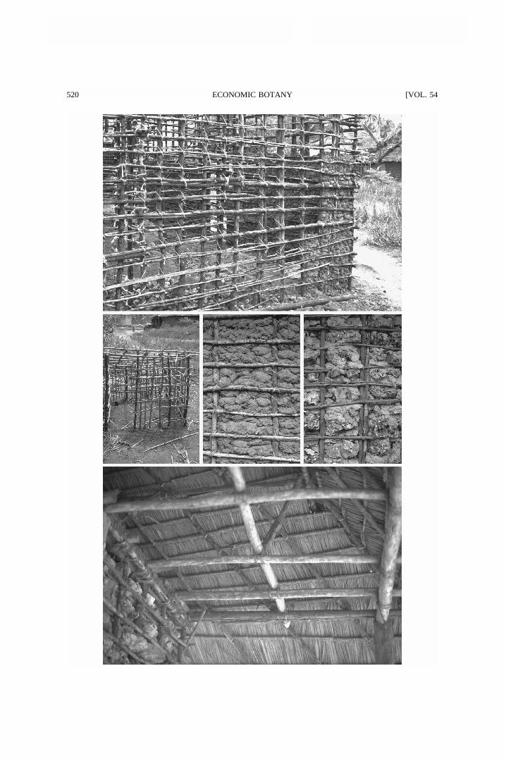
The largest and most significant use of man-groves is in the form of poles used for houseconstruction. Certain species are preferred overothers namely: Ceriops tagal, Rhizophora mu-cronata, and Bruguiera gymnorrhiza (Fig. 4).These are favored because of their ability togrow long and straight, and each of these speciesoccupies a particular place within the frameworkof a house. Bruguiera gymnorrhiza is preferredfor the rooftops rather than for walls because itproduces long yet strong enough poles for theroof. In addition, this species is cited as not last-ing very long in the soil as it does not withstandmoisture and saline soils. Most resistant to thesoil conditions cited above is Rhizophora mu-cronata and it is preferred for the walls and es-pecially the thicker supportive poles and cornerpillars of a house (Fig. 5). Ceriops tagal polesare much thinner and thus used as fito (Table 2;cf. Fig. 5) for creating an interweaving networkin the walls and roofs. C. tagal was also used to
make other houselike structures like shrines,cooking sheds outside the main house, and ani-mal sheds and pegs (cf. Fig. 6). Classification ofmangrove pole diameters and heights was givenby Roberts and Ruara (1967) and the uses in asingle house qualified and quantified per classaccording to our data in Table 2. Looking at theconstruction of a house from the utilization clas-ses point of view we can summarize that theboriti are thick poles that go deep into theground and that they are the main supports forthe walls. At each side of the wall they arecrossed by the fito. The fillings of the walls con-sisted of traditional clay (Fig. 7) or cementeddead coral rock (Fig. 8), whether or not finishedwith a more modern plaster treatment, depend-ing on financial means. The latter provides apolished look exactly like that of a plasteredmodern brick house constructed with cementand stone or concrete bricks. The ceiling is madeof nguzo and boriti, the former being thicker andheavier than the latter, which could be closelypacked or evenly spaced out at one-foot inter-vals. The roof is composed of pau and mazio,which are long poles meeting at a common apexor at the same level at the top depending on theroof design (Fig. 9). Finally, the vigingi are usedto support the roof extension that formed a kindof veranda just outside the main door and is usedas a cool or dry sitting area. The most commonroof fillings are dried coconut leaves woven intoa thatch called makuti (Fig. 9). This material in-sulates the house adequately from the hot day-time sun. The makuti are placed in an overlap-ping manner directly onto the grid of mangrovepoles and tied with strings made from some in-digenous inland creepers, dried coconut leavessplit into thin strips, or split roots of Rhizophoramucronata. From our own observations, we es-timate that 90% of the houses in the villagesaround Mida Creek are of the traditional design,with a bare instead of a cement floor. The av-erage house has an L-shape, consisting of threerooms with one main entrance into the house,and a perimeter of about 27 m.
According to the respondents, once construct-ed a house can last from one to over 30 yearswith an estimated average of eight years, de-pending greatly on the quality of poles and fill-ings used in the framework and especiallywhether or not the house has a cement floor andplastered walls. Also, environmental conditionssuch as soil drainage levels obviously are a fac-
520 [VOL. 54ECONOMIC BOTANY

2000] 521DAHDOUH-GUEBAS ET AL.: UTILIZATION OF MANGROVE WOOD PRODUCTS
←
Fig. 5. Top: Mangrove wall skelet (vertical boriti with horizontal fito, cf. Table 2) partially filled with mud.Fig. 6. Center left: Small cooking shed made of Ceriops tagal.Fig. 7. Center: Close-up of a mangrove wall filled with mud and clay and,Fig. 8. Center right, a wall filled with dead coral and cement.Fig. 9. Bottom: Roof with nguzo and boriti and covered with makuti.
tor. However, it should be highlighted that somehouses built with mangrove wood in Lamu (fur-ther North) are more than a century old, andsome like Fort Jesus (Mombasa) are reported tobe several centuries old.
HARVESTING LOCATIONS
Pole harvesting activities occurred in differentsections of the mangrove forest (Fig. 10). How-ever, the actual harvesting locations were oftena result of preferred species and pole size avail-ability (cf. Fig. 4) rather than merely an elementof accessibility to that section of the forest.Some parts of the creek reportedly had no man-groves that could be harvested, e.g., the Mida/Majaoni region (Fig. 1). As a result the villagersin this part of the creek indicated they traveledto the Kadaina and Uyombo area to harvestpoles of suitable sizes. The closest forest regionto Mida/Majaoni is the adjoining Sudi Island,which is left for tourism-related activity like pic-nicking. Access is restricted and harvesting for-bidden by the Kenya Wildlife Service (KWS).In other areas, especially the island regions ofKadaina, Kirepwe, and Kisiwani, the poles wereharvested in the forest regions closest to thehomesteads (often just outside of the com-pounds). Harvesting of mangrove trees usuallytook place whenever poles were required andnot on any regular or seasonal basis. The orga-nization of the harvesting activities varied ac-cording to different levels of formality. A localformally organized pattern of harvesting in-volves the interested party approaching a pro-fessional mangrove cutter with an authorized li-cense to carry out cutting activities in the forest.Sellers’ prices are from 105 KSh per score (1score � 20 poles) for pau, to 1000 KSh perscore for vigingi (Hirsch and Mauser 1992). Aless formally organized harvesting activity com-prises of the interested party personally harvest-ing the mangroves and seeking a permit fromthe Forestry Department for it. Licenses cost300 KSh plus 3000 KSh per annum per licensee,however only 50% of the applicants actually ob-
tain a license (Hirsch and Mauser 1992). TheForestry Department often stipulates the exactquantities of poles per any particular utilizationclass (Table 2). Officially, on average six scoresper month are allowed to be cut, but actuallyeight times that amount is being extracted(Hirsch and Mauser 1992). The informally or-ganized harvesting activity often took a longertime because the parties were not professionals,lacking skill, experience, and efficient equip-ment. Due to major difficulties in obtaining li-censes most people relied on ordered consign-ments or opted to harvest illegally, which is atthe owner’s risk of getting caught and having thepoles confiscated. The reported high prices ofpoles, from the dealers or directly from the pro-fessional cutters, also encouraged illegal har-vesting to some degree. Information on thequantity of mangroves harvested was obtainedwhen interviewing a professional mangrove cut-ter. He estimated that a nine-ton lorry was filledevery time he went on an ordered consignmentmission. Such an expedition occurred with a fre-quency of about one per month (three weeks ofcutting and one week of rest). Estimating fromthis information, in a year there would be 13such expeditions equaling about 117 tons of har-vested mangrove poles for one professionalmangrove cutter and his team. However, localpeople working with mangroves cutting teams ofabout 50 persons in Gazi, further south, reportedabout 10 filled lorries per week leaving theirmangrove area in the 1960s (Abdulrahman Lali,pers. comm. 1999). These differences in figuresmay reflect the observed differences in distur-bance between the Kenyan north and southcoast, but must be considered in the context ofthe extent and status of the forest, the numberof licenses in the area, and the size of the man-grove cutting team. In 1997 in Mida Creek therewere four harvesting licenses, but local peoplereported that resource depletion forced the cut-ters to move to other areas. Another trend is thatas demand actually increases as deduced fromutilization patterns and population growth, while

522 [VOL. 54ECONOMIC BOTANYT
AB
LE
1.T
RA
DIT
ION
AL
US
ES
OF
MA
NG
RO
VE
SIN
MID
AC
RE
EK
.
Spec
ies
nam
eL
ocal
nam
es(K
isw
ahili
,G
iria
ma)
Use
sPa
rts
used
Avi
cenn
iam
arin
am
chu
bed
post
s,ch
air
legs
,ta
ble
legs
,fe
ncin
gpo
sts,
char
-co
al,
low
qual
ity
com
mer
cial
fire
woo
d,cr
ushi
ngpo
le,
crus
hing
mor
tar,
serv
ing
dish
es,
drum
s,bo
atri
bs,
boar
dga
mes
(bao
)
thic
kst
ems
fire
woo
d(f
orho
me
use)
inse
ctic
ides
dead
stem
sgr
een
stem
s
Bru
guie
ragy
mno
rrhi
zam
uia,
mko
kow
imbi
high
qual
ity
com
mer
cial
fire
woo
d,hi
ghqu
alit
ych
ar-
coal
,co
nstr
ucti
onpo
les,
roof
supp
orts
,bo
atpa
d-dl
es,
oars
,ha
ndca
rtha
ndle
s,ax
eha
ndle
s,po
und-
ing
pole
s
thic
km
atur
est
ems
drum
s,be
ehi
ves
old
holl
owst
ems
Cer
iops
taga
lm
kand
aa,
mko
kom
tune
,m
koko
mw
ekun
duco
nstr
ucti
onpo
les,
padd
les,
oars
,m
ediu
mqu
alit
yco
mm
erci
alfi
rew
ood
mat
ure
and
youn
gst
ems
dyes
(inc
l.ta
nnin
gco
mpo
unds
)fi
shin
gtr
aps
bark
ofst
ems
youn
gfl
exib
lest
ems
Lum
nitz
era
race
mos
aki
kand
aa,
mka
apw
ani
med
ium
qual
ity
com
mer
cial
fire
woo
dan
dch
arco
alm
atur
est
ems,
dead
stem
s
Sonn
erat
iaal
bam
lila
naca
noes
,bo
atri
bs,
padd
les,
mas
ts,
fish
ing
net
floa
ts,
tim
ber
for
win
dow
and
door
fram
es,
med
ium
qual
-it
yco
mm
erci
alch
arco
alan
dfi
rew
ood
thic
km
atur
est
ems
Rhi
zoph
ora
muc
rona
tam
koko
,m
koko
mw
enye
cons
truc
tion
pole
s,hi
ghqu
alit
yco
mm
erci
alch
arco
al,
high
qual
ity
com
mer
cial
fire
woo
dth
ick
mat
ure
stem
san
dyo
ung
stem
s
dyes
(inc
l.ta
nnin
gco
mpo
unds
),m
edic
ines
,oi
nt-
men
tsba
rkof
stem
san
dro
ots
fish
ing
trap
sw
eapo
nsro
ots
youn
gst
ems
Xyl
ocar
pus
gran
atum
mko
mafi
high
qual
ity
tim
ber
for
bed
cons
truc
tion
,w
indo
wan
ddo
orfr
ames
,m
ediu
mqu
alit
yco
mm
erci
alch
arco
alan
dfi
rew
ood
mat
ure
stem
s
oint
men
tscr
ushe
dfr
uits

2000] 523DAHDOUH-GUEBAS ET AL.: UTILIZATION OF MANGROVE WOOD PRODUCTS
TABLE 2. CLASSIFICATION CATEGORIES OF DIFFERENT UTILIZATION CLASSES OF MANGROVE POLES (ROB-ERTS AND RUARA 1967), QUALIFIED WITH RESPECT TO THE USE AND FOR A SINGLE HOUSE QUANTIFIED
PER CATEGORY ACCORDING TO OUR DATA. THE UTILIZATION CLASSES ARE IDENTIFIED BY KISWAHILI WORDS
USED LOCALLY (THERE IS NO TRANSLATION FOR THESE TERMS).
Utilizationclass
Diameter range(cm)
Height(m)
Numberrequired* Use
FitoPau-MazioBoritiNguzoVigingi
2.5–3.54.0–11.5
11.5–13.514.0–20.020.5–35.0
�4�4�4�4�4
10009232
1124
wall fillingroof fillingwall supportsceiling and roof supportssupports and fencing
* 20 poles � 1 score.
Fig. 11. Respondents’ opinions on current foreststatus classified according to mangrove knowledge (n� 100 respondents).
Fig. 10. Location of harvesting activity (n � 100respondents).
supply diminishes as indicated by the reportedforest decline, combined with restriction of har-vesting as a result of the ban, the locals mayturn to other wood materials and to poaching.The degree to which this is admitted cannot re-liably be estimated from inquiries.
MANGROVE DECLINE IN MIDA CREEK
The majority of people state that the man-grove vegetation is declining (Fig. 11) and fur-ther analysis confirms that this is mainly theopinion of those with the highest mangroveknowledge (89% respondents with expert orgood working knowledge). Statistical analysis(�2-test) confronting this group of respondentsversus the people with a rough or no idea onmangroves (Fig. 2, Fig. 11) in their reply on thedecline of mangroves (fast or notable changeagainst no change or no answer) corroboratedthis (�2 � 10.792; d.f. � 1; P � 0.01). The maincause given for the observed change is a declinein desired sizes or in overall number of trees.
Kairo and Gwada (1998) and Kairo et al. (n.d.a) observed a clear physiognomic difference ofmangrove trees between the forest areas ofUyombo (Fig. 1, left) and Kirepwe (Fig. 1,right). The Uyombo region has been subjectedto over-exploitation and as a consequence dis-plays a large proportion of crooked trees (qualityclass 3), in contrast to Kirepwe (Kairo and Gwa-da 1998; Kairo et al., n.d. a).
Another indirect cause for decline is the in-creasingly complex procedures to obtain per-mits. The latter has been put into a frameworkof harvesting activities and cause of the ob-served changes (Fig. 12). Although a ban hasbeen put on mangrove export the system wouldbenefit only for a short term, since the local mar-

524 [VOL. 54ECONOMIC BOTANY
Fig. 12. General framework of harvesting activi-ties and policy leading to the observed changes inMida Creek. Note the loops forming a vicious circle.
ket also has high demands. The most importanttask for the Forestry Department would be tocarry out a complete inventory of the mangroveresource in the whole country. The inventoryshould provide forest cover maps as well as dataon the forest stocking rates for the main species.Such work is currently being done for KiungaMarine National Reserve (Kairo et al., n.d. b;Kairo and Kivyatu 2000) and Ramisi (Kairo andGwada, in prep.). The major obstacle that hasprevented rational use and conservation of man-groves in Kenya has been a management policythat consists of controls and prohibitions in theabsence of the means to implement them (Fer-guson 1993; Kairo 1996).
CONSERVATION AND MANAGEMENT ISSUES
The wealth of the mangal was well appreci-ated by the local residents of Mida Creek andreflected in the realization for the need to con-serve the forest area. There were various effortsto conserve and replant certain areas by orga-nized groups of people, e.g., Dongokundu Man-grove Planters Association and Viriko/VimoyoniWomen’s group. Some even expressed the wishto have stricter and a more rigid control of ac-tivities within the forest by the authorities con-cerned in order to give the forest time to recover.However, policies such as bans on all harvestingactivities cannot be applied effectively without
examining the consequences for local subsis-tence communities.
Numerous recommendations have been putforward concerning the direction and steps to betaken towards a mangrove management plan anda sound forestry management scheme to enablesustainable exploitation of the mangrove re-sources (Kenya Forestry Master Plan 1994).However, few of these, if any, have been imple-mented to date. A clear understanding of the na-ture and dynamics of local mangrove ecosys-tems will be the best guide to any restorationprogram (Field 1996), and thus necessitates fun-damental as well as applied research to fully ap-preciate and understand and even manage thisecosystem and its utilization patterns. The ap-proach to involve the local population by edu-cating them on the value of the ecosystem toenable them to fully appreciate it, such as inGazi Bay, Kenya (Kairo 1995) or in the ChilawLagoon-Mundel Lake-Puttalam area, Sri Lanka(SFFL 1997; Foell et al. 1999), is presently setup in Mida Creek through the Viriko/VimoyoniWomen’s group. This form of environmental ed-ucation introduces a sense of responsibilityamong residents on their activities within theforest, but an effective institutionalization ofcommunity-based natural resource managementand conservation is essential (Agrawal and Gib-son 1999). Special training for personnel of theForestry Department and other authorities man-aging the mangrove forest area would also resultin more appreciation of the value of the resourceand hopefully change behavior and attitudes to-wards exploitation habits and patterns. Duraiap-pah (1998) also emphasizes that groups thatadopt unsustainable activities must be given theincentives (compensation, rewards, taxes, andinformation provision) to stop. Omodei Zoriniand Contini (2000) and Omodei Zorini et al.(2000) have reported that if the local peoplewould be given cattle for instance, they wouldstop cutting mangrove wood for commercialpurposes. Forestry management programs, if putin place in Mida Creek, could result in successparticularly now that the population is aware ofthe need to conserve mangroves. In southernChile, self-determination and territorial rightsare also important factors in the indigenous in-terests in and commitment to conservation ofcertain plant species (Aagesen 1998). However,in some cases, the conditions which are deemedto be necessary for the sustainable management

2000] 525DAHDOUH-GUEBAS ET AL.: UTILIZATION OF MANGROVE WOOD PRODUCTS
of a resource appear to be undermined by in-creasing inequality and conflict (Adger et al.1997), the latter as the result of the effects ofthe economic liberalization process in formercentrally planned economies (Adger 1999).
Clough (1993) cites that economic indicatorsdo not necessarily provide an adequate descrip-tion of the contribution of mangrove ecosystemsto the daily life and culture of people who havetraditionally used mangrove areas. In our viewlocal utilization patterns rather than global use-fulness and utilization inventories are requiredto establish a conservation policy of both man-groves and users’ subsistence requirements.
CONCLUSION
The local residents of Mida Creek are depen-dent to a large degree on the mangrove resource,if the lack of economically acceptable alterna-tives for mangrove resource utilization is con-sidered to cause dependence. The present studyprovides details on mangrove use that were nev-er reported, such as the preference of woodtypes for different purposes within a certain use(construction). This shows that local rather thanglobal utilization patterns constitute importantsources of information. The majority of MidaCreek’s people realize their mangrove forest isdegrading and while some are turning to illegalpractices (e.g., poaching) because of the bureau-cratic difficulties in obtaining a cutting license,others wish to have stricter monitoring and en-forcement of the existing mangrove forest poli-cy. The present will and engagement of the localpeople to protect the mangrove should be an in-centive for the government to put a Kenya For-estry Master Plan into action.
ACKNOWLEDGMENTSWe are very grateful to B. Simpson and her entire staff that proved
very encouraging and supportive during the fieldwork. Many thanks aredue to the practical help of Vladica Sivcev in shaping the questionnaires,and to our local guide on the field. We also thank Willem Brakel, as wellas two anonymous reviewers for their comments on the manuscript, andAdriana Sanchez-Suarez and Dr. Manzour Hazbon for the Spanish ab-stract. Research financed by the Fund for Collective Fundamental Re-search (FKFO) the Belgian National Science Foundation, the Vrije Univ-ersiteit Brussel and with a specialization fellowship of the Flemish Insti-tute for the advancement of scientific-technological research in the in-dustry (IWT). This work was presented on the Symposium on RecentAdvances and Future Trends in Mangrove Research: Biodiversity, Ge-netics, Evolutionary Biology and Restoration (July 8–10, 1998, Toulouse,France).
LITERATURE CITED
Aagesen, D. L. 1998. Indigenous resource rights andconservation of the monkey-puzzle tree (Araucaria
araucana, Araucariaceae): a case study from south-ern Chile. Economic Botany 52(2):146–160.
Adger, W. N. 1999. Exploring income inequality inrural coastal Viet Nam. Journal of DevelopmentStudies 35(5):96–119.
, M. Kelly, N. H. Ninh, and N. C. Thanh.1997. Property rights and the social incidence ofmangrove conversion in Vietnam. CSERGE Work-ing Paper GEC 97–21. Centre for Social and Eco-nomic Research on the Global Environment,School of Environmental Sciences, University ofEast Anglia, Norwich, U.K.
Agrawal, A., and C. C. Gibson. 1999. Enchantmentand disenchantment: the role of community in nat-ural resource conservation. World Development27(4):629–649.
Aksornkoae, S., N. Paphavasit, and G. Wattayak-orn. 1993. Mangroves of Thailand: present statusof conservation, use and management. Pages 83–132 in The economic and environment value ofmangrove forests and their present state of conser-vation. International Tropical Timber Organisation/Japan International Association for Mangroves/In-ternational Society for Mangrove Ecosystems, Ja-pan.
Bailey, K. D. 1987. Methods of social research. Col-lier Macmillon, London, U.K.
Brakel, W. H. 1979. Marine parks and recreation.Pages 409–433 in World Bank Tourism PricingPolicy Study for the Kenya Ministry of Tourismand Wildlife.
Clough, B. F. 1993. The status and value of mangroveforests in Indonesia, Malaysia and Thailand: sum-mary. Pages 1–10 in The economic and environ-ment value of mangrove forests and their presentstate of conservation. International Tropical TimberOrganisation/Japan International Association forMangroves/International Society for MangroveEcosystems, Japan.
Dahdouh-Guebas, F., M. Verneirt, S. Cannicci, J.G. Kairo, and N. Koedam. An exploratory studyon grapsid crab zonation in zoned mangrove forestsin Kenya. (submitted).
Doute, R., N. Ochanda, and H. Epp. 1981. A forestryinventory of Kenya using remote sensing tech-niques. Kenya Rangeland Ecological MonitoringUnit report, Nairobi, Kenya.
Durraiappah, A. K. 1998. Poverty and environmentaldegradation: a review and analysis of the nexus.World Development 26(12):2169–2179.
Farnsworth, E. J., and A. M. Ellison. 1997. Theglobal conservation status of mangroves. Ambio26(6):328–334.
Ferguson, W. 1993. A land(scape) ecological surveyof the mangrove resource of Kenya (Draft Report).Technical Coperation Project (FAO TCP/KEN/OO51) for the Forestry Department, Ministry of

526 [VOL. 54ECONOMIC BOTANY
Environment and Natural Resources, Nairobi, Ken-ya.
Foell, J., E. Harrison, and R. L. Stirrat. 1999. Par-ticipatory approaches to natural resource manage-ment—the case of coastal zone management in thePuttalam District. Summary findings of DFID-funded research ‘participatory mechanisms for sus-tainable development of coastal ecosystems’ (Pro-ject R6977), School of African and Asian studies,University of Sussex, Falmer, Brighton, U.K.
Gang, P. O., and J. L. Agatsiva. 1992. The currentstatus of mangroves along the Kenyan coast: a casestudy of Mida Creek mangroves based on remotesensing. Hydrobiologia 247:29–36.
Hirsch, D. and A. Mauser. 1992. The economic val-ues of mangroves. Two case studies: Mida Creekand Funzi Bay. (Thesis). University of Amsterdam,Netherlands.
Kairo, J. G. 1995. Community participatory forestryfor rehabilitation of deforested mangrove areas ofGazi Bay (Kenya). A first approach. Final technicalreport. University of Nairobi, Department of Bot-any, Nairobi, Kenya.
. 1996. Towards alternative views of mangroveforestry in Kenya. In Supporting capacity buildingin forestry research in Africa. A. Ngeny-Mengech(ed.), International Foundation for Science (IFS),Nairobi, Kenya.
, and P. O. Gwada. 1998. Mangrove of MidaCreek. Ecological survey of Mida Creek. Finaltechnical report. Kenya Wildlife Services, Mom-basa, Kenya.
, and . Mangrove of Kwale district.Structural inventory. Kenya Wildlife Services,Mombasa, Kenya. (in preparation).
, and B. Kiryatu. 2000. Mangrove manage-ment survey with and adjacent to Kiunga MarineNational Reserve. WWF project KE0087.01, Tech-nical Report. WWF EARO, Nairobi, Kenya/UNESCO, Nairobi, Kenya.
, , F. Dahdouh-Guebas, N. Koedam,D. Van Speybroeck, and C. Ochieng. n.d. a. Nat-ural regeneration status of mangrove forests inMida Creek, Kenya.
Kairo, J. G., and B. Kivyato. 2000. Management sur-vey within and adjacent to Kiunga Marine NationalReserve. WWF Project KE0087.01, Technical Re-port. WWF EARO, Nairobi, Kenya/UNESCO, Nai-robi, Kenya.
, B. Kivyatu, J. Church, F. Dahdouh-Gue-bas, N. Koedam, and R. Hoft. n.d. b. Managementsurvey of mangrove forests within the marine pro-tected area of Kiunga, Kenya (presented at the 15thBiennial International Conference of the EstuarineResearch Federation ‘‘Where the River Meets theSea,’’ 25–30 Sept. 1999, New Orleans, U.S.A.).
Kennedy, A. 1988. Mida Creek—a study of human
impact. (Thesis) University of Edinburgh, Scotland,U.K.
Kenya Forestry Master Plan. 1994. DevelopmentProgrammes. Ministry of Environment and NaturalResources, Nairobi, Kenya.
KIFCON. 1995. Arabuko Sokoke Forest and MidaCreek. The offical guide. Kenya Indigenous ForestConservation Programme. Kenya Wildlife Service/Forestry Department, Nairobi, Kenya.
Kokwaro, J. O. 1985. The distribution and economicimportance of the mangrove forests of Kenya. Jour-nal of the East Africa Natural History Society andNational Museum 75(188):1–10.
Omodei Zorini, L., and C. Contini. 2000. A multi-criterion analysis for the sustainable use of naturalresources in Mangrove ecosystems with the in-volvement of local community. Proceedings of the4th European Symposium on European Farmingand Rural Systems Research and Extension into theNext Millenium, April 3–7, Volos, Greece.
Omodei Zorini, L., C. Contini, F. Barbosa, N. S.Jiddawi, J. Ochiewo, R. Polidori, and J. P. Shun-ula. 2000. A participatory analysis for a sustainablemangrove management. Presentation at the Meet-ing on Mangrove Macrobenthos, 7–11, Sept.,Mombasa, Kenya.
Rawlins, S. P. 1957. The East-African mangrovetrade. Unpublished manuscript #51 of the NationalMuseum of Kenya, Nairobi, Kenya.
Reddy, S. R. C., and S. P. Chakravarty. 1999. Forestdependence and income distribution in a subsis-tence economy: evidence from India. World De-velopment 27(7):1141–1149.
Roberts, R. W., and W. W. Ruara. 1967. LamuMangrove Inventory. Forest Department, Nairobi,Kenya.
Salim, A. I. 1985. Kenya’s people. People of the coast:Swahili. Evans Brothers Limited, Nairobi, Kenya.
SFFL. 1997. Performance report for the years 1994,1995 and 1996. Small Fishers Federation of Lanka,Pambala, Kakkapalliya, Sri Lanka.
Spalding, M., F. Blasco, and C. Field. 1997. Worldmangrove atlas. The International Society for Man-grove Ecosystems, Okinawa, Japan.
Tomlinson, P. B. 1986. The botany of mangroves.Cambridge University Press, Cambridge, UK.
APPENDIX 1QUESTIONNAIRE USED DURING THE FIELD
SURVEY
1. What do you understand by the term mangrove?2. What are the uses of mangrove within your house-
hold?a) Fuel-wood (firewood and charcoal)b) Timber (house and boat construction)c) Medicinal products (medicine and ointments)

2000] 527DAHDOUH-GUEBAS ET AL.: UTILIZATION OF MANGROVE WOOD PRODUCTS
d) Furniture (chairs, tables, shelves, utensils, boatmasts, paddles, fishing equipment)
e) Food (for man and animal feeds)f) Others (specify)
3. Which of the above listed uses is the most usedwithin your household?
4. Do you have a preferred species of mangrove foruse as poles for house construction? If so, whichone (vernacular names)?
5. How long do the houses last once constructed withmangrove poles, before they require replacing?
6. Where, within the forest, does the harvesting ac-tivity take place?a) Along the forest edge, closest to homeb) Deep in the heart of the forestc) In a forest region that is far off and requires
travelingd) Do not know
7. How do you organize your harvesting?8. How frequently do you visit the forest to harvest
mangroves?a) At least once a monthb) Once a monthc) Twice a monthd) Once in two monthse) Whenever necessary (specify)
9. What is the size of your household?10. Do you harvest mangroves for uses other than
those within your household? If so, for what pur-poses?a) Small tradingb) To stock in a commercial placec) Other uses (specify)
11. Do you buy mangrove poles? If yes, from whom?12. Has it become easier or more difficult to harvest
mangroves? Why do you think so? Has the forestchanged?
Related Documents


![PSC Post-Trial Brief (Phase One) [Doc 10458] 6-21-2013](https://static.cupdf.com/doc/110x72/577cdbc21a28ab9e78a8ff73/psc-post-trial-brief-phase-one-doc-10458-6-21-2013.jpg)