int. j. remote sensing, 2001 , vol. 22, no. 6, 987± 1004 Typology of atoll rims in Tuamotu Archipelago (French Polynesia) at landscape scale using SPOT HRV images S. ANDRE  FOUE È T 1,2 , M. CLAEREBOUDT 3,4 , P. MATSAKIS 5 , J. PAGE Á S 6 and P. DUFOUR 3 1 Laboratoire de Ge osciencesMarines et Te le de tection,Universite FrancË aise du Paci® que, BP 6570 Faaa-Ae roport, Tahiti, French Polynesia 2 Remote Sensing Biological Oceanography Lab., University of South Florida, Department of Marine Science, 140, 7th Avenue South, St Petersburg, FL 33701, USA 3 IRD, Centre d’Oce anologie de Marseille, rue de la Batterie des Lions, F-1037 Marseille, France 4 College of Agriculture, Fisheries Dept., Sultan Qaboos University, P.O Box 34, Al-Khad 123, Sultanate of Oman 5 Institut de Recherche en Informatique de Toulouse, Universite Paul Sabatier ToulouseÐ 118, Route de Narbonne 31062 Toulouse Cedex, France 6 Centre IRD de Tahiti, BP 529 Papeete, Tahiti, French Polynesia (Received 31 August 1998; in ® nal form 22 November 1999 ) Abstract. The lagoon of an atoll is separated from the ocean by a rim. As the rim controls the ¯ ux of water between ocean and lagoon, its structure is one of the major forcing factors of the biological processes that depend on the renewal rate of lagoonal water. Characterizing rim structure and its degree of hydro- dynamic aperture is mandatory for comparing the functioning of diVerent atoll lagoons. This paper characterizes at landscape scale the diVerent types of rims of the atolls of the Tuamotu Archipelago (French Polynesia) using SPOT HRV multi-spectral images. The classi® cation of 117 segments of rims highlights nine diVerent rims. They diVer in the relative importance of vegetated, submerged, intertidal and emerged domains. These classes are recognized with accuracy greater than 85% using a simple statistical supervised algorithm. A gradient of hydrodynamic aperture is described, from 0.02%Ð very closed rim exposed to the north, to 0.65%Ð wide open rim exposed to dominant southern swell. We show that most of these nine rims have a preferential exposure. According to the direction of the dominant swell in the Tuamotu region, such exposure may explain the structure of the rims and their degree of hydrodynamic aperture. We discuss the implications of these results for research and management. 1. Introduction Atolls are one of the main types of coral reef structures, in addition to barrier, fringing and bank reefs (Guilcher 1988 ). Atolls are classically described as the ® nal step of a fringing-barrier-atoll succession, a step where only carbonate material produced by coral and associated organisms is visible. Deep drilling and radio-isotope dating in the structure of the atolls have con® rmed two processes through geological times that explain concurrently or independently the general saucer-like morphology of atolls (Guilcher 1988 ). First, this morphology may derive from subaerial erosion of the International Journal of Remote Sensing ISSN 0143-1161 print/ ISSN 1366-5901 online Ñ 2001 Taylor & Francis Ltd http://www.tandf.co.uk/journals

Welcome message from author
This document is posted to help you gain knowledge. Please leave a comment to let me know what you think about it! Share it to your friends and learn new things together.
Transcript

int j remote sensing 2001 vol 22 no 6 987plusmn 1004
Typology of atoll rims in Tuamotu Archipelago (French Polynesia) atlandscape scale using SPOT HRV images
S ANDREAcirc FOUEEgrave T1 2
M CLAEREBOUDT34
P MATSAKIS5
J PAGEAacute S6
and P DUFOUR3
1Laboratoire de GeAcirc osciences Marines et TeAcirc leAcirc deAcirc tection UniversiteAcirc FrancEuml aise du
Pacireg que BP 6570 Faaa-AeAcirc roport Tahiti French Polynesia2Remote Sensing Biological Oceanography Lab University of South Florida
Department of Marine Science 140 7th Avenue South St PetersburgFL 33701 USA3IRD Centre drsquoOceAcirc anologie de Marseille rue de la Batterie des Lions
F-1037 Marseille France4College of Agriculture Fisheries Dept Sultan Qaboos University
PO Box 34 Al-Khad 123 Sultanate of Oman5Institut de Recherche en Informatique de Toulouse UniversiteAcirc Paul Sabatier
ToulouseETH 118 Route de Narbonne 31062 Toulouse Cedex France6Centre IRD de Tahiti BP 529 Papeete Tahiti French Polynesia
(Received 31 August 1998 in reg nal form 22 November 1999 )
Abstract The lagoon of an atoll is separated from the ocean by a rim As therim controls the macr ux of water between ocean and lagoon its structure is one ofthe major forcing factors of the biological processes that depend on the renewalrate of lagoonal water Characterizing rim structure and its degree of hydro-dynamic aperture is mandatory for comparing the functioning of diVerent atolllagoons This paper characterizes at landscape scale the diVerent types of rims ofthe atolls of the Tuamotu Archipelago (French Polynesia) using SPOT HRVmulti-spectral images The classireg cation of 117 segments of rims highlights ninediVerent rims They diVer in the relative importance of vegetated submergedintertidal and emerged domains These classes are recognized with accuracygreater than 85 using a simple statistical supervised algorithm A gradient ofhydrodynamic aperture is described from 002ETH very closed rim exposed to thenorth to 065ETH wide open rim exposed to dominant southern swell We showthat most of these nine rims have a preferential exposure According to thedirection of the dominant swell in the Tuamotu region such exposure may explainthe structure of the rims and their degree of hydrodynamic aperture We discussthe implications of these results for research and management
1 IntroductionAtolls are one of the main types of coral reef structures in addition to barrier
fringing and bank reefs (Guilcher 1988 ) Atolls are classically described as the reg nal stepof a fringing-barrier-atoll succession a step where only carbonate material producedby coral and associated organisms is visible Deep drilling and radio-isotope dating inthe structure of the atolls have conreg rmed two processes through geological times thatexplain concurrently or independently the general saucer-like morphology of atolls(Guilcher 1988 ) First this morphology may derive from subaerial erosion of the
International Journal of Remote SensingISSN 0143-1161 printISSN 1366-5901 online Ntilde 2001 Taylor amp Francis Ltd
httpwwwtandfcoukjournals
S AndreAcirc foueEgrave t et al988
calcareous platform during a period of emergence following a tectonic uplift or a sea-level fall (Menard 1982 Winterer 1998) The surface dissolution resulted in a centraldepression and a peripheral rim that were recolonized by coral reef organisms as soonas submergence reoccurred Second the saucer-shape was explained by continuousdiVerential growth and erosion rate between peripheral and central living communitiesand by diVerent patterns of accretion (WoodroVe et al 1999) Whatever the processesthe resulting rim-lagoon structure has major implications for the biological functioningof an atoll The atoll may be described as a juxtaposition of three ecological systemsthe oceanic outer slope the lagoon (including water column and bottom) and the rimThe rim and its degree of hydrodynamic aperture control the macr ux of water betweenocean and lagoon at short time-scale (hours and days) Therefore if we considerphysical or biological processes with similar time-scale magnitude (Hatcher et al 1987 )reefs with diVerent morphology likely have lagoons with diVerent physical and biologicalproperties This was documented by Furnas et al (1990 ) Delesalle and Sournia (1992)and Dufour et al (1998 ) Landscape ecology aims to describe the inmacr uence of structuralproperties such as connectivity degree of overlapping or porosity on the functioningof ecosystems (Forman and Godron 1986) If we dereg ne the landscape scale as the scalethat provides the adequate information on connectivity between the ocean and thelagoon then the landscape scale is required to compare and explain the functioningof diVerent lagoons in order to link oceanic processes rim structure and lagoonalbiological features
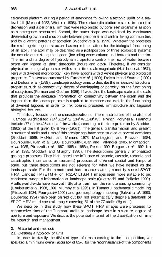
This study focuses on the characterization of the rim structure of the atolls ofTuamotu Archipelago (14 szlig Splusmn 24 szlig S 134 szlig Wplusmn 148 szlig W) French Polynesia Tuamotuincludes 77 of the 425 atolls of the world (according to the interpretation by Stoddart(1965 ) of the list given by Bryan (1953 )) The genesis transformation and presentstructure of atolls and rims of this archipelago have been studied at several occasions(Stoddart 1969 McNutt and Menard 1978 Montaggioni and Pirazzoli 1984Bourrouilh-LeJan et al 1985 Bourrouilh-LeJan and Tallandier 1985 Montaggioniet al 1985 Pirazzoli et al 1987 1988a 1988b Perrin 1990 Buigues et al 1992 Itoet al 1995 Stoddart and Murphy 1996 ) The descriptions generally emphasizedgeologic processes They highlighted the inmacr uence of oceanic eustatic tectonic andcatastrophic (hurricanes or tsunamis) processes at diVerent spatial and temporalscale but these descriptions are not relevant for what we have dereg ned as thelandscape scale For the remote and hard-to-access atolls remotely sensed SPOTHRV Landsat TMETM+ or IRS1-C LISS-III images seem more suitable to getconsistent synoptic information at landscape scale (Quattrochi and Pelletier 1990 )Atolls world-wide have received little attention from the remote sensing community(Loubersac et al 1988 1991 Mumby et al 1995 ) In Tuamotu bathymetric modelling(Pirazzoli 1984 FourgassieAcirc 1990 ) and geomorphology mapping (Salvat et al 1990Loubersac 1994 ) have been carried out but not systematically despite a databank ofSPOT-HRV multi-spectral images covering 51 of the 77 atolls ( reg gure 1)
We describe in this study how these SPOT HRV images were processed tocharacterize rims of the Tuamotu atolls at landscape scale in structure degree ofaperture and exposure We discuss the potential interest of the classireg cation of rimsfor research and management
2 Material and methods21 Dereg ning a typology of rims
In order to classify the diVerent types of rims according to their composition wespecireg ed a minimum overall accuracy of 85 for the reconnaissance of the components
T ypology of atoll rims 989
144ordmW 140ordmW 136ordmW
16ordmS
20ordmS
24ordmS
Figure 1 Location and map of the Tuamotu archipelago Names in italic are atolls notcompletely covered by SPOT HRV imagery
of the rims using SPOT HRV imagery Despite the individual history of each atoll theirrims are made with the same set of geomorphological units that can be hierarchicallyclustered into broader classes relevant for a characterization at landscape scale Wepropose in table 1 a three-level hierarchy The reg rst levelETH Landscape level ETH has onlyfour classes Vegetationrsquo Intertidalrsquo Submergedrsquo and Emergedrsquo The second level ETHIntegrated levelETH is made of 13 classes sketched in reg gure 2 These classes might bediscriminated manually on SPOT HRV images by a photo-interpreter ( reg gure 2) accord-ing to empirical rules based on colour shape and relative location of the classes (Lequeuxet al 1995) The last level ETH Unit level ETH is made of the geomorphological units tradition-ally described in coastal geomorphology literature (Battistini et al 1975 Guilcher 1988)The size of these units can be quite small (few square metres) The 85 accuracythreshold is likely unreachable using SPOT-HRV images (20 m resolution) at the Unitlevel but this level is useful for describing the composition of the Landscape andIntegrated levels using conventional terminology
To test how precisely the classes at Landscape or Integrated levels can berecognized in the three-dimensional spectral space (XS1 XS2 XS3) we used twosupervised algorithms (1) a simple algorithm based on a normalized Euclidiandistance dN (Poujade 1994 ) (2) an algorithm based on an adaptive Mahalanobisdistance dM (Celeux et al 1989 ) The Poujade algorithm requires the mean andvariance of each class in each spectral band The distance dN(p (m s)) between apixel p and the class represented by its mean and variance (m s) is computed using
d2N(p (m s))=
k= XS1 XS3
(pk Otilde mk)2
sk(1)
The adaptive algorithm requires the 3 Ouml 3 covariance matrix for each class The
S AndreAcirc foueEgrave t et al990
Table 1 Three levels of description for an atoll rim The size of the objects at the Landscapeand Integrated levels is compatible with the spatial resolution of SPOT-HRV multi-spectral images (20 m) Most of the Units are dereg ned in Battistini et al (1975 ) `Koparapondrsquo are cyanobacterian ponds located in stagnation zones
Landscape level Integrated Level4 categories 13 categories Unit level
Vegetation Vegetation Vegetation (bush trees)
Conglomerate ConglomerateEmerged domain Coral rubble Boulder rempart(without vegetation) Detrital ridge
Shingle spreadShingle spread over conglomerate
Soils Soils
Soils with old shingle spreadIntertidal reef macr at Intertidal reef macr at
Intertidal inner reef macr atAlgal ridge
Intertidal coral rubble BeachSpillway spitHydraulic bankLittoral spit
Intertidal domain Intertidal conglomerate Intertidal conglomerateFossil algal ridgeOld reef spit (feo)Eroded conglomerate
Residual spillway Residual kopara pondCyanobacterian matsResidual spillway macr agstone
Deep water gt1 m depth LagoonInner slopeOuter slopePass
Spillway Functional spillwaySubmerged rim
Submerged domain Submerged reef macr at Submerged outer reef macr atSubmerged inner reef macr at
Enclosed lagoon Enclosed lagoonKopara pond Kopara pond
distance dM(p (m s)) between a pixel p and the class represented by its mean andcovariance matrix (m C ) is computed using
d2M(p (m C))= |C |
13(mOtilde p)
tC Otilde
1(mOtilde p) (2)
where |C | is the determinant of the matrix CThe test was performed using a SPOT HRV image of Tikehau atoll ( reg gure 3)
acquired in July 1994 Tikehau is morphologically very diversireg ed (Intes et al 1995 )All the classes at Unit level are encountered along its rim Therefore Tikehau maybe considered as a good test atoll Training and control areas were identireg ed andgeoreferenced for all the classes at Integrated and Landscape levels ( reg gure 3) duringreg eld trips carried out in June 1994 July 1994 and December 1995 The number of
T ypology of atoll rims 991
Figure 2 Bloc-diagram of an atoll rim (from Battistini et al 1975 ) displaying the 13 classesat the Integrated level of description The classes are also readily visible on a SPOTHRV image of the rim of the Tikehau atoll The black segments indicate the locationsof the apertures in this rim with numerous spillways The aperture A is simply thesum of the width of these segments
training pixels used to determine the statistical properties of the classes range between44 (for kopara) to 500 (deep water) Generally individual training or control stationswere clusters made of 5 to 20 pixels The accuracy of the two algorithms wasquantireg ed by the overall accuracy of the normalized confusion matrices (Zhuanget al 1995 ) The 95 conreg dence interval of the overall accuracy is computedassuming a normal distribution (Ma and Redmond 1995 )
After the calibration stage based on Tikehau atoll a set of 117 segments of rimswith various lengths and widths but with uniform exposure was processed at theLandscape level The segments belong to 14 atolls diVering in size shape latitude andlongitude and of course morphology (reg gure 4 and table 2) The selection of the atolls isexplained in detail in Dufour and Harmelin-Vivien (1997) They were surveyed duringthe Typatoll 1 cruise in November 1994 The processing of each segment provides asurface of Intertidalrsquo Submergedrsquo Emergedrsquo and Vegetatedrsquo classes with an overallaccuracy greater than 85 The surfaces covered by the diVerent classes were normalizedby the surface of the segment (table 3) Using these normalized surfaces the segments
S AndreAcirc foueEgrave t et al992
Figure 3 Map of Tikehau atoll with locations of the training and control areas The domainsEmergedrsquo and Vegetationrsquo are grey Intertidalrsquo and Submergedrsquo domains are white
were clustered using a hierarchical algorithm based upon Wardrsquos methodETH ie criteriaof minimum variance clusteringETH (Ward 1963) to dereg ne a typology of rims
22 Degree of aperture and exposure of the type of rimsAn indication of the aperture of the atoll is given by a one-dimensional variable
aperture A (in metres) At the Unit level A is the sum of the width of the diVerentspillways submerged rims and passes ( reg gure 2) At the Landscape level aperture Ais dereg ned by the width of Submergedrsquo area of the rim connecting the ocean and thelagoon We dereg ne a simple index of degree of aperture (A) ie the ratio of A to theperimeter of the atoll p
A =Ap (3)
We also dereg ne the aperture Ar of a given segment of rim r as
Ar=Ar pr (4)
To test the null-hypothesis of equality of aperture between clusters of rims ananalysis of variance (ANOVA) was performed (Scherrer 1984) If the null-hypothesismust be rejected an a posteriori ScheVe test determines which clusters diVer in Ar Toobey the conditions of the ANOVA Ar was transformed to Arcsin( Oacute Ar) to insurehomoscedasticity (ie homogeneity of the variances between clusters of rims) and anF-test was applied to insure normal distribution of this new variable (Zar 1984)
Exposure of a segment of rim is simply dereg ned by the angle between the northerndirection and the perpendicular to the oceanic side of the rim To test whether thediVerent clusters of rims are linked to one exposure a circular statistical analysis
T ypology of atoll rims 993
Figure 4 Diversity in size shape and orieintation of the 14 selected atolls used to classifythe type of rims Scale is uniform
Table 2 General features of the 14 atolls used to cluster the rims The index of shapersquo is the`Millerrsquos circularity ratiorsquo equal to Surface(2pPerimeter2) (Stoddart 1965) This indextends towards 1 for circular atolls and to 0 for complex-shaped or elongated atollsThe variable number of segmentsrsquo is the number of segments with uniform exposureused to cluster the rims A circular atoll is segmented into eight segments
Total Rim Number Indexsurf Aperture Perimeter Latitude Longitude surf of of
Atolls (km2) (A) (km) (szlig S) (szlig W) (km
2) segments shape
Amanu 2440 029 725 178093 1407671 34 10 0584Haraiki 254 023 198 174696 1434476 15 5 0816Hikueru 1070 025 400 175860 1426127 246 10 0840Hiti 255 026 184 167309 1440898 103 8 0949Kauehi 3434 024 711 160409 1450066 283 10 0853Marokau 2560 022 750 180555 1422844 385 14 0572Nihiru 1002 034 452 167014 1428362 207 13 0616Reka-reka 52 002 87 168401 1419252 44 4 0858Taiaro 172 000 156 157445 1446333 54 7 0898Takapoto 1041 003 478 146313 1452102 23 7 0572Tekokota 73 056 103 173153 1425646 22 7 0864Tepoto 61 021 90 168166 1442833 45 8 0954Tikehau 4488 025 791 150141 1481694 545 8 0900Tuanake 380 031 238 166434 1442187 123 6 0845
S AndreAcirc foueEgrave t et al994
Table 3 Morphological variables available for each segment of rim
Variable Dereg nition
Surfrim SurfaceV r Surface of vegetation classIr Surface of intertidal classEr Surface of emerged classSr Surface of submerged classV r= V r Surfrim Percentage of vegetation classIr= Ir Surfrim Percentage of intertidal classEr= Er Surfrim Percentage of emerged classSr = Sr Surfrim Percentage of submerged classPr Length along the reef crestAr ApertureAr= Ar Pr Degree of aperture
was performed (Zar 1984 ) The null-hypothesis of no-directionality was tested foreach type of rim with the non-parametric Rayleigh test and the distribution za n
(table B32 in Zar 1984 ) The Rayleigh test is based on the calculus of z
X =
n
i= 1cos a i
n Y=
n
i= 1sin a i
n r v = Oacute X
2+ Y
2 z= n r2
v (5)
where n is the number of segments a i is the exposure of the segment i r v is thelength of the mean vector v If the null-hypothesis is rejected (zgtzan ) the unimodalexposure is the angle av of the mean vector v with
cos a v=X
r v sin a v=
Y
r v(6)
3 Results31 Image clustering
At the Landscape level the overall accuracy were 884 Ocirc 162 (95 conreg denceinterval ) for the Poujade algorithm and 9032 Ocirc 149 for the adaptive algorithm ThediVerence in accuracy was not signireg cant For the Integrated level none of the algorithmsreached the required threshold of 85 accuracy The Poujade and adaptive distancealgorithms obtained 741 Ocirc 22 and 835 Ocirc 19 respectively The diVerent parametricrepresentations of the 13 classes of the Integrated level are sketched in reg gure 5 for thetwo selected algorithms This reg gure illustrates how the classes are spread in the spectralspace dereg ned by XS1 XS2 XS3 We show only the plan dereg ned by the axis XS1 XS3because the spectral features of the classes in XS1 and XS2 were very correlated Theellipsoids at the top of reg gure 5 visualize the spectral space included in a distance dN
equal to 15s where s is the variance of the considered class The choice of the factor15 is arbitrary but for visualization purposes it provides a good compromise betweenexcessively small ellipsoids and those with too much overlap between them The bottomof reg gure 5 presents limits dereg ned by dM=15s with ellipsoids oriented in the directiongiven by the eigen vectors of the matrix COtilde
1 This reg gure helps explain the diVerence in
accuracy between the two algorithms The adaptive algorithm is based on more realisticassumptions that are well highlighted by the allure of the ellipsoids
T ypology of atoll rims 995
Figure 5 Parametric representation (see Results section for explanation) of the 13 categoriesat the Integratedrsquo level of description of atoll rims Top Poujade algorithm Bottomadaptive algorithm
The 835 accuracy for the adaptive algorithm was close to the specireg ed levelbut this rate was not consistently obtained Indeed if we decreased the number oftraining pixels randomly in the diVerent classes the accuracy actually ranged between835 and 702 For the pilot-atoll of Tikehau a detailed ground truth wasavailable and the sizes of training areas were consistent with the minimal specireg ca-tions given by Hay (1979 ) to assess the accuracy of a classireg cation In other atollstraining will likely not be as extensive as in Tikehau because of logistic constraints
S AndreAcirc foueEgrave t et al996
Therefore we had to conclude that the Tikehaursquos 835 accuracy is not easilyreproducible The 85 accuracy was unrealistic at the Integrated level and wecould only consider the Landscape level Since the Poujade algorithm is less time-consuming and requires less information than the adaptive algorithm we used it toquantify the structures of rims using the Landscape level at an overall 85 accuracyThe normalized confusion matrix obtained at the Tikehau atoll using the Poujadealgorithm at Landscape level is presented in table 4
32 T ypology of rimsWe processed the 117 segments of rims using the Poujade algorithm We obtained
for each segment of rim r the variables V r Ir Er and Sr dereg ned in table 3The dendrogramm (not presented here because it included 117 elements) of thehierarchical clustering of these four variables provided nine reg nal clusters simplycalled Rim1 Rim9 The histograms in reg gure 6 emphasize the diVerence in structureaccording to V r Ir Er and Sr Figure 7 visualizes what these rims looklike using for each type of rim a sample extracted from one of the 14 studied atolls
33 T ype of rims and apertureFigure 7 visualizes an a priori gradient of aperture between rims from a maximum
(Rim4) to a minimum (Rim1) The results of ANOVA for the variable Arc sin( Oacute Ar)were highly signireg cant (degree of freedom = 8plusmn 108 F -value= 40008 p=0001 ) andthe null-hypothesis of equality of the aperture was rejected The a posteriori ScheVetest (p=005) highlighted three groups of rims that synthesize the gradient ofaperture
E Aper1 including Rim1 Rim8 Rim9 Ar=002 Ocirc 004 (average Ocirc standarddeviation negative values have no signireg cation minimum is 0) (n= 59)
E Aper2 including Rim2 Rim3 Rim5 Rim6 Rim7 Ar=040 Ocirc 019 (n= 43)E Aper3 including Rim4 Ar=067 Ocirc 022 (n= 15 )
34 T ype of rim and exposureThe circular scatter diagrams in reg gure 8 indicate the exposure of the samples for
each type of rim The direction of the mean vector demonstrates the preferentialexposure The length of the mean vector varies inversely with the amount of disper-sion Table 5 shows the results of circular statistical analysis for the nine groups ofrims Eight groups have signireg cantly a unimodal exposure ( p=005)
Table 4 Normalized confusion matrix for the Landscape level using the Poujade algorithmOverall accuracy is 088
Reference
Submerged Intertidal Emerged Vegetation
Submerged 0851 0111 0022 0016Intertidal 0185 0805 0005 0004Emerged 0000 0071 0928 0001Vegetation 0001 0042 0005 0952
T ypology of atoll rims 997
Figure 6 For each type of rim mean+standard deviation (in percentage) of the vegetation(V ) intertidal (I) emerged (E) and submerged (S) classes
4 Discussion
Our rim typology is based on the four variables at the Landscape level Theperformance of more complex algorithms for the recognition of classes at theIntegratedrsquo level or even for classes at the `Unitrsquo level was assessed It is possible toreach the 85 accuracy but with much more complex analysis that requirefuzzy classireg cation and knowledge-based algorithms characterizing the spatialrelationships between classes An example of such a complex study is described inAndreAcirc foueEgrave t and Roux (1998 ) for the reconnaissance of kopara ponds surroundedby vegetation In this study our objectives were not to provide detailed maps of therims or inventories of specireg c units but to retrieve landscape parameters (degree ofaperture) useful for linking external oceanic forcing with lagoon functioning Wewere more interested in a summary of the relevant structural properties of the rimsrather than detailed information The precision of the description of a rim at theLandscape level was adequate for our purpose despite its simplicity Complementarytests not described here show that aperture quantireg ed at the Integrated or Landscapelevel are very close Moreover other tests on Tikehau showed that aperture computedfrom aerial photos and SPOT HRV images does not diVer more than 8 Thereforea higher resolution will likely not modify our typology from the point of view ofaperture a conclusion that may not be applied to other ecosystems and problems(Benson and MacKenzie 1995 ) However for future studies such as inventories ofspecireg c units (kopara or underwater habitats for reg sheries) the Landscape level mostlikely will be too imprecise and irrelevant
The hydrological characteristics of oceanic water bathing the Tuamotu archipe-lago are rather stable throughout the year being located in the South Pacireg c Gyre(Rancher and Rougerie 1995 ) Easterly tradewinds are dominant with a decreaseduring the rainy season Dominant swell year round comes from a general southerlydirection but the most energetic swells come from south-west Northern swells comingfrom North Pacireg c occur frequently between November and March but with loweramplitude Tidal amplitude is very low all along the archipelago with a range between03 m and 05 m Table 6 shows that most of the types of rim identireg ed using theLandscape level have a preferential exposure Therefore structure of rims and expo-sure are statistically linked suggesting direct causal relationships according to thedirection of dominant swell Rims 3 4 6 and 7 are exposed to the southern swell
S AndreAcirc foueEgrave t et al998
Figure 7 Samples of the nine types of rims viewed by SPOT-HRV images The segments ofrim have been rotated to display lagoon-side on top From top to bottom accordingto a gradient of aperture Rims 1 8 9 2 5 7 3 6 and 4 Vegetation (V ) appearsred intertidal (I) is brown to black emerged (E) is white to grey and submerged(S) is blue-green
Their coarse structure (dominant submerged or intertidal areas reg gure 5) is the resultof the permanent erosion from swell action over long time-scale period Erosionprocesses on atoll rims are evidenced by broken up conglomerate along the outerreef macr ats or spillways (Montaggioni and Pirrazoli 1984 ) These signs are present forRims 3 6 and 7 while the conglomerate is still present in less open Rims 1 8 9 or5 that are also mostly in the northern direction On Rim 4 reg eld studies show thatthe conglomerate does not exist anymore in large areas except for rims lightlyuplifted by tectonic processes such as Rangiroa atoll (Stoddard 1969 ) On the otherhand the most protected and vegetated rims (Rim 1 and 8) are exposed to the northThe unvegetated and closed Rim9 is exposed to the east but we suggest it may bedue to hurricanes rather than tradewinds The semi-open rims (Rim 5 2) are exposedto the south-east and to the north-west respectively ie intermediate directionsbetween north and south
T ypology of atoll rims 999
Figure 8 For each type of rim circular scatter diagrams of the exposure of the samples Thedirection of the arrow is the mean exposure Its length is proportional to the dispersionof the samples
Table 5 Results of the Rayleigh test for the circular analysis for each type of rim(s=signireg cant ns= non signireg cant)
Rim1 Rim2 Rim3 Rim4 Rim5 Rim6 Rim7 Rim8 Rim9
X Otilde 0029 Otilde 0093 Otilde 0039 Otilde 0218 Otilde 0471 0624 Otilde 0319 0131 0892Y 0448 Otilde 0201 Otilde 0702 Otilde 0723 0217 Otilde 0607 Otilde 0369 0501 0104n 27 7 10 15 12 5 9 24 8z computed 5451 0344 4948 8576 3238 3794 2150 6444 7264zan theoretic 2968 2885 2919 2945 2932 2863 2910 2964 2910Signireg cation s ns s s s s ns s s(p=005)
S AndreAcirc foueEgrave t et al1000
Table 6 Percentage of each type of rim in 49 atolls of the Tuamotu archipelago and numberof segments with uniform exposure Among the 51 atolls covered by the SPOT HRVtwo atolls (MakateaETH uplifted and NukutavakeETH dry lagoon) do not have a typicalsaucer-shape morphology and are not included
NbLat Long Seg-
Atoll ( szlig S) ( szlig W) ments Rim1 Rim2 Rim3 Rim4 Rim5 Rim6 Rim7 Rim8 Rim9
Ahe 144893 1463211 7 006 ETH ETH ETH 069 ETH ETH 025 ETHAmanu 178093 1407671 10 009 031 020 ETH 027 013 ETH ETH ETHAnaa 174053 1454902 7 009 ETH ETH ETH 039 ETH 052 ETH ETHAnuanuranga 206210 1433040 8 ETH ETH 036 ETH 036 ETH ETH 011 017Anuanuraro 204037 1435359 4 ETH ETH 029 ETH ETH ETH 025 025 021Apataki 154518 1463153 7 ETH ETH 022 ETH 009 ETH 024 025 020Aratika 155339 1455143 8 026 ETH 034 ETH 011 ETH 029 ETH ETHArutua 153147 1467370 10 ETH ETH ETH 036 005 ETH 047 ETH 012Faaite 167531 1452383 8 ETH ETH 023 032 045 ETH ETH ETH ETHFakarava 162954 1455951 10 026 ETH 012 039 010 ETH 013 ETH ETHHao 182449 1408729 14 026 032 014 ETH 011 ETH 005 009 003Haraiki 174696 1434476 5 041 ETH 032 ETH ETH ETH 027 ETH ETHHereheretue 198765 1449820 6 011 ETH 028 019 ETH ETH 027 ETH 015Hikueru 175860 1426127 10 ETH 014 ETH 042 011 ETH ETH 033 ETHHiti 167309 1440898 8 023 006 008 035 028 ETH ETH ETH ETHKatiu 164280 1443558 7 ETH ETH 048 ETH 028 ETH ETH 024 ETHKauehi 160409 1450066 10 056 ETH ETH 011 022 ETH 011 ETH ETHKaukura 157529 1466742 8 ETH ETH ETH 039 ETH ETH 061 ETH ETHMakemo 164515 1431598 13 024 ETH 012 039 012 ETH ETH 013 ETHManihi 144032 1459622 7 ETH ETH ETH ETH 048 ETH 006 008 038Marokau 180555 1422844 14 020 011 ETH 022 032 ETH 015 ETH ETHMarutea 170410 1431585 11 ETH ETH ETH 053 026 ETH 011 ETH 010
NordMarutea Sud 215179 1355601 11 006 007 ETH ETH 023 ETH 064 ETH ETHMataiva 148827 1486702 5 060 ETH ETH ETH 040 ETH ETH ETH ETHNengo- 187601 1418310 7 ETH ETH 036 014 021 ETH ETH 008 021
nengoNiau 161546 1463605 6 100 ETH ETH ETH ETH ETH ETH ETH ETHNihiru 167014 1428362 13 ETH 010 009 027 021 ETH ETH ETH 033Nukutepipi 207120 1430697 4 ETH ETH 044 ETH 019 ETH ETH ETH 037Pinaki 193880 1386675 6 074 ETH ETH ETH 013 ETH ETH 013 ETHRangiroa 151425 1476058 18 007 002 012 005 028 ETH 041 005 ETHRaraka 161843 1448942 8 ETH 015 017 ETH 037 ETH 015 016 ETHRaroia 160795 1424289 9 ETH 036 ETH 007 048 ETH ETH 005 004Ravahere 182338 1421695 9 ETH ETH 039 005 020 ETH ETH 036 ETHReitoru 178411 1430832 6 ETH ETH 011 018 036 ETH ETH 019 016Reka-reka 168401 1419252 4 020 ETH ETH ETH 029 ETH ETH 051 ETHTaenga 163551 1431331 5 ETH 010 021 ETH ETH ETH 024 ETH 045Tahanea 168696 1447749 12 ETH ETH 008 036 029 ETH 027 ETH ETHTaiaro 157445 1446333 7 033 ETH ETH ETH 000 ETH ETH 067 ETHTakapoto 146313 1452102 7 055 ETH ETH ETH 026 ETH ETH 019 ETHTakaroa 144491 1449697 10 026 ETH ETH ETH 033 ETH 013 028 ETHTakume 157975 1421966 6 ETH ETH 008 ETH 019 ETH 073 ETH ETHTekokota 173153 1425646 7 019 ETH 030 025 ETH ETH 011 015 ETHTematangi 216789 1406356 7 ETH 016 ETH ETH 023 ETH 022 028 011Tepoto 168166 144833 8 014 ETH ETH ETH 007 043 ETH 036 ETHTikehau 150141 148694 8 022 033 ETH ETH 021 ETH 024 ETH ETHToau 159089 1460405 8 ETH ETH ETH 040 014 ETH 046 ETH ETHTuanake 166434 1442187 6 ETH 019 030 ETH 019 ETH ETH 014 018Tureia 208263 1385404 5 056 ETH ETH ETH 018 ETH ETH ETH 026Vairaatea 193573 1392273 4 040 029 ETH ETH ETH ETH 031 ETH ETH
T ypology of atoll rims 1001
Exposure to swells dereg nitively explains both structure of the rims and degree ofaperture However size and shape of the atolls are also co-factors Indeed comple-mentary analysis not detailed here shows that the small (lt20 km
2) circular atolls
may have a dominance of Rim 1 or Rim 8 rims on their southern part while it isunusual on larger atolls In this study the samples from Rim 1 and Rim 8 along thesouth belong to small atolls (ie Reka-Reka or Taiaro) The link between structureof the rims exposure and patterns of swells prevent the generalization of our resultsto atolls located in other oceanic regions While the typology of rims likely couldbe extended to the neighboring atolls of the Society Archipelago or Cook Islandscaution is required for atolls elsewhere in the Pacireg c Ocean (Melanesia MicronesiaAustralia and Hawaii) and of course atolls in the Indian Ocean and Caribbean Wesuggest that similar work could be conducted in other homogeneous oceanic regionsto have a complete characterization of the atolls worldwide
The rim is the result of multi-secular processes of erosion and diagenesis Butthe rim also controls the macr uxes of water between the ocean and lagoon at an hourdayweekmonthyear temporal scale in conjunction with the variability in tidewind swell and season The knowledge of the rim structure is a reg rst step in estimatingthe macr uxes at lagoon boundaries for inferring a residence time for the water insidediVerent lagoons (Tartinville et al 1997 ) Generally in Tuamotu macr ux of waterthrough the rim overpowers other hydrodynamic processes of water exchange exceptfor completely closed atolls such as Taiaro In this case residence time results fromequilibrium between precipitation evaporation and groundwater macr ow inside the rim(Leclerc et al 1999 ) Residence time is an important factor of control on the biologicalprocesses inside lagoons (Hamner and Wolanski 1988 Hatcher et al 1997 ) Residencetime of lagoonal water was correlated with phytoplanktonic biomass (Delesalle andSournia 1992 ) and nutrient concentrations (Hatcher and Fritch 1985 ) In Tuamotuatolls Dufour et al (1998 ) reported a relationship between nutrient concentrationsand degree of aperture and therefore water residence time The combination of bothrim typology and in situ current measurements based on diVerent swell conditionswill lead to a better quantireg cation of the mechanism of water renewal and on thebiological functioning of atoll lagoons Preliminary results are described inAndreAcirc foueEgrave t (1998 ) It shows the link between lagoonal chlorophyll concentrationsand residence time computed using oceanic wave height derived from altimetry andmeasured water velocities in spillways located in diVerent types of rims
The typology of rims also provides wide-scale information to help people incharge of resource management for an entire atoll Aquaculture of oysters for theproduction of black pearls reg sheries coconut harvesting and tourism are the mainsources of income for the few thousands of inhabitants of the Tuamotu archipelagoTuamotu atolls are the subject of planning and management activities that havedramatically increased in the past reg fteen years (Chenon et al 1990 ) However themanagers lack synoptically consistent data to make their decisions Three examplesillustrate how the structure of an atoll rim can be helpful in selecting the locationsof activities and prioritizing them
E The government of French Polynesia is leading an inventory of thekopara ponds to assess the activities of their microbial communities forbio-technologies (Mao Che et al 1998 ) Kopara ponds are encountered indiVerent locations around rims but the most interesting ones are found instable environments that prevent the mixing of the diVerent pond layers Theseenvironments are only in Rim1 Rim8 and on the large vegetated islets of Rim7
S AndreAcirc foueEgrave t et al1002
E Rim1 and Rim8 are more suitable for agricultural purposes They allow con-struction of roads while exploitation of Rim5 or Rim7 requires means ofnavigation Large and stable rims likely have freshwater lens The cost ofexploitations will be higher in Rim2 Rim3 Rim4 and Rim6
E The best atollscapesrsquo for tourism are certainly located in Rim5 and Rim2because of the succession of small islets and shallow submerged zones
As a baseline for future classireg cation of atolls for research or management table6 provides the proportion of each type of rim in the 49 atolls of the Tuamotu coveredby the SPOT HRV imagery
Acknowledgments
We thank the two reviewers for their constructive suggestions This research wasreg nancially supported by DeAcirc partement de la Recherche et des Etudes Doctorales ofthe Centre Universitaire de PolyneAcirc sie FrancEuml aise and by Programme National sur lesReAcirc cifs Coralliens We are grateful to Lionel Laurore for free access to the imageprocessing software GEOIMAGE We thank both IFREMER and the Territory ofFrench Polynesia that provided the archive of SPOT images The crew of the vesselAntarctica and members of the EMIR program are acknowledged for providingassistance in the reg eld at Tikehau in July 1994 Thanks also to the crew of the FrenchNavy vessel La Railleuse which hosted the Typatoll 1 cruise Special thoughts forthe inhabitants of Tikehau especially Theodore Teakura and his family for the helpand hospitality given in June 1994 and December 1995
References
Andrersquofouet S 1998 MeAcirc canismes de renouvellement des eaux des lagons drsquoatolls ETH Action derecherche 12 PGRN Report PGRN (Papeete Service Ressources Marines)
Andrersquofouet S and Roux L 1998 Characterisation of ecotones using membership degreescomputed with a fuzzy classireg er International Journal of Remote Sensing 19 3205plusmn 3211
Battistini R Bourrouilh F Chevalier J-P Coudray J Denizot M Faure GFisher J C Guilcher A Harmelin-Vivien M Jaubert J Laborel J Masse J-PMaugersquo L A Montaggioni L Peyrot-Clausade M Pichon M Plante RPlaziat J C Plessis Y Richard G Salvat B Thomassin B Vasseur P andWeydert P 1975 EleAcirc ments de terminologie reAcirc cifale indopacireg que T heAcirc tys 7 1plusmn 111
Benson B J and Mackenzie M D 1995 EVects on sensor spatial resolution on landscapestructure parameters L andscape Ecology 10 113plusmn 120
Bourrouilh-Lejan F G Tallandier J and Salvat B 1985 Early diagenesis from 6000 yearsago and the geomorphology of atoll rims in the Tuamotu In Proceedings of 5thInternational Coral Reef Congress Tahiti pp 235plusmn 240
Bourrouilh-Lejan F G and Tallandier J 1985 SeAcirc dimentation et fracturation de hauteeAcirc nergie en milieu reAcirc cifal tsunamis ouragans et cyclones et leurs eVets sur la seAcirc dimentologieet la geAcirc omorphologie drsquoun atoll motu et hoa aAacute Rangiroa Tuamotu Pacireg que SE MarineGeology 67 263plusmn 333
Bryan E H 1953 Check list of atolls Atoll Research Bulletin 19 1plusmn 38Buigues D Gachon A and Guille G 1992 Mururoa atoll (French Polynesia) 1 Structure
and geological evolution Bulletin de la SocieAcirc teAcirc GeAcirc ologique de France 163 645plusmn 657Celeux G Diday E Govaert G Lechevallier Y and Ralambondrainy H 1989
Classireg cation automatique des donneAcirc es environnement statistique et informatique (ParisDunod)
Chenon F Varet H Loubersac L Grand S and Hauti A 1990 SIGMA POE RAVAsysteAacute me drsquoinformations geAcirc ographique du Service de la Mer et de lrsquoAquaculture Un outilde gestion du domaine public maritime pour la perliculture In Proceedings of PixrsquoIles90 International Workshop on Remote Sensing and Insular Environments in the Pacireg cintegrated approaches NoumeAcirc a-Tahiti (Noumea ORSTOM) pp 561plusmn 570
T ypology of atoll rims 1003
Delesalle B and Sournia A 1992 Residence time of water and phytoplankton biomass incoral reef lagoons Continental Shelf Research 12 939plusmn 949
Dufour P and Harmelin-Vivien M 1997 A research program for a typology of atoll lagoonsstrategy and reg rst results In Proceedings of 8th International Symposium on Coral ReefPanama (Balboa Smithsonian Institute) pp 843plusmn 848
Dufour P Andrersquofouet S Charpy L Bonnet S and Garcia N 1998 Nutrients concentra-tions in lagoons are dependant on atoll morphology In Proceedings of InternationalSociety for Reef Studies European Meeting Perpignan-France (Perpignan EPHE)Vol Abstracts p 66
Forman R T T and Godron M 1986 L andscape Ecology (New-York John Wiley amp Sons)Fourgassiersquo A 1990 La spatiocarte marine une solution pour la cartographie des atolls polyneAcirc si-
ens In Proceedings of PixrsquoIles 90 International Workshop on Remote Sensing and InsularEnvironments in the Pacireg c integrated approaches NoumeAcirc a-Tahiti (Noumea ORSTOM)pp 329plusmn 341
Fumas M J Mitchell A W Gilmartin M and Revelante N 1990 Phytoplanktonbiomass and primary production in semi-enclosed reef lagoons of the central Great BarrierReef Australia Coral Reefs 9 1plusmn 10
Guilcher A 1988 Coral Reef Geomorphology (New York John Wiley amp Sons)Hamner W M and Wolanski E 1988 Hydrodynamics forcing functions and biological
processes on coral reefs a status review In Proceedings of 6th International Coral ReefSymposium Vol 1 (Townsville 6
thInt Coral Reef Symp Executive Committee)
pp 103plusmn 114Hatcher B G 1997 Coral reef ecosystems how much greater is the whole than the sum of the
parts Coral Reefs 16 S77plusmn S91Hatcher A I and Fritch C A 1985 The control of nitrate and ammonium concentrations
in a coral reef lagoon Coral Reefs 4 101plusmn 110Hatcher B G Imberger J and Smith S V 1987 Scaling analysis of coral reef systems an
approach to problems of scale Coral Reefs 5 171plusmn 181Hay A H 1979 Sampling designs to test land-use map accuracy Photogrammetric Engineering
and Remote Sensing 45 529plusmn 533Intes A Caillart B Charpy-Rouband C-J Charpy L Harmelin-Vivien M Galzin R
and Morize E 1995 Tikehau an atoll of the Tuamotu Archipelago Atoll ResearchBulletin 415
Ito G McNutt M and Gibson R L 1995 Crustal structure of the Tuamotu Plateau 15 szlig Sand implications for its origin Journal of Geophysical Research 100 8097plusmn 8114
Leclerc A M Baptiste P Texier D and Broc D 1999 Density induced water circulationin atoll coral reefs a numerical study L imnology Oceanography 44 1268plusmn 1281
Lequeux D Andrersquofouet S and Morel Y 1995 Protocole de reAcirc alisation de produits cartogra-phiques en milieu drsquoatolls Photo-interpreAcirc tation assisteAcirc e par ordinateur aAacute partir drsquoimagesSPOT et de photographies aeAcirc riennes Report SPT (Papeete Tahiti Service de lrsquourbanismeIFREMER)
Loubersac L 1994 Information geAcirc ographique deAcirc riveAcirc e des donneAcirc es de la teAcirc leAcirc deAcirc tection spatialede haute reAcirc solution sur les lagons des iacuteAtilde les hautes et des atolls Application aux environne-ments des iacuteAtilde les de la PolyneAcirc sie FrancEuml aise eAcirc tats et perspectives MeAcirc moires de l InstitutOceAcirc anographique 18 75plusmn 85
Loubersac L Dahl A L Collotte P Lemaire O DrsquoOzouville L and Grotte A1988 Impact assessment of cyclone Sally on the almost atoll of Aitutaki (Cook Islands)by remote sensing In Proceedings of 6th International Coral Reef Symposium Vol 2(Townsville 6
thInt Coral Reef Symp Executive Committee) pp 455plusmn 462
Loubersac L Burban P Y Lemaire O Varet H and Chenon F 1991 Integrated studyof Aitutakirsquos lagoon (Cook Islands) using SPOT satellite data and in situ measurementsbathymetric modelling Geocarto International 6 31plusmn 37
Ma Z and Redmond R L 1995 Tau coe cients for accuracy assessment of classireg cation ofremote sensing data Photogrammetric Engineering amp Remote Sensing 61 435plusmn 439
Mao Che L Andrersquofouet S Guyauneaud R Caumette P Le Campion T Trichet Jand Payri C 1998 Photosynthetic microbial communities and pigment composition ofmicrobial mats (kopara) encountered in atolls of French Polynesia Preliminary resultsIn Proceedings of European Meeting International Society for Reef Studies Perpignan-France (Perpignan EPHE) Vol Abstracts p 118
T ypology of atoll rims1004
McNutt M and Menard H W 1978 Lithospheric macr exure and uplifted atolls Journal ofGeophysical Research 83 1206plusmn 1212
Menard H W 1982 Inmacr uence of rainfall upon the morphology and distribution of atolls InT he Ocean Floor edited by R A Scruton and M Talwani (New York John Wiley ampSons) pp 305plusmn 311
Montaggioni L F and Pirazzoli P 1984 The signireg cance of exposed conglomerates fromFrench Polynesia (Pacireg c Ocean) as indicators of recent sea-level changes Coral Reefs3 29plusmn 42
Montaggioni L Richard G Bourrouilh-Le Jan F Gabrie C Humbert LMonteforte M Nairn O Pavri C and Salvat B 1985 Geology and marine biologyof Makatea an uplifted atoll Tuamotu archipelago Central Pacireg c Ocean Journal ofCoastal Research 1 165plusmn 171
Mumby P Raines P Gray D and Gibson J 1995 Geographic Information Systems a toolfor integrated coastal zone management in Belize Coastal Management 23 111plusmn 121
Perrin C 1990 Genesis of atoll morphologyETH Mururoa (French Polynesia) Comptes Rendusde lrsquoAcadeAcirc mie des Sciences Series II 311 671plusmn 678
Pirazzoli P A 1984 Cartographie des hauts fonds par teAcirc leAcirc deAcirc tection dans lrsquoarchipel des Gambier(PolyneAcirc sie francEuml aise) L rsquoespace GeAcirc ographique 3 277plusmn 284
Pirazzoli P A Montaggioni L F Vergnaud-Grazzini C and Saliege J F 1987 LateHolocene sea levels and coral reef development in Vahitahi atoll eastern Tuamotu islandsPacireg c Ocean Marine Geology 76 105plusmn 116
Pirazzoli P A Koba M Montaggioni L F and Person A 1988a Anaa (Tuamotu islandscentral Pacireg c) an incipient rising atoll Marine Geology 82 261plusmn 269
Pirazzoli P A Montaggioni L F Salvat B and Faure G 1988b Late Holocene sea-level indicators from twelve atolls in the central and eastern Tuamotu (Pacireg c Ocean)Coral Reefs 7 57plusmn 68
Poujade V 1994 Reconnaissance des formes en teAcirc leAcirc deAcirc tection application aAacute la cartographieplanimeAcirc trique PhD dissertation UniversiteAcirc Paris VII
Quattrochi D A and Pelletier R E 1990 Remote sensing for analysis of landscapes anintroduction In Quantitative methods in landscape ecology the analysis and interpretationof landscape heterogeneity edited by M G Turner and R H Gardner (New-YorkSpringer-Verlag) pp 51plusmn 76
Rancher J and Rougerie F 1995 Lrsquoenvironnement oceAcirc anique de lrsquoarchipel des Tuamotu(PolyneAcirc sie FrancEuml aise) Oceanologica Acta 18 43plusmn 60
Salvat B Salvat F and Loubersac L 1990 Imagerie satellitaire SPOT et caracteAcirc risationgeAcirc omorphologique des atolls drsquoune eAcirc tude de cas (Nukutepipi Tuamotu) aAacute la geAcirc neAcirc ralis-ation In Proceedings of PixrsquoIles 90 International Workshop on Remote Sensing and InsularEnvironments in the Pacireg c integrated approaches NoumeAcirc a-T ahiti (Noumea ORSTOM)pp 573plusmn 576705plusmn 711
Scherrer B 1984 Biostatistiques (Chicoutimi Gaetan-Morin)Stoddart D R 1965 The shape of atolls Marine Geology 3 369plusmn 383Stoddart D R 1969 Reconnaissance geomorphology of Rangiroa atoll Tuamotu archipelago
Atoll Research Bulletin 125 2plusmn 44Stoddart D R and Murphy F J 1996 Relative sea level history on two adjacent atolls
Northwest Tuamotu archipelago In Proceedings of 8th International Symposium on CoralReef Panama (Balboa Smithsonian Institute) Vol Abstract p 189
Tartinville B Deleersnijder E and Rancher J 1997 The water residence time in theMururoa atoll lagoon sensitivity analysis of a three-dimensional model Coral Reefs16 193plusmn 203
Ward J H 1963 Hierarchical grouping to optimize an objective function Journal of AmericanStatistics Association 58 236plusmn 244
Winterer E L 1998 Cretaceous karst guyots new evidence for inheritance of atoll morphologyfrom subaerial erosional terrain Geology 26 59plusmn 62
Woodroffe C McLean R Smithers S and Lawson E 1999 Atoll reef-island formationand response to sea-level change West island Cocos (Keeling) Islands Marine Geology160 85plusmn 104
Zar J H 1984 Biostatistical Analysis (Englewood CliVs New Jersey Prentice Hall)Zhuang X Engel B A Xiong X and Johannsen C J 1995 Analysis of classireg cation
results of remotely sensed data and evaluation of classireg cation algorithms Photo-grammetric Engineering and Remote Sensing 61 427plusmn 433
S AndreAcirc foueEgrave t et al988
calcareous platform during a period of emergence following a tectonic uplift or a sea-level fall (Menard 1982 Winterer 1998) The surface dissolution resulted in a centraldepression and a peripheral rim that were recolonized by coral reef organisms as soonas submergence reoccurred Second the saucer-shape was explained by continuousdiVerential growth and erosion rate between peripheral and central living communitiesand by diVerent patterns of accretion (WoodroVe et al 1999) Whatever the processesthe resulting rim-lagoon structure has major implications for the biological functioningof an atoll The atoll may be described as a juxtaposition of three ecological systemsthe oceanic outer slope the lagoon (including water column and bottom) and the rimThe rim and its degree of hydrodynamic aperture control the macr ux of water betweenocean and lagoon at short time-scale (hours and days) Therefore if we considerphysical or biological processes with similar time-scale magnitude (Hatcher et al 1987 )reefs with diVerent morphology likely have lagoons with diVerent physical and biologicalproperties This was documented by Furnas et al (1990 ) Delesalle and Sournia (1992)and Dufour et al (1998 ) Landscape ecology aims to describe the inmacr uence of structuralproperties such as connectivity degree of overlapping or porosity on the functioningof ecosystems (Forman and Godron 1986) If we dereg ne the landscape scale as the scalethat provides the adequate information on connectivity between the ocean and thelagoon then the landscape scale is required to compare and explain the functioningof diVerent lagoons in order to link oceanic processes rim structure and lagoonalbiological features
This study focuses on the characterization of the rim structure of the atolls ofTuamotu Archipelago (14 szlig Splusmn 24 szlig S 134 szlig Wplusmn 148 szlig W) French Polynesia Tuamotuincludes 77 of the 425 atolls of the world (according to the interpretation by Stoddart(1965 ) of the list given by Bryan (1953 )) The genesis transformation and presentstructure of atolls and rims of this archipelago have been studied at several occasions(Stoddart 1969 McNutt and Menard 1978 Montaggioni and Pirazzoli 1984Bourrouilh-LeJan et al 1985 Bourrouilh-LeJan and Tallandier 1985 Montaggioniet al 1985 Pirazzoli et al 1987 1988a 1988b Perrin 1990 Buigues et al 1992 Itoet al 1995 Stoddart and Murphy 1996 ) The descriptions generally emphasizedgeologic processes They highlighted the inmacr uence of oceanic eustatic tectonic andcatastrophic (hurricanes or tsunamis) processes at diVerent spatial and temporalscale but these descriptions are not relevant for what we have dereg ned as thelandscape scale For the remote and hard-to-access atolls remotely sensed SPOTHRV Landsat TMETM+ or IRS1-C LISS-III images seem more suitable to getconsistent synoptic information at landscape scale (Quattrochi and Pelletier 1990 )Atolls world-wide have received little attention from the remote sensing community(Loubersac et al 1988 1991 Mumby et al 1995 ) In Tuamotu bathymetric modelling(Pirazzoli 1984 FourgassieAcirc 1990 ) and geomorphology mapping (Salvat et al 1990Loubersac 1994 ) have been carried out but not systematically despite a databank ofSPOT-HRV multi-spectral images covering 51 of the 77 atolls ( reg gure 1)
We describe in this study how these SPOT HRV images were processed tocharacterize rims of the Tuamotu atolls at landscape scale in structure degree ofaperture and exposure We discuss the potential interest of the classireg cation of rimsfor research and management
2 Material and methods21 Dereg ning a typology of rims
In order to classify the diVerent types of rims according to their composition wespecireg ed a minimum overall accuracy of 85 for the reconnaissance of the components
T ypology of atoll rims 989
144ordmW 140ordmW 136ordmW
16ordmS
20ordmS
24ordmS
Figure 1 Location and map of the Tuamotu archipelago Names in italic are atolls notcompletely covered by SPOT HRV imagery
of the rims using SPOT HRV imagery Despite the individual history of each atoll theirrims are made with the same set of geomorphological units that can be hierarchicallyclustered into broader classes relevant for a characterization at landscape scale Wepropose in table 1 a three-level hierarchy The reg rst levelETH Landscape level ETH has onlyfour classes Vegetationrsquo Intertidalrsquo Submergedrsquo and Emergedrsquo The second level ETHIntegrated levelETH is made of 13 classes sketched in reg gure 2 These classes might bediscriminated manually on SPOT HRV images by a photo-interpreter ( reg gure 2) accord-ing to empirical rules based on colour shape and relative location of the classes (Lequeuxet al 1995) The last level ETH Unit level ETH is made of the geomorphological units tradition-ally described in coastal geomorphology literature (Battistini et al 1975 Guilcher 1988)The size of these units can be quite small (few square metres) The 85 accuracythreshold is likely unreachable using SPOT-HRV images (20 m resolution) at the Unitlevel but this level is useful for describing the composition of the Landscape andIntegrated levels using conventional terminology
To test how precisely the classes at Landscape or Integrated levels can berecognized in the three-dimensional spectral space (XS1 XS2 XS3) we used twosupervised algorithms (1) a simple algorithm based on a normalized Euclidiandistance dN (Poujade 1994 ) (2) an algorithm based on an adaptive Mahalanobisdistance dM (Celeux et al 1989 ) The Poujade algorithm requires the mean andvariance of each class in each spectral band The distance dN(p (m s)) between apixel p and the class represented by its mean and variance (m s) is computed using
d2N(p (m s))=
k= XS1 XS3
(pk Otilde mk)2
sk(1)
The adaptive algorithm requires the 3 Ouml 3 covariance matrix for each class The
S AndreAcirc foueEgrave t et al990
Table 1 Three levels of description for an atoll rim The size of the objects at the Landscapeand Integrated levels is compatible with the spatial resolution of SPOT-HRV multi-spectral images (20 m) Most of the Units are dereg ned in Battistini et al (1975 ) `Koparapondrsquo are cyanobacterian ponds located in stagnation zones
Landscape level Integrated Level4 categories 13 categories Unit level
Vegetation Vegetation Vegetation (bush trees)
Conglomerate ConglomerateEmerged domain Coral rubble Boulder rempart(without vegetation) Detrital ridge
Shingle spreadShingle spread over conglomerate
Soils Soils
Soils with old shingle spreadIntertidal reef macr at Intertidal reef macr at
Intertidal inner reef macr atAlgal ridge
Intertidal coral rubble BeachSpillway spitHydraulic bankLittoral spit
Intertidal domain Intertidal conglomerate Intertidal conglomerateFossil algal ridgeOld reef spit (feo)Eroded conglomerate
Residual spillway Residual kopara pondCyanobacterian matsResidual spillway macr agstone
Deep water gt1 m depth LagoonInner slopeOuter slopePass
Spillway Functional spillwaySubmerged rim
Submerged domain Submerged reef macr at Submerged outer reef macr atSubmerged inner reef macr at
Enclosed lagoon Enclosed lagoonKopara pond Kopara pond
distance dM(p (m s)) between a pixel p and the class represented by its mean andcovariance matrix (m C ) is computed using
d2M(p (m C))= |C |
13(mOtilde p)
tC Otilde
1(mOtilde p) (2)
where |C | is the determinant of the matrix CThe test was performed using a SPOT HRV image of Tikehau atoll ( reg gure 3)
acquired in July 1994 Tikehau is morphologically very diversireg ed (Intes et al 1995 )All the classes at Unit level are encountered along its rim Therefore Tikehau maybe considered as a good test atoll Training and control areas were identireg ed andgeoreferenced for all the classes at Integrated and Landscape levels ( reg gure 3) duringreg eld trips carried out in June 1994 July 1994 and December 1995 The number of
T ypology of atoll rims 991
Figure 2 Bloc-diagram of an atoll rim (from Battistini et al 1975 ) displaying the 13 classesat the Integrated level of description The classes are also readily visible on a SPOTHRV image of the rim of the Tikehau atoll The black segments indicate the locationsof the apertures in this rim with numerous spillways The aperture A is simply thesum of the width of these segments
training pixels used to determine the statistical properties of the classes range between44 (for kopara) to 500 (deep water) Generally individual training or control stationswere clusters made of 5 to 20 pixels The accuracy of the two algorithms wasquantireg ed by the overall accuracy of the normalized confusion matrices (Zhuanget al 1995 ) The 95 conreg dence interval of the overall accuracy is computedassuming a normal distribution (Ma and Redmond 1995 )
After the calibration stage based on Tikehau atoll a set of 117 segments of rimswith various lengths and widths but with uniform exposure was processed at theLandscape level The segments belong to 14 atolls diVering in size shape latitude andlongitude and of course morphology (reg gure 4 and table 2) The selection of the atolls isexplained in detail in Dufour and Harmelin-Vivien (1997) They were surveyed duringthe Typatoll 1 cruise in November 1994 The processing of each segment provides asurface of Intertidalrsquo Submergedrsquo Emergedrsquo and Vegetatedrsquo classes with an overallaccuracy greater than 85 The surfaces covered by the diVerent classes were normalizedby the surface of the segment (table 3) Using these normalized surfaces the segments
S AndreAcirc foueEgrave t et al992
Figure 3 Map of Tikehau atoll with locations of the training and control areas The domainsEmergedrsquo and Vegetationrsquo are grey Intertidalrsquo and Submergedrsquo domains are white
were clustered using a hierarchical algorithm based upon Wardrsquos methodETH ie criteriaof minimum variance clusteringETH (Ward 1963) to dereg ne a typology of rims
22 Degree of aperture and exposure of the type of rimsAn indication of the aperture of the atoll is given by a one-dimensional variable
aperture A (in metres) At the Unit level A is the sum of the width of the diVerentspillways submerged rims and passes ( reg gure 2) At the Landscape level aperture Ais dereg ned by the width of Submergedrsquo area of the rim connecting the ocean and thelagoon We dereg ne a simple index of degree of aperture (A) ie the ratio of A to theperimeter of the atoll p
A =Ap (3)
We also dereg ne the aperture Ar of a given segment of rim r as
Ar=Ar pr (4)
To test the null-hypothesis of equality of aperture between clusters of rims ananalysis of variance (ANOVA) was performed (Scherrer 1984) If the null-hypothesismust be rejected an a posteriori ScheVe test determines which clusters diVer in Ar Toobey the conditions of the ANOVA Ar was transformed to Arcsin( Oacute Ar) to insurehomoscedasticity (ie homogeneity of the variances between clusters of rims) and anF-test was applied to insure normal distribution of this new variable (Zar 1984)
Exposure of a segment of rim is simply dereg ned by the angle between the northerndirection and the perpendicular to the oceanic side of the rim To test whether thediVerent clusters of rims are linked to one exposure a circular statistical analysis
T ypology of atoll rims 993
Figure 4 Diversity in size shape and orieintation of the 14 selected atolls used to classifythe type of rims Scale is uniform
Table 2 General features of the 14 atolls used to cluster the rims The index of shapersquo is the`Millerrsquos circularity ratiorsquo equal to Surface(2pPerimeter2) (Stoddart 1965) This indextends towards 1 for circular atolls and to 0 for complex-shaped or elongated atollsThe variable number of segmentsrsquo is the number of segments with uniform exposureused to cluster the rims A circular atoll is segmented into eight segments
Total Rim Number Indexsurf Aperture Perimeter Latitude Longitude surf of of
Atolls (km2) (A) (km) (szlig S) (szlig W) (km
2) segments shape
Amanu 2440 029 725 178093 1407671 34 10 0584Haraiki 254 023 198 174696 1434476 15 5 0816Hikueru 1070 025 400 175860 1426127 246 10 0840Hiti 255 026 184 167309 1440898 103 8 0949Kauehi 3434 024 711 160409 1450066 283 10 0853Marokau 2560 022 750 180555 1422844 385 14 0572Nihiru 1002 034 452 167014 1428362 207 13 0616Reka-reka 52 002 87 168401 1419252 44 4 0858Taiaro 172 000 156 157445 1446333 54 7 0898Takapoto 1041 003 478 146313 1452102 23 7 0572Tekokota 73 056 103 173153 1425646 22 7 0864Tepoto 61 021 90 168166 1442833 45 8 0954Tikehau 4488 025 791 150141 1481694 545 8 0900Tuanake 380 031 238 166434 1442187 123 6 0845
S AndreAcirc foueEgrave t et al994
Table 3 Morphological variables available for each segment of rim
Variable Dereg nition
Surfrim SurfaceV r Surface of vegetation classIr Surface of intertidal classEr Surface of emerged classSr Surface of submerged classV r= V r Surfrim Percentage of vegetation classIr= Ir Surfrim Percentage of intertidal classEr= Er Surfrim Percentage of emerged classSr = Sr Surfrim Percentage of submerged classPr Length along the reef crestAr ApertureAr= Ar Pr Degree of aperture
was performed (Zar 1984 ) The null-hypothesis of no-directionality was tested foreach type of rim with the non-parametric Rayleigh test and the distribution za n
(table B32 in Zar 1984 ) The Rayleigh test is based on the calculus of z
X =
n
i= 1cos a i
n Y=
n
i= 1sin a i
n r v = Oacute X
2+ Y
2 z= n r2
v (5)
where n is the number of segments a i is the exposure of the segment i r v is thelength of the mean vector v If the null-hypothesis is rejected (zgtzan ) the unimodalexposure is the angle av of the mean vector v with
cos a v=X
r v sin a v=
Y
r v(6)
3 Results31 Image clustering
At the Landscape level the overall accuracy were 884 Ocirc 162 (95 conreg denceinterval ) for the Poujade algorithm and 9032 Ocirc 149 for the adaptive algorithm ThediVerence in accuracy was not signireg cant For the Integrated level none of the algorithmsreached the required threshold of 85 accuracy The Poujade and adaptive distancealgorithms obtained 741 Ocirc 22 and 835 Ocirc 19 respectively The diVerent parametricrepresentations of the 13 classes of the Integrated level are sketched in reg gure 5 for thetwo selected algorithms This reg gure illustrates how the classes are spread in the spectralspace dereg ned by XS1 XS2 XS3 We show only the plan dereg ned by the axis XS1 XS3because the spectral features of the classes in XS1 and XS2 were very correlated Theellipsoids at the top of reg gure 5 visualize the spectral space included in a distance dN
equal to 15s where s is the variance of the considered class The choice of the factor15 is arbitrary but for visualization purposes it provides a good compromise betweenexcessively small ellipsoids and those with too much overlap between them The bottomof reg gure 5 presents limits dereg ned by dM=15s with ellipsoids oriented in the directiongiven by the eigen vectors of the matrix COtilde
1 This reg gure helps explain the diVerence in
accuracy between the two algorithms The adaptive algorithm is based on more realisticassumptions that are well highlighted by the allure of the ellipsoids
T ypology of atoll rims 995
Figure 5 Parametric representation (see Results section for explanation) of the 13 categoriesat the Integratedrsquo level of description of atoll rims Top Poujade algorithm Bottomadaptive algorithm
The 835 accuracy for the adaptive algorithm was close to the specireg ed levelbut this rate was not consistently obtained Indeed if we decreased the number oftraining pixels randomly in the diVerent classes the accuracy actually ranged between835 and 702 For the pilot-atoll of Tikehau a detailed ground truth wasavailable and the sizes of training areas were consistent with the minimal specireg ca-tions given by Hay (1979 ) to assess the accuracy of a classireg cation In other atollstraining will likely not be as extensive as in Tikehau because of logistic constraints
S AndreAcirc foueEgrave t et al996
Therefore we had to conclude that the Tikehaursquos 835 accuracy is not easilyreproducible The 85 accuracy was unrealistic at the Integrated level and wecould only consider the Landscape level Since the Poujade algorithm is less time-consuming and requires less information than the adaptive algorithm we used it toquantify the structures of rims using the Landscape level at an overall 85 accuracyThe normalized confusion matrix obtained at the Tikehau atoll using the Poujadealgorithm at Landscape level is presented in table 4
32 T ypology of rimsWe processed the 117 segments of rims using the Poujade algorithm We obtained
for each segment of rim r the variables V r Ir Er and Sr dereg ned in table 3The dendrogramm (not presented here because it included 117 elements) of thehierarchical clustering of these four variables provided nine reg nal clusters simplycalled Rim1 Rim9 The histograms in reg gure 6 emphasize the diVerence in structureaccording to V r Ir Er and Sr Figure 7 visualizes what these rims looklike using for each type of rim a sample extracted from one of the 14 studied atolls
33 T ype of rims and apertureFigure 7 visualizes an a priori gradient of aperture between rims from a maximum
(Rim4) to a minimum (Rim1) The results of ANOVA for the variable Arc sin( Oacute Ar)were highly signireg cant (degree of freedom = 8plusmn 108 F -value= 40008 p=0001 ) andthe null-hypothesis of equality of the aperture was rejected The a posteriori ScheVetest (p=005) highlighted three groups of rims that synthesize the gradient ofaperture
E Aper1 including Rim1 Rim8 Rim9 Ar=002 Ocirc 004 (average Ocirc standarddeviation negative values have no signireg cation minimum is 0) (n= 59)
E Aper2 including Rim2 Rim3 Rim5 Rim6 Rim7 Ar=040 Ocirc 019 (n= 43)E Aper3 including Rim4 Ar=067 Ocirc 022 (n= 15 )
34 T ype of rim and exposureThe circular scatter diagrams in reg gure 8 indicate the exposure of the samples for
each type of rim The direction of the mean vector demonstrates the preferentialexposure The length of the mean vector varies inversely with the amount of disper-sion Table 5 shows the results of circular statistical analysis for the nine groups ofrims Eight groups have signireg cantly a unimodal exposure ( p=005)
Table 4 Normalized confusion matrix for the Landscape level using the Poujade algorithmOverall accuracy is 088
Reference
Submerged Intertidal Emerged Vegetation
Submerged 0851 0111 0022 0016Intertidal 0185 0805 0005 0004Emerged 0000 0071 0928 0001Vegetation 0001 0042 0005 0952
T ypology of atoll rims 997
Figure 6 For each type of rim mean+standard deviation (in percentage) of the vegetation(V ) intertidal (I) emerged (E) and submerged (S) classes
4 Discussion
Our rim typology is based on the four variables at the Landscape level Theperformance of more complex algorithms for the recognition of classes at theIntegratedrsquo level or even for classes at the `Unitrsquo level was assessed It is possible toreach the 85 accuracy but with much more complex analysis that requirefuzzy classireg cation and knowledge-based algorithms characterizing the spatialrelationships between classes An example of such a complex study is described inAndreAcirc foueEgrave t and Roux (1998 ) for the reconnaissance of kopara ponds surroundedby vegetation In this study our objectives were not to provide detailed maps of therims or inventories of specireg c units but to retrieve landscape parameters (degree ofaperture) useful for linking external oceanic forcing with lagoon functioning Wewere more interested in a summary of the relevant structural properties of the rimsrather than detailed information The precision of the description of a rim at theLandscape level was adequate for our purpose despite its simplicity Complementarytests not described here show that aperture quantireg ed at the Integrated or Landscapelevel are very close Moreover other tests on Tikehau showed that aperture computedfrom aerial photos and SPOT HRV images does not diVer more than 8 Thereforea higher resolution will likely not modify our typology from the point of view ofaperture a conclusion that may not be applied to other ecosystems and problems(Benson and MacKenzie 1995 ) However for future studies such as inventories ofspecireg c units (kopara or underwater habitats for reg sheries) the Landscape level mostlikely will be too imprecise and irrelevant
The hydrological characteristics of oceanic water bathing the Tuamotu archipe-lago are rather stable throughout the year being located in the South Pacireg c Gyre(Rancher and Rougerie 1995 ) Easterly tradewinds are dominant with a decreaseduring the rainy season Dominant swell year round comes from a general southerlydirection but the most energetic swells come from south-west Northern swells comingfrom North Pacireg c occur frequently between November and March but with loweramplitude Tidal amplitude is very low all along the archipelago with a range between03 m and 05 m Table 6 shows that most of the types of rim identireg ed using theLandscape level have a preferential exposure Therefore structure of rims and expo-sure are statistically linked suggesting direct causal relationships according to thedirection of dominant swell Rims 3 4 6 and 7 are exposed to the southern swell
S AndreAcirc foueEgrave t et al998
Figure 7 Samples of the nine types of rims viewed by SPOT-HRV images The segments ofrim have been rotated to display lagoon-side on top From top to bottom accordingto a gradient of aperture Rims 1 8 9 2 5 7 3 6 and 4 Vegetation (V ) appearsred intertidal (I) is brown to black emerged (E) is white to grey and submerged(S) is blue-green
Their coarse structure (dominant submerged or intertidal areas reg gure 5) is the resultof the permanent erosion from swell action over long time-scale period Erosionprocesses on atoll rims are evidenced by broken up conglomerate along the outerreef macr ats or spillways (Montaggioni and Pirrazoli 1984 ) These signs are present forRims 3 6 and 7 while the conglomerate is still present in less open Rims 1 8 9 or5 that are also mostly in the northern direction On Rim 4 reg eld studies show thatthe conglomerate does not exist anymore in large areas except for rims lightlyuplifted by tectonic processes such as Rangiroa atoll (Stoddard 1969 ) On the otherhand the most protected and vegetated rims (Rim 1 and 8) are exposed to the northThe unvegetated and closed Rim9 is exposed to the east but we suggest it may bedue to hurricanes rather than tradewinds The semi-open rims (Rim 5 2) are exposedto the south-east and to the north-west respectively ie intermediate directionsbetween north and south
T ypology of atoll rims 999
Figure 8 For each type of rim circular scatter diagrams of the exposure of the samples Thedirection of the arrow is the mean exposure Its length is proportional to the dispersionof the samples
Table 5 Results of the Rayleigh test for the circular analysis for each type of rim(s=signireg cant ns= non signireg cant)
Rim1 Rim2 Rim3 Rim4 Rim5 Rim6 Rim7 Rim8 Rim9
X Otilde 0029 Otilde 0093 Otilde 0039 Otilde 0218 Otilde 0471 0624 Otilde 0319 0131 0892Y 0448 Otilde 0201 Otilde 0702 Otilde 0723 0217 Otilde 0607 Otilde 0369 0501 0104n 27 7 10 15 12 5 9 24 8z computed 5451 0344 4948 8576 3238 3794 2150 6444 7264zan theoretic 2968 2885 2919 2945 2932 2863 2910 2964 2910Signireg cation s ns s s s s ns s s(p=005)
S AndreAcirc foueEgrave t et al1000
Table 6 Percentage of each type of rim in 49 atolls of the Tuamotu archipelago and numberof segments with uniform exposure Among the 51 atolls covered by the SPOT HRVtwo atolls (MakateaETH uplifted and NukutavakeETH dry lagoon) do not have a typicalsaucer-shape morphology and are not included
NbLat Long Seg-
Atoll ( szlig S) ( szlig W) ments Rim1 Rim2 Rim3 Rim4 Rim5 Rim6 Rim7 Rim8 Rim9
Ahe 144893 1463211 7 006 ETH ETH ETH 069 ETH ETH 025 ETHAmanu 178093 1407671 10 009 031 020 ETH 027 013 ETH ETH ETHAnaa 174053 1454902 7 009 ETH ETH ETH 039 ETH 052 ETH ETHAnuanuranga 206210 1433040 8 ETH ETH 036 ETH 036 ETH ETH 011 017Anuanuraro 204037 1435359 4 ETH ETH 029 ETH ETH ETH 025 025 021Apataki 154518 1463153 7 ETH ETH 022 ETH 009 ETH 024 025 020Aratika 155339 1455143 8 026 ETH 034 ETH 011 ETH 029 ETH ETHArutua 153147 1467370 10 ETH ETH ETH 036 005 ETH 047 ETH 012Faaite 167531 1452383 8 ETH ETH 023 032 045 ETH ETH ETH ETHFakarava 162954 1455951 10 026 ETH 012 039 010 ETH 013 ETH ETHHao 182449 1408729 14 026 032 014 ETH 011 ETH 005 009 003Haraiki 174696 1434476 5 041 ETH 032 ETH ETH ETH 027 ETH ETHHereheretue 198765 1449820 6 011 ETH 028 019 ETH ETH 027 ETH 015Hikueru 175860 1426127 10 ETH 014 ETH 042 011 ETH ETH 033 ETHHiti 167309 1440898 8 023 006 008 035 028 ETH ETH ETH ETHKatiu 164280 1443558 7 ETH ETH 048 ETH 028 ETH ETH 024 ETHKauehi 160409 1450066 10 056 ETH ETH 011 022 ETH 011 ETH ETHKaukura 157529 1466742 8 ETH ETH ETH 039 ETH ETH 061 ETH ETHMakemo 164515 1431598 13 024 ETH 012 039 012 ETH ETH 013 ETHManihi 144032 1459622 7 ETH ETH ETH ETH 048 ETH 006 008 038Marokau 180555 1422844 14 020 011 ETH 022 032 ETH 015 ETH ETHMarutea 170410 1431585 11 ETH ETH ETH 053 026 ETH 011 ETH 010
NordMarutea Sud 215179 1355601 11 006 007 ETH ETH 023 ETH 064 ETH ETHMataiva 148827 1486702 5 060 ETH ETH ETH 040 ETH ETH ETH ETHNengo- 187601 1418310 7 ETH ETH 036 014 021 ETH ETH 008 021
nengoNiau 161546 1463605 6 100 ETH ETH ETH ETH ETH ETH ETH ETHNihiru 167014 1428362 13 ETH 010 009 027 021 ETH ETH ETH 033Nukutepipi 207120 1430697 4 ETH ETH 044 ETH 019 ETH ETH ETH 037Pinaki 193880 1386675 6 074 ETH ETH ETH 013 ETH ETH 013 ETHRangiroa 151425 1476058 18 007 002 012 005 028 ETH 041 005 ETHRaraka 161843 1448942 8 ETH 015 017 ETH 037 ETH 015 016 ETHRaroia 160795 1424289 9 ETH 036 ETH 007 048 ETH ETH 005 004Ravahere 182338 1421695 9 ETH ETH 039 005 020 ETH ETH 036 ETHReitoru 178411 1430832 6 ETH ETH 011 018 036 ETH ETH 019 016Reka-reka 168401 1419252 4 020 ETH ETH ETH 029 ETH ETH 051 ETHTaenga 163551 1431331 5 ETH 010 021 ETH ETH ETH 024 ETH 045Tahanea 168696 1447749 12 ETH ETH 008 036 029 ETH 027 ETH ETHTaiaro 157445 1446333 7 033 ETH ETH ETH 000 ETH ETH 067 ETHTakapoto 146313 1452102 7 055 ETH ETH ETH 026 ETH ETH 019 ETHTakaroa 144491 1449697 10 026 ETH ETH ETH 033 ETH 013 028 ETHTakume 157975 1421966 6 ETH ETH 008 ETH 019 ETH 073 ETH ETHTekokota 173153 1425646 7 019 ETH 030 025 ETH ETH 011 015 ETHTematangi 216789 1406356 7 ETH 016 ETH ETH 023 ETH 022 028 011Tepoto 168166 144833 8 014 ETH ETH ETH 007 043 ETH 036 ETHTikehau 150141 148694 8 022 033 ETH ETH 021 ETH 024 ETH ETHToau 159089 1460405 8 ETH ETH ETH 040 014 ETH 046 ETH ETHTuanake 166434 1442187 6 ETH 019 030 ETH 019 ETH ETH 014 018Tureia 208263 1385404 5 056 ETH ETH ETH 018 ETH ETH ETH 026Vairaatea 193573 1392273 4 040 029 ETH ETH ETH ETH 031 ETH ETH
T ypology of atoll rims 1001
Exposure to swells dereg nitively explains both structure of the rims and degree ofaperture However size and shape of the atolls are also co-factors Indeed comple-mentary analysis not detailed here shows that the small (lt20 km
2) circular atolls
may have a dominance of Rim 1 or Rim 8 rims on their southern part while it isunusual on larger atolls In this study the samples from Rim 1 and Rim 8 along thesouth belong to small atolls (ie Reka-Reka or Taiaro) The link between structureof the rims exposure and patterns of swells prevent the generalization of our resultsto atolls located in other oceanic regions While the typology of rims likely couldbe extended to the neighboring atolls of the Society Archipelago or Cook Islandscaution is required for atolls elsewhere in the Pacireg c Ocean (Melanesia MicronesiaAustralia and Hawaii) and of course atolls in the Indian Ocean and Caribbean Wesuggest that similar work could be conducted in other homogeneous oceanic regionsto have a complete characterization of the atolls worldwide
The rim is the result of multi-secular processes of erosion and diagenesis Butthe rim also controls the macr uxes of water between the ocean and lagoon at an hourdayweekmonthyear temporal scale in conjunction with the variability in tidewind swell and season The knowledge of the rim structure is a reg rst step in estimatingthe macr uxes at lagoon boundaries for inferring a residence time for the water insidediVerent lagoons (Tartinville et al 1997 ) Generally in Tuamotu macr ux of waterthrough the rim overpowers other hydrodynamic processes of water exchange exceptfor completely closed atolls such as Taiaro In this case residence time results fromequilibrium between precipitation evaporation and groundwater macr ow inside the rim(Leclerc et al 1999 ) Residence time is an important factor of control on the biologicalprocesses inside lagoons (Hamner and Wolanski 1988 Hatcher et al 1997 ) Residencetime of lagoonal water was correlated with phytoplanktonic biomass (Delesalle andSournia 1992 ) and nutrient concentrations (Hatcher and Fritch 1985 ) In Tuamotuatolls Dufour et al (1998 ) reported a relationship between nutrient concentrationsand degree of aperture and therefore water residence time The combination of bothrim typology and in situ current measurements based on diVerent swell conditionswill lead to a better quantireg cation of the mechanism of water renewal and on thebiological functioning of atoll lagoons Preliminary results are described inAndreAcirc foueEgrave t (1998 ) It shows the link between lagoonal chlorophyll concentrationsand residence time computed using oceanic wave height derived from altimetry andmeasured water velocities in spillways located in diVerent types of rims
The typology of rims also provides wide-scale information to help people incharge of resource management for an entire atoll Aquaculture of oysters for theproduction of black pearls reg sheries coconut harvesting and tourism are the mainsources of income for the few thousands of inhabitants of the Tuamotu archipelagoTuamotu atolls are the subject of planning and management activities that havedramatically increased in the past reg fteen years (Chenon et al 1990 ) However themanagers lack synoptically consistent data to make their decisions Three examplesillustrate how the structure of an atoll rim can be helpful in selecting the locationsof activities and prioritizing them
E The government of French Polynesia is leading an inventory of thekopara ponds to assess the activities of their microbial communities forbio-technologies (Mao Che et al 1998 ) Kopara ponds are encountered indiVerent locations around rims but the most interesting ones are found instable environments that prevent the mixing of the diVerent pond layers Theseenvironments are only in Rim1 Rim8 and on the large vegetated islets of Rim7
S AndreAcirc foueEgrave t et al1002
E Rim1 and Rim8 are more suitable for agricultural purposes They allow con-struction of roads while exploitation of Rim5 or Rim7 requires means ofnavigation Large and stable rims likely have freshwater lens The cost ofexploitations will be higher in Rim2 Rim3 Rim4 and Rim6
E The best atollscapesrsquo for tourism are certainly located in Rim5 and Rim2because of the succession of small islets and shallow submerged zones
As a baseline for future classireg cation of atolls for research or management table6 provides the proportion of each type of rim in the 49 atolls of the Tuamotu coveredby the SPOT HRV imagery
Acknowledgments
We thank the two reviewers for their constructive suggestions This research wasreg nancially supported by DeAcirc partement de la Recherche et des Etudes Doctorales ofthe Centre Universitaire de PolyneAcirc sie FrancEuml aise and by Programme National sur lesReAcirc cifs Coralliens We are grateful to Lionel Laurore for free access to the imageprocessing software GEOIMAGE We thank both IFREMER and the Territory ofFrench Polynesia that provided the archive of SPOT images The crew of the vesselAntarctica and members of the EMIR program are acknowledged for providingassistance in the reg eld at Tikehau in July 1994 Thanks also to the crew of the FrenchNavy vessel La Railleuse which hosted the Typatoll 1 cruise Special thoughts forthe inhabitants of Tikehau especially Theodore Teakura and his family for the helpand hospitality given in June 1994 and December 1995
References
Andrersquofouet S 1998 MeAcirc canismes de renouvellement des eaux des lagons drsquoatolls ETH Action derecherche 12 PGRN Report PGRN (Papeete Service Ressources Marines)
Andrersquofouet S and Roux L 1998 Characterisation of ecotones using membership degreescomputed with a fuzzy classireg er International Journal of Remote Sensing 19 3205plusmn 3211
Battistini R Bourrouilh F Chevalier J-P Coudray J Denizot M Faure GFisher J C Guilcher A Harmelin-Vivien M Jaubert J Laborel J Masse J-PMaugersquo L A Montaggioni L Peyrot-Clausade M Pichon M Plante RPlaziat J C Plessis Y Richard G Salvat B Thomassin B Vasseur P andWeydert P 1975 EleAcirc ments de terminologie reAcirc cifale indopacireg que T heAcirc tys 7 1plusmn 111
Benson B J and Mackenzie M D 1995 EVects on sensor spatial resolution on landscapestructure parameters L andscape Ecology 10 113plusmn 120
Bourrouilh-Lejan F G Tallandier J and Salvat B 1985 Early diagenesis from 6000 yearsago and the geomorphology of atoll rims in the Tuamotu In Proceedings of 5thInternational Coral Reef Congress Tahiti pp 235plusmn 240
Bourrouilh-Lejan F G and Tallandier J 1985 SeAcirc dimentation et fracturation de hauteeAcirc nergie en milieu reAcirc cifal tsunamis ouragans et cyclones et leurs eVets sur la seAcirc dimentologieet la geAcirc omorphologie drsquoun atoll motu et hoa aAacute Rangiroa Tuamotu Pacireg que SE MarineGeology 67 263plusmn 333
Bryan E H 1953 Check list of atolls Atoll Research Bulletin 19 1plusmn 38Buigues D Gachon A and Guille G 1992 Mururoa atoll (French Polynesia) 1 Structure
and geological evolution Bulletin de la SocieAcirc teAcirc GeAcirc ologique de France 163 645plusmn 657Celeux G Diday E Govaert G Lechevallier Y and Ralambondrainy H 1989
Classireg cation automatique des donneAcirc es environnement statistique et informatique (ParisDunod)
Chenon F Varet H Loubersac L Grand S and Hauti A 1990 SIGMA POE RAVAsysteAacute me drsquoinformations geAcirc ographique du Service de la Mer et de lrsquoAquaculture Un outilde gestion du domaine public maritime pour la perliculture In Proceedings of PixrsquoIles90 International Workshop on Remote Sensing and Insular Environments in the Pacireg cintegrated approaches NoumeAcirc a-Tahiti (Noumea ORSTOM) pp 561plusmn 570
T ypology of atoll rims 1003
Delesalle B and Sournia A 1992 Residence time of water and phytoplankton biomass incoral reef lagoons Continental Shelf Research 12 939plusmn 949
Dufour P and Harmelin-Vivien M 1997 A research program for a typology of atoll lagoonsstrategy and reg rst results In Proceedings of 8th International Symposium on Coral ReefPanama (Balboa Smithsonian Institute) pp 843plusmn 848
Dufour P Andrersquofouet S Charpy L Bonnet S and Garcia N 1998 Nutrients concentra-tions in lagoons are dependant on atoll morphology In Proceedings of InternationalSociety for Reef Studies European Meeting Perpignan-France (Perpignan EPHE)Vol Abstracts p 66
Forman R T T and Godron M 1986 L andscape Ecology (New-York John Wiley amp Sons)Fourgassiersquo A 1990 La spatiocarte marine une solution pour la cartographie des atolls polyneAcirc si-
ens In Proceedings of PixrsquoIles 90 International Workshop on Remote Sensing and InsularEnvironments in the Pacireg c integrated approaches NoumeAcirc a-Tahiti (Noumea ORSTOM)pp 329plusmn 341
Fumas M J Mitchell A W Gilmartin M and Revelante N 1990 Phytoplanktonbiomass and primary production in semi-enclosed reef lagoons of the central Great BarrierReef Australia Coral Reefs 9 1plusmn 10
Guilcher A 1988 Coral Reef Geomorphology (New York John Wiley amp Sons)Hamner W M and Wolanski E 1988 Hydrodynamics forcing functions and biological
processes on coral reefs a status review In Proceedings of 6th International Coral ReefSymposium Vol 1 (Townsville 6
thInt Coral Reef Symp Executive Committee)
pp 103plusmn 114Hatcher B G 1997 Coral reef ecosystems how much greater is the whole than the sum of the
parts Coral Reefs 16 S77plusmn S91Hatcher A I and Fritch C A 1985 The control of nitrate and ammonium concentrations
in a coral reef lagoon Coral Reefs 4 101plusmn 110Hatcher B G Imberger J and Smith S V 1987 Scaling analysis of coral reef systems an
approach to problems of scale Coral Reefs 5 171plusmn 181Hay A H 1979 Sampling designs to test land-use map accuracy Photogrammetric Engineering
and Remote Sensing 45 529plusmn 533Intes A Caillart B Charpy-Rouband C-J Charpy L Harmelin-Vivien M Galzin R
and Morize E 1995 Tikehau an atoll of the Tuamotu Archipelago Atoll ResearchBulletin 415
Ito G McNutt M and Gibson R L 1995 Crustal structure of the Tuamotu Plateau 15 szlig Sand implications for its origin Journal of Geophysical Research 100 8097plusmn 8114
Leclerc A M Baptiste P Texier D and Broc D 1999 Density induced water circulationin atoll coral reefs a numerical study L imnology Oceanography 44 1268plusmn 1281
Lequeux D Andrersquofouet S and Morel Y 1995 Protocole de reAcirc alisation de produits cartogra-phiques en milieu drsquoatolls Photo-interpreAcirc tation assisteAcirc e par ordinateur aAacute partir drsquoimagesSPOT et de photographies aeAcirc riennes Report SPT (Papeete Tahiti Service de lrsquourbanismeIFREMER)
Loubersac L 1994 Information geAcirc ographique deAcirc riveAcirc e des donneAcirc es de la teAcirc leAcirc deAcirc tection spatialede haute reAcirc solution sur les lagons des iacuteAtilde les hautes et des atolls Application aux environne-ments des iacuteAtilde les de la PolyneAcirc sie FrancEuml aise eAcirc tats et perspectives MeAcirc moires de l InstitutOceAcirc anographique 18 75plusmn 85
Loubersac L Dahl A L Collotte P Lemaire O DrsquoOzouville L and Grotte A1988 Impact assessment of cyclone Sally on the almost atoll of Aitutaki (Cook Islands)by remote sensing In Proceedings of 6th International Coral Reef Symposium Vol 2(Townsville 6
thInt Coral Reef Symp Executive Committee) pp 455plusmn 462
Loubersac L Burban P Y Lemaire O Varet H and Chenon F 1991 Integrated studyof Aitutakirsquos lagoon (Cook Islands) using SPOT satellite data and in situ measurementsbathymetric modelling Geocarto International 6 31plusmn 37
Ma Z and Redmond R L 1995 Tau coe cients for accuracy assessment of classireg cation ofremote sensing data Photogrammetric Engineering amp Remote Sensing 61 435plusmn 439
Mao Che L Andrersquofouet S Guyauneaud R Caumette P Le Campion T Trichet Jand Payri C 1998 Photosynthetic microbial communities and pigment composition ofmicrobial mats (kopara) encountered in atolls of French Polynesia Preliminary resultsIn Proceedings of European Meeting International Society for Reef Studies Perpignan-France (Perpignan EPHE) Vol Abstracts p 118
T ypology of atoll rims1004
McNutt M and Menard H W 1978 Lithospheric macr exure and uplifted atolls Journal ofGeophysical Research 83 1206plusmn 1212
Menard H W 1982 Inmacr uence of rainfall upon the morphology and distribution of atolls InT he Ocean Floor edited by R A Scruton and M Talwani (New York John Wiley ampSons) pp 305plusmn 311
Montaggioni L F and Pirazzoli P 1984 The signireg cance of exposed conglomerates fromFrench Polynesia (Pacireg c Ocean) as indicators of recent sea-level changes Coral Reefs3 29plusmn 42
Montaggioni L Richard G Bourrouilh-Le Jan F Gabrie C Humbert LMonteforte M Nairn O Pavri C and Salvat B 1985 Geology and marine biologyof Makatea an uplifted atoll Tuamotu archipelago Central Pacireg c Ocean Journal ofCoastal Research 1 165plusmn 171
Mumby P Raines P Gray D and Gibson J 1995 Geographic Information Systems a toolfor integrated coastal zone management in Belize Coastal Management 23 111plusmn 121
Perrin C 1990 Genesis of atoll morphologyETH Mururoa (French Polynesia) Comptes Rendusde lrsquoAcadeAcirc mie des Sciences Series II 311 671plusmn 678
Pirazzoli P A 1984 Cartographie des hauts fonds par teAcirc leAcirc deAcirc tection dans lrsquoarchipel des Gambier(PolyneAcirc sie francEuml aise) L rsquoespace GeAcirc ographique 3 277plusmn 284
Pirazzoli P A Montaggioni L F Vergnaud-Grazzini C and Saliege J F 1987 LateHolocene sea levels and coral reef development in Vahitahi atoll eastern Tuamotu islandsPacireg c Ocean Marine Geology 76 105plusmn 116
Pirazzoli P A Koba M Montaggioni L F and Person A 1988a Anaa (Tuamotu islandscentral Pacireg c) an incipient rising atoll Marine Geology 82 261plusmn 269
Pirazzoli P A Montaggioni L F Salvat B and Faure G 1988b Late Holocene sea-level indicators from twelve atolls in the central and eastern Tuamotu (Pacireg c Ocean)Coral Reefs 7 57plusmn 68
Poujade V 1994 Reconnaissance des formes en teAcirc leAcirc deAcirc tection application aAacute la cartographieplanimeAcirc trique PhD dissertation UniversiteAcirc Paris VII
Quattrochi D A and Pelletier R E 1990 Remote sensing for analysis of landscapes anintroduction In Quantitative methods in landscape ecology the analysis and interpretationof landscape heterogeneity edited by M G Turner and R H Gardner (New-YorkSpringer-Verlag) pp 51plusmn 76
Rancher J and Rougerie F 1995 Lrsquoenvironnement oceAcirc anique de lrsquoarchipel des Tuamotu(PolyneAcirc sie FrancEuml aise) Oceanologica Acta 18 43plusmn 60
Salvat B Salvat F and Loubersac L 1990 Imagerie satellitaire SPOT et caracteAcirc risationgeAcirc omorphologique des atolls drsquoune eAcirc tude de cas (Nukutepipi Tuamotu) aAacute la geAcirc neAcirc ralis-ation In Proceedings of PixrsquoIles 90 International Workshop on Remote Sensing and InsularEnvironments in the Pacireg c integrated approaches NoumeAcirc a-T ahiti (Noumea ORSTOM)pp 573plusmn 576705plusmn 711
Scherrer B 1984 Biostatistiques (Chicoutimi Gaetan-Morin)Stoddart D R 1965 The shape of atolls Marine Geology 3 369plusmn 383Stoddart D R 1969 Reconnaissance geomorphology of Rangiroa atoll Tuamotu archipelago
Atoll Research Bulletin 125 2plusmn 44Stoddart D R and Murphy F J 1996 Relative sea level history on two adjacent atolls
Northwest Tuamotu archipelago In Proceedings of 8th International Symposium on CoralReef Panama (Balboa Smithsonian Institute) Vol Abstract p 189
Tartinville B Deleersnijder E and Rancher J 1997 The water residence time in theMururoa atoll lagoon sensitivity analysis of a three-dimensional model Coral Reefs16 193plusmn 203
Ward J H 1963 Hierarchical grouping to optimize an objective function Journal of AmericanStatistics Association 58 236plusmn 244
Winterer E L 1998 Cretaceous karst guyots new evidence for inheritance of atoll morphologyfrom subaerial erosional terrain Geology 26 59plusmn 62
Woodroffe C McLean R Smithers S and Lawson E 1999 Atoll reef-island formationand response to sea-level change West island Cocos (Keeling) Islands Marine Geology160 85plusmn 104
Zar J H 1984 Biostatistical Analysis (Englewood CliVs New Jersey Prentice Hall)Zhuang X Engel B A Xiong X and Johannsen C J 1995 Analysis of classireg cation
results of remotely sensed data and evaluation of classireg cation algorithms Photo-grammetric Engineering and Remote Sensing 61 427plusmn 433
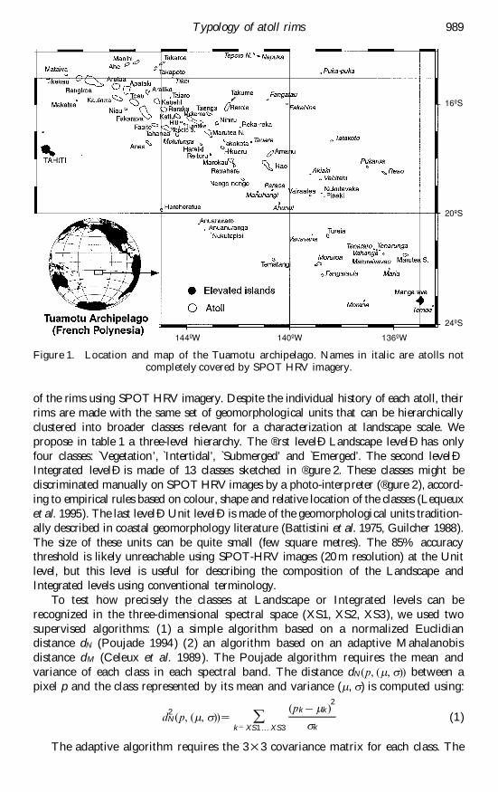
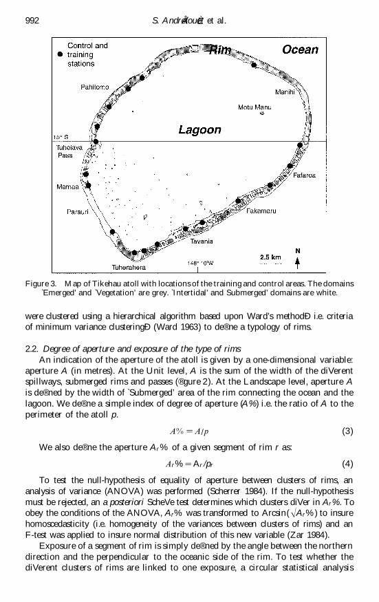
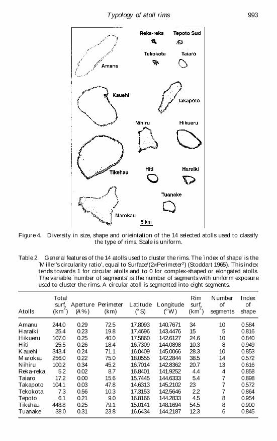
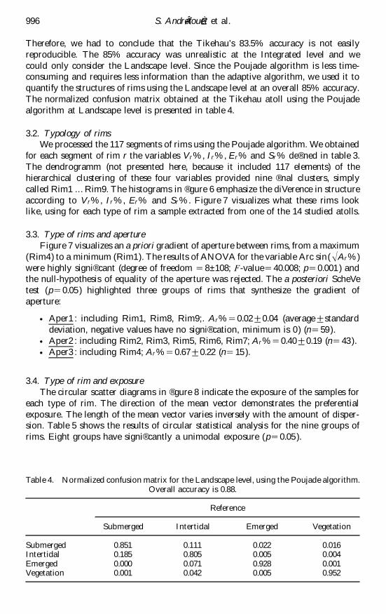
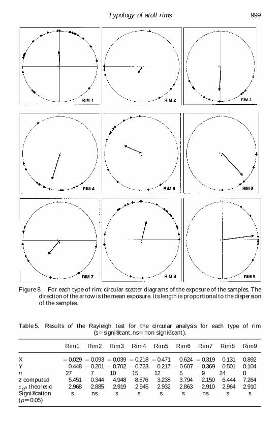
Related Documents


