Cottletown Dam, TX07451 Bastrop County ▪ Inspection Date 05/28/2015 ▪ by TCEQ Staff 1 DAM SAFETY SECTION CRITICAL INFRASTRUCTURE DIVISION Dam Safety Inspection Report GENERAL INFORMATION INVENTORY NO.: TX07451 DAM: Cottletown Dam OWNER: Gordon Conrad Walton, Jr. and Laura Ann Walton STREAM: Unnamed Trib. of Colorado River BASIN: Colorado LOCATION: 5 miles N of Smithville, TX COUNTY: Bastrop 30°4'57.07"N, 97°11'20.36"W DOWNSTREAM HAZARD CLASSIFICATION: See Report DAM HEIGHT: 25 Feet SIZE: Small NORMAL CAPACITY: 33 ac-ft MAX. CAPACITY: 83 ac-ft INSPECTION DATE: May 28, 2015 PREVIOUS INSPECTION DATE: Never Inspected INSPECTION TEAM: C.W. Schneider, P.E., Levi Best PERSONNEL CONTACTED: Mr. Tracy Bratton, P.E., Bowman Consulting SUMMARY Texas Commission on Environmental Quality (TCEQ) Dam Safety Section was contacted by Bastrop County on May 28, 2015 about a dam that overtopped during a storm event that occurred on May 25, 2015 (Memorial Day). The small-sized earthen dam is located north of Highway 71 between Bastrop and Smithville (493 Cottletown Rd., Smithville, TX), on property owned by Gordon Conrad Walton, Jr. and Laura Ann Walton.

Tx07451 cottletown dam-inspectionreport052815wsigs-reduced
Aug 19, 2015
Welcome message from author
This document is posted to help you gain knowledge. Please leave a comment to let me know what you think about it! Share it to your friends and learn new things together.
Transcript
Cottletown Dam, TX07451 Bastrop County ▪ Inspection Date 05/28/2015 ▪ by TCEQ Staff 1
DAM SAFETY SECTION CRITICAL INFRASTRUCTURE DIVISION Dam Safety Inspection Report
GENERAL INFORMATION INVENTORY NO.: TX07451 DAM: Cottletown Dam OWNER: Gordon Conrad Walton, Jr. and Laura Ann Walton STREAM: Unnamed Trib. of Colorado River BASIN: Colorado LOCATION: 5 miles N of Smithville, TX COUNTY: Bastrop 30°4'57.07"N, 97°11'20.36"W DOWNSTREAM HAZARD CLASSIFICATION: See Report DAM HEIGHT: 25 Feet SIZE: Small NORMAL CAPACITY: 33 ac-ft MAX. CAPACITY: 83 ac-ft INSPECTION DATE: May 28, 2015 PREVIOUS INSPECTION DATE: Never Inspected INSPECTION TEAM: C.W. Schneider, P.E., Levi Best PERSONNEL CONTACTED: Mr. Tracy Bratton, P.E., Bowman Consulting
SUMMARY Texas Commission on Environmental Quality (TCEQ) Dam Safety Section was contacted by Bastrop County on May 28, 2015 about a dam that overtopped during a storm event that occurred on May 25, 2015 (Memorial Day). The small-sized earthen dam is located north of Highway 71 between Bastrop and Smithville (493 Cottletown Rd., Smithville, TX), on property owned by Gordon Conrad Walton, Jr. and Laura Ann Walton.
Cottletown Dam, TX07451 Bastrop County ▪ Inspection Date 05/28/2015 ▪ by TCEQ Staff 2
The purpose of the inspection was to observe the dam, assess the damage to the dam, obtain dam dimensional measurements, and determine if potential hazards exist downstream of the dam. The dam was found to be in overall poor condition due to damage received from overtopping flows of up to 1.5 feet. Significant amounts of embankment material had been removed from the downstream slope by erosion. BACKGROUND The dam does not show up on 1997 aerials, but does show up on 2002 aerials. The owners are Conrad Gordon Walton, Jr. and Laura Ann Walton out of Austin. The dam has never been inspected by the Texas Dam Safety Program and was not in the Texas Inventory of Dams at the time of the inspection.
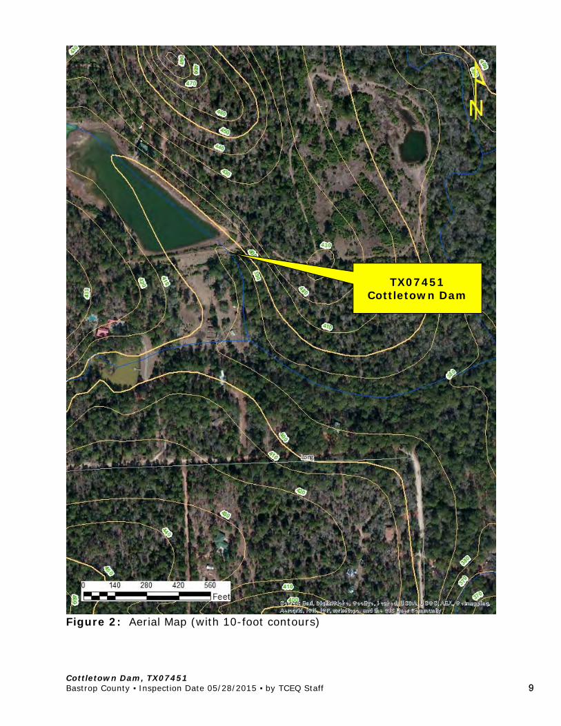
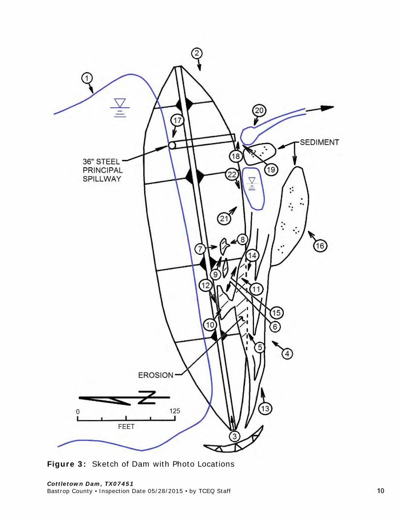
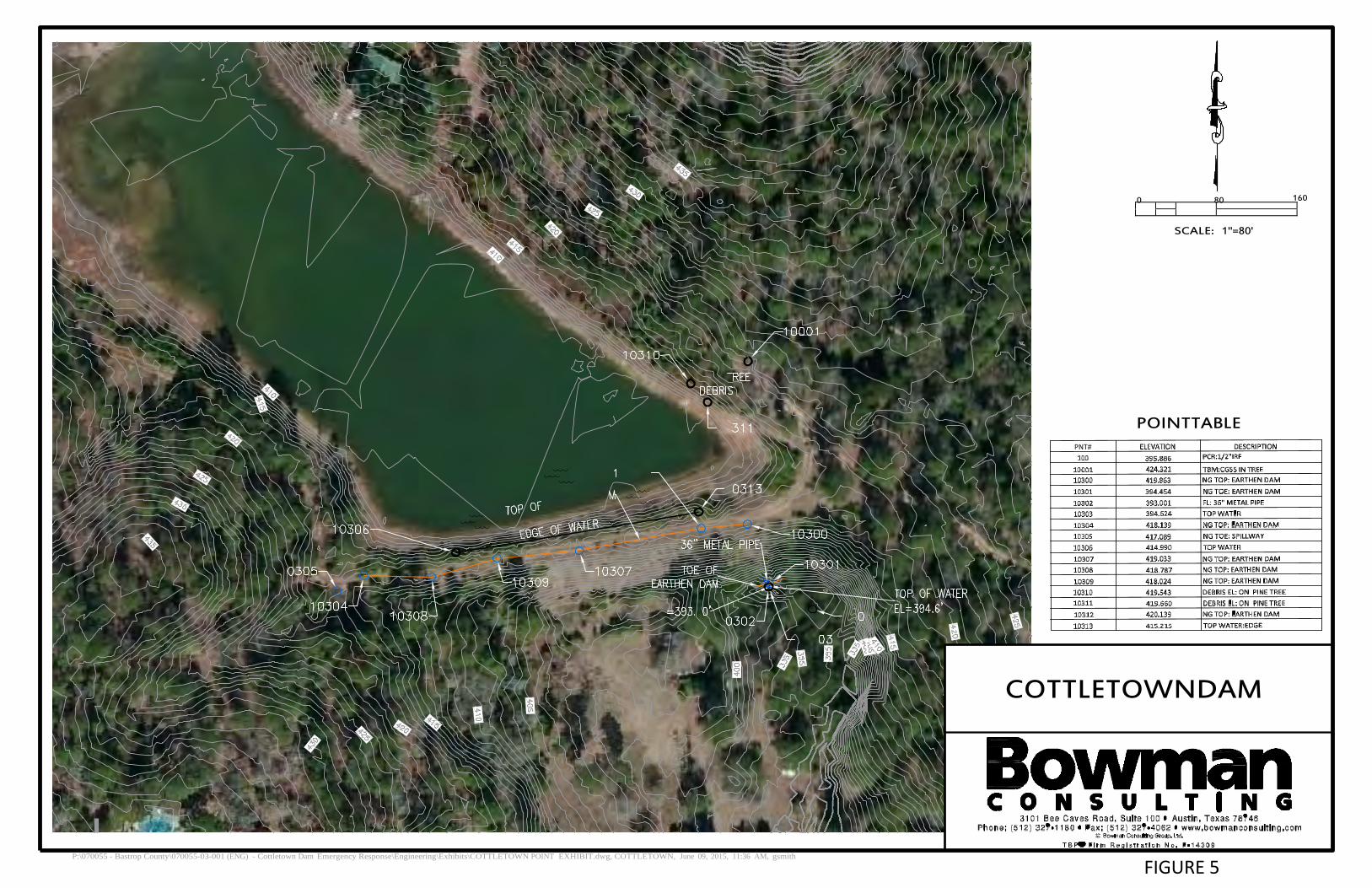
Review of Lower Colorado River Authority (LCRA) rainfall gages in the area indicates that the gage at Sim Gideon Power Plant at Lake Bastrop, which is located approximately 6.5 miles northwest of the dam, recorded 12.48 inches of rain in the two weeks prior to the dam overtopping with 4.71 inches of that falling in the three hour period preceding the overtopping of the dam. The peak one-hour rainfall intensity registered during that storm was 3.86 inches per hour. CURRENT INSPECTION On May 28, 2015, TCEQ staff met with the Mr. Tracy Bratton, P.E., of Bowman Consulting at the dam site. Bowman Consulting is contracted with Bastrop County to provide engineering services. A survey crew from Bowman Consulting was onsite to provide height and distance measurements with a GPS surveying unit. Also present at the inspection was Ms. Mizzy Zdroj, Assistant Fire Chief of the local volunteer fire department (VFD). The dam owner was not present during the inspection. Figure 1 is a location map of the dam. Figure 2 is an aerial image of the dam with contours. Figure 3 is a sketch of the dam with photo locations identified. Figure 4 is an aerial view of the downstream area. Figure 5 is a topographic exhibit of the dam prepared by Bowman Consulting. References to left and right are from the perspective of an observer facing downstream.
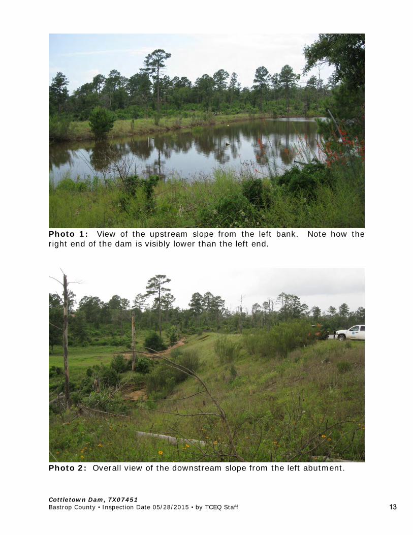
The following observations were noted: The dam was about 450 feet long and was measured to be 27 feet tall at
the maximum section (left end, at the principal spillway). The right end
Cottletown Dam, TX07451 Bastrop County ▪ Inspection Date 05/28/2015 ▪ by TCEQ Staff 3
of the dam is approximately 2 feet lower than the left end [Photos 1-3]. Per TCEQ standards, the effective height of dam is 25 feet.
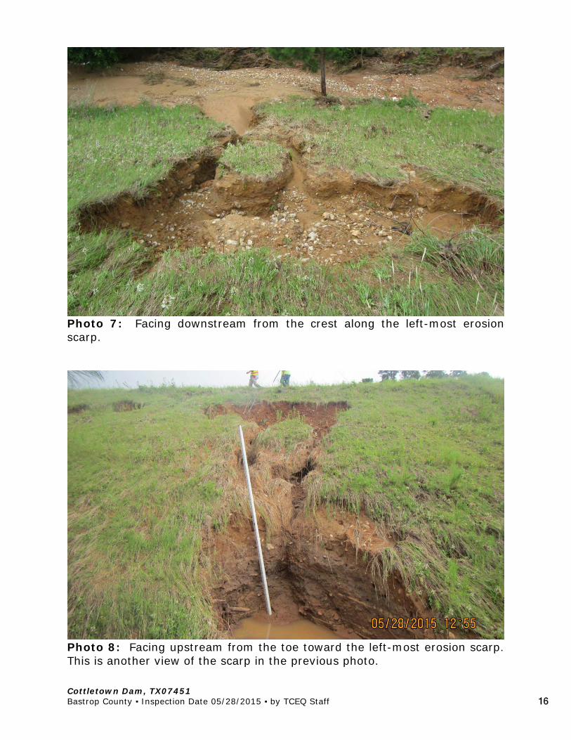
About 150 feet of the right end of the dam was overtopped by up to 1.5
feet (measured from debris line) [Photos 4-12]. Three large scour holes developed on the downstream slope. The largest scour hole was 10 feet deep and right at the edge of the crest. The other two scour holes were approximately 5 feet deep and shy of the edge of the crest.
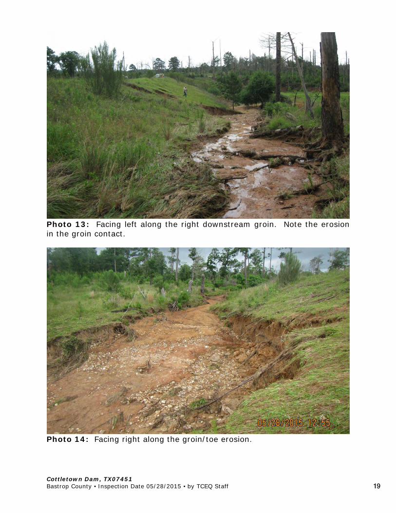
Flow around the right abutment also occurred [Photos 13-14]. The flow
around the abutment was directed along the toe of the dam, which resulted in erosion along the right downstream groin and toe area. A vertical scarp, up to 4 feet tall, was cut into the right toe of the dam. The scarp appeared to be from a combination of overtopping flows as well as flow around the abutment eroding into the toe.
Sedimentation deltas comprised of material eroded from the embankment
were observed along the downstream toe on the right end of the dam, downstream of the erosion scarps, and also just right of the principal spillway outlet [Photos 15-16].
The material in the dam appeared to be consolidated in lifts, with larger
gravels mixed in [Photo 11]. There were no significant seeps in the eroded areas. Other than the erosion, the dam appeared to be relatively stable. The overtopping and erosion occurred on the right end of the dam, where it is only 10-12 feet high, as opposed to the left end, where the dam is 27 feet tall. A breach in the location of the overtopping would likely limit the amount of water emptied from the reservoir.
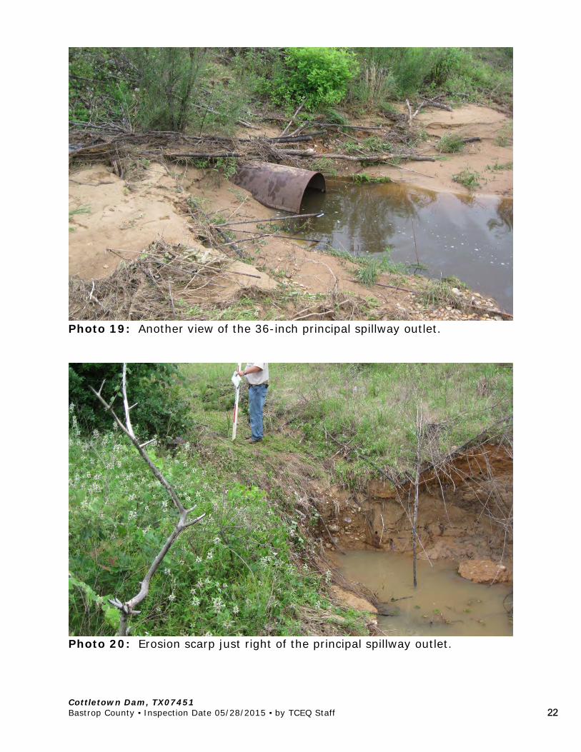
The dam had a 36-inch steel drop inlet principal spillway with a steel
grate over the entrance [Photos 17-19]. Mr. Bratten reported that when he first arrived at the dam, the grate on top of the 36” principal spillway stand pipe was covered with debris. The debris was removed and the water had been drawn down to the level of the spillway crest. Water was entering the standpipe and flowing through the lateral.
There was a 3-foot to 4-foot deep erosion scarp to the right of the
principal spillway outlet [Photo 20].
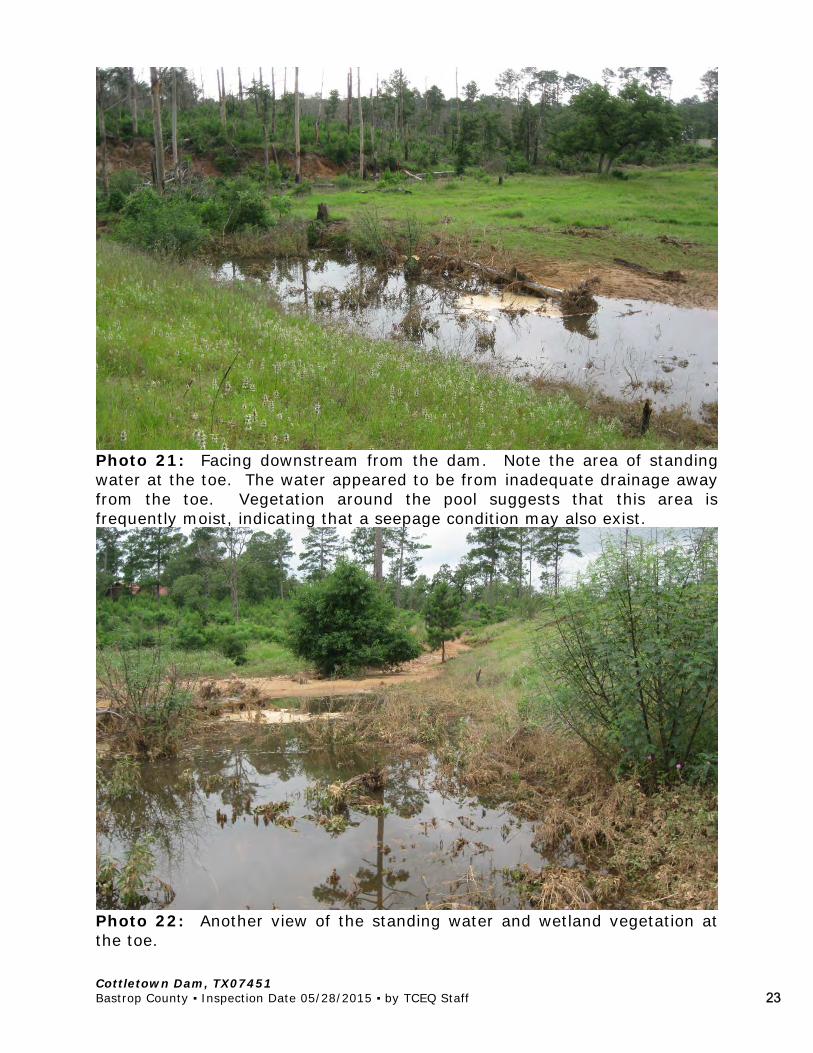
Standing water was observed at the toe of the dam to the right of the principal spillway outlet [Photos 21-22]. The water appeared to be standing due to a lack of positive drainage away from the toe of the dam. Based on the type of vegetation observed near the standing water, it appeared that area may remain moist under normal conditions, which could be indicative of a seepage condition as well.
Cottletown Dam, TX07451 Bastrop County ▪ Inspection Date 05/28/2015 ▪ by TCEQ Staff 4
At the time of the inspection, the distance between the low point in the dam crest and the water level was approximately 3 feet.
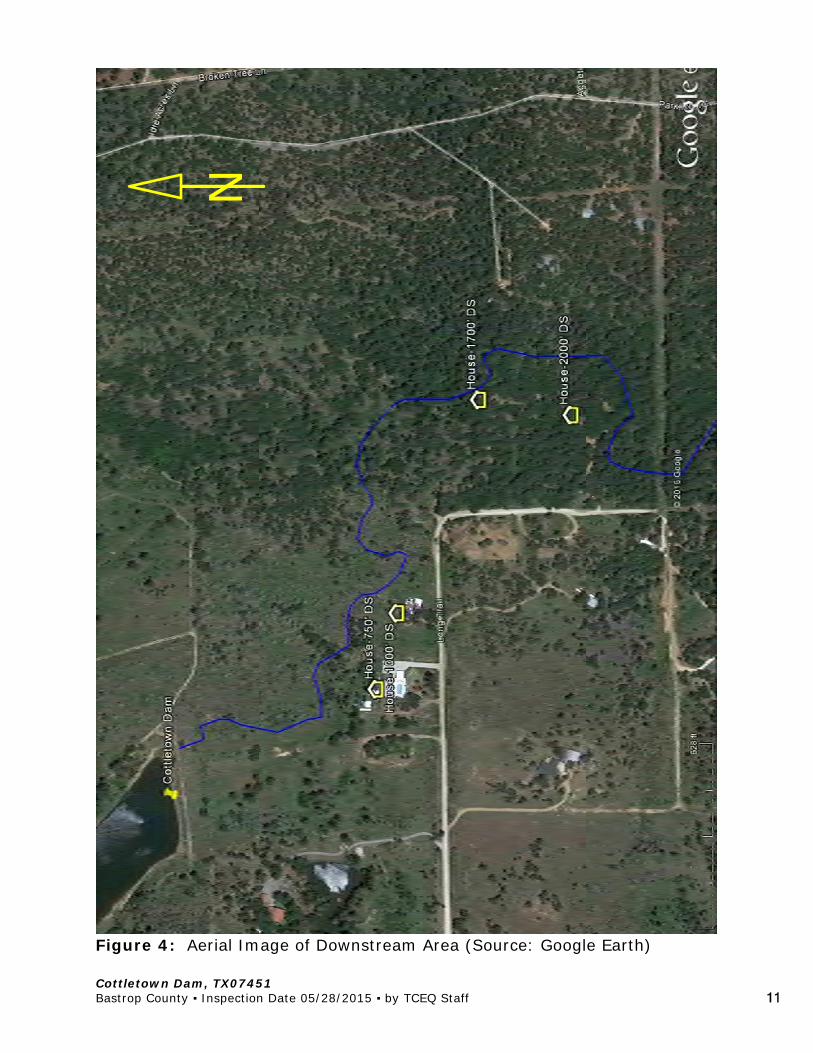
Four occupied residences were verified downstream. The residences were
located on Long Drive and were 750 feet, 1000 feet, 1700 feet, and 2000 feet downstream of the dam [Figure 4]. Ms. Zdroj reported that the VFD performed swift water rescues at two of the residences on the night of May 25. Contact was made with the resident at 244 Long Drive (1700 feet D/S). He confirmed that he and his neighbor to the south (2000 feet D/S) had been rescued the night of the overtopping. He stated that his house was built on stilts. Water got close to the finished floor, but did not get into the house. It did get into his garage.
POST-INSPECTION COMMUNICATIONS Upon conclusion of the inspection, TCEQ inspectors advised Mr. Bratton
and Ms. Zdroj that they have the owner draw the water down, notify the downstream residents of the potential for dam failure, and to monitor the weather so the downstream residents could be evacuated if necessary.
TCEQ checked in with Mr. Bratton about 8:00 pm on 5/28. At that time he reported that the pumps he originally requested were not available and they had found a smaller pump, but access to the site was difficult. Information on siphons was forwarded to Mr. Bratton.
TCEQ called Mr. Bratton about 10:00 am on 5/29 to get an update on the
drawdown. He reported that they located a 12-inch oil field pump truck. The pump had gotten stuck getting to the site. Then, a motor grader that came to pull the truck out got stuck. And, a forest service bulldozer was on the way to pull both out. He did say that they were stuck close enough to the dam that they could get the pump to operate. Overnight they were able to draw the reservoir level down about 6 inches (3.5 feet free board), even with ¾ inches of rain overnight. The VFD knocked on 9 doors once the rains started and asked the residents to voluntarily evacuate. Mr. Bratton did not have information on how many evacuated.
Mr. Bratton reported that the county is reluctant to alter the dam
structurally, as in cutting a relief trench or cutting down the stand pipe. They see drawing down the reservoir through pumps or siphons as a “passive” activity and don’t want the liability for altering the structure. They did plan to press the owner to cut a relief trench around the abutment and/or trim off some of the stand pipe riser.
On June 9, 2015, Mr. Bratton informed that the reservoir level was drawn
down about 5 feet and 4 to 5 feet of the stand pipe was cut off
Cottletown Dam, TX07451 Bastrop County ▪ Inspection Date 05/28/2015 ▪ by TCEQ Staff 5
(approximate elevation 411 ft-msl). Bull rock was to be placed around the standpipe to stabilize the embankment in the vicinity of the stand pipe. The modification to the stand pipe should have resulted in approximately 7 feet of freeboard between the crest of the spillway and the effective top of dam.
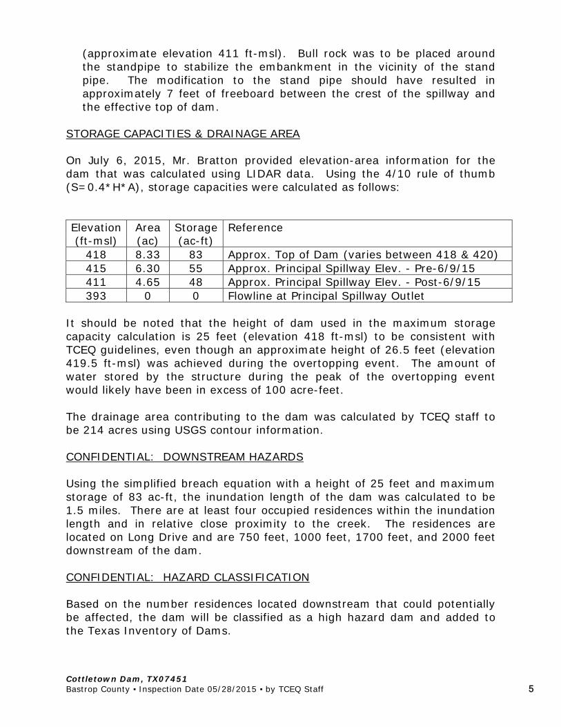
STORAGE CAPACITIES & DRAINAGE AREA On July 6, 2015, Mr. Bratton provided elevation-area information for the dam that was calculated using LIDAR data. Using the 4/10 rule of thumb (S=0.4*H*A), storage capacities were calculated as follows: Elevation Area Storage Reference (ft-msl) (ac) (ac-ft)
418 8.33 83 Approx. Top of Dam (varies between 418 & 420) 415 6.30 55 Approx. Principal Spillway Elev. - Pre-6/9/15 411 4.65 48 Approx. Principal Spillway Elev. - Post-6/9/15 393 0 0 Flowline at Principal Spillway Outlet
It should be noted that the height of dam used in the maximum storage capacity calculation is 25 feet (elevation 418 ft-msl) to be consistent with TCEQ guidelines, even though an approximate height of 26.5 feet (elevation 419.5 ft-msl) was achieved during the overtopping event. The amount of water stored by the structure during the peak of the overtopping event would likely have been in excess of 100 acre-feet. The drainage area contributing to the dam was calculated by TCEQ staff to be 214 acres using USGS contour information. CONFIDENTIAL: DOWNSTREAM HAZARDS Using the simplified breach equation with a height of 25 feet and maximum storage of 83 ac-ft, the inundation length of the dam was calculated to be 1.5 miles. There are at least four occupied residences within the inundation length and in relative close proximity to the creek. The residences are located on Long Drive and are 750 feet, 1000 feet, 1700 feet, and 2000 feet downstream of the dam. CONFIDENTIAL: HAZARD CLASSIFICATION Based on the number residences located downstream that could potentially be affected, the dam will be classified as a high hazard dam and added to the Texas Inventory of Dams.
Cottletown Dam, TX07451 Bastrop County ▪ Inspection Date 05/28/2015 ▪ by TCEQ Staff 6
HYDROLOGIC/HYDRAULIC ANALYSIS There is no record in TCEQ files of a hydrologic/hydraulic analysis ever being performed on the dam. A dam of this size and hazard classification should be capable of passing 75% of the probable maximum flood (PMF). It is not known exactly what percentage of the PMF the dam was capable of passing, but is likely that the percentage was much less than the 75% PMF considering the dam overtopped with less than 5 inches of rainfall during saturated conditions. EMERGENCY ACTION PLAN (EAP) There is no record in TCEQ files of an EAP for the dam. An EAP will be required. REQUIREMENTS/RECOMMENDATIONS 1. A Texas licensed professional engineer (P.E.) with dam experience should
be retained immediately to assess the condition of the dam and provide direction on how to temporarily stabilize the eroded areas of the dam until permanent repairs can be completed.
2. In addition to the additional freeboard provided by removing a +/- 4-foot length of pipe from the principal spillway riser, consideration should be given to cutting a relief trench around one of the abutments to provide additional spillway capacity in the interim.
3. Continue to monitor the dam, particularly during and after storm events.
If more material sloughs off, seeps develop, or water level rises significantly to threaten over-topping the structure again, notify TCEQ Dam Safety and the Bastrop County Emergency Management Coordinator immediately.
4. An Emergency Action Plan is required for this dam. The plan should
provide a means to identify emergency conditions threatening the dam, respond effectively to attempt to prevent failure, and notify the appropriate people to prevent or reduce loss of life and property damage. A guide can be downloaded at: http://www.tceq.state.tx.us/field/damsafetyprog.html. It is recommended that the template found in Appendix C be used for this dam.
5. A P.E. will be required to prepare permanent repair plans for the dam. The plans must be submitted to TCEQ Dam Safety for review and approval before construction can commence.
6. Additional spillway capacity will need to be incorporated in the

Cottletown Dam, TX07451 Bastrop County ▪ Inspection Date 05/28/2015 ▪ by TCEQ Staff 7
rehabilitated dam design. By rule the dam and spillways must safely pass 75% of the PMF. A P.E. will be required to prepare a hydrologic & hydraulic (H&H) analysis.
7. The wet area at the toe of the dam should be inspected by a P.E. during
normal conditions to determine if seepage exists in this area. Provisions for addressing any seepage and/or grading and draining the low area should be incorporated into the permanent repair plans.
8. Once the dam has been repaired and the spillway capacity increased to
meet the design storm requirements, an operation and maintenance plan will be required to address routine maintenance and monitoring of the dam. Routine maintenance includes such items as annual mowing and removal of small trees from the embankment.
CONCLUSIONS Cottletown Dam was overtopped by up to 1.5 feet and sustained damage to the downstream slope on the evening of May 25, 2015. Once the water level was drawn down, the dam, while damaged, appeared to be stable. Additionally, the principal spillway has been reportedly been cut down 4 to 5 feet to reduce the chance of another over-topping event. However, permanent repairs, including additional spillway capacity, are required. The repair plans must be prepared by a Texas licensed professional engineer. ___________________________ ___________________________ Charles W. Schneider, P.E. Levi Best Dam Safety Section Dam Safety Section Critical Infrastructure Division Critical Infrastructure Division

Cottletown Dam, TX07451 Bastrop County ▪ Inspection Date 05/28/2015 ▪ by TCEQ Staff 8
Figure 1: Location Map
TX07451 Cottletown Dam
Bastrop
Smithville
Cottletown Dam, TX07451 Bastrop County ▪ Inspection Date 05/28/2015 ▪ by TCEQ Staff 9
Figure 2: Aerial Map (with 10-foot contours)
TX07451 Cottletown Dam
Cottletown Dam, TX07451 Bastrop County ▪ Inspection Date 05/28/2015 ▪ by TCEQ Staff 10
Figure 3: Sketch of Dam with Photo Locations
Cottletown Dam, TX07451 Bastrop County ▪ Inspection Date 05/28/2015 ▪ by TCEQ Staff 11
Figure 4: Aerial Image of Downstream Area (Source: Google Earth)
N

Cottletown Dam, TX07451 Bastrop County ▪ Inspection Date 05/28/2015 ▪ by TCEQ Staff 12
Insert Figure 5
Cottletown Dam, TX07451 Bastrop County ▪ Inspection Date 05/28/2015 ▪ by TCEQ Staff 13
Photo 1: View of the upstream slope from the left bank. Note how the right end of the dam is visibly lower than the left end.
Photo 2: Overall view of the downstream slope from the left abutment.

Cottletown Dam, TX07451 Bastrop County ▪ Inspection Date 05/28/2015 ▪ by TCEQ Staff 14
Photo 3: Facing left along the crest from the right end of the dam.
Photo 4: Erosion scarps on downstream slope of dam.

Cottletown Dam, TX07451 Bastrop County ▪ Inspection Date 05/28/2015 ▪ by TCEQ Staff 15
Photo 5: Another view of the erosion scarps.
Photo 6: The largest scarp progressed to near the crest of the dam.
Cottletown Dam, TX07451 Bastrop County ▪ Inspection Date 05/28/2015 ▪ by TCEQ Staff 16
Photo 7: Facing downstream from the crest along the left-most erosion scarp.
Photo 8: Facing upstream from the toe toward the left-most erosion scarp. This is another view of the scarp in the previous photo.

Cottletown Dam, TX07451 Bastrop County ▪ Inspection Date 05/28/2015 ▪ by TCEQ Staff 17
Photo 9: Another view of the left-most scarp.
Photo 10: A view of the right-most scarp.

Cottletown Dam, TX07451 Bastrop County ▪ Inspection Date 05/28/2015 ▪ by TCEQ Staff 18
Photo 11: Facing upstream at the right-most and middle scarps. Note the various colored lifts in the embankment material.
Photo 12: Facing right toward the erosion in the downstream groin area.
Cottletown Dam, TX07451 Bastrop County ▪ Inspection Date 05/28/2015 ▪ by TCEQ Staff 19
Photo 13: Facing left along the right downstream groin. Note the erosion in the groin contact.
Photo 14: Facing right along the groin/toe erosion.

Cottletown Dam, TX07451 Bastrop County ▪ Inspection Date 05/28/2015 ▪ by TCEQ Staff 20
Photo 15: Sedimentation delta comprised of material eroded from the embankment.
Photo 16: Another sedimentation delta located at the toe of the dam. Note the downstream flow patterns in the laid over grass.

Cottletown Dam, TX07451 Bastrop County ▪ Inspection Date 05/28/2015 ▪ by TCEQ Staff 21
Photo 17: Principal spillway inlet. Note the steel grate, which was reported to be partially clogged with debris prior to the inspection.
Photo 18: Facing left toward the principal spillway outlet, denoted by the arrow.
Cottletown Dam, TX07451 Bastrop County ▪ Inspection Date 05/28/2015 ▪ by TCEQ Staff 22
Photo 19: Another view of the 36-inch principal spillway outlet.
Photo 20: Erosion scarp just right of the principal spillway outlet.
Cottletown Dam, TX07451 Bastrop County ▪ Inspection Date 05/28/2015 ▪ by TCEQ Staff 23
Photo 21: Facing downstream from the dam. Note the area of standing water at the toe. The water appeared to be from inadequate drainage away from the toe. Vegetation around the pool suggests that this area is frequently moist, indicating that a seepage condition may also exist.
Photo 22: Another view of the standing water and wetland vegetation at the toe.
0 80 160
SCALE: 1"=80'
POINTTABLE
COTTLETOWNDAM
P:\070055 - Bastrop County\070055-03-001 (ENG) - Cottletown Dam Emergency Response\Engineering\Exhibits\COTTLETOWN POINT EXHIBIT.dwg, COTTLETOWN, June 09, 2015, 11:36 AM, gsmith
FIGURE 5
Related Documents