An Advanced Systematic Literature Review on Spatiotemporal Analyses of Twitter Data Enrico Steiger, João Porto de Albuquerque and Alexander Zipf GIScience Research Group, Institute of Geography, Heidelberg University Abstract The objective of this article is to conduct a systematic literature review that provides an overview of the current state of research concerning methods and application for spatiotemporal analyses of the social network Twitter. Reviewed papers and their application domains have shown that the study of geographi- cal processes by using spatiotemporal information from location-based social networks represent a prom- ising and still underexplored field for GIScience researchers. 1 Introduction Interactive social media platforms offer a tremendous amount of voluntarily, user-generated content. In particular, the potential of Twitter has been increasingly recognized by numerous research domains over the last years. Georeferenced Twitter data creates a promising opportu- nity for the research area of GIScience to understand geographic processes and spatial relation- ships inside social networks. However, the growing body of research works conducting Twitter data analysis is not clearly visible and not easy to locate. In particular, applications and applied methods for spatiotemporal analysis of Twitter data are not identifiable at first glance. Specific literature reviews, gathering knowledge and summarizing the scientific production for Twitter based research questions are currently lacking. Therefore, the overall goal of this article is to close this research gap by providing an objective summary of the current state of the research concerning where Twitter in general has been used, for which specific use cases and what methods have been applied. The reviewed articles allow a more detailed evaluation regarding the potential of Twitter, but also summarize remaining challenges and investigate possible drawbacks. A key element of this review is to identify where solid research results already exist and where new research is needed. Cross- analyzing our reviewed papers concerning research disciplines, applications and methods, we identify current research foci and provide a solid foundation for further studies. Finally, rec- ommendations for future research directions are given. 1.1 Background of VGI, Social Media and Location-Based Social Network Emerging technologies have created new approaches towards the distribution and acquisition of crowdsourced information. The growing availability of mobile devices equipped with GPS sensors, high performing computers and broadband internet connections with advanced server Address for correspondence: Enrico Steiger, Institute of Geography, Heidelberg University, Berliner Straße 48D-69120 Heidelberg, Germany. E-mail: [email protected] Acknowledgements: This research has been funded through the graduate scholarship program Crowdanalyser-spatiotemporal analysis of user-generated content supported by the state of Baden Wurttemberg. Review Article Transactions in GIS, 2015, ••(••): ••–•• © 2015 John Wiley & Sons Ltd doi: 10.1111/tgis.12132

Welcome message from author
This document is posted to help you gain knowledge. Please leave a comment to let me know what you think about it! Share it to your friends and learn new things together.
Transcript

An Advanced Systematic Literature Review onSpatiotemporal Analyses of Twitter Data
Enrico Steiger, João Porto de Albuquerque and Alexander Zipf
GIScience Research Group, Institute of Geography, Heidelberg University
AbstractThe objective of this article is to conduct a systematic literature review that provides an overview of thecurrent state of research concerning methods and application for spatiotemporal analyses of the socialnetwork Twitter. Reviewed papers and their application domains have shown that the study of geographi-cal processes by using spatiotemporal information from location-based social networks represent a prom-ising and still underexplored field for GIScience researchers.
1 Introduction
Interactive social media platforms offer a tremendous amount of voluntarily, user-generatedcontent. In particular, the potential of Twitter has been increasingly recognized by numerousresearch domains over the last years. Georeferenced Twitter data creates a promising opportu-nity for the research area of GIScience to understand geographic processes and spatial relation-ships inside social networks. However, the growing body of research works conducting Twitterdata analysis is not clearly visible and not easy to locate. In particular, applications andapplied methods for spatiotemporal analysis of Twitter data are not identifiable at first glance.Specific literature reviews, gathering knowledge and summarizing the scientific production forTwitter based research questions are currently lacking.
Therefore, the overall goal of this article is to close this research gap by providing anobjective summary of the current state of the research concerning where Twitter in general hasbeen used, for which specific use cases and what methods have been applied. The reviewedarticles allow a more detailed evaluation regarding the potential of Twitter, but also summarizeremaining challenges and investigate possible drawbacks. A key element of this review is toidentify where solid research results already exist and where new research is needed. Cross-analyzing our reviewed papers concerning research disciplines, applications and methods, weidentify current research foci and provide a solid foundation for further studies. Finally, rec-ommendations for future research directions are given.
1.1 Background of VGI, Social Media and Location-Based Social Network
Emerging technologies have created new approaches towards the distribution and acquisitionof crowdsourced information. The growing availability of mobile devices equipped with GPSsensors, high performing computers and broadband internet connections with advanced server
Address for correspondence: Enrico Steiger, Institute of Geography, Heidelberg University, Berliner Straße 48D-69120 Heidelberg,Germany. E-mail: [email protected]: This research has been funded through the graduate scholarship program Crowdanalyser-spatiotemporal analysis ofuser-generated content supported by the state of Baden Wurttemberg.
bs_bs_banner
Review Article Transactions in GIS, 2015, ••(••): ••–••
© 2015 John Wiley & Sons Ltd doi: 10.1111/tgis.12132

and client-side key technologies, allows users to participate actively and create content throughmobile applications and location-based services. The role of the user has changed from beingeither a producer or a consumer into being a rather dynamic prosumer (Tapscott 1996). Theparticipation of individuals and their vast amount of generated data has been commonlyknown under the term Web 2.0 (O’Reilly 2009). Facilitated by new technologies, audiencesare using their local knowledge without the need of prior expertise. Goodchild names this phe-nomenon ‘Citizens as Sensors’, where Volunteered Geographic Information (VGI) is created,assembled, and disseminated by individuals or groups with knowledge or capabilities using theWeb 2.0 (Goodchild 2007). Within this interactive networked, participatory model of Peopleas Sensors (Resch 2013), information is supplied free of charge and voluntarily. Haklay termsthis development of new innovative social web mapping applications as the evolution of theGeoWeb (Haklay et al. 2008).
Social Networks are a key part of this development, incorporating new information pluscommunication tools and attracting millions of users. Boyd and Ellison (2007) outline theterm Social Network Sites (SNS), typified by individuals who construct an online profile com-municating with other users, sharing common ideas, activities, events and interests. Location-Based Social Networks further enhance existing social networks, adding a spatial dimensionwith location-embedded services. For example, users upload geotagged photos via Flickr,checking in at a venue with Foursquare or commenting on a local event via Twitter.Geoinformation extracted from these Location-Based Social Networks is usually includedunder the umbrella of Volunteered Geographic Information (Sui and Goodchild 2011).However, Harvey (2013) argues that this would be more precisely labeled as “contributed”data, since people do not consciously volunteer their data, but generate it in the process ofusing the platforms for their particular purposes.
In the case of Twitter, users can post short-status messages with up to 140 characters andmay include photo attachments, which are called “tweets”. These posts can contain specificsyntax such as hashtags (#) as a keyword or term assigned to a topic the users are discussingor commenting about. Furthermore, a user can subscribe to “follow” or become a “follower”of other users’ tweets with the possibility of replying directly (@) to all Twitter posts. Accord-ing to Twitter, about 271 million monthly active users are generating an average of 500 milliontweets per day (https://about.twitter.com/company). With the permission of the user, eachtweet contains a corresponding geo-location acquired from the GPS sensor within the mobiledevice. These location-driven social structures allow mobile device owner with ubiquitousinternet access to exchange details of their personal location as a key point of interaction(Zheng 2011). Location-Based Social Networks are bridging the gap between our physicalworld and online social network services containing three layers of information according toSymeonidis et al. (2014): (1) a social network (user layer); (2) a geographical network (loca-tion layer); and (3) a semantic metadata network (content layer).
Therefore, user posts in Twitter represent a spatiotemporal signal (geolocation and times-tamp of tweet) with a semantic information layer (content of tweet message). After the userregistration, all tweets can be collected in real-time through the official Twitter streamingAPI (https://dev.twitter.com/docs/api/streaming). The API query allows the filtering of key-words and individual user posts to preselect tweets as well as the possibility of obtainingonly georeferenced Twitter messages within a predefined bounding box. Analyzing thisspatiotemporal information layer, which is a by-product of individual people’s social interac-tion, may lead to new insights of understanding spatial structures and underlying patterns.This interdisciplinary and relatively new research field of Location-Based Social Networksshows a lack of commonly used online databases and available literature sources. Systematic
2 E Steiger, J Porto de Albuquerque and A Zipf
© 2015 John Wiley & Sons Ltd Transactions in GIS, 2015, ••(••)

reviews therefore might assist structuring and providing a comprehensive summary of cur-rently existing literature. This review seeks to gain new knowledge and insights into thecurrent state of research of Twitter analyses, regarding involved academic disciplines, primarilyreviewed applications and used methods. One benefit of this review will be the ability to detectcurrent research foci allowing the transfer of established methods from various disciplines intoother disciplines and enhancing new applications. Finally, the review will provide all stake-holders with further knowledge enabling an interdisciplinary research exchange.
1.2 Existing Literature Reviews
A non-systematic keyword search looking for the term “systematic literature reviews” incommon electronic GIS journal libraries was conducted initially, in the following journals:International Journal of Geographic Information Science, International Journal of RemoteSensing, Photogrammetric Engineering and Remote Sensing, Computers and Geosciences,Transactions in GIS, GeoInformatica, Geomatica – i.e. only journal papers which were rankedas a number one GIScience journal according to the Delphi Study by Caron et al. (2008) wereselected. Surprisingly, besides literature surveys and basic non-systematic reviews from otherdisciplines dealing with geographic information systems, no journal articles conducting a sys-tematic literature review with relevance to GIScience have been found. This preliminaryoutcome underlines the need for further research conducting a systematic literature review inGIScience.
Related to geographic information science, Horita et al. (2013) assessed the current stateof research for a conference paper analyzing VGI for disaster management and applying a sys-tematic literature review including a screening process of important literature databases. Roickand Heuser (2013) provided a general but non-systematic review article about the currentresearch on Location-Based Social Networks, stating the need of further studies on investigat-ing how social networks can be applied to specific use cases. Blaschke and Eisank (2012) con-ducted a non-systematic keyword-based literature search comparing the terms “GIS” and“GIScience” and their total number of citations over time. However, existing literature reviewsin the GIScience field have been performed in a rather non-systematic manner, with a lack ofstatistical techniques including metadata analysis. To the best of our knowledge, no systematicliterature reviews have been published up to this moment in well-known journals in the field ofGIScience.
2 Review Method
This review will follow the guidelines developed by Kitchenham and Charters (2007) andKitchenham et al. (2009), dividing the research into three main phases: (1) planning thereview; (2) conducting the review with the selection of studies from electronic databases; and(3) reporting the final review results itself.
The flowchart review model in Figure 1 visualizes our automatic workflow approach.The following paragraphs and sections are divided according to the review process shown inthe flowchart of Figure 1. Due to limited space, the detailed procedure and methods of the lit-erature review, including all intermediary and derived results have been documented in areview protocol and are published as a separate technical report (http://koenigstuhl.geog.uni-heidelberg.de/publications/2014/Steiger/Twitter_review_technicalreport.pdf). The detailedreview method steps have been black-boxed in Figure 1 and are part of the external technicalreport.
Spatiotemporal Analyses of Twitter Data – Systematic Literature Review 3
© 2015 John Wiley & Sons Ltd Transactions in GIS, 2015, ••(••)

Figure 1 Flowchart review process and number of included and excluded papers in each step
4 E Steiger, J Porto de Albuquerque and A Zipf
© 2015 John Wiley & Sons Ltd Transactions in GIS, 2015, ••(••)
Drafting a clear and concise research question is an essential task needed to successfullyidentify primary studies providing a detailed state-of-the-art report (Okoli and Schabram2010). As the review objectives are to extract use cases, focused research areas and methodswhen utilizing Twitter, the following three research questions have been selected:
RQ 1: Which of the academic disciplines are mainly focused on researching Twitter?RQ 2: What are the application domains where Twitter has been used?RQ 3: What are the methods used to analyze data from Twitter?
Application domains are defined as the primarily identifiable research field of Twitter applica-tions for each paper.
The initial step consists of selecting eligible literature sources based on following criteria:
• Consideration of journal, workshop and conference proceedings published between 2005and September 2013 in English;
• Selection of multiple digital libraries with relevance to information research identified byBrereton et al. (2007) and further supplemented with GIScience relevant digital libraries.
The electronic database search with defined keywords was conducted and included all paperspublished up until 30 September 2013. Furthermore, test reviews with preliminary trialsearches were carried out in order to detect and minimize bias concerning the defined searchstrings or during the subsequent data extraction process.
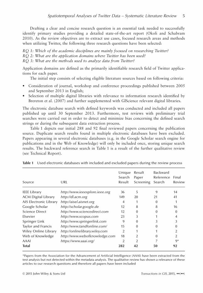
Table 1 depicts our initial 288 and 92 final reviewed papers concerning the publicationsource. Duplicate search results found in multiple electronic databases have been excluded.Papers appearing in several electronic databases (e.g. in the Google Scholar search engine forpublications and in the Web of Knowledge) will only be included once, storing unique searchresults. The backward reference search in Table 1 is a result of the further qualitative review(see Technical Report).
Table 1 Used electronic databases with included and excluded papers during the review process
Source URL
UniqueSearchResult
ResultPaperScreening
BackwardReferenceSearch
FinalReview
IEEE Library http://www.ieeexplore.ieee.org 36 5 9 14ACM Digital Library http://dl.acm.org 149 20 21 41AIS Electronic Library http://aisel.aisnet.org 4 1 0 1Google Scholar http://scholar.google.de 12 8 8 16Science Direct http://www.sciencedirect.com 12 0 0 0Elsevier http://www.scopus.com 23 3 1 4Springer Link http://www.springerlink.com 9 0 3 3Taylor and Francis http://www.tandfonline.com/ 15 0 0 0Wiley Online Library http://onlinelibrary.wiley.com 2 1 1 2Web of Knowledge http://www.webofknowledge.com 18 2 0 2AAAI https://www.aaai.org/ 2 2 7 9*Total 282 42 50 92
*Papers from the Association for the Advancement of Artificial Intelligence (AAAI) have been extracted from thetext analysis but not detected within the metadata analysis. The qualitative review has shown a relevance of thesearticles to our research questions and therefore all papers have been included
Spatiotemporal Analyses of Twitter Data – Systematic Literature Review 5
© 2015 John Wiley & Sons Ltd Transactions in GIS, 2015, ••(••)

The remaining studies (n = 92) have been qualitatively reviewed. A tabulated spreadsheethas been developed to assist the review process. All results are documented in a detailed reviewtable, collating information from all 92 papers aiming to answer our initial research questions.Reviewed papers and their specific applications (RQ 2) (as shown in Figures 5 and 6), havebeen categorized by analyzing the primarily stated research application from the paper. Theapplied methods (RQ3) have been classified using the defined topic types according toKitchenham and Charters (2007).
A practical screen of included papers by reading the full-text, furthers the review by exam-ining methods and use cases. The inclusion (IC) and exclusion criteria (EC) for the qualitativereview are listed in Table 2.
During the paper screening process, 42 papers were included which show relevance to ourprevious formulated research questions (IC1, IC2 and IC3). Fifteen papers not explaining theirmethodological approach or application of Twitter fall within the exclusion criteria (EC1).Another five papers have been excluded because of duplicated content (EC2). These cross cita-tions have not been excluded quantitatively in the metadata- and text-analysis previously asthey are strongly semantically close. Forty-two papers remain for the further analysis.
3 Review Results
Analyzing the year of publication for all included papers in the final review, a constantlyincreasing amount of Twitter research articles have been published during the reviewed timeperiod (01/01/2005–30/09/2013). Between 2009 and 2012 the quantity of published papershas more than tripled from 27 to 84 (Figure 2). As the review includes all works publisheduntil September 2013, a similar trend concerning the number of papers for the whole year2013 can be postulated. The majority of finally included and reviewed papers have been pub-lished between 2011 and 2012 (53 papers for both years).
In the following sections, our research questions will be answered.
3.1 RQ 1: Which of the Academic Disciplines are Mainly Focused onResearching Twitter?
All papers’ metadata has been analyzed to find out from which academic disciplines authorsare contributing research results on Twitter in general (Figure 3). Papers have been classifiedaccording to academic disciplines based on available metadata within the paper, where authorsstate with which department or research field they are affiliated. If not provided inside the
Table 2 Defined inclusion and exclusion criteria during the qualitative review
IC1: Papers clearly depicting their research applications of Twitter data (RQ 1)IC2: Papers clearly describing their used methods concerning the exploration, extraction,
processing, validation and aggregation of Twitter data (RQ 3)IC3: Papers being listed in previous selected electronic databases (Table 1)EC1: Papers not explaining methods nor their applications of Twitter data usage (RQ1 and
RQ3)EC2: Duplicate content, i.e. papers covering the same research about Twitter from the
authors (e.g. a journal paper containing only minor extensions to a conference paper)EC3: Papers not being listed in previous selected electronic databases (Table 1)
6 E Steiger, J Porto de Albuquerque and A Zipf
© 2015 John Wiley & Sons Ltd Transactions in GIS, 2015, ••(••)

papers, the authors’ affiliated faculty or department was investigated through an online search.Forty-six percent of our reviewed papers have been published by researchers working in theComputer Science field, along with 30% from the field of Information Science. Other researchdisciplines such as Earth- and Geoscience (7%), Social Science, Engineering and ComputerLinguistics have only a minor occurrence (less than 4% each). In 9% of the papers authorshave a multi-disciplinary background. In Figure 4 the temporal evolution of reviewed studies
Figure 2 Comparison year of publication of initially selected papers (n = 282) with results from thefinal review (n = 92)
Figure 3 Classification of papers according to authors’ academic research disciplines
Spatiotemporal Analyses of Twitter Data – Systematic Literature Review 7
© 2015 John Wiley & Sons Ltd Transactions in GIS, 2015, ••(••)

(Figure 2) according to their academic discipline (Figure 3) have been combined and analyzed.Due to the sparseness and small number of studies for some disciplines only the most fre-quently occurring ones (above 4%) have been visualized. The majority of the reviewed studieswere published between 2010 and 2013 mainly from an information and computer sciencebackground. From earth/geoscience and social science disciplines only a few studies have beenpublished since 2011.
3.2 RQ 2: What are the Application Domains where Twitter has been Used?
When focusing on primary applications of every paper (Figure 5), more than 46% of thepapers have been classified as research on event detection, 14% of the papers deal with socialnetwork analysis and investigate individual user characteristics and their social relationshipswithin a network. Thirteen percent focus on retrieving direct or indirect geolocation informa-tion from Twitter defined as location inference, while 27% of the papers do not have a specificcontext of application (Figure 5). Within the subfield of event detection and the investigationof abnormal spatial, temporal and semantic tweet frequencies, disaster- and emergency man-agement has been the primarily identified application in 27% of all reviewed studies. Twitterresearch for traffic management has been the application in 14% of reviewed studies, while5% are investigating Twitter for disease/health management. Within 49 papers we were able toextract the geographic location where Twitter data has been collected on a country level and ina few cases on a city level. Almost 24 papers obtain and analyze Twitter datasets inside theUSA (Figure 6). Six papers collect Twitter data on a city-scale for New York. The seven paperscovering Twitter data for Japan and the two papers retrieving social media data for Haiti, useTwitter in the context of disaster management.
3.3 RQ 3: What are the Methods Used to Analyze Data from Twitter?
Before investigating the research methodologies within all reviewed papers, we first examineexactly which information from Twitter data has been used. The applied methods are strongly
Figure 4 Yearly breakdown of publication count in different academic disciplines
8 E Steiger, J Porto de Albuquerque and A Zipf
© 2015 John Wiley & Sons Ltd Transactions in GIS, 2015, ••(••)

dependent on the information content of the Twitter input data (Figure 7). Thirty-threepercent of the papers use all information layers, including the tweet message, the geotag(geospatial information), and the timestamp. The main focus of these papers is a spatio-temporal and semantic analysis. Ten percent of papers focus on researching spatio-temporalinformation in Twitter not including semantic analysis. Therefore, 43% are working withspatial data from tweets. Fifty-seven percent of articles only consider the semantic informationof the tweet itself without spatial information. These papers analyze the content of tweets andconstruct a semantic network to enrich non-spatial posts with geographic information to inferlocations. Within these papers, four papers analyze solely the Twitter posts to infer geographiclocations and identify geographic landmarks from textual information. One paper (Watanabe
Figure 5 Specific application domain of reviewed papers
Figure 6 Streamed Twitter data per country (n = 51)
Spatiotemporal Analyses of Twitter Data – Systematic Literature Review 9
© 2015 John Wiley & Sons Ltd Transactions in GIS, 2015, ••(••)
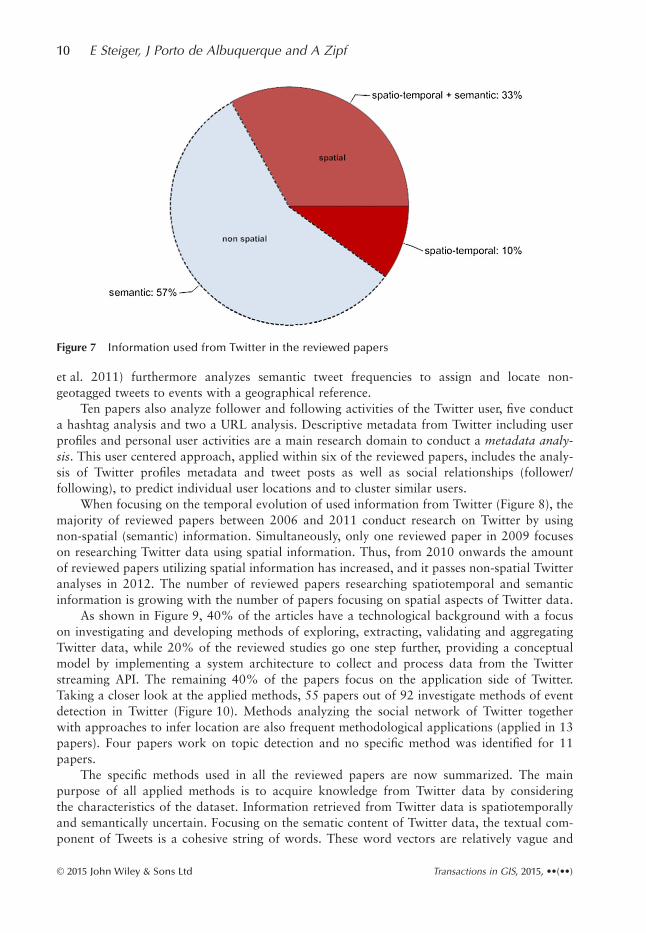
et al. 2011) furthermore analyzes semantic tweet frequencies to assign and locate non-geotagged tweets to events with a geographical reference.
Ten papers also analyze follower and following activities of the Twitter user, five conducta hashtag analysis and two a URL analysis. Descriptive metadata from Twitter including userprofiles and personal user activities are a main research domain to conduct a metadata analy-sis. This user centered approach, applied within six of the reviewed papers, includes the analy-sis of Twitter profiles metadata and tweet posts as well as social relationships (follower/following), to predict individual user locations and to cluster similar users.
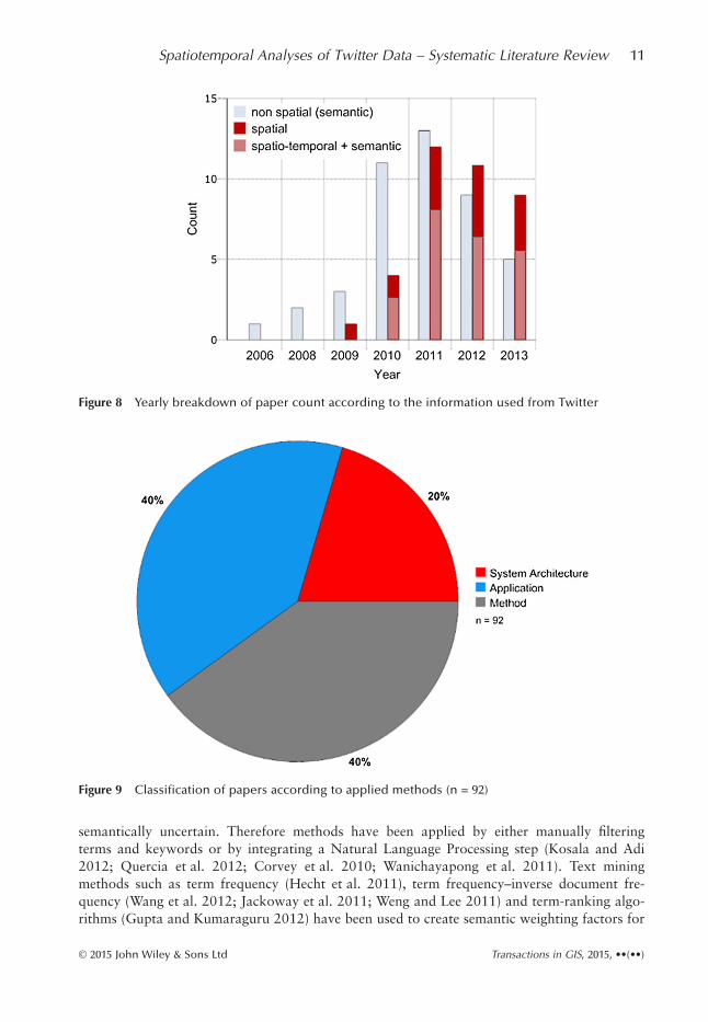
When focusing on the temporal evolution of used information from Twitter (Figure 8), themajority of reviewed papers between 2006 and 2011 conduct research on Twitter by usingnon-spatial (semantic) information. Simultaneously, only one reviewed paper in 2009 focuseson researching Twitter data using spatial information. Thus, from 2010 onwards the amountof reviewed papers utilizing spatial information has increased, and it passes non-spatial Twitteranalyses in 2012. The number of reviewed papers researching spatiotemporal and semanticinformation is growing with the number of papers focusing on spatial aspects of Twitter data.
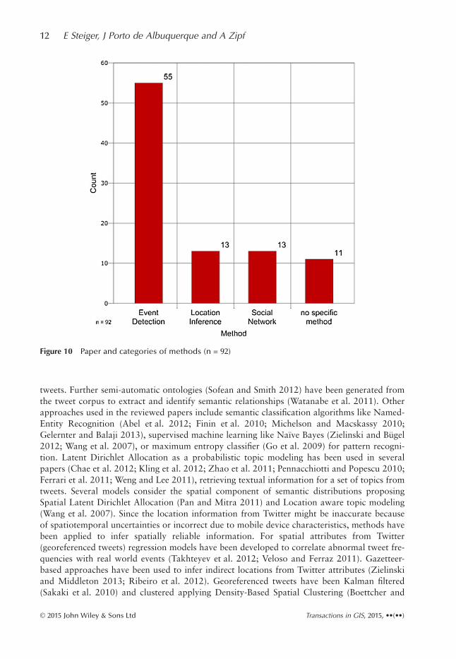
As shown in Figure 9, 40% of the articles have a technological background with a focuson investigating and developing methods of exploring, extracting, validating and aggregatingTwitter data, while 20% of the reviewed studies go one step further, providing a conceptualmodel by implementing a system architecture to collect and process data from the Twitterstreaming API. The remaining 40% of the papers focus on the application side of Twitter.Taking a closer look at the applied methods, 55 papers out of 92 investigate methods of eventdetection in Twitter (Figure 10). Methods analyzing the social network of Twitter togetherwith approaches to infer location are also frequent methodological applications (applied in 13papers). Four papers work on topic detection and no specific method was identified for 11papers.
The specific methods used in all the reviewed papers are now summarized. The mainpurpose of all applied methods is to acquire knowledge from Twitter data by consideringthe characteristics of the dataset. Information retrieved from Twitter data is spatiotemporallyand semantically uncertain. Focusing on the sematic content of Twitter data, the textual com-ponent of Tweets is a cohesive string of words. These word vectors are relatively vague and
Figure 7 Information used from Twitter in the reviewed papers
10 E Steiger, J Porto de Albuquerque and A Zipf
© 2015 John Wiley & Sons Ltd Transactions in GIS, 2015, ••(••)
semantically uncertain. Therefore methods have been applied by either manually filteringterms and keywords or by integrating a Natural Language Processing step (Kosala and Adi2012; Quercia et al. 2012; Corvey et al. 2010; Wanichayapong et al. 2011). Text miningmethods such as term frequency (Hecht et al. 2011), term frequency–inverse document fre-quency (Wang et al. 2012; Jackoway et al. 2011; Weng and Lee 2011) and term-ranking algo-rithms (Gupta and Kumaraguru 2012) have been used to create semantic weighting factors for
Figure 8 Yearly breakdown of paper count according to the information used from Twitter
Figure 9 Classification of papers according to applied methods (n = 92)
Spatiotemporal Analyses of Twitter Data – Systematic Literature Review 11
© 2015 John Wiley & Sons Ltd Transactions in GIS, 2015, ••(••)
tweets. Further semi-automatic ontologies (Sofean and Smith 2012) have been generated fromthe tweet corpus to extract and identify semantic relationships (Watanabe et al. 2011). Otherapproaches used in the reviewed papers include semantic classification algorithms like Named-Entity Recognition (Abel et al. 2012; Finin et al. 2010; Michelson and Macskassy 2010;Gelernter and Balaji 2013), supervised machine learning like Naïve Bayes (Zielinski and Bügel2012; Wang et al. 2007), or maximum entropy classifier (Go et al. 2009) for pattern recogni-tion. Latent Dirichlet Allocation as a probabilistic topic modeling has been used in severalpapers (Chae et al. 2012; Kling et al. 2012; Zhao et al. 2011; Pennacchiotti and Popescu 2010;Ferrari et al. 2011; Weng and Lee 2011), retrieving textual information for a set of topics fromtweets. Several models consider the spatial component of semantic distributions proposingSpatial Latent Dirichlet Allocation (Pan and Mitra 2011) and Location aware topic modeling(Wang et al. 2007). Since the location information from Twitter might be inaccurate becauseof spatiotemporal uncertainties or incorrect due to mobile device characteristics, methods havebeen applied to infer spatially reliable information. For spatial attributes from Twitter(georeferenced tweets) regression models have been developed to correlate abnormal tweet fre-quencies with real world events (Takhteyev et al. 2012; Veloso and Ferraz 2011). Gazetteer-based approaches have been used to infer indirect locations from Twitter attributes (Zielinskiand Middleton 2013; Ribeiro et al. 2012). Georeferenced tweets have been Kalman filtered(Sakaki et al. 2010) and clustered applying Density-Based Spatial Clustering (Boettcher and
Figure 10 Paper and categories of methods (n = 92)
12 E Steiger, J Porto de Albuquerque and A Zipf
© 2015 John Wiley & Sons Ltd Transactions in GIS, 2015, ••(••)

Lee 2012). Based on geotag and semantic content, tweets have also been classified usingSupport Vector Machines (Ritterman et al. 2009; Zubiaga et al. 2011; Starbird and Muzny2012; Sakaki et al. 2010).
3.4 Cross Analysis
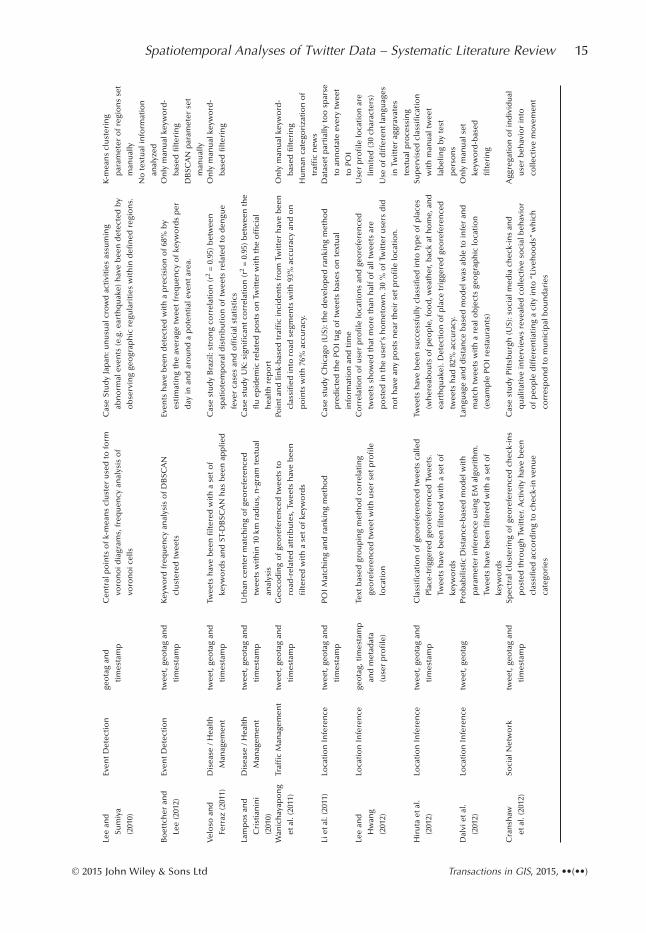
In the following paragraph a cross analysis has been performed, investigating where methodshave been extracted and sorted according to their category of application. However, not all 92qualitatively reviewed papers can be quoted herein. Table 3 includes a detailed description ofthe outcomes of each reviewed study dealing with the spatial aspect of Twitter data.
3.4.1 Event detection
Within the subdomain of an event detection, researchers are investigating on detecting abnor-mal spatial, temporal and semantic tweet frequencies and patterns in real-time using Twitter asa social sensor for real world events (Chae et al. 2012; Yardi and Boyd 2010). Semantic infor-mation has been the predominant information layer used for event detection. Cui et al. (2012)work on semantic topic detection for events by analyzing popular hashtags. Several studiesfocus on the semantic tweet content using Natural language processing (Corvey et al. 2010).Becker and Gravano (2011) and Jackoway et al. (2011) identify real-world event and newscontent on Twitter by extracting and classifying topics using tf-idf and Naive Bayes Classifier.Weng and Lee (2011) cluster wavelet-based signals in Twitter and classify events by applyingtf-idf as well as the LDA topic modeling algorithm (Blei et al. 2003). Kling et al. (2012)research urban topic modeling with LDA and spatio-temporally clustered Twitter data in NewYork to detect events. Lee and Sumiya (2010) study user behavior patterns in Twitter measur-ing geographic regularities detecting geo-social events and identifying Regions of Interests(RoI). Boettcher and Lee (2012) differentiate events based on geographical scales by countingaverage daily keyword frequencies over space using DBSCAN clustering algorithm (Ester et al.1996) and classify terms according to their relevance to a local event. Abel et al. (2012) alsosemantically filter keywords and classify information on Twitter applying Named-entity recog-nition. Hughes and Palen (2009) focus on Twitter metadata performing a user analysis andclassification including tweet response rates for mass convergence events. Starbird and Muzny(2012) analyze mass disruption events using the Support-Vector Machine (SVM) Learningalgorithm to classify user tweeting “on ground” and “not on-ground” for the Occupy WallStreet movement in New York.
Disaster/emergency management. In the area of disaster/emergency managementspatiotemporal and semantic information have been mainly used to analyze Tweets. Thomsonet al. (2012) categorizes tweets and measures tweet proximities comparing different sources ofinformation and assessing reliability of Twitter for the Fukushima nuclear power plant inci-dent. De Longueville and Smith (2009) conduct a spatio-temporal analysis of Twitter tweetsfor a fire event in France. Murthy and Longwell (2013) explore the temporal frequency distri-bution of tweets per country for disasters. Together with MacEachren et al. (2011), who devel-ops a system architecture for situation awareness, they are both applying methodologies forthe earthquake in Haiti. Twitter as an earthquake detection and geolocation system was firstintroduced bv Sakaki et al. (2010) and was adapted by Crooks et al. (2013). Methods in thiswork include a Kalman and partioning filter of tweets together with a SVM classification toestimate the earthquake location and to derive a hazard trajectory from tweets. Sakaki et al.
Spatiotemporal Analyses of Twitter Data – Systematic Literature Review 13
© 2015 John Wiley & Sons Ltd Transactions in GIS, 2015, ••(••)

Tabl
e3
Det
aile
dre
view
and
stu
dy
ove
rvie
wo
fp
aper
sco
nd
uct
ing
spat
iote
mp
ora
lTw
itte
ran
alys
es
Stu
dy
Ap
plic
atio
nU
sed
info
rmat
ion
Met
ho
dSt
ud
yo
verv
iew
Lim
itat
ion
De
Lon
guev
ille
and
Smit
h
(200
9)
Dis
aste
r/Em
erge
ncy
Man
agem
ent
twee
t(i
ncl
ud
ing
UR
Lan
alys
is)
and
met
adat
a(u
ser
pro
file
)
Lan
dm
ark
bas
edge
ogr
aph
icfe
atu
reex
trac
tio
n
by
filt
erin
gtw
eets
wit
ha
set
of
keyw
ord
s
Cas
est
ud
yfi
reev
ent
inFr
ance
:po
sts
are
tem
po
rala
nd
spat
iala
ccu
rate
tore
alw
orl
dev
ent,
they
con
tain
ind
irec
t
geo
grap
hic
alin
form
atio
nan
dp
ost
edU
RLs
refe
rto
med
ia
and
new
sp
ort
als
On
lym
anu
alke
ywo
rd-
bas
edfi
lter
ing
Mu
rth
yan
d
Lon
gwel
l
(201
3)
Dis
aste
r/Em
erge
ncy
Man
agem
ent
twee
t(i
ncl
ud
ing
UR
Lan
dre
twee
t
anal
ysis
)an
dm
eta
dat
a(u
ser
pro
file
)
Sim
ple
extr
acti
on
of
use
rd
efin
edge
ogr
aph
ic
loca
tio
ns
usi
ng
age
oco
din
gse
rvic
ean
d
filt
erin
go
ftw
eets
wit
ha
set
of
keyw
ord
s
Cas
est
ud
yfl
oo
dev
ent
inPa
kist
an:M
ajo
rity
of
flo
od
rela
ted
twee
tsar
elin
ked
totr
adit
ion
alm
edia
sou
rces
and
gen
erat
edw
ith
inPa
kist
anfo
llow
edb
yw
este
rnco
un
trie
s
(UK
,US,
and
Can
ada)
On
lym
anu
alke
ywo
rd-
bas
edfi
lter
ing
Mac
Each
ren
etal
.(20
11)
Dis
aste
r/Em
erge
ncy
Man
agem
ent
twee
t,ge
ota
gan
d
tim
esta
mp
Agg
rega
ted
grid
-bas
edco
un
to
fge
ore
fere
nce
d
twee
tsw
hic
hh
ave
bee
nfi
lter
edw
ith
ase
t
keyw
ord
s
Cas
est
ud
yea
rth
qu
ake
(Hai
ti):
Ap
pro
ach
was
able
toex
trac
t
and
valid
ate
loca
tio
ns
of
twee
tsd
uri
ng
anea
rth
qu
ake
even
t
On
lym
anu
alke
ywo
rd-
bas
edfi
lter
ing
Saka
kiet
al.
(201
0)
Dis
aste
r/Em
erge
ncy
Man
agem
ent
twee
t,ge
ota
gan
d
tim
esta
mp
Kal
man
filt
erin
go
ftw
eet
loca
tio
ns
wh
ich
hav
e
bee
nte
xtu
alcl
assi
fied
usi
ng
SVM
Eart
hq
uak
elo
cati
on
esti
mat
ion
and
typ
ho
ntr
ajec
tory
esti
mat
ion
fro
mtw
eets
isp
oss
ible
,96%
of
eart
hq
uak
es
larg
erth
anin
ten
sity
scal
e3
det
ecte
dfr
om
twee
tsC
roo
kset
al.
(201
3)
Dis
aste
r/Em
erge
ncy
Man
agem
ent
twee
t,ge
ota
gan
d
tim
esta
mp
Cal
cula
tio
no
fan
gula
rd
ista
nce
sfo
rea
ch
geo
refe
ren
ced
twee
tto
real
wo
rdep
icen
ter,
Twee
tsh
ave
bee
nfi
lter
edw
ith
ase
to
f
keyw
ord
s
Cas
eSt
ud
yea
rth
qu
ake
(US)
:wit
hin
2m
inu
tes
100
accu
rate
ly
geo
loca
ted
twee
tsh
ave
bee
np
ost
ed.T
wee
tso
rigi
nat
e
nea
rth
eep
icen
ter
and
slo
wly
dif
fuse
ove
rth
eco
un
try
Eart
hq
uak
ein
ten
sity
can
no
tb
eq
uan
tifi
ed
thro
ugh
Twit
ter
po
sts
Earl
eet
al.
(201
1)
Dis
aste
r/Em
erge
ncy
Man
agem
ent
twee
t,ge
ota
gan
d
tim
esta
mp
Spat
iote
mp
ora
lkey
wo
rdfi
lter
edtw
eet
freq
uen
cyan
alys
isto
det
ect
spat
ialo
utl
iers
Eart
hq
uak
ed
etec
tio
ns
fro
mo
ffici
alge
olo
gica
lsu
rvey
sh
ave
bee
nco
mp
ared
wo
rld
wid
ew
ith
Twit
ter
info
rmat
ion
.Ou
t
of
5,17
5ea
rth
qu
akes
on
ly48
hav
eb
een
det
ecte
dw
ith
in
Twit
ter
(ave
rage
det
ecti
on
del
ayo
f2
min
ute
s).
On
lym
anu
alke
ywo
rd-
bas
edfi
lter
ing
Stef
anid
iset
al.
(201
1)
Dis
aste
r/Em
erge
ncy
Man
agem
ent
twee
t,ge
ota
gan
d
tim
esta
mp
Spat
ialh
ots
po
td
etec
tio
no
ftf
-id
fw
ord
freq
uen
cyan
alyz
edtw
eets
Geo
po
litic
alev
ents
(e.g
.rio
ts)
and
ho
tsp
ots
of
oth
ercr
ises
hav
eb
een
det
ecte
dan
din
form
atio
nd
isse
min
atio
nw
ith
in
Twit
ter
stu
die
din
ord
erto
imp
rove
the
situ
atio
n
awar
enes
san
dem
erge
ncy
resp
on
seTe
rpst
ra(2
012)
Dis
aste
r/Em
erge
ncy
Man
agem
ent
twee
tan
dge
ota
gM
app
ing
of
geo
refe
ren
ced
twee
tsw
hic
hh
ave
bee
nfi
lter
edw
ith
ase
to
fke
ywo
rds
Cas
est
ud
yfe
stiv
alin
Bel
giu
m:e
ven
tin
form
atio
nfo
ra
seve
rest
orm
was
extr
acte
dan
din
sigh
tsfo
rim
pro
vin
g
dis
aste
rm
anag
emen
tan
dre
lief
hav
eb
een
dem
on
stra
ted
Sim
ple
map
pin
go
f
geo
refe
ren
ced
twee
ts,
on
lym
anu
al
keyw
ord
-bas
edfi
lter
ing
Ch
aeet
al.
(201
2)
Dis
aste
r/Em
erge
ncy
Man
agem
ent
twee
t,ge
ota
gan
d
tim
esta
mp
Seas
on
al-t
ren
dd
eco
mp
osi
tio
no
fLD
Ase
man
tic
top
icm
od
eled
twee
tsto
det
ect
abn
orm
al
spat
iote
mp
ora
lpat
tern
Even
tsh
ave
bee
nd
etec
ted
for
thre
eca
sest
ud
ies
usi
ng
loca
tio
nin
form
atio
nan
dte
xtu
alin
form
atio
n
Klin
get
al.
(201
2)
Even
tD
etec
tio
ntw
eet,
geo
tag
and
tim
esta
mp
Spec
tral
clu
ster
ing
and
geo
grap
hic
alh
eat
map
s
of
LDA
sem
anti
cto
pic
mo
del
edtw
eets
Cas
est
ud
yN
ewYo
rk:t
emp
ora
lpat
tern
san
dfu
nct
ion
so
f
urb
anar
eas
hav
eb
een
det
ecte
d
LDA
top
icm
od
el
par
amet
erse
tm
anu
ally
14 E Steiger, J Porto de Albuquerque and A Zipf
© 2015 John Wiley & Sons Ltd Transactions in GIS, 2015, ••(••)
Lee
and
Sum
iya
(201
0)
Even
tD
etec
tio
nge
ota
gan
d
tim
esta
mp
Cen
tral
po
ints
of
k-m
ean
scl
ust
eru
sed
tofo
rm
voro
no
idia
gram
s,fr
equ
ency
anal
ysis
of
voro
no
icel
ls
Cas
eSt
ud
yJa
pan
:un
usu
alcr
ow
dac
tivi
ties
assu
min
g
abn
orm
alev
ents
(e.g
.ear
thq
uak
e)h
ave
bee
nd
etec
ted
by
ob
serv
ing
geo
grap
hic
regu
lari
ties
wit
hin
defi
ned
regi
on
s.
K-m
ean
scl
ust
erin
g
par
amet
ero
fre
gio
ns
set
man
ual
ly
No
text
ual
info
rmat
ion
anal
yzed
Bo
ettc
her
and
Lee
(201
2)
Even
tD
etec
tio
ntw
eet,
geo
tag
and
tim
esta
mp
Key
wo
rdfr
equ
ency
anal
ysis
of
DB
SCA
N
clu
ster
edtw
eets
Even
tsh
ave
bee
nd
etec
ted
wit
ha
pre
cisi
on
of
68%
by
esti
mat
ing
the
aver
age
twee
tfr
equ
ency
of
keyw
ord
sp
er
day
inan
dar
ou
nd
ap
ote
nti
alev
ent
area
.
On
lym
anu
alke
ywo
rd-
bas
edfi
lter
ing
DB
SCA
Np
aram
eter
set
man
ual
lyV
elo
soan
d
Ferr
az(2
011)
Dis
ease
/Hea
lth
Man
agem
ent
twee
t,ge
ota
gan
d
tim
esta
mp
Twee
tsh
ave
bee
nfi
lter
edw
ith
ase
to
f
keyw
ord
san
dST
-DB
SCA
Nh
asb
een
app
lied
Cas
est
ud
yB
razi
l:st
ron
gco
rrel
atio
n(r
2=
0.95
)b
etw
een
spat
iote
mp
ora
ldis
trib
uti
on
of
twee
tsre
late
dto
den
gue
feve
rca
ses
and
offi
cial
stat
isti
cs
On
lym
anu
alke
ywo
rd-
bas
edfi
lter
ing
Lam
po
san
d
Cri
stia
nin
i
(201
0)
Dis
ease
/Hea
lth
Man
agem
ent
twee
t,ge
ota
gan
d
tim
esta
mp
Urb
ance
nte
rm
atch
ing
of
geo
refe
ren
ced
twee
tsw
ith
in10
kmra
diu
s,n
-gra
mte
xtu
al
anal
ysis
Cas
est
ud
yU
K:s
ign
ifica
nt
corr
elat
ion
(r2
=0.
95)
bet
wee
nth
e
flu
epid
emic
rela
ted
po
sts
on
Twit
ter
wit
hth
eo
ffici
al
hea
lth
rep
ort
Wan
ich
ayap
on
g
etal
.(20
11)
Traf
fic
Man
agem
ent
twee
t,ge
ota
gan
d
tim
esta
mp
Geo
cod
ing
of
geo
refe
ren
ced
twee
tsto
road
-rel
ated
attr
ibu
tes,
Twee
tsh
ave
bee
n
filt
ered
wit
ha
set
of
keyw
ord
s
Poin
tan
dlin
k-b
ased
traf
fic
inci
den
tsfr
om
Twit
ter
hav
eb
een
clas
sifi
edin
toro
adse
gmen
tsw
ith
93%
accu
racy
and
on
po
ints
wit
h76
%ac
cura
cy.
On
lym
anu
alke
ywo
rd-
bas
edfi
lter
ing
Hu
man
cate
gori
zati
on
of
traf
fic
new
sLi
etal
.(20
11)
Loca
tio
nIn
fere
nce
twee
t,ge
ota
gan
d
tim
esta
mp
POI
Mat
chin
gan
dra
nki
ng
met
ho
dC
ase
stu
dy
Ch
icag
o(U
S):t
he
dev
elo
ped
ran
kin
gm
eth
od
pre
dic
ted
the
POI
tag
of
twee
tsb
ases
on
text
ual
info
rmat
ion
and
tim
e
Dat
aset
par
tial
lyto
osp
arse
toan
no
tate
ever
ytw
eet
toPO
ILe
ean
d
Hw
ang
(201
2)
Loca
tio
nIn
fere
nce
geo
tag,
tim
esta
mp
and
met
adat
a
(use
rp
rofi
le)
Text
bas
edgr
ou
pin
gm
eth
od
corr
elat
ing
geo
refe
ren
ced
twee
tw
ith
use
rse
tp
rofi
le
loca
tio
n
Co
rrel
atio
no
fu
ser
pro
file
loca
tio
ns
and
geo
refe
ren
ced
twee
tssh
ow
edth
atm
ore
than
hal
fo
fal
ltw
eets
are
po
sted
inth
eu
ser’
sh
om
eto
wn
.30
%o
fTw
itte
ru
sers
did
no
th
ave
any
po
sts
nea
rth
eir
set
pro
file
loca
tio
n.
Use
rp
rofi
lelo
cati
on
are
limit
ed(3
0ch
arac
ters
)
Use
of
dif
fere
nt
lan
guag
es
inTw
itte
rag
grav
ates
text
ual
pro
cess
ing
Hir
uta
etal
.
(201
2)
Loca
tio
nIn
fere
nce
twee
t,ge
ota
gan
d
tim
esta
mp
Cla
ssifi
cati
on
of
geo
refe
ren
ced
twee
tsca
lled
Plac
e-tr
igge
red
geo
refe
ren
ced
Twee
ts.
Twee
tsh
ave
bee
nfi
lter
edw
ith
ase
to
f
keyw
ord
s
Twee
tsh
ave
bee
nsu
cces
sfu
llycl
assi
fied
into
typ
eo
fp
lace
s
(wh
erea
bo
uts
of
peo
ple
,fo
od
,wea
ther
,bac
kat
ho
me,
and
eart
hq
uak
e).D
etec
tio
no
fp
lace
trig
gere
dge
ore
fere
nce
d
twee
tsh
ad82
%ac
cura
cy.
Sup
ervi
sed
clas
sifi
cati
on
wit
hm
anu
altw
eet
lab
elin
gb
yte
st
per
son
sD
alvi
etal
.
(201
2)
Loca
tio
nIn
fere
nce
twee
t,ge
ota
gPr
ob
abili
stic
Dis
tan
ce-b
ased
mo
del
wit
h
par
amet
erin
fere
nce
usi
ng
EMal
gori
thm
.
Twee
tsh
ave
bee
nfi
lter
edw
ith
ase
to
f
keyw
ord
s
Lan
guag
ean
dd
ista
nce
bas
edm
od
elw
asab
leto
infe
ran
d
mat
chtw
eets
wit
ha
real
ob
ject
sge
ogr
aph
iclo
cati
on
(exa
mp
lePO
Ire
stau
ran
ts)
On
lym
anu
alse
t
keyw
ord
-bas
ed
filt
erin
g
Cra
nsh
aw
etal
.(20
12)
Soci
alN
etw
ork
twee
t,ge
ota
gan
d
tim
esta
mp
Spec
tral
clu
ster
ing
of
geo
refe
ren
ced
chec
k-in
s
po
sted
thro
ugh
Twit
ter.
Act
ivit
yh
ave
bee
n
clas
sifi
edac
cord
ing
toch
eck-
inve
nu
e
cate
gori
es
Cas
est
ud
yPi
ttsb
urg
h(U
S):s
oci
alm
edia
chec
k-in
san
d
qu
alit
ativ
ein
terv
iew
sre
veal
edco
llect
ive
soci
alb
ehav
ior
of
peo
ple
dif
fere
nti
atin
ga
city
into
“Liv
eho
od
s”w
hic
h
corr
esp
on
dto
mu
nic
ipal
bo
un
dar
ies
Agg
rega
tio
no
fin
div
idu
al
use
rb
ehav
ior
into
colle
ctiv
em
ove
men
t
Spatiotemporal Analyses of Twitter Data – Systematic Literature Review 15
© 2015 John Wiley & Sons Ltd Transactions in GIS, 2015, ••(••)

(2010) and Earle et al. (2011) monitor earthquakes in China (Sichuan province), Japan andIndonesia, in real time with a semantic and temporal tweet frequency analysis. Zielinski andBügel (2012) use a multilingual language model with a Naive Bayes Classifier to semanticallydetect earthquake events posted on Twitter. Gelernter and Balaji (2013) work with Named-entity recognition to detect and geocode geographic content from an earthquake in NewZealand. Stefanidis et al. (2011) analyze ambient geospatial information for a crisis eventdetection in Egypt (Cairo) performing spatio-temporal and social network analysis. Gupta andKumaraguru (2012) analyze tweets during riots with a news ranking engine validating thecredibility of information by checking the posts and user profile metadata. Flood, storm andhurricane detection are also common applications where methods have been developed.Terpstra (2012) conduct a spatio-temporal analysis on Twitter data during a severe storm at amass event. Zielinski and Middleton (2013) obtain and classify Twitter datasets during atsunami in the Philippines and a flooding event in New York using a gazetteer based automaticgeocoding approach. Chae et al. (2012) describe a term-based filtering and anomaly detectionin Twitter for a hurricane and earthquake event.
Disease/health management. Ritterman et al. (2009) consider Twitter to be a proxy topredict market prices during a swine flu pandemic analyzing tweet content with a SVM classi-fication. Sofean and Smith (2012) observe Twitter for disease reports from users building anontology of medical terms combined with a SVM classification. Veloso and Ferraz (2011) alsoextract keywords from tweets to measure semantic similarities and spatio-temporally locateincidents of dengue fever in Brazil. Lampos and Cristianini (2010) follow a similar approachin the UK, using a correlation regression model to match up Twitter posts with real worlddisease reports.
Traffic management. Wanichayapong et al. (2011) mine Twitter data to derive spatio-temporal traffic-related information using a NLP and keyword filtering method to matchtraffic information from Twitter on road networks in Thailand. Sakaki and Matsuo (2012)have a similar approach in Japan with an additional classification of driving information fromTwitter. Ribeiro et al. (2012) detect and locate traffic events with Twitter by georeferencingtraffic-related tweets with a gazetteer. Kosala and Adi (2012) also collect traffic related Twitterdata using a NLP. Furthermore traffic data is fusioned with social sensor data from Twitter tocheck the plausibility of events. Studies in the area of general mobility aim to derive character-istic motion pattern from a single user and a crowd from Twitter. Wakamiya and Lee (2012)extract mobility patterns over Japan by spatial partitioning tweets (e.g. using administrativeareas, a grid and voronoi clusters). Ferrari et al. (2011) and Fuchs et al. (2013) detect urbanpatterns in the US by spatio-temporally analyzing tweet and user activities including semantictopic modeling. Yuan et al. (2013) complement the approach analyzing location and useractivity and predicting mobility pattern. Terms appearing in Twitter are clustered, classifiedand analyzed concerning their spatial distribution by Andrienko and Andrienko (2013) inorder to detect spatial behaviors. Sadilek et al. (2013) extract spatio-temporal motion of usertrajectories in Twitter.
3.4.2 Location inference
Location inference describes the process of retrieving direct or indirect geolocation informa-tion from Twitter either using provided metadata (user profile) or the semantic tweet content.Ribeiro et al. (2012) focus on enriching geolocation and georeferenced tweets by inferringlocation from user profiles and their social network (friends). Finin et al. (2010) construct a
16 E Steiger, J Porto de Albuquerque and A Zipf
© 2015 John Wiley & Sons Ltd Transactions in GIS, 2015, ••(••)

Named-entity recognition from Twitter to build up a crowdsourced natural language process-ing. A language-based model to predict user locations is introduced by Kinsella et al. (2011).Hecht et al. (2011) evaluate semantic georeferencing methods from user profiles in Twittercomparing term frequencies (tf) and Naive Bayesian Classifier. Chu et al. (2010) and Honget al. (2012) develop a location-aware topic modeling integrating a Naive Bayes classifier tocorrelate relationships between location and words. Kulshrestha and Gummadi (2012) inferuser geolocation by correlating user origin and Twitter population. Li et al. (2011) propose anestimation ranking method to predict POI tags on tweets. Lee and Hwang (2012) spatially cor-relate indirectly inferred geolocation through tweet content and user profile with GPS coordi-nates from the geotag. Gonzalez and Chen (2012) as well as Hiruta et al. (2012) further adaptthe approach realizing a location inference system using profile location and semantic classifiedtweets. Watanabe et al. (2011) focus on a tweet content analysis by creating term associationrules to automatically geotag non-georeferenced Twitter data for local events. Dalvi et al.(2012) geolocate users by matching posted tweets containing indirect spatial information toreal world spatial objects.
3.4.3 Social network analysis
Social network analysis intends to investigate characteristics of individual users within anetwork and their social relationships towards each other. The majority of reviewed papersanalyzed textual information from tweet posts and additional metadata (e.g. user profile, fol-lower, following, retweet). According to Hong et al. (2011) conducting a large scale linguisticTwitter analysis, 51% of all posted Twitter tweets are in English. Pennacchiotti and Popescu(2010) classify linguistic features with LDA topic modeling to detect political affiliation, eth-nicity identification and affinity for a particular business for each Twitter user. Wu et al. (2011)categorize users and their affinity for different news topics having different characteristiclifespans of content. Takhteyev et al. (2012) geo-reference users and detect individual spokenlanguages to assess social ties in Twitter with a correlation and regression analysis and airlineflight data as a ground truth. Cha et al. (2010) measure individual user influences on topics byanalyzing user tweet and retweet behavior. Weng et al. (2010) also study on estimating influ-ence of distinct user calculating and ranking topic similarities with LDA and the relationshipstructure (friend, follower etc.) for each user. Krishnamurthy and Arlitt (2006) and Yardi andBoyd (2010) identify classes of Twitter users and their behaviors looking into typical socialnetwork conversations by analyzing retweets. Cranshaw et al. (2012) examine Foursquaredata posted through Twitter by employing a spectral clustering algorithm to discover charac-teristic neighborhoods showing a spatial and social proximity.
A subfield of social network analysis and computational linguistics are sentiment andemotion analysis for Twitter applying methods of NLP. Go et al. (2009) conduct a Twitter sen-timent analysis using SVM classification, Naive Bayes and Maximum Entropy machine learn-ing technologies. Wang et al. (2012) have a system for real-time Twitter Sentiment Analysisduring the US election integrating NLP and tf-idf. Quercia et al. (2012) classify sentiments andtopics also by extracting emotion words with NLP and weighs the effect on social ties amonguser.
4 Discussion
During the paper-screening process, an increasing number of publications concerning researchon Twitter between 2005 and 2013 can be postulated. This effect over time is not surprising
Spatiotemporal Analyses of Twitter Data – Systematic Literature Review 17
© 2015 John Wiley & Sons Ltd Transactions in GIS, 2015, ••(••)

given the fact Twitter received increased attention by users, which is also mirrored in thegrowing attention Twitter received by researchers. However, when focusing on the amount ofpublished papers over time from different electronic databases selected during the review, wecan discern a broadening of the range of Twitter-relevant articles. From 2005 to 2010 mostselected studies have been published within ACM. From 2010 onwards more reviewed studieshave been produced by a greater variety of publishers (IEEE, Elsevier, Springer). Therefore,research has intensified and spread over further research domains, since the targeted audienceof every electronic database is different.
Most of the reviewed studies dealing with spatiotemporal Twitter analysis (43%) pro-cessed textual information from tweets by applying keyword-based filtering techniques. Limi-tations of Twitter analysis mentioned in the reviewed studies are mainly related to theuncertainty and sparseness of the dataset, making a validation and comparison with referencedata difficult. Other peculiarities have been faced due to the limitations of the Twitter APIquery (e.g. size of bounding box, where to retrieve data) and maximum character limits oftweet posts.
Concluding the results from RQ1, most of the literature concerning Location-Based SocialNetworks and Twitter originates from the field of computer and information sciences (76%),which have been the main academic disciplines to publish papers about Twitter between 2005and 2011. More input from other disciplines would broaden the existing studies and mightlead to new research directions. Research groups already working in the field of Location-Based Social Networks would directly benefit from new interdisciplinary methods and couldfurther advance their own research. From 2011 onwards, other disciplines like earth/geosciences and social sciences also conducted and published research papers regarding thespatiotemporal analysis of Twitter. One explanation can be seen in the increasingpenetration rate and use of social networks by people who are exchanging more and morelocational information supported by a growing availability of mobile devices equippedwith GPS. Within the field of geosciences, for example, this development enables the possibilityof utilizing ‘Citizens as Sensors’ (Goodchild 2007) for a (near) real-time detection andgeolocation of natural hazards. In this manner, reviewed studies and their application domainshave shown that the study of geographical processes by using spatiotemporal informationfrom location-based social networks represents a promising yet underexplored field forGIScience researchers.
Summarizing the results of reviewed studies (Table 3), georeferenced tweets providedaccurate location information for all application domains. However disaster management hasbeen the primarily identified application (RQ2) of Twitter data usage. Within this applicationdomain, study outcomes have demonstrated a high spatiotemporal reliability and usefulnessof tweets. Earthquake detection from Twitter is one successful example in a number ofreviewed studies where disaster events have been localized in a real-time manner, showing ahigh correlation in comparison with official earthquake sensor data. A similar outcome can bestated within the application of disease and health management. Tweets indicating diseaseincidents have shown a similar spatiotemporal distribution in comparison with officialreports. These studies provide a first ground truth on how representative and trustworthytweets for different application domains are. The additional value of this emerging, inexpen-sive and potentially widespread data in comparison to traditionally acquired data is their highspatiotemporal resolution. This opens up the possibility of designing early-warning systemsthat detect spatial patterns and events in a (near) real-time manner, and thus may add to orvalidate existing information sources. These study methods could also be applied in the areaof event detection for traffic and human mobility related applications where research has only
18 E Steiger, J Porto de Albuquerque and A Zipf
© 2015 John Wiley & Sons Ltd Transactions in GIS, 2015, ••(••)

been conducted in a few cases. Considering the previous studies, more research onspatiotemporal analysis of events in the area of traffic management might show a similaroutcome.
Research on social network analysis conducted in 14% of all reviewed studies has beenable to investigate the characteristics of individual users within a network and study theirsocial relationships. The investigation of social ties which also considers spatial distributionscould potentially be a benefit for GIScience researchers to spatiotemporally analyze collectivesocial activities in order to understand geographical processes. Indeed, none of the reviewedstudies related to GIScience have been found analyzing location-based social networks forapplications related to urban planning and management
Reviewed studies dealing with location inference from social networks were able toextract and predict locations of users and places (e.g. points of interest) from Twitter using allavailable information. These results could be used to increase the precision and accuracy oflocations within applications for event detection, by additionally analyzing textual informationfrom tweets as well as metadata (e.g. user profiles).
Looking through all applications, Twitter data has been obtained mainly for the US.Twitter data for Brazil, for instance, has only been analyzed for two use cases, although theTwitter penetration rate for Brazil is one of the highest (Graham and Stephens 2012). Theavailable research consequently does not match up with the quantitative geographical distribu-tion of Twitter usage and indicates the need of future studies to span a wider geographic cov-erage. This can be a potential bias factor since research results might have a different outcomein other study regions. When focusing on the ratio between the active Twitter user and thegeneral population, there is a mismatch between population and sampling frame. The effectknown as sampling bias might lead to exclusion or under/over representation of certain popu-lation groups.
Disaster management has been one of the main identified application domains researchedpredominantly by scientists from the information science field followed by the earth andgeosciences (RQ1 and RQ2). Many studies originating from the earth/geoscience disciplinesare mainly dealing with emergency and disaster management.
Since there is a strong concentration of studies in the area of event detection, specificapplication domains like disaster management could benefit from this methodological knowl-edge during the impact analysis of disasters in order to strengthen situation awareness andimprove emergency response, especially in areas with a lower availability of high-resolutionofficial data sources such as in situ sensors.
The majority of reviewed studies (71%) from computer science faculties have no specificapplication context and are, unsurprisingly, principally focused on developing system archi-tectures and investigating scientific methods to improve technological implementations (RQ1and RQ3). In contrast, publications from the field of information science are leading theresearch on event detection by primarily applying methods to extract textual informationfrom tweets.
Focusing on methods (RQ3), one identified research gap from a GIScience perspective isthe lack of common methods (e.g. applying spatial data mining techniques), in order to adaptto new data types. Georeferenced social media feeds are one example of these new uncertainand sparse data sources. Density-based spatial clustering techniques have been the mainapplied spatial methods of reviewed studies. Point-based observations are clustered based ondistance measures. However, this highly complex and spatiotemporal uncertain informationfrom location-based social networks causes difficulties in finding appropriate parameter valuesof distance measure thresholds. The parameter inference of existing methods is affected by
Spatiotemporal Analyses of Twitter Data – Systematic Literature Review 19
© 2015 John Wiley & Sons Ltd Transactions in GIS, 2015, ••(••)

influences due to different point densities and geographic scale effects. Current methods mightnot sufficiently incorporate these real world geographical characteristics of datasets (Millerand Goodchild 2015). If one is investigating a spatial phenomenon at a wrongly adjustedanalysis scale, the analyst misses out the essential information (i.e. spatial variation). Thus,these issues are crucial for the exploration of latent pattern and the ability to sense geographi-cal processes from Twitter and are classic geographic topics, which offer a great potential forfuture GIScience studies.
Furthermore, event detection has been the predominant methodological research areafor more than 46% of papers. In contrast, only 20% of the reviewed papers propose asystem architecture which could be a potential service application, e.g. for supportingstakeholders during the pre-impact of an extreme event or during an emergency response.Since in many cases information about the occurrence of the event can be considered asgiven (e.g. in some disaster events), it seems that there is currently an overly strong concen-tration of studies in event detection, without resorting to other information sources (e.g.authoritative data such as those from remote sensing, in situ sensors, official organizations).Thus, improved spatiotemporal analysis methods for extracting useful and more detailedinformation about events from Twitter data that leverages existing geoinformation sources(e.g. Herfort et al. 2014) are an important topic to be addressed by future work in thisarea.
Most of the reviewed studies (75%) dealing with spatiotemporal Twitter analysis pro-cessed textual information from tweets by manually applying keyword-based filteringtechniques. More use of computer linguistic approaches with advanced methods to infertextual information from tweets, combined with methods of spatiotemporal analysis,might provide further insights since the number of available studies from computer linguisticdisciplines using spatiotemporal information have been small (RQ1 and RQ3). At thesame time, a changing temporal pattern over the last few years from the exclusive use ofsemantic information to a focus on spatial aspects of Twitter data has been revealed(Figure 8), which underlines the possibility of combining methodological knowledge of pro-cessing semantic and spatiotemporal information. Within the application of social networkanalysis, semantic information and user metadata (user profile, follower/following informa-tion) from social networks have been primarily used to study social relationships (RQ2and RQ3). These information layers have also been mainly used to conduct sentiment andemotion analysis. Using the spatial information of geotagged tweets during sentiment andemotion analysis might lead to new insights such as how people spatially perceive their sur-roundings (e.g. urban emotions). Reviewed studies in the area of disaster management alsofocused on analyzing posted website links (url) through Twitter in order to trackwhat and how information regarding disaster events disseminates in social networks. Thisknowledge could also be beneficial during other events like diseases or mobility-related inci-dents, providing stakeholders with insights and strategies on how to publish and manageinformation.
In summary, GIScience contributions, especially regarding the integration of spatialmethods, have been rare and underrepresented during the literature review. Although 43%percent of papers work with spatial data, only 7% of all reviewed papers have been written bythose from a geosciences background (RQ1 and RQ3). The location component of Twitterhas been considered in several studies. However, certain academic disciplines and applicationdomains are over- and under-represented when reviewing the current state of research andthis study has revealed current gaps and areas for future work. These are from a GIScienceperspective:
20 E Steiger, J Porto de Albuquerque and A Zipf
© 2015 John Wiley & Sons Ltd Transactions in GIS, 2015, ••(••)
1. The lack of common methods for spatial analysis in order to adapt to new uncertain datatypes of location-based social networks such as Twitter.
2. The current spatial methods only marginally incorporate geographic scale effects withinthe spatial analysis of Twitter data.
3. The lack of combination of different methods within Twitter analysis (e.g. social networkanalysis, semantic analysis, spatiotemporal analysis), in order to better utilize all availablesemantic and spatiotemporal information layers.
4. The lack of methods that leverage other data sources not only as reference data, but alsofor data fusion and improving information extraction in the analysis of Twitter data.
In this manner, conducting a systematic literature review is an efficient way to select thebest available research and facilitates research approaches by identifying current existingresearch gaps and study limitations. The outcome of this study provides an overview on thestate of research with new insights into identified spatiotemporal applications and methodswhich are potentially applicable to other location-based social networks and VGI platformsshowing similar data characteristics.
Finally, the conducted review has some limitations. Looking through digital libraries (Section2) which might use different non-transparent search algorithms might generate selection bias,especially when combining search results. Another possible selection bias occurs when non-English citations are excluded. Since the state of research regarding the spatiotemporal analyses ofTwitter is reviewed, we might create a sampling bias which could lead to exclusion or under/overrepresentation of certain research studies. Thus, specific problems of research on LBSN mightonly occur within certain sampling frames chosen by the researcher. Depending on the Twitterinformation and analysis the researchers are focused on (e.g. only georeferenced tweets), unrepre-sentative subsets and different sample sizes from the whole amount of tweets might be generated.Moreover, results from the systematic literature review strongly depend on the input data. There-fore a limiting factor of this systematic literature review was crawl and search limitations of elec-tronic databases, and research papers not being fully accessible.
Another key limitation is that primary studies are very heterogeneous concerning methodsand applications, because used terms can be unclear in the varying academic disciplines. Thesearch term “social media” is one example which was excluded, since search results during themetadata analysis have shown that no relevant research papers with specific methods and usecases were extracted. Keywords arbitrarily defined by researchers can be an issue since thesebuzzwords (e.g. social media and big data) appear and disappear during temporal and thetechnological development (Levy and Ellis 2006). Therefore the underlying methodologiesmight be subject to a more static development, but difficult to assess quantitatively with a sys-tematic literature review. Another limiting aspect is the initially defined search terms during thekeyword-based search, which might be subject to bias, as terminology could be influenced byacademic discipline and background.
To assist the selection process a backward reference search has been performed withinthe qualitative review. Implementing an automatic citation search approach during the quanti-tative review, however, was not possible at this stage, due to the high amount of primarilyincluded papers and the fact that metadata of research papers currently does not containmachine-readable information concerning used references.
When investigating academic disciplines mainly researching on Twitter (Section 3.1)during the review analysis (Section 3), we extracted disciplines according to the department oraffiliated research institute. However, this procedure does not take into consideration authorsworking at a certain department but having a different academic background.
Spatiotemporal Analyses of Twitter Data – Systematic Literature Review 21
© 2015 John Wiley & Sons Ltd Transactions in GIS, 2015, ••(••)

5 Conclusions
This article has presented a systematic literature review on the state of research concerningmethodologies, applications and use cases of Twitter as a Location-Based Social Network. Theproposed systematic literature review method considers and combines search results frommultiple heterogeneous digital libraries and allows an effective reproducible assessment of rel-evant research studies. Together with the implementation of an iterative keyword-based searchconsidering metadata analysis results, we were able to minimize bias during the overall reviewprocess. A combined approach of quantitative and qualitative review methods decreases thepercentage of possible papers which have not been detected at all. One of the main advantagesof the advanced systematic literature review, when compared with non-systematic reviews, isthe degree of confidence that the available literature has been exhaustively and systematicallysearched. Non-systematic literature reviews are biased by the impact of human subjectivity,selecting relevant research papers in a non-reproducible, arbitrary manner. Papers identified inour systematic literature review have been selected from multiple electronic libraries andprovide a much broader multidisciplinary perspective.
Finally, we were able to answer our initial research questions (Sections 3.1–3.3) andprovide new statistics-based insights for Twitter as a Location-Based Social Network. In thismanner, we have shown the need for new research contributions from yet underrepresenteddisciplines within this systematic literature review and hope to further encourage and fosternew research especially from the GIScience field. GIScience can contribute essential researchmethods in order to advance the research of Location-Based Social Networks by furtherintegrating methods of spatial analysis. One GIScience research objective should be todevelop novel methods and approaches towards the spatiotemporal analysis and explorationof social-media data by leveraging existing geographic knowledge. This research could providestakeholders with near-real-time information and could lead to new insights by analyzing geo-graphic and social aspects of Twitter.
References
Abel F, Hauff C, Houben G-J, Tao K, and Stronkman R 2012 Semantics + filtering + Search = Twitcident:Exploring information in social web streams categories and subject descriptors. In Proceedings of theTwenty-third ACM Conference on Hypertext and Social Media, Milwaukee, Wisconsin: 285–94
Andrienko G and Andrienko N 2013 Thematic patterns in georeferenced tweets through space-time visualanalytics. Computing in Science and Engineering 15(3): 72–82
Becker H and Gravano L 2011 Beyond trending topics: Real-world event identification on Twitter. In Proceed-ings of the Fifth International AAAI Conference on Weblogs and Social Media, Barcelona, Spain: 438–41
Blaschke T and Eisank C 2012 How influential is Geographic Information Science? In Proceedings of GIScience2012, Columbus, Ohio
Blei D, Ng A, and Jordan M 2003 Latent dirichlet allocation. Journal of Machine Learning Research 3: 993–1022
Boettcher A and Lee D 2012 EventRadar: A real-time local event detection scheme using Twitter stream. InProceedings of the IEEE International Conference on Green Computing and Communications, Besançon,France: 358–67
Boyd D M and Ellison N B 2007 Social network sites: Definition, history, and scholarship. Journal of Computer-Mediated Communication 13: 210–30
Brereton P, Kitchenham B A, Budgen D, Turner M, and Khalil M 2007 Lessons from applying the systematic lit-erature review process within the software engineering domain. Journal of Systems and Software 80:571–83
Caron C, Goyer D, Roche S, and Jaton A 2008 GIScience journals ranking and evaluation: An internationaldelphi study. Transactions in GIS 12: 293–321
22 E Steiger, J Porto de Albuquerque and A Zipf
© 2015 John Wiley & Sons Ltd Transactions in GIS, 2015, ••(••)

Cha M, Haddadi H, Benevenuto F, and Gummadi K P 2010 Measuring user influence in Twitter: The millionfollower fallacy. In Proceedings of the Fourth International AAAI Conference on Weblogs and SocialMedia, Washington DC: 10–7
Chae J, Thom D, Bosch H, Jang Y, Maciejewski R, Ebert D S, and Ertl, T 2012 Spatiotemporal socialmedia analytics for abnormal event detection and examination using seasonal-trend decomposition. InProceedings of the IEEE Conference on Visual Analytics Science and Technology, Seattle, Washington:143–52
Chu Z, Gianvecchio S, and Wang H 2010 Who is tweeting on Twitter: Human, bot, or cyborg? In Proceedingsof the Twenty-sixth Annual Computer Security Applications Conference, Austin, Texas: 21–30
Corvey W J, Vieweg S, Rood T, and Palmer M 2010 Twitter in mass emergency: What NLP techniques can con-tribute. In Proceedings of the NAACL HLT Workshop on Computational Linguistics in a World of SocialMedia, Los Angeles, California: 23–4
Cranshaw J, Schwartz R, Hong J I, and Sadeh N 2012 The Livehoods project: Utilizing social media to under-stand the dynamics of a city. In Proceedings of the Sixth International AAAI Conference on Weblogs andSocial Media, Dublin, Ireland
Crooks A, Croitoru A, Stefanidis A, and Radzikowski J 2013 #Earthquake: Twitter as a distributed sensorsystem. Transactions in GIS 17: 124–47
Cui A, Zhang M, Liu Y, Ma S, and Zhang K 2012 Discover breaking events with popular hashtags in Twitter.In Proceedings of the Twenty-first ACM International Conference on Information and Knowledge Manage-ment, Maui, Hawaii
Dalvi N, Kumar R, and Pang B 2012 Object matching in tweets with spatial models. In Proceedings of the FifthACM International Conference on Web Search and Data Mining, Seattle, Washington
De Longueville B and Smith R S 2009 “OMG, from here , I can see the flames!”: A use case of mining location-based social networks to acquire spatio-temporal data on forest fires. In Proceedings of the First Interna-tional Workshop on Location Based Social Networks, Seattle, Washington: 73–80
Earle P S, Bowden D C, and Guy M 2011 Twitter earthquake detection: Earthquake monitoring in a socialworld. Annals of Geophysics 54: 708–15
Ester M, Kriegel H-P, Sander J, and Xu X 1996 A density-based algorithm for discovering clusters in largespatial databases with noise. In Proceedings of the Second International Conference on Knowledge Discov-ery and Data Mining, Portland, Oregon
Ferrari L, Rosi A, Mamei M, and Zambonelli F 2011 Extracting urban patterns from location-based social net-works. In Proceedings of the Third ACM SIGSPATIAL International Workshop on Location-Based SocialNetworks, Chicago, Illinois: 9–16
Finin T, Murnane W, Karandikar A, Keller N, and Martinea J 2010 Annotating named entities in Twitter datawith crowdsourcing. In Proceedings of the NAACL HLT Workshop on Creating Speech and LanguageData with Amazon’s Mechanical Turk, Los Angeles, California: 80–8
Fuchs G, Jankowski P, and Augustin S 2013 Extracting personal behavioral patterns from geo-referencedtweets. In Proceedings of the Sixteenth AGILE Conference on Geographic Information Science, Leuven,Belgium
Gelernter J and Balaji S 2013 An algorithm for local geoparsing of microtext. GeoInformatica 17: 635–67Go A, Huang L, and Bhayani R 2009 Sentiment Analysis of Twitter Data. WWW document, http://
nlp.stanford.edu/courses/cs224n/2009/fp/3.pdfGonzalez R and Chen Y 2012 TweoLocator: A non-intrusive geographical locator system for Twitter. In
Proceedings of the Fifth International Workshop on Location-Based Social Networks, Redondo Beach,California: 24–31
Goodchild M F 2007 Citizens as sensors: The world of volunteered geography. GeoJournal 69: 211–21Graham M and Stephens M 2012 A Geography of Twitter. WWW document, http://www.oii.ox.ac.uk/vis/
?id=4fe09570Gupta A and Kumaraguru P 2012 Credibility ranking of tweets during high impact events. In Proceedings of the
First Workshop on Privacy and Security in Online Social Media, Lyon, FranceHaklay M, Singleton A, and Parker C 2008 Web mapping 2.0: The neogeography of the GeoWeb. Geography
Compass 2: 2011–39Harvey F 2013 To volunteer or to contribute locational information? Towards truth in labeling for
crowdsourced geographic information. In Sui S, Elwood S, and Goodchild M F (eds) Crowdsourcing Geo-graphic Knowledge. Dordrecht, The Netherlands, Springer: 31–42
Hecht B, Hong L, Suh B, and Chi E H 2011 Tweets from Justin Bieber’s heart: The dynamics of the “location”field in user profiles. In Proceedings of the ACM CHI Conference on Human Factors in ComputingSystems, Vancouver, British Columbia: 237–46
Herfort B, de Albuquerque J P, Schelhorn S-J, and Zipf A 2014 Exploring the geographical relations betweensocial media and flood phenomena to improve situation awareness: A study about the River Elbe Flood in
Spatiotemporal Analyses of Twitter Data – Systematic Literature Review 23
© 2015 John Wiley & Sons Ltd Transactions in GIS, 2015, ••(••)
June 2013. In Huerta J, Schade S, and Granell C (eds) Connecting a Digital Europe through Location andPlace. Heidelberg, Germany, Springer: 55–71
Hiruta S, Yonezawa T, Jurmu M, and Tokuda H 2012 Detection, classification and visualization of place-triggered geotagged tweets. In Proceedings of the Fourteenth ACM International Conference on UbiquitousComputing, Pittsburgh, Pennsylvania
Hong L, Ahmed A, Gurumurthy S, Smola A, and Tsioutsioulikli K 2012 Discovering geographical topics in theTwitter stream. In Proceedings of the Twenty-first International Conference on the World Wide Web, Lyon,France
Hong L, Convertino G, and Chi E H 2011 Language matters in Twitter: A large scale study characterizingthe top languages in Twitter characterizing differences across languages including URLs and hashtags.In Proceedings of the Fifth International Conference on Weblogs and Social Media, Barcelona, Spain:518–21
Horita F E A, Degrossi L C, Assis L F G, Zipf A, and Albuquerque J P 2013 The use of volunteered geographicinformation and crowdsourcing in disaster management: A systematic literature review. In Proceedings ofthe Nineteenth Americas Conference on Information Systems, Atlanta, Georgia: 1–10
Hughes A L and Palen L 2009 Twitter adoption and use in mass convergence and emergency events. Interna-tional Journal of Emergency Management 6: 248–60
Jackoway A, Samet H, and Sankaranarayanan J 2011 Identification of live news events using Twitter. InProceedings of the Third ACM SIGSPATIAL International Workshop on Location-Based Social Networks,Chicago, Illinois: 248–60
Kinsella S, Murdock V, and Hare N O 2011 “I’m eating a sandwich in Glasgow”: Modeling locations withtweets. In Proceedings of the Third International Workshop on Search and Mining User-generated Con-tents, Glasgow, Scotland: 61–8
Kitchenham B and Charters S 2007 Guidelines for Performing Systematic Literature Reviews in Software Engi-neering. Keele, UK, Keele University and Durham University Joint Report
Kitchenham B, Brereton O P, Budgen D, Turner M, Bailey J, and Linkman S 2009 Systematic literaturereviews in software engineering: A systematic literature review. Information and Software Technology 51:7–15
Kling F, Kildare C, and Pozdnoukhov A 2012 When a city tells a story: Urban topic analysis. In Proceedings ofthe Twentieth ACM SIGSPATIAL International Conference on Advances in Geographic InformationSystems, Redondo Beach, 482–5
Kosala R and Adi E 2012 Harvesting real time traffic information from Twitter. Procedia Engineering 50: 1–11Krishnamurthy B and Arlitt M 2006 A few chirps about Twitter. In Proceedings of the First Workshop on
Online Social Networks, Seattle, Washington: 19–24Kulshrestha J and Gummadi K P 2012 Geographic dissection of the Twitter network. In Proceedings of the Sixth
International AAAI Conference on Weblogs and Social Media, Dublin, IrelandLampos V and Cristianini N 2010 Tracking the flu pandemic by monitoring the Social Web. In Proceedings of
the Second International Workshop on Cognitive Information Processing, Elba Island, Italy: 411–6Lee B and Hwang B-Y 2012 A study of the correlation between the spatial attributes on Twitter. In Proceedings
of the Twenty-eighth International Conference on Data Engineering Workshops, Arlington, Virginia:337–40
Lee R and Sumiya K 2010 Measuring geographical regularities of crowd behaviors for Twitter-based geosocialevent detection. In Proceedings of the Second ACM SIGSPATIAL International Workshop on Location-Based Social Networks, San Jose, California
Levy Y and Ellis T J 2006 A systems approach to conduct an effective literature review in support of informa-tion systems research. Informing Science and Information Technology 9: 351–60
Li W, Serdyukov P, de Vries A P, Eickhoff C, and Larson M 2011 The where in the tweet. In Proceedings ofthe Twentieth ACM International Conference on Information and Knowledge Management, Glasgow,Scotland
MacEachren A M, Jaiswal A, Robinson A C, Pezanowski S, Savelyev A, Mitra P, Zhang X, and Blanford J 2011SensePlace2: GeoTwitter analytics support for situational awareness. In Proceedings of the IEEE Confer-ence on Visual Analytics Science and Technology, Providence, Rhode Island: 181–90
Michelson M and Macskassy S A 2010 Discovering users’ topics of interest on Twitter. In Proceedings of theFourth Workshop on Analytics for Noisy Unstructured Text Data, Toronto, Ontario: 73–9
Miller H J and Goodchild M F 2015 Data-driven geography. GeoJournal 80: in pressMurthy D and Longwell S A 2013 Twitter and disasters. Information, Communication and Society 16: 837–
55O’Reilly T 2009 What is Web 2.0? WWW document, http://oreilly.com/web2/archive/what-is-web-20.htmlOkoli C and Schabram K 2010 A guide to conducting a systematic literature review of information systems
research. Sprouts Working Papers on Information Systems 10: 26
24 E Steiger, J Porto de Albuquerque and A Zipf
© 2015 John Wiley & Sons Ltd Transactions in GIS, 2015, ••(••)

Pan C-C and Mitra P 2011 Event detection with spatial latent Dirichlet allocation. In Proceedings of the Elev-enth International ACM/IEEE Joint Conference on Digital Libraries (JCDL11), Ottawa, Ontario: 349
Pennacchiotti M and Popescu A 2010 A machine learning approach to Twitter user classification. In Proceedingsof the Fifth International AAAI Conference on Weblogs and Social Media, Barcelona, Spain: 281–8
Quercia D, Capra L, and Crowcroft J 2012 The social world of Twitter: Topics, geography, and emotions. InProceedings of the Sixth International AAAI Conference on Weblogs and Social Media, Dublin, Ireland:298–305
Resch B 2013 People as sensors and collective sensing-contextual observations complementing geo-sensornetwork measurements. In Krisp J M (ed) Progress in Location-Based Services. Berlin, Springer LectureNotes in Geoinformation and Cartography: 391–406
Ribeiro S S Jr, Davis C A Jr, Oliveira D R R, Meira W Jr, Gonçalves T S, and Pappa G L 2012 Traffic Observa-tory: A system to detect and locate traffic events and conditions using Twitter. In Proceedings of the FifthInternational Workshop on Location-Based Social Networks, Redondo Beach, California: 5–11
Ritterman J, Osborne M, and Klein E 2009 Using prediction markets and Twitter to predict a swine flu pan-demic. In Proceedings of the First International Workshop on Mining Social Media, Sevilla, Spain
Roick O and Heuser S 2013 Location based social networks: Definition, current state-of-the-art and researchagenda. Transactions in GIS 17: 763–84
Sadilek A, Krumm J, and Horvitz E 2013 Crowdphysics: Planned and opportunistic crowdsourcing for physicaltasks. In Proceedings of the Seventh International AAAI Conference on Weblogs and Social Media, AnnArbor, Michigan
Sakaki T and Matsuo Y 2012 Real-time event extraction for driving information from social sensors. InProceedings of the IEEE International Conference on Cyber Technology in Automation, Control, andIntelligent Systems, Bangkok, Thailand: 221–6
Sakaki T, Okazaki M, and Matsuo Y 2010 Earthquake shakes Twitter users: Real-time event detection by socialsensors. In Proceedings of the Nineteenth International Conference on the World Wide Web, Raleigh,North Carolina: 851–60
Sofean M and Smith M 2012 A real-time architecture for detection of diseases using social networks: Design,implementation and evaluation. In Proceedings of the Twenty-third ACM Conference on Hypertext andSocial Media, Milwaukee, Wisconsin: 309–10
Starbird K and Muzny G 2012 Learning from the crowd: Collaborative filtering techniques for identifyingon-the-ground Twitterers during mass disruptions. In Proceedings of the Ninth International Conferenceon Information Systems for Crisis Response and Management, Vancouver, British Columbia
Stefanidis A, Crooks A, and Radzikowski J 2011 Harvesting ambient geospatial information from social mediafeeds. GeoJournal 78: 319–38
Sui D and Goodchild M F 2011 The convergence of GIS and social media: Challenges for GIScience. Interna-tional Journal of Geographical Information Science 25: 1737–48
Symeonidis P, Ntempos D, and Manolopoulos Y 2014 Location-Based Social Networks: Recommender Systemsfor Location-based Social Networks. Springer New York, Springer
Takhteyev Y, Gruzd A, and Wellman B 2012 Geography of Twitter networks. Social Networks 34: 73–81Tapscott D 1996 The Digital Economy: Promise and Peril in the Age of Networked Intelligence. New York,
McGraw-HillTerpstra T 2012 Towards a realtime Twitter analysis during crises for operational crisis management. In
Proceedings of the Ninth International Conference on Information Systems for Crisis Response and Man-agement, Vancouver, British Columbia
Thomson R, Ito N, Suda H, Lin F, Liu Y, Hayasaka R, Isochi R, and Wang Z 2012 Trusting tweets: TheFukushima disaster and information source credibility on Twitter. In Proceedings of the Ninth Interna-tional Conference on Information Systems for Crisis Response and Management, Vancouver, BritishColumbia
Veloso A and Ferraz F 2011 Dengue surveillance based on a computational model of spatio-temporal locality ofTwitter. In Proceedings of the Third International Conference on Web Science, Koblenz, Germany
Wakamiya S and Lee R 2012 Crowd-sourced urban life monitoring: Urban area characterization basedcrowd behavioral patterns from Twitter categories and subject descriptors. In Proceedings of the SixthInternational Conference on Ubiquitous Information Management and Communication, Kuala Lumpur,Malaysia
Wang C, Wang J, Xie X, and Ma W-Y 2007 Mining geographic knowledge using location aware topic model. InProceedings of the Fourth ACM Workshop on Geographical Information Retrieval, Lisbon, Portugal:65–70
Wang H, Can D, Kazemzadeh A, Bar F, and Narayanan S 2012 A system for real-time Twitter sentiment analy-sis of 2012 U.S. Presidential election cycle. In Proceedings of the Association for Computational Linguistics2012 System Demonstrations, Jeju Island, Korea: 115–20
Spatiotemporal Analyses of Twitter Data – Systematic Literature Review 25
© 2015 John Wiley & Sons Ltd Transactions in GIS, 2015, ••(••)

Wanichayapong N, Pruthipunyaskul W, Pattara-Atikom W, and Chaovalit P 2011 Social-based traffic informa-tion extraction and classification. In Proceedings of the Eleventh International Conference on ITS Telecom-munications, St. Petersburg, Russia: 107–12
Watanabe K, Ochi M, Okabe M, and Onai R 2011 Jasmine: A real-time local-event detection system based ongeolocation information propagated to microblogs. In Proceedings of the Twentieth ACM InternationalConference on Information and Knowledge management, Glasgow, Scotland: 2541–4
Weng J and Lee B 2011 Event detection in Twitter. In Proceedings of the Fifth AAAI International Conferenceon Weblogs and Social Media, Barcelona, Spain: 401–8
Weng J, Lim E, and Jiang J 2010 Twitterrank: Finding topic-sensitive influential Twitterers. In Proceedings of theThird ACM International Conference on Web Search and Data Mining, New York, New York: 261–70
Wu S, Hofman J M, Mason W A, and Watts D J 2011 Who says what to whom on Twitter. In Proceedings ofthe Twentieth International Conference on World Wide Web, Hyderabad, India: 705–14
Yardi S and Boyd D 2010 Tweeting from the Town Square: Measuring geographic local networks. In Proceed-ings of the Fourth International AAAI Conference on Weblogs and Social Media, Washington, DC
Yuan Q, Cong G, Ma Z, Sun A, and Magnenat-Thalmann N 2013 Who, where, when and what: Discoverspatio-temporal topics for Twitter users. In Proceedings of the Nineteenth ACM SIGKDD InternationalConference on Knowledge Discovery and Data Mining, Chicago, Illinois: 605–13
Zhao W X, Jiang J, Weng J, He J, Lim E-P, Yan H, and Li X 2011 Comparing Twitter and Traditional MediaUsing Topic Models, Berlin, Springer
Zheng Y 2011 Location-based Social Networks: Users Computing with Spatial Trajectories. New York,Springer
Zielinski A and Bügel U 2012 Multilingual analysis of Twitter news in support of mass emergency events.In Proceedings of the Tenth International Conference on Information Systems for Crisis Response andManagement, Vancouver, British Columbia: 1–5
Zielinski A and Middleton S E 2013 Social media text mining and network analysis for decision support innatural crisis management. In Proceedings of the Tenth International Conference on Information Systemsfor Crisis Response and Management, Baden-Baden, Germany
Zubiaga A, Spina D, and Martínez R 2011 Classifying trending topics: A typology of conversation triggers onTwitter. In Proceedings of the Twentieth ACM International Conference on Information and KnowledgeManagement, Glasgow, Scotland: 8–11
26 E Steiger, J Porto de Albuquerque and A Zipf
© 2015 John Wiley & Sons Ltd Transactions in GIS, 2015, ••(••)
Related Documents