XXI st ISPRS Congress Beijing, China, Tutorial-10, July 4th, 2008 Leibniz Universität Hannover Tutorial 10 Information extraction from high resolution optical satellite sensors Karsten Jacobsen 1 , Emmanuel Baltsavias 2 , David Holland 3 1 University of Hannover, Nienburger Strasse 1, D-30167 Hannover, Germany, [email protected] 2 Institute of Geodesy and Photogrammetry, ETH Zurich, Wolfgang Pauli Str. 15, CH-8093 Zurich, Switzerland, [email protected] 3 Ordnance Survey, C530, Romsey Road, Southampton,UK, SO16 4GU, [email protected]

Welcome message from author
This document is posted to help you gain knowledge. Please leave a comment to let me know what you think about it! Share it to your friends and learn new things together.
Transcript

XXIst ISPRS Congress Beijing, China, Tutorial-10, July 4th, 2008
Leibniz
Universität
Hannover
Tutorial 10
Information extraction from high resolution optical satellite sensors
Karsten Jacobsen1, Emmanuel Baltsavias2, David Holland3
1 University of Hannover, Nienburger Strasse 1, D-30167 Hannover, Germany, [email protected] Institute of Geodesy and Photogrammetry, ETH Zurich, Wolfgang Pauli Str. 15, CH-8093 Zurich, Switzerland,
[email protected] Ordnance Survey, C530, Romsey Road, Southampton,UK, SO16 4GU, [email protected]

XXIst ISPRS Congress Beijing, China, Tutorial-10, July 4th, 2008
Leibniz
Universität
Hannover
Section 7
Land use and land cover mapping
David Holland
Ordnance Survey, Romsey Road, Southampton, SO16 4GU, UK
XXIst ISPRS Congress Beijing, China, Tutorial-10, July 4th, 2008
Leibniz
Universität
Hannover
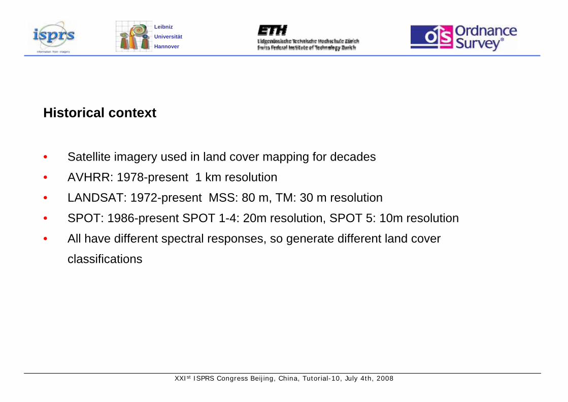
Historical context
• Satellite imagery used in land cover mapping for decades
• AVHRR: 1978-present 1 km resolution
• LANDSAT: 1972-present MSS: 80 m, TM: 30 m resolution
• SPOT: 1986-present SPOT 1-4: 20m resolution, SPOT 5: 10m resolution
• All have different spectral responses, so generate different land cover
classifications
XXIst ISPRS Congress Beijing, China, Tutorial-10, July 4th, 2008
Leibniz
Universität
Hannover
Historical context
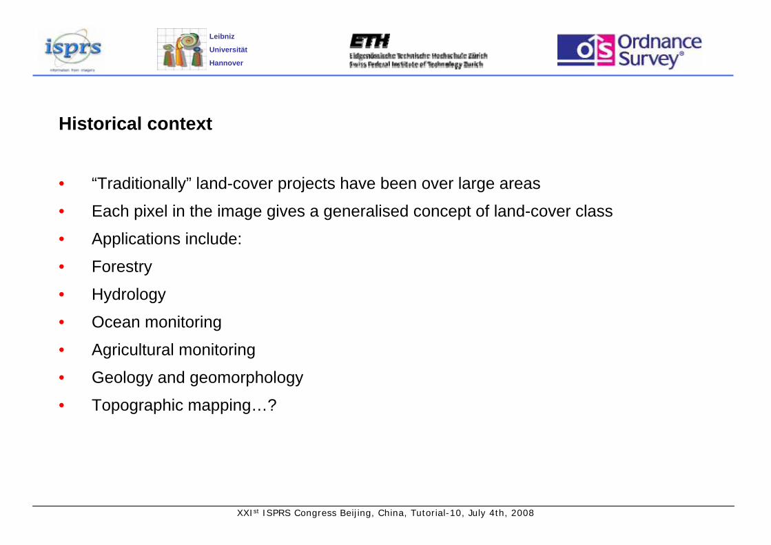
• “Traditionally” land-cover projects have been over large areas
• Each pixel in the image gives a generalised concept of land-cover class
• Applications include:
• Forestry
• Hydrology
• Ocean monitoring
• Agricultural monitoring
• Geology and geomorphology
• Topographic mapping…?

XXIst ISPRS Congress Beijing, China, Tutorial-10, July 4th, 2008
Leibniz
Universität
Hannover
Commercial high resolution satellites with multispectral sensors
760-900625-695520-600450-5201.64mGeoEye 1
Orbview 3
Quickbird
Ikonos
760-900625-695520-600450-5204m
760-900630-690520-600450-5202.8m
760-850630-700520-600450-5204m
IR (nm)Red (nm)Green (nm)
Blue (nm)GSD (m)
• Corresponding almost exactly to bands 1-4 of Landsat
• Note that, unlike Landsat, there are no thermal or mid-infrared channels
XXIst ISPRS Congress Beijing, China, Tutorial-10, July 4th, 2008
Leibniz
Universität
Hannover
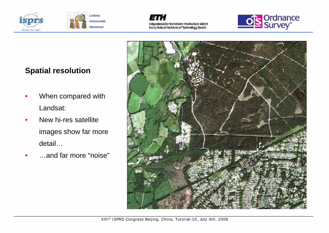
Spatial resolution
• When compared with
Landsat:
• New hi-res satellite
images show far more
detail…
• …and far more “noise”
XXIst ISPRS Congress Beijing, China, Tutorial-10, July 4th, 2008
Leibniz
Universität
Hannover
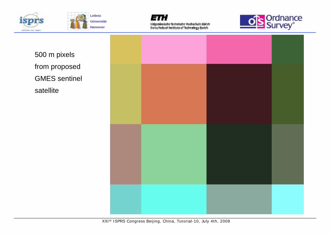
500 m pixels
from proposed
GMES sentinel
satellite

XXIst ISPRS Congress Beijing, China, Tutorial-10, July 4th, 2008
Leibniz
Universität
Hannover
30 m pixels
from LANDSAT

XXIst ISPRS Congress Beijing, China, Tutorial-10, July 4th, 2008
Leibniz
Universität
Hannover
10m pixels,
from SPOT

XXIst ISPRS Congress Beijing, China, Tutorial-10, July 4th, 2008
Leibniz
Universität
Hannover
0.6m pixels, from
Intergraph DMC
aerial camera

XXIst ISPRS Congress Beijing, China, Tutorial-10, July 4th, 2008
Leibniz
Universität
Hannover
• Multispectral in this case means
4-bands
• Can be used to derive the
“traditional” indices such as NDVI
(normalized difference vegetation
index) using the red (R) and near
infrared (IR) bands
RIRRIRNDVI +
−=
Uses of High-resolution multispectral satellite data
XXIst ISPRS Congress Beijing, China, Tutorial-10, July 4th, 2008
Leibniz
Universität
Hannover
Characteristics of high resolution imagery
• Pixel resolution increases complexity of classification
• Most pixels show „mixed pixel“ characteristics
• Areas covered by one image are much smaller than remote sensing practioners are
used to
XXIst ISPRS Congress Beijing, China, Tutorial-10, July 4th, 2008
Leibniz
Universität
Hannover
Methods of classification
• Based only on spectral data (3, 4, 7, or many bands)
• + height (e.g. Using stereo images)
• + texture
• + context (e.g. a high object with straight edges surrounded by lower objects)
• ...or different combinations of these

XXIst ISPRS Congress Beijing, China, Tutorial-10, July 4th, 2008
Leibniz
Universität
Hannover
Methods of classification
• Many different ways of classifying
• Maximum likelihood (e.g. ERDAS Imagine)
• Object-based segmentation (e.g. Definiens)
• Support Vector Machines
• Decision Trees
• Neural networks
XXIst ISPRS Congress Beijing, China, Tutorial-10, July 4th, 2008
Leibniz
Universität
Hannover
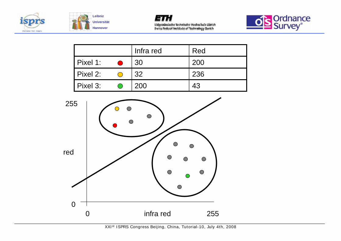
20030Pixel 1:23632Pixel 2:43200Pixel 3:
RedInfra red
infra red
red
00
255
255

XXIst ISPRS Congress Beijing, China, Tutorial-10, July 4th, 2008
Leibniz
Universität
Hannover
Methods of classification – which one to choose
• Depends on what you want to achieve
• Some methods are simple and fast
• Some are reliable, but slow
• Some need a lot of preparatory work (training, formulating rules)
• Find out who has a similar problem and see what they have used!
XXIst ISPRS Congress Beijing, China, Tutorial-10, July 4th, 2008
Leibniz
Universität
Hannover
Classifications
• Again there are many to choose from
• Depends to a large extent on the nature of the data and the classifier
• Standard classifications in different regions:
• E.g. CORINE in Europe
• These may be too general for many applications
• Most users requirements are slightly different
• So there is a tendency to make up your own classification
• This is fine for internal use, but what about collaborative work and comparison to a
common standard?
XXIst ISPRS Congress Beijing, China, Tutorial-10, July 4th, 2008
Leibniz
Universität
Hannover
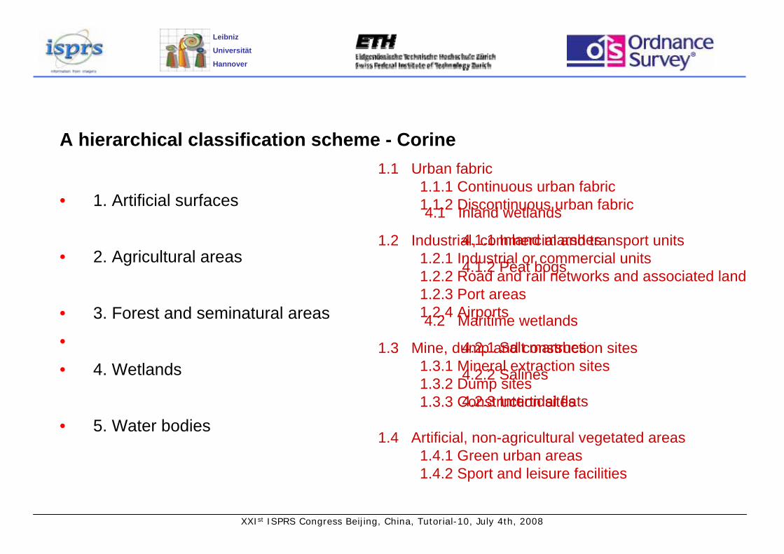
A hierarchical classification scheme - Corine
• 1. Artificial surfaces
• 2. Agricultural areas
• 3. Forest and seminatural areas
•
• 4. Wetlands
• 5. Water bodies
4.1 Inland wetlands
4.1.1 Inland marshes
4.1.2 Peat bogs
4.2 Maritime wetlands
4.2.1 Salt marshes
4.2.2 Salines
4.2.3 Intertidal flats
1.1 Urban fabric1.1.1 Continuous urban fabric1.1.2 Discontinuous urban fabric
1.2 Industrial, commercial and transport units1.2.1 Industrial or commercial units1.2.2 Road and rail networks and associated land1.2.3 Port areas1.2.4 Airports
1.3 Mine, dump and construction sites1.3.1 Mineral extraction sites1.3.2 Dump sites1.3.3 Construction sites
1.4 Artificial, non-agricultural vegetated areas1.4.1 Green urban areas1.4.2 Sport and leisure facilities

XXIst ISPRS Congress Beijing, China, Tutorial-10, July 4th, 2008
Leibniz
Universität
Hannover
• GeoEye 1 will have sensors capable of 1.64m multispectral imaging, launch
planned in August 2008
• WorldView 2 will provide 1.8m multispectral images, launch planned late 2008
• With pan-sharpening, high-resolution (40cm) 4-band images may be derived from
these (although these will not be the same as original 40cm images).
• Some organizations are concentrating on low-resolution rapid-repeat global-
coverage satellite constellations (GMES, DMC, RapidEye)
Future Satellite capability

XXIst ISPRS Congress Beijing, China, Tutorial-10, July 4th, 2008
Leibniz
Universität
Hannover
OEEPE (EuroSDR) study
• To investigate the use of high-resolution satellite imagery for national mapping
• Started in 2001, involving mapping agencies and academic institutions from several
European countries
• One aspect was to investigate land cover
• IKONOS 4m multispectral image of Chandler‘s Ford (Hampshire, UK)
• A mixture of urban, agricultural and wooded land cover

XXIst ISPRS Congress Beijing, China, Tutorial-10, July 4th, 2008
Leibniz
Universität
Hannover
Title•

XXIst ISPRS Congress Beijing, China, Tutorial-10, July 4th, 2008
Leibniz
Universität
Hannover
Title•

XXIst ISPRS Congress Beijing, China, Tutorial-10, July 4th, 2008
Leibniz
Universität
Hannover
Land cover from 4m Ikonos data – OEEPE results
• Sweden: Ikonos suitable for identification and capture of land cover types found in
Swedish 1:10 000 scale mapping
• UK: Ikonos, when combined with national mapping vector data (OS MasterMap)
suitable for identifying most of the CORINE land cover/land use classes
• Germany: Identified several problems when trying to classify the imagery on its
own.

XXIst ISPRS Congress Beijing, China, Tutorial-10, July 4th, 2008
Leibniz
Universität
Hannover
OEEPE results - Some comments
• High-resolution imagery introduces
shadows, which are generalised out of
lower resoluton imagery. These shadows:
• Could be used to identify shadow-
casting objects
• Or could be seen as a barrier to
accurate classification
XXIst ISPRS Congress Beijing, China, Tutorial-10, July 4th, 2008
Leibniz
Universität
Hannover
OEEPE results - Some comments
• High-resolution imagery is very heterogeneous – a single residential property may
have building, road, low vegetation, high vegetation, and water pixels within its
boundary. These are usually averaged out in lower resolution imagery.
• This leads to lower accuracy when assessing pixel classification techniques
• ...sounds counter-intuitive.

XXIst ISPRS Congress Beijing, China, Tutorial-10, July 4th, 2008
Leibniz
Universität
Hannover
Successful applications of high-resolution imagery to land cover mapping
• Olive-tree identification (K. G. Karantzalos, D. P. Argialas, Greece)
• Crop monitoring (Josiane Masson, JRC, Italy)
• Forest mapping in the US and elsewhere
• Mapping urban sprawl in developing countries

XXIst ISPRS Congress Beijing, China, Tutorial-10, July 4th, 2008
Leibniz
Universität
Hannover
Why not more application examples?
• Cost of the imagery?
• Limited extent of available data?
• Difficulty in obtaining suitable data (e.g. Too much cloud cover in Northern Europe)?
• No guarantee of continuity (no constellations of satellites – maybe soon)?
• Many remote sensing practitioners used to working with lower resolution imagery,
and reluctant to abandon previous research?
• Many photogrammetrists used to working with higher resolution imagery, and
reluctant to abandon previous research?
• A combination of the above?

XXIst ISPRS Congress Beijing, China, Tutorial-10, July 4th, 2008
Leibniz
Universität
Hannover
Contact for further information
David HollandResearchOrdnance SurveyRomsey RoadSOUTHAMPTONUnited KingdomSO16 4GU
Phone: +44 (0) 23 8079 2808Fax: +44 (0) 23 8079 2615Email: [email protected] site: www.ordnancesurvey.co.uk
XXIst ISPRS Congress Beijing, China, Tutorial-10, July 4th, 2008
Leibniz
Universität
Hannover
• The satellite is operational 365 days of the year,• Frequent re-visit times (e.g. every 4 days),• Imagery is post-processed relatively quickly,• No Air Traffic Control restrictions apply,• Large area footprint (e.g. 16.5 x 16.5 km2) cuts down the need for block
adjustment and creation of image mosaics,• The satellite can easily access remote or restricted areas,• No aircraft, cameras or expensive equipment are required (by the end user).
Advantages of satellite imageryover aerial photography

XXIst ISPRS Congress Beijing, China, Tutorial-10, July 4th, 2008
Leibniz
Universität
Hannover
• The typical off-nadir viewing angle of up to 25˚ is not acceptable • The production processes required for high resolution satellite imagery may be
different to those of traditional photogrammetric data capture• The reliability of capture and delivery of imagery is unknown,• Image resolution is low compared to most aerial photography.• There is a strong possibility of cloud cover
And the disadvantages …
Related Documents