Turkish Journal of Earth Sciences ACCEPTED MANUSCRIPT doi:10.3906/yer-0910-11 Neotectonic Evolution of an Actively Growing Superimposed Basin in Western Anatolia: The Inner Bay of zmir, Turkey BORA UZEL, HASAN SÖZBLR & ÇALAR ÖZKAYMAK Dokuz Eylül University, Department of Geological Engineering, Tınaztepe Campus, TR35160, Buca-zmir, Turkey Corresponding author: Bora UZEL (e-mail: [email protected]) Please cite this article as: UZEL, B., SÖZBLR, H. & ÖZKAYMAK, Ç. Neotectonic Evolution of an Actively Growing Superimposed Basin in Western Anatolia:The Inner Bay of zmir, Turkey Turkish Journal of Earth Sciences [Turkish J. Earth Sci.] (2010) [in press]. This PDF file is an early version of a manucript accepted for publication in Turkish Journal of Earth Sciences. It will be copyedited and typeset before proof production, the it will be published in its final form. Please note that there may be some changes to occur if an error is discovered!

Welcome message from author
This document is posted to help you gain knowledge. Please leave a comment to let me know what you think about it! Share it to your friends and learn new things together.
Transcript

Turkish Journal of Earth Sciences
ACCEPTED MANUSCRIPT
doi:10.3906/yer-0910-11
Neotectonic Evolution of an Actively Growing Superimposed Basin in
Western Anatolia: The Inner Bay of zmir, Turkey
BORA UZEL, HASAN SÖZB L R & ÇA LAR ÖZKAYMAK
Dokuz Eylül University, Department of Geological Engineering, Tınaztepe Campus,
TR 35160, Buca- zmir, Turkey
Corresponding author: Bora UZEL (e-mail: [email protected])
Please cite this article as: UZEL, B., SÖZB L R, H. & ÖZKAYMAK, Ç. Neotectonic Evolution of an Actively Growing Superimposed Basin in Western Anatolia:The Inner Bay of zmir, Turkey Turkish Journal of Earth Sciences [Turkish J. Earth Sci.] (2010) [in press].
This PDF file is an early version of a manucript accepted for publication in Turkish Journal of Earth Sciences. It will be copyedited and typeset before proof production, the it will be published in its final form. Please note that there may be some changes to occur if an error is discovered!

Neotectonic Evolution of an Actively Growing Superimposed Basin in Western Anatolia: The Inner Bay of İzmir, Turkey
BORA UZEL, HASAN SÖZBİLİR & ÇAĞLAR ÖZKAYMAK
Dokuz Eylül University, Department of Geological Engineering, Tınaztepe Campus,
TR−35160, Buca-İzmir, Turkey
Corresponding author: Bora UZEL
(e-mail: [email protected])
Abbreviated title: Neotectonic Evolution of the Inner Bay of İzmir
Neotectonic Evolution of an Actively Growing Superimposed Basin in Western Anatolia:
The Inner Bay of İzmir, Turkey
BORA UZEL, HASAN SÖZBİLİR & ÇAĞLAR ÖZKAYMAK
Dokuz Eylül University, Department of Geological Engineering, Tınaztepe Campus,
TR−35160, Buca-İzmir, Turkey (e-mail: [email protected])
Abstract: The İzmir Bay is an actively growing shallow marine basin that is controlled by
NE, NW, N–S and E–W trending active faults, in the West Anatolian Extensional Province.
The bay of İzmir is a lazy L-shaped superimposed basin which topographically divided into
an E–W-trending inner bay and a NW-trending outer bay. The Inner Bay of İzmir is an
approximately 5–7-km-wide, 25-km-long asymmetric graben structure and it comprises (i)
upper Cretaceous–Paleocene basement, (ii) an older succession of lower- to upper- Miocene
basin fill, angularly unconformably overlain by (iii) a younger Plio–Quaternary basin fill. The
older succession contain a 0.5-to 1.5-km-thick, folded and coal-bearing continental volcano-
sedimentary sequence. The younger succession of the Inner Bay of İzmir include late
Pliocene–Pleistocene Görece formation and Holocene to recent alluvial fan, fan delta to
shallow marine deposits.
This study reveals that the İzmir Bay region was above sea level and the site of NE–SW
trending lacustrine environment associated with calc-alkaline to alkaline volcanism during the
early to late Miocene. By the late Pliocene the modern coastal areas of İzmir was concealed
beneath the waters of the Aegean sea by the creation of E–W trending Inner Bay of İzmir.

According to detailed geological mapping, geomorphological evidences and computer-
based kinematic analysis, the tectonic evolution of the basin since the early Miocene can be
divided into four stages. The former two extensional stages have resulted in the formation of
NE-SW trending lacustrine volcano-sedimentary basins; the third stage is characterized by
dip- to strike-slip faulting caused to deformation of the older basin fill units and the last
extensional stage operated since the Late Pliocene resulted in the opening of the Inner Bay of
İzmir.
Key words: The İzmir Bay, İzmir fault zone, Karşıyaka fault zone, Seferihisar fault zone,
fault kinematics, superimposed basin, western Anatolia.
Batı Anadolu’ da Aktif Olarak Gelişen Süperimpoze Bir Havzanın Neotektonik Evrimi:
İzmir İç Körfezi, Turkey
Özet: Batı Anadolu Genişleme Bölgesi içerisindeki İzmir Körfezi KD, KB, K–G ve D–B
uzanımlı faylar tarafından kontrol edilen ve aktif olarak gelişmekte olan sığ denizel bir
havzadır. Körfez topografik olarak D–B doğrultulu iç körfez ve KB-GD uzanımlı dış körfez
olmak üzere iki kısımdan oluşan L-şekilli superimpose bir havzadır. İzmir İç Körfezi yaklaşık
5–7-km genişliğinde, 25-km uzunluğunda, D–B gidişli ve bölgesel ölçekli açısal
uyumsuzluklarla birbirinden ayrılan (i) geç Kretase–Paleosen yaşlı temel kayaları, (ii) erken
Miyosen–erken Pliyosen yaşlı eski havza çökelleri ve (iii) Pliyo–Kuvaterner yaşlı genç havza
çökellerinnden oluşur. Eski havza çökelleri 0.5–1.5-km kalınlığındaki kıvrımlanmış ve

yüzeylemiş olan kömür içerikli karasal volkanosedimanter bir istif içerir. İç Körfeze ait genç
havza çökelleri Görece formasyonu ve güncel alüvyonal çökelleden yapılıdır.
Bu çalışma İzmir Körfez alanının erken–geç Miyosen zaman aralığında kalk-alkali ve
alkali volkanizmanın eşlik ettiği deniz düzeyi üzerindeki KD–GB uzanımlı gölsel havzayla
simgelendiğini göstermektedir. Geç Pliyosen’ den itibaren İzmir Körfezi Ege Denizi suları
altında kalmaya başlar ve böylece D-B uzanımlı İzmir İç Körfezi’ nin oluşumu gerçekleşir.
Detaylı jeolojik haritalama, jeomorfolojik veriler, bilgisayar tabanlı kinematik analiz
çalışmaları ve arazi gözlemlerine göre havzanın erken Miyosen’ de başlayan tektonik evrimi
dört evreye ayrılabilir. İlk iki evre KD–GB uzanımlı gölsel volkanosedimenter havzanın
oluşumunu sonuçlamıştır, üçüncü evre eski havza dolgusunun deformasyonuna neden olan
eğim atımlı ve doğrultu atımlı faylanmanın gelişimiyle karakteristiktir, geç Pliyosen’de
başlayan son genişleme evresi İzmir İç Körfezi’ nin açılmasına neden olmuştur.
Anahtar kelimeler: İzmir Körfezi, İzmir fay zonu, Karşıyaka fay zonu, Seferihisar fay zonu,
fay kinematiği, superimpose havza, Batı Anadolu.
Introduction
The İzmir Bay is a typical depression for the Aegean back-arc domain undergoing N–S
extension which is accommodated by active dip- to oblique-slip normal faults and strike-slip
faults. Major part of the modern depression is flooded by the waters of Aegean Sea, forming
the inner bay of İzmir. It is generally accepted that the Aegean Sea started to open as a NW–
SE trending narrow channel in the Serravalian–Tortonian, and widened under the influence of
N–S extensional regime in the Pliocene (Görür et al. 1995). However, western Anatolia next

to the Aegean Sea was the site of lacustrine basin sediments and terrestrial volcanism during
the Neogene time. In the late Pliocene–Pleistocene to Holocene, the Neogene basin in western
Anatolia was invaded while the İzmir Bay was the site of fan-delta to shallow marine
deposition. The back-arc tectonic environment of the Aegean subduction system has been the
sites of extensional back-arc basins since the Late Oligocene. These basins have been
described as a result of extension in response to the retreat of the subducting African plate
under the Eurasian plate (Jolivet 2001). GPS velocity vectors and earthquake slip vectors
show a counterclockwise rotation with southwestward motion of western Anatolian plate into
the Aegean realm along its boundary structures; dextral North Anatolian Fault Zone and
sinistral East Anatolian Fault Zone (Oral 1994; Louvari 2000; Reilinger et al. 2001;
McClusky et al. 2000, Aktuğ & Kılıçoğlu 2006; Figure 1a).
This study shows the existence of at least two generations of basins that are superimposed
in the İzmir bay region. The term of “superimposed basin” is used for a basin type which
includes at least two sediment fills of dissimilar age, origin, facies, internal structure, and
deformational pattern (Koçyiğit 1996). This terminology was mostly adapted on
understanding of multi-deformational history of hydrocarbon-bearing basins and salt tectonics
(Liangjie et al. 2001). In Turkey, many superimposed basins located mostly in or adjacent to
active strike-slip fault zones (e.g. North Anatolian Fault Zone) cutting across suture zones
(Koçyiğit & Kaymakçı 1995; Koçyiğit 1996). This type of basin has a key role in
understanding the deformational phases which responsible for the formation and deformation
pattern of the basin. To verify this, 1/25.000 scaled field geological mapping was carried out
at the inner coastal parts of the İzmir Bay. During the field studies the lithostatigraphical units
and their geological structures were mapped and a number of fault sets were studied in order
to collect kinematic data for paleostress analyses. This contribution allows us (i) to outline the
distribution of superimposed main rock units that episodically forming on each other, (ii) to

establish main faults which are responsible for each deformation phase (iii) to know how and
when the inner bay of İzmir begin to form, and (iv) to show a validity of superimposed basin
including sedimentary packages of different age and orientation on the basis of stratigraphic
and structural data. This work is also important for the active tectonics of İzmir city and
surrounding area where several seismic events happened in the past.
Tectonic Framework of the Region
The basement in the study area is represented by the Bornova flysch zone, whose sedimentary
sequence was strongly folded and dynamically metamorphosed during the early Tertiary
Alpine orogenic event (Erdoğan 1990; Okay & Siyako 1993; Okay et al. 1996; Okay &
Altıner 2007). West of the Bornova flysch zone is represented by a well-defined metamorphic
core complex, the Menderes massif, while east of the zone is characterized by platform
carbonates of Paleozoic-Mesozoic age (the Karaburun platform). These basement rocks are
unconformably overlain by Miocene volcanosedimentary basins having E–W and NE–SW
orientations (Figure 1 & 2).
Field-oriented studies in western Anatolia revealed that the E–W trending Miocene basins
are bounded by approximately E–W-oriented low- and high-angle normal faults (Koçyiğit et
al. 1999; Bozkurt 2000, 2001; Sözbilir 2001, 2002; Bozkurt & Sözbilir 2004, 2006; Emre &
Sözbilir 2007; Çiftçi & Bozkurt 2007, 2008, 2009). The low angle normal faults (detachment
faults) that are kinematically linked with a crustal-scale metamorphic core complex, the
Menderes massif, and approximately E–W and NE–SW dissecting basins form the most
prominent features of western Anatolia (Hetzel et al. 1995; Bozkurt & Oberhansli 2001;
Gessner et al. 2001; Isik & Tekeli 2001; Ring et al. 2003 and references therein; Figure 1).
Detachment fault systems in this province are associated with domal uplift of the Menderes

metamorphic core complex of the lower plate and the formation of asymmetric
supradetachment basins in the upper plate. However, there are some studies revealing the
presence of a number of NE–SW trending strike-slip faults controlling the NE-trending
Miocene deposition on the western Anatolian crust onshore (Kaya 1981; Genç et al. 2001;
Kaya et al. 2004; Erkül et al. 2005a; Uzel & Sözbilir 2006, 2008; Kaya et al. 2007; Sözbilir et
al. 2008) and offsore (Ocakoğlu et al. 2004, 2005). This transversely orientated strike-slip-
dominated zone that accommodated the lateral termination of E–W-trending graben-faults,
linking spatially discrete loci of extension, includes the İzmir-Balıkesir Transfer Zone (Figure
1b). Along the zone, the main structural contacts between the tectonostratigraphic units were
reactivated as transtensional shear zones and resulted in NE–SW trending elongated basins of
Miocene age. Several strike-slip faults have moved contemporaneously with the normal faults
which resulted in alongated Cumaovası basin, south of the study area (Uzel & Sözbilir, 2008).
Therefore, the İzmir-Balıkesir Transfer Zone has been described as a NE-trending strike-slip
dominated zone of weakness limiting the eastern coastlines of the Aegean Sea that lies
between Balıkesir and İzmir cities (Okay & Siyako 1991; Ring et al. 1999; Sözbilir et al.
2003a 2003b; Erkül et al. 2005b; Kaya et al. 2007; Sözbilir et al. 2007; Özkaymak & Sözbilir
2008; Uzel & Sözbilir 2008). Thus, the structural evolution of the İzmir Bay region has been
controlled to a large extend by reactivation of ancient tectonic structures.
The İzmir Bay
The morphology of the Aegean coast of Anatolia is characterized by numerous bays (Figures
1b & 2). From south to north, these are the NE-directed Fethiye, E–W-directed Hisarönü, E–
W-directed Gökova, NE-directed Güllük, E–W-directed Kuşadası, NNW-directed Sığacık, E–
W- to NW-directed İzmir, NE-directed Çandarlı, NW-directed Dikili, and E–W-directed
Gökova Bays. The İzmir Bay which is one of the most distinctive bays of the Aegean Sea
located to the western coast of Anatolia. It’s a lazy L-shaped basin controlled by NE-, NW-
and E–W-trending active faults and can be divided into two depressions based on their surface
and subsurface morphology: the Inner Bay and Outer Bay (Figures 2 & 3). The leg of the
‘‘L’’ defines the Outer Bay of İzmir (Aksu et al. 1987; Sayın 2003; Sayın et al. 2006). It is
about 20-km-wide, 40-km-long, NW-trending basin, bounded by the Karaburun Peninsula to
the southwest and the Foça high and the Menemen plain to the northeast. Along the onshore
Urla-Mordoğan district, there are a series of NW-trending islands and intrabasinal highs.
Here, the Outer Bay of İzmir partitioned with another depression named the Gülbahçe Bay.
The base of “L” interpreted as the Inner Bay of İzmir is approximately 5–7-km-wide and 25-
km-long E–W-trending basin (Figure 3). The fault pattern and seismicity of the İzmir region
has previously been analyzed for earthquake hazard assessment (summarized and published in
İzmir Earthquake Scenario and Master Plan - Radius Project), basin formation and fault
kinematics. Their interrelationships are still open questions. Thus, we present our field-based
geological data and surface/subsurface morphological observations on the Inner Bay of İzmir
that can shed light on its tectonic evolution.
Surface and Subsurface Morphology
The Inner Bay of İzmir is an E–W-directed depression clearly outlined on topographic
elevation map of the region (Figure 3a). The horst of the Inner Bay of İzmir includes three
topographic domains: (i) the Yamanlar High to the north and (ii) the Seferihisar and (iii)
Nifdağı Highs to the south of the bay. The top point of the Yamanlar High is the Kara

Mountain with an altitude of 1076 m. The Yamanlar High has a typical volcanic morphology
which is characterized by a radial drainage pattern (Figure 3b). The top point of the
Seferihisar High is the Tekke Mountain of 1017 m altitude. The northern part of the Tekke
Mountain is characterized by dendritic drainage pattern including approximately north-
flowing rivers. To the NE-side of the Tekke Mountain, the north-flowing rivers suddenly
change their orientation to the NW-direction, which may indicate the presence of a NW–SE
trending fault in the footwall of the İzmir fault zone. The onshore part of the İzmir Bay is
characterized by the E–W-trending Bornova plain which is bounded by Nifdağı High to the
south.
On the subsurface bathymetric map of the İzmir Bay, it is also clear that the İzmir Bay
has two different depression areas: a NW-trending Outer Bay and an E–W-trending Inner Bay
(Figure 3b). Based on bathymetric data carried out by previous studies (Akyarlı et al. 1988;
Alpar et al. 1997; Sayın 2003; Sayın et al. 2006), the maximum water depth is about 70 m in
the Outer Bay, and about 20 m in the Inner Bay. The Inner and Outer Bay depressions are
separated by a narrow threshold named as the Yenikale strait.
Stratigraphy
The rock units exposed in the study area are divided into three groups as (i) the basement, (ii)
older basin fill and (iii) younger basin fill (Figures 4 & 5). Brief descriptions of these units are
given below.
Basement Units

The basement of the basins around Izmir city is characterized by a series of NE-trending
discontinuities, identified in outcrops in the Seferihisar, Spildağı, Nifdağı, and Yamanlar
Mountains. The Bornova mélange (also called the ‘Bornova flysch zone’) forms the basement
of the Miocene to Quaternary units. The Bornova mélange is believed to be related to the
closure of Neotethys Ocean during the late Cretaceous-Paleocene time interval (Erdoğan
1990; Okay & Siyako 1991). It is composed of various-sized blocks of Mesozoic limestones,
cherts, submarine volcanics and serpentinites embedded in a flysch-type sedimentary matrix
(Okay et al. 1996). The Bornova mélange has undergone significant deformation, with a very
low metamorphic grade (Erdoğan 1990; Okay & Siyako 1993; Okay & Altıner 2007). The
details of the stratigraphy of the pre-basin-fill units lie outside the scope of this paper, and the
reader is referred to the most recent literature (Erdoğan 1990; Okay & Siyako 1993; Okay et
al. 1996; Bozkurt & Oberhansli 2001; Okay & Altıner 2007; Okay 2008) for further reading.
The older basin fill
The Miocene stratigraphy of the older basin fill can be subdivided into a lower and an upper
volcano-sedimentary sequence, separated by a regional angular unconformity (Figures 4 & 5).
The lower volcano-sedimentary sequence is well-exposed within and beyond the northern
margin of the incipient Inner Bay of İzmir, and along the Orhanlı fault zone (Figure 4). It is
moderately folded and cross-cut by normal and strike-slip faults. This sequence, consisting
primarily of conglomerates at the base, limestones, mudstones, and sandstone-shale
alternations, unconformably overlies the basement rocks. It consists of three sedimentary units
overlain by the Yamanlar volcanics. The basal section of the lower sequence is here firstly
named as the Kızıldere formation (Figures 5 & 6). Around the Menemen, a basal
conglomerate overlies an erosional surface of sandstone-shale alternation of the Bornova

mélange. The dominant lithology of the formation is made up of brownish-red, thick bedded
to massive, poorly to moderately sorted polymictic conglomerates. Clasts are in range of
pebble size and were mainly derived from the Bornova mélange. The conglomerates alternate
with gray-reddish-brown colored sandstone, siltstone and shale. Upward in the sequence, the
formation ends with a yellowish brown lacustrine limestone level. The Kızıldere formation
can be interpreted as an alluvial to fluvial sequence overlain by lacustrine carbonates.
At the southern sector of the Inner Bay of İzmir, the lithology of lower sequence
characterized by the Çatalca formation (Genç et al. 2001), which is composed of laminated
siltstones, sandstones and shale alternations including lignite lenses and thin bedded
conglomerate levels. The formation is interpreted as a lacustrine-fan delta facies and dated as
lower−middle Miocene based on paleontological and palynological studies (Akartuna 1962;
Kaya 1979, 1981; Genç et al. 2001; Sözbilir et al. 2004; Uzel & Sözbilir, 2008). The lateral
equivalent of the Çatalca formation north of the İzmir Bay is the Sabuncubeli formation,
cropping out between the Bornova and Kayadibi villages and north of Beşyol village. It is
composed of thick bedded conglomerate, sandstone and mudstone alternation with limestone
lenses toward the top (Figure 6b).
The overlying unit is made up of calcalkaline volcanic rocks known as the Yamanlar
volcanics, which conformably rest on the sedimentary rocks described above (Kaya 1979,
1981). In the study area, the Yamanlar volcanics are composed of several lavas, pyroclastic
rocks, dykes and domes of dacitic, andesitic, rhyolitic and basaltic compositions. K-Ar ages of
19.2–14.7 Ma have been reported for the Yamanlar volcanics (Borsi et al. 1972; Savaşçın
1978; Ercan et al. 1996), indicating an early to middle Miocene age.
The upper volcano-sedimentary sequence is exposed at Cumaovası basin and NE of
Bornova district. According to field observations and geological mapping, it is slightly

deformed, folded and faulted. In the northern sector, the sequence begins with the Kızılca
formation resting unconformably on the Yamanlar volcanics. The Kızılca Formation is a
package of terrestrial clastic rocks, intercalated with lacustrine carbonate levels. The
formation is made up of brown, poorly sorted alluvial conglomerates at the base, passing
upwards into greyish-brown sandstones and mudstones. The alluvial conglomerates contain
clasts derived from the Yamanlar volcanics and lacustrine carbonates of the lower volcano-
sedimentary sequence and the Bornova mélange. The succession ends with a light-grey and
yellowish-white clayey limestone intercalation at the top and is gradationally overlain by a
carbonate-dominated sequence forming the Yaka formation. At the transitional contact
between these two units, the Beşyol basalt is located. The Beşyol basalt is characterized by
dark-brownish colored olivine basalt lavas showing peperitic texture at the contact with the
lacustrine carbonate of the Yaka formation. The age of this formation is accepted as late
Miocene according to the stratigraphic correlation of the successions in the neighboring
basins (see Cumaovası basin, Uzel & Sözbilir 2008).
In the southern sector, the upper volcano-sedimentary sequence begins with the Ürkmez
formation (Eşder & Şimşek 1975; Genç et al. 2001) which is dominated by red conglomerate
and sandstone alternated with lacustrine limestone lenses. Upward in the sequence, lithology
displays a fining-upward profile where the conglomerates are replaced gradually by gravels,
sandstones and mudstones. According to Genç et al. (2001), the Ürkmez formation is of latest
middle(?)–late Miocene in age, and is interpreted as alluvial fan and lateral fan deposits
interfingering with low energy lacustrine facies. These clastic rocks are interbedded with
lacustrine limestones of the Yeniköy formation in the upper parts of the unit (Eşder & Şimşek
1975; Genç et al. 2001). The Yeniköy formation consists of sandstone, mudstone and
claystone alternations with thin lignite seams. Upward, the sequence is dominated by thin- to
medium-bedded lacustrine limestones and green laminated claystone alternations. These are

interbedded with pyroclastic rocks of the Cumaovası volcanics (Eşder & Şimşek 1975;
Özgenç 1978; Genç et al. 2001). The outcrops of the Cumaovası volcanics are aligned in
NNE–SSW direction forming ‘central volcanics’ for the basin. The Cumaovası volcanics
yielded 11.5–9 My K/Ar ages (Borsi et al. 1972; Özgenç 1978; Genç et al. 2001). They are
mostly rhyolitic pyroclastic rocks and lava flows with local domes. Genç et al. (2001)
suggested that the Cumaovası volcanics begin with air fall tuffs of about 15 m thickness,
forming early products of the volcanic activity. They are overlain by pyroclastic flow
deposits, which are commonly composed of fragments of angular lava within a pumice
matrix. These are intercalated with rhyolitic lavas, locally including obsidian and perlites.
The younger basin fill
The older basin fill of Miocene age is unconformably overlain by the Plio–Quaternary
younger basin fill of the Inner Bay of İzmir. It consists of two successions: (i) Plio–
Pleistocene alluvial fan deposits (Görece formation), and (ii) Holocene alluvium and fan-delta
to shallow marine deposits (Figures 4 & 5).
The Görece formation is exposed along the strike-slip and normal faults such as
Seferihisar, İzmir, Orhanlı, Buca, Yaka and Değirmendere faults (Figure 4). It is characterized
by red colored semi consolidated continental clastics which are made up of reddish-brown
sandstone and conglomerate alterations. It begins with a basal conglomerate on an erosional
surface of the volcano-sedimentary sequence. The unit is made up of alternations of poorly
bedded, poorly- to moderately sorted reddish-brown conglomerates and poorly bedded,
moderately sorted yellowish-brown sandstone. Based on sedimentary and geometric
characters, the Görece formation can be considered as an alluvial fan deposition including
proximal, middle-distal and alluvial plain parts of the fan system (Uzel & Sözbilir 2008). No

paleontological data have been acquired from the Görece formation. Close to the study area,
Sözbilir et al. (2004) defined the Plio−Pleistocene Sütçüler formation in the Kocaçay basin,
which may probably be correlated with the Görece formation. Plio−Pleistocene sediments
exposed along most of the western Anatolian grabens can also be correlated with the Görece
formation (Koçyiğit et al. 1999; Yılmaz et al. 2000; Sarıca 2000; Seyitoğlu et al. 2002;
Koçyiğit 2005; Rojay et al. 2005; Emre & Sözbilir 2007; Ersoy & Helvacı 2007).
The Holocene alluvium and fan-delta to shallow marine deposits are the uppermost
sediments in the study area, which are restricted by normal faults to the south and north of the
Inner Bay of İzmir. This unit is made up of coarse-grained alluvial-fan deposits, coarse- to
fine-grained fluvial deposits and fine-grained fan-delta and shallow marine sediments. The
alluvial-fans are controlled by the İzmir fault to the south and the Karşıyaka fault to the north.
The alluvial fan deposits are characterized by gray to yellowish-brown colored debris flow
sediments which are commonly poorly sorted, poorly bedded to massive, matrix-rich, and
matrix-supported to clast-supported, unconsolidated composition. The matrix is an unsorted
mixture of sand and reddish-brown mud. The maximum clast size ranges from pebble to large
isolated boulders (260 cm), and the clasts are derived from the underlying basement rocks and
ancient basin fill units. The alluvial fan deposits interfinger with alluvial plain deposits toward
the basin depocentre. The alluvial plain deposits are difficult to recognize, because of the
scarcity of adequate exposures and high settlements in the area. The fluvial deposits are
coarse- to fine-grained axial river deposits carried by the Kavak River. The lateral fans and
the axial river deposits, are controlled by the present-day drainage system in the region,
interfinger laterally and vertically with deltaic deposits and are typical valley fills. The Gediz
delta which is developed by the alluvial deposits of the Gediz River forms an oblique alluvial
plain with respect to the orientation of the İzmir Bay. It is difficult to recognize, because of
their poor exposures and show a record of complex interplay of alluvial and marine

sedimentation. Alluvial fans of diverse size also are present in the southern part of the Inner
Bay of İzmir. The largest alluvial fan has been deposited by the present Ilıca River which has
also formed a fan delata prograding northward. Shallow marine deposits have been
accumulated as medium to fine clastics in the submarine part of the bay. However, available
subsurface data are insufficiently detailed to constrain the thickness, geometry and lithofacies
of submarine sediments.
Faults
A large number of the strike-slip and oblique to dip-slip normal faults are established and
mapped around the Inner Bay of İzmir; these are NE–SW, NW–SE, N–S and E–W trending
fault sets (Figure 4). Detailed analyses of Neogene to Quaternary faults in the study area
enable us to recognize a pre-existing zone of weakness that intermittently reactivated and is
active today. Many of the dip- to strike-slip faults that initiated during the early history of the
Miocene basin formation have become inactive, and older basin fill has been uplifted on the
footwalls of younger faults. Relative chronologies of faulting events were established by
using qualitative observations (e.g. superposition of slickensides on the same fault surface).
NE–SW-trending Faults
The NE–SW trending faults are mostly well exposed as short (0.5–2 km) and long (>20 km)
fault segments. The long segments can be followed along mountain ranged and have formed
the basin margin of the Miocene depressions, whereas the short segments mostly cut and
displaced rocks of the Bornova mélange, together with the Miocene units as well. Two well
known fault zones in the southern sector bound the Seferihisar High from the western and
eastern sides: these are the Seferihisar (SFZ) and Orhanlı fault zone (OFZ), respectively.

The SFZ lying between Sığacık Bay and Güzelbahçe district is a 2–5-km-wide, 30-km-
long and NE-trending dextral fault zone (Figures 4 & 7; İnci et al. 2003; Ocakoğlu et al.
2004, 2005; Emre et al. 2005; Sözbilir et al. 2008). At the northern termination, it consists of
a series of parallel and sub-parallel fault segments. It enters into the study area at the Yelki
town in N20OE strike and cuts the basement rocks of Bornova mélange and Holocene alluvial
deposits. There are also a series of actively growing lateral alluvial fans aligned along the
fault segments (Figure 7). Towards the north, the strike of the fault changes to N40–50OE and
connected to the İFZ. Holocene activity of the fault is evidenced by the dextral offset of
drainage systems of up to 100 m (Emre et al. 2005). Moreover, an intermediate-magnitude
(MW= 5.7) earthquake that struck on April 10, 2003 supports the recent dextral strike-slip
activity of the SFZ (Akyol et al. 2006; Figure 4). Along the northern termination of the SFZ,
the fault segments have a strike of N30–50OE and average dips of about 70–87O to the NW.
The slickenlines on the fault planes show a rake angle ranging from 03O to 32O (Figure 8).
When the SFZ come close to İFZ it bends to the east and their fault planes have a rake angle
up to 70O.
The OFZ forms the western margin of the Cumaovası basin, and is also the most
prominent structure in the region located to the south of İzmir city (Figures 2 & 4). It bounds
the Seferihisar High to the east. It may be traced for about 45 km, between İzmir Bay in the
north and Kuşadası Bay in the south. The fault zone includes several dextral fault segments
extending mainly in a NE−SW-direction. The main motion along the slip surfaces is dextral
strike-slip. However, there are some geomorphological and structural evidence for the
presence of an earlier sinistral strike-slip motion (Uzel & Sözbilir 2008). Typical tectonic
landforms, such as systematically deflected stream channels and ridges, shutter ridges, and
fault scarps, are recognized along segments of the OFZ. On the basis of their morphological
and structural features, it is interpreted that the early sinistral offsets are later overprinted by

dextral offsets. In addition to that, several hot springs occur in the central part of the fault
zone, implying that the fault zone provides effective conduits for the geothermal field. This
indicates that the hot springs in the area are associated with active faults (Uzel & Sözbilir
2008). Recent activity of the OFZ is also evidenced by 6 November 1992 Doğanbey
Earthquake (Tan & Taymaz 2001; Figure 4).
N–S-trending Faults
The N–S faults are steeply dipping, and are mainly of strike-slip nature (Figures 4 & 9). Some
of these show clear evidence of early left-lateral slip reactivated by later right-lateral motion.
In the southern sector, NW of Altındağ two sets of slip lines on the fault planes were
recognised, and slip lines with rakes 10ON are superimposed by striations with an average
rake of 25OS (Figure 10a). The length of this fault is approximately 2 km. The fault cuts
trough Miocene lacustrine limestone and is in turn cut by approximately E−W trending
normal faults of the İFZ. To the southeastern part of the study are, between Işıkkent and
Gökdere village, there is a straight fault zone with a N–S trend, for about 6 km. To the east of
Buca district, several NE–SW trending dextral strike-slip faults splaying out from the main
fault zone cut, and these displaced the unconformity between the Bornova mélange and the
overlying Neogene units (Figures 4 & 9). There are also several oblique-slip normal faults
along the west side of the main fault and are en echelon or oblique to the trend of the main
fault. The en echelon faults are stepply dipping and have normal separation. Some of the
faults have nearly horizontal slickenside striae that are interpreted as consequences of
oblique-slip. Structural evidence for N–S-trending srike-slip faults comes from the northern
section around Akgedik tepe where N–S dextral strike-slip faults cut and displaced Miocene
lacustrine limestones, and display cross-cutting relationsips with the NE–SW trending dextral
strike-slip faults (Figures 10b-d &11).

The N-S trending strike-slip faults may have acted as extensional tear faults (cross-faults)
separating areas that may have experienced different amount of extension. According to Kaya
(1979 & 1981) and Kaya et al. (2004 & 2007), the NE–SW and N–S trending faults were
inherited from old zones of weakness of Paleocene age. These Paleocene faults a) have
significant vertical movements, b) later acted as growth faults during the early Miocene,
because they are responsible for variation in thickness of the Miocene volcano-sedimentary
units, c) were a zone of weakness that aligned volcanic centers, and d) reactivated
intermittently until recent time as indicated by overprinted slickenlines.
NW–SE-trending Faults
The NW–SE trending fault system consists of a set of about high-angle faults, aligned in an
average of N45OW direction, which represent geologically and geomorphologically
prominent structures in the uplifted domain. The presence of two sets of striations on slip
surfaces suggest that some of the NW–SE trending faults reactivated: the fault once operated
as a strike-slip fault, then a normal fault.
The length of this fault system is approximately 10 km. This fault set forms the
nortwestern margin of the Bornova plain. It comprises a series of parallel to sub-parallel
oblique-slip normal faults with minor amounts of dextral and sinistral strike-slip component.
There is also pure sinistral strike-slip component which pre-date the oblique-slip movements.
It is represented by an approximately 2-km-wide shear zone. The fault set starts in east of
Doğanlar villages as two paralel segments forming the northeastern margin of the modern
Bornova plain and intermittenly continues to the northwest in the form of discontinuous
strands of parallel to sub-parallel fault segments. Some of these segments are oblique-slip

normal faults facing towards the basin and formed step-like morphology lowered toward the
basin. Similar NW–SE trending high-angle normal faults are mapped in the southern sector,
South of Balçova district. This fault is cut and displaced by an E–W trending segment of the
İFZ.
There is a NW–SE trending depression in the NE of northern sector between Çiçekli and
Yaka villages (Figure 11). This depression forms the western end of the Quaternary
Kemalpaşa basin. The depression is bounded by the Çiçekli and Yaka faults from south and
north, respectively. The Yaka fault is a 200-m-wide, 5-km-long high-angle normal fault,
which dips at an average angle of 65OSW with a minor dextral strike-slip component. Upper
volcano-sedimentary units are displaced by a northern up-thrown footwall block and a
downfaulted block exhibiting Quaternary sediments, which are tectonically juxtaposed along
the fault. The Çiçekli fault is the southern basin-bounding structure forming the western end
of the Kemalpaşa fault zone. It is a 500-m-wide, 6-km-long, graben-facing normal fault cross-
cutting the NE–SW trending fault zone west of Çiçekli village. The fault displays locally
well-preserved striated fault planes that clearly showing that the Çiçekli fault is an oblique-
slip normal fault dipping at an average of 70ONE, with a minor sinistral strike-slip
component.
E–W-trending Faults
The E–W trending faults are mostly oblique- to dip-slip normal faults and are well exposed
along the northern and southern margins of the Inner Bay of İzmir. There is some structural
evidence, however, for the presence of an earlier strike-slip motion along some of the E–W
trending fault segments. They can be followed along the mountain range and have formed the
basin margin of the Quaternary depression.

The İFZ is the southern incipient margin-bounding structure of the Inner Bay of İzmir. It
is an approximately 2–4-km-wide, 40-km-long, E–W-trending and range-front active normal-
fault zone (Figures 4, 7 & 13a). It bounds the Seferihisar and Nifdağı Highs to the north and
consists of two main fault sets lying between Güzelbahçe and Altındağ villages. Through
Balçova to Güzelbahçe villages, the western fault set of the İFZ is made up of a number of
segments trending approximately in an E–W direction (Figures 7 & 13b). In this section, the
İFZ has corrugations with variable size wave lengths, reaching km-scale amplitude. Their
map view shows a basin-ward-facing step-like fault pattern which is convex to north.
Towards the east, where the eastern fault set of the İFZ enter into Altındağ village in a
WNW–ESE-direction, it includes several en-echelon-arranged synthetic and antithetic fault
segments, dipping to the north and south, respectively (Figure 9). Here, the İFZ cuts the
basement rocks of the Bornova mélange and sedimentary rocks of the older basin fill units,
while its northernmost segment separates the Holocene alluvial deposits from the older rocks.
Holocene lateral alluvial fan sediments growing on the hanging wall of the İFZ are back-tilted
towards the fault.
In the easternmost segment of the fault zone we measured two differently orientated
striation sets on the same slip surface of the İFZ (Figure 13c, d), which strike in
approximately E–W and dip 75ON. The younger set is represented by slip lines with rakes of
79–88OW and overprints an older striation set with an average rake of 10OE. There, the
observed two slickenside lineation with different plunges and slip senses on the same fault
plane suggest that the strike-slip surface was overprinted with dip-slip movements.
The northern sector of the bay between Bayraklı and Karşıyaka district is bounded by the
Karşıyaka fault zone (KFZ) which is an antithetic fault to the İFZ (Figure 4). It is a 0.5–2.5
km-wide, 20-km-long, approximately N80OW- to E–W-trending normal fault zone which is

characterized by a concave, curvilinear range-front fault trace to the south. The hangingwall
of the KFZ comprises the modern basin fill units, while the footwall includes the Bornova
mélange and volcano-sedimentary rocks of the lower sequence. The fault zone displays a
well-developed step-like morphology. There are also a series of actively growing lateral
alluvial fans aligned parallel to the fault. The observed fault planes are trending N80OW,
dipping an average of 60O to SW. Through the village of Bornova, it runs between the
sedimentary rocks of the lower and upper units, N80OW in strike, and it is characterized by an
oblique-slip normal fault dipping to the south. Between Bornova and Naldöken villages, the
fault trends in NW–SE direction and include two closely spaced fault segments.
Folds
The folds observed within the study area comprise a series of anticlines and synclines. These
folds of various sizes characterize the internal deformation of the older basin fill units. Two
types of fold-to-fault relationships have been mapped: folding parallel to the normal-fault
traces, and folds lying oblique to the strike-slip fault traces (Figures 9 & 11).
The E–W-trending folds are well exposed between the Bornova and Beşyol villages where
they are nearly parallel to NW–SE trending normal faults (Figure 11). They are large, open,
gently northwest- to southeast-plunging folds with gently to moderately dipping limbs.
Towards northern parts of the study area folds is open with interlimb angles around 130O. The
origin of the mapped folds can be explained in two ways: (1) a NE–SW-directed compression
that postdates the sedimentation of the Yaka formation, (2) they may be resulted from
extensional tectonics as similar to fault-bend longitudinal folds mapped in the basin fill of the
Gediz graben (Sözbilir 2001, 2002; Çiftçi & Bozkurt 2008). Unfortunately, this study was not

able to document certain evidence for reason of this folding due to limited distribution of this
deformation.
Several folds have been mapped that are associated with strike-slip faults and typically are
arranged in en echelon patterns oblique to the principal direction of shear in which Miocene
rocks are folded into en echelon, NE–SW trending anticlines and synclines that die out within
approximately 2 km (Figure 9). Typically, en echelon folds are distributed in a relatively
narrow zone adjacent to strike-slip faults. The general trend of the folds indicates a NW–SE-
directed compression direction, possibly attributed to the formation of the strike-slip faults.
Paleostress Analysis of Fault-slip Data
Methodology
In this section we aim to better constraining the tectonic evolution of the Bay of İzmir area by
combining field-based structural data with the computer-based paleostress inversion method.
Numerous methods have been developed for the paleostress inversion in graphically (Arthaud
1969; Alexandrowski 1986; Kratz 1988) and numerically (Carey & Brunier 1974; Angelier
1979, 1984, 1990; Etchecopar et al. 1981; Armijo et al. 1982; Gephart & Forsyth 1984;
Michael 1984; Reches 1987; Marrett & Almandinger 1990; Will & Powell 1991; Yin &
Ranalli 1993; Hardcastle 1989; Fry 1999; Ramsey & Lisle 2000; Yamaji 2000; Delvaux &
Sperner 2003; Zalohar & Vrabec 2007). We used the Direct Inversion Method (INVD) of
Angelier (1990), because it is more effective in multistage deformed areas and have been
more widely used (example Vandycke & Bergerat 2001; Brahim et al. 2002; Saintot &
Angelier 2000; Bergerat et al. 2007).

The first step of the analysis in this study was careful data collection in the field. Multi-
stage deformation features, block rotation and heterogeneous fault plane data makes the
specification of local deformation more complex. Thus, the structural observations such as
displacement of stratigraphy, style of fault zone deformation, type and rake angle of
slickenline, direction and dip angle of fault plane, shear sense through the fault and
overprinting and cross-cutting relationships of the features were noted for the identification
and separation of deformation phases correctly. The second step is the computation of local
stress tensors using the fault slip data sets. This computer-based method is based on the
assumption that the rigid block displacement is independent and that striations on a fault plane
are parallel to the maximum resolved shear stress (τ) applied on this fault. The results include
the orientation of principle stress axes that σ1, σ2, and σ3; maximum intermediate, and
minimum principal stress axes, respectively. The stress ratio ( ) describing the relative stress
magnitudes of the calculated mean stress tensor defines by the formula [ = (σ2 – σ1) / (σ3 –
σ1)], it is also another output of this computation. The stress regime is determined by the
nature of the vertical ones: extensional when σ1 is vertical, strike-slip when σ2 is vertical and
compressional when σ3 is vertical. Delvaux et al. (1997) suggest that the stress regimes also

vary in function of the stress ratio ranging in 0- to- 1: radial extension (σ1 vertical, 0 < <
0.25), pure extension (σ1 vertical, 0.25 < < 0.75), transtension (σ1 vertical, 0.75 < < 1 or
σ2 vertical, 1 > > 0.75), pure strike-slip (σ2 vertical, 0.75 > > 0.25), transpression (σ2
vertical, 0.25 > > 0 or σ3 vertical, 0 < < 0.25), pure compression (σ3 vertical, 0.25 < <
0.75) and radial compression (σ3 vertical, 0.75 < < 1).

During the inversion process, for the separation of heterogeneous data, we used some
estimates: ANG and RUP values. The allowable maximum misfit angle (ANG), average angle
between observed slip and computed shear was taken as 20O. The acceptable maximum
quality estimator value (RUP), ranging from 0% (calculated shear stress parallel to actual
striae with the same sense and maximum shear stress) to 200% (calculated shear stress
maximum, parallel to actual striae but opposite in sense) was taken as 75%. The fault plane
data having more than these limited values was separated from the data set. After this
separation the local stress tensor was re-computed. Additionally, at one location we computed
a P-T (pressure-tension) plot using the Angelier software to the compare between the fault
plane data and the focal mechanism solution of a recent earthquake occurred in the study area.
We give the paleostress analysis results and local meanings briefly below. The readers are
referred to Angelier (1979, 1984 & 1990) and Angelier et al. (1982) for more details of stress
inversion procedure.
Paleostress Reconstruction
In order to reconstruct the kinematic development and geological history of the Inner Bay of
İzmir, 65 fault-slip data from 7 locations were collected for paleostress computation. In two of
these locations, overprinting slickensides were noted. Figure 14 and Table 1 gives
reconstruction plots for the study area and shows the subsets of the data together with the
orientation of the calculated principal stress axes and other outputs.
In the southern margin of the Inner Bay of İzmir, we have studied well-exposed fault
surfaces at three localities (sites 1 & 2) along the NE-trending SFZ and OFZ (Figures 8 and
14). The stress field orientations at site-1 along the strike of SFZ suggest a NNE–SSW-
directed extension associated with a WNW–ESE compression (Figure 14 and Table 1). The

calculated principle stress axes are characterized by nearly vertical σ2, as 001O/57O and by
nearly horizontal σ1, as 100O/06O; whereas σ3 is gently oblique, as 194O/33O. The maximum
ANG and RUP values are 13 and 32, respectively. The computed value of = 0.524 is
inferred that, these stress tensors are associated with the pure strike-slip type deformation.
At site-2 on the OFZ, crosscutting relationships and superposition of successive striae in
fault planes show that sinistral faulting was reactivated as dextral faulting (Uzel & Sözbilir
2008). The older kinematic structures including sinistral shear sense are determined in site-2s
(Figure 14 & Table 1). The paleostress computation results of fault-slip measurements for
early phase of sinistral strike-slip faulting suggest a subvertical σ2 (53O) but gently plunging
in σ1 and σ3 (17O and 32O). According to the results of younger dextral movement on the OFZ
(site-2d), the dip of the principle stress axes are similar to early phase that have 77O, 06O and
11O, respectively. For both of strike-slip phase the values for ANG are generally low (05O and
09O), indicating a good fit between the calculated tensors and measured striations, but the
RUP rates were calculated as 45% and 29%.
Site-3 includes data from NW-trending faults at the south of Kayadibi villages (Figure
14). The computed orientations of the principle stress axes (σ1, σ2 and σ3) are 315O/78O,
110O/10O and 200O/05O, respectively. And the ANG and RUP values were calculated as 10O
and 29%, respectively. The projection of the fault-slip shows the NE–SW-directed, pure
extensional ( = 0.431) stress regime (Table 1).

The fault-slip data collected from site-4 along the İFZ include nearly vertical σ1 (76O)
trending at 153O, whereas σ2 and σ3 axes have attitudes of 298O/11O and 030O/08O,
respectively (Figure 14 and Table 1). The allowable maximum misfit angle and the acceptable
maximum quality estimator values were calculated as 09O and 30%, respectively. The rate of
(0.332), between 0.250 and 0.750, represents the local paleostress tensors for the NE–SW-
trending pure extensional deformation in the SW rim of the Inner Bay of İzmir.
In site-5, another location along the İFZ corresponds to the reactivation of older fault
planes (see the ‘Faults’ section above). Older structures including dextral shear indicators are
determined in site-5d. The paleostress results are characterized by tensors with a subvertical
σ2 (301O/71O) that is inferred a pure strike-slip and/or transpressional deformation ( = 0.278,
as very close to 0.250). Moreover, the maximum and minimum principle stress axes were
calculated as 129O/18O and 038O/02O, respectively. The values for ANG and RUP are
generally low, indicating a good fit between the calculated tensors and measured striations.
The reconstruction plot shows NE–SW-trending extension associated with NW-SE
compression in this area. On the other hand, the younger kinematic structures collected at
site-5n, are characterized by subvertical σ2 (71O) trending at 301O, whereas σ2 and σ3 axes are
very slight and calculated as 073O/06O and 341O/16O, respectively. The fault populations are

homogeneous (the ANG and RUP values are very low) and well distributed, with dominant
movement planes parallel to the İFZ. The computed tensors and calculated are reported to
the NNW–SSE-directed pure extensional regime (Figure 14 and Table 1). Additionally, the
reconstruction P-T (pressure-tension) plot of the site-5n and the 16.12.1966 İzmir Earthquake
focal mechanism solution where very close to site-5 location have almost similar P-T pole
points and areas.
We used kinematic data from Yaka and Çiçekli faults at site-6. The orientations of the
computed principal stresses are as follows: σ1 is almost vertical and oriented as 334O/82O, σ2
and σ3 are nearly horizontal and oriented as 96O/04O, and 187O/07O, respectively. The quality
values of the data slightly high (ANG=20O, RUP=43%), but still under the limits. According
to calculated rate and projection results show an N–S-directed pure extensional regime
around the northeastern part of the Bornova plain.
The site-7 comprising seven fault-slip measurements from KFZ mainly indicates a pure
extensional regime with a well constrained, steep and nearly N–S σ1 orientation (Figure 14
and Table 1). The calculated principle stress axes, that σ1, σ2 and σ3 have attitudes 341O/79O,
121O/09O and 212O/07O, respectively. Despite the allowable maximum misfit angle and
quality estimator values are under the limits (15O and 49%). The paleostress reconstruction

results are suggested that the northern margin of Inner Bay of İzmir formed in a NE–SW-
trending extensional stress regime.
Based on the chronology using lithostatigraphical records and superimposed kinematic
structures, the history of stress states can be separated in four stages. Phase 1 and 2 which are
described by syn-sedimentary information from the Miocene lower and upper volcano-
sedimentary sequences. They likely controlled the Miocene deposition and have been related
with regional N–S extensional tectonism (see also Koçyiğit et al. 1999; Lips et al. 2001;
Sözbilir 2001, 2002; Bozkurt & Sözbilir 2004). In study area, Phase 3 is characterized by the
early movement obtained from the NNE-SSW (plot 2s) and E-W trending (plot 5d) faults. The
paleostress results show that the Phase 3 is associated with local NW–SE extensional and
NE–SW-trending compressional regime. Phase 4 is represented by paleostress plots 1, 2d, 3,
4, 5n, 6 and 7 characterized by dextral movement on NE-trending faults and normal- and/or
oblique-slip movement on NW and E–W-trending faults. The calculated stress parameters
comprise the NNW–to NE-trending extension associated with E–W compression. The focal
mechanism solution of the 16.12.1966 İzmir Earthquake is also supporting that the study area
was formed under this recent NNE-directing extensional stress stage (Figure 14c).
Tectonic Evolution of the Inner Bay of İzmir
Recent studies suggested that the tectonic history of İzmir bay region in the late Tertiary was
characterized by motion along NE–SW running shear zone (İBTZ), belonging to a larger
strike-slip system that forming the structural contact between the Aegean region and western
Anatolia (Bozkurt & Sözbilir 2004; Uzel & Sözbilir 2008; Özkaymak & Sözbilir 2008;
Sözbilir et al. 2008, 2009) The tectonic history of the İBTZ can be traced back to the Late
Cretaceous, when a transform fault between the Neotethys Ocean and the Anatolide-Toride

carbonate platform was active. The transform fault led to deposition of flysch-like sediments
(the Bornova mélange) along the fault zone during the late Cretaceous to Paleocene (Okay et
al. 1996). Several studies suggest that the lateral movement on the IBTZ has also been
contemporaneous with the Miocene regional extension, thus it can be defined as a divergent
strike-slip zone (Uzel & Sözbilir 2008).
At the beginning of the Miocene, while western Anatolia was characterized by a core
complex mode of extension during which supradetachment basins were formed and
extension-related deformation caused pervasive mylonitisation of the footwall, with top- to-
the NNE ductile, then brittle shear (Koçyiğit et al. 1999; Lips et al. 2001; Sözbilir 2001,
2002; Bozkurt & Sözbilir 2004), the study area was the site of lacustrine sedimentary
environment associated with calc-alkaline volcanism (Phase 1). It begins with coarse-grained
alluvial fan facies (Kızıldere formation) dominate the vicinity of the NE-trending SFZ and
OFZ, and graded into finer fractions of fluvial or stratigraphically upward facies of lacustrine
sediments (Çatalca formation; Figure 5). Yamanlar volcanic suite, were also exposing in this
depositional period, and represent the early to middle Miocene terrestrial volcanism (Figure
15). The older volcano-sedimentary succession is unconformably overlain by younger
lacustrine deposits of middle to late Miocene age (Figure 15 b). The early to late Miocene
period was of extensional/transtensional origin, and contains more than 1500 m of volcano-
sedimentary deposits. It evolved from a series of NE–SW trending basins to a single
lacustrine basin partly connected with the Aegean Sea (Phase 2).
Following the late Miocene tectonic activity, the region was deformed under the different
tectonic forces that arised after sedimentation of the Yaka formation, thus postdating the
region-wide late Miocene lacustrine sedimentation. During the early Pliocene the area
underwent normal- to strike-slip dominated tectonics that deformed the region-wide lacustrine
limestones, and resulted in tilting and local folding of the Miocene units (Figure 15c). The

relatively through-going NE–SW trending strike slip faults bring the rock units of Bornova
flysch zone into contact with strata of the Miocene formations. Most folds where developed
are parallel, oblique or en echelon to the main faults.
A new tectonic phase (Phase 4) that produced the first product of the Inner Bay of İzmir
took place in the Late Pliocene or Early Pleistocene, which resulted from approximately N–S-
trending tensional effects associated with E–W contraction (Uzel & Sözbilir 2008). This
second system is characterized by alluvial fans formed along the fault-controlled margins and
grades basin-ward into finer fractions of alluvial plain, delta and marine sediments; it is
controlled by NE-trending strike slip and E–W-trending normal faults on both margins of the
Inner Bay of İzmir. During this stage the Miocene sediments and some of the older strike-slip
faults were cut by the İFZ and KFZ to form the Inner Bay of İzmir. Based on the results
obtained from seismotectonic studies (Zhu et al. 2005, Akyol et al. 2006), the present
direction of tension in the area was determined to be NE–SW (Figure 15d).
Discussion and Conclusion
This study shows the existence of two basin formation of different age and orientation in the
İzmir bay region. The older basin is represented by a NE–SW trending depression that filled
with lower to upper Miocene lacustrine sedimentary units intercalated with calc-alkaline to
alkaline volcanic rocks. The younger basin cut across the older one and is characterized by the
E–W to NW–SE trending İzmir bay filled with Plio-Quaternary alluvial fan-fan delta to
shallow marine sediments. Today, major part of the basin is flooded by the waters of Aegean
Sea, forming the inner bay of İzmir.
In the İzmir region to the west of Menderes metamorphic core complex, the stratigraphic
and structural record is compatible with the interpreted episodic deformation. Detailed
mapping of Miocene volcano-sedimentary units also demonstrates a two-phase history of
volcanism. The oldest lower–middle Miocene calc-alkaline volcanic rocks are reminiscent of
many sections around the inner bay of İzmir. Younger volcanic episode was synchronous with
the onset of middle to late Miocene strike-slip deformation in the Cumaovası basin (Uzel &
Sözbilir 2008). These findings imply that middle to late Miocene extension in western
Anatolia is a distinct, younger period of faulting that is superimposed on the older, early–
middle Miocene distribution of extended domains. This resut is compatible with episodic
extension suggested by several studies (Koçyiğit et al. 1999 & 2000; Bozkurt & Sözbilir
2004, 2006; Uzel & Sözbilir 2008; Özkayamak & Sözbilir 2008) in contrast to Seyitoğlu &
Scott (1992) who claimed continuous extension in western Anatolia since late Oligocene.
In general, the main direction of horizontal principal stress axis (σ3) is relatively constant
in west Anatolian extensional province (Koçyiğit et al. 1999; Sözbilir 2001, 2002; Bozkurt &
Sözbilir 2004, 2006; Çiftçi & Bozkurt 2007; Uzel & Sözbilir 2008; Özkaymak & Sözbilir
2008), however westwards; the stress regime evolves locally into pure strike-slip in the İzmir
bay region by the end of Miocene time. Some authors argued that regional extension ceased in
the early Pliocene (5 Ma), after which the stress regime changed to a subhorizontal
compressional stress field that induced an N–S shortening (Koçyiğit et al. 1999). During this
phase the entire Aegean and Anatolian region was affected. Some workers consider that the
subduction along the Aegean trench during the Pliocene was closely related to the
compressional phase referred to above (Mercier 1981; Angelier et al. 1981). However, local
folding of the older basin fill units may be related to the extensional longitudinal folding or
possibly attributed to the formation of the strike-slip faults. Further work should be done for
the cause and nature of the early Pliocene deformation phase operated in western Anatolia.
The paleostress constructions of the younger fault-slip data at st-1, 2, 3n, 4 & 5d,
collected from basin margin faults of the Inner Bay of İzmir suggest that the post Pliocene

deformation of the region is consistent with an NNW- to- NE-trending extension and
approximately E–W compressional regime (Figures 14 & 15). The last stage corresponds to a
pure extensional regime in the area of the Inner Bay of İzmir and to a strike-slip regime in the
Cumaovası and Urla basins. The last four tensors of the İzmir bay region are stratigraphically
constrained to the late Pleistocene-Holocene period. They show a combination of pure strike-
slip movement along steeply-dipping NE–SW trending SFZ and oblique-normal movements
along E–W striking İFZ. In site 7, a set of fault planes with slickensides that affect the
Yamanlar volcanic give a tensor compatible with the last stress regime which resulted in the
formation of the Inner Bay of İzmir.
Acknowledgements
This work is a part of PhD Thesis undertaken by Bora Uzel at Institute of Natural and Applied
Sciences in Dokuz Eylül University. We are gratefully thank to Yalçın Ersoy, Ökmen Sümer
and Fuat Erkül for their constructive discussions and help during the fieldwork. This study
was supported by Dokuz Eylül University Scientific Research Foundation Grant BAP-Project
No: 2007.KB.FEN.039. This manuscript benefited from helpful reviews by Douwe J.J. van
Hinsbergen and an anonymous reviewer.
References
AKARTUNA, M. 1962. İzmir-Torbalı-Seferihisar-Urla bölgesi jeolojisi hakkında [Geology of
İzmir-Torbalı-Seferihisar-Urla region]. Mineral Research and Exploration Institute
(MTA) of Turkey Bulletin 59, 1–18.
AKSU, A.E., PIPER, D.J.W. & KONUK, T. 1987. Late Quaternary tectonic and sedimentary
history of outer İzmir and Candarli bays, western Turkey, Marine Geology 76, 89–104.

AKTUĞ, B. & KILIÇOĞLU, A. 2006. Recent crustal deformation of İzmir, western Anatolia and
surrounding regions as deduced from repeated GPS measurements and strain field.
Journal of Geodynamics 41, 471–484.
AKYARLI, A., ARISOY, A. & ER, T. 1988 Current and sea level measurements performed in the
Izmir Bay. Proceedings of the Environmental Science and Technology Conference, İzmir,
Turkey, Environment 1, 1–12.
AKYOL, N., ZHU, L., MITCHEL, B.J., SÖZBILIR, H. & KEKOVALI, K. 2006. Crustal Structure and
Local Seismicity in Western Anatolia. Geophysical Journal International 166 (3), 1259–
1269, doi: 10.1111/j.1365-246X.2006.03053.x.
ALEXANDROWSKI, P. 1986. Graphical determination of principal directions for slickenside
lineation populations: an attempt modify Arthaud's method. Journal of Structural
Geology 7, 73–82.
ALPAR, B., BURAK, S & GAZIOĞLU, C. 1997. Effect of weather system on the regime of sea
level variations in Üzmir Bay. Turkish Journal of Marine Sciences 3, 83–92.
ANGELIER, J. 1979. Determination of the mean principal directions of stress for a given fault
population. Tectonophysics 56, 17–26.
ANGELIER, J. 1984. Tectonic analysis of fault slip data sets. Journal of Geophysical Research
80, 5835–5848.
ANGELIER, J. 1990. Inversion of field data in fault tectonics to obtain the regional stress: III. A
new rapid direct inversion method by analytical means. Geophys. J. Int. 103, 363– 376.
ANGELIER, J., DUMONT, J.F., KARAMANDERESI, İ.H., POISSON, A., ŞIMŞEK, Ş. & UYSAL, Ş.
1981. Analyses of fault mechanisms and expansion of southwestern Anatolia since the
Late Miocene. Tectonophysics 79, 11–19.
ANGELIER, J., A., TARANTOLA, B., VALETTE, S. & MANOUSSIS. A. 1982. Inversion of field
data in fault tectonics to obtain the regional stress–1. Single phase fault populations: a

new method of computing the stress tensor. Geophysical Journal of Royal Astronomic
Society 69, 607–621.
ARMIJO, R., CAREY, E. & CISTERNAS, A. 1982. The inverse problem inmicrotectonics and the
separation of tectonic phases. Tectonophysics 82, 145–169.
ARTHAUD, F. 1969. Me´thode de determination graphique des directions de reccourcissement,
d’allongement et interme´diaire d’une population de failles. Bulletin de la Societe´
Ge´ologique de France 7, 729–737.
BARKA, A. A. 1992. The North Anatolian fault zone, Annales Tectonicae VI , 164-195.
BERGERAT, F., ANGELIER, J. & ANDREASON, P., 2007. Evolution of paleostress fields and
brittle deformation of the Tornquist Zone in Scania (Sweden) during Permo-Mesozoic
and Cenozoic times. Tectonophysics 444, 93–110.
BORSI, S., FERRARA, G., INNOCENTI, F. & MAZZUOLI, R. 1972. Geochronology and petrology
of recent volcanics in the eastern Aegean sea (west Anatolia and Leovos Island). Bulletin
of Volcanology 36, 473–496.
BOZKURT, E. 2000. Timing of extension on the Büyük Menderes Graben, western Turkey,
and its tectonic implications. In: BOZKURT, E., WINCHESTER, J.A. & PIPER J.D.A. (eds),
Tectonics and Magmatism in Turkey and The Surrounding Area. Geological Society,
London, Special Publications 173, 385–403.
BOZKURT, E. 2001. Neotectonics of Turkey – a synthesis. Geodinamica Acta 14, 3–30.
BOZKURT, E. & OBERHÄNSLI, R. 2001. Menderes Massif (Western Turkey): structural,
metamorphic and magmatic evolution: a synthesis. International Journal of Earth
Sciences 89, 679–708.
BOZKURT, E. & SÖZBILIR, H. 2004. Tectonic evolution of the Gediz Graben: field evidence
for an episodic, two extension in western Turkey. Geological Magazine 141, 63–79.

BOZKURT, E. & SÖZBILIR, H. 2006. Evolution of the large-scale active Manisa Fault,
Southwest Turkey: implications on fault development and regional tectonics.
Geodinamica Acta 19, 427–453.
BRAHIM, L.A., CHOTIN, P., ABDELOUAFI, A., EL ADRAOUI, A., NACKHA, C., DHONT, D.,
CHARROUD, M., ALAOUI, F.S., AMRHAR, M., BOUAZA, A., TABYAOUI, H. & CHAOUNI, A.
2002. Paleostress evolution in the Moroccan African margin from Triassic to Present.
Tectonophysics 357, 187– 205.
CAREY, E. & BRUNIER, B. 1974. Analyse the´orique et nume´rique d’une mode`le
me´chanique e´le´mentaire applique´ a l’e´tude d’une population de failles. Comptes
Rendus de l’Acade´mie des Sciences Series D 279, 891–894.
CIFTCI, N.B. & BOZKURT, E. 2007. Anomalous stress field and active breaching at relay
ramps: a field example from Gediz Graben, SW Turkey. Geological Magazine 144, 687–
699.
CIFTCI, N.B. & BOZKURT, E. 2008. Folding of the Gediz Graben fill, SW Turkey: extensional
and/or contractional origin? Geodinamica Acta 21, 145–167.
CIFTCI, N.B. & BOZKURT, E. 2009. Structural evolution of the Gediz Graben, SW Turkey:
temporal and spatial variation of the graben basin. Basin Research, DOI: 10.1111/j.1365-
2117.2009.00438.x.
DELVAUX, D. & SPERNER, B. 2003. Stress tensor inversion from fault kinematic indicators and
focal mechanism data: the TENSOR program. In: New Insights into Structural
Interpretation and Modelling (D. Nieuwland Ed.). Geological Society, London, Special
Publications 212, 75–100.
DELVAUX, D., MOEYS, R., STAPEL, G., PETIT, C., LEVI, K., MIROSHENKO, A., RUZHICH, V. &
SAN’KOV, V. 1997. Paleostress reconstructions and geodynamics of the Baikal region,
Central Asia, Part 2. Cenozoic rifting. Tectonophysics 282, 1–38.

EMRE, T. & SÖZBILIR, H. 2007. Tectonic evolution of the Kiraz Basin, Küçük Menderes
Graben: evidence for compression/uplift-related basin formation overprinted by
extensional tectonics in West Anatolia. Turkish Journal of Earth Sciences 16, 441–470.
EMRE, Ö., ÖZALP, S., DOĞAN, A., ÖZAKSOY, V., YILDIRIM, C. & GÖKTAŞ, F. 2005. İzmir Yakın
Çevresinin Diri Fayları ve Deprem Potansiyelleri [The Active Faults of the İzmir Region
and their Earthquake potentials]. Mineral Research and Exploration Institute of Turkey
(MTA) Report, No:10754.
ERCAN, T., SATIR, M., STEINITZ, G., DORA, A., SARIFAKIOĞLU, E., WALTER, H.J. & YILDIRIM,
T. 1996. Biga Yarımadası ile Gökçeada, Bozcaada ve Tavşan adalarındaki (KB Anadolu)
Tersiyer volkanizmasının özellikleri [Characteristics of the Tertiary volcanics in Biga
Peninsula, Gökçeeada, Bozcaada and Tavşan Islands (NW Anatolia)]. Mineral Research
and Exploration Institute of Turkey (MTA) Bulletin 117, 55–86 [in Turkish with English
Abstract].
ERDOĞAN, B. 1990. İzmir-Ankara Zonu’nun, İzmir ile Seferihisar arasındaki bölgede
stratigrafik özellikleri ve tektonik evrimi [Stratigraphic features and tectonic evolution of
the İzmir-Ankara Zone located between İzmir and Seferihisar]. Turkish Association of
Petroleum Geologists (TPJD) Bulletin 2, 1–20 [in Turkish].
ERKÜL, F., HELVACI, C. & SÖZBILIR, H. 2005a. Evidence for two episodes of volcanism in the
Bigadic borate basin and tectonic implications for western Turkey. Geological Journal
40, 1–16.
ERKÜL, F., HELVACI, C. & SÖZBILIR, H. 2005b. Stratigraphy and geochronology of the Early
Miocene volcanics in the Bigadiç borate basin, western Turkey. Turkish Journal of Earth
Science 14, 227–253.

ERSOY, Y. & HELVACI, C. 2007. Stratigraphy and geochemical features of the Early Miocene
bimodal (ultrapotassic and calc-alkaline) volcanic activity within the NE-trending Selendi
Basin, Western Anatolia, Turkey. Turkish Journal of Earth Sciences 16, 117–139.
EŞDER, T. & ŞIMŞEK, Ş. 1975. Geology of İzmir (Seferihisar) geothermal area western
Anatolia of Turkey determination of rezervoirs by means of gradient driling. In:
Proceedings of 2nd UN. Symposium, San Francisco, 349–361.
ETCHECOPAR, A., VISSEUR, A. & DAIGNIERES, M. 1981. An inverse problem in microtectonics
for the determination of stress tensors from fault striation analysis. Journal of Structural
Geology 3, 51–65.
FRY, N. 1999. Striated faults: visual appreciation of their constraint on possible paleostress
tensors. Journal of Structural Geology 21, 7–21.
GENÇ, S.C., ALTUNKAYNAK, Ş., KARACIK, Z. & YILMAZ, Y. 2001. The Çubukludağ Graben,
Karaburun peninsula: it’s tectonic significance in the Neogene geological evolution of the
western Anatolia. Geodinamica Acta 14, 45–55.
GEPHART, J.W. & FORSYTH, D.W. 1984. An improved method for determining the regional
stress tensor using earthquake focal mechanism data. Journal of Geophysical Research
B89, 9305–9320.
GESSNER, K., RING, U., PASSCHIER, C.W. & GÜNGÖR, T. 2001. How to resist subduction:
evidence for large-scale out-of-sequence thrusting during Eocene collision in western
Turkey. Journal Geological Society London 158, 769–784.
GÖRÜR, N., ŞENGÖR, A.M.C., SAKINÇ, M., TÜYSÜZ, O., AKKÖK, R., YIĞITBAŞ, E., OKTAY,
F.Y., BARKA, A., SARICA, N., ECEVITOĞLU, B., DEMIRBAĞ, E., ERSOY, S., ALGAN, O.,
GÜNEYSU, C. & AYKOL, A. 1995. Rift formation in the Gökova region, southwest
Anatolia: implications for the opening of the Aegean Sea. Geological Magazine 132,
637–50.

HARDCASTLE, K.C. & HILLS, L.S. 1991. BRUTE3 and SELECT: Quick Basic 4 programmes
for determination of stress tensor configurations and separation of heteregenous
populations of fault slip data. Computer Geoscience 17, 23–43.
HETZEL, R., RING, U., AKAL, C. & TROESCH, M. 1995. Miocene NNE-directed extensional
unroofing in the Menderes Massif, southwestern Turkey. Journal of the Geological
Society London 152, 639–654.
IŞIK, V. & TEKELI, O. 2001. Late orogenic crustal extension in the northern Menderes Massif
(western Turkey): evidence for metamorphic core complex formation. International
Journal of Earth Sciences 89, 757–765.
İNCI, U., SÖZBILIR, H., ERKÜL, F. & SÜMER, Ö. 2003. Urla – Balıkesir arası depremlerin nedeni
fosil bir fay [The reason of the earthquakes between the Urla and Balıkesir is a fossil
fault], Cumhuriyet Gazetesi Bilim Teknik Dergisi 848, 6–7.
JOLIVET, L. 2001. A comparison of geodetic and finite strain pattern in the Aegean,
geodynamic implications. Earth and Planetary Science Letters 187, 95–104.
KAYA, O. 1979. Ortadoğu Ege çöküntüsünün (Neojen) stratigrafisi ve tektoniği [Neogene
Stratigraphy and tectonics of the middle-east Aegean depression]. Geological Society of
Turkey Bulletin 22, 35–58 [in Turkish with English abstract].
KAYA, O. 1981. Miocene reference section for the coastal parts of West Anatolia. Newsletters
on Stratigraphy 10, 164–191.
KAYA, O., ÜNAY, E., GÖKTAŞ, F. & SARAÇ, G. 2007. Early Miocene stratigraphy of Central
West Anatolia, Turkey: implications for the tectonic evolution of the Eastern Aegean
area. Geological Journal 42, 85–109.
KAYA, O., ÜNAY, E., SARAÇ, G., EICHHORN, S., HASSENRÜCK, S., KNAPPE, A., PEKDEĞER, A.
& MAYDA, S. 2004. Halitpaşa transpressive zone: implications for an Early Pliocene

compressional phase in central western Anatolia, Turkey. Turkish Journal of Earth
Sciences 13, 1–13.
KAYMAKCI, N., ALDANMAZ, E., LANGEREIS, C., SPELL, T.L., GÜRER, O.F., & ZANETTI , K.A.
2007. Late Miocene transcurrent tectonics in NW Turkey: evidence from
palaeomagnetism and 40Ar–39Ar dating of alkaline volcanic rocks. Geological Magazine
144/2, 379–392.
KOÇYIĞIT, A. 1996. Superimposed basins and their relations to the recent strike-slip fault
zone: a case study of the Refahiye superimposed basin adjacent to the North Anatolian
Transform Fault, northeastern Turkey, International Geological Review 38, 701–713.
KOÇYIĞIT, A. 2005. The Denizli graben-horst System and the eastern limit of western
Anatolian continental extension: basin fill, structure, deformational mode, throw amount
and episodic evolutionary history, SW Turkey. Geodinamica Acta 18, 167–208.
KOÇYIĞIT, A. & Kaymakçı, N. 1995. İnönü-İnegöl superimposed basins and initiation age of
the extensional neotectonic regime in west Turkey. International Earth Sciences
Colloquium on the Aegean Region, İzmir-Turkey, Abstracts, p. 33.
KOÇYIĞIT, A. & ÖZACAR, A.A. 2003. Extensional neotectonic regime through the NE edge of
the Outer Isparta Angle, SW Turkey: New field and seismic data. Turkish Journal of
Earth Sciences 12, 67–90.
KOÇYIĞIT, A., YUSUFOĞLU, H. & BOZKURT, E. 1999. Evidence from the Gediz Graben for
episodic two-stage extension in western Turkey. Journal of the Geological Society,
London 156, 605–616.
KOÇYIĞIT, A., ÜNAY, E. & SARAÇ, G. 2000. Episodic graben formation and extensional
neotectonic regime in west central Anatolia and the Isparta Angle: a key study in the
Akşehir-Afyon Graben, Turkey. In: BOZKURT, E., WINCHESTER, J.A. & PIPER,

J.D.A. (eds.), Tectonics and Magmatism in Turkey and the Surrounding Area. Geological
Society, London, Specical Publications 173, 405–421.
KRANTZ, R.W., 1988. Multiple fault sets and three-dimensional strain: theory and application.
Journal of Structural Geology 10, 225–237.
LIANGJIE, T., ZHIJUN, J. & CHENGZAO, JIA. 2001. Tectonic analysis of superimposed basins.
Petroleum Geology & Experiment 23(3), 251–255.
LIPS, A.L.W., CASSARD, D., SÖZBILIR, H., YILMAZ, H. & WIJBRANS, J. 2001. Multistage
exhumation of the Menderes Massif, western Anatolia (Turkey). International Journal of
Earth Sciences 89, 781–792.
LOUVARI, E. 2000. 2000, A detailed seismotectonic study in the Aegean sea and surrounding
area with emphasis on the information obtained from microearthquakes. PhD thesis,
Aristotle University, Thessaloniki, Greece, pp 373.
MARRET, R. & ALLMENDINGER, R.W. 1990. Kinematic analysis of fault- slip data. Journal of
Structural Geology 12, 973–986.
MCCLUSKY, S., BALASSANIAN, S., BARKA, A. A., DEMIR, C., ERGINTAV, S., GEORGIEV, I.,
GÜRKAN, O., HAMBURGER, H., HURST, K., KAHLE, H.G., KASTENS, K., KEKELIDZE, G.,
KING, R., KOTZEV, V., LENK, O., MAHMOUD, S., MISHIN, A., NADARIYA, M., OUZOUNIS,
A., PARADISSIS, D., PETER, Y., PRILEPIN, M., REILINGER, R. E., ŞANLI, İ., SEEGER, H.,
TEALEB, A., TOKSÖZ, M. N. & VEIS, G. 2000. Global Positioning System constraints on
plate kinematics and dynamics in the Eastern Mediterranean and Caucasus. Journal of
Geophysical Research 105, 5695–5720.
MERCIER, J.L. 1981. Extensional compressional tectonics associated with the Aegean Arc:
Comparison with the Andean Cordillera of south Peru-North Bolivia. Philosophical
Transactions of the Royal Society of London 300, 337–357.

MICHAEL, A.J., 1984. Determination of stress from slip data: faults and folds. Journal of
Geophysical Research B89, 11517–11526.
OCAKOĞLU, N., DEMIRBAĞ, E. & KUŞCU İ. 2004. Neotectonic structures in the area offshore of
Alaçatı, Doğanbey and Kuşadası (western Turkey): evidence of strike-slip faulting in the
Aegean extensional province. Tectonophysics 391, 67–83.
OCAKOĞLU, N., DEMIRBAĞ, E. & KUŞCU, İ. 2005. Neotectonic structures in İzmir Gulf and
surrounding regions (western Turkey): evidences of strike-slip faulting with compression
in the Aegean extensional regime. Marine Geology 219, 155–171.
OKAY, A.İ. 2008. Geology of Turkey: A synopsis. Anschnitt 21, 19–42.
OKAY, A.İ. & SIYAKO, M. 1991. The New Position of the İzmir-Ankara Neo-Tethyan Suture
Between İzmir and Balıkesir. In: Proceedings of the Ozan Sungurlu Symposium, 333–
355.
OKAY, A.İ. & SIYAKO, M. 1993. The new position of the İzmir-Ankara Neo-Tethyan suture
between İzmir and Balıkesir. In: TURGUT, S. (ed), Tectonics and Hydrocarbon Potential
of Anatolia and Surrounding Regions. Proceedings of the Ozan Sungurlu Symposium,
Ankara, 333–355.
OKAY, A.İ. & ALTINER, D. 2007. A Condensed Mesozoic Succession North of İzmir: A
Fragment of the Anatolide-Tauride Platform in the Bornova Flysch Zone. Turkish
Journal of Earth Sciences 16, , pp. 257–279.
OKAY, A.I., SATIR M., MALUSKI, H., SIYAKO, M., MONIE, P., METZGER, R. & AKYÜZ, S. 1996.
Paleo- and Neo-Tethyan events in northwest Turkey: geological and geochronological
constraints. In: YIN, A,, HARRISON, M. (eds), Tectonics of Asia. Cambridge University
Press, Cambridge, 420–441.

ORAL, B.M. 1994. Global Positioning System (GPS) measurements in Turkey (1988-1992):
Kinematics of Africa-Arabia-Eurasia collision zone. PhD Thesis, Massachusets Institute
of Technology, pp. 344.
ÖZGENÇ, İ. 1978. Cumaovası (İzmir) asit volkanitlerde saptanan iki ekstrüzyon aşaması
arasındaki göreceli yaş ilişkisi [Relative age relationships between two extrusion phases
of Cumaovası acidic volcanics (İzmir)]. Geological Society of Turkey Bulletin 21, 31–34
[in Turkish with English abstract].
ÖZKAYMAK, Ç., & SÖZBILIR, H. 2008. Stratigraphic and structural evidence for fault
reactivation: the active Manisa fault zone, western Anatolia. Turkish Journal of Earth
Sciences 17 (3), 615–635.
RAMSEY, J.G. & LISLE, R.J. 2000. The techniques of modern structural geology. Applications
of Continuum Mechanics in Structural Geology, vol. 3. Academic Press, London.
RECHES, Z., 1987. Determination of the tectonic stress tensor from slip along faults that obey
the Coloumb yield criterion. Tectonics 6, 849–861.
RELLINGER, R.E. & MCCLUSKY, S.C. 2001. GPS constraints on block motions in western
Turkey and the Aegean: implications for earthquake hazards. Proceedings of Symposium
on Seismotectonics of the NW Anatolia- Aegean and Recent Turkey Earthquakes. May 8,
2001. Istanbul Technical University (ITU), Istanbul, 14–20.
RING, U., SUSANNE, L. & MATTHIAS, B. 1999. Structural analysis of a complex nappe
sequence and late orogenic basins from the Agean Island of Samos, Greece. Journal of
Structural Geology 21, 1575–1601.
RING, U., JOHNSON, C., HETZEL, R. & GESSNER, K. 2003. Tectonic denudation of a Late
Cretaceous - Tertiary collisional belt: regionally symmetric cooling patterns and their
relation to extensional faults in the Anatolide belt of western Turkey. Geological
Magazine 140, 421–441.

ROJAY, B., TOPRAK, V., DEMIRCI, C. & SÜZEN, L. 2005. Plio–Quaternary evolution of the
Küçük Menderes Graben Southwestern Anatolia, Turkey. Geodinamica Acta 18, 317–
331.
SAINTOT, A. & ANGELIER, J. 2002. Tectonic paleostress fields and structural evolution of the
NW-Caucasus fold-and-thrust belt from Late Cretaceous to Quaternary. Tectonophysics
357, 1 –31.
SARICA, N. 2000. The Plio−Pleistocene age of Büyük Menderes and Gediz Grabens and their
tectonic significance on N−S extensional tectonics in West Anatolia: mammalian
evidence from the continental deposits. Geological Journal 35, 1–24.
SAVAŞÇIN, Y. 1978. Foça- Urla Neojen Volkanitlerinin Mineralojik ve Jeokimyasal
İncelenmesi ve Kökensel Yorumu, PhD Thesis , pp. 1–15.
SAYIN, E. 2003. Physical features of the İzmir Bay. Continental Shelf Research 23, 957–970.
SAYIN, E., PAZI, İ. & ERONAT, C. 2006. Investigation of water masses in İzmir Bay, western
Turkey. Turkish Journal of Earth Sciences 15, 343–372.
ŞENGÖR, A.M.C., GÖRÜR, N. & ŞAROĞLU, F. 1985. Strike-slip faulting and related basin
formation in zones of tectonic escape: Turkey as a case study. In: BIDDLE, K. & CHRISTIE-
BLICK, N. (eds), Strike-Slip Deformation, Basin Formation and Sedimentation. Society of
Economic Paleontologists and Mineralogists, Special Publications 37, 227–264.
SEYITOĞLU, G., SCOTT, B.C. & RUNDLE, C.C. 1992. Timing of Cenozoic extensional tectonics
in west Turkey. Journal of the Geological Society, London 149, 533–538.
SEYITOĞLU, G., TEKELI, O., ÇEMEN, İ., ŞEN, Ş. & IŞIK, V. 2002. The role of the flexural
rotation/rolling hinge model in the tectonic evolution of the Alaşehir Graben, western
Turkey. Geological Magazine 139, 15–26.

SÖZBILIR, H. 2001. Extensional tectonics and the geometry of related macroscopic structures:
field evidence from the Gediz detachment, western Turkey. Turkish Journal of Earth
Sciences 10, 51–67.
SÖZBILIR, H. 2002. Geometry and origin of folding in the Neogene sediments of the Gediz
Graben, western Anatolia, Turkey. Geodinamica Acta 15, 277–288.
SÖZBILIR, H., ERKÜL, F. & SÜMER, Ö. 2003a. Gümüldür (İzmir) ve Bigadiç (Balıkesir)
arasında uzanan Miyosen sonrası yaşlı KD-Doğrultulu accommodation zonuna ait saha
verileri, Batı Anadolu [Field evidence for post-Miocene NE-trending accomodation zone
lying between Gümüldür (İzmir) and Bigadiç (Balıkesir), west Anatolia]. Geological
Congress of Turkey, Ankara, Abstracts, 85–86.
SÖZBILIR, H., İNCI, U., ERKUL, F. & SÜMER, Ö. 2003b. An active intermitten transform zone
accommodating N−S extension in Western Anatolia and its relation to the North
Anatolian Fault System. International Workshop on the North Anatolian, East Anatolian
and Dead Sea Fault Systems: Recent Progress in Tectonics and Paleoseismology, and
Field Training Course in Paleoseismology, Ankara. Poster Session, 2/2.
SÖZBILIR, H., SARI, B. AKGÜN, F., GÖKÇEN, N., AKKIRAZ, S., SÜMER, Ö. & ERKÜL, F. 2004.
First example of a transtensional supradetachment basin in western Anatolia: The
Kemalpaşa-Torbalı Basin, Turkey. 32nd Internatinonal Geological Congress, Italy,
Abstracts 2, p. 894.
SÖZBILIR, H., SÜMER, Ö., UZEL, B., ÖZKAYMAK, Ç., ERSOY, Y. ERKÜL, F., İNCI, U. & HELVACI,
C. 2007, Batı Anadolu’da İzmir-Balıkesir transfer zonu içinde kalan aktif doğrultu-atımlı
faylarla sınırlı havzaların jeolojik özellikleri [Geological features of basins bordered by
active strike-slip faults that located in the İzmir-Balıkesir transfer zone, western Anaola].
11th Meeting of Active Tectonics Research Group, Abstracts, p. 42.

SÖZBILIR, H., UZEL, B., SÜMER, Ö., İNCI, U., ERSOY, Y. KOÇER, T., DEMIRTAŞ, R. &
ÖZKAYMAK, Ç. 2008. D-B uzanımlı İzmir Fayı ile KD-uzanımlı Seferihisar Fayı’nın
birlikte çalıştığına dair veriler: İzmir Körfezi’ni oluşturan aktif faylarda kinematik ve
paleosismolojik çalışmalar, Batı Anadolu. [Evidence for a kinematically linked E-W
trending İzmir Fault and NE-trending Seferihisar Fault: Kinematic and paleoseismogical
studies carried out on active faults forming the İzmir Bay, Western Anatolia]. Türkiye
Jeoloji Bülteni 51 (2), 91–114.
SÖZBILIR, H., KAYMAKÇI, N., LANGEREIS, C., UZEL, B., ÖZKAYMAK, Ç., ÖZKAPTAN, M. &
GÜLYÜZ, M. 2009. Transfer zonlarının jeolojik evrimi ve bu zonların Batı Anadolu’daki
K-G genişleme tektoniğine katkısı: İzmir-Balıkesir Transfer Zonu [Geological evolution
of transfer zones and their contribution to N-S Extensional tectonics in western Anatolia:
İzmir-Balıkesir Transfer Zone]. 13th Meeting of Active Tectonics Research Group,
Abstracts, p. 51.
TAN, O. & TAYMAZ, T. 2001. Source parametres of November 6, 1992 Doganbey (İzmir)
earthquake (Mw=6.0) obtained from inversion of teleseismic body-waveforms. In:
Proceedings of 4th International Turkish Geology Symposium: Work in Progress on the
Geology of Turkey and Its Surroundings, Çukurova University Publications, p. 171.
TAN, O., TAPIRDAMAZ, C. & YÖRÜK, A. 2008. The Earthquake Catalogues for Turkey.
Turkish Journal of Earth Sciences 17, 405–418.
TAYMAZ, T., YILMAZ, Y. & DILEK, Y. 2007. The Geodynamics of the Aegean and Anatolia:
Introduction. In: TAYMAZ, T., YILMAZ, Y. & DILEK, Y. (eds.) The Geodynamics of the
Aegean and Anatolia . Geological Society of London Special Publications 291, 1–16.
UZEL, B. & SÖZBILIR, H. 2006. Batı Anadolu’da normal faylar ve doğrultu atımlı fayların
birlikte işlediği havzalara bir örnek: Cumaovası çek-ayır havzası, İzmir [An example of
basins which developed under the control of normal faults and strike-slip faults:

Cumaovası pull-apart basin, İzmir]. 10th Meeting of Active Tectonics Research Group,
Abstracts, p. 93.
UZEL, B. & SÖZBILIR, H. 2008. A First record of strike-slip basin in western Anatolia and its
tectonic implication: The Cumaovası basin as an example. Turkish Journal of Earth
Sciences 17, 559–591.
VANDYCKE, S. & BERGERAT, F. 2001. Brittle tectonic structures and palaeostress analysis in
the Isle of Wight, Wessex basin, southern U.K. Journal of Structural Geology 23, 393–
406.
WILL T.M. & POWELL, R. 1991. A robust approach to the calculation of paleostress fields
from fault plane data. Journal of Structural Geology 13, 813–821.
YAMAJI, A., 2000. The multiple inverse method: a new technique to separate stresses from
heterogeneous fault-slip data. Journal of Structural Geology 22, 441–452.
YILMAZ, Y., GENÇ, S.C., GÜRER, O.F., BOZCU M., YILMAZ K., KARACIK Z., ALTUNKAYNAK, Ş.
& ELMAS A. 2000. When did the western Anatolian grabens begin to develop? In:
BOZKURT, E., WINCHESTER, J.A. & PIPER, J.D.A. (eds), Tectonics and Magmatism
in Turkey and the Surrounding Area. Geological Society, London, Special Publication
173, 353–384.
YIN, Z.M. & RANALLI, G. 1993. Determination of tectonic stress field from fault slip data,
toward a probabilistic model. Journal of Geophysical Research 98, 12165–12176.
ZALOHAR, J. & VRABEC, M. 2007. Paleostress analysis of heterogeneous fault-slip data: the
Gauss method. Journal of structural Geology 29, 1798–1810.
ZHU, L., AKYOL, N., MITCHELL, B.J. & SÖZBILIR, H. (2006) Seismotectonics of western
Turkey from high resolution earthquake relocations and moment tensor determinations.
Geophysical Research Letters 33, L07316, doi: 10.1029/2006GL025842.

Figure Captions
Figure 1. (a) Simplified map showing the major Neotectonic elements and plate tectonic
configuration of eastern Mediterranean. DFZ – Dead Sea Fault Zone, PFB – Palmyride
Fold Bend, EAFZ – East Anatolian Fault Zone, NAFZ - North Anatolian Fault Zone,
CAFZ – Central Anatolian Fault Zone, EPF – Ezinepazarı Fault, TGF – Tuzgölü Fault,
İEFZ – İnönü-Eskişehir Fault Zone, AFZ – Akşehir Fault Zone, G – Bay of Gökova,
BMG – Büyük Menderes Graben, GG – Gediz Graben, İ – Bay of İzmir, SG – Simav
Graben, E – Bay of Edremit, NAT – North Anatolian Through, TFZ – Thrace Fault
Zone, WAEP – West Anatolian Extensional Province (redrawing from Taymaz et al.
2007 and complied from Şengör et al. 1985, Barka 1992, Bozkurt 2001, Koçyiğit &
Özaçar 2003; Kaymakçı et al. 2007 and our observations). Large arrows indicate
relative plate motion directions with respect to Eurasia. Source of seismic data are
from Tan et al. (2008). (b) Simplified geological map showing the Neogene-
Quaternary basins in the western Anatolia with main tectonic lines and distribution of
the Neogene−Quaternary deposits (modified from MTA 2002, Geological map of
Turkey, scale 1:500 000; Bozkurt 2000, 2001). İBTZ: İzmir-Balıkesir Transfer Zone.
Figure 2. Simplified geological map of coastal part of western Anatolia with main tectonic
lines and actively growing basins modified from Kaya (1981), MTA (2002), Bozkurt
(2001), Emre et al. (2005) and Uzel & Sözbilir (2008). ORFZ – Ortaköy fault zone,
OFZ – Orhanlı fault zone, SFZ – Seferihisar fault zone, GFZ – Gülbahçe fault zone,
İFZ – İzmir fault zone, KFZ – Karşıyaka fault zone, MFZ – Manisa fault zone, MEFZ
– Menemen fault zone, ZBFZ – Zeytindağ-Bergama fault zone, KMG – Küçük
Menderes graben, CB – Cumaovası basin, GG – Gediz graben, MB – Manisa basin,
BG – Bakırçay graben, KB – Kuşadası Bay, SB – Sığacık Bay, İBİ – Inner Bay of
İzmir, OBİ – Outer Bay of İzmir, ÇB – Çandarlı Bay.

Figure 3. (a) The surface morphology map of the İzmir Bay and surrounding region.
Topographic data were obtained by a Digital Elevation Model (DEM) image with ~90
m ground resolution. This figure was adapted from Global Mapper Program
(www.globalmapper.com). (b) Simplified drainage map of İzmir Bay region with
main parts of the İzmir Bay and catchment areas prepared from THGK (2000,
1:100.000 scale topographic map of Turkey). Bathymetric data simplified from Sayın
(2003) have ~5 m precision. MS – Mordoğan strait, YS –Yenikale strait, HL – Homa
Lagoon, PL – Pelikan Lagoon, UI – Uzun Island, HI – Hekim Island.
Figure 4. Detailed geological map of Inner Bay of İzmir and surrounding area. Note the black
stars show the epicenter of recent earthquakes; 1- 16.12.1966 İzmir, 2- 06.11.1992
Doğanbey, and 3- 10.04.2003 Seferihisar Earthquakes. KFZ – Karşıyaka fault zone,
İFZ – İzmir fault zone, SFZ – Seferihisar fault zone, OFZ – Orhanlı fault zone, ORFZ
– Ortaköy fault zone, DF – Değirmendere fault, KSF – Kısıkköy fault, BFZ – Buca
fault zone (compiled from MTA 2002; Sözbilir et al. 2003b; Tan et al. 2008; Uzel &
Sözbilir 2008 and this study).
Figure 5. Generalized columnar section of the study area including the radiometric age data
from the volcanic rocks (compiled from Kaya 1981; MTA 2002; Uzel & Sözbilir 2008
and this study; the age data from Borsi et al. 1972; Ercan et al. 1996; Genç et al. 2001
and references therein).
Figure 6. Field photos of the older and younger basin fill units. (a) The reddish sandstone and
conglomerate alternation of the Kızıldere formation (b) Field photograph of the main
unconformity between flysch-type highly deformed rocks of the Bornova mélange and
the overlying Miocene sediments of the Sabuncubeli formation. Note the NW–SE
trending faults are cut and display this boundary. (c) The top sections of the Kızılca

formation including the light-grey and yellowish-white clayey limestone and
sandstone alternation. (d) Field view of the Yaka formation. (e) Reddish continental
clastics of the Görece formation. (f) Field photo of the erosional surface between the
recent alluvial deposits and Miocene sediments.
Figure 7. (a) Detailed geological map of Güzelbahçe area (modified after Sözbilir et al.
2008). (b) a geological cross-section showing the structural configuration of the
southern rim of the inner bay of İzmir.
Figure 8. (a) Field photograph showing the morphologic contrast and linkage of the
Seferihisar and İzmir fault zones (view to SE). (b-e) Fresh slip-planes of the
Seferihisar fault zone indicating the nearly horizontal slickenlines where cuts the
basement and basil fill rocks.
Figure 9. (a) Detailed geological map of eastern segment of İzmir fault zone, around Buca-
Altındağ area. İFZ – İzmir fault zone. (a) Geological cross-section showing the
slightly folded and dip- to strike-slip faulted upper sedimentary sequence. Note the
angular unconformity between the upper sedimentary sequence and the underlying
rocks of the Bornova mélange.
Figure 10. Field photographs showing outcrops of N–S-trending faults which cut and
displaced the limestone strata of Yeniköy formation (a) Reactivated fault as shown by
superposed sets of striae. Note the dextral lineations (2) superimposed on the sinistral
(1) strike-slip. (b-d) Two slip-planes of the N-S faults on the Miocene sediments
indicating nearly horizontal slickensides.
Figure 11. (a) Detailed geological map of Bornova area. ÇF – Çiçekli fault, YF – Yaka fault.
(b) Geological cross-section showing the angular unconformity between the lower and

upper sedimentary sequence. Note the Plio-Quaternary basin fill deposits
superimposed on the older basin fill units.
Figure 12. Field photographs showing outcrops of NW–SE-trending normal and oblique-slip
faults. (a) The fault scarp and (b) close-up view of the fault zone cutting the Yamanlar
volcanics at the SW of the Kayadibi village. Note the rake of the slip lines suggests
that motion along the fault is normal with minor amount of dextral component. (c) The
nearly strike-slip striae along a NW-trending fault where it curves to the N–S-
direction. (d) A fault plane with superimposed striae on the limestone of the
Sabuncubeli formation. Note the normal-slip lineations superimposed on the sinistral
strike-slip. These crosscutting relations of different kinematic markers give a good
relative age determination of kinematic phases.
Figure 13. Field photographs of the E-W-trending İzmir fault zone. (a) The step-like
morphology, basin-ward-facing steep fault scarp reflecting an active normal-slip
character of fault zone (view to S, between the Balçova and Narlıdere villages). (b)
Fresh fault-planes of the İzmir fault zone indicating the nearly vertical slickenlines
where cuts the basement rocks. (c & d) In the easternmost segment of the fault zone
we observed and measured two differently orientated striation sets on the same slip
surface of the İzmir fault zone. There, the observed two slickenside lineation with
different plunges and slip senses on the same fault plane suggest that the strike-slip
surface was overprinted with dip-slip movements.
Figure 14. (a) Studied stations on the meso-scale faults of the Inner Bay of İzmir and
paleostress plots including lower hemisphere equal area projection of the fault planes,
slickenlines and stress orientations. Note the black star shows the epicenter of
16.12.1966 İzmir Earthquake. (b) Application of the pressure-tension diagram

(Angelier, 1990) to site-5n fault-slip data; lower hemisphere equal area projection. The
shaded parts are show pressure area. (c) Lower hemisphere equal area projection plots
of the focal mechanism solutions of 16.12.1966 İzmir Earthquake (Tan et al. 2008).
The shaded parts are compressional quadrants. Pressure and tension axes are plotted
with black and white circles respectively.
Figure 15. Geological evolution of the Inner Bay of İzmir. (a) early-middle Miocene:
formation of NE-SW trending depression filled with the older lacustrine sediments and
calc-alkaline volcanics, (b) middle-late Miocene: the younger infill began to form
under the control of NE-SW trending strike-slip faults that caused to deposition of
lateral alluvial fan facies overlying by a regional wide lacustrine carbonates, (c) early
Pliocene: uplift and deformation of the older basin fill units under the conrol ofdip- to
strike-slip faults, (d) late Pliocene-Holocene: formation of the E-W trending normal
faults together with NE-SW trending strike-slip faults resulted in the opening of the
inner bay of İzmir.
Figure 16. An integrated figure of 3D blok diagram and geological cross-section of the Inner
Bay of Izmir.
Table1. Characteristics of stress states used to reconstruct stress regimes as illustrated in
Figure 14. # – number of fault slip data; DO and PO – trends and plunges of stress axes
in degrees; φ – ratio of stress magnitude differences [φ=(σ2-σ3)/(σ1-σ3)]; ANG – the
average angle between observed slip and computed shear, in degrees (acceptable with
ANG<20O); RUP – criterion of maximum quality value for the ‘‘INVD’’ method
(acceptable results with RUP < 75%).

Figure 1 (Uzel et al.)

Figure 2 (Uzel et al.)

Figure 3 (Uzel et al.)

Figure 4 (Uzel et al.)

Figure 5 (Uzel et al.)

Figure 6 (Uzel et al.)

Figure 7 (Uzel et al.)

1
Figure 8 (Uzel et al.)

2
Figure 9 (Uzel et al.)

3
Figure 10 (Uzel et al.)

4
Figure 11 (Uzel et al.)
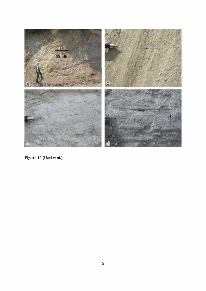
5
Figure 12 (Uzel et al.)

6
Figure 13 (Uzel et al.)

7
Figure 14 (Uzel et al.)

8
Figure 15 (Uzel et al.)

9
Figure 16 (Uzel et al.)
Table 1(Uzel et al.)
Related Documents


