12 Tuesday, October 21, 2003 Weather Facts Cajon Pass Simi Valley Julian Weather Station Max. Temperature 103 100 92 Min. Rel. Humidity 7% 8% 14% Wind NW7 G19 E8 G14 E7 G14 Fire Danger extreme Erratic fire behavior and frequent wind changes Community Impacts • Military communication and training facility threatened by Roblar 2 Fire. • So. CA Edison and LA Water & Power transmission lines threatened by Grand Prix Fire. • Pass Fire results in closures of roads and businesses. • Structures threatened in Lytle Creek, Fontana and Rancho Cucamonga by Grand Prix fire; Reche Canyon by the Pass fire and De Luz by the Roblar 2 fire. • Voluntary evacuation by 150 persons. Human Factors • 1,166 personnel committed to fires to date. Decisions Preparedness Levels: South Ops-3, National-2 • Grand Prix Unified Command included local law enforcement. Damage Assessment • Five residences burned in Reche Canyon on the Pass Fire. • Damage Assessment Teams activated to survey affected properties. • 1,750 acres burned to date during siege. • Estimated suppression costs to date: $175,000 • Light Initial Attack reported in Southern CA with the exception of the three large fires. • Roblar 2 Fire started at Camp Pendleton in San Diego. • Grand Prix Fire started near Fontana in San Bernardino County. • Pass Fire started in Moreno Valley in Riverside. • Agencies began placing orders for large number of resources for the large fires. • Federal Regional Team activated for the Roblar 2 Fire. • Unified Command Team (including Sheriff’s Department) activated for the Grand Prix Fire. • California Fire Agencies responded to and contained 130 new wildland fires statewide. Resources Committed: Engines Resources Committed: Airtankers Major Resources Committed on October 21st Name Crews Engines* Helicopters Dozers Overhead Acres % Contained Roblar 2 6 30 5 2 14 800 5 Grand Prix 31 15 8 2 37 825 0 Pass 7 40 2 2 16 125 10 TOTALS 44 85 15 6 67 1,750 N/A Data used above was extracted from the Incident Status Summary (209) or other best available data for each fire. When a fire is 100% contained, the fire name is deleted but the acreage burned is added to the “contained fires” section to display a cumulative summary of all acres burned to date throughout the siege. Priorities are based on Area Command. *Number of engines reported by incident may not reflect engines that responded during initial attack and were not included in automated agency systems. Engines may have been double counted when fires were split into separate incidents. 0 50 100 150 200 250 300 Flight Hours Available Actual Hours Flown STATEWIDE AIRTANKER RESOURCES AIRTANKERS MAFFS MAFFS not activated until 10/26/03 “If the winds are strong enough, the fire will begin to advance rapidly. Every fire is potentially dangerous, but these conditions obviously magnify those concerns.” Brad Doyle Forecaster for the National Weather Service 0 20% 40% 60% 80% 100% OES FEDs CDF Local % Engines Committed to Inital Attack Throughout CA % Engines Committed to So. CA Fire Siege Planned Maximum Draw for Going Fires STATEWIDE ENGINE RESOURCES 10/21/03 5,502 Engines 346 Engines 26 to Siege 5 to Siege 46 to Siege 8 to Siege 211 Engines 110 Engines

Welcome message from author
This document is posted to help you gain knowledge. Please leave a comment to let me know what you think about it! Share it to your friends and learn new things together.
Transcript

12
Tuesday, October 21, 2003
Weather Facts Cajon Pass Simi Valley Julian Weather Station
Max. Temperature 103 100 92
Min. Rel. Humidity 7% 8% 14%
Wind NW7 G19 E8 G14 E7 G14
Fire Danger extreme
Erratic fire behavior and frequent wind changes
Community Impacts• Military communication and training facility
threatened by Roblar 2 Fire.• So. CA Edison and LA Water & Power transmission
lines threatened by Grand Prix Fire.• Pass Fire results in closures of roads and businesses.• Structures threatened in Lytle Creek, Fontana and
Rancho Cucamonga by Grand Prix fire; Reche Canyonby the Pass fire and De Luz by the Roblar 2 fire.
• Voluntary evacuation by 150 persons.
Human Factors• 1,166 personnel committed to fires to date.
DecisionsPreparedness Levels: South Ops-3, National-2• Grand Prix Unified Command included local law
enforcement.
Damage Assessment• Five residences burned in Reche Canyon on the
Pass Fire.• Damage Assessment Teams activated to survey
affected properties.• 1,750 acres burned to date during siege.• Estimated suppression costs to date: $175,000
•Light Initial Attackreported in SouthernCA with theexception of thethree large fires.
•Roblar 2 Fire startedat Camp Pendleton inSan Diego.
•Grand Prix Firestarted near Fontanain San BernardinoCounty.
•Pass Fire started inMoreno Valley inRiverside.
•Agencies beganplacing orders forlarge number ofresources for thelarge fires.
•Federal RegionalTeam activated forthe Roblar 2 Fire.
•Unified CommandTeam (includingSheriff’s Department)activated for theGrand Prix Fire.
•California FireAgencies respondedto and contained 130new wildland firesstatewide.
Resources Committed: Engines Resources Committed: Airtankers
Major Resources Committed on October 21stName Crews Engines* Helicopters Dozers Overhead Acres % ContainedRoblar 2 6 30 5 2 14 800 5Grand Prix 31 15 8 2 37 825 0Pass 7 40 2 2 16 125 10TOTALS 44 85 15 6 67 1,750 N/AData used above was extracted from the Incident Status Summary (209) or other best available data for each fire. When a fire is 100% contained, the fire name is deleted but theacreage burned is added to the “contained fires” section to display a cumulative summary of all acres burned to date throughout the siege. Priorities are based on Area Command.*Number of engines reported by incident may not reflect engines that responded during initial attack and were not included in automated agency systems. Engines may have beendouble counted when fires were split into separate incidents.
0
50
100
150
200
250
300
Flight Hours AvailableActual Hours Flown
STATEWIDE AIRTANKER RESOURCES
AIRTANKERS MAFFS
MAFFSnot activated
until 10/26/03
“If the winds are strong enough, the fire will begin toadvance rapidly. Every fire is potentially dangerous, butthese conditions obviously magnify those concerns.”
Brad DoyleForecaster for the National Weather Service
0
20%
40%
60%
80%
100%
OESFEDsCDFLocal
% Engines Committed toInital Attack Throughout CA
% Engines Committed to So. CA Fire Siege
Planned Maximum Draw for Going FiresSTATEWIDE ENGINE RESOURCES 10/21/03
5,502 Engines 346 Engines
26 to Siege 5 to Siege46 to Siege 8 to Siege
211 Engines 110 Engines
13
0
1000
2000
3000
4000
5000
Robl
arGr
and
Prix
Pass
218
688260
It Begins…Three fireswithin fourhours
Weather and fuel conditions encoun-tered on October 21, 2003, were perfectto set in motion a chain of events thatresulted in one of the most devastatingperiods in southern California firehistory.
When the Roblar 2 Fire was reportedon October 21, 2003, at 12:01 p.m.,threatening the community of De Luz,the Camp Pendleton Fire Chief wasprepared.
The previous Roblar Fire of 1985provided the department and surround-ing communities the history andknowledge they needed to predict whatcould happen. Since the fire was locatedin a mutual threat zone, aircraft,engines, and crews from multipleagencies were immediately deployed. Adecision was made to order a FederalRegional Team because the fire startedon federal lands. With the threat to lifeand property, strike teams were held inthe De Luz Canyon to provide structureprotection. Preplanning and foresightled to the construction of more than 100miles of strategic fuelbreaks after thefirst Roblar Fire. These fuelbreaks proved
to be instrumental in slowing the fireenough to allow for the aggressivefirefighting actions needed during thefirst night. The fire was fought undernormal wind conditions and was a normalfuel driven fire.
The Grand Prix Fire was reported inFontana, SanBernardino County,at 2:22 p.m., twohours after theRoblar 2 Firestarted. Thecommunities ofLytle Creek andFontana were threatened. Fire wasburning in dense old growth chaparral.No residences were lost and no injurieswere reported. As the fire progressed, thedecision was made to transfer command
Personnel Committed: Day One Acreage Involved: Day One
TotalPersonnelCommitted:1,166
to a Federal Regional Team.The Pass Fire, in Reche Canyon, north
of Moreno Valley in Riverside County, wasreported at 4:11 p.m. Despite the aggres-sive actions of the firefighters, frequentwind changes, inaccessible terrain, anderratic fire behavior led to the destruction
of three residences and two outbuildings.One firefighter suffered from smokeinhalation.
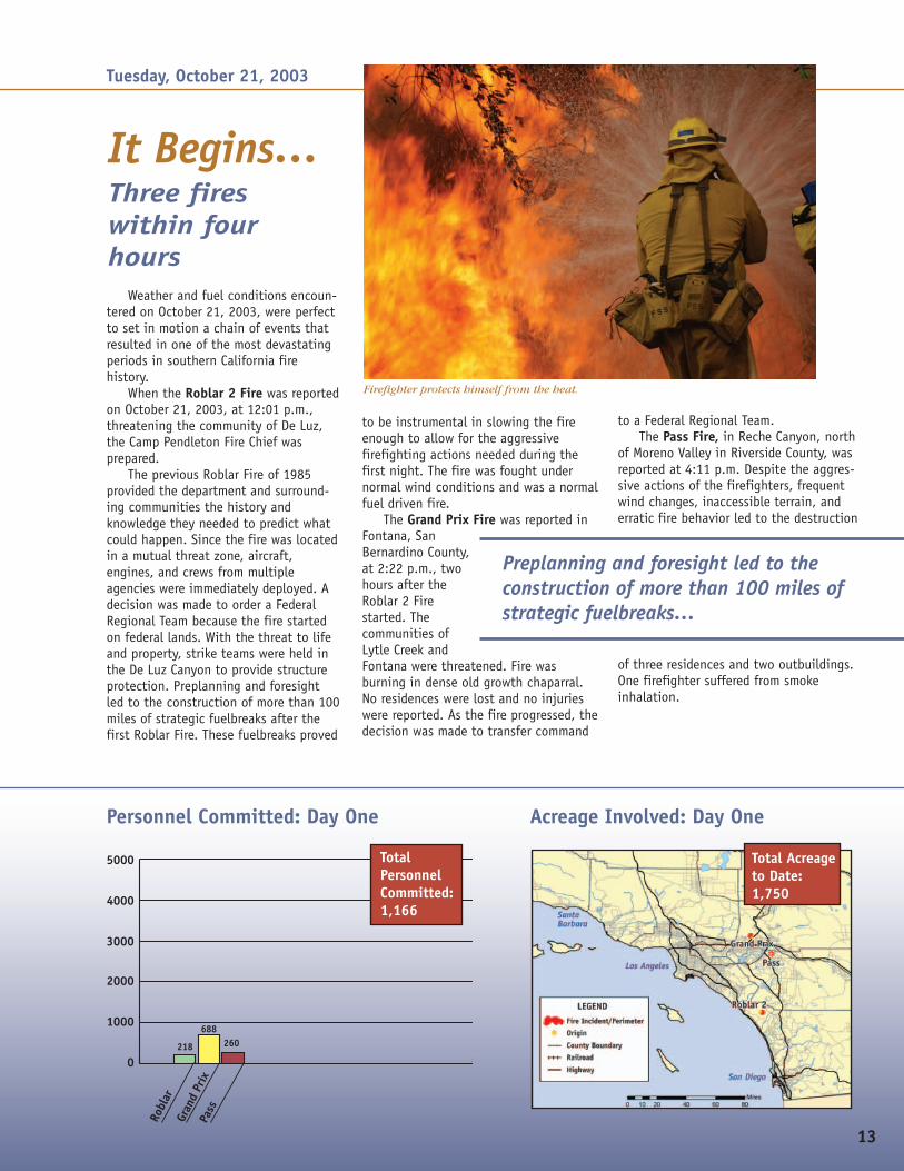
Firefighter protects himself from the heat.
Tuesday, October 21, 2003
Total Acreageto Date:1,750
Preplanning and foresight led to theconstruction of more than 100 miles ofstrategic fuelbreaks…

14
Weather Facts Cajon Pass Simi Valley Julian Weather Station
Max. Temperature 99 92 100
Min. Rel. Humidity 8% 13% 8%
Wind NW6 G11 E6 G15 E8 G14
Fire Danger extreme
Remarks: Spotting and extreme fire behavior observed onlarge fires.
Community Impacts• Three high voltage power lines that provide up to
25% of power to LA basin and an essential publicsafety communication site on San Servaine Mountainthreatened.
• Evacuations in progress for Pigeon Pass and RecheCanyon area of Moreno Valley, Riverside County.
Human Factors• Two serious injuries today.• 1,877 personnel committed to fires to date.
DecisionsPreparedness Levels: South Ops-3, National-2• Pass Fire is approved for Fire Management
Assistance Grant (FMAG).
Damage Assessment• Damage Assessment Teams activated to survey
affected properties.• Five residential and 21 outbuildings burned.• 6,430 acres burned to date during siege.• Estimated suppression costs to date: $2,215,150
Major Resources Committed on October 22ndName (priority) Crews Engines* Helicopters Dozers Overhead Acres % Contained
Roblar 2 (1) 11 39 5 8 64 2,085 5Grand Prix (3) 31 15 11 2 37 1,958 15Pass (2) 19 86 4 2 48 2,387 40TOTALS 61 140 20 12 149 6,430 N/AData used above was extracted from the Incident Status Summary (209) or other best available data for each fire. When a fire is 100% contained, the fire name is deleted but the acreageburned is added to the “contained fires” section to display a cumulative summary of all acres burned to date throughout the siege. Priorities are based on Area Command.*Number of engines reported by incident may not reflect engines that responded during initial attack and were not included in automated agency systems. Engines may have been doublecounted when fires were split into separate incidents.
•Resource orderswere placed throughthe NationalInteragency FireCenter to move out-of-state resourcesinto California.
•CDF staffingpatterns enacted tocall off-dutypersonnel back towork.
•Twice daily MACSconference callsbegin.
•California FireAgencies respondedto and contained154 new wildlandfires statewide.
Resources Committed: Engines Resources Committed: Airtankers
Wednesday, October 22, 2003
0
50
100
150
200
250
300
Flight Hours AvailableActual Hours Flown
STATEWIDE AIRTANKER RESOURCES
AIRTANKERS MAFFS
MAFFSnot activated
until 10/26/03
“When these fires started, the conditions in southernCalifornia were set up for a disaster. The drought had left thevegetation in a stressed condition, much of it already dead ordying. It was ready to explode into flames if any fire escapedinitial attack efforts.”
Tim Duane, Associate Professor, Environmental EngineeringUniversity of California, Berkeley
0
20%
40%
60%
80%
100%
OESFEDsCDFLocal
% Engines Committed toInital Attack Throughout CA
% Engines Committed to So. CA Fire Siege
Planned Maximum Draw for Going FiresSTATEWIDE ENGINE RESOURCES 10/22/03
5,502 Engines 346 Engines
35 to Siege15 to Siege
35 to Siege26 to Siege
211 Engines 110 Engines

15
0
1000
2000
3000
4000
5000
Robl
ar
Gran
d Pr
ixPa
ss
493688 696
With the dawning of October 22,2003, firefighters across southernCalifornia were not only confronted withthree ongoing fires and very extreme,erratic fire weather conditions, but theyalso faced the possibility of a majorwind event forecast for later in the dayplus the prediction of San Ana windslater in the week.
The Federal Regional Team assumedmanagement of the Roblar 2 Fire inUnified Command with CDF and USMC.More than 450 firefighters battled thefire, dry brush, and intense weatherconditions. The fire grew from 800 toalmost 2,100 acres, jumping thefirebreak at Roblar Loop and spreading
into De Luz Canyon, triggering avoluntary evacuation for the communityof De Luz. Evacuees were moved to anevacuation center located in St. Peter
Catholic Church in the community ofFallbrook.
At the same time, the Grand PrixFire had grown to 1,958 acres overnight.With extreme fire behavior throughoutthe night and more than 1,700 struc-
tures threat-ened, the firemade a runinto GrapevineCanyon, amajor tributaryto Lytle Creek.Firefighterswere able to
make good progress anchoring the fire tothe south; however, secondary contin-gency lines were constructed near thethreatened communities in preparation
Personnel Committed: Day Two
TotalPersonnelCommitted:1,877
Heating up…Extreme conditionshamper suppression
for the predicted wind event. Due tosafety issues, Lytle Road was closed tothe general public.
The Pass Fire grew to 2,387 acresovernight. With the high temperatures,low humidity and steep terrain hamper-ing firefighting efforts, five residencesand 21 outbuildings were destroyedduring the past 24-hour period. Firingoperations were conducted in an effortto secure the perimeter of the fire. Amandatory evacuation was in place forthe area of Pigeon Pass, and the fire wasapproved for a Fire ManagementAssistance Grant (FMAG).
Acreage Involved: Day Two
Wednesday, October 22, 2003
Total Acreageto Date:6,430
With high temperatures, low humidity andsteep terrain hampering firefighting efforts,five residences and 21 outbuildings weredestroyed during the 24-hour period.
A firefighter checks the wind conditions by using a Kestrel weather instrument.
16
Weather Facts Cajon Pass Simi Valley Julian Weather Station
Max. Temperature 97 92 95
Min. Rel. Humidity 10% 14% 13%
Wind NW8 G17 E5 G16 E7 G13
Fire Danger extreme extreme extremeRemarks: Above normal temps, strong & gustywinds, low humidity.
Community Impacts• Mandatory evacuation of all residents in Lytle
Creek canyon initiated.• Voluntary evacuation of De Luz residents
initiated.• Evacuations extended west of I-15 on the Grand
Prix Fire.• Grand Prix Fire threatened watershed values and
historical mining sites.
Human Factors• Four serious injuries to date• 2,755 personnel committed to all fires today.• Two major power lines burned and power lost on Grand
Prix Fire.
DecisionsPreparedness Levels: South Ops-3, National-2• Officials established mobilization centers and several
staging areas to help organize responding resources andassign them to the highest priorities.
• U.S. Forest Service pre-positioned Federal National Team insouthern California.
• Damage Assessment Team ordered for Grand Prix Fire.
Damage Assessment• 10,772 acres burned to date.• Five residential structures and 21 outbuildings burned to
date during siege.• Estimated fire suppression costs to date: $4,729,417
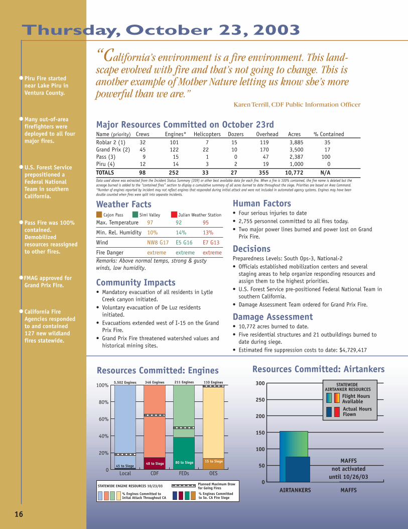
Major Resources Committed on October 23rdName (priority) Crews Engines* Helicopters Dozers Overhead Acres % ContainedRoblar 2 (1) 32 101 7 15 119 3,885 35Grand Prix (2) 45 122 22 10 170 3,500 17Pass (3) 9 15 1 0 47 2,387 100Piru (4) 12 14 3 2 19 1,000 0TOTALS 98 252 33 27 355 10,772 N/AData used above was extracted from the Incident Status Summary (209) or other best available data for each fire. When a fire is 100% contained, the fire name is deleted but theacreage burned is added to the “contained fires” section to display a cumulative summary of all acres burned to date throughout the siege. Priorities are based on Area Command.*Number of engines reported by incident may not reflect engines that responded during initial attack and were not included in automated agency systems. Engines may have beendouble counted when fires were split into separate incidents.
“California’s environment is a fire environment. This land-scape evolved with fire and that’s not going to change. This isanother example of Mother Nature letting us know she’s morepowerful than we are.”
Karen Terrill, CDF Public Information Officer
•Piru Fire startednear Lake Piru inVentura County.
•Many out-of-areafirefighters weredeployed to all fourmajor fires.
•U.S. Forest Serviceprepositioned aFederal NationalTeam in southernCalifornia.
•Pass Fire was 100%contained.Demobilizedresources reassignedto other fires.
•FMAG approved forGrand Prix Fire.
•California FireAgencies respondedto and contained127 new wildlandfires statewide.
Resources Committed: Engines
Thursday, October 23, 2003
0
50
100
150
200
250
300
Flight Hours AvailableActual Hours Flown
STATEWIDE AIRTANKER RESOURCES
AIRTANKERS MAFFS
MAFFSnot activated
until 10/26/03
Resources Committed: Airtankers
0
20%
40%
60%
80%
100%
OESFEDsCDFLocal
% Engines Committed toInital Attack Throughout CA
% Engines Committed to So. CA Fire Siege
Planned Maximum Draw for Going FiresSTATEWIDE ENGINE RESOURCES 10/23/03
5,502 Engines 346 Engines
48 to Siege15 to Siege
45 to Siege80 to Siege
211 Engines 110 Engines
17
0
1000
2000
3000
4000
5000
Robl
ar
Gran
d Pr
ixPa
ssPi
ru
1,2101,096
211 238
With Santa Ana winds predicted af-ter midnight on Thursday, firefighterscontinued to battle toward containmentof the fires. Due to the heavy workloadof participating agencies, daily confer-ence calls were set up between the MACSmembers in lieu of face-to-face meet-ings. Thus, priority setting remained atthe South Ops level.
On the Roblar 2 Fire, even thoughheavy fuels and extreme temperaturescontinued to hamper firefightingefforts overnight, firefighters wereable to hold its progression to 3,885acres. The communities of De Luz andSky Ranch continued to be threatened,with voluntary evacuations in effectfor the community of De Luz. This firealso threatened to move into the SanMateo Wilderness Area. The danger ofunexploded ordinance prevented thefire crews from entering the restrictedtraining area on the Camp Pendletonmilitary base. This hindered contain-ment efforts on the south/southwestflank of the fire.
Personnel Committed: Day ThreeTotalPersonnelCommitted:2,755
The Grand Prix Fire grew to 3,500acres and progressed down to theMiller Narrows area, prompting theevacuation of the Lytle Creek commu-nity. Lytle Creek Road and RanchoCucamonga Canyon Road were closedto all traffic.With thethreat ofcontinuederraticwinds,contingencyplans werein progressto protect other communities west ofthe fire. CDF requests FMAG for GrandPrix Fire.
Firefighters held the Pass Fire to2,387 acres overnight. The incident
One StepForward…Pass Firecontained asPiru begins
commanders declared the Pass Fire 100percent contained and releasedresources for reassignment to otherfires in southern California.
At approximately 1:30 p.m. thePiru Fire was added to the expanding
list of fires in southern California. TheIncident Commander called forfirefighting resources for the fire,located outside the small communityof Piru in Ventura County.
Thursday, October 23, 2003
Acreage Involved: Day Three
Total Acreageto Date:10,772
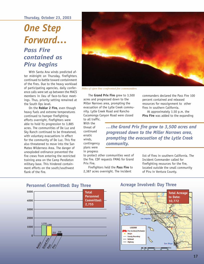
Miles of open line confronted fire commanders.
…the Grand Prix fire grew to 3,500 acres andprogressed down to the Miller Narrows area,prompting the evacuation of the Lytle Creekcommunity.

18
Resources Committed: Engines
Major Resources Committed on October 24thName (priority) Crews Engines* Helicopters Dozers Overhead Acres % ContainedRoblar 2 (2) 38 92 6 15 150 4,680 50Grand Prix (1) 45 220 15 18 155 12,600 19Piru (4) 25 47 6 3 128 1,250 30Verdale (3) 8 38 3 2 30 200 0Happy 2 9 2 2 4 250 25Contained Fire - - - - - 2,387 100
TOTALS 118 409 32 40 498 21,367 N/AData used above was extracted from the Incident Status Summary (209) or other best available data for each fire. When a fire is 100% contained, the fire name is deleted but theacreage burned is added to the “contained fires” section to display a cumulative summary of all acres burned to date throughout the siege. Priorities are based on Area Command.*Number of engines reported by incident may not reflect engines that responded during initial attack and were not included in automated agency systems. Engines may have beendouble counted when fires were split into separate incidents.
Weather Facts Cajon Pass Simi Valley Julian Weather Station
Max. Temperature 96 88 97
Min. Rel. Humidity 8% 14% 6%
Wind NW9 G26 E6 G15 E9 G14
Fire Danger extreme extreme extremeRemarks: Red Flag Warning for high winds (Santa Ana) issued fornext 4 days. Frequent wind direction changes. Spotting, torching andfire whirls reported. Fuel moistures below critical levels.
Community Impacts• Interstate 15 & Interstate 210 freeways closed.• Verdale Fire causes evacuations on the Val Verde
side of the fire.• Contingency plans for communities west of the
Grand Prix fire are developed.• Another high voltage power line is burned and
power lost to LA Basin on Grand Prix Fire.• Evacuations in many areas continue.• Remaining resources on the Pass Fire will be
reassigned today. 100% contained.
• Threat to avocado groves from Roblar 2 Fire.• Ash from the Grand Prix Fire fell 30 miles away on the
Santa Anita Racetrack in Arcadia, site of the Breeder’sCup World Thoroughbred Championships today.
• Health advisory issued for poor air quality in SanBernardino County.
Human Factors• Seven serious injuries to date• 4,770 personnel committed to all fire to date.• Firefighter and public safety are of primary concern.
DecisionsPreparedness Levels: South Ops-3, National-2• U.S. Forest Service directs the Prepositioned Federal
National Team to begin transition process with theFederal Regional Team on the Grand Prix Fire.
Damage Assessment• 21,367 total acres burned to date during siege.• 10 residential & 23 outbuilding structures burned to
date during siege.• Estimated fire suppression costs to date: $8,300,000
•Santa Ana windssurfaced on the GrandPrix Fire increasingstructure threat inRancho Cucamongaand Fontana.
•Verdale Fire startedwest of Santa Claritain LA County.
•Wind driven fires innorthern Californiaoccured with onestructure destroyednear Redding.
•Governor Davisordered all of thestate’s firefightingand emergencyresources into action.
•CDF cancelledvacations and days offfor all personnel.
•CDF reactivated five of10 airtankers thatwere off contract.
•Happy Fire startednorth of LakeCachuma Lake inSanta Barbara County.
•Structure protectionfor De Luz and SkyRanch area requiredon Roblar 2.
•Southern CaliforniaEdison warned ofpotential,unprecedented powercutoffs.
•Health advisoriesissued because ofpoor air quality.
•California FireAgencies responded toand contained 137new wildland firesstatewide.
Friday, October 24, 2003
Resources Committed: Airtankers
0
50
100
150
200
250
300
Flight Hours AvailableActual Hours Flown
STATEWIDE AIRTANKER RESOURCES
AIRTANKERS MAFFS
MAFFSnot activated
until 10/26/03
“This will be the most expensive fire in California history,both in loss of property and the cost of fighting it.”
Dallas Jones, Director of California Office of Emergency Services
0
20%
40%
60%
80%
100%
OESFEDsCDFLocal
% Engines Committed toInital Attack Throughout CA
% Engines Committed to So. CA Fire Siege
Planned Maximum Draw for Going FiresSTATEWIDE ENGINE RESOURCES 10/24/03
5,502 Engines 346 Engines
86 to Siege25 to Siege
105 to Siege
82 to Siege
211 Engines 110 Engines

19
0
1000
2000
3000
4000
5000
Robl
ar
Gran
d Pr
ixPa
ssPi
ru
Verd
ale
Happ
y
1,304
2,167
80
821
31880
Winds continued to frustratefirefighters throughout the night. Whenfirefighters received their operationalbriefings before heading out to the fireline, they found it was more of thesame. They faced another day of theweather working against them on thefireline. Moderate to strong north toeast winds along with low humidity,poor humidity recovery and hightemperatures were predicted throughSunday across the area of southernCalifornia.
On the Roblar 2 Fire, voluntary evacu-ations remained in effect for the commu-nity of De Luz. Firefighters successfullycompleted burning operations which pre-vented the fire from establishing itself inthe San Mateo Wilderness. Had it doneso, the result would likely have been alarge wilderness fire (40,000+ acres) re-quiring very heavy commitment of re-sources and structure threat to the com-munities of San Onofre and San Clemente.For the public’s safety, all roads leadingto De Luz remained closed to the public.Structure protection remained in place forthe residences in the De Luz and Sky Ranchareas. The evacuation center in Fallbrookremained open.
The Grand Prix Fire made majorruns in all directions due to the erraticwinds. The fire increased in size to12,600 acres and progressed into thecommunities of Lytle Creek, RanchoCucamonga and Fontana, destroying fiveresidences and one outbuilding in itspath. A force of interagency firefightersprovided structure protection as the firejumped Interstate 15 in the area ofFontana/Rancho Cucamonga and headedfor several housing developments.Contingency plans continued to bedeveloped for communities east of thefire, as predictions of a 180º wind shiftwere made. Mandatory evacuations wereordered for the communities of RanchoCucamonga, as well as Lytle Creek. TheJesse Turner Community Center inFontana offered refuge to evacuees ofthe affected areas. Active fire forcedthe closure of Interstate 15, Interstate210, Lytle Creek Road, RanchoCucamonga Canyon Road and WardmanBullock Banyon Road.
With residences, ranches and vitalagricultural lands threatened in the areaof the Piru Fire, firefighters focusedtheir attention on building containmentlines around the 1250-acre fire. With
the forecasted wind event, contingencylines were established for structureprotection in the Fillmore area.
Incident Command on the Pass Firecontinued its rapid demobilization of re-sources, enabling reassignment to otherfires in the area. The Damage AssessmentTeams concluded their inventory of alldamaged and destroyed structures. Fiveresidences and 21 outbuildings were de-stroyed. Three residences and two out-buildings were damaged.
At 1:07 p.m., the Verdale Fire wasreported four miles west of Santa Clarita.At 5:00 p.m. a request for an IncidentManagement Team was ordered to man-age the incident. LA County and VenturaCounty entered Unified Command.
The Happy Fire, 10 miles east of SantaYnez on Highway 154, was reported at3:05 p.m.
With the rapid assignment of fire re-sources throughout southern California tobattle the ongoing fires, agency adminis-trators for San Diego City and CDF made astrategic decision to increase coverage forall stations in the San Diego area. SanDiego aircraft had been assigned to firesin other parts of southern California.
Personnel Committed: Day FourTotalPersonnelCommitted:4,770
Increasing threatto homesWeather impedes efforts
Friday, October 24, 2003
Acreage Involved: Day Four
Total Acreageto Date:21,367
The fires’ impacts on communities was vast.
20
Resources Committed: Engines
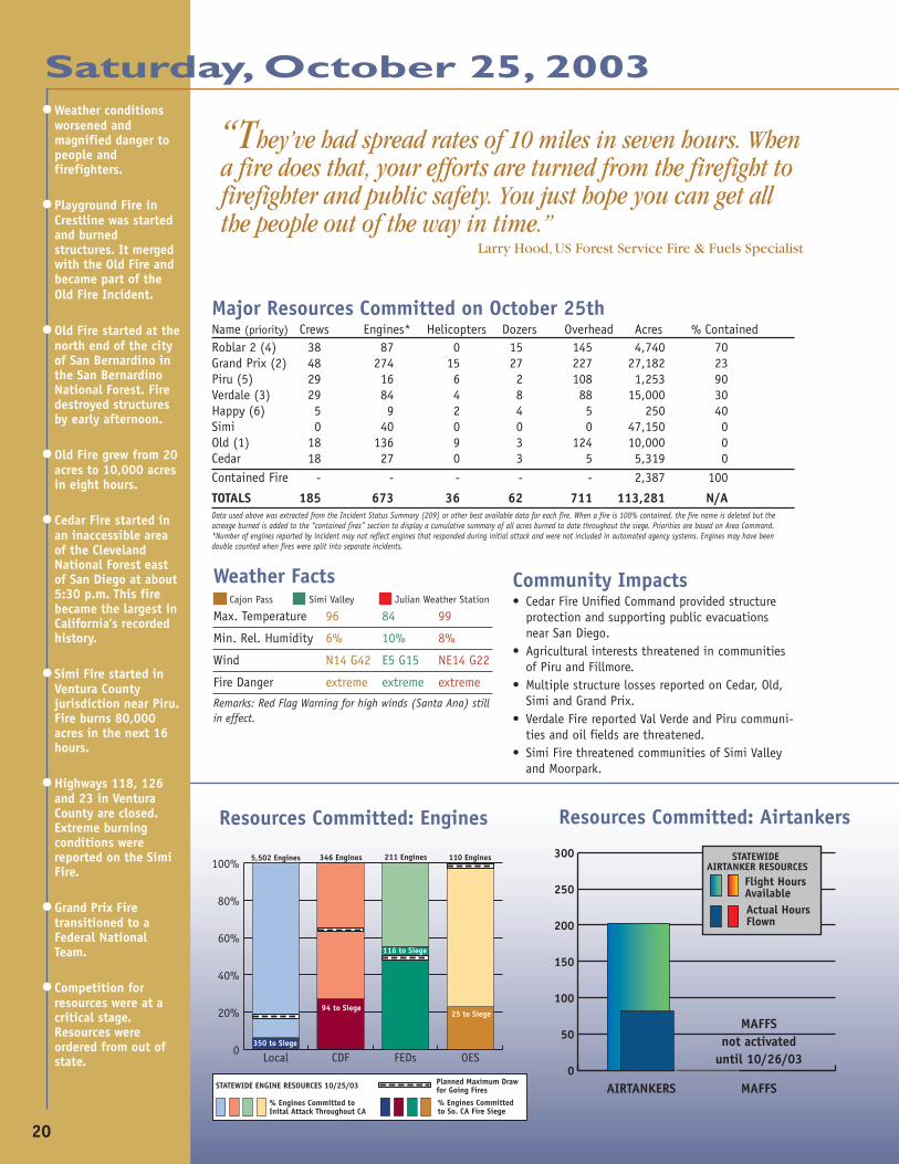
Major Resources Committed on October 25thName (priority) Crews Engines* Helicopters Dozers Overhead Acres % ContainedRoblar 2 (4) 38 87 0 15 145 4,740 70Grand Prix (2) 48 274 15 27 227 27,182 23Piru (5) 29 16 6 2 108 1,253 90Verdale (3) 29 84 4 8 88 15,000 30Happy (6) 5 9 2 4 5 250 40Simi 0 40 0 0 0 47,150 0Old (1) 18 136 9 3 124 10,000 0Cedar 18 27 0 3 5 5,319 0Contained Fire - - - - - 2,387 100
TOTALS 185 673 36 62 711 113,281 N/AData used above was extracted from the Incident Status Summary (209) or other best available data for each fire. When a fire is 100% contained, the fire name is deleted but theacreage burned is added to the “contained fires” section to display a cumulative summary of all acres burned to date throughout the siege. Priorities are based on Area Command.*Number of engines reported by incident may not reflect engines that responded during initial attack and were not included in automated agency systems. Engines may have beendouble counted when fires were split into separate incidents.
Weather Facts Cajon Pass Simi Valley Julian Weather Station
Max. Temperature 96 84 99
Min. Rel. Humidity 6% 10% 8%
Wind N14 G42 E5 G15 NE14 G22
Fire Danger extreme extreme extreme
Remarks: Red Flag Warning for high winds (Santa Ana) stillin effect.
“They’ve had spread rates of 10 miles in seven hours. Whena fire does that, your efforts are turned from the firefight tofirefighter and public safety. You just hope you can get allthe people out of the way in time.”
Larry Hood, US Forest Service Fire & Fuels Specialist
•Weather conditionsworsened andmagnified danger topeople andfirefighters.
•Playground Fire inCrestline was startedand burnedstructures. It mergedwith the Old Fire andbecame part of theOld Fire Incident.
•Old Fire started at thenorth end of the cityof San Bernardino inthe San BernardinoNational Forest. Firedestroyed structuresby early afternoon.
•Old Fire grew from 20acres to 10,000 acresin eight hours.
•Cedar Fire started inan inaccessible areaof the ClevelandNational Forest eastof San Diego at about5:30 p.m. This firebecame the largest inCalifornia’s recordedhistory.
•Simi Fire started inVentura Countyjurisdiction near Piru.Fire burns 80,000acres in the next 16hours.
•Highways 118, 126and 23 in VenturaCounty are closed.Extreme burningconditions werereported on the SimiFire.
•Grand Prix Firetransitioned to aFederal NationalTeam.
•Competition forresources were at acritical stage.Resources wereordered from out ofstate.
Saturday, October 25, 2003
Resources Committed: Airtankers
0
50
100
150
200
250
300
Flight Hours AvailableActual Hours Flown
STATEWIDE AIRTANKER RESOURCES
AIRTANKERS MAFFS
MAFFSnot activated
until 10/26/03
Community Impacts• Cedar Fire Unified Command provided structure
protection and supporting public evacuationsnear San Diego.
• Agricultural interests threatened in communitiesof Piru and Fillmore.
• Multiple structure losses reported on Cedar, Old,Simi and Grand Prix.
• Verdale Fire reported Val Verde and Piru communi-ties and oil fields are threatened.
• Simi Fire threatened communities of Simi Valleyand Moorpark.
0
20%
40%
60%
80%
100%
OESFEDsCDFLocal
% Engines Committed toInital Attack Throughout CA
% Engines Committed to So. CA Fire Siege
Planned Maximum Draw for Going FiresSTATEWIDE ENGINE RESOURCES 10/25/03
5,502 Engines 346 Engines
94 to Siege25 to Siege
350 to Siege
116 to Siege
211 Engines 110 Engines
21
0
1000
2000
3000
4000
5000
Robl
ar
Gran
d Pr
ixPa
ssPi
ru
Verd
ale
Happ
yOl
d
Sim
iCe
dar
1,313
2,427
80
780883
155
775
170456
Personnel Committed: Day FiveTotalPersonnelCommitted:7,039
Saturday, October 25, 2003
Acreage Involved: Day Five
Total Acreageto Date:113,281
• U.S. Forest Service ordered a FederalNational Team for the Old Fire.
• The U.S. Forest Service assigned thePrepositioned Federal National Team torelieve the Federal Regional Team on theGrand Prix fire and remained in theexisting Unified Command.
• Simi Fire starts from a spot fire on theVerdale Fire. Incident Commandersdecide to split fire into two incidents.
• L. A. County Fire Chief makes decision tostrategically place resources to providestructure protection to Claremont and LaVerne west of the Grand Prix Fire—eventhough it meant strictly limitingresources in other areas.
• Due to wind and smoke from the GrandPrix Fire, aircraft were grounded on someincidents and redeployed to other fires.
• The U.S. Forest Service began theprocess to close the Angeles andCleveland National Forests.
• Incident Commanders on the Verdale, Piruand Simi Fires began to coordinate & shareresources among the fires.
• Ventura County Fire Chief requestedambulances to cover empty fire stations toprovide Emergency Medical Service (EMS) tothe public.
• CDF initiated request for two CaliforniaMAFFS from California National Guard.
• Personnel ordered to staff Joint InformationCenter.
• MACS decides to move to preparednesslevel 5, Mode-4.
• FMAG requested through OES for Simi Fire.
Damage Assessment• 113,281 acres burned to date during siege.• Estimated 70 residential and 23 outbuildings
burned to date during siege.• Estimated fire suppression costs to date:
$12,229,417
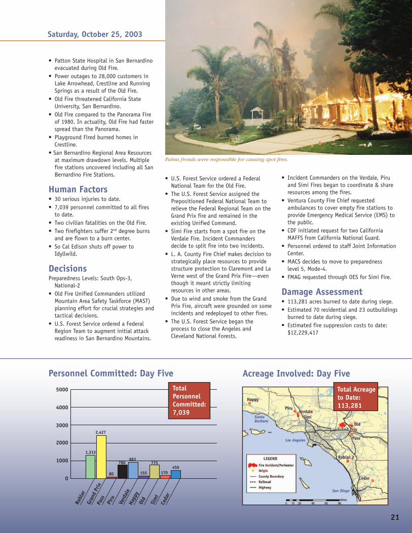
Palms fronds were responsible for causing spot fires.
• Patton State Hospital in San Bernardinoevacuated during Old Fire.
• Power outages to 28,000 customers inLake Arrowhead, Crestline and RunningSprings as a result of the Old Fire.
• Old Fire threatened California StateUniversity, San Bernardino.
• Old Fire compared to the Panorama Fireof 1980. In actuality, Old Fire had fasterspread than the Panorama.
• Playground Fired burned homes inCrestline.
• San Bernardino Regional Area Resourcesat maximum drawdown levels. Multiplefire stations uncovered including all SanBernardino Fire Stations.
Human Factors• 30 serious injuries to date.• 7,039 personnel committed to all fires
to date.• Two civilian fatalities on the Old Fire.• Two firefighters suffer 2nd degree burns
and are flown to a burn center.• So Cal Edison shuts off power to
Idyllwild.
DecisionsPreparedness Levels: South Ops-3,
National-2• Old Fire Unified Commanders utilized
Mountain Area Safety Taskforce (MAST)planning effort for crucial strategies andtactical decisions.
• U.S. Forest Service ordered a FederalRegion Team to augment initial attackreadiness in San Bernardino Mountains.

22
Over the area of the Grand Prix Fire, aSanta Ana wind pattern developed creating veryerratic weather conditions. Winds whipped inall directions. Extreme fire behavior withspotting, torching and fire whirls led to thefire’s progression into the Deer Creek drainage.The number of residences burned increased tosix, and the fire grew to 27,182 acres. Success-ful structure protection efforts allowedevacuations for the communities of Lytle Creekand the Banyon areas of northern Fontana/Rancho Cucamonga were reduced to voluntaryevacuations. New mandatory evacuations wereordered for western Rancho Cucamonga and SanAntonio Heights. The evacuation center at the
Jesse Turner Community Center in Fontana andan additional evacuation center in RanchoCucamonga remained open and ready to handlethe new evacuees. Extreme fire behavior wasobserved throughout the day, additionalevacuations were anticipated. AirOperations were halted due to highwinds. Southern California Edison powerwas shut down to the foothills duringthe fire runs. With the imminent threatof fire spread into Los Angeles County,the LA County Fire Chief made a strategicdecision to place resources where he feltthey were needed most, even if thatmeant severely limiting resources atother stations throughout the county.The cause of the Grand Prix Fire wasdetermined to be “human caused.”Command for the Grand Prix Firetransitioned to a Federal National Teamunder Unified Command. At 11:00 p.m.the fire entered the city of Claremontprompting additional evacuations.
The Fight ContinuesSanta Anas and extreme fire behavior
Saturday, October 25, 2003
The Verdale Fire threatened the communi-ties of Piru and Val Verde and 15 oil fields.Overnight, firefighters worked to hold the fireto 15,000 acres. An oil pipeline infrastructurewas damaged requiring a hazardous materialsresponse. Fish and Game was notified, and tworesidences were evacuated in the area. Duringthe day, high winds prevented firefighters frommounting an aggressive attack on the fire. TheVerdale Fire was approved for FMAG.
The fire spotted 3/4 of a mile acrossHighway 126 and spread to Highways 118 and23. Simi Valley and Moorpark areas werethreatened. At that time, a strategic decisionwas made to split the fire at Highway 126.North of the highway would continue to beknown as the Verdale Fire, south of Highway126 would be known as the Simi Fire. With thisdecision, all road closures were lifted for thearea of the Verdale Fire. The Simi Fire burned80,000 acres in 16 hours. A State IncidentCommand Team was ordered to manage the SimiFire in Ventura County.
Eight strike teams of engines were involvedin the initial attack of the Simi Fire. Theirmission was to provide structure protection forthe Simi Valley and Moorpark areas of the fire.At one point, only three of the 32 VenturaCounty Fire Department stations were covered.The Ventura County Fire Chief requested privateambulance services to cover all vacated firestations in order to ensure a basic level of EMSfor the county.
On the Piru Fire, firefighters continued toconcentrate their efforts on holding the firelineand providing structure protection for the
•Multiple Federal andState CommandTeams ordered forCedar, Simi and OldFires.
•Governor Davisproclaims a State ofEmergency in SanBernardino andVentura Counties.
•A helicoptergrounded on October24th due tomechanical issuesnear the Grand Prixperimeter wasburned over andscorched.
•Intense mediaattention escalatesfrom all nationaland manyinternationalnetworks.
•California FireAgencies respondedto and contained197 new wildlandfires statewide.
…extreme fire behavior was observedthroughout the day, additionalevacuations were anticipated. AirOperations were halted due to highwinds. Southern California Edison powerwas shut down to the foothills during thefire runs.
A helicopter dampens approaching flames on the Cedar Fire.
23
threatened homes in the Fillmore area. The fire grew from700 acres to 1,253 acres in 24 hours and was burning withinthe 1997 Hooper Fire area. Contingency plans were in placefor the predicted wind event, as the fire was projected toincrease in size significantly. Several additional structureswere threatened.
Incident Commanders forthe Verdale, Piru and Simi Firesentered into an informal AreaCommand to coordinate andshare resources between thefires and better facilitate theirmanagement.
On the Happy Fire,aggressive firefighting effortsheld the fire to 250 acres. Therewas no immediate threat tostructures, however, someresidential ranches were locatedin the area. Good progress wasmade with dozers, and the firewas declared 100 percentcontained by the next day.
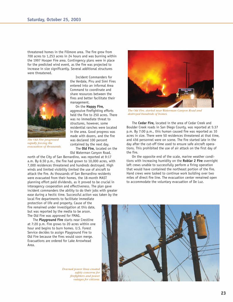
The Old Fire, located on theOld Waterman Canyon Road,
north of the City of San Bernardino, was reported at 9:17a.m. By 6:30 p.m., the fire had grown to 10,000 acres, with7,000 residences threatened and hundreds destroyed. Highwinds and limited visibility limited the use of aircraft toattack the fire. As thousands of San Bernardino residentswere evacuated from their homes, the 18-month MASTplanning effort paid dividends, as it proved to be crucial ininteragency cooperation and effectiveness. The plan gaveincident commanders the ability to do their jobs with greaterease during a hectic time. Successful action was taken by thelocal fire departments to facilitate immediateprotection of life and property. Cause of thefire remained under investigation at this date,but was reported by the media to be arson.The Old Fire was approved for FMAG.
The Playground Fire starts near Crestlineat 7:20 p.m. Fire grows to 20 acres within onehour and begins to burn homes. U.S. ForestService decides to assign Playground Fire toOld Fire because the fires would soon merge.Evacuations are ordered for Lake ArrowheadArea.
Saturday, October 25, 2003
The Cedar Fire, located in the area of Cedar Creek andBoulder Creek roads in San Diego County, was reported at 5:37p.m. By 7:00 p.m., this human caused fire was reported as 10acres in size. There were 50 residences threatened at that time,and 456 personnel were on scene. The fire started late in theday after the cut-off time used to ensure safe aircraft opera-tions. This prohibited the use of air attack on the first day ofthe fire.
On the opposite end of the scale, marine weather condi-tions with increasing humidity on the Roblar 2 Fire overnightleft crews unable to successfully perform a firing operationthat would have contained the northeast portion of the fire.Hand crews were tasked to continue work building over twomiles of direct fire line. The evacuation center remained opento accommodate the voluntary evacuation of De Luz.
The Old Fire, started near Waterman Canyon Road anddestroyed hundreds of homes.
Downed power lines createdsafety concerns for
firefighters and poweroutages for citizens.
The Old Fire progressedrapidly forcing theevacuation of thousands.
24
Resources Committed: Engines
•Paradise Fire startednear Valley Center inSan Diego County.
•Otay Fire started inSan Diego County nearMine Canyon Road onOtay Mountain.
•Mountain Fire startedin the Sage area,Riverside County.Threatened homes eastof Temecula.
•Wellman Fire startedin Riverside Countynear Anza. Firecontained at 100acres.
•Governor Davisdeclared a state ofemergency in SanDiego and Los AngelesCounties.
•FAA orderedevacuation of RegionalTerminal RadarApproach ControlFacility at MiramarMarine Air Station,due to theapproaching CedarFire.
•Commercial airlineflights in regionimpacted. Someairports closed. Airtravel disruptednationwide.
•Two small planescrashed in San DiegoCounty due to poorvisibility from smoke.
•San Diego Gas &Electric Co. shut downa major electricaltransmission lineserving 11,000 homesand other sites aroundSan Diego.
Major Resources Committed on October 26thName (priority) Crews Engines* Helicopters Dozers Overhead Acres % ContainedRoblar 2 (7) 13 34 0 2 112 6,892 85Grand Prix (3) 43 347 15 27 233 52,184 25Piru (6) 29 16 7 2 108 25,000 5Verdale (5) 21 45 0 5 122 8,680 85Happy 5 9 2 4 5 250 100Simi (4) 1 144 6 1 58 80,000 5Old (2) 30 180 8 4 199 24,000 5Cedar (1) 30 170 3 1 15 134,257 0Paradise (1) 14 55 0 0 35 15,000 0Mountain 0 38 3 3 78 2,000 0Otay/Mine 8 6 0 0 33 10,000 0Wellman 0 17 1 4 5 100 20Contained Fire - - - - - 2,387 100
TOTALS 194 1,061 45 53 1,003 360,750 N/AData used above was extracted from the Incident Status Summary (209) or other best available data for each fire. When a fire is 100% contained, the fire name is deleted but theacreage burned is added to the “contained fires” section to display a cumulative summary of all acres burned to date throughout the siege. Priorities are based on Area Command.*Number of engines reported by incident may not reflect engines that responded during initial attack and were not included in automated agency systems. Engines may have beendouble counted when fires were split into separate incidents.
Weather Facts Cajon Pass Simi Valley Julian Weather Station
Max. Temperature 91 69 95
Min. Rel. Humidity 6% 9% 7%
Wind NE18 G38 E22 G49 E21 G31
Fire Danger extreme extreme extreme
Remarks: Red Flag Warning for high winds still in effect. Extreme firerates of spread experienced. Spotting over a mile away, torching,crowning, intense runs observed.
0
50
100
150
200
250
300
Flight Hours AvailableActual Hours Flown
STATEWIDE AIRTANKER RESOURCES
AIRTANKERS MAFFS
Resources Committed: Airtankers
Sunday, October 26, 2003
Community Impacts• No power in the Anza area affects water supply,
hampering water supply for hose lays.• Widespread threat to domestic livestock and farm
animals in rural areas and associated wildlife refugeareas. Ranch structures were also threatened onseveral fires.
• Mass community evacuations continue to affectmany areas including two community hospitals andzoo in Big Bear.
“The reason the Simi Fire burned a smaller percentageof the structures that were threatened compared to theGrand Prix, Old, Cedar and Paradise Fires is directly relatedto the mandatory, minimum 100 foot clearance ordinancein Ventura County.”
Kelley Gouette, CDF-San Luis Obispo, Operations Chief, Simi Fire
0
20%
40%
60%
80%
100%
OESFEDsCDFLocal
% Engines Committed toInital Attack Throughout CA
% Engines Committed to So. CA Fire Siege
Planned Maximum Draw for Going FiresSTATEWIDE ENGINE RESOURCES 10/26/03
5,502 Engines 346 Engines
150 to Siege
101 to Siege
545 to Siege
106 to Siege
211 Engines 110 Engines

25
0
1000
2000
3000
4000
5000
Robl
ar
Gran
d Pr
ixPi
ruVe
rdal
eOl
dSi
mi
Ceda
r Pa
radi
se
Mou
ntai
n Ot
ay
Wel
lman
520
2,506
824620
1,291
7281,000
222352
142 150
Personnel Committed: Day Six
TotalPersonnelCommitted:8,355
Sunday, October 26, 2003
Acreage Involved: Day Six
Total Acreageto Date:360,750
• Air quality degradation widespread in southern CA.• Exposed portions of S. CA Edison power grid are being shut
down during fire runs.• Railroad freight lines in the Cajon Pass area were shut down
resulting in $2 million per hour revenue loss. Amtrakpassenger lines also shut down in the Simi Valley area.
• Many major roads and freeways remain closed or impacted.• Fires caused the closure of businesses, public offices and
schools in southern CA.• Ships docked in San Diego pressed into duty as evacuation
centers for military families.• A total of 22 evacuation centers operating in southern
California. More than 5,000 evacuees being housed.• FAA San Diego Center shut down due to fire threat.
Human Factors• Cedar Fire had 13 civilian fatalities.• Paradise Fire: 2 fatalities confirmed, numerous civilian
fatalities reported but unconfirmed.• 37 serious injuries to date. Serious burn injuries being
reported.• Red Cross opening evacuation centers in multiple areas.• Resources on the Otay Fire are in a “defensive posture” until
winds die down and more resources become available.• Pressure from elected officials to obtain more MAFFS aircraft
from out of state even though fire commanders did notidentify a need.
• Congressional and legislative information requests increase toa level that began to impact the Incident Commanders’ abilityto make quick, decisive decisions on Cedar Fire.
DecisionsPreparedness Levels: South Ops–5; National–2• California National Guard military resources assigned to Cedar
and Paradise Fires.• U.S. Forest Service assigned contract airtankers to siege from
across the nation, and activated six military airtankers fromoutside California.
• U.S Forest Service staffed the Emergency Support Function 4(ESF-4, Firefighting) at the FEMA Regional Operations Center inOakland.
• Back firing was initiated along Highway 18 and 138 nearCrestline.
• State Incident Command Team assigned to the Cedar Fire.• FMAG requested for Cedar and Padua fires.• Substantial resources sent to “heel of fire” in effort to save
Julian, Pinehurst and Cuyamaca from an aggressive Cedar Fire.• U.S. Forest Service staffed the Emergency Services Function of
the Federal Disaster Plan in the anticipation of a federal disasterdeclaration.
• Initiated strategic decision to utilize the International fuelbreakon the Otay Fire for large defensive action.
• State Incident Command Team assigned to the Paradise Fire.• State Incident Command Team assigned to the Mountain Fire.• Paradise Incident Commander went outside the normal ordering
system to obtain resources due to the magnitude of thesituation. Tribal Government helped with incident response byproviding equipment.
• San Diego County Emergency Operations Center activated.• U.S. Forest Service decided to split Padua Fire from Grand Prix
Fire and ordered a Federal National Team.• Grand Prix Fire assigned eight strike teams of engines to assist
the Old Fire in the protection of the community of Devore.• Grand Prix and Old Fire burned together at Cajon Pass.
Damage Assessment• 360,750 total acres burned to date during siege.• 435 residential, 151 outbuilding and 10 commercial structures
burned to date during siege.• Damage assessment teams continue to survey and document fire
losses.• Estimated fire suppression costs to date: $17,582,534

26
Sunday, October 26, 2003
As media and political attention elevatedregarding the fires in southern California, so didthe number of requests for information at alllevels. This attention impacted the fire com-manders’ ability to make quick, decisive deci-sions in some cases. As the number of firesescalated and a federal disaster declaration wasanticipated, U.S. Forest Service staffed the FEMAESF-4 (firefighting) function.
At 1:30 a.m., a new fire was reported. TheParadise Fire was located in the Valley Centerarea of San Diego County. Very hot, dry windsdrove the fire to more than 15,000 acres by 7:00p.m. There were reports of civilian fatalities, aswell as the destruction of 57 homes and 103outbuildings. Major portions of Valley Centerwere evacuated. The fire was determined to be“human caused.” In order to obtain firefightingresources, the incident commander went outsidethe normal ordering process. Tribal Governmentassisted in the incident response by providingadditional equipment to fire commanders.
At 10:30 a.m., the Roblar 2 Fire wasreported as 85 percent contained. The antici-pated wind conditions did not surface aspredicted, providingfirefighters the break theyneeded to work towardcontainment. Resources werein great demand throughoutsouthern California. Goodprogress on the Roblar 2 Fireallowed the IC to releaseresources for use on otherfires. Roads in the De Luz areawere re-opened to residents. The evacuationcenter at St. Peter’s Church remained opened.
When the call was received reporting thestart of the Mountain Fire in Riverside County,fire personnel immediately responded leaving 30fire stations unstaffed. Within the first hour, thefire grew to more than 2,000 acres, destroyingsix homes and threatening hundreds more. Arearesidents were advised to leave their homes andhead for the evacuation center at TemeculaValley High School. A large animal evacuationcenter was established at Cactus Valley. Twocivilians received treatment for serious burninjuries. Containment efforts were complicatedby a wind-driven, fast moving fire and limitedresources.
At 1:00 p.m., the Otay/Mine Fire, started inMine Canyon near Otay in San Diego County.Extreme rates of fire spread were observed. ABureau of Land Management fuel break was
utilized to contain a portion of the fire, as thefire quickly escalated to more than 10,000 acresin the first six hours. With multiple fires in SanDiego County, resources were becoming extremelyscarce. More than 300 homes were endangered;and when the fire threatened transmission lines,the Governor’s Office and San Diego Gas &Electric were notified. Highway 94, Otay Moun-tain, and Otay Lakes roads were closed. A StateIncident Command Team was ordered.
At 1:05 p.m., the Wellman Fire, near Anza inRiverside County was reported. Initially, the localarea was evacuated and roads were closed. By6:00 p.m., residents returned to their homes.With electric power shut off, water tenders hadto go several miles to Garner Valley for water.This fact, coupled with limited resources and adelayed response of dozers, mired line construc-tion. Hose lays were hampered by the lack ofwater, and there was no fuel in the area due tothe lack of power. Immediately following the firstreport of the Wellman and Mountain fires,Riverside county Sheriff’s Department deployed70 deputies to stop all traffic on Highway 74 tolook for arson suspects.
Extreme fire conditions driven by winds inexcess of 45–50 miles per hour ravaged the areaof the Grand Prix Fire. Fire spread rapidly in alldirections. High voltage power lines, providingup to 25 percent of the power to the Los AngelesBasin, were shut down. The number of homesdestroyed rose to 60. Evacuations, both manda-tory and voluntary, continued throughout thearea while the American Red Cross worked toestablish additional evacuation centers.Interstates 15, 215 and 210, as well as the SantaFe Burlington Union Pacific rail lines were closedcausing major impacts to interstate commerce.
Westward spread toward Claremont and Mt.Baldy communities prompted the LA County FireChief and U.S. Forest Service to split off thewestern branch of the Grand Prix Fire, and createa separate fire to be called the Padua Fire.
Firefighters made good progress on theVerdale Fire as fire behavior moderated. Over the
A Full-fledged SiegeResources are tapped
•The Simi Firethreatened to jumpthe Highway 118.
•Amtrak passengerservice and railfreight disrupted.Union Pacific hadto park 30 trains,and BurlingtonNorthern Santa FEdelayed 82 trainsdue to closure ofrail lines throughCajon Pass andSimi Valley.
•California FireAgenciesresponded to andcontained 213 newwildland firesstatewide.
In order to obtain firefighting resources,the incident commander went outside thenormal ordering process.

27
life of the fire, more than 800 structures were threatened, asthe fire grew to 8,680 acres spreading west toward Piru. Underdifficult conditions, firefighters did an incredible job, limitinglosses on this fire to one outbuilding. No further movement ofthe fire was expected. Structural fire personnel started theprocess of demobilization of resources for reassignment toother fires.
Fire personnel battled against erratic winds as the PiruFire expanded to the south and west at high rates of spreadtoward the communities of Fillmore, Ventura, Santa Paula andPiru. The fire produced a convection column of more than20,000 feet. The fire threatened Hopper Ranch and the CondorResearch site. Effective structure protection occurred withlimited suppression resources.
Evacuations continued on the Old Fire, as the winds drovethe fire to both the east and west. Although the Red Crossattempted to establish evacuation centers in several areas, theprimary evacuation center was located at the San BernardinoInternational Airport. With more than 300 residences de-stroyed and the fire consuming more than 24,000 acres, aNational Incident Management Team was ordered and estab-lished unified command of the fire at 6:00 a.m. October 27,2003. Backfiring operations along Highway 18 commenced toprotect the mountain communities and $7.5 billion ininfrastructure.
The Simi Fire experienced extreme rates of spreadimmediately aftercrossing Highway126. More than6,800 residenceswere directlythreatened and sixwere destroyed.10,000 additionalresidences wereindirectly threatenedby the fire.Firefighters werecommitted primarilyto structureprotection efforts.The Ronald ReaganPresidential LibraryComplex wasthreatened. The fireclosed Highways118, 126, and 23.The Red Crossopened fourevacuation centerswithin the SimiValley area.
As the threat to structures and lives was grave,firefighters worked long shifts to battle the Cedar Fire.Over 1,000 structures were destroyed when the fireburned through San Diego Country Estates, BaronaIndian Reservation, Barona Mesa, Ramona, MusseyGrade, Poway, San Diego, Lakeside, Harbison Canyon, TheCrest, Peutz Valley and Alpine. The winds and heavyamounts of dry fuels in the area contributed to the rapidspread of the fire. Extreme fire behavior was observedthroughout the night.
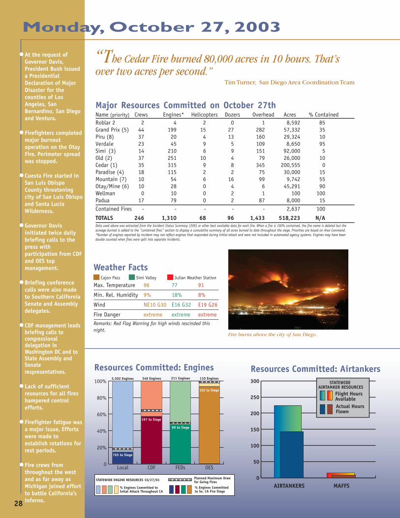
With more than 30,000 residences threatened, morethan 1,000 fire personnel fought the blaze. There were13 civilian fatalities, all of which occurred as peoplewere attempting to evacuate their homes and wereoverrun by the fire front. Many of the communitiesthreatened have very little ingress and egress, whichhampered firefighting and evacuation efforts. Prevailingwinds were less than predicted, but the fire continued togenerate thermal convections that pushed the fire in avariety of directions with more than 200-foot flamelengths observed. Evacuation centers continued tosupport thousands of residents. Interstate 8, betweenLos Coches and Crestline, and Highway 67 were closed.Interstate 15 was closed intermittently.
The Grand Prix and Old Fire merged and surrounded the Incident Command Post.
28
•At the request ofGovernor Davis,President Bush issueda PresidentialDeclaration of MajorDisaster for thecounties of LosAngeles, SanBernardino, San Diegoand Ventura.
•Firefighters completedmajor burnoutoperation on the OtayFire. Perimeter spreadwas stopped.
•Cuesta Fire started inSan Luis ObispoCounty threateningcity of San Luis Obispoand Santa LuciaWilderness.
•Governor Davisinitiated twice dailybriefing calls to thepress withparticipation from CDFand OES topmanagement.
•Briefing conferencecalls were also madeto Southern CaliforniaSenate and Assemblydelegates.
•CDF management leadsbriefing calls tocongressionaldelegation inWashington DC and toState Assembly andSenaterespresentatives.
•Lack of sufficientresources for all fireshampered controlefforts.
•Firefighter fatigue wasa major issue. Effortswere made toestablish rotations forrest periods.
•Fire crews fromthroughout the westand as far away asMichigan joined effortto battle California’sinferno.
Major Resources Committed on October 27thName (priority) Crews Engines* Helicopters Dozers Overhead Acres % ContainedRoblar 2 2 4 2 0 1 8,592 85Grand Prix (5) 44 199 15 27 282 57,332 35Piru (8) 37 20 4 13 160 29,324 10Verdale 23 45 9 5 109 8,650 95Simi (3) 14 210 6 9 151 92,000 5Old (2) 37 251 10 4 79 26,000 10Cedar (1) 35 315 9 8 345 200,555 0Paradise (4) 18 115 2 2 75 30,000 15Mountain (7) 10 54 6 16 99 9,742 55Otay/Mine (6) 10 28 0 4 6 45,291 90Wellman 0 10 0 2 1 100 100Padua 17 79 0 2 87 8,000 15Contained Fires - - - - - 2,637 100
TOTALS 246 1,310 68 96 1,433 518,223 N/AData used above was extracted from the Incident Status Summary (209) or other best available data for each fire. When a fire is 100% contained, the fire name is deleted but theacreage burned is added to the “contained fires” section to display a cumulative summary of all acres burned to date throughout the siege. Priorities are based on Area Command.*Number of engines reported by incident may not reflect engines that responded during initial attack and were not included in automated agency systems. Engines may have beendouble counted when fires were split into separate incidents.
Weather Facts Cajon Pass Simi Valley Julian Weather Station
Max. Temperature 96 77 91
Min. Rel. Humidity 9% 18% 8%
Wind NE10 G30 E16 G32 E19 G26
Fire Danger extreme extreme extremeRemarks: Red Flag Warning for high winds rescinded thisnight.
Resources Committed: Engines
“The Cedar Fire burned 80,000 acres in 10 hours. That’sover two acres per second.”
Tim Turner, San Diego Area Coordination Team
0
50
100
150
200
250
300
Flight Hours AvailableActual Hours Flown
STATEWIDE AIRTANKER RESOURCES
AIRTANKERS MAFFS
Resources Committed: Airtankers
Monday, October 27, 2003
0
20%
40%
60%
80%
100%
OESFEDsCDFLocal
% Engines Committed toInital Attack Throughout CA
% Engines Committed to So. CA Fire Siege
Planned Maximum Draw for Going FiresSTATEWIDE ENGINE RESOURCES 10/27/03
5,502 Engines 346 Engines
197 to Siege
102 to Siege
765 to Siege
99 to Siege
211 Engines 110 Engines
Fire burns above the city of San Diego.

29
Monday, October 27, 2003
0
1000
2000
3000
4000
5000
Robl
ar 2
Gran
d Pr
ixPi
ruVe
rdal
eOl
dSi
mi
Ceda
rPa
radi
seM
ount
ain
Otay
Wel
lman
68
2,278
1,083
677
1,632
1,074
2,300
918697
33148
Personnel Committed: Day SevenTotalPersonnelCommitted:11,106
Community Impacts• Piru Fire threatens the Sespe Condor sanctuary, Sespe Wilder-
ness, Threatened & Endangered species and agricultural assets.• Major utility poles down and damaged. 50,000 people
without power.• Thousands of structures continue to be threatened.• Mountain Fire threatens farmland, animals, vineyards and
numerous structures.• Paradise Fire damages cell phone sites.• Beetle killed trees in vicinity of the Old Fire mixed with
structures is a huge concern for incident commanders.• Sixteen or more towns and cities threatened by the Cedar Fire.
Fire extends into San Diego city limits. Mass evacuationsoccurring, with evacuation centers set up in all major commu-nities.
• Interstate 8, Highway 67 and Interstate 5 closed as a result ofthe Cedar Fire.
• Poor air quality from smoke increased purchases of dust masksand visits to hospitals.
• NFL moves Monday Night Football game between the San DiegoChargers and the Miami Dolphins to Phoenix, AZ.
• The Joint Information Center (JIC) opened and began to receivean average of 1,500 calls per day.
• The Union Pacific Railroad was closed for most of the day dueto the Grand Prix Fire.
Human Factors• 17 fatalities to date.• 13 fatalities on Cedar Fire were private citizens who were
overrun by the fire front while attempting to evacuate.• 53 serious injuries to date.• 11,106 personnel committed to fires to date.
DecisionsPreparedness Levels: South Ops–4, National–2• Branch VII of the Grand Prix Fire was split off into the
Padua Incident, due to span of control and lack of commu-nication frequencies. The Federal National Team assumedcommand of the Padua Fire in Unified Command with LACounty.
• MACS group began meeting at South Ops with continuedconference calls to those who could not physically be atSouth Ops.
• Riverside County OES activated Level 1 operation.• Evacuation center set up by Red Cross at Temecula Valley High
School.• Cedar Fire was split into East/West zones. Federal National
Team assumed command of East zone.• State Incident Command Team transitioned to command of the
Piru Fire.• Old Fire Federal Regional Team transitioned to a Federal
National Team.• Los Padres National Forest orders “fire area closures.”• Dozers approved for use in the Sespe Wilderness on the Piru
Fire.• Command of the Roblar 2 Fire was transferred from a Federal
Regional Team to the Department of Defense.• Closure of Angeles and Cleveland National Forests went
into effect.
Damage Assessment• 986 residential, 10 commercial, 152 outbuildings burned to
date during siege.• 518,223 acres burned to date during siege.• Estimated fire suppression costs to date: $20,000,000• Poor brush clearance around homes with no defensible space
causing problems for firefighters protecting structures.
Acreage Involved: Day Seven
Total Acreageto Date:518,223

30
Monday, October 27, 2003
With winds predicted in excess of 40 mph,firefighters knew they would have their hands fullfighting the fires throughout southern California.
They realized, even if the elected officials andpublic didn’t, that it would take more than airtankers to extinguish fires of this magnitude. Itwould take a variety of strategies and tactics forthe fire personnel to be successful.
As both high winds and dry fuels continued onthe Paradise Fire, the fire grew to 30,000 acres.Two civilian fatalities were confirmed. Power to theValley Center area was disrupted, and there wasdamage reported to several cellular telephonesites. The fire was held along Valley Center Roadand Highway 76. As winds calmed, firefightersmade progress in the Escondido area.
Containment of the Roblar 2 Fire stood at 85percent. Santa Ana winds pushed the fire west intoCamp Pendleton’s military training area. Manage-ment of the firewas turned overto the military.Excess fireresources weredemobilized forreassignment toother fires.
The SantaAna winds, hightemperatures,and low humiditychallengedfirefighters onthe Grand PrixFire. With theimmediate threatto the communi-ties of LytleCreek, RanchoCucamonga, SanAntonio Heights,Upland, Mt.Baldy, Claremont,Rialto, Fontana,LaVerne and SanDimas, mandatory evacuations remained in effect.Railroad service to the area remained closed, asdid Interstate 210 and 215. Portions of the SouthCalifornia Edison power grid remained shut down.When the fire entered Los Angeles County andAngeles National Forest the Grand Prix IncidentManagement Team experienced span of control andcommunication issues. The distance between the
Safety is PrimaryNumerous homes destroyed
camp and the western portion of the fire wastoo great for the Team to realistically manage.Moreover, the ability for firefighters tocommunicate with the base camp wasextremely poor raising valid safety issues. Thewestern branch of the Grand Prix Fire becamethe Padua Fire. A Federal National Teamassumed unified command with Los AngelesCounty Fire Department. A successful firingoperation started on the 26th was effective inslowing the Westward progression of the fire.
Prior to the winds diminishing, the SimiFire experienced extreme rates of spread. Thefire now encompassed more than 92,000acres. Winds drove the fire as it jumpedHighway 118 in the early morning hours.Historically, when fires are fueled by strongSanta Ana winds and reach the area of RockyPeak near Simi Valley, they burn all the way to
Malibu. With this information in mind, theFire Chief launched all available air resourcesin order to stop the eastern progression of thefire toward Highway 118. This independentaction was successful. Due to the aggressivefire suppression efforts by firefighters, theslop over was contained at approximately 50acres. Several roads within the area remain
•Firefighter moralewas falling due tonegative mediacoverage on the CedarFire.
•Ventura County fuelsreduction efforts andvegetation projectswere successful inhelping suppressionefforts on the PiruFire, and contributedto lessen fire impactin developed areas onthe Simi Fire.Residents able toshelter in place dueto community design.
•Simi Fire spottedacross 118 freewayand threatenedChatsworth and LosAngeles. Spot firewas contained at 50acres. Los AngelesCity and County FireDepartments enteredinto unifiedcommand with CDFand Ventura CountyFire Dept.
•Roblar 2 Fire 85%contained.
•MACS convened atSouth Ops whereface-to-face meetingsreplaced twice dailyconference calls.
•National FootballLeague movedMonday Nightfootball gamescheduled forNovember 3rd fromSan Diego to Tempe,Arizona. The SanDiego Stadium(Qualcomm) parkinglot was being used asa emergency relieflocation.
•California FireAgencies respondedto and contained 183new wildland firesstatewide.
Fires burned rapidly through dead, diseased and dying forests.

31
closed. Structures along the southern and western edges arethreatened and will remain so until adequate line construc-tion efforts can begin. Sixteen homes and 64 outbuildingshave been destroyed to date. Through pre-planning effortsby Ventura County Fire personnel, the local citizens wereable to shelter in place. Local cellular telephone sites wereoverwhelmed. Union Pacific Railroad lines were closed in theSimi Valley area effecting freight and Amtrak service on mainCalifornia coastal railway. Media coverage of the Simi Fireincreased drastically as Governor-ElectSchwarzenegger visited the IncidentCommand Post.
A major burnout operation wassuccessfully completed on the Otay/Mine Fire. Although a federalrepeater site was damaged in the fire,and there were many utility polesdown and damaged, the maintransmission lines were out of danger.The area burned was 45,291 acres andthe fire had been declared 90 percentcontained.
As was the case with many of theother southern California fires, winds drove the MountainFire to almost 10,000 acres over night. The fire moved veryquickly with short and long range spotting. The fire contin-ued to threaten residential dwellings, farmland, vineyardsand domestic animals. Mandatory evacuations in thecommunities of Sage and Glen Oak Hills remained in effect.
Overnight, the Piru Fire pushed south and west reachingthe communities of Piru and Fillmore. The fire was closing inon the Sespe drainage creating a potential threat to thewest. In spite of the extreme fire behavior, steep ruggedterrain, heavy fuel loading, and limited resources,firefighters have been very successful in providing structureprotection to threatened communities. To date, with morethan 300 structures threatened and 29,324 acres burned, firepersonnel have been successful in protecting all but oneoutbuilding. A State Incident Command Team assumedcommand of the Piru Fire in a Unified Command with U.S.Forest Service, Ventura County Fire, and Ventura CountySheriff‘s Department.
As the Federal National Team arrived at the Old Fire,they found 24,000 acres had burned to date. Firefighterswere faced with all the right conditions for a catastrophicwildfire—strong winds, heavy fuel loads, and drought anddisease stressed trees intermingled with thousands of homes.Structures continued to be burned as the fire spread rapidly
Monday, October 27, 2003
throughout the area. Fire crews struggled with theelements to provide structure protection and establishanchor points in order to stop the spread into SanBernardino. Several mountain communities were undermandatory evacuations with the primary evacuation centerlocated at the airport and a secondary center opened atthe Sultana High School in Hesperia. Successful evacua-tions occurred due to extensive pre-planning and commu-nity participation. Throughout the day, the fire continued
to make runs, even in areas that had already burned.Continued structure protection in Devore were successfulin that area. The successful structure protection can becredited to firefighters efforts and the use of firefightinggels. Air tankers and helicopters were used to keep the firesouth of the Rim of the World and out of the majorpopulation center. At the day’s end, there were more than1,600 fire personnel and resources assigned to the OldFire.
On the Cedar Fire, high level Santa Ana windscontinued to push heavy smoke over the San Diego areawhile the fire began pushing east under a light onshoreflow. A State Incident Command Team assumed commandat 7:00 a.m. Significant perimeter control operations weresuccessful in Poway, San Diego and the Harbison Canyonarea south of Interstate 8.
Using a recent 1,000 acre prescribed burn north ofPine Valley and a 380 acre brush reduction project area atMt. Laguna, perimeter control operations began on the SEflank of the fire that would eventually save the communi-ties of Descanso, Guatay, Pine Valley and Mt. Laguna.
The fire burned easterly and spread over the top ofCuyamaca and North Peaks and was burning in CuyamacaState Park. Most of the structures burned were in the areawest and north of the community of Descanso.
The fire moved very quickly with short and longrange spotting observed. The fire continued tothreaten residential dwellings, farmland, vineyardsand domestic animals. Mandatory evacuations in thecommunities of Sage and Glen Oak Hills remained ineffect.
Related Documents