Communications, Sensing & Navigation Lab WIDEBAND INTERFEROMETRIC SENSING AND IMAGING POLARIMETRY 1 Hawaiian Village, Honolulu, Hawaii, 2010 July 25 – 30 IGARSS10-TU1.L09-3417 Tuesday, 2010 July 27, 8:20 – 10:00 "Recent advances in fully polarimetric Space-SAR sensor design and its applications” Invited Presentation Wolfgang-Martin Boerner University of Illinois at Chicago, Department of Electrical & Computer Engineering, Communications, Sensing & Navigation Laboratory Chicago, IL/USA IEEE International Geosciences& Remote Sensing Symposium

Welcome message from author
This document is posted to help you gain knowledge. Please leave a comment to let me know what you think about it! Share it to your friends and learn new things together.
Transcript

Communications, Sensing & Navigation Lab
WIDEBAND INTERFEROMETRIC SENSING AND IMAGING POLARIMETRY 1
Hawaiian Village, Honolulu, Hawaii, 2010 July 25 – 30
IGARSS10-TU1.L09-3417
Tuesday, 2010 July 27, 8:20 – 10:00
"Recent advances in fully polarimetric Space-SAR
sensor design and its applications”
Invited Presentation
Wolfgang-Martin Boerner
University of Illinois at Chicago, Department of Electrical & Computer Engineering, Communications, Sensing & Navigation Laboratory
Chicago, IL/USA
IEEE International Geosciences& Remote Sensing Symposium

Communications, Sensing & Navigation Lab
WIDEBAND INTERFEROMETRIC SENSING AND IMAGING POLARIMETRY 2
ABSTRACTIn this overview, reasons are provided on why we do need to place multi-
modal, multi-band single and multiple pass POLinSAR monitoring
platforms into air and space. The questions “on what POLinSAR
monitoring can provide that POL-SAR and IN-SAR by themselves cannot
accomplish” is assessed; whereupon facts and justifications on placing
POL-IN-BISAR satellite clusters into space are presented. Reasons for
this technology becoming a basic requirement for current, near-future
and much more so for future all-day & night year around monitoring of
the terrestrial covers are analyzed in view of the un-abating and
uncontrollable terrestrial population explosion, which has, does and for
ever will result in unavoidable conflicts deteriorating unfortunately at
times into terrorism. The pertinent questions on how to reduce the
exorbitant cost for initiating this “home-globe security protection”
technology are therefore also broached, and the expected benefits are
laid out. The pertinent National and International airborne and space
borne multi-modal, multi-band SAR remote sensing and security conflict
surveillance support agencies are herewith invited for co-sponsoring our
proposal, which is timely and fleets of orbiting multi-band space-borne
POLinSAR platforms are urgently required.

Communications, Sensing & Navigation Lab
WIDEBAND INTERFEROMETRIC SENSING AND IMAGING POLARIMETRY 3

Communications, Sensing & Navigation Lab
WIDEBAND INTERFEROMETRIC SENSING AND IMAGING POLARIMETRY 4
Multi-Altitude Near-Range and Remote Sensing in Wide-Area
Environmental
Surveillance for Real Time Monitoring of the Earth’s Biosphere:
for an ecological investigation of the Earth through observation and identification of harmful
anthropogenic influences due to the interaction of:
Oceans Atmosphere/Stratosphere/Mesosphere
Biosphere
Hydrosphere
for an early warning system of natural and man-made environmental catastrophes and to take quick
actions to buffer the impact to the catastrophe under the increasing pressures of a relentlessly un-
abating population explosion:
Severe weather Typhoons
Earthquakes Volcanic Eruptions
Global Weather Changes
Degeneration into steppe Retreating Glaciers
Pollution of Ground Water Pollution of Air
Destruction of the Biosphere

Communications, Sensing & Navigation Lab
WIDEBAND INTERFEROMETRIC SENSING AND IMAGING POLARIMETRY 5
The Hydrologic CycleHydrologic cycle with volcanologic & seismic activity
Earthquake drop-slip
Volcano eruption with smock

Communications, Sensing & Navigation Lab
WIDEBAND INTERFEROMETRIC SENSING AND IMAGING POLARIMETRY 6
Pacific and Indian Oceans

Communications, Sensing & Navigation Lab
WIDEBAND INTERFEROMETRIC SENSING AND IMAGING POLARIMETRY 7
From BBC news site
Taiwan
Communications, Sensing & Navigation Lab
WIDEBAND INTERFEROMETRIC SENSING AND IMAGING POLARIMETRY 8
The terrestrial tectonology: Alfred Wegener’s tectonic plate theory and the
two major seismic belts
Belt 2, Circum-Pacific belt
Communications, Sensing & Navigation Lab
10 GHz
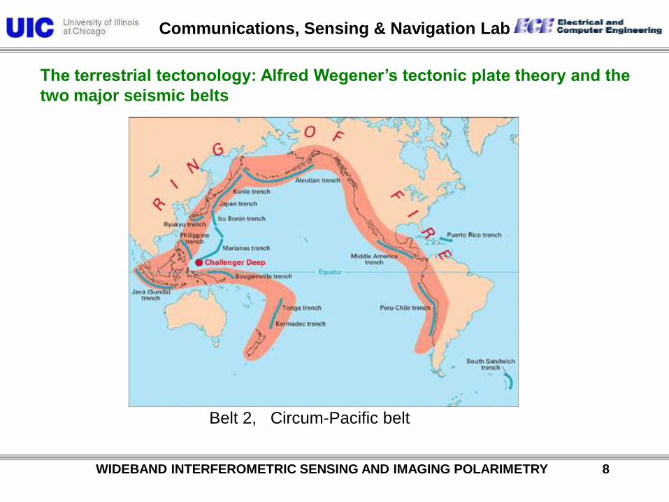
Transmission spectrum of the atmosphere / Attenuation
Gaseous attenuation negligible
focus on precipitation
WIDEBAND INTERFEROMETRIC SENSING AND IMAGING POLARIMETRY 9

Communications, Sensing & Navigation Lab
Most affected regions
WIDEBAND INTERFEROMETRIC SENSING AND IMAGING POLARIMETRY 10

Communications, Sensing & Navigation Lab
WIDEBAND INTERFEROMETRIC SENSING AND IMAGING POLARIMETRY 11
Electromagnetic Spectrum
Visible
Communications, Sensing & Navigation Lab
WIDEBAND INTERFEROMETRIC SENSING AND IMAGING POLARIMETRY 12
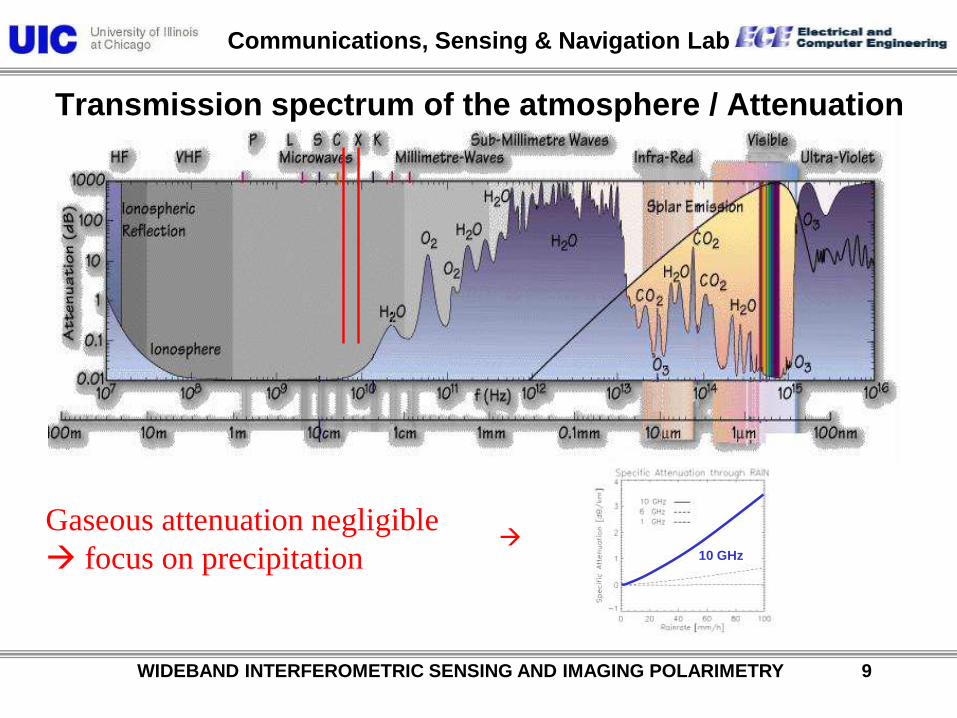
PI-SAR=TU-CNEAS-Sato-lab-Koike-Takafumi-1=030317
PI-SAR

Communications, Sensing & Navigation Lab
WIDEBAND INTERFEROMETRIC SENSING AND IMAGING POLARIMETRY 13
Red: Sendai7602_HH polarization
Green: Sendai7603_HH polarization
Blue: Sendai7604_HH polarization
N

Communications, Sensing & Navigation Lab
WIDEBAND INTERFEROMETRIC SENSING AND IMAGING POLARIMETRY 14
Square path data
Flight direction

Communications, Sensing & Navigation Lab
WIDEBAND INTERFEROMETRIC SENSING AND IMAGING POLARIMETRY 15
POLARIMETRIC SPACEBORNE SAR SENSORS
ENVISAT / ASARESA (EU)
2002C-Band (Sngl / Twin)
HH, VV, (HH,VV),(HH,HV), (HV,VV)
ALOS / PALSARNASDA / JAROS (J)
2003L-Band
HH,VV, (HH,HV), (VV,VH)
RADARSAT 2CSA / MDA (CA)
2004C-Band (Quad)
TERRASARBMBF / DLR / ASTRIUM
2005X-Band (Twin)
(HH,VV), (HH,HV), (HV,VV)
L-Band (Quad)

Communications, Sensing & Navigation Lab
WIDEBAND INTERFEROMETRIC SENSING AND IMAGING POLARIMETRY 16
Table 1. Comparison of High-Level Parameters
Parameter PALSAR RADARSAT-2 TerraSAR-X
Orbit: LEO, circular Sun-synchronous Sun-synchronous Sun-synchronous
Repeat Period (days) 46 24 11
Equatorial Crossing time (hrs) 22:30 (ascending) 18:00 (ascending) 18.00 (ascending)
Inclination (degrees) 98.16 98.6 97.44
Equatorial Altitude (km) 692 798 515
Wavelength (Band) 23 cm (L) 5.6 cm (C) 3 cm (X)
Fully polarimetric mode Yes Yes Yes
ALOS / PALSARJapanese Space Agency (JAXA)
L-Band (quad), 2006
TerraSAR-XGerman Aerospace Center (DLR) / Astirum
X-Band (quad), 2007
RadarSAT-IICanadian Space Agency (CSA)
C-Band (quad), 2007

Communications, Sensing & Navigation Lab
WIDEBAND INTERFEROMETRIC SENSING AND IMAGING POLARIMETRY 17
Launch Date June 2004
Launch Vehicle H-IIASpacecraft Mass 4,000kg
Generated Power 7kW
Orbit691.65km
Sun Synchronous
Repeat Cycle
(Sub-Cycle)
46 days
( 2 days )
PRISM AVNIR-2
PALSAR
Data Relay
Antenna
Solar Array
Star
TrackerGPS Antenna
Flight
Direct io
n
Earth
PRISM : Panchromatic Remote Sensing Instruments for Stereo Mapping
AVNIR-2: Advanced Visible and Near Infrared Radiometer type 2
PALSAR: Phased Array type L-band Synthetic Aperture Radar
ALOS Satellite SystemALOS Satellite System

Communications, Sensing & Navigation Lab
WIDEBAND INTERFEROMETRIC SENSING AND IMAGING POLARIMETRY 18
Table 1. Selected PALSAR Mode Parameters
Mode (selected) Resolution (m) Swath (km) Looks Polarization
Standard, stripmap 20 x 10 70 2 HH or VV
Fine 10 70 1 HH or VV
ScanSAR (5-beam) ~ 100 350 8 HH or VV
Dual polarization (as above) (as above) (as above) (HH, HV), (VV, VH)
Quad-pol 30 x 10 30 2 Full polarization
ALOS is one of the largest Earth observing satellites
ever developed, at 3850 kg. It is in a near-exact 45-
day repeat sun-synchronous orbit, 690 km altitude
above the equator. The active phased array SAR
antenna is obliquely Earth-facing, aligned with the
spacecraft velocity vector. The solar array is
arranged at right angles to the orbit plane, consistent
with the near-mid-day orbit phasing. The X-band
down-link must be shared with optical instruments,
which constrains SAR operation times.

Communications, Sensing & Navigation Lab
Ascending
2006/8/17
ALPSRP029970850-1.1A
2006/10/2
ALPSRP036680850-1.1A
ALOS-PALSAR Polarimteric Mode
Tomakomai
Hokkaido
Descending
ALPSRP030192750-1.1D
2006/8/19
ALPSRP091090850-1.1A
2007/10/10Yoshio Yamaguchi
©JAXA, METI
WIDEBAND INTERFEROMETRIC SENSING AND IMAGING POLARIMETRY 19

Communications, Sensing & Navigation Lab
POLSAR image analysis
<Average>
Pauli Basis
Eigenvalue
Scattering Power DecompositionCovariance matrix
Coherency matrix
Entropy, Alpha-angle, Anisotropy
Scattering matrix
= Quad. Pol. data
Pd, Pv, Ps, Pc
VVHVHHColor-Composite
HH-VV, 2HV, HH+VV
λ1 λ2 λ3
HV Basis
HH, 2HV, VV
Ps Pv
Pd
volume
scattering
double
bounce
surface
scattering
WIDEBAND INTERFEROMETRIC SENSING AND IMAGING POLARIMETRY 20

Communications, Sensing & Navigation Lab
WIDEBAND INTERFEROMETRIC SENSING AND IMAGING POLARIMETRY 21
The four-component decomposition of scattering powers Ps, Pd, Pv, and Pc

Communications, Sensing & Navigation Lab
ALPSRP072570650-1.1A
32.825N
130.364E
2007/6/5
©JAXA, METI
Fugen-dake
Unzen
Google earth optical image
ALOS-PALSAR pol. image
Ps Pv
Pd
WIDEBAND INTERFEROMETRIC SENSING AND IMAGING POLARIMETRY 22

Communications, Sensing & Navigation Lab
ALPSRP072570650-1.1A
Pauli-basis
HV-basis
©JAXA, METIHH, 2HV, VV
HH-VV, 2HV, HH+VV
Pd, Pv, Ps
Scattering power
decomposition
Ps Pv
Pd
2007/6/5
32.825N
130.364E
Fugen-dake Unzen
WIDEBAND INTERFEROMETRIC SENSING AND IMAGING POLARIMETRY 23

Communications, Sensing & Navigation Lab
WIDEBAND INTERFEROMETRIC SENSING AND IMAGING POLARIMETRY 24
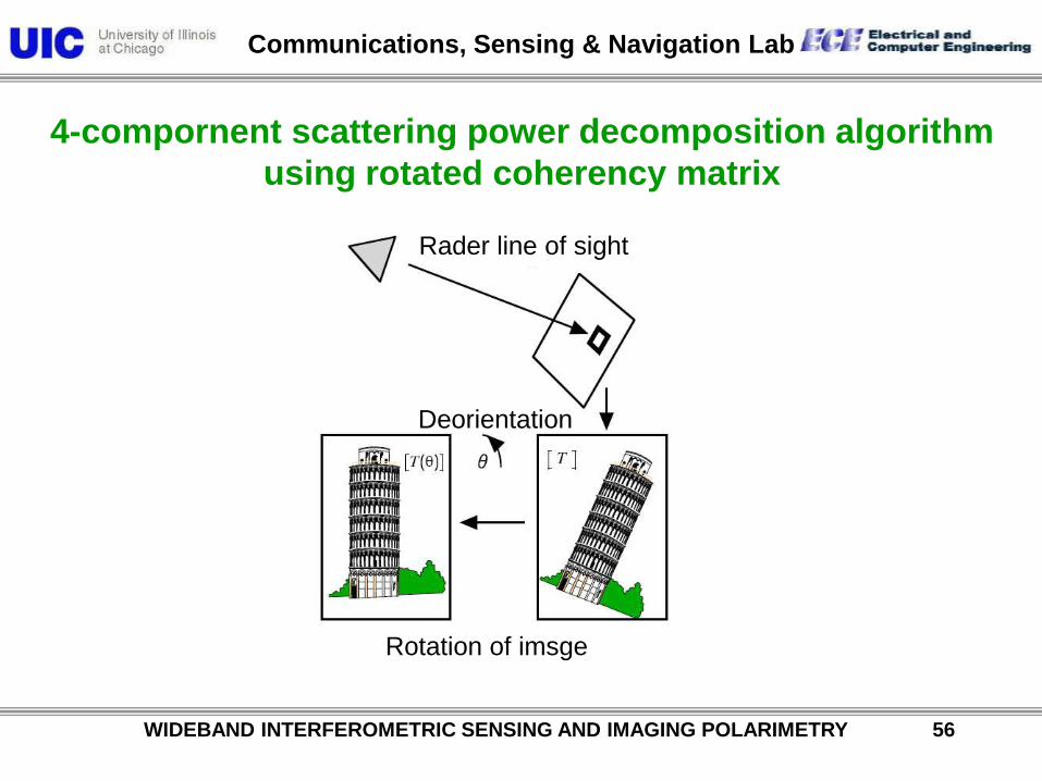
Rader line of sight
Deorientation
Rotation of imsge
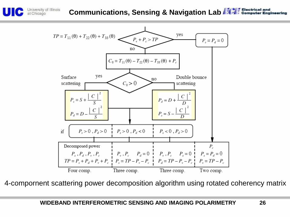
4-compornent scattering power decomposition algorithm
using rotated coherency matrix

Communications, Sensing & Navigation Lab
WIDEBAND INTERFEROMETRIC SENSING AND IMAGING POLARIMETRY 25
4-compornent scattering power decomposition algorithm using rotated coherency matrix
Communications, Sensing & Navigation Lab
WIDEBAND INTERFEROMETRIC SENSING AND IMAGING POLARIMETRY 26
4-compornent scattering power decomposition algorithm using rotated coherency matrix
Communications, Sensing & Navigation Lab
WIDEBAND INTERFEROMETRIC SENSING AND IMAGING POLARIMETRY 27
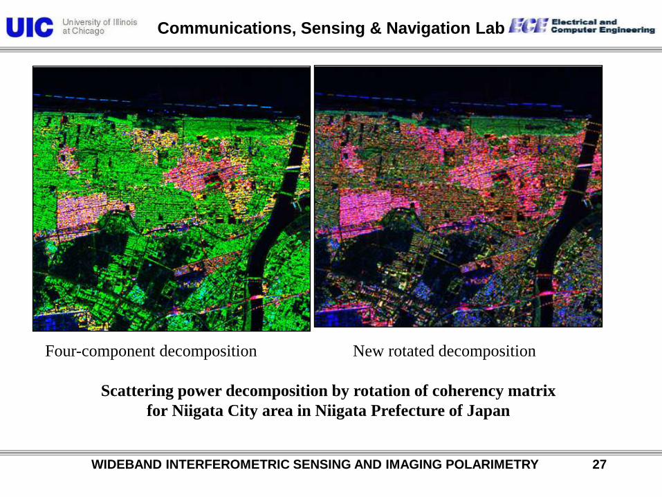
Four-component decomposition New rotated decomposition
Scattering power decomposition by rotation of coherency matrix
for Niigata City area in Niigata Prefecture of Japan
Communications, Sensing & Navigation Lab
WIDEBAND INTERFEROMETRIC SENSING AND IMAGING POLARIMETRY 28
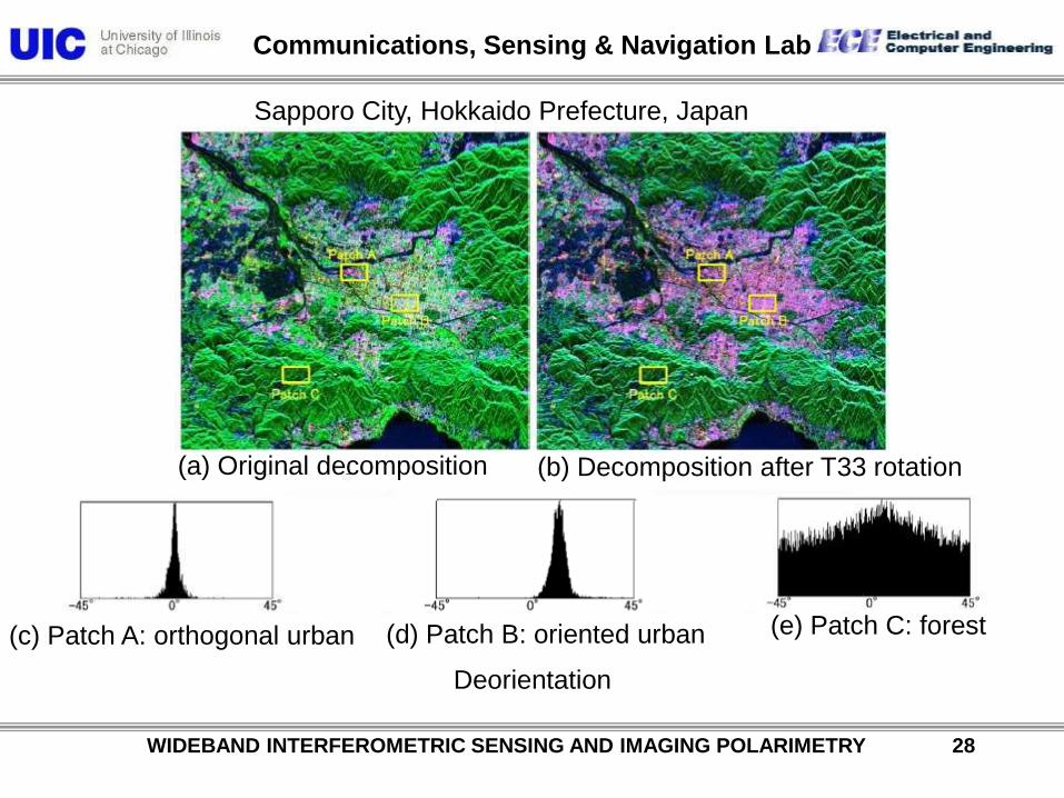
Deorientation
(a) Original decomposition (b) Decomposition after T33 rotation
(c) Patch A: orthogonal urban (d) Patch B: oriented urban (e) Patch C: forest
Sapporo City, Hokkaido Prefecture, Japan
Communications, Sensing & Navigation Lab
WIDEBAND INTERFEROMETRIC SENSING AND IMAGING POLARIMETRY 29
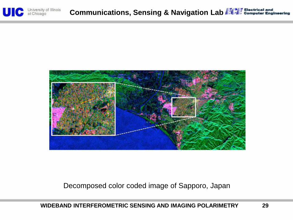
Decomposed color coded image of Sapporo, Japan

Communications, Sensing & Navigation Lab
WIDEBAND INTERFEROMETRIC SENSING AND IMAGING POLARIMETRY 30
Interest area
0m
3800m
Data fusion of DEM and RADARSAT SAR images By CSRSR.
Monitoring of ongoing surface deformation along Cheleng-Pu fault
Taiwan

Communications, Sensing & Navigation Lab
WIDEBAND INTERFEROMETRIC SENSING AND IMAGING POLARIMETRY 31
ELF/ULF Electromagnetic Spectrum

Communications, Sensing & Navigation Lab
WIDEBAND INTERFEROMETRIC SENSING AND IMAGING POLARIMETRY 32
Earth-Ionosphere Cavity

Communications, Sensing & Navigation Lab
WIDEBAND INTERFEROMETRIC SENSING AND IMAGING POLARIMETRY 33
Tectonic Stress Electromagnetic Signatures

Communications, Sensing & Navigation Lab
WIDEBAND INTERFEROMETRIC SENSING AND IMAGING POLARIMETRY 34
Schumann Spherics (Electric Storm) Signatures

Communications, Sensing & Navigation Lab
WIDEBAND INTERFEROMETRIC SENSING AND IMAGING POLARIMETRY 35
Recent electromagnetic signatures associated with the Chi-Chi and Chia-
Yi earthquakes of 1999.
ULF Magnetometric & Electrometric Measurement Arrangement
Three-axes Fluxgate
Magnetometer

Communications, Sensing & Navigation Lab
WIDEBAND INTERFEROMETRIC SENSING AND IMAGING POLARIMETRY 36
Recent electromagnetic signatures associated with the Chi-Chi and Chia-
Yi earthquakes of 1999.
Simplified Schematic of the Site and Equipment Layout

Communications, Sensing & Navigation Lab
WIDEBAND INTERFEROMETRIC SENSING AND IMAGING POLARIMETRY 37
ULF Tectonic & Spherics Signatures at About .1 to 20 Hz
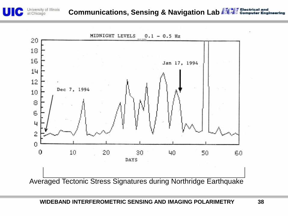
Communications, Sensing & Navigation Lab
WIDEBAND INTERFEROMETRIC SENSING AND IMAGING POLARIMETRY 38
Averaged Tectonic Stress Signatures during Northridge Earthquake

Communications, Sensing & Navigation Lab
WIDEBAND INTERFEROMETRIC SENSING AND IMAGING POLARIMETRY 39
Earthquakes• Blue circle:
Radius 50 Km
• Red line:
Chelungpu fault
• Star mark: Three sample earthquakes
• Black circle: Earthquakes M >= 5.0
Earthquakes occurred in six bluecircles (except HC, LP) werecompared with the anomalyTaiwan

Communications, Sensing & Navigation Lab
WIDEBAND INTERFEROMETRIC SENSING AND IMAGING POLARIMETRY 40
Recent electromagnetic signatures associated with the Chi-Chi and Chia-
Yi earthquakes of 1999, May to December in Taiwan
The raw data in LY station in March, April May, August, September,
October, November and December, 1999.

Communications, Sensing & Navigation Lab
WIDEBAND INTERFEROMETRIC SENSING AND IMAGING POLARIMETRY 41
Brief introduction of DIFF-RP-IN-SAR
• Three-pass “repeat track” interferometry uses
two baselines to acquire
interferograms at different times.
• Despite exaggeration in picture on the right,
the incidence angles and absolute ranges are
nearly the same.
• Now suppose that the surface deformed
slightly between the second and third
acquisitions in such a way that the range
changed by an amount
• In the repeat-track implementation of
interferometry, the signal travels each path
twice, since the transmitter and receiver are in
the same place. Therefore, the
interferometric phase is
(B1,1); (B2 ,2)
6D DIFFERENTIAL SAR INTERFEROMETRY
HOW DOES IT WORK?
B2B1
1 2
B2B1
B2B1
1 2
range4
range22

Communications, Sensing & Navigation Lab
WIDEBAND INTERFEROMETRIC SENSING AND IMAGING POLARIMETRY 42
Monitoring of ongoing surface deformation along Cheleng-Pu fault

Communications, Sensing & Navigation Lab
WIDEBAND INTERFEROMETRIC SENSING AND IMAGING POLARIMETRY 43
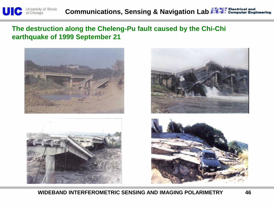
The destruction along the Cheleng-Pu fault caused by the Chi-Chi
earthquake of 1999 September 21

Communications, Sensing & Navigation Lab
WIDEBAND INTERFEROMETRIC SENSING AND IMAGING POLARIMETRY 44
Communications, Sensing & Navigation Lab
WIDEBAND INTERFEROMETRIC SENSING AND IMAGING POLARIMETRY 45
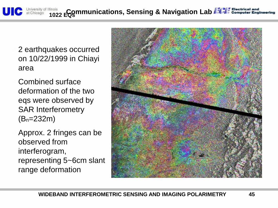
2 earthquakes occurred
on 10/22/1999 in Chiayi
area
Combined surface
deformation of the two
eqs were observed by
SAR Interferometry
(Bn=232m)
Approx. 2 fringes can be
observed from
interferogram,
representing 5~6cm slant
range deformation
1022 EQs
Communications, Sensing & Navigation Lab
WIDEBAND INTERFEROMETRIC SENSING AND IMAGING POLARIMETRY 46
The destruction along the Cheleng-Pu fault caused by the Chi-Chi
earthquake of 1999 September 21

Communications, Sensing & Navigation Lab
WIDEBAND INTERFEROMETRIC SENSING AND IMAGING POLARIMETRY 47
The destruction along the Cheleng-Pu fault caused by the Chi-Chi
earthquake of 1999 September 21

Communications, Sensing & Navigation Lab
Ascending
2009/5/1
Data no.PASL1100905011424530907020000PASL1100905011424530907020001PASL1100905011424530907020002PASL1100905011424530907020003PASL1100905011424530907020004
ALOS-PALSAR Polarimteric Mode
©METI, ERSDAC
Yoshio Yamaguchi
Taiwan
21.5°
Taiwan
WIDEBAND INTERFEROMETRIC SENSING AND IMAGING POLARIMETRY 48
Sun Moon-lake
Chelengpu-fault
Taitong

Communications, Sensing & Navigation Lab
WIDEBAND INTERFEROMETRIC SENSING AND IMAGING POLARIMETRY 49
3.4.5.6.7.8
Polarimetric mode
Incident angle :23.1°
Date:2009/05/01
Path:442
Frame:430(3),440(4)
450(5),460(6)
470(7),480(8)

Communications, Sensing & Navigation Lab
WIDEBAND INTERFEROMETRIC SENSING AND IMAGING POLARIMETRY 50
Ps Pv
Pd
Taitung
Luye

Communications, Sensing & Navigation Lab
POLSAR image analysis
<Average>
Pauli Basis
Eigenvalue
Scattering Power DecompositionCovariance matrix
Coherency matrix
Entropy, Alpha-angle, Anisotropy
Scattering matrix
= Quad. Pol. data
Pd, Pv, Ps, Pc
VVHVHHColor-Composite
HH-VV, 2HV, HH+VV
λ1 λ2 λ3
HV Basis
HH, 2HV, VV
Ps Pv
Pd
volume
scattering
double
bounce
surface
scattering
WIDEBAND INTERFEROMETRIC SENSING AND IMAGING POLARIMETRY 51

Communications, Sensing & Navigation Lab
WIDEBAND INTERFEROMETRIC SENSING AND IMAGING POLARIMETRY 52
The four-component decomposition of scattering powers Ps, Pd, Pv, and Pc
Communications, Sensing & Navigation Lab
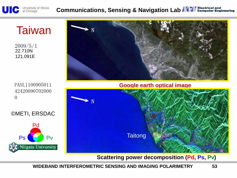
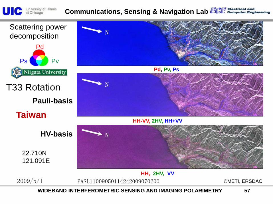
Google earth optical imagePASL1100905011424200907020000
22.710N
121.091E
Ps Pv
Pd
Taiwan
©METI, ERSDAC
N
Scattering power decomposition (Pd, Ps, Pv)
2009/5/1
WIDEBAND INTERFEROMETRIC SENSING AND IMAGING POLARIMETRY 53
N
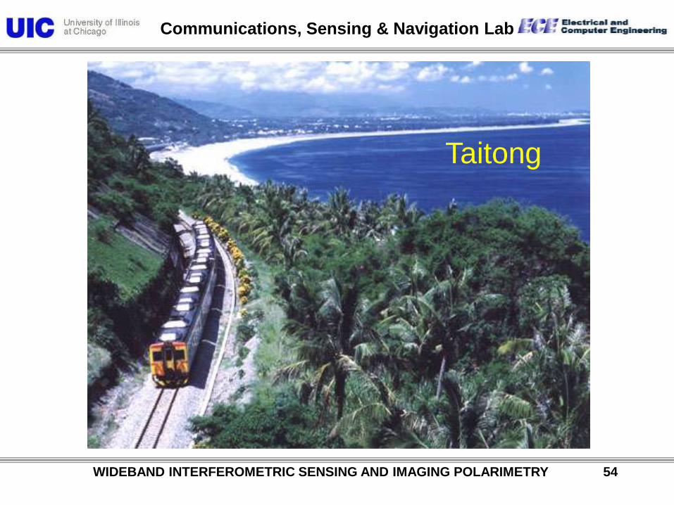
Taitong
Communications, Sensing & Navigation Lab
WIDEBAND INTERFEROMETRIC SENSING AND IMAGING POLARIMETRY 54
Taitong

Communications, Sensing & Navigation Lab
HH, 2HV, VV
HH-VV, 2HV, HH+VV
Pd, Pv, Ps
Scattering power
decomposition
Ps Pv
Pd
2009/5/1
PASL11009050114242009070200
Pauli-basis
HV-basis
22.710N
121.091E
Taiwan
©METI, ERSDAC
WIDEBAND INTERFEROMETRIC SENSING AND IMAGING POLARIMETRY 55
N
N
N
Communications, Sensing & Navigation Lab
WIDEBAND INTERFEROMETRIC SENSING AND IMAGING POLARIMETRY 56
Rader line of sight
Deorientation
Rotation of imsge
4-compornent scattering power decomposition algorithm
using rotated coherency matrix
Communications, Sensing & Navigation Lab
Pauli-basis
HV-basis
Scattering power
decomposition
Ps Pv
Pd
T33 Rotation
HH, 2HV, VV
HH-VV, 2HV, HH+VV
Pd, Pv, Ps
2009/5/1 PASL11009050114242009070200 ©METI, ERSDAC
22.710N
121.091E
Taiwan
WIDEBAND INTERFEROMETRIC SENSING AND IMAGING POLARIMETRY 57
N
N
N

Communications, Sensing & Navigation Lab
WIDEBAND INTERFEROMETRIC SENSING AND IMAGING POLARIMETRY 58
Ps Pv
Pd
Luye
Yushan Nlt. Park

Communications, Sensing & Navigation Lab
WIDEBAND INTERFEROMETRIC SENSING AND IMAGING POLARIMETRY 59
Yushan Mountain

Communications, Sensing & Navigation Lab
Google earth optical image
Scattering power decomposition (Pd, Ps, Pv)
PASL1100905011424200907020001
23.207N
120.983E
Ps Pv
Pd
©METI, ERSDAC
2009/5/1
Taiwan N
N
WIDEBAND INTERFEROMETRIC SENSING AND IMAGING POLARIMETRY 60

Communications, Sensing & Navigation Lab
HH, 2HV, VV
HH-VV, 2HV, HH+VV
Pd, Pv, Ps
Scattering power
decomposition
Ps Pv
Pd
2009/5/1
HV-basis
Taiwan
PASL1100905011424200907020001
23.207N
120.983E
Pauli-basis
©METI, ERSDAC
N
N
N
WIDEBAND INTERFEROMETRIC SENSING AND IMAGING POLARIMETRY 61

Communications, Sensing & Navigation Lab
HH, 2HV, VV
HH-VV, 2HV, HH+VV
Pd, Pv, Ps
Scattering power
decomposition
Ps Pv
Pd
2009/5/1
Pauli-basis
HV-basis
PASL1100905011424200907020001
T33 Rotation
©METI, ERSDAC
Taiwan23.207N
120.983E
N
N
N
WIDEBAND INTERFEROMETRIC SENSING AND IMAGING POLARIMETRY 62

Communications, Sensing & Navigation Lab
Google earth optical image
Scattering power decomposition (Pd, Ps, Pv)
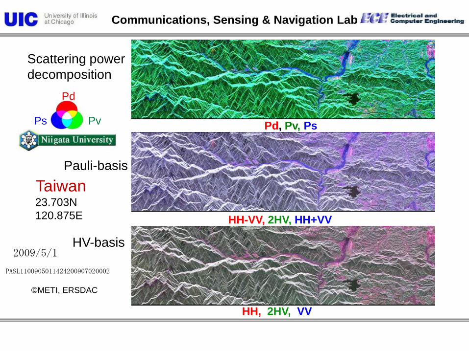
PASL1100905011424200907020002
23.703N
120.875E
Ps Pv
Pd
2009/5/1
©METI, ERSDAC
Taiwan
Puli City
Sun Moon Lake
Jiji
N

Communications, Sensing & Navigation Lab
WIDEBAND INTERFEROMETRIC SENSING AND IMAGING POLARIMETRY 64
Sun-Moon Lake
Communications, Sensing & Navigation Lab
HH, 2HV, VV
HH-VV, 2HV, HH+VV
Pd, Pv, Ps
Scattering power
decomposition
Ps Pv
Pd
2009/5/1
PASL1100905011424200907020002
HV-basis
Taiwan23.703N
120.875E
Pauli-basis
©METI, ERSDAC

Communications, Sensing & Navigation Lab
WIDEBAND INTERFEROMETRIC SENSING AND IMAGING POLARIMETRY 66
The destruction along the Cheleng-Pu fault caused by the Chi-Chi
earthquake of 1999 September 21

Communications, Sensing & Navigation Lab
HH, 2HV, VV
HH-VV, 2HV, HH+VV
Pd, Pv, Ps
Scattering power
decomposition
Ps Pv
Pd
2009/5/1
PASL1100905011424200907020002
Pauli-basis
HV-basis
T33 Rotation
©METI, ERSDAC
Taiwan23.703N
120.875E

Communications, Sensing & Navigation Lab
Google earth optical image
Scattering power decomposition (Pd, Ps, Pv)
PASL1100905011424200907020003
24.200N
120.766E
2009/5/1
Ps Pv
Pd
©METI, ERSDAC
Taiwan N
Miaoli City
Jhonggang River
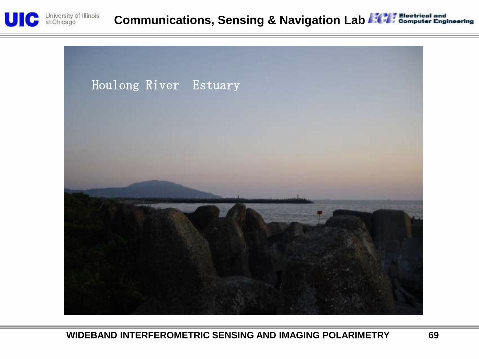
Houlong River
Communications, Sensing & Navigation Lab
WIDEBAND INTERFEROMETRIC SENSING AND IMAGING POLARIMETRY 69
Houlong River Estuary

Communications, Sensing & Navigation Lab
HH, 2HV, VV
HH-VV, 2HV, HH+VV
Pd, Pv, Ps
Scattering power
decomposition
Ps Pv
Pd
2009/5/1
PASL1100905011424200907020003
HV-basis
Taiwan24.200N
120.983E
Pauli-basis
©METI, ERSDAC

Communications, Sensing & Navigation Lab
HH, 2HV, VV
HH-VV, 2HV, HH+VV
Pd, Pv, Ps
Scattering power
decomposition
Ps Pv
Pd
2009/5/1
PASL1100905011424200907020003
Pauli-basis
HV-basis
T33 Rotation
©METI, ERSDAC
Taiwan24.200N
120.983E

Communications, Sensing & Navigation Lab
Google earth optical image
Scattering power decomposition (Pd, Ps, Pv)
PASL1100905011424200907020004
24.697N
120.656E
Ps Pv
Pd
2009/5/1
©METI, ERSDAC
Taiwan
N
Jhonggang River Estuary
Jhonggang River Estuary

Communications, Sensing & Navigation Lab
HH, 2HV, VV
HH-VV, 2HV, HH+VV
Pd, Pv, Ps
Scattering power
decomposition
Ps Pv
Pd
2009/5/1
PASL1100905011424200907020004
HV-basis
Taiwan24.200N
120.766E
Pauli-basis
©METI, ERSDAC

Communications, Sensing & Navigation Lab
HH, 2HV, VV
HH-VV, 2HV, HH+VV
Pd, Pv, Ps
Scattering power
decomposition
Ps Pv
Pd
2009/5/1
PASL1100905011424200907020004
Pauli-basis
HV-basis
T33 Rotation
©METI, ERSDAC
Taiwan24.200N
120.766E

Communications, Sensing & Navigation Lab
ALOS-PALSAR Polarimteric Mode
©JAXA, METI
2007/3/10
Data no.
ALPSRP059887030ALPSRP059887040
Yoshio Yamaguchi
Ascending
2009/3/15
Data no.
ALPSRP167247030ALPSRP167247040
WIDEBAND INTERFEROMETRIC SENSING AND IMAGING POLARIMETRY 75

Communications, Sensing & Navigation Lab
ALPSRP059887030-P1.1__A
2007/3/10
-7.942N112.870E
©JAXA, METI
Ps Pv
Pd
Indonesia
Scattering power
Decomposition
Google earth optical image
Decomposed image (Ps, Pd, Pv)
N
WIDEBAND INTERFEROMETRIC SENSING AND IMAGING POLARIMETRY 76

Communications, Sensing & Navigation Lab
Scattering power
decomposition
Ps Pv
Pd
Pauli-basis
HV-basis
2007/3/10
-7.942N112.870E
Indonesia
©JAXA, METI
ALPSRP059887030-P1.1__A
HH, 2HV, VV (50 up)
HH-VV, 2HV, HH+VV (0-50 up)
Pd, Pv, Ps (80 up)
WIDEBAND INTERFEROMETRIC SENSING AND IMAGING POLARIMETRY 77

Communications, Sensing & Navigation Lab
©JAXA, METI
Scattering power
decomposition
Ps Pv
Pd
Pauli-basis
HV-basis
2007/3/10
-7.942N112.870E
Indonesia
T33 Rotation
ALPSRP059887030-P1.1__A
HH, 2HV, VV (50 up)
HH-VV, 2HV, HH+VV (80 up)
Pd, Pv, Ps (80 up)
WIDEBAND INTERFEROMETRIC SENSING AND IMAGING POLARIMETRY 78

Communications, Sensing & Navigation Lab
WIDEBAND INTERFEROMETRIC SENSING AND IMAGING POLARIMETRY 79
“Natural hazards are inevitable.
Natural disasters are not.”

Communications, Sensing & Navigation Lab
ALOS-PALSAR Polarimteric Mode2008 Sichuan earthquake, China
Descending
06/23 06/28
illumination
Yoshio Yamaguchi
©JAXA, METI
WIDEBAND INTERFEROMETRIC SENSING AND IMAGING POLARIMETRY 80

Communications, Sensing & Navigation Lab
ALPSRP128522970-P1.1__D
2008/6/23
31.850N104.644E
©JAXA, METI
Ps Pv
Pd
2008 Sichuan
earthquake
China
Scattering powerDecomposition
Google earth optical image
Decomposed image (Ps, Pd, Pv)
N
WIDEBAND INTERFEROMETRIC SENSING AND IMAGING POLARIMETRY 81

Communications, Sensing & Navigation Lab
Scattering power
decomposition
Ps Pv
Pd
Pauli-basis
HV-basis
2008/6/23
31.850N104.644E
2008 Sichuan
earthquake
China
©JAXA, METI
ALPSRP128522970-P1.1__D
HH, 2HV, VV (50 up)
HH-VV, 2HV, HH+VV (0-50 up)
Pd, Pv, Ps (80 up)
WIDEBAND INTERFEROMETRIC SENSING AND IMAGING POLARIMETRY 82

Communications, Sensing & Navigation Lab
©JAXA, METI
Scattering power
decomposition
Ps Pv
Pd
Pauli-basis
HV-basis
2008/6/23
31.850N104.644E
2008 Sichuan
earthquake
China
T33 Rotation
ALPSRP128522970-P1.1__D
HH, 2HV, VV (50 up)
HH-VV, 2HV, HH+VV (80 up)
Pd, Pv, Ps (80 up)
WIDEBAND INTERFEROMETRIC SENSING AND IMAGING POLARIMETRY 83

Communications, Sensing & Navigation Lab
ALOS-PALSAR Polarimteric Mode: 2007 ~ 2010
©JAXA, METI
2007/3/10
Data no.
ALPSRP059887030ALPSRP059887040
Yoshio Yamaguchi
Ascending
2009/3/15
Data no.
ALPSRP167247030ALPSRP167247040
WIDEBAND INTERFEROMETRIC SENSING AND IMAGING POLARIMETRY 84
Indonesia
Communications, Sensing & Navigation Lab
WIDEBAND INTERFEROMETRIC SENSING AND IMAGING POLARIMETRY 85
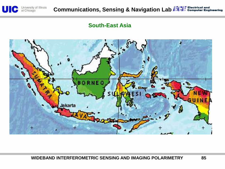
South-East Asia

Communications, Sensing & Navigation Lab
Singapore
Jakarta
Kuala Lumpur
18331797
1861
1907
1935
A flurry of ruptures have occurred since 2000
2000
2002
2004Mar 28, 2005 Ms8.4
Apr 10, 2005 Ms6.7
PADANG
Feb 26, 2005 Mw6.7
Krakatau
WIDEBAND INTERFEROMETRIC SENSING AND IMAGING POLARIMETRY 86

Communications, Sensing & Navigation Lab
ALPSRP059887030-P1.1__A
2007/3/10
-7.942N112.870E
©JAXA, METI
Ps Pv
Pd
Indonesia
Scattering power
Decomposition
Google earth optical image
Decomposed image (Ps, Pd, Pv)
N
WIDEBAND INTERFEROMETRIC SENSING AND IMAGING POLARIMETRY 87

Communications, Sensing & Navigation Lab
Scattering power
decomposition
Ps Pv
Pd
Pauli-basis
HV-basis
2007/3/10
-7.942N112.870E
Indonesia
©JAXA, METI
ALPSRP059887030-P1.1__A
HH, 2HV, VV (50 up)
HH-VV, 2HV, HH+VV (0-50 up)
Pd, Pv, Ps (80 up)
WIDEBAND INTERFEROMETRIC SENSING AND IMAGING POLARIMETRY 88

Communications, Sensing & Navigation Lab
©JAXA, METI
Scattering power
decomposition
Ps Pv
Pd
Pauli-basis
HV-basis
2007/3/10
-7.942N112.870E
Indonesia
T33 Rotation
ALPSRP059887030-P1.1__A
HH, 2HV, VV (50 up)
HH-VV, 2HV, HH+VV (80 up)
Pd, Pv, Ps (80 up)
WIDEBAND INTERFEROMETRIC SENSING AND IMAGING POLARIMETRY 89

Communications, Sensing & Navigation Lab
WIDEBAND INTERFEROMETRIC SENSING AND IMAGING POLARIMETRY 90
Ascending
Data no.
ALPSRP178330
260
ALOS-PALSAR Polarimetric Mode
Philippines
© METI, JAXA
Yoshio Yamaguchi
2009/5/30
13.501N
123.551E

Communications, Sensing & Navigation Lab
WIDEBAND INTERFEROMETRIC SENSING AND IMAGING POLARIMETRY 91
Ps Pv
Pd
Scattering power
Decomposition
Google Earth optical image
Decomposed image (Ps, Pd, Pv) with rotation 2*12 window
Data no.
ALPSRP178330260
Philippines
2009/5/30
13.501N
123.551E
©METI, JAXA
N
Mt. Mayon

Communications, Sensing & Navigation Lab
WIDEBAND INTERFEROMETRIC SENSING AND IMAGING POLARIMETRY 92
Ps Pv
Pd
Scattering power
Decomposition
Google Earth optical image
Decomposed image (Ps, Pd, Pv) with rotation 2*12 window
Data no.
ALPSRP211880260
Philippines
2010/1/15
13.498N
123.561E
©METI, JAXA
N
Mt. Mayon

Communications, Sensing & Navigation Lab
WIDEBAND INTERFEROMETRIC SENSING AND IMAGING POLARIMETRY 93
Ps Pv
Pd
Scattering power
Decomposition
Google Earth optical image
Decomposed image (Ps, Pd, Pv) with rotation 2*12 window
Data no.
ALPSRP225300260-P1.1__A
Philippines
2010/4/17
13.498N
123.568E
©METI, JAXA
N
Mt. Mayon

Communications, Sensing & Navigation Lab
WIDEBAND INTERFEROMETRIC SENSING AND IMAGING POLARIMETRY 94
2009/5/30
2010/1/15
2010/4/17
Mt. Mayon
Philippines
Ps Pv
Pd
Communications, Sensing & Navigation Lab
WIDEBAND INTERFEROMETRIC SENSING AND IMAGING POLARIMETRY 95
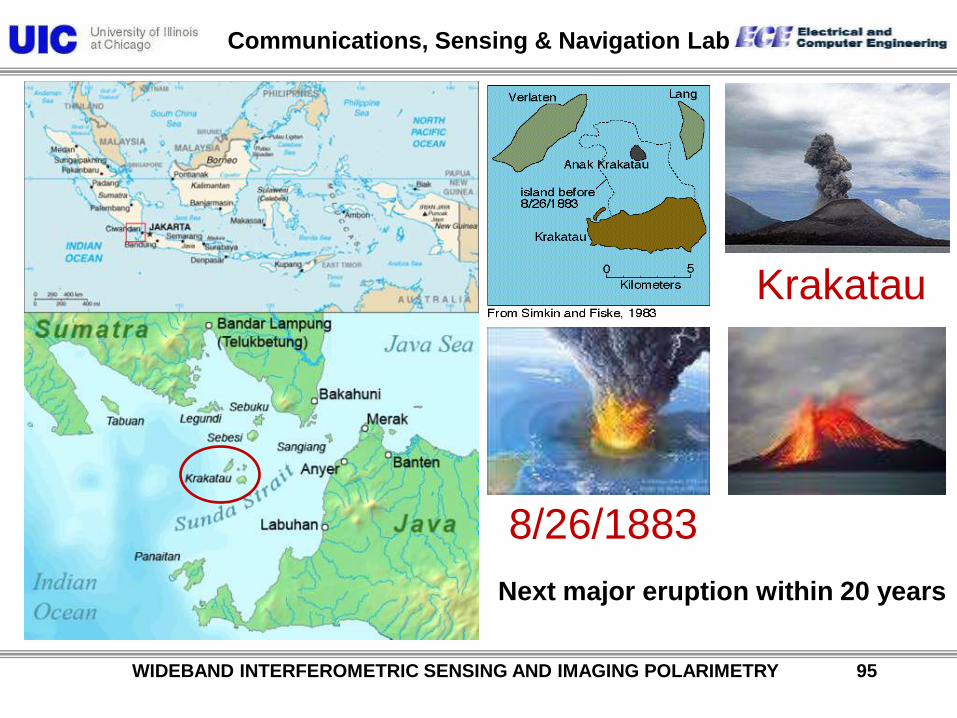
Krakatau
8/26/1883
Next major eruption within 20 years

Communications, Sensing & Navigation Lab
WIDEBAND INTERFEROMETRIC SENSING AND IMAGING POLARIMETRY 96
Indian Ocean Tsunamis: 1833 & 2004
Hannah Fairfield/The New York Times, Science Section, January 4, 2005

Communications, Sensing & Navigation Lab
WIDEBAND INTERFEROMETRIC SENSING AND IMAGING POLARIMETRY 97
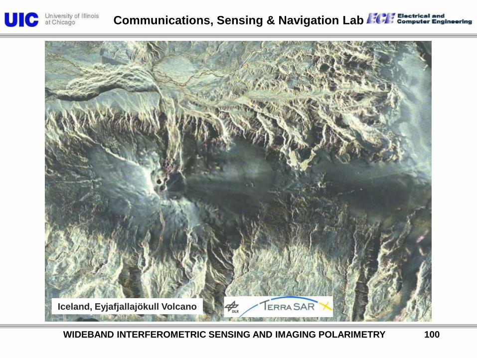
Iceland, Eyjafjallajökull Volcano
Aachen
Eyjafjallajökull
Eyjafjallajökull
Keflavik

Communications, Sensing & Navigation Lab
Physical interpretation of rain cell signatures
• Partial backscattering at hydrometeors (precipitation volume)
• Attenuation of incident wave
AB
t
Am
pli
tude
z
A
B
B A
Transmited waveBackscattered wave (attenuated) (B)Backscattered wave from hydrometeors (A)
Received signals
WIDEBAND INTERFEROMETRIC SENSING AND IMAGING POLARIMETRY 98

Communications, Sensing & Navigation Lab
Slant range reflectivity profile („A-scope“) for the rain
cell cut from a very recent TerraSAR-X measurement
Po
we
r [d
B]
Azi
muth
Range
WIDEBAND INTERFEROMETRIC SENSING AND IMAGING POLARIMETRY 99
Communications, Sensing & Navigation Lab
Iceland, Eyjafjallajökull Volcano
WIDEBAND INTERFEROMETRIC SENSING AND IMAGING POLARIMETRY 100

Communications, Sensing & Navigation Lab
NASA-JPL UAVSAR on Global Hawk
WIDEBAND INTERFEROMETRIC SENSING AND IMAGING POLARIMETRY 101

Communications, Sensing & Navigation Lab
GROB Super-High-Altitude UAV
WIDEBAND INTERFEROMETRIC SENSING AND IMAGING POLARIMETRY 102
Grob G520T Egret D-FSTN

Communications, Sensing & Navigation Lab
TandemSAR-X DLR
Launch: 2010 June 21
WIDEBAND INTERFEROMETRIC SENSING AND IMAGING POLARIMETRY 103

Communications, Sensing & Navigation Lab
WIDEBAND INTERFEROMETRIC SENSING AND IMAGING POLARIMETRY 104
TanDEM-X Launch June 21, 2010 at 2:14 UTC

Communications, Sensing & Navigation Lab
WIDEBAND INTERFEROMETRIC SENSING AND IMAGING POLARIMETRY 105
Madagascar
DLR/Astrium First TanDEM-X images 2010 June

Communications, Sensing & Navigation Lab
WIDEBAND INTERFEROMETRIC SENSING AND IMAGING POLARIMETRY 106
Ukraine - Donez
DLR/Astrium First TanDEM-X images

Communications, Sensing & Navigation Lab
WIDEBAND INTERFEROMETRIC SENSING AND IMAGING POLARIMETRY 107
DLR/Astrium First TanDEM-X images 2010 June
Moscow - Sherementyevo

Communications, Sensing & Navigation Lab
TandemSAR-L (Destiny): JPL & DLR
WIDEBAND INTERFEROMETRIC SENSING AND IMAGING POLARIMETRY 108

Communications, Sensing & Navigation Lab
WIDEBAND INTERFEROMETRIC SENSING AND IMAGING POLARIMETRY 109
ACQUISITION OF NEW BANDS FOR BOTH PASSIVE & ACTIVE SENSING
Deep earth sounding ULF - LF
Ground penetrating radar LF - VHF
Mineral resource exploration HF - UHF
Biomass and vegetative cover estimation HF – EHF (P/L/C-Band)
Man made surface structure monitoring HF – EHF (C/X/K-Band)
Atmospheric passive remote sensing cm – sub-mm
◊ We need to put our act together as the global remote sensing community and request from
ITU/WMO the protection of the “fundamental natural resource: the e-m spectrum”, and for
providing the spectral bands for us to fulfill our professional duties as
“The Remote Sensing Pathologists and Radiologist of the Earth and Planetary Covers”

Communications, Sensing & Navigation Lab
WIDEBAND INTERFEROMETRIC SENSING AND IMAGING POLARIMETRY 110
THE IMMINENT COLLISION:
Passive vs Active Spectrum Users, e. g. radio-astronomy vs global telecommunications complex
◊ CLEAN THE PROPAGATION SPACE FROM PROPAGATION LITTER:
- users not requiring free propagation space must be relegated
to the use of the global EO fiber transmission network
◊ PRESERVE THE GLOBAL NATURAL RESOURCE – THE E-M SPECTRUM FROM MISUSE:
- misuse of spectral band acquisition by aggressive
telecommunication complex must be put to an end
◊ ASSIST AERONOMISTS AND RADIO ASTRONOMERS IN ESTABLISHING THE
BACKGROUND NATURAL NOISE SIGNATURES OF TERRESTRIAL, PLANETARY AND
GALACTIC ORIGIN
- establish natural background signatures in all spectral bands
◊ THERE DOES NOT EXIST A SINGLE SPECTRAL BAND IN WHICH THE TERRESTRIAL
COVERS DO NOT POSSESS DISTINCT EIGEN-RESONANCES
- the measurement and monitoring of natural eigen-resonances is essential for natural hazard
prediction and mitigation – short term and long term

Communications, Sensing & Navigation Lab
WIDEBAND INTERFEROMETRIC SENSING AND IMAGING POLARIMETRY 111
Interference
Obstruction:
EMI-SAR

Communications, Sensing & Navigation Lab
WIDEBAND INTERFEROMETRIC SENSING AND IMAGING POLARIMETRY 112

Communications, Sensing & Navigation Lab
WIDEBAND INTERFEROMETRIC SENSING AND IMAGING POLARIMETRY 113
Communications, Sensing & Navigation Lab
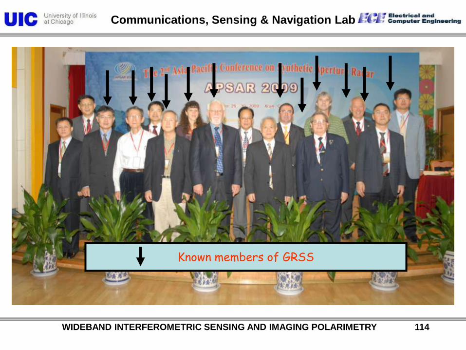
Known members of GRSS
WIDEBAND INTERFEROMETRIC SENSING AND IMAGING POLARIMETRY 114

Communications, Sensing & Navigation Lab
WIDEBAND INTERFEROMETRIC SENSING AND IMAGING POLARIMETRY 115
APSAR 2011
Asia Pacific International Conference on Synthetic Aperture Radar
• Sep. 26-30, 2011
Seoul, Korea
Organized by Radar Society of Korean Institute of Electromagnetic, KIEES
Co-sponsored by IEEE, AESS, GRSS, CIE, IEICE

Communications, Sensing & Navigation Lab
WIDEBAND INTERFEROMETRIC SENSING AND IMAGING POLARIMETRY 116
Date : 2011, 26 – 30, Sept.
Place : Seoul Educational Culture Center
Venue : Seoul is the capital of Korea and also conveniently located in the middle of
several major northeast Asian metropolises. The city is and infinite discoveries with over
600 years history. The ancient capital of an ancient land, Seoul is a city where the
traditional and the cutting-edge exist side-by-side in perfect harmony.
Important Dates : • Abstract (2p) Submission: March 14, 2011• Notification of Acceptance: May 30, 2011• Final Paper (4p) Submission: July 18, 2011• Pre-Registration Deadline: July 18, 2011
Submission : Authors are invited to submit two pages abstracts of original contributions in
the form of paper summaries. The abstract should concisely describes the objectives,
results and conclusions of the original work.
Webpage : www.apsar2011.org
APSAR 2011 Information

Communications, Sensing & Navigation Lab
WIDEBAND INTERFEROMETRIC SENSING AND IMAGING POLARIMETRY 117
Conference topicsA. SAR Systems
1. Spaceborne, Airborne SAR Systems and Missions
2. SAR/ISAR Systems Modeling and Simulation
3. Ultra Wideband and High Resolution SAR Systems
4. Advanced SAR Concepts and Modes
5. Bi- and Multistatic SAR Systems
6.Unmanned Aerial Vehicle and Millimeter Wave SAR Systems
1. SAR Antennas, T/R Modules, and Phased Arrays, Digital Beam Forming
2. SAR Components and Subsystem
3. On-Board/ Real-Time SAR Processing
4. SAR/ISAR Calibration and Verification
5. Interferometry and related techniques
6. Polarimetry
7. Anti-Jamming and SAR Interference Suppression
B. SAR Technology
1. High Resolution SAR processing
2. Data Fusion and Information Retrieval
3. SAR/GMTI/STAP and Change Detection
4. Feature Extraction and Analysis
5. Image Filtering, Correction and Enhancement
6. Archiving, Data Formats and Distribution
7. ISAR Signal Processing
C. SAR Signal Processing
D. SAR Applications
1. Post-Processing Techniques
2. Data Compression and Mining
3. Hazards and Disasters Monitoring
4. Urban and Land Surface Remote Sensing
5. Atmosphere and Ocean Observation
6. Polarimetry and/or Interferometry
7. Data Fusion and Tomography Applications
8. Target Recognition, Classification and Segmentation
1. Radar Systems Architectures
2. Radar Component and Subsystems
3. Antenna Technology and Adaptive Arrays
4. Waveform Design and Signal Processing
5. Detection and Estimation, Tracking
6. RCS Measurement and Analysis
7. Radar Spectrum and Interference Suppression
8. UWB, GPR, Bio-Medical Imaging Radar Systems
9. Automotive Radar
10. Civil/Military/Security Radar Applications
E. General Radar Technology
F. Other SAR /Radar Related Topics
These lists of topics should not be considered as
limiting the submission of interesting papers on related
fields. Papers covering all areas of SAR, radar, system
and signal processing technologies are encouraged.

Communications, Sensing & Navigation Lab
WIDEBAND INTERFEROMETRIC SENSING AND IMAGING POLARIMETRY 118
Program Committee Members Program Committee Members
General Chair: Young Kil Kwag (Korea Aerospace Univ.)
Advisory Committee : Woo il Moon (Seoul National Univ.)Jung Woong Ra (KAIST)
Organizing Committee Chair: Sangwook Nam (Seoul National Univ.)
TPC Chair: Yi Sok Oh (Hongik Univ.)TPC Co-Chair: Joohwan Chun (KAIST)
Session Track: Woo Kyung Lee (Korea Aerospace Univ.)Hoon Yol Lee (Kangwon Univ.)
Tutorial: Duk Jin Kim (Seoul National Univ.)Poster Session: Kang Wook Kim (GIST)Award: Young Soo Kim (POSTECH)
Kyung Tae kim (Youngnam Univ.)Publicity: Woo Kyung Lee (Korea Aerospace Univ.)Publication: Duk Jin Kim (Seoul National Univ.)Finance: Minho Ka (KPU)Registration: Taek Kyung Lee (Korea Aerospace Univ.)Exhibition: Chulhun Seo (Soong Sil Univ.)Local Arrangement: Hyeong Dong Kim (Han Yang Univ.)Secretary: Jeong Phill Kim (Chung Ang Univ.)
International Advisory Committee
Mark Davis(IEEE)
Wolfgang -Martin Boerner (Univ. of Illinois, USA)
Shunjun Wu(Xidian University, China)
Motoyuki Sato ( Tohoku University, Japan)
Tony Milne (UNSW, Australia)
Albert Moreira ( DLR, Germany)
Hugh Griffith (UCL, UK)
Paul Rosen(JPL, USA)
International Program Committee
Oeijun Li (Peking University, China)
Ya-Qin Jin (FUdan University, China)
Jian Yang (Tsingua University, China)
Chao Wang (Chinese Academy of Science, China)
Hiroshi Kimura (Gifu University, Japan)
Masanobu Shimada (JAXA, Japan)
Yoshio Yamaguch (Niigata University, Japan)
Chris Baker (Australia National University, Australia)
Konstantine Lukin(IRE NASU,Ukraine)
Marian Werner (DLR, Germany)
Rudolf Zhan (EADS, Germany)
Scott Hensley (JPL, USA)
Yunjin Kim (JPL, USA)

Communications, Sensing & Navigation Lab
WIDEBAND INTERFEROMETRIC SENSING AND IMAGING POLARIMETRY 119
IGARSS 2011
Sendai, JapanIEEE GRSS Japan Chapter
1 - 5 August, 2011
http://igarss11.org/
http://www.grss-ieee.org/
Communications, Sensing & Navigation Lab
WIDEBAND INTERFEROMETRIC SENSING AND IMAGING POLARIMETRY 120
FOUNDATIONS AND RELEVANCE OF MODERN
EARTH REMOTE SENSING & ITS ACTIVITIES
Conclusions:
The Electromagnetic Spectrum:
A Natural Global Treasure
Terrestrial Remote Sensing with PolSAR:
The Diagnostics of the Health of the Earth
at all weather and volcanic conditions
and at day and night
Related Documents