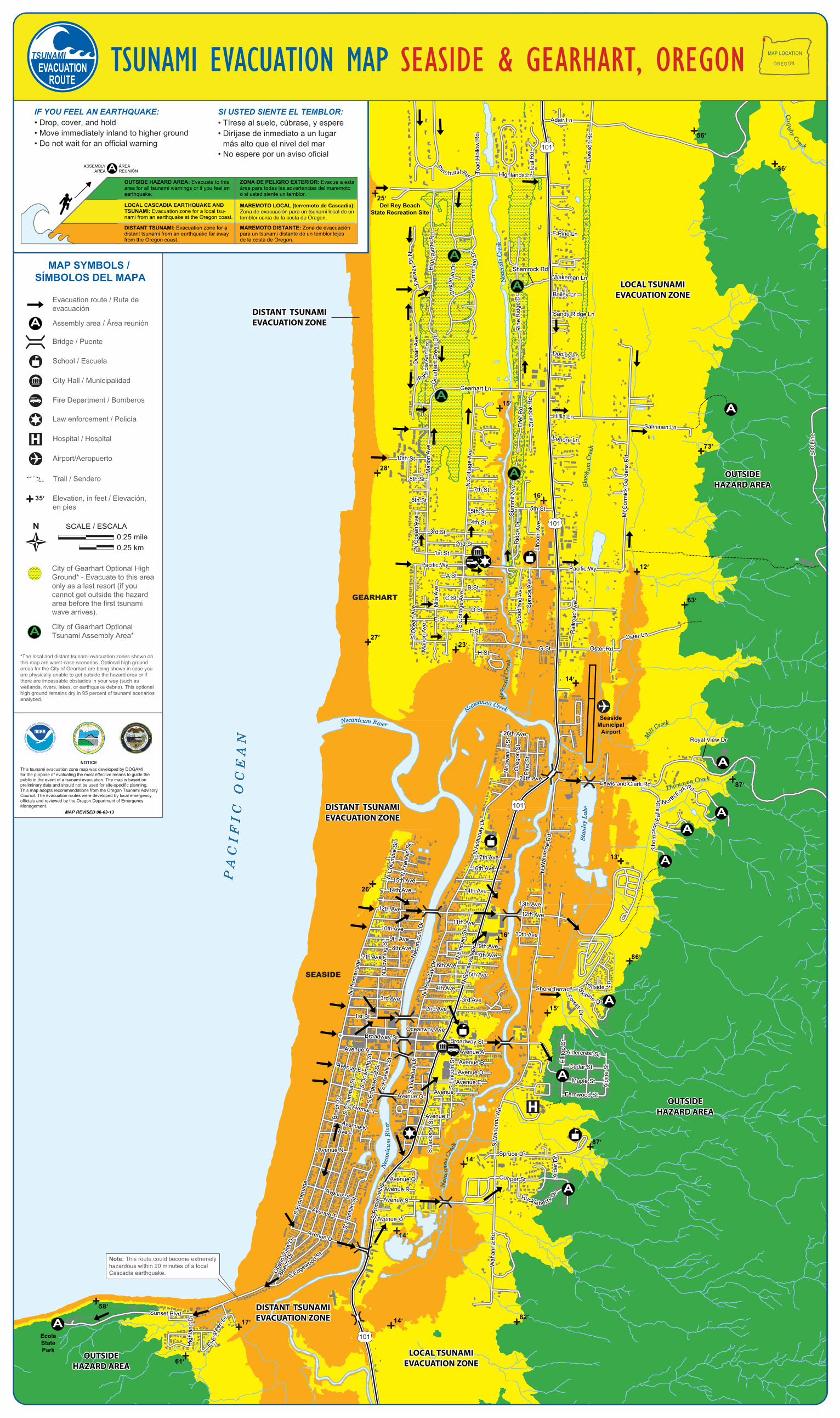
101 101 101 101 Seaside Municipal Airport A A A A A A A A A P A C I F I C O C E A N N e c a n i c u m R i v er N e a w a n n a C re e k N e a c o x i e C r e e k M i l l C r e e k T h o m ps on C r ee k Stanley Lake S k o o k u m C r e e k N e a c o x i e C r e e k N e a w an n a C r e e k N e c a n i c u m R ive r C u l l a b y C r e e k P A C I F I C O C E A N N e c a n i c u m R i v er N e a w a n n a C re e k N e a c o x i e C r e e k M i l l C r e e k T h o m ps on C r ee k Stanley Lake S k o o k u m C r e e k N e a c o x i e C r e e k N e a w an n a C r e e k N e c a n i c u m R ive r C u l l a b y C r e e k OUTSIDE HAZARD AREA OUTSIDE HAZARD AREA OUTSIDE HAZARD AREA OUTSIDE HAZARD AREA DISTANT TSUNAMI EVACUATION ZONE DISTANT TSUNAMI EVACUATION ZONE DISTANT TSUNAMI EVACUATION ZONE DISTANT TSUNAMI EVACUATION ZONE DISTANT TSUNAMI EVACUATION ZONE DISTANT TSUNAMI EVACUATION ZONE LOCAL TSUNAMI EVACUATION ZONE LOCAL TSUNAMI EVACUATION ZONE LOCAL TSUNAMI EVACUATION ZONE LOCAL TSUNAMI EVACUATION ZONE OUTSIDE HAZARD AREA OUTSIDE HAZARD AREA Del Rey Beach State Recreation Site Elmer Feldenheimer State Natural Area Ecola State Park GEARHART SEASIDE E Pine Ln Wakeman Ln Bailey Ln Dooley Ln Sandy Ridge Ln Gearhart Ln F a i r w a y D r N H i g h R i d g e R d S h e r i d a n D r D r u m m o n d D r Pine Ridge Dr Ge arhart Green Dr P a t ricia Ann L n Ocean Ave McCormick Gardens Rd N Cottage Ave S Cottage Ave Summit Ave Ridge Dr Lincoln Ave Marion Ave N Ocean Ave S Ocean Ave Marion Ave Nita Ave Hillia Ln 10th St 8th St 4th St Pacific Wy E St G St 26th Ave 24th Ave 17th Ave 16th Ave 15th Ave 14th Ave 12th Ave 9th Ave 7th Ave 6th Ave 7th Ave 5th Ave 8th Ave 4th Ave 2nd Ave 3rd Ave 3rd Ave 1 1th Ave 10th Ave 9th Ave 12th Ave 14th Ave 13th Ave 10th Ave Pine St Oregon St Neawanna St Oster Rd H St F St D St C St B St A St Pacific Wy 1st St 7th St 6th St 5th St 5th St Salminen Ln L e nore Ln Woo dland Ave Spruce Ave Railroad Ave O s ter L n Le wis and Clark R d N o rt h F o r k R d T h o m p s o n F a l l s D r N Holladay Dr N Columbia St N Franklin St N Promenade S Holladay Dr N Wah a nna Rd N Downing St Ne c anicum Dr 1st St N Lincoln St S hore T erra ce H i l lside L p S k y l i n e D r F orest Dr Hilltop Dr Alpine St Aldercres t St Cedar St Maple St Fernwood St Oceanway Ave Broadway St Broadway St Avenue A Avenue B Avenue D Avenue E Avenue F Avenue I Avenue A Avenue E Avenue G Avenue I Avenue K S Downing St S Edgewood St S Columbia S t Beach Dr S Franklin St S Promenade S Franklin St S Edgewo od St Avenue N Ave L Avenue S Avenue T Avenue U Oc e an Vist a D r Beach Dr Sunset Blvd H igh land Dr E v e rg r een Dr S Lincoln St S Jackson St Avenue Q Avenue R Avenue S Avenue U S Wahann a Rd Spruce Dr Alder Dr C o o per St H uck l e b e r ry D r Wahanna Rd 5 0 0 Lin e S R o o s e v e l t D r N Roosevelt Dr 3rd St 2nd St Fifer Rd C h i n o o k R d N Holladay Dr Highlands Ln T oa d Hollow Rd P i n e h u r s t R d T eal Rd Adair Ln Dawson Rd Royal View Dr Shamrock Rd E Pine Ln Wakeman Ln Bailey Ln Dooley Ln Sandy Ridge Ln Gearhart Ln F a i r w a y D r N H i g h R i d g e R d S h e r i d a n D r D r u m m o n d D r Pine Ridge Dr Ge arhart Green Dr P a t ricia Ann L n Ocean Ave McCormick Gardens Rd N Cottage Ave S Cottage Ave Summit Ave Ridge Dr Lincoln Ave Marion Ave N Ocean Ave S Ocean Ave Marion Ave Nita Ave Hillia Ln 10th St 8th St 4th St Pacific Wy E St G St 26th Ave 24th Ave 17th Ave 16th Ave 15th Ave 14th Ave 12th Ave 9th Ave 7th Ave 6th Ave 7th Ave 5th Ave 8th Ave 4th Ave 2nd Ave 3rd Ave 3rd Ave 1 1th Ave 10th Ave 9th Ave 12th Ave 14th Ave 13th Ave 10th Ave Pine St Oregon St Neawanna St Oster Rd H St F St D St C St B St A St Pacific Wy 1st St 7th St 6th St 5th St 5th St Salminen Ln L e nore Ln Woo dland Ave Spruce Ave Railroad Ave O s ter L n Le wis and Clark R d N o rt h F o r k R d T h o m p s o n F a l l s D r N Holladay Dr N Columbia St N Franklin St N Promenade S Holladay Dr N Wah a nna Rd N Downing St Ne c anicum Dr 1st St N Lincoln St S hore T erra ce H i l lside L p S k y l i n e D r F orest Dr Hilltop Dr Alpine St Aldercres t St Cedar St Maple St Fernwood St Oceanway Ave Broadway St Broadway St Avenue A Avenue B Avenue D Avenue E Avenue F Avenue I Avenue A Avenue E Avenue G Avenue I Avenue K S Downing St S Edgewood St S Columbia S t Beach Dr S Franklin St S Promenade S Franklin St S Edgewo od St Avenue N Ave L Avenue S Avenue T Avenue U Oc e an Vist a D r Beach Dr Sunset Blvd H igh land Dr E v e rg r een Dr S Lincoln St S Jackson St Avenue Q Avenue R Avenue S Avenue U S Wahann a Rd Spruce Dr Alder Dr C o o per St H uck l e b e r ry D r Wahanna Rd 5 0 0 Lin e S R o o s e v e l t D r N Roosevelt Dr 3rd St 2nd St Fifer Rd C h i no o k R d N Holladay Dr Highlands Ln T oa d Hollow Rd P i n e h u r s t R d T eal Rd Adair Ln Dawson Rd Royal View Dr Shamrock Rd A A A A 25’ 56’ 36’ 15’ 28’ 27’ 23’ 12’ 63’ 14’ 87’ 26’ 13’ 16’ 86’ 15’ 87’ 14’ 14’ 82’ 14’ 17’ 61’ 58’ 73’ 16’ Note: This route could become extremely hazardous within 20 minutes of a local Cascadia earthquake. Elevation, in feet / Elevación, en pies 35’ Trail / Sendero City Hall / Municipalidad Airport/Aeropuerto Hospital / Hospital Law enforcement / Policía Fire Department / Bomberos School / Escuela Bridge / Puente Evacuation route / Ruta de evacuación Assembly area / Área reunión A MAP SYMBOLS / SÍMBOLOS DEL MAPA N 0.25 mile 0.25 km SCALE / ESCALA NOTICE This tsunami evacuation zone map was developed by DOGAMI for the purpose of evaluating the most effective means to guide the public in the event of a tsunami evacuation. The map is based on preliminary data and should not be used for site-specific planning. This map adopts recommendations from the Oregon Tsunami Advisory Council. The evacuation routes were developed by local emergency officials and reviewed by the Oregon Department of Emergency Management. MAP REVISED 06-03-13 O RE G O N D E PA R T ME N T O F G EO L O GY A N D M I N E R AL I N D U ST R I E S 19 37 *The local and distant tsunami evacuation zones shown on this map are worst-case scenarios. Optional high ground areas for the City of Gearhart are being shown in case you are physically unable to get outside the hazard area or if there are impassable obstacles in your way (such as wetlands, rivers, lakes, or earthquake debris). This optional high ground remains dry in 95 percent of tsunami scenarios analyzed. City of Gearhart Optional High Ground* - Evacuate to this area only as a last resort (if you cannot get outside the hazard area before the first tsunami wave arrives). City of Gearhart Optional Tsunami Assembly Area* A • Drop, cover, and hold • Move immediately inland to higher ground • Do not wait for an official warning IF YOU FEEL AN EARTHQUAKE: • Tírese al suelo, cúbrase, y espere • Diríjase de inmediato a un lugar más alto que el nivel del mar • No espere por un aviso oficial SI USTED SIENTE EL TEMBLOR: OUTSIDE HAZARD AREA: Evacuate to this area for all tsunami warnings or if you feel an earthquake. DISTANT TSUNAMI: Evacuation zone for a distant tsunami from an earthquake far away from the Oregon coast. ZONA DE PELIGRO EXTERIOR: Evacue a esta área para todas las advertencias del maremoto o si usted siente un temblor. MAREMOTO LOCAL (terremoto de Cascadia): Zona de evacuación para un tsunami local de un temblor cerca de la costa de Oregon. MAREMOTO DISTANTE: Zona de evacuación para un tsunami distante de un temblor lejos de la costa de Oregon. LOCAL CASCADIA EARTHQUAKE AND TSUNAMI: Evacuation zone for a local tsu- nami from an earthquake at the Oregon coast. ASSEMBLY AREA ÁREA REUNIÓN A MAP LOCATION O RE G O N TSUNAMI EVACUATION MAP SEASIDE & GEARHART, OREGON

Welcome message from author
This document is posted to help you gain knowledge. Please leave a comment to let me know what you think about it! Share it to your friends and learn new things together.
Transcript
101
101
101
101
SeasideMunicipal
Airport
A
A
AA
A
A
A
A
A
PA
CI F
I C O
CE
AN
Necanicum River
Neawanna Creek
Nea
coxi
e Cr
eek
Mill
Creek
Thompson Creek
Stan
ley
Lake
Skoo
k um
Cre
ek
N
eaco
xie C
reek
Nea
wan
na C
reek
Nec
anic
um R
iver
Cullaby Creek
PA
CI F
I C O
CE
AN
Necanicum River
Neawanna Creek
Nea
coxi
e Cr
eek
Mill
Creek
Thompson Creek
Stan
ley
Lake
Skoo
k um
Cre
ek
N
eaco
xie C
reek
Nea
wan
na C
reek
Nec
anic
um R
iver
Cullaby Creek
OUTSIDEHAZARD AREA
OUTSIDEHAZARD AREA
OUTSIDEHAZARD AREA
OUTSIDEHAZARD AREA
DISTANT TSUNAMIEVACUATION ZONEDISTANT TSUNAMIEVACUATION ZONE
DISTANT TSUNAMIEVACUATION ZONEDISTANT TSUNAMIEVACUATION ZONE
DISTANT TSUNAMIEVACUATION ZONEDISTANT TSUNAMIEVACUATION ZONE
LOCAL TSUNAMIEVACUATION ZONE
LOCAL TSUNAMIEVACUATION ZONE
LOCAL TSUNAMIEVACUATION ZONE
LOCAL TSUNAMIEVACUATION ZONE
OUTSIDEHAZARD AREA
OUTSIDEHAZARD AREA
Del Rey BeachState Recreation Site
Elmer FeldenheimerState Natural Area
EcolaStatePark
GEARHART
SEASIDE
E Pine Ln
Wakeman Ln
Bailey Ln
Dooley Ln
Sandy Ridge Ln
Gearhart Ln
Fairw
ay D
r N
Hig
h R
idge
Rd
Sher
idan
Dr
Dru
mm
ond
Dr
Pin
e R
idge
Dr
Gea
rhar
t Gre
en D
r
Pa tric
ia A
nn L
n
Oce
an A
ve
McC
orm
ick
Gar
dens
Rd
N C
otta
ge A
ve
S C
otta
ge A
ve
Sum
mit
Ave
Rid
ge D
r
Linc
oln
Ave
Mar
ion
Ave
N O
cean
Ave
S O
cean
Ave
Mar
ion
Ave
Nita
Ave
Hillia Ln
10th St
8th St
4th St
Pacific Wy
E St
G St
26th Ave
24th Ave
17th Ave
16th Ave
15th Ave
14th Ave
12th Ave
9th Ave
7th Ave6th Ave
7th Ave
5th Ave
8th Ave
4th Ave
2nd Ave3rd Ave3rd Ave
11th Ave10th Ave
9th Ave
12th Ave
14th Ave
13th Ave
10th Ave
Pin
e St
Ore
gon
St
Nea
wan
na S
t
Oster RdH St
F St
D St
C St
B St
A StPacific Wy
1st St
7th St
6th St
5th St 5th St
Salminen Ln
Lenore Ln
Woo
dlan
d Av
eS
pruc
e Av
e
Rai
lroad
Ave
Oster Ln
Lewis and Clark Rd
N orth Fork
Rd
Tho m
pson
Fal
ls D
r
N H
olla
day
Dr
N C
olum
bia
StN
Fra
nklin
St
N P
rom
enad
e
S H
olla
day
Dr
N W
ahan
na R
d
N D
owni
ng S
t
Nec
anic
um D
r
1st St
N L
inco
ln S
t
Shore TerraceHi l lside L
p
Sk yline Dr
F orest Dr
Hill
top
Dr
Alp
ine
St
Aldercrest St
Cedar St
Maple St
Fernwood St
Oceanway AveBroadway St Broadway St
Avenue A
Avenue BAvenue D
Avenue EAvenue F
Avenue I
Avenue A
Avenue E
Avenue G
Avenue I
Avenue K
S D
owni
ng S
tS
Edge
woo
d St
S C
olum
bia
St
Beac
h D
r
S Fr
ankl
in S
t
S Pr
omen
ade
S Fr
ankl
in S
t
S Edgewood St
Avenue N
Ave L
Avenue S
Avenue T
Avenue U
Oce
an V
ista
Dr
Beac
h Dr
Sunset Blvd
Hig
hlan
d D
r
Ev er
gree
n Dr
S L
inco
ln S
t
S J
acks
on S
t
Avenue Q Avenue R
Avenue S
Avenue U
S W
ahan
na R
d
Spruce Dr
Ald
er D
r
Cooper St
Huckle berry D
r
Wah
anna
Rd
50
0 Li
ne
S R
oose
velt
Dr
N R
oose
velt
Dr
3rd St
2nd St
Fife
r Rd
Chi
nook
Rd
N H
olla
day
Dr
Highlands LnToad
Hol
low
Rd
Pine hurst Rd Tea
l Rd
Adair Ln
D
awso
n R
d
Royal View Dr
Shamrock Rd
A
A
A
A
25’
56’
36’
15’
28’
27’23’
12’
63’
14’
87’
26’
13’
16’
86’
15’
87’
14’
14’
82’14’17’
61’
58’
73’
16’
Note: This route could become extremely hazardous within 20 minutes of a local Cascadia earthquake.
Elevation, in feet / Elevación, en pies
35’
Trail / Sendero
City Hall / Municipalidad
Airport/Aeropuerto
Hospital / Hospital
Law enforcement / Policía
Fire Department / Bomberos
School / Escuela
Bridge / Puente
Evacuation route / Ruta de evacuación
Assembly area / Área reuniónA
MAP SYMBOLS / SÍMBOLOS DEL MAPA
N0.25 mile0.25 km
SCALE / ESCALA
NOTICEThis tsunami evacuation zone map was developed by DOGAMI for the purpose of evaluating the most effective means to guide the public in the event of a tsunami evacuation. The map is based on preliminary data and should not be used for site-specific planning. This map adopts recommendations from the Oregon Tsunami Advisory Council. The evacuation routes were developed by local emergency officials and reviewed by the Oregon Department of Emergency Management.
MAP REVISED 06-03-13
OR
EG
ON
DE
PA
RTM
E
NT O F G EO L O GY A NDM I N
ER
AL
I ND
US
TR
IES
1937
*The local and distant tsunami evacuation zones shown on this map are worst-case scenarios. Optional high ground areas for the City of Gearhart are being shown in case you are physically unable to get outside the hazard area or if there are impassable obstacles in your way (such as wetlands, rivers, lakes, or earthquake debris). This optional high ground remains dry in 95 percent of tsunami scenarios analyzed.
City of Gearhart Optional High Ground* - Evacuate to this area only as a last resort (if you cannot get outside the hazard area before the first tsunami wave arrives).
City of Gearhart Optional Tsunami Assembly Area*A
• Drop, cover, and hold• Move immediately inland to higher ground • Do not wait for an official warning
IF YOU FEEL AN EARTHQUAKE:• Tírese al suelo, cúbrase, y espere• Diríjase de inmediato a un lugar más alto que el nivel del mar• No espere por un aviso oficial
SI USTED SIENTE EL TEMBLOR:
OUTSIDE HAZARD AREA: Evacuate to this area for all tsunami warnings or if you feel an earthquake.
DISTANT TSUNAMI: Evacuation zone for a distant tsunami from an earthquake far away from the Oregon coast.
ZONA DE PELIGRO EXTERIOR: Evacue a esta área para todas las advertencias del maremoto o si usted siente un temblor.
MAREMOTO LOCAL (terremoto de Cascadia):Zona de evacuación para un tsunami local de un temblor cerca de la costa de Oregon.
MAREMOTO DISTANTE: Zona de evacuación para un tsunami distante de un temblor lejosde la costa de Oregon.
LOCAL CASCADIA EARTHQUAKE AND TSUNAMI: Evacuation zone for a local tsu-nami from an earthquake at the Oregon coast.
ASSEMBLYAREA
ÁREA REUNIÓNA
MAP LOCATION
O RE GO NTSUNAMI EVACUATION MAP SEASIDE & GEARHART, OREGON

A lo
cal t
suna
mi c
an c
ome
onsh
ore
with
in 1
5 to
20
min
utes
aft
er th
e ea
rthq
uake
— b
efor
e th
ere
is ti
me
for a
n of
ficia
l war
ning
from
the
natio
nal w
arni
ng s
yste
m. G
roun
d sh
akin
g fr
om th
e ea
rthq
uake
may
be
the
only
war
ning
you
hav
e.
Evac
uate
qui
ckly
!
A d
ista
nt ts
unam
i will
take
4 h
ours
or m
ore
to c
ome
asho
re. Y
ou w
ill fe
el n
o ea
rthq
uake
, and
the
tsun
ami w
ill g
ener
ally
be
sm
alle
r tha
n th
at fr
om a
loca
l ear
thqu
ake.
Typ
ical
ly, t
here
is ti
me
for a
n of
ficia
l war
ning
and
eva
cuat
ion
to s
afet
y.
Evac
uatio
n fo
r a d
ista
nt ts
unam
i will
gen
eral
ly b
e in
dica
ted
by a
3-m
inut
e si
ren
blas
t (if
your
are
a ha
s si
rens
) and
an
ann
ounc
emen
t ove
r NO
AA
wea
ther
radi
o th
at th
e lo
cal a
rea
has
been
put
into
an
offic
ial T
SUN
AM
I WA
RNIN
G.
In is
olat
ed a
reas
alo
ng b
each
es a
nd b
ays
you
may
not
hea
r a w
arni
ng s
iren.
Her
e, a
sud
den
chan
ge o
f sea
leve
l sho
uld
prom
pt y
ou to
mov
e im
med
iate
ly to
hig
h gr
ound
. If y
ou h
ear t
he 3
-min
ute
blas
t or s
ee a
sud
den
sea
leve
l cha
nge,
firs
t ev
acua
te a
way
from
sho
relin
e ar
eas,
then
turn
on
your
loca
l bro
adca
st m
edia
or N
OA
A w
eath
er ra
dio
for m
ore
info
rmat
ion.
1. E
vacu
ate
on fo
ot, i
f at
all p
ossi
ble.
Fol
low
eva
cuat
ion
sign
s an
d ar
row
s
to
an A
ssem
bly
Are
a.*
2. I
f you
nee
d he
lp e
vacu
atin
g, tie
som
ethi
ng
w
hite
(sh
eet
or t
owel
) to
the
fron
t do
or k
nob.
Mak
e it
larg
e
eno
ugh
to b
e vi
sibl
e fr
om t
he s
tree
t. If
the
emer
genc
y is
a
d
ista
nt t
suna
mi,
then
hel
p m
ay a
rriv
e. In
the
eve
nt o
f a lo
cal
t
suna
mi,
it is
unl
ikel
y th
at a
nyon
e w
ill h
elp
you,
so
mak
e a
plan
and
be
prep
ared
!
3. S
tay
away
from
pot
entia
lly h
azar
dous
are
as u
ntil
you
rece
ive
an
ALL
CLE
AR
from
loca
l offi
cial
s. T
suna
mis
ofte
n fo
llow
riv
er
c
hann
els,
and
dang
erou
s w
aves
can
per
sist
for
seve
ral h
ours
.
Loc
al o
ffici
als
mus
t in
spec
t al
l flo
oded
or
eart
hqua
ke-d
amag
ed
s
truc
ture
s be
fore
any
one
can
go b
ack
into
the
m.
4. A
fter
evac
uatio
n, c
heck
with
loca
l em
erge
ncy
offic
ials
if
y
ou t
hink
you
hav
e sp
ecia
l ski
lls a
nd c
an h
elp,
or if
you
nee
d as
sist
ance
loca
ting
lost
fam
ily m
embe
rs.
Loca
l tsu
nam
is
Dist
ant t
suna
mis
Look
for
thes
e ha
zard
zon
e si
gns
and
be r
eady
to
leav
e th
e ar
ea b
yfo
llow
ing
evac
uatio
n ro
ute
sign
s.
WHA
T TO
DO fo
r bot
h lo
cal
and
dist
ant t
suna
mis
TSUN
AMI H
AZAR
D ZO
NE
IN C
ASE
OF E
ARTH
QUAK
E, G
O
TO H
IGH
GROU
ND O
R IN
LAND
*Ass
embl
y ar
eas
A a
re s
how
n on
the
map
. D
o no
t co
nfus
e A
ssem
bly
Are
as w
ith
Evac
uatio
n C
ente
rs, w
hich
are
sho
rt-t
erm
hel
p ce
nter
s se
t up
afte
r a d
isas
ter
occu
rs.
AC
limb
to A
ssem
bly
Are
a
A ts
unam
i is
a se
ries
of s
ea w
aves
, usu
ally
cau
sed
by a
dis
plac
emen
t of t
he o
cean
floo
r by
an
unde
rsea
ear
thqu
ake.
As
tsun
amis
ent
er s
hallo
w w
ater
nea
r lan
d, th
ey in
crea
se in
hei
ght a
nd c
an
caus
e gr
eat l
oss
of li
fe a
nd p
rope
rty
dam
age.
Rece
nt re
sear
ch s
ugge
sts
that
tsun
amis
hav
e st
ruck
the
Ore
gon
coas
t on
a re
gula
r bas
is. T
hey
can
occu
r any
tim
e, d
ay o
r nig
ht. T
ypic
al w
ave
heig
hts
from
tsun
amis
occ
urrin
g in
the
Paci
fic O
cean
ov
er th
e la
st 5
00 y
ears
hav
e be
en 2
0–65
feet
at t
he s
hore
line.
How
ever
, bec
ause
of l
ocal
con
ditio
ns
a fe
w w
aves
may
hav
e be
en m
uch
high
er —
as
muc
h as
100
feet
.W
e di
stin
guis
h be
twee
n a
tsun
ami c
ause
d by
an
unde
rsea
ear
thqu
ake
near
the
Ore
gon
coas
t (a
loca
l tsu
nam
i) an
d an
und
erse
a ea
rthq
uake
far a
way
from
the
coas
t (a
dist
ant t
suna
mi).
WHA
T TO
KNOW
abo
ut ts
unam
is
DROP, COVER, HOLD until the earthquake is over; protect yourselfMOVE IMMEDIATELY INLAND to high ground and away from low-lying coastal areasFOLLOW EVACUATION ROUTE SIGNS
DO NOT WAIT for an official warningGO ON FOOT if at all possibleDO NOT PACK or delayDO NOT RETURN to the beach – large waves may continue to come onshore for several hoursWAIT for an “all clear” from local emergency officials before returning to low-lying areas
www.OregonTsunami.org
•
•
•••••
•
WHAT TO DO:
If you feel an earthquake, a tsunami may be coming...
BE P
REPA
RED!
Ass
embl
e em
erge
ncy
kits
with
at l
east
a 3
-day
sup
ply
for e
ach
fam
ily m
embe
r:•
Loca
l map
sho
win
g sa
fe e
vacu
atio
n ro
utes
to h
igh
grou
nd•
Firs
t-ai
d su
pplie
s, pr
escr
iptio
ns a
nd n
on-p
resc
riptio
n
med
icat
ion
• W
ater
bot
tle a
nd fi
ltrat
ion
or tr
eatm
ent s
uppl
ies
ca
pabl
e of
pro
vidi
ng 1
gal
lon
per p
erso
n pe
r day
• N
on-p
eris
habl
e fo
od (r
eady
-to-
eat m
eals
,
cann
ed fo
od, b
aby
food
, ene
rgy
bars
)•
Cook
ing
and
eatin
g ut
ensi
ls, c
an o
pene
r, St
erno
®
or o
ther
hea
t sou
rce
• M
atch
es in
wat
er-p
roof
con
tain
er o
r lig
hter
• Sh
elte
r (te
nt),
slee
ping
bag
s, bl
anke
ts•
Port
able
radi
o, N
OA
A w
eath
er ra
dio,
flas
hlig
ht,
an
d ex
tra
batt
erie
s•
Rain
gea
r, st
urdy
foot
wea
r, ex
tra
clot
hing
• Pe
rson
al h
ygie
ne it
ems
(toi
let p
aper
, soa
p, to
othb
rush
)•
Tool
s an
d su
pplie
s (p
ocke
t kni
fe, s
hut-
off w
renc
h,
du
ct ta
pe, g
love
s, w
hist
les,
plas
tic b
ags)
• Ca
sh
• St
art a
tsun
ami b
uddy
sys
tem
• M
ake
and
dist
ribut
e em
erge
ncy
pack
s•
Initi
ate
or p
artic
ipat
e in
a lo
cal p
repa
redn
ess
prog
ram
Visi
t Ore
gonT
suna
mi.o
rg to
find
mor
e gr
eat r
esou
rces
!
How
to h
elp
with
tsun
ami a
ware
ness
in yo
ur co
mm
unity
OR
EG
ON
DE
PA
RTM
E NT O F G EO L O G Y ANDM
I NE
RA
LIN
US
TR
IES
1937
D
Funded by the National Oceanic and Atmospheric Administration under NTHMP contract award DG133W07CN0335 through the Oregon Department of Geology
and Mineral Industries. Published by the Oregon Department of Geology andMineral Industries in consultation with local emergency management officials.
Oregon Emergency Management3225 State Street, Salem, OR 97301
P.O. Box 14370, Salem, OR 97309-5062(503) 378-2911
http://www.oregon.gov/OMD/OEM/
Clatsop County Emergency Management800 Exchange Street, Suite 400
Astoria, OR 97103(503) 325-8645
www.co.clatsop.or.us
Oregon Department of Geology and Mineral Industries800 NE Oregon Street #28, Suite 965
Portland, OR 97232(971) 673-1555
http://www.oregongeology.org
Nature of the Northwest Information Center800 NE Oregon Street #28, Suite 965
Portland, OR 97232(971) 673-2331
http://www.naturenw.org
International Tsunami Information Center737 Bishop Street, Suite 2200
Honolulu, HI 96813(808) 532-6422
http://itic.ioc-unesco.org
Gearhart Fire Department670 Pacific Way
Gearhart, OR 97138(503) 738-7838
www.gearhartfire.com
City of Seaside989 Broadway StreetSeaside, OR 97138
(503) 738-5511(503) 738-6311 non-business hours
www.cityofseaside.us
City of Gearhart698 Pacific Way
Gearhart, OR 97138(503) 738-5501
www.cityofgearhart.com
CONTACTS
This information could save your life –
Please read it and share it with your family and friends.
Seaside & Gearhart
OREGON
EVACUATIONMAP ON REVERSE
D
Related Documents